edinburgh research explorer - university of edinburgh · [email protected], keywords: mobile,...
TRANSCRIPT
Edinburgh Research Explorer
Fieldtrip GB: Creating a customisable mapping and data captureapp for the HEFE community
Citation for published version:Butchart, B, Pope, A, King, M, Hamilton, G, Terzis, P & Koutroumpas, M 2013, 'Fieldtrip GB: Creating acustomisable mapping and data capture app for the HEFE community' Paper presented at GISRUK 2013,Liverpool, United Kingdom, 3/04/13 - 5/04/13, pp. 13.
Link:Link to publication record in Edinburgh Research Explorer
Document Version:Early version, also known as pre-print
General rightsCopyright for the publications made accessible via the Edinburgh Research Explorer is retained by the author(s)and / or other copyright owners and it is a condition of accessing these publications that users recognise andabide by the legal requirements associated with these rights.
Take down policyThe University of Edinburgh has made every reasonable effort to ensure that Edinburgh Research Explorercontent complies with UK legislation. If you believe that the public display of this file breaches copyright pleasecontact [email protected] providing details, and we will remove access to the work immediately andinvestigate your claim.
Download date: 30. May. 2018
Fieldtrip GB: Creating a customisable mapping and data capture app for
the HEFE community
Ben Butchart1 , Addy Pope
1, Murray King
1, George Hamilton
1
Panos Terzis1, Michael Koutroumpas
1
1EDINA, The University of Edinburgh, 160 Causewayside, Edinburgh, EH9 1PR
Tel. (+44) 131 651 7712 Fax (+44) 131 650 3308
[email protected], www.edina.ac.uk
KEYWORDS: mobile, mapping, data capture, cloud, API, cartography, open data, ordnance
survey, citizen science.
Fieldtrip GB is a mobile app for iOS and Android smartphones. It has been designed to allow users to
take high quality basemaps into the field and capture spatial data against them. Fieldtrip GB is part
of a suite of tools that connect through a Personal Cloud API (PCAPI) which allow users and
developers to create custom data forms and manage the creation and flow of data captured through
the app. This paper introduces the app and explains the concept of the PCAPI. It also describes some
of the difficulties in developing apps in the current fragmented mobile sector and details the use of
open data to create a suitable basemap for the application.
1. Introduction
This paper describes Fieldtrip GB [1], a smartphone app and related web interfaces from EDINA[2]
which allows users to view cached maps on their mobile phones and capture data in the field, using
their own data collection forms. The application attempts to overcome several challenges with using
mobile technology in field for education and data capture.
Location aware technology is increasingly carried in people’s pockets in the form of a smart phone or
similar mobile devices [3]. These devices connect people to the world-wide-web and carry a wide
array of sensors including GPS. Such is the ubiquity and rapid adoption of mobile sensors, we find
ourselves entering a new era of human connectivity, that Butchart (co-author) has dubbed the
“Sensed World Web” [4]; a condition where as humans we begin “to enhance our own human
senses and connect those senses to networked databases”. Location Based Services based on spatial
sensors such as GPS, digital compass and accelerometer are the first class of Sensed World Web
applications to be widely adopted. Popular apps for navigation, social networking and data
visualisation have harnessed geospatial awareness to drive the rapid growth in smartphone
adoption.
Increasingly, educators and researchers are investigating how to respond to this trend in sensor
proliferation to enhance learning and collect data for research. The Centre for Enhanced Fieldwork
has produced a number of reports and guides on how to exploit smartphones and tablets for
fieldwork [5, 6]. There has been significant uptake of smartphones apps for research, as outlined in
UK Environmental Observation Framework’s comprehensive report on citizen science [7], which
discusses several smartphone applications such as Birdtrack[8], Leaf Watch[9] and Project Budburst
[10] (among others) where smartphone have been successfully used for obtaining research data. The
report also summarizes some of the challenges in developing smartphone applications for data
collection (repeated below)
Relatively high cost in the development of smartphone apps.
Rapid advances in technology…, so can become redundant quickly.
Requirement for apps to be developed for multiple operating systems.
Requires good mobile phone signal for live communication with the internet…
The quality of signal coverage is patchy and focussed on areas of high population density.
Versatile apps for data collection… do not allow apps to be ‘branded’ thus limiting their use in mass participation projects, while a proliferation of standalone apps could create clutter and be self-defeating.
Users expect apps to be intuitive and have high usability, which can add to design costs.
Apps for iPhones currently need to be vetted before acceptance to the App Store (for iPhone apps) or Google Play (for Android apps).
People who do not have smartphones are automatically excluded from participation.
from UKOF Citizen Science Report (2012) pp48-49 [7] (abridged)
In this paper we describe how Fieldtrip GB has attempted to address these challenges.
The next generation Sensed World Web apps will build on the foundation of geospatial capabilities
to include computer vision and speech recognition capabilities. Capabilities such as natural feature
detection, visual identification of objects, voice and sound detection and natural language
processing are already a feature of many new applications and we expect this to grow as devices
acquire greater processing power. We intend the Fieldtrip GB application to follow this trend so that
it can be a future platform of choice for educators and researchers to experiment and exploit the
power of the Sensed World Web for teaching and research.
1.1 Related Work
Several other data capture apps are already widely used and respond to the challenges outlined
above in different ways. Photo geo-tagging apps such Flickr [13] , Panoramio [14] as well as
specialised data capture apps such as Evernote [15], EpiCollect [16], WildKnowledge [17] and
Fulcrum[18] are all potentially extremely useful teaching and research tools. Of these,
WildKnowledge, Fulcrum and EpiCollect allow users to create custom data collection forms in a
similar way to Fieldtrip GB. The main distinctive feature of Fieldtrip GB is the provision of its own
basemaps optimized for fieldtrip use cases and its ability to link to the user’s existing Cloud provider.
2. Fieldtrip GB
Fieldtrip GB (Figure 1) allows users to stream Ordnance Survey (OS) [19] maps to their mobile
phones providing access to high quality background mapping in the field. In addition, several data
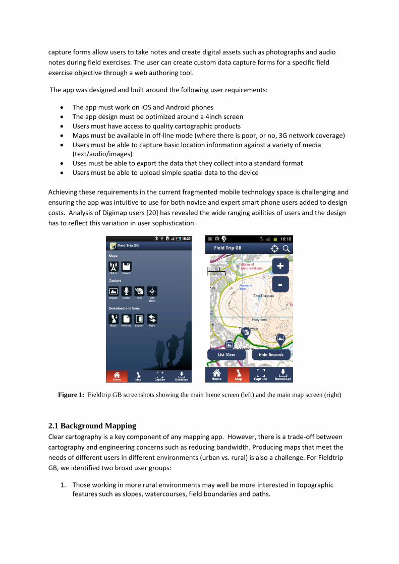
capture forms allow users to take notes and create digital assets such as photographs and audio
notes during field exercises. The user can create custom data capture forms for a specific field
exercise objective through a web authoring tool.
The app was designed and built around the following user requirements:
The app must work on iOS and Android phones
The app design must be optimized around a 4inch screen
Users must have access to quality cartographic products
Maps must be available in off-line mode (where there is poor, or no, 3G network coverage)
Users must be able to capture basic location information against a variety of media (text/audio/images)
Uses must be able to export the data that they collect into a standard format
Users must be able to upload simple spatial data to the device
Achieving these requirements in the current fragmented mobile technology space is challenging and
ensuring the app was intuitive to use for both novice and expert smart phone users added to design
costs. Analysis of Digimap users [20] has revealed the wide ranging abilities of users and the design
has to reflect this variation in user sophistication.
Figure 1: Fieldtrip GB screenshots showing the main home screen (left) and the main map screen (right)
2.1 Background Mapping
Clear cartography is a key component of any mapping app. However, there is a trade-off between
cartography and engineering concerns such as reducing bandwidth. Producing maps that meet the
needs of different users in different environments (urban vs. rural) is also a challenge. For Fieldtrip
GB, we identified two broad user groups:
1. Those working in more rural environments may well be more interested in topographic features such as slopes, watercourses, field boundaries and paths.
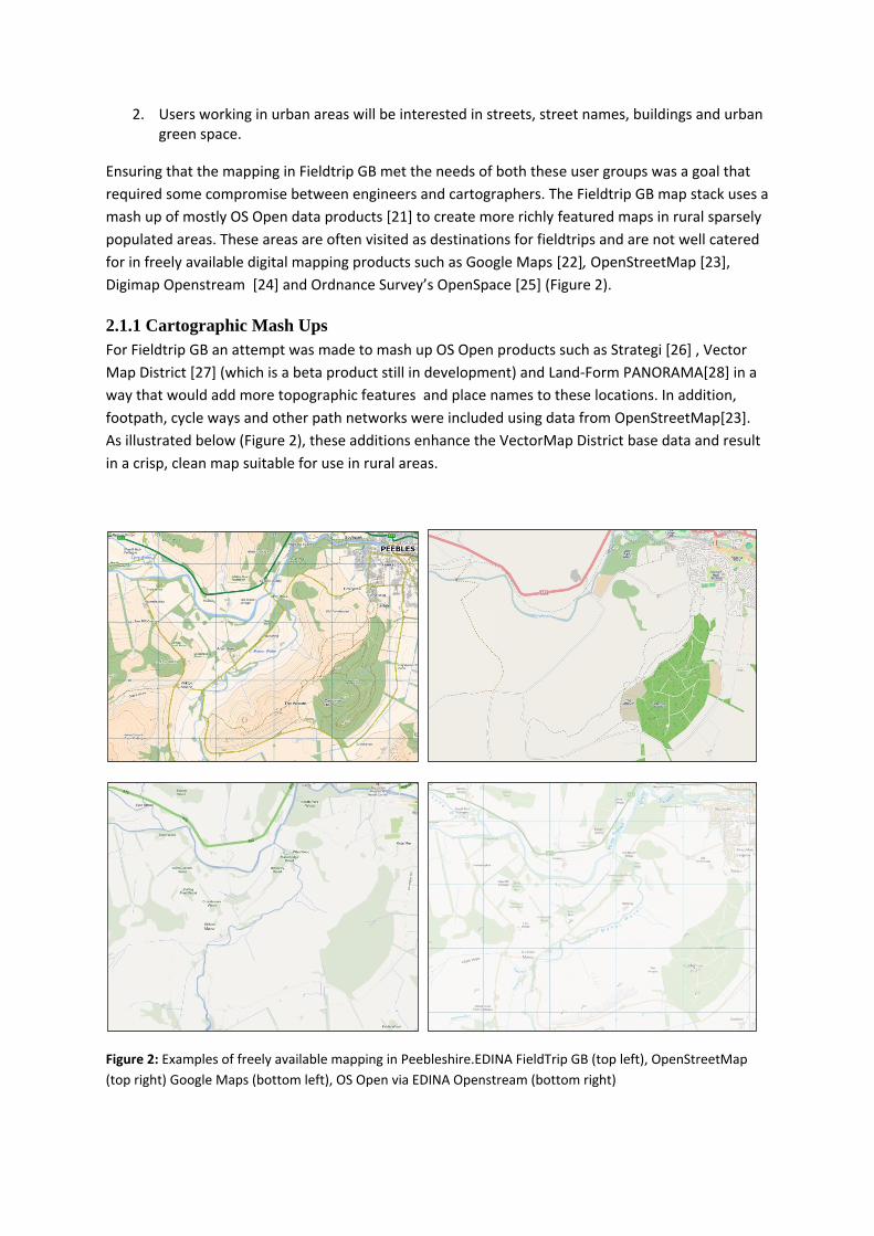
2. Users working in urban areas will be interested in streets, street names, buildings and urban green space.
Ensuring that the mapping in Fieldtrip GB met the needs of both these user groups was a goal that
required some compromise between engineers and cartographers. The Fieldtrip GB map stack uses a
mash up of mostly OS Open data products [21] to create more richly featured maps in rural sparsely
populated areas. These areas are often visited as destinations for fieldtrips and are not well catered
for in freely available digital mapping products such as Google Maps [22], OpenStreetMap [23],
Digimap Openstream [24] and Ordnance Survey’s OpenSpace [25] (Figure 2).
2.1.1 Cartographic Mash Ups
For Fieldtrip GB an attempt was made to mash up OS Open products such as Strategi [26] , Vector
Map District [27] (which is a beta product still in development) and Land-Form PANORAMA[28] in a
way that would add more topographic features and place names to these locations. In addition,
footpath, cycle ways and other path networks were included using data from OpenStreetMap[23].
As illustrated below (Figure 2), these additions enhance the VectorMap District base data and result
in a crisp, clean map suitable for use in rural areas.
Figure 2: Examples of freely available mapping in Peebleshire.EDINA FieldTrip GB (top left), OpenStreetMap
(top right) Google Maps (bottom left), OS Open via EDINA Openstream (bottom right)
While adding value to the base data, mixing products originally designed for different scales and
purposes in the way we have done has consequences. The Fieldtrip GB map has many cartographic
anomalies and conflicts, many of which are expensive or impossible to rectify. For example, some
text label features in the Strategi dataset are designed to be placed on a map at its natural scale of
1:250,000. This includes national park labels where the text “Snowdonia National Park” is broken up
in source data into two separate entries “Snowdonia” and “National Park” with cartographic
positions for each that causes conflicts with other features from other datasets. This leads to a
situation where one part of the text is rendered, but not the other (Figure 3). Manual work on the
raw data is required to realign the text against a single geographic point so that rendering applies to
the full text of the feature (Figure 4). In contrast, sometimes the data available is not adequate for
the cartographic use we are applying. Water features such as names of rivers are available in Vector
Map District but do not have information on the angle of characters at the point in a line feature.
This leads to less appealing labelling where the text is not aligned to the direction of the feature it
describes (Figure 5)
Figure 3: Some cartographic challenges when diverging from intended scale resulting in orphaned National
Park Text Labels
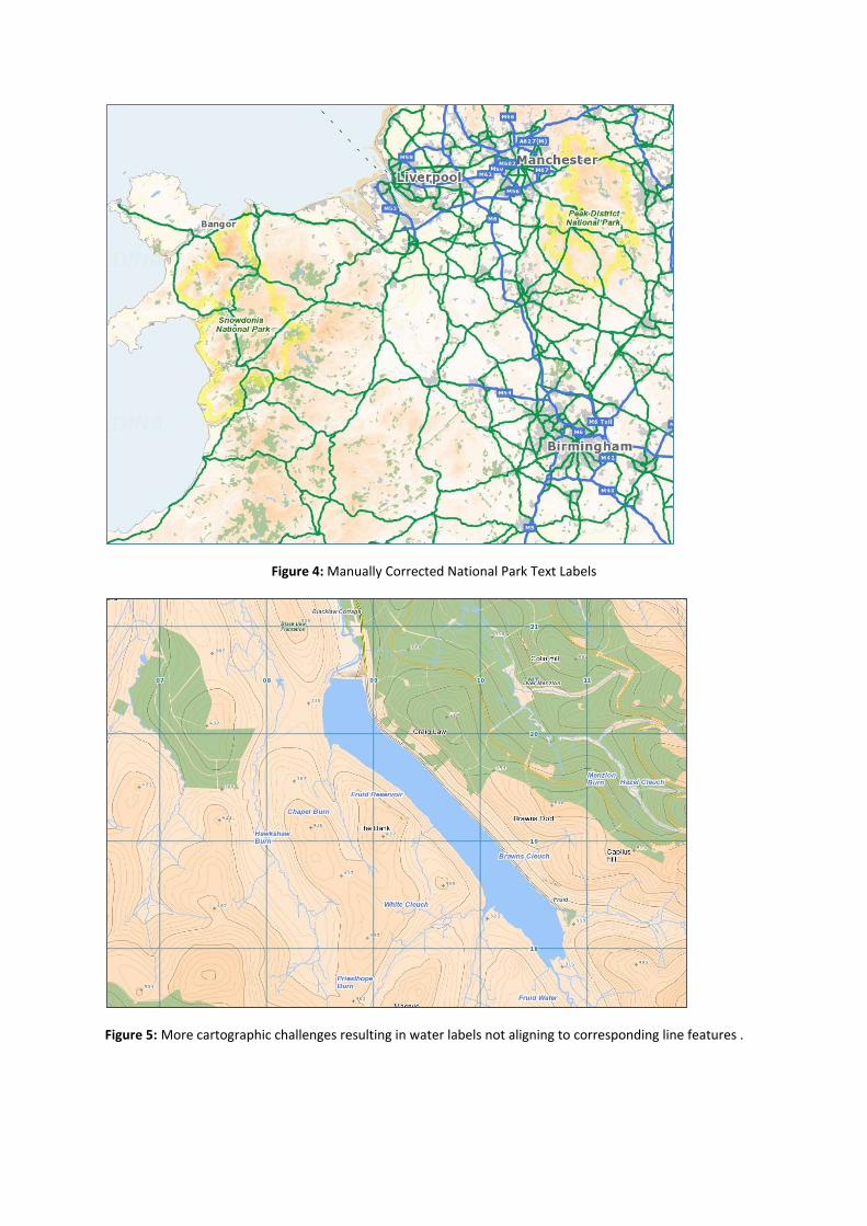
Figure 4: Manually Corrected National Park Text Labels
Figure 5: More cartographic challenges resulting in water labels not aligning to corresponding line features .
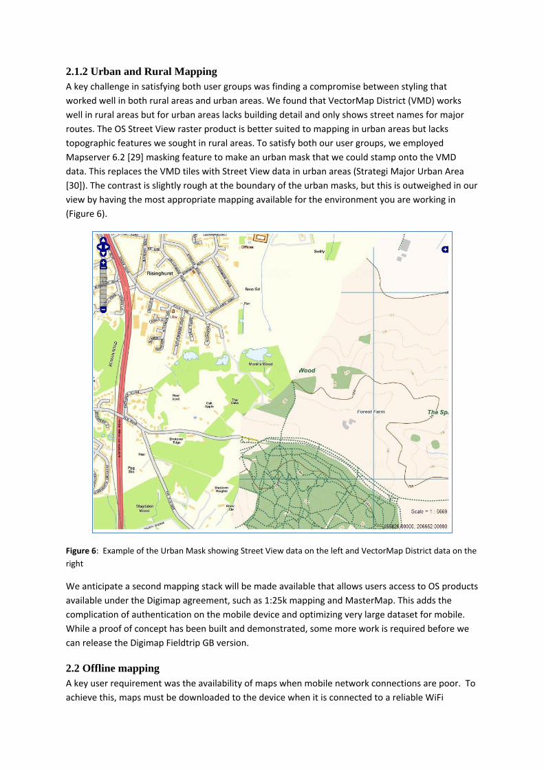
2.1.2 Urban and Rural Mapping
A key challenge in satisfying both user groups was finding a compromise between styling that
worked well in both rural areas and urban areas. We found that VectorMap District (VMD) works
well in rural areas but for urban areas lacks building detail and only shows street names for major
routes. The OS Street View raster product is better suited to mapping in urban areas but lacks
topographic features we sought in rural areas. To satisfy both our user groups, we employed
Mapserver 6.2 [29] masking feature to make an urban mask that we could stamp onto the VMD
data. This replaces the VMD tiles with Street View data in urban areas (Strategi Major Urban Area
[30]). The contrast is slightly rough at the boundary of the urban masks, but this is outweighed in our
view by having the most appropriate mapping available for the environment you are working in
(Figure 6).
Figure 6: Example of the Urban Mask showing Street View data on the left and VectorMap District data on the
right
We anticipate a second mapping stack will be made available that allows users access to OS products
available under the Digimap agreement, such as 1:25k mapping and MasterMap. This adds the
complication of authentication on the mobile device and optimizing very large dataset for mobile.
While a proof of concept has been built and demonstrated, some more work is required before we
can release the Digimap Fieldtrip GB version.
2.2 Offline mapping
A key user requirement was the availability of maps when mobile network connections are poor. To
achieve this, maps must be downloaded to the device when it is connected to a reliable WiFi
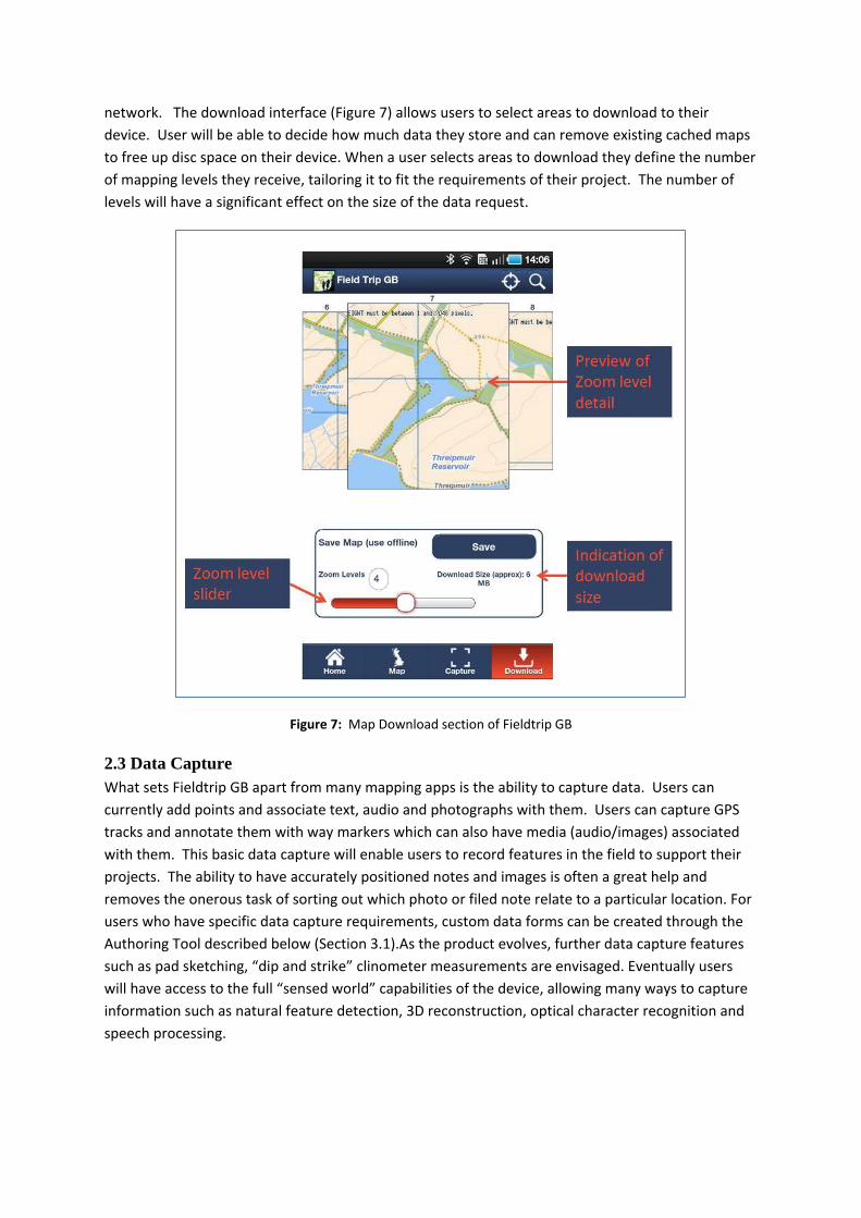
network. The download interface (Figure 7) allows users to select areas to download to their
device. User will be able to decide how much data they store and can remove existing cached maps
to free up disc space on their device. When a user selects areas to download they define the number
of mapping levels they receive, tailoring it to fit the requirements of their project. The number of
levels will have a significant effect on the size of the data request.
Figure 7: Map Download section of Fieldtrip GB
2.3 Data Capture
What sets Fieldtrip GB apart from many mapping apps is the ability to capture data. Users can
currently add points and associate text, audio and photographs with them. Users can capture GPS
tracks and annotate them with way markers which can also have media (audio/images) associated
with them. This basic data capture will enable users to record features in the field to support their
projects. The ability to have accurately positioned notes and images is often a great help and
removes the onerous task of sorting out which photo or filed note relate to a particular location. For
users who have specific data capture requirements, custom data forms can be created through the
Authoring Tool described below (Section 3.1).As the product evolves, further data capture features
such as pad sketching, “dip and strike” clinometer measurements are envisaged. Eventually users
will have access to the full “sensed world” capabilities of the device, allowing many ways to capture
information such as natural feature detection, 3D reconstruction, optical character recognition and
speech processing.
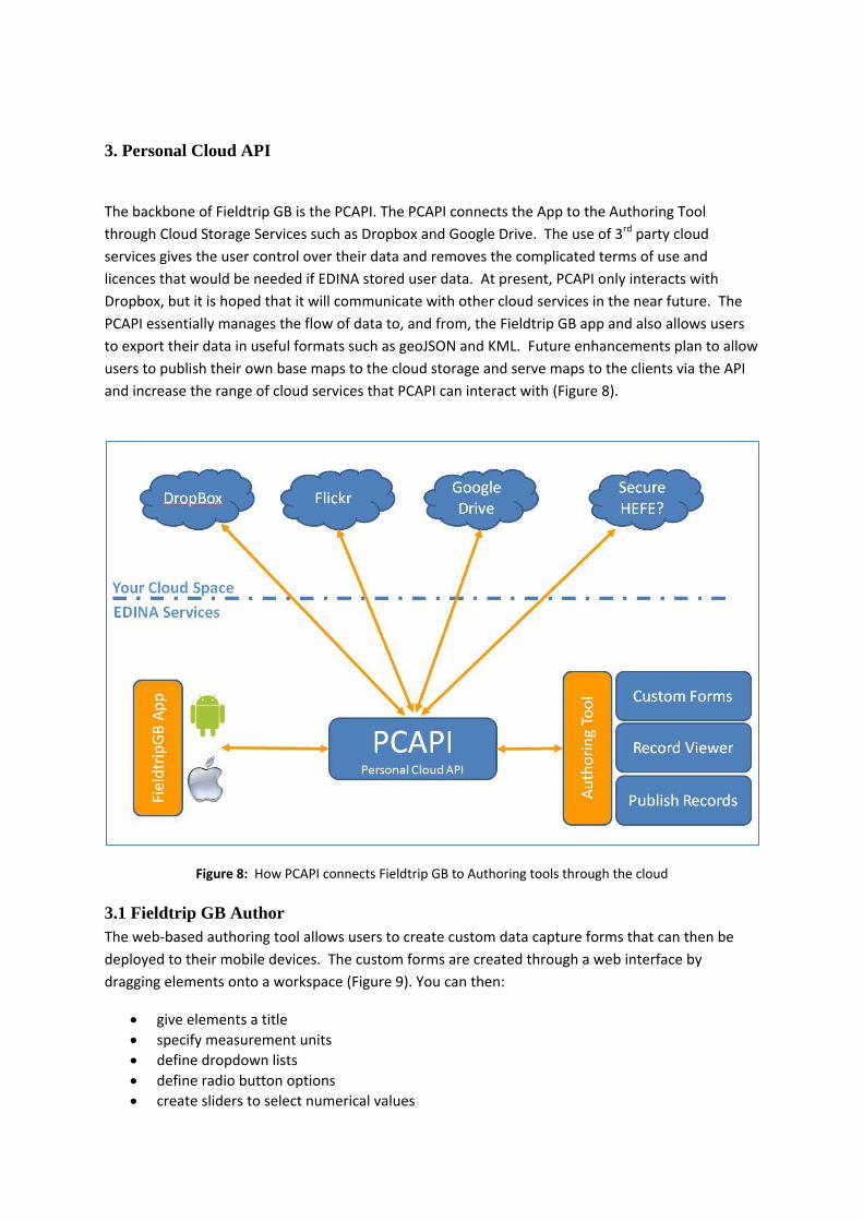
3. Personal Cloud API
The backbone of Fieldtrip GB is the PCAPI. The PCAPI connects the App to the Authoring Tool
through Cloud Storage Services such as Dropbox and Google Drive. The use of 3rd party cloud
services gives the user control over their data and removes the complicated terms of use and
licences that would be needed if EDINA stored user data. At present, PCAPI only interacts with
Dropbox, but it is hoped that it will communicate with other cloud services in the near future. The
PCAPI essentially manages the flow of data to, and from, the Fieldtrip GB app and also allows users
to export their data in useful formats such as geoJSON and KML. Future enhancements plan to allow
users to publish their own base maps to the cloud storage and serve maps to the clients via the API
and increase the range of cloud services that PCAPI can interact with (Figure 8).
Figure 8: How PCAPI connects Fieldtrip GB to Authoring tools through the cloud
3.1 Fieldtrip GB Author
The web-based authoring tool allows users to create custom data capture forms that can then be
deployed to their mobile devices. The custom forms are created through a web interface by
dragging elements onto a workspace (Figure 9). You can then:
give elements a title
specify measurement units
define dropdown lists
define radio button options
create sliders to select numerical values
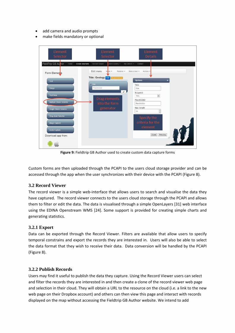
add camera and audio prompts
make fields mandatory or optional
Figure 9: Fieldtrip GB Author used to create custom data capture forms
Custom forms are then uploaded through the PCAPI to the users cloud storage provider and can be
accessed through the app when the user synchronizes with their device with the PCAPI (Figure 8).
3.2 Record Viewer
The record viewer is a simple web-interface that allows users to search and visualise the data they
have captured. The record viewer connects to the users cloud storage through the PCAPI and allows
them to filter or edit the data. The data is visualised through a simple OpenLayers [31] web interface
using the EDINA Openstream WMS [24]. Some support is provided for creating simple charts and
generating statistics.
3.2.1 Export
Data can be exported through the Record Viewer. Filters are available that allow users to specify
temporal constrains and export the records they are interested in. Users will also be able to select
the data format that they wish to receive their data. Data conversion will be handled by the PCAPI
(Figure 8).
3.2.2 Publish Records
Users may find it useful to publish the data they capture. Using the Record Viewer users can select
and filter the records they are interested in and then create a clone of the record viewer web page
and selection in their cloud. They will obtain a URL to the resource on the cloud (i.e. a link to the new
web page on their Dropbox account) and others can then view this page and interact with records
displayed on the map without accessing the Fieldtrip GB Author website. We intend to add
enhancements so that the user can add their own logos, titles, branding and base maps so that they
can fully make the output of the data capture exercise their own.
4. Architecture and engineering
Compared to standard web application development, we found developing a mapping application
for mobile challenging. During the project we worked for some time on an iOS version of the app,
using native APIs and libraries. At the same time, we developed a version for Android using the
PhoneGap [32] web/native hybrid solution, where the bulk of development is done in a web browser
embedded within the app using more familiar web technologies such as HTML, CSS and Javascript.
Having worked with both native iOS and the PhoneGap [32] framework, it is clear now that hybrid is
a better option for an app such as Fieldtrip GB. We found that reusing existing well established web
mapping technologies such as OpenLayers [31] was more versatile than native map frameworks,
with support for multiple projections and protocols making it easier to adapt to changing
requirements. This outweighed the impact on the user-experience that using a hybrid app creates.
With the dizzying speed of change in mobile technology this versatility pays off, even if a native
solution seems a less bulky and more appealing at first. The embedded web browser also worked
best for including custom data forms, allowing us to use HTML5 Forms in both the mobile client and
the desktop based Authoring Tool. Attempting to render user defined data forms using a native UI
seemed to be re-inventing core aspects of the web browser, so embedding a web view in the app
proved less of an overhead than originally thought. Overall, these small differences add up to a huge
difference in cost of ownership and make running a service such as Fieldtrip GB a more sustainable
proposition.
Another way we simplified the architecture of the application was to pre-cache all tiles so that front
facing servers had no dependencies on databases or map server middleware. The maps were
generated using Mapserver 6.2 [29] with PostGIS [33]. These components were deployed on
multiple instances to a cloud infrastructure using OpenStack [34], so that tile generation could be
scaled without committing long term hardware infrastructure. The MapCache seeder [35] process
was configured to send requests to multiple cloud instances. Once cached, the cloud instances could
be dispensed with, leaving Mapcache the only backend component. We can replicate, load balance
and scale the Mapcache relatively easily reducing costs, dependencies and points of failure.
5. Conclusions
There are many mobile apps being developed for specific data capture tasks. It is clear to us that data capture will grow in popularity as mobile devices get ever more powerful. Soon tools for recognizing faces, places, generating 3d point clouds, augmenting sketches and precise field measurement will be available in millions of pockets. We found a hybrid web/native approach is the most affordable and flexible option for creating data capture applications that work on multiple platforms, especially when the app integrates with an HTML5 web site for managing data. We have outsourced parts of the application (e.g. digital asset storage) and simplified the architecture to bring down cost of ownership.
Given the difficulty in developing products for an ever more fragmented mobile technology space, we believe an approach that allows users to customise generic apps is preferred to an ever increasing proliferation of standalone apps with similar functionality. While apps running in a
general purpose web browser are not likely to meet user expectations, we believe an app that covers a particular theme such as field exercises or citizen science can be made flexible enough to support several different projects. In the case of Fieldtrip GB project, the Authoring Tool appears to be the key to our mapping app becoming a genuinely useful educational resource. People we have demonstrated Fieldtrip GB are more excited about the possibilities of the Authoring Tool than they are about the app itself. It seems that empowering users to make the app do what exactly what they want it to do, rather than design an app for a generic “user story” is the route to ensuring adoption. Therefore the FieldtripGB Author tool has become the focus for future development of Fieldtrip GB.
6. Acknowledgements
We would like to acknowledge the generous and ongoing support of JISC both for their investment
in this project and promoting mobile technology across Higher Education community. We also
acknowledge Ordnance Survey for their continuing to support Higher Education and their Open Data
initiative.
7. References and Resources
[1] FieldTrip GB website, http://fieldtripgb.blogs.edina.ac.uk/ (accessed 29/01/2013)
[2] Edina, http://edina.ac.uk/ (accessed 29/01/2013)
[3] Meeker, M and Wu Liang (2012) Internet Trends, http://kpcb.com/insights/2012-internet-
trends, KPCB, (accessed 29/01/2013)
[4] Butchart, B (2012) Towards a Sensed World Description Language,
http://www.perey.com/ARStandards/[Butchart]Sensed_World_Web_AR_Standards.pdf,
Sixth International AR Standards Community Meeting, Geneva.
[5] Welsh, K., France, D., Whalley, W.B, Park, J.R, (2012) Geotagging Photographs in Fieldwork,
Journal of Geography in Higher Education.
[6] Welsh, K., France, D. (2012) Spotlight on….Smartphones and fieldwork, Geography, Vol.97 (1),
p.47-51
[7] Roy, H.E., Pocock, M.J.O., Preston, C.D., Roy, D.B. & Savage, J. Tweddle, J.C. & Robinson, L.D.,
(2012) Understanding Citizen Science and Environmental Monitoring, UK Environmental Observation
Framework, http://www.ceh.ac.uk/products/publications/documents/CitizenScienceReview.pdf
(accessed 29/01/2013)
[8] Birdtrack https://play.google.com/store/apps/details?id=bto.org.monitoring.birdtrack (accessed
01/02/2013)
[9] Leafwatch http://leafwatch.naturelocator.org/ (accessed 01/02/2013)
[10] Project Budburst http://budburst.org/gomobile.php (accessed 01/02/2013)
[11] Dropbox www.dropbox.com/ (accessed 01/02/2013)
[12] Wordpress, http://wordpress.com/ (accessed 01/02/2013)
[13] Flickr, http://www.flickr.com/, (accessed 01/02/2013)
[14] Panoramio, http://www.panoramio.com/, (accessed 01/02/2013)
[15] Evernote, http://evernote.com/, (accessed 01/02/2013)
[16] Epicollect, http://www.epicollect.net/ (accessed 01/02/2013)
[17] Wildknowledge, http://www.wildknowledge.co.uk/, (accessed 01/02/2013)
[18] Fulcrum, http://fulcrumapp.com/, (accessed 01/02/2013)
[19] Ordnance Survey, http://www.ordnancesurvey.co.uk/oswebsite/ (accessed 29/01/2013)
[20] Pope A (2012) Usability Service Enhancements to Digimap,
http://used.blogs.edina.ac.uk/personas/ , EDINA, University of Edinburgh
[21] OS OpenData , http://www.ordnancesurvey.co.uk/oswebsite/products/os-opendata.html
(accessed 29/01/2013)
[22] Google Maps, http://maps.google.co.uk/
[23] OpenStreetMap, http://www.openstreetmap.org/, (accessed 29/01/2013)
[24] EDINA Openstream, openstream.edina.ac.uk, (accessed 29/01/2013)
[25] OS OpenSpace http://www.ordnancesurvey.co.uk/oswebsite/business/licences/using-and-
creating-data-with-os-products/os-openspace/index.html, (accessed 01/02/2013)
[26] Ordnance Survey Strategi,
http://www.ordnancesurvey.co.uk/oswebsite/products/strategi/index.html, (accessed 01/02/2013)
[27] Ordnance Survey VectorMap District,
http://www.ordnancesurvey.co.uk/oswebsite/products/os-vectormap-district/index.html, (accessed
01/02/2013)
[28] Ordnance Survey Land-Form PANORAMA
http://www.ordnancesurvey.co.uk/oswebsite/products/land-form-panorama/index.html
(accessed 01/02/2013)
[29] Mapserver 6.2, http://mapserver.org/development/announce/6-2.html, (accessed 01/02/2013)
[30] Ordnance Survey (2012), Strategi User Guide And Technical Specification v.8.4, pp.15-16,
Ordnance Survey. http://www.ordnancesurvey.co.uk/oswebsite/docs/user-guides/strategi-user-
guide.pdf (accessed 01/02/2013)
[31] OpenLayers homepage, http://openlayers.org/ (accessed 01/02/2013)
[32] Phone Gap, http://phonegap.com/ (accessed 01/02/2013)
[33] PostGIS, http://postgis.net/, (accessed 01/02/2013)
[34] Openstack project homepage , http://www.openstack.org/ (accessed 01/02/2013)
[35] Mapcache seeder documentation, http://mapserver.org/mapcache/seed.html, (accessed
01/02/2013)
Biography
Addy Pope – is a member of the geo team at EDINA and has over 10 years’ experience as a GIS
professional. Prior to this he was involved in research in glacial remote sensing.
Ben Butchart – is head of geo-engineering at EDINA. Ben has over 15 years of software development
experience in both commercial and academic sectors.
Murray King – is a senior developer in the geo team and has over 10 years’ experience of developing
technical solutions in the commercial sector
George Hamilton - is a senior developer in the geo team and has over 10 years’ experience of
developing technical solutions in the commercial sector
Panos Terzis – is a developer in the geo-team with an MSc in GIS he has focused on developing GIS
tools
Michael Koutroumpas– is an experienced web developer working in the geo team at EDINA