ecosystems labels environment canada...
TRANSCRIPT
E
E
E
E
E
E
EE
E
E
E
E
E
E
E
E
E
E
E
E
E
E
E
E
E
E
E
E
E
E
E
E
E
E
E
E
E
E
E
E
E
E
E
E
E
E
E
E
E
E
E
E
E
E
E
E
E
E
E
E
E
E
(
(
(
(
(
(
(
(
(
(
(
(
(
(
(
(
(
(
(
(
(
(
(
(
(CWHdm
GEL
SPRCWHdm
SOGCWHxm1
GELCWHxm1
GELCWHdm
CWHxm1
SOG
SPRCWHdm
Mink
Island
U N
D
CallBight
LucyPoint
Curme
Islands
Morgan
Island
MT
SPOONER
M I
N K
I S
L A
N D
T E N E D O S
B A Y U N W I N
L A K E
Sky
Pilot
Rock
Pringle
Rock
Grass
Islet
PaigeIslets
OrielRocks
LucyIslet
Ray
Rock
L l o y d C r e e k
U N W I N
R A N G E
W A
D D
I
N
G T
O
N
C
H
A N
N
E
L
W E S T
R E D O N D A
I S L A N D
D
E
S
O
L
A
T
I
O
N
S
O
U
N
D
H O
M F
R
A Y
C
H
A
N
N
E
L
E A S T R E D O N D A
I S L A N D
Melville
Island
ElworthyIsland
MarylebonePoint
MaryIslands
M e l a n i e C o v e
C o p p l e s t o n e I
HoraceHead
William
Islands
T H
E O
D O
S
I A
R I V E R
Prideaux
HavenE v e l e i g h
I s l a n d
Otter
Island
Price
Point
B l a c k L a k e
Eveleigh
Anchorage
CopplestonePoint
Lloyd
Point
L a u r a
C o v e
Call
Bight
Roffey
Island
ChurchPoint
R o s c o e B a y
MelaniePoint
LLANOVER
MTN
ScobellIsland
Bold
Head
E L
Redonda
IslandDurham
Point
725010OF:co
79467RI:ff3RI:ff
72898MF:co2MF:co
78176RI:ff3RI:gu1YF
76278RI:ff
2WN:sp
74815MF:co5MF:co
776810MF:co
72957RI:ff2RI:fh1RI:ri
758110MF:co
80897RI:ff3RI:ff
748710OF:co
77499MF:co
1YF
805410MF:co
81189MF:co
1YF
76915WD:co3MF:co2MF:co
80316RI:ff4RI:fh
766010MF:co
72536RI:ff2RI:ff
2WN:sp
74117MF:co3MF:co
732910RI:ff
761710RI:ff
78615MF:co5MF:co
746410MF:co
82197MF:co
3YF
82629RI:ff1RI:fm
79615RI:gu5RI:ff
80257MF:co3MF:co
73647MF:co3WD:co
74898MF:co2WD:mx
81778MF:co2MF:co
770310RI:ff
761910RI:ff
739710MF:co
771710MF:co
795810MF:co
74246RI:fl4RI:ff
749810MF:co
766510MF:co
735810MF:co
72185MF
791410MF:co
174588MF:co2WD:co
770610MF:co
754510RI:fl
81928RI:ff2RI:fm
773510MF:co
719910RI:ff
751510MF:co
746610RI:fh
75118WN:sp2WN:sp
81869MF:co1WD:co
761510RI:ff
79165RI:gu5RI:ff
76737MF:co3MF:co
773010WD:co
79136MF:co4MF:co
75429MF:co1HB:hb
75988OF:co2MF:co
789810MF:co
76708RI:ff
2MF:co
820010MF:co
809210MF:co
768410MF:co
789910MF:co
747410MF:co
77025RI:ff
5MF:co
743410RI:fh
73446MF:co2MF:co2MF:co
734010MF:co
78216HB:cs4WD:co
77089MF:co1WD:co
750910RI:ff
759610RI:ff
759910MF:co
727710MF:co
73284MF:co3RI:ff
3WN:sp
791210RI:ff
75719MF:co
1YF
77485RI:ff
5MF:co
78626MF:co4MF:co
793010MF:co
763710MF:co
442
73454MF:co4MF:co2WD:co
801010MF:co
758810RI:fh
762810MF:co
728010MF:co
765210MF:co
818410MF:co
73506MF:co4MF:co
790410MF:co
73144RI:ff4YF2RI:ff
755510RI:ff
78406WD:co4MF:co
73419MF:co1HB:hb
79787MF:co
2YF1WD:co
78136RI:ff2RI:ff2RI:ff
750410RI:ff
782610WD:co
82428MF:co2HB:vs
76016WD:co4MF:co
78096MF:co2MF:co2MF:co
83687RI:ff3RI:ff
74766MF:co4MF:co
780410MF:co
174958MF:co2WD:co
75358RI:ff2RI:ff
7500*6WN:sw4WN:ms
77658MF:co2MF:co
80097RI:gu3RI:gu
80489MF:co1WD:co
82215MF:co4MF:co1HB:hb
77748RI:gu2RI:ff
81537MF:co3MF:co
741010WD:co
77425MF:co3WD:co2OF:co
727810WN:sp
75828RI:gu2RI:gu
81788WD:co2HB:sh
733910RI:ff
76386MF:co4MF:co
76728RI:ff2RI:ff
755410MF:co
76906MF:co4MF:co
728410RI:ff
73157WD:mx3MF:co
766310CL:cc
75365RI:gu5RI:ff
771010HB:vs
767510HB:vs
77668WD:co2HB:hb
81568HB:vs2HB:sh
764410HB:vs
817210HB:vs
828110HB:vs
760510HB:vs
81957WD:co3HB:hb
82768WD:co2HB:cs
771110HB:vs
825910HB:vs
833210HB:vs
817310HB:vs
812610HB:vs
79577WD:co3MF:co
756410RI:ff
779810RI:ff
762110MF:co 7634
10RI:ff
78224CL:cc3HB:sh3WD:co
77525WD:co3HB:hb2MF:co
79224MF:co3RI:ff3YF
741410WD:co
80565WN:sp5WN:sp
80557WD:co3HB:sh
734W3W3R
812710MF:co
78548MF:co
2YF
82605OF:co5MF:co
823510MF:co
804010RI:ff
75947WN:bg2WN:fn1WN:sw
744310WN:sp
7421*8MF:co2MF:co
738510WD:co
80128WN:sp2RI:ff
78596RI:ff4RI:fm
78456WD:co2MF:co2HB:sh
740110RI:ff
73205MF:co5MF:co
82166MF:co4WD:co
781410MF:co
744610WN:sp
806910WD:co
777310WD:co
80168WD:co2MF:co
73934WD:co4MF:co2HB:sh
788710WD:co
78686MF:co4WD:co
77245HB:sh5HB:cs
75657HB:sh3WD:co
7392*6WD:mx2HB:sh2MF:co
765810MF:co
754610RI:ff
80438MF:co2WD:co
81918WD:co2HB:cs
75328WN:sp2WN:ms
737110WD:co
74954RI:ff
4MF:co2WN:sp
77456RI:ff
4MF:co
76834WD:co4HB:sh2HB:hb
745310WN:sp
778610MF:co
803510WD:co
73235MF:co5MF:mx
83028MF:co2HB:hb
177264HB:sh3CL:cc3HB:hb
74856WD:mx2HB:hb2HB:sh
74757WD:co3MF:co
819910MF:co
732710MF:co
1822110MF:co
771610MF:co
77625HB:hb4WD:co1CL:ic
82978MF:co2HB:cs
810310MF:co
77266MF:co4WD:co
74927WN:sp3WN:sp
735510RI:ff
735610MF:co
769310RI:ff
76667WD:co3MF:co
80955RI:ff5RI:ff
797110RI:ff
806810MF:co
753310MF:co
784310WD:mx
777910RI:ff
80196WN:sp
4YF
7480*10RI:ff
79526RI:ff
2WN:sp2RI:ff
778410WD:co
7413*7WD:mx2HB:hb1CL:ic
78396WD:co2HB:cs2CL:cc
81417WD:co3CL:cc
80524RI:ff
3WN:ms3WN:sp
765110WN:sp
77785MF:co3HB:cs2WD:co
80498MF:co2WD:co
75535WD:mx5HB:sh
745010RI:ff
753110RI:ff
750610WD:co
78107WD:co2HB:sh1HB:cs
80457MF:co3WD:co
78576WD:co4HB:hb
77585RI:ff
5WN:sp
77555HB:sh5HB:cs
82729MF:co1HB:vs
758710RI:ff
759310WN:sp
78927MF:co3WN:sp
750310MF:co
738110MF:co
76396HB:cs4WD:co
747010RI:ff
743310WN:sp
757310WN:sp
76648RI:ff
2WN:sp
836710HB:vs
73324MF:co4WD:co2MF:co
78206RI:ff4RI:gu
767910WD:co
81967WD:co3HB:cs
76147RI:ff3RI:ff
73946HB:cs4WD:co
77367WN:sp3WN:bg
826410WN:sw
77644HB:cs3WD:co3HB:sh
74495WD:co5WD:co
80669WD:co1CL:cc
743610MF:co
763010MF:co
73667RI:ff2RI:ff
1WN:sp
737010RI:ff
7668*7WD:co3HB:cs
77295RI:ff5RI:ff7631
10WD:co
744210RI:ff
735110MF:co
72586MF:co4WN:sp
798710RI:ff
829610OF:co
74396WN:bg4WN:bg
759110RI:ff
76437HB:cs
3YF
803810WN:sp
748310RI:ff
76888WD:co2MF:co
745810WN:bg
74865WN:ms5WN:sp
804610RI:ff
82478MF:co2HB:vs
78496CL:cc4HB:hb
73085RI:ff5RI:ff
815410WD:co
76267HB:cs3WD:co
778310WN:sp
762210CL:cc
7704*8WD:co2HB:vs
76805WD:co3CL:cc2HB:cs
73224MF:co4HB:sh2MF:co
794410WN:sp
762310WN:sp
7613*5WD:co5HB:vs
754910WN:sw
82116MF:co4HB:cs
762910WD:co
74555MF:co3HB:cs2HB:vs
82385CL:ic
5WD:co
73966WN:sp4RI:ff
81057MF:co3HB:sh
74356CL:cc4WD:co
82056CL:cc4WD:co
7681*6WD:co4HB:vs
793110WN:sw
763210CL:cc
817610WD:co
775110WN:sp
833010HB:vs
755010HB:vs
764010WD:co
833110HB:vs
760710WN:sw
796510MF:co
837010HB:vs
567110HB:vs
829910HB:vs
839810HB:vs8384
10HB:vs
765910HB:vs
823610HB:vs
755210HB:vs
828210HB:vs
837410HB:vs
792710HB:vs
69467RI:ff2RI:ff1RI:fh
372000m.E
372000m.E
74
74
76
76
78
78
380
380
82
82
84
84
386000m.E
386000m.E
5552
000m
. N
5552
000m
. N
54 54
56 56
58 58
5560 5560
5562
000m
. N
5562
000m
. N
124°48'0"W
124°48'0"W
124°36'0"W
124°36'0"W
50°6
'0"N
50°6
'0"N
50°1
2'0"
N
50°1
2'0"
N
092K.017092K.017
092K.017 092K.017
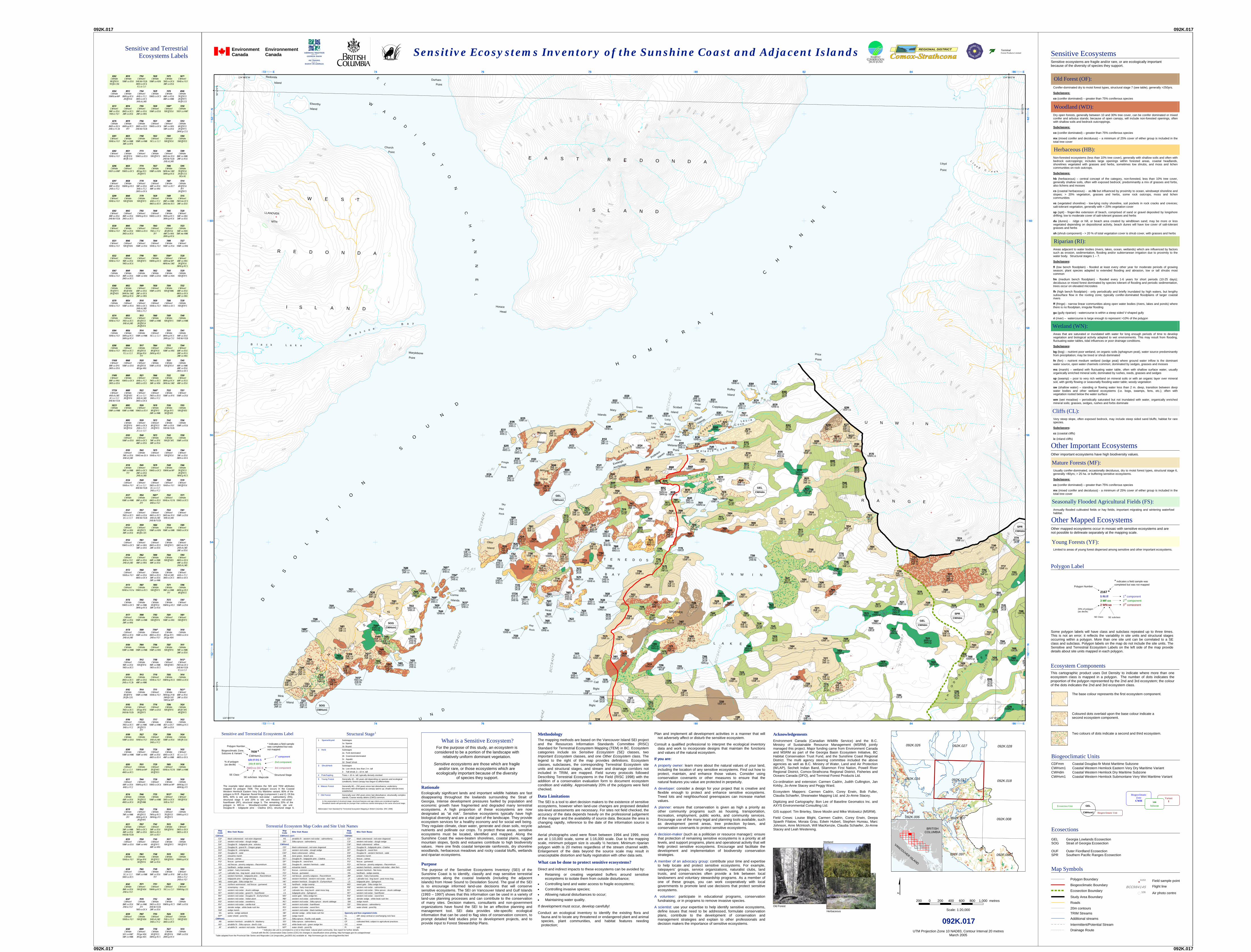
Sensitive ecosystems are fragile and/or rare, or are ecologically important because of the diversity of species they support.
Sensitive Ecosystems
Variant
1
Biogeoclimatic Zone
CWH xm Subzone Ecosection Unit GEL
CWHxm1 Biogeoclimatic Unit
Sensitive Ecosystems Inventory of the Sunshine Coast and Adjacent IslandsSensitive and TerrestrialEcosystems Labels
Map Symbols
Field sample point
Air photo centre
Flight line
Map Code Site Unit Name Map
Code Site Unit Name Map Code Site Unit Name
CDFmm CWHvm1 con't CWHdm CD* black cottonwood - red-osier dogwood AS amabilis fir - western red-cedar - salmonberry CD* black cottonwood - red-osier dogwood CS* western red-cedar - slough sedge SS* Sitka spruce - salmonberry CS* western red-cedar - slough sedge DA* Douglas-fir - lodgepole pine - arbutus CWHxm1 CW* black cottonwood - willow DG* Douglas-fir - grand fir - Oregon grape CD* black cottonwood - red-osier dogwood DC* Douglas-fir - lodgepole pine - Cladina DO* Douglas-fir - oniongrass CS* western red-cedar - slough sedge DF* Douglas-fir - sword fern DS* Douglas-fir - salal CW* black cottonwood - willow DS* Douglas-fir - western hemlock - salal EM* estuarine marsh DB dune grass - beach pea EM* estuarine marsh FC* fescue - camas DC* Douglas-fir - lodgepole pine - Cladina FC* fescue - camas FG* fescue - gumweed DF* Douglas-fir - sword fern FG* fescue - gumweed FO* red fescue - poverty oatgrass - Racomitrium DS* Douglas-fir - western hemlock - salal FO* red fescue - poverty oatgrass - Racomitrium HS hardhack - sedge swamp EM* estuarine marsh HD* western hemlock - western red-cedar - deer fern JM* juniper - hairy manzanita FC* fescue - common camas HM* western hemlock - flat moss LP* Labrador tea - bog laurel - peat moss bog FG* fescue - gumweed HS hardhack - sedge swamp LR western hemlock - lodgepole pine - Racomitrium FO* red fescue - poverty oatgrass - Racomitrium JM* juniper - hairy manzanita LS* lodgepole pine - Sphagnum bog HD* western hemlock - western red-cedar - deer fern LP Labrador tea - bog laurel - peat moss bog MS sweet gale - Sitka sedge fen HK* western hemlock - Douglas-fir - Eurhynchium LS lodgepole pine - Sphagnum NF northern wormwood - red fescue - gumweed HS hardhack - sedge swamp MS* sweet gale - Sitka sedge fen OR oceanspray - rose JM* juniper - hairy manzanita RB* western red-cedar - salmonberry RC* western red-cedar - skunk cabbage LP Labrador tea - bog laurel - peat moss bog RC* western red-cedar - Sitka spruce - skunk cabbage RF* western red-cedar - grand fir - foamflower LS lodgepole pine - Sphagnum RF* western red-cedar - foamflower RK* western red-cedar - Douglas-fir - Eurhynchium MS* sweet gale - Sitka sedge fen RS* western red-cedar - sword fern RP* western red-cedar - Indian-plum RB* western red-cedar - salmonberry SB* slender sedge - white beak-rush fen RS* western red-cedar - snowberry RC* western red-cedar - Sitka spruce - skunk cabbage SM sedge marsh RV* western red-cedar - vanilla-leaf RF* western red-cedar - foamflower SS* Sitka spruce - salmonberry SB* slender sedge - white beak-rush fen RS* western red-cedar - sword fern WP water shield - pond lily SM* sedge marsh RT* western red-cedar - black twinberry SS spirea - sedge wetland SB* slender sedge - white beak-rush fen Sparsely and Non-vegetated Units
WP* water shield - pond lily SM* sedge marsh CL cliff: steep vertical or overhanging rock face CWHvm1 SP* Sitka spruce - Pacific crab apple RI river
AB western hemlock - amabilis fir - blueberry SS* Sitka spruce - salmonberry CF cultivated field, subject to agricultural practices AD* amabilis fir - Sitka spruce - devil's club WG* white beak-rush - green sedge fen OC ocean AF amabilis fir - western red-cedar - foamflower WP* water shield - pond lily PI spit
* Indicates site unit is correlated to a red or blue listed natural plant community. See report for further details. Consult with the BC Conservation Data Centre (CDC) for changes in classification since printing. http://srmapps.gov.bc.ca/apps/eswp/
Table adapted from the Provincial Site Series and Mapcodes List (mapcodes_jan2003.xls) available at: http://srmwww.gov.bc.ca/ecology/tem/list.html
Terrestrial Ecosystem Map Codes and Site Unit Names
092K.007
092K.017
092F.097
092K.016
092K.008092K.006
092K.018
092F.096
092K.027
092F.098
092K.026 092K.028
VANCOUVER ISLAND
BRITISHCOLUMBIA
Acknowledgements Environment Canada (Canadian Wildlife Service) and the B.C. Ministry of Sustainable Resource Management (MSRM) jointly managed this project. Major funding came from Environment Canada and MSRM as part of the Georgia Basin Ecosystem Initiative, BC Habitat Conservation Trust Fund, and the Sunshine Coast Regional District. The multi agency steering committee included the above agencies as well as B.C. Ministry of Water, Land and Air Protection (WLAP), Sechelt Indian Band, Sliammon First Nation, Powell River Regional District, Comox-Strathcona Regional District, Fisheries and Oceans Canada (DFO), and Terminal Forest Products Ltd.
Co-ordination and extension: Carmen Cadrin, Judith Cullington, Jan Kirkby, Jo-Anne Stacey and Peggy Ward.
Ecosystem Mappers: Carmen Cadrin, Corey Erwin, Bob Fuller, Claudia Schaefer, Shearwater Mapping Ltd. and Jo-Anne Stacey.
Digitizing and Cartography: Bon Lee of Baseline Geomatics Inc. and AXYS Environmental Consulting Ltd.
GIS support: Tim Brierley, Steve Moslin and Mike Wolowicz (MSRM).
Field Crews: Louise Blight, Carmen Cadrin, Corey Erwin, Deepa Spaeth Filatow, Moraia Grau, Edwin Hubert, Stephen Hureau, Marc Johnson, Anre McIntosh, Will MacKenzie, Claudia Schaefer, Jo-Anne Stacey and Leah Westereng.
$092K.017
UTM Projection Zone 10 NAD83, Contour Interval 20 metresMarch 2005
Scale: 1:20,000
200 0 200 400 600 800 1,000 metres
Structural Stage1
1 Sparse/bryoid Substages 1a Sparse 1b Bryoid 2 Herb Substages 2a Forb-dominated 2b Graminoid-dominated 2c Aquatic 2d Dwarf shrub 3 Shrub/Herb Substages 3a Low shrub; less than 2 m. tall 3 Tall shrub; 2 – 10 m. tall 4 Pole/Sapling Trees > 10 m. tall; typically densely stocked
5 Young Forest
Generally 40 – 80 years old depending on species and ecological conditions; forest canopy has begun to differentiate
6 Mature Forest Generally 80 – 250 years since last disturbance; understory becomes well developed as canopy opens up; shade tolerant trees established
7 Old Forest Generally over 250 years since last disturbance; structurally complex stands; Coarse woody debris (CWD) common.
1 In the assessment of structural stage, structural features and age criteria are considered together. Broadleaf stands will generally be younger than coniferous stands belonging to the same structural stage.
Abbreviated from Standard for Terrestrial Ecosystem Mapping in British Columbia (RIC 1998)
Biogeoclimatic UnitsCDFmmCWHxm1CWHdmCWHvm1
Coastal Douglas-fir Moist Maritime SubzoneCoastal Western Hemlock Eastern Very Dry Maritime VariantCoastal Western Hemlock Dry Maritime SubzoneCoastal Western Hemlock Submontane Very Wet Maritime Variant
GELSOG
OUFSPR
Georgia Lowlands EcosectionStrait of Georgia Ecosection
Outer Fiordland EcosectionSouthern Pacific Ranges Ecosection
Ecosections
Ecosystem Components
Some polygon labels will have class and subclass repeated up to three times. This is not an error; it reflects the variability in site units and structural stages occurring within a polygon. More than one site unit can be correlated to a SE class and subclass. Polygon labels on the map do not include the site units. The Sensitive and Terrestrial Ecosystem Labels on the left side of the map provide details about site units mapped in each polygon.
This cartographic product uses Dot Density to indicate where more than oneecosystem class is mapped in a polygon. The number of dots indicates theproportion of the polygon represented by the 2nd and 3rd ecosystem; the colourof the dots indicates the 2nd and 3rd ecosystem class.
The base colour represents the first ecosystem component.
Coloured dots overlaid upon the base colour indicate asecond ecosystem component.
Two colours of dots indicate a second and third ecosystem.
Terminal Forest Products Limited
Sensitive and Terrestrial Ecosystems Label
The example label above indicates the SEI and TEM attributesmapped for polygon 7838. The polygon occurs in the CoastalWestern Hemlock Eastern Very Dry Maritime variant; 80% of the polygon is RI:ff - Riparian: fluvial fringe (component 1 and 2). Of this80%, 60% is site unit Western red-cedar - salmonberry (RS), structural stage 5 and 20% is site unit Western red-cedar -foamflower (RF), structural stage 5. The remaining 20% of the polygon is WD:co - Woodland:conifer dominated, site unit Douglas-fir - lodgepole pine - Cladina (DC), structural stage 6.
7838 * CWHxm1
6RI:ff RS 5 2RI:ff RF5
2WD:co DC 6
* indicates a field sample was completed but was not mapped
Polygon Number
Biogeoclimatic Zone, Subzone & Variant
% of polygon (as decile)
Structural Stage Mapcode
SE Class
1st component
2nd component
3rd component
SE subclass
Polygon Boundary
Biogeoclimatic Boundary
Roads
20m contoursTRIM StreamsAdditional streams
Intermittent/Potential Stream Drainage Route
Study Area Boundary
BCC984145
( 106Ecosection Boundary
G153[
EnvironmentCanada
EnvironnementCanada
Conifer-dominated dry to moist forest types, structural stage 7 (see table), generally >250yrs.
Subclasses:
co (conifer dominated) – greater than 75% coniferous species
Dry open forests, generally between 10 and 30% tree cover, can be conifer dominated or mixed conifer and arbutus stands; because of open canopy, will include non-forested openings, often with shallow soils and bedrock outcroppings.
Subclasses: co (conifer dominated) – greater than 75% coniferous species
mx (mixed conifer and deciduous) – a minimum of 25% cover of either group is included in the total tree cover
Non-forested ecosystems (less than 10% tree cover), generally with shallow soils and often with bedrock outcroppings; includes large openings within forested areas, coastal headlands, shorelines vegetated with grasses and herbs, sometimes low shrubs, and moss and lichen communities on rock outcrops.
Subclasses:
hb (herbaceous) – central concept of the category, non-forested, less than 10% tree cover, generally shallow soils, often with exposed bedrock; predominantly a mix of grasses and forbs, also lichens and mosses
cs (coastal herbaceous) - as hb but influenced by proximity to ocean, windswept shoreline and slopes; > 20% vegetation, grasses and herbs, some rock outcrops, moss and lichen communities
vs (vegetated shoreline) - low-lying rocky shoreline, soil pockets in rock cracks and crevices; salt-tolerant vegetation, generally with < 20% vegetation cover
sp (spit) - finger-like extension of beach, comprised of sand or gravel deposited by longshore drifting; low to moderate cover of salt-tolerant grasses and herbs
du (dunes) - ridge or hill, or beach area created by windblown sand; may be more or less vegetated depending on depositional activity, beach dunes will have low cover of salt-tolerant grasses and herbs
sh (shrub component) - > 20 % of total vegetation cover is shrub cover, with grasses and herbs
Old Forest (OF):
Woodland (WD):
Herbaceous (HB):
Areas adjacent to water bodies (rivers, lakes, ocean, wetlands) which are influenced by factors such as erosion, sedimentation, flooding and/or subterranean irrigation due to proximity to the water body. Structural stages 1 – 7.
Subclasses:
fl (low bench floodplain) - flooded at least every other year for moderate periods of growing season; plant species adapted to extended flooding and abrasion, low or tall shrubs most common
fm (medium bench floodplain) - flooded every 1-6 years for short periods (10-25 days); deciduous or mixed forest dominated by species tolerant of flooding and periodic sedimentation, trees occur on elevated microsites
fh (high bench floodplain) - only periodically and briefly inundated by high waters, but lengthy subsurface flow in the rooting zone; typically conifer-dominated floodplains of larger coastal rivers
ff (fringe) - narrow linear communities along open water bodies (rivers, lakes and ponds) where there is no floodplain, irregular flooding
gu (gully riparian) - watercourse is within a steep sided V-shaped gully
ri (river) – watercourse is large enough to represent >10% of the polygon
Riparian (RI):
Usually conifer-dominated, occasionally deciduous, dry to moist forest types, structural stage 6, generally >80yrs; > 25 ha. or buffering sensitive ecosystems.
Subclasses:
co (conifer dominated) – greater than 75% coniferous species
mx (mixed conifer and deciduous) - a minimum of 25% cover of either group is included in the total tree cover
Annually flooded cultivated fields or hay fields; important migrating and wintering waterfowl habitat.
Mature Forests (MF):
Seasonally Flooded Agricultural Fields (FS):
Limited to areas of young forest dispersed among sensitive and other important ecosystems.
Young Forests (YF):
Areas that are saturated or inundated with water for long enough periods of time to develop vegetation and biological activity adapted to wet environments. This may result from flooding, fluctuating water tables, tidal influences or poor drainage conditions.
Subclasses:
bg (bog) – nutrient poor wetland, on organic soils (sphagnum peat), water source predominantly from precipitation; may be treed or shrub dominated
fn (fen) – nutrient medium wetland (sedge peat) where ground water inflow is the dominant water source, open water channels common; dominated by sedges, grasses and mosses
ms (marsh) – wetland with fluctuating water table, often with shallow surface water, usually organically enriched mineral soils; dominated by rushes, reeds, grasses and sedges
sp (swamp) – poor to very rich wetland on mineral soils or with an organic layer over mineral soil, with gently flowing or seasonally flooding water table; woody vegetation
sw (shallow water) – standing or flowing water less than 2 m. deep, transition between deep water bodies and other wetland ecosystems (i.e. bogs, swamps, fens, etc.); often with vegetation rooted below the water surface
wm (wet meadow) – periodically saturated but not inundated with water, organically enriched mineral soils; grasses, sedges, rushes and forbs dominate
Very steep slope, often exposed bedrock, may include steep sided sand bluffs; habitat for rare species.
Subclasses:
cc (coastal cliffs)
ic (inland cliffs)
Wetland (WN):
Cliffs (CL):
Other Important EcosystemsOther important ecosystems have high biodiversity values.
Other mapped ecosystems occur in mosaic with sensitive ecosystems and arenot possible to delineate separately at the mapping scale.
Other Mapped Ecosystems
What is a Sensitive Ecosystem?
For the purpose of this study, an ecosystem is considered to be a portion of the landscape with
relatively uniform dominant vegetation.
Sensitive ecosystems are those which are fragile and/or rare, or those ecosystems which are
ecologically important because of the diversity of species they support.
Rationale Ecologically significant lands and important wildlife habitats are fast disappearing throughout the lowlands surrounding the Strait of Georgia. Intense development pressures fuelled by population and economic growth have fragmented and degraded many terrestrial ecosystems. A high proportion of these ecosystems are now designated as “at risk”. Sensitive ecosystems typically have high biological diversity and are a vital part of the landscape. They provide ecosystem services for a healthy economy and for social well being. They regulate climate, clean water, generate and clean soils, recycle nutrients and pollinate our crops. To protect these areas, sensitive ecosystems must be located, identified and mapped. Along the Sunshine Coast the wave-beaten shorelines, coastal plains, rugged mountain slopes, fjords and estuaries contribute to high biodiversity values. Here one finds coastal temperate rainforests, dry shoreline woodlands, herbaceous meadows and rocky coastal bluffs, wetlands and riparian ecosystems.
Purpose The purpose of the Sensitive Ecosystems Inventory (SEI) of the Sunshine Coast is to identify, classify and map sensitive terrestrial ecosystems along the coastal lowlands (including the adjacent islands) from Howe Sound to Desolation Sound. The goal of the SEI is to encourage informed land-use decisions that will conserve sensitive ecosystems. The SEI on Vancouver Island and Gulf Islands (1993 – 1997) shows that this information can be used in a variety of land-use planning processes and can contribute to the conservation of many sites. Decision makers, consultants and non-government organizations have found the SEI to be an effective planning and management tool. SEI data provides site-specific ecological information that can be used to flag sites of conservation concern, to prompt detailed field studies prior to development projects, and to provide input to Forest Stewardship Plans.
MethodologyThe mapping methods are based on the Vancouver Island SEI project and the Resources Information Standards Committee (RISC) Standard for Terrestrial Ecosystem Mapping (TEM) in BC. Ecosystem categories include six Sensitive Ecosystem (SE) classes, two Important Ecosystem classes, and one Other Ecosystem class. The legend to the right of the map provides definitions. Ecosystem classes, subclasses, the corresponding Terrestrial Ecosystem site units and structural stages, and stream and drainage corridors not included in TRIM, are mapped. Field survey protocols followed Describing Terrestrial Ecosystems in the Field (RISC 1998) with the addition of a conservation evaluation form to document ecosystem condition and viability. Approximately 20% of the polygons were field checked.
Data Limitations The SEI is a tool to alert decision makers to the existence of sensitive ecosystems, however when land-use changes are proposed detailed site-level assessments are necessary. For sites not field checked, the accuracy of the data depends heavily on the professional judgement of the mapper and the availability of source data. Because the area is changing rapidly, reference to the date of the information source is advised. Aerial photographs used were flown between 1994 and 1999, most are at 1:10,000 scale, some at 1:16,000 scale. Due to the mapping scale, minimum polygon size is usually ½ hectare. Minimum riparian polygon width is 20 metres regardless of the stream channel width. Enlargement of the data beyond the source scale may result in unacceptable distortion and faulty registration with other data sets.
What can be done to protect sensitive ecosystems? Direct and indirect impacts to these ecosystems can be avoided by: • Retaining or creating vegetated buffers around sensitive
ecosystems to isolate them from outside disturbance; • Controlling land and water access to fragile ecosystems; • Controlling invasive species; • Allowing natural disturbances to occur; • Maintaining water quality.
If development must occur, develop carefully!
Conduct an ecological inventory to identify the existing flora and fauna and to locate any threatened or endangered plant and animal species, plant communities, and habitat features needing protection;
Plan and implement all development activities in a manner that will not adversely affect or disturb the sensitive ecosystem.
Consult a qualified professional to interpret the ecological inventory data and work to incorporate designs that maintain the functions and values of the natural ecosystem.
If you are:
A property owner: learn more about the natural values of your land, including the location of any sensitive ecosystems. Find out how to protect, maintain, and enhance those values. Consider using conservation covenants or other measures to ensure that the natural features you value are protected in perpetuity.
A developer: consider a design for your project that is creative and flexible enough to protect and enhance sensitive ecosystems. Treed lots and neighbourhood greenspaces can increase market values.
A planner: ensure that conservation is given as high a priority asother community programs such as housing, transportation, recreation, employment, public works, and community services. Encourage use of the many legal and planning tools available, such as development permit areas, tree protection by-laws, and conservation covenants to protect sensitive ecosystems.
A decision-maker (such as a politician or resource manager): ensure that protection of remaining sensitive ecosystems is a priority at all levels, and support programs, plans and operational activity that will help protect sensitive ecosystems. Encourage and facilitate the development and implementation of biodiversity conservation strategies.
A member of an advocacy group: contribute your time and expertise to help locate and protect sensitive ecosystems. For example, ratepayers’ groups, service organizations, naturalist clubs, land trusts, and conservancies often provide a link between local landowners and voluntary stewardship programs. As a member of one of these groups, you can work cooperatively with local governments to promote land use decisions that protect sensitive ecosystems.
A volunteer: participate in educational programs, conservation fundraising, or in programs to remove invasive species.
A scientist: use your expertise to help identify sensitive ecosystems, define issues that need to be addressed, formulate conservation plans, contribute to the development of conservation andmanagement strategies and explain to other professionals and decision makers the importance of sensitive ecosystems.
Polygon Label
SE subclass SE Class
20% of polygon (as decile)
2167 * 5 RI:ff 1st component 3 MF:co 2nd component 2 WN:sp 3rd component
* indicates a field sample was completed but was not mapped
Polygon Number
Old Forest
Wetland
Herbaceous
5671CWHxm1
10HB:vs FG1
6946CWHdm
7RI:ff RS52RI:ff RF51RI:fh SS5
7250CWHdm
10OF:co HM7
7253CWHdm
6RI:ff RS52RI:ff RF5
2WN:sp CS5
7284CWHdm
10RI:ff RS5
7289CWHdm
8MF:co HM62MF:co RS6
7295CWHdm
7RI:ff RS62RI:fh SS5
1RI:ri RI
7314CWHdm
4RI:ff RS64YF
2RI:ff RF5
7315CWHxm1
7WD:mx DC53MF:co DS6
7320CWHxm1
5MF:co HK65MF:co DS6
7323CWHdm
5MF:co HD65MF:mx HM6
7327CWHxm1
10MF:co HK6
7328CWHxm1
4MF:co HK63RI:ff RS6
3WN:sp RC5
7329CWHdm
10RI:ff RF5
7332CWHxm1
4MF:co DS64WD:co DC62MF:co HK6
7339CWHdm
10RI:ff RF5
7340CWHdm
10MF:co HM6
7341CWHdm
9MF:co DS61HB:hb FO2b
7344CWHxm1
6MF:co DS62MF:co DC62MF:co HK6
7345CWHdm
4MF:co HM64MF:co DS62WD:co DC5
7350CWHxm1
6MF:co DC64MF:co DS6
7351CWHxm1
10MF:co DS6
7355CWHdm
10RI:ff HD5
7356CWHdm
10MF:co RS6
7358CWHdm
10MF:co RS6
7364CWHxm1
7MF:co DS63WD:co DC6
7366CWHdm
7RI:ff RS52RI:ff RF5
1WN:sp RC5
7370CWHxm1
10RI:ff RS6
7371CWHdm
10WD:co DC5
7381CWHxm1
10MF:co DS6
7385CWHxm1
10WD:co DC6
7392*CWHxm1
6WD:mx DC62HB:sh JM32MF:co DS6
7393CWHxm1
4WD:co DC64MF:co DS62HB:sh JM3
7394CWHxm1
6HB:cs FC24WD:co DC6
7396CWHdm
6WN:sp HS34RI:ff RS5
7397CWHxm1
10MF:co DS6
7401CWHxm1
10RI:ff RF5
7410CWHdm
10WD:co DC6
7411CWHdm
7MF:co HM63MF:co DS6
7413*CWHxm1
7WD:mx DC32HB:hb FO2b
1CL:ic CL1
7414CWHdm
10WD:co DC6
7421*CWHxm1
8MF:co RS62MF:co DS6
7424CWHdm
6RI:fl CW54RI:ff RF5
7433CWHdm
10WN:sp RC5
7434CWHdm
10RI:fh SS6
7435CWHxm1
6CL:cc CL14WD:co DC6
7436CWHdm
10MF:co HM6
7439CWHdm
6WN:bg LS54WN:bg LP3
7442CWHxm1
10RI:ff RS6
7446CWHdm
10WN:sp RC5
7449CWHxm1
5WD:co DC65WD:co DC4
7450CWHdm
10RI:ff RF5
7453CWHdm
10WN:sp RC6
7455CWHxm1
5MF:co DS63HB:cs FC22HB:vs FG1
7458CWHxm1
10WN:bg LS5
7464CWHdm
10MF:co RS6
7470CWHdm
10RI:ff HD5
7474CWHdm
10MF:co DS6
7475CWHdm
7WD:co DC63MF:co DS6
7476CWHdm
6MF:co RS64MF:co HM6
7480*CWHxm1
10RI:ff DS6
7481CWHxm1
5MF:co HK65MF:co DS6
7483CWHxm1
10RI:ff RS6
7485CWHxm1
6WD:mx DC62HB:hb FO2b2HB:sh JM3
7486CWHdm
5WN:ms SM25WN:sp RC6
7487CWHdm
10OF:co DC7
7489CWHdm
8MF:co HM62WD:mx DC5
7492CWHdm
7WN:sp RC53WN:sp RC6
7495CWHxm14RI:ff RS6
4MF:co HK62WN:sp RC6
7498CWHdm
10MF:co RS6
7500*CWHxm1
6WN:sw WP4WN:ms SM2
7503CWHdm
10MF:co HD6
7504CWHdm
10RI:ff HM6
7506CWHxm1
10WD:co DC5
7509CWHdm
10RI:ff RF5
7511CWHdm
8WN:sp RC52WN:sp CS3
7515CWHxm1
10MF:co HK6
7531CWHdm
10RI:ff RS4
7532CWHdm
8WN:sp RC42WN:ms SM2
7533CWHdm
10MF:co RF6
7536CWHdm
5RI:gu RF55RI:ff HD5
7542CWHdm
9MF:co DS61HB:hb FO2b
7545CWHdm
10RI:fl CW5
7546CWHxm1
10RI:ff RS6
7549CWHdm
10WN:sw WP
7550CWHxm1
10HB:vs FG1
7552CWHxm1
10HB:vs FG1b
7553CWHxm1
5WD:mx DC65HB:sh JM3
7554CWHdm
10MF:co HM6
7555CWHdm
10RI:ff RF5
7564CWHdm
10RI:ff HD5
7565CWHdm
7HB:sh JM33WD:co DC5
7571CWHdm
9MF:co HM61YF
7573CWHdm
10WN:sp HS3
7581CWHxm1
10MF:co HK6
7582CWHdm
8RI:gu RF52RI:gu HD6
7587CWHdm
10RI:ff RF6
7591CWHxm1
10RI:ff HK5
7593CWHdm
10WN:sp RC6
7594CWHdm
7WN:bg LP3b2WN:fn SB21WN:sw WP
7596CWHdm
10RI:ff RF6
7598CWHdm
8OF:co DS72MF:co DS6
7599CWHdm
10MF:co RS6
7601CWHdm
6WD:co DC54MF:co HM6
7605CWHxm1
10HB:vs FG1b
7607CWHdm
10WN:sw WP
7613*CWHxm1
5WD:co DC65HB:vs FG1
7614CWHxm17RI:ff RS53RI:ff RF5
7615CWHdm
10RI:ff RF6
7617CWHdm
10RI:ff RF5
7619CWHdm
10RI:ff RF6
7621CWHdm
10MF:co RF6
7622CWHxm1
10CL:cc CL1
7623CWHdm
10WN:sp RC5
7626CWHxm1
7HB:cs FC23WD:co DC5
7627CWHdm
8RI:ff RF62WN:sp RC4
7628CWHdm
10MF:co HD6
7629CWHdm
10WD:co DC5
7630CWHxm1
10MF:co DS6
7631CWHxm1
10WD:co DC6
7632CWHxm1
10CL:cc CL1
7634CWHdm
10RI:ff RF5
7637CWHdm
10MF:co HD6
7638CWHxm1
6MF:co DS64MF:co HK6
7639CWHxm1
6HB:cs FC24WD:co DC4
7640CWHxm1
10WD:co DC5
7643CWHxm1
7HB:cs FC23YF
7644CWHxm1
10HB:vs FG1
7651CWHdm
10WN:sp RC5
7652CWHdm
10MF:co DS6
7658CWHxm1
10MF:co DF6
7659CWHxm1
10HB:vs FG1
7660CWHdm
10MF:co HM6
7663CWHxm1
10CL:cc CL1
7664CWHxm18RI:ff RS6
2WN:sp HS3
7665CWHdm
10MF:co RS6
7666CWHdm
7WD:co DC53MF:co HD6
7668*CWHxm1
7WD:co DC63HB:cs FC2
7670CWHdm
8RI:ff RF52MF:co HM6
7672CWHxm18RI:ff RS52RI:ff RF5
7673CWHdm
7MF:co DF63MF:co RS6
7675CWHxm1
10HB:vs FG1
7679CWHxm1
10WD:co DC5
7680CWHxm1
5WD:co DC53CL:cc CL12HB:cs FC2
7681*CWHxm1
6WD:co DC64HB:vs FG1
7683CWHxm1
4WD:co DC54HB:sh JM3
2HB:hb FO2b
7684CWHdm
10MF:co HD6
7688CWHxm1
8WD:co DC62MF:co DS6
7690CWHdm
6MF:co HM64MF:co DS6
7691CWHdm
5WD:co DC63MF:co DS62MF:co HM6
7693CWHdm
10RI:ff RF5
7702CWHdm
5RI:ff RS65MF:co RS6
7703CWHdm
10RI:ff RF6
7704*CWHxm1
8WD:co DC62HB:vs FG1
7706CWHxm1
10MF:co HK6
7708CWHdm
9MF:co HM61WD:co DC5
7710CWHxm1
10HB:vs FG1
7711CWHxm1
10HB:vs FG1
7716CWHxm1
10MF:co DS6
7717CWHdm
10MF:co HM6
7724CWHxm1
5HB:sh JM35HB:cs FC2
7726CWHxm1
6MF:co DS64WD:co DC4
7729CWHxm15RI:ff HK55RI:ff DS5
7730CWHxm1
10WD:co DC6
7735CWHdm
10MF:co HM6
7736CWHdm
7WN:sp RC53WN:bg LP3
7742CWHxm1
5MF:co DS63WD:co DC42OF:co DS7
7745CWHxm16RI:ff RF5
4MF:co HK6
7748CWHdm
5RI:ff RS55MF:co RS6
7749CWHdm
9MF:co DS61YF
7751CWHxm1
10WN:sp RC5
7752CWHdm
5WD:co DC63HB:hb FO2b2MF:co DS6
7755CWHxm1
5HB:sh JM35HB:cs FC2
7758CWHdm
5RI:ff RS55WN:sp RC5
7762CWHxm1
5HB:hb FO2b4WD:co DC61CL:ic CL1
7764CWHxm1
4HB:cs FC23WD:co DC53HB:sh JM3
7765CWHxm1
8MF:co DS62MF:co HK6
7766CWHdm
8WD:co DS52HB:hb FO2b
7768CWHdm
10MF:co HM6
7773CWHxm1
10WD:co DC6
7774CWHdm
8RI:gu RS52RI:ff RF5
7778CWHxm1
5MF:co DS63HB:cs FC22WD:co DC6
7779CWHdm
10RI:ff RF5
7783CWHxm1
10WN:sp RC6
7784CWHxm1
10WD:co DC6
7786CWHxm1
10MF:co DS6
7798CWHxm1
10RI:ff RF5
7804CWHdm
10MF:co HD6
7809CWHxm1
6MF:co DS62MF:co DC62MF:co HK6
7810CWHxm1
7WD:co DC52HB:sh JM31HB:cs FC2
7813CWHxm16RI:ff RS52RI:ff RS42RI:ff DF4
7814CWHdm
10MF:co HM6
7817CWHdm
6RI:ff RS63RI:gu RS6
1YF
7820CWHxm16RI:ff RS6
4RI:gu HK6
7821CWHxm1
6HB:cs FC24WD:co DS5
7822CWHxm1
4CL:cc CL13HB:sh JM33WD:co DC6
7826CWHxm1
10WD:co DC4
7839CWHxm1
6WD:co DC62HB:cs FC22CL:cc CL1
7840CWHxm1
6WD:co DC54MF:co DS6
7843CWHdm
10WD:mx DC4
7845CWHxm1
6WD:co DC52MF:co DS62HB:sh JM3
7849CWHxm1
6CL:cc CL14HB:hb FO2b
7854CWHdm
8MF:co RS62YF
7857CWHxm1
6WD:co DS64HB:hb FO2b
7859CWHxm16RI:ff RF5
4RI:fm CD5
7861CWHxm1
5MF:co HK65MF:co DS6
7862CWHxm1
6MF:co DS64MF:co HK6
7868CWHxm1
6MF:co DS64WD:co DC4
7887CWHdm
10WD:co DC5
7892CWHdm
7MF:co HM63WN:sp RC6
7898CWHdm
10MF:co HM6
7899CWHdm
10MF:co DS6
7904CWHdm
10MF:co HM6
7912CWHdm
10RI:ff RF6
7913CWHdm
6MF:co DS64MF:co HM6
7914CWHdm
10MF:co HM6
7916CWHxm1
5RI:gu RF65RI:ff RF5
7922CWHdm
4MF:co HM63RI:ff RS5
3YF
7927CWHdm
10HB:vs FG1
7930CWHxm1
10MF:co HK6
7931CWHdm
10WN:sw WP
7944CWHxm1
10WN:sp RC5
7946CWHdm
7RI:ff RS53RI:ff HM6
7952CWHxm16RI:ff RS5
2WN:sp RC62RI:ff HK5
7957CWHxm1
7WD:co DC53MF:co DS6
7958CWHxm1
10MF:co HK6
7961CWHdm
5RI:gu RF65RI:ff RF6
7965CWHdm
10MF:co HM6
7971CWHxm1
10RI:ff HD6
7978CWHdm
7MF:co HM62YF
1WD:co DC4
7987CWHdm
10RI:ff HD6
8009CWHxm1
7RI:gu HD63RI:gu HD5
8010CWHdm
10MF:co DS6
8012CWHdm
8WN:sp RC62RI:ff RS6
8016CWHxm1
8WD:co DC52MF:co DS6
8019CWHdm
6WN:sp RC54YF
8025CWHdm
7MF:co HM63MF:co RF6
8031CWHdm
6RI:ff RF64RI:fh SS6
8035CWHxm1
10WD:co DC5
8038CWHdm
10WN:sp HS3
8040CWHdm
10RI:ff HD6
8043CWHxm1
8MF:co DS62WD:co DC5
8045CWHdm
7MF:co DS63WD:co DC6
8046CWHxm1
10RI:ff HD6
8048CWHxm1
9MF:co DS61WD:co DC6
8049CWHdm
8MF:co DS62WD:co DC5
8052CWHdm
4RI:ff HD63WN:ms SM23WN:sp RC6
8054CWHxm1
10MF:co RS6
8055CWHxm1
7WD:co DC53HB:sh JM3
8056CWHdm
5WN:sp RC55WN:sp RC4
8066CWHxm1
9WD:co DC31CL:cc CL1
8068CWHxm1
10MF:co DS6
8069CWHdm
10WD:co DC4
8089CWHdm
7RI:ff HD53RI:ff RF6
8092CWHdm
10MF:co HM6
8095CWHdm
5RI:ff RF65RI:ff RS6
8103CWHxm1
10MF:co DS6
8105CWHxm1
7MF:co DS63HB:sh JM3
8118CWHdm
9MF:co HM61YF
8126CWHxm1
10HB:vs FG1
8127CWHdm
10MF:co HM6
8141CWHxm1
7WD:co DC53CL:cc CL1
8153CWHxm1
7MF:co HK63MF:co DS6
8154CWHxm1
10WD:co DC5
8156CWHxm1
8HB:vs FG12HB:sh JM3
8172CWHxm1
10HB:vs FG1
8173CWHxm1
10HB:vs FG1a
8176CWHdm
10WD:co DC5
8177CWHxm1
8MF:co DS62MF:co HK6
8178CWHxm1
8WD:co DC62HB:sh JM3
8184CWHdm
10MF:co HM6
8186CWHxm1
9MF:co DS61WD:co DC5
8191CWHdm
8WD:co DC52HB:cs FC2b
8192CWHdm
8RI:ff RF62RI:fm CD5
8195CWHdm
7WD:co DC53HB:hb FO2b
8196CWHxm1
7WD:co DC53HB:cs FC2
8199CWHdm
10MF:co DS6
8200CWHdm
10MF:co HM6
8205CWHxm1
6CL:cc CL14WD:co DC5
8211CWHxm1
6MF:co DS64HB:cs FC2
8216CWHdm
6MF:co DS64WD:co DC6
8219CWHdm
7MF:co HM63YF
8221CWHdm
5MF:co HM64MF:co DS61HB:hb FO2b
8235CWHxm1
10MF:co DS6
8236CWHdm
10HB:vs FG1
8238CWHxm1
5CL:ic CL15WD:co DC5
8242CWHdm
8MF:co DS62HB:vs FG1
8247CWHxm1
8MF:co DS62HB:vs FG1
8259CWHxm1
10HB:vs FG1
8260CWHdm
5OF:co HM75MF:co HM6
8262CWHdm
9RI:ff RF61RI:fm CD6
8264CWHdm
10WN:sw WP
8272CWHxm1
9MF:co DS61HB:vs FG1
8276CWHdm
8WD:co DC62HB:cs FC2b
8281CWHxm1
10HB:vs FG1
8282CWHxm1
10HB:vs FG1
8296CWHdm
10OF:co HM7
8297CWHxm1
8MF:co DS62HB:cs FC2
8299CWHxm1
10HB:vs FG1
8302CWHxm1
8MF:co DS62HB:hb FO2b
8330CWHxm1
10HB:vs FG1
8331CWHxm1
10HB:vs FG1
8332CWHxm1
10HB:vs FG1
8367CWHdm
10HB:vs FG1
8368CWHdm
7RI:ff RF53RI:ff HD5
8370CWHdm
10HB:vs FG1
8374CWHdm
10HB:vs FG1
8384CWHdm
10HB:vs FG1
8398CWHdm
10HB:vs FG1
17458CWHxm1
8MF:co DF62WD:co DS6
17495CWHxm1
8MF:co HK62WD:co DS6
17726CWHxm1
4HB:sh JM33CL:cc CL1
3HB:hb FO2b
18221CWHdm
10MF:co HM6