ecosystem approach to aquaculture management and...
TRANSCRIPT

UNEP(DEPI)/MED WG.371/Inf.4 24 May 2012
ENGLISH
ORIGINAL: ENGLISH
MEDITERRANEAN ACTION PLAN Third Meeting of National Correspondents of the Strategic Action Programme for the Conservation of Biological Diversity in the Mediterranean Region (SAP BIO) / MedMPAnet Project Mid-term Workshop Malaga, 4 - 6 July 2012
Ecosystem approach to Aquaculture management and biodiversity conservation in a Mediterranean coastal
wetland: case study of Doniana marshes (Andalucia, Spain)
Delegates are kindly requested to bring their documents to the meeting
UNEP/MAP RAC/SPA - Tunis, 2012

Note: The designation employed and the presentation of the material in this document do not imply the expression of any opinion whatsoever on the part of RAC/SPA and UNEP concerning the legal status of any State, territory, city or area, or of its authorities, or concerning the delimitation of their frontiers or boundaries. The views expressed in the document are those of the author and not necessarily represented the views of RAC/SPA and UNEP. © 2012 United Nations Environment Programme Mediterranean Action Plan Regional Activity Centre for Specially Protected Areas (RAC/SPA) Boulevard du leader Yasser Arafat B.P.337 –1080 Tunis CEDEX E-mail: [email protected] The original version (English) of this document has been prepared for the Regional Activity Centre for Specially Protected Areas (RAC/SPA) by the international consultant: MIGUEL MEDIALDEA Expert in wetlands management RAC/SPA Consultant

UNEP(DEPI)/MED WG.371/Inf.4 Page 1
Contents Preface
1. Introduction. 3
1.1. Sustainable aquaculture and coastal wetland conservation: a current replicable model 3
1.2. Overview of the natural history of Isla Mayor del Guadalquivir 4
2. Aquaculture as a base for a sustainable wetland management: the case of Veta la Palma 9
2.1. Environmental services supported by extensive/semi-extensive aquaculture 10
2.1.1. Increase of aquatic biodiversity as a consequence of hydrologyc stability 11
2.1.2. Waterflow restablishment and sanitary management of the ecosystem 12
2.1.2.1. Improvement of Guadalquivir River water quality 12
2.1.2.2. Soil disinfection and prevention of wetland-associated epidemic diseases 13
2.1.3. Restoration of the original coastal wetland landscape 14
2.1.4. Buffering of seasonal/interannual water variability effects in Doniana 15
2.1.5. Increase or bird population diversity: fish ponds as coastal bird sanctuaries 17
2.1.6. Protection of Guadalquivir River fish species 18
2.2. Economic productivity and social welfare 20
3. Aquaculture and mitigation of climate change affecting Doniana wetland 21
3.1. Variation in climatic, biophysical and productive conditions derived from climate change 21
3.2. Aquaculture for climate change mitigation 21
Final remarks 23
A widely recognized model for the conservation and management of Mediterranean wetlands 23
Eco-friendly aquaculture may guarantee the protection of Mediterranean coastal wetlands, promoting the balance between biodiversity conservation and development
23
Selected Bibliography 25
Appendix. Table with all vertebrates species recorded in Doniana aquaculture operation, considered under threat following IUCN criteria
27

UNEP(DEPI)/MED WG.371/Inf.4 Page 2
Preface
he European Union adopted in 2002 a Community strategy for a sustainable aquaculture, according to which future European fish-farming industry should be situated at the forefront of sustainable development, in both production and
application of technology. The Marine Programme of the World Conservation Union (IUCN) has been promoting best practices in the aquaculture sector. The IUCN and the Federation of European Aquaculture Producers (FEAP) signed a common agreement to cooperate in the development of sustainable aquaculture in 2005.
Aquaculture in the Mediterranean experienced a drastic increase in recent years. But
the environmental problems linked to conventional fish farms have also dramatically increased (Medialdea, 2009). Faecal contamination from fish farms results in harmful algal blooms and reduced water quality; escaped domesticates mingle with wild stocks and weaken gene pools; diseases spawned in fish-farms spread to wild fishes; chemicals and antibiotics seep into surrounding waters and affect marine life; important and sensitive coastal and wetland areas are disrupted or destroyed; and wild fish stocks are depleted in order to provide feed for carnivorous domesticates. Aquaculture needs to develop effective tools to maintain profitability and improve the quality of its products, all while minimizing environmental impacts. In the Mediterranean region, he fish-farming industry of the future will not only produce economical profits and employment opportunities, but will manage its ecological capital (its resources) in a sustainable and even perhaps an environmentally beneficial way. The present document has been prepared in the framework of the Strategic Action Programme for the Conservation of Biological Diversity (SAP BIO) in the Mediterranean Region, which aim is to offer adequate responses to the diverse and complex threats to Mediterranean marine and coastal biodiversity, implementing national and regional actions that involve the participation of all countries, stakeholders and users (UNEP-MAP-RAC/SPA, 2003). The General Fisheries Commission for the Mediterranean (GFCM) and its subsidiary Committee on Aquaculture (CAQ) have agreed on the importance of identifying positive interactions between aquaculture/fishing practices along the Mediterranean Region, taking into account the existing initiatives. The medium-term objective is to elaborate a regional action project to be made for the future conservation and management of these areas, helping to eventually revert their environmental degradation.
This document examines the environmental outputs of Veta la Palma fish-farm, an extensive aquaculture operation located in Doniana wetland, Southern Spain, where economical benefits result from the application of innovative production methods involving a wide environmental concern through an ecosystem approach to its management. This operation has not only been managed to supply top-quality aquaculture products, but also to minimize its ecological footprints and enhance natural ecology and biodiversity of a formerly degraded wetland area. Present analysis is made under the principles accounted by the Ramsar Convention; the 1978 (revised in 1995) Barcelona Convention (and its protocols) for the Protection of the Marine Environment and the Coastal Region of the Mediterranean; the 1992 Convention on Biological Diversity Rio Summit, the 2002 Johannesburg Declaration on Sustainable Development; the 2003 Food and Agriculture Organization (FAO) Code of Conduct of Responsible Fisheries in the Mediterranean; and the CBD Strategic Plan for Biodiversity 2011-2020 and the Aichi Biodiversity Targets.
T

UNEP(DEPI)/MED WG.371/Inf.4 Page 3
1 Introduction 1.1 Sustainable aquaculture and coastal wetland conservation: a current
replicable model
Coastal wetlands and lagoons around the Mediterranean basin have since long played a major role in the development of local communities through the varied benefits people have obtained from these ecosystems. In addition to flood control and groundwater replenishment, coastal wetlands and lagoons provide other services for the health, safety and welfare of human populations including food and agricultural products, fibre, timber, fertile land, water supply, and water transport. Coastal wetlands and lagoons are also major reservoirs of biodiversity that support high species richness, many of them being wetland-dependent during critical life stages and unique. A number of coastal wetlands and lagoons along the Mediterranean shores are listed as sites of biological and ecological interest, some of them being protected areas.
Mediterranean people have used these singular places and lived in them for
centuries, usually exploiting their richness in terms of artisanal capture fisheries and aquaculture to the extent that ecosystem integrity has become strongly dependent on these activities. The age-old maintenance of some of these practices has decisively contributed to preserve these ecosystems, along with their cultural heritage, promoting both environmental conservation and the development of local economy. Economic activity based on traditional aquaculture and other traditional fishery systems have led to the protection and restoration of coastal wetlands and lagoons, increasing biodiversity and restoring lost ecosystem services.
In Mediterranean countries where extensive/semi-extensive aquaculture and traditional fishery systems are still practiced, managed wetlands and lagoons constitute habitats for numerous threatened species of fish, amphibians, reptiles and birds. This is the case of Isla Mayor del Guadalquivir in Southern Spain, where this activity plays a fundamental role for the conservation of the rich and diverse fauna of a vast protected Mediterranean coastal marshland, that has been designated a Wetland of International Importance under the Ramsar Convention and a Biosphere Reserve under the UNESCO Man & Biosphere Programme. The area currently devoted to aquaculture extends over 3,200 hectares in a privately ruled estate called Veta la Palma, that occupies the formerly degraded Southern half of Isla Mayor del Guadalquivir. Veta la Palma aquaculture ponds supports the bird diversity of the neighbouring Doniana National Park and provide excellent habitat and food for high numbers of animal species, many of them listed as endangered or threatened in Annex II of the Protocol concerning Specially Protected Areas and Biological Diversity (SPA/BD) of the Barcelona Convention or in the red list of the International Union for Conservation of Nature (IUCN). The aquaculture operation has become internationally recognized for its role in conservation and was awarded in 2003 by the Anders Wall Foundation in cooperation with the Directorate-Generale for the Environment of the European Commision (Otero and Bailey, 2003).
The same principles could be applied to other coastal wetlands in the Mediterranean area, where aquaculture could effectively support a number of environmental services for the hydrology and ecology of many disturbed coastal areas, restoring the damage produced in the original landscape by land misuses, while combining the economic benefits of aquaculture with objectives in conservation.

UNEP(DEPI)/MED WG.371/Inf.4 Page 4 In addition, Doniana and the delta of the Guadalquivir River in SW Spain are situated on an strategic point for climate change. The geomorphologic processes are very active in the area and during the last decades precipitation has decreased while maximum temperatures have increased significantly (Viner and Sayer, 2006). This trend is likely to continue in the future, and erosion, desertification and sea level rise, all risks arising from climate change, may affect biodiversity conservation. The important water system developed for the aquaculture activity could effectively help to mitigate the climate change effects on the area, preventing erosion and sedimentation, contributing to coastal line preservation, maintaining carbon balance, and ensuring the profitability of this activity and also the biodiversity under any of the predicted climate scenarios.
This model can be a useful tool for future plans involving the regeneration of disrupted marshland areas and coastal wetlands in the whole Mediterranean region, integrating aquaculture with other regional sources of social and economical inputs. 1.2 Overview of the natural history of Isla Mayor del Guadalquivir
Isla Mayor Island is located in the Southwestern quadrant of the Iberian Peninsula, between the South of the Eurasian continent and Northern Africa. Climate of the area is Mediterranean moderated by the ocean, with warm dry summers and cool wet winters. Mean annual temperature is 17ºC, while average annual precipitation reaches 525 mm (Llamas, 1988). Geographically, Isla Mayor lies at the centre of the Guadalquivir River delta, and is bounded on the east by the River and on the west by Doniana National Park. This location, in the heart of the most extensive, representative and dynamic ecosystem of Doniana - the Marsh - and just a few kilometers to the mouth of the river, determines marked annual variations in Isla Mayor natural cycles. The vastness of the landscape, the influence of prevailing Southwestern wind and the flooding characteristics of the marshes, with water levels depending mainly on seasonal rainwater, make Isla Mayor Island a wild and rough territory, difficult for settlement and agricultural livestock production.
Largely described as a huge and muddy no-man's land, Isla Mayor is situated in an area that, approximately twenty centuries ago, was a large inner lake known as Ligur Lake by the Phoenicians and Lacus Ligustinus under Roman Empire, resulted from the closing of an earlier bay – the Baetican Gulf – by successive coastal sands bars. River-borne sediments and marine deposits laid down by the tide were silting up the lake, forming the base of the Marshes (Bayán Jardín, 2006). The Guadalquivir River, in its way through this alluvial plain in formation, was branched off in one arm on the left bank (Brazo del Este), which created Isla Menor Island, and another branch on the right bank (Brazo de la Torre), which formed Isla Mayor. According to Pomponius Mela (III.1.15): “… [The Baetis] forms a great lagoon and […] branches in two arms running with so great flow rate in each one as that brought in a single [the main] canal” (Figure 1).

UNEP(DEPI)/MED WG.371/Inf.4 Page 5
The input of sediments from watercourses draining in the old lacus formed the present topography of the whole area, characterized by an essentially flat relief with a shallow hydrographical network (Bayán Jardín, 2006). Abel Chapman, in his Unexplored Spain, describes the Marsh - perhaps wrongly termed as lower Delta - as “…a vast area of semi-tidal saline ooze and marsh, extending over forty or fifty miles in length, and spreading out laterally to untold leagues on either side of the river”. More ahead, the author depicts this landscape in terms of “… practically a uniform dead-level of alluvial mud, only broken by vetas [levees], or low grass-grown ridges seldom rising more than a foot or two above the flat, and which vary in extent from a few yards to hundreds of acres.” At present, more than a hundred years after Chapman´s visit, the most outstanding element of perception in this landscape is still the lack of relief: “…Lower Delta, […] which still remains a wilderness, and must for centuries remain so… ”
The uneven topography is, therefore, responsible for Marsh singularity, a landscape often portrayed as monotonous, desolated or even deceptive. Chapman (Unexplored Spain) further writes: “Should our attempted description read vague, we may plead that there is nothing tangible to describe in a wilderness devoid of salient feature. Nor can we liken it with any other spot, for nowhere on earth have we met with a region like this - nominally dry all summer and inundated all winter, yet subject to such infinite variation according to varying seasons.”
But such physical uniformity does not resist a detailed ecological analysis. In addition to a high primary productivity, this apparently flat land hides a mosaic of microhabitats defined by variations in soil conditions and humidity: high or salty marsh, partially or exceptionally flooded, dominated by succulent halophytes (almajos from Chenopodiaceae family as glasswort Salicornia ramossissima with Arthrocnemum macrostachyum, A. perenne and seablite Suaeda sp.); and lower-lying areas (sweet marshland) with a stronger seasonal variation and a more varied vegetation like bulrush (Cyperus sp.), sea club-rush (known locally as castañuela, Scirpus maritimus), rushes (Juncus sp.), crowfoot (Ranunculus baudotii), broad-leaf cattail (Typha sp), common reed (Phragmites australis), etc (García
N
River Guadalquivir main canal
Isla Mayor
Brazo de la Torre
Isla Menor
Doñana National Park marshes
Figure 1. Evolution of ancient Lacus Ligustinus to the modern hydrological network of the Guadalquivir Marshes, where new island lying between river branches (Isla Mayor and Isla Menor) are shown. Veta la Palma Estate extends over Southern half of Isla Mayor (pointed by the arrow in the Figure). Adapted from www.jerez2020.com/jerezrvh/origen_geografico.htm.

UNEP(DEPI)/MED WG.371/Inf.4 Page 6 Novo, 1997). In normal years, these areas stay flooded from October to May-June and congregate a myriad of bird species, particularly waterbirds, while raptors, steppe-habitat birds, mammals (hares, mice, shrews…), amphibians like frogs, toads and newts, and snakes are usually found in the high salty marshland. Lucios and vetas represent both extreme of topographic and hydrologic gradients. In the lucios (depressions which hold wet season lagoons), no vegetation can grow due to the high salt content of the soil, while the vetas are islands rising above the plain, where cattle and wild fauna find refuge in flooding periods.
Isla Mayor, Isla Menor and the other areas stretched among Guadalquivir River branches, as well as the remaining marshland areas to the East of Brazo del Este and to the West of Brazo de la Torre, have a long history of natural evolution by silting-up and man made transformations – reservoir construction and drainage works in the main Guadalquivir canal, interruption of connections (cortas) between different branches, further works carried out around Doniana National Park involving Brazo de la Torre bank canalling to control the extension of floodable area, etc. - that has largely affected the original hydrology (Bayán Jardín, 2006). The whole area is currently a floodable plain composed of depressions which depend on seasonal rains to get filled, and are surrounded by natural drainage canals (caños) and artificial waterways bordering smaller slow-moving interfluves (esteros). Floodplain flat relief is only interrupted by old levees (vetas) and islets (García Novo, 1988).
However, Isla Mayor shows a more delayed morphological evolution than neighbour stream-bordered areas. In this island, the process described above develops from North to the South and is not yet finished, seemingly a young dynamic territory. Hence, further management works in the island (canal and wall construction, drainage for agricultural purposes, etc.) have altered natural evolution pattern (García Novo, 1988). Some areas of Isla Mayor – in its Southern part - still maintain their natural functionality and preserve original physiognomic types of marshes, established along the flood and topographic gradients. In some relict spots, it is also possible to catch a glimpse of former large wet depressions known as Lucio Real, Lucio del Caño Nuevo and Lucio del Caño de la Sal that extended over the island before human transformations.
This “… viewless waste …” that strongly impressed Chapman (Unexplored Spain), emerged in a territory economically structured around the Lacus Ligustinus. Latin authors Avienus (Ora Maritima, 284), Pliny the Elder (NH, III.3.11) and Pomponius Mela (III.1.15) described this area as characterized by a diversified economy, supplying farming and fishing products destined for local consumption and marketing. Neighboring villages as Caura (present Coria del Río) made their living through fishing sábalos, barbels, mullets, eels, lampreys and sturgeons (sollos) in the lagoon, while vineyards and olive trees covered its shores. Strabo (III.2.6) and Columella (RR I.20) gave vivid testimonies of the importance and extension of vineyards and olive trees in the area. As long as the continuous input of sediments was gradually filling the lagoon, people from the surrounding towns were introducing their cattle in the new “…land randomly formed [Isla Mayor Island]…” Extensive livestock management in the vetas, fishing in caños and lucios and waterfowl hunting became major land uses, while salt mines, charcoal production and almajos burning for soap manufacture, proliferated as minor customs (Algarín Vélez, 2000).
After a long historical parenthesis, in 1253 King Alfonso X The Sage donated Isla Mayor and other parts of the Guadalquivir River marshes to the Council of the City of Seville, and in 1272 to the inhabitants of La Guardia (present Puebla del Río), giving documentary evidence of a territory abounding in pastures. Afterward, The Catholic Kings decided to rent Isla Mayor Island - a public land till that time - with the aim of supporting the costs of the war for the conquest of the Kingdom of Granada. Isla Mayor was given back to the Council

UNEP(DEPI)/MED WG.371/Inf.4 Page 7
of Seville some years later, and many surrounding towns (Alcalá del Río, Salteras, La Rinconada, La Algaba, Santiponce, Coria del Río, Puebla del Río…) granted the land for common usage of the pastures. That was a time when many farmers illegally introduced their livestock in the Island, constructed reed-built huts in the vetas and raised fences for the initial crops.
The first attempts to transform Isla Mayor into farm land date back to the 19th Century, when the best territories of the Island were ruled - with some speculative aims - by important figures of the local Upper Class, as the Marqués de Casa Riera. However, such projects were quickly given up because of the land barrenness, and livestock seemed to be the only profitable business in this land.
In 1923, the British company Islas del Río Guadalquivir Limited acquired Isla Mayor and initiated major works to prevent annual flooding, in order to transform the area for cereal agriculture. The construction of settlements and the initial success of cereal crop stimulated the arrival of people coming from different places of the Iberian Peninsula. The first rural communities, like the Village of Alfonso XIII, arose in the area at that time. However, the excessive operating costs combined with climate harshness and succeeding losses of cereal harvest, forced the company to abandon a project that had been supported by the Spanish Monarchy as a real colonization plan.
Rice was introduced as an alternative crop for the poor soils of the marshes in 1937, when Rafael Beca - an important local landowner - arrived to Isla Mayor with the order, made by Franco´s General Queipo de Llano, to initiate the culture of rice in the marsh. The Village of Alfonso XIII was equipped with stores, doctor and religious service, becoming the only rice storehouse of the War National zone, since the main historic rice area in Spain – Valencia – was still in Republican hands. Soon after the Conflict, rice culture was encouraged in the whole area, favoring the construction of new settlements like El Puntal (present Village of Isla Mayor, the most important town of the Island), whose rapid social and economic growth attracted people from Valencia that knew the techniques for rice cultivation.
In the 40s and 50s of 20th Century, rice growing became the main activity in the Guadalquivir River marshes, including the North of Isla Mayor. Firstly based on traditional methods (permanent care of the land, labourers and foremen living together at the foot of the big estates, etc.), crop management was gradually mechanized (direct sowing, use of chemicals, combine harvesters, etc.) determining an extraordinary increase in the volume and quality of the harvest. Today, a vast area of 400 square kilometres divided by the Guadalquivir is dedicated to this activity. On the right side, rice fields extend from the fertile valley of Puebla del Río on the North to the limit of Veta la Palma Estate on the South, bordering with the rivers Guadalquivir (East) and Guadiamar (West). On the left bank, the crop occupies most of Isla Menor Island and other marshland areas. Average output reaches 310,000 metric tones, approximately 40% of Spain rice production (data obtained from the Federación de Arroceros de Sevilla).
The works undertaken by British owners on Isla Mayor to control periodic flooding of the Guadalquivir River included the construction from 1926 to 1928 of a wall surrounding the whole of the island. In 1966, 10,300 ha of Southern Isla Mayor (the present Veta la Palma Estate) were sold to the company Agropecuaria del Guadalquivir, managed by a rich Argentine family (rice growing extended over the remaining 14,000 ha, out of the total 25,000 ha of the Island). Agropecuaria del Guadalquivir improved the flood defenses and used this traditionally grazing land for cattle breeding.

UNEP(DEPI)/MED WG.371/Inf.4 Page 8
The project was undertaken in two stages. Firstly, between 1966 and 1969 former wet depressions (lucios) were drained by means of a 230-kilometre drainage canal network. Additionally, 110 km of roads, a peripheral breakwater and different facilities for livestock were constructed. The main goal of second stage was to substitute natural marshland pasture for improved cereals destined to feed livestock. The ecological consequences were lucios drying-up and almost total interruption of tidal influence (except during very high tides, locally called botamentos). Tidal marshland practically disappeared and grasses invade the dried lucios. In areas conserving a short flooding regime, halophytes (particularly Arthrocnemum macrostachyum) dominated. The construction of floodgates allowed to improve the control of the hydrological network and to artificially inundate (during botamentos) small areas for waterfowl hunting and traditional fishing (eel, shrimp, etc., García Novo, 1988).
Further work plans by Agropecuaria del Guadalquivir were never carried out. In 1978 about 8,000 ha of the Estate were declared a protected area by National Administration, under the figure of Eastern Prepark of Doniana.
In 1982, Agropecuaria del Guadalquivir was bought by Hisparroz, S.A. and renamed as Pesquerías Isla Mayor, S.A. (PIMSA), which is the present owner of Veta la Palma Estate. Marshland pasture substitution by cereal was abandoned and former drainage network was improved and used in a reverse way, that is, as irrigation canals to restore dried lucios and create shallow lagoons for aquaculture purposes.
First research experiences on aquaculture were undertaken in the property from 1982 to 1984 by the Departement of Ecology, University of Sevilla, following a collaboration contract signed with the Estate ownership. Trials were made in 9 small cultivation ponds outside the limits of the Eastern Prepark of Doniana, and cultivated species were carp (Cyprinus carpio), eel (Anguilla anguilla), tilapia (Oreochromis sp.) and shrimp (Palaemonetes varians). In spite of the good results, poaching forced to give up the project. Meanwhile, different larger ponds were prepared and flooded in other Estate areas for sea bass (Dicentrarchus labrax), eel, shrimp and king-prawn (Penaeus kenathurus) cultivation under provisional permissions by Fishing Authority of the Local Autonomous Administration (García Novo, 1988). In 1989, the whole area of Veta la Palma lying between the Guadalquivir River on the East and South, and its right Brazo de la Torre branch on the West, was included in the new Doniana Natural Park created by Administration.
Considering the favorable results obtained in the preliminary experiences, in 1990 an ambitious aquaculture project was initiated in Veta la Palma under definitive approval by Fishing administrators, according to the Plan for the Use and Management of Doniana National Park (PRUG) regulations. 3,200 ha of the Estate were flooded with first-rate water from the Guadalquivir delta. The result was a carefully managed wetland supporting a rich and nourished flora and fauna, particularly dense communities of invertebrate species, which are the basis for a vast range of extensive aquaculture products. Cultivate species are typical of the delta, including Sea bass (Dicentrarchus labrax), Sea bream (Sparus aurata), Meagre (Argyrosomus regius), Sole fish (Solea solea, S. senegalensis), White shrimp (Palaemonetes varians), Eel (Anguilla anguilla) and mullets (Flat head grey mullets Mugil cephalus and Thin-lipped grey mullet Liza ramada). Some 4,600 ha of Veta la Palma extension is marshland pasture for extensive livestock, producing horses and brave bulls; on the remaining 2,500 ha dry cereal is grown on rotational basis.
As a consequence of land drainage work started by the British and improved by
Agropecuaria del Guadalquivir, the area of Veta la Palma – and the whole Isla Mayor Island - lost many of its original wetland physical features such as seasonal flooding, resulting in a

UNEP(DEPI)/MED WG.371/Inf.4 Page 9
dramatic decrease of its natural diversity of aquatic birds. Isla Mayor was no longer that “…surface carpeted with waterfowls […] dreary zone would offer but little attraction was it not for its feathered inhabitants” described by Chapman (Unexplored Spain). This situation kept the same until aquaculture rescued and transformed Veta la Palma into what is a model of integrated wetland management that has restored and enhanced the natural ecology of this area.
2 Aquaculture as a base for a sustainable wetland
management: the case of Veta la Palma
Veta la Palma fish farming area is divided into 45 rectangular, 70-hectare ponds, connected to each other and with the rivers Guadalquivir and Brazo de la Torre by means of a complex 300-kilometer irrigation and drainage canal network. To maintain oxygenation and water quality, one million cubic meters of water is pumped daily from the river through the whole system, which is designed to work both in open and close circuit, depending on environmental and operational circumstances (Figure 2).
Figure 2. Operational scheme of Veta la Palma fish farm
Semi-extensive culture units
Extensive ponds
Irrigation and drainage canals
Pumping station
Tidal flood-gate

UNEP(DEPI)/MED WG.371/Inf.4 Page 10 2.1 Environmental services supported by extensive/ semi-extensive
aquaculture The aquaculture operation and surrounding marshland pastures in Veta la Palma have been managed to restore the damage produced in the original wetland by former land-uses, minimizing its own ecological footprint and combining the economic benefits of aquaculture with objectives in conservation (Figure 3) Figure 3. Satellite image of Veta la Palma estate. The other images illustrate current activities of the property – extensive/semi-extensive aquaculture, livestock and rice crop – and their contribution to conservation (photos by Veta la Palma, H. Muñiz, A. Liébana and J. Ramos).

UNEP(DEPI)/MED WG.371/Inf.4 Page 11
2.1.1. Increase of aquatic biodiversity as a consequence of hydrologyc stability Extensive fish farming ponds are characterized by their stability regarding flooded surface (3,200 ha), average depth (40-50 cm), water flow rate (up to 1 hm3/day in summer) and salinity, although salt content may fluctuate according to the season and the amount of rain (6-15 g/l in wet periods and 15-25 g/l during driest episodes).
This stability allows to buffer changes in the salinity, water flow and nutrient concentration values of the Guadalquivir river delta, promoting a massive development of phytoplankton (primary producers) that quickly assimilates nitrogen and phosphorus excess in the water. Veta la Palma is located in an area of mild Mediterranean climate with an Atlantic influence that moderates temperatures. In such conditions, the continuous input of organic matter in the water favors, via phytoplankton, the development of salt tolerant saprophytic bacteria and phytobenthos (mainly sediment algae), periphyton (mixture of diatoms, cyanobacterial filaments and detritus that attach to the submerged surface of aquatic vegetation), and aquatic macrophytes such as Ruppia sp. and Potamogeton sp.
Primary consumers predating on phytoplankton and phytobenthos are represented by zooplankton organisms: protozoans, planktonic rotifers (mainly Brachionus plicatilis), and microcrustaceans as copepods (Arctodiaptomus salinus) and cladocers (Daphnia magna, Moina sp). Associated to the benthonic compartment, a microfauna composed of benthonic rotifers, nematodes, aquatic worms (oligochaets and polychaets as Nereis sp.), chironomids (Chironomus salinarius, mosquito larvae, etc.), isopods (Synidotea and Lekanesphaera), amphipods (Corophium orientale) and aquatic hemipters (Corixa) included in the herbivorous/detritivorous trophic level, can be found.
The next trophic level - omnivorous organisms - include crustaceans as mysid shrimps (Mesopodopsis sp. and Neomysis sp.) and shrimps (mainly Palaemonetes varians but occasionally Palaemon longirrostris and P. serratus), and fishes as mullets (Liza ramada, Mugil cephalus). Sea bream (Sparus aurata) is in a second step inside this level.
Carnivorous are represented by small fishes as Pomatochystus microps, P. minutus and Fundulus heteroclitus, whose diet is composed mainly of larvae, active predators as Sea bass (Dicentrarchus labrax) and Meagre (Argyrosomus regius), that feed on crustaceans and other fishes, and Eel (Anguilla anguilla). Sole fish (Solea solea, S. senegalensis) is usually found associated to the benthonic compartment.
Therefore, the single combination of water, light and nutrients, through the effect of photosynthesis combined with a careful management of water flow, generates a highly stable and productive aquatic ecosystem distinguished by its diversity and ubiquitous multitrophic interactions (PIMSA, 1995; Rodríguez Pérez and Green, 2003).

UNEP(DEPI)/MED WG.371/Inf.4 Page 12 2.1.2. Waterflow restablishment and sanitary management of the ecosystem
2.1.2.1. Improvement of Guadalquivir River water quality Veta la Palma aquaculture ponds behave like huge water treatment plants, where the excess of nutrients (nitrogen, phosphorus, etc.) and organic matter of biological origin, is removed from the water and transformed into living biomass by means of natural processes (Medialdea, 2009). This biomass is finally extracted from the system via commercial fishing and predation by birds. In water, inorganic nitrogen is present in several forms: ammonia, nitrite and nitrate. All these forms are biochemically convertible, according to the oxidation and reduction state of the water and the activity of organisms (mainly bacteria and cyanobacteria) that are capable of fixing nitrogen from the air into a form available to the remainder of the biota. Ionized ammonium (NH4
+) and ammonia (NH3) are usually found in equilibrium in water. The equilibrium is governed by pH; above pH 9.5, ammonia may be predominant and, in concentration among 0.1 – 0.2 mg/l it may be toxic for aquatic organisms. When an aquatic plant or animal dies, or an animal excretes, the initial form of nitrogen is organic. Then bacteria (or in some cases, fungi) convert the organic nitrogen into ammonia (ammonification).
In Veta la Palma fish farming ponds, where pH is usually under 9.5, ammonium is present mainly in the ionized form and in concentration rarely above 0.1 mg/l. In this extensive and shallow water sheet, ammonia is chemical and biologically converted to nitrate. The primary stage of nitrification is the oxidation of ammonia to nitrite (NO2
-), an intermediate form of nitrogen which accumulation (continuous values above 0.5 mg/l) is toxic for life. The second stage is the oxidation of the nitrites into nitrate (NO3
-), an essential nutrient for photosynthesis that is assimilated by the aquatic plants and algae. Recorded nitrite values in the ponds are always under 0.2 mg/l, explaining to a large extent that water flow management in the fish farm allows a total performance of nitrification process.
Phosphorus is the primary nutrient limiting biological productivity in aquatic systems. The cycling of phosphorus is complex in the aquaculture ponds, with the majority being bound up in the particulate phase as living biota (i.e. algae and bacteria). Labile compounds are excreted by the algae and bacteria. The compounds, algae, and bacteria combine with each other to form a snot-like (colloidal) material. Most of this colloidal material is lost from the productive zone by sedimentation in the bottom of the ponds, leaving a minimum portion in the form of soluble orthophosphate (PO4
3-). Orthophosphate is quickly assimilated by algae and macrophytes that live in the water and cover pond banks and canals, so final concentration of this phosphorous form usually remain in almost untraceable levels (0.01 - 0.34 mg/l). In addition, the huge ecological productivity of fishing ponds and particularly the high renovation rate of phytoplankton, help to maintain soluble orthophosphate concentration at a very low level.
Therefore, the hydrologic system operating in Veta la Palma installation contributes to maintain oxygenation and water quality, and to avoid eutrophication caused by the increase in the amount of nitrogen and phosphorous compounds. In addition, the strength of nitrogen and phosphorus cycles in this aquatic system allows to effectively controlling the amounts of nutrients in water, particularly phosphorous, that are applied to surrounding agricultural lands as fertilizers and are finally carried into delta water with run off.

UNEP(DEPI)/MED WG.371/Inf.4 Page 13
The natural lagoon technology for water purification running in Veta la Palma assures that the water pumped daily from the Guadalquivir River is given back to the delta with an improved microbiological, physical and chemical quality, according to data obtained in periodic analyses made in the water by national laboratories credited for environmental tests (Figure 4).
2.1.2.2. Soil disinfection and prevention of wetland-associated diseases
In the last remnant of the original lower Guadalquivir marshes, currently covering 27,000 ha of Doniana National Park, marked seasonal variations in water level and the effect of severe droughts that periodically occur in the area, combined with high summer temperatures and increase of salt content in the water during that season, produce strong oxygen depletions in stagnant waters that can trigger epidemic outbreaks of Clostridium or Salmonella, eventually leading to bird death. Occurrence of avian botulism outbreaks has been reported in Doniana in different occasions along recent past, causing die-off of some 30,000 birds in 1986.
Veta la Palma hydrological management allows the whole 3,200 ha of fish farm extension including ponds and irrigation/drainage canal network, to be flooded or dried up in a maximum of 48 hours, maintaining the system in optimal sanitary conditions. This is essential for fish farming operations and for achieving a complete ecological integration with the surroundings landscape.
Figure 4. Water control scheme at Veta la Palma aquaculture operation.
IRRIGATION CANAL
SEMI-EXTENSIVE CULTURE AREAS (JUVENILES AND
COMMERCIAL SIZE FISHES)
EXTENSIVE CULTURE PONDS
DRAINAGE CANAL
MAIN DRAINAGE CANAL
DECANTATION POND
PRIMARY IRRIGATION
CANAL

UNEP(DEPI)/MED WG.371/Inf.4 Page 14
In addition, after finishing a culture cycle, each pond is totally emptied and the sediment in excess is removed from the vessel. This operation is usually undertaken at the beginning of summer, once every 4 or 5 years, rotating over the 45 existing ponds, so that the organic content of soil including bacterial spores mineralize via photoxidation.
Consequently, this managed wetland behaves as a sanitary shelter, with an optimum environmental quality, against possible epidemic outbreaks.
2.1.3. Restoration of the original coastal wetland landscape
As a result of major land drainage works made before 1982, the area of Veta la Palma could no longer be described as a wetland. The ecological and functional mosaic created in this Estate, inundating the formerly dried up marshland for aquaculture purposes and preserving the surrounding high-marsh areas for extensive livestock grazing, has restored the natural ecology and landscape of the area, reestablishing its wetland character.
Since 1990, important material and human resources have also been invested to further improve the ecology of the area, through the following initiatives:
• A 300-hectare Bird Protection Area has been established in a Central northern part of the Estate known as Lucio del Bocón. The area includes several shallow lagoons with islands, and areas with different ecological types of marshland (PIMSA, IIMA and EURODUCK, 1992).
• A 500-hectare Biological reserve has been created for research purposes in the
Southwest of the property, in an area of high marsh vegetation (PIMSA, 2000).
• More than a 100 islands and walls have been built within fish farming ponds to serve as bird sanctuaries and nesting sites for waterfowls (PIMSA, 2000).
• Total 150 km of pond shores and embankments have undergone extensive
revegetation (Figure 5). Islands and walls have been designed with irregular shapes and generally smooth
slopes. Each island presents a central area covered by marshland shrub vegetation (mainly the Almajo Arthrocnemum macrostachyum with Seablite Suaeda sp.), bordered by emergent macrophytes such as Common reed (Phragmites australis) and Cattail (Typha sp.). Potamogeton sp., Ruppia sp. and other submerged aquatic plants are dominant in canals and pond open water areas. Islands are less than 1.5 m high and are built using the sediment removed from the ponds during periodical maintenance operations. This material is composed mainly of slime and clay coming from the Guadalquivir river delta, and contains plant seeds, so it can be used as substrate for revegetation. In just a short time, halophytes and marshland shrubs cover the new islands, offering a heterogeneous habitat to aquatic birds.

UNEP(DEPI)/MED WG.371/Inf.4 Page 15
2.1.4. Buffering of seasonal/interannual water variability effects in Doniana wetland
Doniana wetland exhibits a hydrologic regime that includes a high water table and
extensive flooding from October to May-June, followed by a strong summer drying. Hence, in order to prevent epidemic outbreaks, at the beginning of summer the Authorities of Doniana National Park boost natural drying of marsh areas by means of artificial drainage. As a result, every year thousands of waterfowl and coot broods have to seek for flooded areas in surrounding sites. These birds massively cross the Brazo de la Torre that separates the aquaculture operation from the National Park, finding food and suited physical conditions to continue growing in the 3,200-hectare fish farming ponds and bordering marshland areas of the Estate.
Similarly, at the end of the summer and the beginning of autumn, the marshes of
Doniana National Park are still dry, and the clean, oxygenated and plenty of food water of Veta la Palma offers shelter for thousands of early migratory birds.
The flooding / drying cycle managed in the fish farming ponds also determines which
species of birds can be found in this artificial wetland. Thus, the ponds in drying stage attract
Figure 5. Revegetation of extensive fish ponds and inmediate occupation by bird fauna. Photos by H. Muñiz.

UNEP(DEPI)/MED WG.371/Inf.4 Page 16 big contingents of waders, particularly during migratory passes when it is possible to record flocks over 5,000 waders feeding on the ponds.
Severe cyclic droughts are usual in Doniana area. Figure 6 shows a comparison between population sizes of some bird species recorded in Veta la Palma and Doniana National Park, during the dry period 1973-2001.
Veta la Palma aquaculture operation is part of Doniana area; therefore, any management activity affects biodiversity. Thus, Veta la Palma plays a fundamental role as buffer zone in Doniana area, providing food and water for waterfowls, herons, gulls and other varied bird fauna of Doniana during moulting time, breeding season and post-breeding annual migration, as well as during particularly dry interannual periods.
0
500
1000
1500
2000
Popu
lati
on s
ize
1975 1983 1993 1995
Year
Doñana National Park Veta la Palma
A) B)
C) D
Figure 6. Population sizes of some relevant bird species in Veta la Palma and Doñana National Park, during the period 1973 – 2001 (only dry years are shown). A) Black-necked grebe (Podiceps nigricollis);B) Purple heron (Ardea purpurea); C) Avocet (Recurvirostra avosetta); D) Gull-billed tern (Sterna nilotica)

UNEP(DEPI)/MED WG.371/Inf.4 Page 17
2.1.5. Increase of bird population and diversity: fish ponds as coastal bird sanctuaries
It is necessary to emphasize the extreme importance of Veta la Palma aquaculture
ponds for the conservation of Mediterranean birds.
Since 1986, where first trials on extensive aquaculture were carried out in the Estate, the number of both nesting and migrating birds living in Veta la Palma, especially those considered threatened according to International Union for Conservation of Nature (IUCN) criteria, has increased so significantly (Figure 7) that the Estate is currently regarded as the most important area of private land for aquatic birds throughout Europe (Otero & Bailey, 2003).
First assessment of bird community answer to the flooding of formerly dried up Veta
la Palma marshland, for aquaculture purposes, was carried out in 1989 by the Department of Zoology, Complutense University of Madrid (Fernández-Cruz et al, 1989). The study showed that short after aquaculture started in the Estate, bird population using the 500-ha initially flooded surface reached more than 60,000, a value higher than the threshold of 20,000 aquatic birds that the Ramsar Convention requires for a wetland to be proposed as an Important Bird Area.
At present, the 3,200 ha of Veta la Palma extensive ponds, the 4,600 ha of
surrounding marshes preserving the original biotopes, and the remaining 2,500 ha dedicated to cereal growing, congregate more than 250.000 birds any time all over the year, including al least 1% of the world population of some species required by Ramsar Convention.
0
500
1000
1500
2000
2500
3000
3500
1973 1975 1977 1983 1987 1989 1991 1993 1995 1997 2000 2001
Year
Nº
Black-necked grebe Greater cormorant Grey heron
Purple heron Common stork Marbled teal
Gull-billed tern Slender-billed gull White-headed duck
Spoonbill Osprey
Figure 7. Evolution of the population of some relevant species of birds in the aquaculture ponds of Veta la Palma, (Doñana Nature Protected Area) for the period 1973 (before aquaculture project and, consequently, with marshes still dried for cattle grazing) – 2001.

UNEP(DEPI)/MED WG.371/Inf.4 Page 18
During winter season (November – February), pre-breeding migration (February – March) and breeding season (April – June), a dense and varied bird community is attracted by the 45 ponds of Veta la Palma. During these stages of annual cycle, birds use pond banks, shorelines and islands, and the surrounding preserved original marshland, for feeding, resting and breeding. Avocet (Recurvirostra avosetta), Black-winged Stil (Himantopus himantopus), Slender-billed Gull (Larus genei), Little Tern (Sterna albifrons), Gull-billed Tern (Sterna nilotica) and many other species reproduce here in great numbers.
From July to October (post-breeding migratory pass), the number of ducks and waders recorded at the Estate has an extraordinary qualitative and quantitative importance in the context of international bird conservation. By this time, the 3,200-ha permanently flooded area of Veta la Palma represent the last point of water in the whole Doniana marshes, and the only site that is able to provide food and shelter for early migratory birds such as Shoveler (Anas clypeata) and Black-tailed Godwit (Limosa limosa, Quirós Herruzo and Maneiro Márquez, 1996; EBD, 2000).
More tan 250 species of birds can currently be recorded in Veta la Palma, almost 50 of them included in the IUCN Red List of Threatened Species (IUCN, 2011). Kentish plover (Charadrius alexandrinus), Slender-billed Gull (Larus geneii), Osprey (Pandion haliaetus), Greater Flamingo (Phoenicopterus ruber), Little tern (Sterna albifrons) and Gull-billed Tern (Sterna nilotica) are also included in Annex II of the Protocol concerning Specially Protected Areas and Biological Diversity (SPA/BD) of the Barcelona Convention.
Total bird population size reach maximum figures between August and October. Census data by the Doniana Biological Station recorded a total of 600,000 birds in Veta la Palma in October, 2002, which represented 80% of all birds of Doniana by that time (EBD, 2000; 2004).
2.1.6. Protection of Guadalquivir River fish fauna
Although bird community concentrates most of the attention about the effect of aquaculture on biodiversity in Doniana wetland, the flora and fauna of the aquaculture operation and the whole Veta la Palma Estate is extremely important and variable.
During the last 50 years, diversity and population size of lower Guadalquivir fish species have dramatically decreased as a consequence of river pollution, obstacles against free migration, and overfishing. Incidence of these factors has been especially remarkable for migratory species such as sturgeon, Acipenser sturio (locally known as sollo) and some members of the Clupeidae family (Allis shad, Alosa alosa and Twaite shad, Alosa fallax), as present considered extinct in the area.
Regulation works in the river have inevitably caused significant changes in the physical and chemical characteristics of the rivers. In response, fish communities have also changed towards a higher abundance of alien species, decreasing abundance of native ones. In addition, fishing activities in the Guadalquivir delta have never been appropriately regulated, and overfishing has largely affected fish populations and the important nursery function of the delta (maximum estuarine recruitment of many fish species juveniles occurs during glass eel and shrimp fishing season, for example).
As mentioned above, the carefully managed aquatic ecosystem of Veta la Palma is characterized by its highly structured trophic network. The 3,200 ha of extremely productive extensive ponds play an important role in the protection of autochthonous species of the
UNEP(DEPI)/MED WG.371/Inf.4 Page 19
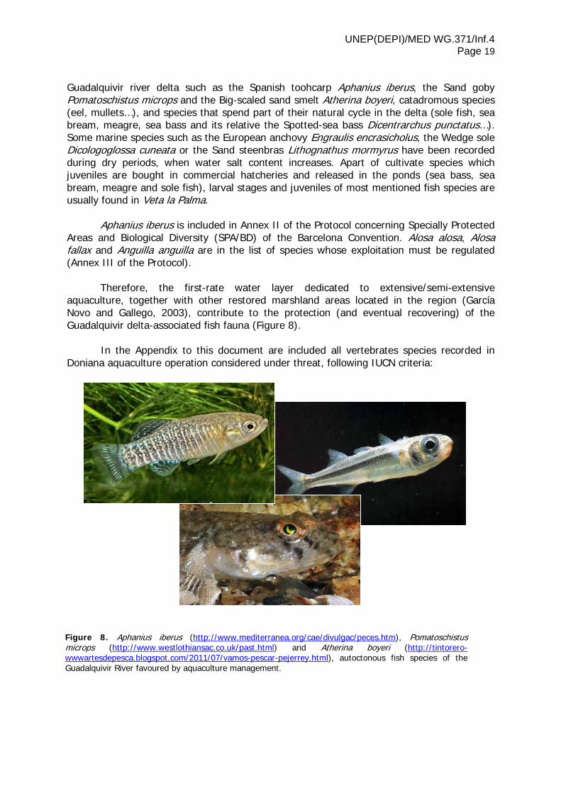
Guadalquivir river delta such as the Spanish toohcarp Aphanius iberus, the Sand goby Pomatoschistus microps and the Big-scaled sand smelt Atherina boyeri, catadromous species (eel, mullets…), and species that spend part of their natural cycle in the delta (sole fish, sea bream, meagre, sea bass and its relative the Spotted-sea bass Dicentrarchus punctatus…). Some marine species such as the European anchovy Engraulis encrasicholus, the Wedge sole Dicologoglossa cuneata or the Sand steenbras Lithognathus mormyrus have been recorded during dry periods, when water salt content increases. Apart of cultivate species which juveniles are bought in commercial hatcheries and released in the ponds (sea bass, sea bream, meagre and sole fish), larval stages and juveniles of most mentioned fish species are usually found in Veta la Palma.
Aphanius iberus is included in Annex II of the Protocol concerning Specially Protected Areas and Biological Diversity (SPA/BD) of the Barcelona Convention. Alosa alosa, Alosa fallax and Anguilla anguilla are in the list of species whose exploitation must be regulated (Annex III of the Protocol).
Therefore, the first-rate water layer dedicated to extensive/semi-extensive aquaculture, together with other restored marshland areas located in the region (García Novo and Gallego, 2003), contribute to the protection (and eventual recovering) of the Guadalquivir delta-associated fish fauna (Figure 8). In the Appendix to this document are included all vertebrates species recorded in Doniana aquaculture operation considered under threat, following IUCN criteria:
Figure 8. Aphanius iberus (http://www.mediterranea.org/cae/divulgac/peces.htm), Pomatoschistus microps (http://www.westlothiansac.co.uk/past.html) and Atherina boyeri (http://tintorero-wwwartesdepesca.blogspot.com/2011/07/vamos-pescar-pejerrey.html), autoctonous fish species of the Guadalquivir River favoured by aquaculture management.

UNEP(DEPI)/MED WG.371/Inf.4 Page 20 2.2 Economic productivity and social welfare
Business profitability is essential to generate an environmental outcome and social
welfare. Aquaculture in Doniana wetland annually yields around 1,500 tonnes of fish and shrimps. Percentage distribution per species is shown in Figure 9.
Mullets are farmed from wild river delta populations that enter the fish farm moving upstream through the drainage canals. Mullets are omnivorous fishes that efficiently feed on benthonic invertebrates, algae and floating macrophytes, removing nitrogen and phosphorus wastes released into the ponds and contributing to the maintenance of water quality. Entering mullets are under 200 grames, while commercial size after 18 months growing into the extensive ponds reaches 1,5 – 2 kilograms. Mullet are fished in extensive pond by trawling, once the production cycle is finished and water level can be lowered. Eels are captured once or twice in a week, using a tradicional fishing art very similar to the one used for shrimps. Annual yield depends on the state of wild populations, at present seriously overexploited in the Guadalquivir delta. Culture of sea bream and sea bass in Doniana aquaculture area of Veta la Palma has been based on the combination of extensive and semi-extensive regimes, using fingerlings acquired from commercial hatcheries. The development of more modern culture techniques, along with market evolution, have promoted a significant growth in Veta la Palma sea bass production, at present over 60% of total fish output. Improvements and new achievements in the management of hydraulic system, natural and artificial feeding, and strategies to avoid predation by birds, have allowed to optimize sea bass culture cycle, which duration is currently established in 30 months to reach a commercial size of 1 kg.
Extensive and semi-intensive aquaculture in Doniana provides direct income to 100 families from surrounding villages, also generating many other non-direct employees. Along with the application of innovative farming practices, this activity is committed to the task of
Figure 9. Percentage distribution per species of annual aquaculture production in Veta la Palma (Doñana area, SW Spain).
62%
17%
13%
5% 2% 1%
SEA BASS
SHRIMP MULLETS
SEA BREAM
EEL
OTHERS

UNEP(DEPI)/MED WG.371/Inf.4 Page 21
preserving traditional fishing methods that have been employed during centuries by the people living around the Guadalquivir delta area.
3 Aquaculture and mitigation of climate change affecting Doniana wetland
3.1 Variation in climatic, biophysical and productive conditions
derived from climate change
The Iberian Peninsula is considered one of the areas in Mediterranean region most affected by climate variation, all climate changes scenarios indicating marked increases in temperatures and a significant decrease in annual rainfall (Viner and Sayer, 2006).
Doniana wetland is located in a strategic point in terms of exposure to climate
change, with desertification, erosion and sea level rise as major forces that may affect both the biodiversity and the economy of local communities.
Quality of the soils in the whole area (a thick marshland clay cap with sandy and
limestone soils above) is not ideal for agriculture, except for rice crop (yields over 7 tonnes per year are usual; Bayán Jardín, 2006). Decreases in precipitation and increases in temperatures will surely affect soil salinity, making agriculture even harder on this region of Spain in a future scenario of climate change.
Marshland pasture cover an important area of Doniana wetland and are extensively
used by bulls, cows and horses, contributing to the conservation of marshland ecosystem and the local economy. As climate becomes drier and hotter, the risk of losing productivity increases, making necessary to further reduce the number of cattle heads.
Finally, changes in the actual pattern of habitats will significantly affect Doniana´s
fauna, particularly bird population, since Doniana currently represents a main migratory stop for many bird species and a first-rate breeding ground for many others.
3.2 Aquaculture for climate change mitigation
Under the mentioned changing conditions derived from climate variation, aquaculture
may become a serious alternative to ensure future water availability and control for the entire wetland ecosystem.
Extensive/semi-extensive aquaculture in Veta la Palma is based on a complex system of canals that allows to regulate the water across the Estate and surrounding areas, also focusing on water quality and composition. As it has been largely described in present document (see chapter 1.2), a long listory of natural evolution by silting-up joined to more recent channelling works made to avoid flooding and allow cultivation in Isla Mayor del Guadalquivir, completely changed the landscape and biodiversity pattern of a siginificant part of the original Doniana wetland. When aquaculture initiated in 1982, it was decided that the drainage work would be reversed and used for flooding activities. This activity has been successful not only for the economic sector, but also for the local, regional and Europe-scaled fauna.
Aquaculture management takes into consideration both productivity and biodiversity.
The 300 km of canals, the rivers bordering the Estate where fish farmng develops, and the

UNEP(DEPI)/MED WG.371/Inf.4 Page 22 huge patch of protected lagoons and marshland pastures surrounding the extensive fish ponds, allow Veta la Palma and the whole Doniana ecosystem to mitigate the effect of a decrease in precipitation by adapting the water control scheme and pumping operation from the river delta. Water, salt, food and vegetation cover combine themselves to provide excellent opportunities for animal breeding and feeding, transforming this area in an oasis for many species that have to face changes in climate and habitats happening both in Europe and Africa (Viner and Sayer, 2006).
Regarding carbon balance, emissions from livestock and rice growing (76% of all
emissions; Viner and Sayer, 2006) in the area may be compensated by carbon sequestration through photosynthesis in the aquaculture operation allowing food production with a mitigated effect on climate change. Such approach, up-scaled at Mediterranean level across the abundant degraded marshland areas which have lost functionality along last decades might have a sound positive effect in the region.

UNEP(DEPI)/MED WG.371/Inf.4 Page 23
Final remarks
A w idely recognized model for the conservation and management of Mediterranean wetlands
Described approach to sustainability, based on the combination of economic benefits
of aquaculture with conservation goals, has gained a wide international recognition.
The aquaculture production methodologies applied in Doniana wetland are included in what the Directorate-General for Fisheries and Maritime Affairs, European Commission, has named aqua-environmental measures. As defined in the European Fisheries Fund (EFF), aqua-environmental measures aim to promote aquaculture techniques that help to protect and improve the environment and to conserve nature (EU, 2007). Such technologies have to be ecologically efficient and respectful, under hardest environmental exigencies within the framework of NATURA 2000.
Veta la Palma aquaculture operation in the heart of Doniana has the recognition and support of a number of international institutions such as WWF, the Royal Society for the Protection of Birds and Wildlife Trust, Euroduck Internacional, the European Landowners Organization, the Spanish MAB (Man and Biosphere) Committee (UNESCO) or the European Commission.
Ecosystem approach to aquaculture may guarantee the conservation of Mediterranean coastal wetlands, promoting the balance between biodiversity conservation and development
It is widely known that the age-old maintenance of some sustainable aquaculture and fishery practices in the Mediterranean shores of Italy, France, Spain and other countries has contributed to the preservation of coastal wetlands and its associated cultural heritage. Extensive fish farming systems may effectively restore and further protect disturbed coastal ecosystems, playing a useful role in integrating economic activity with protection of biodiversity.
The sustainable aquaculture system currently operating in Doniana is a highly successful model of integrated management in an extremely sensitive Mediterranean coastal wetland (Abend, 2009). The areas of extensive aquaculture ponds, natural marshland and cereal farming constitute an ecosystem of great wealth, where balanced human managing has recovered a former wetland that had been largely destroyed by natural silting-up and a former flood control scheme, increasing natural gradients of hydrographic and topographic heterogeneity (Ecoagriculture Snapshot, 2010).
Extensive fish farming activity maintains the Guadalquivir River marshes in a favorable conservation state and becomes a very valuable support of Doniana, representing a compromise with the future of conservation and development in the area. In the words of Dr. Delibes de Castro, former Director of Doniana Biological Station: “Veta la Palma is adapting a new outlook on conservation objectives. It intends being dynamic and creative in designing a model for management which must be both practical and productive in order to guarantee survival in the future” (Otero and Bailey, 2003).
Described as “…more water than land […] is the lungs, larder and hospital for aquatic birds”, the aquaculture facility of Veta la Palma provides tangible meaning to sustainability: it

UNEP(DEPI)/MED WG.371/Inf.4 Page 24 is economically successful and supplies real support to the environment and to the local economy (Cranbrook, 2002).
Following the opinion of Durá and Castroviejo (2007), this model of ecosystem
approach to aquaculture activity constitutes an interesting and efficient case study in relation to the modern safekeeping of the territory, in which collaboration between private and public initiatives based on investment in eco-friendly productivity solutions, generating both economical and ecological outcomes, makes an enormous contribution to the conservation of coastal wetland natural resources and biodiversity.

UNEP(DEPI)/MED WG.371/Inf.4 Page 25
Selected bibliography
Abend, L. (2009). Sustainable aquaculture net profit. TIME Magazine, Vol. 173, No. 24: 43. Algarín Vélez, S. (2000). Antecedentes Históricos de la Pesca en la Marisma de Doniana.
Conferencia inaugural de las Jornadas: LA PESCA Y SU CONTRIBUCIÓN AL DESARROLLO SOSTENIBLE DE DONIANA. Consejería de Medio Ambiente, Junta de Andalucía y C.S.I.C.
Bayán Jardín, B.J. (2006). The path of water in the Marshes: changes in the hydrological
network. En Doniana. Water and Biosphere. Ed. Francisco García Novo y Cipriano Martín Cabrera. Doniana 2005 – Confederación Gidrográfica del Guadalquivir (Guadalquivir Hydrologic Basin Authority), Spanish Ministry of the Environment.
Chapman, A. and Buck, W.J. (1910). Unexplored Spain. London, Edward Arnold Ed. 528 pp. Cranbrook, C. (2002). How the land lies in Spain. Country Life, October, pp. 104-106. Durá, C.J. and Castroviejo, J. (2007). La Custodia del Territorio. Nueva Herramienta para la
Conservación de la Biodiversidad”. Publicaciones de la Asociación de Amigos de Doniana, nº 16.
Ecoagriculture Snapshot (2010). Biodiversity-friendly aquaculture on the Veta la Palma
Estate, Spain. Ecoagriculture Partners, Washington DC, USA.
EBD, EQUIPO DE SEGUIMIENTO DE PROCESOS NATURALES Y UNIDAD DE SEGUIMIENTO DEL AREA DE CONSERVACIÓN (P.N.D.-O.A.PP.NN) (2000) Informe Anual sobre Aves Acuáticas en las Marismas del Guadalquivir. Año Biológico 2001/2002. En: "Memoria Anual de Actividades y Resultados". Parque Nacional de Doniana, 2001, Anexo XXII. 36 pp. EBD. El Acebuche, Almonte.
EBD, EQUIPO DE SEGUIMIENTO DE PROCESOS NATURALES (2004) Anuario Ornitológico de Doniana nº1 (Septiembre 1999 - agosto 2001). Cuadernos de Almonte. Número extraordinario.
EU, European Union (2007). “Conference on EFF, Inland fishing and aquaculture protection methods enhancing the environment”. Directorate-General for Fisheries and Maritime Affairs, European Commission. June 27-29, Bucarest, Romania.
Fernández-Cruz, M.; Martín-Novella, C.; Fernández, G.; González, E. and París, M. (1989). Informe sobre la evolución e importancia de las poblaciones de aves de los antiguos lucios reinundados del sur de Isla Mayor (Sevilla). En Modificaciones y Actividades Complementarias al Proyecto de Acuicultura Extensiva en la finca Veta la Palma, Pesquerías Isla Mayor, S.A.
García Novo, F. (1988). Evaluación del impacto ambiental de la transformación de terrenos
en Isla Mayor para acuicultura extensiva. Departamentos de Biología Vegetal y Biología Animal, Facultad de Biología, Universidad de Sevilla.

UNEP(DEPI)/MED WG.371/Inf.4 Page 26 García Novo, F. (1997) The ecosystems of Doniana National Park. En: The Ecology and
Conservation of European Dunes. García Novo et al. Eds. Secretariado de Publicaciones, Universidad de Sevilla. 97-116
García Novo, F and Gallego, J.B. (2003). Restaurando las Marismas del Guadalquivir. Medio
Ambiente, 43. IUCN (2011). The IUCN Red List of Threatened Species. Ed. IUCN, Gland, Switzerland. Llamas, R. (1988). Conflicts between wetland conservation and groundwater exploitation:
two case histories in Spain. Environ. Geol. Water Sci. Vol. 11, No. 3, 241-250. Medialdea, J.M. (2009). A new approach to sustainable aquaculture. The Solutions Journal
(http://www.thesolutionsjournal.com/node/639). Washington DC. USA. Otero, C. (2000). Patrimonio Natural y Propiedad Rural en España. Exlibris Ed. S.L., 551 pp. Otero, C. and Bailey, T. (2003). European Natural and Cultural Heritage. Friends of the
Countryside Eds. 701 pp. PIMSA (1995). Incidencia de los cultivos acuícolas de PIMSA en la calidad del agua.
Monografía realizada por Pesquerías Isla Mayor, S.A. PIMSA (2000). La piscicultura extensiva y la conservación de especies amenazadas en el
entorno de Doniana. Veta la palma, Isla mayor, Sevilla. Monografía realizada por Pesquerías Isla Mayor, S.A.
PIMSA, IIMA and EURODUCK (1992). Proyecto para la adecuación del territorio de Veta la
Palma como refugio de aves acuáticas en las marismas del Guadalquivir, España. Editado por Pesquerías Isla Mayor, S.A. (PIMSA), Iberian Institute for the Environment and Natural Resources (IIMA) y European Waterfowl Habitat Fund (Euroduck).
Quirós Herruzo, F. and Maneiro Márquez, M.A. (1996). Estudio Ornitológico de la finca Veta
la Palma, T.M. de Puebla del Río (Sevilla). Monografía encargada por el Parque Natural del Entorno de Doniana.
Rodríguez Pérez, H. and Green, A.J. (2003). Estudio de los invertebrados acuáticos en el
Parque Natural de Doniana y su importancia en la dieta de las aves acuáticas. Consejería de Medio Ambiente de la Junta de Andalucía y el C.S.I.C. Eds.
References to Latin authors Avieno (Ora Maritima, 284). Plinio el Viejo (NH, III.3.11),
Pomponio Mela (III.1.15), Estrabón (III.2.6) y Columella (RR I.20) are quoted in the work of Carreras Monfort, C: Producción de Haltern 70 y Dressel 7-11 en las Inmediaciones del lacus Ligustinus (Las Marismas, Bajo Guadalquivir). Actas del Congreso Internacional Ex Baetica Amphorae. Conservas, Aceite y Vino de la bética en el Imperio Romano. Écija, 2001; pp. 419-426.
UNEP-MAP-RAC/SPA (2003). Strategic Action Programme For The Conservation Of Biological
Diversity (SAP BIO) In The Mediterranean Region. Ed RAC/SPA, Tunis. Viner, D. and Sayer, M. (2006). Veta la Palma. ELO Climate Change Project. Climate
Research Unit, University of East Anglia.

UNEP(DEPI)/MED WG.371/Inf.4 Page 27
Appendix 1. Vertebrate species recorded in Doniana aquaculture operation, considered under threat according to IUCN List of Threatened Species 2011.
Mammals Birds
Otter Lutra lutra NT Roller Coracias garrulus NT Lesser mouse-eared Myotis Myotis Blythii LC Little Egret Egretta garzetta LC
Greater horseshoe Bat Rhinolophus ferrumequinum LC Peregrine Falcon Falco peregrinus LC
Mehely´s horseshoe Bat Rhinolophus mehelyi VU Red-knobbed Coot Fulica cristata LC
Fish Gull-billed Tern Sterna nilotica LC Alis Shad Alosa alosa LC Collared Pratincole Glareola pratincola LC Twaite Shad Alosa fallax LC Common Crane Grus grus LC
Spanish Toohtcarp Aphanius iberus EN Black-winged Stilt Himantopus himantopus LC
Pseudochondrostoma willkommii VU Slender-billed Gull Larus genei LC
Cobitis paludica VU Marbled Teal Marmaronetta angustirostris V
Iberochondrostoma lemmingii VU Rufous-tailed Rock-thrush Montinola saxatilis LC
Amphibians Egyptian Vulture Neophron percnopterus EN
Southern marbled Newt Triturus pygmaeus NT Red-crested Pochard Netta rufina LC
Birds Eurasian Curlew Numenius arquata NT
Common Kingfisher Alcedo atthis LC Black-crowned Night-heron Nycticorax nycticorax LC
Garganey Anas querquedula LC White-headed Duck Oxyura leucocephala EN
White-rumped Swift Apus caffer LC Osprey Pandion haliaetus LC
Spanish imperial Eagle Aquila adalberti VU Greater Flamingo Phoenicopterus roseus LC
Purple Heron Ardea purpurea LC Common Redstart Phoenicurus phoenicurus LC
Squacco Heron Ardeola ralloides LC Purple Swamphen Porphirio porphyrio LC Short-eared Owl Asio flammeus LC Eurasian Spoonbill Platalea leucorodia LC Ferruginous Duck Aythya nyroca NT Glossy Ibis Plegadis falcinellus LC Great Bittern Botaurus stellaris LC Black-necked Grebe Podiceps nigricollis LC Rufou-taileds Scrub-robin Eythropygia galactotes LC Pin-tailed Sandgrouse Pterocles alchata LC
White Stork Ciconia ciconia LC Ruddy Shelduck Tadorna ferruginea LC Black Storn Ciconia nigra LC Pied avocet Recurvirostra avosetta LC Western Marsh Harrier Circus aeruginosus LC Little Tern Sterna albifrons LC
Montagu´s Harrier Circus pygargus LC Caspian Tern Sterna caspia LC
Whiskered Tern Chlidonias hybrida LC European Turtle-dove Streptopelia turtur LC
Black Tern Chlidonias niger LC
LC: Least Concern; NT: Near Threatened; V: Vulnerable; EN: Endangered; CR: Critically Endangered; EW: Extinct in the Wild; EX: Extinct