eatontown - amazon web services
TRANSCRIPT
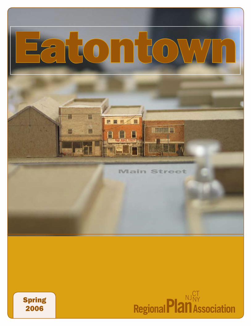
Eatontown
Spring2006

AcknowledgementsThis RPA report was prepared by Regional Plan Association and our project partners with generous funding from the Borough of Eatontown and a Smart Growth grant from the New Jersey Depart-ment of Community Affairs. RPA wishes to thank Mayor Gerald Tarantolo and the Borough of Eaton-town as well as DCA Commissioner Susan Bass Levin and the staff of the Office of Smart Growth for their financial support and assistance. We acknowledge Mayor Tarantolo and the Eatontown Borough Council, the Eatontown Ad Hoc Com-mittee, Borough staff and all of the individuals for their time, guidance and participation in the meet-ings, public forums and design workshop to help refine the ideas presented here.
Project StaffRobert Lane, Director of Design Programs, was the principle author of this report, with additional input from project staff and partners.
Thomas G. Dallessio, AICP/PP, Vice President and New Jersey Director, Regional Plan AssociationDavid Kooris, Associate Planner, RPA Sasha Corchado, New Jersey Project Manager, RPACeleste Layne, Junior Planner, RPA Jennifer Cox, Manager of GIS, RPA Dihan Lu, Design Intern, RPA Justin Kray, Intern, RPA Project PartnersGail O’Reilly, Principal, Townworks, LLCTracy Challenger, The Agora CoalitionMaura McManimon, Executive Director, N.J. Department of Com-
munity Affairs – Office of Smart GrowthAdam Zellner, N.J. Department of Community Affairs – Office of Smart GrowthDave Bruccoleri, Project Manager, N.J. Department of Transportation
Eatontown Ad Hoc CommitteeHon. Gerald Tarantolo, Mayor, Borough of EatontownMike Trotta, Borough Administrator, Borough of EatontownHarvey Slovin, Eatontown Planning BoardChristine Mellaci, Eatontown Planning BoardJamie Pavlis, Eatontown Business Advisory CommitteeJeanne Wood, Historical CommitteePaul Kirzow, Eatontown ResidentBob Patterson, Eatontown ResidentGerri Hopkins, Council LiaisonPeter Beronio, The Agora CoalitionJeffrey Donohoe, Jeffrey Donohoe Associates
Development Review AdvisorsMark Cannuli, Sharbell DevelopmentRichard Johnson, Matrix Development Group Anthony Marchetta, LCOR, Inc.Joel Schwartz, Landmark CommunitiesDavid Trager, Woodmont Properties
Parking Strategies AdvisorThomas Calu, Consulting Services
The Eatontown Community Design Work-shop, convened May 2005, was made possible with the support and assistance of a number of partners. Special thanks to the mayor and his staff for hosting the event, as well as the project partners, speakers and program facilitators for dedicating their time and expertise to the workshop: Juan Ayala, Associate, Cooper Robertson and PartnersBrent Barnes, Director of Transportation Systems Planning,
N.J. Department of TransportationMartin Bierbaum, Executive Director, Municipal Land Use Cen-
ter at the College of New JerseyBob Brown, Principal, Brown Keener Bressi DesignColin Cathcart, Principal, Kiss and Cathcart ArchitectsCara Griffin, Senior Planner, RPA Rob Pirani, Director of Environmental Programs, RPA Matthew Priest, Associate, Cooper Robertson and PartnersCarlos Rodrigues, Director – Princeton Office, Looney Ricks Kiss ArchitectsChris Stienon, Associate, Beyer Blinder Belle ArchitectsSteve Tilly, Principal, Steven Tilly ArchitectsMeg Walker, Associate, Project for Public SpacesMatt Wanamaker, Associate, Looney Ricks Kiss ArchitectsLee Weintraub, Principal, Lee Weintraub Landscape Architect
Finally, a special thanks to the residents of Eaton-town for their enthusiasm, interest and commit-ment to restoring Eatontown’s historic downtown to a safe, lively main street for future generations.
This report was designed by Jeff Ferzoco, Senior Designer.
Questions can be directed to Thomas G. Dallessio or Robert Lane of Regional Plan Association. A copy of this report can be found on RPA’s website: www.rpa.org.

Acknowledgements 1
Why did Eatontown Create this Vision? 2
Envisioning a Downtown Eatontown 3
Mission Statement, Goals and Objectives 4
Regional Context 5
Overview of the study area 6
Development Potential and Interest 9
Parking Issues and Opportunities 10
Towards a Shared Vision 12
Consensus Matrices 1-3 14
Consensus Matrices 4-6 16
Consensus Matrices 7-9 18
The Consensus Planning Framework 20
Two Illustrative Proposals 22
Consensus Plan 1 22
Consensus Plan 2 24
Phasing 26
Public Response 28
Next Steps 29
References 30
RPA Board of Directors & New Jersey Committee 31
Contents

� Eatontown
Why Did Eatontown Create This Vision?For a number of years, residents and business owners recognized that a key area of Eatontown was not living up to its potential. What used to be the downtown Village Area of Eatontown, where people could walk to buy groceries, get a haircut or enjoy a dinner at a restaurant became a victim of the region’s success. Truck and car traffic on Highway 35 made crossing the street unpleasant and at times dangerous. Regional and strip malls drew customers away. Parking lots replaced homes with a sea of blacktop that disconnected neighborhoods from the downtown. Recent improvements, including the acquisi-tion and development of Wampum Park, modest streetscape and parking improvements, and a newfound desire to restore this area to its former glory encouraged the Mayor and Council, Planning Board and others to undertake efforts to create a new vision for downtown Eatontown. Eatontown’s leadership undertook planning activities which determined that a Special Improve-ment District (SID) in the Village Area was not feasible as a tool for the revitalization of Village Area. However, the Preliminary Investigation, Eatontown Redevelopment Area Analysis; October 2003 determined that the downtown area did qualify as a Redevelopment Area as defined by N.J.S.A. 40A:12A-1, New Jersey Local Redevelop-ment and Housing Law (LRHL). The area under study included seventy-two properties covering a total of roughly twenty-one acres, where facilities provided critical support to community life in the Borough of Eatontown. This area however needed to be improved and that could only be provided through public involvement. When the General Services Administration officially announced that a portion of the mili-tary housing stock at Fort Monmouth, known as
Howard Commons, was deemed sur-plus, the Borough was awarded a Smart Growth Grant from the N.J. Department of Community Affairs to develop a plan that would reconfigure the housing and re-stitch the neighborhood back into the Eatontown community as it was being severed from the campus-like environ-ment of Fort Monmouth. Following the recommendation of the Eatontown Redevelopment Area Analysis, the Bor-ough undertook an 18-month visioning
exercise to reshape the downtown Village Area.
�
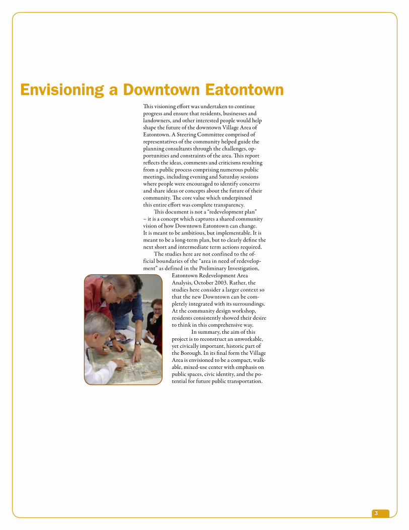
This visioning effort was undertaken to continue progress and ensure that residents, businesses and landowners, and other interested people would help shape the future of the downtown Village Area of Eatontown. A Steering Committee comprised of representatives of the community helped guide the planning consultants through the challenges, op-portunities and constraints of the area. This report reflects the ideas, comments and criticisms resulting from a public process comprising numerous public meetings, including evening and Saturday sessions where people were encouraged to identify concerns and share ideas or concepts about the future of their community. The core value which underpinned this entire effort was complete transparency. This document is not a “redevelopment plan” – it is a concept which captures a shared community vision of how Downtown Eatontown can change. It is meant to be ambitious, but implementable. It is meant to be a long-term plan, but to clearly define the next short and intermediate term actions required. The studies here are not confined to the of-ficial boundaries of the “area in need of redevelop-ment” as defined in the Preliminary Investigation,
Eatontown Redevelopment AreaAnalysis, October 2003. Rather, the studies here consider a larger context so that the new Downtown can be com-pletely integrated with its surroundings. At the community design workshop, residents consistently showed their desire to think in this comprehensive way. In summary, the aim of this project is to reconstruct an unworkable, yet civically important, historic part of the Borough. In its final form the Village Area is envisioned to be a compact, walk-able, mixed-use center with emphasis on public spaces, civic identity, and the po-tential for future public transportation.
Envisioning a Downtown Eatontown

� Eatontown
Eatontown’s Village Area has been identified as a problem for many years. Eatontown’s Master plan has referenced redesigning the area as a priority for the Borough. Efforts such as capital improvements, land acquisition, and planning initiatives to assess the feasibility of various economic development tools have all left the Borough short of achieving its goal of transforming the Village Area. The visioning and redevelopment approach currently underway, for the first time, offers real hope for a lasting change. The community has characterized the area as ‘unsightly,’ ‘inhospitable,’ ‘unsafe’ and ‘unde-rutilized.’ Most citizens would agree that the area is Eatontown’s downtown. It serves as a dominant feature that shapes people’s perception of Eatontown. The current appearance of the Village Area leaves the community feeling misunderstood or certainly misrepresented. Eatontown is proud of its character and history. The public consensus is that there are aspects of the downtown area worth saving. At a minimum, the community wants the Village Area to be more attractive. Over the years, numerous documents have ar-ticulated the need to transform the Village Area into a real Downtown. The foundation for this vision-ing exercise was created by helping the stakeholders articulate a mission statement and associated specific goals to achieve it. These statements were validated through discussions at several of the public meetings:
Mission Statement, Goals and Objectives
Specific Goals and Objectives
1 The area should be attractive
2 The area should be safer for pedestrians and overall more walkable.
3 The area should continue to be mixed use.
4 The plan should include public space for civic activities.
5 The plan should be implementable.
6 The plan should accommodate the transportation needs of future generations.
7 The plan should accommodate the housing needs of a variety of age groups (life-cycle housing).
8 The plan should accommodate the future needs of Eatontown’s Bor-ough Hall and other civic amenities such as the library and firehouse.
9 The plan should guard against the future loss of historically significant buildings.
10 The plan will respect adjacent neighborhoods.
Mission Statement The Eatontown Village Area will be a beautiful, walk-able, mixed-use center with emphasis on public spaces, civic identity, and the potential for future public transportation.
�
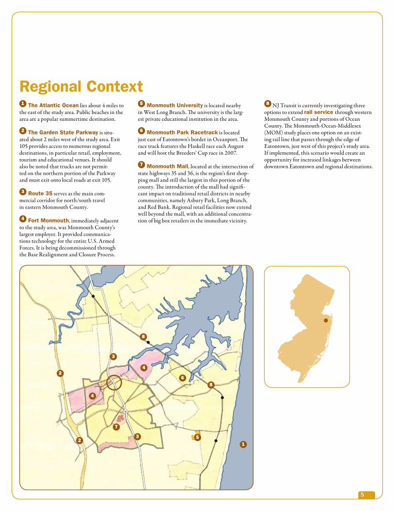
1 The Atlantic Ocean lies about 4 miles to the east of the study area. Public beaches in the area are a popular summertime destination.
2 The Garden State Parkway is situ-ated about 2 miles west of the study area. Exit 105 provides access to numerous regional destinations, in particular retail, employment, tourism and educational venues. It should also be noted that trucks are not permit-ted on the northern portion of the Parkway and must exit onto local roads at exit 105.
3 Route �� serves as the main com-mercial corridor for north/south travel in eastern Monmouth County.
4 Fort Monmouth, immediately adjacent to the study area, was Monmouth County’s largest employer. It provided communica-tions technology for the entire U.S. Armed Forces. It is being decommissioned through the Base Realignment and Closure Process.
Regional Context5 Monmouth University is located nearby
in West Long Branch. The university is the larg-est private educational institution in the area.
6 Monmouth Park Racetrack is located just east of Eatontown’s border in Oceanport. The race track features the Haskell race each August and will host the Breeders’ Cup race in 2007.
7 Monmouth Mall, located at the intersection of state highways 35 and 36, is the region’s first shop-ping mall and still the largest in this portion of the county. The introduction of the mall had signifi-cant impact on traditional retail districts in nearby communities, namely Asbury Park, Long Branch, and Red Bank. Regional retail facilities now extend well beyond the mall, with an additional concentra-tion of big box retailers in the immediate vicinity.
8 NJ Transit is currently investigating three options to extend rail service through western Monmouth County and portions of Ocean County. The Monmouth-Ocean-Middlesex (MOM) study places one option on an exist-ing rail line that passes through the edge of Eatontown, just west of this project’s study area. If implemented, this scenario would create an opportunity for increased linkages between downtown Eatontown and regional destinations.
4
1
2
23
3
4
5
6
7
8
8

� Eatontown
Once the historic downtown was at the crossroads of Main Street and Broad Street. Since that time, the study area has suffered the ravages of suburban auto-mobility: What was once the main street is now State Route 35, a roadway trapped somewhere be-tween a regional highway and a suburban commercial strip. Most of the economic vitality was sucked out of here by the Monmouth Mall and strip malls lining nearby arterials. And yet, enough of the original fabric remains so that it is possible to imagine a revitalized downtown: appropriately sized streets and blocks, mixed-use buildings that are oriented
Overview of the Study Areatowards the streets; various historic structures. There are many dilapidated, vacant and underuti-lized properties but there are also some property owners, residents and business owners who are committed to this area. The scale of the area is basically “low-rise,” where two- and three-story buildings predominate. Residents value the scale and convenience of the neighborhood-type retail as a relief from the large-scale highway-oriented businesses elsewhere in the township.

�
1 Disconnected Landscapes:There are several parks in the area that are disconnected from each other and from the surrounding neighborhoods.
2 Route 35:The downtown is split in two by Route 35, a high-speed, high-volume state highway. This creates dangerous pedestrian conditions at crossings and along narrow sidewalks, and has promoted blight in the buildings that front it. (see highway discussion below)
3 Auto-dominated Environment:
The pedestrian is overwhelmed by space given over to the automobile, either for turning move-ments or for huge expanses of surface parking (seen here as grey-green spaces.) The few existing businesses rely on easy access to parking behind their stores. Surprisingly, if all of the existing buildings were fully occupied, most of this park-ing would be needed.
4 Poor Building Quality and Character:
Many of the buildings, especially those fronting Route 35 are vacant, or partially vacant, and are in various states of abandonment and neglect. Few of the buildings have historic character.
The Area’s Challenges
Broad St.
Throckmorton St.
Rt. �
�
White S
t.
Lewis St.
1
1
4
4
2
3
3

� Eatontown
1 Potential Rt. 35 development:
If the character of the roadway network – and in particular Route 35 – is re-thought, there is the opportunity to create pedestrian-oriented streets with storefronts and to restore the pedes-trian-oriented environment that once existed here, with sidewalk-facing storefronts and a residential population.
2 Strong Surrounding Neighborhoods:
The study area is closely surrounded by attrac-tive, stable neighborhoods. Linkages to these neighborhoods can breathe life into the Down-town and connect residents to parks, shopping and transportation. There are also several historic buildings still in the area.
3 Green Connections:Several parks can be linked to each other and to the neighborhoods. Landscaped streets can weave this green through the Downtown.
4 Civic Identity:The concentration of civic uses here – the City Hall, library and fire station – give this area a special sense of place beyond its identity as a neighborhood to shop and live. These uses add to the retail, office and residential activities to create the kind of dynamic land-use mix associ-ated with a downtown or downtown.
5 Public OwnershipThe municipality owns much of the land in this area which provides flexibility for implementing the plan, seen as the grey areas in the diagram.
Development Opportunities
13
2
4
2
5

�
single family neighborhoods around the study area. While the situation may be different elsewhere in the state, the developers felt that in this location the market was probably stronger for sales than rentals. The developers were also cautious about age-restricted development in this town-center type of environment. Concern was both for the market, which one developer suggested is starting to get satu-rated, and a “character” issue – whether too much age-restricted housing would dampen the goal of creating an active place. One developer used the term “age targeted” – some number of smaller units favor-ing “empty nesters” and couples without children. The developers agreed that these settings (as with transit-oriented developments) tend not to attract families with young children. Another developer offered some interesting statistics contrasting actual number of children compared to the projections for a variety of compact mixed-use developments: Washington Town Center – 2900 projected, 930 actual; Gas Light Commons – 210 projected, 20 actual; Franklin Square – 120 projected, 11 actual.
Non-Residential Uses Retail Uses: Certainly ground floor retail will be an essential part of the new downtown environ-ment. Larger format retail (“big box” type) does not make sense here because of the scale and character of the area and because that would not be compatible with a “town center” or new “downtown” environ-ment. One developer suggested that of the national chains, some of the smaller, high-end retailers might ultimately locate here. These could be the kinds of retailers found in the high end so called “life-style” shopping centers. 10,000 sf. is probably the upper end of the typical size. In any case, the retail was not a major factor in the developers’ projections regarding overall subject feasibility and profitability. Office Uses: There may be a market for small office uses – professional offices that could be of a scale compatible with the rest of the new down-town. These could be part of a mixed-use build-ing but could also be in their own small building. However, none of the developers believed that this was really an “office site” in the sense that a new office building, for example a 200,000 sf. build-ing, would fit here because of the location’s inferior access. Office developers will choose first sites near the Garden State Parkway and the Turnpike. In addition, the office market is soft. As an example, one developer cited the former CECOM building, now privately owned, which is located in Tinton Falls near the entrance to the parkway. Current plans call for demolishing the office building to make room for an age-restricted housing development.
A vision for the future of downtown Eatontown should be ambitious, but attainable. For this reason, it was important to have a sense of how the development community thought about this kind of challenge. Several developers with records of building high-quality, mixed-use projects were interviewed to measure the gap between a pure market response and the community vision which included the many amenities and public spaces that would make this area a “place.” Depending on how the project evolves, some of these amenities may be paid for by the developer. But it is a certainty that the community’s vision will exceed the developer’s costs – indeed, we should hope it does! Still it was important to know the scale of that gap so that the commu-nity could be realistic about the size of its own financial contribution and the need to raise additional funds from other public sources and through innovative financing and implementa-tion strategies. In the end, we want an ambitious plan that pushes the envelope but is buildable.
Developer ReactionAll of the developers interviewed were enthu-siastic about this effort. Monmouth County is a very desirable place to live and the devel-opers were impressed that the Borough had taken the initiative to create a plan for this area. All the developers could easily see a new mixed-use downtown environment in this location. They liked the existing mix of uses – parks, civic uses, retail and residential. Without the ability to do a formal analysis at this point, the developers still offered their “instinctive” response to what might be built here. Housing, of course, was at the top of the list. All developers we consulted were unanimous that residential construction was the driver for redevelopment here and were also impressed by the community’s willingness to that reality. Based on their experience elsewhere, develop-ers suggested a variety of attached and mixed-use building types including townhouses, stacked flats and small apartment buildings. Per acre densities of 25, 50 and 75 units were possible here although “density” per se should never become the principal criterion for deciding how to use the space. Also, any given density can be configured in so many ways that it says very little about the ability to achieve the goals of the project. One developer (Sharbell) also suggested 1200 sf. to 1400 sf. live-work “loft-type” units as an excellent way to make the transition form the core of the new downtown to the existing
Other IssuesFort Monmouth is on the Base Realignment and Closure (BRAC) list and scheduled to close in 2011. If the property retains residential holdings, or is intensified with more housing, it could support the new downtown by helping to sustain the market for retail uses and gener-ally enlivening the downtown. In addition, with residential intensification there are more options for transit. On the other hand, if Fort Monmouth’s housing came on the market at lower rents and sale prices, it could undercut the market for the new housing at the rede-velopment site. Potentially more troubling is a scenario in which an entire new community is created, complete with its own “downtown.” Because there are so many unknowns here and with the reluctance to have the Town Center redevelopment effort held hostage to the Fort’s fu-ture, two things will be important (beyond track-ing what happens there). First, to the extent that the process can move quickly, this redevelopment project can help set the tone for development in the Fort. Second – and more importantly – this project must have its own unique identity, build-ing on the existing history and spirit of the place. In that way, it can retain its power as a destination in the face of any new developments that try to create a downtown environment from scratch.
Relocation of Municipal UsesOne of the more ambitious ideas is to relocate the existing municipal uses. Again, a realis-tic assessment acknowledges the real – if not insurmountable – challenges. A new, fully code-compliant, state-of-the-art facility – es-pecially a municipal building or library with satisfactory audio visual and communications technology – is a complicated programming, design and construction project in its own right, and likely to be very time-consuming. One developer provided an anecdote: A Washington, D.C., municipality floated bonds to build a new school on a property adjacent to the existing school. The developer built the school. A portion of the rental income from the new development was then used to pay for the bonds. This exploited the lower inter-est rates available to the municipality and the “patience” of the municipality for being paid back (as opposed to a private lender).
Development Potential and Interest

10 Eatontown
Parking Issues and OpportunitiesAssessmentDespite the amount of land area devoted to surface parking, there is not, as seemed perhaps at first, so much extra capacity that any signifi-cant intensification could take place simply by consolidating underutilized parking spaces and making them available for development. An extensive interview with the Borough Business Administrator suggests that at present the municipal lot may be approximately 30% un-derutilized but this is because the adjacent office building is not fully occupied. When that office building was partially used for a computer school, the lot was completely full. In fact some policing was required to prevent over flow into the spaces reserved for the municipal uses. In addition, many of the existing commercial properties are vacant or underutilized. If all of these were fully active the area might actually be under-parked.
Park and Ride ActivityOne question that has been raised is whether some of the parking spaces are being occupied by people who are parking for the day and taking the bus. It seems that this is unlikely. First, the bus route does not go to Manhattan or any of the major employment areas on the New Jersey side
of the harbor, (although the bus does go to Red Bank, where there is an NJTransit connection to Manhattan, and to Jersey City, which is served by PATH service into New York). Also, parking rules over most of the lot prevent full day parking that extends over both rush hours. However, parking strategies can be part of a limited mixed-use development. Capacity AnalysisIn addition to the anecdotal experience of these observations, RPA made an estimate of park-ing demand by estimating the total amount of square footage devoted to different uses and
assigning standard ratios for parking demand. The Borough currently uses traditional suburban allowances: 5 spaces/1000 sf retail, 3 spaces/1000 sf office and 2 spaces per dwelling unit(du). A more aggressive - and potentially more beneficial - analysis would lower these ratios to 4 spaces/1000 sf retail, 2.5 spaces/1000 sf office and 1.5 to 1.75 spaces/du. Looking at the subtotals for the three primary redevelopment blocks bounded by Broad Street, Throckmorton Street, and Kellys Lane, there would theoretically be a requirement for 173 spaces for office uses, 56 for residential, 185 for retail and 49 for institutional for a total of 463 spaces. Even if the higher ratios described above are used, 383 spaces would theoretically be required. Using the aerial photograph, it appears that there are currently about 381 striped spaces with room for another 25 or so in some of the “informal” parking areas, suggest-ing a shortfall of about 57 spaces using the standard ratios and barely sufficient using the lower ratios.
Parking Issues Parking will be a major factor in the design of the new downtown. In fact, several of the developers thought that the parking solutions might drive the design. There are many precedents for creative
solutions to parking that we will have to draw on. This reinforces the notion that there will be a strong relationship between the character of the new center and the solution to the parking problem. Surface Parking:Surface parking is clearly a limita-tion on density, and in that sense, a damper on the “downtown feel” of this place. However, if properly designed, and especially if it is ac-commodated as on-street parking, surface parking can contribute to
the “downtown feel” of a place. A development with parking at grade and on-street, can get to as a high as 20 du/acre if handled creatively. The Franklin Square project in the Borough of Metuchen is a good example of this. It consists of townhouse apartments. Surface parking in this project works by parking in the interior, by creating internal streets with on-street parking, and after success-ful negotiation with the Borough of Metuchen, on-street parking on the adjacent public streets.
Parking Below:A dense development with parking on the ground floor and housing above can reach densities as high
as 70 du/acre. The Park Square development is a good example of this: Two double loaded buildings create the edges for a large block in a downtown. One building consists of three residential floors over a 1st floor of parking. The other building is four residential floors over two floors of parking – a special situation enabled by a change in grade at one end of the block. There are several design issues for buildings with parking on the ground floor. First among these is the negative impact of the edge of a parking deck on street life. Several developers have tried to solve this by creating an architec-tural edge to the 1st floor parking (as at Gaslight Commons, South Orange, 41 du/acre). Others have gone further by taking away some parking spaces to insert ground floor retail and offices, and to create the appearance of entries by treating fire stairs and secondary stairs as architectural features (see project in South Bound Brook). Another strategy is to continuously line the edge of the 1st floor parking with pedestrian-friendly uses. While this is an excellent solution from the point of view of enlivening the street, it results in a building above that is excessively deep and inefficient for housing (85’ minimum).
Building a New Free-Standing GarageStructured parking, while expensive, can create the most flexibility because it can be efficient and can take away the burden of accommodating parking on individual sites or buildings. However, of all the various solutions, this was met with the most skepticism by the developers we interviewed. Even though pre-fabricated construction could reduce costs, even a bare bones parking deck would cost somewhere between $15,000 and $20,000 a space. Anything more elaborate from an architectural point of view – for example, treating the facades in some way, or making the ground floor pedestrian-friendly – could drive the costs up to $30,000 a space. (In the preliminary design studies a 216-car garage was modeled. These per space costs translate into a garage that would cost in the range of $3.2 to $4.3 million). The construction costs for the garage need to be accounted for. If the developer wants to re-capture them as rent, he might have to charge be-tween $185/mo (for the $20,000 space) and $265/mo (for the $30,000 space) an amount that may be more than the local real estate market will bear. In fact, none of the developers interviewed could identify a free-standing parking struc-ture that had been built recently in New Jersey with purely private money. The garages are

11
built with public participation at some level. The Landmark Square mixed-use project in Somerville, New Jersey, includes a garage where the municipality is contributing to the costs. Rents also vary by the management. Access to a space somewhere in the garage is obviously less expensive than a reserved space (23% more expen-sive). On the other hand, shared parking is more easily accomplished if fewer spaces are assigned.
Structured Parking: Models for Public Private Partnership Because of the cost burdens, municipalities are more frequently considering the need for structured parking as if it were a form of public infrastructure or utility – a necessity if redevelop-ment is to occur. This is not to say, however, that the private sector should not be expected to make some contribution toward such parking projects; of course, it all depends upon the economics of a given redevelopment opportunity. To these ends, there is an emerging trend to seek “public/private partnerships” by which structured parking can be developed in support of economic development, striking a balance between the competing and mutual interests of government and investors.
The Montclair ExampleThe Township of Montclair and the Montclair Parking Authority recently entered into a series of agreements with the designated redeveloper of a mixed-use project, allowing that project to share in the availability of parking capacity in a new deck. The 430-space deck (replacing a 172-space surface lot) was sized to include 97 parking spaces required by the redevelopment plan to support the retail component of the redeveloper’s adjacent project, which has allowed the redeveloper to maximize its own property. The redeveloper is building the new deck under a design/build guaranteed maximum price contract, and making a capital contribution equivalent to the cost of the 97 parking spaces by refunding its agreed-upon percentage fee (for developing the deck) and also dedicating a por-tion of Payments in Lieu of Taxes (PILOTs) to cover amortization of its proportionate share of debt service for the cost of structured parking. The deck is financed with tax-exempt bonds, and the deck operating budget is not burdened with property taxes. The redeveloper also makes ongoing proportionate contributions to capital repair reserves and operating expenses for the deck. The new parking deck will remain available to
the public on a first-come first-served basis, while the redeveloper will receive a negotiated annual allowance of parking validation credits. The parking authority receives the benefit of turnover parking revenues coming from the additional 97 spaces. With construction well underway, this project is scheduled for completion in November of 2005.
Another ExampleThe details pertaining to this emerging possible transaction are far from solidified, but the following information illustrates how the public/private part-nership approach might unfold in another redevelop-ment case. This time, the redeveloper asks the munic-ipality to take a bit of a risk by relying on a percentage in the economic performance of the redevelopment project and its ability to generate demand for parking. After a few months of studying the site, the designat-ed redeveloper of a project involving 300 residential units, 44,000 square feet of retail space and 150,000 square feet of office space has a plan to accommodate its residential parking on-site. However, the burden of developing structured parking for the retail and commercial portions of its program would be just too much for the project to bear; the +/- 500 parking spaces required would reduce yield (productivity) of the footprint, and the cost of structured parking would necessitate unrealistic rental rates, render-ing the redevelopment unable to compete against adjacent communities where on-street and surface parking is typically available. So, the redeveloper proposes to build a 900-space deck on adjacent municipal property, replac-ing 300 existing surface spaces, accommodating the redeveloper’s need for 500 spaces and leaving an extra 100 spaces to support other potential development in the immediate area. Again, the redeveloper will contribute its agreed-upon percent-age fee (likely in the range of 5.5% to 8% of the cost of the deck), but suggests that the municipality rely on market rate revenues from the parking demand to be created by the redevelopment with back-up from a percentage interest in the economic perfor-mance of the redevelopment project. The potential is now being explored to determine whether the proposed deck might also include a band of retail space that would create an additional income stream and evening activity in support of the deck. In this case, the redeveloper submits that the redevelopment will be unable to compete for market share without a subsidy, which may very well be part of the price the municipality must pay to achieve the density and mix of redevelopment desired.
Some Implications:As stated above, there is not enough surplus space to launch a redevelopment effort without coming up with an alternative strategy for park-ing. Among the ideas to consider are these:
1. Make use of the lower unimproved lot north of Throckmorton: This lot could likely hold about 120 cars. The Business Administration stated that in the past, efforts to promote use of this lot have been unsuccessful. However, we should look to a time when the walk is more pleasant than it is
now, when some improvements to the area have taken place. After all, the distances are not great. Initially, municipal employees and owners of businesses should be encouraged to park here.
�. Consider a new deck in the area of the lower lot: This is an appealing idea because there is at least a one-story grade change at the hillside leading down to the lot. As stated, the issue here will be the cost of building a new lot. Based on interviews with developers, some public participation will probably be necessary.
�. Consider shared parking: There is po-tentially a shared parking opportunity between the existing institutional/municipal uses and the new development. Many new residents will drive
to work, leaving spaces available for municipal employees who will want to park during the hours residents are away. Evening events will have to be accommodated in some special way.
�. Maximize on-street parking: On-street parking reinforces the downtown character of any area – providing both convenience for shop-ping and helping to define sidewalk spaces and calm traffic. To the extent that the plan for this area creates a “finer grain” of streets and blocks, opportunities for on-street parking can be greatly expanded. One developer stated that successful negotiations for more on-street parking on state and local roads at the perimeter of the project site, enabled him to achieve appropriate densities.
�. Consider Public Private Partnerships: Because the municipality owns so much of the land in the study area, there are excellent opportunities to partner with a developer in the construction of a garage, in keeping with several of the examples described above.
1� Eatontown
Street Alterations The table sketch shows what changes each group made to the roadway network. The solid light lines are existing streets that remain unchanged. Dashed lines represent existing streets that are changed or eliminated. The heaviest lines show new streets. Almost all of the roadway network diagrams share certain features: the extension of new roads north of Throckmorton and south of Broad and the elimination of the other “jug handles.”
Non-Supporting Structures This diagram identifies those structures that would have to be removed to complete the open space and street network proposed by the groups. Al-though the final extent of redevelopment will be subject to negotiation with prospective developers, these diagrams illustrate the fact that the downtown concepts proposed by the different groups can theoretically be achieved without extensive demolition. In fact, it would probably add interest to this place to have some combination of existing and new structures. This analysis has to be qualified: several groups proposed the complete transformation of Route 35 into a “suburban boulevard,” complete with a tree-lined median. Because this requires a wider right-of-way, it would be necessary to demolish all of the struc-tures on one side or the other of Route 35.
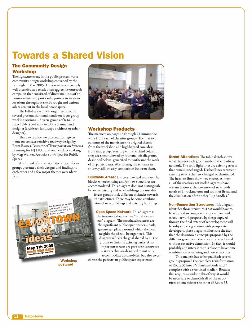
The Community Design WorkshopThe signature event in the public process was a community design workshop convened by the Borough in May 2005. This event was extremely well attended as a result of an aggressive outreach campaign that consisted of direct mailings of an-nouncements and post cards; posters in strategic locations throughout the Borough; and various ads taken out in the local newspapers. The full-day event was organized around several presentations and hands-on focus group working sessions – diverse groups of 8-to-10 stakeholders co-facilitated by a planner and designer (architect, landscape architect or urban designer). There were also two presentations given – one on context-sensitive roadway design by Brent Barnes, Director of Transportation Systems Planning for NJ DOT and one on place-making by Meg Walker, Associate of Project for Public Spaces. At the end of the session, the various focus groups presented their designs and findings to each other and a few major themes were identi-fied.
Workshop Products The matrices on pages 16 through 21 summarize work from each of the nine groups. The first two columns of the matrix are the original sketch from the workshop and highlighted core ideas from that group. Starting with the third column, they are then followed by four analysis diagrams, described below, generated to synthesize the work of all participants. Abstracting the schemes in this way, allows easy comparison between them.
Buildable Areas: The crosshatched areas are the blocks where existing and/or new structures are accommodated. This diagram does not distinguish between existing and new buildings because dif-
ferent groups took different attitudes towards the structures. There may be some combina-tion of new buildings and existing buildings.
Open Space Network This diagram is the inverse of the previous “buildable ar-eas” diagram: The crosshatched areas are the significant public open spaces – park, greenways, plazas around which the new neighborhood will be organized. This diagram reflects the goal shared by all the groups to link the existing parks. Also, important streets are part of this network – streets that are designed to not only accommodate automobiles, but also to cel-
ebrate the pedestrian public space experience.
Towards a Shared Vision
Workshop postcard

1�
Table sketch

1� Eatontown
• Constructing new street and block net-work by connecting existing parking lots
• Constructing new north-south road parallel to Rt. 35
• Creating a village green at the town’s center
• Increasing pedestrian access with through block connections
• Concealing surface parking with a contiguous street wall
• Extending Lewis St. across Rt. 35
• Establishing a village green at the new intersection created by Lewis St.
• Using landscaped streets to tie to-gether open spaces downtown
• Centralizing parking facili-ties in a multi-level structure
• Creating main street environment through ground floor retail
• Constructing a new main street south of Broad St.
• Closing Broad St. downtown and con-verting space into a pedestrian mall
• Creating a large development site west of Rt. 35
• Creating civic plaza next to library
• Linking public parks with pedes-trian access across Lewis St.
Core IdeasWorkshop Sketches
1Group
2Group
3Group
Group conceptsConcensus Matrices 1 to 3
Open Space
Defining Edges
New Streets
Demapped Streets
Conflicting Structures
Non-Supporting Structures
Buildable Areas
Buildable Areas

1�
Non Supporting StructuresStreet AlterationsOpen Space Network
Open Space
Defining Edges
New Streets
Demapped Streets
Conflicting Structures
Non-Supporting Structures

1� Eatontown
• Eliminating Throckmorton and Lewis Streets west of Rt. 35
• Opening a new village green to con-nect Wolcott and Wampum parks
• Redeveloping builings west of Rt. 35 to face inward towards village green
• Angled parking along Broad St.
• Strengthening residential charac-ter along Throckmorton
Buildable Areas
• Transforming Rt. 35 running through downtown into a landscaped boulevard
• Developing consistent street walls fac-ing main streets and parks
• Maintain small town building scale
• Arching Throckmorton St. to con-nect symmetrically with Broad St.
• Developing mixed-use and live/work space
• Establishing Rt. 35 as a main street envi-ronment through retail recruitment
• Relocating municipal uses to Rt. 35
• Building a new outpatient medical facil-ity on open land south of Broad St.
• Sharing parking spaces downtown
• Developing new residential homes along the water’s edge to the north
Core Ideas
4Group
5Group
6Group
Group conceptsConcensus Matrices � to �
Workshop Sketches Buildable Areas
Buildable Areas Open Space
Defining Edges
New Streets
Demapped Streets
Conflicting Structures
Non-Supporting Structures

Non Supporting StructuresStreet AlterationsOpen Space Network
1�
Open Space
Defining Edges
New Streets
Demapped Streets
Conflicting Structures
Non-Supporting Structures

1� Eatontown
• Linking blocks between Throckmorton and-Broad Streets with a pedestrian walkway
• Capping height limit at three stories
• Connecting Wolcott and Wampum parks
• Improving pedestrian environment by landscaping and widening sidewalks
• Encouraging mixed-use development
Buildable Areas
• Constructing new road south of Broad St.
• Linking all open space around down-town with a trail/bike path
• Opening a new civic space next to library
• Focusing surface parking at the cen-ter of development sites
• Calming intersection of Broad St. and Rt. 35 with a landscaped meridian
• Transforming Rt. 35 into a boulevard
• Straightening Broad St. jughandle curve to create a rectangular development site west of Rt. 35
• Creating pedestrian bridge over Lewis St.
• Crafting design guidelines to control facade, signage and streetscape improvements
• Increasing residential presence downtown
Core Ideas
7Group
8Group
9Group
Group conceptsConcensus Matrices � to �
Workshop Sketches Buildable Areas
Buildable Areas Open Space
Defining Edges
New Streets
Demapped Streets
Conflicting Structures
Non-Supporting Structures

Non Supporting StructuresStreet AlterationsOpen Space Network
1�
Open Space
Defining Edges
New Streets
Demapped Streets
Conflicting Structures
Non-Supporting Structures

�0 Eatontown
The diagram on page 21 is an attempt to capture as many of the ideas of the different working groups as possible. It is created by comparing the analysis diagrams described in the previ-ous section and finding the strategies that were suggested by most of the groups around each of the categories of concern – buildable area/open space and street alterations. There was a fairly strong context here in the form of existing roads and parks that remain, and consensus on the big problems, specifically Route 35 (the groups came up with many of the same basic ideas). This makes it possible to offer this new diagram that captures most of the features of the previous diagrams. More than the detailed design studies that follow, this diagram is the most important product of this process because it establishes a framework for the downtown that can accommo-date a broad range of activities at different levels of intensity. It does not obligate the municipal-ity to necessarily save or demolish particular structures; it does not create a commitment to any one mix of uses and activities. What it does is establish the public realm or streets and open spaces which will capture, over the long term, the spirit of the Eatontown Downtown as articulated by the residents of Eatontown. What are the fun-damental features of this planning framework?
1 Eliminate the “jug handle” by clos-ing eastern section of Lewis Street This enables the consolidation of the two oddly-sized blocks west of Route 35, and simplifies the traf-fic patterns and intersections with Route 35.
2 Link the Parks By rationalizing the road-way network west of Route 35, and by creat-ing a new linking space, it is possible to con-nect Wampun Park and Wolcott Park.
3 Create a Greenway Network around the Downtown Building on the new link between the two existing parks, it is possible to extend the greenway network along the Wampum Brook. There is also the ability to extend the greenway network in the area south of Broad Street where there are several large poorly defined green spaces.
4 Extend the Street and Block Network to the north of Throckmorton There is a large unimproved area between Throckmorton and the Wampum Brook. New streets here would create opportunities not only for new development, but for access to a new greenway along the Wampum Brook. There are also opportunities to manage parking in this area.
5 Extend the Street and Block Network to the south of Broad Street New streets in this area create a new level of connectivity to the neigh-borhoods to the south and east of the Downtown and especially to the existing townhouse development along near Schuber Place. This large unimproved area can also accommodate new parks and can help extend the greenway loop around the Downtown.
6 Create a new Civic Space in the Downtown While different groups suggested different locations, in general, the groups identify a new civic space – a plaza or “Village Square” in the western portion of the large eastern block.
7 Create a new North-South Street in this large Block. To increase the over-all connectivity of the district, a new street roughly bisects the oversized eastern block.
8 Create a new Mid-Block Pedes-trian Connection. To increase the overall walkability of the district and to provide an alternative to the streets with cars, an east-west pedestrian route through both the eastern and western blocks is created.
9 Treat Broad Street and Route 35 as main street-like environments. Both of these roads should be thought of as civic spaces which accommodate the automobile, but more importantly, have a strong iden-tity as public pedestrian-oriented places.
The Consensus Planning Framework

�1
Legend Open Space Defining Edges Civic Plaza Hardscape Pedestrian Link Landscape Pedestrian Link
Broad St.
Throckmorton St.
White S
t.
Lewis St.
Rte. �
�
Consensus Diagram
1
5
4
2
3
6
7
9
3
3
9
8

�� Eatontown
The consensus planning framework can accom-modate a wide variety of redevelopment plans. In order to illustrate the range of possibilities, two consensus plans are presented which are different in several significant ways. These are described first as diagrams to facilitate compari-son with the analysis diagrams and the Consensus Planning Framework. Then, they are presented as architectural plans with structures and open spaces delineated and rendered. Detailed block-by-block summaries of the program uses and parking requirements are given. Physical models of both plans were constructed, were used as an interactive tool at the July 20, 2005 presenta-tion, and are presented here in photographs. Two essential observations should be made for the purposes of quantifying the build-out represented in each plan; the maximum number of new structures are shown. Only the most permanent residential buildings and in the case of the first plan – the civic buildings – are retained. But, as demonstrated with the model during the workshop, and in keeping with the “conflicting structures” diagram, both plans can be achieved with a mix of existing and proposed structures. Second, again as demonstrated with the model, it is possible to mix and match aspects of both test plans – for example, the designs for the block east of Route 35 are interchangeable with either plan, as are the designs for the new blocks north of Throckmorton or south of Broad Street.
A Note about Parking:Accommodating the automobile remains one of the real challenges even in compact down-town types of environments, especially if public transit is not robust. Given the prevail-ing dependency on the automobile in the area, while lower parking ratios would be ideal, for the purposes of these calculations, the follow-ing standard conservative ratios are assumed:
• 5 spaces per 1000 sf of retail space• 3 spaces per 100 sf of office space• 2 spaces per dwelling unit
Shared Parking:The mixed-use buildings along Route 35 are the only place where we have made more aggressive parking assumptions. Here, 1.5 spaces are provided for each dwelling unit, the assumption being that some of the spaces used by shoppers during the day would be avail-able for overnight parking by residents. The civic uses on the block – the mu-nicipal building, library, police and fire station – currently use about 100 spaces in aggregate. This is assumed to con-tinue to be the case in both test plans.
In the first consensus scheme, the overall intensity of development is limited by what can be accommo-dated with on-street and surface parking. Because the new road network creates a considerable amount of new curb frontage, the on-street parking opportuni-ties are significant. The total development program in this proposal is about 78,400 square feet of commer-cial space and about 278 dwelling units, requiring in total, including the 100 spaces allocated for existing municipal uses, about 920 parking spaces. In terms of land use, 3-story mixed-use buildings line Route 35 and portions of Broad Street proximate to Route 35. These are buildings with ground floor commercial space and apartments or a combination of offices and apartments above. Elsewhere, townhouses are proposed with stacked townhouses along portions of Broad Street and Throckmorton. In terms of massing, buildings step down in scale away from Route 35 in order to make the transition to the smaller scale single-family neighborhoods that surround the Downtown. Typically, the maximum height is three stories, with two story building heights at the edges of the surrounding neighbor-hoods. Along Route 35, and perhaps along the por-tions of Broad Street closest to Route 35, buildings could be four stories high if there was a setback at the third floor. One of the distinguishing features of this plan, as compared to Consensus Plan #2, is that the municipal uses are left in place. The buildings could be renovated, and the public open space around the buildings could be consolidated and redesigned. But the buildings themselves remain. Another distinguishing feature is the location of the new public space called for in planning the eastern block framework diagram. In this design study, it is located in the interior of the eastern block, at the crossing of pedestrian connections to Route 35 and to Broad Street. Route 35 is improved with new “streetscape elements” lighting, landscaping, sidewalk design, and special attention is paid to the pedestrian crossings at Broad and Throckmorton. But the state-owned right-of-way does not change. This design study has several advantages. There are no costs associated with building a parking structure or new municipal buildings, both of which would require creating a proactive partnership between a developer and the municipality. The Route 35 design is fairly conservative. There are also disadvantages. The design is constrained by existing buildings and surface parking limitations. Also, Route 35 will continue to be a bar-rier, even if the crossings are redesigned for pedestri-ans.
In terms of parks and open space, in keeping with the consensus planning framework, this design study creates a new connection between Wolcott and Wampum Parks; creates a new greenway along the Wampum Brook ; and suggests new park spaces in the unimproved areas south of Broad Street. These collectively create a kind of greenway loop around the new downtown.
BIG IDEAS:• Development is limited to what can
be accommodated with on-street and surface parking.
• The municipal complex stays as-is.• Route �� is “traffic-calmed” but not
reconfigured
ADVANTAGES:• This scheme is less ambitious and
easier to implement.• No costs associated with building a
parking structure and new municipal buildings.
DISADVANTAGES:• Design is constrained by the existing
buildings and surface parking limita-tions.
• Route �� is still a barrier, even if cross-ings at intersections are re-designed for pedestrians.
Program Totals: ��,�00 sf. Commercial ��� Dwelling Units ��0 parking spaces
Two Illustrative Proposals 1Consensus Plan

��
Broad St.
Throckmorton St.
White S
t.
Lewis St.
Rte. �
�M
ain St.
�� Eatontown
Consensus Plan 2 also satisfies all conditions of the consensus planning framework, but the second consensus plan is much more ambitious in three significant ways. First, overall intensity is not constrained by surface and off-street parking capacity. In this proposal, a new parking deck is constructed on the north side of Throckmorton. Because there is a significant slope down to the Wampum Brook, access to some of the garage levels can exploit the change in grade from Throckmorton down to the brook, which also reduces its visual impact from the surrounding streets. In order to maintain the lively residential character of Throckmorton, a new residential building straddles the edges of the parking structure, so that the parking structure does not deaden the quality of Throckmorton as a pedestrian oriented residential street. As outlined above, the parking structure would only be built if there was some active participation by the Borough, for which there exist several models. Second, in this study the municipal complex is re-built on the “100% corner” of Broad and Route 35. This has several advantages. It provides the Borough with a new state-of-the-art library and town hall (the fire station could be rebuilt in another location, perhaps a location more ac-cessible and central to the entire Borough). This location also places a signature civic structure on the most visible corner of the downtown, celebrating and announcing to passers-by that this is the civic heart of the Borough. Finally, this location enables the new municipal complex to have two orientations – to act as a kind of bridge between a re-designed Route 35 and a new civic space along Broad Street just to the east. Third, the study proposes that Route 35 is not only re-landscaped and “traffic calmed” as in the first consensus plan, but incompletely re-built as a “suburban boulevard”: the right-of-way is increased to accommodate a new tree-lined center median; sidewalks are widened; there is no room for on-street parallel parking on Rte 35. Collectively these changes transform this segment of Route 35 from a strip highway to one of the significant public spaces in the Downtown. In the study, the new public space is located along Broad Street about midway between Route 35 andWhite Street. This is a strategic location, because it enables the new public space to relate not only to Broad Street but to relate to the new north-south road that the planning framework di-agram calls for in this location. That road, in turn, links to the new streets and blocks created north of Throckmorton and South of Broad Street. This
space would be enlivened by commercial uses on the ground floor of the buildings that bound it and by the civic activities of the new municipal facility. In keeping with the consensus planning framework, this design study creates a new con-nection between Wolcott and Wampum Parks; creates a new greenway along the Wampum Brook; and suggests new park spaces in the unimproved areas south of Broad Street. As in the first con-sensus plan, these collectively create a kind of greenway loop around the new downtown. The overall land use pattern is similar to the first test study. However, here the level of intensity is greater: Approximately 94,000 sf. of commercial space, 420 dwelling units and 1,240 parking spaces. In terms of massing, buildings step down in scale away from Route 35 in order to make the transition to the smaller scale single family neighborhoods that surround the Downtown. Typically, the maximum height is three stories, with two-story building heights at the edges of the surrounding neighborhoods. Along Route 35, and perhaps along the portions of Broad Street clos-est to Route 35, buildings could be four stories high if there is a setback at the third floor. This design study has several advantages: The Borough would have a new municipal complex located in such a way that a strong civic identity will be created for this place. Route 35 would be completely transformed into a true public space. And overall, there is more flexibility in the design and allocation of uses, enabled by the parking structure. To the extent that improvements to the public spaces and other amenities are provided by the developer, the more robust development program will increase the developer contribution. But this plan is also much more difficult to implement. While NJ DOT has indicated their willingness to consider any of several new designs for this portion of Route 35, there is no question that this is a bigger undertaking because of the scale of the improvements and the need for an expanded right-of-way, requiring that all proper-ties on one side of the road be demolished.
Consensus Plan 2BIG IDEAS:• More flexibility is created by placing
some of the parking in a new structure.• The municipal complex is re-built.• Route �� becomes a tree-lined boule-
vard
ADVANTAGES:• This scheme creates a new, well-de-
fined public space at the center of the village area.
• This scheme creates a new civic land-mark at the signature corner of Main and Broad
• This scheme transforms Route �� from a highway into a significant public-space.
DISADVANTAGES:• Requires proactive participation by the
Township to help build the parking deck and move the municipal uses.
• The Route �� boulevard is a more difficult to implement and requires expanded right-of-way.
Program Totals: ��,�00 sf Commercial ��0 Dwelling Units 1,��� parking spaces

��
Broad St.
Throckmorton St.
White S
t.
Lewis St.
Rte. �
�M
ain St.

�� Eatontown
The two test plans differ significantly in how ambi-tious they are in terms of the amount of new develop-ments, the requirements for proactive partnership between the municipality and private developers, and the extent of the required changes to the roadway network, in particular, the reconfiguration of Route 35. It is clear that all test proposals, or any other al-ternative plans, could only be implemented in phases. They present a long-term vision that is meant to guide many short- and intermediate-term decisions. Speed and sequence of implementation will be impacted by the aggressiveness with which the Borough tackles those features of both plans that are beyond the private developers’ control, especially for the more ambitious proposal. (See “next steps” sec-tion.) Key activities the Borough can initiate include:
• Redesign of Route 35 with NJ DOT
• Acquisition of property by the Borough
• Other roadway improvements to other parts of the roadway network controlled by the County and the municipality
• Obtaining funding for parks and greenways
• Commitment and securing of funding to rebuild municipal buildings (for proposal #2)
• Completion of a formal redevelopment plan
Still, as shown in the sequence of model photographs, there is a logical sequence informed by what the Bor-ough and other public entities (NJ DOT) control.
Phasing

��
Existing
Phase One Re-build the public realm: This includes the streetscape improvements; the reconfiguration and realignment of some of the County and municipal roads; creation of park linkages and greenways; phased improvements to Route 35 – traffic calming and, if there is support for it, reconfiguration.
Phase Two
The re-design of the east and west core blocks: The municipality already owns significant amounts of property on these two blocks and therefore can offer a builder the greatest amount of flexibility in these locations.
Phase Three
The extension of the street and block pattern: While there is almost universal support in the community for addressing these areas, there are several obstacles in the short and intermediate term: the need to expand the redevelopment study, the presence of several strip type uses (for example, McDonalds) that are nevertheless economically very viable; and the political challenges of making new connections to established residential enclaves (for example, the townhouse development south and east of the study area).
Consensus Plan
1Consensus Plan
2

�� Eatontown
Eatontown residents have always been receptive to change in the Downtown area. There is universal agreement that something needs to change here. At the final stakeholder presentation on July 20, 2005, Eatontown residents expressed the value of a visioning exercise that explains the consequences of future development in real, physical terms. There was enthusiastic agreement that the two test design studies captured these values and the essential ideas generated at the Community Design Workshop.
Great Ideas for a Great PlaceThe community continues to express enthusiasm for the major features of the consensus planning framework:
• The linking of parks and open space
• The creation of a new civic space in the Downtown
• Mixed use development for a “downtown” environment
• Rationalizing the street network
• Creating opportunities for new development
There are concerns as well, which the community will continue to have to address as this process moves forward:
Level of IntensificationResidents understand that there is a direct relation-ship between the amount of development that is allowed here and the developers’ contribution to public amenities – the benefits of the more ambitious Design Study #2 are clear. But the question remains of how dense the area could become before it lost its “village-scale” character. Interestingly, during the final presentation, several residents made the astute observation that if the massing of the buildings as shown in the model was more varied and detailed, the apparent scale of development would be greatly reduced. This is certainly the case and should be part of the design criteria for the area (height and set-back regulations, limits on length of walls without changes in plane or minor setbacks, etc.)
“Planners Blight” and Concern forDisplacementLandowners and stakeholders within the study area are anxious for a clear direction to be set as soon as possible because without it, they do not know how much they should be investing in their properties now – the so called “planners blight” phenom-enon. In addition, while it is true that most of the businesses and residences within the study area are
marginal, they do provide desired services, em-ployment and affordable shelter for some number of people. Stakeholders would like the impacts of redevelopment to be minimized for these people. One possibility is that the accommodation of existing businesses and residents would be made an obligation of the redeveloper. This needs to be examined in more detail and in concert with other remedies (buy-outs, relocation fees, etc.)
Skepticism about Route ��It is clear that most of the community goals cannot be achieved if Route 35 remains the regional strip highway it is today. Both test schemes suggest ways in which the road would have to be re-designed – from traffic calming and pedestrianization to the more ambitious suburban boulevard concept. Stakeholders remain skeptical that these changes are possible and that the impacts of slowing traffic in this portions of Route 35 will be acceptable not only to NJ DOT but to the residents of Eatontown. Counter to this is the fact that NJ DOT has continually indicated its interest in re-designing Route 35 in a way that supports the community goals. In fact, this section of Route 35 has been designated as its own study area for that purpose. The Borough must continue to engage proac-tively NJ DOT on the re-design of this road.
Public Response

��
In order to keep momentum going, it is impor-tant to identify short-term actions that are in the municipality’s direct control. Each of the next steps described below can be initiated immediately.
• Revise Existing ZoningEven without a redevelopment plan in place, the municipality should revise the existing zoning to sup-port the vision offered in this study. Provisions in the zoning that undermine the vision should be changed or eliminated. Some supporting regulations would include the following provisions: require build-ings to be located at the sidewalk edge to define the streets and the public space of the sidewalk; require parking to be behind buildings; require minimum building heights of two stories along Route 35 and Broad Street; allow mixed-use buildings wih retail or offices on the ground floor and residential above; loosen parking requirements for mixed use buildings to promote compact “downtown scale” development.
• Engage NJ DOTThe Route 35 study is currently underway. The Borough should aggressively pursue negotia-tions with DOT over the re-design of this seg-ment of the highway and secure funding for short-term aesthetic/streetscape improvements.
• Begin the Redevelopment Plan ProcessIf the Borough is committed to this plan, the next step would be to hire consultants to draft a formal redevelopment plan. Based on community input during the design workshops, it may be necessary to expand/change the boundaries of the redevelop-ment area to give the Borough more flexibility.
• Create a Standing CommitteeThis effort has been guided by a project steering committee. As this is a long-term effort, some kind of standing committee should be put in place. Its composition can be similar to the current project committee – a diverse mix of elected officials, repre-sentatives from the boards, community based organi-zations and other stakeholders. Some kind of gover-nance structure is probably needed, but it should not become another layer of government bureaucracy.
Short-Term Action Items

�0 Eatontown
Since the mid-eighties the Master Plan, and sub-sequent reexamination reports, reinforce the idea of a town center. Goal and objective statements continually call for the preservation of historic structures, stimulation of local investment, and overall improved access to social, cultural, civic and recreation amenities to which access is now impeded by the existing land use arrangement.
Master Plan Reexamination ReportAs stated in the Objective Statement of the 1986 Master Plan and again in the most recent Master Plan Reexamination Report (Novem-ber 2001, pg. 12 “Objective;” Section #11) The Borough is committed to “explore the potential for specifically encouraging the continued build-ing improvements with in the Village Area.”
Master Plan Reexamination ReportNovember �001Goals and Objective Section item 8 (13) - “Consider alternative for expansion of the floor area available for municipal operation in coordination with the prior work performed by the administration.”
Borough Master Plan 1���Pg. V – Goal Statement – “Establish linkages to open spaces to the maximum extent feasible.”
Master Plan Reexamination ReportNovember �001Pg. 4 Goal section #2 - “To provide for and en-courage the use of al remaining vacant land con-sistent with neighborhood characteristics, land capability, fiscal balance, practicalities of the marketplace, and current aesthetic standards.”
Borough Master Plan 1���Pg. V – Goal Statement – “To design and imple-ment the road plan of the Borough to facilitate the movement of residents from one quadrant to other without using Route 35 or 36 or the traffic circle and discourage traffic from outside the borough from using streets internal to residential areas.”
Master Plan Reexamination ReportNovember �001“To identify specific areas which should not be developed either because of sensitivity or suit-ability for open space at an appropriate location.” (d.) “Establish corridor links between major open spaces to the maximum extent feasible.”
References for Goals and Objectives

�1

�� Eatontown
New Jersey Committee
Karen D. Alexander Philip Beachem William E. BestJohn BloomfieldFred M. Brody Stephanie Bush-BasketteBrant B. Cali John Ciaffone Timothy Comerford Carol C. CronheimClive S. CummisChristopher J. Daggett Jerry Fitzgerald EnglishPamela FischerHon. James J. Florio Urs P. Gauchat Robert L. Geddes Robert S. Goldsmith George Hampton Charles E. “Sandy” HanceDavid J. HarrisPamela HershJ. Robert HillierDeborah Hoffman James HsuBarbara E. KauffmanDennis J. Krumholz Susan S. Lederman Richard C. LeoneJoseph J. Maraziti, Jr. Anthony L. MarchettaTheresa Marshall Eileen McGinnisJohn L. McGoldrickSean T. MonaghanChristopher J. PaladinoRebecca PerkinsJeffrey M. PollockLee Porter Ingrid W. ReedDonald C. Richardson Carlos RodriguesCicero H ScaleraRonald J. SlemberSharon C. TaylorJeffrey A. WarshElnardo J. Webster, IIMelanie Willoughby

��
Regional Plan Association (RPA) is an independent regional planning organization that improves the quality of life and the economic competitiveness of the 31-county, New York-New Jersey-Connecticut region through research, planning, and advocacy. Since 1922, RPA has been shaping transportation systems, protecting open spaces, and promoting better community design for the region's continued growth. We anticipate the challenges the region will face in the years to come, and we mobilize the region's civic, business, and government sectors to take action.
RPA's current work is aimed largely at implement-ing the ideas put forth in the Third Regional Plan, with efforts focused in five project areas: community design, open space, transportation, workforce and the economy, and housing. For more information about Regional Plan Association, please visit our website, www.rpa.org.
Chairman Peter W. Herman
Vice Chairman and Co-Chairman, New JerseyChristopher J. Daggett
Vice Chairman andCo-Chairman, New JerseyHon. James J. Florio
Vice Chairman and Co-Chairman, ConnecticutJohn S. Griswold, Jr.
Vice Chairman and Co-Chairman, ConnecticutMichael P. Meotti
Vice Chairman and Chairman, Long Island Robert A. Scott
PresidentRobert D. Yaro
Treasurer Brendan J. Dugan
Robert F. ArningHilary M. BallonLaurie BeckelmanStephen R. BeckwithJ. Max Bond, Jr.George CampbellFrank S. CiceroJill M. ConsidineKevin S. CorbettAlfred A. DelliBoviNancy R. DouzinasDouglas DurstBarbara Joelson FifeMicheal C. FinneganTimur F. GalenMichael GoldenMark B. GoldfusMaxine GriffithKenneth T. JacksonIra H. JollesRichard A. KahanRichard D. KaplanShirley Strum KennyMatthew S. KissnerRobert KnappJohn Z. KukralSusan S. LedermanRichard C. LeoneCharles J. MaikishJoseph J. Maraziti, Jr.
John L. McGoldrickRobert E. MoritzThe Very Reverend James Parks MortonPeter H. NachtweyJan NicholsonBruce P. NolopKevin J. PearsonJames S. PolshekRichard RavitchGregg RechlerThomas L. RichClaire M. RobinsonElizabeth Barlow RogersJanette Sadik-KhanStevan A. SandbergH. Claude ShostalSusan L. SolomonLuther TaiSharon C. TaylorKaren E. WagnerPaul T. Williams, Jr.William M. Yaro
Directors EmeretiRoscoe C. BrownRobert N. RichMary Ann Werner
4 Irving Place, 7th floorNew York, NY 10003212.253.2727fax 212. 253.5666
Two Landmark Square, Suite 108Stamford, CT 06901203.356.0390fax 203.356.0390
94 Church Street, Suite 401New Brunswick, NJ 08901732.828.9945fax 732.828.9949
board of directors

�� Eatontown