eastgate neighborhood plan amendment - developer presentation
TRANSCRIPT

UNIVERSITY TOWN CENTERREZONING

Requests
• Comprehensive Plan Amendment – amending Eastgate Neighborhood Plan

Subject Property

Current Land Use

Urban
• This land use designation is generally for areas that should have a very intense level of development activities. These areas will tend to consist of townhomes, duplexes, and high-density apartments. General commercial and office uses, business parks, and vertical mixed-use may also be permitted within growth and redevelopment areas.

Eastgate Neighborhood Plan – adopted June 2011
• Plan states:
• “….access to Lincoln is to be restricted”
• incorporates single-family along Lincoln Ave with a rear alley pattern”
• incorporates multi-family and/or commercial behind the single-family uses
• Wellesley & Vassar Courts should be looped and provide additional points of access for this property
• Incorporate a hike/bike trail
• This property should utilize a PDD for zoning

Concept Plan

Neighborhood Planning Process
• College Station Neighborhood Planning process does NOT include conducting a TIA when created
• Rezonings are the logical next step after the adoption of any land use plan
• Rezonings are required to perform TIA’s in an effort to see the impacts of the land use plan recommendations

Changed Conditions since Eastgate Plan adoption• Importance of the public way connection
• Block Length Ordinance adoption – Sept 2013
• Commercial Preservation Report – Feb 2017
• TIA Results – Aug 2017

Importance of Public Way Connection
1. Viability of commercial development
2. Lack of Visibility from University Drive - lot depth
3. National retailers have looked at this property and are willing to live with lack of visibility IF access to Lincoln is granted
4. Feeds commercial traffic to major collector (Lincoln) rather than residential streets
5. Without connection – only multi-family is viable on this rear 6 acres
6. Retailers/restaurants live and die by visibility and access
7. Examples
• Home Depot – multi-family behind
• Post Oak Square – Grandy’s & hilltop
• Buffalo Wild Wings – hotel
8. Connectivity between thoroughfares (block length)

Changed Conditions since Eastgate Plan adoption• Importance of the public way connection
• Block Length Ordinance adoption – Sept 2013
• Commercial Preservation Report – Feb 2017
• TIA Results – Aug 2017

Block Length
• In order to provide a public street network that is complimentary to the Thoroughfare Plan and that ensures uniform access and circulation, block length shall not exceed nine hundred (900) feet in Suburban Commercial and General Commercial designations.

Block Length

Offset Intersections
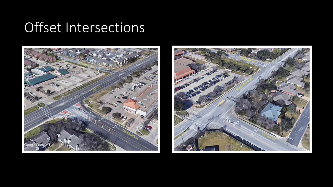
Offset Intersections

Mitigation Efforts
• Cul-de-sac at Ashburn Avenue
• Emergency access gate across Ashburn Avenue
• Raised median on Lincoln Avenue
• Is it necessary?
16

Changed Conditions since Eastgate Plan adoption• Importance of the public way connection
• Block Length Ordinance adoption – Sept 2013
• Commercial Preservation Report – Feb 2017
• TIA Results – Aug 2017

Commercial Preservation

Commercial Preservation
University Town Center • Property is 7 ½ acres located to the south of the existing
University Town Center development.
• Recommendation: Pursue City-initiated rezoning, in coordination with the property owner, to preserve the area for future commercial activities in lieu of multi-family development. The Eastgate Neighborhood Plan recommends use of a PDD Planned Development District for rezoning.
• Priority: First Phase. Staff will work with the property owner to complete a Comprehensive Plan Amendment and to develop a PDD Planned Development District zoning to address development concerns and constraints cited in the EastgateNeighborhood Plan.
• Size: 7 1/2 acres (some portion should remain zoned for single-family or townhome development)
• Property owner: Sahara Realty Group, Ltd (David Scarmardo)
• Future Land Use & Character designation: Urban and General Suburban
• Other Studies: Eastgate Neighborhood Plan describes the access to Lincoln Avenue as restricted and the land use adjacent to Lincoln as future single-family
• Existing zoning: GS General Suburban
• Entitlements: None
• Existing development: Vacant

Retail Sales & HOT Tax Value
• Current University Town Center = $1.1million/year in tax revenue
• Future University Town Center + 7 acres - projected $1.5 million/year in tax revenue
• Total Retail Sales & HOT Tax Value = $2.6 million/year
• Is it necessary?
20

Changed Conditions since Eastgate Plan adoption• Importance of the public way connection
• Block Length Ordinance adoption – Sept 2013
• Commercial Preservation Report – Feb 2017
• TIA Results – Aug 2017

Traffic Impact Analysis (TIA) Existing Conditions• Lincoln Ave
• 5,500 vehicles per day
• Major Collector type volumes
• Ashburn Ave, less than 350 vph
• Primarily residential traffic

TIA Information
• Study required for request anticipated to generate 150 vehicle trips per peak hour
• Site generates 223 AM trips and 195 PM trips
• Restaurant anticipated to generate around 65% of trips
Land Use Intensity /
Description Units
Townhouse 10 Dwelling Units
Hotel 100 Rooms
General Office 10,000 Square Feet
Shopping Center 15,000 Square Feet
High-Turnover Restaurant 25,000 Square Feet

TIA Global Trip Distribution
• Non-residential traffic concentrated along University Dr
• Munson provides connectivity to Lincoln Ave and Harvey Rd
• Little traffic along Ashburn Ave 1
0%
Texas
12% South
78% University

Scenarios Considered
1. Existing + Background Traffic
2. Original Study
3. Public Way Extension to Wellesley & Vassar Court
4. No Public Way Extension

Study Area – Existing + Background Volumes

Calculating Link Volume Difference
Scenario Build Out Volumes
Existing + Background
Volumes
Link Volume Difference

Study Area – Original TIA Link Volumes Difference

Study Area – Public Way Extension to V&W Court Link Volumes Difference

Study Area – No Public Way Extension Link Volumes Difference

TIA Recommendations
• Connection between University Dr and Lincoln Ave provides:
• Site access to UTC
• Connectivity to the surrounding area
• Two southbound exiting lanes at the site access proposed along Lincoln Ave
• Driveways to be laid out along Public Way extension be constructed to lineup with W&V to the west
• Acceptable LOS = LOS D
• LOS C or better projected through Build Out

Scenario Traffic Impacts
Ashburn Munson W&V
Original Study –
Public Way
Extension to
Lincoln & W&V
AM Peak = +5
PM Peak = +4
AM Peak = +22
PM Peak = +20
AM Peak = +0
PM Peak = +0
Public Way
Extension to
W&V Only
AM Peak = +0
PM Peak = +0
AM Peak = +17
PM Peak = +16
AM Peak = +58
PM Peak = +52
No Public Way
Extension
AM Peak = +0
PM Peak = +0
AM Peak = +18
PM Peak = +14
AM Peak = +0
PM Peak = +0

Public Way Connection - yes or no?
• National retailers are not interested with no Lincoln connection• Rear property will only develop as multi-family without connection• Loss of approx. $1.5 million/year in tax revenue• Council unanimously recommended and directed staff to pursue
Commercial Preservation of this lot• Developer has relied upon Council direction in February 2017 for staff to
pursue Comp Plan amendment to remove restriction in EastgateNeighborhood Plan and pursue a PDD rezoning
• TIA results – no difference on Ashburn/Munson between connection vs no connection
• Is it necessary?33

Pearland town center

Pearland town center

Alley

Alley

Alley
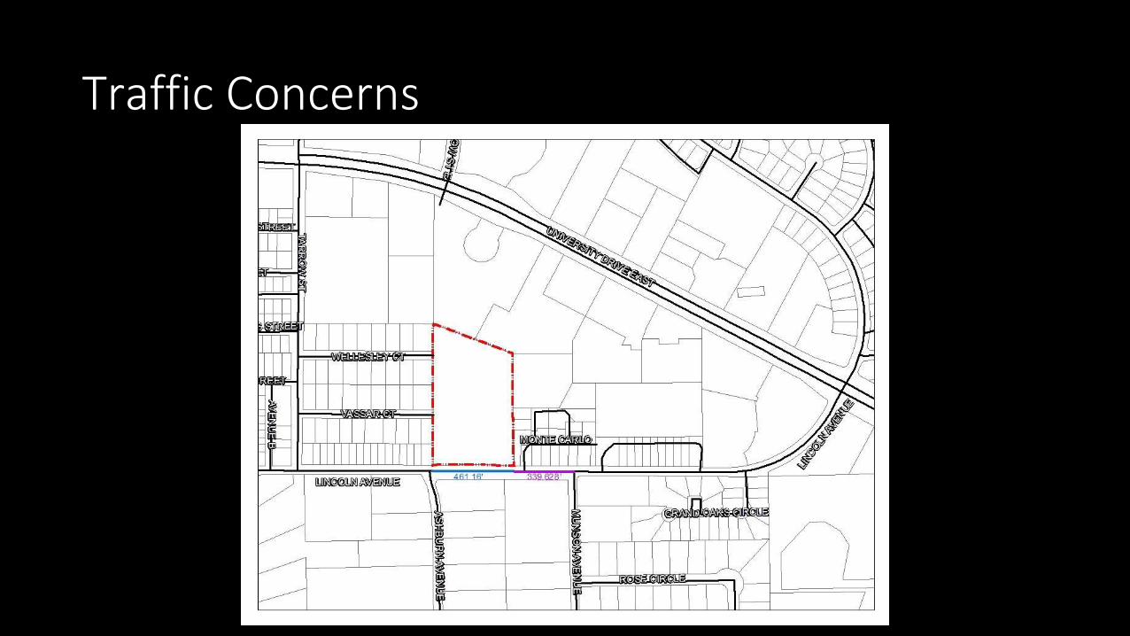
Traffic Concerns