east gippsland regional catchment strategy: …focus of the plan is on identifying climate change...
TRANSCRIPT
East Gippsland Regional Catchment Strategy: Climate Change Adaptation and Mitigation Plan
Version Reviewers
Final for Board
Strategy Manager Convenor Climate Change Plan Committee & EGCMA Board
2
Contents East Gippsland Regional Catchment Strategy: ........................................................................................ 1
Climate Change Adaptation and Mitigation Plan.................................................................................... 1
Foreword ................................................................................................................................................. 4
1. Introduction and planning context ..................................................................................................... 5
1.1 Background ................................................................................................................................... 5
1.2 Planning Principles ........................................................................................................................ 7
1.3 Purpose and Scope ........................................................................................................................ 7
1.3.1 What is included in the Plan .................................................................................................. 8
1.3.2 What is not included in the Plan ............................................................................................ 8
1.4 Strategic context ........................................................................................................................... 9
1.4.1 Legislation and policy ............................................................................................................. 9
1.4.2 Roles and Responsibilities .................................................................................................... 10
1.4.3 Important terms and definitions .......................................................................................... 12
2. Approach ........................................................................................................................................... 15
2.1 Bringing together knowledge and science to inform planning ................................................... 15
3. Drivers of change .............................................................................................................................. 21
3.1 Current and future climate ......................................................................................................... 21
3.2 Direct and indirect effects of future climate .............................................................................. 23
3.3 Socio-economic factors ............................................................................................................... 24
3.3.1 Influences on landholder adaptation to climate change ..................................................... 25
4. Climate change issues, impacts and potential adaptation options .................................................. 25
4.1 Existing approaches to adaptation ............................................................................................. 26
4.2 Soils and agricultural land ........................................................................................................... 27
4.3 Waterways – rivers and inland wetlands .................................................................................... 30
4.4 Coasts, estuaries and coastal wetlands ...................................................................................... 32
4.5 Native vegetation ........................................................................................................................ 33
4.6 Aboriginal cultural values ............................................................................................................ 35
5. Adaptation Plan................................................................................................................................. 36
5.1. Introduction ............................................................................................................................... 36
5.2 Adaptation Plan for priority RCS assets ...................................................................................... 37
5.3 Adaptation Plan for the East Gippsland ‘Areas of focus’ ............................................................ 44
5.3.1 East Gippsland Lowlands ...................................................................................................... 44
5.3.2 East Gippsland Uplands ................................................................................................. 47

3
5.3.3 East Gippsland Plains .................................................................................................... 50
6. Mitigation options ............................................................................................................................. 52
6.1 Carbon farming ........................................................................................................................... 53
6.2 Soil carbon ................................................................................................................................... 53
6.3 Vegetation ................................................................................................................................... 55
6.4 Blue carbon ................................................................................................................................. 56
6.5 Carbon options assessment for priority assets ........................................................................... 57
7. Implementation, monitoring and evaluation ................................................................................... 60
7.1 Implementation approach ......................................................................................................... 60
7.2 Monitoring and Evaluation ......................................................................................................... 61
8. References ........................................................................................................................................ 63
Appendices ............................................................................................................................................ 65
Appendix 1. Legislation and Policy .................................................................................................... 65
Commonwealth policy context ..................................................................................................... 65
State policy context....................................................................................................................... 65
Appendix 2. Detailed approach and methods .................................................................................. 66
Vulnerability and threat assessment ............................................................................................ 66
Assessment of climate change impact on threats to natural assets. ........................................... 69
Adaptation pathways .................................................................................................................... 71
Appendix 3. Vulnerability assessment maps .................................................................................... 74
Appendix 4. Adaptation pathways workshop results ....................................................................... 84
Lowlands Adaptation Options Analysis ......................................................................................... 85
Uplands Adaptation Options Analysis ........................................................................................... 87
Plains Adaptation Options Analysis .............................................................................................. 89
Appendix 5. Emissions Reduction Fund (ERF) approved methods ................................................... 91
Appendix 6. Soil carbon potential options ........................................................................................ 93

4
Foreword From Swifts Creek to Dargo, Mallacoota to Meerlieu, and everywhere in between, people living in
East Gippsland are no strangers to living with a variable climate. The East Gippsland Catchment
Management Authority (EGCMA) has led the development of a regional plan for Climate Change
Mitigation and Adaptation to help understand the consequences that arise for primary producers
and the regional community as a result of climate variability.
Developing the Plan has provided an opportunity to listen to local community members and gain an
appreciation of how climate variability impacts on individuals and the ways in which people are
responding to changes in weather patterns. A variable and changing climate poses both challenges
and opportunities for local producers and the broader community. Recognising valuable local
knowledge, together with research and case studies, has enabled the CMA to develop options for
land and natural resource managers to consider when making decisions about the future
management of the region’s natural resources.
The Plan:
Describes what farmers, communities and organisations in East Gippsland are currently
doing to adapt to seasonal variability.
Highlights the likely impacts from climate change and variability across East Gippsland.
Identifies potential opportunities arising from the projected changes.
Offers a range of practical options to support adaptation and carbon sequestration on
freehold land and with associated primary industries.

5
1. Introduction and planning context
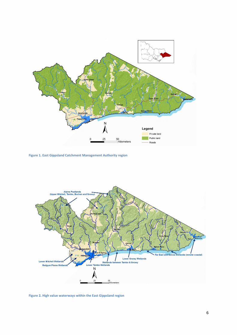
1.1 Background East Gippsland has many significant natural assets including soils, rivers, wetlands and coasts. The
region is unique in that it has large tracts of vegetated public land and smaller reserves scattered
through the rural and urban areas of freehold land.
Productive land uses are strongly linked to the natural assets including the major river floodplains,
which are used for intensive horticulture, and the foothills, which are used for grazing and timber
production. 17% of the East Gippsland region is freehold land. Grazing, irrigated horticulture and
dairy are the major agricultural land uses in East Gippsland (EGCMA, 2013).
People living in East Gippsland are no strangers to living with a variable climate, with drought, fire
and flooding occurring across history. Landholders, government agencies and community groups are
already adapting to climate variability in response to perceived risks.
The Australian Government has provided funding for the development of a natural resource
management (NRM) plan to identify options for climate change adaptation and mitigation. The
planning process has used a strategic approach and a long term planning timeframe to examine the
potential issues and opportunities arising from a drier, warmer and more variable climate in the
region. The plan has drawn on recent investigations and climate science data and reports, and has
involved discussions with landholders and regional stakeholders.
6
Figure 1. East Gippsland Catchment Management Authority region
Figure 2. High value waterways within the East Gippsland region

7
1.2 Planning Principles
Existing regional NRM plans are of varying climate change readiness. The Australian Government
recognises there is varying capacity for each of the regional NRM organisations to: plan for the
uncertainties of climatic conditions; access suitable planning resources, including spatial
information; and identify those parts of the landscape suitable for biodiverse carbon sequestration
plantings.
Development of this Plan has been guided by a set of principles drawing on those established by the
Australian Government for the NRM Planning for Climate Change Fund. The Plan therefore:
• Is framed in the context of the East Gippsland Regional Catchment Strategy (RCS) and its
programs of management, and forms a supporting document to the RCS;
• Uses the best available information, including existing information on the values of and
threats to natural assets in the region. No new investigations or research were undertaken
as part of this project;
• Is consistent with relevant Commonwealth and Victorian legislation, policies and strategies;
• Incorporated the views of the East Gippsland community through a structured consultation
and engagement program;
• Used the input from the regional community received through this program to develop its
recommended adaptation and mitigation options;
• Views climate change not as an isolated threat; rather as a multiplier or intensifier of known
threatening processes, and that in some instances it may have a positive impact on natural
assets;
• Is adaptable and has the ability to incorporate new information during its life;
• Includes, as its target audience, the community, as well as staff from government agencies
and other organisations that are responsible for NRM planning.
1.3 Purpose and Scope The East Gippsland Catchment Management Authority (EGCMA) has developed this Draft East
Gippsland Regional Catchment Strategy: Climate Change Adaptation and Mitigation Plan (the Plan).
The Plan represents a first effort at identifying options to address the potential impacts and
opportunities from climate change, based on an understanding of CSIRO climate projections for
2050.
The Plan has a focus on freehold land and will assist agencies and freehold land managers to make
informed decisions that consider feasibility of options for climate change adaptation and mitigation.
The Plan draws on recent research and investigation as well as local knowledge, which have
provided a strong platform on which to assess adaptation options and mitigation responses to asset
vulnerability and the socio-economic factors relevant to the East Gippsland region.
The Plan includes priority options for adaptation and mitigation to reduce the vulnerability of the
locations most likely to be impacted by climate change; and the most appropriate locations for
carbon sequestration projects. The Plan also recognises that climate change impacts are not viewed
in isolation from other threatening processes such as weed invasion, flood, erosion and

8
sedimentation, and bushfire impacts that may interact with each other, and which may be
intensified or in some cases ameliorated by climate change.
On the positive side, compared to other parts of Victoria, the projected changes in temperature and
rainfall by 2050 in East Gippsland will be more moderate. As a consequence, there may be more
opportunities for adaptation and development of new enterprises in primary production than in
other parts of Victoria and potential for increased production due to shifts in crops to Gippsland
from other production areas.
Importantly, the Plan supports and builds on the direction of the East Gippsland Regional Catchment
Strategy by highlighting the potential impact of climate change on priority regional assets, together
with practical and feasible options for their future management under a variable and changing
climate.
1.3.1 What is included in the Plan
The Plan has a principal focus on exploring practical options to support adaptation and mitigation for
natural assets on freehold land and their associated primary industries.
The Plan also considers:
Issues arising from climate change that operate at the landscape scale and have impacts
across public and freehold land and urban and rural areas; this includes fire, flood and
invasive plants and animals;
Options that are applicable for mitigation and adaptation on the smaller areas of public land
scattered throughout the region and the crown frontage of rivers and streams;
Sea level rise and storm surge in the context of the potential impact to natural assets and
the productivity of freehold agricultural land.
The Plan is consistent with Commonwealth and Victorian legislation, policies and strategies. The
focus of the Plan is on identifying climate change adaptation and mitigation measures where they
are not already the subject of statutory or regulatory responsibilities arising from policy and
legislation.
1.3.2 What is not included in the Plan
The Plan operates at the strategic level and is intended to provide flexibility for agencies and
freehold landholders to respond to a changing climate. The Plan does not aim to provide detailed
priorities and actions at the level that could be expected in action plans.
Planning for the large areas of public land in the region is the responsibility of the relevant land
managers. Similarly, planning for the region’s urban areas is the responsibility of local government.
While therefore not specifically focussed on planning in these areas, the Plan seeks to inform and be
informed by these planning activities by:
identifying preferred climate change adaptation and mitigation options in the broader
regional landscape;

9
providing a source of information and data; and,
providing a basis to support development of, and alignment with, future planning by public
land managers and local government.
The scope of potential mitigation options has been confined to consideration of carbon
sequestration in vegetation and soil in terrestrial and aquatic ecosystems. Mitigation through
reduction in greenhouse gases (i.e. through solar energy or reduced methane production) is not
within the scope of the Plan.
1.4 Strategic context The East Gippsland Regional Catchment Strategy (RCS) provides the overarching strategic direction
for natural resource management in East Gippsland for the period 2013-2019. It provides an
integrated planning framework for managing land, water and biodiversity in the region, in line with
the requirements of the Catchment and Land Protection Act 1994 (Vic).
The RCS sets objectives for a 20-year timeframe, providing long-term direction for natural resource
management. Strategic management actions are set for a six-year timeframe, the life of the RCS.
They are the most effective management activities that can be undertaken in this period, which
contribute to the achievement of the 20-year objectives. There is a range of sub-strategies and
actions plans that sit under and are given effect by the RCS, including this Plan.
The process of developing this plan has included a review of the RCS objectives from a climate
change perspective. The Plan will be implemented through the arrangements established for the
East Gippsland RCS.
1.4.1 Legislation and policy
Commonwealth policy context
The Australian Government has a range of programs that aim to reduce greenhouse emissions and
provide for adaptation to climate change. The Emissions Reduction Fund is the centrepiece of the
Australian Government’s policy suite to reduce emissions. Through a competitive process
community and business organisations will be contracted to implement projects that will lead to real
emissions reductions. Projects must use legislated methods to estimate emissions reductions
(Commonwealth of Australia, 2014b).
Natural resource management activities, including reforesting and revegetating land and improving
agricultural soils, will be eligible once methods have been developed and approved. The
establishment of the Emissions Reduction Fund builds on the previously established Carbon Farming
Initiative (CFI).
The Carbon Farming Initiative Amendment Bill 2014 was passed by the Parliament in November
2014. CFI is a legislated, Australian voluntary carbon offsets scheme administered by the Clean
Energy Regulator. The CFI allows land managers to earn carbon credits by reducing greenhouse gas

10
(GHG) emissions and increasing carbon sequestration in vegetation and soils through changes to
agricultural and land management practices (Commonwealth of Australia, 2014a).
State policy context
At a state level, the Climate Change Act 2010 (the Act) provides guidance on the Victorian
Government's roles and responsibilities in responding strategically to climate change in the context
of national climate change policy settings. The Act requires decision makers to take climate change
into account when making decisions under key pieces of legislation, including the Catchment and
Land Protection Act 1994, Coastal Management Act 1995, Environment Protection Act 1970, Flora
and Fauna Guarantee Act 1988, and Water Act 1989. The Climate Change Act requires the Victorian
Government to develop a Climate Change Adaptation Plan every four years, to outline the potential
impacts and risks associated with a changing climate. The first Victorian Climate Change Adaptation
Plan was released in 2013 and provides the framework for managing climate risks to critical Victorian
Government assets and services. It aims to help position the Victorian Government to prepare for
future climate challenges and to adapt to change.
1.4.2 Roles and Responsibilities
This Plan aims to identify strategies and options for mitigation and adaptation for both public assets
and freehold land managers.
The Plan will be implemented as a sub-strategy of the Regional Catchment Strategy, through
established partnerships and implementation arrangements with:
Agencies with direct water management, land management or other relevant legislated
responsibilities;
The regional community; and,
Other stakeholders such as non-government organisations, Landcare, Traditional Owners or
other community groups.
Roles and responsibilities for adaptation and mitigation align with existing statutory obligations and
arrangements for the management of natural assets. That is, government and government agencies
are responsible for managing the impacts to, and adaptation responses for, public assets and
providing leadership for adaptation and mitigation through appropriate policy and programs,
regulation, science and information.
The owners and managers of freehold land are responsible for managing their land. All levels of
government play a key role in supporting these managers and the wider community, including
through the provision of planning to support appropriate adaptation and mitigation responses.
Table 1. Roles and responsibilities of natural resource management stakeholders in climate change adaptation and mitigation
Stakeholder Role/responsibility
East Gippsland CMA Development, implementation and monitoring of Regional Catchment Strategy, and sub-strategies
Identify priority assets for protection from threats, including climate change
Community engagement and education
Commonwealth Integrating climate change adaptation and mitigation into NRM regional planning

11
Stakeholder Role/responsibility
Government (Department of the Environment, Department of Agriculture)
Funding programs (e.g. CFI, National Landcare Program).
State Government (Department of Environment, Land, Water and Planning; Parks Victoria; Department of Economic Development, Jobs, Transport and Resources)
Managing risks to public assets and services managed by the Victorian Government – including embedding climate change considerations into risk management and business planning for assets and critical service delivery
Managing risks to Victoria’s natural assets and natural resource-based industries – including developing overarching policy settings and direction for addressing climate risks to biodiversity, soils, waterways and land, coastal and marine ecosystems
Building disaster resilience and integrated emergency management – including reviewing and reforming emergency management arrangements.
Improving access to research and information for decision-making – by supporting coordinated research and information provision to assist all parties to adapt
Supporting private sector adaptation – by developing policy settings that support appropriate risk allocation, remove barriers to effective adaptation and promote business innovation
Partnering with local government and communities – including providing a basis for ongoing engagement with Victorian councils and their communities.
Victorian Climate Change Act 2010. The Act contains measures that support the management of, and adaptation to, climate risks and increase the ability of individuals, businesses and communities to capitalise on opportunities and includes:
Requiring the Victorian Government to develop a Climate Change Adaptation Plan every four years to outline the potential impacts and risks associated with a changing climate
Requiring decision makers to take climate change into account when making specified decisions under the Catchment and Land Protection Act 1994, Coastal Management Act 1995, Environment Protection Act 1970, Flora and Fauna Guarantee Act 1988, Public Health and Wellbeing Act 2008 and Water Act 1989
Creating new arrangements for the ownership, registration and transfer of forestry and carbon sequestration rights to help Victorian landholders who take part in carbon sequestration projects under the Commonwealth Government's Carbon Farming Initiative.
Water Authorities Impacts of different climate scenarios on inflows to storages and rivers systems
Reducing the costs associated with energy consumption and minimising greenhouse gas emissions
Research into customers’ water consumption changes under different climate scenarios
Providing environmental and recreational water
Infrastructure and water use efficiency projects
Participation in development of Sustainable Water Strategies and Groundwater Management Plans.
Local Government Managing risks and impacts to public assets owned and managed by local government and to local government service delivery
Collaborating across councils and, with the Victorian Government, managing regional climate change risks
Working in partnership with the community, locally based organisations and stakeholders to manage relevant climate risks
Implementing relevant legislation to promote climate adaptation
Contributing appropriate resources to prepare, prevent, respond and recover from detrimental climate impacts.
Farmers / land managers
Management of land, including consideration of sustainable land management practices.

12
Stakeholder Role/responsibility
Soils Groups and Productivity Groups
Agronomic and farming systems research and development.
Direct extension programs with farmers – information provision, technical guidance, awareness raising.
Aboriginal community
Gunaikurnai Land and Waters Aboriginal Corporation (GLaWAC ) the representative body for Gunaikurnai people, land and culture - notes that Gunaikurnai have a connection to all land within the native title boundaries (and in contested native title areas), including freehold land. The draft Country Plan (2015) states: ‘Gunaikurnai heritage is strong across our landscape, Aboriginal cultural sites and artefacts can be found along our songlines, and trade routes, mountain ridges and waterways. They remind us about the ways of our ancestors and show our close and continuing connection to Country. Some of these sites have been recorded, however many have not yet been found and protected. Our spiritual connection is something that cannot be seen, but nevertheless exists strongly in the places we walk and in the paths of our ancestors’.
GLaWAC holds Native Title on behalf of the Gunaikurnai People and has cultural heritage responsibilities under the Aboriginal Heritage Act 2006. GLaWAC has a custodial and cultural responsibility to look after Country.
GLaWAC has a leadership role in strengthening joint land management on Country (example of joint management with Parks Victoria of 9 Parks and 1 Reserve)
Opportunities for Aboriginal people to work on Country, including on carbon sequestration projects, recording cultural values and integrating traditional Gunaikurnai land management techniques (e.g. fire) into future climate adaption planning and management.
Landcare Networks and Landcare Groups
Local information sharing and awareness raising
Direct implementation of projects (e.g. revegetation, weed control) funded by State and Federal Government.
Regional Sustainability Groups
Community engagement and education
Working together to help reduce the community’s environmental footprint.
NGOs with NRM and biodiversity focus
State-wide conservation planning for biodiversity and connectivity
Direct land management
Scientific and technical advice for land managers.
1.4.3 Important terms and definitions
The meanings of the terms used in this Plan are set out below, as adapted for the purposes of this
project.
Assets: are the tangible bio-physical elements of the environment that are valuable for their role
and function or intrinsic value in their own right. Natural elements of the environment, with
environmental, social and economic values (EGCMA, 2013).
Greenhouse Gas: is any atmospheric gas that contributes to the greenhouse effect by
absorbing infrared radiation produced by solar warming of the Earth's surface. This
includes carbon dioxide (CO2), methane (CH4), nitrous oxide (NO2), and water vapour.
Climate variability: is the medium to longer-term aspect of weather. It refers to the variations in the
average state of climate from between a few years to a few decades. The term is used for time
frames of at least months. Climatic variability (CV) occurs at widely varying temporal and spatial
scales. Climate variability can result in extreme weather events, such as droughts, heavy rainfall, fire

13
weather, heat waves, hail storms and flooding. Seasonal variability and the occurrence of extreme
weather events is a key feature in East Gippsland.
Seasonal variability: refers to variations in climate factors, such as temperature and rainfall, as they
relate to particular seasons. For example, the variation in the timing of the ‘autumn break’ between
years or the occurrence of a wetter than average summer period, are examples of seasonal
variability.
Climate change: is the change in the average weather over a long period of time, typically measured
in periods of at least decades. Climate change can occur due to a combination of natural and human
causes (SCARP, 2014).
Weather: is the day-by-day variation in temperature, wind and rainfall (SCARP, 2014).
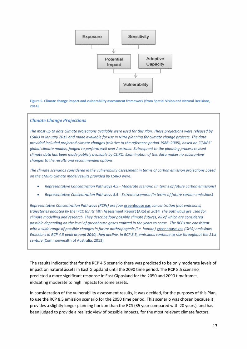
Exposure: means the weather events, weather patterns and background climate conditions that
affect the landscape and assets.
Sensitivity: reflects the responsiveness of an asset to climatic stressors or influences, and the degree
to which changes in climate might affect that system in its current form. Sensitive assets are those
which are highly responsive to climate and can be significantly affected by small climate changes.
Adaptive capacity: is the ability of an asset to adjust to climate change (including climate variability
and extremes), to moderate potential impact, to take advantage of opportunities, or to cope with
the consequences. The adaptive capacity of an asset or society describes its ability to modify its
characteristics or behaviour so as to cope better with changes in external conditions. Improving the
adaptive capacity of an asset reduces its vulnerability.
Vulnerability: is the degree to which an asset is susceptible to, or unable to cope with, adverse
effects of climate change, including climate variability and extremes. Vulnerability is a function of the
character, magnitude, and rate of climate variation to which an asset is exposed, its sensitivity, and
its adaptive capacity.
Terms used to describe approaches used in planning for climate change include (from SCARP, 2014):
Adaptation: is the process to manage risks, adjust activities or benefit from opportunities. In the
context of the Plan it means to adjust the management of natural assets and primary production to
the medium and long-term impacts of climatic change, such as sea-level rise, temperature rise and
changing rainfall patterns.
Blue carbon: is the carbon stored in coastal and marine ecosystems. Recent research into blue
carbon has focussed on carbon in coastal ecosystems – mangroves, tidal marshes and seagrasses.
These ecosystems sequester and store large quantities of carbon in the plants and sediment below.
For the purposes of this Plan, freshwater ecosystems including wetlands, rivers and creeks have
been considered as potential areas for blue carbon sequestration.
Carbon sequestration: is the general term used for the capture and long-term storage of carbon
dioxide. Capture can occur at the point of emission (e.g. from power plants) or through natural

14
processes (such as photosynthesis), which remove carbon dioxide from the earth's atmosphere and
which can be enhanced by appropriate management practices. Sequestration methods include:
enhancing the storage of carbon in soil (soil sequestration);
enhancing the storage of carbon in forests and other vegetation (terrestrial sequestration);
enhancing the storage of carbon in waterway, wetland and estuarine environments (aquatic
sequestration);
storing carbon in underground geological formations (geosequestration);
storing carbon in the ocean (ocean sequestration); and
subjecting carbon to chemical reactions to form inorganic carbonates (mineral carbonation).
Mitigation: is direct action to reduce the rate at which climate change is occurring by decreasing the
amount of greenhouse gases (e.g. emission reductions) and/or increasing the sequestration of
carbon through activities such as revegetation and soil storage.
Abbreviations
CFI – Carbon Farming Initiative
CMA – Catchment Management Authority
GHG – Greenhouse Gas
MER – Monitoring Evaluation and Reporting
NRM – Natural Resource Management
SCARP – Southern Slopes Climate Change Adaptation Research Partnership
15
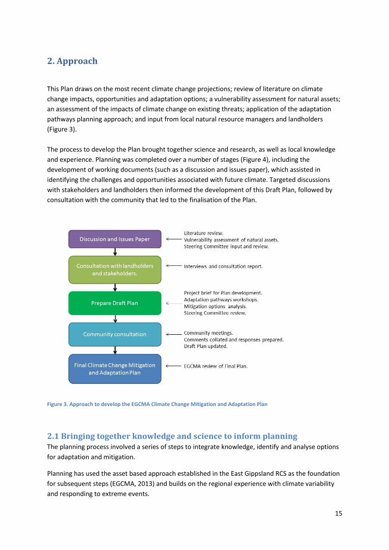
2. Approach
This Plan draws on the most recent climate change projections; review of literature on climate
change impacts, opportunities and adaptation options; a vulnerability assessment for natural assets;
an assessment of the impacts of climate change on existing threats; application of the adaptation
pathways planning approach; and input from local natural resource managers and landholders
(Figure 3).
The process to develop the Plan brought together science and research, as well as local knowledge
and experience. Planning was completed over a number of stages (Figure 4), including the
development of working documents (such as a discussion and issues paper), which assisted in
identifying the challenges and opportunities associated with future climate. Targeted discussions
with stakeholders and landholders then informed the development of this Draft Plan, followed by
consultation with the community that led to the finalisation of the Plan.
Figure 3. Approach to develop the EGCMA Climate Change Mitigation and Adaptation Plan
2.1 Bringing together knowledge and science to inform planning The planning process involved a series of steps to integrate knowledge, identify and analyse options
for adaptation and mitigation.
Planning has used the asset based approach established in the East Gippsland RCS as the foundation
for subsequent steps (EGCMA, 2013) and builds on the regional experience with climate variability
and responding to extreme events.

16
Each step is described in more detail below.
Figure 4. Major steps in developing the East Gippsland Climate Change Mitigation and Adaptation Plan
Vulnerability assessment
The first step in the process involved identifying the assets that are most vulnerable to climate
change. A vulnerability and spatial impact assessment was completed to inform NRM planning for
climate change. The assessment was completed for multiple natural asset classes and values and
included the use of available data on the characteristics, values and condition of the assets. The
assets considered in the assessment were consistent with those used in the RCS process and
included native vegetation, rivers and streams, wetlands, estuaries, coasts and soils.
The assessment incorporated multiple projections of future climate (see ‘climate change projections’
box) over different time frames and considered the potential climate change impact and
vulnerability using the assessment framework presented in Figure 5. The assessment covered the
whole of the state of Victoria.
17
Figure 5. Climate change impact and vulnerability assessment framework (from Spatial Vision and Natural Decisions,
2014).
Climate Change Projections The most up to date climate projections available were used for this Plan. These projections were released by
CSIRO in January 2015 and made available for use in NRM planning for climate change projects. The data
provided included projected climate changes (relative to the reference period 1986–2005), based on ‘CMIP5’
global climate models, judged to perform well over Australia. Subsequent to the planning process revised
climate data has been made publicly available by CSIRO. Examination of this data makes no substantive
changes to the results and recommended options.
The climate scenarios considered in the vulnerability assessment in terms of carbon emission projections based
on the CMIP5 climate model results provided by CSIRO were:
Representative Concentration Pathways 4.5 - Moderate scenario (in terms of future carbon emissions)
Representative Concentration Pathways 8.5 - Extreme scenario (in terms of future carbon emissions)
Representative Concentration Pathways (RCPs) are four greenhouse gas concentration (not emissions)
trajectories adopted by the IPCC for its fifth Assessment Report (AR5) in 2014. The pathways are used for
climate modelling and research. They describe four possible climate futures, all of which are considered
possible depending on the level of greenhouse gases emitted in the years to come. The RCPs are consistent
with a wide range of possible changes in future anthropogenic (i.e. human) greenhouse gas (GHG) emissions.
Emissions in RCP 4.5 peak around 2040, then decline. In RCP 8.5, emissions continue to rise throughout the 21st
century (Commonwealth of Australia, 2013).
The results indicated that for the RCP 4.5 scenario there was predicted to be only moderate levels of
impact on natural assets in East Gippsland until the 2090 time period. The RCP 8.5 scenario
predicted a more significant response in East Gippsland for the 2050 and 2090 timeframes,
indicating moderate to high impacts for some assets.
In consideration of the vulnerability assessment results, it was decided, for the purposes of this Plan,
to use the RCP 8.5 emission scenario for the 2050 time period. This scenario was chosen because it
provides a slightly longer planning horizon than the RCS (35 year compared with 20 years), and has
been judged to provide a realistic view of possible impacts, for the most relevant climate factors,
18
particularly changes in temperature and rainfall. The maps of results from the vulnerability
assessment for the East Gippsland region are provided in Appendix 1.
Planning also considered the potential impacts in the 2070 and 2090 time periods to help inform
thinking about trajectories and potential longer-term impacts for less vulnerable assets.
Threat assessment
The direct impacts from climate change should not be viewed in isolation but may act synergistically
when combined with other current or emerging threats to the values of assets. The effects of fire;
flood; habitat loss and change in land-use / land management practices; invasive animals; pests and
diseases; as well as altered water regimes on these assets, may intensify or be reduced under
climate change (NCCARF, 2013).
A review of the threat levels for assets identified in the East Gippsland RCS in light of projected
climate change impacts was completed to help inform the Plan (see Appendix 2).
The review assessed how the projected changes to climate variables may influence existing threats
and provides focus on the likely impacts of climate change whilst considering existing threat levels.
For example, reduced rainfall and increased temperate are likely to have a direct amplifying
influence on fire frequency and severity and when the entire suite of climate variables are
considered it is likely that there will be increased threat from fire in the future. For each priority
asset the assessment identifies both the current level of threat and the likely change in threat in the
future as a result of climate change.
The threat assessment framework identified that climate change is likely to have the highest
combined impact on the threats from erosion, fire, altered flow regime, degraded water quality and
degraded native vegetation. Together with the results of vulnerability assessment and consultation
with regional stakeholders, this threat assessment helped to identify locations and options for
climate change adaptation and mitigation in the region.
Climate change issues, opportunities
Describing the potential issues for primary production and natural assets from climate change was
the next step in the process. This was introduced through a timeline exercise with stakeholders that
captured past climate variability, change in the landscape and associated land and natural resource
management issues. This step enabled the scope of the project to be refined and locally important
factors, relevant to the East Gippsland region, to be described and considered in the subsequent
analysis of future climate. Both the risks and opportunities arising from climate change were
identified through review of relevant literature. Interviews were also held with key stakeholders and
landholders in the region, which enabled local issues of importance to be highlighted.
Adaptation options
Potential adaptation options for the natural assets and major agricultural industries in the region
were identified and documented through interviews with landholders and NRM stakeholders,
information assembled by SCARP, and a broader review of available literature. Landholder
interviews focussed on experience with past seasonal variability and future plans for adaptation
based on projected changes in climate.

19
The information gathered through these steps was compiled into working documents, for
subsequent review by the Climate Change Plan Steering Committee.
Identifying locations for adaptation planning
The approach used to identify locations and options for adaptation has two broad elements:
1. Development of adaptation options for individual priority RCS assets; and,
2. Development of strategic adaptation options across broader areas, described as ‘Areas of
focus’ for the purposes of this Plan.
The three ‘Areas of focus’ were developed to represent typical conditions of the East Gippsland
region by identifying suites of similar climate change vulnerabilities, impacts and responses. These
similar areas were then grouped together into the following sub-regional ‘Areas of focus’:
East Gippsland Plains which encompasses an area in the west of the region between the
Gippsland Lakes, the Mitchell River and areas of forest and reserves in the foothills of the
Great Dividing Range.
East Gippsland Lowlands which incorporates the floodplains of the Mitchell, Tambo,
Nicholson, Snowy, Cann and Genoa Rivers;
East Gippsland Uplands, which incorporates the areas of freehold land in the Dargo valley,
and upper Tambo and upper Snowy catchments.
These areas are broadly representative of the types of freehold land in the East Gippsland region.
Adaptation planning
Identification of adaptation options for this Plan incorporated a planning approach known as
‘Adaptation pathways’, in addition to the previously described studies, literature review and
engagement with stakeholders.
Adaptation pathways planning is a process whereby organisations or groups can map current actions
and future adaptation options, and assess these options in relation to a variety of relevant
considerations (Wallis et al., 2015).
While the methods for implementing an adaptive pathways approach are still emerging, the project
team trialled processes with researchers from SCARP (SCARP, 2014a) to further develop the method
for application in East Gippsland. A key benefit of the approach was the enabling of discussions
around:
the potential trade-offs required for different adaptation options;
the feasibility and practicality of various options;
maintaining productivity and enterprise viability in the future; and,
the importance of identifying local important climate change issues for different natural
assets.
20
Workshops were conducted for each of the ‘areas of focus’ using the following structured approach:
1. Reviewing the RCS objectives;
2. Understanding the current situation including the extent and condition of natural assets,
trends in land management practices, drivers and barriers to adaptation;
3. Analysing the possible future based on projected changes in climate and potential impacts
(using the vulnerability assessment results) associated with emissions scenario RCP 8.5 for
the 2050 and 2090 timeframes;
4. Identifying potential adaptation options; and
5. Assessing feasibility, risk, adoption and cost of respective options.
Each workshop developed an agreed set of adaptation pathways. Each ‘Area of Focus’ workshop
involved people with particular scientific and technical information relevant to each asset, together
with local knowledge about aspects such as land use and land management trends, values and
attitudes, and socio-economic drivers.
The workshop process enabled participants to contribute specific information and ideas for each
step. This information was collected and analysed and forms the basis of the adaptation options set
out in Section 5.
Further analysis informed the development of options for priority RCS assets. The vulnerability
assessment results were used to rank the priority RCS assets. Assets were given a vulnerability
ranking of very high, high, moderate or low according to their vulnerability score.
Adaptation options were identified for those assets with a moderate to very high vulnerability
ranking. The identification of adaptation options for RCS assets drew on the results from the
climate-threat assessment, a review of adaptation research and literature, consultation with regional
stakeholders and the outcomes from the adaptation pathways workshops.
Mitigation options
Climate change mitigation consists of actions to limit the magnitude and/or rate of long-term
climate change. Climate change mitigation generally involves reductions in human (anthropogenic)
emissions of greenhouse gases, together with activities that aim to increase the sequestration of
carbon in native vegetation, soils and the carbon in aquatic environments, known as ’blue carbon’.
A range of mitigation options were identified during the development of the Plan, some of which
relate directly to reducing greenhouse gas emissions (e.g. reduced tillage cropping systems);
however the focus for this plan is on options which aim to increase carbon sequestration in
terrestrial vegetation, soils and aquatic environments. In East Gippsland, significant aquatic
environments with the potential to sequester ‘blue carbon’ include:
coastal ecosystems such as mangrove, seagrass and saltmarsh.
wetlands; and
rivers and streams including riparian and in-stream vegetation.

21
Specific carbon sequestration options have been examined in detail in Section 6, where priority
assets have been assessed in an analytical way in terms of the relative potential of activities to
enable these assets to sequester and store atmospheric carbon.
There are significant linkages between adaptation and mitigation actions. A number of actions
identified in the development of adaptation pathways are directly relevant to emissions reduction
and carbon sequestration. For example:
In agricultural production systems the adoption of practices that increase biomass and
reduce disturbance of soils has mitigation benefits through reducing greenhouse gas losses,
while also increasing soil carbon levels
Restoration of areas of land to reduce flood damage risk was identified as a key adaptation
option in floodplain landscapes (in the Lowlands adaptation pathways workshop), with the
added mitigation benefit of carbon sequestration through establishment of vegetation.
Evaluation of mitigation options has been informed by review of:
Government frameworks and methods; and
A literature review, particularly that of Hamilton et. al (2014). This report was prepared
specifically for the Southern Slopes Cluster of natural resource management regions to assist
with NRM planning for climate change projects. The report focussed not only on ways of
sequestering terrestrial and aquatic carbon in soils and plants, but also ways of maintaining
and preventing loss from existing stocks of stored carbon in the landscape. Sequestration
activities that reduce GHG emissions in the Agriculture, Forestry and Other Land Use sectors
that are within the sphere of activities relevant to Southern Slopes Cluster were also
examined.
3. Drivers of change
Planning for adaptation and mitigation requires understanding and consideration of both climate
and non-climate “drivers” that influence how natural and human systems respond over a range of
time frames. Climate drivers include both current climate variables and future projections of climate,
whilst non-climate drivers include socio-economic trends, market forces and existing threats in the
landscape. This section describes the key climate drivers relevant to East Gippsland, its natural assets
and agricultural industries.
3.1 Current and future climate East Gippsland has a mild climate with warm summers and mild to cool winter conditions that vary
considerably within the topography of the region, influenced by:
Average annual rainfall which varies from 600mm to 1000mm as a result of topography and
prevailing wind conditions;
Low pressure systems off the east coast which can be responsible for extremely heavy
rainfall events in East Gippsland; and

22
The topography of the Great Dividing Range and the Strzelecki’s, which can induce ‘foehn
like’ winds creating ‘rain shadow’ areas.
Climate variability is a significant feature of the East Gippsland climate with patterns of drought,
flood and fire occurring across history.
A summary of the most recent climate projections for the region, based on research from CSIRO,
indicate that the future climate in East Gippsland is likely to have the following characteristics:
Temperature
Average daily minimum and maximum temperatures are predicted to increase, with an
increase in the temperature reached on the hottest days and increase in the frequency of
hot days and duration of warm spells.
Rainfall
Decline in average annual rainfall particularly autumn-winter and spring rainfall, with
potentially an increase in summer rainfall.
Tendency for heavier rainfall interspersed by longer dry periods, with some extremely dry
and wet years, with natural variability continuing to be a major driver of rainfall.
Intensity of rainfall and time in drought
Intensity of heavy rainfall events is predicted to increase, with timing and magnitude driven
by natural variability.
A decline in the number, but an increase in the intensity of east coast lows, impacting on
average rainfall and heavy rain events.
Time spent in drought is predicted to increase in line with changes to average rainfall, and
the frequency and duration of extreme droughts will increase.
Wind
Little change in annual average wind speed, but higher wind speeds during the cooler
months (July to October) and lower wind speeds during the warmer months (November to
May).
Relative Humidity
Decrease in relative humidity across all seasons, with a tendency for decreases in humidity
to coincide with areas of rainfall decline, leading to reduced effective water availability
through lower moisture inputs and higher rates of evapotranspiration.
Fire
More frequent and intense fires are projected as a result of increased temperature and
reduced relative humidity.
Sea level
Continued increase in sea levels and more frequent sea level extremes, including storm
surge, is projected.
23
3.2 Direct and indirect effects of future climate Climate change can have direct effects on assets, through changes in rainfall and temperature, and
secondary effects such as sea level rise, droughts, floods, and other extreme weather events.
Climate variables, other than temperature and rainfall, which also influence processes in the
landscape like plant growth and the hydrological cycle, are also important to consider. For example
solar radiation, relative humidity and potential evapotranspiration are all likely to have effects on
primary production and on natural assets.
In East Gippsland, while the overall amount of rainfall may not change significantly, a shift from
winter to summer rainfall is likely to result in more rainfall being lost to evaporation and
evapotranspiration. This has implications for the growing of pastures and crops, and for natural
resource management activities including the timing and methods for establishment of native
vegetation.
Projected changes in rainfall and higher rates of evaporation will result in reduced run-off and less
water for on-farm dams and catchments, although this may be moderated by summer rainfall
events. Decreases in rainfall and higher evaporation rates will mean less soil moisture, less runoff
and reduced base flow for rivers. Average annual runoff into the major rivers of East Gippsland is
predicted to decrease by between 25% and 35% by 2030, and by more than 50% by 2070 (DSE,
2008a).
There may also be a corresponding increase in demand for water as a result of warmer
temperatures and population changes. Therefore, the need to use water more efficiently and
effectively will be even greater (DSE, 2008b).
Furthermore lower base flows in rivers and higher temperatures may also reduce water quality
within the catchment and create a more favourable environment for potentially harmful algal
blooms (DSE, 2008a).
The potential increase in the intensity of heavy rainfall is likely to result in an increased frequency
and magnitude of flooding; which, if accompanied by increased summer rainfall and reduced
average inflows, could result in shifts in the flow regimes of rivers. For example, there may be a
decrease in the magnitude of base flows in winter and spring, but an increase in the number of high
flow events and floods in summer and autumn.
Community perspectives - floods
When it floods you can lose a whole crop in an instant. In some places on the floodplain it’s just not suitable for growing them [vegies]. It would be better if it stayed as dairy in those places so then you wouldn’t lose all that topsoil.
When it floods we have to try and get the water off the paddocks as quick as we can otherwise we lose pasture. We pump into big drains that go around our property and eventually go into the local creek.
Sometimes you just have to respond to it as it happens. We had a big rainfall event and flooding in April, just after lambing. We had nowhere to put them – the lambs were just drowning. In that instance we should have put them in a stock containment area that we built in the drought.

24
An overall trend towards warmer, drier weather is likely to increase the frequency and intensity of
bushfires. Fire-weather risk measures how a combination of weather variables influences the risk of
a fire starting, its rate of spread, its intensity and the difficulty in suppressing it. In comparison to
climate during the period from 1974 to 2003, by 2020 it is projected that the number of ‘extreme’
fire danger days will generally increase by between 5% and 40% (DSE, 2008a). However there are
significant differences in the projections for fire weather; modelling using lower emissions scenarios
predicts the number of ‘extreme’ fire days is likely to increase by between 15% and 25% by 2050,
while under a higher emissions growth scenario, the number of days is likely to increase by between
120% and 230%. Greater bushfire activity could temporarily contaminate water catchments with
sediments and ash and have longer-term impacts on catchment yield, water quality and runoff to
waterways.
Community perspectives – fire
Fire just has to be a massive consideration in East Gippsland. If our rainfall shifts in season and it gets hotter I reckon there will be a lot more grass fires and that will be a big concern.
We are moving away from fire recovery where we just put back what was there before, we are encouraging communities to adapt to fire and learn from what happens in fires when they rebuild.
Wildfire is a big problem - planned burning needs to consider the frequency, timing and environmental needs of the broader landscape.
3.3 Socio-economic factors Socio-economic and political factors will play a significant role in how primary producers, the
broader community and institutions (such as government) respond to climate change.
As the pattern and magnitude of future climate change is uncertain, so too are future trends in
factors related to primary production and NRM, such as land use and land management change,
enterprise viability, demographic shifts and community attitudes.
In some parts of East Gippsland, there is a trend towards a smaller number of ageing farmers
managing larger areas of land. In contrast some areas closer to major regional centres are
experiencing increased population of lifestyle landholders attracted to the amenity values associated
with East Gippsland.
The trend of an ageing population is consistent with what is occurring in other places in Victoria
(Victorian Government, 2014) and one study forecasts the percentage of people aged over 65 in East
Gippsland will increase from 20% to 32% by 2026 (DPCD, 2011). Such demographic changes,
including amalgamation of farms, have reduced the population of isolated communities and
impacted on the capacity of some communities to respond to natural events, such as fire and
drought. Whilst development has benefits for the regional economy the increase in smaller lifestyle
and peri-urban properties can place pressure on infrastructure and the condition of natural assets
and can result in loss of productive land.
25
There is potential for land use to change over time in response to both socio-economic factors and a
changing climate. These factors provide a backdrop to the consideration of adaptation and
mitigation options in this Plan, but in line with the scope they aren’t the focus of this Plan. The East
Gippsland Shire Council has commenced a Rural Landuse Strategy to provide strategic and long term
planning for rural land use and development to address these matters.
3.3.1 Influences on landholder adaptation to climate change
In a study of landholder responses to climate change, Thwaites et. al, (2008) proposed a framework
to understand the influences on rural landholder adaptation to changes in their environment. People
have different abilities and inclinations to respond (making decisions about how to act in the short
and long term) to a range of conditions that occur at different scales. The following critical themes
were identified:
Factors particular to individuals; value and belief systems, attitudes and perceptions,
personalities, goals and motivations.
The range of ‘resources’ (social, human, financial, physical, natural) available to them.
The nature of the practice they are considering or have taken. This is essentially the
feasibility, benefits and costs of the option as seen by different landholders.
Regional agricultural systems and broader operating environment; economic conditions and
pressures; government policies, legislation, programmes; public pressures; and
environmental conditions, such as climate change (Thwaites et al., 2008).
Consultation with primary producers and key community stakeholders in East Gippsland confirmed
the importance of the above factors in both short and long term responses to climate variability and
climate change. This was reinforced in the development and evaluation of options examined in the
adaptation pathways planning.
4. Climate change issues, impacts and potential adaptation options
Natural assets, including productive soils, rivers, wetlands, estuaries, native vegetation, fauna and
coastal areas are of great value to the East Gippsland community.
The potential impacts on these natural assets, from climate change, may act synergistically with
other current and emerging threatening processes such as habitat loss; change in land-use and
management practices; invasive animals; pests and diseases; fire; and reduced water availability and
altered flow regimes.
Projected changes in climate also have the potential to provide new and significant challenges. The
key issues, opportunities and potential relevant to primary production and natural resource
management in East Gippsland are summarised in the sections below. The options identified in this
section have informed the development of the Adaptation Plan (Section 5).

26
The vulnerability of natural assets has been described in the context of the RCS Landscape areas: the
Gippsland Lakes and Hinterland, Gippsland Lakes Upper Catchment, East Coast, and Far East Coast,
in line with the overall approach to the Plan (see below).
Figure 6. Landscape Areas of the East Gippsland Regional Catchment Strategy (EGCMA, 2013)
4.1 Existing approaches to adaptation Landholders and natural resource managers are already making a conscious effort to cope with and
respond to seasonal variability and significant climate events such as flood, fire and drought in
response to perceived risks. These responses include: identifying new water supplies such as
groundwater bores; capturing more surface water (by enlarging dams, and installing additional tank
storage); and improving water use efficiency (by installing pipes and troughs, and in some cases
adopting minimum till practices to conserve soil moisture). The continued use of perennial pasture
species in the last decade has been important in maintaining grazing enterprise viability through dry
periods.
Long term planning to cope with a more variable climate is also occurring and is driven by socio-
economic and climate related factors. Examples of longer-term responses include: shifting family
business structures (including off-property work); purchase of additional holdings in alternative
districts to reduce drought risk; changes in enterprise mix; and changes in land and water
management (e.g. accessing ground and surface water, water storage, establishing perennial
pastures).
27
4.2 Soils and agricultural land The vulnerability of soils to climate change is strongly linked to the type of soil and its inherent
characteristics, but is ultimately determined by land use and management. For example, maintaining
groundcover on light sandy soils will reduce the vulnerability of that soil to erosion.
In this Plan the focus for adaptation is on understanding the issues for agricultural land managers in
order to develop adaptation options that have benefits for soils and agricultural production.
There is significant variability in land type and geology in the East Gippsland region. Soils in the
eastern part of the East Gippsland region are well structured and fertile with high organic matter
content, whilst in the west of the region soils are generally low in organic matter content, are lightly
textured and prone to erosion (EGCMA, 2013).
The major agricultural commodities in East Gippsland are vegetables, livestock and livestock
products (meat, milk, and wool), crops, and hay. Agricultural production in the region is
concentrated on the Gippsland Plains, the Mitchell and Tambo river valleys and the Monaro
Tablelands, where the original open grassy woodland lent itself to grazing, and where rich alluvial
soil has supported the development of intensive agriculture.
In general, the lowland soils associated with the Red Gum Plains and fertile river valleys have the
potential for increased agricultural production in the future (EGCMA, 2013).
A key challenge for the management of grazing land relates to varying stocking rates in response to
seasonal conditions. The onset of dry seasonal conditions and transition to longer-term drought is
often subtle and the ability to adaptively adjust stocking rates is a constant challenge, but when
done successfully maintains ground cover and reduces the need for hand feeding of animals.
Strategic use of stock-containment areas is also very effective in protecting pasture and soils, with
benefits in both drought and excessively wet years.
Issues, opportunities and asset vulnerability
The potential impacts of a warmer, drier and more variable climate on soils and the major
agricultural industries in the East Gippsland region include:
reduced water availability and security
changes to growth of pasture and yield of crops
altered carrying capacity and soil condition
negative impacts on animal health
physical damage due to more frequent and/or severe floods and fires, and
changed spread of pests, weeds and disease.
Community Perspectives – grazing and cropping
Droughts have had the biggest impact, you gradually get declines in stock and productivity and your ability to respond deteriorates. With floods and fires there are short-term impacts but with drought it goes on and on.
It’s the combination of market forces and climatic events that cause shifts in agriculture say from wool to beef or to cropping.
On the really hot days you have to make sure there is a good amount of shade in the paddock and plenty of

28
water or the cattle really suffer.
Groundwater is a really important resource [on the Red Gum plains]. If access to groundwater was impacted then that would really affect agriculture in this area. We rely on it for stock water and lots of people use it to irrigate crops too.
Community Perspectives - horticulture:
Droughts are game changing…during the last drought I spent a lot of money building dams to increase water security. One dry year with no water and no product to sell was enough to make that decision.
If we had 4-5 days over 42C then that would have a big impact. In those conditions flowers drop off and the plants can’t physically take up water.
Compared to other parts of Victoria, the projected changes in temperature and rainfall by 2050 in
East Gippsland will be more moderate. As a consequence, there may be more opportunities for
adaptation and development of new enterprises in primary production than in other parts of
Victoria and potential for increased production due to shifts in crops to Gippsland from other
production areas.
The vulnerability of soils to climate change is strongly linked to the inherent properties of the soil as
described by the soil type and the level of ground cover. In East Gippsland, soils were assessed as
having a lower overall potential vulnerability to climate change compared with the other asset
classes. The soils, on freehold land, with the highest potential vulnerability were: dark clays, pale
sands, yellow duplex soils, red friable earths, grey clays and grey sands. (Spatial Vision & Natural
Decisions, 2014).
Table 2. Highest potential vulnerability for soil classes that have a freehold land interface in East Gippsland (Spatial Vision & Natural Decisions, 2014)
Asset name East Gippsland RCS Landscape Area
Red friable earths
East Coast Gippsland Lakes & Hinterlands Far East Catchments
Pale sands, Yellow duplex soils East Coast Gippsland Lakes & Hinterlands
Grey clays, Grey sands
Far East Catchments East Coast Gippsland Lakes & Hinterlands Gippsland Lakes Upper Catchment
Dark clays East Coast
Potential adaptation options
Potential adaptation options for agricultural land and soil are set out below and have formed the
basis of analysis for development of this Plan. Options have been identified in response to key
climate change variables.

29
It is important to note that the options outlined below relate to individual practices, rather than
whole farming systems. For agricultural land managers, profitability is the underlying driver to be
considered when adaptation options are being assessed. Adaptation in farming systems is unlikely to
happen practice by practice, rather through incremental changes that enhance the long-term
financial viability of enterprises. Market forces remain a key influence on the operation of farming
enterprises and set the context for adaptation. The potential adaptation options described below
will require careful evaluation of both short-term and long-term financial performance, feasibility
and risk, and support through farm-scale extension and agronomic advice.
Table 3. Potential adaptation options for agricultural enterprises in East Gippsland
Climate Change Variables:
Reduced and more variable rainfall
Increased temperatures and extreme heat
Increased intensity and frequency of rainfall events (including flooding)
Increased frequency of fire
Storm surge and sea level rise
Agricultural land – grazing (beef, dairy and sheep)
Soil management practices to reduce compaction, tillage, and retaining stubble; these reduce potential for nitrous oxide loss and increase soil carbon, while also improving productivity Optimise feed use efficiency through improved breeding programs that improve growth rates and weaning times Use flexible grazing techniques based on the pasture and animal requirements to maintain productivity and improve ground cover Match fertiliser program to pasture/crop requirements including industry tools that draw on soil/plant testing, seasonal forecasting, soil nutrient reserve and fertiliser type Increase diversity of farm water options
Provide shelter and shade from extreme heat, through vegetation establishment or use of shade structures Provision of sheltered watering points Trial of new pasture and crop varieties Increase ground cover through grazing management Change to milking times to avoid hottest part of day Consider calving/lambing times in the context of potential heat stress and feed availability Use of summer active perennials in pasture systems
Improve and increase flood-warning systems Maintain groundcover to mitigate against erosion Adoption of alternative grazing strategies Consider timing of planned burns and risk of rainfall events / flooding to reduce downstream impacts
Consider on-farm strategies to protect assets in high fire risk areas Additional insurance Property level fire management plan
Increased effort on invasive plant and animal control after fires
Identify alternate varieties and breeds that can deal with increased salinity Urban development may move away from the coast to high agriculture and natural asset areas

30
Climate Change Variables:
Reduced and more variable rainfall
Increased temperatures and extreme heat
Increased intensity and frequency of rainfall events (including flooding)
Increased frequency of fire
Storm surge and sea level rise
Agricultural land – horticulture
Increase on-farm water storage capacity Increase irrigation efficiency and re-use where applicable Spread production over a range of areas within the region to different irrigation or rainfall zones New/alternate varieties more tolerant of water stress and reduced rainfall Change crops to more water efficient varieties
Trial new/alternate varieties more tolerant of increased temperature
Shift timing of planting, change crops Use protective structures Irrigation and water management to mitigate heat effects For perennial crops optimise canopy growth and shading to prevent damage to fruit (sun, fungal and pest attack)
Use alternative bed preparation techniques that reduce cultivation Inter row plantings of pliable plant species Shift production out of floodplain and/or spread production across multiple locations Early detection programs to address new diseases and pests Schedule planting to avoid planting during flood prone times Use ground cover crops to protect paddocks at flood risk during time of year when floods most likely
Additional insurance Farm based fire management plan Consider placement of key infrastructure to enable better protection during fire event. Coordinated recovery programs to assist landholders to respond.
Identify alternate varieties that can deal with increased salinity Provide buffer between crop and area likely to be impacted by storm surge and increased salinity
4.3 Waterways – rivers and inland wetlands The waterways of East Gippsland are important features of the landscape, providing water for
agriculture and domestic use, having high social and cultural values and for being largely in good
condition, with approximately 82% assessed as being of ‘Excellent’ or ‘Good’ condition in Victoria
(EGCMA, 2014).
Issues, opportunities and asset vulnerability
The projected decreases in average rainfall and runoff is likely to have direct impacts on the
hydrology of waterways and wetlands, with consequent impacts for vegetation and fauna (Wallis et
al., 2015). For wetlands, these changes combined with increased temperatures could cause a shift in
wetting and drying regimes, with the impact likely to be greatest on those that require frequent
wetting or permanent inundation.
Existing threats including flooding, erosion and sedimentation are likely to be exacerbated by
increased frequency and intensity of rainfall events, whilst poor water quality will also be influenced
by increased temperatures and low flow conditions in summer and autumn (Hobday & Lough, 2011).

31
In East Gippsland, rivers were not considered as being highly vulnerable to climate change, because
of their generally good condition (Spatial Vision & Natural Decisions, 2014). The rivers with the
highest potential vulnerability in the region are the upper reaches of the (unregulated) waterways
such as Suggan Buggan River, Rocky River, Little River East Branch, Butchers Creek, Bonang River,
Boggy Creek and Bendoc River.
Unlike waterways in other regions, the vulnerability of these rivers is due to their inherent sensitivity
rather than their adaptive capacity. The vulnerable waterways in East Gippsland are all located in
the upper catchment and are unregulated and, due to their location in the catchment, are sensitive
to changes in rainfall in order to maintain their flow regimes.
Regarding inland wetlands, shallow freshwater marshes and freshwater meadows on freehold and
public land within the Gippsland Lakes and Hinterlands, the East Coast Landscape Areas and the
Alpine Peatlands were found to be the most vulnerable as a result of their low adaptive capacity
(lack of connectivity and remnant vegetation) and their sensitivity to changes in rainfall and
increases in temperature (Spatial Vision & Natural Decisions, 2014).
The impact of climate change on existing threats to natural assets in East Gippsland was assessed
through a simple framework (see section 2.1 ‘Threat assessment’). For rivers and inland wetlands,
climate change was assessed as having the highest impact on threats from invasive plants, degraded
riparian zones and altered flow regimes. For alpine wetlands there is also likely to be a high impact
on threats from invasive animals (through increased populations and range of invasive species) and
fire regime (from a predicted increased frequency of fire). A focus on managing these threats will
contribute to improving the adaptive capacity of waterways in the region to adapt to a changing
climate.
Potential adaptation options
Potential adaptation options for rivers and inland wetlands in response to key climate change
variables are set out below and have formed the basis of analysis for development of this Plan:
Table 4. Potential adaptation options for rivers and inland wetlands in East Gippsland
Climate Change Variables
Reduced and more variable rainfall
Increased temperature and extreme heat
Increased intensity and frequency of rainfall events (including flooding)
Increased frequency of fire
Storm surge and sea level rise
Rivers
Increase extent of riparian vegetation and improve connectivity of corridors to provide shading of waterways
Provision of environmental flows
Protection of summer base flows (regulation of timing / magnitude of extraction)
Protection of refuge areas for fish and aquatic fauna in conjunction with pest species programs
Establishment of riparian vegetation; in stream habitat restoration
Control competing aquatic species (plant and animal)
Maintenance of ground cover in strategic areas
Geomorphic recovery through works (vegetation and structural)
Management of flashy surface water inflows in urban / agricultural environments through swale drains and constructed wetlands
Focus fuel reduction burning to protect vulnerable areas.
Increase effort in recovery programs to assist with rehabilitation of burnt habitats.
Allow for migration of habitats as salinity level increases
Consider artificial barriers to maintain freshwater / brackish habitats
32
Wetlands
Removing existing artificial barriers or lowering ‘commence to fill’ levels Preventing disturbance to the peat structure of alpine wetlands (e.g. through fire, physical damage etc), which can accelerate drying
Weed and pest control to improve condition and adaptive capacity Improve connectivity between wetland habitats Restore buffer vegetation around wetlands
Management of flashy surface water inflows in urban / agricultural environments through swale drains and constructed wetlands
As for rivers As for rivers
4.4 Coasts, estuaries and coastal wetlands The East Gippsland coast includes systems of dunes, rocky headlands, cliffs, marshes and sandy
beaches that are protected in the regions iconic coastal parks and reserves. Whilst much of the
coastline is formed from mobile sand dunes shifting gradually eastward, in the far east the coastline
is punctuated by rocky headlands and outcrops (EGCMA, 2013).
Estuaries and coastal wetlands within this zone range from the largest and most modified, in the
west of the region (the Gippsland Lakes), to a series of smaller systems that are in exceptional
condition, in the east (EGCMA, 2013). Many of the region’s estuaries provide important waterbird
habitat, especially during drought. The mid-sized estuaries such as Snowy River and Sydenham Inlet
are of national importance, and the Gippsland Lakes are internationally significant (EGCMA, 2013).
Issues, opportunities and asset vulnerability
Coastal areas including estuaries and wetlands are subject to a range of hazards including
inundation, erosion and flooding, which are likely to increase in frequency and extent in the coastal
areas of the region under future climate scenarios. The drivers of these include changes in sea level,
storm surge, tides and rainfall. Transition and migration of coastal habitats is possible where there
are no barriers such as infrastructure or other built assets, but there are potential impacts to
agriculture from inundation of low-lying land. Loss of habitat is possible where coastal habitats
become trapped between landward boundaries and rising sea level.
Estuaries and coastal wetlands are likely to be highly vulnerable to the effects of climate change,
including from changes to catchment inflows, storm surge and sea level rise, with associated impacts
including shoreline erosion and changes to salinity and water quality (Gillanders et al., 2011).
In East Gippsland shallow freshwater coastal wetlands1 and estuaries were assessed as being the
most vulnerable natural assets (Spatial Vision & Natural Decisions, 2014). These results are due to
both the sensitivity of these systems to changing climate and their adaptive capacity. For those
coastal wetlands in the Gippsland Lakes and Hinterlands Landscape Area a low adaptive capacity was
due to impacts from adjoining land uses and quality and amount of adjacent native vegetation.
1 Coastal wetlands were defined by Spatial Vision & Natural Decisions, 2014 as being those wetlands with a
tidal water source or within an area that had potential to be inundated by sea level rise by 2100.

33
These results are consistent with a vulnerability assessment, completed in 2013 for all Victorian
wetlands, which indicated that coastal wetlands were highly vulnerable (SKM, 2013).
The impact of climate change on existing threats to natural assets in East Gippsland was assessed
through a simple framework (see section 2.1 ‘Threat assessment’). For coasts, estuaries and coastal
wetlands climate change was assessed as having the highest impact on invasive plants and animals
(through increased populations and range of invasive species), and loss of native vegetation
(including impacts from sea level rise and storm surge).
Potential aadaptation options
Potential adaptation options for coasts, coastal wetlands and estuaries in response to key climate
change variables are set out below and have formed the basis of analysis for development of this
Plan.
Table 5. Potential adaptation options for coasts, estuaries and coastal wetlands in East Gippsland
Climate Change Variables Reduced and more variable rainfall
Increased temperatures and extreme heat
Increased intensity and frequency of rainfall events (including flooding)
Increased frequency of fire
Storm surge and sea level rise
Supporting a planned migration; start including pioneering species into the next EVCs where there is potentially saltwater ingress Investigate potential solutions where coastal habitats become trapped between landward boundaries and rising sea level
Geomorphic recovery through works (vegetation and structural)
Focus fuel reduction burning to protect vulnerable areas. Increase effort in recovery programs to assist with rehabilitation of burnt habitats.
Map where new areas will be and plan appropriately for migration of habitats
4.5 Native vegetation The East Gippsland region contains a diversity of native vegetation types reflecting the range of
landscapes from the coast to the Great Dividing Range. On the plains are extensive heathlands,
woodlands and forest; in the foothills there is a wide belt of dry and damp forest; whilst in the
highlands tall wet forests transition to subalpine and alpine vegetation (EGCMA, 2013).
The extent, continuity and diversity of native vegetation make the region nationally significant as a
reservoir for temperate zone biodiversity, with clearing being significant only in the plains of the
Gippsland Lakes hinterland, the Monaro tablelands and the isolated valleys and floodplains of the
major rivers (EGCMA, 2013).
Issues, opportunities and asset vulnerability
Native vegetation is likely to be impacted by climate change through changes to annual rainfall and
increased temperatures. In East Gippsland, gradual changes in the composition of vegetation
communities are likely to occur as some species are replaced by others (i.e. woodlands into
34
grasslands and wetlands, snow gums into subalpine grasslands). However for communities already
close to threshold, in terms of extent or condition, these changes are likely to occur much sooner or,
in the case of already degraded ecosystems, there may be an accelerated loss of diversity and
structural integrity.
Indirect impacts on native vegetation may be more severe than direct impacts. Future changes to
land management in response to both socio-economic and climate factors are likely to be important
drivers of change in vegetation extent and condition. An increase in climate induced severity of
existing threats, including fire and invasive plants, which may be exacerbated by a warmer, drier and
more variable climate is also likely.
Other potential impacts for vegetation communities include:
Primary production could increase where rain is not limiting, due to increased atmospheric
carbon dioxide levels
Earlier flowering of a range of flora
Change in vegetation community structure through changed fire regimes, including more
intense and frequent fires and drying of terrestrial vegetation
Increased mortality during drought of heat-sensitive species
Breeding failures due to loss/mis-match of pollinators and seasonality of rainfall
Seeding and germination failure due to too high temperatures or lack of soil moisture
Potential negative impacts of wildfires on long-lived species and irreversible changes to
vegetation communities(NCCARF Terrestrial Biodiversity Network, 2013).
In East Gippsland wetlands, the most vulnerable native vegetation communities were assessed as
being rainforests, wet or damp forests, and rocky outcrop and escarpment scrubs (Spatial Vision &
Natural Decisions, 2014). These results are due to both the sensitivity of these systems to changing
climate and a poor adaptive capacity.
Table 6. Highest potential vulnerability for broad vegetation communities that have a freehold land interface in East Gippsland (Spatial Vision & Natural Decisions, 2014)
Asset name RCS Landscape Area
Wetlands
East Coast Gippsland Lakes & Hinterlands
Rainforests
East Coast Far East Catchments Gippsland Lakes & Hinterlands Gippsland Lakes Upper Catchment
Wet or Damp Forests Far East Catchments Gippsland Lakes & Hinterlands Gippsland Lakes Upper Catchment
Rocky Outcrop or Escarpment Scrubs
Gippsland Lakes & Hinterlands Gippsland Lakes Upper Catchment
Montane Grasslands, Shrublands or Woodlands, Red Gum Grassy Woodlands
Far East Catchments Gippsland Lakes Upper Catchment Gippsland Lakes & Hinterlands
Herb-rich Woodlands East Coast Gippsland Lakes & Hinterlands

35
Potential adaptation options
Potential adaptation options for native vegetation are set out below and have formed the basis of
analysis for development of this Plan.
Table 7. Potential adaptation options for native vegetation in East Gippsland
Climate Change Variables Reduced and more variable rainfall
Increased temperatures, and extreme heat
Increased intensity and frequency of rainfall events (including flooding)
Increased frequency of fire
Storm surge and sea level rise
Protect high quality remnants as reservoirs of regeneration potential Weed control to improve quality and condition Increase species diversity through targeted revegetation Reduce pressure from over-browsing by domestic stock and macropods
Improve connectivity through targeted revegetation and remnant management Increase size of remnant patches with buffer planting
Increase extent and connectivity of riparian and floodplain vegetation to reduce impact of extreme events
Match burning / fire regimes to tolerable fire intervals. Increase effort in recovery programs to assist with rehabilitation of burnt habitats.
Map where new areas will be and plan appropriately for migration of habitats
A Note on Fauna
The natural environments and dependent fauna of East Gippsland are already responding to climate
change. Species are moving to higher elevations in alpine regions, some species’ ranges are
expanding southward to cooler climates, migratory birds are arriving earlier and departing later, and
breeding seasons are occurring earlier.
The key threats to fauna are broadly similar to those associated with terrestrial habitat, with
particular concern associated with the impact of pest plants and animals, altered fire regimes and
loss of habitat quality. This Plan therefore uses terrestrial habitat as a surrogate for fauna, and does
not develop adaptation or mitigation measures specifically for fauna species, for the following
reasons:
fauna were not analysed as a separate class of asset in the RCS asset structure; and,
the specific species-by species nature of climate change impacts on fauna.
A strategic Gippsland Lakes Hinterland Vegetation Plan is being prepared by the EGCMA at present, to address the following priority objective from the East Gippsland RCS “Targeted improvement of the condition, security, diversity and connectivity of native vegetation”. Fauna habitat will be a significant beneficiary of the implementation of this plan.
4.6 Aboriginal cultural values The draft GLaWAC Country Plan (2015) notes that ‘climate change poses a threat to our Country with decreasing rainfall and an increase in temperatures threatening the health of our rivers and land. Our

36
towns and bush will come under threat from increased bushfire events, and the flooding of coastal environments and towns such as Lakes Entrance will have a major impact on cultural and natural values as well as the tourism industries.’ It is likely there are cultural values within the freehold landscape that will be potentially impacted by climate change (tangible examples of these values are Scar Trees or Coastal Shell Middens), with the likely outcome of the impact being values are destroyed (by fire, flood or coastal erosion processes). The plan supports the concept of building partnerships and goodwill between private landholders and GLaWAC to have a holistic view of managing climate change impacts. For example, GLaWAC and private landholders work together to protect or record the cultural values before they are lost due to climate change.
5. Adaptation Plan
5.1. Introduction This section sets out the priorities and options to support adaptation to a drying, warming and more
variable climate within a 35-year timeframe (2050).
The approach used for adaptation planning has two broad elements:
Development of adaptation options for individual priority RCS assets; and
Development of strategic adaptation options across broader areas, called ‘Areas of focus’
(for the purposes of this Plan).
Adaptation Plan for Priority RCS Assets
The first set of adaptation options in this Plan is based on the identification of an adaptation
response for the priority assets described in the East Gippsland RCS using the methods outlined in
Section 2.1.
The purpose of these priorities and options is to assist primary producers and natural resource
managers to make informed and robust decisions about potential impacts and strategic options for
adaptation, and to inform future planning and implementation programs associated with these
assets.
Adaptation Plan for East Gippsland landscape areas of focus
The ‘Areas of focus’ concept provides a broader geographic view of the adaptation needs of the
region.
Three ‘Areas of focus’ were developed by identifying areas with similar climate change
vulnerabilities, impacts, and responses. These similar areas were then grouped together into the
following sub-regional ‘Areas of focus’:
East Gippsland Plains
the Lowlands; and
the Uplands

37
These are broadly representative of the types of freehold land in the East Gippsland region.
The strategic adaptation options identified the three areas of focus based on the findings from the
‘adaptation pathways’ workshops (see Section 2.1 for approach and Appendix 4 for the detailed
workshop results). This is based on assessment that considers the interactions and adaptation
options for a mix of natural assets, with consideration to the likely issues for, and responses of,
agricultural land managers. The approach has also considered issues that operate at a landscape
scale across land tenure such as fire, floods and invasive plants and animals.
5.2 Adaptation Plan for priority RCS assets The tables below set out the strategic adaptation options identified for those priority natural assets
that have a vulnerability assessment rating of moderate, high or very high.
Assets with a low vulnerability have also been identified and are set out in Table 10.

38
Table 8. Adaptation options for highly vulnerable assets in the East Gippsland region
Asset name Vulnerability rating
2
Vulnerability description Climate - threat impact rating
3
Threats amplified by climate change Asset adaptation options
Gippsland Lakes fringing wetlands (Gippsland Lakes and Hinterland)
VH Coastal wetlands including the Gippsland Lakes and fringing wetlands, Lake Tyers and Ewings Marsh are highly vulnerable to impacts from climate change. Sea level rise and changes to hydrology are likely to be the major drivers of change. The adaptive capacity of these wetlands is variable, with those in the East Coast having a higher adaptive capacity due to land management arrangements, better condition and a lower current threat level.
H Altered flow regime Soil erosion, fire regime, degraded water quality, loss of native vegetation
Plan for a potential change in state in the Gippsland Lakes due to increasing salinity including, identification of assets impacted by rising sea level and storm surge and options for transition and migration of habitats. Support public and freehold land managers to implement works to manage threats and improve adaptive capacity of wetlands within zones of transition.
Lake Tyers (East Coast)
VH M Fire regime, altered flow regime, increased salinity, degraded water quality, loss of native vegetation
Ewings Marsh (East coast)
VH M Soil erosion, fire regime, altered flow regime, increased salinity, degraded water quality, soil compaction, loss of native vegetation
Alpine peatlands (Gippsland Lakes Upper Catchment)
H Alpine wetlands are highly vulnerable to impacts from climate change. Increase in temperature and reduced rainfall are likely to be the major drivers of change. Predicted changes in temperature and rainfall beyond the planning timeframe are likely to have transformational impacts on these ecosystems.
H Fire regime, altered flow regime Loss of native vegetation, degraded water quality, degraded riparian zone, soil erosion
Support public land managers to improve the adaptive capacity of alpine wetlands through the management of current threats including managing fire risk, invasive plants and animals. Investigate the likely thresholds for alpine wetlands to inform management beyond the planning timeframe.
Alpine peatlands (Far East Coast)
H H Fire regime, altered flow regime
2 Assets were ranked based on their vulnerability score for the RCP 8.5 2050 scenario, where VH = <15 = Low, 15 -19 = Moderate, 20 - 24 = High, > 24 = Very High 3 The impact of climate change to existing threats were assessed and ranked based on a scoring system, where <40 = Low, 40-49 = Moderate, 50-59 = High, >60 = Very High
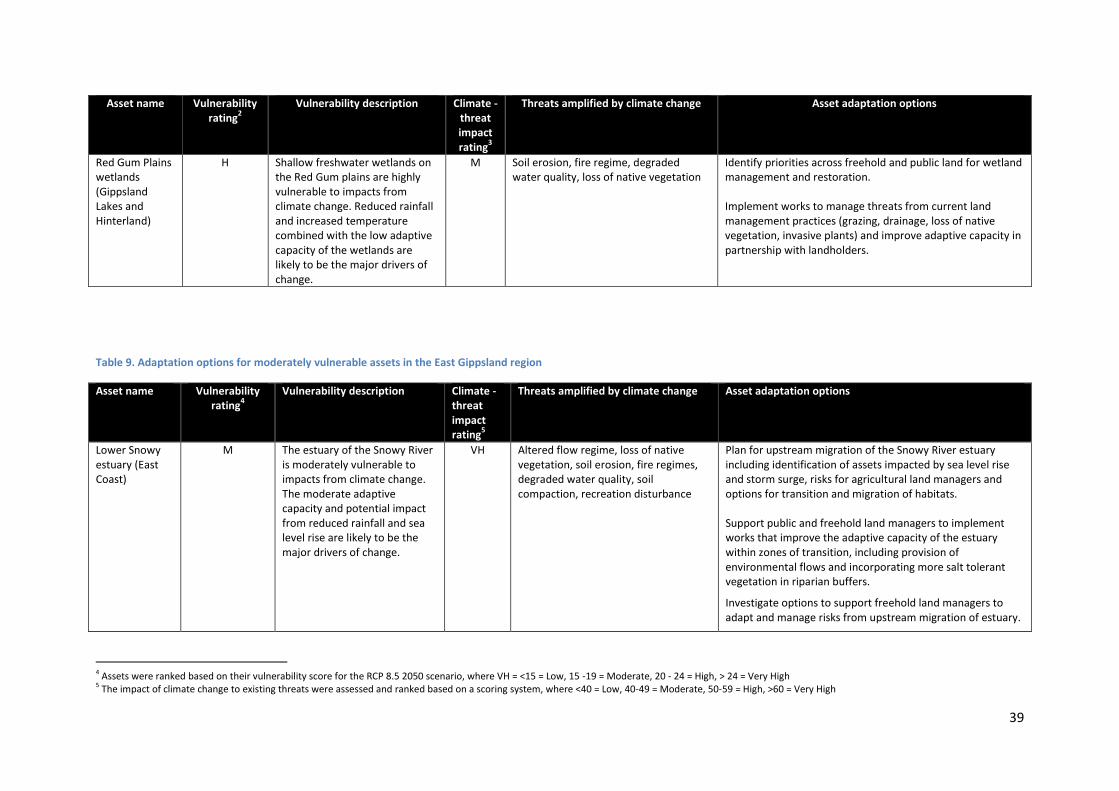
39
Asset name Vulnerability rating
2
Vulnerability description Climate - threat impact rating
3
Threats amplified by climate change Asset adaptation options
Red Gum Plains wetlands (Gippsland Lakes and Hinterland)
H Shallow freshwater wetlands on the Red Gum plains are highly vulnerable to impacts from climate change. Reduced rainfall and increased temperature combined with the low adaptive capacity of the wetlands are likely to be the major drivers of change.
M Soil erosion, fire regime, degraded water quality, loss of native vegetation
Identify priorities across freehold and public land for wetland management and restoration. Implement works to manage threats from current land management practices (grazing, drainage, loss of native vegetation, invasive plants) and improve adaptive capacity in partnership with landholders.
Table 9. Adaptation options for moderately vulnerable assets in the East Gippsland region
Asset name Vulnerability rating
4 Vulnerability description Climate -
threat impact rating
5
Threats amplified by climate change Asset adaptation options
Lower Snowy estuary (East Coast)
M The estuary of the Snowy River is moderately vulnerable to impacts from climate change. The moderate adaptive capacity and potential impact from reduced rainfall and sea level rise are likely to be the major drivers of change.
VH Altered flow regime, loss of native vegetation, soil erosion, fire regimes, degraded water quality, soil compaction, recreation disturbance
Plan for upstream migration of the Snowy River estuary including identification of assets impacted by sea level rise and storm surge, risks for agricultural land managers and options for transition and migration of habitats. Support public and freehold land managers to implement works that improve the adaptive capacity of the estuary within zones of transition, including provision of environmental flows and incorporating more salt tolerant vegetation in riparian buffers.
Investigate options to support freehold land managers to adapt and manage risks from upstream migration of estuary.
4 Assets were ranked based on their vulnerability score for the RCP 8.5 2050 scenario, where VH = <15 = Low, 15 -19 = Moderate, 20 - 24 = High, > 24 = Very High 5 The impact of climate change to existing threats were assessed and ranked based on a scoring system, where <40 = Low, 40-49 = Moderate, 50-59 = High, >60 = Very High

40
Asset name Vulnerability rating
4 Vulnerability description Climate -
threat impact rating
5
Threats amplified by climate change Asset adaptation options
Snowy River wetlands (East Coast)
M
The floodplain wetlands of the major rivers including the Snowy, Mitchell and Tambo are moderately vulnerable to impacts from climate change. The moderate adaptive capacity and potential impact from reduced rainfall are likely to be the main drivers of change.
VH Altered flow regime, loss of native vegetation, soil erosion, fire regimes, degraded water quality, recreation disturbance
Identify priorities for wetland management and restoration across freehold and public land. Implement works to manage threats from current land management practices (grazing, drainage, loss of native vegetation, invasive plants), and improve adaptive capacity in partnership with landholders. Investigate options to address altered hydrology.
Lower Mitchell wetlands (Gippsland Lakes and Hinterland)
H
Altered flow regime, loss of native vegetation, soil compaction, degraded water quality, increased salinity, fire regime, soil erosion
Lower Tambo wetlands (Gippsland Lakes and Hinterland)
Nicholson River (Gippsland Lakes Upper Catchment)
M The upper reaches of the Nicholson river are moderately vulnerable to climate change. The potential impact from reduced rainfall has contributed to its vulnerability due to its location in the catchment. The upper reaches of the Nicholson River have a high adaptive capacity.
H Altered flow regime, degraded water quality
Maintain the high adaptive capacity of the Nicholson River through works to maintain the current good condition (for example, weed control in forested areas). Implement measures to manage current threats that are likely to be amplified by climate change (altered hydrology, fire regime, degraded water quality).
Combienbar River (Far East Catchments)
M The Combienbar river is moderately vulnerable to climate change. The potential impact from reduced rainfall has contributed to its vulnerability due to its location in the catchment. Some reaches of the Combienbar River have a lower adaptive capacity.
H Soil erosion, fire regimes, altered flow regimes, degraded water quality, soil compaction, loss of native vegetation, recreation disturbance
Maintain the adaptive capacity of the Combienbar River through works to maintain the current good condition (for example, weed control in forested areas) Implement works to improve adaptive capacity including establishing a continuous riparian buffer with fencing and vegetation restoration.

41
Asset name Vulnerability rating
4 Vulnerability description Climate -
threat impact rating
5
Threats amplified by climate change Asset adaptation options
Wonnangatta River (Gippsland Lakes Upper Catchment)
M The upper reaches of the Wonnangatta River are moderately vulnerable to climate change. The potential impact from reduced rainfall has contributed to its vulnerability due to its location in the catchment. The lower parts of the Wonnangatta have a moderate adaptive capacity (where it flows through freehold land) whilst the upper reaches have a high to very high adaptive capacity.
M Soil erosion, fire regime, altered flow regime, degraded water quality, loss of native vegetation, recreational disturbance
Maintain the adaptive capacity of the Wonnangatta River through works to maintain the current good condition (for example weed control in forested areas, management of fire to protect riparian vegetation) Implement works to improve adaptive capacity including establishing a continuous riparian buffer with fencing and vegetation restoration.
Tambo Valley (Gippsland Lakes Upper Catchment)
M
The soils and agricultural land of the Tambo Valley, Snowy Mountain Basin, Dargo Mountain Basin and Monaro tableland are moderately vulnerable to climate change. The adaptive capacity of the major land systems of these areas is moderate and is linked to both current and historic land management. The potential impact from reduced rainfall and increased temperature is likely to further amplify existing threats to soils and agricultural land.
M
Soil erosion, loss of native vegetation, fire regime
Support landholders to improve adaptive capacity of soils and agricultural land through measures to improve groundcover, soil fertility and soil carbon. Incorporate farm viability and other socio-economic considerations in the design of programs to support landholders to adapt to a warmer drier climate. Implement measures that aim to manage fire risk across public and freehold land and provide for community recovery including through participation in planning and delivery of control burning programs.
Snowy Mountain basin (Far East Catchment)
Dargo Mountain Basin (Gippsland Lakes Upper Catchment)
Monaro Tablelands

42
Asset name Vulnerability rating
4 Vulnerability description Climate -
threat impact rating
5
Threats amplified by climate change Asset adaptation options
Coastal zone (Gippsland Lakes and Hinterland)
M The vegetation of the coastal zone is moderately vulnerable to climate change within the planning timeframe. The potential impact from changes to rainfall and temperature combined with sea level rise will be major drivers of change beyond the planning timeframe. Many of the vegetation communities in the coastal area of the Gippsland Lakes have a low adaptive capacity and climate change is likely to amplify existing threats.
M Loss of native vegetation, fire regimes, Soil erosion, soil compaction
Plan for a potential change in state and potential loss of coastal vegetation communities due to increasing salinity , increased erosion and inundation including, identification of at risk assets and options for transition and migration of habitats. Implement works to manage threats and improve adaptive capacity of vegetation within zones of transition.

43
A number of priority assets were assessed as having a low vulnerability according to the RCP 8.5 2050 scenario. The results are set out in Table 10. It is important to note that whilst these assets may have a low vulnerability in the short to medium term, their vulnerability will potentially increase later in the century (i.e. by 2090) as a result of more significant changes in temperature and rainfall. Whilst a detailed assessment of adaptation options has not been completed for these assets, a number of strategies are applicable, including monitoring the condition of these assets and addressing existing threats potentially amplified by climate change. Table 10. Assets with a Low vulnerability rating in the East Gippsland region
Asset Name Vulnerability rating
Climate threat rating
Threats amplified by Climate Change
Mallacoota (East Coast) L M Fire regime
Mitchell River (Gippsland Lakes Upper)
L H Soil erosion, altered flow regime
Nicholson River (Gippsland Lakes Upper)
L H Altered flow regime
Snowy River flats (East Coast)
L M
Lower Snowy River (East Coast)
L VH Altered flow regime, loss of native vegetation
Mallacoota Inlet (East Coast)
L M Degraded water quality
Bemm River and Sydenham Inlet (East Coast)
L H Loss of native vegetation
East Cape Conran to the border (East Coast)
L M Fire regime
Remote wetlands (East Coast)
L M Fire regime
Brodribb River (East Coast)
L M Loss of native vegetation
Cabbage Tree Creek (East Coast)
L M Loss of native vegetation
Buchan Valley (East Coast)
L M Soil erosion, loss of native vegetation
Cann River floodplain (Far East Coast)
L H Loss of native vegetation
Genoa River floodplain (Far East Coast)
L H Loss of native vegetation
Cann River (Far East Coast) L H No existing high threats identified in RCS
Genoa River (Far East Coast) L H No existing high threats identified in RCS
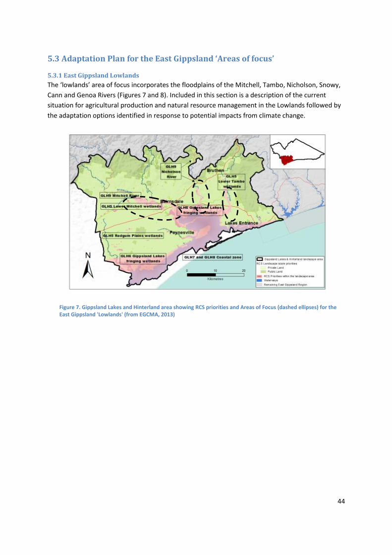
44
5.3 Adaptation Plan for the East Gippsland ‘Areas of focus’
5.3.1 East Gippsland Lowlands
The ‘lowlands’ area of focus incorporates the floodplains of the Mitchell, Tambo, Nicholson, Snowy,
Cann and Genoa Rivers (Figures 7 and 8). Included in this section is a description of the current
situation for agricultural production and natural resource management in the Lowlands followed by
the adaptation options identified in response to potential impacts from climate change.
Figure 7. Gippsland Lakes and Hinterland area showing RCS priorities and Areas of Focus (dashed ellipses) for the East Gippsland 'Lowlands' (from EGCMA, 2013)

45
Figure 8. Far East Catchment area showing RCS priorities and Areas of Focus (dashed ellipses) for the East Gippsland 'Lowlands' (from EGCMA, 2013)

46
Current Situation
The assets considered in the planning area include the cleared agricultural land and productive soils that support grazing (beef and dairy) and horticulture, as well as the waterways and associated riparian vegetation.
There are differences in both the enterprise type and issues facing agricultural producers in each of the floodplain areas. The Lindenow area of the Mitchell River floodplain has a higher proportion of vegetable producers with some grazing, whilst the floodplains of the Snowy River, Cann River and Genoa have a mix of dairy, beef and some seed production.
The floodplains are a dynamic environment and the landholders who live on them are used to flooding as a part of the natural cycle. However when fire occurs in the upper catchment followed by large rainfall events, this causes significant impacts for waterways and agricultural producers in the form of damage to pasture and crops, loss of soil and erosion of banks. An increase and spread of invasive plants and animals from other areas including fireweed and deer has been observed and is of concern to many landholders.
Security of supply of water during summer for irrigation and for stock water is an issue of concern for landholders, both now and in the future, and appropriate flows and quality of water is an issue of importance for waterway health. Waterway stability and erosion from flooding has been a significant issue for the EGCMA and landholders and work completed along all of the major rivers to re-establish native vegetation and stabilise bed and banks is starting to reap benefits in the form of reduced damage following high flow events.
There is evidence of implementation of best management practices and adaptation to seasonal variability by larger producers. This includes use of regular soil testing to inform fertiliser application, and establishment of cover crops and stock rotation. Some landholders are also looking to trial new practices to improve erosion resistance on the floodplain (trees/shrubs on gullies and strategic plantings).
Lowlands Strategic Adaptation Options
The priority strategic options identified for the Lowlands are outlined below.
Support programs across public and freehold land that aim to reduce fire risk and support
recovery of communities and natural assets from fire
Plan and implement projects that provide for transition and migration of ecosystems due
to sea level rise and associated increased salinity and foreshore erosion
Manage impacts of flooding waterways, floodplains and agricultural land through
planning and implementation of a program of works and measures across freehold and
public land
Support initiatives to improve water security for irrigators whilst protecting flows for
environmental outcomes
Support adaptation of agricultural enterprises through extension, incentives and trials
Implement projects in partnership with landholders to retain native vegetation, establish
riparian buffers and manage wetlands
Support policy and programs to address spread of new and emerging invasive plants,
animals and other pathogens.
Explore land use planning mechanisms to protect high value agricultural land and provide
opportunities for enterprise change.

47
5.3.2 East Gippsland Uplands
The uplands encompass the areas of freehold land in the Dargo valley, and upper Tambo and upper
Snowy catchments (Figures 9 and 10). Included in this section is a description of the current
situation for natural resource management and agricultural production in the Uplands followed by
the adaptation options identified in response to potential impacts from climate change.
Figure 9. Far East catchment area showing RCS priorities and Areas of Focus (dashed ellipses) for the East Gippsland 'Uplands' (from EGCMA, 2013)

48
Figure 10. Gippsland Lakes Upper catchment area showing RCS priorities and Areas of Focus (dashed ellipses) for the East Gippsland 'Uplands' (from EGCMA, 2013)

49
Current Situation
The assets considered in the planning area include the cleared agricultural land and productive soils that
support grazing as well as the waterways and native vegetation. Issues associated with the interface between
public and freehold land have been a major consideration in the assessment of various options.
Climatic events (drought, large rainfall events), repeated large fires and wild dogs have had major impacts on
farm viability and the levels of stress within the farming community. There is a trend of rationalisation from
smaller traditional family farms towards a smaller number of larger properties. There has also been a change
in the mix of enterprise type with a shift from sheep to cattle and an increase in the number of smaller lifestyle
properties, often with part-time management by landholders. A combination of these factors and an ageing
population has led to a decline in the population.
Support in the form of extension and farm advisors for landholders in the uplands is quite limited and possibly
declining. In recent times there has been a shift away from extension services being provided by government
departments and the remoteness makes it difficult for farmers to access private consultants and advisors.
Fire and invasive plants and animals have also impacted on the structure and condition of native vegetation in
the uplands. New weeds are being spread by management practices on public and freehold land (frequency
and timing of spraying and slashing). Some previously controlled weeds are also being transported into the
region from interstate / neighbouring regions because they are not actively being controlled in those areas.
Landholders currently have limited ability to undertake controlled burning of bushland on freehold land to
manage fire risk, and this is seen as a significant concern into the future. Management of new and emerging
weeds and controlling the spread of pests and diseases is also an area landholders would like to see more
focus on.
Flood, drought and fire are often triggers of land management change on both public and freehold land. In
recent times government agencies have taken a more proactive approach following these events and use it as
an opportunity to improve management of natural resources.
Uplands Strategic Adaptation Options
The priority strategic options identified for the Uplands are outlined below.
Support programs across public and freehold land that aim to reduce fire risk and support
recovery of communities and natural assets from fire
Plan and implement projects that provide for transition of ecosystems due to a drying, warming
and variable climate
Support adaptation of agricultural enterprises through research and development extension,
incentives and trials
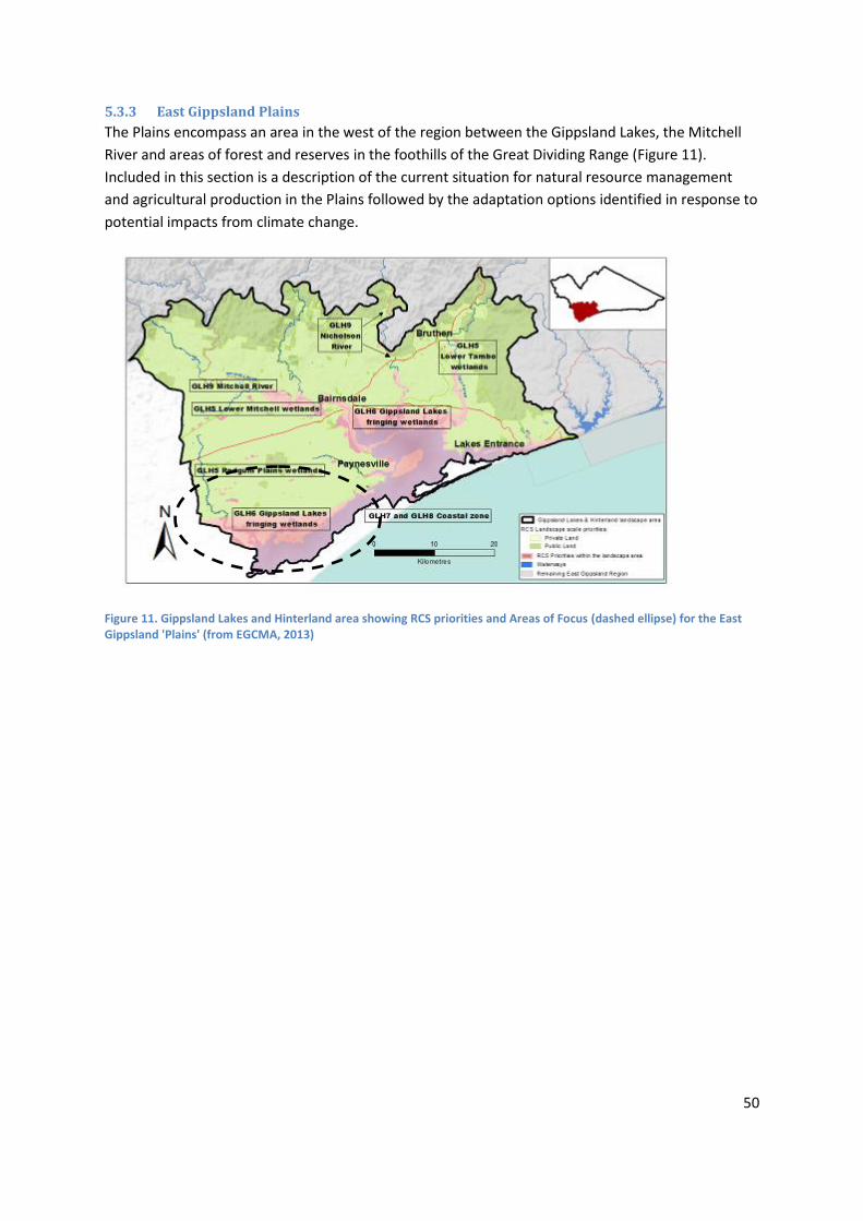
50
5.3.3 East Gippsland Plains
The Plains encompass an area in the west of the region between the Gippsland Lakes, the Mitchell
River and areas of forest and reserves in the foothills of the Great Dividing Range (Figure 11).
Included in this section is a description of the current situation for natural resource management
and agricultural production in the Plains followed by the adaptation options identified in response to
potential impacts from climate change.
Figure 11. Gippsland Lakes and Hinterland area showing RCS priorities and Areas of Focus (dashed ellipse) for the East Gippsland 'Plains' (from EGCMA, 2013)
51
Current Situation
The assets considered in the planning area include the cleared agricultural land and productive soils, wetlands,
waterways and native vegetation as well as the issues associated with the interface between rural and urban
land.
This part of the East Gippsland region has the largest amount of cleared land with scattered remnants
including on both freehold land and in small public reserves. Despite the East Gippsland region having a high
proportion of public land, the Plains form part of a broader bioregion that is under represented in the National
Reserve System. The area has particular importance for its biodiversity values including the EPBC listed
Gippsland Red Gum Grassy Woodlands and Seasonal Herbaceous Wetlands of the Lowland Plan. The condition
of vegetation and freshwater wetlands is generally poor as a result of grazing, invasive plants and changes in
hydrology.
There have been changes in the mix of agricultural enterprises in the area. An area once dominated by sheep
(wool and meat production) now mostly supports a mix of cattle, sheep and cereal cropping.
There is a strong reliance on groundwater for the provision of stock water and to a lesser extent for irrigation
of crops. The long term security and availability of this resource is an issue of concern for landholders. Whilst
some landholders are actively adopting improved management practices such as soil testing and flexible
grazing methods, widespread adoption is limited by a complex set of socio- economic factors including
demographics, market forces and farm viability issues.
With the growth of the major urban area of Bairnsdale has come an increase in the number of smaller lifestyle properties, often managed by landholders who don’t have a history on the land.
Plains Strategic Adaptation Options
The priority strategic options identified for the Plains are outlined below.
Support initiatives to improve on-farm water security (groundwater and surface water) and
improve the environmental outcomes for wetlands.
Support initiatives to address invasive plants and animals across public and freehold land
Plan and implement projects that provide for transition of habitats due to a drying, warming and
variable climate
Identify priorities and plan for wetland management across freehold and public land, with
consideration to agricultural land management practices, current condition and potential impacts
of climate change
Support adaptation of agricultural enterprises through extension, incentives and trials
Support initiatives that encourage the establishment of well-managed perennial pasture systems
on grazing lands
Support actions that improve the extent and condition of the vulnerable, rare and threatened
vegetation communities
Explore land use planning mechanisms to protect high value agricultural land and provide opportunities for enterprise change.

52
6. Mitigation options
Native vegetation and agricultural land are important to climate change mitigation. Firstly because
of the significance of their carbon stock and secondly because their exchange of greenhouse gases
between the atmosphere and soils and vegetation can go both ways. Many human activities such as
logging, grazing of livestock or ploughing, influence the exchange of greenhouse gases with the
atmosphere and ultimately the carbon footprint of the sector.
Carbon dioxide (CO2) differs from the other major greenhouse gases relevant to the sector in that
the carbon can be stored in large quantities in the various carbon pools in vegetation, soils and living
organisms.
Mitigation options have been considered within the context set by the Australian Government in
outlining the Principles that should underpin regional planning for climate change, including:
identifying priority landscapes for carbon plantings
identifying strategies to build landscape integrity
guiding adaptation and mitigation actions to address climate change impacts on natural
ecosystems
avoiding adverse impacts associated with carbon in the landscape.
This Plan will help guide the types and locations of carbon farming and biodiversity activities to help
maximise the benefits for biodiversity, water and agricultural production in the region. An adaptive
management approach and continued improved strategic planning will ensure development of NRM
co-benefits, such as maintenance of ecological processes, landscape connectivity and resilience, and
wildlife corridors, from carbon sequestration projects. Whilst carbon sequestration may not be the
principal driver of adopting a change in land management, it may be an important positive spin-off.
The consideration of carbon mitigation options in this Plan has been made with the objective of
enhancing ecological processes, for example: climatic processes, primary productivity, hydrological
processes, formation of biophysical habitats, interactions between species, movements of organisms
and natural disturbance regime. It will also be important to understand and minimise any potential
negative consequences, such as increased fire risk and reduced water yield.
Mitigation options within this Plan will largely be focussed on options to sequester carbon (as
opposed to options that aim to reduce emissions of greenhouse gases). With respect to carbon
sequestration there is a limited suite of actions that are suitable for the respective natural asset
types. These have been categorised in the following table.

53
Table 11. Carbon Sequestration options for natural assets
Asset type
Carbon sequestration options
Native vegetation (terrestrial)
Biodiverse plantings
Natural regeneration
Coastal habitats – saltmarsh, mangroves, seagrass
Habitat restoration and enhancement
Grazing control (saltmarsh)
Rivers
Riparian plantings
Natural regeneration
Wetlands
Grazing control promoting reestablishment of natural wetland vegetation
Buffer plantings
Natural regeneration
Soils
Changed land use – e.g. grazing to cropping
Changed management of grazing land
6.1 Carbon farming The Australian Government program for carbon mitigation with relevance to natural resource
management and agriculture is managed through the Emissions Reduction Fund (ERF), formerly the
Carbon Farming Initiative (CFI) (Australian Government, 2014). There are a number of ERF approved
methods (see Appendix 5 for details).
In order to inform this Plan, a preliminary evaluation of these options has been completed with
respect to:
The carbon sequestration potential of specific options;
Alignment with the objectives of the RCS and the relevance of different options to priority
assets; and,
An assessment of the costs and benefits associated with these options, including a
consideration of feasibility, risk and adverse impacts.
The results of this evaluation are presented in Table 7 together with a brief description of the
methods.
It should be noted that approved methodologies for participation in the ERF require extensive
documentation and recording of activities, which may be a constraint to wide scale adoption.
6.2 Soil carbon On a global scale soil is estimated to contain three times as much carbon as the atmosphere and
nearly four times as much as contained in living matter (Lal, 2002). However, the carbon content of
many agricultural soils has declined over time and there are some estimates of significant
opportunities for carbon sequestration through changes to land use and land management (Lal,
2002). The amount of additional carbon sequestered when a new management practice is adopted
depends on the initial carbon content, the practice, soil type and climate.
54
In East Gippsland, the soils underlying agricultural land are variable in their type, fertility and
condition. There are various forms of soil degradation in the region including erosion, acidification,
structure decline, waterlogging and salinisation. These threats to soil health and productivity have
been the focus of a range of initiatives including mapping of erosion risk, soil testing as well as
extension and implementation of recommended management practices by farmers. Adoption of
management practices that aim to address these threats can have flow-on benefits in the form of
soil carbon accumulation, but carbon itself may not be a primary driver for the management
practices of many farmers.
Improving soil carbon stocks on agricultural land in East Gippsland is strongly linked to management
practices; such strategies that optimise fertiliser use, stock management and groundcover retention
in grazing systems, and reduced tillage in cropping and horticultural systems or in grazing systems.
Soil carbon can be stored in grazing systems by increasing the amount of organic matter in
agricultural soils. This occurs when management practices either increase the amount of biomass
(such as plant material) that is incorporated into the soil and/or reduce the amount of organic
matter that is released from soils (for example, by reducing soil disturbance) (Department of
Environment, 2014). Soil carbon is inherently unstable and prolonged drought can remove much of
the stored carbon.
An increase in soil carbon has benefits to farming through improved soil structure, water holding
capacity and nutrient retention. Soil carbon will accumulate where there is extra, sustained pasture
growth. The practices that are likely to increase soil carbon through the production of extra growth
are the use of fertilizer, some rotational grazing systems and the introduction of perennial pasture
species. The benefit to producers will be primarily from utilising the extra feed generated from the
activities undertaken, rather than any direct benefit from increased carbon content. Any strategies
to improve soil carbon levels must consider the economic justification for undertaking the specific
activity.
There is much uncertainty and debate, particularly within Australia, around the role of soils in
carbon sequestration. This includes issues such as: the total potential of agricultural soils to store
additional carbon, the rate at which soils can accumulate carbon, the permanence of the stored
carbon, and how best to monitor changes in soil carbon stocks (Sanderman et al, 2010).
The Emissions Reduction Fund allows farmers and other landholders to earn carbon credits by
reducing greenhouse gas emissions or storing carbon on the land. Participants can earn carbon
credits by setting up a project under an approved ERF method, which sets out the rules for
implementing and monitoring the activity (see Appendix 5 for further explanation).
It is important to note that many of the options available to primary producers to increase soil
carbon, for example stubble/biomass retention in cropping and grazing systems, are seen more
generally as key strategies in the development of more profitable and sustainable farming systems.
The adoption of these practices is not currently being driven by a motivation to participate in
initiatives such as the Emissions Reduction Fund (ERF), but rather as a means of achieving long-term
farm viability. The biomass from which the organic matter (soil carbon) is derived is expensive to

55
produce and, at current pricing, commercial sequestration provides a much smaller return than
using the feed for livestock. In addition there are restrictions on future land use.
Within broad parameters, landholders will have a choice of which land management activities to
implement to build soil carbon. Activities must include at least one new management activity. Some
activities, such as permanent destocking, are not eligible. Types of activities that could potentially be
implemented include, but are not limited to, converting cropland to permanent pasture,
rejuvenating pastures, or changing grazing patterns.
Site specific factors such as soil type, climate and management history all influence the potential for
soil carbon sequestration (the increase in soil carbon stocks over time). There is no guarantee that
any one or more of the eligible activities chosen by landholders will build soil carbon at any
particular project site. Project proponents should seek expert advice on the management actions
that will best suit their project area.
Landholders must measure the soil carbon stocks at the project site at regular intervals during the
project to estimate carbon sequestration. Emissions from other sources that have changed as a
result of the project, such as emissions from livestock, tillage events and applications of lime or
synthetic fertiliser, must be calculated to find the net abatement from the project.
6.3 Vegetation New tree plantings can be established in agricultural landscapes to sequester carbon dioxide and
help offset greenhouse gas emissions. Revegetation provides a suite of benefits for biodiversity,
water quality and timber production, but it is also realised that long-term plantings will be affected
by climate change as will flora and fauna, land and water degradation from salinity, and rates of
timber production.
In East Gippsland a number of options are appropriate to sequester carbon in native vegetation. It is
important to recognise that different options are linked to different motivations and priorities.
These options include:
Environmental plantings with a primary focus on improving natural resource management
outcomes such as water quality, erosion reduction and habitat improvement
Human-induced (natural) regeneration is sometimes a cost-effective option for restoring
land in concert with a change in land management or land use
Agroforestry plantings which aim to generate environmental benefits while also enabling
sustainable harvesting of trees for timber products
Commercial plantings where the primary aim is timber production.
Biodiversity benefits are often highest (due to better soil and moisture availability) in riparian zones,
where much of the current revegetation effort associated with improving waterway health in East
Gippsland has been successfully focused.
56
Commercial forestry is best suited to high-rainfall areas. Commercial plantings are likely to
accumulate carbon fastest, but are also the most likely to be harvested, so may ultimately stabilise
at lower levels of sequestered carbon than permanent plantings in lower rainfall areas. This suggests
that high rainfall plantings will give the best short-term benefits but that slower-growing plantings
subject to minimal harvesting may take over as good long term sinks for carbon (Polglase et al.,
2011).
It is also important to appreciate interactions between revegetation, water and climate change. The
potential impacts of climate change include reduced runoff, stream flow and ultimately, security of
water supply, due to lower rainfall and higher evaporation. Even where rainfall does not change
significantly, higher potential evaporation will still contribute to net decreases in runoff. As has been
demonstrated in other high rainfall catchments, revegetation will reduce runoff independently of
climate change, but will add to the losses caused by climate change (Jones et al., 2006). The
potential for adverse impacts, such as reduced water yield, increased risk of wildfire and reservoirs
for pest plant and animal invasion should be considered in the context of revegetation programs.
While reforestation for carbon outcomes has received much attention in recent years, Polglase et al.
(2011) concluded that under current or plausible future market and policy conditions few areas are
economically viable for carbon forests in Australia and that additional incentives may be needed to
target tree establishment in areas which will have other environmental benefits, such as
biodiversity. Furthermore, where carbon plantings are likely to be more economically viable, other
land uses are also likely to outcompete them.
Increasing the amount of native vegetation plantings can in some cases lead to increased pressure
from pest animals, such as deer and foxes, and pest plants, together with potential for elevated fire
risk in some instances. These factors need to be further evaluated when considering the feasibility
and risk of environmental plantings on freehold land.
6.4 Blue carbon Vegetated aquatic habitats, including coastal environments (saltmarsh, mangroves, and seagrass
meadows) and freshwater ecosystems, collectively known as ‘blue carbon’ environments, together
sequester nearly equivalent quantities of organic carbon (Corg) as their terrestrial counterparts, in
spite of their comparatively limited biomass (0.05% of terrestrial plant biomass).
East Gippsland contains significant areas suitable for the conservation and sequestration of ‘blue
carbon’. In many cases these areas are in good condition and therefore the protection of these
ecosystems, and their carbon stores, should be a high priority. As noted by Carnell et al (2014), these
features make vegetated estuarine environments particularly ideal candidates for carbon offset
programs and nature-based climate mitigation initiatives. Waterways and wetlands (which include
alpine peatland, freshwater wetland and coastal wetlands) are also thought to be significant carbon
sinks (Carnell et al., 2014).
A preliminary assessment of the potential of ‘blue carbon’ for estuaries in the East Gippsland region
was completed in 2014 (Carnell et al., 2014), with the following recommendations to maximize
carbon stocks within vegetated coastal environments in East Gippsland:
Prioritise ‘blue carbon’ hotspots for conservation

57
Produce updated seagrass distribution maps
Focus revegetation projects on saltmarsh ecosystems and/or estuarine environments closer
to fluvial inputs
Restore natural hydrology to enhance carbon sequestration in vegetated coastal habitats
Research the distribution and carbon storage potential of wetland ecosystems in East
Gippsland.
It is not clear how ‘blue carbon’ would be assessed under the current ERF approved methods. The
current literature also has a focus on marine and estuarine vegetation communities as opposed to
other aquatic and water dependent vegetation communities such as riparian and in-stream
vegetation. The carbon potential of riparian vegetation can be assessed using the method described
above and therefore it may be more appropriate to assess these vegetation communities within the
methods described for environmental plantings and human induced natural regeneration.
6.5 Carbon options assessment for priority assets While a range of different options are possible for increasing carbon stocks in soil, terrestrial and
aquatic environments have been outlined above, four have been assessed as particularly relevant to
the priority assets in the East Gippsland RCS. These are:
1. Grazing system change – to increase soil carbon in broad-acre beef and sheep production
systems as a result of implementing management actions such as flexible grazing techniques
based on the pasture and animal requirements that maintain productivity and improve
groundcover.
2. Environmental plantings – to increase terrestrial carbon stocks through revegetation,
especially along waterways, and to buffer and connect high value remnant vegetation.
3. Human induced natural regeneration – to increase carbon stocks associated with existing
native habitat or in areas suitable for land use change such as marginally productive or
degraded areas.
4. Blue carbon sequestration through the conservation and restoration of freshwater and
estuarine ecosystems such as areas of wetland, saltmarsh, mangroves and seagrass.
Table 12 outlines the potential for implementation of four carbon sequestration options across the
priority asset areas. It is important to note that this analysis is not a measure of the amount of
carbon sequestered, but rather a rating of the applicability of the options.
In addition to a broad assessment of the appropriateness and potential of these options, a
preliminary assessment of the technical feasibility, likelihood of adoption, socio-political risk and
potential for adverse impacts has been made for each asset. A legend is provided at the bottom of
the table to assist with interpreting the results.
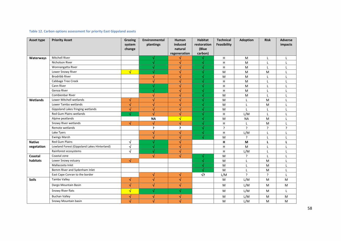
58
Table 12. Carbon options assessment for priority East Gippsland assets
Asset type Priority Asset Grazing system change
Environmental plantings
Human induced natural
regeneration
Habitat restoration
(Blue carbon)
Technical Feasibility
Adoption Risk Adverse impacts
Waterways Mitchell River H M L L Nicholson River H M L L Wonnangatta River H M L L Lower Snowy River M M M L Brodribb River M M L L Cabbage Tree Creek H M L L Cann River H M L L Genoa River H M L L Combienbar River M M L L
Wetlands Lower Mitchell wetlands M L M L Lower Tambo wetlands M L M L Gippsland Lakes fringing wetlands M L L L Red Gum Plains wetlands H L/M L L Alpine peatlands NA M NA M L Snowy River wetlands H L M L Remote wetlands ? ? ? ? ? ? Lake Tyers H L/M L L Ewings Marsh M ? L L
Native vegetation
Red Gum Plains H M L L Lowland Forest (Gippsland Lakes Hinterland) H M L L Rainforest ecosystems H L/M L L
Coastal habitats
Coastal zone M ? L L Lower Snowy estuary M L M L Mallacoota Inlet M L M L Bemm River and Sydenham Inlet M L M L East Cape Conran to the border ? L/M ? ? L
Soils Tambo Valley M L/M M M Dargo Mountain Basin M L/M M M Snowy River flats M L/M M L Buchan Valley M L/M M M Snowy Mountain basin M L/M M M

59
Asset type Priority Asset Grazing system change
Environmental plantings
Human induced natural
regeneration
Habitat restoration
(Blue carbon)
Technical Feasibility
Adoption Risk Adverse impacts
Monaro Tablelands L/M L/M M L Cann River floodplain M L/M M L Genoa River floodplain M L/M M L
Legend:
Potential not rated High carbon potential Moderate carbon potential Low carbon potential
NA Not appropriate
H High
M Moderate
L Low
? Unknown
Note on methods:
a. Rating of carbon potential has been made based on ‘best guess’ judgments informed by local knowledge of carbon sequestration rates influenced by factors including
climatic factors (rainfall, temperature), soil and land system characteristics and appropriateness for asset protection.
b. Assessment of feasibility, risk, adoption, cost and potential for adverse impacts has been made with consideration of the following criteria.
i. Feasibility – How technically feasible is the application of the option?
ii. Risk – What is the risk of failure due to socio-political or administrative factors?
iii. Adoption – What is the likelihood of landholder adoption/participation?
iv. Cost – What is the magnitude of the cost in implementing the option (additional to business as usual)?
v. Adverse impacts – What is the likely magnitude of any potential adverse impacts associated with carbon mitigation (e.g. increased fire risk, reduced water yield)?
60
7. Implementation, monitoring and evaluation
7.1 Implementation approach Adaptation planning is currently occurring across a range of organisations in East Gippsland including
NRM organisations, government agencies, industry bodies and community groups. Effective
responses require an integrated approach to capacity building; extension; provision of timely and
useful information; and support for direct on-ground activities.
This Plan is a sub-strategy to the East Gippsland RCS and as such the implementation of this Plan will
occur through the arrangements established for the RCS.
This Plan will be implemented through partnerships involving:
agencies with land management or other relevant legislated responsibilities in the five
program areas of the RCS (one regional and four landscape area based)
communities in the RCS program areas
other key stakeholders such as non-government organisations, Landcare and other
community groups
The EGCMA’s program working groups (PWGs), made up of representatives from the delivery
partners, are responsible for taking carriage of management actions associated with the five
programs of the RCS. This integration approach builds on previous and current collaboration practice
in the region, evident through the delivery of the RCS, and development of this Plan.
The program working groups are responsible for coordinating specific aspects of RCS
implementation within programs or themes. These responsibilities will be extended to include
consideration of the options presented in this Plan when developing:
implementation targets
action planning, updated annually
targeted investment proposals
integrated delivery arrangements
coordinated monitoring and evaluation of implementation, including integrated reporting
against targets, and
adaptive management.
In addition, The EGCMA will seek opportunities to utilise the outputs from the Plan to assist other
regional organisations with their climate change planning. Projects already underway or proposed
include a Rural Land Use Strategy (East Gippsland Shire), and an Estuary Adaptation Pathways
Project (DELWP)

61
Resourcing implementation
Investment proposals to support options within this Plan will be developed as investment
opportunities arise. Project proposals will be prepared in conjunction with delivery partners and will
be structured to reflect the RCS regional programs and their associated themes.
Available funding and resources will influence implementation. The implementation approach that
will be applied in East Gippsland will coordinate the prioritisation of management actions so that
maximum benefit is achieved with the available resources.
Adaptive Management
The principle of adaptive management is central to the EGCMA’s implementation arrangements for
of the RCS.
Throughout the implementation of this Plan, the EGCMA will actively monitor for, and review, new
information which becomes available, particularly updated projections. Implementation programs
will be adapted to account for the implications of any significant new information.
The EGCMA will work with our delivery partners to bring the best available information tools to
support the establishment of annual priorities e.g. in the case of threatened species, populations or
communities, using databases and other tools developed and maintained by DELWP. The EGCMA
will also seek to better describe assets using updated and new spatial datasets and tools as they
become available.
Renewal
As this Plan is a sub-strategy to the East Gippsland RCS, it will be renewed through the established
renewal arrangements for the RCS. The RCS is scheduled for a mid-term review in 2016 and renewal
in 2019.
The EGCMA intends to integrate climate change adaptation and mitigation into the RCS as it is
renewed over time. At each renewal, the latest projections would be used to inform the NRM
priority setting process which underpins the RCS.
7.2 Monitoring and Evaluation
The Monitoring Evaluation and Reporting (MER) component of the RCS implementation-planning
framework describes how the implementation will be monitored and how the effectiveness of the
contribution of the management actions towards the land and water resource objectives of the RCS
will be assessed. The MER process also provides a consistent basis for communicating
implementation results to stakeholders and funding investors.
In 2012, Catchment Management Authorities and DSE developed a MER framework to apply to all
NRM activities in Victoria. The EGCMA MER approach complies with this framework.
RCS MER planning uses program logic to describe the expected cause-and-effect relationships
between management actions and their immediate outputs, and longer-term objectives concerning
asset condition. Describing program logic provides a framework to monitor and evaluate the
effectiveness of RCS implementation.

62
The EGCMA will coordinate with partner agencies to collect and collate the data needed for effective
monitoring, evaluating and reporting.
Monitoring
The EGCMA will monitor the implementation of the RCS by collecting and collating quantitative
measures from regional NRM agencies and partners.
In particular, monitoring focuses on measuring progress towards targets set in the RCS
implementation planning.
Monitoring will contribute to the ability to apply adaptive management and be undertaken in an
integrated manner to reflect the nature of the region’s program delivery (multiple delivery partners,
multiple investment sources).
Evaluation
Program evaluation will be used to test the validity of assumptions that underpin the program logic
about how and why particular management activities will contribute to the RCS objectives.
Data from our monitoring activities will be used to consider evaluation questions, designed to affirm
or adapt the assumptions upon which the program logic relies.
Examples of evaluation questions are:
To what extent were the strategy implementation actions completed (during the life of the
RCS)?
How effective were the implemented measures (actions)?
How have completed actions contributed towards the agreed targets and RCS objectives?
Program evaluation will make a significant contribution to the three-year and six-year RCS reviews.
Reporting
It is recognised that all delivery partners have internal reporting obligations for activities they undertake and have various arrangements to meet these obligations. A role of the EGCMA is to ensure that reporting obligations are met for funding that is directed to the region via the EGCMA, and to coordinate the development of a regional picture that reflects the aggregate of activities by delivery partners that contribute to the implementation of the RCS.
Reporting on RCS implementation will involve annual reporting of RCS management actions to delivery partners, the EGCMA Board and DELWP, complemented by more comprehensive three-year and six-year reporting of progress towards targets.
RCS review
In accordance with the Catchment and Land Protection Act, a mid-term evaluation of the RCS and its
implementation will be completed during 2016. A more comprehensive review of the RCS at the
conclusion of its six-year term will be completed by July 2019.

63
8. References
Australian Government. (2014). Carbon Farming Initiative: About the Initative. Retrieved December 20, 2014, from http://www.cleanenergyregulator.gov.au/Carbon-Farming-Initiative/About-the-initiative/Pages/default.aspx
Carnell, P., Ewers, C., Rochelmeyer, E., Ierodiaconou, D., Sanderman, J., & Macreadie, P. (2014). The Distribution and Abundance of “Blue Carbon” within East Gippsland. A report for the East Gippsland CMA. Deakin University.
Commonwealth of Australia. (2013). Representation Concentration Pathways. Fact Sheet. Department of Environment. Australian Government. Retrieved from http://www.environment.gov.au/system/files/resources/492978e6-d26b-4202-ae51-5eba10c0b51a/files/wa-rcp-fact-sheet.pdf
Commonwealth of Australia. (2014a). Carbon Farming Initiative transition. Retrieved from http://www.environment.gov.au/climate-change/emissions-reduction-fund/carbon-farming-initiative-project-transition
Commonwealth of Australia. (2014b). The Emissions Reduction Fund, how it works. Retrieved January 19, 2015, from http://www.environment.gov.au/system/files/resources/5acdfbf8-8ced-4c54-a61a-c06cb31d1e88/files/reducing-australias-emissions.pdf
DPCD. (2011). Change and Disadvantage in the Gippsland Region, Victoria. March, 2011. Department of Planning and Community Development.
DSE. (2008a). Climate Change in East Gippsland. Department of Sustainability and Environment. East Melbourne, Victoria.
DSE. (2008b). Climate Change in Victoria: 2008 Summary. Department of Sustainability and Environment, Victoria.
EGCMA. (2013). East Gippsland Regional Catchment Strategy. 2013-2019.
EGCMA. (2014). East Gippsland Waterway Strategy, East Gippsland Catchment Management Authority, Bairnsdale.
Gillanders, B, Elsdon, T, Halliday, I, Gregory, D, Jenkins, P, Robins, J, & Valesini, F (2011). 'Potential effects of climate change on Australian estuaries and fish utilising estuaries: a review', Marine and Freshwater Research, 62, 1115–1131.
Hamilton, L, Wallis, P, & Leith, P (2014). A review of carbon sequestration in vegetation and soils; options, opportunities and barriers for the Southern Slopes Cluster NRM’s.
Hobday, A, & Lough, J (2011). 'Projected climate change in Australian marine and freshwater environments', Marine and Freshwater Research, 62, 1000–1014.

64
Jones, R, Dettman, P, Park, G, Rogers, M, & White, T (2006). The relationship between adaptation and mitigation in managing climate change risks: a regional response from north central Victoria, Australia. Mitigation and Adaptation Strategies for Global Change, special issue "Challenges in Integrating Mitigation and Adaptation as Responses to Climate Change", ed. Wilbanks, T, Klein, R & Sataye, J
NCCARF Terrestrial Biodiversity Network. (2013). Terrestrial Report Card 2013: Climate change impacts and adaptation on Australian Biodiversity.
Polglase, P, Reeson, A, Hawkins, C, Paul, K, Siggins, A, Turner, J, Crawford, D, Jovanovic, T, Hobbs, T, Opie, K, Carwardine, J, Almeida, A. (2011). Opportunities for carbon forestry in Australia: Economic assessment and constraints to implementation. CSIRO.
Sanderman, J, Farquharson, R, & Baldock, J (2010). Soil Carbon Sequestration Potential: A review for Australian agriculture, CSIRO Land and Water.
SCARP. (2014a). Adaptation Pathways Planning Playbook. Unpublished Draft - 15 September 2014.
SCARP. (2014b). Southern Slopes Information Portal. Southern Slopes Climate Change Adaptation Research Partnership, Hobart, Australia.
SKM. (2013). Indicative Assessment of Climate Change Vulnerability for Wetlands in Victoria.Prepared by Sinclair Knight Merz for the Department of Sustainability and Environment; Victoria.
Spatial Vision, & Natural Decisions. (2014). Final Project Report 1 – Impact and Vulnerability Assessment Process and Spatial Outputs. Report by Spatial Vision and Natural Decisions for Victorian Catchment Management Authorities.
Thwaites, R, Curtis, A, Mazur, N, & Race, D (2008). Understanding rural landholder responses to climate change. ILWS Report No. 48, Albury, NSW: Charles Sturt University.
Victorian Government. (2014). Gippsland Regional Growth Plan. Gippsland Local Government Network and the Department of Transport, Planning and Local Infrastructure.
Wallis, P, Turner, S, Haywood, A, Leith, P, Hamilton, L, Bosomworth, K, Harris, R, Bridle, K (2015). Southern Slopes Information Portal Report: Climate change adaptation information for natural resource planning and implementation. Southern Slopes Climate Change Adaptation Research Partnership (SCARP), Hobart, Tasmania.

65
Appendices
Appendix 1. Legislation and Policy
Commonwealth policy context
The Australian Government has a range of programs that aim to reduce greenhouse emissions and
provide for adaptation to climate change. The Emissions Reduction Fund is the centrepiece of the
Australian Government’s policy suite to reduce emissions. Through a competitive process
community and business projects will be contracted to implement projects that will lead to real
emissions reductions. Projects must use legislated methods to estimate emissions reductions
(Commonwealth of Australia, 2014b).
Natural resource management activities including reforesting and revegetating land and improving
agricultural soils will be eligible once methods have been developed and approved. The
establishment of the Emissions Reduction Fund builds on the previously established Carbon Farming
Initiative (CFI).
The Carbon Farming Initiative Amendment Bill 2014 was passed by the Parliament in November
2014. CFI is a legislated Australian voluntary carbon offsets scheme administered by the Clean
Energy Regulator. The CFI allows land managers to earn carbon credits by reducing greenhouse gas
emissions and increasing carbon sequestration in vegetation and soils through changes to
agricultural and land management practices (Commonwealth of Australia, 2014a).
State policy context
The Climate Change Act 2010 (the Act) provides guidance on the Victorian Government's roles and
responsibilities in responding strategically to climate change in the context of national climate
change policy settings. The Act requires decision makers to take climate change into account when
making decisions under key pieces of legislation including the Catchment and Land Protection Act
1994, Environment Protection Act 1970, Flora and Fauna Guarantee Act 1988, and Water Act 1989.
The Climate Change Act requires the Victorian Government to develop a Climate Change Adaptation
Plan every four years, to outline the potential impacts and risks associated with a changing climate.
The first Victorian Climate Change Adaptation Plan released in 2013 provides the framework for
managing climate risks to critical Victorian Government assets and services. It aims to help position
the Victorian Government to prepare for future climate challenges and to adapt to change.

66
Appendix 2. Detailed approach and methods
Vulnerability and threat assessment
An assessment of potential impact and vulnerability to climate change was completed for the
natural assets of the East Gippsland region as part of a state-wide process (Spatial Vision & Natural
Decisions, 2014). The assessment of potential impacts and vulnerability required consideration of
the sensitivity and adaptive capacity of the relevant assets.
Important definitions
Assets are tangible, physical elements of the environment, which are valued by people for a variety
of reasons. The asset-based approach to NRM planning focuses on protecting or maintaining
biophysical items that are of most value (ecological, social, cultural and economic) to people.
The asset-based approach framework combines information about asset values, threats to assets
and the risks of not addressing these threats. The asset-based approach in the RCS has been guided
by the DEPI guidelines ‘Applying the Asset-Based Approach for the development of Regional
Catchment Strategies’. The East Gippsland RCS describes the following asset types: terrestrial
environments, rivers, estuaries, wetlands coasts, marine, soil and land.
Exposure refers to the type and magnitude of local and regional biophysical stressors that assets will
likely face as a result of climate change, including direct climatic variables (such as temperature,
rainfall, seasonality, frost days) and indirect climatic impacts, such as flooding and bushfire
frequency. Exposure is specifically related to the amount of a factor to which an asset is exposed.
Sensitivity is the degree to which a system is affected, either adversely or beneficially, by climate
variability or change. The effect may be direct or indirect. Sensitivity refers to the “dose-response
relationship” between a system or asset’s exposure and the potential for that to result in impacts.
Differences in sensitivity between assets relate to the differences in responses between them to the
same amount of climate variability or change.
Potential Impacts of climate change involve the interaction of asset exposure (the magnitude of
change an asset will face due to modifications to the climate) and asset sensitivity (how much the
asset will be affected by those changes).
Adaptive capacity relates to the ability of a system via intrinsic mechanisms to adjust to changes in
climate parameters, including climate variability and extremes, to moderate potential damages, to
take advantage of opportunities or to cope with the consequences. Sensitivity and Adaptive
Capacity are theoretically similar and interrelated concepts. For example, a system that has been
degraded by the impacts of invasive weed species may have a high sensitivity to increases in
temperature (i.e. a large-dose dependent response), compared to a habitat not impacted by invasive
species. In addition, reduced seed dispersal rates due to changes in population age structures of
plant species can reduce adaptive capacity. Care must be taken to clearly delineate between these
concepts, to ensure that “double-counting” of various factors does not impact the final spatial
model.

67
Vulnerability is the degree to which a system is susceptible to, and unable to cope with, adverse
effects of climate change including climate variability and extremes. Vulnerability is a function of the
character, magnitude and rate of climate change and variation to which a system is exposed, its
sensitivity and its adaptive capacity.
Vulnerability assessment process
The process involved identifying the sensitivity of an asset type to two different climate exposures
(or climatic stressors under a particular climate scenario), and adaptive capacity, and using this
information to determine the potential impact and assessed vulnerability rating.
The general steps undertaken for each natural asset type in application of the vulnerability
assessment process were as follows:
1. Identify two key Climate Stressors/Exposures (and potential changes)
2. Identify Asset Classes relevant to Stressors
3. Assign likely Sensitivity to Climate Stressors (likely response to change)
4. Calculate Potential Impact for each Climate Stressor (Exposure) for the change anticipated for a
given climate scenario and time frame
5. Calculate the Worst Potential Impact for each combination of Climate Stressors (Exposure) for a
given climate scenario and time frame
6. Develop a likely Adaptive Capacity measure (based on current condition) for NRM asset
7. Calculate Vulnerability based on potential impact and intrinsic adaptive capacity based on current
state for a given climate scenario and time frame.

68
Table 13. Summary of Climate Stressors (Exposures), Climate Stressor Sensitivity considerations and Adaptive Capacity inputs (Spatial Vision & Natural Decisions, 2014).
Asset Type Climate Stressor Sensitivity Input Adaptive Capacity
Native
Vegetation
Total Rainfall Nov to April - daily Max Temp
EVC sub-groups
Site condition Landscape connectivity
Wetlands
Mar to Nov - Rainfall Nov to April - daily Max Temp
Wetland type (FW meadows, marshes etc) Water Source (river, groundwater) Alpine/non-alpine Within 2100 SLR and storm surge extent
% native vegetation presence within 50m Quality of native vegetation within 50m Land use within 50m Presence of drain, levee or cropping
Coastal
wetlands
Mar to Nov - Rainfall Sea Level Rise & Storm Surge
Wetland type (Freshwater meadows, marshes etc) Wetlands Regime - Supratidal Water Source (river, groundwater) Within 2100 SLR and storm surge extent
% native vegetation presence within 100m Dominant native vegetation quality within 100m Dominant land use within 100m Presence of drain, levee or cropping
Estuaries Mar to Nov - Rainfall Sea Level Rise & Storm Surge
Open – Permanent & Intermittent Regulated catchment or not Mouth type – bay / coast
% native vegetation within catchment Quality of native vegetation within catchment Population & population density within catchment
Rivers and
Streams
Mar to Nov - Rainfall Nov to April - daily Max Temp
Regulated or not Perennial / permanent Terrain category – plains, intermediate, upper
% native vegetation presence within 100m Quality of native vegetation within 100m ISC – hydrology & streamside zone rating
Soils and Land Total Rainfall Nov to April - daily Max Temp
Land system based soils Susceptibility to wind erosion Susceptibility to water erosion & terrain type
Native vegetation cover/ground cover Site condition & landscape context Land degradation (salinity, erosion)
The results from the vulnerability assessment using the RCP 8.5 emission scenario for the 2050 time
period have been used as the basis of this Plan, with consideration also given to the results for the
2090 timeframe. This scenario has been chosen because it provides a slightly longer planning
horizon than the Regional Catchment Strategy (35 year compared with 20 years), and has been
judged to provide a realistic view of possible impacts, under specific changes in climate factors,
particularly changes in temperature and rainfall.

69
Assessment of climate change impact on threats to natural assets.
A review of the threat levels for assets identified in the East Gippsland RCS in light of project climate
change impacts was completed to help inform the Plan. Together with the results of vulnerability
assessment and consultation with regional stakeholders, this review will assist with the identification
of priorities for climate change adaptation and mitigation in the region.
The first step for this review was to define the relationship between climate variables and threats to
natural assets (see Table 16). This involved identifying which climate variables had a relationship to
particular threats. Then the nature of the threat response was defined, firstly as either magnifying or
decreasing the threat and whether it was a direct or indirect effect (Table 14). An overall ranking
over the threat/climate variable relationship was then defined (see Table 16) using the categories in
Table 15.
Table 14. Threat response to climate variable
Threat response
↑ - Direct
↑ - Indirect
No change
↓ - Direct
↓ - Indirect
Unknown
Not applicable
Table 15. Climate change effect rating for threats
Climate change effect
High
Moderate
Low
Unknown
The preliminary analysis identified that soil erosion, altered flow regimes, degraded water quality
and loss of native vegetation were the threats most likely to be amplified by a changing climate, with
invasive animals, acid-sulfate soils, development and recreation having the lowest future impact.

70
Table 16. Assessment of how threats to natural assets may alter as a result of climate change
Climate factor
Threats to Natural Assets
Soil erosion
Invasive plants
Invasive animals
Fire regimes
Altered flow
regimes
Increased salinity
Degraded riparian zones
Degraded water quality
Soil compaction
Acid sulfate
soils
Loss of native
vegetation
Development and
population growth
Recreation disturbance
Increased temperature in all seasons ↑I ↑D ↑I ↑D ↑D ↑I ↑I ↑I 0 ↑I ↑I ↑I ↑I
Decreased winter, spring and summer rainfall
↑I ↑D ↑I ↑I ↑D ↑D ↑I ↑D ↑I ↑I ↑I U 0
Increased intensity and frequency of extreme rainfall events
↑D ↑D ↑I ↓D ↑I ↓D ↑D ↑D ↑I ↑I 0 U ↑I
Increased solar radiation 0 ↑D ↓D ↑D 0 0 0 ↑I 0 0 U U 0
Increased evapotranspiration in all seasons ↑D 0 ↑I ↑I ↑D ↑D ↑D ↑I ↑I ↑I ↑I U 0
More frequent and severe fires ↑D ↑I ↑D ↑D ↑D 0 ↑D ↑D ↑I ↑I ↑D U ↑D
Decreased soil moisture in all seasons ↑D ↑I 0 ↑I ↑D 0 ↑I ↑I ↑I 0 ↑I U 0
Sea level rise ↑D 0 U 0 0 ↑D 0 ↑D 0 U ↑D U ↑I
Storm surge ↑D ↑I U 0 0 ↑D 0 ↑D 0 U ↑D U ↑I
SCORE
COMBINED EFFECT High Moderate Moderate High High Moderate Moderate High Moderate Low High Low Moderate

71
Adaptation pathways
Given future uncertainty related to climate and other socio-economic variables, keeping as many
management options open as possible is vital.
The adaptation pathways approach enables decision makers to consider a range of possible
management actions and how they will perform under a range of potential futures. The approach is
shaped by considering thresholds and tipping points of particular outcomes and management
options. Thereby considering if and when a management option might cease to be effective, and
what might be the tell-tale signs of the threshold or tipping point being approached or exceeded.
A working definition developed to climate change planning by CMAs is given as “A pathway
approach allows us to move forward in the face of uncertainty by considering a range of adaptation
actions and sequences as new information and data become available.”
The pathways planning approach accords with recognised principles for adaptation: Consider
multiple possible futures; plan to learn; be explicit about values and knowledge; and action does not
require complete knowledge or consensus.
The principles of an adaptation pathways approach to strategic planning have been applied in the
Plan development to:
Provide a strategic rather than reactive planning process
Provide a flexible strategy, by committing to short-term, incremental actions within existing
governance arrangements, while monitoring how ‘robust’ possible options remain across a
multitude of possible futures
Shift planning from vulnerability assessments to strategies that may address the underlying
drivers of those vulnerabilities over the longer term
Enable a means for salient and credible dialogue
Support synergies with best-practice regional NRM and use existing data, information and
planning processes such as risk and vulnerability assessments.
Three adaptation pathways workshops were held during the development of the Plan. Each focused
on a representative area of the region. The areas represent the broad types of landscapes and range
of issues present in East Gippsland.
While the principles of adaptation pathways were used to underpin the approach used in these
workshops it was not possible to fully develop pathways for the final Plan due to lack of knowledge,
complexity and issues of scale.
Three assets/case studies were explored in the Adaptation workshops:
1. Plains – Red Gum Plains, native vegetation, wetlands and productive soils
2. Uplands - Dargo, upper Tambo, upper Snowy - Land use change, fire

72
3. Lowlands - Genoa, Cann, Snowy, Tambo, Nicholson and Mitchell floodplains - Production on
floodplains (horticulture and dairy), water resources, environmental flows, rainforest in
agricultural systems.

73
1. Define Objectives
The current objectives stated in the EG RCS are
the basis for the planning process.
These will be discussed and refined, where
possible using ‘SMART’ criteria.
2. Current Situation
Consider the current situation to inform options for
the future.
Historical and current drivers of land use/land
management
Social-economic context – enterprise viability,
key indicators, adoption of improved practices
Current extent, condition, trend, threats, actions
(Spatial analysis informed by local knowledge)
How are asset elements (soils, wetlands, grassy
woodlands) valued by the community?
Current options that are being implemented to
protect/manage assets
Current programs (assessment, incentives,
extension)
* Key results and themes from community consultation
3. Analyse Possible Futures
Document climate projections
Examine vulnerability assessment results (2030,
2050,2070, 2090 time frames)
o RCP 4.5
o RCP 8.5
Assess impact of changing climate on current intensity
of threats (ref. Issues Paper)
Identify how social, economic drivers may change over
time?
Identify where trade-offs may need to be assessed
Identify thresholds and trigger points for assets where
transformation/irreversible change may occur
Select which scenarios to use for further evaluation - key
system drivers, identified and described in the current
situation analysis, provide the basis for developing future
scenarios.
4. Identifying and Prioritising options
1. Identify options to address existing drivers of vulnerabilities under current conditions
2. Identify tipping points, turning points and trigger points where possible
3. Identify alternate and additional options that could help address objectives under the range of potential futures
4. Sequence potential actions into draft pathways where possible (document)
5. Analyse and evaluate the options (adoption, feasibility, costs, risk)
6. Finalise and document or map pathways
Conceptual framework for Adaptation Pathways Planning in East Gippsland
5. Adaptive Management, MERI &
Learning
Identify key indicators of systems
change (e.g. tipping, turning and
trigger points)
Adjust monitoring program to align
with refined goals and objectives

74
Appendix 3. Vulnerability assessment maps
Figure 12. Vulnerability assessment results: Native Vegetation worst impact (RCP 8.5 2050)
East Gippsland Climate Change
Adaptation and Mitigation Plan
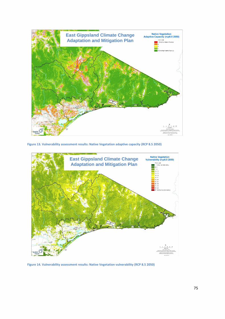
75
Figure 13. Vulnerability assessment results: Native Vegetation adaptive capacity (RCP 8.5 2050)
Figure 14. Vulnerability assessment results: Native Vegetation vulnerability (RCP 8.5 2050)
East Gippsland Climate Change
Adaptation and Mitigation Plan
East Gippsland Climate Change
Adaptation and Mitigation Plan

76
Figure 15. Vulnerability assessment results: Soils worst impact (RCP 8.5 2050)
Figure 16. Vulnerability assessment results: Soils vulnerability (RCP 8.5 2050)
East Gippsland Climate Change
Adaptation and Mitigation Plan
East Gippsland Climate Change
Adaptation and Mitigation Plan

77
Figure 17. Vulnerability assessment results: Rivers worst impact (RCP 8.5 2050)
Figure 18. Vulnerability assessment results: Rivers adaptive capacity (RCP 8.5 2050)
East Gippsland Climate Change
Adaptation and Mitigation Plan
East Gippsland Climate Change
Adaptation and Mitigation Plan

78
Figure 19. Vulnerability assessment results: Rivers vulnerability (RCP 8.5 2050)
Figure 20. Vulnerability assessment results: Estuaries worst impact (RCP 8.5 2050)
East Gippsland Climate Change
Adaptation and Mitigation Plan
East Gippsland Climate Change
Adaptation and Mitigation Plan
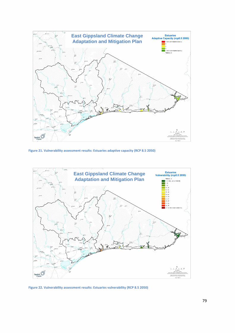
79
Figure 21. Vulnerability assessment results: Estuaries adaptive capacity (RCP 8.5 2050)
Figure 22. Vulnerability assessment results: Estuaries vulnerability (RCP 8.5 2050)
East Gippsland Climate Change
Adaptation and Mitigation Plan
East Gippsland Climate Change
Adaptation and Mitigation Plan

80
Figure 23. Vulnerability assessment results: Wetlands worst impact (RCP 8.5 2050)
Figure 24. Vulnerability assessment results: Wetlands adaptive capacity (RCP 8.5 2050)
East Gippsland Climate Change
Adaptation and Mitigation Plan
East Gippsland Climate Change
Adaptation and Mitigation Plan

81
Figure 25. Vulnerability assessment results: Wetlands vulnerability (RCP 8.5 2050)
East Gippsland Climate Change
Adaptation and Mitigation Plan

82
Figure 26. Vulnerability assessment results: Coastal wetlands worst impact (RCP 8.5 2050)
Figure 27. Vulnerability assessment results: Coastal wetlands adaptive capacity (RCP 8.5 2050)
East Gippsland Climate Change
Adaptation and Mitigation Plan
East Gippsland Climate Change
Adaptation and Mitigation Plan

83
Figure 28. Vulnerability assessment results: Coastal wetlands vulnerability (RCP 8.5 2050)
East Gippsland Climate Change
Adaptation and Mitigation Plan
84
Appendix 4. Adaptation pathways workshop results The adaptation options identified through the pathways case studies are detailed in the tables
below. These options represent the ideas of the workshop participants and do not represent a
prioritised list; each option has been assessed to understand the feasibility, likely level of adoption
by landholders, socio-political risk and cost, to assist with the planning process. Options have been
ranked based on this assessment using an H (High), M (Moderate) or L (Low) rating. Options with an
H rating are those that are more likely to be ready to implement whilst those with an L or M rating
may require further investigation before the options could be further explored.
Note: A legend for the graphical representation of the timeline applicable for each option is included
at the bottom of each table.

85
Lowlands Adaptation Options Analysis
Table 17. Adaptation options for the East Gippsland Lowlands
Adaptation option Option
Assessment
Soils / Ag
Land
Native
Vegeta
tion
Waterways 2014 2030 2040 2050
Develop local floodplain management plans that address flood risk, infrastructure and vegetation management across public and freehold land.
H (0.42)
Provide support for diversification within agricultural industries (e.g. cropping, pasture mix, changed calving time) through trials and extension programs.
M (0.15)
Support implementation of projects to improve water security for irrigators such as construction of off-stream storages for pumping/inflow during winter fill period.
M (0.15)
Promote the use of summer crops to provide winter fodder in anticipation of summer rainfall events (extension).
H (0.37)
Review biosecurity policy and programs to enable increased surveillance and early intervention of new and emerging biosecurity threats.
L (0.05)
Investigate and trial approaches to establish alternative native species and communities in areas where conditions are in transition due to climate change.
L (0.07)
Trial cooperative approaches to management of riparian frontages across crown and freehold land.
L (0.05)
Partition ‘at risk’ freehold land under permanent cover, pasture, vegetation i.e. areas likely to erode (incentives).
H (0.83)
Investigate and trial stewardship programs that provide incentives for landholders to retain and manage native vegetation on farm (including saline and estuarine areas where transition or migration of communities is likely).
M (0.11)

86
Adaptation option Option
Assessment
Soils / Ag
Land
Native
Vegeta
tion
Waterways 2014 2030 2040 2050
Assess feasibility of barrages and other physical barriers in estuarine areas to prevent further saline incursion.
L (0.07)
Support industry research and development into opportunities for novel agricultural enterprises and diversification within enterprises.
L (0.07)
Review policy and regulation to provide for cooperative burning on public and freehold land to manage fire risk and improve biodiversity.
M (0.11)
Support industry and landholders to increase water security on farm through construction, modification, and deeper dams to increase capacity, together with reticulation of water supply (troughs).
M (0.37)
Investigate options and develop plan for inland migration of fringing wetlands.
H (1.2)
Support initiatives to establish strategically located large permanent firebreaks that are maintained to manage fire risk.
H (1.3)
Investigate feasibility of storing water in Managed Aquifer Recharge scheme(s).
Not Assessed
2014 2030 2040 2050
Preparatory work required before option could be adopted (grey indicating preparatory work) Review / decision point for option
Option may not be robust across the planning timeframe (grey indicating lower confidence) Option appears to be robust across the planning timeframe
Option not desirable Option appears to partially contribute to towards adaptation across the planning timeframe
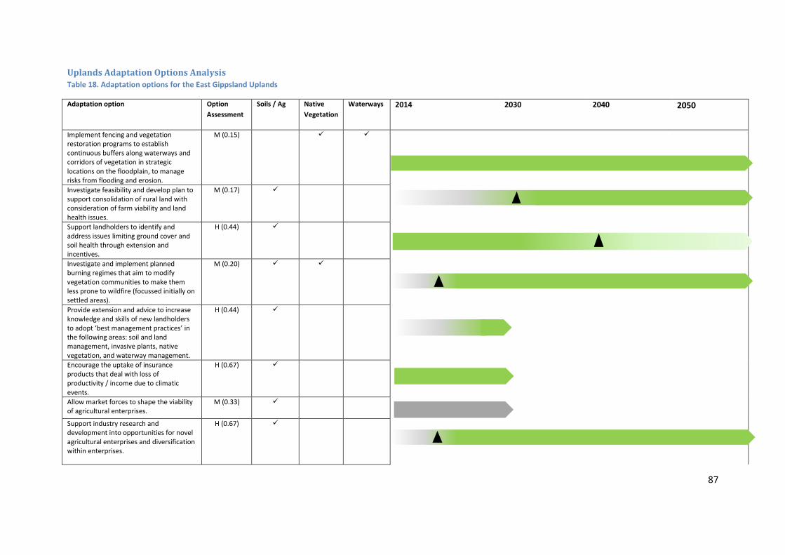
87
Uplands Adaptation Options Analysis
Table 18. Adaptation options for the East Gippsland Uplands
Adaptation option Option
Assessment
Soils / Ag Native
Vegetation
Waterways 2014 2030 2040 2050
Implement fencing and vegetation restoration programs to establish continuous buffers along waterways and corridors of vegetation in strategic locations on the floodplain, to manage risks from flooding and erosion.
M (0.15)
Investigate feasibility and develop plan to support consolidation of rural land with consideration of farm viability and land health issues.
M (0.17)
Support landholders to identify and address issues limiting ground cover and soil health through extension and incentives.
H (0.44)
Investigate and implement planned burning regimes that aim to modify vegetation communities to make them less prone to wildfire (focussed initially on settled areas).
M (0.20)
Provide extension and advice to increase knowledge and skills of new landholders to adopt ‘best management practices’ in the following areas: soil and land management, invasive plants, native vegetation, and waterway management.
H (0.44)
Encourage the uptake of insurance products that deal with loss of productivity / income due to climatic events.
H (0.67)
Allow market forces to shape the viability of agricultural enterprises.
M (0.33)
Support industry research and development into opportunities for novel agricultural enterprises and diversification within enterprises.
H (0.67)
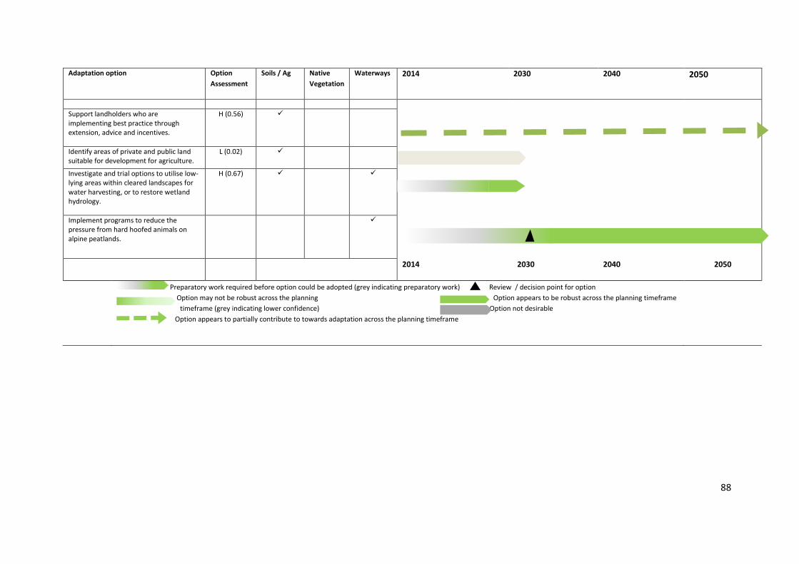
88
Adaptation option Option
Assessment
Soils / Ag Native
Vegetation
Waterways 2014 2030 2040 2050
Support landholders who are implementing best practice through extension, advice and incentives.
H (0.56)
Identify areas of private and public land suitable for development for agriculture.
L (0.02)
Investigate and trial options to utilise low-lying areas within cleared landscapes for water harvesting, or to restore wetland hydrology.
H (0.67)
Implement programs to reduce the pressure from hard hoofed animals on alpine peatlands.
2014 2030 2040 2050
Preparatory work required before option could be adopted (grey indicating preparatory work) Review / decision point for option
Option may not be robust across the planning Option appears to be robust across the planning timeframe
timeframe (grey indicating lower confidence) Option not desirable
Option appears to partially contribute to towards adaptation across the planning timeframe

89
Plains Adaptation Options Analysis
Table 19. Adaptation options for the East Gippsland Plains
Adaptation option Option
Assessment
Soils / Ag Native
Vegetation
Wetlands
Continue business as usual. M 0.11
Support efforts to Improve adaptive capacity of native vegetation through inclusion of more dry tolerant species within the restoration of an EVC.
H 0.44
Support landholders through extension and advice to improve groundcover through use of dryland perennial grass species.
H 0.44
Investigate and trial options to utilise low-lying areas within cleared landscapes for water harvesting, or to restore wetland hydrology.
M 0.28
Support landholders to adopt new practices through mentoring, consultants, discussion and focus groups.
H 0.67
Investigate and trial approaches for cooperative herd management and cross property rotational grazing.
M 0.10
Develop a plan for wetland management across land tenure that prioritises based on current condition and potential impacts of climate change and other threats.
M 0.15
Provide extension and advice to increase knowledge and skills of new landholders to adopt ‘best management practices’ in the following areas: soil and land management, Invasive plants, native vegetation and waterway management.
M 0.17

90
Continue to support partnership arrangements for NRM climate change planning through regular forums and review of Plans. (9)
H 0.83
Investigate and review planning for groundwater resources in light of climate change projections and aquifer yield.
H 0.56
Continue to implement invasive plant and animal programs of surveillance, monitoring and treatment across public and freehold land.
H 0.83
2014 2030 2040 2050
Preparatory work required before option could be adopted (grey indicating preparatory work) Review / decision point for option
Option may not be robust across the planning timeframe (grey indicating lower confidence)
Option appears to be robust across the planning timeframe

91
Appendix 5. Emissions Reduction Fund (ERF) approved methods Note: These methods were established as part of the former Carbon Farming Initiative (CFI) now incorporated into the
ERF.
Relevant asset types
Approved method Notes
Land/soils Sequestering carbon in soils in grazing systems
Soil carbon can be stored in grazing systems by increasing the amount of organic matter in agricultural soils. This occurs when management practices increase the amount of biomass (such as plant material) that is incorporated into the soil and/or reduce the amount of organic matter that is released from soils (for example, by reducing soil disturbance). Some activities, such as permanent destocking, are not eligible. Types of activities that could potentially be implemented include, but are not limited to, converting cropland to permanent pasture, rejuvenating pastures, or changing grazing patterns. Landholders must measure the soil carbon stocks at the project site, at regular intervals during the project, to estimate carbon sequestration. Emissions from other sources that have changed as a result of the project, such as emissions from livestock, tillage events and applications of lime or synthetic fertiliser, must be calculated to find the net abatement from the project. http://www.environment.gov.au/climate-change/emissions-reduction-fund/cfi/methodologies/determinations/sequestering-carbon-in-soils
Waterways, wetlands, native habitat
Environmental plantings
Under this method, planting or seeding native species on cleared land will allow a forest to grow and increase the carbon stored on the land. This method differs from other vegetation methodologies because it involves seeding or planting native trees rather than assisting natural forest regeneration. The method also uses a modelling approach to calculate the carbon stored, rather than directly measuring trees in sample plots.
Environmental plantings are a carbon storage activity and the project area must be maintained permanently to ensure that any environmental benefit achieved is not reversed. The CFI permanence rules recognise the realities of Australia’s natural environment and climatic conditions. Owners of environmental planting projects will not be penalised for losing carbon through no fault of their own. In the event of naturally occurring events such as bushfire or disease, the landholder must take reasonable action to re-establish carbon stores. The CFI permanence requirements mean that environmental planting projects should be viewed as complementary to existing land use and should only be considered in areas where they will deliver benefits for natural resource management or agricultural productivity. http://www.environment.gov.au/climate-change/emissions-reduction-fund/cfi/methodologies/determinations/environmental-plantings
Waterways, native habitat
Human-Induced regeneration of a permanent even-aged native forest
This method could be used by landholders who want to establish forests by promoting the regeneration of native forests, which have been suppressed by agricultural land uses, such as grazing. For example, landholders may want to regenerate certain areas of their property to provide shelter for stock, minimise erosion, reduce salinity, improve water quality or provide a habitat for wildlife, while potentially boosting their income by generating credits under the CFI.
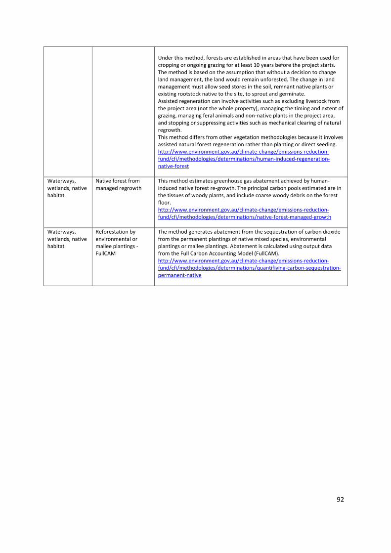
92
Under this method, forests are established in areas that have been used for cropping or ongoing grazing for at least 10 years before the project starts. The method is based on the assumption that without a decision to change land management, the land would remain unforested. The change in land management must allow seed stores in the soil, remnant native plants or existing rootstock native to the site, to sprout and germinate. Assisted regeneration can involve activities such as excluding livestock from the project area (not the whole property), managing the timing and extent of grazing, managing feral animals and non-native plants in the project area, and stopping or suppressing activities such as mechanical clearing of natural regrowth. This method differs from other vegetation methodologies because it involves assisted natural forest regeneration rather than planting or direct seeding. http://www.environment.gov.au/climate-change/emissions-reduction-fund/cfi/methodologies/determinations/human-induced-regeneration-native-forest
Waterways, wetlands, native habitat
Native forest from managed regrowth
This method estimates greenhouse gas abatement achieved by human-induced native forest re-growth. The principal carbon pools estimated are in the tissues of woody plants, and include coarse woody debris on the forest floor. http://www.environment.gov.au/climate-change/emissions-reduction-fund/cfi/methodologies/determinations/native-forest-managed-growth
Waterways, wetlands, native habitat
Reforestation by environmental or mallee plantings - FullCAM
The method generates abatement from the sequestration of carbon dioxide from the permanent plantings of native mixed species, environmental plantings or mallee plantings. Abatement is calculated using output data from the Full Carbon Accounting Model (FullCAM). http://www.environment.gov.au/climate-change/emissions-reduction-fund/cfi/methodologies/determinations/quantifiying-carbon-sequestration-permanent-native

93
Appendix 6. Soil carbon potential options
Reference: Soil Carbon Sequestration Potential: A review for Australian agriculture, Jonathan
Sanderman, Ryan Farquharson and Jeffrey Baldock, CSIRO Land and Water (2010)