east fork roadhouse doyon, limited a-3/me… · east fork roadhouse doyon, limited
TRANSCRIPT
.... :._ ..
EAST FORK ROADHOUSE
DOYON, LIMITED
BLM I1AA-12333
A
wr .....

CERTIFICATE OF ELIGIBILITY
EAST FORK ROADHOUSE
DOYON, LIMITED
BLH IIAA-12333
I, Jacob Lestenkof, Area Director, Bureau of Indian Affairs, pursuant to
the authority vested in me by 43 CFR 2653.5(h), hereby issue a Certifi
cate of Eligibility to Doyon, Limited, for East Fork Roadhouse
(BLM #AA-12333) as a historical place for the following reasons:
1. Extensive field investigation by BIA personnel found
substantial evidence supporting a claim of a Native
historical place.
2. The - site has archeological and an thropological
research potential that may yield information impor
tant to the prehis tory and his tory of the Alaska
Na tive peoples.
3. This site meets the criteria for selection as a
Native historical place and cemetery site as required
by 43 CFR 2653, et~.
This certificate and accompanying report will be submitted to the
Bureau of Land Management which, pursuant to 43 CFR 2653.5(k) and (1),
will issue an appealable decision on the application./l
/ ! ~(/hL~dS;Area Direc tor
Dated: " 1984
B
til" • .•.
TABLE OF CONTENTS
EAST FORK ROADHOUSE
DOYON, LIMITED
BLM IlAA-12333
•
Cover Sheet • • • • • • • •
Certificate of Eligibility
Table of Contents • • • • •
Claims Examiner's Certificate.
Claims Examiner's Report
EXHIBIT #1
A.
B.
C.
D.
E.
F.
G.
H.
I.
EXHIBIT 112
. .
. . . .
. .
. . . . . . .. . . .
. . . . . .
. . . . .
. . . . . .
A
B
C
fj
1
4
5
10
12
13
14
15
16
17
A.
B.
EXHIBIT 113
A.
B.
Regional Corporation Application
Related Papers with Application •
NPS Cover Letter ••••
CPSU Section 14(h)(1) Form
. .22
23
40
41
c
., ..... -

•
CLAIMS I-:XAM INER' S CERTI FICATE
EAST FORK ROADHOUSE
DOYON, LIMITED
BLM IIAA-12333
I, Stanley J. Casey, hereby certify the following to be true and correct
to the bes t of my knowledge and belief:
That I review~d this report of the field investigation and' data supp~ied
by field investigators, archeologists, their field notes, and research;
That the conclusions contained in the Claims Examiner's report are based
on an accurate analysis of my findings;
That my recommendations are valid and consistent with the guidance
contained in 43 CFR 2650, e t ~.
~~Certified this 30'" day of , 1984
----~~,-----
n\~xam1ner
Reviewed and approved by:
o
Da te: Ai Cej ' 1984
~ ..... "
CLAIMS EXAMINER'S REPORT
FOR
EAST FORK ROADHOUSE
DOYON, LIMITED
BLM IIAA-12333
I. FINDINGS OF FAcr
1. Doyop, Limited, is a Native regional corporation organized in
accordance with 43 CFR 2650. (Exhibit 2) .
2. The Corpora tion au thorized an individual
applications in accordance with 43 CFR 2650.2.
to file its
(Exhibi t 2)
3. The Corporation included a statement of significance in
accordance with 43 CFR 2653.5(f). (Exhibit 2)
4. The site is marked on United States Geological Survey (USGS)
quadran~e map, 1:63,360, Medfra (A-3) in. accordance with 43
CFR 2653.5(f). (Exhibit 1)
5. The site is specifically described in Exhibit 1, Appendix C.
6. BlA field investigators located the site to be within the area
described by the Corpora t Ion , (Exhibi t 1)
7. The site is not within 2 miles of the boundary of any home
rule or first class city.
8. BIA field inves tiga tors rna rked the corners of the site in
accordance with 43 CFR 2653.S(j). (Exhibit 1)
9. BIA field
(Exhibit 1)
lnves t Lga tors examined the site in 1981•
.;;r • .• "
10. CPSU archeologists investigated the site in 1981. (Exhibit 1)
11. BlA field lnves tiga tors took pho tos of the s 1 t e , (Exh ibi t 1)
12. The Corporation, CPSU, and BrA agree on the site location.
13. Based upon field examina tion, resea rch, and the CPSU repor t
BIA has determined tha t East Fork Roadhouse is eligible for
certification as a historical place.
II. CONCLUSIONS OF LAW"
l~ An eligible Native regional corporation can select lands
pursuant to Section 14(h)(1) of ANCSA.
2. A Native regional corporation can authorize an individual to
file its applications for Section 14(h)(1) selections.
3. An ap plica tion for a Section 14(h)(l) selection can be
amended.
~.
4. BIA can modify the boundaries of a ceme tery site or a
historical place.
5. A historical place selection in a national forest can be
granted.
6. BIA can consul t 0 ther Federal agencies on Sec tion 14 (h) (1)
selec t Lons ,
7. BIA shall confirm the ex Is tence of a cemetery site or a
historical place.
8. BIA can issue a certificate of eligibility or ineligibility
for a cemetery site or a historical place.
2
Ill. RECOMMENDATION
1. I t is recommended tha t BlA issue a certifica te of eligibili ty
for East Fork Roadhouse as a historical place for the
following reasons:
A. Extensive field inves tlga tion by BlA personnel
found substantial evidence supporting a claim of
a Native historical place.
B. The site has archeological and anthropological
research potential that may yield information
important to the prehistory and history of the
Alaska Native peoples.
-c. This site meets the criteria for selection as a
Native historical place and cemetery site as
required by 43 eFR 2653, !!~.
3til" .......
..
-
APPENDIX A
CERTIFICATE OF REVIEW
EAST FORK ROADHOUSE
DOYON, LIMITED
BLM lAA-12333
I, Gene A. Smerchek, certify the following Section 14(h)(1) report to be
true to the best of my knowledge and belief:
That the field investigators conducted the investigation here
inafter described;
That the report of this investigation was prepared from obser
va tions,_ interviews, field notes, photographs, and research
before, during, and after the field examination;
Tha t I reviewed the inforDla tion hereinafter contained and
found it to be an accurate report of the investigation;
That the field investigator's summary of this investigation
accura tely reflee ts the - findings of the field examlna tion
required by 43 CFR 2653.5(h).
MAY Z 0 1984Dated
Real ty S pecialis t
.,.. .....
APPENDIX B
REPORT OF INVESTIGATION
FOR
EAST FORK ROADHOUSE
DOYON, LIMITED
BLM I1AA-12333
I. PURPOSE AND AUTHORITY
The purpose of this report is to set forth investiga tive findings
from the ANCSA Office examination of the Doyon, Limited,
application for East Fork Roadhouse as a historical place.
Section 14(h)(1) of the Alaska Native Claims Settlement Act
(ANCSA), Public Law 92-203, as amended, authorizes the Secretary of
the Interior to convey fee title to existing cemetery sites and
his torical places to the appropria te regional corpora tion.
Departmental,~elea8es1666", 230 OM 1, and 10 BlAH 3 .1_ delega te to
the Area Director the authority to certify the existence of
cemetery sites and historical places under Section 14(h)(1) of
ANCSA.
The ANCSA Office is delegated the authority and responsibility to
conduct field investigations of the sites selected, to prepare
reports of those inves tiga t Ions , and to make recommenda tions as to
certification in accordance with 43 CFR 2653.5.
II. BACKGROUND
Doyon, Limi ted, applied for Eas t Fork Roadhouse as a historical
place on June 28, 1976, in compliance with regulations of
Section 14(h)(1) of the Alaska Native Claims Settlement Act
(ANCSA) •
.;I" ......
A tract of land was claimed including the NW~NE~ Section '5,
T. 28 S., R. 25 E., Kateel River Meridian (KRM), Alaska (as amended
on December 28, 1976). Doyon, Limited, marked the site location on
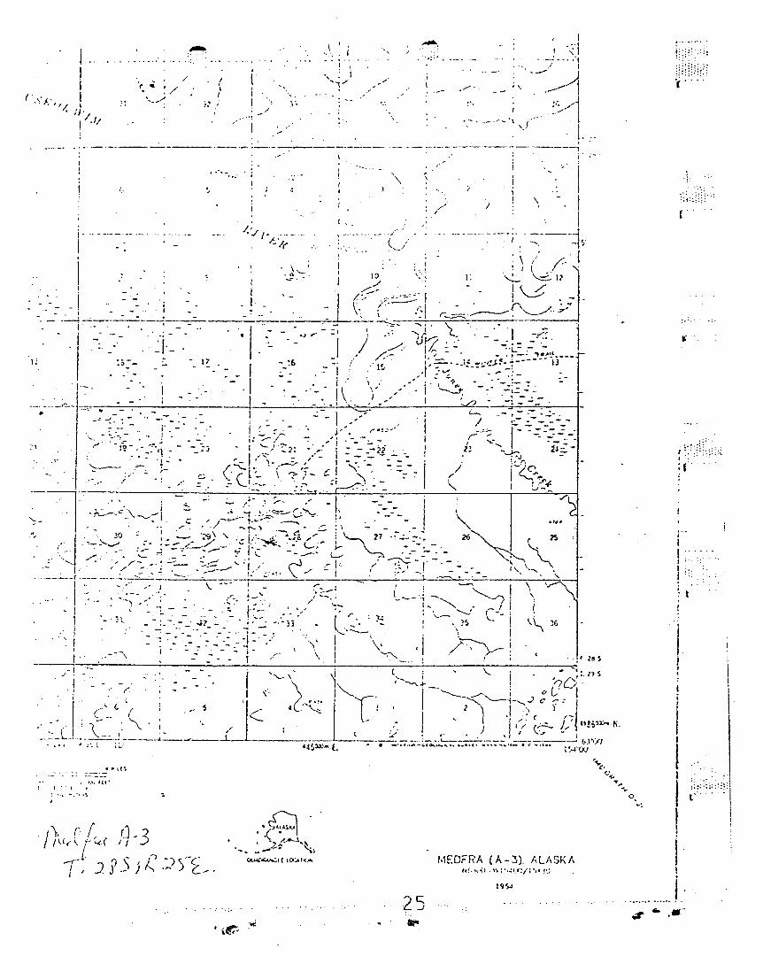
Uni ted States Geological Survey (USGS) quadrangle map, 1: 63,360,
Medfra A-3, 1954 (limited revisions 1976).
The Bureau of Land Managemen t (BLM) preadj udica ted the applica tion
and assigned it case file number AA-12333. BLM then forwarded the
applica tion to the Bureau of Indian Affairs (BIA) ANCSA Office for
field investigation.
According to Doyon, Limited, there was a village at the site dating
at least to the pro tohis toric period. The area contained good
• hunting and fishing, especially sheep hunting. The inhabi tants of
the village moved to the mouth of the Tonzona River when groceries
became available by regular steamboat service beginning in the late
19th century. Later, a roadhouse and cabin were built serving dog
team mail carriers and travelers to Nenana. Though leveled by fire
after abandonment, the founda tions of the roadhouse and cabin are
still visible. There is a cemetery behind the site.-~,~
According to Native informant Miska Deaphon of Nikolai village, a
Native village existed prior to the roadhouse being built. There
were two old log houses and a ceme tery, whe.r~ E~ai Pe truska was
buried about 1915 or 1916. The roadhouse was built around 1923 and
lasted until the early 1930' s, Deaphon himself stopped at the
roadhouse while carrying dog team mail from Nenana.
Preseason iaves tiga tion revealed the site as applied for is in
possible conflict with State Selection Application AA-21385.
III. INVESTIGATIVE FINDINGS
Field investigation of East Fork Roadhouse was conducted on June 25
and 26, 1931, by BIA Field Investigators Jim Sykes, Sheri Lewis,
6~ .......
Bill White, and Patti Hughes. Cooperative Park Studies Unit (CPSU)
personnel A. J. Lynch and Frank Broderick provided technical
assistance. The site was located earlier on June 10, 1981, by BlA
Real ty Spec ialis t Ron Kor tlever and BlA Field loves tiga tor Pa t ti
Hughes, with the aid of Native informant Miska Deaphon t of Nikolai.
Site boundaries were de termined by all personnel following a tran
sected reconnaissance of the site. As a result of the field
inves tiga tion, the site was found to lie wi thin the E~E~SW~,
W~SW~SE~ Section 15, and the NW~NW~NE~t N~E~NW~, SE~NE~N~ Sec~ion'I
22, T. 28 S., R. 2S E., KRM, Alaska. This is outside the applied-
for area.
The site is loca ted on the sou th bank of the Eas t Fork of the
Kuskokwim River, immediately downstream from a large river island.
There is- a large grassy clearing containing major fea tures of the
main use area. The clearing is bounded by the river on one side,
and by stands of large birch trees on the other three sides. Far
ther back from the river are two areas of tundra wi th modera te
stands of black spruce. Moss and lichens cover much of the area. - .~~
ou ts ide the grassy clearing.
Remains of three cabin footings were found. Cabin 112
largest and contained an underground cache at its center.
appears to have burned.
was the
Cabin 63
A Russian Orthodox grave si te was found in the trees behind the
grassy clearing. About 7S feet behind the grave site are remains
of five small structures •.
A number of boards were found at the river's edge. Approxima tely
250 feet from the western edge of the clearing are remains from a
hunting camp. Tre~ cutting 1s evident in a large area surrounding
the area of main use. A cache pole was found a t the northeas tern
edge of the clearing.
7.r- ....
There were two cabins and a grave before the roadhouse was built,
according to Native informant, Miska Deaphon, Chief of the Nikolai
band. One cabin was by the riverbank.
Esai Petruska was buried by his parents in the summer of 1915 or
1916 and Miska Deaphon's father, who was then chief. The original
Native inhabitants left the area around 1917-18. Later, two
brothers lived there with their mother.
Next , whi te men moved in and buil t a roadhouse. Logs from the
abandoned Native cabins may have been used in the roadhouse ~on-
"struction about 1923 by Bob Jones and Carl Snowshoes (or Snowshoe
Carl). Joe Oats ran it next, followed by Diamond Dick, who ran it
the last two years, ending in the early 1930's when airplanes began
carrying mail, replacing dog teams.
Visitors to the roadhouse included mostly travelers to Nenana, and
mail carriers wi th their dog teams. The roadhouse had two rooms
and underground food storage.
There was a40ng dog ba~ which had individual cubicles f~the'
dogs. A traveler could feed and water his dogs inside. The five
or six structures behind the grave are not doghouses, Deaphon
said. The doghouses were near the river.
Informant Jim Nikolai, of Nikolai village, (from notes taken by
Mary Krowl), recalled seeing the roadhouse as a child, but said the
cabin burned down after it was abandoned.
There is no present use of the site.
The site as surveyed is in possible conflict with State Selection
Application AA-12635.
A buffer zone of 90 feet to 260 feet was provided to protect the
integrity of the surveyed area.
8~ ......
•
Visual integrity of the. site is also preserved by the established
boundaries. The boundaries enclose an area of 12 acres, more or
less.
IV. SUMMARY
Field inves tlga tion of the Eas t Fork Roadhouse on June 25 and 26,
1981, revealed the remains of three cabin footings, a nearby grave
site,' five unidentified small structures, and remains of a hunting
camp.
Doyon, Limited, applied for an area of land within the NlhN~
Section 5, T. 28 S., R. 25 E., KRM, Alaska. Local guide informa
tion and the field investigation indicate the application should be
amended to include a historical place within the E~s~slh, w~slhs~
Section 15, and N~N~NE~, N~N~N~, S~N~N~ Section 22,
T. 28 S., R. 25 E., KRM, Alaska.
The field investigation of the site as surveyed revealed a possible
conflict with State Selection Application AA-12635.
The site as surveyed contains 12 acres, more or less, including the
buffer zone provided for in Title 43, Code of Federal Regulations.
9.;I" .....

APPENDIX C
LEGAL DESCRIPTION
BLM lAA-12333
A parcel of land located within the ~S~StJ,;, \kStJ,;S~ Section 15, and
N~NW~N~, N~~\$(, S~NN\h Section 22, T. 28 S., R. 25 E., Kateel
River Meridian (KRM) , Alaska. The 8i te is more specifically described
as follows:
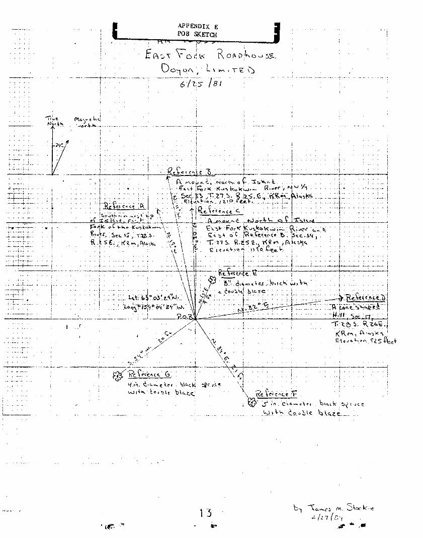
Beginning at the point of beginning (POD), latitude 63·03'29" N., longi
tude 154°04'24" W., designated as a witness corner to Corner 1 (We-i),
marked with a 5/8-inch aluminum alloy rod extending 22 inches above the
ground, referenced to the following:
Reference A: N. 19° W. to the southernmost tip of a large island in the
East Fork of the Kuskokwim River, loca ted in Section 15,
T. 28 S. ,R. 25 E., KRM, Alaska;
Reference B: N•. N.~ W•. to a mound to the north of a large island _in the
East Fork of the Kuskokwim River (Reference A), elevation
1210 feet, located in the Nlh Sec tion 33, T. 27 S.,
R. 25 E., KRM, Alaska;
Reference C: N. 02 ° W. to a mound to the north of a large island in the
East Fork of the Kuskokwim River (Reference A) and east of
Reference B, eleva tion 1190 feet, loca ted in Sec tion 34,
T. 27 S., R. 25 E., KRM, Alaska;
Reference 0: N. 82° E. to the southernmost cone-shaped hill in a series
of three, elevation 925 feet, located in Section 17,
T. 28 S., R. 26 E., KRM, Ala 8 ka ;
Reference E: N. 23° E., 9 feet to an 8-inch diameter birch tree wi th a
double blaze;
10.". ......
Reference F: S. 34° E., 21 feet to a 5-inch diameter black spruce with
a double blaze;
Reference G: S. S4° \.J., 20 feet to a 4-inch diameter black spruce with
a double b Laz e ;
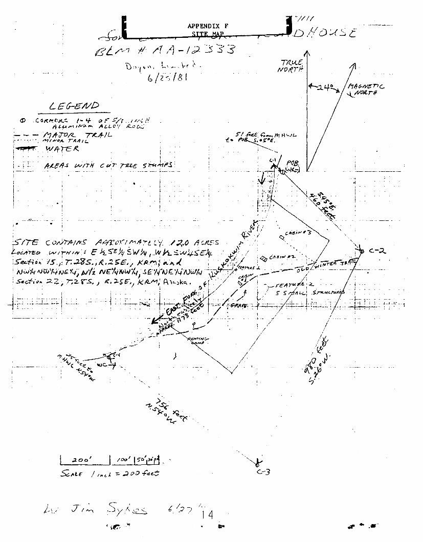
Thence S. 45° E., 460 feet to Corner 2 (C-2), marked with a 5/8-inch
aluminum alloy rod extending 9 inches above the ground, referenced to a
black spruce with a double blaze, N. 16° E., 14 feet, and a black spruce
with a double blaze, N. 51 ° E., 19 feet, and a black spruce with a
double blaze, S.- 51 0 E., 14 feetj
Thence S. 26° W., 980 feet to Corner 3 (C-3), marked with a 5/8-inch
aluminum alloy rod extending 7 inches above the ground, referenced to a
5-inch diame ter black spruce wi th a double blaze, S. 59 0 W., 10 fee t ,
and a 4-inch diame ter b lack spruce wi th a doub le blaze, N. 20 ° W.,
26 feet, and a 3-inch diameter black spruce with a double blaze;
N. 70° E., 30 feet;
Thence N. 54° W., '756 feet to a witness corner to Corner 4 (WC-4),
marked with a 5/8-inch aluminum alloy rod extending 20 inches above the
ground, referenced to a 5-inch diameter b lack spruce wi th a doub Le
blaze, N. 76° E., 19 feet, and a 3-inch diameter black spruce with a
double blaze, S. 34° E., 30 feet, and a 3-inch diameter black spruce
with a double blaze, S. 60° W., 24 feet, and a S-inch diameter black
spruce with double blaze, N. 76° W., 2 feet;
Thence N. 54° W., 25 feet to Corner 4 at the mean high water line (MHWL)
of the Eas t Fork of the Kuskokwim River;
Thence in a northeas te r Ly di rec tion, approxima te ly 1173 fee t , following
the MHWL along the meander of the East Fork of the Kuskokwim River,
upstream to Corner 1 (C-l)j
Thence S. 45° E., Sl feet, returning to the POB (WC-l).
The site described contains 12 acres, more or less.
lr rI ..... '

APPENDIX D
SURVEY FORMAT
BLM #AA-12333
This survey was conducted on June 25 and 26, 1981, following a tzan
sected reconnaissance of the site. BIA and CPSU personnel determined
the site boundaries •
. All bearings were ob tained wi th a Suun to compass declina ted 24 0 to true•
north. All distances were measured with a IOO-foot Lufkin fiberglass
tape.
The corners of the si te were marked wi th 5/S-inch aluminum alloy rods
driven to the point of resistance with sufficient portion extending
aboveground as monuments. Each monument has been cited and described in
the legal description.
, .... '
··..-t·~ .. __.._-_·· -_.
R.t~ fe:- p, 5 >. _ I I
,E f'\ :. v V 0 ~ ~< K0 (l. 0 i\." 0 ..J ~S"-
D01 01\ ~' L\ M 1"\ E \':J-"-'-'-6~(i;5 [8",
'\f~e.~'rJ~.
il"W\c.y,ehq'~"4"-\-..h.~,
I
"~ .
...-~ ------ ----i,
1,,. ,,
i!
, ..,
.. I,i
t,,<>.< k ~? r·J c e
I::l\.xie..._ ..
!.._-_.~-
.. ,I!i
J
•..;... , .1-:
... _-4.-_.... ~.
, ,
~ -"'.... -; .... "
----: .•-t- ..... ·t--· ,,
-~-~-_.__.. L--.----
, 3 -\c.. _n M, 5\CX' k, ~2./17(t"t
.r#" •.•
L£6-&/1/D
<:'-;2..
..·1
-11.
. i
i .I .,j"I
!
--- ...
,Do'r"'" L\~,\-(\.
. b I z: lSi
j ... ~ ~-
a:> ,c.G/(f".Cj(.!;. 1- 4- «r ;:/(./r.,.:..8Il '4A M I"':"''''' A /.L. C''f ~o c..:;
'c:.-::.~ :~,fiTO/<- T4/L~11Vi>~ r-<II,,-
. \;1/}frc ~
I"
!..1QlI¥ p..! .. .,,
.200' 100'IS'O','.d.~,4l£ / I ... ", ::;;:) oo -Fild;
II;" ~ ,.-
I- ":;T/~ Sv,~.:>..:
/' ~
/ ...
14.". ....
)6
t
'P. o. "8.
1(
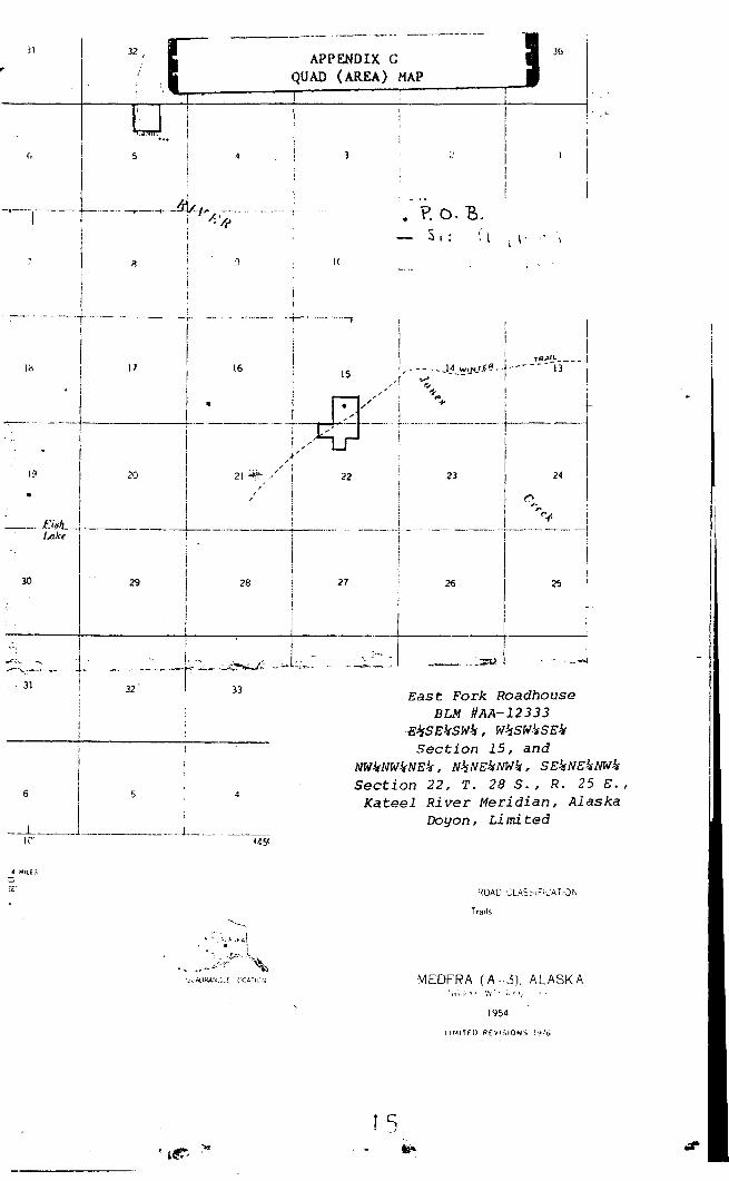
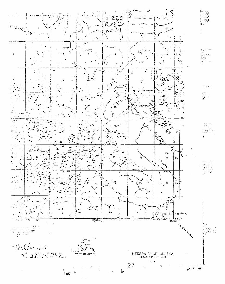
APPENDIX GQUAD (AREA) MAP
4
11
(, I
~--I---~-- .~~ 4'-",:?I
I 1r~lffD RfYI$IONS 1':.116
1954
MEDFRA (A -31. ALASK A
Eas t Fork RoadhouseBLM #AA-12333
eJsSE%SWJ.t, W.!sSW,!sSE!tSection 15, and
NW!tNW!tNEt, N.!sNE!tNWlt, SE!tNEltNWJ.tSection 22, T. 28 S., R. 25 E.,
Kateel River Meridian, AlaskaDoyon, Li mi ted
15
27
4
16
33
5
32
17
I.-..- -+ -- ---I
19
_. -"1
, ... "'. ,I. .~.- A\• I
__ .... ~..~~.!~~7~,~\~
-~'\.·ADNAt~.;.! . P(.:t.Hl.'~~
..
1«
31
6
II,
--&-__~ ....L._ ...... _ ..__.
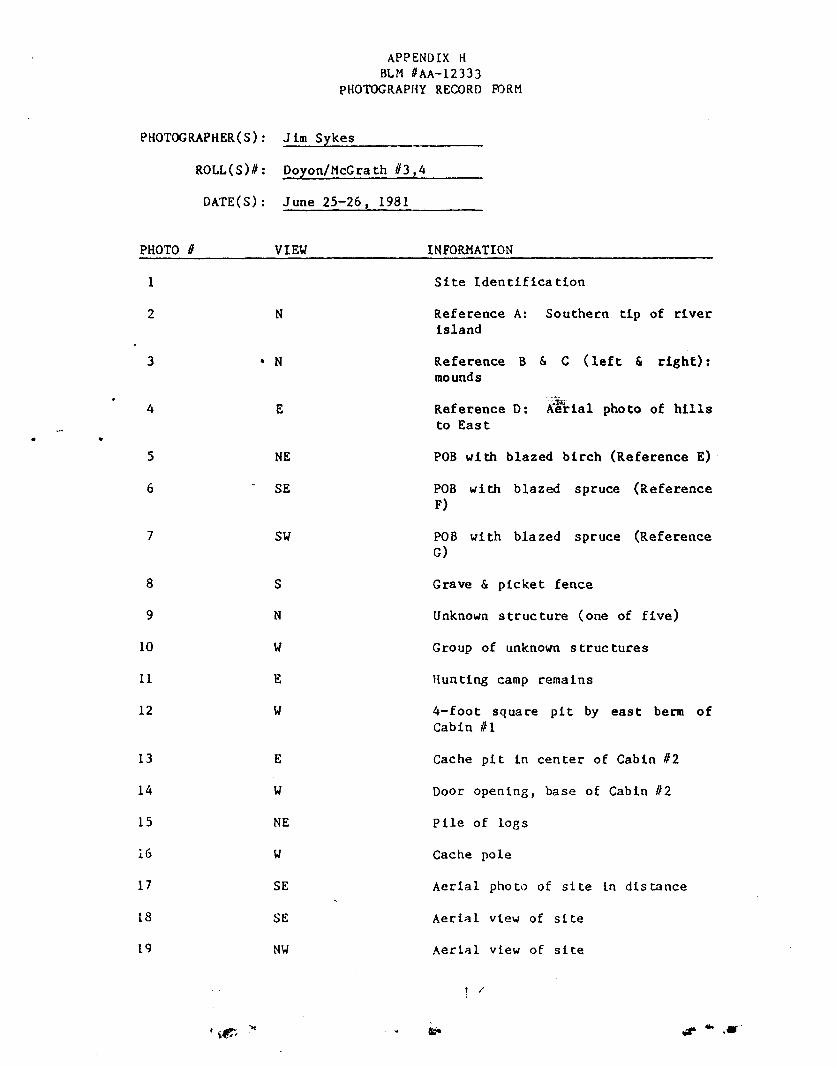
APPENDIX HBLM IJAA-12333
pHOTOGRAPHY RECORD roaM
PHOTOGRAPHER(S): .;;..J.::,:im.:;;.....=SJ-Y...:.;k..:::..es=-- _
ROLL(S)#: Doyon/McGrath 03,4
DATE(S): June 25-26, 1981
•
PHOTO II
1
2
3
4
5
6
7
8
9
10
11
12
13
14
15
16
17
18
19
VIEW
N
• N
E
NE
SE
SW
S
N
W
E
W
E
W
NE
SE
SE
NW
INFORMATION
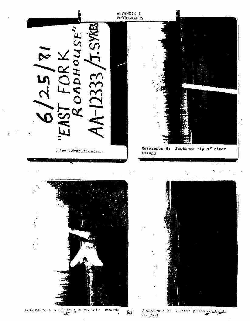
Site Identification
Reference A: Southern tip of riverisland
Reference B & C (left & right) :mounds
Reference D: Klrtal photo of hillsto East
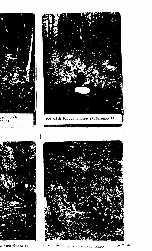
POB with blazed birch (Reference E)
POB with blazed spruce (ReferenceF)
POB wi th bla zed spruce (ReferenceG)
Grave & picket fence
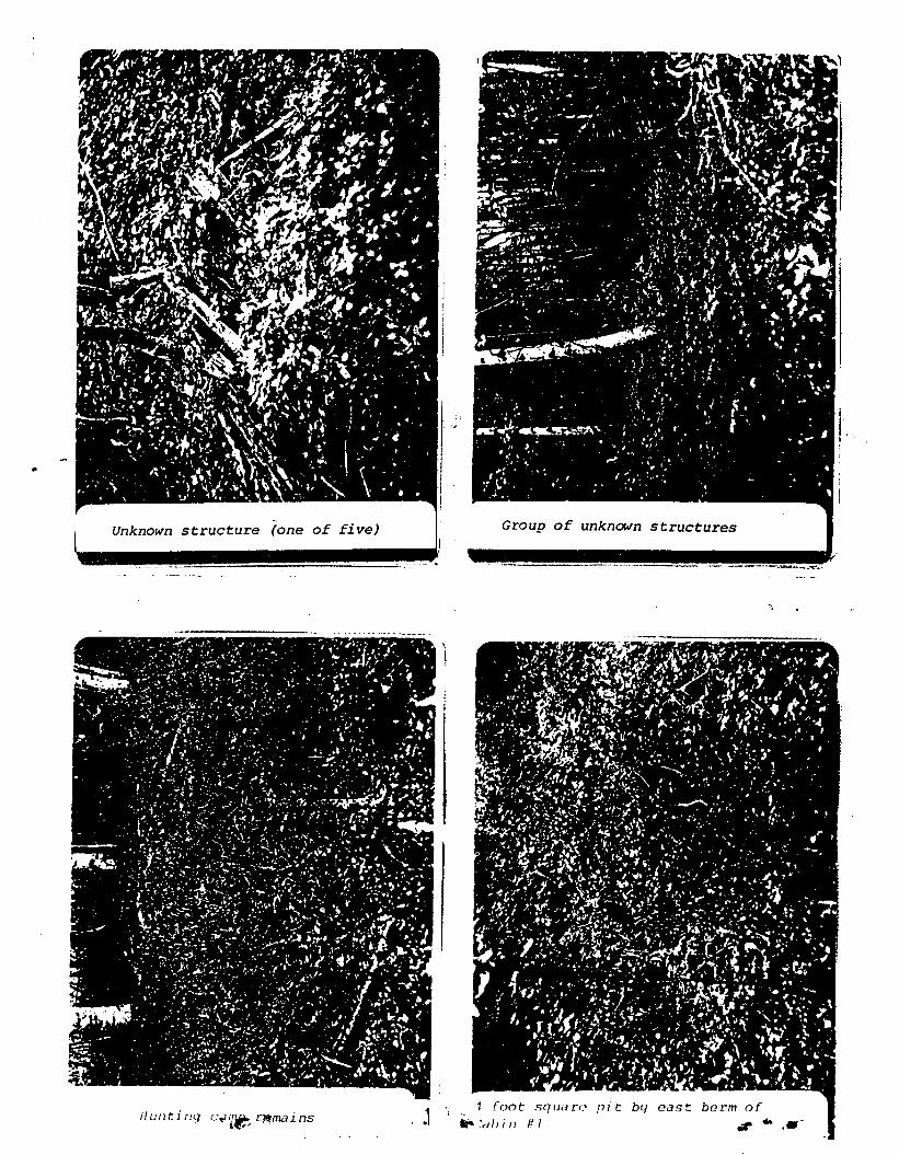
Unknown structure (one of five)
Group of unknown structures
Hunting camp remains
4-foot squa re pit by east berm ofCabin III
Cache pit in center of Cabin #2
Door opening, base of Cabin 112
Pile of logs
Cache pole
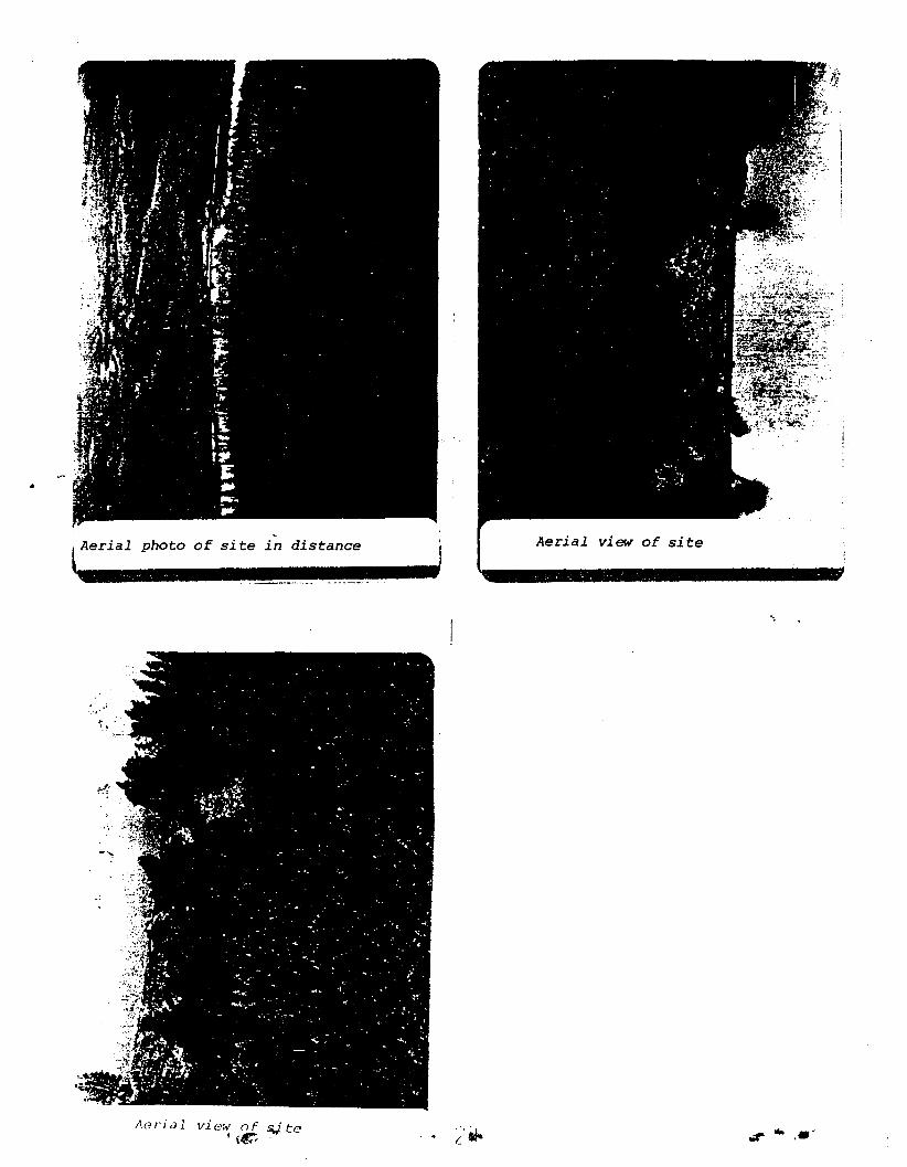
Aerial photo of site in distance
Aerial view of site
Aerial view of site
1 /
..,.. .....
II
Site Identification
APPENDIX IPHOTOGRAPHS
Reference A: Southern tip of ri verisland
a('f(~reTlc(' 13 6. (' (lert. s r i qtitz l : mounds(I.e·
L .''.- Reference 0:to £as t
A(~ri,)l photo o [..hi Ils..,. ..
·,'~----~~-----
.,.'0 ((cC"fdrencc G)
" ): )
POB with blazed spruce (Reference F)
• ..: .~. e~ I ....J '::.,. >. ....:.-- .:;' ....; .
Grave ~ pi cket fence.,.. .....
Unknown structure (one of five) Group of unknown structures
-_._.-..._--_ ...~- ,.-...... -------.-.-...::.-.,~.
1/unt i ny C~1~~ ~mains . .1I -; 1 foot so u» ro pi t btJ east berm of
"":aliin III .,. .....-

I-
Cache pi t in center of Cabin #2Door opening, base of Cabin #2
1.:wIIII~~~~__"'_~J
-. ;
Pi l e of logs-.... Cacho pole -I ....-
•
~Aerial photo of site in distance
Aerial view of s;"i.te·,e
iI
......c
Aerial view of si te
" ......

UNITED STA rr.siJEPAln:.1F:-';T OF rnr: l:--:TEI':IORIlUI;:£::,\U 0:" L\::U :.~;\";,\(;l'::':U;T
REGIOt::,!. COld)Or).TI(l:~ S:LLCTIO:~ I,PPLlCt.TIOt:I\ct of ()l'I."',::'li,(,: J:', j~I~'1 (,n 1.',S c. VIOl)
-: :
FC>:':.: ,\I'I'i~O\'E[)()~.1H ~:() ..;] -h'1;_, ~ ~
1-----
,.-\ -:
j-;; ,
----------------------'--_._-_.-----------
Doyon, Li 1111 ted f i rs t and Ha l l St re c t sIa i rbank s , Alaska 99701 ·.•
Specify ','pe of se lcct ion~J Surface and s.ubs ur tac e e s t at e- (~3 erR 2652):~J ~uLsulfac(' es t at e only (1.1':U ~:('i(·ct1ons. 43 CFH 26:'2)
~ ...j Surface and ~u!Jsurbn: estut e (Ccmct e ry Sjtc~; 43 CfI~ ~!(53)
UD Surface and subsurface estelle (Historical Places; 43 CFr~ 2653)
OJ, (jive writ ten Ictal descr ipt ion of Jands req uestcd ( au ach sep orate sheet. i/Ilcccssary)•
Certain available publ ic lands as defined by Section 3(e} and wi thdr-ewnpursuant to Section l4(h)(l) of the Alaska ;lative Claims Settlement Act. Theselands are described in more detail in Append i ce A attached. Included in theselection are any and all lands listed in Appendice A as exclusion because ofullege~ valid existing rights, if such alleged rights are subsequently detenminedto be invalid, as evidenced by a denial of title thereto by the United States.
'. List U.S.G.S. quadrangle maps used to portray requested lands
Medfra A-2~-A-3
Have you art ached a copy of each map? CIJ Yes [J No
InciC",.tc land use and occupancy C::J Occupied m Unoccupiedr- i ~lining Cl air»o Entryman
[~ Native Use[J Other ( spl'ci/y)
----_...:=.::~-==-==:.::..-.;:
Indicate Enll~lemt:n: (acres) T(]I<.t l'::::'lilJ.:~"'<'nl 2 Pre"iously Piled This Appl ic .. t i on'11 I 10n aCI"eS mo re
Ot" LeSSGi\,(: llL:~::~<l1 prd~·rcnc~. if selection :JiJpliciltlOn is [ded pursu:lot to Sec. 2f>52.3(f) of the rer,ubtio:1s
Authority for s i gnaturc =~J Au a ched ~,J Pre vious ly filed in Se ri al No,~ ::::-;::,::=,~'==::::':'=='=:':::'::::-~7 ':"===.::.:.:=:..~.
I~TIFY That the stat ernents made h ere in are true, complete. an d c or rcc t to Ih~' best of my know l ec ge and be l ieflie made in [;000 [a ith ,
___J:.~nd Selection fltJcnt(Sil~r""u,d (T'llt-) l:\,,~(').._.. ~-~.;::::--::::; -=;.....-:-.-_:... -:...-::..~..:.:.:...:.::~~.:.:. -.-==-'="- ~•.:.•:-::. :-:: __--:. ..:.~:-:;:..:=..:,.::' ':';";-'::"'7:::;.''::::-==-..=::::...:;:~=.:-_ :-_,",: ::=:=:-7"~=-=-----:::':-~--=--:--=-:- _-=-:::::---==--..-:-.;.-_--=-.:=..-=::.=.•:'::" ;=--=-.-::::':~
\~ u.s.c. Sect ron ! l101. r.:akl-S it (. c r nnr- fCH n n v pt'r~ulI kno\\"in~~I)" .',.d w sl lf u l l y to :!\~.i<e :0 .. n·v dcpa rt rn r-nt o r CI~:'·n.:\· c.( ~h("
:St":t..S .u..y Leis e , {lclliJOUS, Or rr,lU<.Jult'fil S.lott·~(,:Tl!S or r e pr e s e ru n r i on s a s to any r.lIHU:r Vo'lthl!'\ 1:5 j ur i s d rc t i on ,
',Ii
:
--22...,
· t. :-.
'" ..•'
.-
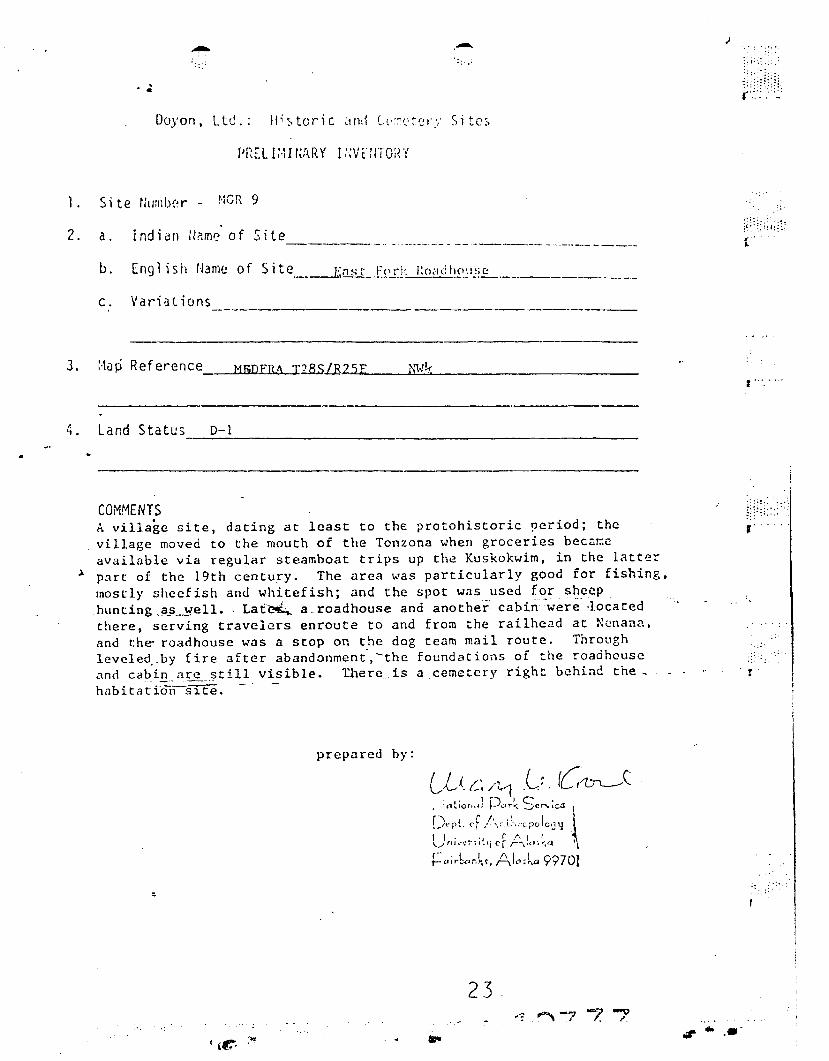
1. 5, te rill:nb(~r - NCR 9
2. a. Indian U?:me' of Site-----..._.. - . -----_._- _. -_.------ - ._...-._- - ----
b. English r!3me of Site En s t FC'rk l:o,tdhCl\ISC------_._.... __._---_.- -- --------------
J
(
3. Ma~ Reference t1IjDFRA I2..8.S1.R....2...l.5....E__....l.!C~ _
f" .... ,
4. Land Status D-1._----------
COMMENTSA village site, dating at least to the protohistoric ~eriod; thevillage moved to the mouth of the Tonz ona when groceries b e caneavailable via regular steamboat trips up the Kuskokwim, in the l~tt~r
~ part of the 19th centu!y. The area was particularly good for fishing,mostly sheefish and whitefish; and the spot was used for sheephunting ,il_fL.~elL . Laf~ a.roadhouse and another cabin-were -Io ca t edthere, serving travelers enroute to and from the railhead at ~~nann.
and th~ roadhouse was a stop on the dog team mail route. Throughlevcle~_by fire after abandonmeni,-the foundations of the roadhouseand cabin .J.l:'C still visible. Ihercis a cemetery right behind the,h[Jbitati:;f~srt·~. . .
prepared by:
23
, .
;::
r'
..,. .....
-; :~ .
.:.~ f;: :...-....
e-: :~:.
J' .. , '
if: .. :H~k:)/
r"
l ' •• r . i i :- I I. ; ; .•..:.
!.~I' ,." ..TI••;o.!.fT 01- 1'1:E 1:~.: :·:h.luf..l:l:tJl,L"~j OJ'~ I.I',HIJ 1>1:\1'1,:-.; '.'.:',:;;'
,....\:.::~ .SUHAL R(GIS1CR rU'.[-
Ler. ..1 Rde'"""". .(M u:<" I'. I<J S )
(fut"u·d~· ,. -'f S 4)
Act of D0cc~ber 18.1971 (43 U.S.C. ]h~l)
Ij;••• ""' ""'Hoc. ,.",;.~"" _.~--'------_._--Dayon , Li;;lit,~~
Fir::t and 1I~1l St r e e t s~airb.nks 'lavka 99701, . • 1\ ..
j
I :
IO.,."ription (Or Land
VCR 9 East Fork .Ibadhouse .~fra T 285 R 25E !<R'1 tJW?;
.
.- -
. " --_. .~ .. .~ ~'~-.._-_ ... .. -,
DATE OF ACTION ACTION TAKEN. --- ....- ,. ,. .. ".~. .' ' ,
- ~-...July 6.•1976 Application received Ib
II
III
III-:.. II - II
•
.~ .".:,
<>·4· ','f::.. ~ ...,,;r .... '
( , ,'/," i "~
1- ..
III
:J jI .//
::
,II{
",-'
.--
/
-.I
I '~'1._.:. -. :,
, / I
;~ .~~
"1t :::...- . .-" -~ .\ ..- '
, -J I.
, .
i"I
II:::, t' .
.,;r • ....
Ii
I
I1· '.
t i/~i;:::~1
t !
II
.............J.
\I
19So1
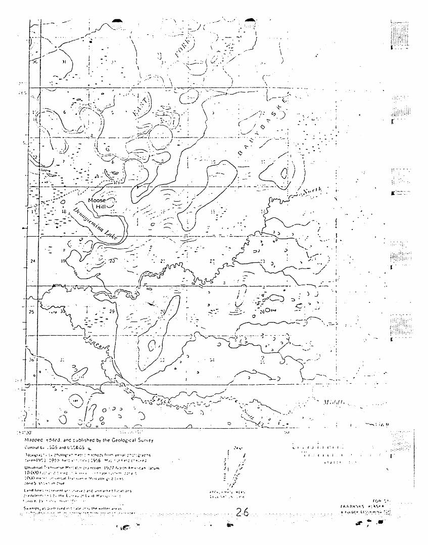
MEDFRA (A - 3), ALASKA
-:I
, /"
2S..
,\
.- ..- ·.·-·-···0-----.·-··-------·,j'\.
• \. I
. (\ -'" ....:", -III
......»»,
,J
t._
. ~... '(..
. 1·-.
I' I
'j). r!, (.1_:>I\l{"t\,({ I) ..J
.-,--.l 0 \- I n -) ,'-CI 1 J - ) I" .,.. .J C - .
~ .". ... 'I ...
"• J
~.,
I,
,,- .
".; .
-': ..
,.
..
...I,
:
I ,
t,
I, I
I
.'
,-,
)
I
\,I,
. ." ~
2·6.
, ( ...~ .... ' ..... I
~.I .. " 0 •• • p"
~'\,-. ),0 .. r » ',_ .;/
\ .' I -r : >, i ::'/.\" "• ------- .., •.• i
'~- .': "-,
\
/
\ ,,j
3 •: .'jr
'jI
. ~
'~"'::,i.-1 -·· ..·.1-<, \. • I
I\
l,
~.-
::-.:", ."
~.: . ~ ; .::
I! :I::::::::·:l~ .. '
II
I
I
Ie
,........ ... . .
.'
--- -
MEDFR/\ (/,-·3). Al/ISKA'<i6KIlj . V.l",'::f .J/I '., J:.J
.J
:":f'.-. - -
-r.: . i
': ··.; .. :'11.'1..
'-"
.-:'~::-":""':':=':_-="7' .~ "'\oC'
."" ... IUIi:': I ,
.- .
I:
",
: J ::'::0.'
1?:A
27 til" .... '
';" ii.~ r-c ,I
,'. , . ~.... _ •• :.l...."......_.. •
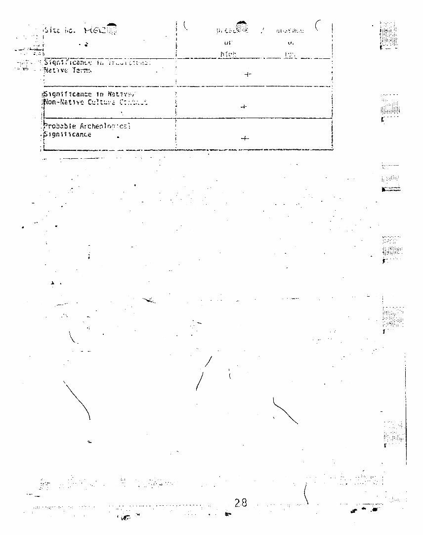
='.: !, f":r' '. , ·~S ,qit1yiC<1'n~·~-;:::-,r;·~_~ ~ 'Z: :',::; -;----., ._--~. "t'"!' '.. . ::Ne t .,vc.:: or e~";"'!1~... '
. ,
:~.~~l' (,:..:.;~~;~~
h~,.;."., '.
+.
(
iI•,
-4-
'~19n~f7can:e 10 NQt1v~,·
;f<on-Ncthf: C~~t~\'.;; C:::~:._~~
11
!~rOb~ble A:~he0100:c~~:F,gnlticanc.e
t.01I 60' ,_~ •.__.._~~.'-.. .-.__-__·...c~ .._.__.. ___....__ .. oJ
..
~: ~ ..
:'.':
,.....
. "
\
: ~ - ." .. '.:.t' :: :.;,'
J
\
\/
/
" .;.:
r ..
.... '.;-'
. ": ~: .., :;. 2,8 :,' .._....: ........ .. ,•.
00.'c-:
"T1 W --::'=' --l -cr, - .4J
r-6 v 1 c I r.:-..-". -~ rr1 -., I :
.... n ,......( .-;...; ;:=3 N ::- -~(fl ~ t.::
.. ~ i I I. ~..)-
Ci .... ".,
:!:.- I'. "X:) : ... <, ; ;
r-_. ::x ~: r: .'.:.:.::..-...:.: -- l .-.( .. r
~ (:; c;~m :;: -p-
Crr»......-,
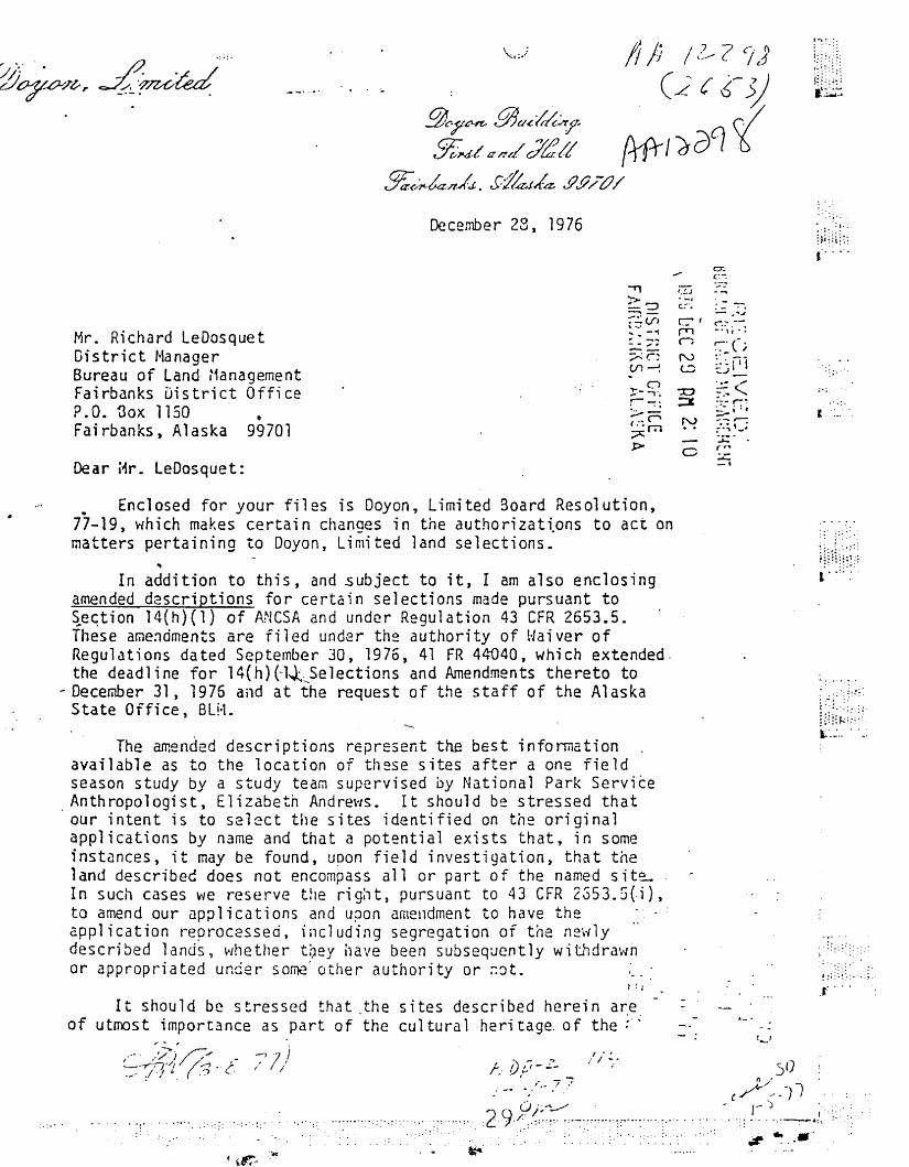
December 23, 1976
Mr. Richard LeDosquetDistrict ManagerBureau of Land :1anagementFairbanks District OfficeP.O. '3ox 1150 ,Fairbanks, Alaska 99701
Dear i~r. LeDosquet:
• Enclosed for your files is Doyon, Limited Board Resolution,77-19, which makes certain changes in the authorizattons to act onmatters pertaining to Doyon, Limited land selections.
't
In addition to this, and subject to it, I am also enclosingamended descriptions for certain selections made pursuant to~e~tion 14(h)(1) of ANCSA and under Regulation 43 CFR 2653.5.These arne~dments are filed under the authority of Waiver ofRegulations dated September 30, 1976, 41 FR 44040, which extended.the deadline for l4(h)(-1~:..Selections and Amendments thereto to
- December 31, 1975 and at the request of the staff of the AlaskaState Office, 8LM.
The amended descriptions represent the best informationavailable as to the location of these sites after a one fieldseason study by a study team supervised by National Park Service
. Anthropologist, Elizabeth Andrews • It should be' stressed thatour intent is to se l ec t the sites identified on the originalapplications by name and that a potential exists that, in someinstances, it may be found, upon field investigation, that theland describec does not encompass all or part of the named siteIn such cases \-/e reserve the r i qh t , pursuant to 43 CFR 2S53.G(i),to amend our applications and upon amendment to have theapplication reprocessed, including segregation or the new lydescribed 1ands, \AIhethe r toey i1 ave been subsequent 1y with draI." nor appropriated under some' other authority or r.o t ,
I ~ I
It should be stressed that the sites described herein a~e.
of utmost importance as part of the cul tura 1 heri tage. of the ;"
•• ~ » ,
" .... ..
~~~~~\;;~~ '
1. ••. :
• 0';-: .:,:.
1i~~i~ ;/l......:.: :' .:
.~ ...
--7, 7,J, ,/ /
. ':'.~.
~ -; .....

cc:
:
•
Richard lEDosquetPageJwDDecember 28, 1976
native population of th~ Doyon Region and that it is essentialthat they be identified, secreqated from aoproor tat ion by others,and preserved as mandated by the Alaska :~ative Claims SettlementAct , As such, we request that oLH make every' effort to processthese as is necessary to enable their field examination andidentification by alA at the earliest possible date.
Thank you for your cooperation.
Si nce rely,.; ·1 ',.'. . " f/"~;7'>,,':.[';71:.. .·tc.'/.;.:~T.D. HillialilsDirector of Lands
Eacl csures
Fairbanks Land Office~
Curt "1cVee t State Di rectorAlaska BLN555 Cordova StreetAnchorage, Alaska
I
r' ...
.~ .
I:: ...
~ .. ~ . : .: .:.0.,: :
r···· ..
H?;~;'
~·~::D·
i:: :,: .
:~;::~":.
...... •. ..
-:;=7::::~ .~ .•~.:=:-_.:--~.~,:~ ..;...... ' . ::: .... . .. .':':wt": .•.•.
,.,..r. , '-_ ... -.,.. .. ,''v. '-'I~' J :.JC:::>Cl'lPL i on'~J
(
, ,., \ "
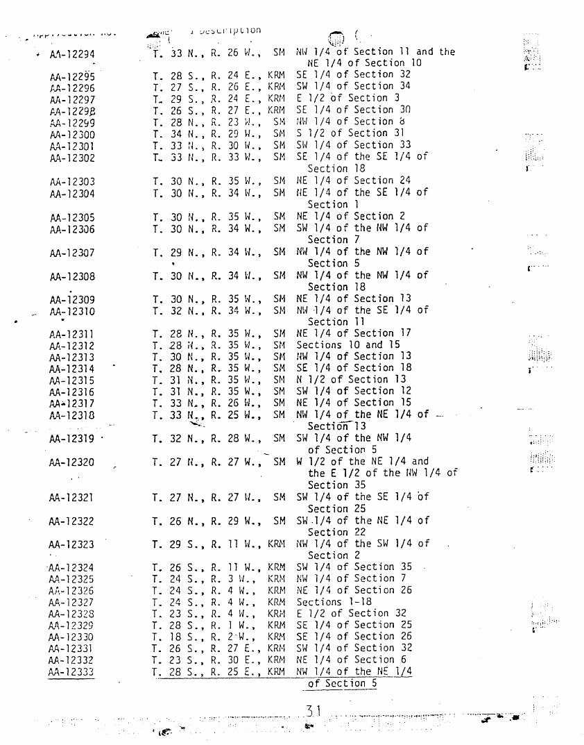
;~ : ; ~ . ~:';' .,'
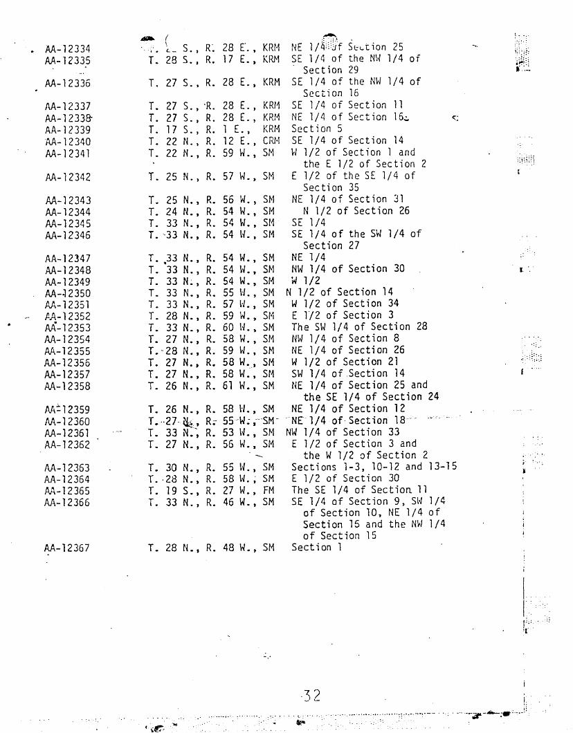
.. A.~-12294 T• 33 N., R. 26 H., 511 NW 1/4 of Section 11 and the ~;:~<~~:
11E 1/4 of Section 10 .:'<.;>':
AA-12295 T. 28 S. , R. 24 E. , KRM SE 1/4 of Sect ion 32lo°':: ,:
1:.A-12296 T. 27 S. t R. 26 E. , KRl1 SW 1/4 of Section 34AI~- 12297 T. 29 S,) I~' 24 E. ) KRf1 E 1/2 of Section 3f.A- 1229,8 T. 26 S., R. 27 E. t KRr1 SE 1/4 0 f Sect i on 30
AA-122~9 T. 28 N. , R. 23 ~J., sr·1 NH 1/4 of Section 0AA-12300 T. 34 N., R. 29 l,./., SN S 1/2 of Section 31 ,.......
AA-12301 T. 33 rL, R. 30 I~., SM Sl~ 1/4 of Section 33AA-12302 T.. 33 tL, R. 33 H. , S11 SE 1/4 of the SE 1/4 of \~ ~':~:::
Section 18 f.'
AA-12303 T. 30 N., R. 35 H., SM HE 1/4 of Section 24AA-12304 T. 30 N., R. 34 lL, SM HE 1/4 of the SE 1/4 of
Section 1AA-1230S T. 30 N., R. 35 t~., SN NE 1/4 of Section 2AA-12306 T. 30 N., R. 34 W. , SM SW 1/4 of the NW 1/4 of
Section 7AA-12307 T. 29 N., R. 34 v.. S11 NW 1/4 of the NW 1/4 of . ... : ...
Section 5 ,......AA-1230B T. 30 N., R. 34 t-J., SH NW 1/4 of the NW 1/4 of
Section 18AA-12309 T. 30 N., R. 35 \L) Sf1 NE 1/4 of Section 13
~. AA-12310 T. 32 N.• R. 34 W. J SN NW ~/4 of the SE 1/4 of• .. Section 11
P.A-12311 T. 28 N. , R. 35 H., SH NE 1/4 of Section 17Aft.-12312 T. 28 iL, R. 35 u., SN Sections 10 and 15AA-12313 T. 30 N. J R. 35 u., SH NW 1/4 of Section 13 .U~HU~:,
AA-12314 T. 28 N., R., 35 H. , SM SE 1/4 of Section 18AA~12315 T. 31 N. , R. 35 H., SN N 1/2 of Sect ion 13AA-12316 T. 31 N. , R. 35 W., SM SW 1/4 of Section 12AA:.12317 T. 33 N.• , R. 26 H., SM NE 1/4 of Section 15AA-12318 T. 33 N." R. 25 W., SM NW 1/4 of the NE 1/4 of
~:. Section'13AA-12319 T. 32 N., R. 28 W., SM SW 1/4 of the NW 1/4 c::::::: :
of Sect; 011 5M-12320 T. 27 N., R. 27 W. , SM W 1/2 of the NE 1/4 and
r- : :',: .:-:...:.
the E 1/2 of the m~ 1/4 ofSection 35
AA-12321 T. 27 N., R. 27 lL, SM SW 1/4 of the SE 1/4 ofSection 25
AA-12322 T. 26 N., R. 29 W., SM SW .1/4 of the NE 1/4 ofSection 22
AA-12323 T. 29 S., R. 11 l" • , KRN NW 1/4 of the SW 1/4 ofSection 2
'AA-12324 T. 26 S., R. 11 w. , KRM SW 1/4 of Sect ion 35A/J..-12325 T. 24 S. , R. 3 \-1., KR~1 NW 1/4 of Section 7A);-12326 T. 24 5., R. 4 \~., KRM NE 1/4 of Section 26AA-12327 T. 24 S. , R. 4 \~., KRM Sections 1-18AA-12328 T. 23 S. t R. 4 H., KR;·1 E 1/2 of Section 32 "I
A.I\-12329 T. 28 S., R. 1 w. , KRH SE 1/4 of Section 25 ~: ~ , : i ~ : : :;.:.
M-12330 T. 18 S., R. 2·W. , KR.~1 SE 1/4 of Section 26,.."
PA-12331 T. 26 s. , R. 27 E., KRt·t SW 1/4 of Section 32AA-12332 T. 23 S., R. 30 E., KRN NE 1/4 of Section 6AA-12333 T. 28 S., R. 25 E.) KRM NW 1/4 0 f the NE 1/4
..of Sect ion 5
.._'.~-' ..........-. ...---;-: ... ..3.1 -..·......... ~.-,·.'-·.:~:::t ",.:~:.-~7:· . : .. ,..~.-._.,.",',' ..,. .. ,
( ..t':- :'"" ~

,
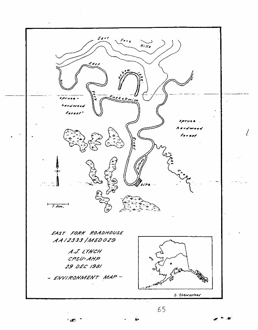
EAST FORK RtJALJHtJVS£
A A 12..13.s/ ME/)- t?23
"cEATI/Ii'E MAP HI-SITE AIi'EA
. cz
..-
LEGEIYLJ
+-: J'"' re
F: I'S41tuY'e
IN
,-';,...... 1
III
4IJ m .
A.V: LYNCHCPS(/-AHP
_.~--- _..-
;6 crV.IV&: /.941
•
.~'ie:- '.,
63..,. ....

EAST FIJRK RtJAOIIOV'SEAAI2J,J.J/UEf)- tJ2..5'
FEATV'RE MAP #'.2 -INSET
A.J: LYA/CIf
CPSt/-AIIP
.1'G <fl/A/E" 1.981
.- , 10 1?'7. 1- .--- -'-
~"".sS!l
c/t1.11 "'''''.1.....
LEGE#O
P, 0 (J"'O : clleh~ p'-d or eilll",,..
t : !Jr.Vd
S : sd,.."etvrll
-.----.------_.._-_._-----_. -.... ---.-.~ --".. ~
",,,"L...-__• ---'{~ ....:. . _
64.I ......
L
,$/,ruc c
h" ...,_•• ,
_. .••. - .. • • . r __"_"
~-N-
j
I IAn? I
EAST FO.RK If'OAL>H()t/SE
AA/£..J3J /UELJGJ29
A.J LYA/Cf!CPSt/-AHP
.?.9 LJEC 1.98/
EA/Y/ROA/ME/VT A-tAP-
65..,.. .... -
T. 25 N., R. 56 W., SNT. 24 N. t R. 54 W., SMT. 33 N., R. 54 W., SMT. '·33 N. t R. 54 H., SM
T. 30 N., R. 55 W., SMT. -28 N., R. 58 H. ~ SMT. 19 S., R. 27 W.) FMT. 33 N.) R. 46 W., SM
T. 26 N., R. 58 H., SMT. --27-~., R;- 5S-W~' ,--'SM"T. 33 N;~ R. 53 W., SMT. 27 N., R. 56 W., SM
T. 27 S., -R. 28 E., KRr1T. 27 S., R. 28 E., KRf1T. 17 S., R. 1 E., KRr~
T. 22 N., R• 12 E., CRHT. 22 N., R. 59 H., SN
f . _.,.
I, .:
i:b~;
'.~~~j ,'._~
54W.,SM54 H., S~1
54 W., St~
55 H., SM57 H., SM59 W., Sfwj60 H., SM58 W., St159 H., SM58 W., SH58 W.-·, St461 W., SM
T••33 N., R.T. 33 N., R.T. 33 N~, R.T. 33 N., R.T. 33 N., R.T. 28 N., R.T. 33 N.) R.T. 27 N.) R.T.-28 N., R.T. 27 N.,. R.T. 27 N., R.T. 26 N., R.
4JA. ( .......
. :;'. ~_ S., R~ 28 E"., KRr~ NE 1/4U)f S{;l..tion 25T. 28 S., R. 17 c.. KRN SE 1/4 of the N\~ 1/4 of
Section 29T. 27 S. 1 R. 28 E., KRM SE 1/4 of the NW 1/4 of
Section 16SE 1/4 of Section 11NE 1/4 of Section 16~
Section 5SE 1/4 of Section 14W1/2 of Section 1 and
the E 1/2 of Section 2T. 25 N., R. 57 W.) SM E 1/2 of the SE 1/4 of
Section 35NE 1/4 of Section 31
N 1/2 of Section 26SE 1/4SE 1/4 of the SW 1/4 of
Section 27NE 1/4NW 1/4 of Section 30W 1/2
N 1/2 of Section 14W1/2 of Section 34E l/2 of Section 3The SW 1/4 of Section 28NW 1/4 of Section 8NE 1/4 of Section 26W1/2 of Section 21SW 1/4 of.Section 14NE 1/4 of Section 25 and
the SE 1/4 of Section 24NE 1/4 of Section 12
'NE 1/4 of· Sect ion 18'"NW 1/4 of Section 33E 1/2 of Section 3 and
the W1/2 of Section 2Sections 1-3, 10-12 and 13-15E 1/2 of Section 30The SE 1/4 of Section 11SE 1/4 of Section 9, SW 1/4
of Section 10, NE 1/4 ofSection 15 and the NW 1/4of Section 15
T. 28 N., R. 48 W.) SM Section 1
AA-12347AA-12348AA-12349AA-~ 2350AA-12351flA-12352AA-12353M-12354AA-12355AA-12356AA-12357AA-12358
AA~12359
M-12360AA-12361AA-12362
AA-12363AA-12364AA-12365AA-12366
AA-12337AA-1233frAA-12339AA-12340AA-12341
AA-12336
AA-12334AA-12335
AA-12342
AA-12343AA-12344AA-12345AA-12346
AA-12367
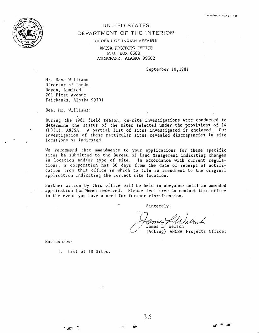
UNITED STATES
DEPARTMENT OF THE INTERIOR
BUREAU OF INDIAN AFFAIRS
ANCSA PROJFCfS OFFICEP.O. BOX 6688
ANa~ORAGE, AIASKA 99502
September 10,1981
Mr. Dave WilliamsDirector of LandsDoyon, Limited201 First Avenuefairbanks, Alaska 99701
Dear Nr. Williams:
During the 1981 field season, on-site investigations were conducted todetermine the s ta tus of the sites selected under the provisions of 14(h)(l), ANCSA. A partial list of sites investigated is enclosed. Ourinvestigation of these particular sites revealed discrepancies in sitelocations as indicated.
We recommend that amendments to your applications for these specificsites be submitted to the Bureau of Land Management indicating changesin location and/or type of site. In accordance with current regulations, a corporation has 60 days from the date of receipt of notification from this office in which to file an amendment to the originalapplication indicating the correct site location.
Further action by this office will be held in abeyance until an amendedapplication has'-..o·een"received. Please feel free to contact this' officein the event you have a need for further clarification.
Sincerely,
/() >4uJ~;/;~. Welschl-/ (Acting) ANCSA Projects Officer
Enclosures:
1. List of 18 Sites.
33r;r .. ,.
BUIllt\A~TiT98
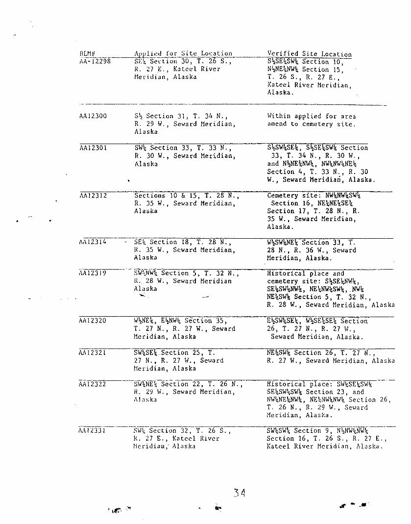
AA12300
AA12301
AA12312
;\A 12319
AA12320
M12321
AA1232.2
_-.e..ACLPl'liy~J.J:.~~S i .te Locat i onSE~ Section 30, T. 26 s.,R. 27 E., Kaleel RiverMeridian, Alaska
s~ Section 31, T. 34 N.,R. 29 W., Seward Meridian,Alaska
SW~ Section 33, T. 33 N.,R. 30 W., Seward Meridian,Alaska
Sections 10 & 15, T. 28 N.,R. 35 W., Seward Meridian,Alaska
SE~ Section 18, T. 28 N.,R. 35 W., Seward Meridian,Al as ka
SW\NW~ Section 5, T. 32 N.,R.. 28 W., Seward MeridianAlaska
".;:.
W~NE~, E~NW\ Section 35,T. 27 N., R. 27 W., SewardMeridian, Alaska
SW~SE~ Section 25, T.27 N., R. 27 W., SewardMeridian, Alaska
SW\NE\ Section 22, T. 26 N.,R. 29 W., Seward Meridian,AL1sk.1
Verified Site LocationS~E~SW\ Section 10,N~NE~NW~ Section 15,T. 26 S., R. 27 E.,Kateel River Meridian,Alaska.
Within applied for areaamend to cemetery site.
S\SW~SE~, S~SE\SW~ Section33, T. 34 N., R. 30 W.,
and N~NE\m~\, NW~NW~NE\
Section 4, T. 33 N., R. 30W., Seward Meridian, Alaska.
Cemetery site: NW%NW\SW~Section 16, NE~NE~SE~
Section 11, T. 28 N., R.35 W., Seward Meridian,Alaska.
W~SW~\ Section 33, T.28 N., R. 36 W., SewardMeridian, Alaska.
Historical place andcemetery site: S~SE~~W\,
SE\SW~NW~, NE~NW~SW~,NW~
NE~SW\ Section 5, T. 32 N.,R. 28 W., Seward Meridian, Alaska
E~SW~SE~, W~SE\SE~ Section26, T. 27 N., R. 27 \1.,Seward Meridian, Alaska.
NE~SW~ Section 26, T. 27 N.,R. 27 W' J Seward Heridian, Alaska
Historical place: SW\SE~SW~
SE~SW~SW\ Section 23, andNW\NE~N\v~, NE~NW\NW\ Section 26,T. 26 N., R. 29 W., SewardMeridian, Alaska.
/\i\12331----------~._-- ----
SW\ Section 32, T. 26 S.,R. 27 E., Kateel River~le rid i au ,' Alas lea
SW\SW~ Section 9 I N~NW\NW\'-----
Section 16, T. 26 S., R. 27 E.,Kateel River Meridian, Alaska.
..,. .....
•
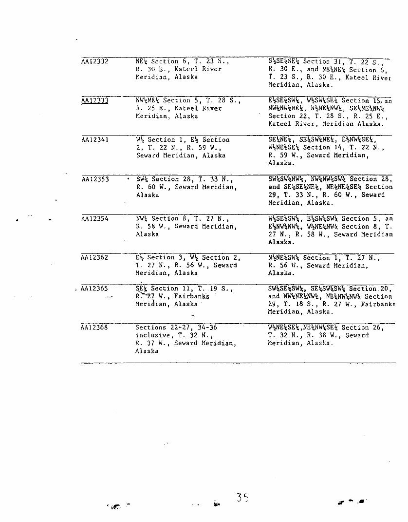
i\A12332
,MI2333
AA12341
AA123S3
AA12354
AA12362
AA1236S
AA12368
NE~ Section 6, T. 23 S.,R. 30 E.• Kateel RiverHer i di an , Alaska
NW~NE~ Section S, T. 28 S.,R. 25 E., Kateel RiverHe r i di.an , Alaska
w~ Section I, E\ Section2, T. 22 N., R. S9 W.,Seward Meridian, Alaska
• SWt Section 28, T. 33 N.,R. 60 W., Seward Meridian,Alaska
NW~ Section 8, T. 27 N.,R. 58 W., Seward Meridian,Alaska
E\ Section 3, W\ Section 2,T. 27 N" R. 56 W., SewardI'leridian, Alaska
SE\ Section II, T. 19 S.,R~7 W., Fairbanks .Meridian, Alaska'
Sections 22-27, 34-36inclusive, T. 32 N.,R. 37 W., Seward Meridian,Alaska
S\SE~SE~ Section 31, T. 22 S.,R. 30 E., and NE~NE~ Section 6 •T. 23 S., R. 30 E., Kateel RivetMeridian, Alaska.
E~SE~SW~, W~SW~SE~ Section 15, anNW~NW~NE~, N\NE~NW~, SE~NE~NW~
Section 22, T. 28 S.• R. 25 E.•Kateel River, Meridian Alaska.
SE~NE~, SE~SW~NE~, E\NW~SE~,
W\NE~SE~ Section 14, T. 22 N.,R. 59 W., Seward Meridian,
.Alaska.
SW\SW~W\, NW~NW~SW\ Section 28,and SE~SE\NE\, NE\NE\SE\ Section29, T. 33 N., R. 60 W., SewardMeridian, Alaska.
W\SE~SW\, E\SW\SW~ Section 5, anE\NW\NW\, W\NE~W\ Section 8, T.27 N., R. 58 W., Seward MeridianAlaska.
N\NE~SW\ Section I, T. 27 N.,R. 56 W., Seward Meridian,Alaska.
SW\SE\SW\, SE~SW~SW\ Section 20,and NW\NEWW\, NE~NW\N\'/~ Section29, T. 18 S., R. 21 W., FairbanksMeridian, Alaska.
W~NE\SE~,NE~NW~SE~Section 26,T. 32 N., R. 38 W., SewardMeridian, Alaska.
3S tit" 60 •• "
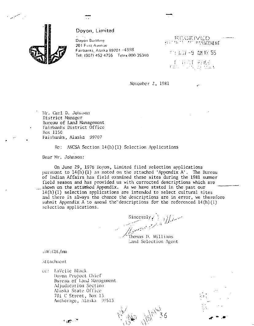
-Doyon, Limited
I If" ". ~ .. .; \ ,I ' .', I
Doyon Builrllllq
201 First AvenueFairbanks, Alaska 99701 -4898Tel: (907) 452-4755 Telex 090353110
r t.
November 2, 1981
't'IL Carl D. .Jciu.sonDistrict ~hnager
Bureau of Land ManagementFairbanks District OfficeBox llSCFa i rbanks , Alaska 99707
Rc : ,L\J\;CSA Section 14(h) (1) Selection Applications
Dear Mr , .Johnson :
On JW1C 29. 1976 Doyon J Limited filed sclection applicationspursuant to 14(h)(1) as noted on the attached 'Appendix i\'. The Bureauof indian Affairs has field examined these sites during the 1981 summerfield season and has provided us with corrected descriptions which are
_ shown on the. attaehed Appendix. As we have stated in the past ourl4(h)(1) selection applications are intended to select cultural sitesand there is always the chance the descriptions are in error J we thereforesubmit Appendix A to amend the~dcscriptions for the referenced 14(11)(1)selection applications.
II Ji\~ : CUl./l11m
.vt t acluncnt
cc : I.avc Ll c BlackJXJ~'on Project ChiefBu rcau of Land ~'lll1;lgcll\cnt
Adj ud i ca t ion Section!\J uska St at c Office701 C Street, Box 13Anchorage, .-\It:lska ~)~;S13
. .(.") ~
" .
."".'" ..,

:\\ -12314
:\.:\ - 1231~)
"APPENDIX A
011]11 i ed for S1 tc Location
SE 1/4 Section 30, T. 26 S.,R. 27 E., Katccl River~ICl" i di an, Alaska
S 1/2 Section 31, T. 34 N.,R. 29 W., Seward Mcri.di.an ,Alaska
SW 1/4 Section 33, T. 33 N.,H. 30 w., Seward ~Ieridian,
AJ a ska
Sect ion ~ 10 GIS, T. 28 N. ,R. 3S w.: Seward Mcri dinn ,Alaska
-~:...-
SE 1/4 Section 18, T. 28 N.,I~. 35 \'1., Seward ~lcridian,
j\laska
S\v 1/4 N\'I 1/4 Sect ion 5,T. 32 N., R. 28 \V., Sewnrd~Ic ridian Alaska
h: 1/2 ~~1: ll:l, E 1/2 ~lY 1/4Sc'c t i 0 il :3 S, T. ~ -: N., Ie 27 \\'. ,Sc\\a I'd ~\l('r i d i an , :\1 aska
Verified Site Location
S 1/2 SE 1/4 S\v 1/4 Section 10N 1/2 NE 1/4 Mv 1/4 Section IS,T. 26 S., R. 27 E., Katec1 River~lcriJian, Alaska.
Cemetery Site: E 1/2 NE 1/4sw 1/4 Section 31, T. 34 N.,R. 29 \'/., Seward Meridian, Alaska.
S 1/2 SW 1/4 SE 1/4,S 1/2 SE 1/4 SW 1/4 Section 33,T. 34 N., R. 30 W., andN ] /2 NE 1/4 N\~ 1/4,Mv 1/4 NW 1/4 NE 1/4 Section 4,T. 33 N., R. 30 W., Seward~Icrid1an Alaska.
Ccmctc ry site: N\~ 1/4 M~ 1/4 S\\' 1/4Section 16, NE 1/4 NE 1/4 SE 1/4Section 17, T. 28 N., H. 35 \V.,Seward Meridian Alaska.
W1/2 SW 1/4 NE 1/4 Section 33,T. 28 N., R. 36 W., Scwardfv1eridian, Alaska.
lIistorica1 place and cemetery site:S 1/2 SL 1/4 ~..W 1/4,SE 1/4 S\V 1/4 NW 1/4,NE 1/4 Mv 1/4 SW 1/ tl, l'M 1/4;-.JE 1/4 Sly 1/4 Section 5,T. 32 N., H. 28 W., Seward~.lcridial1, Al aska .
I: liZ S\V 1/4 Sf: 1/4,tv 1/2 SF 1/4 SE 1/4 Scc ti o.: .«.T. 27 N., R. 27 W., Scwa ro~'<.'ridian, Alaxka ,
37,;r .... -
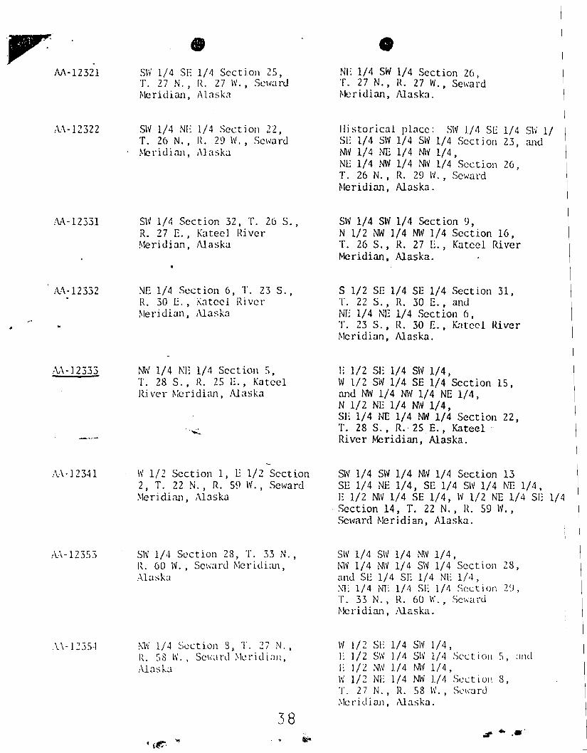
M-12321
A:\-12322
/\1\-12331
;\:'\-12332
•SW 1/4 51: 1/4 Section 25,T. 27 1'1., IL 27 1\1., Seward:-Iericlian, Al aska
5N 1/4 1'11: 1/4 Section 22,T. 26 N., JL 29 w, Seward~lcridiaJl, Alaska
SW 1/4 Section 32, T. 26 S.,R. 27 E., Kateel RiverMeridian, Alaska
NE 1/4 Section 6, T. 23 S.,R. 30 E., Kateel River~leridian, Alaska
•NE 1/4 SW 1/4 Section zo I
T. 27 N., R. 27 W., Seward~leridian, Alaska.
ll i s to r i ca I place: SN 1/tl 5E 1/4 S\'J 1151: 1/4 SW 1/4 SW 1/4 Section 23, andN\v 1/4 NE 1/4 N\v 1/4,NE 1/4 1'1W 1/4 1'1\\1 1/4 Section 26,T. 26 N., R. 29 \'J., SewardMeridian, Alaska.
SW 1/4 SW 1/4 Section 9,N 1/2 NW 1/4 NW 1/4 Section 16,T. 26 S., R. 27 E. I Katccl Rivertvlcridian. Alaska.
S 1/2 Sr:: 1/4 SE 1/4 Section 31,T. 22 S., R. 30 E., andNE 1/4 NE 1/4 Section 6,T. 23 S., IL 30 E., Kat co I River~lcridlan, Alaska.
,\\-12333
.:\:\ - I 2341
/\.,\-12353
,\.,\-1235,1
;-,M 1/4 NE 1/4 Section 5,T. 28 S., R. 25 E., Ka t ceIRi ve r Meridian, Alaska
'.:.:.,
W1/2 Section 1, E 1/2 Section2, T. 22 N., R. S9 \\0'., Seward~leridian, Alaska
51\' 1/4 Section 28, T. 33 N.,IL 60 W., Seward ~Icridian,
Alasb
:--'1~ 1/4 Section 8, T. 27 N. I
R. 58 \'1 •• Seward ~Ieridiall,
Alaska
38
I: 1/2 SI: 1/4 SN 1/4,W1/2 SW 1/4 SE 1/4 Section IS,~ld Mv 1/4 Mv 1/4 NE 1/4,N 1/2 NE 1/4 Mv 1/4,SE 1/4 NE 1/4 NW 1/4 Section 22,1'. 28 S., R.· 2S E., KateelRiver Meridian, Alaska.
SN 1/4 SW 1/4 Mv 1/4 Section 13SE 1/4 NE 1/4, SE 1/4 SW 1/4 NT:: 1/4,E 1/2 MV 1/4 SE 1/4, W 1/2 NE 1/4 SE
. Section 14, T. 22 N., It S9 W.,Seward Me r i di an, Alaska.
SW 1/4 S\\' 1/4 t'-M 1/4,Nlv 1/4 NW 1/4 SW 1/4 Section 28,and SE 1/4 SE 1/4 NE 1/4,:'\1: 1/4 NT 1/4 51: 1/01 Scct ion 2~J,
T. 33 N., R. 60 w., Scwa rd~lcridian, Alaska.
IV 1/2 SE 1/4 Sly 1/4,}; 1/2 S\V 1/4 SIV 1/4 Scc t. i ou S, :1I\dL 1/2 Mv 1/4 NW 1/4,Iv 1/2 NE 1/4 NW 1/4 Scc t i on 8,T. 27 N., R. 58 w.. Soward~leridiaJ1, Alaska.
., ..... '
!v\-12362
i\.:\ - 12365
A.-\-12368
•
E 1/2 Section 3, W1/2Section 2, T. 27 N., R. 56 W.,Seward Meridian, Alaska
SE 1/4 Section 11, T. 19 S.,R. 27 W., fairbanks~leridian, Alaska
Sections 22-27, 34-36inclusive, T. 32 N.,R. 37 w.. Seward MeridianAl aska-
N 1/2 NE 1/4 SW 1/4 Section 1,T. 27 N., Jt. 56 W., Seward:Meridian, Alaska.
SW 1/4 SI: 1/4 SW 1/4,SE 1/4 SW 1/4 Slv 1/4 Section 20,and NW 1/4 NE 1/4 I'M 1/4,NE 1/4 NW 1/4 NW 1/4 Section 29,T. 18 S., R. 27 W., Fa irbanks~~ridian, Alaska.
SW 1/4 SE 1/4 NE 1/4,W1/2 NE 1/4 SE 1/4,NE 1/4 NW 1/4SE 1/4 Section 26,r. 32 N., R. 38 w., Seward "Meridian, Alaska .
....'i.t:"..
..~.- --
39.,.. .....
IN REPLY REFER TO:
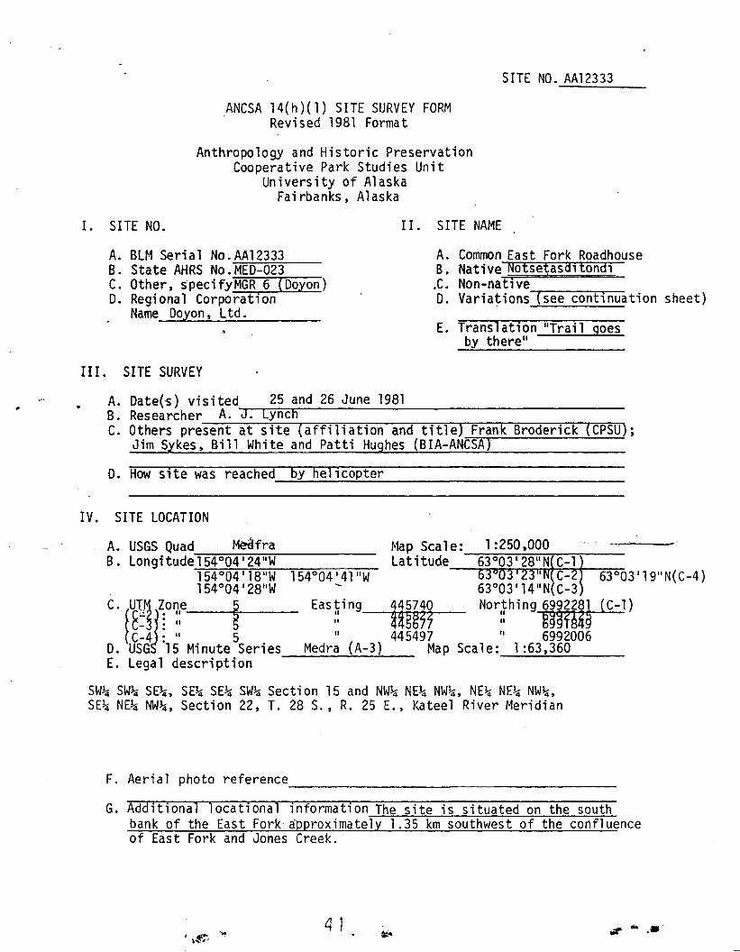
A44 (ARO-PCR)
United States Department of the InteriorNATIONAL PARK SERVICE
Alaska Regional Office540 West Fifth Avenue
Anchorage, Alaska 99501
1 6 SEP 1982
Mr. Larry P. Cooper, Jr., DirectorANCSA Projects OfficeBureau of Indian AffairsP.O. Box 6688Anchorage, Alaska 99502
Dear Mr. Cooper:
Enclosed is the National Park Service, Cooperative Park Studies Unit (CPSU) .submission of our findings regarding the below listed site for the Bureau ofIndJan Affairs' final certification document.
AA-12333 East Fork Roadhouse
As required by the ANCSA 14(h) rules and regulations (43 CFR 2653), theAnthropologists from the Cooperative Park Studies Unit, University of Alaska,Fairbanks, representing the National Park Service, have surveyed and documented the site in the field, gathered ethnohistoric information from knowledgeable local residents, and researched archival and library sources.
The research staff has assessed the evidence for significance and on the basisof their research find that this site meets the criteria for significance asstated in 43 CFR 2653. .
-~"
In addition, the research staff is also of the opinion that the site meets thesignificance criteria for nomination to the National Register of HistoricPlaces. A National Register nomination form for this site has been sent toyour office, and is on file at the CPSU, the State Historic PreservationOfficer's office, and the appropriate Native corporations.
By copy of this letter, this concludes the National Park Service's consultation for this site as required by regulation. This includes transmittal ofthe ANCSA 14(h)(1) site survey form for the site, supporting documentationsuch as photographs and maps, and a National Register nomination form.
Sincerely,
:JLt~]/i ! ({)/(,!-t=dA 1Wi 11 i arfI C. vJe 1chAssociate Regional DirectorPlanning, Recreation, and Cultural Resources
Enclosure
cc:Bruce Ream, CPSU, FairbanksRegional Archeologist, Alaska Region
(Contracting Officer's Representative)File X Contract CX-9000-9-E060
r. (',.! \.J .... ... ..
SITE NO. AA12333
ANCSA 14(h)(1) SITE SURVEY FORMRevised 1981 Format
Anthropology and Historic PreservationCooperative Park Studies Unit
University of AlaskaFairbanks, Alaska
1. SITE NO. II. SITE NAME
A. BLM Serial No.AA12333B. State AHRS No.MED-023C. Other, specifyMGR 6 (Doyon)D. Regional Corporation
Name Doyon, Ltd.
A. Common East Fork RoadhouseB. Native Notse~asaltondl
.C. Non-nat; veD. Varia~ions'('s-ee--c-on~t~i-nu-ation sheet}
E. Translation "Trail goesby there"
III. SITE SURVEY
.. A. Date(-s) visited 25 and 26 June 1981B. Researcher A. J. LynchC. Others present at site (affiliation and title) Frank Broderick (CPSU);
Jim Sykes, Bill White and Patti Hughes (BIA-ANCSA)
D. How site was reached by helicopter--=------'----------------
_0'Map Scale: 1:250,000Latitude 63°03 128"N C-1
C- 63°03 119I1N(C-4}
63°03'14"N(C-3Northing 6992281 (C-l)
:: -mfA4~-445497 "6992006
Map Scale: 1:63,360
Easting 445740tl~
II 445677\I
Medra (A-3)
IV. SITE LOCATION
A. USGS Quad Medfra-:""'::'-=-=-:~~.,....-;------B. Longitude154°04 124"W
-=-1-=54-=-:0::-:0~4-=-"1::-:8:-:-:"-:-:-W---:~::-:::-:~::-::-:-:--
154°04 128"W
c. ~UT~ Zone ~C;.i ~: " -C- : II
C-4 : \I 5D. USG 15 Minute SeriesE. Legal description ----~-~--
SW~ SW~ SE~, SE~ SE~ SW~ Section 15 and NW~ NE~ NW~, NE~ NE~ NW~,
SE~ NE~ NW~, Section 22, T. 28 S., R. 25 E., Katee1 River Meridian
F. Aerial photo reference _
G. Additional locational information The site is situated on the southbank of the East Fork-a2proximately 1.35 km southwest of the confluenceof East Fork and Jones Creek.
4 1 "",. ... ..-
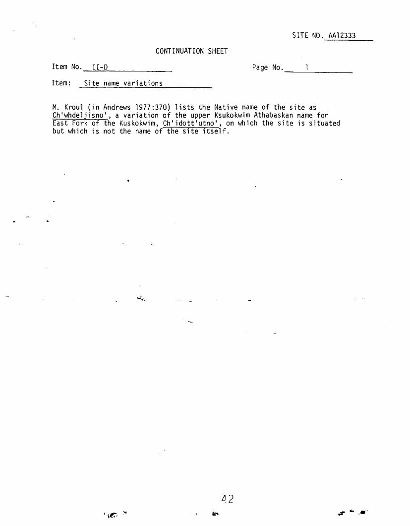
SITE NO. AA12333
CONTINUATION SHEET
Item No. 11-0---'-------------Item: Site name variations
Page No.-------
M. Kroul (in Andrews 1977:370) lists the Native name of the site asCh'whdeljisno', a variation of the upper Ksukokwim Athabaskan name forEast Fork of the Kuskokwim, Ch'idott'utno', on which the site is situatedbut which is not the name of the site itself.
tI .....

V. LAND STATUS
A. [J Within ll(a)(l)B. [J Regional DeficiencyC. X~ 0-1D~ [] Existing Wildlife RefugeE. [] Existing National ForestF. [] Additions to Wildlife Refuge
2
- SITE NO. AA1Z333
G. [] 0-21. [] Proposed Park2. [] Proposed Wild and
Scenic River3. [] Pro posed Wi 1d1i fe
Refuge4. [] Proposed Forest
H. [] Other, specify-----K. Describe any land status confl icts with l4(h){"1) 'selections- that
become evident in the field.
None evident.
VI. MACROENVIRONMENT
A. Ecosystem1. [] Moist Tundra .- 6~- [J Bottomland Spruce-Poplar2. [] Wet Tundra 7. [] Muskeg, Low Brush3. [] Alpine Tundra 8. [] Upland Spruce-Hardwood4. [] High Brus~ 9. ~] Lowland Spruce-Hardwood5. [] Coastal Western Hemlock-Spruce Forest
.._~.~ _.~ .
This refers to a named ecosystem as indicated on the Joint FederalState Land Use Planning Commission Map. If the site is locatedwithin an ecosystem which is""" like a small island within an areaof another major ecosystem, this should be noted.
10. Additional comment
Opposite (north) side of East Fork from site is tn upland spruce-hardwoodecosystem.
B. Land form1. [~ Valley
a. [Xl fl ats b. [] slopes2. [] Ri dre .
a. ] mountain b. [] beach3. [] Knoll4. [] Terrace
a. [] river b. [J wave cut5. [J Shore
a. [J lake b. ~J river or stream c. [] ocean11 ~.. oJ .,. ......
~ ie- ,.., tsi-

3
SITE NO.AA12333
C. Has the area been glaciated1. [] no2. [] yes: Describe glacial features in area around the site.
Glacial features resorted by East Fork.
D. Coastal features, if applicable1. [] cliff coast 5. [] shingle beach2. [J sandy beach 6. [] lagoQn3. [] rocky beach 7. [] fiord estuary4. [] other (sea caves, tidal flats, spits, etc.)~ specify----
Describe
E. Other land formsMoose Hill, known to the upper Kuskokwim Indians as Heart Hill, is situated8.5 km southeast of the site. Jones Creek enters East Fork 1.35 km northeastof the site~ The valley floor begins to slope upward to East Fork Hills 1 km
. north and on the opposite side of the East Fork from the site. A swamp is400 km south and west of the site. A sandbar island has in the middle ofEast Fork approximately 250 m north of the site~
VII. IMMEDIATE SITE E~IRONMENT
A. Local topographic situation1. [] Low rise on terrace· -2. [] Terrace edge, not on a point3. [] Point of terrace edge4. [J Terrace remnant of lower terrace5. [J Terrace remnant on flood plain6. ~ Low rise on flood plain7. [] Undifferentiated area of land form8. [] Other, speci fy9. Oeser; pt ion (s t ze-,-d"'i""l"-'s""7t-a-nc-e-s-,-e-:-tc-.....)-----------
Site is approximately 4 m above the river level in an area of low relief onthe south side of the river.
B. Relationship to other topographic features (within SOD mor 1650 feet)1. [J Proximity to salt waters2. ~J Proximity to m~jor tributary3. ~] Proximity to smaller streams4. ~J Proximity to confluence of streams5. ~J Proximity to slough (current or dry)6. [J Proximity to lake (current or dry)
44
.'
.,. ......
4
, SITE NO. AA12333
7. [] Proximity to hill, ridge, or low rise (under 35 m or 100 feet)8. [~ Proximity to an island9. [] Proximity to a pass
10. Description of explication (size, distances, clear or glacialstream, etc.)
,Site is on the south bank of the East Fork of the Kuskokwim River,1.35 km southwest of the confluence of East Fork and Jones ~reek. Site is250 m south of an island in the East Fork and 400 m north and east of anextensive swamp.
C. .sot 1 descr ipt aon
Silt mixed with river gravel.
D. Description of site vegetationSite is in a grassy clearing with birch, willow and white spruce impinging
at the edges. Old cabin foundations are overgrown by birch up to 12 m highand smaller willow. Beyond clearing vegetation is rather open second-growthwhite spruce forest. Forest floor is covered with blueberry and scrub,underlain by moss,-ground.dogwood, twinflower and other wildflowers.
VIII. SITE DESCRIPTION
A. Type (indicated all that apply)1. [] Archeological Precontact2. [~ Archeol.o.gical Postcontact late nineteenth- eentury.-to early 1930s -3. [] Other, specify-------------------
B. Definition1. [)J Vi llage2. [] Camp3. [] Isolated dwelling4. [] Cache5. [J Isolated non-dwelling6. [] Homes tead7. [] Lookout"8. [~ Cemetery9. [] Sacred place
(other than cemetery)
10. [] Signal site (navigationallandmark)
11. IX] Trail12. [] Mining camp13. [] Battl e site14. [] Materal source (flint, red
paint, copper, etc.), specify
15. [] S,ite associated with stories
16. Other, specify (caribou fence, fish weir, mail cabin, reindeerherder's cabin, ceremonial grounds, roadhouse, fur far, cave,trade route, pictograph, petroglyph, etc.) Roadhouse existedat site subsequent to a small Indian settlement.
C. Description of features and structures at the site.1. [] House pits (give number and size and describe)
..,. .... '
5
SITE NO. AA12333
2. ~J Cache pits (give number and size and describe) 3Pit 1: 2.2 m by 2.6 m; 35 cm deepPit 2: 90 cm in diameter; 30 cm deepPit 3: 2.1 m square; 30 em deep
(cellar within foundations of roadhouse, cabin 2)
3. [] Middens (describe)
4. [] Flake scatters (describe)
5. gJ Above-ground structures (give number and size and describe)•
3 cabin foundations: see continuation sheet5 small pole houses (not cabins): see continuation sheet1 hunting camp: see continuation sheet1 elevated cache (ruins): see continuation sheet
6. gJ Cemetery (give number of graves and describe) 1 graveGrave surrounded by wooden balustrade (collapsed), 1.3 m by 1.8 m; corner post
._J~_ (turned on wood 1athe1....1- m hi gh . Pickets-of mi 11ed boards, 1 inch by 2 tnches .:
7. gJ OtherOne area of scattered burned boards (feature 1), 2 posts, 1 woodpile.Feature 1: barren area on riverbank, 4.3 m by 9.4 m, with milled boards towhich wire netting adheres. Other small bits of charred boards are scatteredover the ground I s surface. (; t t t t h t )see con lnua 10n s ee
Describe any important relationships among the features that arenot readily evident from the maps.
apply)IX. CONDITION OF SITE
A. Present use (indicate all that1. [] Community residences2. [] Family residences3. [J Individual residence4. [] Subsistence (kind) _5. [J Mining (kind) _6. [] Religious7. [J Continuous
'i.e· ....
SITE NO. AA12333
CONTINUATION SHEET
1Item No. VIII-C-5
Item: Above-ground structures
Page No.-------
SPH-2:SPH-3:SPH-4:SPH-5:
..
A. CabinsCabin 1: 4.8 m by 6.5 m; foundations only; birch and willow 12 m to 15 m
high growing on and within foundations.Cabin 2: foundations only, 2 rooms. Overall dimensions: 6.0 m by 13.5 m;
main (west) room: 6.0 m by 9.4 m; east room: 6.0 m by 4.1 m.Cellar within main room of Cabin 2.
Cabin 3: 8.8 m by 9.0 m; partial foundations only; 2 charred foundationlogs visible; birch trees ca. 12 m high growing on and withinfoundations. .
B: Small pole houses (SPH) with walls of birch poles, ca. 5 cm in diameter,and roofs of birch bark.SPH-1: mound of collapsed poles, moss, and birch bark measures 1.6 m by
1.7 m; len9th of the middle upriaht is 70 cm which is eaua1 tothe original height of the structure. Ridgepole is 1.26 m long.mound of collapse measures 1.65 m by 2.1 m.
II "" II 1. 7 m by 2.0 m.
II II II II 1.65 m by 2.6 m.II II II II 2.0 m by 2. 5 m.
C. Hunting camp: tempa.r.c~ry structure withfoundati on of unbarked birchand spruce poles laid at obtuse angles: 1.1 m by 1.4 m by 2.5 m by 2.2 mby 4.8 m from birch tree to white spruce (both living). No pole presentbetween spruce and bi rch, 2.9 m (-doorway?).
D. Elevated cache: collapsed, 2.85 m post only with steel banding 25 cm widedislodged from midsection of post.
~ 7..........
SITE NO. AA12333
CONTINUATION SHEET
Item No. VIII-C-7
Item: Other
Page No.-------
Post 1: 67 em high, 6 em in diameter, with chain and dog snap on end.Past 2: 2 posts, 70 em high, driven side by side into ground and touching
each other.Log pile: 1.85 m by 5.4 m, 60 cm high, overgrown with moss.
'" ..... -
6
. SITE NO. AA12333
8. [] Seasonal (which)~~~~~~~~~~~~~~~~~9. [] Occupi ed
10. ~~ Unoccupied11.. [] Other, specify12. Descri be wh ich ar-ea-s-a-r-e-u-s-e--'d-a-n-d-:--:-h-ow-.--:r-nc--';l"-u--'d-e-s-u"7"b-s"':""is-t:-"'e-n-c-e-a-n-"d-
other economic activities.
B. Disturbance by cultural activity1. [] Construction .2. [] Pot-hunting or unsystematic artifact collecting3. [] Vandalism4. [] Reuse of materials5. [] Archeological excavation or testing6. Describe nature and extent
Area around site cut over for wood some time ago, now regrowing withspruce and birch.
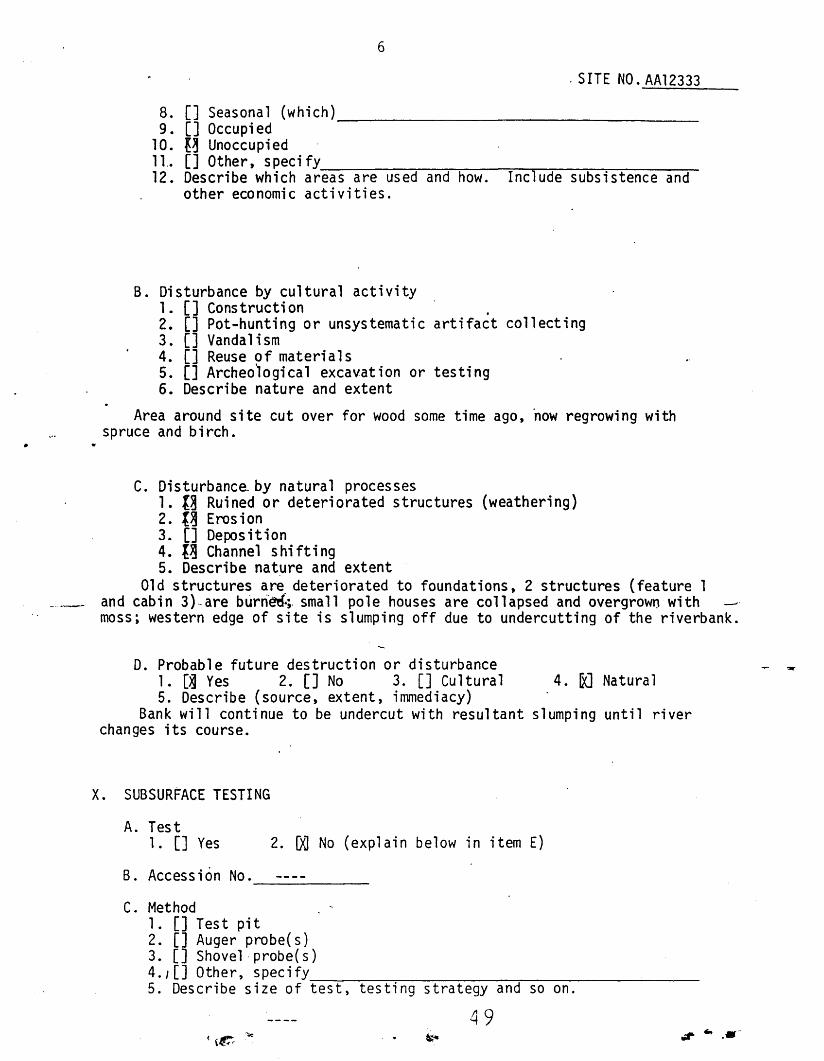
C. Disturbanca by natural processes1. t~ Ruined or deteriorated structures (weathering)2. t~ Erosion3. [] Depos it ion4. {~ Channel shifting5. Describe nat~re and extent
Old structures are deteriorated to foundations, 2 structures (feature 1and cabin 3)~are burried.;. small pole houses are collapsed and overgrown withmoss; western edge of site is slumping off due to undercutting of the riverbank.
D. Probable future destruction or disturbance1. [~ Yes 2. [] No 3. [] Cultural 4. IX] Natural5. Describe (source, extent, immediacy)
Bank will continue to be undercut with resultant slumping until riverchanges its course.
x. SUBSURFACE TESTING
A. Test1. [] Yes 2. ~ No (explain below in item E)
B. Accession No.------C. Method
1. [] Test pit2. [] Auger probe(s)3. [] Shovelprobe(s)4.,[] Other, specify
~--:----:-~--;-----:-----:---~---------5. Describe size of test, testing strategy and so on.
49
2. g~ No
7
SITE NO. AA12333
D. Findings Soil Profile1. [] Features2. [] Arti facts3. [] Sterile4. [] Other5. Describe findings. Reco~d artifacts on Field Catalog Form and
attach to Site Survey Form.
E. Justification for action.
X~. SURFACE COLLECTIONS. Mark site number and surface collection number onsite map and bag. Record collection son Field Catalog Form and attachto Site Survey Form.
A. Collection1. [] Yes
B. Accession No.-------C. Justification for collections
.~.~~--- .
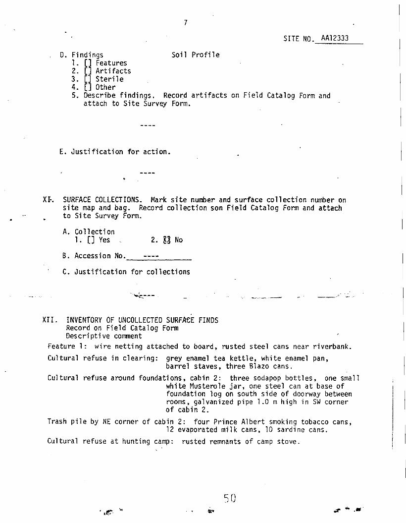
XII. INVENTORY OF UNCOLLECTED SURFAeE FINDSRecord on Field Catalog FormDescriptive comment
Feature 1: wire netting attached to board, rusted steel cans near riverbank.Cultural refuse in clearing: grey enamel tea kettle, white enamel pan,
barrel staves, three Blazo cans.Cultural refuse around foundations, cabin 2: three sodapop bottles, one small
white Musterole jar, one steel can at base offoundation log on south side of doorway betweenrooms, galvanized pipe 1.0 mhigh in SW cornerof cabin 2.
Trash pile by NE corner of cabin 2: four Prince Albert smoking tobacco cans,12 evaporated milk cans, 10 sardine cans.
Cultural refuse at hunting camp: rusted remnants of camp stove.
..,.. ......
XIII. PHOTOGRAPHIC RECORD
. SITE NO. AA12333
Be certain to have scale in photo.
. B. Date 26 and 26 June 1981
D. Frame number, direction of view, photo content.
LD. photo
FRAME NO.
1.
2.
DIRECTION OF VIEW
down
II
PHOTO CONTENT
II
Aerialphotos
3.Northwest, Grassy clearing at site ..
4.West II
5.I
South II
6. East II
7.North - Site area with island in background
8.West Site area on river loop
9.South Site area
O.Southeast .-....< /I
n. :
East "12.
South Wooded area of site south of clearing\V13.
14.
15.
16.
17.
18.
19.
20.
Eo
down LD. photo
II II
" Balustrade at grave
. Northwest Small pole house 1
West Sma 11 pole house 2
Southwest Small pole house 3 (birch bark roof)
Northwest Small pole house 4 (birch bark roof and ridge pole)
Northeast Sma 11 pole house 5
Remarks (time of day, weather, other things affecting photos)
, I.e. ...51
~ -lil,;t5:.-......
9
SITE NO. AA12333
XIII. PHOTOGRAPHIC RECORD Be certain to have scale in photo.
B. Date 26 June 1981A. J. LynchA. Photographer__~~~~~~ ___
C. Roll No •__-..::2=--- _
D. Frame number, direction of view, photo content
1.0. photo (with wrong roll numbe\)
FRAME NO.O.1.
2.
3.
4.
5:
p.
7.
DIRECTION OF VIEW PHOTO CONTENTEast South foundatlon, cabin 2
Cabin 2 t Frank in west room
Frank by cabi n 3
Winter trail near east boundary
II
Area with small pole houses
Cabin 2
(Frank Broderick)
8.Cellar in cabin 2
9.Trees inside foundations of cabin 2
10.
11.Aerial photo of E. Fork. area in vicinity of site
II
12.I.D~ ~hoto (with proper roll number)
13.
14.
15.
16.
17.
18.
19.
20.
E. Remarks (time of day, weather, other things affecting photos)
.,.. ... ,..
10
SITE NO. AA12333
XIV. EVALUATION
A. Cultural-temporal placement1. Cultural affiliation (if known)
a. [] Es kimo. specify_· ::----;--:--;~_:_:"7---:----:-------b. [XJ Indian, speci fy upper Kuskokwim Athabaskanc. [] Aleut, specifyd. [J Non-na ti ve , s p-ec""""ir-:f:-y---------:-------
2. Time placement (if known)a. [XJ 1920-1950b. [Xl 1900-1919c. [Xl 1850-1899d. [] 1800-1849e. [J 1700-1799f. [] 1400-1699g. [] Other. specify _
3. Evidence for time placement (state geological evidence, botanicalevidence, cultural evidence, etc.)
Historical evidence: see Item XVII-H-1, ReferencesCultural evidence: oral history of the Nikolai elders
B. Ethnographic sumnary
Complete ethnographic information should be in your notes. Summarizeinformation acquired during the field season. Note type and sourceof information: village, knowledgeable elder, notes, tape, historic
._. document, arcll!~e, etc.).
PLEASE NOTE-Some of the information in this section comes from taped interviews
made for the CPSU-AHP 14(h)(1) Project. Researchers gathered this materialto document site significance and local history as required under provisionsof ANCSA 14(h)(1). Interviewees made these tapes with the understanding thatthe tapes were not for publication or general circulation; according to thePrivacy Act of 1974, traDscripts or notes made directly from the tapes cannotbe used outside the 14(h){1) Program without permission from CPSU and fromthose interviewed.
Notsetasditondi, meaning "trail goes by there" in the upper Kuskokwim Athabaskanlanguage, is the site of a small Indian settlement, one of two or three small settlementsthat the upper Kuskokwim people established between old Nikolai and Telida in the latenineteenth century after they moved up from the TonzonaRiver (CPSU Doyon tape 1). Thesettlement, which was found vacant at the time, was visited in 1899 by Lt. Joseph Herronduring his exploration of the region. He noted that "it consisted of two cabins of hewnlogs, a cache and a graveyard" (Herron 1901 :35, 39, 40, map).
The Petruska family made their borne at the site in a two-room cabin near the river(CPSU Doyon tape 5). In 1915 or 1916 Esai Petruska, are of the Petruska sons, died whilestill a youth at summer fish camp. His parents buried him in the grave at the site,about 8 m behind the Petruska house. The head man of the Nikolai band of upper KuskokwimIndians, Deaphon, was present at the burial ceremony (BIA Doyon tape 4). A short whilelater. in 1917 or 1918, the Petruska family moved with their surviving children fromthe site to Nikolai (CPSU Doyon tape 5).
(see continuation sheet) ........-

SITE NO. AA12333
CONTINUATION SHEET
Item No. XIV-B
Item: Ethnographic summary
Page No.-------
Euro-Americans moved into the area after the mail run opened from Nenanato McGrath over the trail that runs through the site (CPSU Doyon tape 5). In1923 Robert Jones, a white man, and Carl IlSnowshoes" Fosberg built East ForkRoadhouse and trading post on the site (Brown 1980:40; Oswalt 1980:40). Theold Native cabin was dismantled and used in the construction of the roadhouse(CPSU Doyon tape 5). Fosberg died at East Fork Roadhouse in 1925 and wasburied 2 miles downriver from it, close to the trail (CPSU Doyon tape 5).In November 1928, and Indian found Jones dead at the roadhouse (Brown 1980:40).Joe Oats next ran the roadhouse, and finally "Diamond Dick" Rhodes took overas ~roprietor in 1930 and ran it until its abandonment in 1931 or 1932(CPSU Doyon tape 1j. By 1940, when a Nikolai resident first visited thesite, one .of the cabins was burned down (CPSU Doyon tape 1).
~._-
.....
54.". .....
11
SITE NO. AA12333
xv. ASSESSMENT OF SIGNIFICANCE AND ELIGIBILITY
A. Does the site possess integrity of location, design, setting,materials, workmanship and association?
The site does possess integrity of location and setting. The site is situatedin wilderness which, although cut over in the past 80 years, reflects an activityof the Native people who regularly stockpiled wood for their winter heating needs.The balustrade marking the grave and the small pole houses, although in advancedstages of deterioration, still exhibit integrity of design, materials and workmanship.Finally, because the site is directly linked with people whose descendants still liveand subsist in the area, the site has integrity of association.
B. Is the site associated with events that have made a substantialcontribution to the history of the Natives of Alaska?
The site is associated with the coalescence of the Nikolai-Telida band ofupper Kuskokwim Indians from single-family population units thinly spread overthe KUSKokwim basin to ~ergent population centers at Nikolai, Telida and McG~ath.
C. Is the sfte associated with the lives of persons significant inthe past of Alaska Natives?
, The site is associated with the lives of the immediate predecessors of theNikolai people, providing a significant link with the past of the upper KuskokwimIndians.
_.'-~-
D. Does the site possess outstanding and demonstrably enduringsymbolic value in the traditions and cultural beliefs andpractices of Alaska Natives?
The site symbolizes the traditional life style of the family unit of upperKuskokwim Indians who still formed a single, self-sufficient economic unit at thebeginning of the twentieth century.
E. Doe~ the site embody the distinctive characteristics of a type,perlod, or method of construction, or represent the work of amaster, or possess.high artistic values?
The balustrade marking the grave on the site embodies the distinctive characteristics of the grave marker assumed by the upper Kuskokwim Indians after theintroduction of the Russian Orthodox religion.
.r ... ,.'
12
. SITE NO. AA12333
F. Has the site yielded, or is it likely to yield informationimportant in prehistory or history?
The site was documented historically by Lt. Joseph Herron who visited thesettlement on 18 August 1899 and photographed the building (Herron 1891 :35, 39,40, map). In addition, knowledge of the site from early in the twentieth centuryto the present is possessed by the Nikolai people through their .oral history.
G. Based upon your assessment of the information provided byethnographic and ethnohistoric sou~ces, documentation in historicand scholarly works, and the on-site archeological investigation,do you recommend this site for conveyance under ANCSA l4(h)(l)Rules and Regulations 43 CFR 2653.51
"1. ~~ yes2. [] no (explain reasons below) .3. [] insufficient information for determination
-- -_.... - >. --'-'-- ---- ..
H. Additional comment
Notsetasditondi is an excellent example of the single-family settlementthat was still typical of upper Kuskokwim Indian lifeways early in the twentiethcentury.
XVI. BOUNDARY JUSTIFICATION
Boundaries include all known cultural features at the site, including thehistoric Native settlement grave, and hunting camp and the remnants of theroadhouse. A buffer zone of 60 m on the northeast and southeast sides and .90 m on the southwest side maintains physical and visual integrity. The EastFork of the Kuskokwim River forms a natural boundary to the northwest.
~ .......
13
SITE NO. AA12333
XVII. ATTACHM~NTS
USGS map with site location marked.
Metes and bounds description.
Environmental and location map.
Field Catalog Forms (collected and uncollected artifacts).
Site map (including feature num)ers, points of testingand collecting, disturbance, and BIA boundaries).
Photograph contact sheets.
A. 00
B. []
C. 00
D. rKJ
E. IX]
F. IX]
G. []
H. [l
Nationa) Register Nomination Form.
Additional information, specify.1. ~] Elders of Nikolai who supplied information about the site: Miska
: - --!!eaphon and Andrew Gregory2. ~] Orthography provided by Ray Collins, Coordinator of Rural
Education, (University of Alaska), McGrath.3. ga Published References (see below)
References:
Andrews, Elizabeth1977 Report on the cultural resources of the Doyon region, central Alaska,
vol. II. Occasional Paper no. 5, Anthropology and Historic Preservation,Cooperative Park Studies Unit, University of Alaska, Fairbanks .
...~Brown, C.-·~C-- ---- -----..--
1980 The upper Kuskokwim River basin. Report to Chief, Division ofResources, BLM. Report on file, BLM State Office, Anchorage.
Herron, Joseph1901 Explorations in Alaska, 1899. War Department, Adjutant-General's
Office. Government Printing Office, Washington, D.C.
Oswalt, Wendell H.1980 Historic settlements along the Kuskokwim River, Alaska. Alaska State
Library Historical Monograph no. 7. Alaska Division of State Librariesand Museums, Juneau.
.". ... -

SITE NO. AA12333
CONTINUATION SHEET
Item No. XVII-D
Item: Metes and bounds description
Page No.-------
A parcel of land located within E~ S~ SW~, W~ SW~ SE~ Section 15, andNW~ NW~ NE~, ~ NE~ NW~, and S~ NE~ NW~ Section 22, T. 28 S., R. 25 E., KRM.The site is more specifically described as follows:
METES AND BOUNDSBeginning at the point of beginning (P.O.B.), latitude 63°03 129 HN,
longitude 154°04 124"W, designated as Corner 1 (C-l), marked with a SIB-inchaluminum alloy rod extending 22 inches above the ground, referenced to thefo11 owi ng:Reference A: N19°W, to the southernmost tip of a large island in the EastFork of Kuskokwim River, located in Section 15, T. 28 S., R. 25 E., KRM;Reference B: Nl1°W to a mound rising above the horizon to the north and westof Reference A, elevation 1210 feet, located in NW~ Section 33, T. 27 5.,
.. R. 25 E., KRM ;
Reference C: N02°W to a mound rising barely above the horizon north ofReference A, and east of Reference B, elevation 1190 feet, located inSection 34, T. 27 5., R. 25 E. KRM;Reference D: N82°E to the southernmost cone-shaped hill in series of three,elevation 925 feet, located in Section 17, T. 28 S., R. 26 E., KRM;Reference E: N23°E, 9 feet to a birch tree 8 inches in diameter with doubleblaze; ........Reference F: S34°E, 2l~feet to a black spruce 5 inches in diameter withdo ub1e b1aze ;Reference G: S54°W, 20 feet to a black spruce 4 inches in diameter withdouble blaze;
thence S45°E, 460 feet to Corner 2 (C-2), marked with a 5/8-inch aluminumalloy rod extending 9 inches above the 'ground, referenced to a blackspruce with a double blaze, N16°E, 14 feet, and a black spruce witha double blaze, N5loE, 19 feet, and a black spruce with a doubleblaze, S51 0E, 14 feet;
thence S26°W, 980 feet to C-3, marked with a 5/8-inch aluminum alloy rodextending 7 inches above the ground, referenced to a black spruce5 inches in diameter with a double blaze, S59°W, 10 feet, and a blackspruce 4 inches in diameter with a double blaze, N200W, 26 feet, anda black spruce 3 inches in diameter with a double blaze, N700E,30 feet;
thence N54°W, 756 feet to C-4, marked with a 5/8-inch aluminum alloy rodextending 20 inches ?bove the ground, referenced to a black spruce5 inches in diameter with a double blaze, N76°E, 19 feet, anda black spruce 3 inches in diameter with a double blaze, S34°E, 30 feet,and a black spruce 3 inches in diameter with a double blaze, S60 oW,
24 feet, and a black spruce 5 inches in diameter with double blaze,N76°W, 2 feet;
< (3_.( (see continuation sheet)
~ ", ......
SITE NO. AA12333
CONTINUATION SHEET
2Item No. XVII-D
Item: Metes and bounds description
Page No.-------
-"
thence N54°W, 25 feet to the high-water mark (HWM) of the East Fork of theKuskokwim River;
thence in a northeasterly direction, approximately 1173 feet, following theHWM along the sinuosity of the East Fork of the Kuskokwim River,upstream, to a point near the P.O.B.;
thence S4SoE,--Sl-feet, returning to the-P~O~B.iC-l):---
The site described contains approximately 10.8 acres.
•
.... _-~. -~-
.-----.
:-=9I" .• -

14
SITE NO. 4412333
FIELD CATALOG FORM
Site Name: East Fork Roadhouse Date: 25 and 26 June 1981
Items come from: [] subsurface test [] surface collection
GU surface inventory of uncollected items
Collector: See item no. XII. Inventory of Uncollected Surface Finds.
. --Fi e1d-"-- _._.- - Deser-t ptlon._- ---------- - "Locatfon"
- - _.- ._-- -----Remarks-·--"-'---Specimen (for test pitsNumber include depth
" and datum pts , ) ~
.".
• It'
-
._. .-
.. - .... --~ ..".- . ,_...~.. 9'-- -_.- ..- ._ .......... .. .. ..,.-- ",-, ..-- ,-_._. _._-;--::~_~A_" -- ....-.. -- .-. .. -' _.. '-
....
,
.~ .... 6 ().".
... .•..( (e- o
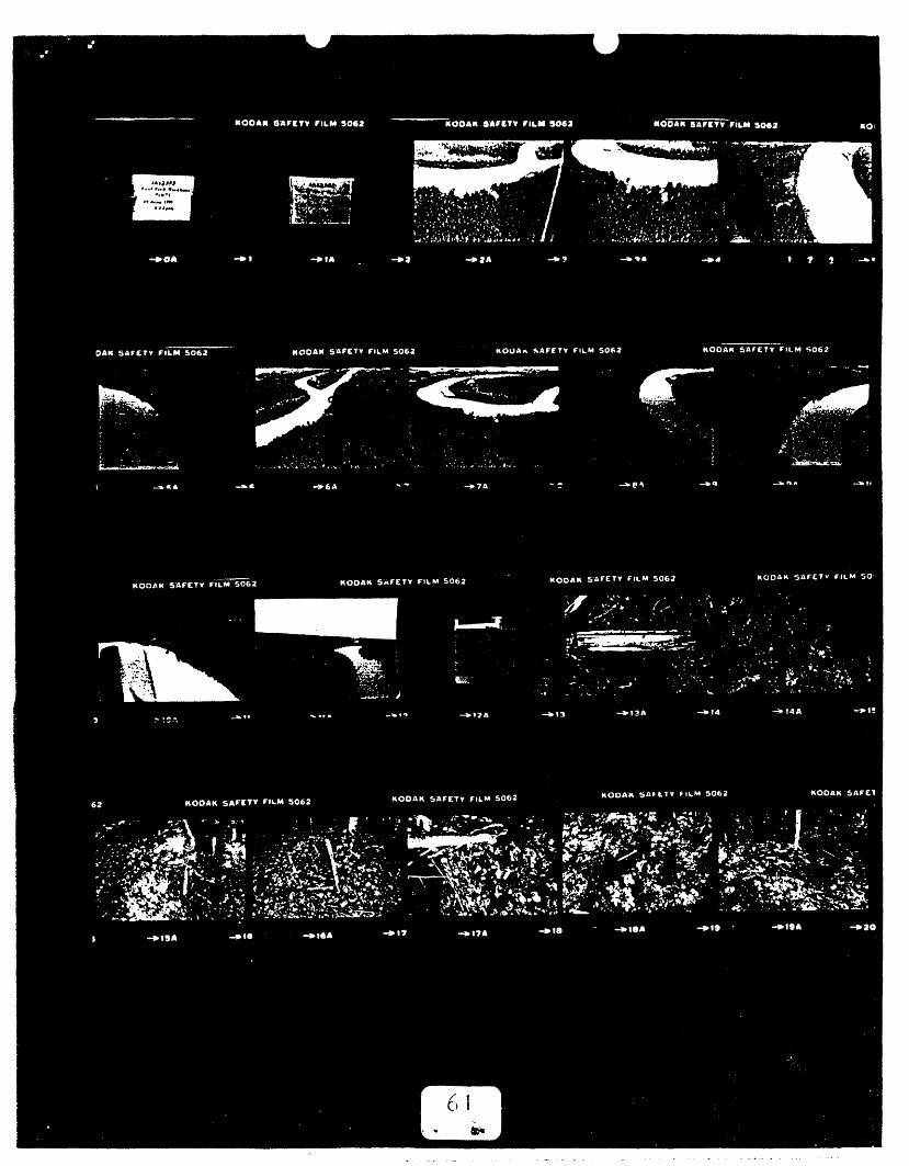
EAST FtJRK RtJAiJl{tJus£
A A 12.1J.7/ MEa- tJ2.5'r'EATVR.E MAP tlfl-SITE AIi'EA
A.V: LY/VCII
CPS//-AIIP--._-- _. -
;G t.(t/A/E, /.94/
,
LEGE/Yb
+-: $'41 V~
F: ,t'8J1CU1"'S
63.,. .......
EAST Ft?RK !?tJA£J/lI1USEAA/2j3.J/UEf)- 112.5'
FEATURE MAP #' .2 - I/VSET
A.J: LYA/CH
CPSt/-AIiP
.?G vl//VE" I.9B/
LfGE#/JP, 0 (H" 0 : c6eh6 p,.t .,,. ellll.,.
t : 91"tI.".
S : s t ,.vee v"..
u I 14 rrr, 1_ ~-- - -~- -~ ~
'",,,'"{
'I.e·"
-.__. - --- ----._- -. -- ------. _.... ---.". _...::.:.---:,.
A
64,;r • .• '
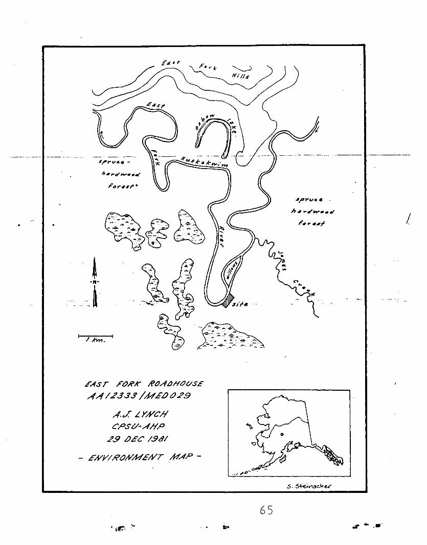
I / A'm. I
EAST FOHK ~()ALJHOt/SE
AA1.2.33.5' /UE.otJ.29
A.J LYA/Ch'CPSt/-AIiP
.?.9 £JEC /.98/
- EA/Y/RtJA//WE/'VT /WAP-
.sprue.
II" .. , ....... ,
65
!
tit .......