earthquake damages related to site effects: a case
TRANSCRIPT
The 14th
World Conference on Earthquake Engineering
October 12-17, 2008, Beijing, China
EARTHQUAKE DAMAGES RELATED TO SITE EFFECTS: A CASE STUDY
FOR AN ALPINE VALLEY
D. Fäh1, S. Fritsche
1, D. Roten
1, G. Stamm
1, P. Kästli
1, V. Poggi
1
1
Swiss Seismological Service, ETH Hönggerberg, Zurich, Switzerland
Email: [email protected]
ABSTRACT :
The Valais in Switzerland is the area of largest seismic hazard in Switzerland and has experienced a magnitude 6 or larger event every 100 years (1524, 1584, 1685, 1755, 1855, 1946). The Visp event of 1855 was the largest
in Switzerland for the last 300 years. Besides its seismic activity, the Valais is characterized by several factors
adding to the total hazard level: rough topography, unstable and steep slopes, and deep sediment-filled valleys. During the large earthquakes of the past the area experienced great damage from earthquake ground motion and
different secondary phenomena such as liquefaction in the Rhone plain, landslide reactivation and extended
rock fall. From the detailed historical reconstruction of the large events in 1855 and 1946, and macroseismic
investigations related to smaller events in the past 150 years, it became obvious that the major effects were concentrated in some villages in the alluvial planes. In order to analyse this pattern we combined measurements
of ambient noise, weak motion records and numerical wave propagation modeling to analyze the past
earthquakes. The results provide clear evidence that the observed damage is caused by local site effects induced by two- and three-dimensional wave propagation phenomena. The results of this work demonstrate the
complexity of wave propagation effects that cause amplification of seismic waves in irregularly shaped
structures such as mountain valleys, and the importance to combine different analysis techniques and data. Due to river regulations and engineering progress in the last century, seismically unfavorable sites have become
attractive for expanded settlement and industries. Future earthquakes will therefore cause more damage than
was observed in the past. For this reason it is important to learn from past events, to recognize and map
potential areas at risk, and to estimate ground motion and non-linear behaviour for engineers and planners.
KEYWORDS: seismic ground motion, non-linear phenomena, seismic hazard, historical earthquakes, Valais, Switzerland
The 14th
World Conference on Earthquake Engineering
October 12-17, 2008, Beijing, China
1. EARTHQUAKES IN SWITZERLAND
Although damaging earthquakes are rare in Switzerland when compared to more seismically active regions,
such events have occurred in the past and will continue to do so. Over the past 700 years, a total of 28 events of
a moment magnitude Mw≥5.5 are known to have occurred, twelve of which caused severe damage (Intensity of
VIII or higher). Moderate to high seismic risk in Switzerland results from high population density and high degrees of industrialization, as well as from little preparedness due to the relatively long return periods of
strong ground shaking. Earthquakes strike generally without warning, and the best preparation modern society
can achieve is to upgrade the building stock, infrastructure and critical facilities so that damage is minimized. The input for all measures of risk mitigation is the assessment of the different kinds of hazards associated with
earthquakes through advanced technology.
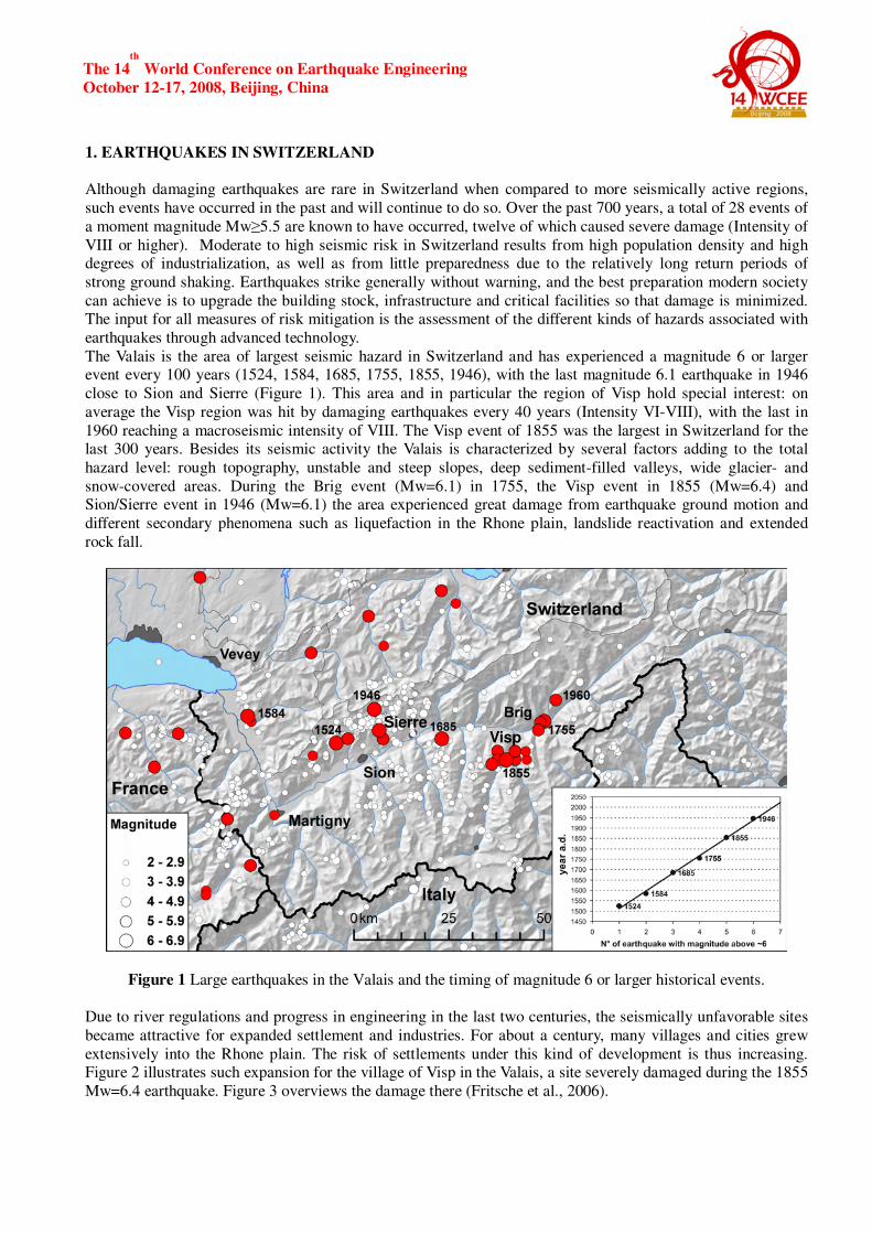
The Valais is the area of largest seismic hazard in Switzerland and has experienced a magnitude 6 or larger event every 100 years (1524, 1584, 1685, 1755, 1855, 1946), with the last magnitude 6.1 earthquake in 1946
close to Sion and Sierre (Figure 1). This area and in particular the region of Visp hold special interest: on
average the Visp region was hit by damaging earthquakes every 40 years (Intensity VI-VIII), with the last in
1960 reaching a macroseismic intensity of VIII. The Visp event of 1855 was the largest in Switzerland for the last 300 years. Besides its seismic activity the Valais is characterized by several factors adding to the total
hazard level: rough topography, unstable and steep slopes, deep sediment-filled valleys, wide glacier- and
snow-covered areas. During the Brig event (Mw=6.1) in 1755, the Visp event in 1855 (Mw=6.4) and Sion/Sierre event in 1946 (Mw=6.1) the area experienced great damage from earthquake ground motion and
different secondary phenomena such as liquefaction in the Rhone plain, landslide reactivation and extended
rock fall.
Figure 1 Large earthquakes in the Valais and the timing of magnitude 6 or larger historical events.
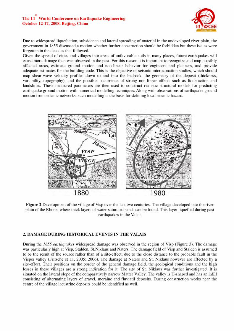
Due to river regulations and progress in engineering in the last two centuries, the seismically unfavorable sites
became attractive for expanded settlement and industries. For about a century, many villages and cities grew
extensively into the Rhone plain. The risk of settlements under this kind of development is thus increasing. Figure 2 illustrates such expansion for the village of Visp in the Valais, a site severely damaged during the 1855
Mw=6.4 earthquake. Figure 3 overviews the damage there (Fritsche et al., 2006).
Visp Sierre
The 14th
World Conference on Earthquake Engineering
October 12-17, 2008, Beijing, China
Due to widespread liquefaction, subsidence and lateral spreading of material in the undeveloped river plain, the
government in 1855 discussed a motion whether further construction should be forbidden but these issues were forgotten in the decades that followed.
Given the spread of cities and villages into areas of unfavorable soils in many places, future earthquakes will
cause more damage than was observed in the past. For this reason it is important to recognize and map possibly
affected areas, estimate ground motion and non-linear behavior for engineers and planners, and provide adequate estimates for the building code. This is the objective of seismic microzonation studies, which should
map shear-wave velocity profiles down to and into the bedrock, the geometry of the deposit (thickness,
variability, topography), and the possible occurrence of strong non-linear effects such as liquefaction and landslides. These measured parameters are then used to construct realistic structural models for predicting
earthquake ground motion with numerical modelling techniques. Along with observations of earthquake ground
motion from seismic networks, such modelling is the basis for defining local seismic hazard.
Figure 2 Development of the village of Visp over the last two centuries. The village developed into the river
plain of the Rhone, where thick layers of water-saturated sands can be found. This layer liquefied during past
earthquakes in the Valais
2. DAMAGE DURING HISTORICAL EVENTS IN THE VALAIS
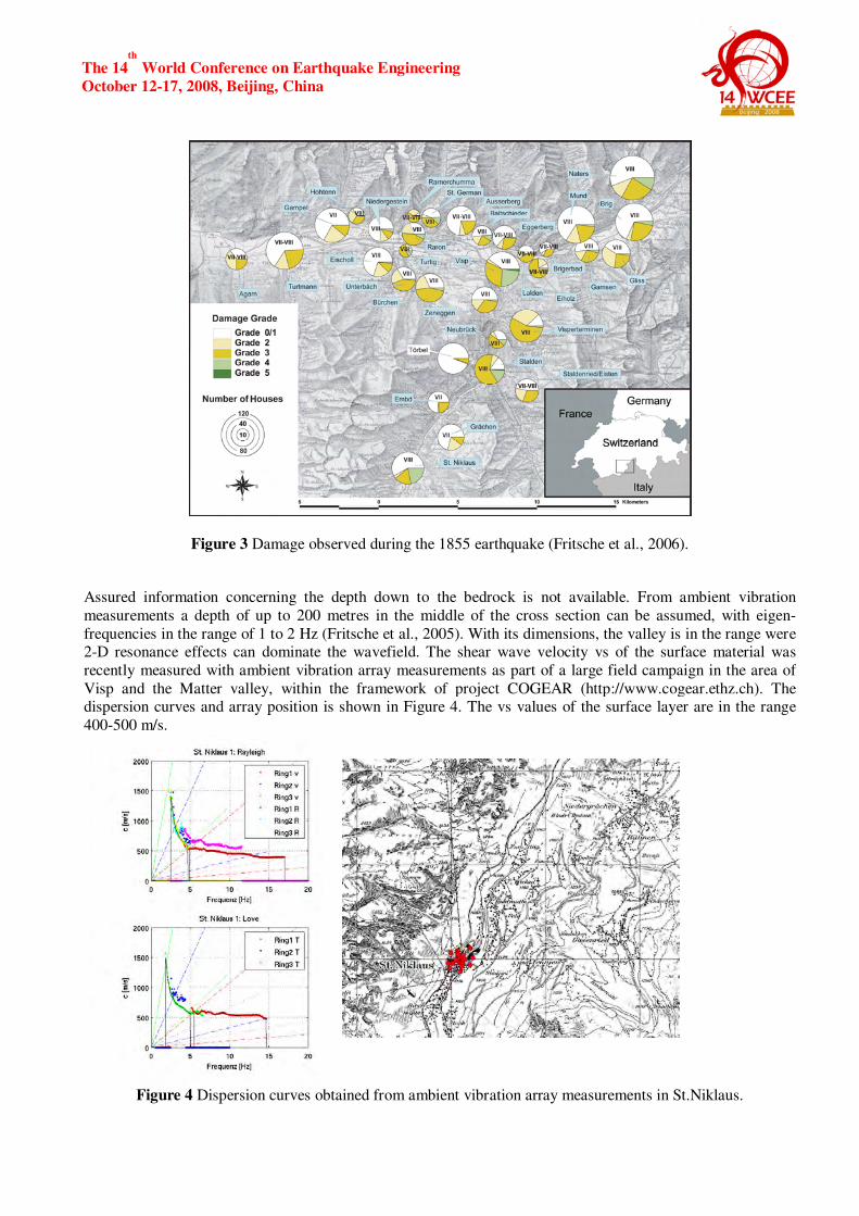
During the 1855 earthquakes widespread damage was observed in the region of Visp (Figure 3). The damage
was particularly high at Visp, Stalden, St.Niklaus and Naters. The damage field of Visp and Stalden is assumed
to be the result of the source rather than of a site-effect, due to the close distance to the probable fault in the
Visper valley (Fritsche et al., 2005; 2006). The damage at Naters and St. Niklaus however are affected by a site-effect. Their positions on the border of the general damage field, the geological conditions and the high
losses in these villages are a strong indication for it. The site of St. Niklaus was further investigated. It is
situated on the lateral slope of the comparatively narrow Matter Valley. The valley is U-shaped and has an infill consisting of alternating layers of gravel, moraine and fluviatil deposits. During construction works near the
centre of the village lacustrine deposits could be identified as well.
The 14th
World Conference on Earthquake Engineering
October 12-17, 2008, Beijing, China
Figure 3 Damage observed during the 1855 earthquake (Fritsche et al., 2006).
Assured information concerning the depth down to the bedrock is not available. From ambient vibration
measurements a depth of up to 200 metres in the middle of the cross section can be assumed, with eigen-
frequencies in the range of 1 to 2 Hz (Fritsche et al., 2005). With its dimensions, the valley is in the range were 2-D resonance effects can dominate the wavefield. The shear wave velocity vs of the surface material was
recently measured with ambient vibration array measurements as part of a large field campaign in the area of
Visp and the Matter valley, within the framework of project COGEAR (http://www.cogear.ethz.ch). The dispersion curves and array position is shown in Figure 4. The vs values of the surface layer are in the range
400-500 m/s.
Figure 4 Dispersion curves obtained from ambient vibration array measurements in St.Niklaus.
The 14th
World Conference on Earthquake Engineering
October 12-17, 2008, Beijing, China
For Naters the situation is not as clear due to the fact that the commune Naters covers a wide area including
several small localities. The damage however was not analysed in such detail, and the particular area ofincreased damage is not yet pinpointed. Ambient vibration array measurements revealed some areas in the
Rhone plane with shear wave velocities of the surface material in the range 200-300m/s. Such velocities can be
attributed to a layer of sand and silt. This layer can be found at many sites in the Rhone plain. It is a shallow (5-
10 m) low-velocity layer with shear-wave velocities as low as 100 m/s at some sites. Since such layers are very important in terms of ground shaking and liquefaction, many sites in Rhone were investigated in the framework
of COGEAR in order to define the shear-wave velocity of the shallow Rhone sediments. Such sites will be the
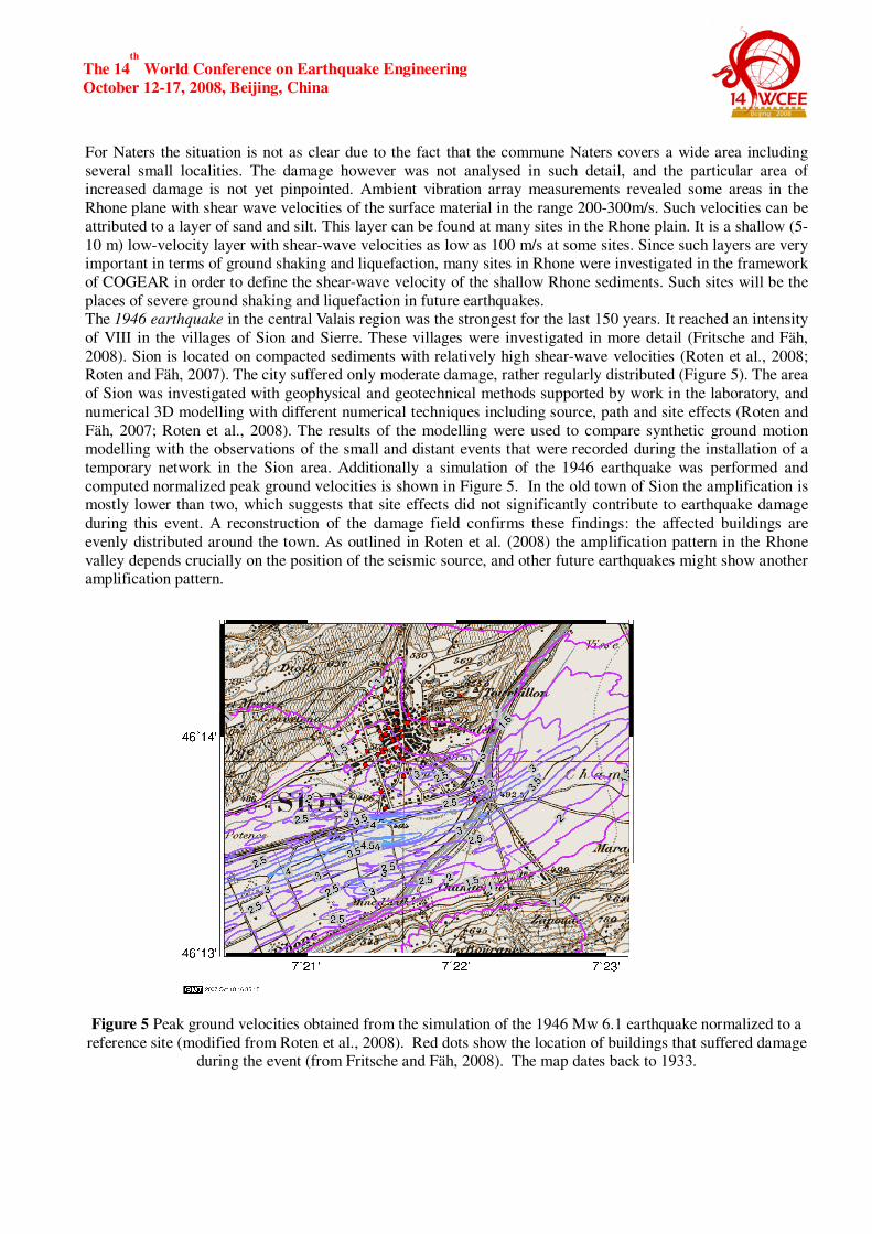
places of severe ground shaking and liquefaction in future earthquakes. The 1946 earthquake in the central Valais region was the strongest for the last 150 years. It reached an intensity
of VIII in the villages of Sion and Sierre. These villages were investigated in more detail (Fritsche and Fäh,
2008). Sion is located on compacted sediments with relatively high shear-wave velocities (Roten et al., 2008; Roten and Fäh, 2007). The city suffered only moderate damage, rather regularly distributed (Figure 5). The area
of Sion was investigated with geophysical and geotechnical methods supported by work in the laboratory, and
numerical 3D modelling with different numerical techniques including source, path and site effects (Roten and
Fäh, 2007; Roten et al., 2008). The results of the modelling were used to compare synthetic ground motion modelling with the observations of the small and distant events that were recorded during the installation of a
temporary network in the Sion area. Additionally a simulation of the 1946 earthquake was performed and
computed normalized peak ground velocities is shown in Figure 5. In the old town of Sion the amplification is mostly lower than two, which suggests that site effects did not significantly contribute to earthquake damage
during this event. A reconstruction of the damage field confirms these findings: the affected buildings are
evenly distributed around the town. As outlined in Roten et al. (2008) the amplification pattern in the Rhone
valley depends crucially on the position of the seismic source, and other future earthquakes might show another amplification pattern.
Figure 5 Peak ground velocities obtained from the simulation of the 1946 Mw 6.1 earthquake normalized to a
reference site (modified from Roten et al., 2008). Red dots show the location of buildings that suffered damage during the event (from Fritsche and Fäh, 2008). The map dates back to 1933.
The 14th
World Conference on Earthquake Engineering
October 12-17, 2008, Beijing, China
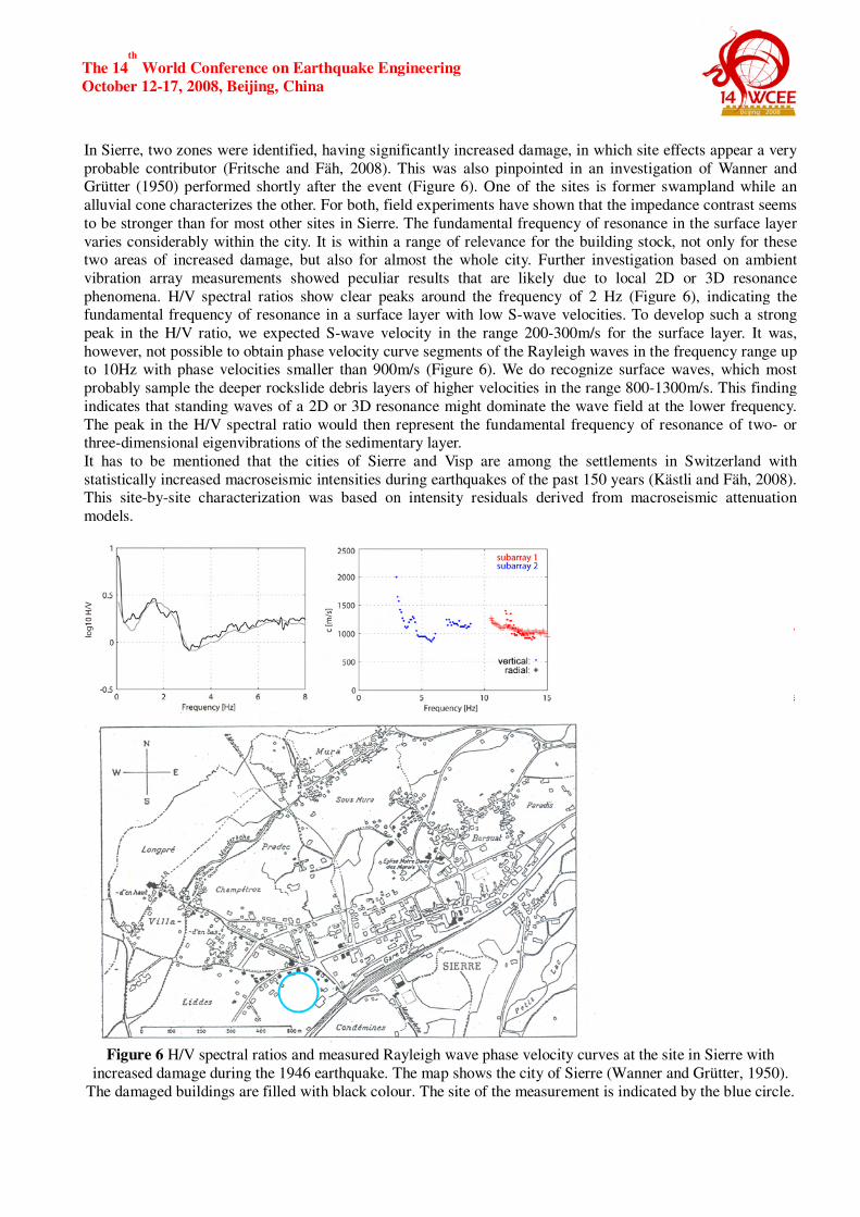
In Sierre, two zones were identified, having significantly increased damage, in which site effects appear a very
probable contributor (Fritsche and Fäh, 2008). This was also pinpointed in an investigation of Wanner and Grütter (1950) performed shortly after the event (Figure 6). One of the sites is former swampland while an
alluvial cone characterizes the other. For both, field experiments have shown that the impedance contrast seems
to be stronger than for most other sites in Sierre. The fundamental frequency of resonance in the surface layer
varies considerably within the city. It is within a range of relevance for the building stock, not only for these two areas of increased damage, but also for almost the whole city. Further investigation based on ambient
vibration array measurements showed peculiar results that are likely due to local 2D or 3D resonance
phenomena. H/V spectral ratios show clear peaks around the frequency of 2 Hz (Figure 6), indicating the fundamental frequency of resonance in a surface layer with low S-wave velocities. To develop such a strong
peak in the H/V ratio, we expected S-wave velocity in the range 200-300m/s for the surface layer. It was,
however, not possible to obtain phase velocity curve segments of the Rayleigh waves in the frequency range up to 10Hz with phase velocities smaller than 900m/s (Figure 6). We do recognize surface waves, which most
probably sample the deeper rockslide debris layers of higher velocities in the range 800-1300m/s. This finding
indicates that standing waves of a 2D or 3D resonance might dominate the wave field at the lower frequency.
The peak in the H/V spectral ratio would then represent the fundamental frequency of resonance of two- or three-dimensional eigenvibrations of the sedimentary layer.
It has to be mentioned that the cities of Sierre and Visp are among the settlements in Switzerland with
statistically increased macroseismic intensities during earthquakes of the past 150 years (Kästli and Fäh, 2008). This site-by-site characterization was based on intensity residuals derived from macroseismic attenuation
models.
Figure 6 H/V spectral ratios and measured Rayleigh wave phase velocity curves at the site in Sierre with
increased damage during the 1946 earthquake. The map shows the city of Sierre (Wanner and Grütter, 1950).
The damaged buildings are filled with black colour. The site of the measurement is indicated by the blue circle.
The 14th
World Conference on Earthquake Engineering
October 12-17, 2008, Beijing, China
3. EXPECTED AMPLIFICATIONS IN THE RHONE VALLEY
The Rhone valley was densely populated during the last 60 years. Because site conditions in the plain are not
very favorable, we might expect larger damage in future events than we have seen in the past. Numerical
modeling allows to predict ground motion amplification; Two studies were performed for the Sion region
(Roten et al., 2008; Havenith et al., 2008). The valley sites can be characterized as soils of class C according to Eurocode 8 with vs ranging from 300 to 500 m/s on the surface, increasing at depth to 800–1200 m/s. Locally,
these sediments are covered with a sand/silt-layer corresponding to soil class D with vs as low as 100–150 m/s
at the surface. Such sands and silts will show strong non-linear effects even at low ground-motion levels as well as liquefaction (Roten, 2007).
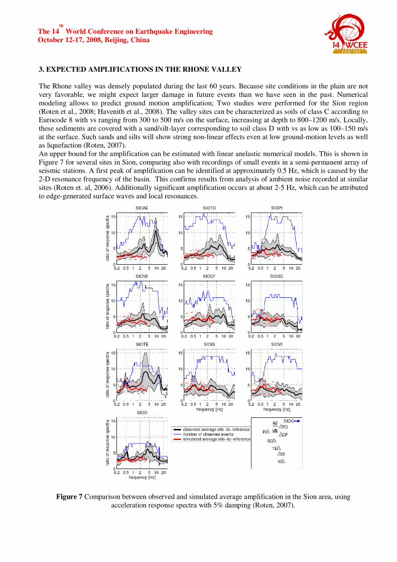
An upper bound for the amplification can be estimated with linear anelastic numerical models. This is shown in
Figure 7 for several sites in Sion, comparing also with recordings of small events in a semi-permanent array of seismic stations. A first peak of amplification can be identified at approximately 0.5 Hz, which is caused by the
2-D resonance frequency of the basin. This confirms results from analysis of ambient noise recorded at similar
sites (Roten et. al, 2006). Additionally significant amplification occurs at about 2-5 Hz, which can be attributed
to edge-generated surface waves and local resonances.
Figure 7 Comparison between observed and simulated average amplification in the Sion area, using
acceleration response spectra with 5% damping (Roten, 2007).
The 14th
World Conference on Earthquake Engineering
October 12-17, 2008, Beijing, China
1D and 2D simulation results obtained by Roten (2007) suggest that nonlinearity becomes important at
acceleration levels of 0.5 ms-2
on rock, and deamplification occurs at rock spectral accelerations (SA) exceeding approximately 2 ms
-2. Additionally, strong nonlinear effects such as liquefaction must be expected at
this level of ground motion. At frequencies above 1 Hz, the spectral acceleration is below the value in the
building code for the vast majority of the simulated events. At the 2-D resonance frequency of the basin near
0.5 Hz, however, the simulated spectral acceleration exceeds the code values for many simulated scenarios.
4. OUTLOOK
Earthquake observations and numerical simulations for Alpine valleys show that the seismic response is often
dominated by 2D or 3D resonance at low frequencies, while edge-generated surface waves are responsible for
significant amplification at higher frequencies. The expected ground motion is therefore very site-specific. Analysis of soil nonlinearity suggests that increased damping may lead to reduced amplification for low levels
of rock SA, especially at higher frequencies. At lower frequencies the design spectra may still be exceeded as a
consequence of the 2D resonance.
The probability of observing a major earthquake in the Valais in the next 10-40 years is high. For this reason, project COGEAR (http://www.cogear.ethz.ch) was launched in 2008. COGEAR is an interdisciplinary natural
hazard project to investigate short and long-term earthquake preparation processes as well as complex surface
effects induced by seismic strong ground-motion. Besides other objectives, the modeling and observation of weak and strong ground-motion as a result of complex source and path effects are main tasks, including non-
linear wave propagation phenomena and liquefaction.
5. REFERENCES
Fäh, D. (2006). Evaluating site effects in areas of low seismicity. Proceedings: First European Conference on
Earthquake Engineering and Seismology. Geneva, Switzerland, (CD ROM). Keynote Paper K3. Fäh, D., Giardini, D. et al. (2003). Earthquake Catalogue Of Switzerland (ECOS) and the related Macroseismic
Database . Eclogae geol. Helv, 96, 219-236.
Fritsche, S., Fäh, D. and Giardini, D. (2005). Damage Fields and Site-Effects. Investigations on the 1855 Earthquake in Switzerland. Proceedings: 250
th Anniversary of the 1755 Lisbon Earthquake, Lisbon 2005.
Fritsche, S., Fäh, D., Gisler, M. and Giardini, D. (2006). Reconstructing the damage field of the 1855
earthquake in Switzerland: historical investigations on a well-documented event. Geophys. J. Int., 166,
719–731. Fritsche, S. and Fäh, D. (2008). The 1946 Magnitude 6.1 Earthquake in the Valais: Site-Effects as Contributor
to the Damage. Eclogae Geol. Helv., submitted.
Gisler, M., Fäh, D. and Deichmann, N. (2004). The Valais earthquake of December 9, 1755. Eclogae Geol.
Helv., 97, 411-422.
Havenith, H.B., Fäh, D., Alvarez-Rubio, S. and Roten, D. (2008). Response spectra for the deep sediment-filled
Rhône Valley in the Swiss Alps. Soil Dynamics and Earthquake Engineering, in press. Kästli, P. and Fäh, D. (2008). Site amplification factors for intensity attenuation; a case study for Switzerland.
submitted.
Roten D. (2007). Site effects in the Rhone valley analysed by ambient noise, weak motion records and
numerical simulations. Dissertation ETH Zurich, Diss. ETH No. 17471, pp 173. Roten, D., Fäh, D., Cornou, C. and Giardini, D. (2006). 2D resonances in Alpine valleys identified from
ambient vibration wavefields. Geophys. J. Int., 165, 889-905.
Roten, D. and Fäh, D. (2007). A combined inversion of Rayleigh wave dispersion and 2D resonance frequencies. Geophys. J. Int., 168, 1261–1275.
Roten, D., Fäh, D., Olsen, K.B. and Giardini, D. (2008). A comparison of observed and simulated site response
in the Rhone valley. Geophys. J. Int., 173, 958-978. Wanner, E. and Grütter. M. (1950). Etude sur les répliques de tremblement de terre du Valais, de 1946 à 1950.
Bulletin de la Murithienne, fasc. LXVII. 24-41.