earth-science sciencedirect morphologic and facies trends
TRANSCRIPT
Available online at www.sciencedirect.com
ELSEVIER
Morphologic and facies trends through the fluvial-marine transition in tide-dominated depositional systems: A schematic framework for
environmental and sequence-stratigraphic interpretation
Robert W. Dalrymple *, Kyungsik Choi 1Department o f Geological Sciences and Geological Engineering, Queen's University, Kingston, Ontario, Canada K7L 3N6
Received 22 June 2005; accepted 3 October 2006
Abstract
M ost tide-dominated estuarine and deltaic deposits accumulate in the fluvial-to-marine transition zone, which is one o f the most complicated areas on earth, because o f the large number o f terrestrial and marine processes that interact there. An understanding o f how the facies change through this transition is necessary i f w e are to make correct paleo-environmental and sequence-stratigraphic interpretations o f sedimentary successions. The most important process variations in this zone are: a seaward decrease in the intensity o f river flow and a seaward increase in the intensity o f tidal currents. Together these trends cause a dominance o f river currents and a net seaward transport o f sediment in the inner part o f the transition zone, and a dominance o f tidal currents in the seaward part o f the transition, with the tendency for the development o f a net landward transport o f sediment. These transport patterns in turn develop a bedload convergence within the middle portion o f all estuaries and in the distributary-mouth-bar area o f deltas. The transport pathways also generate grain-size trends in the sand fraction: a seaward decrease in sand size through the entire fluvial-m arine transition in deltas, and through the river-dominated, inner part o f estuaries, but a landward decrease in sand size in the outer part o f estuaries. A turbidity maximum (i.e., a zone o f significantly elevated suspended-sediment concentrations) is developed within estuaries and the delta-plain region o f deltas as a result o f flocculation and density-driven water-circulation patterns. This leads to an area within the estuary or delta plain where the abundance and thickness o f the mud drapes are greatest, including the potential for the development o f fluid-mud deposits (i.e., structureless mud layers more than 0 .5 -1 cm thick that were deposited in a single slack-water period). A monotonie seaward increase in salinity characterizes both estuaries and deltas. The brackish-water conditions in the transition zone, accompanied by the high turbidity and physically harsh conditions, produce a biologically stressed environment, in which bioturbation is generally not pervasive. The ichnofossil assemblage in this zone is characterized by the low diversity o f ichnogenera, small size o f the individual burrows (typically smaller than their open-marine counterparts), and highly variable population densities, ranging from unbioturbated to very high-density mono-specific assemblages in local areas.
This review begins with a survey o f how and why each depositional process varies through the fluvial-to-marine transition and then examines the sedimentological responses to these processes, focussing on the observable, longitudinal variations in the development and/or abimdance o f each deposit characteristic (e.g., sand grain size, paleocurrent patterns, mud drapes, and biological attributes). The review ends with a summary o f the characteristics o f each major facies zone through the transition, with separate discussions for both estuaries and deltas. It must be noted that any attempt to generalize, as is done here, w ill undoubtedly
* Corresponding author. Tel.: +1 613 533 6186; fax: +1 613 533 6592.E-mail addresses: [email protected] (R.W. Dalrymple), [email protected] (K. Choi).
1 Present address: Faculty o f Earth Systems and Environmental Sciences, Chonnam National University, Gwangju 500-757, Korea. Tel.: +82 62 530 3473; fax: +82 62 530 3469.
0012-8252/$ - see front matter <© 2007 Elsevier B.V. All rights reserved, doi: 10.1016/j.earscirev.2006.10.002
ScienceDirectEARTH-SCIENCE
m
Earth-Science Reviews 81 (2007) 135-174www.elsevier.com/locate/earscirev

136 R. If: Dalrymple, K. Choi / Earth-Science Reviews 81 (2007) 135-174
contain statements that are inappropriate for individual deposits or systems. Exceptions must be expected and the concepts must be applied with due consideration for the local context.© 2007 Elsevier B.V. A ll rights reserved.
Keywords: tide-dominated; proxim al-distal facies trends; fluvial-m arine transition; delta; estuary
1. Introduction
The correct interpretation of ancient sedimentary deposits, whether for academic or applied purposes, requires knowledge about two separate, but inter-related aspects of sedimentary successions: interpretation of the original depositional environments, using the techniques of facies analysis, as illustrated by the popular textbook “Facies Models” (Walker and James, 1992); and subdivision of the stratigraphie succession into genetically related units using the principles of sequence stratigraphy (e.g., Van Wagoner et al., 1988; Posamentier and Allen, 1999; Catuneanu, 2006). The integration of these two lines of investigation allows the construction of realistic paleogeographic reconstructions that show how the depositional facies are related in space and time. From this, it is possible to develop more precise depositional histories, and to predict more accurately the location and geometry of hydrocarbon reservoir facies.
The sequence-stratigraphic analysis of sedimentary successions, including the identification of sequence boundaries and maximum flooding siufaces, is based on the identification of sequential (i.e., progressive) changes in the nature of the deposits. Thus, prograda- tional successions, in which more proximal deposits overlie those formed in more distal settings, characterize the falling-stage, lowstand, andhighstand systems tracts, whereas retrogradational facies stacking (i.e., more distal over more proximal deposits) occius in the transgressive systems tract. Facies stacking patterns are also important for the correct identification of some environments. For example, estuaries, as defined by Dalrymple etal. (1992; see also Boyd et al., 2006; Dalrymple, 2006), form only under transgressive conditions and thus are represented primarily by transgressive successions, whereas deltas are progradational (Dalrymple et al., 2003).
[Throughout this review, the terms “estuary” and “estuarine” refer only to transgressive coastal areas and not to those areas with brackish-water! Indeed, as will be noted later, brackish-water conditions also occiu in deltas and even in some shelf environments, whereas some transgressing coastal areas have either fully fresh or frilly marine salinity. However, the use of “estuary” here differs slightly from that proposed by Dalrymple et al. (1992) and instead follows the revised definition
proposed by Dalrymple (2006) in that we do not restrict the term to incised-valley systems. Thus, the abandoned portions of delta plains that are undergoing transgression (i.e., the “destructive phase” of the delta cycle) are here considered to be estuaries (Fig. 1). In this context, the term “delta” is applied only to the actively prograding portion of the larger deltaic system.]
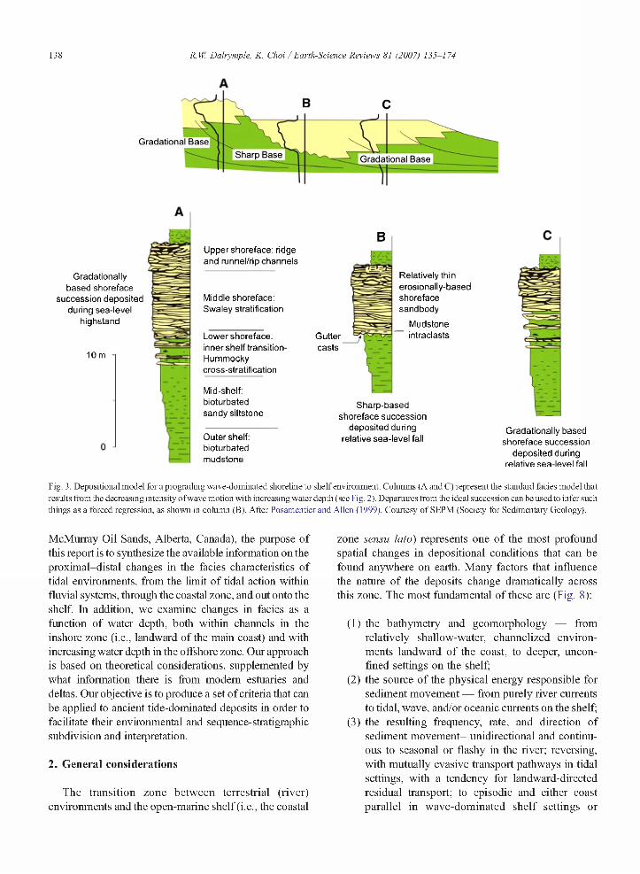
The paragraphs above show that the ability to distinguish proximal facies from more distal deposits is an essential element of most sedimentary interpretations. However, the distinction of proximal from distal facies is not equally easy in all environmental settings. Wave- dominated coastal zones (i.e., the beach-shoreface-shelf suite of environments) display a simple and well- understood decrease in wave-energy level as the water depth increases (Fig. 2 ). As a result of this monotonie trend in wave energy, there is a predictable correlation between water depth and facies that is represented by an upward-coarsening succession (Fig. 3A, C) that passes from mudstones (“offshore”), through deposits with thin,
Fig. 1. Satellite image of the Indus River delta (sensu lato). The area of active river outflow occurs at the apex of the deltaic protrusion in the centre of the image. Only this part of the coast and the immediately adjacent areas are receiving river-supplied sediment directly from the river; hence, this is the only part of the system that is actively pro grading at the present time (i.e., it is the only part of the system that is truly deltaic in the context used in this paper). The remainder of the delta plain is inactive (i.e., abandoned) and is inferred to be undergoing slow transgression due to tectonic subsidence and/or compaction of the underlying mud. Thus, the many sinuous tidal channels in the abandoned part of the larger delta complex behave as estuaries, as defined herein. For more information on this delta, see Brookfield (1998) and Prins et al. (2000). Courtesy of European Space Agency (ESA).

R. W. Dalrymple, K. Choi / Earth-Science Reviews 81 (2007) 135-174 137
Direction of Wave Propagation
L/2
Fig. 2. Diagram showing the decrease in the intensity o f wave-orbital motion with increasing depth in a water body. Below “wave base”, there is no appreciable sediment movement due to surface-wave action. This trend is entirely predictable and leads to the vertical succession of sedimentary structures shown in Fig. 3.
discrete sandstone beds with wave ripples and hummocky cross stratification (HCS) (offshore transition), into amalgamated sandstones with HCS (lower shore- face) and eventually into sandstones with swaley cross stratification (SCS) and cross bedding (upper shoreface) (e.g.. Walker and Plint, 1992). In fact, this vertical succession is so predictable that deviations from the expected succession can be used to infer such things as forced regressions (Fig. 3B).
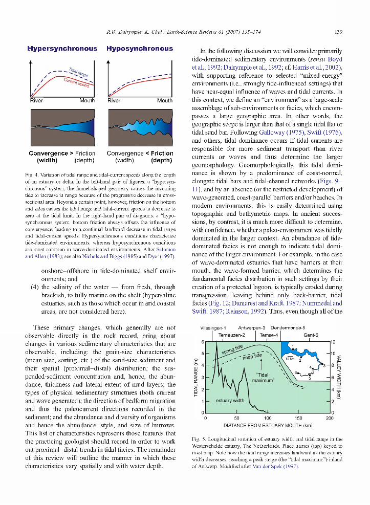
By comparison, the proximal-distal changes in processes and facies that occur in tide-dominated environments (sensu Boyd et al., 1992; see the “General considerations” section below for a discussion of what is meant by “tide dominated”) are not well known because of their inherent complexity. At least two fundamental factors account for this. First, tidal energy does not vary in a simple (i.e., monotonie) way with onshore-offshore position. Studies in many modem environments show that tide-dominated environments are generally hypersyn- chronous. This means that the tidal range increases landward because of the funnel-shaped geometry of the channel systems comprising the estuary or delta (Figs. 4 and 5 ). This in turn means that there are two areas with relatively weak tidal currents (at the mouth and at the head), separated by an area with stronger tidal currents. Thus, it might be possible to get similar tidal deposits in two very different parts of the fluvial-marine transition, leading to confusion and potential mis-interpretation of the depositional environment. Secondly, tidal environments are characterized by complex networks of tidal channels and bars. This causes the architecture of the deposits to be complex because of the migration and
stacking of successive channels and the presence of erosion surfaces of several different orders (Figs. 6 and 7 ). Furthermore, there are vertical changes in tidal current speeds within a single channel that mimic the longitudinal changes in tidal energy. The erosional juxtaposition of channel bodies also makes it difficult to recognize any larger-scale stratigraphie trends that may exist.
The task of interpreting ancient tidal deposits is made even more challenging by the fact that there is a global dominance of transgressive coastlines in the modem world. Consequently, almost all of the well-studied modem, tide-dominated systems are transgressive (i.e., estuaries such as the Bay of Fundy — Dalrymple et al., 1990,1991 ; Dalrymple andZaitlin, 1994; and the Severn Estuary — Harris and Collins, 1985; Allen, 1990). By comparison, there are very few well-documented modem (Dalrymple et al., 2003) or ancient (e.g., Mutti et al., 1985; Maguregui and Tyler, 1991; Martinius et al., 2001) examples of progradational (i.e., deltaic) tide- dominated successions, and some well-respected sedi- mentologists have even suggested that tide-dominated deltas do not exist (Walker, 1992; Bhattacharya and Walker, 1992), a view that is not universally accepted (Dalrymple, 1999; Harris et al., 2002; Dalrymple et al., 2003; Willis, 2005). This bias in the availability of analogues leads to a tendency for workers to assume that ancient tide-dominated deposits were also formed during transgressions.
Given these inherent difficulties with the interpretation of tide-dominated deposits, which are of increasing economic importance given the large number of important petroleum reservoirs hosted by tidal deposits (e.g., the
138 R. If: Dalrymple, K. Choi / Earth-Science Reviews 81 (2007) 135-174
Gradational BaseSharp Base Gradational Base
Gradationally based shoreface
succession deposited during sea-level
highstand
10 m
Upper shoreface: ridge and runnel/rip channels
Middle shoreface: Swaley stratification
Lower shoreface: inner shelf Iransition- Hummocky cross-stratification
Mid-shelf: bioturbated sandy siltstone
Outer shelf: bioturbated mudstone
Guttercasts
Relatively thin erosionally-based shoreface sandbody
Mudstone — intraclasts
Sharp-based shoreface succession
deposited during relative sea-level fall
Gradationally based shoreface succession
deposited during relative sea-level fall
Fig. 3. Depositional model for a prograding wave-dominated shoreline to shelf environment. Columns (A and C ) represent the standard lacies model that results from foe decreasing intensity o f wave motion with increasing water depth ( see Fig. 2). Departures from foe ideal succession can be used to infer such things as a forced regression, as shown in column (B). After Posamentier and Allen ( 1999). Courtesy o f SEPM (Society for Sedimentary Geology).
McMurray Oil Sands, Alberta, Canada), the purpose of this report is to synthesize the available information on the proximal-distal changes in the facies characteristics of tidal environments, from the limit of tidal action within fluvial systems, through the coastal zone, and out onto the shelf. In addition, we examine changes in facies as a function of water depth, both within channels in the inshore zone (i.e., landward of the main coast) and with increasing water depth in the offshore zone. Our approach is based on theoretical considerations, supplemented by what information there is from modem estuaries and deltas. Our objective is to produce a set of criteria that can be applied to ancient tide-dominated deposits in order to facilitate their environmental and sequence-stratigraphic subdivision and interpretation.
2. General considerations
The transition zone between terrestrial (river) environments and the open-marine shelf (i.e., the coastal
zone sensu lato) represents one of the most profound spatial changes in depositional conditions that can be found anywhere on earth. Many factors that influence the nature of the deposits change dramatically across this zone. The most fundamental of these are (Fig. 8 ):
(1) the bathymetry and geomorphology — from relatively shallow-water, channelized environments landward of the coast, to deeper, unconfined settings on the shelf;
(2 ) the source of the physical energy responsible for sediment movement — from purely river currents to tidal, wave, and/or oceanic currents on the shelf;
(3) the resulting frequency, rate, and direction of sediment movement- unidirectional and continuous to seasonal or flashy in the river; reversing, with mutually evasive transport pathways in tidal settings, with a tendency for landward-directed residual transport; to episodic and either coast parallel in wave-dominated shelf settings or
R. W. Dalrymple, K. Choi / Earth-Science Reviews 81 (2007) 135-174 139
Hypersynchronous Hyposynchronous
Convergence > Friction Convergence < Friction(width) (depth) (width) (depth)
Fig. 4. Variation of tidal range and tidal-current speeds along the length of an estuary or delta. In the left-hand pair of figures, a “hypersynchronous” system, the funnel-shaped geometry causes the incoming tide to increase in range because of the progressive decrease in cross- sectional area. Beyond a certain point, however, friction on the bottom and sides causes the tidal range and tidal-current speeds to decrease to zero at the tidal limit. In the right-hand pair o f diagrams, a “hypo- synchronous system, bottom friction always offsets the influence of convergence, leading to a continual landward decrease in tidal range and tidal-current speeds. Hypersynchronous conditions characterize tide-dominated environments, whereas hyposynchronous conditions are most common in wave-dominated environments. After Salomon and Allen (1983); see also Nichols and Biggs (1985) and Dyer (1997).
onshore-offshore in tide-dominated shelf environments; and
(4) the salinity of the water — from fresh, through brackish, to fully marine on the shelf (hypersaline estuaries, such as those which occur in arid coastal areas, are not considered here).
These primary changes, which generally are not observable directly in the rock record, bring about changes in various sedimentary characteristics that are observable, including: the grain-size characteristics (mean size, sorting, etc. ) of the sand-size sediment and their spatial (proximal-distal) distribution; the sus- pended-sediment concentration and, hence, the abundance, thickness and lateral extent of mud layers; the types of physical sedimentary structures (both current and wave generated); the direction of bedform migration and thus the paleocurrent directions recorded in the sediment; and the abundance and diversity of organisms and hence the abundance, style, and size of burrows. This list of characteristics represents those features that the practicing geologist should record in order to work out proximal-distal trends in tidal facies. The remainder of this review will outline the manner in which these characteristics vary spatially and with water depth.
Mouth
In the following discussion we will consider primarily tide-dominated sedimentary environments (sensu Boyd et al., 1992; Dalrymple et al., 1992; cf. Harris et ah, 2002), with supporting reference to selected “mixed-energy” environments (i.e., strongly tide-influenced settings) that have near-equal influence of waves and tidal currents. In this context, we define an “environment” as a large-scale assemblage of sub-environments or facies, which encompasses a large geographic area. In other words, the geographic scope is larger than that of a single tidal flat or tidal sandbar. Following Galloway (1975), Swift (1976), and others, tidal dominance occius if tidal currents are responsible for more sediment transport than river currents or waves and thus determine the larger geomorphology. Geomorphologically, this tidal dominance is shown by a predominance of coast-normal, elongate tidal bars and tidal-channel networks (Figs. 9 - 11 ), and by an absence (or the restricted development) of wave-generated, coast-parallel barriers and/or beaches. In modem environments, this is easily determined using topographic and bathymetric maps. In ancient successions, by contrast, it is much more difficult to determine, with confidence, whether a paleo-environment was tidally dominated in the larger context. An abundance of tide- dominated facies is not enough to indicate tidal dominance of the larger environment. For example, in the case of wave-dominated estuaries that have barriers at their mouth, the wave-formed barrier, which determines the fundamental facies distribution in such settings by their creation of a protected lagoon, is typically eroded during transgression, leaving behind only back-barrier, tidal facies (Fig. 12; Damarest and Kraft, 1987;Nummedaland Swift, 1987; Reinson, 1992). Thus, even though all ofthe
Vlissingen-1 Antwerpen-3 Dendermonde-5Temeuzen-2 Temse-4 Gent-6
6
5 ñeSp l'deE
4UJO
"Tidalmaximum”
4 ^
estuary width1
00 50 100 150 200
DISTANCE FROM ESTUARY MOUTH (km)
Fig. 5. Longitudinal variation of estuary width and tidal range in the Westerschelde estuary, The Netherlands. Place names (top) keyed to inset map. Note how the tidal range increases landward as the estuary width decreases, reaching a peak range (the “tidal maximum”) inland of Antwerp. Modified after Van der Spek (1997).
Mouth

140 R. W. Dalrymple, K. Choi / Earth-Science Reviews 81 (2007) 135-174
Open marine) S h e lf
'X '- — ^\ Estuarine t
X -Tidal barsl/ Salt TST| Marshi
Tidal-FluvlalChannel
Fluvial Ir-. 1
Fig. 6. Schematic vertical cross section of a tide-dominated estuary located within an incised valley (see map view in Fig. 9). The overall succession is transgressive in character, with fluvial deposits at the base, overlain by estuarine deposits, and capped by open-marine deposits o f the succeeding progradation. Systems tracts are noted. Within the estuary deposits, note that the sandy channels become larger (wider) upward, reflecting the seaward-flaring, funnel shape of this type of system (see Figs. 9 and 21 below). These sandy channel deposits are flanked by muddy tidal-flat and salt- marsh sediments. After Dalrymple (1992).
preserved estuarine deposits may show strong evidence of tidal action and little or no wave influence, the environment as a whole was not tidally dominated. As a result, the application of the results presented below to individual rock successions must be done with caution.
3. Process variations
In the following sections, we examine the longitudinal (from land to sea) and depth-related var
iation of the physical, chemical, and biological processes that directly influence the nature of the deposits. Because estuaries and deltas have important differences in some regards, they are considered separately.
3.1. Physical processes
Three significant physical processes (i.e., the energy sources: Fig. 8) must be considered: river
Deltaicl
Fluyiall Fluvial-Estuarlne
■ vó' •'j=. Fluyiall LST
Prodelta I
Fig. 7. Schematic vertical cross section o f a tide-dominated delta, based on the Fly River delta. Papua New Guntea (see map view in Fig. 11). The succession is progradational: front base to top, the facies succession consists of prodelta —> delta front —> distributary mouth bars (DMB) —> delta plant —> fluvial deposits. Note that the delta-plain deposits consist o f a nested series o f tidally influenced/dominated channels. After Dalrymple et al. (2003). Courtesy o f SEPM (Society for Sedimentary Geology).

R. W. Dalrymple, K. Choi / Earth-Science Reviews 81 (2007) 135-174 141
SEA
Salinity
Sedimentmovement
Energy source
Depth/Geomorphology
Normalm arine
COASTLINEi
Brackish w ater !
Bidirectional co ast normal
I■Tidal c u rre n ts !
LAND
Freshw ater
Unidirectionalseaw ard
Deep;unconfined
— 1---IIShallow; so m ewhat confined
■ River currents
Shallow;channelized
Fig. 8. Coast-normal variation in the essential controls on sedimentation in the transition from purely fluvial settings (“land”), through the tide-dominated coastal zone, to shelf environments (“sea”). These variations represent the fundamental constraints that determine the nature of the facies changes through this transition zone.
currents, tidal currents, and waves. The relative importance of these processes varies in a systematic manner through the river-to-marine transition (Figs. 9 and 11). Physical processes of lesser importance (e.g., wind and oceanic currents) are not considered here for simplicity, but may be important in some cases.
3.1.1. River currentsRiver currents decrease in strength and relative
important in a seaward direction through both estuaries and deltas, because of the decreasing physical and hydraulic gradient as the river approaches the sea. The splitting of flow between multiple distributary and tidal channels also contributes to the seaward decrease in the strength of river flow.
RIVERSHELF ESTUARYMAKINt-DlJMINAl fcD MIXED-ENERG Y ■ RIVER-DOMINATED
TOTAL ENERGY (̂jrrents
■T ¡daiTIDAL GMaxim um’
TO ; : M * Ml ANOI RING STRA GH1
T DAL
E R O S IO N A L TIDAL SA N D
A LLU V IA LV ALLEYSALT M A R SH i t • *-
BLC
Net transporti bidirectional
bidirectional (flood dominant) , dominant) unidirectional
Fig. 9. (A) Schematic map of a tide-dominated estuary. Note the funnel shape, the systematic changes in channel geometry (“straight”-meandering-“straight”), the presence of elongate tidal bars in the seaward part, and the fringing muddy tidal flats and salt marshes. (Note that the mud flats and salt marshes are replaced with mangroves in tropical areas). Because the system as a whole is migrating landward (i.e., transgressing), the outer margin of the mudflats is commonly bordered by an erosional channel margin (cf. Dalrymple et al., 1991). A schematic cross section of such an estuary is shown in Fig. 6. After Dalrymple et al. (1992). (B) Longitudinal variation of the intensity of the three main physical processes, river currents, tidal currents and waves, and the resulting directions of net sediment transport (at bottom of A) through a tide-dominated estuary. Note the development of a bedload convergence (BLC) at the location of the tightly meandering portion of the channel. Modified from Dalrymple et al. (1992). (C) Longitudinal variation of: the grain size of the sand fraction, the suspended- sediment concentration and “bulk” grain size of the resulting deposits (essentially the sand:mud ratio). See text for additional discussion. A and B courtesy of SEPM (Society for Sedimentary Geology).
.sedimey
< 5- I CÛ LU <
ß u ik grain

142 R. W. Dalrymple, K. Choi / Earth-Science Reviews 81 (2007) 135-174
Fig. 10. Mosaic o f satellite images o f the tide-dominated Mankyimg and Dongjin estuaries (Saemankum estuary, South Korea) showing shore-normal, elongate tidal bars. For more information on this system, see Park et al. (1995).
3.1.2. Tidal currentsThe seaward part of estuaries and deltas is subjected
to tidal action that produces an alternation of landward- directed (flood) and seaward-directed (ebb) tidal currents. Because tide-dominated systems are hyper- synchronous (Fig. 4), tidal ranges and tidal currents increase as one goes landward from the sea, because the incoming tidal wave is compressed into a progressively smaller cross-sectional area, until friction causes them to decrease toward the tidal limit. As a result, the maximum tidal-current speeds occur within the middle estuary (Figs. 9B and 13 ), or in the middle to inner part of the delta plain, near the place where the distributary channels bifurcate (Fig. 11C). This area is referred to here as the “tidal maximum” (Figs. 5 and 13). Local constrictions, and especially those caused by bedrock outcrops, will also produce areas with stronger currents, but these are generally of smaller geographic size than the current-speed maximum generated by convergence.
3.1.3. Resultant currents and sand transport directionsThe actually measured, resultant current speeds are
the sum of the tidal and river-generated water movements (ignoring density-driven circulation for the time being). In the river proper, current speeds generally vary
only slowly, typically on a weekly to monthly time scale in response to seasonal or storm-related variations in water discharge. Even flashy fluvial systems with short, high-magnitude floods exhibit current-speed variations that that are generally slow relative to the semi-diurnal variation in current speeds that characterize most tidal systems. As a result, over the period of one tidal cycle (12.4 h in common semi-diurnal systems), the river currents can in most cases be considered to be effectively constant (Fig. 14A). As one moves seaward, tidal influence is felt first by a tidally induced modulation of the seaward-directed river flow: the current is directed seaward throughout the entire tidal cycle and never stops, but experiences variations in speed as a result of an alternation of retardation (by the tidal-backwater effect) and acceleration (by tidal drawdown) of the river current (Fig. 14B). Moving further seaward, the tidal currents gradually increase in strength such that, at some point, the retardation by the flood tide becomes great enough that the river flow is just stopped but doesn’t reverse (Fig. 14C ); still further seaward, periodic flow reversals occur, with the length and strength of the landward-directed currents increasing in a down-river direction, at least as far as the “tidal maximum” (Fig. 14D, E). As a result, the water movement in the seaward part of estuaries and deltas is typically dominated by tidal currents, whereas the inner part is dominated by river currents (Figs. 9,11,13 and 14).
The progressive, landward decrease in the effect of the tide means that the “tidal limit” is not a rigidly defined location. It could be placed anywhere between the most landward occurrence of flow reversal (Fig. 14C ) and the most landward occurrence of tidally modulated river flow (Fig. 14B) that may be separated by many tens to hundreds of kilometers. These positions also move upstream and downstream over long distances in response to variations in river discharge or neap-spring changes in tidal range. Thus, areas with no tidal influence during times of high river discharge may experience appreciable tidal influence during times of low river flow. As a result, the “tidal limit” is best considered as a zone rather than a specific fixed point. This also means that it is possible to find sporadic tidal indicators in areas that are otherwise purely fluvial. See Van den Berg et al. (in press) for additional discussion of how the tidal limit may be defined.
Sand-size bedload material and silt and clay-size suspended sediment respond very differently to the complex, combined fluvial and tidal currents, because of their different thresholds of motion and settling velocities. Bedload material almost always displays a
R. W. Dalrymple, K. Choi / Earth-Science Reviews 81 (2007) 135-174 143
B SHELF DELTA - - H RIVERMARINE -DOMINATED MIXED-ENERGY I RIVER-DOMINATED
“T idalM axim um "
RIVER*CURRENTS
T DAL
SALT M ARSH
DISTRIBUTARY
PRODELTA
MUD ALLUVIAL
B A R S
N et t r a n s p o r t
bidirectional ■ (flood dominant?),
Increasingly bidirectional (but ebb dominant) unidirectional
ied.sedimentco0Ce
Bulk grain
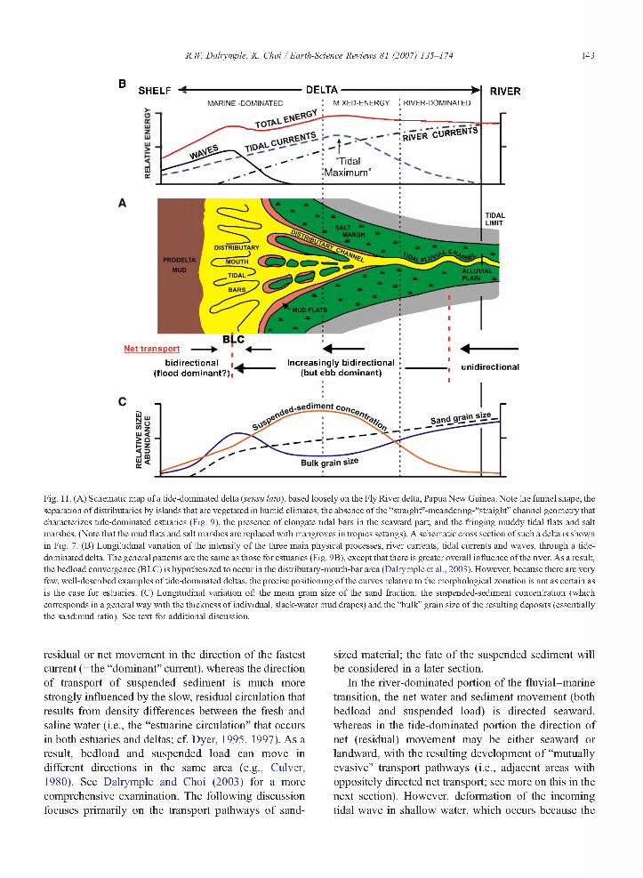
Fig. 11. (A) Schematic map of a tide-dominated delta (sensu lato), based loosely on the Fly River delta, Papua New Guinea. Note the funnel shape, the separation of distributaries by islands that are vegetated in humid climates, the absence of the “straight”-meandering-“straight” channel geometry that characterizes tide-dominated estuaries (Fig. 9), the presence of elongate tidal bars in the seaward part, and the fringing muddy tidal flats and salt marshes. (Note that the mud flats and salt marshes are replaced with mangroves in tropics settings). A schematic cross section of such a delta is shown in Fig. 7. (B) Longitudinal variation of the intensity o f the three main physical processes, river currents, tidal currents and waves, through a tide- dominated delta. The general patterns are the same as those for estuaries (Fig. 9B), except that there is greater overall influence of the river. As a result, the bedload convergence (BLC) is hypothesized to occur in the distributary-mouth-bar area (Dalrymple et al., 2003). However, because there are very few, well-described examples of tide-dominated deltas, the precise positioning of the curves relative to the morphological zonation is not as certain as is the case for estuaries. (C) Longitudinal variation of: the mean grain size o f the sand fraction, the suspended-sediment concentration (which corresponds in a general way with the thickness o f individual, slack-water mud drapes) and the “bulk” grain size of the resulting deposits (essentially the sand:mud ratio). See text for additional discussion.
residual or net movement in the direction of the fastest current (=the “dominant” current), whereas the direction of transport of suspended sediment is much more strongly influenced by the slow, residual circulation that results from density differences between the fresh and saline water (i.e., the “estuarine circulation” that occurs in both estuaries and deltas; cf. Dyer, 1995, 1997). As a result, bedload and suspended load can move in different directions in the same area (e.g., Culver, 1980). See Dalrymple and Choi (2003) for a more comprehensive examination. The following discussion focuses primarily on the transport pathways of sand
sized material; the fate of the suspended sediment will be considered in a later section.
In the river-dominated portion of the fluvial-marine transition, the net water and sediment movement (both bedload and suspended load) is directed seaward, whereas in the tide-dominated portion the direction of net (residual) movement may be either seaward or landward, with the resulting development of “mutually evasive” transport pathways (i.e., adjacent areas with oppositely directed net transport; see more on this in the next section). However, deformation of the incoming tidal wave in shallow water, which occurs because the

144 R. If: Dalrymple, K. Choi / Earth-Science Reviews 81 (2007) 135-174
duneswashover beach
tidal flat
ebb tidal delta
marsh ' s flood‘ a tidal
deltalin tidal channe
waveravinement
surface
iSITS
sequence boundary
Fig. 12. Block diagram illustrating the various sub-environments in a transgressing barrier island-lagoon system, and the stratigraphie succession that is generated as the barrier migrates landward. Note that the preserved succession lying between the sequence boundary and the ravinement surface consists entirely o f tidal lacies, because o f the erosion o f the wave-generated barrier island. Despite the prevalence o f tidal deposits, the environment as a whole was wave dominated. After Reinson ( 1992).
trough of the wave experiences greater frictional slowing than the crest, which in turn causes the flood tide to be of shorter duration and have higher current speeds than the ebb tide, leads to a tendency for flood dominance and a net landward-directed transport of bed material (i.e., sand) in the seaward parts of estuaries and deltas.
Thus, all tide-dominated systems contain a “bedload convergence” (BLC; cf. Johnson et al., 1982) that lies between an inner, fluvially dominated portion that has net seaward-directed transport, and an outer, tide- dominated portion that has net landward-directed transport (Figs. 9B, 11B and 13 ). The location of the bedload convergence differs between estuaries and deltas: in tide-dominated estuaries, the convergence lies landward of the main coastline, in the middle part of the estuary (Figs. 9B and 13; cf. Dalrymple et al., 1992); whereas, in deltas, the convergence appears to lie within the distributary-mouth-bar area (Fig. 11B; Dalrymple et al., 2003).
3.1.4. Wave actionAlthough this report focuses on tide-dominated and
mixed-energy systems in which tidal currents play the predominant role in sediment transport and deposition, wave action cannot be ignored at the seaward end because of the large, open-water fetch that characterizes the marine basin. (Only in relatively constricted seaways where the fetch is limited will wave action be low to negligible). Wave energy at the bed will increase
landward from the shelf toward the shallower water at the coastline (Figs. 2, 9B and 11B), reaching a maximum at the mouth of the estuary or delta. Because of the open-mouth character of tide-dominated systems, wave energy will penetrate some distance into the estuary or delta, but frictional dissipation in shallow
4.0Facies zone
5fE, * BLCoLiiUiCl</)\ -ZLUDCtro “Tidal
maximum'
DISTANCE FROM TIDAL LIMIT (km)
Fig. 13. Longitudinal variation of tidal-currents speed in the Cobequid Bay-Salmon River estuary, Bay of Fundy. All data points represent the averages of measurements taken at several locations. Note that both the flood and ebb currents are fastest at the 20 km point (=the “tidal maximum”); in other words, the system is “hypersynchronous” (cf. Fig. 4). Note also that the average speed of the flood currents exceeds that o f the ebb currents throughout most of the estuary, causing a “flood dominance” and a net, landward transport o f sand. Only in the very headward part of the estuary, where ebb currents are supplemented by river flow, does ebb dominance occur. The net result is the development of a bedload convergence (BLC) at the 2 km point. (In estuaries with a larger river, the BLC lies proportionately further seaward than in this example). See Fig. 27 for the location of the facies zones. After Dalrymple et al. (1991).

R. W. Dalrymple, K. Choi / Earth-Science Reviews 81 (2007) 135-174 145
SEA LAND
F 0T idal
m axim um
0
©
©
Tidal modulation of current speeds
Current reversals
Tidal dominance River dominance
Fig. 14. Simplified schematic representation of the change in the nature o f current patterns over a tidal period in the transition for purely river flow at right, to purely tidal flow in the sea at left. E= seaward-directed (river and/or ebb) currents; F = landward-directed (flood) currents. See text for additional discussion.
water will cause the waves to decrease in importance in a landward direction. Thus, the mouth of tide-dominated estuaries and deltas will experience more wave action than areas either seaward or landward. Whether or not wave action dominates locally over tidal currents in this area depends on such factors as the climatic belt and the intensity of onshore-directed winds, the size of the open- water fetch, and the intensity of the tidal currents that vary as a function of the tidal prism (i.e., the area within the estuary or delta landward of the cross section of interest that experiences tidal water-level fluctuations, multiplied by the average tidal range in that area; cf. Dalrymple, 1992).
3.2. Chemical processes
The mixing of fresh water and salt water is a fundamental aspect of all estuaries and deltas, with the salinity increasing monotonically from the river to the sea (Figs. 15,16,17 and 18; see also Fenster et al. (2001, their Fig. 6) and Hughes et al. (1998, their Fig. 4) for additional examples). The distance over which the transition occurs (i.e., the steepness of the longitudinal salinity gradient) depends on the intensity of tidal mixing and the amount of river discharge: the length of the zone of brackish water may range from only a few kilometres (Yeo estuary — 2 km, Uncles et al., 2002; Somerset Axe estuary — 2.9 km, Uncles et al., 2002; Squamish River estuary — 5.5 km, Gibson and Hickin, 1997) to many tens or even hundreds of kilometres (Rajang River delta — 60 km, Staub et al., 2000; Gironde estuary — 65 km, Allen, 1991 ; Hawkesbury River estuary — 75 km, Hughes et al., 1998;
Fly River delta — 80-100 km, Alongi et al., 1992; Wolanski et al., 1995; Scheldt estuary — 110-120 km, Muylaert et al., 2005; Gambia River estuary — 200- 250 km, Sanmuganathan and Waite, 1975 ). The landward limit of detectable salt-water influence (i.e., a salinity ofca 0.1 %o) lies seaward of the tidal limit, regardless of how this is defined (cf. Fig. 14), in all cases (e.g., Allen et al., 1980; Castaing and Allen, 1981). The limit of salt-water intrusion is pushed seaward at times of high river discharge, when salinities throughout the estuary or delta are reduced, whereas salt water penetrates further and salinities are higher when the river discharge is low.
Within the zone of mixing, the vertical gradient of salinity is dependant on the intensity of turbulence, which increases as the strength of the river and tidal currents increases. In most tide-dominated settings, turbulence is sufficient to cause salinity to be vertically homogeneous, but in areas or at times (e.g., neap tides) with weaker tidal currents, salinity-induced density stratification can occur, leading to the development of “estuarine circulation” in which denser, more saline bottom water tends to move landward at the bottom of the channel(s), while fresher water moves seaward at the surface (Fig. 19)(Dyer, 1997; Dalrymple and Choi, 2003; Harris et al., 2004). [In arid coastal areas, evaporation within an estuary can produce elevated salinities, causing the development of an inverse circulation pattem: a wedge of dense, hypersaline water flows seaward along the bottom, while lighter, normal- marine water flows into the estuary at the surface (Lennon et al., 1987). Such estuaries are called “inverse estuaries” by oceanographers. They are not considered further here.]

146 R. W. Dalrymple, K. Choi / Earth-Science Reviews 81 (2007) 135-174
B SHELF ■ ESTUARY ■ RIVER
TID A L S A N D B A R S
A LLU V IA LV ALLEYS A L T M A R SH
ind iv id ua l d e n s i t y
low river flow
TID A L
E R O S IO N A L
S H E L F
M EANDERING . S T R A IG H T
Fig. 15. (A) Schematic facies map of a tide-dominated estuary. (B) Longitudinal variation o f salinity through a tide-dominated estuary. The shaded zone is an indication of the temporal variability o f salinity that occurs because of changes in the river discharge: the salinity gradient migrates up estuary as the river discharge decreases and down estuary when the river discharge is higher. (C) Longitudinal variation of: the diversity (number of species) o f benthic invertebrate organisms, their size (i.e., the size of the burrows) and the relative number of individuals per square meter. Trends based on general observations reported by Buatois et al. (1997), Pemberton et al. (2001) and MacEachem et al. (2005b). See text for more discussion.
The salinity of the water within the marine basin at the mouth of the estuary or delta (i.e., the absolute value of the salinity at the seaward end of Figs. 15 and 18 ) is typically normal marine (i.e., 35%o). However, if the river discharge is large and/or the marine basin has a distant or restricted connection with the world ocean, salinity within the basin may be depressed and brackish, either in nearshore areas only, or more generally. For example, the area offshore of the Amazon River is brackish for many hundreds of kilometres from the river mouth, especially to the northwest, in the direction of flow of the shelf currents (Gibbs and Konwar, 1986), while the entire Cretaceous Western Interior Seaway of the United States and Canada is thought to have been brackish at certain times (Slingerland et al., 1996).
3.3. Biological processes
As noted above, the fluvial-to-marine transition is subjected to brackish-water conditions. This area also experiences extremely variable conditions because of
changes in salinity over individual tidal cycles and seasonally in response to variations in river discharge (Figs. 15 and 18). In addition, there is frequent sediment disturbance (deposition or erosion) by tidal currents, river currents and/or waves, plus very high suspended- sediment concentrations in the water column in some areas (see more on this below). Within the intertidal zone, organisms must also cope with periodic exposure to the atmosphere and the associated temperature changes.
As a result, relatively few organisms are adapted to live in this hostile environment. Indeed, the number of species present (i.e., the species diversity) is generally lowest in areas with salinity levels of ca. l-5% o (Fig. 20), with species diversity increasing outward toward the sea (Figs. 16 and 17) and landward into fresh water (although the freshwater area does not have as high a diversity as the marine part of the system). The organisms that do live within the fluvial-marine transition are generally those that are adapted to life in salt water and display behaviours that protect them from these harsh and highly variable
R. lí' Dalrymple, K. Choi / Earth-Science Reviews 81 (2007) 135-174 147
Ogeechee River estuary, USA
k m
o © © 01 1-
> 20
4000 _40 Tj T
•.30
ñ 20œ 10 1000 >
40 30 20 10DISTANCE FROM ESTUARY MOUTH (km)
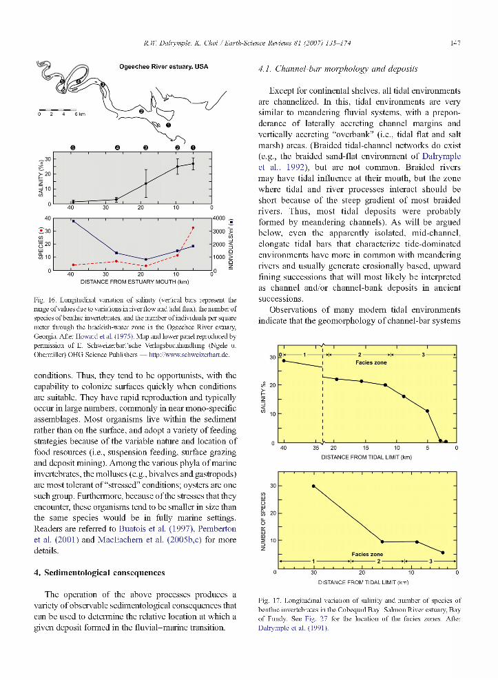
Fig. 16. Longitudinal variation of salinity (vertical bars represent the range of values due to variations in river flow and tidal flux), the number of species of benthic invertebrates, and the number of individuals per square meter through the brackish-water zone in the Ogeechee River estuary, Georgia. After Howard et al. (1975). Map and lower panel reproduced by permission of E. Schweizerbart’sche Verlagsbuchhandlung (Ngele u. Obermiller) OHG Science Publishers — http://www.schweizerbart.de.
conditions. Thus, they tend to be opportunists, with the capability to colonize surfaces quickly when conditions are suitable. They have rapid reproduction and typically occur in large numbers, commonly in near mono-specific assemblages. Most organisms live within the sediment rather than on the surface, and adopt a variety of feeding strategies because of the variable nature and location of food resoiuces (i.e., suspension feeding, surface grazing and deposit mining). Among the various phyla of marine invertebrates, the molluscs (e.g., bivalves and gastropods) are most tolerant of “stressed” conditions; oysters are one such group. Furthermore, because ofthe stresses that they encounter, these organisms tend to be smaller in size than the same species would be in fully marine settings. Readers are referred to Buatois et al. ( 1997), Pemberton et al. (2001) and MacEachem et al. (2005b,c) for more details.
4. Sedimentological consequences
The operation of the above processes produces a variety of observable sedimentological consequences that can be used to determine the relative location at which a given deposit formed in the fluvial-marine transition.
4.1. Channel-bar morphology and deposits
Except for continental shelves, all tidal environments are channelized. In this, tidal environments are very similar to meandering fluvial systems, with a preponderance of laterally accreting channel margins and vertically accreting “overbank” (i.e., tidal flat and salt marsh) areas. (Braided tidal-channel networks do exist (e.g., the braided sand-flat environment of Dalrymple et al., 1992), but are not common. Braided rivers may have tidal influence at their mouth, but the zone where tidal and river processes interact should be short because of the steep gradient of most braided rivers. Thus, most tidal deposits were probably formed by meandering channels). As will be argued below, even the apparently isolated, mid-channel, elongate tidal bars that characterize tide-dominated environments have more in common with meandering rivers and usually generate erosionally based, upward fining successions that will most likely be interpreted as channel and/or channel-bank deposits in ancient successions.
Observations of many modem tidal environments indicate that the geomorphology of channel-bar systems
Facies zone
20
_ j
S
40 35DISTANCE FROM TIDAL LIMIT (km)
coLjJ
Sm 20u_OcuLiim
Facies zone
0 30 20 10 0DISTANCE FROM TIDAL LIMIT (km)
Fig. 17. Longitudinal variation of salinity and number of species of benthic invertebrates in the Cobequid Bay-Salmon River estuary, Bay of Fundy. See Fig. 27 for the location of the facies zones. After Dalrymple et al. (1991).

148 R. W. Dalrymple, K. Choi / Earth-Science Reviews 81 (2007) 135-174
B SHELF < DELTA RIVER
low river „ flow
high river flow
ATID A LLIMIT
SALT
DISTRIBUTARY
PRODELTA MOUTH
ALLUVIAL PLAIN iTIDAL
BA RS
MUD FLATS
C
densityindividual d e j^
Fig. 18. (A) Schematic map facies map of a tide-dominated delta (sensu lato). (B) Longitudinal variation o f salinity through a tide-dominated delta. As in estuaries, the salinity gradient is displaced seaward when the river discharge is high, and landward when river discharge is low. In addition, there may be significant variation between the various distributary channels: “active” channels with high river discharge will contain water with lower salinity than “inactive” distributaries with minimal river input (cf. Wolanksi et al., 1997). The zone of brackish water is shown as being displaced seaward relative to that in estuaries (cf. Fig. 15), on the assumption that deltas have an overall greater river influence than estuaries. (C) Longitudinal variation of: the diversity (number of species) o f benthic invertebrate organisms, their size (i.e., the size o f the burrows) and the relative number of individuals per square meter. Trends based on general observations reported by Buatois et al. (1997), Pemberton et al. (2001) and MacEachem et al. (2005b). See text for more discussion.
(including channel width, channel curvature and the types of bars present) changes in a systematic manner through the fluvial-marine transition. The primary control on these changes is the predictable seaward increase in the flux of water through the channels.
The amount of river discharge increases down the fluvial system as a result of the addition of runoff from tributary drainage basins and local precipitation. However, in the fluvial-marine transition, it is the tidally generated water movements that exert the major control on the
0.5%o 5%o
River
— ► Residual circulation
£ Suspension fallout Low SSC High
Fig. 19. Formation o f a salt wedge, as shown by the inclined salinity contours (dashed lines) in the zone o f mixing between fresh water and seawater. The resulting, residual, density-driven circulation (outward flow in the surface layer; landward flow near the bed), coupled with the effects o f flocculation, leads to the trapping of fine-grained material near the tip o f the salt wedge and the development o f a turbidity maximum where suspended- sediment concentrations (SSCs) are elevated. SSC values may exceed 10 gL near the bed beneath the turbidity maximum, producing fluid-mud bodies in the bottoms o f the channels. After Dalrymple and Choi (2003 ). Reproduced with kind permission o f Springer Science and Business Media.

R. lí' Dalrymple, K. Choi / Earth-Science Reviews 81 (2007) 135-174 149
Diversity decreases as sa lin ity decreases, reaching a m inim um at 5%o
Brackish water species{Mixed Skolithos D e p a u p e ra te Cruziana Ichnofacies)
Marine species(D iverse T race Fossil A sse m b la g e s) Cruziana Ichnofacies)
Freshwater species(Mixed Freshw ater/T errestria l T race Fossil A sse m b la g e s)
0I I 01igo' I Mesohaline I Polyhaline i Euryhaline iI I haline I wiesonanne | (Brachyhallne) I (Euhallne) I0.5 %o 5 %o 18 %o 30 %o 40 %o
tFreshwater
Fig. 20. Classification o f salinity levels and variation o f species diversity through the freshwater to seawater transition. Note that brackish-water environments have low taxonomic diversity and are characterized by a mixed Skolithos—Cruziana ichnofacies. After Buatois et al. ( 1997). Courtesy o f SEPM (Society for Sedimentary Geology).
magnitude of the water flux. This tidal flux, which is termed the “tidal prism”, increases seaward as a result of the progressive increase in the area to be flooded and drained on each tide. Consequently, all channels with a strong tidal influence show a seaward increase in their cross-sectional area. In general, water depth does not increase significantly, so most of the increase in cross- sectional area is accomplished by a seaward increase in the width of each channel. Theoretical studies (Pillsbury, 1939; Myrick and Leopold, 1963) and morphological observations (e.g., Wright et al., 1973; Figs. 5 and 21) show that this seaward widening is exponential and is responsible for the classic “funnel-shaped” geometry of tide-dominated systems such as the Thames estuary and the Fly River delta. However, a similar funnel-shaped morphology typifies all tidal-flat and salt-marsh channels, even in microtidal and mesotidal areas (Figs. 1,5,22 and 23).
Almost all fluvial and tidal channels are curved (i.e., they display meander bends) to a greater or lesser degree. Two, inter-related factors appear to influence the tightness of the bends. Wide channels with a large discharge do not bend as tightly as narrow channels with a small discharge; therefore, the seaward parts of tide- influenced systems generally have much straighter channels than are found further landward. In addition, above some critical slope, steeper hydraulic gradients (i.e., steeper water-surface slopes), which are generally
associated with faster currents, produce straighter channels (Schumm and Khan, 1972). Thus, rivers tend to become more sinuous as one moves from steeper inland areas toward low-gradient coastal areas. Similarly, tidally influenced channels become more sinuous as the tidal current speeds decrease in a landward direction.
No quantitative data exist on these trends, but they are readily observable in satellite images and maps (Figs. 1, 22, 23, 24 and 25). Such observations also indicate that estuaries and deltas have somewhat different channel patterns. Within tide-dominated estuaries, the tightest meander bends universally occur at the location of the bedload convergence, producing the “straight”-mean- dering-“straighf ’ channel pattern (Fig. 9A) described by Dalrymple et al. (1992 ). Examples that show this pattem include the Cobequid Bay-Salmon River estuary (Bay of Fundy; Fig. 27), the Severn River estuary, the Thames estuary, and the Ord River estuary (Fig. 21 A), and the same pattem has been documented in a small tidal channel in the microtidal Venice lagoon (Solari et al., 2002, their Fig. 2 ). The tightly meandering zone appears to represent the site of the lowest hydraulic energy, located between the fluvially and tidally dominated parts of the estuary (Dalrymple et al., 1992). Within tide- dominated deltas, the radius of curvature is never as tight as that seen in the tightly meandering portion of estuaries and the “straight’’-meandering-“straight” channel pattern does not occur. Instead, the channels become

150 R. W. Dalrymple, K. Choi / Earth-Science Reviews 81 (2007) 135-174
Fig. 21. Six examples of coastal systems that display a fimnel-shaped geometry (i.e., the width increases exponentially with distance seaward): (A) Ord River, Australia; (B) Khor Abdullah, Iraq; (C) Irrawaddy River, Myanmar (Burma); (D) Hoogly River, India; (E) Cua Soirap, Vietnam; (F) Fly River, Papua New Guinea. Note that in most of the systems, the sinuosity o f the channel increases as it becomes narrower. (A-E) Modified after Wright et al. (1973) and reproduced with permission of the University o f Chicago Press.
progressively less sinuous from the river toward the sea (Fig. 11A; Dalrymple et al., 2003). Examples that show this pattern include the Fly River delta (Fig. 2IF), the Colorado River delta (Fig. 25), the Yangtze River delta (Fig. 26), the Ganges-Brahmaputra River delta, and the Amazon River delta.
The longitudinal changes in channel width and curvature have a strong influence on the nature of the bars that are developed. In the relatively narrow and more sinuous channels that characterize the inland parts of tidal systems, the bars are bank-attached point bars or alternate bars (cf. Barwis, 1978) with no separation of the flow into mutually evasive flood-and ebb-dominated channels (Van den Berg et al., in press). By contrast, at the seaward end of the system where the channels are wide and relatively straight, elongate tidal bars (also called tidal sand ridges or tidal sand banks in shelf areas ) are the main within-channel morphological elements, occurring also in the distributary-mouth-bar area of
deltas. See Dalrymple and Rhodes (1995 ) for additional discussion of barforms in tidal environments.
The transition between these two end-member bar types occurs gradually as the channel widens and straightens. In landward areas where the flow is overall ebb dominated, the downstream asymmetry that typifies meander bends in rivers (cf. Fagherazzi et al., 2004) causes the downstream portion of the point bar to be sheltered from the ebb tide, but to experience the frill force of the flood tide. As a result, a flood barb (a headward- terminating, “blind” flood channel; Robinson, 1960 ) may be developed, that is separated from the main ebb channel by a short, elongate tidal bar (Fig. 26A). As one moves seaward into areas with straighter channels, the elongate tidal bars become longer, but remain attached to one or other of the channel banks (Fig. 26B). The channel-bar morphology in Cobequid Bay, Bay of Fundy, has this fundamental morphology (Fig. 27; Dalrymple et al., 1991). However, once the channel width exceeds
R. W. Dalrymple, K. Choi / Earth-Science Reviews 81 (2007) 135-174 151
30 hm
Fig. 22. Satellite image of the Irrawaddy River delta, Myanmar (spring tidal range 2 m). The active distributary lies in the upper left comer whereas the remainder of area is “inactive” delta plain; compare with Fig. 1. Note that the channels become progressively narrower and more sinuous in a landward direction. For more information on this system, see Rodolfo (1975) and Woodroffe (2000). Courtesy of NASA.
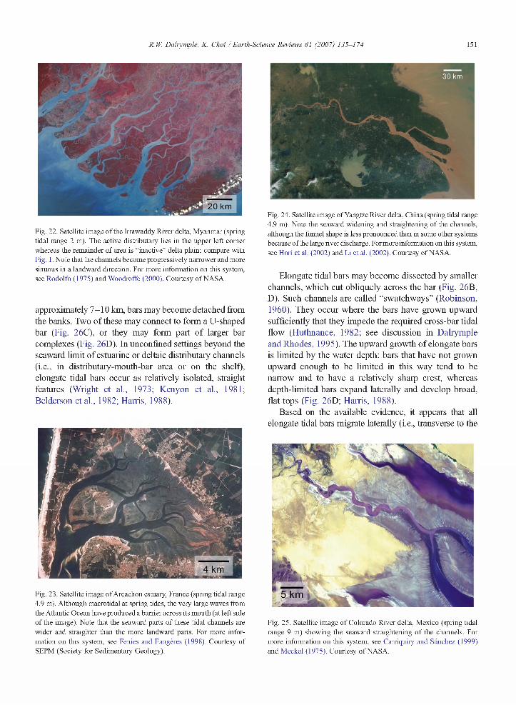
approximately 7-10 km, bars may become detached from the banks. Two of these may connect to form a U-shaped bar (Fig. 26C), or they may form part of larger bar complexes (Fig. 26D). In unconfined settings beyond the seaward limit of estuarine or deltaic distributary channels (i.e., in distributary-mouth-bar area or on the shelf), elongate tidal bars occur as relatively isolated, straight features (Wright et al., 1973; Kenyon et al., 1981; Belderson et al., 1982; Harris, 1988).
Fig. 24. Satellite image of Yangtze River delta, China (spring tidal range 4.9 m). Note the seaward widening and straightening of the channels, although the funnel shape is less pronounced than in some other systems because o f the large river discharge. For more information on this system, see Hori et al. (2002) and Li et al. (2002). Courtesy of NASA.
Elongate tidal bars may become dissected by smaller channels, which cut obliquely across the bar (Fig. 26B, D). Such channels are called “swatchways” (Robinson, 1960). They occur where the bars have grown upward sufficiently that they impede the required cross-bar tidal flow (Huthnance, 1982; see discussion in Dalrymple and Rhodes, 1995 ). The upward growth of elongate bars is limited by the water depth: bars that have not grown upward enough to be limited in this way tend to be narrow and to have a relatively sharp crest, whereas depth-limited bars expand laterally and develop broad, flat tops (Fig. 26D; Harris, 1988).
Based on the available evidence, it appears that all elongate tidal bars migrate laterally (i.e., transverse to the
Fig. 23. Satellite image of Arcachon estuary, France (spring tidal range 4.9 m). Although macrotidal at spring tides, the very large waves from the Atlantic Ocean have produced a barrier across its mouth (at left side of the image). Note that the seaward parts of these tidal channels are wider and straighter than the more landward parts. For more information on this system, see Fenies and Faugères (1998). Courtesy of SEPM (Society for Sedimentary Geology).
Fig. 25. Satellite image of Colorado River delta, Mexico (spring tidal range 9 m) showing the seaward straightening of the channels. For more information on this system, see Carriquiry and Sánchez (1999) and Meckel (1975). Courtesy of NASA.
152 R. W. Dalrymple, K. Choi / Earth-Science Reviews 81 (2007) 135-174
2 km
K IW A
Okm
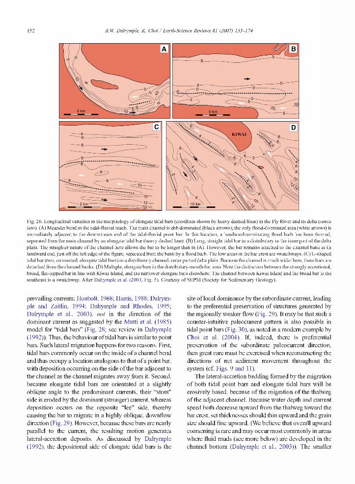
Fig. 26. Longitudinal variation in the morphology of elongate tidal bars (crestlines shown by heavy dashed lines) in the Fly River and its delta (sensu lato). (A) Meander bend in the tidal-fluvial reach. The main channel is ebb dominated (black arrows); the only flood-dominated area (white arrows) is immediately adjacent to the downstream end of the tidal-fluvial point bar. In this location, a headward-terminating flood barb has been formed, separated from the main channel by an elongate tidal bar (heavy dashed line). (B) Long, straight tidal bar in a distributary in the inner part of the delta plain. The straighter nature o f the channel here allows the bar to be longer than in (A). However, the bar remains attached to the channel bank at its landward end, just off the left edge of the figure, separated from the bank by a flood barb. The low areas in the bar crest are swatchway s. (C) U-shaped tidal bar (two, connected, elongate tidal bars) in a distributary channel, outer part o f delta plain. Because the channel is much wider here, these bars are detached from the channel banks. (D) Multiple, elongate bars in the distributary-mouth-bar area. Note the distinction between the strongly accretional, broad, flat-topped bar in line with Kiwai Island, and the narrower elongate bars elsewhere. The channel between Kiwai Island and the broad bar to the southeast is a swatchway. After Dalrymple et al. (2003, Fig. 5). Courtesy of SEPM (Society for Sedimentary Geology).
prevailing currents; Houbolt, 1968; Harris, 1988; Dalrymple and Zaitlin, 1994; Dalrymple and Rhodes, 1995; Dalrymple et al., 2003), not in the direction of the dominant current as suggested by the Mutti et al. (1985) model for “tidal bars” (Fig. 28; see review in Dalrymple ( 1992)). Thus, the behaviour of tidal bars is similar to point bars. Such lateral migration happens for two reasons. First, tidal bars commonly occur on the inside of a channel bend and thus occupy a location analogous to that of a point bar, with deposition occurring on the side of the bar adjacent to the channel as the channel migrates away from it. Second, because elongate tidal bars are orientated at a slightly oblique angle to the predominant currents, their “stoss” side is eroded by the dominant (stronger) current, whereas deposition occurs on the opposite “lee” side, thereby causing the bar to migrate in a highly oblique, downflow direction (Fig. 29). However, because these bars are nearly parallel to the current, the resulting motion generates lateral-accretion deposits. As discussed by Dalrymple (1992), the depositional side of elongate tidal bars is the
site of local dominance by the subordinate current, leading to the preferential preservation of structures generated by the regionally weaker flow (Fig. 29). It may be that such a counter-intuitive paleocurrent pattem is also possible in tidal point bars (Fig. 30), as noted in a modem example by Choi et al. (2004). If, indeed, there is preferential preservation of the subordinate paleocurrent direction, then great care must be exercised when reconstructing the directions of net sediment movement throughout the system (cf. Figs. 9 and 11).
The lateral-accretion bedding formed by the migration of both tidal point bars and elongate tidal bars will be erosively based, because of the migration of the thalweg of the adjacent channel. Because water depth and crurent speed both decrease upward from the thalweg toward the bar crest, set thicknesses should thin upward and the grain size should fine upward. (We believe that overall upward coarsening is rare and may occru most commonly in areas where fluid muds (see more below) are developed in the channel bottom (Dalrymple et al., 2003)). The smaller

Facies Zones
Q uebec Gulf o f St. Lawrence
NewBrunswick
AtlanticOceanErosional
ForeshoreElongate Sand bars
Mixed Flats and Mudflats Salt MarshSand Flats
68" 66" 64" 62“ 60'W
Fig. 27. Facies distribution in the Cobequid Bay-Salm on River macrotidal estuary. Bay o f Fundy (maximum spring tidal range 16.3 m). Facies zone 1, elongate sand bars (medium to coarse sand); zone 2, upper-flow-regime sand flats (fine sand); and zone 3, tidal-fluvial transition. The elongate sand bars in the outer part o f the estuary occur in two rows (termed “bar chains" by Dalrymple et al., 1991; red dashed lines) that attach to the shorelines at their landward ends. These bar chains are dissected into smaller, individual bars by swatchways. The erosional foreshores bordering zone 1 are not unique to Cobequid Bay and also occur in the Severn estuary (Allen, 1987). After Dalrymple et al. (1991).
UlU l
R.W. D
alrymple, K. Choi /Earth-Science
Reviews 81
(2007) 135-174
154 R. W. Dalrymple, K. Choi / Earth-Science Reviews 81 (2007) 135-174
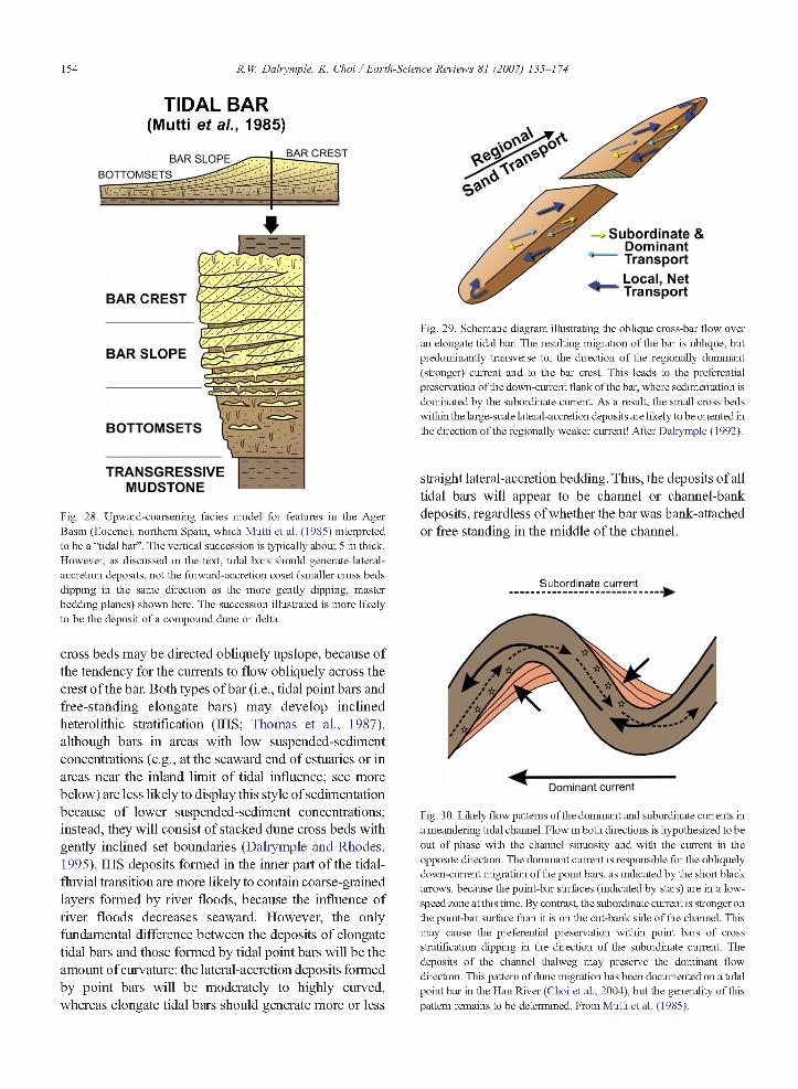
TIDAL BAR(Mutti et al., 1985)
BAR CRESTBAR SLOPEBOTTOM SETS
BAR CR EST
BAR SLO PE
BOTTOMSETS
—— IT
TRANSGRESSIVEMUDSTONE
Fig. 28. Upward-coarsening facies model for features in the Ager Basin (Eocene), northern Spain, which Mutti et al. (1985) interpreted to be a “tidal bar”. The vertical succession is typically about 5 m thick. However, as discussed in the text, tidal bars should generate lateral- accretion deposits, not the forward-accretion coset (smaller cross beds dipping in the same direction as the more gently dipping, master bedding planes) shown here. The succession illustrated is more likely to be the deposit of a compound dune or delta.
cross beds may be directed obliquely upslope, because of the tendency for the currents to flow obliquely across the crest ofthe bar. Both types of bar (i.e., tidal point bars and free-standing elongate bars) may develop inclined heterolithic stratification (IHS; Thomas et al., 1987), although bars in areas with low suspended-sediment concentrations (e.g., at the seaward end of estuaries or in areas near the inland limit of tidal influence; see more below) are less likely to display this style of sedimentation because of lower suspended-sediment concentrations; instead, they will consist of stacked dime cross beds with gently inclined set boundaries (Dalrymple and Rhodes,1995). IHS deposits formed in the inner part ofthe tidal- fluvial transition are more likely to contain coarse-grained layers formed by river floods, because the influence of river floods decreases seaward. However, the only fundamental difference between the deposits of elongate tidal bars and those formed by tidal point bars will be the amount ofcurvature: the lateral-accretion deposits formed by point bars will be moderately to highly curved, whereas elongate tidal bars should generate more or less
S u b o rd in a te & D o m in a n t T ra n sp o r t
__ Local, Net “ T ra n sp o r t
Fig. 29. Schematic diagram illustrating the oblique cross-bar flow over an elongate tidal bar. The resulting migration of the bar is oblique, but predominantly transverse to, the direction of the regionally dominant (stronger) current and to the bar crest. This leads to the preferential preservation of the down-current flank of the bar, where sedimentation is dominated by the subordinate current. As a result, the small cross beds within the large-scale lateral-accretion deposits are likely to be oriented in the direction ofthe regionally weaker current! After Dalrymple (1992).
straight lateral-accretion bedding. Thus, the deposits of all tidal bars will appear to be channel or channel-bank deposits, regardless of whether the bar was bank-attached or free standing in the middle of the channel.
Subordinate current
Dominant current
Fig. 30. Likely flow patterns of the dominant and subordinate currents in a meandering tidal channel. Flow in both directions is hypothesized to be out of phase with the channel sinuosity and with the current in the opposite direction. The dominant current is responsible for the obliquely down-current migration of the point bars, as indicated by the short black arrows, because the point-bar surfaces (indicated by stars) are in a low- speed zone at this time. By contrast, the subordinate current is stronger on the point-bar surface than it is on the cut-bank side of the channel. This may cause the preferential preservation within point bars of cross stratification dipping in the direction of the subordinate current. The deposits o f the channel thalweg may preserve the dominant flow direction. This pattern of dune migration has been documented on a tidal point bar in the Han Riva: (Choi et al., 2004), but the generality o f this pattern remains to be determined. From Mutti et al. (1985).

R. lí' Dalrymple, K. Choi / Earth-Science Reviews 81 (2007) 135-174 155
1 m
Ebb (dominant)
Fig. 31. Internal structures of a small compound dune. In this example, the master bedding planes dip in the ebb direction, at angles generally less titan 15°. Most of tile angle-of-repose cross bed at the top will be eroded when the next superimposed dune arrives at the brink. Note the abundance of herringbone cross-stratification, r = reactivation surface formed by the last flood ( subordinate) tide. This is a complex variant of the idealized structure shown in Fig. 32D: the added complexity is caused by the selective preservation of subordinate-current dunes because of the strongly depositional nature of foe lee face of the compound dune. After Dalrymple ( 1984).
4.2. Cross-bedding styles and paleoflow indicators
The detailed characteristics of the cross stratification produced by the ripples and dunes on the channel floor and banks will reflect the longitudinal variations in the time-velocity characteristics of the combined river and tidal currents (Fig. 14), whereas their orientation indicates the direction of residual sand transport at the site in question. As a result, cross stratification provides a powerful means to reconstruct the nature of the current regime and, hence, to determine where within a system the deposits in question may have formed.
In the truly fluvial portion of river, above limit of tidal influence (Fig. 14A), all of the ripples and dunes migrate seaward and paleocurrents are unidirectional toward the sea, with a degree of dispersion of orientation that reflects the sinuosity of the fluvial channel (Collinson, 1971).
As one moves seaward into the region that experiences weak tidal modulation of river flow (Fig. 14B ), indicators oftidal action may not be evident because the flowremains unidirectional. The regular variations in current speed that occiu in this region may be expressed as regular variations in the grain size of adjacent laminae: medium to coarse sand in the laminae deposited by the stronger currents; finer sand in the laminae deposited by the slower currents (Piret Plink-Björklund, pers. comm., 2003). While such a regular alternation of grain sizes might be caused by tidal velocity variations, similar structures can be formed by the periodic arrival of superimposed ripples at the dune’s brink (cf. McCabe and Jones, 1977). In order to interpret confidently such coarse-fine alternations as tidal, it would be necessary to document the existence of tidal rhythmicity (i.e., tidal bundling) in the form of thick-thin alternations (due to the diumal inequality) and/or neap-spring changes in lamina thickness (cf. Dalrymple, 1992; see De Boer et al. (1989) for a method of assessing the statistical significance of possible tidal-rhythmite series ).
Still further seaward, as the strength of the tidal currents increases, the appearance of slack-water periods (Fig. 14C, D) provides the first opportunity for the deposition of mud drapes within cross beds and/or between sets of ripple cross lamination. The relatively low suspended-sediment concentration (SSC) that occurs in this region (see more below) causes these drapes to be quite thin (perhaps less than 1 mm). The drapes may also be relatively silty and/or rich in terrestrial organic material or mica (Van den Berg et al., in press). The mud drapes in the tidal-fluvial transition zone may be single (Fig. 14C ) or double (Fig. 14D ), depending on whether there are one or two slack-water periods, the latter occurring further seaward than the former. The development of these mud drapes may also be influenced by the seasonal variation in river discharge that affects this area: during high river flow, the turbidity maximum (see below) will be pushed further seaward, thereby inhibiting the accumulation of mud drapes, whereas mud drapes may be formed more readily during periods of low river discharge when peak current speeds are less (cf. Lettley et al., 2005). (Mud drapes may also be present in the purely fluvial section up river, but they would have formed during season-long periods of low river flow and would probably be thicker and/or more composite in character than the drapes formed during a single, tidal slack-water period that lasts only a few tens of minutes (Smith, 1987; Thomas et al., 1987; Shanley et al., 1992; Lanier et al., 1993)).
Indicators of current reversals (cf. Fig. 14D-F ) should begin to appear slightly further seaward than evidence of slack-water periods. The first evidence of such reversals might be landward-directed current ripples that are generated by the weak flood currents that would occur just seaward of the limit of flow reversals. (Note: One must be careful not to mistake the counter-current ripples formed by the flow-separation vortex in the troughs of dunes for those formed by the flood-tidal currents. The latter ripples may climb high up the dune’s lee face (Van

156 R. W. Dalrymple, K. Choi / Earth-Science Reviews 81 (2007) 135-174
den Berg et al., in press) rather than being restricted to the lower parts of the cross beds as counter-current ripples are.) Reactivation surfaces caused by tidal-flow reversals
(Klein, 1970; De Mowbray and Visser, 1984) should also appear first in this same zone. (Note: Reactivation surfaces can also be formed by river-stage variations

R. W. Dalrymple, K. Choi / Earth-Science Reviews 81 (2007) 135-174 157
(Collinson, 1970) and erosion of a bedform’s brink by the arrival of a superimposed bedform (McCabe and Jones, 1977; Dalrymple, 1984). Distinguishing these from those formed by tidal-flow reversals may be difficult. The presence of rhythmic tidal bundling (Visser, 1980; De Boer et al., 1989) should be demonstrated before a tidal origin is inferred).
All reverse-flow indicators should become progressively more common as the flood-tidal currents become stronger in the more seaward parts of estuaries and deltas (Fig. 14). However, the development of mutually evasive channels, in which each channel is dominated by either the ebb or flood current, means that bi-directional (herringbone) cross-bedding is not likely to be abundant. The two localities where herringbone cross-bedding has the greatest potential to occur are (1) at the Crestline of elongate tidal bars, because this separates mutually evasive tidal channels and thus experiences ebb and flood tidal currents of equal strength, and (2 ) within the deposits of compound dunes (Figs. 31 and 32 ), because the small dunes formed on the lee face of the larger dune by the local, subordinate current have a high preservation potential, due to burial during the ensuing dominant current (cf. Dalrymple, 1984). Van den Berg et al. (in press) have suggested that herringbone crossbedding may be more common in the inner-most part of the fluvial-marine transition than in areas further seaward because mutually evasive tidal channels are not as pronounced near the limit of tidal influence.
Dune cross bedding may occur almost anywhere along the length of a tidal-dominated estuary or delta, providing the sand grain size is appropriate (i.e., coarser than approximately 0.15 mm; Southard and Boguchwal, 1990). Ron Steel (pers. comm., 2003) has suggested that tidal cross-bedding appears more “regular” than, and lacks the deep scouring at set bases that characterises the crossbedding in fluvial deposits. In other words, tidal crossbedding tends to be more planar-tabular, and to have vertically adjacent sets of more similar size, than fluvial cross-bedding. There are two possible reasons for this difference. (F) Dalrymple and Rhodes (1995) noted that tidal dunes (and even 3D tidal dunes) tend to be more two dimensional, in general, than fluvial dunes, because the scour pits are not as pronounced. It is hypothesized that this occius because the dunes do not develop fully
because the currents reverse too frequently. (2) The processes responsible for the formation of tidal dunes are extremely regular (i.e., the speed ofthe tidal currents and the effective water depths vary only within a relatively small range), so there is a high probability that adjacent dunes will have similar characteristics and that the dimes will not vary markedly in size or shape over time. By contrast, river floods are commonly highly variable in magnitude, leading to the development of very different bedforms during each flood.
Compound dunes (Ashley, 1990) are relatively common in tidal environments, especially in areas with water depths greater than approximately 8-10 m. The deposits of compound dunes (formerly called “sandwaves”) should have the following featiues (cf. Allen, 1980; Dalrymple, 1984; Dalrymple and Rhodes, 1995; Figs. 31 and 32):
(1) begin from an erosion siuface in all but the rarest of cases;
(2) consist of compound cross stratification in which the smaller sets dip in the same direction as the low- angle master bedding planes (which typically have dips of <10°) (i.e., the deposits show “forward accretion”, not lateral accretion as occius in the deposits of tidal bars);
(3 ) upward coarsening of the size of the sand;(4) upward decrease in the abundance of mud drapes
and biotiubation, if present;(5) upward increase of set thickness; and(6) upward increase in the energy levels as indicated by
the nature of the cross stratification (i.e., an upward transition from ripples into planar-tabular crossbedding (=2D dimes), or from planar-tabular crossbedding up into trough cross-bedding (= 3D dunes)).
The latter foiu features occiu because the current strength is less in the trough of the compoimd dime than it is at the crest. The thickness of the cosets produced by individual compoimd dimes may range from < lm to > 1 0 m . See the section below on water-depth indicators for further discussion.
It might be noted that this description is very similar to what is shown in the model of a “tidal bar” (Fig. 28 )
Fig. 32. Theoretical models of the structures within tidal bedforms: (A) a simple dune (sensu Ashley, 1990); (B-E) “sandwaves” (= compound dunes) as proposed by Allen (1980). M = mud drape; B = bioturbation. “E” refers to a hierarchy of erosion surfaces. E2 surfaces are the “master bedding places” that are most likely produced by the migration of the troughs of the superimposed dunes (Dalrymple, 1984), not by current reversals as suggested by Allen (1980). Although not stated in the original paper, these structural models are probably based on real examples in the Lower Greensand, southern England. However, the details of the structures shown in (E) and (F) are unrealistic (cf. Dalrymple, 1984; Dalrymple and Rhodes, 1995): the superimposed dunes are shown here as nucleating in situ on the lee side as the dominant current is re-established following a period of subordinate current that erodes the lee side of the large dune. Instead, many field observations show that the superimposed dunes survive for many tidal cycles and migrate down the lee face, rather than being reborn during each dominant tide (as is implied in parts (E) and (F)).

158 R. W. Dalrymple, K. Choi / Earth-Science Reviews 81 (2007) 135-174
as proposed by Mutti et al. (1985; see also Dalrymple, 1992 ). For this reason, the features on which the Mutti et al. model is based are more likely to be compoimd dunes than elongate tidal bars.
4.3. Sand-size distributions
The grain size of the gravel and/or sand fraction (i.e., the bedload material) of a river or tidal system tends to become finer in the direction of (net) transport for three reasons (cf. McLaren and Bowles, 1985). (1) There is a tendency for the energy level to decrease in the direction of transport. As a result, the coarsest fraction of the sediment load is deposited as the flow becomes too weak to transport it further. This process, which is termed “competence-driven deposition”, is most important in situations where the bedload material contains a wide range of grain sizes, but does not operate in situations where only a narrow range of relatively fine-grained sand is in transport. (2) A decrease in energy level also decreases the “capacity” ofthe flow (i.e., the amount of sediment that can be carried). Thus, if the flow is “at capacity” and the energy level decreases, sediment must be deposited, regardless of the actual energy level and the grain size of the sediment. Therefore, even upper-flow- regime currents can deposit medium, fine, or even very fine sand. In the process, there will be a tendency for preferential deposition ofthe coarser fractions. (3) During deposition, the coarser size fraction preferentially comes to rest at lower topographic elevations, such as at the base of channels or at the toe of the avalanche face on dimes. Because of this, the coarser fraction tends to escape erosion by later events and thus remains as a deposit while the finer fraction moves further down the transport path.
These factors, operating in the context ofthe patterns of net sediment transport shown in Figs. 9 and 11, produce predictable, but different, longitudinal changes in the grain size of the sand fraction within estuaries and deltas (Figs. 9C, 11C). (Note that the following generalizations apply to the average grain size within any one channel. Small-scale local variability, such as occurs vertically on channel banks, is not considered here). Deltas have the simplest pattem (Fig. 11C ), with a progressive decrease in sand size from inland, proximal locations, to distal sites in the mouth-bar region. Estuaries, on the other hand, commonly display a seaward-fining trend in the inner, fluvially dominated portion, and a landward-fining trend in their seaward part, where net landward-directed transport occurs (Fig. 9C). Thus, the finest grain sizes occur at the bedload convergence (Fig. 33). (Note that the development of the landward-fining trend depends on there being a source of relatively coarse sand at the mouth
ofthe estuary. This is commonly the case in incised-valley systems, in which preceding falling-stage and lowstand deposits that are more likely to be coarse grained may be reworked during transgressive ravinement. However, in the case of abandoned-delta-plain estuaries, the sand source is reworked distributary-mouth-bar material, which may be relatively fine grained).
Mud pebbles are a common constituent of channel- bottom deposits in many tide-dominated and tide- influenced sedimentary environments, because of the abundance of slack-water drapes and muddy tidal-flat and salt-marsh deposits. The abundance of mud pebbles is likely to be highest in the middle reach of estuaries and in the delta-plain environment (i.e., in those portions of estuaries and deltas where the SSCs are highest; see more in the next section).
4.4. Suspended-sediment concentrations and mud-drape abundance
As the fine-grained sediment (suspended silt and claysized particles) being carried by the river enters the brackish-water area (Figs. 15 and 18), they begin to form loose aggregates called floes (Nichols and Biggs, 1985; Burban et al., 1989; Dyer, 1995) in response to the electrical attraction between the ions in water and the unsatisfied bonds at the edges ofthe crystal lattices, and to the binding action of complex organic molecules. Some degree of flocculation may occur in the river water as a result of dissolved organic material, but flocculation occurs most noticeably where the salinity is in the range of 1—10%o. Floe size is limited by turbulent shear stresses, which tend to rip the loose aggregates apart, but the net result is an overall increase in the size and settling velocity of the fine-grained material. This in turn promotes deposition of the slit- and clay-size sediment in the fluvial-marine transition zone. The formation of faecal pellets by organisms also contributes to this process.
The deposition ofthe suspended material is enhanced by three hydrodynamic processes that operate in both deltas and estuaries, and act to trap the fine-grained material and limit its export to the sea (Dyer, 1995, 1997; Dalrymple and Choi, 2003 ). (1) In many estuaries and deltas, the lighter fresh water rides over a landward- tapering wedge of saltier water (Fig. 19). Landward- directed, near-bed flow in the salt wedge carries fine material into the estuary or delta, once this sediment settles down from the river-supplied surface layer. Export of fine-grained sediment to the sea occurs primarily at those times where high river discharge pushes the salt wedge out ofthe estuary or delta; at other times, the silt and clay is mostly trapped landward of

R. W. Dalrymple, K. Choi / Earth-Science Reviews 81 (2007) 135-174 159
FLUVIAL - SAND
MARINESAND
5 2.0
2 3.0
DISTANCE FROM TIDAL LIMIT (km)
■1
0 MARINESAND
FLUVIALSAND
1
2
3-20 0 20 40 60 80 100
DISTANCE FROM ESTUARY MOUTH (km)
INLET I FUNNEL I FLUVIALI I CHANNEL
Fig. 33. Longitudinal variation of the grain size of the sands in: (A) the Cobequid Bay-Salmon River estuary, Bay of Fundy (after Zaitlin, 1987; Dalrymple et al., 1991); and (B) the Gironde estuary, France (after Allen, 1991). Note that the finest grain size occurs at the site of the bedload convergence (BLC), as determined by hydrodynamic and morphologic evidence. See Fig. 27 for the location of the facies zones in the Cobequid Bay-Salmon River estuary; zone 4 =the purely fluvial portion of the Salmon River. The river is to the right and the sea to the left in both figures.
the coast. (2) The tendency for the development of landward-directed, residual tidal flow (Figs. 9B, 11B, 13 and 14) in the seaward part of estuaries and deltas also tends to carry suspended sediment landward. (3) Settling lag (the time taken for suspended sediment to reach the bed after the current speed drops below the level needed to maintain it in suspension) and scour lag (a result of the fact that suspended sediment is deposited at lower speeds than are required to erode it) cause the preferential landward movement of fine-grained material because of the landward decrease in tidal- current speeds (Straaten and Kuenen, 1958; see also Nichols and Biggs, 1985; Dyer, 1995; Dalrymple and Choi, 2003).
These processes, acting together in the context of alternating deposition and resuspension of fine material by tidal currents, generate a zone of elevated suspended- sediment concentrations (SSCs) within the area stretching from near the landward limit of tidal water excursions (i.e., between the locations represented by Fig. 14C and D) to a poorly defined location within the zone occupied by the salinity gradient (i.e., to a point where the salinity is ca. 20%o; Nichols and Biggs, 1985; Dyer, 1997; Lettley
et al., 2005). This zone of elevated SSCs is called the “turbidity maximum” (Figs. 9C and 11C ) and occurs regardless of whether the fine-grained sediment is supplied by the river, as is the case in most estuaries and deltas, or is carried into the estuary from the sea. Examples of the latter include : the Cobequid Bay-Salmon River and Severn River estuaries where the suspended sediment comes from erosion of older material by ravinement processes (Allen, 1987; Dalrymple et al., 1990), and the Hangzhou Estuary, China, which lies immediately to the south of, and receives large quantities of mud from, the Yangtze River (Zhang and Li, 1996). In the turbidity maximum, which occupies the middle part of estuaries and the channels on the delta plain, SSCs may be anywhere from a few times to several orders of magnitude higher than in the river or out on the shelf (Dyer, 1995 ).
In a growing number of documented cases, the SSCs in the turbidity maximum are sufficiently high that “fluid muds” are generated. (Fluid mud is defined as any aqueous suspension in which the concentration of particles exceeds 10 gm/1 (Faas, 1991). The characteristics of fluid mud are not well known, but they have rheological properties intermediate between dirty water and a stationary, deposited mud layer. They have some strength, but can be set in motion by the drag of the overlying moving water). When the tidal currents are strong, the suspended sediment tends to be dispersed through the water column. However, when the currents slacken, the mud settles to the bed, creating a near-bed layer of elevated concentrations that may become a fluid mud. While this dense suspension is stationary, the basal part may consolidate sufficiently to escape erosion when the tidal currents accelerate again. In some systems, fluid muds appear to be most common during and shortly after spring tides (e.g., Wolanski et al., 1995; Harris et al., 2004), because the strong tidal currents at this time resuspend large amounts of mud; during neap tides, by contrast, there is insufficient mud in suspension to develop fluid muds at slack water. It is possible, however, that in other systems fluid muds occur at a different stage of the neap spring cycle.
The abundance and thickness of mud layers, and especially of layers deposited during a single slack-water period (cf. Fig. 14) are directly related to the longitudinal variation in SSCs (Figs. 9C and 11C). In the innermost part of the fluvial-tidal transition, SSCs are low and the mud drapes are thin. In the extreme case, they may be represented only by indistinct laminae in which there is a small amount of infiltrated silt and/or clay. Terrestrial organic detritus and/or mica may be an important constituent of the drapes in this area. As one moves further seaward, however, the mud drapes become thicker

160 R. W. Dalrymple, K. Choi / Earth-Science Reviews 81 (2007) 135-174
BOTTOM
Fig. 34. Muddy, heterolithic deposits from distributary channels o f the Fly River delta, from Dalrymple et al. (2003). (A) Thick, structureless mud layers (light material) from the bottom of an active channel, which were deposited by bottom-hugging fluid muds. It is important to note that these mud layers do not contain sharply defined silt or sand partings: this indicates that they are not the product o f multiple slack-water periods such as might occur during neap tides. The sand between the mud layers is the coarsest sand that occurs in the delta, which is consistent with the channel- bottom location in which these deposits accumulated. (B) Thin mud layers from the intertidal zone, interbedded with sand that is much finer than that in (A). These mud layers are thin because the suspended-sediment concentration at the level of the intertidal zone is much less than that in channel- bottom locations. Note the presence of rooting and burrows in (B). Courtesy of SEPM (Society for Sedimentary Geology).
and more abundant, because of the increasing concentration of suspended material; the greatest thickness and abundance of drapes will occur beneath the peak of the turbidity maximum. The fluid-mud bodies that may occur beneath the turbidity maximum can produce abnormally thick mud layers (cf. McCave, 1970). For example, in the Fly River (Dalrymple et al., 2003) and Amazon River deltas (Jaeger and Nittrouer, 1995; Kuehl et al., 1996), mud layers ranging in thickness from about 1 cm to as much as 10 cm (or locally even more) have been attributed to deposition from fluid muds (Fig. 34). Such layers are internally structureless and may contain disseminated terrestrial organic material. Importantly, they lack internal silt or sand partings that would indicate that they are composite layers that accumulated over a time period longer than a single slack-water period. Indeed, great care
should be taken to ascertain that a thick mud layer is a single depositional event before ascribing its deposition to fluid mud.
If fluid-mud deposits are present in a system, they will occur in the topographically low areas such as channel bottoms because the fluid mud is a dense suspension that hugs the bottom. The channel successions produced in these cases have the potential to become sandier upward (Dalrymple et al., 2003 ). In such situations, the channel- bottom facies will contain the thickest mud layers, separated by the coarsest sand in the channel succession. The largest cross beds will occiu in this facies, if the sand is coarse enough to form dunes. At higher elevations, the mud layers become thinner (compare Fig. 34A, B) and the proportion of sand increases, even though the sand size decreases. The greatest sand content appears to

R. W. Dalrymple, K. Choi / Earth-Science Reviews 81 (2007) 135-174 161
occur near the mid-depth of the channel. Above this level, the sediments become muddier again, because of the inability of the currents to carry sand onto the shallow tidal flats. This topic will be discussed in more detail in the “Water Depth” section.
Seaward of the turbidity maximum, SSCs decrease and individual slack-water drapes should become thinner. Because deltas experience a relatively stronger influence of river flow than estuaries, especially in their seaward part (compare Figs. 9B and 1 IB), the turbidity maximum tends to be displaced further seaward, and the suspended-sediment values may decrease more slowly, than in estuaries. This means that the seaward part of deltas is muddy (i.e., the prodelta region), not only because of the availability of mud in suspension, but also because sand is not transported to this area. Overall, therefore, deltas contain two areas with a high proportion of mud (Fig. llC-bulk grain-size curve ), the prodelta area, which is muddy because of the absence of sand, and the delta-plain area, because of the high SSCs that occur there. Between these areas, the deposits of the distributary-mouth bars are relatively sandy, mainly because wave action in this area (cf. Fig. 1 IB) inhibits mud deposition and/or resuspends any mud that may be deposited in shallow water (Dalrymple et al., 2003 ).
The seaward part of estuaries is generally mud free (Fig. 9C— see the coarse bulk grain size in the estuary mouth area), except in situations where (1 ) the estuary is nearly frill and is in the process of converting to a delta, or (2 ) mud is supplied from sediment-exporting systems nearby (e.g., the Hangzhou estuary, which is supplied with mud from the updrift Yangtze River; Zhang and Li, 1996). As a result, the estuary-mouth sand body, and the
erosional lag that occurs seaward of it, typically has only very thin drapes, or lacks them altogether (Fig. 35). The muddiest portion of estuaries lies at or near the location of the bedload convergence (Fig. 9C— see the bulk grain-size curve).
As mentioned in the previous section, mud pebbles are a prominent constituent of channel deposits in the vicinity of the turbidity maximum (i.e., in channels on the delta plain, or in the middle portion of estuaries; Figs. 9C and 11C). This is so because: (1) the high suspended-sediment concentration permits the deposition of relatively thick mud drapes; (2 ) the currents are sufficiently strong during peak ebb and flood flow to re- erode these drapes; and (3) muddy tidal flats and salt marshes may be eroded by lateral migration of the channels. Such pebbles tend to be somewhat tabular in shape, with their shortest dimension approximately equal to the thickness of the mud layer from which they were derived. They tend to have rounded outlines because the mud is commonly still soft. This may also lead to them becoming further flattened during compaction and/or to being penetrated by the adjacent sand grains. These features, combined with their stratigraphie setting within channel deposits, should enable them to be distinguished from platy mud clasts derived by the desiccation and breakage of thin mud drapes in the intertidal zone.
4.5. Biological characteristics
Because of the many stresses that exist in the fluvial- marine transition in both estuaries and deltas, including the widespread occurrence of brackish-water conditions,
Fig. 35. Trench in the seaward part (zone 1) o f the Cobequid Bay-Salmon River estuary, Bay of Fundy (cf. Fig. 27), showing two reactivation surfaces with no discernable mud drapes. Drapes are absent because the suspended-sediment concentrations in this area are very low: this area lies seaward of the turbidity maximum. The local site of this trench is flood dominated (cross bed dipping to the right). The last ebb tide has eroded the brink of the former flood dune (beneath the person’s foot) and deposited the sand as an “ebb cap” (the upper cross bed dipping to the left). The surface beneath the person’s foot will become a reactivation surface.

162 R. W. Dalrymple, K. Choi / Earth-Science Reviews 81 (2007) 135-174
high suspended-sediment concentrations, high current speeds, and significant temporal variability in these environmental conditions, the body and trace-fossil assemblages are typically distinctive (MacEachem et al., 2005c). Because molluscs are among the organisms most tolerant of stressed conditions, gastropods and bivalves are the most common body fossils. Oysters, which are tolerant of brackish water, moderate SSCs, and moderate- to high-energy conditions because of their reef-building ability, are particularly common in marginal-marine settings, although they are not restricted to these environments.
There are few, if any, trace fossils that are entirely confined to brackish-water environments because no one animal behaviour is unique to this setting. In individual cases, however, experience may show that some trace fossils are diagnostic of and/or much more abundant in certain settings than in other environments. For example, Arenicolit.es, Cylindrichnus, Gryolithes and Teichichnus are more abundant in brackish-water settings than in fully marine deposits (Pemberton et al., 2001; Buatois et al., 2002; MacEachem et al., 2005c), whereas Helminthopsis is diagnostic of fully marine condition in the Cretaceous of the Western Interior Seaway of Alberta. (When undertaking to characterize the traces of a given succession, one must keep in mind the fact that organisms have moved into marginal- marine environments gradually throughout the Phaner- ozoic (Buatois et al., 2005). Therefore, different suites of trace fossils may be present in deposits of different ages. ) Rather than specific trace types, it is the general nature of the trace-fossil assemblage that is characteristic of the brackish-water environment. The attributes of such assemblages are as follows (Eloward and Frey, 1973, 1975; Howard et al., 1975; Gingras et al., 1999; Pemberton et al., 2001; MacEachem et al., 2005c).
In general, the trace-fossil assemblage in brackish- water deposits represents an impoverished marine assemblage. The number of ichnogenera is low (i.e., there is a low diversity) because of the small number of species capable of inhabiting the region of reduced salinity, relative to the adjacent open-marine environment (Figs. 15C, 16, 17, 18C and 20). The minimum diversity might be expected at a salinity of approximately 5%o, with the diversity increasing both landward and seaward (Figs. 16 and 20 ). Of course stresses other than salinity are also able to produce low ichnogenera diversity (e.g., high suspended-sediment concentrations, low temperatures, elevated salinity), so caution must be exercised in using this criterion in isolation. The number of individual traces may be very high, because the organisms capable of living in these stressed environments reproduce quickly,
creating nearly monospecific assemblages with high population densities (Fig. 16). Most of the individual traces are smaller than their open-marine counterparts, because the organisms are stressed and do not grow to large sizes (Figs. 15C and 18C). There is also a high rate of mortality, so it is much more common to find juveniles than larger, mature individuals. Most traces are relatively simple and consist of a mixture of vertical, dwelling burrows of the Skolithos ichnofacies and horizontal feeding traces of the Cruziana ichnofacies (Fig. 20). These infaunal burrows are created to allow the organisms to live in the relatively stable, subsurface environment, below the level of the most extreme fluctuations in salinity, temperature, oxygen levels, turbidity, and erosion/deposition that occur at the sediment-water interface. The presence of a mixed Skolithos—Cruziana assemblage also reflects the fact that the organisms inhabiting estuaries and deltas tend to be trophic generalists and are able to adopt a variety of behaviours as conditions dictate, sometimes suspension feeding, sometimes deposit feeding. Although relatively little is known about the impact on the organisms of high suspended- sediment concentrations, it has been suggested (MacEachem et al., 2005c) that filter-feeding organisms and traces may be scarce or non-existent, leaving only an impoverished Cruziana assemblage. The highly variable environmental conditions will lead to great variability in the degree of bioturbation (e.g., Gingras et al., 1999). Locations and/or periods that are hospitable may be thoroughly bioturbated, perhaps with a monospecific trace-fossil assemblage, whereas closely adjacent beds may be unbioturbated: such environmental oscillations may be seasonal in nature, due to variations in river discharge that lower the salinity and/or increase the current speeds and sedimentation rate (cf. Gingras et al., 2002; Dashtgard and Gingras, 2005; Pearson and Gingras, 2006). Overall, the deposits typically have a bioturbation index (Droser and Bottjer, 1986, 1989) that is between 0 - 2, and the original stratification and structures are easily visible. This feature may be one of the more immediately obvious distinctions between estuarine/deltaic muddy deposits and those formed in an open-marine environment where bioturbation is generally much more pervasive. Elements of the Cruziana ichnofacies should become progressively more abundant as one moves seaward onto the shelf in deltaic systems, although the sandy lag deposits that characterize the shelf area seaward of estuaries are likely to contain a Skolithos ichnofacies. The diversity and size of the traces will be larger because of the environmental stability and more uniform availability of food. In the transition to the fully ffesh-water environment of the fluvial system, insect burrows will

R. W. Dalrymple, K. Choi / Earth-Science Reviews 81 (2007) 135-174 163
become more abundant, leading to the development of the Scoyenia, Mermia and Coprinisphaera ichnofacies (Pemberton et al., 2001; MacEachem et al., 2005b).
A note of caution must be added here with regard to the use of brackish-water trace-fossil assemblages in environmental interpretation. There has been a tendency of late to use the presence of brackish-water trace fossils as the basis for inferring an “estuarine” depositional environment. If an estuary is defined in the oceanographic sense as “a semi-enclosed coastal body of water in which sea water is measurably diluted by fresh water derived from land drainage” (Pritchard, 1967), then this is a legitimate interpretation, assuming that geographic confinement can also be inferred. However, it is then inappropriate to switch to the Dalrymple et al. (1992) definition of estuary (as used herein) and infer that the succession is transgressive. As has been noted elsewhere here, brackish-water conditions are not restricted to estuaries (sensu Dalrymple et al., 1992) and can even occur in open-shelf settings. Therefore, we encourage explicit use of the term “brackish” for deposits interpreted to have formed under conditions of reduced salinity, followed by the separate determination of the geomor- phic setting in which the brackish-water conditions existed.
4.6. Water-depth indicators
The preceding descriptions have focussed primarily on the longitudinal position between the river and the sea, because this is the most useful way to consider facies variability in this area. Water depth, which is such an important parameter in wave-dominated systems (Fig. 2), is of less significance in tidal systems. Nevertheless, water depth does play a role in determining the facies characteristics of tidal deposits and it is useful to be able to infer the changes in paleo-water depth that are recorded in ancient tidal successions, if only to distinguish between depth-related and proximal-distal changes in facies. In the following consideration of the influence of water depth, it is necessary to examine channelized environments separately from the unconfined setting on the shelf.
4.6.1. Channelized, inshore environmentsIt is likely that most tidal deposits were formed
within channels, because, as discussed above, channels characterize virtually all tide-dominated environments in areas landward of the coastline. Like all channels, those with a tidal influence tend to have the fastest current in the deepest part of the channel. These channels behave like meandering-river channels and
migrate laterally, with erosion on the outside of the meander bend and deposition on the point bar or elongate tidal bar that occupies the inside of the bend (see preceding discussion of channel-bar morphology). These fundamental characteristics in turn determine the major depth-related facies changes.
All channel deposits begin with an erosion surface. This surface may be obvious, although it may also be cryptic because of the juxtaposition of superficially similar heterolithic facies below and above the surface (cf. Dalrymple et al., 2003, their Fig. 7C). The sands within the channel succession (i.e., that were deposited on the channel-margin point bar or elongate tidal bar) should generally fine upward. Thus, the coarsest sand should occur at or near the base of the channel, in the deepest water. Exceptions to this upward-fining fiend are known from the upstream portion of point bars in meandering rivers (Jackson, 1975), but the extent to which this situation exists in tidal environments is not known. However, such an explanation is unlikely to account for the upward-coarsening fiends that are reported from some ancient deposits. Such successions may represent the deposits of compound dunes (see description above) or bayhead deltas building into an estuarine central basin.
If the grain size allows the formation of dunes, the largest cross beds should, on average, occur in the deepest water, with set thickness decreasing upward into shallower water. Recently, Leclair and Bridge (2001) have developed a two-step method by which the water depth can be calculated from the thickness of preserved cross beds formed by dimes. To do this, the mean set thickness (.vn i) in a uniform coset of cross beds is used to calculate the mean height of the original dunes (/;„,):
hm = 2.9(±0.7 )sm. (1)
This value is then substituted into the following equation to determine the paleo-water depth (d):
3<d/hm<20. (2)
This method was developed for cross beds formed in fluvial environments. Because the characteristics of tidal dunes may be somewhat different from those formed by unidirectional currents (see discussion earlier in this review, as well as Dalrymple and Rhodes, 1995), the accuracy of this approach is not known, but it should give a ball-park estimate of the water depth.
In most cases, the amount of mud should increase upward through the channel succession. However, in cases where fluid muds occurred in the bottom of the channel, this pattem will not exist. Instead, as was

164 R. W. Dalrymple, K. Choi / Earth-Science Reviews 81 (2007) 135-174
discussed above, the muddiest deposits may occur at the base of the channel, with the sandiest sediments occurring in that part of the succession formed at intermediate water depths. Above this, the “normal” upward increase in mud should occur. The thickness of the mud layers will decrease progressively upward into shallower water, with the thickest mud layers forming in the channel thalweg and the thinnest mud layers occurring on the upper intertidal flats, on average. If the presumed channel margin extends into the intertidal and supratidal zones, emergence indicators, including desiccation cracks and/or rooting, should be present in the upper part of the succession. However, channel margins that are formed by an in-channel (i.e., freestanding), elongate tidal bar need not extend into the intertidal zone. In such cases, there may be an upward increase in the abundance of wave-generated structures.
4.6.2. Unconfined, offshore/shelf environmen tsChannels die out gradually in the delta front or at the
seaward end of the estuary-mouth tidal bars. This progressive loss of channel margins, together with the increasing water depth, should cause the tidal currents to decrease in strength in an offshore direction (Figs. 9B and 1 IB), although exceptions are possible, especially if there are bathymetric constrictions, such as would exist in narrow seaways. In the typical (?) case, the offshore slowing of the tidal currents should be reflected in the nature of the deposits. Because estuaries and deltas are most different from each other in the offshore area (Figs. 9 and 11), they are discussed separately below. They are similar, however, in that both should display a progressive offshore decrease in the amount of wave influence (Figs. 9B and 1 IB) and an increase in the salinity of the water (Figs. 15 and 18 ).
In the case of deltas, there should be a progressive, offshore decrease in the bulk grain size, accomplished by a gradual thinning and fining of the sandy beds, and a corresponding increase in the thickness of the mud interbeds. There are very few detailed descriptions of the delta-front and prodeltaic deposits of strongly tide- influenced deltas (e.g., the Amazon (Kuehl et al., 1996) and Fly River (Harris et al., 1993; Dalrymple et al., 2003; Walsh and Nittrouer, 2003 ) deltas), but if these two examples are representative, at least some of the mud beds in the delta front and proximal prodeltaic areas may be deposited almost instantaneously by fluid- mud flows. Such mud layers are structureless and unbioturbated, except at their top. By contrast, the intervening sand layers may be deposited more slowly and contain a higher degree of bioturbation; see MacEachem et al., 2005a, for a discussion of the
ichnology of deltaic deposits. Rhythmically interlaminated sands and muds formed by normal tidal processes may also be present in shallow-water areas, provided there are periods with little or no wave action (Jaeger and Nittrouer, 1995; Dalrymple et al., 2003 ). In systems that are coarser grained than the Amazon and Fly deltas, other evidence of tidal action in shallow water may consist of cross-bedded sands that were deposited in the mouth-bar region. Such cross bedding should typically be less than approximately 20-50 cm thick, because of the relatively shallow water in this area. The facing direction of these dunes may be seaward if they occur directly offshore from an active distributary (cf. the ancient example provided by the Frewens Sandstone; Willis et al., 1999), although Dalrymple et al. (2003) have predicted that the delta-front region may, as a whole, display an offshore increase in the prevalence of flood-oriented cross bedding (Fig. 11C ). In deeper water further offshore, the sediment will generally be too fine to permit the development of dunes. In the distal prodelta area, sedimentation is slower than further landward and the mud is more extensively bioturbated. Because there are relatively few stresses, the trace-fossil suite should consist of a diverse assemblage of relatively large burrows (Fig. 18C), generally belonging to the Cruziana ichnofacies. The upward-shallowing succession created by progradation of the delta mouth is illustrated schematically in Fig. 7.
In the case of estuaries, the shelf seaward of the estuary mouth is usually erosional, because of the absence of sediment input: the new sediment being supplied by the rivers is trapped in the estuaries in most situations. Only near the end of a transgression when the larger rivers have started to export mud, is it possible for muddy shelf deposits to be coeval with estuarine sedimentation in systems with smaller rivers. This reflects the fact that adjacent river systems may be out-of-phase at the turn-around point (transgression to regression), because of differing rates of sediment supply (Helland-Hansen and Martinsen, 1996). For example, the Mississippi River is regressive and building a delta, while the nearby Trinity and Sabine Rivers are still in a transgressive, estuarine phase. The same applies to the Yangtze River delta and the nearby Hanghzou estuary. The Gironde Estuary is near the “turn-around” point: it has recently begun to export mud to the shelf (Castaing and Allen, 1981; Lesueur et al.,1996) and adjacent smaller estuaries (Chaumillon and Weber, 2006), but is still not exporting river-supplied sand to the shelf (Allen, 1991).
As a result of the general absence of muddy deposits, the shelf is typically covered by sand and/or gravel that
R. W. Dalrymple, K. Choi / Earth-Science Reviews 81 (2007) 135-174 165
represent a lag on the transgressive ravinement surface. These sediments may be reworked into a diverse suite of bedforms and elongate tidal bars (also called shelf sand ridges; Belderson et al., 1982; Bemé et al., 1988; Dalrymple, 1992 ), if the tidal currents are sufficiently strong. Because the water depth is greater here than in the shallow water of the estuary, the bedforms can become much larger. As a result, the maximum, crossbed set thickness has the potential to be much greater than that found in shallower water, although it might not be if the amount of sand is limited. These large and very large dunes (sensu Ashley, 1990) and shelf ridges also have the potential to be preserved as large formsets (e.g., Fig. 24 in Dalrymple, 1992; Snedden and Dalrymple, 1999): they can become moribund as the transgression continues and tidal-current speeds decrease, and may be buried by mud during the subsequent progradation. Also, because the tidal-current speeds on the shelf are likely to be weaker than those within the estuary, there may be periods of several to many days near neap tides when the speeds are below the threshold of sediment movement. As a result, these cross beds are likely to be more intensely bioturbated (e.g., Fig. 17 of Dalrymple, 1992) than those formed in the more continuously active, shallow-water parts of estuaries or deltas. However, the rotary nature of tidal currents in shelf areas (Dalrymple, 1992) also means that there are no true slack-water periods. This, together with the low SSCs in offshore areas (Fig. 9C ), means that mud drapes will be very thin or non-existent (cf. Fig. 34).
5. Environmental summaries
The foregoing material has examined the fluvial- marine transition zone in some detail, considering each of the several depositional processes and responses separately. This approach highlights the fundamental processes that are responsible for the facies gradients that exist, but makes it difficult to appreciate the facies characteristics of each part of the proximal-distal transition that result from the combined influence of all processes. Therefore, we provide here a summary of the deposits of each area within the transition, for both estuaries and deltas. Note that the boundaries between all of the following sub-environments are gradational and relatively arbitrary.
Please note also that the small number of well- documented case studies, both modem and ancient, limits our ability to generalize. As a result, the descriptions provided here do not yet have the robustness of a well-defined facies model in the sense of Walker (1992 ), because we are not yet able to “distil away” the
local variability with confidence. Furthermore, the potential exists for considerable variation between systems with regard to such important variables as the grain size of the sand supplied by the river and/or tidal currents, which will, in turn, determine the suite of sedimentary structures developed: an abundance of medium to coarse sand will permit extensive development of dune cross bedding, whereas the restriction of the sand fraction to the fine and very fine sand grades will prevent the development of cross bedding and limit the structures to ripples and upper-flow-regime parallel lamination. The abundance of fine-grained, suspended sediment, and hence of mud drapes, may also differ between systems. Such variations, which may be governed by the tectonic setting, are not taken into account in the following environmental summaries, but must be considered carefully in the interpretation of any deposit.
5.1. Fluvial zone
By definition, this area experiences no effective tidal action: there might be weak modulation of the river flow by the tides (Fig. 14A-C), but no recognizable tidal structures are produced. Even in the purely fluvial area where there is no tidal action at all, pseudo-tidal features may be developed. Reactivation siufaces may be formed by erosion of a dune’s brink by a superimposed dune, by river-stage variations, or by wave action (Collinson, 1970; Jones and McCabe, 1980). Alternation of coarse- and fine-grained lamina within cross beds may mimic small-scale tidal bundles, but could also be formed by the episodic arrival of ripples at the dime’s brink; the thickness of the laminae should be demonstrably cyclic, reflecting a neap-spring cycles or variations in flow strength as a result of the diurnal inequality (De Boer et al., 1989), before a tidal origin is inferred with confidence. Reverse-flow ripples or dunes formed by separation eddies at a variety of scales (e.g., within dune troughs; on the downstream end of tight meander bends; in the sheltered area adjacent to river confluences), may masquerade as herringbone cross bedding. It is suggested here that the cross bedding within the piuely fluvial environment may lack the regularity of set thickness and is overall more three-dimensional than that which characterizes tidal deposits.
Mud drapes may be present, but are likely to be thicker than individual, tidal-slack-water deposits and may show evidence of amalgamation. Inclined hetero- lithic deposits have been documented in demonstrably fluvial deposits (Jackson, 1981; Calverley, 1984; Makaske and Nap, 1995; Page et al., 2003), although
166 R. W. Dalrymple, K. Choi / Earth-Science Reviews 81 (2007) 135-174
it is apparently not as abundant as in tidal settings. Bioturbation may occur in fluvial deposits, but the bioturbation index is rarely as high as in tidal deposits, and the diversity may also be somewhat higher. Disorganized forms created by insect larvae predominate, and the trace-fossil assemblages should belong to the Scoyenia, Mermia or Coprinisphaera ichnofacies (MacEachem et al., 2005b).
The bottom line is that care must be taken not to over-interpret the presence of tidal deposits on the basis of a few, scattered, pseudo-tidal features.
5.2. Fluvial-tidal transition
The inner end of this zone is taken at the point where tidal action is just sufficient to leave a recognizable record in the deposits; this represents the “tidal limit” of Figs. 8 and 11. The outer end is more difficult to define, because of the gradual way that the relative influence of river and tidal currents changes (Fig. 14). For the purposes of this discussion we place the outer end of the fluvial-tidal transition as follows: in estuaries, at the outer end of the fluvially dominated portion (i.e., at the bedload convergence, which is also the location of the tightly meandering reach in the middle of the “straighf’-meandering- “straighf ’ succession of channel shapes; Fig. 9), whereas in deltas, the outer end is placed at the point where the seaward widening becomes sufficient to allow the formation of multiple elongate bars, which corresponds approximately with the separation of the flow into distributaries in systems such as the Fly River delta (Fig. 11).
The fluvial-tidal transition zone, as defined here, may range in length from a few kilometres in steep- gradient (i.e., braided-river) systems to hundreds of kilometres in low-gradient settings such as the Amazon River. Tidal modulation of river flow causes significant variations in current speed, and current reversals occur, but the water flow is dominated by the river and hence seaward-directed currents are stronger and act for longer than landward-directed flows. If the fluvial regime is strongly seasonal, then the sedimentary record of this zone will reflect this more than anywhere else within the system: strong seaward transport will occur during river floods, whereas landward transport may take place during periods of low river flow. Overall, however, the net sediment transport is seaward. The suspended sediment concentration is relatively low, but increases in a seaward direction, because this area lies on the landward side of the turbidity maximum. Throughout most of this zone, the water is entirely fresh; brackish- water conditions may prevail at the seaward end of the
zone, and will extend further into the zone at times of low river flow (Figs. 15C and 18C). The general characteristics of the deposits of this zone are as follows.
The sinuosity of the channels increases seaward in estuaries, but decreases (i.e., the channels become straighter) seaward in deltaic systems. Inclined hetero- lithic stratification is more abundant than in fluvial deposits and will become more abundant in a seaward direction. If the river is highly seasonal, the deposits may display a wide range of grain sizes, consisting of coarse material supplied by the river and fine sediment carried landward by tidal currents. The deposits may, therefore, display a wider range of grain sizes than anywhere else in the tidal system. The grain size of the sediment supplied by the river becomes finer grained in a seaward direction, especially if the system is aggradational.
Tidal rhythmites are possible and may be spectacularly developed even though this area contains fresh water (Kvale and Mastalerz, 1998 ). They are likely to be best developed in the fine-grained deposits formed during times of low river flow. Tidal-flat deposits that contain flaser, wavy, and lenticular bedding are possible in the upper part of IHS channel-margin successions. Cross bedding is predominantly unidirectional; the main channel is ebb dominated, but the depositional face of the tidal point bars may be flood dominant (cf. Fig. 30). Herringbone cross bedding is possible and reactivation surfaces become progressively more common in a seaward direction, allowing the recognition of tidal bundles and tidal-bimdle sequences. Mud drapes can occur within cross beds, but are not very thick, and will be most abundant during low stages of the river. A recent description of the physical structures occurring with this zone is provided by Van den Berg et al. (in press). Bioturbation will be minimal and is dominated by fresh-water ichnofacies, although there is the possibility of finding a brackish-water trace-fossil assemblage (low diversity; small size; locally high population density but overall low bioturbation index) in the seaward part of this zone, in the deposits that accumulate during times of low river flow.
5.3. Active, delta-plain distributary channels
This zone extends from the point of bifurcation of the distributary channels to the mouth-bar region at the seaward end of the channels. Here we consider only those channels that receive significant fluvial discharge and hence represent the “active” portion of the subaerial delta plain. (Note that the “inactive” distributaries (i.e., those channels that do no carry significant amounts of
R. W. Dalrymple, K. Choi / Earth-Science Reviews 81 (2007) 135-174 167
river discharge ) are considered separately in the “Middle Estuary” section below). These active channels experience both significant river flow and strong tidal currents. Indeed, tidal currents probably input more energy than river currents and this area is likely to be tidally dominated. There are many mutually evasive transport pathways and significant bi-directional transport of sediment; however, the net sediment transport is seaward, because these channels are the pathway by which sediment is exported to the distributary mouth bars (Fig. 11B ). The salinity of the water varies from essentially fresh water at the landward limit of this zone, to values in the middle to upper part of the brackish- water range at the seaward end, depending on seasonal variations in river discharge (Fig. 18C ). The peak of the turbidity maximum (Fig. 19) lies within this zone. As a result of these attributes, the deposits should display the following features.
The sinuosity of the channels decreases (i.e., they become straighter) in a seaward direction, but the channels are relatively straight throughout this area. The grain size of the fluvially supplied sediment becomes progressively finer downstream; if the river discharge is seasonal, grain size may show seasonal variations, but they will be much less pronounced than at locations further upriver. Paleocurrent patterns may be unidirectional at any one location (i.e., within a single channel succession), but different channels or parts of channels may show oppositely directed cross bedding, producing an overall bimodal orientation but with an ebb- dominance. Evidence of tidal action (e.g., reactivation surfaces and/or tidal bundles) should be relatively abundant because this area contains the “tidal maximum” (Fig. 1 IB) and tidal bundles and tidal rhythmites may be developed, but the cyclicity may be degraded by erosion during spring tides (because of the strong tidal currents ), by amalgamation of mud layers at neap tides, and/or by erosion by onshore-directed storm waves. Wave-generated structures are expected to be present, especially near the seaward end of this zone, because of the seaward widening of these channels.
Mud drapes should be extensively developed and single-tide drapes should be thicker here than in any zone with the deltaic system because of the high suspended-sediment concentrations. Fluid-mud deposits (i.e., single-tide mud drapes more than about 0.5-1 cm thick) may occur here, and, if they do, then channel-bar successions will show an overall (bulk) coarsening/ sanding upward to the mid-channel depth, because of the preferential development of fluid-mud deposits in channel-bottom locations. The size of the sand will, however, fine upward continuously through the channel
succession (i.e., the coarsest sand will occur in association with the thickest mud drapes). Intraforma- tional, mud-pebble conglomerates may be widely developed at channel bases as result of the ripping up of fluid-mud layers, and an upward-fining tidal-flat succession will characterize the upper part of many channel-bar successions. Overall, mud layers will thin upward.
Body fossils are likely to be rare because of the high rates of sedimentation, high suspended-sediment concentrations and low salinity, but, if any are present, they are likely to be limited to molluscs (e.g., bivalves and/or gastropods). Trace fossils may also be relatively scarce (i.e., the overall bioturbation index will be low) and the assemblage will display brackish-water characteristics, including low diversity, small size, and high numbers within bioturbated intervals. These bioturbated intervals will be most prominent in systems with seasonal river discharge, occurring in those deposits that accumulated dining times of low river discharge. In situations with relatively low SSCs, vertical traces will dominate, but such forms may be notably absent if SSC values are high.
5.4. Middle estuary
This area occupies the same environmental location within an estuary as active delta-plain distributary channels do within a delta (see above), and extends from the bedload convergence to an ill-defined location near the mouth of the estuary. As discussed earlier, abandoned delta distributary channels are also considered to be estuarine because they do not carry much river discharge and experience reworking by tidal currents (Dalrymple, 2006). All of these estuarine areas contain the “tidal maximum” (Fig. 9B) and will experience strong tidal currents. As described by Dalrymple et al. (1992), such areas may contain upper-flow-regime structures in shallow systems that are strongly tidally dominated. Because these areas lie seaward of the bedload convergence (Fig. 9B ) they have a net landward transport of sediment, which is the opposite of that seen within active delta distributaries (see above). Because of the transport direction, the sand- fraction grain size should decrease landward from its source at the seaward end of the channel system, provided there is net deposition, again the opposite direction to that seen within delta distributaries. There is likely to be little or no evidence of river action in the physical structures, and there will be little or no evidence of any seasonality of fluvial discharge. Elowever, the water is brackish, although probably

168 R. W. Dalrymple, K. Choi / Earth-Science Reviews 81 (2007) 135-174
with an overall higher salinity than the comparable portion of an active delta because of the smaller relative influence of river input (cf. Figs. 15C and 18C ). Thus, body fossils, especially of molluscs, may be somewhat more abundant than in deltas. The trace-fossil suite will also reflect the stressed conditions and consist of an impoverished assemblage of small, dominantly vertical burrows that may occiu in large numbers within burrowed intervals. Overall, the level of bioturbation is generally low, but sporadic.
As implied above, there are two main varieties of estuary that need to be distinguished (cf. Dalrymple, 2006), those that lie within incised valleys and overlie a sequence boundary (Fig. 6; Dalrymple et al., 1992), and those that occupy abandoned portions of a delta plain (Figs. 1 and 22 ) and undergo transgression as a result of compaction-driven and/or tectonic subsidence. Incised- valley estuaries occupy a container that was cut by fluvial process, whereas delta-plain estuaries may occupy either an abandoned distributary channel and/or be created solely by tidal scour (Vos and Van Heeringen, 1997; Beets and Van der Spek, 2000). Because an incised-valley estuary is likely to be connected directly to a river whereas an abandoned distributary channel may not be, the former type of estuary is likely to experience stronger river influence. In general, incised-valley estuaries may contain: (1 ) coarser sediment, especially in their seaward part, because the “marine” sediment soiuce consists of coarse-grained falling-stage and/or lowstand deposits, whereas delta-plain estuaries receive sediment reworked from slightly older distributary-mouth-bar deposits; (2 ) fewer muddy deposits, especially in their seaward part, because delta-plain estuaries may import suspended sediment from nearby, active distributaries; and (3) a more stressed ichofossil assemblage because of the greater prevalence of brackish water (in the extreme case, there may be little fresh water input to delta-plain estuaries because the river flow is diverted through the active distributaries). Both types of estuary will display a landward increase in channel sinuosity, but this may be especially well developed in delta-plain estuaries with little river influence (cf. Figs. 1 and 22 ).
5.5. Distributary mouth bars
The distributary-mouth-bar area of a delta is the downstream terminus of sand transport and contains the finest sand in the system (Fig. 11C ). Tidal-current action is much stronger than river flow at this location, and produces a series of mutually evasive tidal channels, separated by straight, elongate tidal bars. These bars lie only a short distance seaward of the turbidity maximum
and fluid muds can be developed. However, the exposed position at the mouth of the system means that they will experience stronger and more frequent wave action than anywhere else in the delta (Fig. 1 IB); consequently, any mud that may be deposited has a high probability of being resuspended, except in locally sheltered sites or diuing times when wave action is (seasonally) low, leading to the development of some of the sandiest deposits in the entire delta (cf. Dalrymple et al., 2003 ). The salinity of the water is brackish; this, together with the relatively frequent disturbance of the sandy substrate by tidal currents and waves causes bioturbation to be limited. Deposit characteristics include the following features.
Channels and tidal bars are straight and may display either sharp-based, lateral-accretion bedding because of lateral migration of the inter-bar channels, or gradual upward coarsening from the prodeltaic and delta-front deposits. The sand will be the finest sand in the system, the exact grain size of which will determine the nature of the sedimentary structures. If the sand is medium sand, dune cross bedding will be abundant; reactivation surfaces formed by current reversals and/or wave action will be moderately abundant, and mud drapes may be well developed, especially in somewhat deeper areas that are more protected from wave action. If, instead, the sand is fine to very fine sand, flat bedding and wavegenerated HCS may be abundant. Overall, the paleo- current pattem should be bimodal, although at any given location the paleocurrents should be unimodal because of the mutually evasive nature of the residual transport paths. Fluid-mud layers may occiu in the bases of channels and intraformational mud-pebble conglomerates may be present because of the erosion of mud drapes. The bioturbation index will be low, but the diversity of traces should be higher than in the distributary channels because of higher overall salinity.
5.6. Outer estuarine bars
The elongate tidal bars that occiu at the seaward end of incised-valley estuaries (Fig. 9A) are likely to be among the cleanest of tidal deposits, because they are constantly reworked by strong tidal currents and waves, and because they lie seaward of the turbidity maximum, with no offshore soiuce of muddy sediment in most cases (unless there is a sediment-exporting delta nearby, as is the case with the Hangzhou Estuary, China (Zhang and Li, 1996). By contrast, delta-plain estuaries that receive suspended sediment from nearby distributary channels may contain a higher abundance of mud drapes.

R. W. Dalrymple, K. Choi / Earth-Science Reviews 81 (2007) 135-174 169
The sand in the outer estuarine bars will be coarser grained than in the middle estuary further landward; in systems such as the Cobequid Bay-Salmon River (Bay of Fiuidy) and Severn River estuaries, the transition to finer sand is abrupt, for the reason outlined in Dalrymple et al. (1991: bedload material entering the system from the sea cannot move significantly beyond the head of the first major flood barb because it is recycled seaward in an ebb-dominated transport path). The overall sediment- transport direction will be landward, although ebb- dominant channels do exist. Salinity levels are nearly normal marine, but the potential for nearly constant movement of the sand may inhibit benthic colonization. The detailed characteristics of the deposits are as follows.
Lateral migration of the channels between bars causes these bars to contain straight, lateral-accretion bedding that typically lacks the IHS bedding seen in more landward areas because of the lower suspended- sediment concentrations. The relatively coarse-grained sand that occurs in this area generally allows the development of dunes and widespread cross bedding with moderately abundant reactivation surfaces. Paleo- currents are likely to be predominantly landward directed, because of the flood dominance of this area, but with areas of ebb dominance. Wave-generated structures are likely to be more common here than elsewhere in the estuarine system. Mud drapes are thin and/or rare, especially in the more seaward part of incised-valley estuaries, but may be more abundant in delta-plain estuaries where nearby distributaries create a turbid coastal zone. Trace fossils are likely to be rare in the sandy sediments because of constant sediment movement. However, in more distal settings, such as in the transition to the shelf where sediment movement may be more intermittent, bioturbation may be more pervasive (cf. Harris et al., 1992). Shell debris can also be an important constituent of the outer estuarine bars, unless it is leached by acidic pore fluids.
J. 7. Tide-dominated shelf
In the case of incised-valley estuaries, the shelf area seaward of the outer-estuarine tidal bars has a fundamentally different character than the delta-front and prodeltaic area that lies seaward of deltaic systems. Because estuaries are transgressive and experience net landward movement of sediment, the shelf is generally erosional and covered by a lag composed of the coarsest sand, gravel and/or shells available. Suspended-sediment concentrations in such areas are typically low. (By contrast, the delta front and prodelta
area immediately seaward of the distributary-mouth bars in deltas receives the suspended-sediment load being supplied by the river; as a result, it is muddy). The only estuarine systems that may differ from this generalization are those that lie adjacent to and down- drift from an active delta (either as part of the delta plain, or in a nearby valley; e.g., the Hangzhou Estuary, China). In these cases, the offshore area may be muddy because it is, in reality, an extension of the prodeltaic region of the adjacent system. In all cases, storm-wave action will be more intense than in more sheltered, inshore areas, and the water will be at or near normal-marine salinity.
The deposits of the erosional shelf seaward of typical estuaries consist of a thin layer of relatively coarse sand and/or gravel that may be built up locally into elongate tidal bars and/or large compound dunes (Belderson et al., 1982), all overlying a ravinement surface. Medium to large-scale cross bedding, commonly with a compound geometry will be produced by these bedforms; paleocurrent directions will be generally unidirectional (typically oriented parallel to the coastline, but onshore-offshore trends are also possible), but with some herringbone cross bedding within the compound cross-bedded cosets. Storm-wave-generated structures are possible, especially in shallower-water areas and in any fine to very fine sand that is present; such deposits may well appear to be wave dominated because of the presence of HCS. Mud drapes are typically absent, unless there is a nearby delta that is exporting mud. Bioturbation may range from rare to intense, depending on the frequency of sediment movement, with both vertical and horizontal forms possible. Shell debris may be particularly abundant if there is little mobile sediment.
J. 8. Delta front and prodelta
The deposits of the delta-front and prodelta areas contain a seaward decreasing amount of sand and generate an upward-coarsening succession dining progradation. The delta-front deposits consist of interbedded sand and mud, in which the mud may be structureless and unbioturbated because it was deposited rapidly by fluid muds. Slow, passive settling of finegrained sediment from suspension is also possible (Harris et al., 2004). If the sand that escapes from the distributary mouth bars into the delta front is coinse enough, they will contain dune cross bedding; paleo- currents given by their cross bedding will be bimodal (onshore and offshore), although perhaps with a landward dominance (Dalrymple et al., 2003). More

170 R. W. Dalrymple, K. Choi / Earth-Science Reviews 81 (2007) 135-174
typically, perhaps, the sands will be fine to very fine and will contain wave-generated structures including HCS because of the direct exposure to wave action. Tidal rhythmites may be present (Jaeger and Nittrouer, 1995), but long successions (more than a few days) are unlikely because of disturbance by waves. The prodeltaic muds that are thoroughly bioturbated, with a diverse assemblage of large, dominantly horizontal burrows ('Cruziana ichnofacies).
6. Concluding remarks
The transition between the land and the sea in tide- dominated coastal environments is among the most complex on Earth, because of the interaction of numerous physical, chemical and biological processes. The resulting deposits are also complex and consist predominantly of channel deposits: most of the tidal bars that occur in these environments produce lateral- accretion deposits because of lateral migration of the adjacent channel. The complex architecture of the resulting succession makes sequence-stratigraphic interpretation difficult, in part because of the subtle facies changes that occiu through the fluvial-marine transition. This paper has used the existing information on process changes through this transition to produce a schematic framework that predicts the general trends in sediment-transport (and paleocurrent) directions, sand grain-size, the abundance and prominence of mud drapes, and the main characteristics of the biologic structures. Local variability is ignored in this attempt to define those features that are believed to have the greatest potential to facilitate the identification of proximal-distal trends in such deposits. This review also highlights the importance of correctly identifying whether the system under study is an estuary (i.e., a transgressive coastal environment with sediment input from both the land and the sea) or a delta (i.e., a coastal environment that is regressing because of the direct supply of fluvial sediment), because the facies trends will be different in these two settings.
It should be noted in closing that the environmental summaries provided here should be regarded as preliminary because the number of case studies of many of the sub environments is small. Also, because they are intended to be general, these summaries cannot encompass the entire range of variability that exists in nature. They should only be taken as general guidelines, rather than as definitive statements of the deposits of what the deposits will be like in each facies area. Undoubtedly, future work will refine the generalizations presented here.
Acknowledgements
The authors thank the sponsors (Norsk Agip A/S, BP Norge AS, DONG Norge as, Esso Norge AS, Fortum Petroleum AS, Phillips Petroleum Company Norway, A/ S Norske Shell, Statoil ASA, and TotalFinaElf Exploration Norge) of the FORCE (FOrum for Reservoir Characterization and reservoir Engineering, a branch of the Norwegian Petroleum Directorate) “Tidal Signatures” project for the financial support that enabled the writing of this review, and for granting permission to publish it. Much of Dalrymple’s research on tidal deposits has been supported by research grants from the Canadian Natural Sciences and Engineering Research Council. Choi thanks KOSEF (Korea Science and Engineering Foundation) and Dr. SeungSoo Chun (Chonnam National University) for financial support.
References
Allen, J.R.L., 1980. Sand waves: a model o f origin and internal structure. Sedimentary Geology 26, 281-328.
Allen, J.R.L., 1987. Reworking of muddy intertidal sediments in the Severn Estuary, southwestern U.K. — a preliminary survey. Sedimentary Geology 50, 1-23.
Allen, J.R.L., 1990. The Severn Estuary in southwest Britain: its retreat under marine transgression, and fine-sediment regime. Sedimentary Geology 66, 13-28.
Allen, G.R, 1991. Sedimentary processes and facies in the Gironde estuary: a recent model for macrotidal estuarine systems. In: Smith,D.G., Reinson, G.E., Zaitlin, B.A., Rahmani, R.A. (Eds.), Clastic Tidal Sedimentology. Canadian Society o f Petroleum Geologists Memoir, vol. 16, pp. 29-40.
Allen, G.R, Salomon, J.C., Bassoullet, P., duPenhoat, Y., de Grandpre, C., 1980. Effects of tides on mixing and suspended sediment transport in macrotidal estuaries. Marine Geology 26, 69-90.
Alongi, D.M., Christoffersen, P., Tirendi, R, Robertson, A.I., 1992. The influence of freshwater and material export on sedimentary facies and benthic processes within the Fly delta and adjacent Gulf o f Papua (Papua New Guinea). Continental Shelf Research 12, 287-326.
Ashley, G.M., 1990. Classification of large-scale subaqueous bedforms: a new look at an old problem. Journal of Sedimentary Petrology 60, 160-172.
Barwis, J.H., 1978. Sedimentology of some South Carolina tidal-creek point bars, and a comparison with their fluvial counterparts. In: Miall, A.D. (Ed.), Fluvial Sedimentology. Canadian Society of Petroleum Geologists, Memoir, vol. 5, pp. 129-160.
Beets, D.J., Van der Spek, A.J.F., 2000. The Holocene evolution of the barrier and the back-barrier basins of Belgium and the Netherlands as a function of late Weichselian morphology, relative sea-level rise and sediment supply. Geologie en Mijnbouw 79, 3-16.
Belderson, R.H., Johnson, M.A., Kenyon, N.H., 1982. Bedforms. In: Stride, A.H. (Ed.), Offshore Tidal Sands: Processes and Deposits. Chapman and Haii, London, pp. 27-57.
Berné, S., Auffret, J.-R, Walker, P., 1988. Internal structure of subtidal sandwaves revealed by high-resolution seismic reflection. Sedimentology 35, 5-20.

R. W. Dalrymple, K. Choi / Earth-Science Reviews 81 (2007) 135-174 171
Bhattacharya, J., Walker, R.G., 1992. Deltas. In: Walker, R.G., James, N.R (Eds.), Facies Models: Response to Sea Level Change. Geological Association of Canada, St. John’s, pp. 157-177.
Boyd, R., Dalrymple, R.W., Zaitlin, B. A., 1992. Classification of coastal sedimentary environments. Sedimentary Geology 80, 139-150.
Boyd, R., Dalrymple, R.W., Zaitlin, B.A., 2006. Estuary and incised valley facies models. In: Posamentier, H.W., Walker, R.G. (Eds.), Facies Models Revisited. SEPM Special Publication, vol. 84, pp. 171-234.
Brookfield, M.E., 1998. The evolution of the great river systems of southern Asia during the Cenozoic India-Asia collision: rivers draining southwards. Geomorphology 22, 285-312.
Buatois, L.A., Mangano, M.G., Maples, C.G., Lanier, W.P., 1997. The paradox of nonmaiine ichnofacies in tidal rhythmites: integrating sedimentologic and ichnologic data from the late Carboniferous of eastern Kansas, USA. Palaios 12, 467-481.
Buatois, L.A., Mangano, M.G., Alissa, A., Carr, T.R., 2002. Sequence stratigraphie and sedimentologic significance o f biogenic structures from a late Paleozoic marginal to open-marine reservoir, Morrow Sandstone, subsurface of southwest Kansas, USA. Sedimentary Geology 152, 99-132.
Buatois, L.A., Gingras, M., MacEachem, J.A., Mangano, M.G., Zonneveld, J.P., Pemberton, S.G., Netto, R.G., Martin, A., 2005. Colonization of brackish-water systems through time: evidence from the trace-fossil record. Palaios 20, 321-347.
Burban, P.-Y., Lick, W., Lick, J., 1989. The flocculation of fine-grained sediments in estuarine waters. Journal of Geophyical Research 94, 8323-8330.
Calverley, E.A., 1984. Sedimentology and geomorphology of the modem epsilon cross-stratified point bar deposits in the Athabasca upper delta plain. Unpublished M.Sc. thesis, University o f Calgary, Calgary, Alberta, 116 p.
Carriquiry, J.D., Sánchez, A., 1999. Sedimentation in the Colorado River delta and Upper Gulf o f California after nearly a century of discharge loss. Marine Geology 158, 125-145.
Castaing, P., Allen, G.P., 1981. Mechanism controlling seaward escape of suspended sediment from the Gironde: a macrotidal estuary in France. Marine Geology 40, 101-118.
Catuneanu, O., 2006. Principles o f Sequence Stratigraphy. Elsevier, Amsterdam, 386 pp.
Chaumillon, E., Weber, N., 2006. Spatial variability o f modem incised- valleys on the French Atlantic Coast: Comparison between the Charente and the Lay-Sèvre incised-valleys. In: Dalrymple, R.W., Leckie, D.A., Tillman, R.W. (Eds.), Incised Valleys in Time and Space. SEPM Special Publication, vol. 85, pp. 57-85.
Choi, K.S., Dalrymple, R.W., Chun, S.S., Kim, S.P., 2004. Sedimentology of modem, inclined heterolithic stratification (IHS) in the macrotidal Han River delta, Korea. Journal of Sedimentary Research 74,677-689.
Collinson, J.D., 1970. Bedforms of the Tana River, Norway. Geographisca Annaler 52A, 31-55.
Collinson, J.D., 1971. Current vector dispersion in a river of fluctuating discharge. Geologie en Mijnbouw 50, 671-678.
Culver, S.J., 1980. Differential two-way sediment transport in the Bristol Channel and Severn Estuary, U.K. Marine Geology 34, M39-M43.
Dalrymple, R.W., 1984. Morphology and internal structure of sand waves in the Bay of Fundy. Sedimentology 31, 365-382.
Dalrymple, R.W., 1992. Tidal depositional systems. In: Walker, R.G., James, N.P. (Eds.), Facies Models: Response to Sea Level Change. Geological Association of Canada, St. John’s, pp. 195-218.
Dalrymple, R.W., 1999. Tide-dominated deltas: do they exist or are they all estuaries? American Association of Petroleum Geologists Annual Meeting, Official Program, San Antonio, pp. A29-A30.
Dalrymple, R.W., 2006. Incised valleys in time and space: introduction to the volume and an examination of the controls on valley formation and filling. In: Dalrymple, R.W., Leckie, D.A., Tillman, R. (Eds.), Incised Valleys in Time and Space. SEPM Special Publication, vol. 85, pp. 5-12.
Dalrymple, R.W., Choi, K.S., 2003. Sediment transport by tidal currents. In: Middleton, G.V. (Ed.), Encyclopedia o f Sediments and Sedimentary Rocks. Kluwer Academic Publishers, Dordrecht, pp. 606-609.
Dalrymple, R.W., Rhodes, R.N., 1995. Estuarine dunes and bars. In: Perillo, G.M.E. (Ed.), Geomorphology and Sedimentology of Estuaries. Elsevier, Amsterdam, pp. 359-422.
Dalrymple, R.W., Zaitlin, B.A., 1994. High-resolution sequence stratigraphy of a complex, incised valley succession, the Cobequid Bay-Salmon River estuary, Bay of Fundy, Canada. Sedimentology 41, 1069-1091.
Dalrymple, R.W., Knight, R.J., Zaitlin, B.A., Middleton, G.V., 1990. Dynamics and facies model o f a macrotidal sand bar complex. Sedimentology 37, 577-612.
Dalrymple, R.W., Makino, Y., Zaitlin, B.A., 1991. Temporal and spatial patterns of rhythmite deposition on mud flats in the macrotidal, Cobequid Bay-Salmon River estuary, Bay of Fundy, Canada. In: Smith, D.G., Reinson, G.E., Zaitlin, B.A., Rahmani, R.A. (Eds.), Clastic Tidal Sedimentology. Canadian Society of Petroleum Geologists Memoir, vol. 16, pp. 137-160.
Dalrymple, R.W., Zaitlin, B.A., Boyd, R., 1992. Estuarine facies models: conceptual basis and stratigraphie implications. Journal of Sedimentary Petrololgy 62, 1130-1146.
Dalrymple, R.W., Baker, E.K., Harris, P.T., Hughes, M., 2003. Sedimentology and stratigraphy of a tide-dominated, foreland-basin delta (Fly River, Papua New Guinea). In: Sidi, F.H., Nummedal, D., Imbert, P., Darman, H., Posamentier, H.W. (Eds.), Tropical Deltas of Southeast Asia-Sedimentology, Stratigraphy, and Petroleum Geology. SEPM Special Publication, vol. 76, pp. 147-173.
Damarest II, J.M., Kraft, J.C., 1987. Stratigraphie record of Quaternary sea levels: implications for more ancient strata. In: Nummedal, D., Pilkey, O.H., Howard, J.D. (Eds.), Sea-level Fluctuation and Coastal Evolution. SEPM Special Publication, vol. 41, pp. 223-239.
Dashtgard, S.E., Gingras, M.K., 2005. Facies architecture and ichnology of recent salt-marsh deposits: Waterside Marsh, New Brunswick, Canada. Journal of Sedimentary Research 75, 596-607.
De Boer, P.L., Oost, A.P., Visser, M.J., 1989. The diurnal inequality of the tides as a parameter for recognizing tidal influences. Journal of Sedimentary Petrology 59, 912-921.
De Mowbray, T., Visser, M.J., 1984. Reactivation surfaces in subtidal channel deposits, Oosterschelde, southwest Netherlands. Journal of Sedimentary Petrology 54, 811-824.
Droser, M.L., Bottjer, D.J., 1986. Semiquantitative field classification of ichnofabric. Journal of Sedimentary Petrology 56, 558-559.
Droser, M.L., Bottjer, D.J., 1989. Ichnofabric of sandstones deposited in high-energy nearshore environments: measurement and utilization. Palaios 4, 598-604.
Dyer, K.R., 1995. Sediment transport processes in estuaries. In: Perillo, G.M.E. (Ed.), Geomorphology and Sedimentology of Estuaries. Elsevier, Amsterdam, pp. 423-449.
Dyer, K.R., 1997. Estuaries—Physical Introduction, 2nd ed. John Wiley and Sons, Chichester. 195 pp.
Fagherazzi, S., Gäbet, E.J., Furbish, D.J., 2004. The effect of bidirectional flow on tidal channel planforms. Earth Surface Processes and Landforms 29, 295-309.
Faas, R.W., 1991. Rheological boundaries o f mud. Where are the limits? Geo-Marine Letters 11, 143-146.
172 R. W. Dalrymple, K. Choi / Earth-Science Reviews 81 (2007) 135-174
Fenies, H., Faugères, J.-C., 1998. Facies and geometry of tidal channel-fill deposits (Arcachon Lagoon, SW France). Marine Geology 150, 131-148.
Fenster, M.S., FitzGerald, D.M., Kelly, J.T., Belknap, D.F., Buyne- vich, I.V., Dickson, S.M., 2001. Net ebb sediment transport in a rock-bound, mesotidal estuary during spiing-ffeshet conditions: Kennebec River estuary, Maine. Bulletin o f Geological Society of America 113, 1522-1531.
Galloway, W.E., 1975. Process framework for describing the morphological and stratigraphie evolution of deltaic depositional systems. In: Broussard, M.E. (Ed.), Deltas. Houston Geological Society, Houston, Texas, pp. 87-98.
Gibbs, R.J., Konwar, L., 1986. Coagulation and settling of Amazon River suspended sediment. Continental Shelf Research 6,127-149.
Gibson, J.W., Hickin, E.J., 1997. Inter-and supratidal sedimentology of a fjord-head estuary, south-western British Columbia. Sedimentology 44, 1031-1051.
Gingras, M.K., Pemberton, S.G., Saunders, T., 1999. The ichnology of modem and Pleistocene brackish-water deposits at Willapa Bay, Washington: variability in estuarine setting. Palaios 14, 352-374.
Gingras, M.K., Rasamen, M., Ranzi, A., 2002. The significance of bioturbated inclined heterolithic stratification in the southern part of the Miocene Solimoes Formation, Rio Acre, Amazonia, Brazil. Palaios 17, 591-601.
Harris, P.T., 1988. Large scale bedforms as indicators o f mutually evasive sand transport and the sequential infilling of wide-mouthed estuaries. Sedimentary Geology 57, 273-298.
Harris, P.T., Collins, M.B., 1985. Bedform distributions and sediment transport paths in the Bristol Channel and Severn Estuary, U.K. Marine Geology 62, 153-166.
Harris, P.T., Pattiaratchi, C.B., Cole, A.R., Keene, J.B., 1992. Evolution of subtidal sandbanks in Moreton Bay, Eastern Australia. Marine Geology 103, 225-257.
Harris, P.T., Baker, E.K., Cole, A.R., Short, S.A., 1993. A preliminaiy study of sedimentation in the tidally dominated Fly River Delta, Gulf o f Papua. Continental Shelf Research 13, 441-472.
Harris, P.T., Heap, A.D., Bryce, S.M., Porter-Smith, R., Ryan, D.A., Heggie, D.T., 2002. Classification of Australian clastic coastal depositional environments based upon a quantative analysis of wave, tidal, and river power. Journal of Sedimentary Research 72,858-870.
Harris, P.T., Hughes, M.G., Baker, E.K., Dalrymple, R.W., Keene, J.B., 2004. Sediment transport in distributary channels and its export to the pro-deltaic environment in a tidally-dominated delta: Fly River, Papua New Guinea. Continental Shelf Research 24, 2431-2454.
Helland-Hansen, W., Martinsen, O J., 1996. Shoreline trajectories and sequences: description of variable depositional-dip scenarios. Journal of Sedimentary Research 66, 670-688.
Hori, K., Saito, Y., Zhao, Q., Wang, P., 2002. Architecture and evolution of the tide-dominated Changjiang (Yangtze) River delta, China. Sedimentary Geology 146, 249-264.
Houbolt, J.H.C., 1968. Recent sediment in the Southern Bight o f the North Sea. Geologie en Mijnbouw 47, 245-273.
Howard, J.D., Frey, R.W., 1973. Characteristic physical and biogenic structures in Georgia estuaries. American Association of Petroleum Geologists Bulletin 57, 1169-1184.
Howard, J.D., Frey, R.W., 1975. Estuaries of the Georgia Coast, U.S. A.: Sedimentology and Biology. II. Regional animal-sediment characteristics of Geoigia estuaries. Senckenbeigiana Maritima 7, 33-103.
Howard, J.D., Elders, C. A., Heinbokel, J.F., 1975. Estuaries of the Geoigia coast, U.S.A.: Sedimentology and biology. V. Animal-sediment relationships in estuarine point bar deposits, Ogeechee River- Ossabaw Sound, Geoigia Senckenbergiana Maritima 7, 181-203.
Hughes, M.G., Harris, P.T., Hubble, T.C.T., 1998. Dynamics of the turbidity maximum zone in a micro-tidal estuary: Hawkesbury River, Australia. Sedimentology 45, 397-410.
Huthnance, J.M., 1982. On one mechanism forming linear sand banks. Estuarine, Coastal Shelf Science 14, 79-99.
Jackson II, R.G., 1975. Velocity-bedfoim-texture patterns of meander bends in the lower Wabash River of Illinois and Indiana. Geological Society o f America Bulletin 86, 1511-1522.
Jackson II, R.G., 1981. Sedimentology of muddy fine-grained channel deposits in meandering streams of the American Middle West. Journal o f Sedimentary Petrology 51, 1169-1192.
Jaeger, J.M., Nittrouer, C.A., 1995. Tidal controls on the formation of fine-scale sedimentary strata near the Amazon River mouth. Marine Geology 125, 259-281.
Johnson, M.A., Kenyon, N.H., Belderson, R.H., Stride, A.H., 1982. Sand transport. In: Stride, A.H. (Ed.), Offshore Tidal Sands, Processes and Deposits. Chapman and Haii, London, pp. 58-94.
Jones, C.M., McCabe, P.J., 1980. Erosion surfaces within giant, fluvial cross-beds o f the Carboniferous in Northern England. Journal of Sedimentary Petrology 50, 613-620.
Kenyon, N.H., Belderson, R.H., Stride, A.H., Johnson, M.A., 1981. Offshore tidal sand banks as indicators of net sand transport and as potential deposits. In: Nio, S.-D., Shiittenhelm, R.T.E., Van Weering, Tj.C.E. (Eds.), Holocene Marine Sedimentation in the North Sea Basin. International Association of Sedimentologists Special Publication, vol. 5, pp. 257-268.
Klein, G. de V., 1970. Depositional and dispersal dynamics of intertidal sand bars. Journal o f Sedimentary Petrology 40, 1095-1127.
Kuehl, S.A., Nittrouer, C. A., Allison, M.A., Faria, L.E.C., Dakut, D.A., Maeger, J.M., Pacioni, T.D., Figueiredo, A.G., Underkoffler, E.C., 1996. Sediment deposition, accumulation, and seabed dynamics in an energetic fine-grained coastal environment. Continental Shelf Research 16, 787-815.
Kvale, E.P., Mastalerz, M., 1998. Evidence of ancient freshwater tidal deposits. In: Alexander, C.R., Davis, R.A., Henry, V.J. (Eds.), Tidalites: Processes and Products. SEPM Special Publication, vol. 61, pp. 95-107.
Lanier, W.P., Feldman, H.R., Archer, A.W., 1993. Tidal sedimentation from a fluvial to estuarine transition, Douglas Group, Missourian- Virgilian, Kansas. Journal o f Sedimentary Petrology 63, 860-873.
Leclair, S.F., Bridge, J.S., 2001. Quantitative interpretation of sedimentary structures formed by river dunes. Journal o f Sedimentary Research 71, 713-716.
Lennon, G.W., Bowers, D.G., Nunes, R.A., Scott, B.D., Ali, M., Boyle, J., Wenju, C., Herzfeld, M., Johansson, G., Nield, S., Petrusevics, P., Stephenson, P., Suskin, A.A., Wijffels, S.E.A., 1987. Gravity currents and the release of salt from an inverse estuary. Nature 327,695-697.
Lesueur, P., Tastet, J.P., Marambat, L., 1996. Shelf mud fields formation within historical times: examples from offshore the Gironde estuary, France. Continental Shelf Research 16, 1849-1870.
Lettley, C.D., Pemberton, S.G., Gingras, M.K., Ranger, M.J., Blakney, B.J., 2005. Integrating sedimentology and ichnology to shed light on the system dynamics and paleogeography of an ancient riverine estuary. In: MacEachem, J.A., Bann, K.L., Gingras, M.K., Pemberton, S.G. (Eds.), Applied Ichnology. SEPM Short Course Notes, vol. 52, pp. 144-162.
Li, C., Wang, P., Sun, H., Zhang, J., Fan, D., Deng, B., 2002. Late Quaternary incised-valley fill of the Yangtze delta (China): its stratigraphie framework and evolution. Sedimentary Geology 152, 133-158.
MacEachem, J.A., Bann, K.L., Bhattacharya, J.P., Howell, C.D., 2005a. Ichnology of deltas: Organism responses to the dynamic
R. W. Dalrymple, K. Choi / Earth-Science Reviews 81 (2007) 135-174 173
interplay of rivers, waves, storms and tides. In: Gioson, L., Bhattacharya, J.P. (Eds.), River Deltas: Concepts Models and Examples. SEPM Special Publication, vol. 83, pp. 49-85.
MacEachem, J.A., Bann, K.L., Pemberton, S.G., Gingras, M.K., 2005b. The ichnofacies paradigm: high-resolution paleoenvironmental interpretation o f the rock record. In: MacEachem, J.A., Bann, K.L., Gingras, M.K., Pemberton, S.G. (Eds.), Applied Ichnology. SEPM Short Course Notes, vol. 52, pp. 27-64.
MacEachem, J.A., Pemberton, S.G., Bann, K.L., Gingras, M.K., 2005c. Departures from the archetypal ichnofacies: Effective recognition of physico-chemical stresses in the rock record. In: MacEachem, J.A., Bann, K.L., Gingras, M.K., Pemberton, S.G. (Eds.), Applied Ichnology. SEPM Short Course Notes, vol. 52, pp. 65-93.
Maguregui, J., Tyler, N., 1991. Evolution of middle Eocene tide- dominated deltaic sandstones, Launillas Field, Maracaibo Bain, western Venezuela. In: Miall, A.D., Tyler, N. (Eds.), The Three- Dimensional Facies Architecture of Terrigenous Clastic Sediments and Its Implications for Hydrocarbon Discovery and Recovery. SEPM Concepts in Sedimentology and Paleontology, vol. 3, pp. 233-244.
Makaske, B., Nap, R.L., 1995. A transition from a braided to a meandering channel facies, showing inclined heterolithic stratification (late Weichselian, central Netherlands). Geologie en Mijnbouw 74, 13-20.
Martinius, A.W., Kaas, I., Naess, A., Helgesen, G., Kjaerefjord, J.M., Keith, D.A., 2001. Sedimentology of the heterolithic and tide- dominated Tilje Formation (Early Jurassic, Halten Terrace, offshore nid-Norway). In: Martinsen, O.J., Drey er, T. (Eds.), Sedimentary Environments Offshore Norway — Palaeozoic to Recent. Norwegian Petroleum Foundation Special Publication, vol. 10, pp. 103-144.
McCabe, P.J., Jones, C.M., 1977. Formation of reactivation surfaces within superimposed deltas and bedforms. Journal of Sedimentary Petrology 47, 707-715.
McCave, I.N., 1970. Deposition of fine-grained sediment from tidal currents. Journal o f Geophysical Research 75, 4151-4159.
McLaren, P., Bowles, D., 1985. The effects of sediment transport on grain size distributions. Journal o f Sedimentary Petrology 55, 457-470.
Meckel, L.D., 1975. Holocene sand bodies in the Colorado River delta area, northern Gulf o f California. In: Broussard, M.L. (Ed.), Deltas: Models for Exploration. Houston Geological Society, Houston, pp. 87-98.
Mutti, E., Rosell, J., Allen, G.P., Fonnesu, F., Sgavetti, M., 1985. The Eocene Baronia tide dominated delta-shelf system in the Ager Basin. In: Mila, M.D., Rosell, J. (Eds.), Excursion Guidebook, 6th European Regional Meeting. International Association of Sedimento logists, Lleida, Spain, pp. 579-600.
Muylaert, K., Dasseville, R., De Brabandere, L.D., Dehairs, F., Vyverman, W., 2005. Dissolved organic carbon in the freshwater tidal reaches of the Schelde estuary. Estuarine, Coastal and Shelf Science 64, 591-600.
Myrick, R.M., Leopold, L.B., 1963. Hydraulic geometry of a small tidal estuary. U.S. Geological Survey Professional Paper 422-B (18 pp.).
Nichols, M.M., Biggs, R.B., 1985. Estuaries. In: Davis, R.A. (Ed.), Coastal Sedimentary Environments, 2nd ed. Springer-Verlag, New York, pp. 77-186.
Nummedal, D., Swift, D.J.P., 1987. Transgressive stratigraphy at sequence-bounding unconformities: some principles derived from Holocene and Cretaceous examples. In: Nummedal, D., Pilkey, O.H., Howard, J.D. (Eds.), Sea-Level Fluctuation and Coastal Evolution. SEPM Special Publication, vol. 41, pp. 241-260.
Page, K.J., Nanson, G.C., Frazier, P.S., 2003. Floodplain formation and sediment stratigraphy resulting from oblique accretion on the
Murrumbidgee River, Australia. Journal of Sedimentary Research 73, 5-14.
Park, Y.A., Choi, K.S., Choi, J.Y., 1995. Signatures of the sea level fluctuations recorded in the innershelf deposits in the eastern margin of Yellow Sea (Korean West Sea). The Yellow Sea 1, 17-24.
Pearson, N.J., Gingras, M.K., 2006. An ichnological and sedimento- logical facies model for muddy point-bar deposits. Journal of Sedimentary Research 76, 771-782.
Pemberton, S.G., Spila, M., Pulham, A.J., Saunders, T., MacEachem, J.A., Robbins, D., Sinclair, I.K., 2001. Ichnology and sedimentology of shallow to marginal marine systems. Geological Association of Canada, Short Course Notes 15. 343 p.
Pillsbury, G.B., 1939. Tidal hydraulics. U.S. Army Corps o f Engineers, Professional Paper 34 (281 pp.).
Posamentier, H.W., Allen, G.P., 1999. Siliciclastic sequence stratigraphy— concepts and applications. SEPM Concepts in Sedimentology and Paleontology 7. 210 p.
Prins, M.A., Postma, G., Cleveringa, J., Cramp, A., Kenyon, N.H., 2000. Controls on terrigenous sediment supply to the Arabian Sea during the late Quaternary, the Indus Fan. Marine Geology 169, 327-349.
Pritchard, D.W., 1967. What is an estuary? Physical viewpoint. In: Lauff, G.H. (Ed.), Estuaries. American Association for the Advancement of Science Publication, vol. 83, pp. 3-5.
Reinson, G.E., 1992. Transgressive barrier island and estuarine systems. In: Walker, R.G., James, N.P. (Eds.), Facies Models: Response to Sea Level Change. Geological Association of Canada, St. John’s, pp. 179-194.
Robinson, A.H.W., 1960. Ebb-flood channel systems in sandy bays and estuaries. Geography 45, 183-199.
Rodolfo, K.S., 1975. The Irrawaddy Delta: tertiary setting and modem offshore sedimentation. In: Broussard, M.L. (Ed.), Deltas: Models for Exploration. Houston Geological Society, Houston, pp. 339-356.
Salomon, J.C., Allen, G.P., 1983. Role sedimento logique de la mare dans les estuaires a fort marnage. Compagnie Francais des Petro les. Notes and Memoires 18, 35-44.
Sanmuganathan, K., Waite, P.J., 1975. Analysis of the discharge measurements carried out at Bansang, The Gambia, during March 1974. Hydraulics Research, United Kingdom. Report No. OD3.
Schümm, S.A., Khan, H.R., 1972. Experimental study of channel patterns. Geological Society of America Bulletin 83, 1755-1770.
Shanley, K.W., McCabe, P.J., Hettinger, R.D., 1992. Tidal influence in Cretaceous fluvial strata from Utah, USA: a key to sequence stratigraphie interpretation. Sedimentology 39, 905-930.
Slingerland, R., Kump, L.R., Arthur, M. A., Fawcett, P.J., Sageman, B.B., Barron, E.J., 1996. Estuarine circulation in the Turanian Western Interior Seaway of North America. Geological Society of America Bulletin 108, 941-952.
Smith, D.G., 1987. Meandering river point bar lithofacies models: modem and ancient examples compared. In: Ethridge, F.G., Flores, R.M., Harvey, M.D. (Eds.), Recent Developments in Fluvial Sedimentology. SEPM Special Publication, vol. 39, pp. 83-91.
Snedden, J.W., Dalrymple, R.W., 1999. Modem shelf sand ridges: from historical perspective to a unified hydrodynamic and evolutionary model. In: Bergman, K.M., Snedden, J.W. (Eds.), Isolated Shallow Marine Sand Bodies: Sequence Stratigraphie Analysis and Sedimento logical Perspectives. SEPM Special Publication, vol. 64, pp. 13-28.
Solari, L., Seminara, G., Lanzoni, S., Marani, M., Rinaldo, A., 2002. Sand bars in tidal channels: Part 2. Tidal meanders. Journal of Fluid Mechanics 451, 203-238.
174 R. W. Dalrymple, K. Choi / Earth-Science Reviews 81 (2007) 135-174
Southard, J.B., Boguchwal, L.A., 1990. Bed configurations in steady unidirectional water flows. Part 2. Synthesis o f flume data. Journal of Sedimentary Petrology 60, 649-657.
Staub, J.R., Among, H.I., Gastaldo, R.A., 2000. Seasonal sediment transport and deposition in the Rajang River delta, Sarawak, East Malaysia. Sedimentary Geology 133, 249-264.
Straaten, L.M.J.U., Kuenen, Ph.H., 1958. Tidal action as a cause of clay accumulation. Journal o f Sedimentary Petrology 28,406-413.
Swift, D.J.P., 1976. Coastal sedimentation. In: Stanley, D.J., Swift, D.J.P. (Eds.), Marine Sediment Transport and Environmental Management. Wiley, New York, pp. 255-311.
Thomas, R.G., Smith, D.G., Wood, J.M., Visser, J., Calverley-Range,E.A., Koster, E.H., 1987. Inclined heterolithic stratification— terminology, description, interpretation and significance. Sedimentary Geology 53, 123-179.
Uncles, R.J., Stephens, J.A., Smith, R.E., 2002. The dependence of estuarine turbidity on tidal intrusion length, tidal range and residence time. Continental Shelf Research 22, 1835-1856.
Van den Berg, J.H., Boersma, J.R., Van Gelder, A., in press. Diagnostic sedimentary structures o f the fluvial-tidal transition zone. Evidence from deposits of the Rhine Delta. Netherlands Journal of Geosciences.
Van der Spek, A.J.F., 1997. Tidal asymmetry and long-term evolution of Holocene tidal basins in the Netherlands: simulation o f palaeo- tides in the Schelde estuary. Marine Geology 141, 71-90.
Van Wagoner, J.C., Posamentier, H.W., Mitchum Jr., R.M., Vail, P.R., Sarg, J.F., Loutit, T.S., Hardenbol, J., 1988. An overview of the fundamentals of sequence stratigraphy and key définitions. In: Wilgus, C.K., Hastings, B. S., Kendall, C.G.StC., Posamentier, H.W., Ross, C.A., Van Wagoner, J.C. (Eds.), Sea Level Changes—An Integrated Approach. SEPM Special Publication, vol. 42, pp. 39-45.
Visser, M.J., 1980. Neap-spiing cycles reflected in Holocene subtidal large-scale bedform deposits: aprehminarynote. Geology 8,543-546.
Vos, P.C., Van Heeringen, R.M., 1997. Holocene geology and occupation history of Zeeland. In: Fischer, M.M. (Ed.), Holocene Evolution of Zeeland (SW Netherlands). Mededelingen Nederlands Instituut voor Toegepaste Geo wetenschappen TNO, Haarlem, pp. 5-109.
Walker, R.G., 1992. Facies, facies models and modem stratigraphie concepts. In: Walker, R.G., James, N.P. (Eds.), Facies Models: Response to Sea Level Change. Geological Association of Canada, St. John’s, pp. 1-14.
Walker, R.G., James, N.P., 1992. Facies Models: Response to Sea Level Change. Geological Association of Canada, St. John’s. 454 pp.
Walker, R.G., Plint, A.G., 1992. Wave-and storm-dominated shallow marine system. In: Walker, R.G., James, N.P. (Eds.), Facies Models: Response to Sea Level Change. Geological Association of Canada, St. John’s, pp. 219-238.
Walsh, J.P., Nittrouer, C.A., 2003. Contrasting styles of off-shelf sediment accumulation in New Guinea. Marine Geology 196, 105-125.
Willis, B.J., 2005. Deposits o f tide-influence river deltas. In: Giosan, L., Bhattacharya, J.P. (Eds.), River Deltas-Concepts, Models, and Examples. SEPM Special Publication, vol. 83, pp. 87-129.
Willis, B.J., Bhattacharya, J.P., Gabel, S.L., White, C.D., 1999. Architecture of a tide-influence river delta in the Frontier Formation of central Wyoming. Sedimentology 46, 667-688.
Wolanski, E., King, B., Galloway, D., 1995. Dynamics o f the turbidity maximum in the Fly River estuary, Papua New Guinea. Estuarine, Coastal and Shelf Science 40, 321-337.
Wolanksi, E., King, B., Galloway, D., 1997. Salinity intrusion into the Fly River estuary, Papua New Guinea. Journal of Coastal Research 13, 983-994.
Woodroffe, C.D., 2000. Deltaic and estuarine environments and their Late Quaternary dynamics on the Sunda and Sahul shelves. Journal of Asian Earth Sciences 18, 393-413.
Wright, L.D., Coleman, J.M., Thom, B.G., 1973. Processes o f channel development in a high-tide-range environment: Cambrige Gulf- Ord River delta, western Australia. Journal o f Geology 81, 15-41.
Zaitlin, B.A., 1987. Sedimentology of the Cobequid Bay-Salmon River estuary, Bay of Fundy, Canada. Unpublished Ph.D. thesis. Queen’s University, Kingston, Ontario. 391 p.
Zhang, G., Li, C., 1996. The fills and stratigraphie sequences in the Qiantangjiang incised paleo valley, China. Journal o f Sedimentary Research 66, 406-414.