earth s hypsographic curveshantashrimsl.yolasite.com/resources/t_7_notes for...2. the continental...
TRANSCRIPT
Notes for students of SYBA Geography G2, Ahmednagar College. It is note for any commercial purpose.
Topic: 7. Submarine Relief:
1. General idea of ocean relief.
2. 2. Relief of Atlantic, Pacific and Indian oceans.
1. General idea of ocean relief.
Introduction:
Bathymetry (bathos depth, metry measurement) is the measurement of ocean depths and
the charting of the shape, or topography (topos place, graphy description of) of the ocean floor.
Determining bathymetry involves measuring the vertical distance from the ocean surface down to
the mountains, valleys, and plains of the sea floor. The first recorded attempt to measure the ocean s
depth was conducted in the Mediterranean Sea in about 85 B.C. by a Greek named Posidonius.
Posidonius s crew made a sounding. The standard unit of ocean depth is the fathom (fathme *
outstretched arms2), which is equal to 1.8 meters (6 feet).
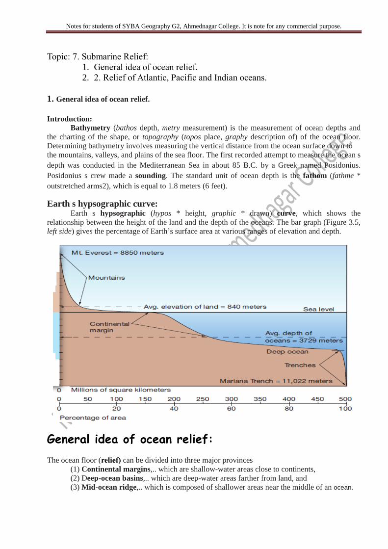
Earth s hypsographic curve: Earth s hypsographic (hypos * height, graphic * drawn) curve, which shows the
relationship between the height of the land and the depth of the oceans. The bar graph (Figure 3.5,
left side) gives the percentage of Earth’s surface area at various ranges of elevation and depth.
General idea of ocean relief:
The ocean floor (relief) can be divided into three major provinces
(1) Continental margins,.. which are shallow-water areas close to continents,
(2) Deep-ocean basins,.. which are deep-water areas farther from land, and
(3) Mid-ocean ridge,.. which is composed of shallower areas near the middle of an ocean.

Notes for students of SYBA Geography G2, Ahmednagar College. It is note for any commercial purpose.
Passive versus Active Continental Margins
Continental margins can be classified as either passive or active, depending on their
proximity to plate boundaries.
1. Passive margins: passive margins usually lack major tectonic activity (such as large
earthquakes, eruptive volcanoes, and mountain building).The East Coast of the United States.
2. Active margins: a high degree of tectonic activity.
Two types of active margins exist.
Convergent active margins are associated with oceanic continental convergent plate
boundaries.
Transform active margins are less common and are associated with transform plate
boundaries.
Divisions of the Ocean Floors
Major Ocean Relief Features
The ocean floors can be divided into five major divisions:
1. The Continental Shelf;
2. The Continental Slope;
3. The continental rise
4. The Deep Sea Plain (Abyssal Plain. )
5. The Oceanic Deeps.
Besides, these divisions there are also major and minor relief features in the ocean
floors like…. ridges, hills, Sea mounts,guyots, trenches, canyons, etc.
Minor Ocean Relief Features:
Ridges, Hills, Seamounts, Guyots, Trenches, Canyons, Sleeps, Fracture zones, Island arcs,
Atolls, Coral reefs, Submerged volcanoes and Sea-scarps
Continental Shelf
The continental shelf is defined as a generally flat zone extending from the shore beneath
the ocean surface to a point at which a marked increase in slope angle occurs, called the
shelf break.
It is usually flat and relatively featureless because of marine sediment deposits but can
contain coastal islands, reefs, and raised banks. The
The average width of the continental shelf is about 70 kms,
But it varies from a few tens of meters to 1500 kms.

Notes for students of SYBA Geography G2, Ahmednagar College. It is note for any commercial purpose.
The broadest shelves occur off the northern coasts of Siberia and North America in the
Arctic Ocean.
The average depth at which the shelf break occurs is about 135 meters
Examples: Continental Shelf of South-East Asia, Great Banks around Newfoundland,
Submerged region between Australia and New Guinea
The shelf is formed mainly due to
submergence of a part of a continent
relative rise in sea level
Sedimentary deposits brought down by rivers
Various types of shelves based on different sediments of terrestrial origin —
glaciated shelf: (Surrounding Greenland),
coral reef shelf : (Queensland, Australia),
shelf of a large river: (Around Nile Delta),
shelf with dendritic valleys: (At the Mouth of Hudson River)
shelf along young mountain ranges: (Shelves between Hawaiian Islands).
Importance of continent shelves
Importance of continent shelves
1. Marine food comes almost entirely from continental shelves;
2. They provide the richest fishing grounds;
3. They are potential sites for economic minerals
20% of the world production of petroleum and gas comes from shelves.
Polymetallic nodules (manganese nodules; concentric layers of iron and manganese hydroxides)
etc. are good sources of various mineral ores like manganese, iron copper, gold etc..]
Continental Slope The continental slope, which lies beyond the shelf break, is where the deep-ocean basins
begin.
Total relief in this region is similar to that found in mountain ranges on the continents.
The break at the top of the slope may be from 1 to 5 kms.
Worldwide, the slope of the continental slopes averages about 4 degrees but varies from 1 to
25 degrees.
the Pacific Ocean, the continental slopes average more than 5 degrees
Submarine Canyons and Turbidity Currents
Submarine canyons, which are narrow but deep submarine valleys that are V-shaped in
profile view and have branches or tributaries with steep to overhanging walls.
Continental Rise The continental rise is a transition zone between the continental margin and the deep-ocean
floor comprised of a huge submerged pile of debris.
The material transported by these currents is responsible for the creation of continental rises.
deep-sea fans, or submarine fans. One of the largest deep-sea fans in the world is the
Indus Fan, a passive margin fan that extends 1800 kilometers (1100 miles) south of
Pakistan.

Notes for students of SYBA Geography G2, Ahmednagar College. It is note for any commercial purpose.
Deep-Ocean Basins: The deep-ocean floor lies beyond the continental margin province (the shelf, slope, and the
rise).
Deep sea plains are gently sloping areas of the ocean basins.
These are the flattest and smoothest regions of the world.
The depths vary between 3,000 and 6,000m. These plains are covered with fine-grained
sediments like clay and silt.
Oceanic Deeps or Trenches
These areas are the deepest parts of the oceans.
The trenches are relatively steep sided, narrow basins.
They are some 3-5 km deeper than the surrounding ocean floor.
They occur at the bases of continental slopes and along island arcs and are associated with
active volcanoes and strong earthquakes.
That is why they are very significant in the study of plate movements.
As many as 57 deeps have been explored so far; of which 32 are in the Pacific Ocean; 19 in
the Atlantic Ocean and 6 in the Indian Ocean.
Deepest Point on the Earth in Pacific Ocean: Mariana Trench (- 11022m)
Abyssal Plains These abyssal (a * without, byssus * bottom) plains average between 4500 meters and 6000
meters deep.
They are not literally bottomless, but they are some of the deepest (and flattest) regions on
Earth.
Abyssal plains are formed by fine particles of sediment slowly drifting onto the deep-ocean
floor.
Over millions of years, a thick blanket of sediment is produced by suspension settling as
fine particles (analogous to marine dust ) accumulate on the ocean floor.
The type of continental margin determines the distribution of abyssal plains.
For instance, few abyssal plains are located in the Pacific Ocean; instead, most occur in the
Atlantic and Indian Oceans
Minor Relief Features
Apart from the above mentioned major relief features of the ocean floor, some minor but
significant features...
Mid-Oceanic Ridges
A mid-oceanic ridge is composed of
two chains of mountains separated by a
large depression.
The mountain ranges can have peaks as
high as 2,500 m and some even reach
above the ocean’s surface. Iceland, a
part of the mid- Atlantic Ridge, is an
example.
Seamount
o It is a mountain with pointed summits, rising from the seafloor that does not reach the
surface of the ocean.
o Seamounts are volcanic in origin.
o These can be 3,000-4,500 m tall.
o The Emperor seamount, an extension of the Hawaiian Islands in the Pacific Ocean, is a
good example.
Submarine Canyons
These are deep valleys, some comparable to the Grand Canyon of the Colorado river.
The Hudson Canyon is the best known canyon in the world.

Notes for students of SYBA Geography G2, Ahmednagar College. It is note for any commercial purpose.
Guyots
It is a flat topped seamount.
They show evidences of gradual subsidence through stages to become flat topped
submerged mountains.
It is estimated that more than 10,000 seamounts and guyots exist in the Pacific Ocean alone.
Atoll
These are low islands found in the tropical oceans consisting of coral reefs surrounding a
central depression.
It may be a part of the sea (lagoon), or sometimes form enclosing a body of fresh, brackish,
or highly saline water.
Relief of Atlantic, Pacific and Indian oceans

Notes for students of SYBA Geography G2, Ahmednagar College. It is note for any commercial purpose.

Notes for students of SYBA Geography G2, Ahmednagar College. It is note for any commercial purpose.

Notes for students of SYBA Geography G2, Ahmednagar College. It is note for any commercial purpose.

Notes for students of SYBA Geography G2, Ahmednagar College. It is note for any commercial purpose.