eagle road and state street intersection concept study · eagle road and state street intersection...
TRANSCRIPT

EAGLE ROAD AND STATE STREETINTERSECTION CONCEPT STUDYEagle, IdahoMay 2014

This page intentionally left blank

Eagle, Idaho
Prepared For:Ada County Highway District (ACHD)3775 Adams St.Garden City, ID 83714(208) 387-6100
Prepared By:Kittelson & Associates, Inc.101 S. Capitol Blvd., Suite 301 Boise, ID 83702(208) 338-2683
ACHD Project No. 313022KAI Project No. 13096
May 2014

This page intentionally left blank

Eagle Road and State Street Intersection Concept Study | i
PROJECT MANAGEMENT TEAMAndrew Cibor, ACHD Traffic, Project ManagerNichoel Baird Spencer, City of Eagle Planning & ZoningDana Borquist, City of Eagle Police (former)Ryan Cutler, ACHD Capital ProjectsChristy Foltz-Ahlrichs, ACHD CommunicationJustin Lucas, ACHD Planning & Programming (former)Sabrina Anderson, ACHD Planning & Programming/ City of Eagle LiaisonTerry Little, ACHD TrafficJeremy Andree, ACHD DesignHugo Fregoso, ACHD Capital ProjectsGary Inselman, ACHD Development ServicesMichele White, ACHD Right-of-WayDave Serdar, ACHD Right-of-Way
STAKEHOLDER COMMITTEECindy Compton, Nearby Neighborhood LeaderRobert Grubb, Eagle Design Review BoardJohn Franden, ACHD CommissionMandy White, Meridian School DistrictMark Butler, Eagle City CouncilKurt McClenny, Eagle Fire DepartmentMary Defayette, Eagle City CouncilKarianne Fallow, Eagle Historic Preservation Commission Gary Kohlmeier, Eagle Elementary SchoolJeff Laughlin, Eagle Transportation CommitteeGretchen Gilbert, Eagle Chamber of CommerceJane Kramer, Eagle Urban Renewal Agency Citizen Advisory CommitteeJim Reynolds, Eagle City MayorMary Barker, Valley Regional Transit (former)Jacob Hassard, Valley Regional TransitSteve Bartlett, City of Eagle Police
CONSULTANT TEAMKittelson & Associates, Inc.
John Ringert, Project PrincipalYuri Mereszczak, Project ManagerBrian Ray, Senior Technical AdvisorRyan Whitney, Project AnalystRobyn Austin, Graphic Artist
A special thanks to the Eagle Mayor and City Council, and Ada County Highway District Commission for par-ticipating and providing input and guidance during the development of the plan.A final thank you to the community of Eagle and the many individuals and businesses that provided infor-mation, comments, suggestions, and/or their valuable time through the course of this study. Many interested local residents, business owners, and business rep-resentatives were extremely involved and helpful in providing comments and direction that assisted in the development of this study.
PREFACEThe Eagle/State Intersection Concept Study was performed under the guidance of the Project Management Team (PMT) and Stakeholder Committee (SC). The PMT was responsible for reviewing all work products, providing techni-cal direction to the project, facilitating the Public Involvement Meeting, and making recommendations to the Eagle City Council and Ada County Highway District (ACHD) Commission. The PMT included staff representatives from ACHD and the City of Eagle. The SC was responsible for reviewing project documents, representing constituents’ perspectives, communicating the project process with constituents, providing input and recommendations to the PMT, and participating in the project’s public meeting. The SC was made up of local citizens, agency representatives, and local officials. Thank you to the following PMT and SC members for their instrumental involvement with the Eagle/State Intersection Concept Study.

This page intentionally left blank

Eagle Road and State Street Intersection Concept Study | iii
TABLE OF CONTENTS
PREFACE ...................................................................................................................................... i
PROJECT MANAGEMENT TEAM .................................................................................................... i
STAKEHOLDER COMMITTEE .......................................................................................................... i
CONSULTANT TEAM ...................................................................................................................... i
SECTION 1. RECOMMENDATIONS & IMPLEMENTATION STRATEGY ............................................... 1EXPECTED OUTCOMES & BENEFITS OF RECOMMENDATIONS ........................................................ 10
SECTION 2. PROJECT INTRODUCTION ......................................................................................... 13PROJECT BACKGROUND & OVERVIEW ........................................................................................... 13GOALS AND OBJECTIVES ................................................................................................................ 13
SECTION 3. PROJECT APPROACH & CONTEXT ............................................................................ 15PROJECT APPROACH ...................................................................................................................... 15PROJECT CONTEXT ........................................................................................................................ 16ELEMENTS OF ALTERNATIVES ........................................................................................................ 18
SECTION 4. ALTERNATIVES OVERVIEW, EVALUATION, & SUMMARY ............................................ 19INTERSECTION EVALUATION CRITERIA........................................................................................... 19INTERSECTION ALTERNATIVES ....................................................................................................... 19PROJECT SUMMARY ...................................................................................................................... 30
SECTION 5. REFERENCES ............................................................................................................ 31
APPENDIX A: DOWNTOWN CIRCULATION RECOMMENDATIONS .......................................... 33

iv | Kittelson & Associates, Inc.
LIST OF TABLES
Table 1: Roundabout at the Eagle Road/State Street Intersection ................................................ 5
Table 2: Plaza Drive Extension ...................................................................................................... 6
Table 3: Aikens Street (East of Eagle Rd) Extension & Widening/Streetscape ............................... 7
Table 4: Aikens Street (West of Eagle Rd) & Olde Park Place (South of State St) Widening/Streetscape ................................................................................................................. 8
Table 5: Idaho Street Extension & Olde Park Place (North of State St) Widening/Streetscape ................................................................................................................ 9
Table 5: Expected Outcomes and Benefits of Recommendations ................................................ 10
Table 5: Expected Outcomes and Benefits of Recommendations (continued) ............................. 11
Table 5: Expected Outcomes and Benefits of Recommendations (continued) ............................. 12
Table 6: Existing Study Area Roadways ...................................................................................... 17
Table 7: Intersection Alternatives Evaluation Summary .............................................................. 25
Table 8: Intersection Alternatives Cost Estimate Summary ........................................................ 25
Table 9: Summary of the Public’s Alternatives Ranking .............................................................. 26
Table 10: Summary of the Stakeholder Committee Alternatives Ranking ................................... 26
Table 11: Summary of Downtown Circulation Improvements ..................................................... 28
LIST OF FIGURES
Figure 1: Concept Study Recommendations ................................................................................. 3
Figure 2: Site Vicinity Map and Project Study Area ..................................................................... 14
Figure 3: Project Roadmap ......................................................................................................... 15
Figure 4: Downtown Eagle Future Land Use Plan ....................................................................... 17
Figure 5: Footprint Diagram of an Expanded Signalized Intersection & Associated Queue Diagram ........................................................................................................ 18
Figure 6: Expanded Signal Alternative ....................................................................................... 21
Figure 7: Quadrant Alternative .................................................................................................. 22
Figure 8: Roundabout Alternative ............................................................................................. 23
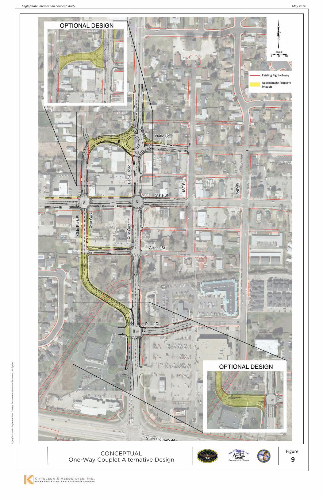
Figure 9: One-Way Couplet Alternative .................................................................................... 24
Figure 10: Downtown Street Improvements from Downtown Eagle Plan ................................... 28

Eagle Road and State Street Intersection Concept Study | 1
SECTION 1. RECOMMENDATIONS & IMPLEMENTATION STRATEGYThe recommendations of the Eagle/State Intersection Concept Study were developed through collaborative transportation planning. These recommendations con-sidered the roadway network context and multimodal travel demands in downtown Eagle, Idaho, combined with the community objectives of promoting a mix of land uses, walkability, and active streets in downtown. The specific improvements recommended were arrived at through extensive input from the citizens of Eagle, the project Stakeholder Committee (SC), the Project Management Team (PMT), Eagle City Council, and the Ada County Highway District (ACHD) Commission. De-tails of the project process, alternatives evaluation, and public involvement are included in Sections 2 through 4 of this report, while the remainder of this section fo-cuses on the recommendations and implementation strategy. The general public, SC, and PMT were presented with different approaches to accommodating future growth at the Eagle Road/State Street intersection and asked to provide feedback. From this feedback, the following five alternatives for the intersection were developed and evaluated:
▪ No-Build;
▪ Expanded Signal;
▪ Quadrant;
▪ Roundabout; and,
▪ One-Way Couplet.Additionally, circulation improvements from the Down-town Eagle Plan (Reference 1) that could be imple-mented with any of the intersection alternatives were developed and evaluated. Several worksessions with the Eagle City Council and ACHD Commission described the intersection alternatives and downtown circulation improvements, presented the comments received, and allowed for feedback from the elected officials within each organization. Initially, the Eagle City Council supported the No-Build intersection alternative. However, after reconsidering the assessment of intersection alternatives relative to the project’s evaluation criteria, the feedback from the general public, SC, and PMT, and the Eagle Transpor-tation Committee’s unanimous support of the round-about alternative, the Eagle City Council ultimately recommended to the ACHD Commission the round-about alternative. The ACHD Commission supported the recommendation and adopted the roundabout as the preferred alternative for the Eagle/State intersec-tion in a public hearing on March 26th, 2014. A request for reconsideration of the roundabout alternative adoption was heard on April 9th, 2014. The adoption of the roundabout alternative was upheld by the ACHD Commission. Consistent support for the downtown cir-culation improvements was received throughout the
course of the project and the specific improvements listed below were adopted by the ACHD Commission as part of the March 26th, 2014 public hearing. In summary, the recommendations of this study are as follows and will be incorporated in ACHD’s Master Street Map and prioritized in ACHD’s Capital Improve-ments Plan and Five-Year Work Plan based on the im-mediate and projected needs of the road system and input from citizens:
▪ Eagle Road/State Street Intersection: Roundabout Alternative including a four-lane cross section on Eagle Road from Plaza Drive to State Street;
▪ Plaza Drive Extension (currently programmed for construction in 2018)
▪ Aikens Street Extension (currently programmed for construction in Preliminary Development)
▪ Olde Park Place & Aikens Street Widening/Streetscape
▪ Idaho Street Extension & Olde Park Place Widening/Streetscape
The recommendations of the Eagle/State Intersection Concept Study are illustrated in Figure 1. More detailed illustrations of the recommendations are provided in Figure 8 and Appendix A of this report.Tables 1 through 5 further describe the recommenda-tions and key elements to consider moving forward into implementation. Several global implementation elements for these projects are as follows:
▪ Additional public involvement and property owner outreach will be conducted when advancing the recommendations through the design and construction phases.
▪ ACHD, the City of Eagle, and the Eagle Urban Renewal Agency will coordinate cost share agreements for improvements outside of ACHD’s standard improvements (e.g., wide sidewalks and landscape areas). Eagle Urban Renewal Agency investment in these projects should be a serious consideration, especially in regard to streetscape improvements.
▪ The City of Eagle Parking Fund is an additional funding mechanism for consideration with regard to parking impacts and improvements.
▪ As properties along these roadways redevelop, the City and ACHD agreed to pursue consolidation of access and cross access agreements as appropriate.
▪ The City and ACHD also agreed to explore and implement, as appropriate, sustainable green storm water infrastructure.

2 | Kittelson & Associates, Inc.
This page intentionally left blank


This page intentionally left blank

Eagle Road and State Street Intersection Concept Study | 5
Table 1: Roundabout at the Eagle Road/State Street Intersection
Description Key Implementation Elements
General
Construct a multilane roundabout at the Eagle Road/State Street intersec-tion including a four-lane cross section on Eagle Road from Plaza Drive to State Street.
Programming/Funding
▪ Pursue ACHD IFYWP Intersection Program funding
▪ Establish cost share agreement with City and/or Urban Renewal Agency for buffer & central island landscaping/art
Length & Extents
Eagle Road/State Street intersection including improvements along the fol-lowing approaches:
▪ Eagle Rd (north): ~325’ north of Idaho St
▪ Eagle Rd (south): To Plaza Drive
▪ State St (west): To Olde Park Place
▪ State St (east): To 2nd St
Timeframe/Phasing
Priority to be established upon incorporation of project into ACHD’s
IFYWP and Capital Improvements Plan
Approach Lane Configurations
Eagle Rd (north & south):
▪ Entry: TH+RT lane & TH+LT lane
▪ Exit: 2 lanesState St (west):
▪ Entry: RT only lane & TH+LT lane
▪ Exit: 1 laneState St (east):
▪ Entry: LT+TH+RT lane & LT only lane
▪ Exit: 1 lane
Design/Construction
▪ Develop a comprehensive construction phasing plan outlining maintenance of traffic and access to existing businesses during construction
▪ Coordinate with the City, Urban Renewal Agency, and/or Eagle Arts Commission on landscape treatments and/or art in the central island
▪ Explore on-street parking in lieu of a bike lane on State Street east of the intersection
▪ Plan for active pedestrian control at multilane pedestrian crossings
▪ Explore green stormwater infrastructure treatments.
Right-of-Way Acquisition
▪ ACHD and the City to further discussions & design of access on nearby parcels.
▪ Impacts to three structures and one full property acquisition likely, in addition to ~33,000 sq.ft. of ROW acquisition needed across 25 parcels
▪ Impacts expected to 6 private parking stalls
Estimated Cost1 $3,600,000 to $4,600,000
R/W = Right-of-Way; IFYWP = Integrated Five-Year Work Program; PD = Preliminary Development1 Total of design, construction, and right-of-way cost estimates. Refer to the Technical Appendix for cost estimate worksheets.

6 | Kittelson & Associates, Inc.
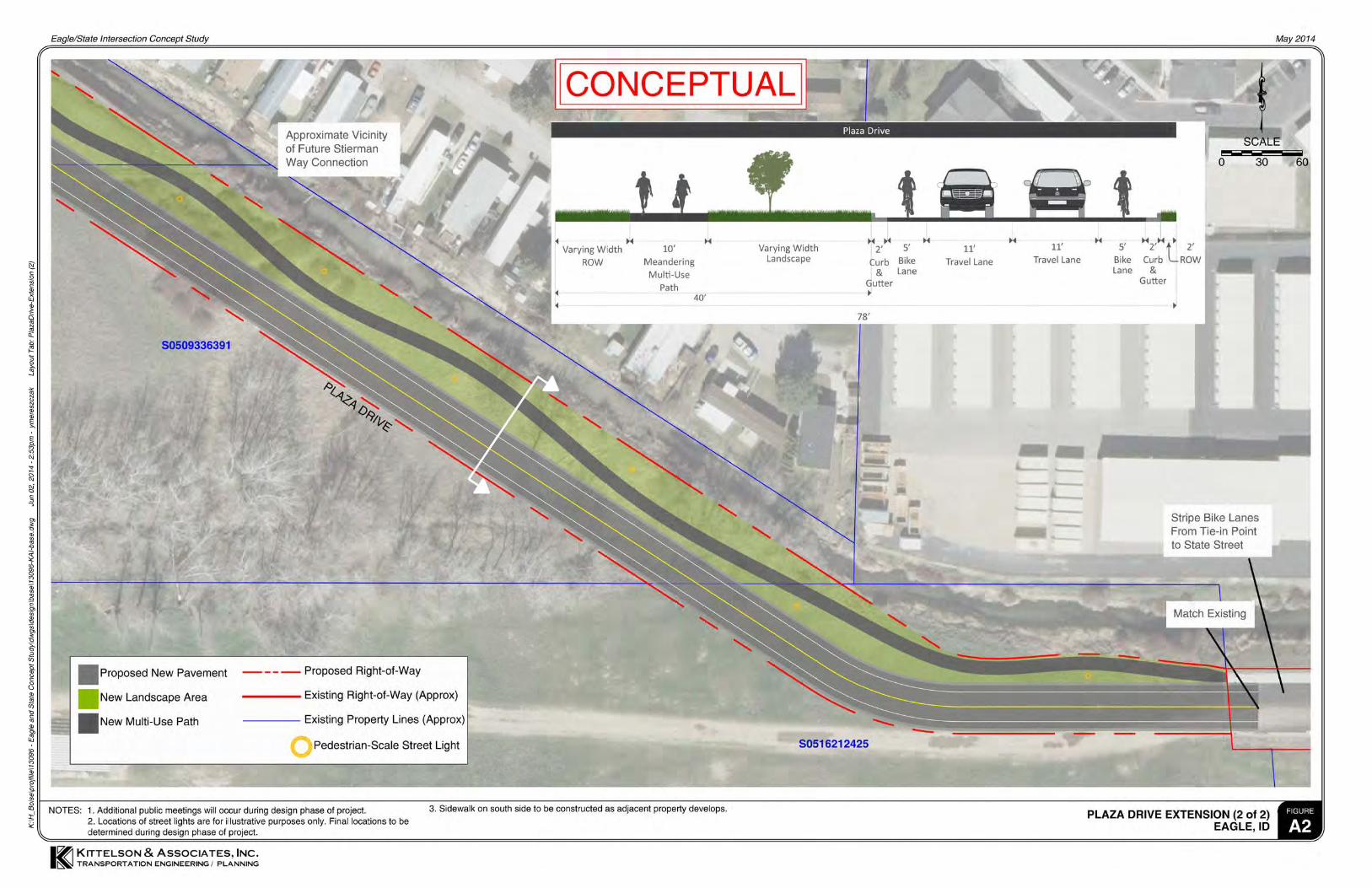
Table 2: Plaza Drive Extension
Description Key Implementation Elements
General Extending the existing ACHD-owned roadway Programming/Funding
▪ Listed in ACHD IFYWP Economic Development Program ($1,708,000)
▪ Establish cost share agreement with City and/or Urban Renewal Agency
Length & Extents
~1,900’ between 2nd Street and Plaza Drive terminus Timeframe/Phasing Design: 2014-15; ROW: 2016;
Construction: 2018
Width ~78’ (ROW to ROW) Design/Construction
▪ Evaluate 2nd Street/Plaza Drive for all-way stop control or mini-roundabout
▪ Coordinate multi-use pathway/green space design with City & Settlers Irrigation District. Explore green stormwater infrastructure treatments.
▪ Construct sidewalk and green space on south side with future development
▪ Consider and plan for future connection of Stierman Way
▪ Stripe bike lanes on existing roadway from east tie-in point to State Street
▪ Sidewalk on south side to be constructed as properties develop
Cross Section
▪ One 11’ travel lane in each direction
▪ One 5’ bicycle lane in each direction
▪ 2’ curb & gutter on each side
▪ North side: 40’ green space allowing for landscaping, 8’ sidewalk (west half), 10’ multi-use path (east half along canal)
▪ South side: 2’ ROW buffer behind curb
Right-of-Way Acquisition ▪ ~69,000 sq.ft. of ROW
acquisition needed across two parcels in addition to the two ACHD-owned parcels
Estimated Cost1 $1,820,000 to $2,155,000
ROW = Right-of-Way; IFYWP = Integrated Five-Year Work Program; PD = Preliminary Development 1 Total of design, construction, and right-of-way cost estimates. Refer to the Technical Appendix for cost estimate worksheets.

Eagle Road and State Street Intersection Concept Study | 7
Table 3: Aikens Street (East of Eagle Rd) Extension & Widening/Streetscape
Description Key Implementation Elements
General
Extending the existing ACHD-owned roadway and widening/streetscape to existing Aikens
Street
Programming/Funding
▪ Listed in ACHD IFYWP Economic Development Program ($832,000)
▪ Establish cost share agreement with City and/or Urban Renewal Agency
Length & Extents
~700’ between Eagle Road and 2nd Street Timeframe/Phasing Design: 2016; ROW: 2017;
Construction: PD
Width 50’ (ROW to ROW) Design/Construction
▪ Install stop control on Aikens Street at intersection with 2nd Street and curb bulb-out on southwest corner.
▪ Install stop control on 1st Street at intersection with Aikens Street.
▪ Construct curb bulb-out on southeast corner of Aikens Street/Eagle Road intersection.
▪ Match existing sidewalk and curb on south side of Aikens Street in vicinity of 1st Street and on north side of Aikens between 1st Street and Eagle Road
▪ Remove existing speed hump west of 1st Street
▪ Accommodate existing structures near Eagle Road/Aikens Street intersection.
▪ Explore green stormwater infrastructure treatments
Cross Section
▪ One 10’ travel lane in each direction
▪ One 6’ parallel parking lane on south side
▪ 2’ curb & gutter on each side
▪ 10’ sidewalks on each side with 4’x4’ tree grates every ~35’ and pedestrian-scale street lighting.
▪ ROW at back of sidewalk
Right-of-Way Acquisition
▪ One full property acquisition likely and ~12,775 sq.ft. of ROW acquisition across 9 parcels
▪ Impacts expected to 13 private parking stalls
Estimated Cost1 $965,000 to $1,180,000
ROW = Right-of-Way; IFYWP = Integrated Five-Year Work Program; PD = Preliminary Development 1 Total of design, construction, and right-of-way cost estimates. Refer to the Technical Appendix for cost esti-mate worksheets.

8 | Kittelson & Associates, Inc.
Table 4: Aikens Street (West of Eagle Rd) & Olde Park Place (South of State St) Widening/Streetscape
Description Key Implementation Elements
General Widening and streetscape to ex-isting ACHD-owned local streets Programming/Funding
▪ Pursue funding through means besides ACHD or through future ACHD IFYWP Economic Development Program projects
▪ Establish cost share agreement with City and/or Urban Renewal Agency
Length & Extents
▪ ~320’ of Olde Park Place between State Street and Aikens Street
▪ ~320’ of Aikens Street between Olde Park Place and Eagle Road
Timeframe/Phasing
▪ Lower priority than Plaza Drive and Aikens Street extensions. Higher priority than Idaho Street Extension & Olde Park Place widening/streetscape.
Width 56’ (ROW to ROW) for both roadways Design/Construction
▪ Construct curb bulb-outs on west leg of Aikens Street/Eagle Road intersection and south leg of Olde Park Place/State Street intersection
▪ Relocate power poles along Olde Park Place
▪ Explore green stormwater infrastructure treatments.
Cross Section
▪ One 10’ travel lane in each direction on both streets
▪ One 6’ parallel parking lane on each side of both streets
▪ 2’ curb & gutter on each side of both streets
▪ 10’ sidewalks on each side of both streets with 4’x4’ tree grates every ~35’ and pedestrian-scale street lighting.
▪ ROW at back of sidewalk
Right-of-Way Acquisi-tion
▪ As parcels redevelop, ACHD and the City to pursue potential access consolidation.
▪ One full property acquisition likely and ~11,870 sq.ft. of ROW acquisition across 8 parcels
▪ Impacts expected to 9 private parking stalls
Estimated Cost1
Aikens Street: $525,000 to $640,000 Olde Park Place: $520,000 to $635,000
Total: $1,045,000 to $1,275,000
ROW = Right-of-Way; IFYWP = Integrated Five-Year Work Program; PD = Preliminary Development 1 Total of design, construction, and right-of-way cost estimates. Refer to the Technical Appendix for cost estimate worksheets.

Eagle Road and State Street Intersection Concept Study | 9
Table 5: Idaho Street Extension & Olde Park Place (North of State St) Widening/Streetscape
Description Key Implementation Elements
General
▪ Widening and streetscape to existing ACHD-owned Olde Park Place
▪ Extending the existing ACHD-owned Idaho Street roadway
Programming/Funding
▪ Pursue funding through means besides ACHD or through future ACHD IFYWP Economic Development Program projects
▪ Establish cost share agreement with City and/or Urban Renewal Agency
Length & Extents
▪ ~380’ of Olde Park Place between State Street and the future Idaho Street extension
▪ Extending Idaho Street from Olde Park Place to Eagle Road (~320’)
Timeframe/Phas-ing
Lowest priority of build recommenda-tions in study.
Width 56’ (ROW to ROW) for both roadways
Design/Construc-tion
▪ Construct curb bulb-outs on northwest corner of Olde Park Place/State Street, east and south legs of Idaho Street/Olde Park Place, and west leg of Idaho Street/Eagle Road
▪ Install stop control on Idaho Street at intersections with Olde Park Place and Eagle Road
▪ Relocate power poles along Olde Park Place
▪ Match existing sidewalk and curb on east side of Olde Park Place in vicinity of State Street.
▪ Explore sustainable green stormwater infrastructure treatments.
Cross Section
▪ One 10’ travel lane in each direction on both streets
▪ One 6’ parallel parking lane on each side of both streets
▪ 2’ curb & gutter on each side of both streets
▪ 10’ sidewalks on each side of both streets with 4’x4’ tree grates every ~35’ and pedestrian-scale street lighting
▪ ROW at back of sidewalk
Right-of-Way Acquisition
▪ As parcels redevelop, ACHD and the City to pursue potential access consolidation.
▪ Three full property acquisitions likely for the Idaho Street extension and ~1,475 sq.ft. of ROW acquisition across 6 parcels along Olde Park Place
Estimated Cost1
Olde Park Place: $425,000 to $500,000 Idaho Street Ext: $860,000 to $1,075,000
Total: $1,285,000 to $1,575,000
ROW = Right-of-Way; IFYWP = Integrated Five-Year Work Program; PD = Preliminary Development 1 Total of design, construction, and right-of-way cost estimates. Refer to the Technical Appendix for cost esti-mate worksheets.

10 | Kittelson & Associates, Inc.
EXPECTED OUTCOMES & BENEFITS OF RECOMMENDATIONSThe expected outcomes and benefits associated with the recommendations provide justification and incen-tives for prioritizing and completing the projects. Un-derstanding anticipated project benefits also helps assess the value gained from these projects in relation to the investment put forth.
Quantifying operations and safety benefits for the downtown circulation projects is difficult as there is a lack of data describing traditional operational and safe-ty measures for these roadways. However, these proj-ects support the community values and goals outlined in the Downtown Eagle Plan. Beyond that, these proj-ects were supported by the stakeholders and citizens of Eagle as evidenced by the feedback received through project’s public meetings. Several qualitative benefits are described in Table 5 for the proposed recommen-dations.
Table 5: Expected Outcomes and Benefits of Recommendations
Roundabout at Eagle Road/State Street Intersection
Expected Outcome Expected Benefit
Intersection projected to meet ACHD operational stan-dards and vehicle queues not anticipated to spill back
through nearby intersections.
▪ Provides for adequate (within ACHD standards) traffic flow and mobility through the Eagle Road/State Street intersection and reduces blocking of nearby intersections.
Reduced conflicts and slower speeds than existing conditions.
▪ Expected to reduce crash severity at the intersection based on national research statistics (Reference 2).
Shorter pedestrian crossing lengths and two-stage crossings.
▪ Supports the walkability goal in the Downtown Eagle Plan.
Bicyclists provided the option to ride with traffic through the roundabout or use the 10-foot wide side-
walks around the roundabout. ▪ Accommodates various skill and comfort levels of
bicyclists in negotiating the roundabout.
Opportunity to provide landscaping and/or art in central island.
▪ Improves aesthetics and furthers a sense of place within downtown Eagle, supporting the goal of creating an “entry and place marker” in the Four Corners Planning Area as stated in the Downtown Eagle Plan.
Provides u-turn opportunities at the intersection al-lowing the potential for increased access management
within the vicinity of the intersection. ▪ Increased access management reduces the number
of conflict points.

Eagle Road and State Street Intersection Concept Study | 11
Plaza Drive Extension
Expected Outcome Expected Benefit
The Plaza Drive extension will remove approximately 200 vehicles from State Street during the year 2035
weekday p.m. peak hour.
▪ PM peak hour traffic volume on State Street is reduced by approximately 20%.
▪ Total entering volume at the Eagle Road/State Street intersection is reduced by approximately 5%, improving the intersection operation.
Connects an existing dead end street to the downtown transportation network and forms the backbone of a planned grid network within the Plaza Planning Area.
▪ Improves network connectivity for multiple modes of travel allowing additional route choices and easier mobility within downtown.
▪ Provides an alternative route to access businesses east of Eagle Road and for emergency services response.
Provides access to undeveloped land in the Plaza Plan-ning Area near downtown.
▪ Supports economic development within downtown Eagle, aligning well with several goals outlined in the Downtown Eagle Plan.
Provides connected and enhanced pedestrian and bicycle facilities within downtown.
▪ Supports the walkability and interconnected streets and pathways goals within the Downtown Eagle Plan
Aikens Street Extension
Expected Outcome Expected Benefit
Connects an existing dead end street to the downtown transportation network.
▪ Provides network connectivity for multiple modes of travel, allowing additional route choices and easier mobility within downtown.
▪ Eliminates turnaround maneuvers in front of the businesses and properties on the east end of Aikens Street.
Provides access to businesses and properties on Aik-ens Street for vehicles and pedestrians through con-
nectivity, on-street parking, and new sidewalks.
▪ Supports economic development within downtown Eagle, aligning well with several goals outlined in the Downtown Eagle Plan.
Provides connected and enhanced pedestrian facilities within downtown.
▪ Supports the walkability and interconnected streets and pathways goals within the Downtown Eagle Plan.
Table 5: Expected Outcomes and Benefits of Recommendations (continued)
12 | Kittelson & Associates, Inc.
Olde Park Place & Aikens Street Widening/Streetscape
Expected Outcome Expected Benefit
Provides increased width on existing narrow streets for vehicular travel and parking.
▪ Improves network connectivity for vehicles allowing for more route choices and easier mobility within downtown.
▪ On-street parking provides opportunities for private property currently being used for parking to redevelop.
Provides sidewalks for pedestrian travel.
▪ Improves network connectivity for pedestrians allowing user-friendly access to current and future businesses along Olde Park Place and Aikens Street.
▪ Provides a dedicated facility for pedestrians, separate from the vehicular travel way.
Provides easier access to businesses and properties on Olde Park Place and Aikens Street for vehicles and
pedestrians.
▪ Supports economic development within downtown Eagle, aligning well with several goals outlined in the Downtown Eagle Plan.
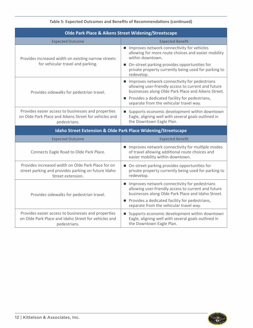
Idaho Street Extension & Olde Park Place Widening/Streetscape
Expected Outcome Expected Benefit
Connects Eagle Road to Olde Park Place. ▪ Improves network connectivity for multiple modes
of travel allowing additional route choices and easier mobility within downtown.
Provides increased width on Olde Park Place for on street parking and provides parking on future Idaho
Street extension.
▪ On-street parking provides opportunities for private property currently being used for parking to redevelop.
Provides sidewalks for pedestrian travel.
▪ Improves network connectivity for pedestrians allowing user-friendly access to current and future businesses along Olde Park Place and Idaho Street.
▪ Provides a dedicated facility for pedestrians, separate from the vehicular travel way.
Provides easier access to businesses and properties on Olde Park Place and Idaho Street for vehicles and
pedestrians.
▪ Supports economic development within downtown Eagle, aligning well with several goals outlined in the Downtown Eagle Plan.
Table 5: Expected Outcomes and Benefits of Recommendations (continued)

Eagle Road and State Street Intersection Concept Study | 13
SECTION 2. PROJECT INTRODUCTION The Eagle/State Intersection Concept Study was a plan-ning study needed to determine the future transporta-tion plan for the downtown core of the City of Eagle. This study provided recommendations and an imple-mentation plan to guide the Ada County Highway Dis-trict (ACHD) and the City of Eagle in funding, designing, and constructing future transportation projects within the study area. The purpose of the project was to fos-ter collaboration between the community, City of Ea-gle, and ACHD to identify solutions at the Eagle Road/State Street intersection and in the Eagle downtown core. These solutions must balance the need to safely accommodate the expected growth in traffic demand resulting from the City’s land use plan with the City’s goals of fostering a walkable, active, vibrant, mixed-use environment in downtown Eagle.
PROJECT BACKGROUND & OVERVIEW
The City of Eagle is located in northwest Ada County approximately 10 miles northwest of downtown Boise, Idaho. Since its incorporation in 1971, Eagle’s popula-tion has grown substantially. Once known as a small, agriculturally focused town of less than 3,000 resi-dents, Eagle’s population grew to near 10,000 by the late 1990s and is now approaching 25,000. Community and transportation growth projections show substan-tial growth continuing within the City of Eagle and the surrounding areas into the foreseeable future.
The location of downtown Eagle is also a matter of sig-nificance in understanding the context and function of the roadway network. The character of the area, and the roadway network, transition rapidly from one fo-cused on larger, commercial land-uses and mobility to one of a small-business oriented downtown with a con-fined roadway cross-section.
Eagle Road is the only north-south roadway connec-tion across State Highway (SH) 44 for a mile to the east or west. Eagle Road also offers the only crossing of the Boise River for a seven-mile stretch between Glen-wood Street to the east and Linder Road to the west. This means the most convenient and viable option for north-south travel for a significant portion of traffic is Eagle Road.
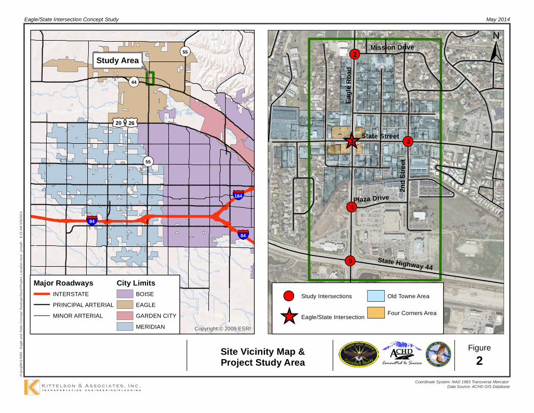
The Eagle/State intersection is located in the heart of downtown Eagle in an area referred to as the “Old Towne” section of downtown. The Downtown Eagle Plan states “Old Towne Eagle should maintain the quaint feel of a traditional town center; as the active community center and community gathering place for the City” (Reference 1). More specifically, the Down-town Eagle Plan refers to the parcels of land adjacent to the Eagle Road/State Street intersection as the “Four Corners Planning Area.” The Plan states: “…though lo-cated in Old Towne, the Four Corners area should be
treated as a unique urban design area, serving as an entry and place marker letting visitors know You Have Arrived in Downtown Eagle” (Reference 1). Figure 2 il-lustrates a site vicinity map along with the project study area.At the City’s request, ACHD completed a preliminary analysis of options for the Eagle Road/State Street in-tersection in early 2012. However, identifying the best intersection alternative required additional evaluation of the downtown street network along with more in depth traffic analysis, and stakeholder and public in-volvement; thus the impetus for this study.
GOALS AND OBJECTIVESThe goals and objectives for this study were crafted within the context of the project’s background, and considering the purpose and of this study. Details of the goals and objectives are found in the Project Overview Memorandum within the Technical Appendix (Refer-ence 3), and are generally summarized as:
▪ Land Use/Transportation Integration: Develop a concept functioning in harmony with the existing and potential land uses, while serving to create a sense of place and support economic development.
▪ Intersection Function: Strive for a concept considering the safety and operational needs of various modes of travel, maximizing the intersection lifespan without compromising the desired community values.
▪ Network Evaluation: Understand the impacts of the intersection on the downtown street and sidewalk network and vice versa. Address safety concerns and gaps in the pedestrian and bicycle facilities.
▪ Community/Stakeholder Involvement: Engage the community and build understanding of opportunities, constraints, and findings. Gather valuable input to guide project decisions. Provide an open, honest, transparent decision-making process.
▪ Project Implementation: Strive for a concept making the best use of available funds while providing flexibility to respond to changing socioeconomic conditions. Create a prioritized implementation plan to further transportation investments and assist in developing partnerships to fund and implement the recommendations.
Eagle
Roa
d
State Street
2nd S
treet
State Highway 44
Plaza Drive
Mission Drive2
3
5
1
4
Eagle/State Intersection Concept Study May 2014
Figure2
H:\pr
ojfile
\1309
6 - E
agle
and S
tate C
once
pt St
udy\g
is\ba
se\P
rojec
t_Loc
ation
.mxd
- jcri
safi -
8:15
AM 5/
5/201
4
Coordinate System: NAD 1983 Transverse Mercator Data Source: ACHD GIS Database
Site Vicinity Map &Project Study Area
Study Intersections
Eagle/State Intersection
Old Towne Area
Four Corners Area
84
184
84
44
55
55
Copyright:© 2009 ESRI
Major RoadwaysINTERSTATEPRINCIPAL ARTERIALMINOR ARTERIAL
City LimitsBOISEEAGLEGARDEN CITYMERIDIAN
Study Area
20 26

Eagle Road and State Street Intersection Concept Study | 15
SECTION 3. PROJECT APPROACH & CONTEXT The Eagle/State Intersection Concept Study was initiat-ed and managed by ACHD. The City of Eagle was an in-vested partner and collaborated with ACHD throughout the entire course of the project. Both agencies commit-ted to the project approach and fostered meaningful and continuous engagement of affected stakeholders and the general public throughout the course of the project.
PROJECT APPROACHACHD and the City of Eagle partnered to employ the process and principles of Smart Transportation Plan-ning, which is an effective means of collaboration founded upon a process in which a multi-disciplinary team considers a wide range of context-sensitive solu-tions (CSS) and works closely with the community to determine the best transportation solutions (Reference 4).
Source: Smart Transportation Planning Guidebook (Reference 3)
The principles of Smart Transportation Planning are outlined in the graphic above. The Project Manage-ment Team (PMT) and the Stakeholder Committee (SC)
served to implement these principles on this project, balancing competing interests and needs against vari-ous options for improvement. The foundation of this balance was a commitment to the process, which was strengthened and supported by past visions for the area (e.g. Downtown Eagle Plan) and a public involve-ment approach employing the following qualities and characteristics:
▪ An open, honest, and transparent decision-making process conducted through constructive two-way communication between the project team and the public.
▪ Early and continuous opportunities for stakeholders to share values, understand the opportunities within the study area, develop potential solutions, and raise issues and concerns to be considered by the project team.
▪ Proactively inform and encourage the participation of stakeholders.
▪ Build widespread community understanding of opportunities, constraints, findings, and decisions.
▪ Implement a process driving ownership, validity, and commitment to the development of context sensitive solutions.
Benefits were realized, most notably through the ex-tensive and continuous feedback received throughout the course of the project. In total, well over 100 dif-ferent people provided input to guide the recommen-dations of the project. The project recommendations were informed by both the implementation of Smart Transportation Planning, and the stakeholder and pub-lic feedback. Evidence of this is demonstrated through the fact the PMT and SC were able to develop solutions beyond the Eagle Road/State Street intersection itself. The study recommendations were outcomes of the general project roadmap illustrated in Figure 3.
Figure 3: Project Roadmap

16 | Kittelson & Associates, Inc.
PROJECT CONTEXTThe context of the Eagle/State Intersection Concept Study was initially described through the various com-ponents of the Smart Transportation Planning Ideal as outlined in the graphic below. Each component’s rel-evance to the project context is summarized below. Additional detail is provided in the project’s Public In-volvement Plan provided within the Technical Appendix (Reference 3).
▪ Financial
▪ One of the primary needs of this study was to establish transportation priorities within downtown Eagle to work toward programming and funding improvement projects.
▪ Community
▪ From the Downtown Eagle Plan, the community desires solutions promoting a mix of land uses, walkability, and active streets.
▪ Land Use
▪ Many of the properties in the vicinity of the Eagle Road/State Street intersection are vacant or underdeveloped and have yet to realize the full potential of the land use vision for downtown Eagle (Figure 4).
▪ Future land use plans for significant development to the north of downtown will create increasing demand on the downtown transportation system.
▪ Transportation
▪ The aspects of mobility, safety, and access at and within the vicinity of the Eagle/State intersection must each be addressed and prioritized.
▪ Environment
▪ The desire for a welcoming, pedestrian- and bicycle-friendly downtown competes directly with providing mobility on Eagle Road and State Street.
Existing & Planned Transportation FacilitiesThe context of the Eagle/State Intersection Concept Study is further described in Table 6. Table 6 summa-rizes the existing conditions of the study roadways and the projected traffic volumes and number of lanes for each segment of these roadways. The existing conditions intersection traffic operation analysis found all study intersections currently meet ACHD’s minimum volume-to-capacity ratio standards (Reference 5). Additionally, crash data from 2007-2011 showed the most common crash type in the study area to be rear-end. Most crashes involved vehicles only; less than 2% of the crashes involved bicycles or pedes-trians. Review of the crash data did not show any exist-ing issues or trends with pedestrian and bicycle safety in the study area.

Eagle Road and State Street Intersection Concept Study | 17
Figure 4: Downtown Eagle Future Land Use Plan (From Downtown Eagle Plan - Reference 1)
Table 6: Existing Study Area Roadways
RoadwayFunctional
Classification1
Number of LanesAverage Daily Traffic (ADT) Posted
Speed (mph) Sidewalks
Bicycle Lanes
On-Street
ParkingExisting Programmed2 Existing Projected3
Eagle Road (S of Plaza Dr)
Minor Arterial 5 5 19,110 29,800 30 Yes Yes No
Eagle Road (N of Plaza Dr)
Minor Arterial 3 5 18,590 26,600 30 Yes Yes No
Eagle Road (N of State St)
Minor Arterial 3 3 11,270 17,600 30 Yes Yes No
State Street (E of Eagle Rd)
Minor Arterial 2/3 3 10,170 15,500 25 Yes No4 Yes5
State Street (W of Eagle Rd)
Minor Arterial 2/3 3 7,850 13,700 25 Yes No4 Partial7
State Highway 44
Principal Arterial
5 Lanes 5 Lanes 27,000 50,400 55 Yes No No
Plaza Drive (E of Eagle)
Collector 3 Lanes 3 Lanes 5,610 3,600 25 Yes No No
2nd Street (S of State)
Collector 2 Lanes 2 Lanes 3,580 2,800 25 Yes No Yes
Mission Drive Local Street 2 Lanes 2 Lanes 290 N/A 25 Yes No Yes
Olde Park Place Local Street 2 Lanes 2 Lanes 580 N/A 20 No No Yes/No5
Aikens Street Local Street 2 Lanes 2 Lanes 420 400 20 Yes/No6 No Yes
Idaho Street Local Street 2 Lanes 2 Lanes 460 800 20 Partial No Yes
1 Information from the Community Planning Association of Southwest Idaho (COMPASS) 2035 Federal Functional Classification Map (Reference 5) 2 Information from the ACHD Capital Improvements Plan (Reference 6) 3 Volumes from year 2035 regional travel demand model, based on improvements outlined in the ACHD Capital Improvements Plan 4 No bike lanes, but bike shared-lane markings are provided 5 South side of State Street only 6 Sidewalks provided on the section east of Eagle Road only 7 No on-street parking between Eagle Road and Olde Park Place
18 | Kittelson & Associates, Inc.
Fundamental Approaches to Serving TrafficThe PMT and SC engaged in discussions on funda-mental approaches to serving traffic in the study area, further defining the project context and giving a bet-ter understanding of travel behavior in and around downtown Eagle. Those fundamental approaches are briefly described below and discussed in more depth in Technical Memorandum #1: Improvements in Light of Broader Influences provided in the Technical Appendix (Reference 3):
▪ “Through”: Focused on serving trips through the study area. The goal of this approach is to serve the traffic demand on Eagle Road and State Street by maximizing capacity enhancements on these roadways and at the Eagle/State intersection.
▪ “Around”: Focused on routing trips around the study area. The goal is to discourage traffic from traveling through downtown on Eagle Road and State Street and focus on adding capacity and incentives for traffic to use other roadways outside of the downtown and study area.
▪ “Absorbed”: Focused on absorbing trips within and through the study area onto routes other than Eagle Road and State Street. The goal would be to ease the traffic volume load on Eagle Road and State Street by maximizing enhancements and/or connections to other roadways within the downtown.
The PMT and SC recognized not one single approach, on its own, was appropriate for the study area. The groups concluded if the future traffic demand through the study area is to be served it will require expanding Eagle Road and State Street, adding new roadway con-nections, or a combination of both.
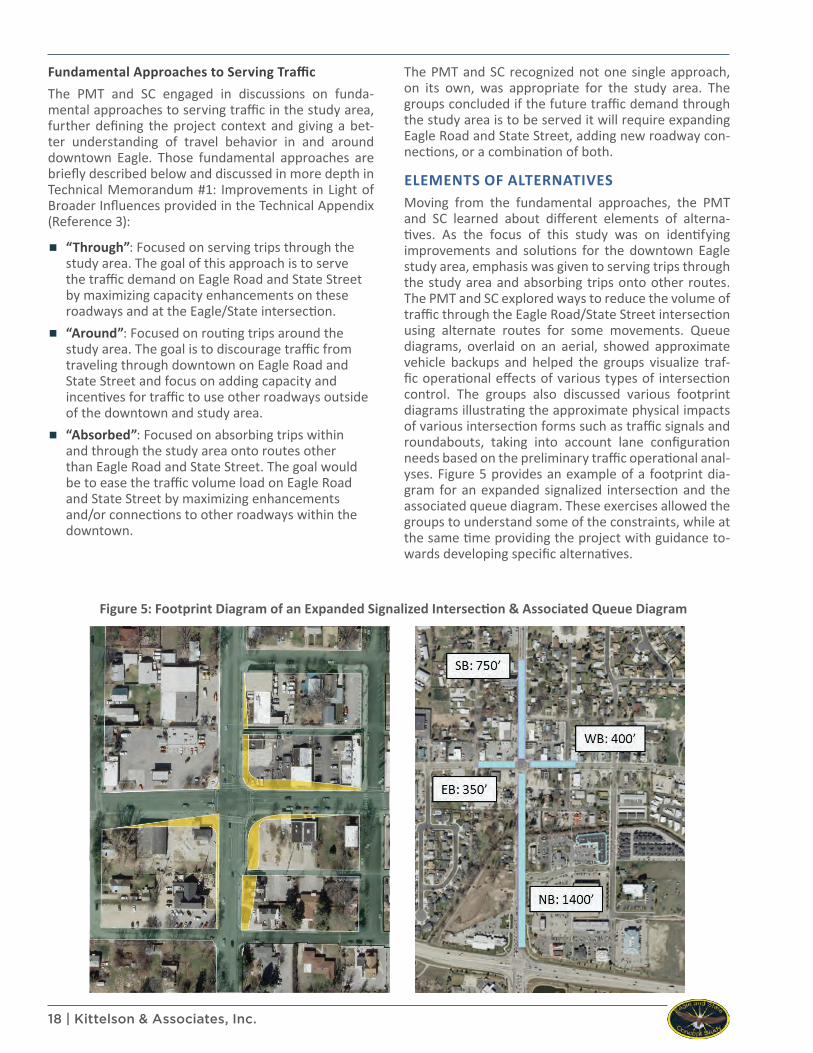
ELEMENTS OF ALTERNATIVESMoving from the fundamental approaches, the PMT and SC learned about different elements of alterna-tives. As the focus of this study was on identifying improvements and solutions for the downtown Eagle study area, emphasis was given to serving trips through the study area and absorbing trips onto other routes. The PMT and SC explored ways to reduce the volume of traffic through the Eagle Road/State Street intersection using alternate routes for some movements. Queue diagrams, overlaid on an aerial, showed approximate vehicle backups and helped the groups visualize traf-fic operational effects of various types of intersection control. The groups also discussed various footprint diagrams illustrating the approximate physical impacts of various intersection forms such as traffic signals and roundabouts, taking into account lane configuration needs based on the preliminary traffic operational anal-yses. Figure 5 provides an example of a footprint dia-gram for an expanded signalized intersection and the associated queue diagram. These exercises allowed the groups to understand some of the constraints, while at the same time providing the project with guidance to-wards developing specific alternatives.
Figure 5: Footprint Diagram of an Expanded Signalized Intersection & Associated Queue Diagram
Eagle Road and State Street Intersection Concept Study | 19
SECTION 4. ALTERNATIVES OVERVIEW, EVALUATION, & SUMMARYSpecific intersection alternatives and downtown circu-lation alternatives were developed by applying the prin-ciples of the Smart Transportation Planning approach within the framework of the project context. Feedback and rankings from the PMT, SC, and citizens of Eagle were critical in the establishment of alternatives, the refinement of alternatives, and in determining the proj-ect recommendations.
INTERSECTION EVALUATION CRITERIAIntersection evaluation criteria were established at the outset of the project in collaboration with the PMT and SC. The intersection evaluation criteria developed were specific for this project and provided a means for consistently and equitably assessing intersection alter-natives’ performance relative to the project goals and objectives. The evaluation criteria and key consider-ations are briefly outlined below and described in more detail in the Project Overview Memorandum within the Technical Appendix (Reference 2):
▪ Land Use Compatibility ▪ Consistency with land use visions & community
values
▪ Impacts to existing or future development opportunities
▪ Fit with the character of downtown
▪ Traffic Operations ▪ Vehicular delay/level of service
▪ Traffic demand versus available capacity
▪ Queuing impacts to nearby intersections and driveways
▪ Safety ▪ Safety for vehicular travel
▪ Safety for non-motorized users
▪ Non-Motorized Travel ▪ Connections & opportunities for additional
facilities
▪ Compatibility of treatments with downtown environment
▪ Physical Impacts ▪ Property & access
▪ On-street parking
▪ Utilities & other infrastructure
▪ Implementation ▪ Construction & right-of-way acquisition costs
▪ Constructability & phasing of construction
▪ Public acceptance
Members of the PMT and SC worked together to priori-tize the evaluation criteria. This helped frame decisions moving forward and distinguish those alternatives with better assessments under the higher priority criteria. Both the PMT and SC clearly identified the “Safety” cri-terion as the highest priority.
INTERSECTION ALTERNATIVESFive specific intersection alternatives were developed and evaluated based on extensive input from the citi-zens of Eagle, the SC, the PMT, Eagle City Council, and the ACHD Commission. The alternatives included the following:
▪ No-Build ▪ Expanded Signal ▪ Quadrant ▪ Roundabout ▪ One-Way Couplet
The alternatives were developed at a sketch-level and are presented in Figures 6 through 9. The conceptual sketches go beyond the immediate intersection area to illustrate approximate system impacts of each alterna-tive, show tie-ins to the existing roadways, and pres-ent lane configuration and traffic control needs at the nearby intersections.Each alternative was assessed relative to the six inter-section evaluation criteria. The results of this assess-ment, along with preliminary cost estimates for each alternative, are summarized in the sub-sections below. Additional detail on the analysis and evaluation of al-ternatives is provided in Technical Memorandum #2: Intersection Alternatives Evaluation & Downtown Cir-culation Concepts, and the Traffic Analysis Report in the Technical Appendix (Reference 3).
No-Build AlternativeThe no-build alternative maintains the existing configu-ration of the Eagle Road/State Street intersection, en-couraging traffic to find other routes around downtown Eagle due to the expected increase in congestion at the intersection. A sensitivity analysis assessed the lifespan of the no-build condition at the Eagle Road/State Street intersection because the traffic operations results do not meet ACHD’s volume-to-capacity standards in the future. Details of this analysis are provided in the Traffic Analysis Report in the Technical Appendix (Reference 3). The ACHD volume-to-capacity threshold is forecast to be exceeded between the years 2025 and 2030. However, the Eagle Road/State Street intersection is expected to fail prior to that because 95th percentile queues from the intersection are expected to spill back through the 2nd Street intersection between the years 2015 and 2020 and through the Plaza Drive intersection between the years 2020 and 2025.

20 | Kittelson & Associates, Inc.
Expanded Signal AlternativeThe expanded signal alternative expands the existing intersection footprint by adding lanes to critical move-ments. The most beneficial lane additions are a second through lane for northbound traffic and a second west-bound left-turn lane. This alternative requires widening of Eagle Road between State Street and Plaza Drive to a four-lane section and provides a raised median, bike lanes, and sidewalks between State Street and Plaza Drive. Figure 6 illustrates the concept sketch for the ex-panded signal alternative.
Quadrant AlternativeA quadrant intersection routes turning movements away from an intersection to improve traffic opera-tions. At the Eagle Road/State Street intersection the quadrant alternative routes the westbound left-turn movement through the 2nd Street/State Street inter-section to Eagle Road via 2nd Street and Plaza Drive. Vehicles would also have the option of turning left at the Olde Park Place/State Street intersection and trav-eling back to Eagle Road via Olde Park Place and Aik-ens Street. This alternative requires a signal at the 2nd Street/State Street intersection to adequately accom-modate the additional left-turn demand, but minimizes widening along both Eagle Road and State Street in the vicinity of the Eagle Road/State Street intersection. Fig-ure 7 illustrates the concept sketch for the quadrant alternative.
Roundabout AlternativeIncreased future traffic volume and the close proximity of other intersections to the Eagle Road/State Street in-tersection result in queues spilling back through nearby major intersections under the previously described al-ternatives. In addition, safety has been identified as a focus area for the project. For these reasons, a round-about alternative was considered at the Eagle Road/State Street intersection. Traffic analysis revealed a sin-gle-lane roundabout would not be sufficient to process the traffic demand, justifying the need for a multilane roundabout alternative. The multilane roundabout al-ternative requires widening of Eagle Road between State Street and Plaza Drive to a four-lane section, and provides a raised median, bike lanes, and sidewalks. Figure 8 illustrates the concept sketch for the round-about alternative.
One-Way Couplet AlternativeSeveral options for accommodating one-way travel were explored at a conceptual level, including the use of Olde Park Place, Eagle Road, 1st Street, and 2nd Street. The preferred one-way couplet alternative as-sumes Eagle Road is converted to one-way, northbound travel between Plaza Drive and Idaho Street. South-bound travel is assumed via a one-way connection to Olde Park Place near Idaho Street, connecting back to Eagle Road at Plaza Drive. These one-way segments of roadway require two-lanes for vehicular traffic and pro-vide on-street parking, bike lanes, and sidewalks. Eagle Road would remain a two-way street south of Plaza Drive and north of Idaho Street. Two unique intersec-tion concepts were considered for each end point of the one-way couplet. Figure 9 illustrates the concept sketch for the one-way couplet alternative, including the two unique concepts for each end point of the cou-plet.

Eagle/State Intersection Concept Study
Figure
6
May 2014H
:\pro
jfile
\130
96 -
Eag
le a
nd S
tate
Con
cept
Stu
dy\te
chni
cal m
emos
\Tec
h M
emo
#2\F
igur
es
CONCEPTUAL Expanded Signal Alternative Design

Eagle/State Intersection Concept Study
Figure
7
May 2014H
:\pro
jfile
\130
96 -
Eag
le a
nd S
tate
Con
cept
Stu
dy\te
chni
cal m
emos
\Tec
h M
emo
#2\F
igur
es
CONCEPTUAL Quadrant Alternative Design

Eagle/State Intersection Concept Study
Figure
8
May 2014H
:\pro
jfile
\130
96 -
Eag
le a
nd S
tate
Con
cept
Stu
dy\te
chni
cal m
emos
\Tec
h M
emo
#2\F
igur
es
CONCEPTUALRoundabout Alternative Design
Eagle/State Intersection Concept Study
Figure
9
May 2014
H:\p
rojfi
le\1
3096
- E
agle
and
Sta
te C
once
pt S
tudy
\tech
nica
l mem
os\T
ech
Mem
o #2
\Fig
ures
CONCEPTUALOne-Way Couplet Alternative Design

Eagle Road and State Street Intersection Concept Study | 25
Intersection Alternatives Evaluation SummaryTable 7 presents a summary of the evaluation for all five of the intersection alternatives.The following were identified when comparing the evaluation of alternatives:
▪ Land Use Compatibility - The quadrant and one-way couplet best support the land use vision for downtown Eagle.
▪ Traffic Operations - All four build alternatives improve traffic operations compared to the no-build alternative. The roundabout results in the best overall traffic operations for the intersection and minimizes vehicle spill back to other nearby intersections.
▪ Safety - The roundabout and one-way couplet are expected to provide the best overall safety performance of the five alternatives.
▪ Non-Motorized Travel - The one-way couplet is projected to provide the best environment for pedestrian and bicycle travel.
▪ Physical Impacts - The no-build and quadrant alternative have the least significant physical impacts.
▪ Implementation - Of the four build alternatives, the expanded signal and quadrant are expected to be the easiest to implement and construct.
Preliminary cost estimates for each of the four build al-ternatives provide another element for comparing and evaluating the alternatives. Design/construction and right-of-way (ROW) acquisition estimated cost ranges for each of the four build alternatives are shown in Ta-ble 8. The following were identified when comparing the al-ternatives’ cost estimates:
▪ The no-build alternative assumed no construction to the Eagle Road/State Street intersection or surrounding roadways.
▪ The expanded signal and roundabout alternatives are estimated to have similar overall costs although the costs for construction and right-of-way acquisition vary.
▪ The quadrant is the least expensive of the four build alternatives.
▪ The one-way couplet is the most expensive of the four build alternatives.
Table 7: Intersection Alternatives Evaluation Summary
Evaluation Criteria No-Build Expanded Signal Quadrant Roundabout One-Way
Couplet
Land Use Compatibility Fair Fair Good Fair Good
Traffic Operations Poor Fair Fair Good Fair
Safety Fair Fair Fair Good Good
Non-Motorized Travel Fair Fair Fair Fair Good
Physical Impacts Good Fair Good Fair Poor
Implementation Good Fair Fair Poor Poor
Table 8: Intersection Alternatives Cost Estimate Summary
Component No-Build Expanded Signal Quadrant Roundabout One-Way Cou-
plet
Design/Construction N/A $3.1M - $4.1M $2.6M - $3.4M $2.8M - $3.8M $4.9M - $5.9M
ROW Acquisition N/A $375k - $475k $375k - $475k $775k - $875k $900k - $1.7M
TOTAL N/A $3.5M - $4.6M $2.9M - $3.8M $3.6M - $4.6M $5.8M - $7.6M

26 | Kittelson & Associates, Inc.
Public Feedback on Intersection AlternativesPublic feedback played a significant role in the project, guiding the development and refinement of alterna-tives. For example, the one-way couplet alternative, not included in the initial set of alternatives, was de-veloped after receiving feedback from the stakeholders and general public to explore this alternative (Refer-ence 3 – Joint PMT/SC Meeting #3 Summary). The majority of comments from the general public were received at, and following, the Property Owner/Tenant Meeting and Public Involvement Meeting held on June 24th, 2013. Display boards illustrating the pro-cess and findings of the technical evaluation were pre-sented along with large plots displaying the sketches and evaluation of each intersection alternative. Meet-ing attendees were provided with a comment sheet and asked to rank alternatives for the Eagle Road/State Street intersection in order of most preferred (rank of 1) to least preferred (rank of 5) and provide com-ments towards their rankings. The rankings were used to calculate a weighted average rank, with the lowest average being the most supported alternative. Table 9 provides a summary of all of the rankings received from both meetings.The general public’s opinion on the alternatives was very mixed. As shown in Table 9, the weighted aver-age rank of all the alternatives was very close, with the difference between the most preferred alternative and the least preferred alternative being only 0.6 (2.5 to 3.1). Key observations from the rankings include:
▪ The no-build alternative received the most #1 rankings (21) and also had the most #5 rankings (23) resulting in the second lowest weighted average rank (3.0).
▪ The one-way couplet alternative had the second most #1 rankings (20), followed by the roundabout (17).
▪ The roundabout alternative was preferred by many (17 - #1 rankings), but also had 13 - #4 rankings and 10 - #5 rankings. Overall the roundabout tied for second in weighted average rank with the expanded signal alternative (2.8).
▪ The quadrant alternative had the lowest weighted average rank (3.1).
Following the general public meetings, the SC was asked to rank the intersection alternatives in the same manner as the general public. Table 10 provides a sum-mary of the SC rankings.
Table 9: Summary of the Public’s Alternatives Ranking
AlternativeRanking of Alternative Number
of Rankings
Weighted Average Rank
Rank#1 #2 #3 #4 #5
One-Way Couplet 20 9 7 7 9 52 2.5 1Roundabout 17 7 3 13 10 50 2.8 2
Expanded Signal 8 13 6 14 4 45 2.8 2No-Build 21 6 5 1 23 56 3.0 4Quadrant 2 10 19 6 6 43 3.1 5
Table 10: Summary of the Stakeholder Committee Alternatives Ranking
AlternativeRanking of Alternative Number
of Rankings
Weighted Average Rank
Rank#1 #2 #3 #4 #5
Roundabout 8 0 0 1 1 10 1.7 1Quadrant 1 6 2 0 0 9 2.1 2
One-Way Couplet 1 3 2 4 0 10 2.9 3Expanded Signal 0 0 4 4 1 9 3.7 4
No-Build 0 1 1 1 7 10 4.4 5

Eagle Road and State Street Intersection Concept Study | 27
As summarized in Table 10, the roundabout alternative was the most preferred intersection alternative (eight #1 rankings) among the SC members with a weighted average ranking of 1.7. The no-build alternative was the least preferred alternative (seven #5 rankings) with a weighted average ranking of 4.4. The quadrant alter-native was also a favorable option with the SC (one #1 ranking and six #2 rankings) with a weighted average ranking of 2.1. Comparing these results to the feedback from the general public meetings shows similarities and differences:
▪ Both the SC and the general public ranked the roundabout alternative in the top two among all alternatives (SC as #1, General Public as #2);
▪ Both the SC and the general public ranked the no-build alternative in the bottom two among all alternatives (SC as #5, General Public as #4);
▪ The SC ranked the quadrant alternative as the second most preferred alternative while the general public ranked the quadrant alternative as the least preferred alternative;
▪ The SC ranked the one-way couplet alternative as the third most preferred alternative while the general public ranked the one-way couplet as the most preferred alternative.
▪ The difference between the weighted average rankings for the #5 alternative and the #1 alternative is 2.7 among the stakeholders, while only 0.6 among the general public.
The Eagle City Council conducted a public hearing on the project at Eagle City Hall on August 13, 2013, fol-lowing the ranking of intersection alternatives by the SC. The City Council received a briefing on the project from City staff and heard a wide variety of public tes-timony on the project. At the hearing the City Coun-cil unanimously supported the downtown circulation
recommendations discussed in the next sub-section of this report, but did not support preserving right-of-way or prioritizing improvements at the Eagle Road/State Street intersection (Reference 8). Following the City Council’s decision on the project, the Eagle Transportation Committee prepared multiple let-ters to the City and conducted a presentation to the City Council stating the Committee’s unanimous support for the roundabout alternative and addressed some of the perceived concerns with a roundabout (Reference 9). Given this new information, Eagle City Council held a second public hearing at Eagle City Hall on March 18, 2014 and voted 3 to 2 to recommend the roundabout alternative for the Eagle Road/State Street intersec-tion along with the downtown circulation recommen-dations. The City, in a letter to the ACHD Commission, provided the following in support of the roundabout alternative recommendation:
▪ Local examples of success with roundabouts
▪ Highest safety rating for pedestrians and vehicles of the alternatives considered
▪ Minimizes impacts to local businesses
▪ Manages congestion and traffic queues
▪ Central island provides an opportunity to reinforce the unique sense of place and community identity in the City of Eagle (Reference 9)
The ACHD Commission held a public hearing to consider adoption of the Concept Study following the City Coun-cil’s recommendation in favor of a roundabout. Similar to previous hearings, the public provided a mix of opin-ions ranging from full endorsement of a roundabout to complete opposition to the roundabout. Comments were provided on the downtown circulation projects as well, with most people supporting them. The Commis-sion adopted the Concept Study with a recommenda-tion to move forward with the roundabout alternative by a 3 to 2 vote (Reference 10). Following the Commis-sion’s adoption of the study, a request for reconsidera-tion was filed on the project by a newly formed citizen group - Eagle Citizens & Businesses Against the Down-town Roundabout. Their primary concerns were in re-gard to the safety of bicyclists and visually-impaired pedestrians (Reference 11). The ACHD Commission heard their request but did not make a motion to re-consider the adoption of the Concept Study (Reference 12).More detailed information on the public feedback re-ceived on intersection alternatives is provided in the SC Meeting #4 Summary and the Public Feedback Sum-mary Memorandum in the Technical Appendix (Refer-ence 3).

28 | Kittelson & Associates, Inc.
DOWNTOWN CIRCULATION ALTERNATIVESOne of the primary objectives of the Eagle/State In-tersection Concept Study was to explore circulation improvements within downtown that may extend the lifespan of the Eagle Road/State Street intersection, ad-dress safety performance, enhance economic develop-ment potential, and/or address gaps in the pedestrian and bicycle facilities. The Downtown Eagle Plan provides the basis for different circulation alternatives explored as a part of this study. Figure 10, from the Downtown Eagle Plan, illustrates at a conceptual level a number of circulation improvements, all of which were presented to the SC and the general public for feedback. The cir-culation improvements were not assessed on the basis of the evaluation criteria used to assess the intersec-tion alternatives. Rather, these concepts were assessed based on the amount of support received from the public and the expected benefits from implementation.Attendees of the Property Owner/Tenant Meeting and Public Involvement Meeting held on June 24th, 2013 were asked to choose their top three circulation im-provements from the Downtown Eagle Plan and pro-vide feedback on their choices. Table 11 summarizes the number of votes each circulation improvement re-ceived.
Table 11: Summary of Downtown Circulation Improvements
ImprovementsNumber of Votes
A) Plaza Drive Extension 31
C) Palmetto Avenue Extension across State Highway 44
22
D) Idaho Street Extension 18
B) Stierman Way Extension (Parkway) 17
G) Aikens Street Extension 16
E) 1st Street Pedestrian Mall 16
F) Promote the creation/preservation of an urban grid
10
Figure 10: Downtown Street Improvements from Downtown Eagle Plan (Reference 1)

Eagle Road and State Street Intersection Concept Study | 29
The Idaho Street Extension, Stierman Way Extension, Aikens Street Extension, and 1st Street Pedestrian Mall were slightly less favored than the top two, the Plaza Drive Extension and the Palmetto Avenue Extension across SH 44. All four of these improvements were with-in two votes of each other indicating relatively equal preference for each. Several comments were made in reference to the Palmetto Avenue Extension and the potential of providing access to SH 44; however, this potential project does not include at-grade access to SH 44 due to Idaho Transportation Department access policy on this facility. Therefore, the extension would need to be a grade-separated facility across SH 44.Based on the public feedback, discussions with the PMT and SC, and City Council and ACHD Commission sup-port, the following projects were further developed as a part of this study:
▪ Plaza Drive Extension
▪ Aikens Street (East of Eagle Road) Extension
▪ Aikens Street (West of Eagle Road) and Olde Park Place (South of State Street) Widening/Streetscape
▪ Olde Park Place (North of State Street) Widening/Streetscape and Idaho Street extension from Eagle Road to Olde Park Place
The other street projects identified in the Downtown Eagle Plan are not precluded from future exploration or action, but were not further developed as a part of this study. Figure 1 provides an overview of the concept design for the projects identified above, while figures displaying more detail for these projects are provided in Appendix A of this report. Implementation of these downtown circulation projects supports the following goals within the Downtown Eagle Plan (Reference 1):
▪ Preserve, design, develop, and promote downtown Eagle as the “Heart of Eagle”;
▪ Make downtown easy to get to for all modes of transportation and all generations – seek to expand and develop an interconnected street and pathway system; and,
▪ Maintain downtown Eagle as the heart of the community with pedestrian-friendly streetscapes and ample parking.
The downtown circulation concepts also align with the three points of focus in transportation planning within the Downtown Eagle Plan (Reference 1):
▪ Emphasize and enhance downtown as a destination;
▪ Give priority to pedestrians, bicyclists, and future transit; and,
▪ Improve connectivity between downtown Eagle and the rest of the City and surrounding area.
The following benefits are expected with implementa-tion of the circulation concepts and are discussed in more depth alongside implementation details within the Recommendations and Implementation Strategy section of this report:
▪ Small reductions in traffic through the Eagle Road/State Street intersection;
▪ Improved network connectivity for multiple modes of travel;
▪ Separated facilities for vehicles and pedestrians, and in some cases bicyclists;
▪ Alternate routes and/or improved connections for emergency services response;
▪ An increase in economic development potential within downtown Eagle with better access to existing businesses and undeveloped or underdeveloped land.

30 | Kittelson & Associates, Inc.
PROJECT SUMMARYThe Eagle/State Intersection Concept Study accom-plished its primary purpose of identifying and prioritiz-ing recommendations for the Eagle Road/State Street intersection and the City of Eagle downtown core. The recommended roundabout alternative for the Eagle Road/State Street intersection is expected to provide safety benefits, improve traffic operations, and en-hance the character and sense of place in downtown Eagle. The roundabout alternative was supported by many attendees of the public meetings, the PMT and SC, the Eagle Transportation Committee, and the Eagle City Council, and subsequently adopted by the ACHD Commission as the recommended alternative for the Eagle Road/State Street intersection. ACHD’s Master Street Map will be revised to reflect this recommenda-tion, which includes a four-lane cross section on Eagle Road from Plaza Drive to State Street.
The recommended downtown circulation projects provide improved network connectivity, street and sidewalk facilities for multiple modes, and support eco-nomic development in downtown. The results and recommendations of this study have been accepted by the City of Eagle and ACHD as the best balance of safely accommodating expected traffic growth with the City’s primary goals for transportation in downtown Eagle. The recommended roundabout alternative and downtown circulation projects will be prioritized in ACHD’s Capital Improvements Plan and Five-Year Work Plan based on the immediate and pro-jected needs of the road system and input from citi-zens.

Eagle Road and State Street Intersection Concept Study | 31
SECTION 5. REFERENCES1. City of Eagle. Downtown Eagle Plan. Addendum A – Section 6.8.13 of the 2011 Eagle Comprehensive Plan. Ad-
opted through Resolution No. 11-02. February 3, 2011.
2. Transportation Research Board. NCHRP Report 672: Roundabouts: An Informational Guide, 2nd ed., Washing-ton, D.C., 2010.
3. Kittelson & Associates, Inc. Eagle/State Intersection Concept Study – Technical Appendix. February 2014
4. New Jersey Department of Transportation & Pennsylvania Department of Transportation. Smart Transportation Guidebook. March 2008.
5. Ada County Highway District (ACHD). Policy Manual – Section 7106 – Traffic Impact Studies. Adopted through Ordinance No. 217. September 14, 2011.
6. Community Planning Association of Southwest Idaho (COMPASS), 2035 Functional Classification Map, January 2012
7. Ada County Highway District (ACHD), ACHD 2012 Capital Improvements Plan (CIP), May 2012
8. City of Eagle. “August 13, 2013 Eagle City Council Meeting Minutes.” http://lf.cityofeagle.org/WebLink8/0/doc/27584/Page1.aspx. Accessed January 3, 2014.
9. Ada County Highway District (ACHD). “Eagle/State Staff Report for March 26, 2014 Commission Meeting.” http://www.achdidaho.org/MeetingsAgendas/CommissionMeetings/Archive/2014/03-26-14/ACIBOREagle-State_Staff-Report-5.pdf. Accessed May 5, 2014.
10. Ada County Highway District (ACHD). “March 26, 2014 Commission Meeting Minutes.” http://achdidaho.org/MeetingsAgendas/CommissionMeetings/Archive/2014/Minutes/03262014Minutes.pdf. Accessed May 5, 2014.
11. Ada County Highway District (ACHD). “Request for Reconsideration of March 26, 2014 Eagle/State Intersec-tion Concept Study Adoption.” http://www.achdidaho.org/MeetingsAgendas/CommissionMeetings/Ar-chive/2014/04-09-14/SWORKMAN20140401Reconsideration.pdf. Accessed May 5, 2014.
12. Ada County Highway District (ACHD). “April 9, 2014 Commission Meeting Minutes.” http://achdidaho.org/Meet-ingsAgendas/CommissionMeetings/Archive/2014/Minutes/04092014Minutes.pdf. Accessed May 5, 2014.

This page intentionally left blank

Eagle Road and State Street Intersection Concept Study | 33
A APPENDIX A: DOWNTOWN CIRCULATION RECOMMENDATIONS

This page intentionally left blank