e4 : applications of ground-penetrating radar e4.1
TRANSCRIPT

Geophysics 223 April 2009
1
E4 : Applications of ground-penetrating radar E4.1 Geotechnical and environmental applications of GPR The following examples of GPR data are from http://www.sensoft.ca Sensors and Software Ltd. are thanked for permission to use these figures. E4.1.1 Soil water content
From http://www.sensoft.ca/applications/geotech/geotech.html Soil water content of a California vineyard
• Velocity of the ground wave decreases as the water content of the soil increases. This allows for non-invasive mapping in locations such as in a vineyard.

Geophysics 223 April 2009
2
• The radar measurements give good agreement with other methods of measuring soil-water content. Details in Hubbard et al., The Leading Edge, (2002)

Geophysics 223 April 2009
3
E4.1.2 Water table depth
From http://www.sensoft.ca/applications/geotech/geotech.html E4.1.3 Contaminant mapping
From http://www.sensoft.ca/applications/geotech/geotech.html

Geophysics 223 April 2009
4
E4.1.4 Contaminant remediation
From http://www.sensoft.ca/applications/geotech/geotech.html E4.1.5 Underground storage tanks
From http://www.sensoft.ca/applications/geotech/geotech.html

Geophysics 223 April 2009
5
E4.1.6 Saltwater intrusion
From http://www.sensoft.ca/applications/geotech/geotech.html E4.1.7 Depth to bedrock
From Davis and Annan, Geophysical Prospecting, (1989)
Geophysics 223 April 2009
6
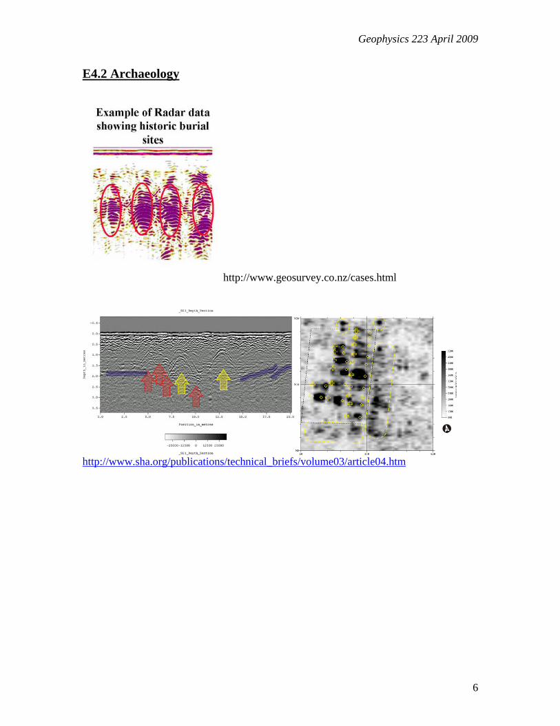
E4.2 Archaeology
http://www.geosurvey.co.nz/cases.html
http://www.sha.org/publications/technical_briefs/volume03/article04.htm

Geophysics 223 April 2009
7
http://www.sensoft.ca/applications/forensics/forensics.html
http://www.geo-sense.com/GPR.htm
• Detection of an archaeological cave in the Biblical city of Nysa (Shomron, Israel) using a GPR survey, from the time of Joshua Bin-Nun (around 1300 BC). This cave is known as the "Mikve" of the city.
Geophysics 223 April 2009
8
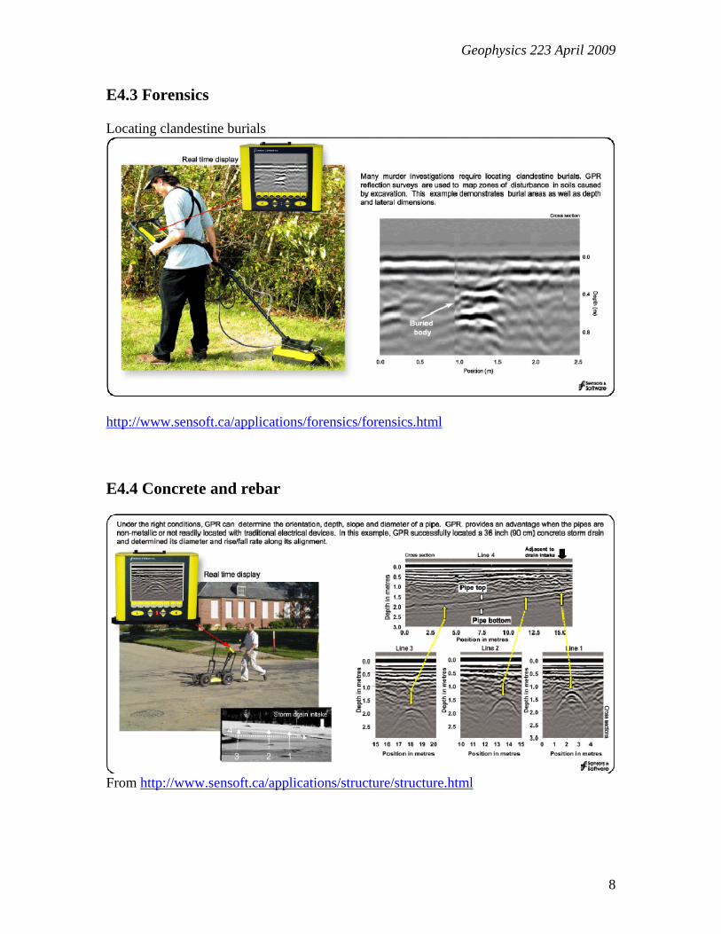
E4.3 Forensics Locating clandestine burials
http://www.sensoft.ca/applications/forensics/forensics.html E4.4 Concrete and rebar
From http://www.sensoft.ca/applications/structure/structure.html

Geophysics 223 April 2009
9
E4.5 Location of buried utilities
http://www.accuratedetection.com/products/easy_locator.html E4.6 Military applications Applications include landmine clearance, unexploded ordinance detection and location of clandestine tunnels and bunkers. http://www.sensoft.ca/applications/security/security.html

Geophysics 223 April 2009
10
E4.7 Sedimentology http://www.see.leeds.ac.uk/research/igs/seddies/best/jamunabar.htm
Real time studies of sedimentation in a gravel bar in Bangladesh from Best et al., (2003)

Geophysics 223 April 2009
11
E4.8 Mining
• Example from Davis and Annan (1989) of GPR data collected in a mine. • Fractures can be identified, as well as a dyke.

Geophysics 223 April 2009
12
• GPR Data collected in a potash mine

Geophysics 223 April 2009
13
E4.9 Glaciology
E4.9.1 Measuring ice thickness and bedrock topography
Figure from Martin Sharp (EAS)
Problems:
• off-nadir returns (migration), internal reflections, scattering from crevasses, absorption by water
• Resolution/penetration trade-off in frequency selection
• Map internal reflectors, bed reflection power as indicators of thermal structure

Geophysics 223 April 2009
14
Figures from Martin Sharp (EAS)

Geophysics 223 April 2009
15

Geophysics 223 April 2009
16
Photos from Martin Sharp and Jeff Kavanaugh (EAS)
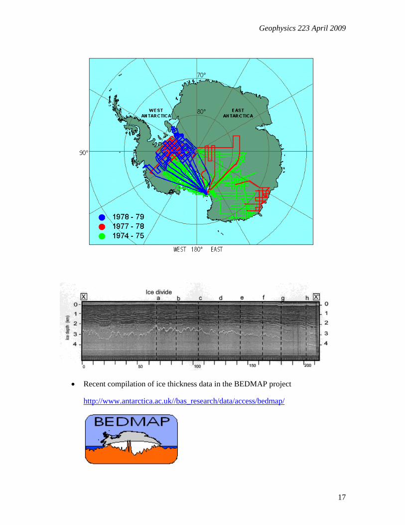
Antarctica
• One of the first applications of radar for measuring ice thickness was described by Walford (1964). Also called radio-echo sounding (RES). Radio waves travel at 0.168 m/ns. General review of radar applications in glaciology given by Plewes and Hubbard (2001).
• Extensive data base collected in Antarctica in the 1960’s and 1970s using airborne radar system. More than 400,000 km of profile data collected Scott Polar Research Institute, NSF and Technical University of Denmark.
• Figures below are from http://www.bgc.bris.ac.uk/research/RES
Geophysics 223 April 2009
17
• Recent compilation of ice thickness data in the BEDMAP project
http://www.antarctica.ac.uk//bas_research/data/access/bedmap/

Geophysics 223 April 2009
18
http://www.antarctica.ac.uk//bas_research/data/access/bedmap/

Geophysics 223 April 2009
19
Canadian Arctic
• Radar section from John Evans Glacier, Ellesmere Island. For details see Copland and Sharp (2001).
• Measuring ice thickness can confirm space geodetic studies of glacier volume.
E4.9.2 Mapping internal structure of ice sheets and glaciers.
• Internal reflections believed to be due to isochronous layers. Layers of dust from volcanic eruptions can give strong reflections. Example below is taken from the Fletcher Promontory, Antarctica and the undulations in the isochronous layers are not correlated with bedrock topography (Vaughan et al., 1999). One feature occurs at an ice divide and reflects non-linear rheology of ice.
• Mapping this internal structure helps with interpretation of ice core data. The internal reflections can also used to understand flow pattern of glacier.

Geophysics 223 April 2009
20
Vaughan et al., Nature, (1999)

Geophysics 223 April 2009
21
Figure from Martin Sharp (EAS)
• Local-scale snow accumulation variability on the Greenland ice sheet from ground-penetrating radar (GPR) http://cires.colorado.edu/~maurerj/gpr/gpr_cryosphere.html

Geophysics 223 April 2009
22
E4.9.3 Determine basal conditions
• Sub-glacial lakes first identified on the basis of character of a flat basal reflection, and flat ice surface. http://www.bgc.bris.ac.uk/research/RES/RES/4_subg.html
Lake Vostock was detected from both airborne and satellite radar.
More information http://earthsci.org/education/Lake_Vostok/vostok.html
Animation : http://www.earthinstitute.columbia.edu/news/vostok/vostok.swf
• Elsewhere the amplitude of the basal reflection can be used to study the composition of sub-glacial sediments. Reflections from a frozen base or one containing free water are quite different. This parameter is important for understanding how easily the glacier or ice sheet can move.
• For examples see Holt et al., (2006) who used airborne radar to infer that the bed of the Taylor Glacier is frozen.

Geophysics 223 April 2009
23
E4.10 References Arcone, S.A. (1996), High resolution of glacial ice stratigraphy: A ground-penetrating radar study of Pegasus Runway, McMurdo Station, Antarctica. Geophysics. 61(6): 1653-1663. Best, J.L., P. J. Ashworth, C. S. Bristow, and J. Roden , Three-Dimensional Sedimentary Architecture of a Large, Mid-Channel Sand Braid Bar, Jamuna River, Bangladesh, J. of Sedimentary Research, 2003 73: 516-530 Copland, L. and Sharp, M. 2001. Mapping thermal and hydrological conditions beneath a polythermal glacier using radio echo sounding. Journal of Glaciology, 47, 232-242. Davis, J.L., and P. Annan, Ground-penetrating radar for high resolution mapping of soil and rock stratigraphy, Geophysical Prospecting, 37, 531-551, 1989. Holt, J.W., M.E. Peters, D.L. Morse, D.D. Blankenship, L.E. Lindzey, J.L. Kavanaugh and K.M. Cuffey, Identifying and characterizing subsurface echoes in airborne radar sounding data from a high clutter environment in Taylor Valley, Antarctica, 11th International conference of Ground Penetrating radar, June 19-22, Columbus, Ohio, USA, 2006. Hubbard, S., K. Grote, Y. Rubin, Mapping the volumetric soil water content of a California vineyard using high frequency GPR ground wave data, The Leading Edge, 552-559, June 2002. Plewes, L.A. and B. Hubbard, A review of the use of radio echo sounding in glaciology, Progress in Physical Geography 2001; 25; 203, DOI: 10.1177/030913330102500203 Vaughan, D.G., H.F.J. Corr, C.S.M. Doake, and E.D. Waddington (1999), Distortion of isochronous layers in ice revealed by ground-penetrating radar. Nature. 398: 323-326. Walford, M.E.R. (1964), Radio-echo sounding through an ice shelf. Nature. 204: 317-319. Welch, B.C., W.T. Pfeffer, J.T. Harper and N.F. Humphrey (1998), Mapping subglacial surfaces of temperate valley glaciers by two-pass migration of radio-echo sounding survey data, Journal of Glaciology. 44: 164-170 Winebrenner, D.P., B.E. Smith, G.A. Catania, H.B. Conway, and C.F. Raymond (2003), Radio-frequency attenuation between Siple Dome, West Antarctica, from wide-angle and profiling radar observations. Annals of Glaciology. 37: 226-232.