due diligence report melbourne beach, fl
TRANSCRIPT
Hampton Apartment Redevelopment Due Diligence Report
Melbourne Beach, FL
10 August 2017
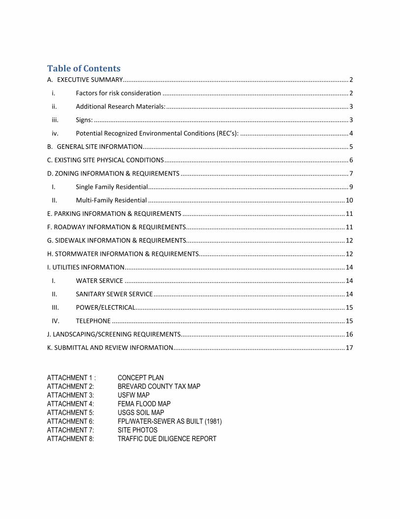
Table of Contents
A. EXECUTIVE SUMMARY ............................................................................................................................. 2
i. Factors for risk consideration ....................................................................................................... 2
ii. Additional Research Materials: ..................................................................................................... 3
iii. Signs: ............................................................................................................................................. 3
iv. Potential Recognized Environmental Conditions (REC’s): ............................................................ 4
B. GENERAL SITE INFORMATION .................................................................................................................. 5
C. EXISTING SITE PHYSICAL CONDITIONS ...................................................................................................... 6
D. ZONING INFORMATION & REQUIREMENTS ............................................................................................. 7
I. Single Family Residential ............................................................................................................... 9
II. Multi-Family Residential ............................................................................................................. 10
E. PARKING INFORMATION & REQUIREMENTS .......................................................................................... 11
F. ROADWAY INFORMATION & REQUIREMENTS ........................................................................................ 11
G. SIDEWALK INFORMATION & REQUIREMENTS........................................................................................ 12
H. STORMWATER INFORMATION & REQUIREMENTS................................................................................. 12
I. UTILITIES INFORMATION .......................................................................................................................... 14
I. WATER SERVICE .......................................................................................................................... 14
II. SANITARY SEWER SERVICE .......................................................................................................... 14
III. POWER/ELECTRICAL .................................................................................................................... 15
IV. TELEPHONE ................................................................................................................................. 15
J. LANDSCAPING/SCREENING REQUIREMENTS ........................................................................................... 16
K. SUBMITTAL AND REVIEW INFORMATION ............................................................................................... 17
ATTACHMENT 1 : CONCEPT PLAN
ATTACHMENT 2: BREVARD COUNTY TAX MAP
ATTACHMENT 3: USFW MAP
ATTACHMENT 4: FEMA FLOOD MAP
ATTACHMENT 5: USGS SOIL MAP
ATTACHMENT 6: FPL/WATER-SEWER AS BUILT (1981)
ATTACHMENT 7: SITE PHOTOS
ATTACHMENT 8: TRAFFIC DUE DILIGENCE REPORT

Due Diligence Report
160 Versailles Drive,
Melbourne Beach, FL
Page 2 of 19
A. EXECUTIVE SUMMARY
The proposed site is approximately 18.85 acres, within the jurisdiction of Brevard
County, Florida. The site is located on the lot west of SR A1A and adjacent to
Versailles Drive – approximately 4.25 miles south of the Melbourne Causeway (US-
192).
The proposed site is currently undeveloped and zoned in the Low-density Multiple-
family residential (RU-2-8) with the surrounding parcels of similar uses and zoning.
The parcel fronts the Indian River to the west and SR A1A to the east, with an
existing accessway – Versailles Dr. – to the south.
The site existing features include stormwater, roadway, and sanitary sewer
throughout the previous Hampton Apartment development. The existing access will
remain at the existing Versailles Drive.
The proposed development consists of the construction of multiple/single-family
residential homes. Per Brevard County Land Development Code, single-family
attached dwellings are permitted in the RU-2-8 zoning district. Information
provided in the report based on the development standards of both single-family
attached residential and low-density multiple family residential criterion.
i. Factors for risk consideration
• Per legal description provided, the site area is defined by three individual (3)
parcels whereas the current Brevard County Property Appraisers property
information card lists the site area with two (2) parcels.
• Report was prepared without benefit of survey or land title abstract search;
therefore, it is not defined where Parcel III lies.
• Breezeway/Visual Corridor regulations:
i. Riverfront properties shall include all land from the mean low-water
line to a distance of 250 feet or the closest dedicated public right-of-
way, running to parallel to the water, whichever distance is less.
ii. No building, structures, berms or solid fences, or combination thereof,
more than four (4) feet in height shall be permitted in the
breezeway/visual corridor.
iii. The minimum 30% breezeway/visual corridor requirement shall apply
to all riverfront properties except single-family residential.
iv. An additional 1% of breezeway above minimum requirements shall be
provided for each additional one foot of building height over 35 feet,
up to a building height of 55 feet, and an additional 1/2% of
breezeway above minimum requirements shall be provided for each
additional one foot of building height above 55 feet.

Due Diligence Report
160 Versailles Drive,
Melbourne Beach, FL
Page 3 of 19
• Based on information provided by the owner, there are two variances still in
effect for the existing parcels
i. V-975 was granted on the Parcel I, II and III in 1980 and allows for a
wall variance of two (2) ft. over the required four (4) ft. for a front wall
and one (1) ft. over the maximum thirty-five (35) ft. building height
limit.
ii. V-1054 was granted solely on Parcel III in 1981 and allows for a
deviation of nineteen (19) ft. over the maximum thirty-five (35) ft.
building height limit.
• A conditional use for the use of the Residential Marina will be required during
the redevelopment site plan review. Prior to closing the buyer will obtain an
assurance from Brevard County that a conditional use permit is not required
for the marina which is a grandfathered pre-existing use.
• 12 adult gopher tortoise burrows were identified within the parcel. Burrows
will need to be relocated.
• A regional liftstation and existing sewer infrastructure remains on site.
• Per Mr. Clifford R. Repperger’s (Attorney for the Respondent) letter dated
July 1, 2008 and Cindy Fox’s (Brevard County Planning & Zoning Manager)
response dated August 12, 2016, the following is still valid:
i. The pre-existing use (PEU-009) is granted for Parcel I and II and may
be developed at 10 units per acre up to a total density of 178 units.
The PEU does not include Parcel III.
ii. Parcel III can be developed at a current density of 8 units per acre.
ii. Additional Research Materials:
The following documents were consulted for this due diligence: • Brevard County Land Development Code
• Water Standards (City of Melbourne) • Sewer Standards (Brevard County)
• St. John’s River Water Management District
• 2012 Florida Accessibility Code
• Clifford R. Repperger Hamptons Building Code Case Resolution Letter (2008)
• Cindy Fox Zoning Verification Letter (2016)
iii. Signs:
Any sign to be erected will require a building or electrical permit from Brevard
County. However, the following types of signs do not require a permit:
• Identification Signs. Signs identifying only the name and address of the
owners, occupants or buildings. Such signs shall not exceed an area of two
square feet for a single-family residential or four square feet for a multiple-
family, nonresidential or mixed use structure.
• Real Estate Signs. Signs for sale, lease or rental of real estate shall be

Due Diligence Report
160 Versailles Drive,
Melbourne Beach, FL
Page 4 of 19
exempt from permitting. Real estate signs also include open house and
model home signs. Subject to the following requirements:
o Max. Sign Surface Area: 48 sq. ft.
o Setback/size: All temporary signs shall maintain a
minimum 15-foot setback from all other property lines.
Setback
Distance (ft.)
Sign Area
(sq. ft.)
Sign Height
(measured from ground) (ft.)
Notes
< 5 4 4 -
5-15 32 10 Sign shall be located 25 ft. or greater from any intersection
(street or driveway)
15-25 40 20 Sign shall be located 25 ft. or
greater from any intersection (street or driveway)
25 75 32 Sign shall be located 25 ft. or greater from any intersection
(street or driveway)
iv. Potential Recognized Environmental Conditions (REC’s):
• 12 adult gopher tortoise burrows were identified within the parcel. These
burrows were described as potentially active.
• The majority of the burrows were located within disturbed habitats including
the large spoil piles located onsite.
• All gopher tortoises must be relocated from potential development area. If
burrows remain 25 feet or further from the clearing or construction area,
no permit is required.
• A Phase 1 ESA report dated August 2017 from BKI consultants was reviewed.
No REC’s were identified for this site.
(Atkins derived the above information provided by BKI Consultants Gopher Tortoise
Report and Phase 1 Report. Atkins does not warranty the accuracy or completeness
of the information.)
Due Diligence Report
160 Versailles Drive,
Melbourne Beach, FL
Page 5 of 19
B. GENERAL SITE INFORMATION
1. Site Address: 160 Versailles Drive, Melbourne Beach, FL 32951.
2. Jurisdiction or Municipality: Brevard County
3. Site Parcel Number: 28-38-20-00-00006.0-0000.00 28-38-20-00-00005.0-0000.00
4. Site Acreage: 18.85 Ac.
5. Site Zoning: Low-density multiple-family residential, (RU-2-8). Density of 8
units/acre is inconsistent with zoning. Based on RU-2-8 zoning parcels I and II may have 10 units/acre (152 units) and for mixed density use Parcel III may have 8 units/acre (178 units).
6. Size of proposed building: TBD
7. Type of proposed building: Single/Multiple Family Residential Units
8. Are there any known easements? If yes, can you build/plant in the
easement? Describe. Yes. Water & Sewer easements on the south side of the property. Also, a 10’ easement from the adjacent
properties to the south.
9. Are offsite easements required? Describe. TBD at a future date.
a. Are onsite easements required? Describe. Revised access easement
potentially FPL easements and new water-sewer easements.
10. Are there any site development restrictions on the site such as development or special use restrictions, covenants, or others: TBD. From the Cliff Repperger’s
letter, exhibit B, there are notable permitted exceptions for the parcels indicated as I, II, II which should be re-examined by client’s legal counsel for applicability and legal opinion.
11. Existing property boundary information from: (tax map or survey, etc.): See Attachment 2 – Brevard County Property Appraiser Tax Map
12. Easement/ROW Vacating: It is unknown at the time of the preparation of this report if Versailles Road is an actual ROW requiring official abandoning and
vacating for site development or modification. The same would apply for utility easement. It is unclear if these matters can be handled at the time of Platting or
other formal process. Per discussion with Brevard County Surveying and Mapping Dept. (Marc Cazessus 321-633-2080), there is currently no deed associated with
Versailles Dr. granting the ROW to the County.
Due Diligence Report
160 Versailles Drive,
Melbourne Beach, FL
Page 6 of 19
C. EXISTING SITE PHYSICAL CONDITIONS
1. Existing use of property: There is currently a vacant property that had been
cleared of prior apartment dwellings.
2. Is on-site demolition of existing structures required? None required
3. Existing vegetation present on developed site? (NONE, LIGHT, MODERATE,
HEAVY) Describe. Light vegetation exist due to the previous development.
Trees and shrubbery located sparsely throughout the lot.
4. Does the existing site have surface drainage features? Prior use stormwater ponds exist onsite.
5. Any potential wetland areas? No known wetland areas exist (See Attachment 3)
6. Any potential waters of the state? No known waters of the state (See Attachment 3)
7. Excessive grading anticipated? Describe. Not anticipated.
8. Should retaining walls be anticipated? Describe. Not Anticipated.
9. Is further environmental assessment warranted (wetlands determination, state
waters determination, Phase I environmental, Geotechnical Report, Asbestos
Survey)? Describe. Geotechnical Report, Phase I report; Phase II if required by Phase 1.
10. Are there any existing storm water systems on or near the site (creeks,
streams, ponds, culverts, etc.)? Yes, stormwater ponds remains from
previous development.
11.Is the site within the 100-year flood plain (FEMA)? No, except for a small fringe area adjacent to the Indian River water’s edge. Site upland area is primarily in
Zone X per FEMA panel FM12009C0616G Map Revised March 17, 2014. See Attachment 4 – FEMA Flood Map
Due Diligence Report
160 Versailles Drive,
Melbourne Beach, FL
Page 7 of 19
D. ZONING INFORMATION & REQUIREMENTS
1. Current zoning classification on the existing property:
Low-density multiple-family residential, (RU-2-8). Other density implications apply. See item B.5.
2. What types of use (retail, office, restaurant, etc.) are currently allowed? The RU-2-8 low-density multiple-family residential zoning classifications
encompass lands devoted to low-density multifamily residential purposes, together with such accessory uses as may be necessary or are normally
compatible with residential surroundings.
3. Any anticipated changes to the development code in the near future? None
anticipated.
4. Is there any type of overlay district? No.
5. Is there any design principles for the overlay district? No
6. Maximum building height allowed: 45 feet. Where any structure or building exceeds 35 feet in height the conditions must be fully satisfied:
a) The distance between the building and the lot line of any adjacent parcel shall be no less than the sum of (a) the setback required by the zoning
classification and (b) the product of the height of the building in excess of 35 feet (as measured from the average elevation of the finished
development grade of the building site) multiplied by 1.25. This may also be expressed as the formula:
[(X-35)x1.25] + Z.
where X = total building height in feet Z = setback required by the applicable zoning
For example: if applicable setback is 20 feet, and the building height is 55 feet, the minimum distance between the building and the lot line of the adjacent parcel would be:
[(55-35)x1.25] + 20 = 45 feet.
b) In no event shall the ratio of the distance between the lot line of any residentially zoned parcel and the height of the structure be less than two to one. For example, a building 55 feet in height must be no less than 110
feet from the lot line of an adjacent residentially zoned parcel.
Due Diligence Report
160 Versailles Drive,
Melbourne Beach, FL
Page 8 of 19
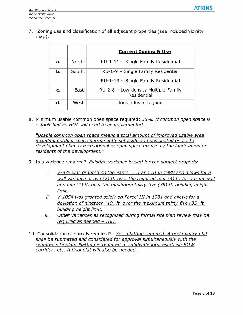
7. Zoning use and classification of all adjacent properties (see included vicinity map):
Current Zoning & Use
a. North: RU-1-11 – Single Family Residential
b. South: RU-1-9 – Single Family Residential
RU-1-13 – Single Family Residential
c. East: RU-2-8 – Low-density Multiple-Family Residential
d. West: Indian River Lagoon
8. Minimum usable common open space required: 35%. If common open space is
established an HOA will need to be implemented. “Usable common open space means a total amount of improved usable area
including outdoor space permanently set aside and designated on a site development plan as recreational or open space for use by the landowners or
residents of the development.”
9. Is a variance required? Existing variance issued for the subject property.
i. V-975 was granted on the Parcel I, II and III in 1980 and allows for a
wall variance of two (2) ft. over the required four (4) ft. for a front wall
and one (1) ft. over the maximum thirty-five (35) ft. building height
limit.
ii. V-1054 was granted solely on Parcel III in 1981 and allows for a
deviation of nineteen (19) ft. over the maximum thirty-five (35) ft.
building height limit.
iii. Other variances as recognized during formal site plan review may be
required as needed – TBD.
10. Consolidation of parcels required? Yes, platting required. A preliminary plat
shall be submitted and considered for approval simultaneously with the required site plan. Platting is required to subdivide lots, establish ROW
corridors etc. A final plat will also be needed.
Due Diligence Report
160 Versailles Drive,
Melbourne Beach, FL
Page 9 of 19
I. Single Family Residential
Single-family attached residential means a multiple residential unit structure that is architecturally and characteristically compatible with single-family detached residential lifestyle. These residential characteristics include architectural styles which share a common wall. Each residential unit shall be contiguous to and have direct access to a designated yard, and have its own entrance separate from any other unit within the same structure. 11. Required setbacks and/or required buffer yards from right-of-ways or
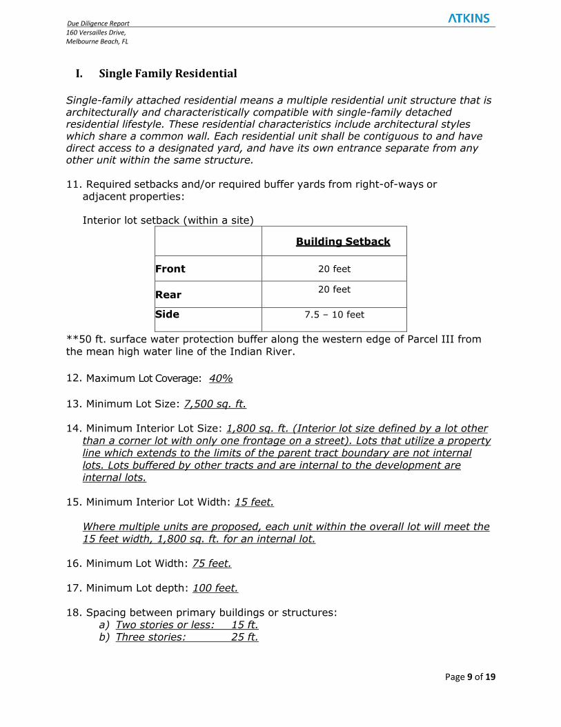
adjacent properties: Interior lot setback (within a site)
Building Setback
Front 20 feet
Rear 20 feet
Side
7.5 – 10 feet
**50 ft. surface water protection buffer along the western edge of Parcel III from
the mean high water line of the Indian River.
12. Maximum Lot Coverage: 40%
13. Minimum Lot Size: 7,500 sq. ft.
14. Minimum Interior Lot Size: 1,800 sq. ft. (Interior lot size defined by a lot other
than a corner lot with only one frontage on a street). Lots that utilize a property line which extends to the limits of the parent tract boundary are not internal
lots. Lots buffered by other tracts and are internal to the development are internal lots.
15. Minimum Interior Lot Width: 15 feet.
Where multiple units are proposed, each unit within the overall lot will meet the 15 feet width, 1,800 sq. ft. for an internal lot.
16. Minimum Lot Width: 75 feet.
17. Minimum Lot depth: 100 feet.
18. Spacing between primary buildings or structures: a) Two stories or less: 15 ft. b) Three stories: 25 ft.
Due Diligence Report
160 Versailles Drive,
Melbourne Beach, FL
Page 10 of 19
II. Multi-Family Residential
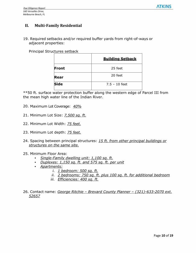
19. Required setbacks and/or required buffer yards from right-of-ways or adjacent properties: Principal Structures setback
Building Setback
Front 25 feet
Rear 20 feet
Side
7.5 – 10 feet
**50 ft. surface water protection buffer along the western edge of Parcel III from
the mean high water line of the Indian River.
20. Maximum Lot Coverage: 40%
21. Minimum Lot Size: 7,500 sq. ft.
22. Minimum Lot Width: 75 feet.
23. Minimum Lot depth: 75 feet.
24. Spacing between principal structures: 15 ft. from other principal buildings or
structures on the same site.
25. Minimum Floor Area: • Single-Family dwelling unit: 1,100 sq. ft. • Duplexes: 1,150 sq. ft. and 575 sq. ft. per unit
• Apartments: i. 1 bedroom: 500 sq. ft.
ii. 2 bedrooms: 750 sq. ft. plus 100 sq. ft. for additional bedroom iii. Efficiencies: 400 sq. ft.
26. Contact name: George Ritchie – Brevard County Planner – (321)-633-2070 ext. 52657

Due Diligence Report
160 Versailles Drive,
Melbourne Beach, FL
Page 11 of 19
E. PARKING INFORMATION & REQUIREMENTS
1. Parking requirements: Apartment Complexes: 1.75 spaces per unit. Condominiums and Townhome Complexes: 2 spaces per
residential unit plus 1 space per 5 units for guest parking. Complexes with more than 15 units shall not be required to provide guest parking.
2. Standard 90o Parking Stall dimensions:
• Minimum: 9 ft. x 20 ft.
4. Minimum Two-way Drive aisle dimension: A minimum aisle width of 24 ft. is
required for 2-way traffic.
5. Minimum One-Way drive aisle dimension: A minimum aisle width of 14 ft. is required for 1-way traffic.
6. Handicap accessible parking requirements: • These parking spaces shall be conveniently located with respect to main
and secondary entrances and ramps to sidewalks shall be provided and conveniently located in relationship to the disabled parking spaces.
F. ROADWAY INFORMATION & REQUIREMENTS
1. Classifications of all adjoining roadways:
Street Name
Classification
Jurisdiction Speed Limit
SR-A1A
Urban Minor Arterial
FDOT
40
Versailles Drive/
Liftstation Access Drive
Urban Local
Statutory
2. Is signalized access available to the site? No signalized access available.
3. Is a traffic study required? Yes, a reduced size traffic impact analysis will be
needed initially to mitigate request for intensive study.
4. Do curb cuts exist on the site? Yes, curb exist for existing driveway. A right turn lane also exists from A1A.
5. Must new driveway permits be obtained? Any modifications to existing access
will require and FDOT driveway permit. This would include items such as guardhouses or amended driveway geometry.
Due Diligence Report
160 Versailles Drive,
Melbourne Beach, FL
Page 12 of 19
6. Are off-site roadway improvements, such as acceleration or deceleration lanes,
anticipated? Any improvements will be determined with further design analysis and direction from FDOT along with County Traffic Study review.
7. Contact name, jurisdiction, and telephone numbers:
• Florida Department of Transportation (FDOT) – Jack West, Brevard
Operations, (321) 634-6100.
G. SIDEWALK INFORMATION & REQUIREMENTS
1. Do sidewalks exist along the adjoining right-of-ways? No sidewalks present
along SR-A1A right-of-way. 2. Are sidewalks required along right-of-way frontage? If so, what size? Yes,
sidewalks shall be at least five (5) in width. All sidewalks and ramps shall conform to the latest requirements published in the most recent edition of the Americans with Disabilities Act (ADA) Accessibility Guidelines. A
sidewalk/pedestrian accessway exists along the west side of A1A and therefore will satisfy the requirements on sidewalks required in development
frontage. Separate interior sidewalks for pedestrian circulation to the single/multi-family homes will need to be provided.
3. Are interior sidewalks/pedestrian access required? If so, what size? On-site
sidewalks shall be 5 feet in width, minimum, and provide access from the right-
of-way to the building entrance.
H. STORMWATER INFORMATION & REQUIREMENTS 1. Is on-site storm water detention required? If yes, what type? Yes, stormwater
quality for the project parcel will be provided. Stormwater attenuation is unknown at this time for the site.
2. Is surface drainage off-site allowed? Yes; provided the runoff is treated prior to discharge and the runoff rates do not exceed pre-development rates (pre
vs post).
3. Stormwater System Design Requirements:
• Design Storms: Attenuation for the 25-yr/24-hr storm; onsite retention must be provided for the first one inch of rainfall over the entire area.
• Is a fence required around the pond? If it holds more than 2 feet of water longer than 24-72 hrs. Design will determine. Fence is required if pond side
slopes exceed the following maximums:
Due Diligence Report
160 Versailles Drive,
Melbourne Beach, FL
Page 13 of 19
or permanent wet basins must contain side slopes that are not steeper than 4H:1V out to a depth of two feet below the control elevation. As
an alternative, the basins can be fenced or otherwise restricted from public access if the slopes must be steeper due to space or other
constraints. o In ponds or detention basins that are designed to be dry as the normal
conditions, the maximum side slopes shall be three (3) horizontal to
one vertical.
• Is a planted buffer required around the pond? TBD
4. Stormwater system design requirements:
• Existing stormwater system tie-ins? Yes, existing drainage identified on site at this time. Additional drainage information to be provided during survey.
5. Contact name, jurisdiction, and telephone numbers: St. John’s River Water
Management District, 321-676-6631
6. County Recharge Area: At the preparation of this report it is unknown if this site is within the Aquifer Recharge Area I, II or III requiring additional stormwater measures to be undertaken to allow for additional percolation and groundwater
recharge beyond normal limits.

Due Diligence Report
160 Versailles Drive,
Melbourne Beach, FL
Page 14 of 19
I. UTILITIES INFORMATION
I. WATER SERVICE
1. Is water directly available to the site? Yes. The site is currently serviced by City of Melbourne. There is an existing 8” WM runs along Versailles Drive.
2. Is a fire hydrant within 500’ of the site? Yes. There are four (4) existing fire
hydrants located along Versailles Drive.
3. Is the water service public or private? Public
4. Is there an existing water meter servicing the site? Size? TBD
5. Impact fees? TBD
6. Contact name, jurisdiction, and telephone numbers: Keith Cunningham, City of
Melbourne, Engineering Department, (321)-608-7306
II. SANITARY SEWER SERVICE
1. Is sewer service directly available to the site? If NO, describe the nearest
available service: Yes. There is an 8" gravity main located along Versailles Dr. that is currently serviced by the Brevard County.
2. Is a lift station required? Yes, existing lift station available at the west end of Versailles Dr. Existing lift station capacity unknown at this time.
3. What size is the available sewer line? 8”
4. Who will perform and pay for the tap? The contractor will perform the work and
pay for tap.
5. Impact fees? TBD
6. Does the site have enough sewer capacity? TBD.
7. Contact name, jurisdiction, and telephone numbers: Dee Ravenscroft, Brevard County, Utilities Service Department, (321)-633-2089
8. Is there reclaimed water? No reclaimed water located from the information
provided by the County.
Due Diligence Report
160 Versailles Drive,
Melbourne Beach, FL
Page 15 of 19
III. POWER/ELECTRICAL
1. Is there existing service to the site? Yes
2. Are electrical services readily available to the site? Overhead or Underground.
Yes, overhead power source appears to be on west side of SR A1A.
3. Size, type, and location of service line? TBD.
4. Contact name, jurisdiction, and telephone numbers: Joel Bray, FPL, 954-581-3088
IV. TELEPHONE
1. Are telephone services available to the site? Yes
2. Contact name, jurisdiction, and telephone numbers: Frank Martin, AT&T Florida, (321) 690-2071
Due Diligence Report
160 Versailles Drive,
Melbourne Beach, FL
Page 16 of 19
J. LANDSCAPING/SCREENING REQUIREMENTS
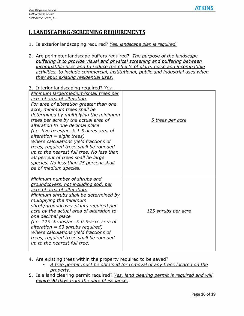
1. Is exterior landscaping required? Yes, landscape plan is required. 2. Are perimeter landscape buffers required? The purpose of the landscape
buffering is to provide visual and physical screening and buffering between
incompatible uses and to reduce the effects of glare, noise and incompatible activities, to include commercial, institutional, public and industrial uses when
they abut existing residential uses. 3. Interior landscaping required? Yes.
Minimum large/medium/small trees per acre of area of alteration.
For area of alteration greater than one acre, minimum trees shall be
determined by multiplying the minimum trees per acre by the actual area of alteration to one decimal place
(i.e. five trees/ac. X 1.5 acres area of alteration = eight trees)
Where calculations yield fractions of trees, required trees shall be rounded up to the nearest full tree. No less than
50 percent of trees shall be large species. No less than 25 percent shall
be of medium species.
5 trees per acre
Minimum number of shrubs and groundcovers, not including sod, per acre of area of alteration.
Minimum shrubs shall be determined by multiplying the minimum
shrub/groundcover plants required per acre by the actual area of alteration to one decimal place
(i.e. 125 shrubs/ac. X 0.5-acre area of alteration = 63 shrubs required)
Where calculations yield fractions of trees, required trees shall be rounded up to the nearest full tree.
125 shrubs per acre
4. Are existing trees within the property required to be saved? • A tree permit must be obtained for removal of any trees located on the
property. 5. Is a land clearing permit required? Yes, land clearing permit is required and will
expire 90 days from the date of issuance.
Due Diligence Report
160 Versailles Drive,
Melbourne Beach, FL
Page 17 of 19
K. SUBMITTAL AND REVIEW INFORMATION
1. What is the site approval process?
• Pre-Application conference required for the following: (180 days) i. Projects consisting of three acres or more; ii. Residential multifamily developments consisting of 20 units or
greater in size • Formal Site Plan submittal and review
• Applicant must submit plans to outside agencies (FDOT, FDEP, SJRWMD) • Staff Reviews for Completeness • Comments provided to applicant and DRM Meeting scheduled to review
the comments in person with the applicant • Formal response to comments and resubmittal (3 week submittal review)
• 3 reviews are typical for site plans and informal projects • Once all comments are addressed, plans are substantially approved • Pre-Construction Conference held
• Plan Approved
2. What is required for building permit submittal? Building permit application, application requires review by Brevard County staff.
3. Does the site require platting? Platting is anticipated however will be further vetted during the pre-application meeting.
4. Is a Demo permit required? Yes, for removal of complete structures or parts or
structures, including single family, 2 family, manufactured homes, and accessory structures.
5. Can Civil Documents and Building Plans be submitted at the same time? No.
6. Multi-Family Residential Dock Facility: i. Brevard County Land Development Review: Unless reconciled
(awaiting further information) permit will be needed to re-establish
the dock facility and possibly require a Conditional Use Permit ii. Brevard County Natural Resources: A marina consistency review
may be required. Per the Manatee Protection Plan (MPP) review letter from Darcie McGee, dated March 2, 2016, the submitted MPP states that the facility shall be allowed to continue with the existing
use, and may renovate according to permitting guidelines, provided there is no change in facility size. However, the applicant is
responsible for obtaining all permit approvals per Brevard County regulations related to site development.
iii. FDEP Permit Due Diligence: A permit for re-establishing the dock
facility on 9/23/16 and expires 9/22/21. iv. Army Corp. Dock Permit Due Diligence: The permit is pending. No
response has been provided from Army Corps. As of 8/7/17.
Due Diligence Report
160 Versailles Drive,
Melbourne Beach, FL
Page 18 of 19
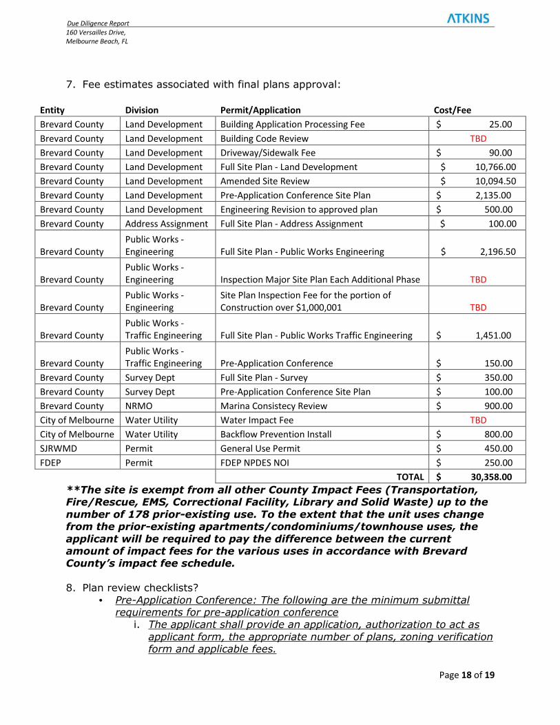
7. Fee estimates associated with final plans approval:
Entity Division Permit/Application Cost/Fee
Brevard County Land Development Building Application Processing Fee $ 25.00
Brevard County Land Development Building Code Review TBD
Brevard County Land Development Driveway/Sidewalk Fee $ 90.00
Brevard County Land Development Full Site Plan - Land Development $ 10,766.00
Brevard County Land Development Amended Site Review $ 10,094.50
Brevard County Land Development Pre-Application Conference Site Plan $ 2,135.00
Brevard County Land Development Engineering Revision to approved plan $ 500.00
Brevard County Address Assignment Full Site Plan - Address Assignment $ 100.00
Brevard County
Public Works -
Engineering Full Site Plan - Public Works Engineering $ 2,196.50
Brevard County
Public Works -
Engineering Inspection Major Site Plan Each Additional Phase TBD
Brevard County
Public Works -
Engineering
Site Plan Inspection Fee for the portion of
Construction over $1,000,001 TBD
Brevard County
Public Works -
Traffic Engineering Full Site Plan - Public Works Traffic Engineering $ 1,451.00
Brevard County
Public Works -
Traffic Engineering Pre-Application Conference $ 150.00
Brevard County Survey Dept Full Site Plan - Survey $ 350.00
Brevard County Survey Dept Pre-Application Conference Site Plan $ 100.00
Brevard County NRMO Marina Consistecy Review $ 900.00
City of Melbourne Water Utility Water Impact Fee TBD
City of Melbourne Water Utility Backflow Prevention Install $ 800.00
SJRWMD Permit General Use Permit $ 450.00
FDEP Permit FDEP NPDES NOI $ 250.00
TOTAL $ 30,358.00
**The site is exempt from all other County Impact Fees (Transportation, Fire/Rescue, EMS, Correctional Facility, Library and Solid Waste) up to the
number of 178 prior-existing use. To the extent that the unit uses change from the prior-existing apartments/condominiums/townhouse uses, the
applicant will be required to pay the difference between the current amount of impact fees for the various uses in accordance with Brevard County’s impact fee schedule.
8. Plan review checklists?
• Pre-Application Conference: The following are the minimum submittal requirements for pre-application conference
i. The applicant shall provide an application, authorization to act as
applicant form, the appropriate number of plans, zoning verification form and applicable fees.
Due Diligence Report
160 Versailles Drive,
Melbourne Beach, FL
Page 19 of 19
ii. The site plan sketch with the relevant information such as vicinity map, complete legal description, sufficient topographic information,
location of all proposed and existing improvements, traffic information, location and designation of what FEMA special flood
hazard the project is located in.
• Formal Site Plan: The applicant shall an application together with the
documentation require below, the appropriate number of plans and surveys and applicable fees, unless specified otherwise.
i. Authorization to act as applicant form ii. Approved concurrency form iii. Zoning verification form, together with copies of any CUPs. Binding
site plan (BSP), binding development (BDP) etc.
• A copy of the recorded deed reflecting current ownership, purchase
agreement or other document indicating ownership and legal description of the subject property.
• Stormwater calculations signed and sealed by a professional engineer licensed in the state.
• A traffic impact analysis identifying the projected trip generation and
roadway configuration, including the impacts to the surrounding roadway infrastructure, and proposed improvements to support the
intended use of the property.
Disclaimer: The information in this document was prepared by ATKINS. While reasonable steps are made to assure its accuracy, it cannot
guarantee that changes, alterations or interpretations may occur.

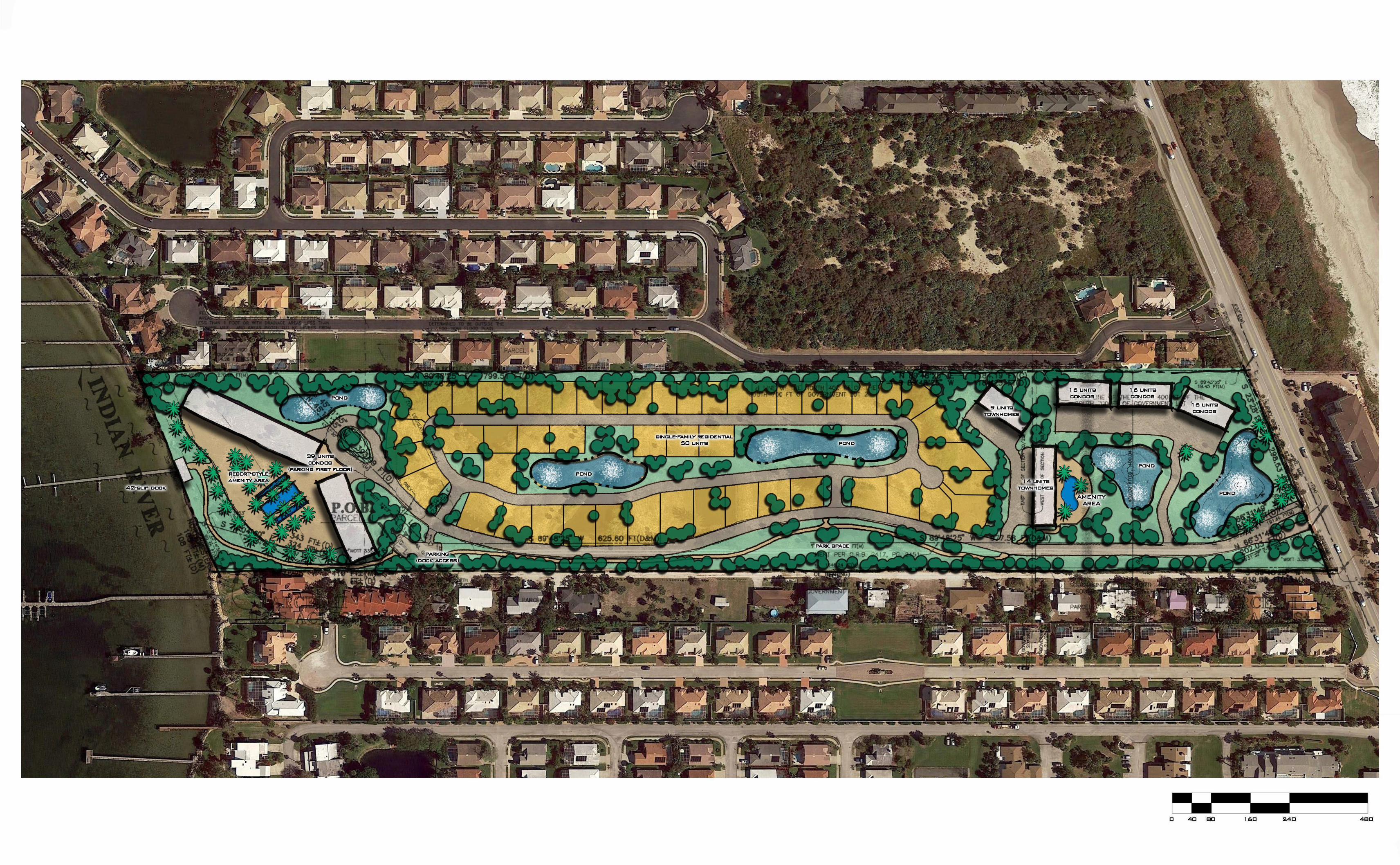
PHOENIX PARK LLC
ATTACHMENT - 1
CONCEPT PLAN
Prepared By:
7175 Murrell Road | Melbourne, FL 32940
PHOENIX PARK LLC
ATTACHMENT - 2
BREVARD COUNTY PROPERTY
APPRAISER TAX MAP &
PROPERTY INFO CARD
Prepared By:
7175 Murrell Road | Melbourne, FL 32940
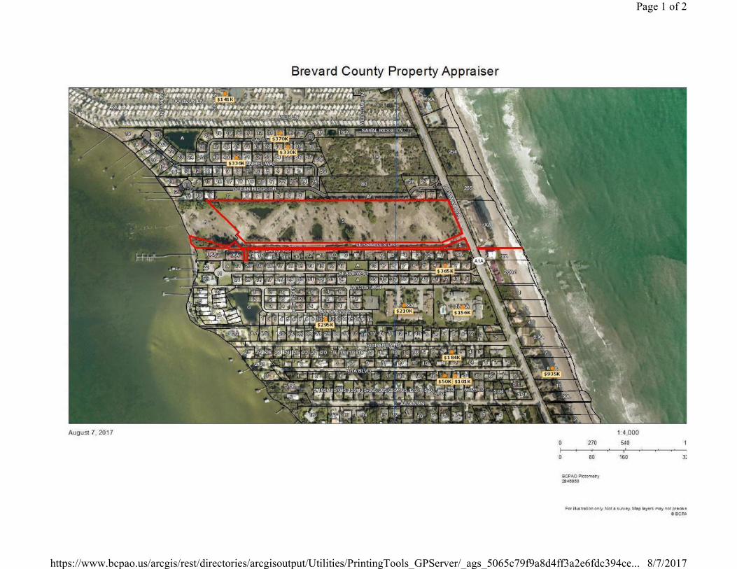
Page 1 of 2
8/7/2017https://www.bcpao.us/arcgis/rest/directories/arcgisoutput/Utilities/PrintingTools_GPServer/_ags_5065c79f9a8d4ff3a2e6fdc394ce...
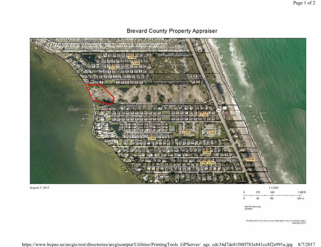
Page 1 of 2
8/7/2017https://www.bcpao.us/arcgis/rest/directories/arcgisoutput/Utilities/PrintingTools_GPServer/_ags_cdc34d7de81f48f783e841cc8f2e991a.jpg

Parcel ID: 28-38-20-00-00005.0-0000.00
Millage Code: 3400 Exemption: Use Code: 9908
Site Address: 342 VERSAILLES DR , MELBOURNE BEACH 32951 Tax ID: 2849283
General Parcel Information
Site Address is assigned by Brevard County Address Assignment for E-911 purposes and may not reflect the postal community name.
Owner Name: HAMPTONS ASSOCIATES LTD, THE
Second Name:
C/O HARLEY PROPERTIES INVESTORS
Mailing Address: P O BOX 941490 City, State, Zipcode: ATLANTA, GA 31141
Owner Information
Sub Name:
N 400 FT OF S 700 FT OF GOVT LOT 2 & THAT PART OF N 400 FT OF S 700 FT OF GOVT LOT 1 IN SEC 21 LYING W OF A1A EXC ORB 2417 PGS 2436, 2438, 2440 PARS 10,14 & 261 IN SEC 21
Abbreviated Description
Roll Year: 2011 2012 2013Market Value Total:1 $640,800 $640,800 $712,000
Agricultural Market Value: $0 $0 $0Assessed Value Non-
School: $640,800 $640,800 $704,880Assessed Value School: $640,800 $640,800 $712,000
Homestead Exemption:2 $0 $0 $0Additional Homestead:2 $0 $0 $0
Other Exemptions:2 $0 $0 $0Taxable Value Non-
School:3$640,800 $640,800 $704,880
Taxable Value School:3 $640,800 $640,800 $712,000
Value SummaryAcres: 15.65
Site Code: 110Land Value: $712,000
Land Information
1: Market value is established for ad valorem purposes in accordance with s.193.011(1) and (8), Florida Statutes. This value does not represent anticipated selling price for the property.
2: Exemptions are applicable for the year shown and may or may not be applicable if an owner change has occurred.
3: The Additional Homestead exemption does not apply when calculating taxable value for school districts pursuant to Amendment 1.
Official Records Book/Page Sale Date Sale Amount Deed
Type
Sale Screening
Code
Sale Screening
Source
Physical Change
CodeVacant/Improved
2885/2299 2/28/1988 $6,975,000 PT 2389/0874 9/1/1982 $100 WD
Sale Information
Sale screening and sale screening source codes are for assessment purposes only and have no bearing on potential marketability of the property.
Proposed Taxes 2013Taxing Authorities Ad Valorem Taxes Billed
County: $4,097.05
Rollback Taxes 2013Taxing Authorities Ad Valorem Taxes Billed
County $3,986.94
Page 1 of 2BCPAO - Property Details
11/18/2013https://www.bcpao.us/asp/Show_parcel.asp?acct=2849283&gen=T&tax=T&bld=T&oth=...
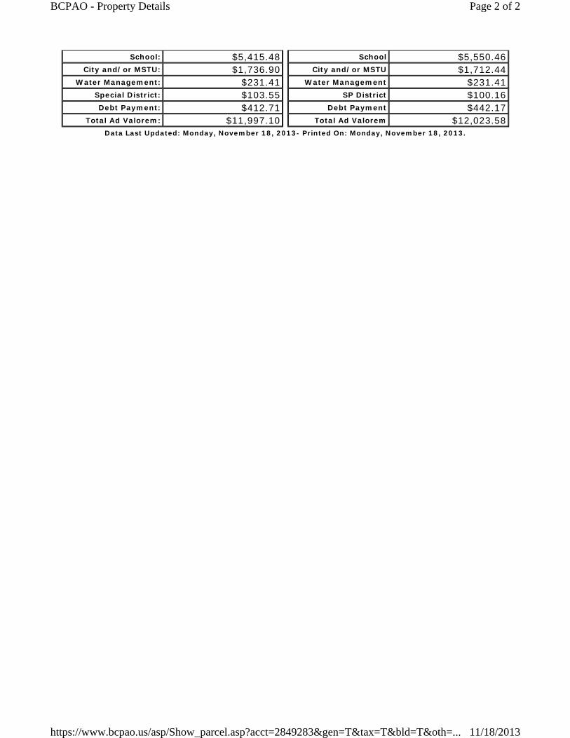
School: $5,415.48City and/or MSTU: $1,736.90
Water Management: $231.41Special District: $103.55Debt Payment: $412.71
Total Ad Valorem: $11,997.10
School $5,550.46City and/or MSTU $1,712.44
Water Management $231.41SP District $100.16
Debt Payment $442.17Total Ad Valorem $12,023.58
Data Last Updated: Monday, November 18, 2013- Printed On: Monday, November 18, 2013.
Page 2 of 2BCPAO - Property Details
11/18/2013https://www.bcpao.us/asp/Show_parcel.asp?acct=2849283&gen=T&tax=T&bld=T&oth=...

Parcel ID: 28-38-20-00-00006.0-0000.00
Millage Code: 3400 Exemption: Use Code: 1222
Site Address: Tax ID: 2849284
General Parcel Information
Site Address is assigned by Brevard County Address Assignment for E-911 purposes and may not reflect the postal community name.
Owner Name: HAMPTONS ASSOCIATES LTD, THE
Second Name:
C/O HARLEY PROPERTY INVESTORS
Mailing Address: P O BOX 941490 City, State, Zipcode: ATLANTA, GA 31141
Owner Information
Sub Name:
PT OF N 400 FT OF S 700 FT OF LOT 2 AS DESC IN ORB 2544 PG 2487 PAR 78
Abbreviated Description
Roll Year: 2011 2012 2013Market Value Total:1 $641,770 $634,500 $686,250
Agricultural Market Value: $0 $0 $0Assessed Value Non-
School: $641,770 $634,500 $686,250Assessed Value School: $641,770 $634,500 $686,250
Homestead Exemption:2 $0 $0 $0Additional Homestead:2 $0 $0 $0
Other Exemptions:2 $0 $0 $0Taxable Value Non-
School:3$641,770 $634,500 $686,250
Taxable Value School:3 $641,770 $634,500 $686,250
Value SummaryAcres: 3.2
Site Code: 110
Land Information
1: Market value is established for ad valorem purposes in accordance with s.193.011(1) and (8), Florida Statutes. This value does not represent anticipated selling price for the property.
2: Exemptions are applicable for the year shown and may or may not be applicable if an owner change has occurred.
3: The Additional Homestead exemption does not apply when calculating taxable value for school districts pursuant to Amendment 1.
Official Records Book/Page Sale Date Sale Amount Deed
Type
Sale Screening
Code
Sale Screening
Source
Physical Change
CodeVacant/Improved
2885/2299 2/28/1988 $6,975,000 PT 2544/2587 9/1/1984 $100 NN 2365/2151 5/1/1982 $323,200 WD
Sale Information
Sale screening and sale screening source codes are for assessment purposes only and have no bearing on potential marketability of the property.
Extra Feature Description UnitsExtra Feature Information
Page 1 of 2BCPAO - Property Details
11/18/2013https://www.bcpao.us/asp/Show_parcel.asp?acct=2849284&gen=T&tax=T&bld=T&oth=...

DOCK 3,462Proposed Taxes 2013
Taxing Authorities Ad Valorem Taxes BilledCounty: $3,988.76School: $5,219.63
City and/or MSTU: $1,690.99Water Management: $225.30
Special District: $100.81Debt Payment: $401.80
Total Ad Valorem: $11,627.29
Rollback Taxes 2013Taxing Authorities Ad Valorem Taxes Billed
County $3,881.56School $5,349.73
City and/or MSTU $1,667.18Water Management $225.30
SP District $97.51Debt Payment $430.48
Total Ad Valorem $11,651.76Data Last Updated: Monday, November 18, 2013- Printed On: Monday, November 18, 2013.
Page 2 of 2BCPAO - Property Details
11/18/2013https://www.bcpao.us/asp/Show_parcel.asp?acct=2849284&gen=T&tax=T&bld=T&oth=...
PHOENIX PARK LLC
ATTACHMENT - 3
U.S. FISH AND WILDLIFE MAP
Prepared By:
7175 Murrell Road | Melbourne, FL 32940
USFW Wetland Map
U.S. Fish and Wildlife Service, National Standards and Support Team,[email protected]
WetlandsEstuarine and Marine DeepwaterEstuarine and Marine Wetland
Freshwater Emergent WetlandFreshwater Forested/Shrub WetlandFreshwater Pond
LakeOtherRiverine
July 25, 2017
0 0.1 0.20.05 mi
0 0.15 0.30.075 km
1:6,521
This page was produced by the NWI mapperNational Wetlands Inventory (NWI)
This map is for general reference only. The US Fish and Wildlife Service is not responsible for the accuracy or currentness of the base data shown on this map. All wetlands related data should be used in accordance with the layer metadata found on the Wetlands Mapper web site.
PHOENIX PARK LLC
ATTACHMENT - 4
FEMA FLOOD MAP
Prepared By:
7175 Murrell Road | Melbourne, FL 32940
PHOENIX PARK LLC
ATTACHMENT - 5
USGS SOIL MAP
Prepared By:
7175 Murrell Road | Melbourne, FL 32940
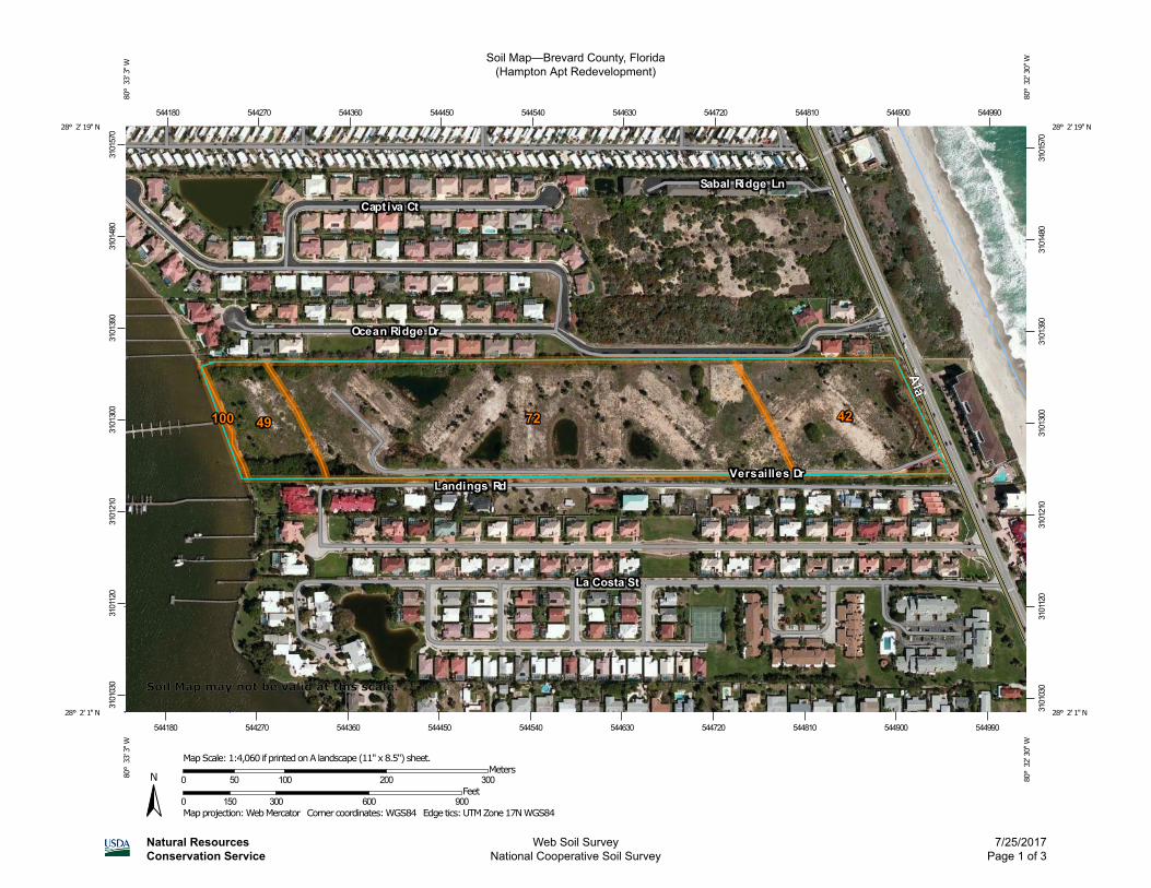
Soil Map—Brevard County, Florida(Hampton Apt Redevelopment)
Natural ResourcesConservation Service
Web Soil SurveyNational Cooperative Soil Survey
7/25/2017Page 1 of 3
3101
030
3101
120
3101
210
3101
300
3101
390
3101
480
3101
570
3101
030
3101
120
3101
210
3101
300
3101
390
3101
480
3101
570
544180 544270 544360 544450 544540 544630 544720 544810 544900 544990
544180 544270 544360 544450 544540 544630 544720 544810 544900 544990
28° 2' 19'' N80
° 3
3' 3
'' W28° 2' 19'' N
80° 3
2' 3
0'' W
28° 2' 1'' N
80° 3
3' 3
'' W
28° 2' 1'' N
80° 3
2' 3
0'' W
N
Map projection: Web Mercator Corner coordinates: WGS84 Edge tics: UTM Zone 17N WGS840 150 300 600 900
Feet0 50 100 200 300
MetersMap Scale: 1:4,060 if printed on A landscape (11" x 8.5") sheet.
Soil Map may not be valid at this scale.
MAP LEGEND MAP INFORMATION
Area of Interest (AOI)Area of Interest (AOI)
SoilsSoil Map Unit Polygons
Soil Map Unit Lines
Soil Map Unit Points
Special Point FeaturesBlowout
Borrow Pit
Clay Spot
Closed Depression
Gravel Pit
Gravelly Spot
Landfill
Lava Flow
Marsh or swamp
Mine or Quarry
Miscellaneous Water
Perennial Water
Rock Outcrop
Saline Spot
Sandy Spot
Severely Eroded Spot
Sinkhole
Slide or Slip
Sodic Spot
Spoil Area
Stony Spot
Very Stony Spot
Wet Spot
Other
Special Line Features
Water FeaturesStreams and Canals
TransportationRails
Interstate Highways
US Routes
Major Roads
Local Roads
BackgroundAerial Photography
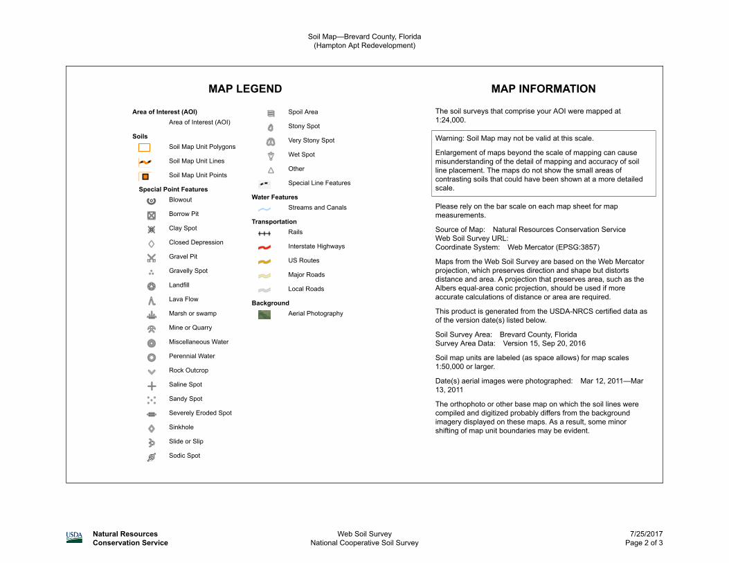
The soil surveys that comprise your AOI were mapped at1:24,000.
Warning: Soil Map may not be valid at this scale.
Enlargement of maps beyond the scale of mapping can causemisunderstanding of the detail of mapping and accuracy of soilline placement. The maps do not show the small areas ofcontrasting soils that could have been shown at a more detailedscale.
Please rely on the bar scale on each map sheet for mapmeasurements.
Source of Map: Natural Resources Conservation ServiceWeb Soil Survey URL:Coordinate System: Web Mercator (EPSG:3857)
Maps from the Web Soil Survey are based on the Web Mercatorprojection, which preserves direction and shape but distortsdistance and area. A projection that preserves area, such as theAlbers equal-area conic projection, should be used if moreaccurate calculations of distance or area are required.
This product is generated from the USDA-NRCS certified data asof the version date(s) listed below.
Soil Survey Area: Brevard County, FloridaSurvey Area Data: Version 15, Sep 20, 2016
Soil map units are labeled (as space allows) for map scales1:50,000 or larger.
Date(s) aerial images were photographed: Mar 12, 2011—Mar13, 2011
The orthophoto or other base map on which the soil lines werecompiled and digitized probably differs from the backgroundimagery displayed on these maps. As a result, some minorshifting of map unit boundaries may be evident.
Soil Map—Brevard County, Florida(Hampton Apt Redevelopment)
Natural ResourcesConservation Service
Web Soil SurveyNational Cooperative Soil Survey
7/25/2017Page 2 of 3
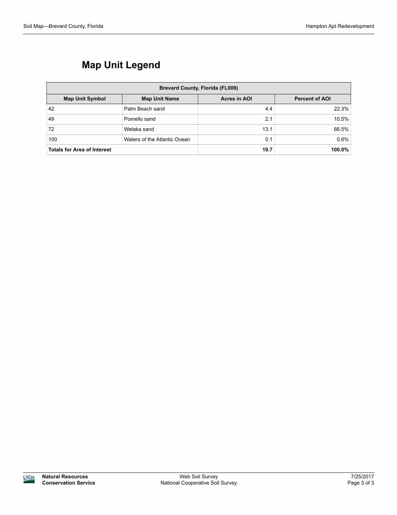
Map Unit Legend
Brevard County, Florida (FL009)
Map Unit Symbol Map Unit Name Acres in AOI Percent of AOI
42 Palm Beach sand 4.4 22.3%
49 Pomello sand 2.1 10.5%
72 Welaka sand 13.1 66.5%
100 Waters of the Atlantic Ocean 0.1 0.6%
Totals for Area of Interest 19.7 100.0%
Soil Map—Brevard County, Florida Hampton Apt Redevelopment
Natural ResourcesConservation Service
Web Soil SurveyNational Cooperative Soil Survey
7/25/2017Page 3 of 3
PHOENIX PARK LLC
ATTACHMENT - 6
FPL/WATER-SEWER AS-BUILTS
(1981)
Prepared By:
7175 Murrell Road | Melbourne, FL 32940

PL
EA
SE
BE
AD
VIS
ED
TH
AT
RE
CE
IPT
OF
TH
IS D
RA
WIN
G
AN
D/O
R S
UR
VE
Y,
WH
ICH
IS
AN
AP
PR
OX
IMA
TIO
N,
DO
ES
NO
T R
EL
IEV
E Y
OU
OF
AN
Y
STA
TU
TO
RY
OB
LIG
AT
ION
S,
INC
LU
DIN
G T
HE
PR
OV
ISIO
NS
CO
NTA
INE
D
IN S
EC
TIO
N 5
56
,
FL
OR
IDA
STA
TU
TE
S
CA
LL
811
OR
1-8
00
-43
2-4
77
0 (
SU
NS
HIN
E
STA
TE
ON
E C
AL
L)
PR
IOR
TO
AN
Y E
XC
AV
AT
ION
AC
TIV
ITIE
S

PHOENIX PARK LLC
ATTACHMENT - 7
SITE PHOTOS
Prepared By:
7175 Murrell Road | Melbourne, FL 32940
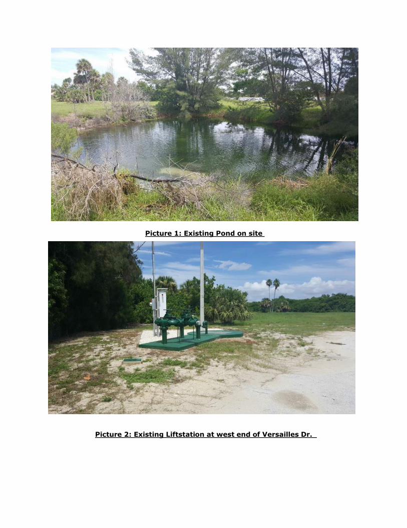
Picture 1: Existing Pond on site
Picture 2: Existing Liftstation at west end of Versailles Dr.
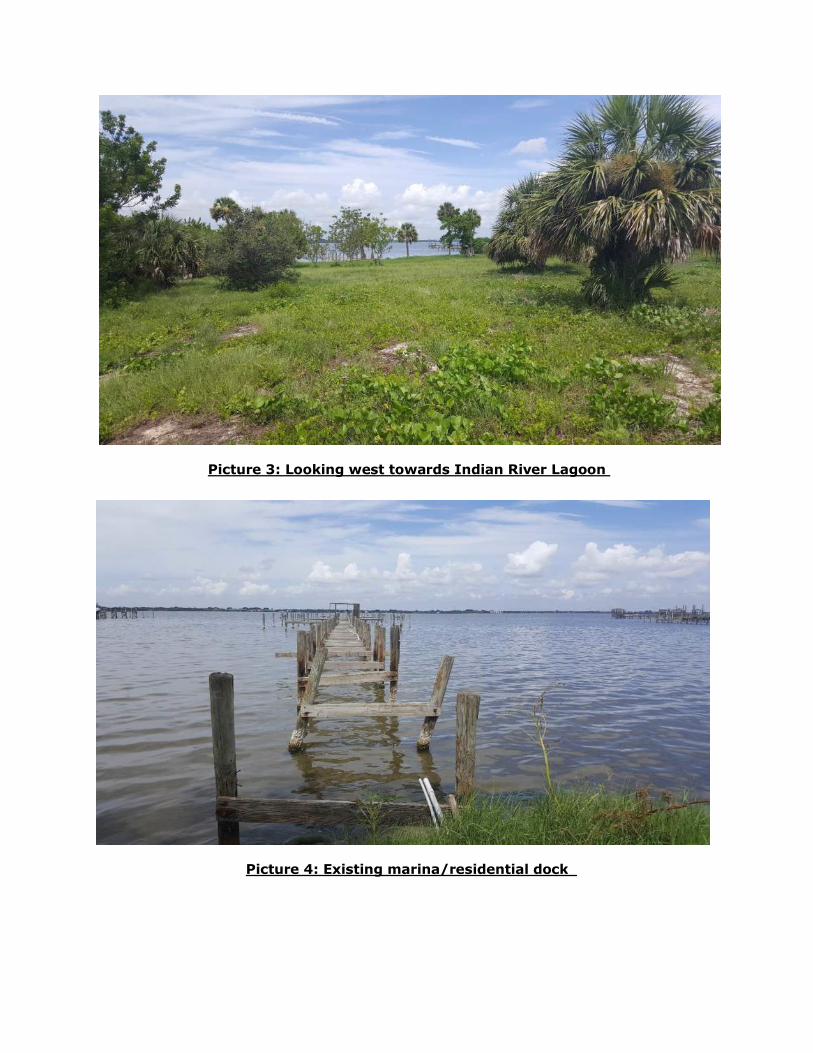
Picture 3: Looking west towards Indian River Lagoon
Picture 4: Existing marina/residential dock

PHOENIX PARK LLC
ATTACHMENT - 8
TRAFFIC DUE DILIGENCE REPORT
Prepared By:
7175 Murrell Road | Melbourne, FL 32940
P a g e | 1
Due Diligence Report
Old Hamptons Apartments, Melbourne Beach, Brevard County, FL
July 18, 2017
A. Existing Conditions
Site Location: The development in this study is located in Melbourne Beach, Florida along the west side of
the intersection of Versailles Drive and State Road A1A (SR-A1A). The development site is located
approximately 4.25 miles south of the Melbourne Causeway bridge (US-192) intersection along SR-A1A.
The proposed site will lie on approximately 20 acres currently undeveloped, bordered by residential land
uses to the north and south as well as the Indian River to the west. In the proposed concept, access is
provided to the site via the existing Versailles Drive.
Roadway Classification: SR-A1A is classified as an Urban Minor Arterial. Versailles Drive is unclassified,
but it is assumed to be an urban local road.
Cross Section: The SR A1A cross-section is a two-lane undivided highway with a single southbound right
turn lane. Although not fully constructed, Versailles Drive is expected to be a two-lane undivided local street.
Pedestrian Facilities: SR-A1A contains a sidewalk on the west side of the roadway. However, at the point
SR-A1A borders the site the sidewalks transition to the roadway shoulder.
Traffic: Traffic volume information is provided in Table 1 and Table 2 below (data obtained from the 2016
Florida Transportation Information Database). The counts indicate that the segments are currently operating
within the allowable Level of Service (LOS) threshold.
Table 1. 2016 Peak Hour Directional Roadway Information
Facility Approach Speed Limit
(mph)
2016 Peak Hour Dir. Volume
LOS D Service Volume Capacity
V/C LOS Allowable
LOS
SR-A1A SB 40 643 924 0.70 C D
SR-A1A NB 40 567 880 0.64 C D
Sources: 2016 Florida Traffic Online, FDOT Quality/Level of Service Handbook Generalized Tables
Table 2. 2016 Daily Traffic Roadway Information
Facility Approach Speed Limit
(mph) 2016 AADT
LOS D Service Volume Capacity
V/C LOS Allowable
LOS
SR-A1A From North 40 13,100 18,585 0.70 C D
SR-A1A From South 40 9,400 17,700 0.51 C D
Sources: 2016 Florida Traffic Online, FDOT Quality/Level of Service Handbook Generalized Tables
B. Anticipated Site Traffic Volumes
Traffic volumes expected to be generated by the proposed development were forecasted using the 9th
Edition of Institute of Transportation Engineers (ITE) Trip Generation Manual. The trip generation for the
proposed Hampton Apartments development was calculated using the trip generation equations for Land
Use Code (LUC) 220 (Apartment) and LUC 230 (Residential Condominium/Townhouse). The trip-generation
estimates were based on the preliminary concept attached which includes 76 apartments and 70
condos/townhomes.

P a g e | 2
The proposed development is expected to generate the following trips:
• 1,056 vehicle trips (528 in and 528 out) on an average weekday
• 80 vehicle trips (15 in and 65 out) during the weekday AM peak hour
• 104 vehicle trips (68 in, 36 out) during the weekday PM peak hour
C. Local Code Review
Per the Brevard County’s Policy on Minimum Requirements for Traffic Impact Analyses, a Transportation
Impact Analysis (TIA) is required based on the amount of peak hour trips generated. The requirements state
the study limits will be 0.5 miles per every 100 peak hour trips.
D. Site Traffic Analysis
Impact of Newly Generated Trips
During the PM peak hour, an estimated 104 new trips will be generated by the development. Per Brevard
County requirements, it is expected the study should include analysis of SR-A1A, 0.5 mile in both directions.
Previous Entitlements
Previously the development site contained 178 dwelling units that were demolished around 2009 according
to Google Earth historical imagery. A document pertaining to the property includes an entitlement stating the
following:
“The site is exempt from all other impact fees (Transportation, Fire/Rescue, EMS, Correctional Facility,
Library, and Solid Waste) up to the number of 178 prior-existing units regardless of the time of
subsequent redevelopment of the site from the last date of residential occupation as long as the use of
the property is the same (i.e. apartments, condominiums, townhouses).”
This entitlement should serve as an exemption from paying transportation impact fees. Therefore, a traffic
impact study should not be required.
E. Recommendations
Due to prior entitlements, a full traffic analysis should not be required since the development size is less
than the previously accounted for 178 dwelling units, furthermore waiving transportation impact fees.
However, if prior entitlements are not recognized, the development is estimated to generate enough trips to
warrant a traffic impact analysis with study limits 0.5 mile from the development site.
If required, the preliminary cost of traffic count efforts and the traffic impact study is $8,000-$10,000.

© Atkins Ltd except where stated otherwise. The Atkins logo, and the strapline ‘Plan Design Enable’ are trademarks of Atkins Ltd.
Jeffrey Lucas Atkins North America, Inc. 7175 Murrell Road Melbourne, FL 32940
Email: [email protected]