dsp east wanneroo appendix h engineering servicing report
TRANSCRIPT

East Wanneroo District Structure Plan
Engineering Servicing Report
East Wanneroo District Structure Plan
Engineering Servicing Report
Contents Introduction ..............................................................................................................................................................1 1.
Water Reticulation ....................................................................................................................................................1 2.
Wastewater ...............................................................................................................................................................2 3.
Electricity ..................................................................................................................................................................5 4.
Communications .......................................................................................................................................................6 5.
Gas ............................................................................................................................................................................8 6.
Staging.......................................................................................................................................................................9 7.
Conclusion .................................................................................................................................................................9 8.
Appendix A – East Wanneroo District Structure Plan Service Strategies
Revision Date Author
A 9.11.18 A.Thomson
B 11.12.18 A.Thomson
C 17.12.18 A.Thomson
D 14.1.19 A.Thomson
E 16.8.19 A.Thomson

P:\6371 East Wanneroo\6371-00\Correspondence\East Wanneroo - Servicing Report Aug19_E.docx 1
East Wanneroo District Structure Plan
Engineering Servicing Report
Introduction 1.This report has been prepared by Cossill & Webley Pty Ltd (CW) for Department of Planning, Lands and Heritage and summarises the results of an engineering assessment of the servicing strategies and constraints of the East Wanneroo District Structure Plan (EWDSP).
This report covers the engineering infrastructure requirements including water supply, sewerage reticulation, power reticulation, telecommunication and gas for the future urban development of the Site.
The investigations and preparation of the report are largely based on preliminary advice from the various service authorities and is current as of September 2019.
Water Reticulation 2.The EWDSP area is within the Water Corporation’s water licence area. The existing and anticipated water supply future scheme are presented on Drawing 6371-00-WATER in Appendix A.
The EWDSP is proposed to be serviced with water from the Wanneroo Reservoir tank site located on Steven Street in Wanneroo. This tank is currently fed from the existing Wanneroo Groundwater treatment plant (GWTP) located to the east of the DSP area as presented on Drawing 6371-00-WATER. Ultimately, an additional bore main from the GWTP to the Wanneroo Reservoir is proposed, which will be augmented via a new supply from the proposed Alkimos Desalination plant (anticipated 2028).
There is existing water infrastructure at the western and southern extents of the DSP area that have limited capacity to service discrete areas. There is limited existing water supply capacity to service the broader DSP area and as development progresses, water headwork infrastructure extensions will be required as well as expansion of water storage at the Wanneroo Reservoir site. It is anticipated these headworks extensions will be provided by the Water Corporation if development progresses in a frontal manner.
There are also a series of planned large volume trunk mains connecting the Wanneroo Reservoir to other regional water storage facilities within the Integrated Water Supply Scheme depicted on Drawing 6371-00-WATER. Timing for construction of these mains is unknown at this stage, but provision should be made within proposed road reserves for the future installation of these mains. The Water Corporation should be consulted at the time of preparation of future Local Structure Plans to refine the headwork infrastructure and land requirements for these mains.
The Water Corporation will review the water supply scheme for the EWDSP to confirm the available water supply from the Wanneroo Reservoir and required upgrades into the future. Previous conceptual planning for the gravity scheme (based on a smaller Structure Plan) indicated the existing ground level storage (277ML capacity) would be sufficient until around 2044. However, the Water Corporation anticipates this planning will need to be substantially revised for the expanded study area. Currently Water Corporation planning suggests another ground level storage in the order of 100 ML will need to be constructed as development of the EWDSP progresses.
Water Corporation has confirmed that part of the western portion of the DSP area surrounding the Reservoir site is a high level supply zone, as depicted on Drawing 6371-00-WATER. The High Level zone is served from a small elevated tank at the Wanneroo Reservoir site. The Water Corporation will review the planning for the high level zone when total dwelling yields and other land use information becomes available through the finalisation of the DSP. There is currently a 0.8 ML tank servicing the High Level Zone, though the long term plan is to provide an additional 4 ML elevated tank and pump upgrades to service the DSP area. This upgrade work is currently scheduled for 2027, though this may be brought forward if development within in the high level zone occurs more rapidly than forecast.

P:\6371 East Wanneroo\6371-00\Correspondence\East Wanneroo - Servicing Report Aug19_E.docx 2
East Wanneroo District Structure Plan
Engineering Servicing Report
The DSP area also contains a series of groundwater production bores and bulk water transfer mains which draw water from both the deeper Yarragadee aquifer as well as the superficial (shallower) aquifer and transfer this water to the Wanneroo Groundwater Treatment Plant for treatment and distribution. The groundwater bores are currently within a P1 protection classification, and include a 300 metre Well Head Protection Zone. Residential and industrial developments are not permissible uses within P1 areas, and declassification to P2 or P3 will be required to support the anticipated DSP zonings. The Water Corporation’s response to reducing classifications of the Underground Water Pollution Control Area (UWPCA) is that source protection is the primary barrier to prevent contamination of groundwater resources, particularly those which form part of the metropolitan integrated water supply scheme.
The Wanneroo Groundwater Treatment Plant is located within a proposed industrial area in the DSP. Water Corporation has identified an indicative land use buffer to the combined risks of chlorine, H2S odour and Legionella from the operations of the GWTP, as depicted on Drawing 6371-00-WATER. Further technical investigation will be required to determine the full extent of the buffer and setback from sensitive land uses as development occurs in this area as well as any land required to accommodate future treatment plant expansion.
From a water infrastructure perspective, a development front commencing along the central western edge in proximity to the Corporation’s Wanneroo Reservoir and associated distribution mains is likely to be more cost effective than commencing large-scale development in the far south, north or east of the area. In some locations where development proceeds ahead of the logical urban front, ahead of the hydraulic need for the installation of headworks-sized infrastructure, or ahead of the Corporation’s ability to fund headworks infrastructure through its capital program, land developers may be required to fund and install temporary infrastructure to service new development areas.
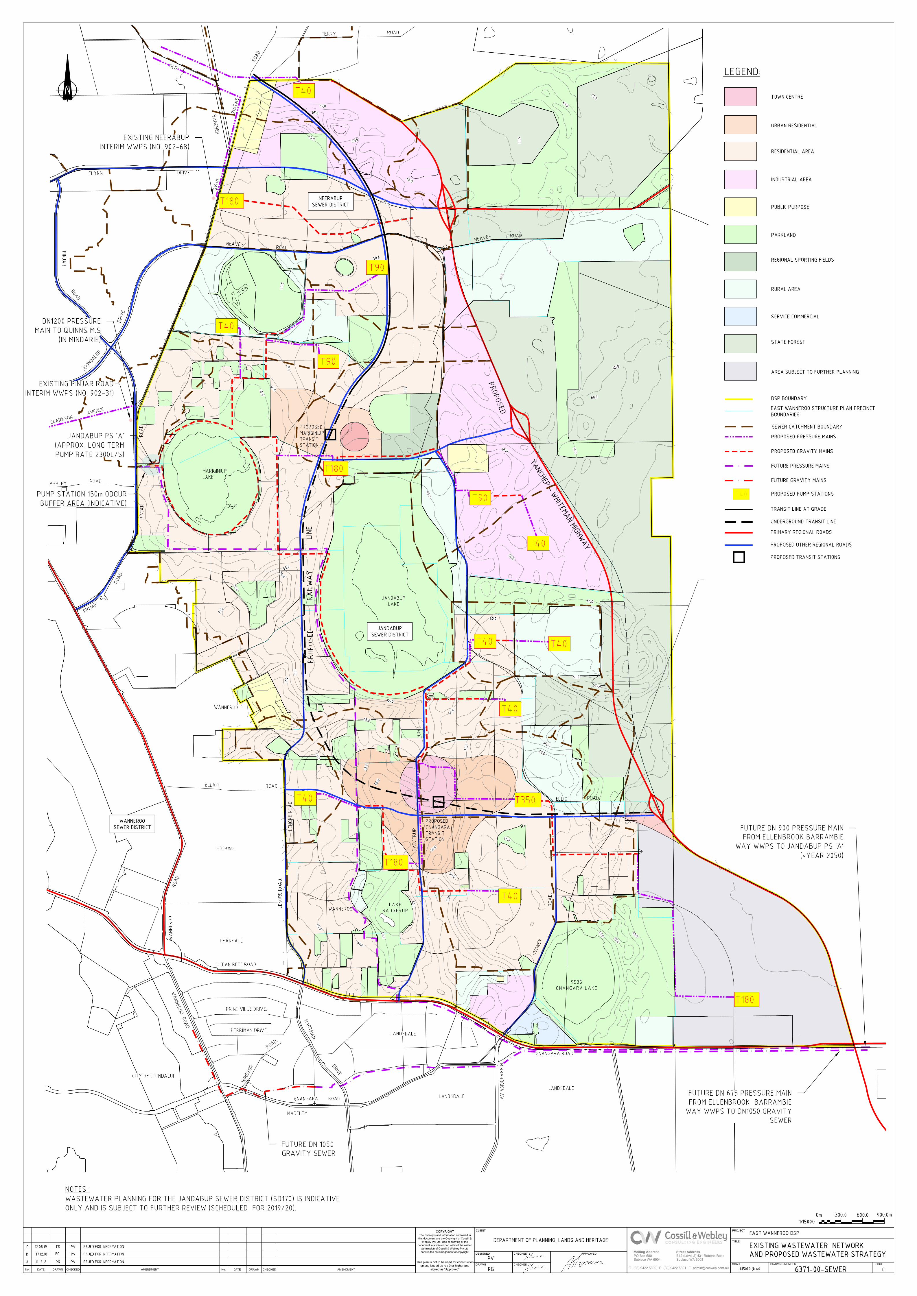
Wastewater 3.The EWDSP area is within the Water Corporation’s wastewater operating licence area, for which long term, conceptual wastewater planning has previously been prepared based on an earlier, smaller version of the East Wanneroo DSP. The proposed wastewater strategy is presented in Drawing 6371-00-SEWER in Appendix A.
The EWDSP falls into two sewer catchments:
The area north of Neaves Road is covered by the Neerabup Sewer District Plan (SD160);
The balance of the DWDSP area south of Neaves Road falls within the Jandabup Sewer District Plan (SD170). The Water Corporation’s current planning for this sewer catchment currently only extends to the western side of Jandabup Lake.
Drawing 6371-00-SEWER summarises the available Water Corporation wastewater planning information, including indicative locations and sizing of wastewater pump stations, extending the network into the future development at the eastern extent of the EWDSP. The area west of Jandabup Lake and Gnangara Lake requires further updated sewer planning, which the Water Corporation has advised will be resourced and undertaken in the next calendar year. The inclusion of the new rail line through the centre of the study area may re-define some pump station catchment boundaries and locations.
The study area is located at the boundary of the Water Corporation’s Beenyup and Alkimos Waste Water Treatment Plant (WWTP) catchment areas. The Beenyup WWTP currently has no capacity to service additional development within the study area, however projects within Water Corporation’s 5-year Capital Investment Program are planned to divert existing flows from the Neerabup Sewer District northwards to Alkimos which may allow some land areas along the western boundary of the DSP to be considered for pumping into the Beenyup WWTP catchment. These works will include extension to the Quinns Main Sewer and installation of new pumping infrastructure and a pressure main from the Neerabup Main PS to the end of the proposed main sewer extension.
P:\6371 East Wanneroo\6371-00\Correspondence\East Wanneroo - Servicing Report Aug19_E.docx 3
East Wanneroo District Structure Plan
Engineering Servicing Report
The Water Corporation has indicated that some pockets of land adjoining the eastern boundary of the Wanneroo Sewer District and Neerabup Sewer District could possibly be developed in the short term, subject to available capacity in the adjoining sewerage networks to accept pumped wastewater discharges from these development areas. Each development proposal will be considered on its merits, and technical investigations will need to be undertaken to examine options for pump station locations and possible discharge points. Preliminary investigations indicate there is spare capacity or available wastewater solutions to service approximately 5,000 residential lots in the short to medium term along the western boundary.
North-western areas of the DSP area (north of Neaves Road) may be able to utilise latent capacity within the Neerabup Interim WWPS which currently pumps wastewater southwards via the Wanneroo Road Pressure Main to discharge into the catchment of the Beenyup WWTP. The Water Corporation anticipates there is capacity to service approximately 3,000 lots in this area under this strategy. This latent capacity is in place to service the undeveloped portions of the Neerabup Sewer District catchment, comprised largely of the Banksia Grove Residential area and Neerabup Industrial Estate. Depending on the development rate in these areas, some of this latent capacity will be absorbed. Availability of sewer capacity under this strategy will be on a “first come first serve basis” until the surplus capacity at the Neerabup WWPS is exhausted at which time the ultimate solution will be required to divert flows northwards to the Alkimos WWTP catchment.
The future main wastewater pump station for the study area will be the Jandabup PS ‘A’ which is expected to have an approximate long term pump rate of 1900 L/s, taking into account the new investigation areas both within the EWDSP area, and beyond. This pump station will not only serve the Jandabup catchment, but also ultimately receive bulk wastewater transfers from the Ellenbrook, Bullsbrook and West Swan Sewer Districts via a large (DN900) pressure main pumping from the Ellenbrook Barrambie Way Main wastewater pump station near the intersection of Lord Street and Gnangara Road. The proposed Jandabup PS “A” will require a land area of approximately two hectares, with an ultimate odour buffer of 150 metres radius.
While Jandabup PS ‘A’ will become the main pump station for the sewer district, it is likely this pump station will comprised multiple stages as the area develops. The need and staging will be dictated by developer interest in developing the land in the immediate catchment of the main WWPS, and the size of the developments proposed. Small, temporary pump stations may be employed if there is discharge capacity available in the neighbouring network.
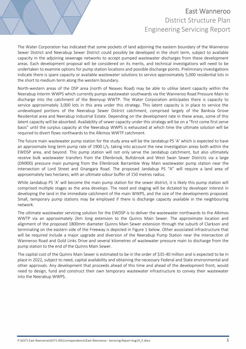
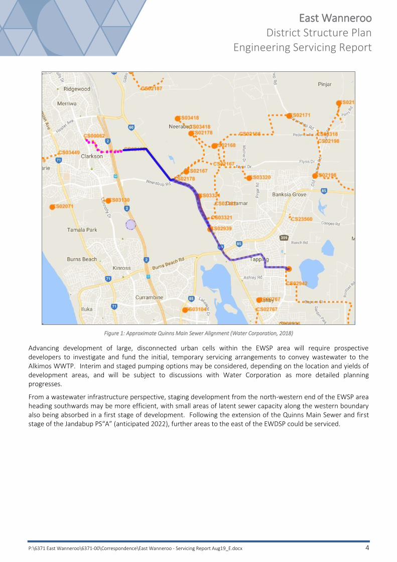
The ultimate wastewater servicing solution for the EWDSP is to deliver the wastewater northwards to the Alkimos WWTP via an approximately 2km long extension to the Quinns Main Sewer. The approximate location and alignment of the proposed 1800mm diameter Quinns Main Sewer extension through the suburb of Clarkson and terminating on the eastern side of the Freeway is depicted in Figure 1 below. Other associated infrastructure that will be required include a major upgrade and diversion of the Neerabup Pump Station near the intersection of Wanneroo Road and Gold Links Drive and several kilometres of wastewater pressure main to discharge from the pump station to the end of the Quinns Main Sewer.
The capital cost of the Quinns Main Sewer is estimated to be in the order of $35-40 million and is expected to be in place in 2022, subject to need, capital availability and obtaining the necessary Federal and State environmental and other approvals. Any development that proceeds ahead of this time and ahead of the development front, would need to design, fund and construct their own temporary wastewater infrastructure to convey their wastewater into the Neerabup WWPS.
P:\6371 East Wanneroo\6371-00\Correspondence\East Wanneroo - Servicing Report Aug19_E.docx 4
East Wanneroo District Structure Plan
Engineering Servicing Report
Figure 1: Approximate Quinns Main Sewer Alignment (Water Corporation, 2018)
Advancing development of large, disconnected urban cells within the EWSP area will require prospective developers to investigate and fund the initial, temporary servicing arrangements to convey wastewater to the Alkimos WWTP. Interim and staged pumping options may be considered, depending on the location and yields of development areas, and will be subject to discussions with Water Corporation as more detailed planning progresses.
From a wastewater infrastructure perspective, staging development from the north-western end of the EWSP area heading southwards may be more efficient, with small areas of latent sewer capacity along the western boundary also being absorbed in a first stage of development. Following the extension of the Quinns Main Sewer and first stage of the Jandabup PS“A” (anticipated 2022), further areas to the east of the EWDSP could be serviced.

P:\6371 East Wanneroo\6371-00\Correspondence\East Wanneroo - Servicing Report Aug19_E.docx 5
East Wanneroo District Structure Plan
Engineering Servicing Report
Electricity 4.The EWDSP area is currently serviced from the existing Wanneroo and Wangara Zone Substations as depicted on Drawing 6371-00-ELEC included in Appendix A. There is some capacity available in these substations to support urbanisation of the EWDSP area.
Western Power has advised that load demand has stabilised in recent years, due to, among other things, the residential uptake of PV (solar) panels. Power supply to the EWDSP will be monitored to ensure that if development proceeds under normal natural load conditions, in a frontal manner, headwork infrastructure can be extended to service the development as required. Some contribution from developers to headwork extensions or upgrades may be required if development proceeds in a non-frontal manner.
While assessment of the load requirements based on development densities and growth would need to be undertaken by Western Power, it is envisaged that the Wanneroo substation could meet short term load demands, and the Wangara substation could be upgraded to include two additional transformers (only one transformer is currently installed) if required.
Western Power has also identified a future potential zone substation to the east of the EWDSP area as depicted on Drawing 6371-00-ELEC within the area zoned for industrial use. A possible location has been identified adjacent to the Water Corporation’s Groundwater Treatment Plant (Townsend/Amarante Road), but is still subject to review and agreement by both Western Power and the Water Corporation. The need for the zone substation is uncertain at this time and is likely to be in the medium to long term, if required. If this substation is determined to be required, a Public Purpose – SEC reservation would be required under the MRS to protect and manage the infrastructure asset.
Supply to the new 132 kV/22 kV zone substation will require the extension of a number of high voltage transmission lines (132kV) as indicatively depicted on Drawing 6371-00-ELEC. A line assessment study will be required prior to the construction of these lines, to determine the final route and associated restriction zones. Western Power anticipates the restriction zones could be a minimum of width of 20 metres and would restrict building development within this zone. This restriction zone would need to be protected by a Western Power transmission line easement over any freehold properties affected, to ensure that it has unobstructed access, safety standards are met and to protect the asset.
Western Power has indicated the timing of an additional double circuit 132kV line has not yet been determined due to uncertainty in load forecasts, but it is currently expected beyond 2028. These transmission lines are proposed to run from the Neerabup terminal to the intersection of Badgerup and Jambanis Roads, from where they may continue as two single circuits along separate routes.
The proposed location of these transmission lines will wherever possible, be located within existing road reserves taking into account power loadings, risks associated with the co-location of other utilities and impacts of any easements on private properties. Further investigation for alignments may be undertaken as part of the Local Structure Plan process.
The transmission lines will also be required to cross an existing high pressure gas main along Neaves Road. The route requires more detailed planning and alignment investigation, though preference would be to cross the line after the pressure reduction zone, where the line reduces from 6,900 kPa to 1,900 kPa.
Western Power land requirements are typically identified as part of Local Structure Plans with statutory provisions for the sites/easements to be gifted to Western Power as a condition of subdivision. The proposed substation site will be required as a Crown reserve with a management order to Western Power, whilst Western Power standard easements will be required over transmission lines for freehold properties, however not required over any Crown reservations.

P:\6371 East Wanneroo\6371-00\Correspondence\East Wanneroo - Servicing Report Aug19_E.docx 6
East Wanneroo District Structure Plan
Engineering Servicing Report
Communications 5.The EWDSP is within nbn’s fixed line footprint, and hence can be serviced with optic fibre under their roll-out scheme for greenfield developments. NBN Co has confirmed there is network adjacent to the Site, and therefore no backhaul charges would apply if development were to proceed from the western and southern boundaries of the development.
Under the Federal Government’s new Telecommunications in New Developments Policy, developers are responsible for contributing to the cost of delivering the nbn™ network in new developments. This includes contributing to part of the costs of the build (installing pit & pipe) as well as a $600 per lot deployment change.
Through the nbn, the ownership issues of delivering wholesale fibre to the premises have been transferred to the Government with over 190 Retail Service Providers offering services over the network, including business grade services of up to 1 Gbps symmetrical speeds. There are other private communication providers that can also offer alternative services.
Developers of new residential estates have the option to pay nbn or an alternative service provider for provision of a high speed broadband network. In either case the developer will install pit and pipe infrastructure that can accommodate a future high speed broadband network.
The current design practice for road reserves, pavement and verge provisions will make adequate allowance for services including broadband in accordance with the agreed Utilities Service Providers handbook. Nbn has advised that 2x100mm conduits will be required within all Primary and Other Regional Road reserves (one for local feeds and one for express runs), and 1x100mm pipe will be required within local distributor roads. Pits will also be required at major intersections.
5.1 Perth International Telecommunications Centre
The Perth International Telecommunications Centre (PITC) is located immediately south of the EWDSP area, south of Gnangara Road and east of Landsdale as depicted in attached Drawing 6371-00-COMMS included in Appendix A. The 287 ha site includes 37 substantially-sized antennas providing secure satellite communications for phone, fax, data traffic and broadcast television on a global scale.
Telstra has confirmed the site is of state, national and international significance as it also provides maritime and aeronautical safety and tracking; telephony; remote area communications; telemetry; tracking command and monitoring of satellites and spacecraft for scientific missions; as well as other global satellite communications. It is recognised under agreements between Telstra and the Australian Federal Government.
Any development located within a north-west arc of the PITC has potential to generate Radio Frequency Interference (RFI), due to the orientation and tracking paths of the satellites, which could have potential detrimental impact on the PITC’s operations. The areas identified as having potential for creating RFI are depicted overleaf in Figure 2 and summarised in the table below:
Area Current Zoning Anticipated Re-zoning
RFI Likelihood Actions
1 Planning Investigation Rural Possible Review/input by Telstra
2 Planning Investigation Urban Unlikely None
3 Urban investigation Urban / Industrial Possible Review/input by Telstra

P:\6371 East Wanneroo\6371-00\Correspondence\East Wanneroo - Servicing Report Aug19_E.docx 7
East Wanneroo District Structure Plan
Engineering Servicing Report
Telstra has investigated the areas identified below and proposed futures zonings, and their likelihood to generate RFI that could be detrimental to the operation of the PITC. While there is no objection to proposed developments in any of the areas, residential areas with a proposed density coding of greater than R20 or commercial or industrial areas may have potential to create RFI issues. Telstra requests the opportunity to review and provide technical input to any proposed structure plans prior to public release.
Figure 2: Areas of Potential RFI for PITC (Telstra, 2018)

P:\6371 East Wanneroo\6371-00\Correspondence\East Wanneroo - Servicing Report Aug19_E.docx 8
East Wanneroo District Structure Plan
Engineering Servicing Report
Gas 6.The EWDSP area is not currently serviced with reticulated gas infrastructure.
There is an existing high pressure gas main located in the Neaves Road reserve through the DSP area, as depicted in Figure 3. The incoming supply from the east is a DN250 steel 6,900 kPa high pressure supply, which reduces to 1,900 kPa in the vicinity of Bardie Road, Mariginiup. Any new infrastructure adjacent to or crossing the pipeline that could be a source of electrical current, such as above or below ground power cables, earth rods, substations, transformers or impressed current systems of non-ATCO assets, must not interfere with the corrosion protection and induced voltage mitigation equipment of the gas pipeline.
A 750m-radius Pressure Reduction Zone is centred on the location of the change and is deemed a high risk area; where if gas can be smelled, it indicates a potential issue with the Pressure Reducing Station. Excessive vibrations (generated by construction activities) may cause difficulties with the monitoring equipment in the reduction station and ATCO should be advised of any works within this zone. However, there are no restrictions on development within the zone other than liaising with ATCO for any proposed works.
Figure 3: Existing High Pressure Gas and PRZ (ATCO Gas, 2018)
Future 132 kV power transmission lines will be required to cross the gas pipeline in this general vicinity. ATCO Gas has advised there should be no EPR issues as long as there is no earthing involved or substation installation in the vicinity of the crossing. ATCO has confirmed that at the DSP level, they have no objections to the proposed route shown, as long as works are carried out in accordance with their requirements. Further discussions will be required when Western Power commence further alignment investigations and planning.
Future servicing of the EWDSP will be via the extension of high, medium and low pressure reticulation gas mains, and if development proceeds in a frontal manner, no off-site headwork upgrades are anticipated.
P:\6371 East Wanneroo\6371-00\Correspondence\East Wanneroo - Servicing Report Aug19_E.docx 9
East Wanneroo District Structure Plan
Engineering Servicing Report
Staging 7.Service infrastructure for water reticulation, sewer reticulation, power and telecommunications is available along the western boundary of the EWDSP area. It is anticipated that development will proceed in this location extending east-ward.
Advancing development of the large, disconnected urban cells within the EWSP area will require prospective developers to investigate and fund initial, temporary servicing arrangements for all services. Interim and staged infrastructure solutions may be considered, depending on the location and yields of development areas, and will be subject to discussions with the relevant service agencies as more detailed planning progresses.
Conclusion 8.The East Wanneroo District Structure Plan has planned strategies for all utility services, with some limited capacity adjacent to the western boundary of the proposed urban area.
There are no engineering impediments to the development, though co-ordination and co-operation with the relevant Service Authorities will be required at the rezoning and Local Structure Plan stages as the development progresses.
P:\6371 East Wanneroo\6371-00\Correspondence\East Wanneroo - Servicing Report Aug19_E.docx 10
East Wanneroo District Structure Plan
Engineering Servicing Report
APPENDIX A
East Wanneroo District Structure Plan Service Strategies

AMENDMENTDATE DRAWNNo. CHECKEDCHECKED
COPYRIGHT
The concepts and information contained in
this document are the Copyright of Cossill &
Webley Pty Ltd. Use or copying of the
document in whole or part without the written
permission of Cossill & Webley Pty Ltd
constitutes an infringement of copyright.
This plan is not to be used for construction
unless issued as rev 0 or higher and
signed as "Approved"No. DRAWNDATE AMENDMENT
DRAWN
CLIENT
DESIGNED
CHECKED
CHECKED APPROVED
SCALE
TITLE
PROJECT
DRAWING NUMBER ISSUE
Subiaco WA 6904
(08) 9422 5800 ET F [email protected]
PO Box 680
(08) 9422 5801
Subiaco WA 6008
B12 (Level 2) 431 Roberts Road
Street AddressMailing Address