dsm and true ortho generation with the ......this case study shows the results of such a dense...
TRANSCRIPT
ASPRS 2010 Annual Conference San Diego, California April 26-30, 2010
DSM AND TRUE ORTHO GENERATION WITH THE ULTRACAM-L -- A CASE STUDY
Alexander Wiechert, Managing Director Michael Gruber, Chief Photogrammetrist
Vexcel Imaging Austria / Microsoft Photogrammetry Anzengrubergasse 8/4, 8010 Graz / Austria
[email protected] [email protected]
ABSTRACT Dense Matching is used to match a huge number of pixels automatically to generate a surface model from a set of overlapping digital images. Once a DSM has been processed, it then can be used to generate a so called true-ortho image. Such a true-ortho image has significant advantages over a standard ortho image.
Typically, two sensors are used to generate such a true-ortho image: a Lidar sensor system to generate the DSM and an aerial camera to generate the aerial image. Currently another approach is under development which is based on aerial images only. The DSM will be generated by a dense match of the aerial images. The advantage is obvious: only one sensor is required and the expected quality of the true-ortho images is higher due to the higher resolution of the underlying DSM.
This case study shows the results of such a dense matching, DSM and true-ortho image generation process based on survey flights undertaken with the new UltraCamL.
The UltraCamL is the so called "large medium format mapping camera". It utilizes the concept of the large format camera systems for the medium format market. As a result, the same geometric accuracy and radiometric dynamic can be achieved.
The case study shows that this also results in comparable matching mapping and photogrammetry capabilities. The study demonstrates the capabilities of a dense matching approach but also highlights restrictions. Based on that an outlook into the future such as computer vision based classification and DTM filtering is given.
INTRODUCTION
Vexcel Imaging GmbH, located in Graz, Austria, was founded in 1993, focusing on photogrammetric technologies that included the UltraScan 5000 precision photogrammetric scanner, culminating with the development of the UltraCam line of digital aerial cameras. The company was acquired by Microsoft in May 2006, largely for its camera technology, photogrammetric know-how and 3D modeling innovations and to further the advancement of Microsoft’s Virtual Earth mapping initiative (now called BING maps).
Led today by Alexander Wiechert, General Manager of Vexcel Imaging GmbH, the company provides the aerial mapping community with state-of-the-art photogrammetric products based on the latest and most advanced technological developments. Vexcel Imaging GmbH has become the market leader in the large format camera market due to its unparalleled technology and first class support which results in a maximum of customer benefit. The company’s flagship product, the UltraCamXp, has been announced in July 2008 and is the world-wide largest large format digital aerial mapping camera. Most recently, Vexcel Imaging announced its entry into the medium format camera market through the UltraCamL which is a medium format digital photogrammetric system. In working towards a more complete photogrammetric solution, Vexcel Imaging also recently announced its UltraMap workflow software for managing and distributing data collected with the UltraCam systems.
ULTRACAM-L/Lp
The UltraCamL has been announced in July 2008 and it has been shipped to first customers in May 2009. It will be updated to the UltraCamLp in 2010, providing an increased footprint of 92 Mega pixel (was 64 Mega pixels with the UltraCamL). This so called large medium format mapping camera addresses the smaller segment without sacrificing

ASPRS 2010 Annual Conference San Diego, California April 26-30, 2010
any image quality. Its unique camera design utilizes the concept of the large format camera system UltraCamX and UltraCamXp for the medium format market. By that, an affordable integrated mapping solution with a very high productivity without scarifying any image quality became now available to the remote sensing market. The UltraCamLp defines the industry standard in the medium format mapping market.
The UltraCamL/Lp provides the same geometric accuracy, the same radiometric dynamic, the same matching mapping and photogrammetry capability and the same forward motion compensation by TDI than the large format cameras but it comes in a medium format package and price.
The camera is designed to allow smaller companies to go digital by replacing their film cameras with the affordable UltraCamLp. Also big flyers may add the UltraCamLp to their sensor portfolio to be able to serve smaller projects more efficiently.
The camera concept differs from the standard concept of the medium format market to address the requirements for a mapping grade camera and also to increase the productivity. It utilizes the unique and patented concept of the
large format camera UltraCamXp and has two cones for PAN image collection. This ensures mapping grade geometric accuracy and radiometric dynamic as well as superior collection efficiency.
The high resolution PAN image is being stitched together out of the two sub-images collected by the PAN cones. It has 64 Mega pixel final images size (UCL) or 92 Mega pixels for UCLp (which was almost the format of the UltraCamD, introduced in 2003). The high resolution PAN image is being used for the mapping and photogrammetric work. It is supported by one lower resolution RGB cone and one additional NIR cone.
The RGB cone acquires the color information to color the pixels of the PAN image by the well know pan-sharpening methodology with a ratio of 1:2. The NIR cone collects NIR imagery with the same resolution than the RGB cone to support classification work. The PAN cones are lined up in flight direction and utilize the syntopic exposure for parallax free imagery, invented and patented by Vexcel for its large format cameras UltraCamD, X and Xp.
All cones (PAN, RGB and NIR) have forward motion compensation by time delayed integration (TDI). This feature of the UltraCamL/Lp is also unique to the medium format market. FMC by TDI has been proved and is the standard in the large format camera market where all frame based cameras use his concept to avoid motion blur and to increase flight envelope or duration. The UltraCamL/Lp uses the same technology for motion blur free PAN, RGB and NIR imagery and extended flight envelope or flight duration.
The camera is a highly integrated system, integrating all subsystems into the camera head and no additional storage or computing units is required any more. The makes the camera very compact, easy to handle, easy to install and suitable for smaller planes, too.
The camera head includes: • Computer sub-system • Solid state storage sub-system • IMU bay for third party GMP/INS systems • Connectors for display, power, service • Sensor sub-system (lenses, shutters, CCDs, electronics)
The storage system of the UltraCamL/Lp (left image) consists of an in flight exchangeable data unit with solid state devices. Each data unit has 1 TB of memory which lasts for around 2500 uncompressed images. The in flight exchange can be done in less than three minutes which leads to an “unlimited” storage in the aircraft due to multiple
Figure 1. UltraCam-L/Lp.
Figure 2. UltraCam-L/Lp lens system.
Figure 3. UltraCam-L/Lp image registration.

ASPRS 2010 Annual Conference San Diego, California April 26-30, 2010
data units. So, there is no mission restriction due to the storage system of the camera.
The UltraCamL/Lp also introduces a new service concept to the camera market. The computing subsystem (right
image) is fully integrated into the camera head and very easy to access by a pull-out rack for service and maintenance. This reduces down-time in case of a service or maintenance.
ULTRAMAP UltraMap is the new processing software for the UltraCam series. It supports all UltraCam cameras and extends
the workflow into a full photogrammetric workflow by a seamless integration of aero triangulation and bundle adjustment functionality into the existing image processing workflow.
UltraMap is designed to handle all kind of projects ranging from projects with a few hundred images up to projects with ten thousands of images and it is optimized for UltraCam images. For this, it introduces a new, revolutionary technology and concept of image handling, a direct spin of from the latest available Microsoft technology.
Main features of UltraMap are: • Download manager, integrates the existing UltraCam download stations • Distributed image processing level 0 to 2 and level 2 to 3 • Usage of multi core / multi CPU systems • Automated load balancing, also in heterogeneous environments • New Monolithic Stitching for level 0 to 2 processing • New Monolithic Radiometry for level 2 to 3 processing • Supports field and main office environment • Handling of huge image blocks • Auto-calibration functionality • Interactive quality control per image and per block • 16 Bit visualization for Pan and RGB and NIR images • Index map based visualization to identify missing images, crab angle issues, GPS/IMU accuracy,
overlap, radiometry
Figure 4. UltraCam-L/Lp integrated solid state storage system (left) and integrated computer system (right).

ASPRS 2010 Annual Conference San Diego, California April 26-30, 2010
Figure 5. UltraMap concept and modules. Main features of the UltraMap/AT extension are:
• Aerial triangulation software package • Supports unconstrained environments • Usage of high redundancy imagery • Combined feature-based and area-based
methods • Guided GCP measurement
(documentation link support) • Professional bundle adjustment by
BINGO The usage of high redundancy imagery makes
UltraCam/AT very robust, very invariant to initial position errors, rotation and intensity variances. UltraMap is highly scalable and support much more than 50 cores in parallel. Tests have shown that a typical block with 2,000 images takes about 1-2 hours for tie point collection on a standard PC environment. This translates into approx. 90 seconds for one image on a single core standard PC.
The accuracy achieved by UltraMap/AT for large UltraCam blocks of images is in the range of a sigma naught value of around 1 micron.
DENSE MATCHING A significant change in photogrammetry has been achieved by Multi-Ray Photogrammetry which became possible
with the advent of the digital camera such as UltraCam and a fully digital work flow by software systems such as UltraMap. This allowed for significantly increased forward overlap as well as the ability to collect more images but virtually, and without increasing acquisition costs. However, Multi-Ray Photogrammetry in a first step is not a new technology; it is a specific flight pattern with a very high forward overlap (80%, even 90%) and an increased sidelap (up to 60%). The result is a highly redundant dataset that allows automated “dense matching” to extract digital surface models (DSM) from the imagery by matching the pixels of the overlapping images automatically.
Figure 6. UltraMap AT workflow.

ASPRS 2010 Annual Conference San Diego, California April 26-30, 2010
The work Vexcel does for Bing Maps with the UltraMap dense
Matcher shows that roughly 50% of all pixels match automatically. Unstructured terrain leads to lower matching percentage, in well-structured terrain such as cities, this ratio increases drastically. Due to the large amount of pixels which are collected by a digital camera, an average dense matching ratio of 50% results in a DSM with a very high point density. If a project is captured with a 10cm GSD image, this leads to 100 pixels per square meter (10 x 10). An average dense matching result of 50% leads to a point density of the resulting 3D point cloud of 50 points per square meter. This is significantly higher than the point density of a typical Lidar project.
The achievable height accuracy is better than the GSD, thus a 10cm
imagery leads to <10cm height accuracy of the resulting digital surface model. The quality of the automated dense matching process depends significantly on the camera and the structure of the terrain. Geometric stability and radiometric dynamic of the camera have a direct impact on the matching results.
Once the DSM has been processed out of the images, the DSM and the original image can be combined in a true-
ortho projection which results on a so called true-ortho image. This is an image with no perspective view as each pixel of the image has been (true-) ortho rectified by a surface model and not by a terrain model like the standard ortho image. True-ortho images have a significant benefit in some applications as they do not have any leaning objects.
The survey was performed with 10cm GSD imagery of the UltraCamL. The raw imagery was then processed with UltraMap and a very dense surface model was automatically created employing the multi-ray photogrammetry approach. The average point density of the DSM is higher than 50 points per square meter and the height accuracy is better than 10cm. The DSM was then used to process true-ortho images from the raw imagery
Figure 7. Highly redundant data set. One object is visible in up to 15 images due to the specific flight
pattern.
Figure 8. 10cm GSD true-ortho image from UltraCamL images; high resolution DSM generated by dense matching out of the UltraCamL images using the UltraMap dense matcher.

ASPRS 2010 Annual Conference San Diego, California April 26-30, 2010
The image on the left shows a grey shaded relief of the dense DSM that was processed by automatically dens matching the images from the UltraCamL. The grey values represent height information. The right image shows the true-ortho image that was then processed by overlaying the UltraCamL raw imagery with the DSM.
Noticeable is the extremely sharp edge representation in the DSM. This is because of the high point density which
is achieved through the automated dense matching of the high-resolution images. The result is that also the true-ortho images show almost no artifacts in spite of high resolution of 10cm.
DTM FILTERING The next step once a digital surface model (DSM) has been processed is the filtering (removal) of man-made
objects to obtain a digital terrain model (DTM). In Lidar scanning the filtering is based on multiple echoes in combination with relatively simple filtering methods to determine if a 3D point belongs to a man-made object or not. As a result, significant manual effort is required to improve the DTM.
The image based approach differs from that and offers additional possibilities. Combining computer vision and photogrammetry leads to a very strong automated terrain filtering. Due to the images a visual representation of the scene exists. This can be used to classify each pixel of the image. Currently around 15 classes such as roof, street, concrete, sand, water etc. are used in the UltraMap DTM filtering process. Classification adds “intelligence” to the image. After the classification, each pixel belongs to a specific class. This information then is used to filter the DSM. Due to the additional intelligence obtained by the classification the terrain filtering is very strong and highly automated. Except some challenging terrain such as forest, the filtering results are superior without manual interaction.
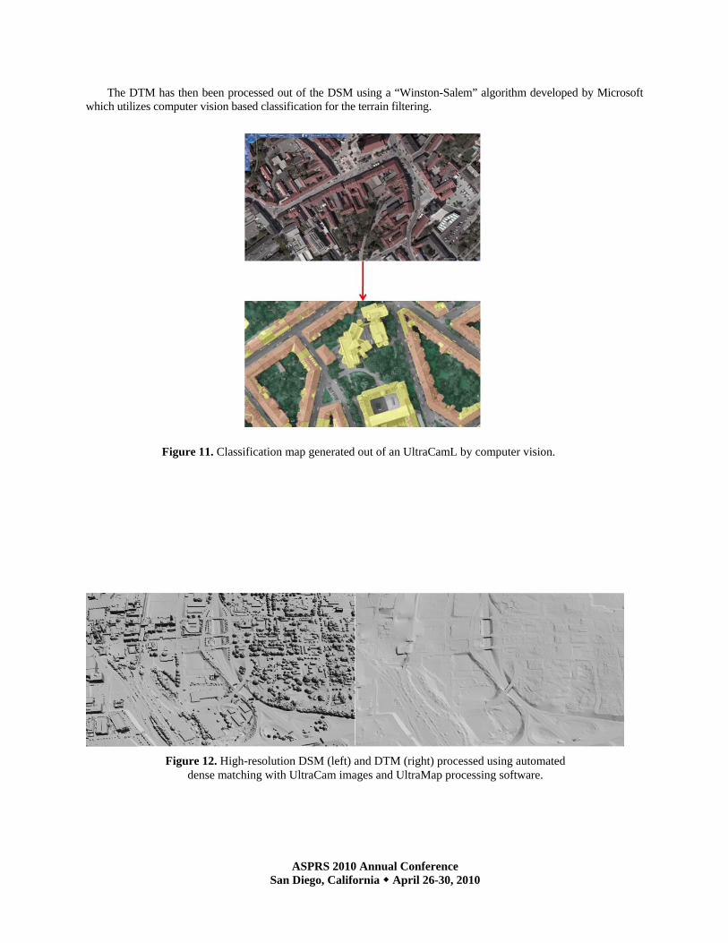
The images below show a grey-scaled relief of the DSM (left) and the DTM (right). The DSM has been processed using UltraMap software and a set of UltraCam images.
Figure 9. High resolution DSM by dense matching of UltraCamL images (left) and 10cm GSD true-ortho image (right).
Figure 10. High resolution DSM by dense matching of UltraCamL images (left) and 10cm GSD true-ortho image (right).
ASPRS 2010 Annual Conference San Diego, California April 26-30, 2010
The DTM has then been processed out of the DSM using a “Winston-Salem” algorithm developed by Microsoft which utilizes computer vision based classification for the terrain filtering.
Figure 12. High-resolution DSM (left) and DTM (right) processed using automated dense matching with UltraCam images and UltraMap processing software.
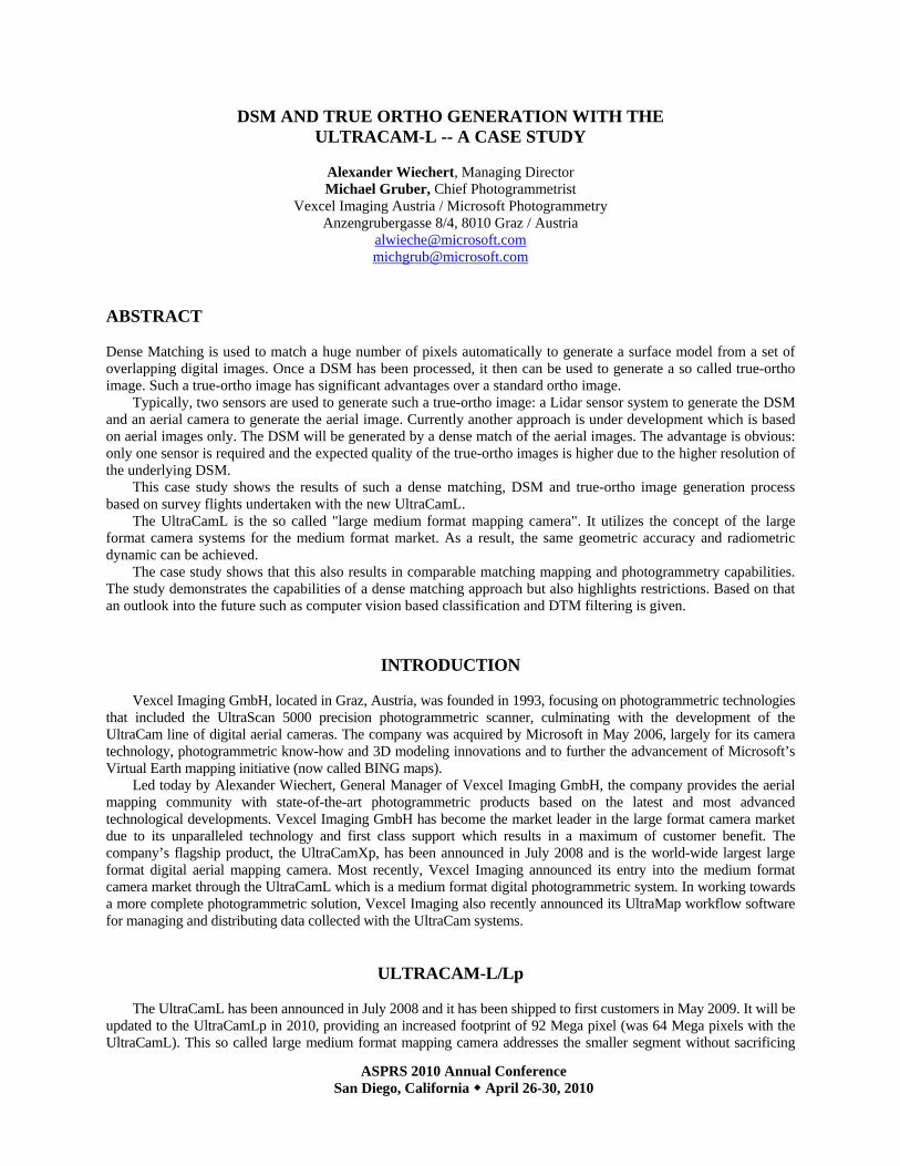
Figure 11. Classification map generated out of an UltraCamL by computer vision.

ASPRS 2010 Annual Conference San Diego, California April 26-30, 2010
EFFICIENCY The table below shows a comparison of a generic high end airborne Lidar system and a UltraCamXp and
UltraCamLp survey.
Generic High-Performance
Lidar
UltraCamXp UltraCamLp
Density: 8 points/sqm FOV: 30 deg. Height: 750 m Speed: 60 m/s Eff. pulse rate: 193 kHz Scan rate: 170 scans/s Strip width: 403m Sidelap: 20% Effective strip: 322 meter Efficiency: 17%
GSD: 25 cm FOV: 55 deg. Height: 4,188 m Speed: < 141 m/s Collection rate: 98 MP/sec. Frame rate: 2 sec. Strip width: 4,328 meter Sidelap: 60% Effective strip: 1,731 meter Efficiency: 100%
GSD: 25 cm FOV: 52 deg. Height: 2,917 m Speed: < 99 m/s Collection rate: 32 MP/sec. Frame rate: 2,5 sec. Strip width: 2,926 meter Sidelap: 60% Effective strip: 1,170 meter Efficiency: 68%
Using the UltraCamXp as the 100% efficiency reference for the strip width, the UltraCamLp has 68% of that
collection efficiency and a generic high end Lidar system has 17% of the collection efficiency for an eight points per square meter project. This reflects the huge collection capacity of digital aerial cameras.
REFERENCES
Gruber, M., & Wiechert, A., 2009. New digital aerial cameras by Vexcel Imaging / Microsoft, Proceedings of the Remote Sensing and Photogrammetry Society (RSPSoc) Annual Conference 2009, 8-11. 9. 2009, Leicester, UK.
Leberl, F., et al., 2003. The UltraCam Large Format Aerial Digital Camera System, Proceedings of the American Society For Photogrammetry & Remote Sensing, 5-9 May, 2003, Anchorage, Alaska.