dry season 2009-2010 outlook: el niño and potential impacts robert molleda warning coordination...
TRANSCRIPT

Dry Season 2009-2010 Outlook:El Niño and Potential Impacts
Robert MolledaWarning Coordination Meteorologist
National Weather ServiceMiami Forecast Office

Rainy Season Summary
• May 11 – October 17 (160 days).• Wetter (mostly) and hotter than normal.• Naples and its immediate Gulf coastal areas
observed below normal precipitation. • Pockets of SE Florida metro areas also
received below normal precipitation.

05
101520253035404550
Rainfall 5/11 - 10/17
Normal 5/11 - 10/17
Southeast Florida Wet Season 2009 Rainfall

Southwest Florida Wet Season 2009 Rainfall
05
101520253035404550
Naples Moore Haven Oasis Ranger
Rainfall 5/11 - 10/17
Normal 5/11 - 10/17
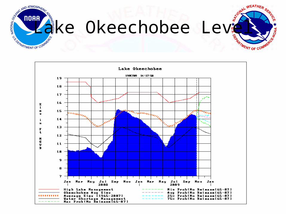
Lake Okeechobee Level

El Niño: What Does It Mean For South Florida This Winter?

Climate is what we expect, weather is what we get.Mark Twain
Transition ZoneTransition ZoneBetween Two Between Two
MajorMajorClimatesClimates
Florida - Prone to Very High Climate and Weather Variability
Slide Courtesy:NWS Melbourne, FL

Strong La Nina Storm Track
Strong EL Nino Storm Track
La Nina
El Nino
Florida Dry Season
Slide Courtesy:NWS Melbourne, FL

Normal Ocean Surface Temperatures (°C)January
Equator
Date Line
Equatorial ocean temperatures are normally warmest in the western Pacific and coolest in the eastern Pacific.
In the central and eastern Pacific, there is a lot of year-to-year variability. Some years are much warmer and wetter (El Niño) and some years are much cooler and drier (La Niña).
Warm, Wet
Cool, Dry

10
January Ocean Temperatures (oC) Comparing Normal to El Niño
Temperature Departures TemperaturesEl Niño
Normal
•El Niño: a periodic warming (every 3-6 years) of the central and eastern equatorial Pacific

Not easy to see effect of El Nino on U.S. in a given weather Map or satellite picture
Slide Courtesy:NWS Melbourne, FL

El Nino and La Nina have the greatest impact when they are strong –
About 50% time Neutral or Near Normal
8 moderate or higher El Niño's and 9 La Niña's in 60 last years
Neutral Range
Slide Courtesy:NWS Melbourne, FL

El Niño’s influence on Atlantic hurricane activity is well known
El Niño increases the vertical wind shear over the Atlantic, suppressing hurricane activity.
More Shear
Increased Wind Shear, Fewer Hurricanes
Warm, Wet
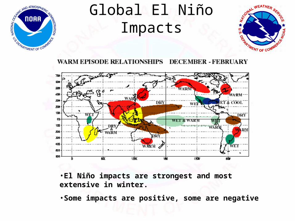
Global El Niño Impacts
•El Niño impacts are strongest and most extensive in winter.
•Some impacts are positive, some are negative

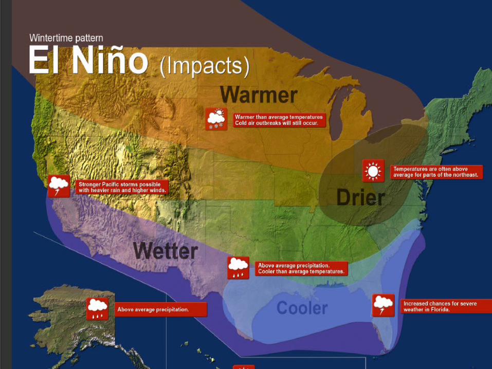
Wintertime Impacts in North America
El Niño:
•Pacific jet stream, storm track are south of normal
•Polar jet stream well into Canada
•Fewer arctic outbreaks
16
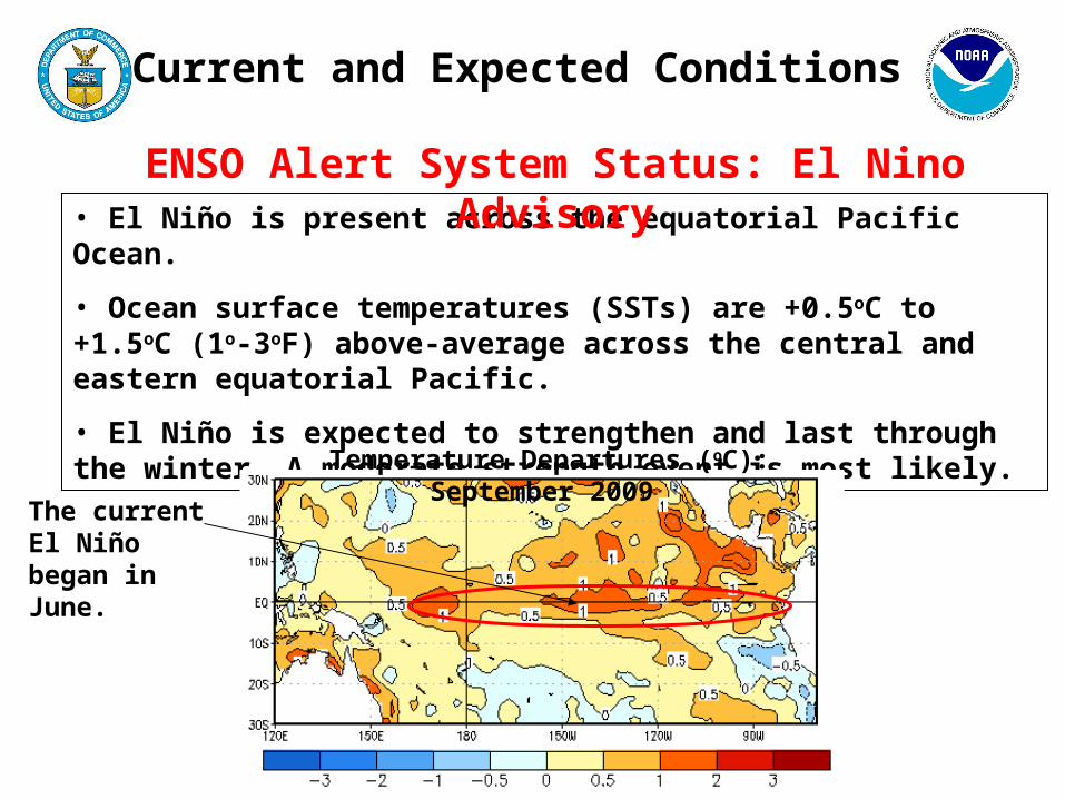
• El Niño is present across the equatorial Pacific Ocean.
• Ocean surface temperatures (SSTs) are +0.5oC to +1.5oC (1o-3oF) above-average across the central and eastern equatorial Pacific.
• El Niño is expected to strengthen and last through the winter. A moderate strength event is most likely.
ENSO Alert System Status: El Nino Advisory
Current and Expected Conditions
The current El Niño began in June.
Temperature Departures (oC): September 2009

Niño Region SST Departures (oC) Recent Evolution
The latest weekly SST departures are:
Niño 4 1.4ºC
Niño 3.4 1.1ºC
Niño 3 0.8ºC
Niño 1+2 0.1ºC
18
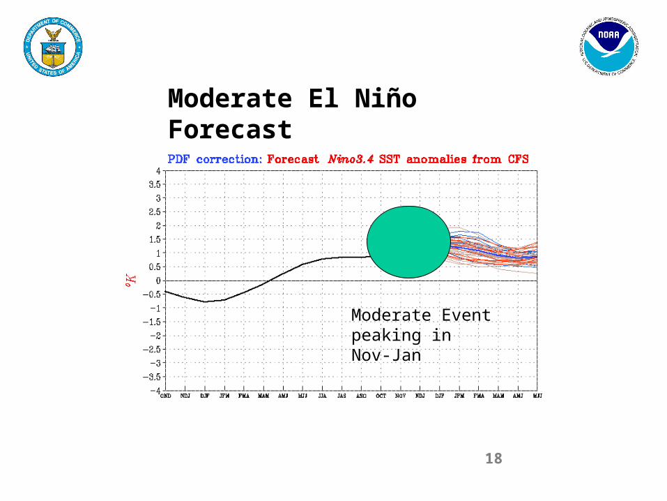
Moderate El Niño Forecast
Moderate Event peaking in Nov-Jan
19
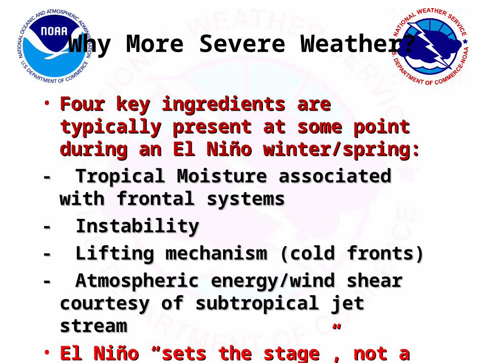
Why More Severe Weather?
• Four key ingredients are typically present Four key ingredients are typically present at some point during an El Niño at some point during an El Niño winter/spring:winter/spring:
- Tropical Moisture associated with frontal - Tropical Moisture associated with frontal systemssystems
- Instability- Instability
- Lifting mechanism (cold fronts)- Lifting mechanism (cold fronts)
- Atmospheric energy/wind shear courtesy - Atmospheric energy/wind shear courtesy of subtropical jet streamof subtropical jet stream
• El Niño “sets the stage”, not a cause.El Niño “sets the stage”, not a cause.
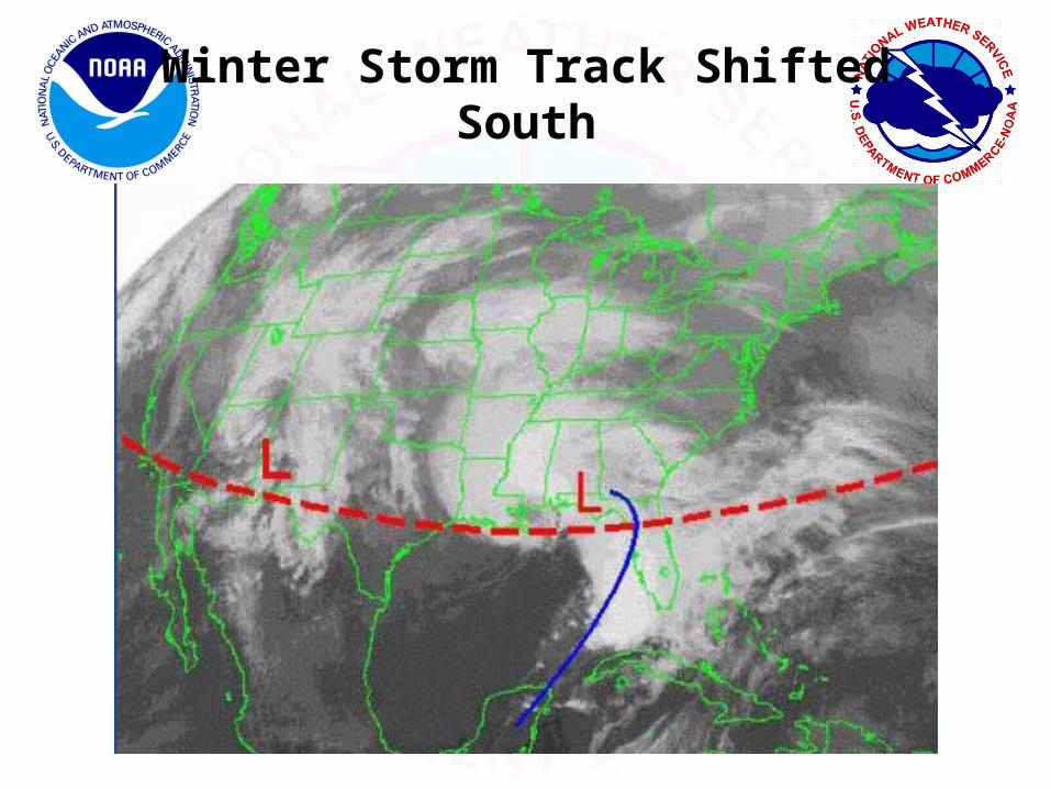
Winter Storm Track Shifted South

Jet Stream
Top 10 La Niñas Top 10 El Niños
Jet stream farther south in El Niño winters favors increased Florida storminess with severe weather/tornadoes possible
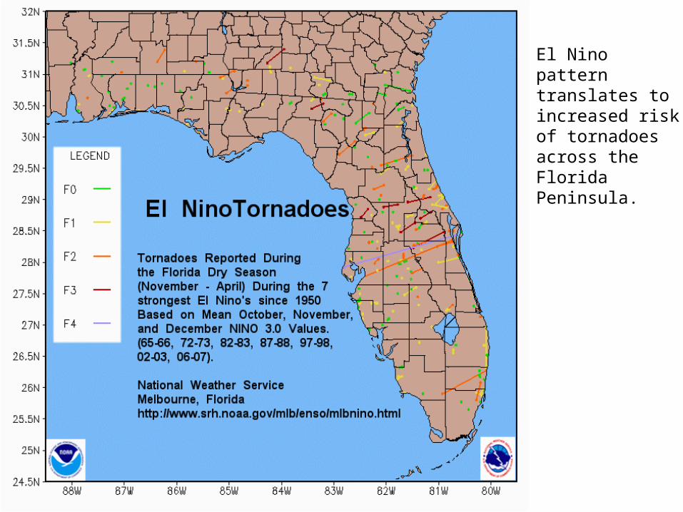
El Nino pattern translates to increased risk of tornadoes across the Florida Peninsula.

La Nina pattern produces much lower risk for tornadoes across the Florida Peninsula compared with El Nino years.
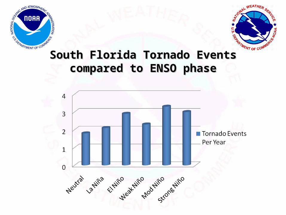
South Florida Tornado Events compared to South Florida Tornado Events compared to ENSO phaseENSO phase

March 27, 2003: Moderate El NiñoMarch 27, 2003: Moderate El Niño
Liberty City/Brownsville section of MiamiOne fatality
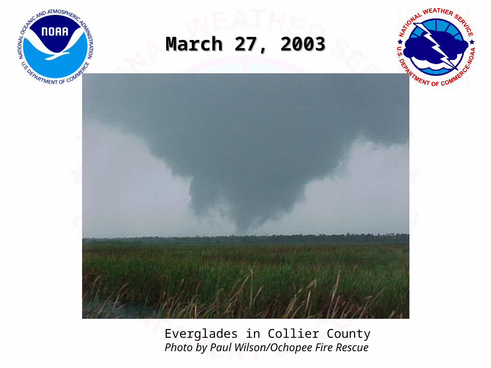
March 27, 2003March 27, 2003
Everglades in Collier CountyPhoto by Paul Wilson/Ochopee Fire Rescue

April 5, 1925: El Niño??April 5, 1925: El Niño??
North Dade: 5 deaths

Precipitation OutlookDecember-February 2009

Temperature OutlookDecember-February 2009
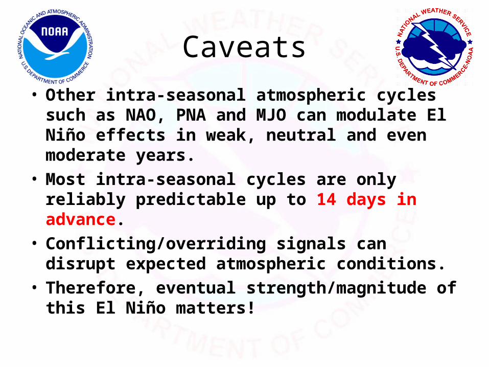
Caveats• Other intra-seasonal atmospheric cycles such as
NAO, PNA and MJO can modulate El Niño effects in weak, neutral and even moderate years.
• Most intra-seasonal cycles are only reliably predictable up to 14 days in advance.
• Conflicting/overriding signals can disrupt expected atmospheric conditions.
• Therefore, eventual strength/magnitude of this El Niño matters!
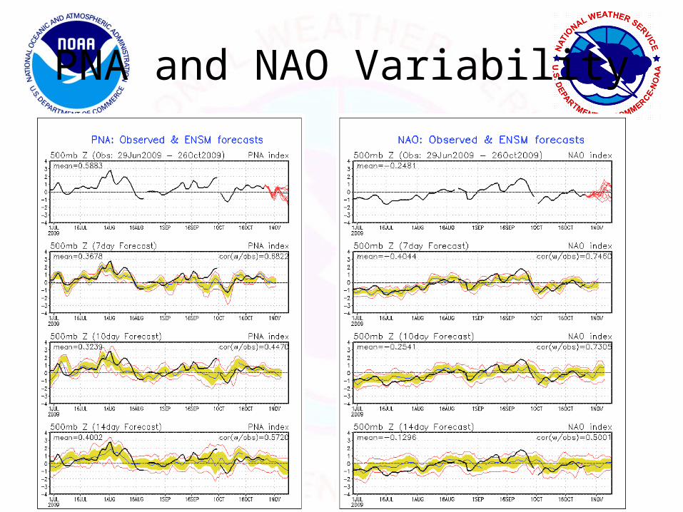
PNA and NAO Variability
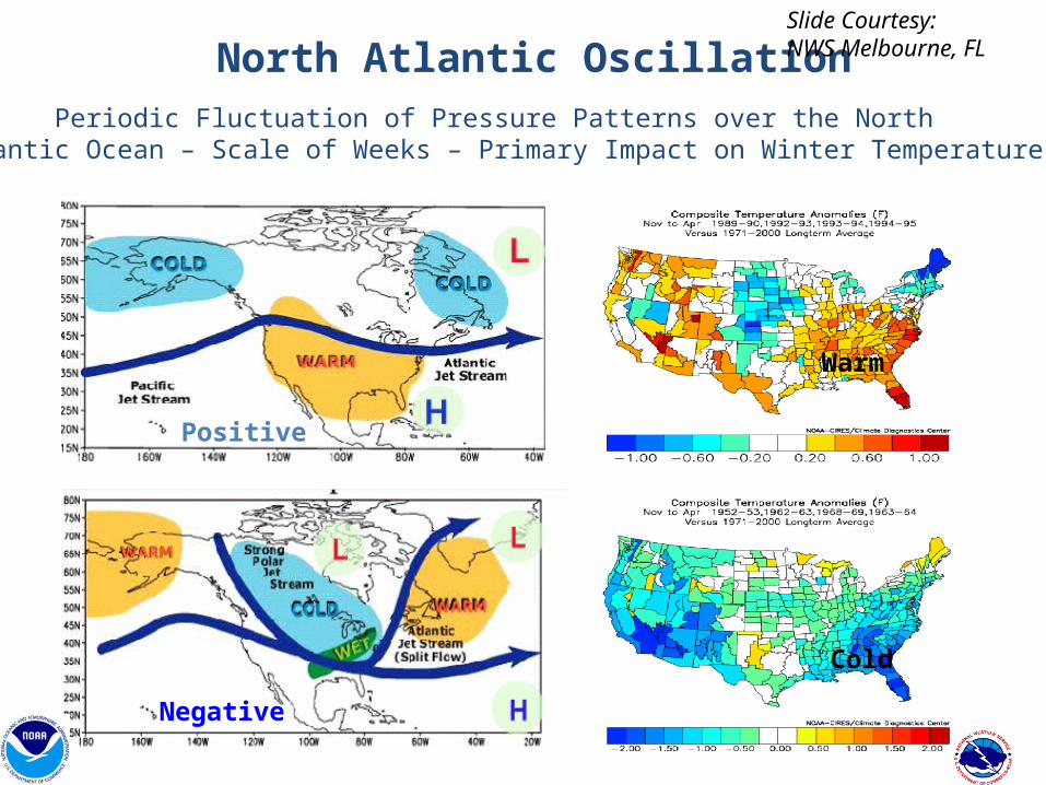
North Atlantic Oscillation
Negative
Positive
Periodic Fluctuation of Pressure Patterns over the NorthAtlantic Ocean – Scale of Weeks – Primary Impact on Winter Temperature
Cold
Warm
Slide Courtesy:NWS Melbourne, FL

2006-07 Moderate El Nino: Not What We Expected
Strong AO+ Pattern
South Florida: Warm and Dry in El Niño Year
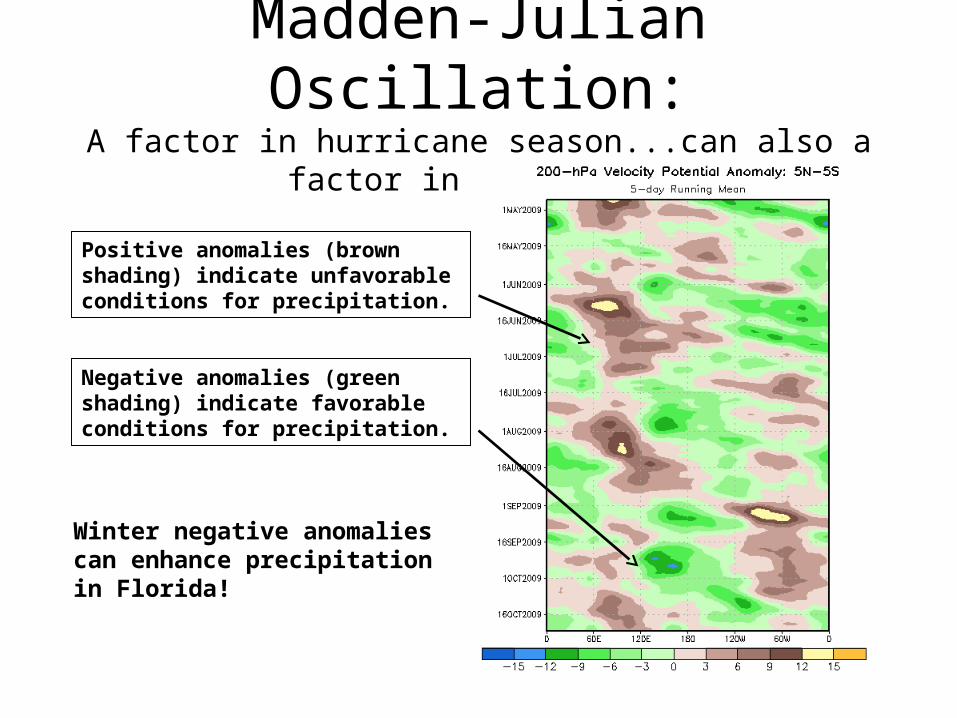
Madden-Julian Oscillation:A factor in hurricane season...can also a factor in the winter
Negative anomalies (green shading) indicate favorable conditions for precipitation.
Positive anomalies (brown shading) indicate unfavorable conditions for precipitation.
Winter negative anomalies can enhance precipitation in Florida!
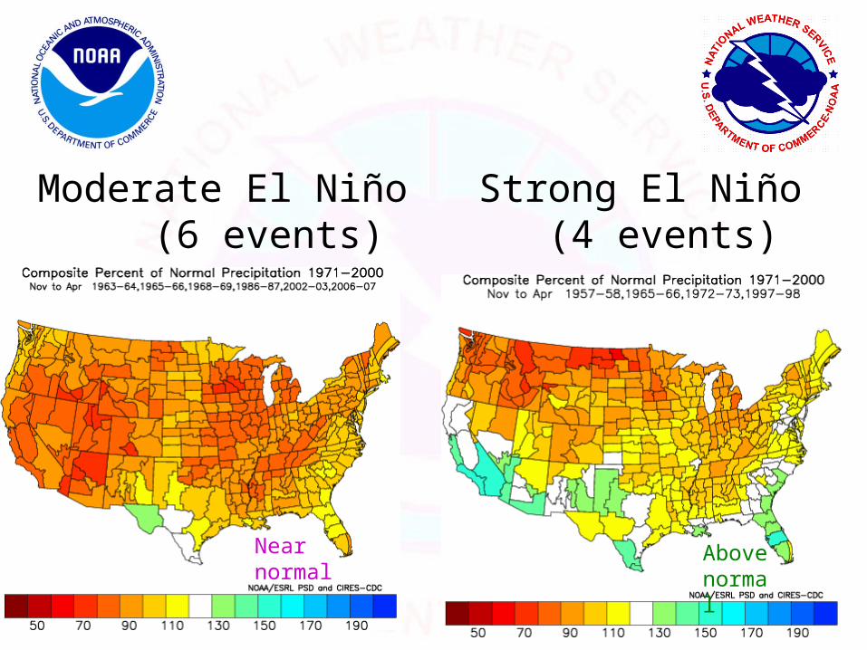
Moderate El Niño (6 events)
Strong El Niño (4 events)
Near normal
Above normal
SummarySummary
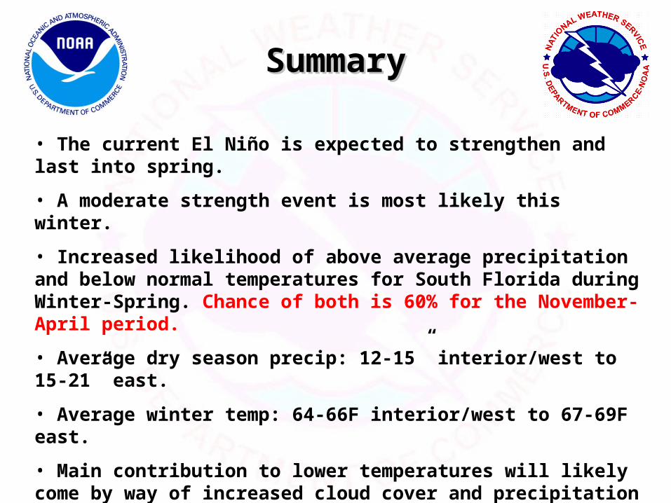
• The current El Niño is expected to strengthen and last into spring.
• A moderate strength event is most likely this winter.
• Increased likelihood of above average precipitation and below normal temperatures for South Florida during Winter-Spring. Chance of both is 60% for the November-April period.
• Average dry season precip: 12-15” interior/west to 15-21” east.
• Average winter temp: 64-66F interior/west to 67-69F east.
• Main contribution to lower temperatures will likely come by way of increased cloud cover and precipitation with frontal systems, with main effects on lower daily maximum temperatures.
• Despite lower temperatures, threat of a significant freeze no higher than normal. Arctic/Polar cold air outbreaks not as frequent or common in El Niño, but can still occur (Jan 2003, Jan 1977).

Main ImpactsMain Impacts
• Increased storminess across the southern U.S. enhances the threat of severe weather in South Florida this winter.
• Emphasis on potential increased tornado threat. Most killer Florida tornado events occur in El Niño years.
• Public awareness and response is critical.

Public Awareness
• Many past Florida tornado events occurred at night.
• Events originate in data sparse areas (Gulf of Mexico), which presents lack of long lead time situational awareness.
• Special severe weather alerts ahead of significant events.

Sample Severe Weather Outlook
• ...ENHANCED RISK OF TORNADOES ACROSS PORTIONS OF • CENTRAL AND SOUTHERN FLORIDA TONIGHT...
• THE STORM PREDICTION CENTER IS FORECASTING THE DEVELOPMENT OF STRONG TO
SEVERE THUNDERSTORMS ACROSS THIS REGION. CONDITIONS WILL BECOME VERY FAVORABLE FOR ISOLATED STRONG AND POSSIBLY LONG-LIVED TORNADOES.
• THE REGION IS PARTICULARLY VULNERABLE TO STRONG AND DAMAGING TORNADOES DURING THE OVERNIGHT AND EARLY MORNING HOURS THIS TIME OF YEAR.
• PERSONS IN THIS AREA ARE URGED TO HAVE HEIGHTENED AWARENESS AND REVIEW WEATHER SAFETY RULES. HAVE A PERSONAL SAFETY PLAN FOR YOU AND YOUR FAMILY AND CAREFULLY MONITOR THE LATEST WATCHES AND WARNINGS FROM THE NATIONAL WEATHER SERVICE.
• THOSE RESIDING IN MOBILE HOMES...RECREATIONAL VEHICLES...AND OTHER TEMPORARY• HOUSING WILL BE UNPROTECTED SHOULD A TORNADO STRIKE.
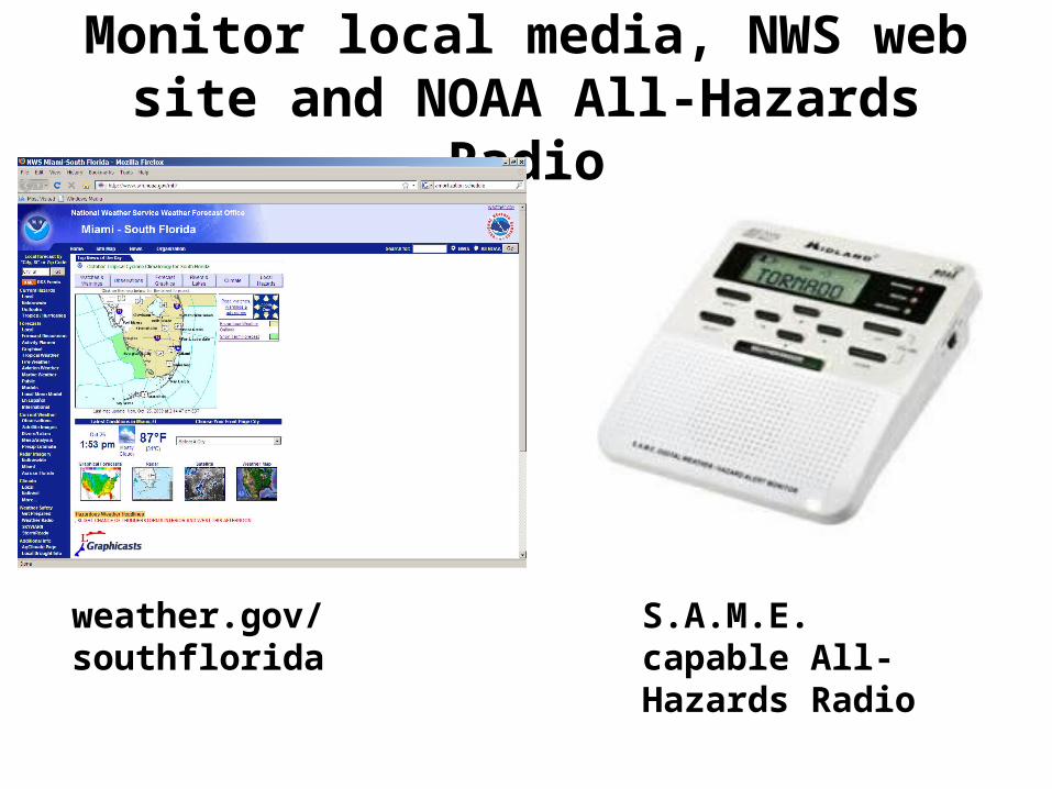
Monitor local media, NWS web site and NOAA All-Hazards Radio
weather.gov/southflorida S.A.M.E. capable All-Hazards Radio

Thank You
• Contact information:
On the Web: weather.gov/southfloridaPhone Recording: 305-229-4550Administrative: 305-229-4522