drought and land subsidence: monitoring from space · new radar measurements for future work...
TRANSCRIPT

Drought and Land Subsidence:
Monitoring from Space
Tom G Farr, Cathleen Jones, Zhen Liu (Project Team) Stephanie Granger (T/PM)
Jet Propulsion Laboratory California Institute of Technology
[email protected] [email protected]
Copyright 2015 California Institute of Technology. U.S. Government sponsorship acknowledged

NASA study for the state
Department of Water Resources
Progress Report: Subsidence in the Central Valley, California
• Long-term land subsidence creates problems for water
infrastructure and alters flow gradients in waterways.
• Applies proven data analysis techniques to map ground
deformation in Central Valley using radar data from
satellites and aircraft.
• Addresses key questions for understanding and managing
subsidence related to groundwater pumping.
Copyright 2015 California Institute of Technology. U.S. Government sponsorship acknowledged
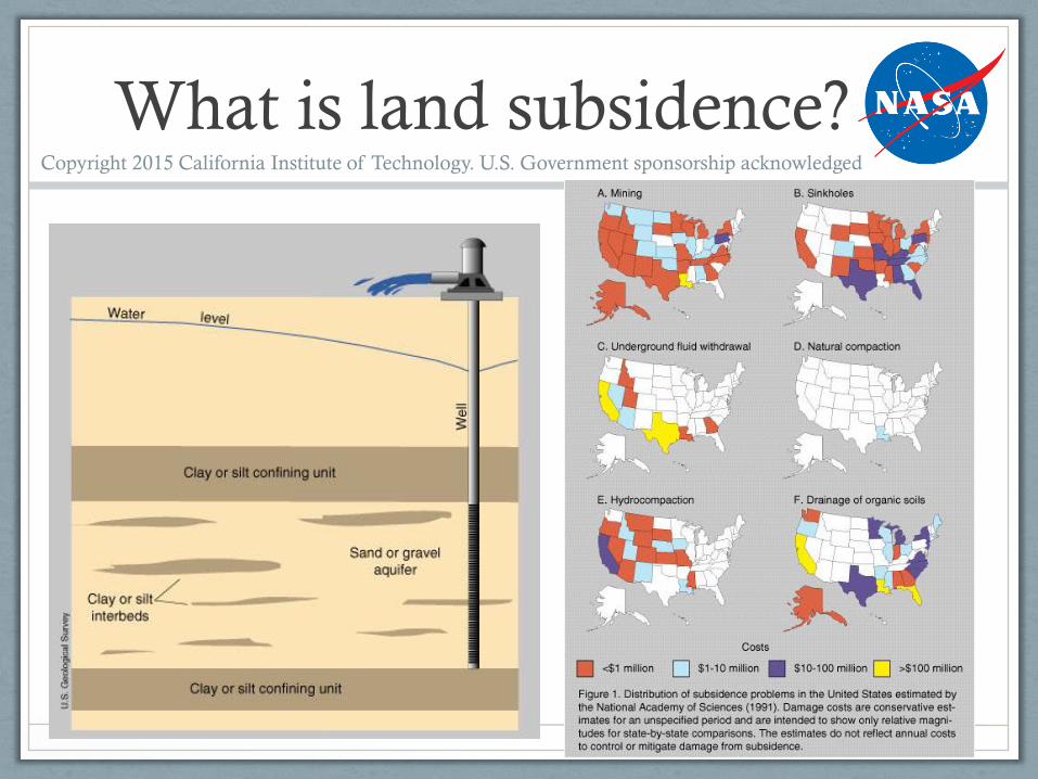
What is land subsidence? Copyright 2015 California Institute of Technology. U.S. Government sponsorship acknowledged

Evidence of subsidence
Credit: http://water.usgs.gov/ogw/pubs/fs00165/ - Land Subsidence in the United States, USGS USGS Fact Sheet-165-00 and
USGS Water-Resources Investigations Report 03-4015.
Land subsidence: Fissures in the Mojave Desert,
California
Left: Location of 1977 maximum subsidence in the United States identified by Dr. Joseph F.
Poland (pictured). Signs on pole show approximate altitude of land surface in 1925, 1955, and
1977. San Joaquin Valley southwest of Mendota, California. Credit: Dick Ireland, USGS.
Copyright 2015 California Institute of Technology. U.S. Government sponsorship acknowledged
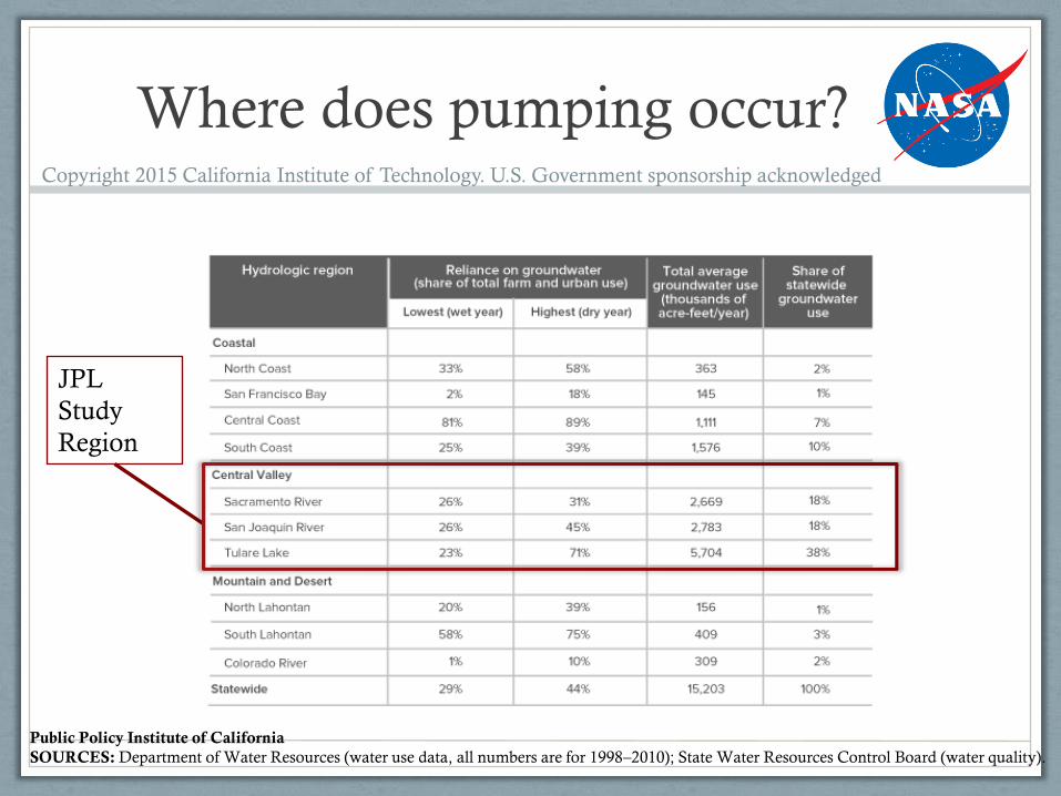
Where does pumping occur?
Public Policy Institute of California
SOURCES: Department of Water Resources (water use data, all numbers are for 1998–2010); State Water Resources Control Board (water quality).
Copyright 2015 California Institute of Technology. U.S. Government sponsorship acknowledged
JPL
Study
Region

Groundwater pumping in dry
years
Public Policy Institute of California
SOURCES: Department of Water Resources (water use data, all numbers are for 1998–2010); State Water Resources Control Board (water quality).
Copyright 2015 California Institute of Technology. U.S. Government sponsorship acknowledged
JPL Study Period 1

Impact of land subsidence Copyright 2015 California Institute of Technology. U.S. Government sponsorship acknowledged

“Seeing” subsidence from space
• Groundwater is an important part of California’s water supply, especially
in a dry year and especially in the Central Valley.
• Land subsidence is a consequence of groundwater over-pumping.
• Wells provide some monitoring capability, but there are practical
difficulties and they don’t provide subsidence information.
• Interferometric Synthetic Aperture Radar (InSAR) can provide
information on land subsidence by measuring surface deformation caused
by withdrawal and recharge of aquifers.
• We are developing information products for water managers, the public,
and hydrologists including animations, maps of ‘hot spots’, pixel histories,
and regional maps of subsidence and groundwater change
Copyright 2015 California Institute of Technology. U.S. Government sponsorship acknowledged

Interferometry 101:
deformation maps
When two observations are made from the same location in space but at different times, the interferometric phase is proportional to any change in the range of a surface feature.
Df =4p
l(r(t1) - r(t2 )) =
4p
lDrchanget1
t2
Drchange
r(t1 )r(t2 )
t1 t2
Surface Deformation Phase
Copyright 2015 California Institute of Technology. U.S. Government sponsorship acknowledged
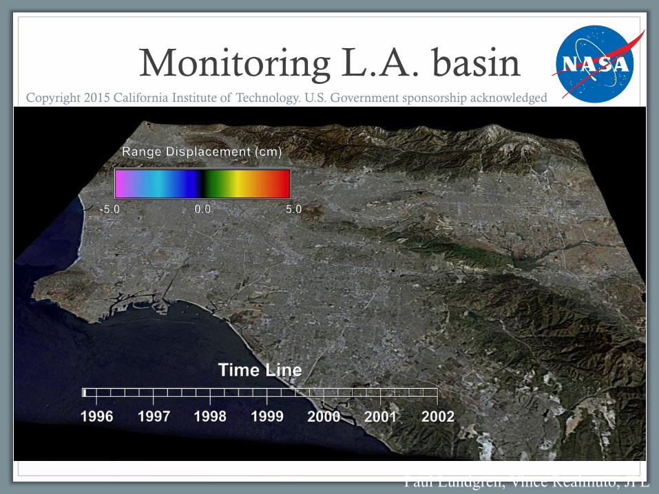
Monitoring L.A. basin
Paul Lundgren, Vince Realmuto, JPL
Copyright 2015 California Institute of Technology. U.S. Government sponsorship acknowledged
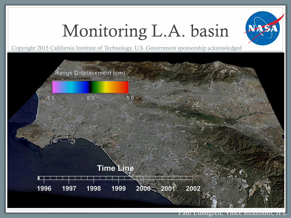
Monitoring L.A. basin
Paul Lundgren, Vince Realmuto, JPL
Copyright 2015 California Institute of Technology. U.S. Government sponsorship acknowledged

Try it yourself at:
http://webgis.irea.cnr.it/
Copyright 2015 California Institute of Technology. U.S. Government sponsorship acknowledged

Subsidence in the Central Valley of
California: PALSAR, 2007-2011
Zhen Liu, Vince Realmuto, Tom Farr, JPL
Copyright 2015 California Institute of Technology. U.S. Government sponsorship acknowledged

San Joaquin Valley subsidence Copyright 2015 California Institute of Technology. U.S. Government sponsorship acknowledged

Sacramento Valley subsidence Copyright 2015 California Institute of Technology. U.S. Government sponsorship acknowledged

Subsidence histories in San
Joaquin and Sacramento Valleys Copyright 2015 California Institute of Technology. U.S. Government sponsorship acknowledged

CA Aqueduct and Delta-
Mendota Canal Copyright 2015 California Institute of Technology. U.S. Government sponsorship acknowledged

CA Aqueduct near Buttonwillow Copyright 2015 California Institute of Technology. U.S. Government sponsorship acknowledged
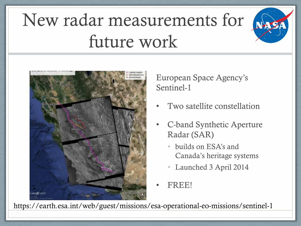
New radar measurements for
future work
European Space Agency’s
Sentinel-1
• Two satellite constellation
• C-band Synthetic Aperture
Radar (SAR)
• builds on ESA’s and
Canada’s heritage systems
• Launched 3 April 2014
• FREE!
https://earth.esa.int/web/guest/missions/esa-operational-eo-missions/sentinel-1

NASA-ISRO Synthetic Aperture
Radar (NISAR)
NASA-ISRO Synthetic Aperture Radar (NISAR), is a collaborative mission jointly by the Indian
Space Research Organisation and the U.S. National Aeronautics and Space Administration, planned
for launch in 2020.
Copyright 2015 California Institute of Technology. U.S. Government sponsorship acknowledged
http://nisar.jpl.nasa.gov
Summary
• InSAR maps and measures surface deformation which correlates with
subsidence due to groundwater withdrawal and recharge.
• A study funded by the California Department of Water Resources
(DWR) identified subsidence “hot spots” in the Central Valley under
drought conditions.
• Follow-on work will continue the record using radar data from Sentinel-1.
• NASA-JPL currently relies on data from other countries (Japan,
Europe, Italy, and Canada); the NASA-Indian Space Agency SAR
mission (NISAR) will ensure continuity of these critical data sets.
• We have submitted proposals to NASA to extend and improve our
understanding of aquifer systems through joint analysis of data from
complementary NASA data products and their precursors.
Copyright 2015 California Institute of Technology. U.S. Government sponsorship acknowledged

Thank you
Tom Farr
Stephanie Granger
Copyright 2015 California Institute of Technology. U.S. Government sponsorship acknowledged