drilling permits (w-1) - texas rrc permits (w-1) drilling permits pending approval plus latitudes...
TRANSCRIPT

Drilling Permits (W-1)
Drilling Permits Pending Approval Plus Latitudes and Longitudes
Railroad Commission of Texas Information Technology Services Division
May 2017

Table of Contents
1.0 Purpose ................................................................................ 1
2.0 Data Export Information ......................................................... 1
3.0 File Descriptions .................................................................... 2
4.0 File Definitions ....................................................................... 6
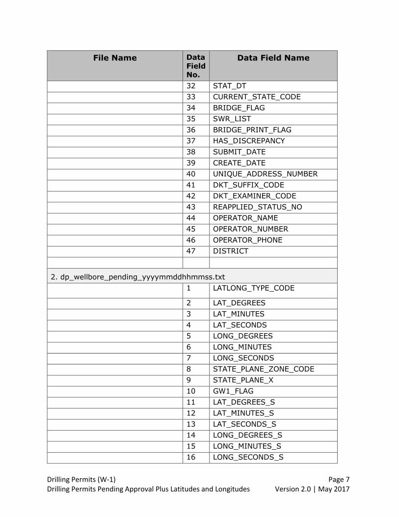
1. dp_drilling_permit_pending_yyyymmddhhmmss.txt .................. 6
2. dp_wellbore_pending_yyyymmddhhmmss.txt .......................... 7
3. dp_permit_restriction_pending_yyymmddhhmmss.txt ............... 8
4. dp_swr_resolution_pending_yyyymmddhhmmss.txt .................. 9
5. dp_permitted_field_pending_yyyymmddhhmmss.txt ................. 9
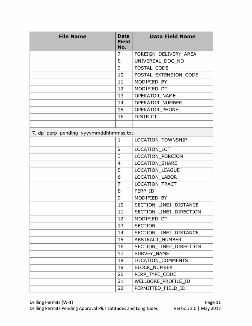
6. dp_mailing_address_pending_yyyymmddhhmmss.txt .............. 10
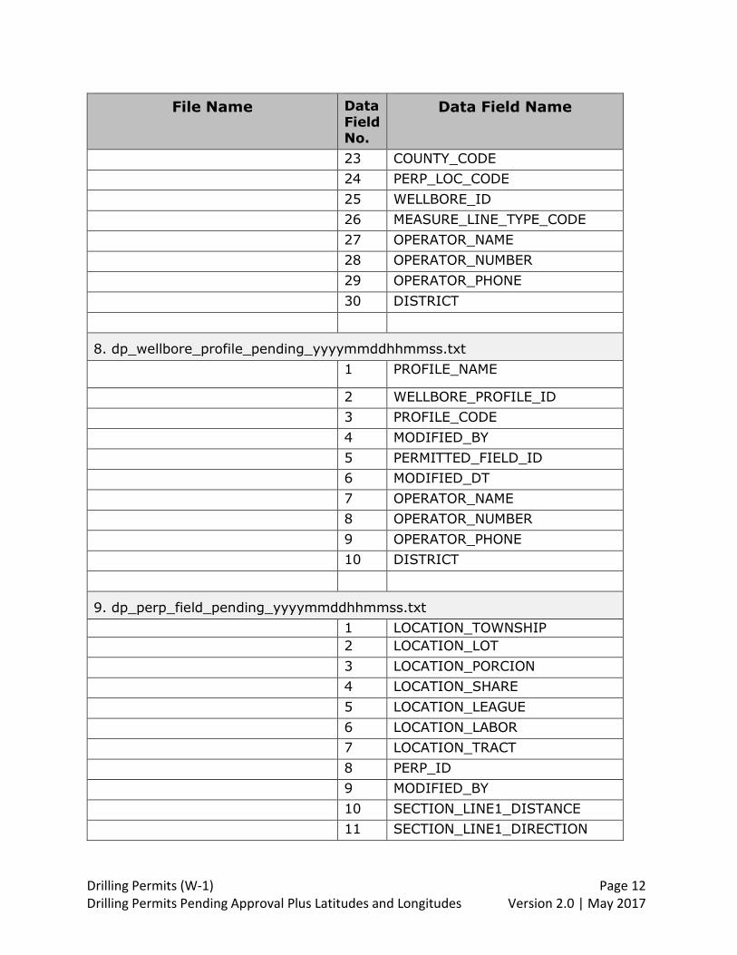
7. dp_perp_pending_yyyymmddhhmmss.txt ............................... 11
8. dp_wellbore_profile_pending_yyyymmddhhmmss.txt ............... 12
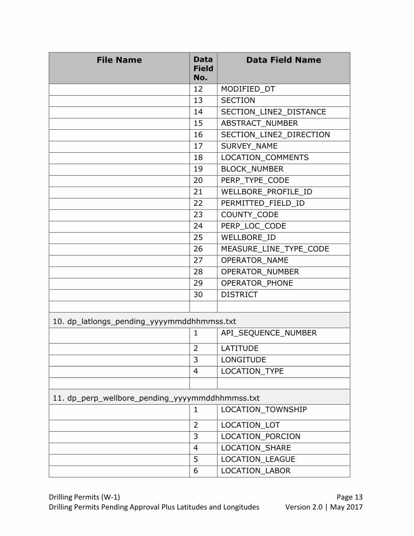
9. dp_perp_field_pending_yyyymmddhhmmss.txt ....................... 12
10. dp_latlongs_pending_yyyymmddhhmmss.txt......................... 13
11. dp_perp_wellbore_pending_yyyymmddhhmmss.txt ................ 13
5.0 Data Dictionary .................................................................... 15
6.0 Data Relationships ................................................................ 43
7.0 Revisions ............................................................................. 44
Drilling Permits (W-1) Page 1 Drilling Permits Pending Approval Plus Latitudes and Longitudes Version 2.0 | May 2017
1.0 Purpose
This document provides the file formats and data dictionary for submitted drilling permit applications (Form W-1 Application for Permit to Drill, Recomplete or Re-enter). The files only contain applications that are in a pending approval status.
The file creation process parses the data for a drilling permit application into
multiple text files. The date and time at the end of the file indicate when the file was generated. The file creation process generates two sets of files daily. One file set is generated at approximately 11:00 a.m., which captures W-1s submitted after
5:00 p.m. of the previous day and before 11:00 a.m. of the current day. The second file set captures W-1s submitted between 11:00 a.m. and 5:00 p.m. of the
current day. The text files for an application are associated with each other through common
data fields identified in Section 3.0 File Descriptions. Data field definitions are provided in Section 5.0 Data Dictionary. A graphical view of how the data is parsed
is provided in Section 6.0 Data Relationships. Since the applications are in a pending approval status, the data in the record may
contains errors that will be corrected prior to application approval. There may be blank data fields where the data will be added later, during the application review
process. Other data fields such as completion code will remain blank until after the well is drilled, and the permit is closed.
To view current data for a specific application or permit, you can access the Drilling Permits Query screen on the RRC public website:
http://webapps2.rrc.state.tx.us/EWA/drillingPermitsQueryAction.do.
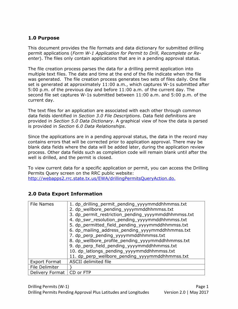
2.0 Data Export Information
File Names
1. dp_drilling_permit_pending_yyyymmddhhmmss.txt
2. dp_wellbore_pending_yyyymmddhhmmss.txt 3. dp_permit_restriction_pending_yyyymmddhhmmss.txt 4. dp_swr_resolution_pending_yyyymmddhhmmss.txt
5. dp_permitted_field_pending_yyyymmddhhmmss.txt 6. dp_mailing_address_pending_yyyymmddhhmmss.txt
7. dp_perp_pending_yyyymmddhhmmss.txt 8. dp_wellbore_profile_pending_yyyymmddhhmmss.txt 9. dp_perp_field_pending_yyyymmddhhmmss.txt
10. dp_latlongs_pending_yyyymmddhhmmss.txt 11. dp_perp_wellbore_pending_yyyymmddhhmmss.txt
Export Format ASCII delimited file
File Delimiter }
Delivery Format CD or FTP

Drilling Permits (W-1) Page 2 Drilling Permits Pending Approval Plus Latitudes and Longitudes Version 2.0 | May 2017
3.0 File Descriptions
File Name File Description
1. dp_drilling_permit_pending_
yyyymmddhhmmss.txt
Drilling Permit level information. There is one
record for each drilling permit application entered in the online Drilling Permits system. This record contains information for the application and the
drilling permit issued.
UNIVERSAL_DOC_NO is the system-assigned unique identifier for this file.
Data in this text file is associated with other files via the UNIVERSAL_DOC_NO column:
dp_wellbore_pending (File 2) dp_permit_restriction_pending (File 3)
dp_swr_resolution_pending (File 4) dp_permitted_field_pending (File 5).
2. dp_wellbore_pending_ yyyymmddhhmmss.txt
Wellbore information for the drilling permit. There is one record for each drilling permit application
entered in the online Drilling Permits system. This record contains wellbore surface hole location data
such as distance and direction from nearest town, county code, GPS coordinates, and API number.
Data in this text file is associated with the “dp_drilling_permit_pending” file via the
UNIVERSAL_DOC_NO column.
3. dp_permit_restriction_pending_ yyymmddhhmmss.txt
Restriction(s) applied to a drilling permit. There can be multiple records for each drilling permit application entered in the online Drilling Permits
system. Restriction codes are as follows: 09 - Corrected permit to show correct survey.
12 - No authority to downhole commingle until exception to Rule 10 is granted. 15 - This permit is generated for administrative
purposes only. 17 - Approved under entity for density pursuant to
Docket # 18 - Administrative SWR 39 Exception. 21 - This is not a directional well. Unintentionally
deviated. As drilled BHL 22 - Permit to drill granted pending approval.
23 - Exception to SWR 86 granted per Docket #
Drilling Permits (W-1) Page 3 Drilling Permits Pending Approval Plus Latitudes and Longitudes Version 2.0 | May 2017
File Name File Description
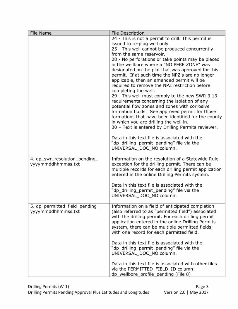
24 - This is not a permit to drill. This permit is issued to re-plug well only.
25 - This well cannot be produced concurrently from the same reservoir. 28 - No perforations or take points may be placed
in the wellbore where a "NO PERF ZONE" was designated on the plat that was approved for this
permit. If at such time the NPZ's are no longer applicable, then an amended permit will be required to remove the NPZ restriction before
completing the well. 29 - This well must comply to the new SWR 3.13
requirements concerning the isolation of any potential flow zones and zones with corrosive formation fluids. See approved permit for those
formations that have been identified for the county in which you are drilling the well in. 30 – Text is entered by Drilling Permits reviewer.
Data in this text file is associated with the “dp_drilling_permit_pending” file via the
UNIVERSAL_DOC_NO column.
4. dp_swr_resolution_pending_ yyyymmddhhmmss.txt
Information on the resolution of a Statewide Rule exception for the drilling permit. There can be
multiple records for each drilling permit application entered in the online Drilling Permits system.
Data in this text file is associated with the
“dp_drilling_permit_pending” file via the UNIVERSAL_DOC_NO column.
5. dp_permitted_field_pending_
yyyymmddhhmmss.txt
Information on a field of anticipated completion
(also referred to as “permitted field”) associated with the drilling permit. For each drilling permit application entered in the online Drilling Permits
system, there can be multiple permitted fields, with one record for each permitted field.
Data in this text file is associated with the “dp_drilling_permit_pending” file via the UNIVERSAL_DOC_NO column. Data in this text file is associated with other files
via the PERMITTED_FIELD_ID column: dp_wellbore_profile_pending (File 8)
Drilling Permits (W-1) Page 4 Drilling Permits Pending Approval Plus Latitudes and Longitudes Version 2.0 | May 2017
File Name File Description
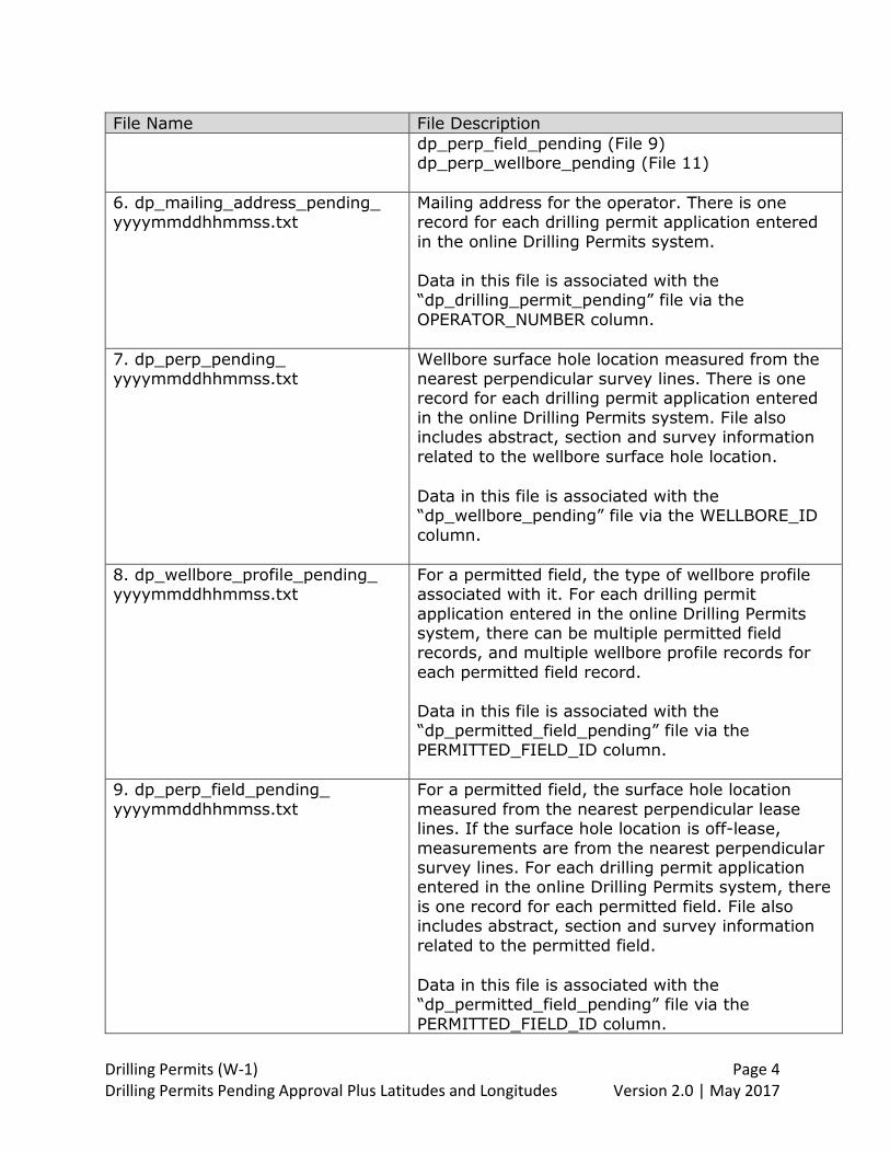
dp_perp_field_pending (File 9) dp_perp_wellbore_pending (File 11)
6. dp_mailing_address_pending_ yyyymmddhhmmss.txt
Mailing address for the operator. There is one record for each drilling permit application entered
in the online Drilling Permits system.
Data in this file is associated with the “dp_drilling_permit_pending” file via the
OPERATOR_NUMBER column.
7. dp_perp_pending_ yyyymmddhhmmss.txt
Wellbore surface hole location measured from the nearest perpendicular survey lines. There is one record for each drilling permit application entered
in the online Drilling Permits system. File also includes abstract, section and survey information
related to the wellbore surface hole location.
Data in this file is associated with the “dp_wellbore_pending” file via the WELLBORE_ID
column.
8. dp_wellbore_profile_pending_ yyyymmddhhmmss.txt
For a permitted field, the type of wellbore profile associated with it. For each drilling permit
application entered in the online Drilling Permits system, there can be multiple permitted field records, and multiple wellbore profile records for
each permitted field record.
Data in this file is associated with the “dp_permitted_field_pending” file via the PERMITTED_FIELD_ID column.
9. dp_perp_field_pending_
yyyymmddhhmmss.txt
For a permitted field, the surface hole location
measured from the nearest perpendicular lease lines. If the surface hole location is off-lease,
measurements are from the nearest perpendicular survey lines. For each drilling permit application entered in the online Drilling Permits system, there
is one record for each permitted field. File also includes abstract, section and survey information
related to the permitted field.
Data in this file is associated with the “dp_permitted_field_pending” file via the
PERMITTED_FIELD_ID column.
Drilling Permits (W-1) Page 5 Drilling Permits Pending Approval Plus Latitudes and Longitudes Version 2.0 | May 2017
File Name File Description
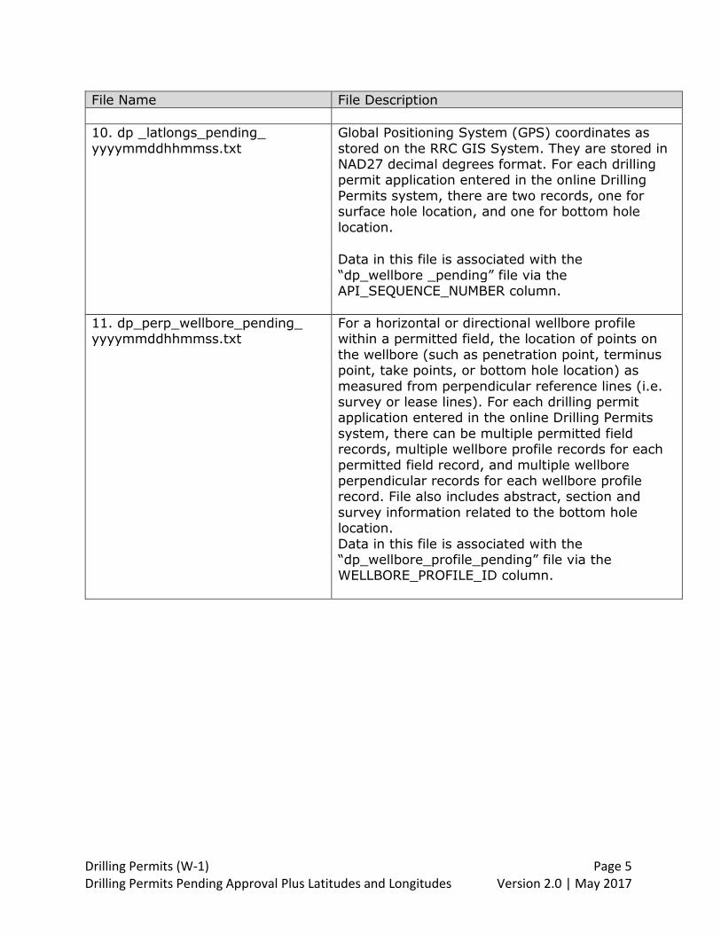
10. dp _latlongs_pending_
yyyymmddhhmmss.txt
Global Positioning System (GPS) coordinates as
stored on the RRC GIS System. They are stored in NAD27 decimal degrees format. For each drilling permit application entered in the online Drilling
Permits system, there are two records, one for surface hole location, and one for bottom hole
location.
Data in this file is associated with the
“dp_wellbore _pending” file via the API_SEQUENCE_NUMBER column.
11. dp_perp_wellbore_pending_ yyyymmddhhmmss.txt
For a horizontal or directional wellbore profile within a permitted field, the location of points on
the wellbore (such as penetration point, terminus point, take points, or bottom hole location) as
measured from perpendicular reference lines (i.e. survey or lease lines). For each drilling permit application entered in the online Drilling Permits
system, there can be multiple permitted field records, multiple wellbore profile records for each
permitted field record, and multiple wellbore perpendicular records for each wellbore profile record. File also includes abstract, section and
survey information related to the bottom hole location.
Data in this file is associated with the “dp_wellbore_profile_pending” file via the WELLBORE_PROFILE_ID column.

Drilling Permits (W-1) Page 6 Drilling Permits Pending Approval Plus Latitudes and Longitudes Version 2.0 | May 2017
4.0 File Definitions
File Name Data Field No.
Data Field Name
1. dp_drilling_permit_pending_yyyymmddhhmmss.txt
1 SWR38_ABBR_NOTICE
2 IS_REAPPLIED
3 UNIVERSAL_DOC_NO
4 STATUS_NUMBER
5 EFFECTIVE_DT
6 RETURN_DT
7 TOTAL_DEPTH
8 IS_AMENDMENT
9 SWR_36_FLAG
10 DEVELOP_MINERALS_FLAG
11 CASE_DOCKET_NO
12 FINAL_PROTEST_DT
13 STATUS_SEQ_NO
14 SPUD_DT
15 EXPEDITE_FLAG
16 EXPEDITE_DATE_TIME
17 FILING_PURPOSE_CODE
18 SURFACE_CASING_DT
19 DEFAULT_LEASE_NAME
20 DEFAULT_WELL_NUMBER
21 DEFAULT_VERTICAL
22 DEFAULT_HORIZONTAL
23 DEFAULT_SIDETRACK
24 LOCKED_BY
25 DEFAULT_DIRECTIONAL
26 STATUS_CODE
27 EXPIRATION_DATE
28 WALKIN_CONTACT_NAME
29 WALKIN_CONTACT_PHONE
30 COMPLETION_CODE
31 SWR_SUBSECT_CODE
Drilling Permits (W-1) Page 7 Drilling Permits Pending Approval Plus Latitudes and Longitudes Version 2.0 | May 2017
File Name Data
Field No.
Data Field Name
32 STAT_DT
33 CURRENT_STATE_CODE
34 BRIDGE_FLAG
35 SWR_LIST
36 BRIDGE_PRINT_FLAG
37 HAS_DISCREPANCY
38 SUBMIT_DATE
39 CREATE_DATE
40 UNIQUE_ADDRESS_NUMBER
41 DKT_SUFFIX_CODE
42 DKT_EXAMINER_CODE
43 REAPPLIED_STATUS_NO
44 OPERATOR_NAME
45 OPERATOR_NUMBER
46 OPERATOR_PHONE
47 DISTRICT
2. dp_wellbore_pending_yyyymmddhhmmss.txt
1 LATLONG_TYPE_CODE
2 LAT_DEGREES
3 LAT_MINUTES
4 LAT_SECONDS
5 LONG_DEGREES
6 LONG_MINUTES
7 LONG_SECONDS
8 STATE_PLANE_ZONE_CODE
9 STATE_PLANE_X
10 GW1_FLAG
11 LAT_DEGREES_S
12 LAT_MINUTES_S
13 LAT_SECONDS_S
14 LONG_DEGREES_S
15 LONG_MINUTES_S
16 LONG_SECONDS_S

Drilling Permits (W-1) Page 8 Drilling Permits Pending Approval Plus Latitudes and Longitudes Version 2.0 | May 2017
File Name Data
Field No.
Data Field Name
17 API_SEQUENCE_NUMBER
18 DIRECTIONS
19 MODIFIED_BY
20 NEAREST_TOWN_DISTANCE
21 NEAREST_TOWN
22 MODIFIED_DT
23 API_LINKED_FLAG
24 LOCATION_DESCRIPTION
25 COUNTY_CODE
26 SURFACE_LOCATION_CODE
27 WELLBORE_ID
28 OFFSHORE_COUNTY_CODE
29 UNIVERSAL_DOC_NO
30 HORIZ_WELLBORE_TYPE_CODE
31 STACKED_LAT_STATUS_NO
32 PSA_FLAG
33 ALLOCATION_FLAG
34 STACKED_LATERAL_FLAG
35 STATE_PLANE_Y
36 OPERATOR_NAME
37 OPERATOR_NUMBER
38 OPERATOR_PHONE
39 DISTRICT
3. dp_permit_restriction_pending_yyymmddhhmmss.txt
1 PERMIT_RESTRICTION_ID
2 RESTRICTION_CODE
3 UNIVERSAL_DOC_NO
4 RESTRICTION_TEXT
5 MODIFIED_BY
6 MODIFIED_DT
7 OPERATOR_NAME
8 OPERATOR_NUMBER
9 OPERATOR_PHONE

Drilling Permits (W-1) Page 9 Drilling Permits Pending Approval Plus Latitudes and Longitudes Version 2.0 | May 2017
File Name Data
Field No.
Data Field Name
10 DISTRICT
4. dp_swr_resolution_pending_yyyymmddhhmmss.txt
1 UNIVERSAL_DOC_NO
2 SWR_RESLTN_CODE
3 MODIFIED_BY
4 MODIFIED_DT
5 SWR_RESOLUTION_ID
6 OPERATOR_NAME
7 OPERATOR_NUMBER
8 OPERATOR_PHONE
9 DISTRICT
5. dp_permitted_field_pending_yyyymmddhhmmss.txt
1 OFF_LEASE_PNTRN_PT_FLAG
2 OFF_LEASE_SURF_LOC_FLAG
3 REX_OLPP_OWN_OFFSET_YN
4 REX_OLPP_WAVIER_YN
5 REX_OLPP_NOTICE_YN
6 REX_OLPP_PUBLICATION_YN
7 REX_OLPP_HEARING_REQUEST_
YN
8 REX_OLPP_LAST_NOTICE_DT
9 REX_OLPP_DOCKET_NO
10 WELL_NUMBER
11 UNIVERSAL_DOC_NO
12 FIELD_ID
13 WELL_TYPE_CODE
14 MODIFIED_BY
15 COMPLETION_DEPTH

Drilling Permits (W-1) Page 10 Drilling Permits Pending Approval Plus Latitudes and Longitudes Version 2.0 | May 2017
File Name Data
Field No.
Data Field Name
16 MODIFIED_DT
17 PRIMARY_FIELD_FLAG
18 NEAREST_WELL_DISTANCE
19 NEAREST_LEASE_DISTANCE
20 TOTAL_ACRES
21 NON_CONCURRENT_37WELLS
22 NON_CONCURRENT_38WELLS
23 POOLED_UNIT_FLAG
24 UNITIZED_DOCKET_NO
25 SWR39_RESOLUTION
26 REPORTED_LEASE_NAME
27 WELL_COUNT
28 ENTITY_DENSITY_DOCKET_NO
29 FIELD_VALIDATED_DT
30 W1A_TRACT_DT
31 COMPLETION_DT
32 COMPLETION_WELL_CODE
33 PERMITTED_FIELD_ID
34 TEXT_FOR_85279201
35 REX_OLPP_HEARING_OUTCOME
_CODE
36 OPERATOR_NAME
37 OPERATOR_NUMBER
38 OPERATOR_PHONE
39 DISTRICT
6. dp_mailing_address_pending_yyyymmddhhmmss.txt
1 MAILING_ADDRESS_ID
2 ADDRESS_LINE1
3 ADDRESS_LINE2
4 CITY
5 COUNTRY_CODE
6 STATE_CODE
Drilling Permits (W-1) Page 11 Drilling Permits Pending Approval Plus Latitudes and Longitudes Version 2.0 | May 2017
File Name Data
Field No.
Data Field Name
7 FOREIGN_DELIVERY_AREA
8 UNIVERSAL_DOC_NO
9 POSTAL_CODE
10 POSTAL_EXTENSION_CODE
11 MODIFIED_BY
12 MODIFIED_DT
13 OPERATOR_NAME
14 OPERATOR_NUMBER
15 OPERATOR_PHONE
16 DISTRICT
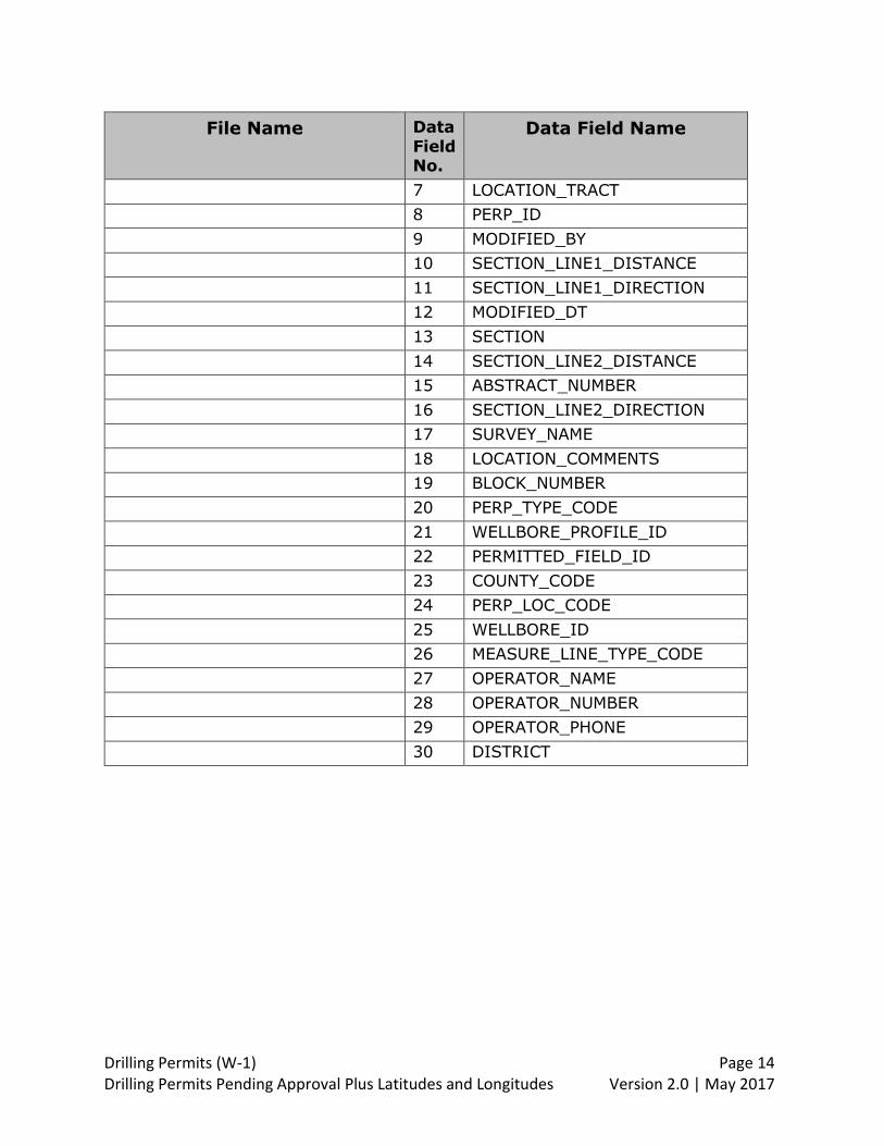
7. dp_perp_pending_yyyymmddhhmmss.txt
1 LOCATION_TOWNSHIP
2 LOCATION_LOT
3 LOCATION_PORCION
4 LOCATION_SHARE
5 LOCATION_LEAGUE
6 LOCATION_LABOR
7 LOCATION_TRACT
8 PERP_ID
9 MODIFIED_BY
10 SECTION_LINE1_DISTANCE
11 SECTION_LINE1_DIRECTION
12 MODIFIED_DT
13 SECTION
14 SECTION_LINE2_DISTANCE
15 ABSTRACT_NUMBER
16 SECTION_LINE2_DIRECTION
17 SURVEY_NAME
18 LOCATION_COMMENTS
19 BLOCK_NUMBER
20 PERP_TYPE_CODE
21 WELLBORE_PROFILE_ID
22 PERMITTED_FIELD_ID
Drilling Permits (W-1) Page 12 Drilling Permits Pending Approval Plus Latitudes and Longitudes Version 2.0 | May 2017
File Name Data
Field No.
Data Field Name
23 COUNTY_CODE
24 PERP_LOC_CODE
25 WELLBORE_ID
26 MEASURE_LINE_TYPE_CODE
27 OPERATOR_NAME
28 OPERATOR_NUMBER
29 OPERATOR_PHONE
30 DISTRICT
8. dp_wellbore_profile_pending_yyyymmddhhmmss.txt
1 PROFILE_NAME
2 WELLBORE_PROFILE_ID
3 PROFILE_CODE
4 MODIFIED_BY
5 PERMITTED_FIELD_ID
6 MODIFIED_DT
7 OPERATOR_NAME
8 OPERATOR_NUMBER
9 OPERATOR_PHONE
10 DISTRICT
9. dp_perp_field_pending_yyyymmddhhmmss.txt
1 LOCATION_TOWNSHIP
2 LOCATION_LOT
3 LOCATION_PORCION
4 LOCATION_SHARE
5 LOCATION_LEAGUE
6 LOCATION_LABOR
7 LOCATION_TRACT
8 PERP_ID
9 MODIFIED_BY
10 SECTION_LINE1_DISTANCE
11 SECTION_LINE1_DIRECTION
Drilling Permits (W-1) Page 13 Drilling Permits Pending Approval Plus Latitudes and Longitudes Version 2.0 | May 2017
File Name Data
Field No.
Data Field Name
12 MODIFIED_DT
13 SECTION
14 SECTION_LINE2_DISTANCE
15 ABSTRACT_NUMBER
16 SECTION_LINE2_DIRECTION
17 SURVEY_NAME
18 LOCATION_COMMENTS
19 BLOCK_NUMBER
20 PERP_TYPE_CODE
21 WELLBORE_PROFILE_ID
22 PERMITTED_FIELD_ID
23 COUNTY_CODE
24 PERP_LOC_CODE
25 WELLBORE_ID
26 MEASURE_LINE_TYPE_CODE
27 OPERATOR_NAME
28 OPERATOR_NUMBER
29 OPERATOR_PHONE
30 DISTRICT
10. dp_latlongs_pending_yyyymmddhhmmss.txt
1 API_SEQUENCE_NUMBER
2 LATITUDE
3 LONGITUDE
4 LOCATION_TYPE
11. dp_perp_wellbore_pending_yyyymmddhhmmss.txt
1 LOCATION_TOWNSHIP
2 LOCATION_LOT
3 LOCATION_PORCION
4 LOCATION_SHARE
5 LOCATION_LEAGUE
6 LOCATION_LABOR
Drilling Permits (W-1) Page 14 Drilling Permits Pending Approval Plus Latitudes and Longitudes Version 2.0 | May 2017
File Name Data
Field No.
Data Field Name
7 LOCATION_TRACT
8 PERP_ID
9 MODIFIED_BY
10 SECTION_LINE1_DISTANCE
11 SECTION_LINE1_DIRECTION
12 MODIFIED_DT
13 SECTION
14 SECTION_LINE2_DISTANCE
15 ABSTRACT_NUMBER
16 SECTION_LINE2_DIRECTION
17 SURVEY_NAME
18 LOCATION_COMMENTS
19 BLOCK_NUMBER
20 PERP_TYPE_CODE
21 WELLBORE_PROFILE_ID
22 PERMITTED_FIELD_ID
23 COUNTY_CODE
24 PERP_LOC_CODE
25 WELLBORE_ID
26 MEASURE_LINE_TYPE_CODE
27 OPERATOR_NAME
28 OPERATOR_NUMBER
29 OPERATOR_PHONE
30 DISTRICT

Drilling Permits (W-1) Page 15 Drilling Permits Pending Approval Plus Latitudes and Longitudes Version 2.0 | May 2017
5.0 Data Dictionary
This data dictionary provides a description of all the data fields relevant to a drilling permit application record. The Submitted Drilling Permits Pending Approval file contains a “snapshot” of the data for records that were in a pending approval status
at the time the file was created.
The specific data fields that are populated, and the values in those data fields, are dependent on factors such as the purpose of filing, the type of wellbore profile, or whether the filer has requested one or more statewide rule exceptions. Also, data
field values may be populated or modified as the application moves from submission through the review process, and on to final approval. Several data fields
will not contain a value until after the well is drilled, and the drilling permit is closed.
Data fields in this section are listed in alphabetical order.
Data Field Name Data Field Description ABSTRACT_NUMBER Assigned number as it is recorded with the
Texas General Land Office for the surveyed property in which the well is located. The term ‘abstract’ refers to an original land
survey describing an area transferred from the public domain by either the Republic of Texas or
the State of Texas. Each survey so recorded is assigned an abstract number, which is unique within the county in which the survey falls.
Because Texas has never performed a uniform statewide land survey, these original surveys
called “Patent Surveys” constitute the State’s Official Land Survey System.
Not every drilling permit application record will contain an abstract number.
In the ‘dp_perp_pending’ files, abstract number denotes the abstract associated with the
wellbore surface hole location. In the ‘dp_perp_field_pending’ file, abstract
number denotes the abstract associated with the bottom hole location for a directional wellbore profile, or the terminus location for a
horizontal wellbore profile.
ADDRESS_LINE1 Operator mailing address line one.

Drilling Permits (W-1) Page 16 Drilling Permits Pending Approval Plus Latitudes and Longitudes Version 2.0 | May 2017
Data Field Name Data Field Description
ADDRESS_LINE2 Operator mailing address line two.
ALLOCATION_FLAG For a horizontal wellbore profile, a value of ‘Y’
indicates that the well will be completed as an allocation well. The default value is blank. This data field was added to the file in April
2013.
API_LINKED_FLAG This indicator is used by RRC internal systems.
API_SEQUENCE_NUMBER A permanent unique identifier assigned to a wellbore. It consists of 10 digits; the first two
are the state code, the next 3 digits are the county code, and the last 5 digits are assigned by the RRC, and are unique within the county.
API_SEQUENCE_NUMBER is used to link the
DP_WELLBORE_PENDING file to the DP_LATLONGS_PENDING file.
BLOCK_NUMBER A block is a defined set of original land surveys. A block has an identifying name and/or number,
and surveys within it are usually consecutively numbered, mile-square sections. Land grants
from the State of Texas to railroad companies were often patented in blocks and sections.
Not every drilling permit application record will contain a block number.
In the ‘dp_perp_pending’ files, block number
denotes the block associated with the wellbore surface hole location. In the ‘dp_perp_field_pending’ file, block
number denotes the block associated with the bottom hole location for a directional wellbore
profile, or the terminus location for a horizontal wellbore profile.
BRIDGE_FLAG Not used
BRIDGE_PRINT_FLAG Not used
CASE_DOCKET_NO Contains a seven-digit RRC case number when the application requires an exception to
Statewide Rule 37 (statewide spacing rule), or contains a ten-digit RRC docket number when
Drilling Permits (W-1) Page 17 Drilling Permits Pending Approval Plus Latitudes and Longitudes Version 2.0 | May 2017
Data Field Name Data Field Description the application requires an exception to Statewide Rule 38 (well densities).
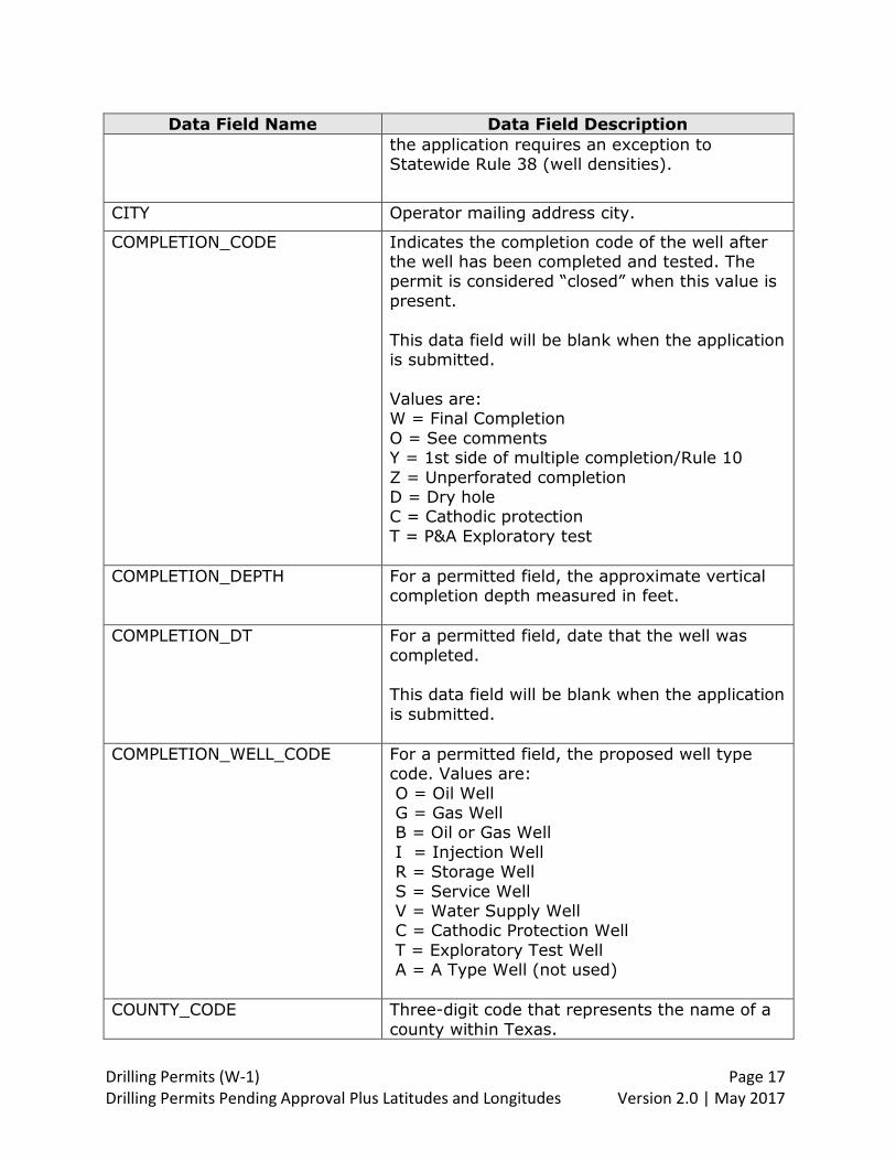
CITY Operator mailing address city.
COMPLETION_CODE Indicates the completion code of the well after the well has been completed and tested. The permit is considered “closed” when this value is
present.
This data field will be blank when the application is submitted.
Values are: W = Final Completion
O = See comments Y = 1st side of multiple completion/Rule 10
Z = Unperforated completion D = Dry hole C = Cathodic protection
T = P&A Exploratory test
COMPLETION_DEPTH For a permitted field, the approximate vertical completion depth measured in feet.
COMPLETION_DT For a permitted field, date that the well was
completed. This data field will be blank when the application
is submitted.
COMPLETION_WELL_CODE For a permitted field, the proposed well type code. Values are:
O = Oil Well G = Gas Well B = Oil or Gas Well
I = Injection Well R = Storage Well
S = Service Well V = Water Supply Well C = Cathodic Protection Well
T = Exploratory Test Well A = A Type Well (not used)
COUNTY_CODE Three-digit code that represents the name of a
county within Texas.

Drilling Permits (W-1) Page 18 Drilling Permits Pending Approval Plus Latitudes and Longitudes Version 2.0 | May 2017
Data Field Name Data Field Description The RRC assigns a number to each onshore
county; the American Petroleum Institute (API) assigns a number to each offshore county. The first 254 numbers of the code are odd, and
indicate onshore counties only. The remaining 23 numbers are both odd and even, and
correspond to wells located in state or federal waters. Because a field may span counties, there is a
county code stored for each permitted field on a drilling permit application.
In the ‘dp_wellbore_pending’ and ‘dp_perp_pending’ files, county code denotes the county of the wellbore surface hole location.
In the file ‘dp_perp_field_pending’ and ‘dp_perp_wellbore_pending’ files, county code
denotes the county associated with the bottom hole location for a directional wellbore profile, or the terminus location for a horizontal wellbore
profile. The RRC public website has a list of valid county
codes: http://www.rrc.state.tx.us/about-us/organization-activities/rrc-locations/counties-by-dist/.
COUNTRY_CODE Code representing the name of the country in
an Operator mailing address. Country_Code is blank for a US mailing address.
CREATE_DATE Date the drilling permit application was first
saved on the online DP system.
CURRENT_STATE_CODE Applications are routed through a series of internal work queues as they are being processed to the point of approval. This data
field contains the code for the current queue where the application resides.
1. APP (Approved) 2. ABT (Aborted) 3. REF (Rejected)
4. WIP (Work in Progress) 5. FOP (Field Operations)
6. MPC (Mapping Correction) 7. MPR (Mapping Review) 8. HEA (Hearing)

Drilling Permits (W-1) Page 19 Drilling Permits Pending Approval Plus Latitudes and Longitudes Version 2.0 | May 2017
Data Field Name Data Field Description 9. LEG (Legal Exam) 10.TEC (Technical Exam)
11.DOC (Docket Services) 12.SWR (SWR Hold) 13.NOA (Notice of Application)
14.PSA (Public Sales) 15.ENG (Engineering)
16.DP_ (Drilling Permit) 17.MAP (Mapping) 18.API (API Verification)
19.CAN (Cancelled) 20.MCA (MPC Cancel)
21.MRS (MPC Restore) 22.MRJ (MPC Reject) 23.MRI (MPC Reinstatement)
24.WIT (Withdrawn)
DEFAULT_DIRECTIONAL This data field will contain ‘Y’ when the wellbore profile for the permit is directional. It will
contain ‘N’ when the wellbore profile for the permit is not directional. A permit can have more than one wellbore profile.
DEFAULT_HORIZONTAL This data field will contain ‘Y’ when the wellbore
profile for the permit is horizontal. It will contain ‘N’ when the wellbore profile for the permit is
not horizontal. A permit can have more than one wellbore profile.
DEFAULT_LEASE_NAME Lease name for the permit. Lease name for the field designated as the primary field by the filer
will be the same as the lease name for the permit.
DEFAULT_SIDETRACK This data field will contain ‘Y’ when the wellbore
profile for the permit is sidetrack. It will contain ‘N’ when the wellbore profile for the permit is not sidetrack. A permit can have more than one
wellbore profile.
DEFAULT_VERTICAL This data field will contain ‘Y’ when the wellbore profile for the permit is vertical. It will contain
‘N’ when the wellbore profile for the permit is not vertical. A permit can have more than one wellbore profile.

Drilling Permits (W-1) Page 20 Drilling Permits Pending Approval Plus Latitudes and Longitudes Version 2.0 | May 2017
Data Field Name Data Field Description DEFAULT_WELL_NUMBER Well identifier assigned by the operator. Well
number is six characters long.
DEVELOP_MINERALS_FLAG Flag that denotes the answer to the question on the drilling permit application: “Do you have the
right to develop minerals under any right of way?”
Values are: Y = Yes
N = No
DIRECTIONS Direction of the wellbore surface location from the nearest town. Values are: N = North
NE = Northeast E = East
SE = Southeast S = South SW = Southwest
W = West NW = Northwest
Within
DISTRICT RRC District where the wellbore surface hole is located. Values are:
01 & 02 San Antonio District 03 Houston District
04 Corpus Christi District 05 & 06 Kilgore District 7B Abilene District
7C San Angelo District 08 & 8A Midland District
09 Wichita Falls District 10 Pampa District
The RRC public website lists the district for each of the counties within the state:
http://www.rrc.state.tx.us/about-us/organization-activities/rrc-locations/counties-by-dist/
DKT_SUFFIX_CODE A code that provides information about one or
more statewide rule exception requests. Some of the codes provide information about whether

Drilling Permits (W-1) Page 21 Drilling Permits Pending Approval Plus Latitudes and Longitudes Version 2.0 | May 2017
Data Field Name Data Field Description the exception will be resolved administratively or through a hearing.
The statewide rules represented by the codes are:
Statewide Rule 37 – Well spacing Statewide Rule 38 – Well densities
Statewide Rule 38(D)(3) – Well densities/unit dissolution Statewide Rule 39 - Contiguity of acreage for
proration and drilling units
Values are: A37 = Exception to Statewide Rule 37 resolved administratively
R37 = Exception to Statewide Rule 37 R38 = Exception to Statewide Rule 38
38D = Exception to Statewide Rule 38(d)(3) 7A8 = Exceptions to Statewide Rules 37 & 38 resolved administratively
7H8 = Exceptions to Statewide Rules 37 & 38 resolved through a hearing
7H9 = Exceptions to Statewide Rules 37 & 39 resolved through a hearing
DKT_EXAMINER_CODE A code used internally by the RRC to represent the person who served as reviewer for the
statewide rule exception.
EFFECTIVE_DT Date that the drilling permit was approved and issued.
ENTITY_DENSITY_DOCKET_NO For a permitted field, the docket number for the
final order that grants a unitized area entity for density authority.
EXPEDITE_DATE_TIME This data field is not used.
EXPEDITE_FLAG Data field that denotes whether the operator has requested expedited processing for the
drilling permit application. Values are: Y = Expedited
N = Not Expedited
Drilling Permits (W-1) Page 22 Drilling Permits Pending Approval Plus Latitudes and Longitudes Version 2.0 | May 2017
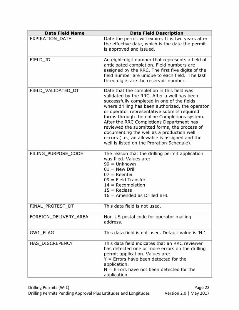
Data Field Name Data Field Description EXPIRATION_DATE Date the permit will expire. It is two years after
the effective date, which is the date the permit
is approved and issued.
FIELD_ID An eight-digit number that represents a field of
anticipated completion. Field numbers are assigned by the RRC. The first five digits of the
field number are unique to each field. The last three digits are the reservoir number.
FIELD_VALIDATED_DT Date that the completion in this field was validated by the RRC. After a well has been
successfully completed in one of the fields where drilling has been authorized, the operator
or operator representative submits required forms through the online Completions system.
After the RRC Completions Department has reviewed the submitted forms, the process of documenting the well as a production well
occurs (i.e., an allowable is assigned and the well is listed on the Proration Schedule).
FILING_PURPOSE_CODE The reason that the drilling permit application
was filed. Values are: 99 = Unknown 01 = New Drill
07 = Reenter 09 = Field Transfer
14 = Recompletion 15 = Reclass 16 = Amended as Drilled BHL
FINAL_PROTEST_DT This data field is not used.
FOREIGN_DELIVERY_AREA Non-US postal code for operator mailing
address.
GW1_FLAG This data field is not used. Default value is ‘N.’
HAS_DISCREPENCY This data field indicates that an RRC reviewer has detected one or more errors on the drilling permit application. Values are:
Y = Errors have been detected for the application.
N = Errors have not been detected for the application.

Drilling Permits (W-1) Page 23 Drilling Permits Pending Approval Plus Latitudes and Longitudes Version 2.0 | May 2017
Data Field Name Data Field Description This data field will contain ‘N’ when the
application is submitted.
HORIZ_WELLBORE_TYPE_CODE A code designating the proposed completion
type for a horizontal well. Values are: 1 = Production Sharing Agreement (PSA)
2 = Allocation 3 = Stacked Lateral
This data item was added to the file on 9/25/2013.
IS_AMENDMENT A value of ‘Y’ denotes that the drilling permit
application is an amendment to an approved permit. The default value is ‘N.’
IS_REAPPLIED A value of ‘Y’ denotes that the record is for a
new application that was created from an expired permit. The default value is blank.
To reapply, the expired permit: 1) Must not be closed (i.e. it must not have
a value in Completion_Code). 2) Filing purpose must be New Drill (with no
value in Spud_Dt), Reentry, or
Recompletion (i.e. there must be a value of ‘01,’ ‘07’ or ‘14,’ respectively, in
Filing_Purpose_Code.) This data field was added to the file in December 2016.
Notes about GPS Coordinates for location of the wellbore: Latitude is the North-South geographic coordinate measurement, and longitude is
the East-West geographic coordinate measurement. The online Drilling Permit system accepts GPS coordinates in the following formats: 1) Decimal degrees
(Format is dd.dddddd for latititude; -ddd.dddddd for longitude). 2) Degrees, minutes, seconds
(Format is ‘dd mm ss.ss’ for latitude; ‘-ddd mm ss.ss’ for longitude). 3) State plane (Format for X-coordinate is ‘nnnnnnn.nn’; Y-coordinate is ‘nnnnnnnn.nn’).
Drilling Permits (W-1) Page 24 Drilling Permits Pending Approval Plus Latitudes and Longitudes Version 2.0 | May 2017
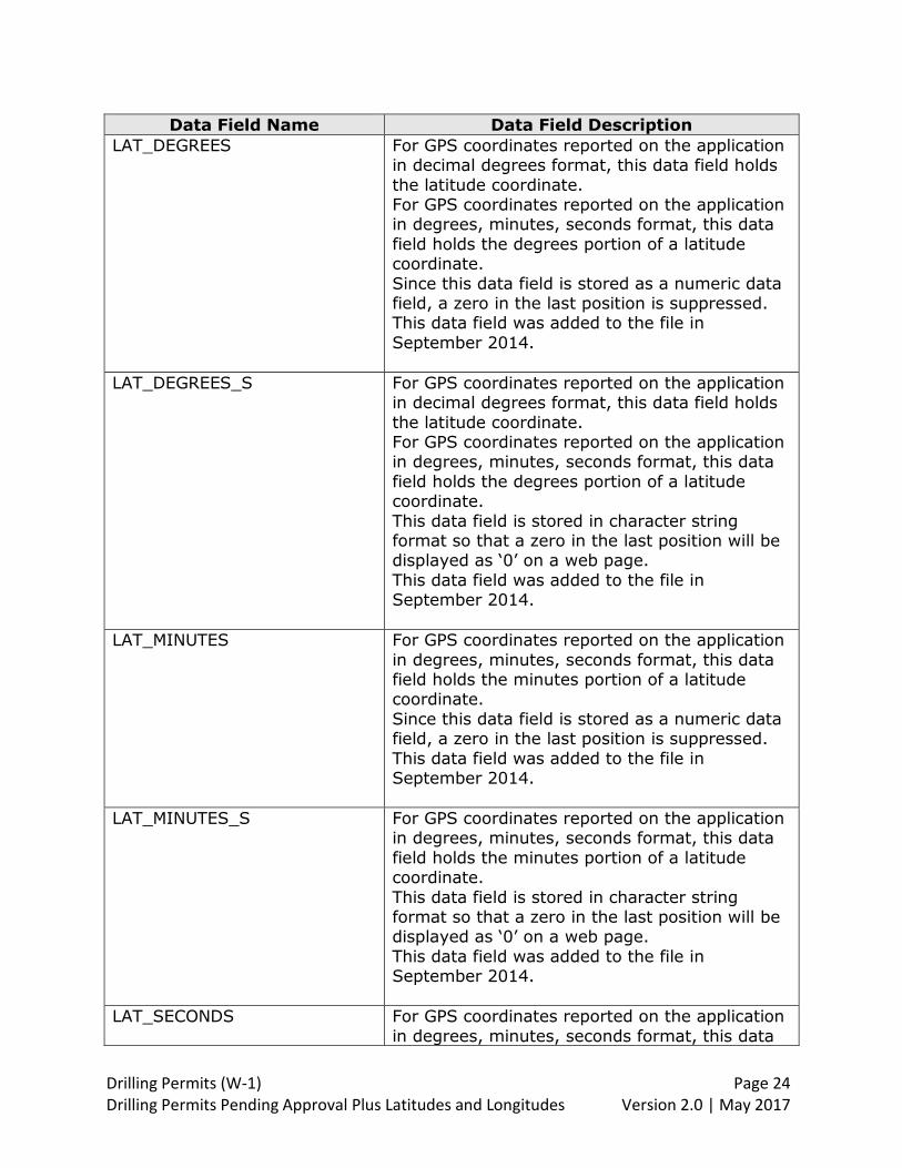
Data Field Name Data Field Description LAT_DEGREES For GPS coordinates reported on the application
in decimal degrees format, this data field holds
the latitude coordinate. For GPS coordinates reported on the application in degrees, minutes, seconds format, this data
field holds the degrees portion of a latitude coordinate.
Since this data field is stored as a numeric data field, a zero in the last position is suppressed. This data field was added to the file in
September 2014.
LAT_DEGREES_S For GPS coordinates reported on the application in decimal degrees format, this data field holds
the latitude coordinate. For GPS coordinates reported on the application in degrees, minutes, seconds format, this data
field holds the degrees portion of a latitude coordinate.
This data field is stored in character string format so that a zero in the last position will be displayed as ‘0’ on a web page.
This data field was added to the file in September 2014.
LAT_MINUTES For GPS coordinates reported on the application
in degrees, minutes, seconds format, this data field holds the minutes portion of a latitude coordinate.
Since this data field is stored as a numeric data field, a zero in the last position is suppressed.
This data field was added to the file in September 2014.
LAT_MINUTES_S For GPS coordinates reported on the application in degrees, minutes, seconds format, this data
field holds the minutes portion of a latitude coordinate.
This data field is stored in character string format so that a zero in the last position will be displayed as ‘0’ on a web page.
This data field was added to the file in September 2014.
LAT_SECONDS For GPS coordinates reported on the application
in degrees, minutes, seconds format, this data
Drilling Permits (W-1) Page 25 Drilling Permits Pending Approval Plus Latitudes and Longitudes Version 2.0 | May 2017
Data Field Name Data Field Description field holds the seconds portion of a latitude coordinate.
Since this data field is stored as a numeric data field, a zero in the last position is suppressed. This data field was added to the file in
September 2014.
LAT_SECONDS_S For GPS coordinates reported on the application in degrees, minutes, seconds format, this data
field holds the seconds portion of a latitude coordinate. This data field is stored in character string
format so that a zero in the last position will be displayed as ‘0’ on a web page.
This data field was added to the file in September 2014.
LATITUDE GPS latitude coordinate for wellbore location, as stored on the RRC GIS system. The value in
Location_Type indicates whether the latitude coordinate is for surface hole location or for
bottom hole location. Coordinate format is decimal degrees, and datum is NAD27.
LATLONG_TYPE_CODE Datum reported on the application for the wellbore surface location GPS coordinates.
Values are: 1 = NAD27
2 = NAD83 3 = WGS84 This data field was added to the file in
September 2014.
LOCATION_COMMENTS For a permitted field, comments about the location.
LOCATION_DESCRIPTION This data field is not used.
LOCATION_LABOR Labor where the wellbore surface hole is
located. A league is divided into 25 labors, each of which is approximately 177 acres.
Not every drilling permit application record will contain a value for labor.

Drilling Permits (W-1) Page 26 Drilling Permits Pending Approval Plus Latitudes and Longitudes Version 2.0 | May 2017
Data Field Name Data Field Description This data field was added to the file in September 2014.
LOCATION_LEAGUE League where the wellbore surface hole is located. A league is a stand-alone survey which
is approximately 4426 acres.
Not every drilling permit application record will contain a value for league.
This data field was added to the file in September 2014.
LOCATION_LOT Lot where the wellbore surface hole is located.
A lot is a portion of a tract which has been divided into roughly equal parts and assigned a
number. Not every drilling permit application record will
contain a value for lot.
This data field was added to the file in September 2014.
LOCATION_PORCION Porcion where the wellbore surface hole is located. Porcions are associated with the very
large original Spanish land grants that occurred primarily in south Texas along the Rio Grande
river. Not every drilling permit application record will
contain a value for porcion.
This data field was added to the file in September 2014.
LOCATION_SHARE Share where the wellbore surface hole is located. A share is a further breakdown of a
porcion.
Not every drilling permit application record will contain a value for share.
This data field was added to the file in September 2014.
Drilling Permits (W-1) Page 27 Drilling Permits Pending Approval Plus Latitudes and Longitudes Version 2.0 | May 2017
Data Field Name Data Field Description LOCATION_TOWNSHIP Township where the wellbore surface hole is
located. A township is a square unit of land that
is six miles on a side. Townships were originally surveyed by the US General Land Office. They are marked on the US Geological Survey
topographic maps.
Not every drilling permit application record will contain a value for township.
This data field was added to the file in September 2014.
LOCATION_TRACT Tract where the wellbore surface hole is located. A tract denotes the boundary of a current property ownership parcel.
Not every drilling permit application record will contain a value for tract.
This data field was added to the file in September 2014.
LOCATION_TYPE Indicates whether the GPS coordinates
represent the surface hole location of the wellbore, or the bottom hole location of the
wellbore. Values are: Surface = surface hole location Bottom = bottom hole location.
LOCKED_BY This data field contains blanks.
LONG_DEGREES For GPS coordinates reported on the application
in decimal degrees format, this data field holds the longitude coordinate.
For GPS coordinates reported on the application in degrees, minutes, seconds format, this data field holds the degrees portion of a longitude
coordinate. Since this data field is stored as a numeric data
field, a zero in the last position is suppressed. This data field was added to the file in September 2014.
Drilling Permits (W-1) Page 28 Drilling Permits Pending Approval Plus Latitudes and Longitudes Version 2.0 | May 2017
Data Field Name Data Field Description LONG_DEGREES_S For GPS coordinates reported on the application
in decimal degrees format, this data field holds
the longitude coordinate. For GPS coordinates reported on the application in degrees, minutes, seconds format, this data
field holds the degrees portion of a longitude coordinate.
This data field is stored in character string format so that a zero in the last position will be displayed as ‘0’ on a web page.
This data field was added to the file in September 2014.
LONG_MINUTES For GPS coordinates reported on the application
in degrees, minutes, seconds format, this data field holds the minutes portion of a longitude coordinate.
Since this data field is stored as a numeric data field, a zero in the last position is suppressed.
This data field was added to the file in September 2014.
LONG_MINUTES_S For GPS coordinates reported on the application in degrees, minutes, seconds format, this data
field holds the minutes portion of a longitude coordinate.
This data field is stored in character string format so that a zero in the last position will be displayed as ‘0’ on a web page.
This data field was added to the file in September 2014.
LONG_SECONDS For GPS coordinates reported on the application
in degrees, minutes, seconds format, this data field holds the seconds portion of a longitude coordinate.
Since this data field is stored as a numeric data field, a zero in the last position is suppressed.
This data field was added to the file in September 2014.
LONG_SECONDS_S For GPS coordinates reported on the application in degrees, minutes, seconds format, this data
field holds the seconds portion of a longitude coordinate.
Drilling Permits (W-1) Page 29 Drilling Permits Pending Approval Plus Latitudes and Longitudes Version 2.0 | May 2017
Data Field Name Data Field Description This data field is stored in character string format so that a zero in the last position will be
displayed as ‘0’ on a web page. This data field was added to the file in September 2014.
LONGITUDE GPS longitude coordinate reported for wellbore
location, as stored on the RRC GIS system. The value in Location_Type indicates whether the
longitude coordinate is for surface hole location or for bottom hole location. Coordinate format is decimal degrees, and datum is NAD27.
MAILING_ADDRESS_ID System-assigned unique identifier on the
dp_mailing_address_pending file.
MEASURE_LINE_TYPE_CODE This data field is not used.
MODIFIED_BY This data field contains blanks.
MODIFIED_DT The date the row of data was last modified.
NEAREST_LEASE_DISTANCE For a vertical well, this is the distance in feet from the wellbore surface hole location to the nearest lease line.
For a directional well, this is the distance in feet
from the wellbore bottom hole location to the nearest lease line.
For a horizontal well, this is the distance in feet from the wellbore productive interval (i.e.,
interval between the first take point and last take point) to the nearest lease line.
NEAREST_TOWN From the wellbore surface hole location, name of the town within the same county that is
closest in distance.
NEAREST_TOWN_DISTANCE Distance in miles from the wellbore surface hole location to the nearest town.
NEAREST_WELL_DISTANCE For a vertical well in a permitted field, this is the
distance in feet from the wellbore surface hole
Drilling Permits (W-1) Page 30 Drilling Permits Pending Approval Plus Latitudes and Longitudes Version 2.0 | May 2017
Data Field Name Data Field Description location to the nearest well* on this lease in this reservoir.
For a directional well in a permitted field, this is the distance in feet from the wellbore bottom
hole location to the nearest well* on this lease in this reservoir.
For a horizontal well in a permitted field, this is the distance in feet from the wellbore
productive interval (i.e., interval between the first take point and last take point) to the
nearest well* on this lease in this reservoir. *”nearest well” includes wells that are applied
for, permitted or completed.
NON_CONCURRENT_37WELLS Within a permitted field that has a Rule 37 between well exception, the well number(s) for
well(s) that will not produce concurrently for that field.
NON_CONCURRENT_38WELLS Within a permitted field that has a Rule 38 well density exception, the well number(s) for
well(s) that will not produce concurrently for that field.
OFF_LEASE_PNTRN_PT_FLAG Indicator for an off-lease penetration point,
applicable only for horizontal wellbore profiles. This data field was added to the file in February 2016.
OFF_LEASE_SURF_LOC_FLAG Indicator for an off-lease surface location flag,
applicable only for horizontal and directional wellbore profiles.
This data field was added to the file in February 2016.
OPERATOR_NAME Operator name as it appears on Form P-5 Organization Report.
OPERATOR_NUMBER Operator number assigned by the RRC P-5
system.
Drilling Permits (W-1) Page 31 Drilling Permits Pending Approval Plus Latitudes and Longitudes Version 2.0 | May 2017
Data Field Name Data Field Description OPERATOR_PHONE Operator phone number as it appears on Form
P-5 Organization Report.
PERMIT_RESTRICTION_ID System-assigned unique identifier for the DP_PERMIT_RESTRICTION_PENDING file.
PERMITTED_FIELD_ID
System-assigned unique identifier that provides
a link between the dp_permitted_field_pending, dp_perp_pending, dp_perp_field_pending, and
dp_perp_wellbore_pending files.
PERP_ID System-assigned identifier for the DP_perp_field_pending and DP_perp_wellbore_pending file.
PERP_LOC_CODE A code that represents a point within the
wellbore measured by perpendicular reference lines. ‘BH’ is used for a directional wellbore
profile; the other codes are used for a horizontal wellbore profile. Values are: TP = Terminus point
PP = Penetration point BH = Bottom hole
LP = Last take point FP = First take point
PERP_TYPE_CODE Type of reference line used for the perpendicular measurements. Values are:
S = Survey L = Line
POOLED_UNIT_FLAG For a permitted field, this data field indicates
that multiple tracts of land have been pooled together as a unit to meet minimum drilling unit acreage requirements.
Values are: Y = Pooled unit
N = Not a pooled unit
POSTAL_CODE Operator mailing address zip code (first 5 digits).
POSTAL_EXTENSION_CODE Operator mailing address zip code extension (last 4 digits).

Drilling Permits (W-1) Page 32 Drilling Permits Pending Approval Plus Latitudes and Longitudes Version 2.0 | May 2017
Data Field Name Data Field Description PRIMARY_FIELD_FLAG A value of ‘Y’ indicates that the filer has
identified this field as the primary field for the
permit application. By default, the system designates the first field added to the online drilling permit application as the primary field.
When the filer adds more fields to the application, values from the primary field are
populated as default values for subsequent fields. After the second field is added to the application, the filer can change the field that is
designated as the primary field. A value of ‘N’ indicates that the field on this record is not a
primary field.
PROFILE_CODE For a permitted field, a code that represents the type of wellbore profile. Values are: VR = Vertical
VS = Vertical Sidetrack DR = Directional
DS = Directional Sidetrack HR = Horizontal HS = Horizontal Sidetrack
PSA_FLAG For a horizontal wellbore profile, a value of ‘Y’
indicates that the proposed completion type is Production Sharing Agreement (PSA). The
default value is blank. This data field was added to the file in April 2013.
REAPPLIED_STATUS This data item contains a value when the
IS_REAPPLIED value is ‘Y’. REAPPLIED_STATUS is the status/permit number of the expired
permit that was used to create a new application for the reapplication process. The new application is assigned a status/permit
number when it is submitted. This data field was added to the file in
December 2016.
REPORTED_LEASE_NAME For a permitted field, the lease name entered by the filer. If the filer designated the permitted field as the primary field,
Reported_Lease_Name will be the same as the lease name at the permit level.

Drilling Permits (W-1) Page 33 Drilling Permits Pending Approval Plus Latitudes and Longitudes Version 2.0 | May 2017
Data Field Name Data Field Description RESTRICTION_CODE A code representing a restriction that is
applicable to the drilling permit.
RESTRICTION_TEXT Text that describes the permit restriction represented by the restriction code.
RETURN_DT This data field is not used.
REX_OLPP_DOCKET_NO For a permitted field with an off-lease
penetration point, this data field contains the Docket Number if a hearing was requested to
resolve the off-lease penetration point. This data field was added to the file in February
2016.
REX_OLPP_HEARING_ OUTCOME_CODE
For a permitted field with an off-lease penetration point, this data field contains a code
representing the outcome of a Hearing held to come to an agreement with affected parties. Values are:
1 = Not applicable (default value) 2 = Approved
3 = Denied 4 = Dismissed
This data field was added to the file in February 2016.
REX_OLPP_HEARING_REQUEST
_YN
For a permitted field with an off-lease
penetration point, a value of ‘Y’ indicates that the filer has requested a hearing because they
were unable to come to agreement with affected parties. The default value is ‘N.’
This data field was added to the file in February 2016.
REX_OLPP_LAST_NOTICE_DT For a permitted field with an off-lease
penetration point, this data field contains the date that the last notice was mailed to an affected party. The permit cannot be processed
until 21 days after the last notice is mailed.
This data field was added to the file in February 2016.
Drilling Permits (W-1) Page 34 Drilling Permits Pending Approval Plus Latitudes and Longitudes Version 2.0 | May 2017
Data Field Name Data Field Description
REX_OLPP_NOTICE_YN For a permitted field with an off-lease
penetration point, a value of ‘Y’ indicates that the filer has mailed notices to affected parties. The default value is ‘N.’
This data field was added to the file in February
2016.
REX_OLPP_OWN_OFFSET_YN For a permitted field with an off-lease penetration point, a value of ‘Y’ indicates that
the filer is the only party affected by the off-lease penetration point. Default value is ‘N.’
This data field was added to the file in February 2016.
REX_OLPP_PUBLICATION_YN For a permitted field with an off-lease
penetration point, a value of ‘Y’ indicates that the filer has published a notice once a week for four consecutive weeks in a newspaper of
general circulation in the county of the well location. Default value is ‘N.’
This data field was added to the file in February 2016.
REX_OLPP_WAVIER_YN For a permitted field with an off-lease
penetration point, a value of ‘Y’ indicates that the filer is submitting waivers from affected
parties. The default value is ‘N.’ This data field was added to the file in February
2016.
SECTION A section is the unit of subdivision of a block. It is identified by an assigned section number.
Not every drilling permit application record will contain a value for section.
In the ‘dp_perp_pending’ files, section denotes
the section associated with the wellbore surface hole location. In the ‘dp_perp_field_pending’ file, section
denotes the section associated with the bottom
Drilling Permits (W-1) Page 35 Drilling Permits Pending Approval Plus Latitudes and Longitudes Version 2.0 | May 2017
Data Field Name Data Field Description hole location for a directional wellbore profile, or the terminus location for a horizontal wellbore
profile.
SECTION_LINE1_DIRECTION The plat and Form W-1 require two reference
lines that are perpendicular to each other. For reference line 1, this data field contains the
direction from the lease line or survey line to the wellbore surface hole location, or to a
specific point on the wellbore. Note: When direction is measured from a lease line, Perp_type_code = ‘L,’ and ‘S’ when
direction is from a survey line. When direction is measured to the wellbore surface hole location,
Perp_loc_code = blanks. When direction is measured to a specific point on the wellbore, Perp_loc_code = ‘TP’ (Terminus point), ‘PP’
(penetration point), ‘BH’ (Bottom hole), ‘LP’ (Last take point), or ‘FP’ (First take point).
SECTION_LINE1_DISTANCE The plat and Form W-1 require two reference
lines that are perpendicular to each other. For reference line 1, this data field contains the distance from the lease line or survey line to the
wellbore surface hole location, or to a specific point on the wellbore.
Note: When distance is measured from a lease line, Perp_type_code = ‘L,’ and ‘S’ when distance is from a survey line. When distance is
measured to the wellbore surface hole location, Perp_loc_code = blanks. When distance is
measured to a specific point on the wellbore, Perp_loc_code = ‘TP’ (Terminus point), ‘PP’ (penetration point), ‘BH’ (Bottom hole), ‘LP’
(Last take point), or ‘FP’ (First take point).
SECTION_LINE2_DIRECTION The plat and Form W-1 require two reference lines that are perpendicular to each other. For
reference line 2, this data field contains the direction from the lease line or survey line to the wellbore surface hole location, or to a
specific point on the wellbore. Note: When direction is measured from a lease
line, Perp_type_code = ‘L,’ and ‘S’ when direction is from a survey line. When direction is measured to the wellbore surface hole location,

Drilling Permits (W-1) Page 36 Drilling Permits Pending Approval Plus Latitudes and Longitudes Version 2.0 | May 2017
Data Field Name Data Field Description Perp_loc_code = blanks. When direction is measured to a specific point on the wellbore,
Perp_loc_code = ‘TP’ (Terminus point), ‘PP’ (penetration point), ‘BH’ (Bottom hole), ‘LP’ (Last take point), or ‘FP’ (First take point).
SECTION_LINE2_DISTANCE The plat and Form W-1 require two reference
lines that are perpendicular to each other. For reference line 2, this data field contains the
distance from the lease line or survey line to the wellbore surface hole location, or to a specific point on the wellbore.
Note: When distance is measured from a lease line, Perp_type_code = ‘L,’ and ‘S’ when
distance is from a survey line. When distance is measured to wellbore surface hole location, Perp_loc_code = blanks. When distance is
measured to a specific point on the wellbore, Perp_loc_code = ‘TP’ (Terminus point), ‘PP’
(penetration point), ‘BH’ (Bottom hole), ‘LP’ (Last take point), or ‘FP’ (First take point).
SPUD_DT Date that drilling first begins.
STACKED_LATERAL_FLAG For a horizontal wellbore profile, a value of ‘Y’ indicates that the operator has two or more
horizontal drainhole wells on this lease from different surface locations. All take points are
within the same field and within a specific rectangular area. The default value is blank. This data field was added to the file in April
2013.
STACKED_LAT_STATUS_NO For a stacked lateral well, the Drilling Permit number of the well to be designated as the
“record” or “parent” well. This data field was added to the file in April 2013.
STAT_DT At the permit level, date that drilling was
completed.
STATE_CODE Code representing the name of the U.S. state in an Operator mailing address.

Drilling Permits (W-1) Page 37 Drilling Permits Pending Approval Plus Latitudes and Longitudes Version 2.0 | May 2017
Data Field Name Data Field Description STATE_PLANE_X For GPS coordinates reported on the application
in State Plane format, this data field contains
the X-coordinate (East-West) for wellbore surface hole location. This data field was added to the file in
September 2014.
STATE_PLANE_Y For GPS coordinates reported on the application in State Plane format, this data field contains
the Y-coordinate (North-South) for wellbore surface hole location. This data field was added to the file in
September 2014.
STATE_PLANE_ZONE_CODE This data field is used with the State Plane format reported on the application for GPS
coordinates. It indicates the geographic zone within Texas. Values are: 1 = North
2 = North Central 3 = Central
4 = South Central 5 = South This data field was added to the file in
September 2014.
STATUS_CODE Status of the application. Applications in the Submitted Drilling Permits Pending Approval file
contain status ‘P’ (Pending approval.) Values at other stages of the application process are:
A = Approved W= Withdrawn
D = Dismissed E = Denied C = Closed
O = Other X = Deleted
Z = Cancelled after approval
STATUS_NUMBER A six-digit number assigned to each drilling permit application received at the RRC. When the application is approved, this becomes the
permit number. Each amendment to a permit will remain under the same permit number.

Drilling Permits (W-1) Page 38 Drilling Permits Pending Approval Plus Latitudes and Longitudes Version 2.0 | May 2017
Data Field Name Data Field Description Amendments are tracked by a sequence number (See Status_Seq_No.)
STATUS_SEQ_NO A two-digit number assigned to each permit number. This number, used internally, identifies
each amendment to a drilling permit. The original filing of a drilling permit application is
indicated by the status number and a sequence number of "99." The status number and the
previous filing’s sequence number minus 1 will identify each amendment to that permit. For example:
Status # Sequence # Original filing 0000001 99
First amendment 0000001 98 Second amendment 0000001 97 Third amendment 0000001 96
SUBMIT_DATE Date that the drilling permit application was
submitted through the online system.
SURFACE_CASING_DT Date that surface casing was set in the well. Surface casing is set after the well is spudded.
SURFACE_LOCATION_CODE Denotes whether the wellbore surface location is
on land or water. Values are: L = Land O = Offshore
I = Inland Waterway B = Bay/Estuary
SURVEY_NAME A survey is a certified measured description of a
piece of land. The term sometimes refers to the land itself. In Texas, original surveys were performed as part of the patenting process
whereby land was transferred from the public domain. These "patent surveys", recorded at
the Texas General Land Office, constitute an official land grid for the State and are the basis for subsequent land surveys.
This data field will contain a value when the
drilling permit application is submitted through the online system.

Drilling Permits (W-1) Page 39 Drilling Permits Pending Approval Plus Latitudes and Longitudes Version 2.0 | May 2017
Data Field Name Data Field Description In the ‘dp_perp_pending’ files, survey name denotes the survey associated with the wellbore
surface hole location. In the ‘dp_perp_field_pending’ file, survey name denotes the survey associated with the bottom
hole location for a directional wellbore profile, or the terminus location for a horizontal wellbore
profile.
SWR38_ABR_NOTICE
Abbreviated notification of a Rule 38 exception allows an operator to provide notification of the permit application to affected parties located
within a defined “abbreviated” geographical area adjacent to the wellbore. A value of ‘Y’ in
this data field indicates that 1) the permit has a Rule 38 well density exception for one or more fields 2) each of the fields requiring a Rule 38
exception is eligible for “abbreviated” notification and 3) the operator has elected to
provide abbreviated notification of the permit application to affected parties. The default value is blank.
This data field was added to the file in February
2016.
SWR_36_FLAG Indicator that denotes that at least one field on the permit application is known to contain
hydrogen sulfide gas (H2S). Values are:
Y = Yes N = No
SWR_LIST If applicable, this data field contains one or more codes that represent Statewide Rule
exceptions that apply to this permit application. Values are:
36 = Exception to Statewide Rule 36 37 = Exception to Statewide Rule 37 38 = Exception to Statewide Rule 38
39 = Exception to Statewide Rule 39

Drilling Permits (W-1) Page 40 Drilling Permits Pending Approval Plus Latitudes and Longitudes Version 2.0 | May 2017
Data Field Name Data Field Description SWR_RESLTN_CODE A code that identifies how the operator has
resolved the requirement to notify affected
parties about a requested Statewide Rule exception. Values are: 1) OFF = Own Offset. Operator filing for the
permit is the designated operator for all acreage in the notification area.
2) WAV = Waivers. Operator filing for the permit has obtained a waiver from affected mineral interest owner(s) allowing the well to be
drilled in the proposed location. 3) SVR = Service List. Operator filing for the
permit has provided a list of names and addresses of all affected mineral interest owners within the notification area.
4) PUB = Publication. The operator filing for the permit attempts to notify all affected mineral
interest owners by publishing a notice in a newspaper of general circulation in the county of the wellbore surface hole location.
5) UAF = Unaffected. Affected parties are outside the state of Texas.
6) HRG = Hearing Requested. The operator filing for the permit anticipates a protest to the application, and they request that it be set
immediately for hearing.
SWR_RESOLUTION_ID System-assigned unique identifier for the DP_SWR_RESOLUTION_PENDING file.
SWR_SUBSECT_CODE A code that denotes how one or more Statewide
Rule exception(s) for the permit were resolved. Values are: H2A = Represents SWR 37 (h)(2)(A) under
which the operator is granted an exception by means of notice or hearing.
H2B = Represents SWR 37 (h)(2)(B) under which the operator is granted an exception by means of waivers, own offset or unaffected
status. 8H3 = Represents SWR 38 (h)(3) under which
the operator is granted an exception by means of submission of evidence and notice if needed. 2A8 = Combination of a SWR 37(h)(2)(A)
exception and a SWR 38 exception.
Drilling Permits (W-1) Page 41 Drilling Permits Pending Approval Plus Latitudes and Longitudes Version 2.0 | May 2017
Data Field Name Data Field Description 2B8 = Combination of a SWR 37(h)(2)(B) exception and a SWR 38 exception.
SWR39_RESOLUTION For a permit with a SWR 39 exception, this data field contains the docket number or other
information required to resolve the exception.
TEXT_FOR_85279201 Depth of Horizontal Severance. This depth or average depth of the horizontal
depth severance is required for two fields located in the Spraberry Trend Area.
This data field will be populated only if the value in Field_ID is 85279201 or 85280301.
TOTAL_ACRES Number of total acres in lease, pooled unit or unitized tract.
TOTAL_DEPTH A wellbore’s true vertical depth in feet.
UNIQUE_ADDRESS_NUMBER Not used.
UNITIZED_DOCKET_NO The docket number assigned by the Commission
when a pooled unit was created through a hearing.
UNIVERSAL_DOC_NO System-assigned unique identifier for the DP_DRILLING_PERMIT_PENDING file.
W1A_TRACT_DT Date that the tract took its size and shape, as
reported on Form W-1A Substandard Acreage Certification.
WALKIN_CONTACT_NAME This data field is no longer used.
WALKIN_CONTACT_PHONE This data field is no longer used.
WELL_COUNT The number of wells* on this lease in the
applied-for field. *includes wells that are applied for, permitted or completed.
WELL_NUMBER Well identifier assigned by the operator. Well
number is six characters long.

Drilling Permits (W-1) Page 42 Drilling Permits Pending Approval Plus Latitudes and Longitudes Version 2.0 | May 2017
Data Field Name Data Field Description WELL_TYPE_CODE Type of well. Values are:
O = Oil well
G = Gas well B = Oil or gas well I = Injection or disposal well
R = Storage well S = Service well
V = Water supply well C = Cathodic protection well T = Exploratory test well
A = A type well
WELLBORE_ID System-assigned unique identifier for the DP_WELLBORE_PENDING file. It is used to link
the DP_WELLBORE_PENDING file to the DP_PERP_PENDING file.
WELLBORE_PROFILE_ID System-assigned unique identifier for the DP_WELLBORE_PROFILE_PENDING file.
It is used to link the DP_WELLBORE_PROFILE_PENDING file to the
DP_PERP_WELLBORE_PENDING file.
Drilling Permits (W-1) Page 43 Drilling Permits Pending Approval Plus Latitudes and Longitudes Version 2.0 | May 2017
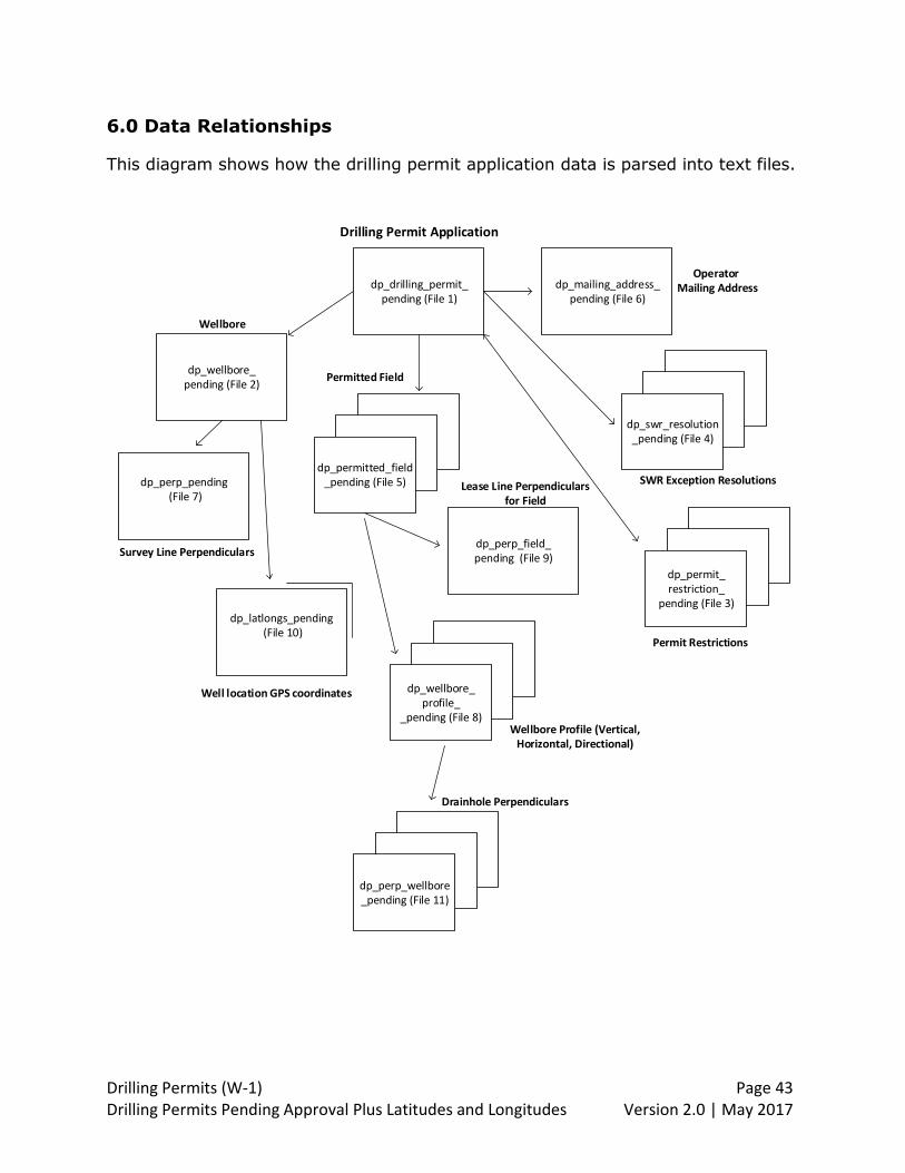
6.0 Data Relationships
This diagram shows how the drilling permit application data is parsed into text files.
dp_drilling_permit_pending (File 1)
dp_wellbore_pending (File 2)
dp_perp_pending (File 7)
dp_mailing_address_pending (File 6)
Wellbore
Drilling Permit Application
dp_permit_ restriction_
pending (File 3)
dp_swr_resolution_pending (File 4)
dp_permitted_field_pending (File 5)
dp_wellbore_profile_
_pending (File 8)
dp_perp_wellbore_pending (File 11)
dp_perp_field_pending (File 9)
Drainhole Perpendiculars
Wellbore Profile (Vertical, Horizontal, Directional)
Lease Line Perpendiculars for Field
Survey Line Perpendiculars
Permitted Field
Well location GPS coordinates
Permit Restrictions
SWR Exception Resolutions
Operator Mailing Address
dp_latlongs_pending (File 10)

Drilling Permits (W-1) Page 44 Drilling Permits Pending Approval Plus Latitudes and Longitudes Version 2.0 | May 2017
7.0 Revisions
Ver-
sion
Revision
Date
Revision
1.0 4/15/2013 First documented version
1.1 6/11/2014 Addition of TEXT_FOR_85279201 column to the
dp_permitted_field_pending_ yyyymmdd hhmmss.txt file.
1.2 9/30/2014 1) Updated dp_perp_field_pending, dp_perp_pending and
dp_wellbore_pending files for new data fields implemented on
9/29/2014. New data fields are related to GPS coordinates for
surface location and additional data fields for legal location
(township, lot, porcion, share, league, labor, tract.)
2) Manual updated to reflect order of columns for all files.
3) Update column names to reflect formatting as shown in files.
1.3 11/17/2014 Updated files dp_wellbore_profile_pending and
dp_perp_wellbore_pending.
1.4 3/10/2016 Updated file dp_permitted_field_pending for new data fields
implemented 2/28/2016: “OFF_LEASE_PNTRN_PT_FLAG,”
“OFF_LEASE_SURF_LOC_FLAG,” “REX_OFPP_OWN_OFFSET_YN,”
“REX_OLPP_WAIVER_YN,” “REX_OLPP_NOTICE_YN,”
“REX_OLPP_PUBLICATION_YN,” “REX_OLPP_HEARING_REQUEST_YN,”
“REX_OLPP_LAST_NOTICE_DT,” “REX_OLPP_DOCKET_NO.”
2.0 5/30/2017 1) Updated file dp_drilling_permit_pending for 3 new data fields:
“SWR38_ABR_NOTICE,” “IS_REAPPLIED,” and
“REAPPLIED_STATUS_NO.”
Note: “SWR38_ABR_NOTICE” was implemented 2/28/2016. Data fields
“IS_REAPPLIED” and “REAPPLIED_STATUS_NO” were implemented on
12/4/2016.
2) To be consistent with other published external user guides:
numbered the main sections of the document, added version and
publication date to the footer,
3) In 4.0 File Definitions, re-ordered the file names to be consistent
with the order that the file names are listed in the 2.0 Data Export
Information and 3.0 File Description sections.
4) In 5.0 Data Dictionary, added more information to the data field
descriptions.
5) Added 6.0 Data Relationships to clarify how the drilling permit
information is parsed into the eleven different text files.
6) Renamed the manual from “Submitted Drilling Permits Pending
Approval.”