draft winchester district local plan part 2 recommended responses to issues raised ... ·...
TRANSCRIPT
CAB 2711(LP) Appendix F
1
Draft Winchester District Local Plan Part 2
Recommended Responses to Issues Raised
WALTHAM CHASE
1. A summary of all the representations on the draft Local Plan directly relating to Waltham Chase was presented to the Cabinet (Local Plan) Committee on 12 March 2015 – report CAB 2670(LP) Appendix 2. That report contains a full summary of comments by Local Plan policy/paragraph/map. Copies of all representations are available on the Council’s web site: http://documents.winchester.gov.uk/LPP2/Default.aspx
2. Report CAB2670 (LP) records the various issues raised in relation to different parts of the Plan. It responds to some of these but leaves most for further consideration. This report presents all the key issues raised in relation to the Waltham Chase section of the draft Local Plan and recommends responses on all of these, including any already subject to recommendations in CAB2670 (LP).
Scale of Development / Housing Requirement
3. There were several objections to the scale of development required in Waltham Chase, however, the housing requirement of 250 dwellings was established in Local Plan Part 1 (policy MTRA2). Some comments refer to the overdevelopment of the settlement and the severe impacts this will have on local infrastructure, especially the roads and local school, again these were all taken into account in setting the housing requirement for Waltham Chase in the LPP1. Traffic and Access
4. Concerns were raise in respect of the impact of the level of development on the local highways, and the potential for the new housing to encourage and exacerbate rat-running. There were also concerns regarding the limited amount of local employment, which would encourage out commuting by the new residents putting further pressure on the local roads.
5. In order to better understand the potential impact of the proposed level of development on the important transport corridors along the B 2177 and B3354, the Council commissioned Systra to undertake a study to assess the cumulative impacts1. The conclusion in respect of Waltham Chase, especially at the junction of Winchester Road/ Forest Road/ Curdridge Lane, was that there is sufficient capacity to accommodate the forecast level of growth, but there would be pressure on junctions elsewhere along the corridor which might require mitigation.
1 B2177- B3354 Corridor Cumulative Traffic Impacts Study; Systra- August 2015
CAB 2711(LP) Appendix F
2
Open Space and Other Infrastructure
6. Several objectors raised issues in respect of the impact on local facilities and services. The main impact is likely to be on the local primary school, and the Plan recognises the need to expand the local schools which is why the policies allocating the preferred housing sites each has a specific requirement to contribute toward the expansion of St John’s Primary school and other infrastructure required to make the development acceptable in planning terms.
7. Concerns were also raised that the level of development would have an adverse impact on the surrounding countryside and wildlife. All the site allocations are required to provide open space and suitable buffers to reduce their impact on the countryside, and where appropriate to retain existing landscape features
8. Southern Water raised objections to policies WC1, WC3, and WC4 on the basis that their current assessment reveals that additional local sewerage infrastructure would be required to accommodate the proposed development, involving making a connection to the local sewerage network at the nearest point of adequate capacity at a cost to the developers. Although Policy CP17 of Local Plan Part 1 covers the matters raised, following further discussion with Southern Water it is recommended that the following wording is added to the relevant policies under ‘infrastructure’: “provide a connection to the nearest point of adequate capacity in the sewerage network, in collaboration with the service provider.”
9. Sites allocated under Policies WC1, WC2, and WC3 are within 5.6 kilometers
from the Solent Special Protection Area, and therefore, fall within the area covered by the Interim Solent Recreation Mitigation Strategy. The development of these sites will be expected to make a financial contribution towards measures to mitigate their recreational impact on the internationally protected sites.
10. The table at paragraph 4.7.5 of the draft Local Plan Part 2 sets out the housing
requirement and the various sources of supply. Most of the information had a base date of 31 March 2013, with some later information on significant planning permissions. It is now possible to update this information to a base date of 31 March 2015. The various headings in the table can be updated as follows, taking account of the comments made:
a. Requirement (2011-2031)
No change, this is set by Local Plan Part 1.
b. Net completions 1.4.11 – 31.3.15 15
c. Outstanding permissions at 31.3.15

CAB 2711(LP) Appendix F
3
1 d. Significant permissions since 31.3.15
0 e. SHLAA sites within settlement boundary
60- Morgans Yard f. Windfall allowance
None g. Total Supply (b+c+d+e+f)
76 h. Remainder to be allocated (a - g)
The requirement remains at 250 dwellings and the updated supply totals 76, leaving 174 units to be allocated.
Site Selection / Omission Sites
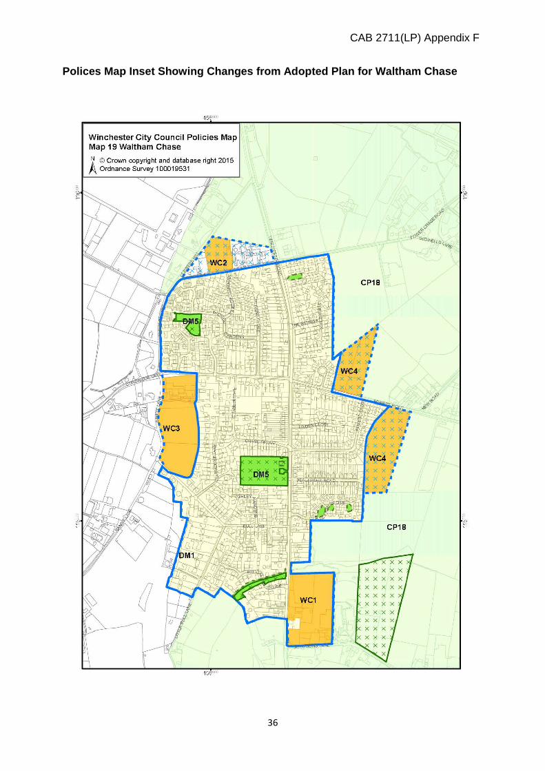
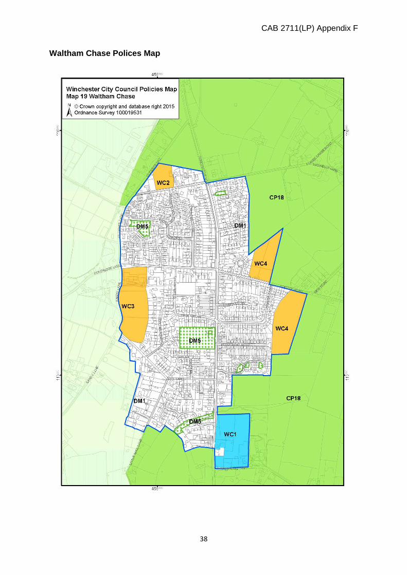
11. City Council officers worked with Shedfield Parish Council to determine the most effective and sustainable strategy to meet the development needs of the settlement of Waltham Chase. The Parish also conducted their own survey of local residents to gauge the preferred strategy for distributing the required level of new housing. The conclusion was that the most sustainable means of meeting the required level of growth was to spread development around the settlement with the identification of a number of smaller to medium sized sites. This would reflect the historic organic growth of the settlement and ensure reasonable access to existing services.
12. There was only one SHLAA site of any significance within the current settlement boundary, Morgans Yard, and this was carried forward as a preferred allocation. Given the limited number of completions within the plan period, and outstanding planning permissions a total of 174 dwellings needed to be allocated on greenfield sites.
13. Having assessed all the sites put forward for development outside of the
settlement boundary, three sites were preferred to meet the housing requirement. The three preferred sites were:
• Land at Clewers Lane (SHLAA reference 1753, 2491, 2288) • Land at Sandy Lane (SHLAA reference 1890, 1892, 1893) • Land to the north and south of Forest Road (SHLAA reference 1837
2567)
14. The site promoters were invited to discuss the potential capacity for each site, and its deliverability with the City and Parish Councils. The Parish in the

CAB 2711(LP) Appendix F
4
meantime conducted an informal consultation on the preferred options, which only attracted a small response.
15. The draft Local Plan therefore in addition to Morgans Yard, allocated the above three sites for housing and open space development (policies WC1, WC2, WC3, and WC4). As well as receiving comments on these policies (see below), comments were also received on a number of other sites, either promoting them instead of/as well as the preferred sites. These ‘omission’ sites and the comments on them are considered below. Appendix 1 re-assesses the omission housing sites and the relevant allocations in the draft Plan against the ‘key criteria’ set out in the Local Plan. Because, Clewers Lane has planning permission, and Morgans Yard is within the settlement boundary the omission sites are assessed against the draft allocations at Forest Road and Sandy Lane.
Site 2388 - north of Lower Chase Road
16. This site is being promoted for employment uses. There is an existing employment use adjoining this site immediately to the west. However, there is no requirement to find any additional employment land in this area. The site is on the edge of the settlement, and in a visually ‘most sensitive area’ in the Swanmore/ Waltham Chase Gap, so is not suited to a large footprint employment use. Accordingly, the site is not considered suitable for allocation as an employment site. Site - Land South of Solomons Lane
17. This site is promoted for development by the landowner as a more sustainable alternative to other preferred sites due to its proximity to the school and other local facilities. This site was not put forward as a SHLAA site so was not part of the original assessment process.
18. The site is immediately south of Morgans Yard, and would be accessed off of Solomons Lane, which would bring about a potential conflict between the new access for the housing at Morgans Yard, and the additional traffic visiting the extended school. While the site would have good access to the school it would not enjoy particularly good access to other village facilities. To allocate this site for development would extend the settlement boundary further south beyond Solomons Lane and would not form a logical or defensible edge to the settlement. The site is also within the Swanmore/ Waltham Chase Gap, which would be eroded further with development in this location. There is no compelling reason therefore to prefer this site as an alternative to the sites originally selected, and to allocate this site for development. Site – Ludwells Farm

CAB 2711(LP) Appendix F
5
19. The site comprises of around 1.4 hectares of land to the north of Lower Chase
Road at Ludwells Farm. It is proposed that the site should be developed as a 60 bed extra care unit to meet the needs of the aging population. The promoters of the site suggest that the Local Plan Part 1 underestimates the need for housing aimed principally at an aging population, and the site is therefore being promoted for specialist accommodation for the elderly which would be in addition to the overall housing requirement for the settlement.
20. The site has an unimplemented planning consent for a rest home granted in 1990, and is separated from the existing settlement boundary in the gap between Waltham Chase and Swanmore. The consultation response was accompanied by a detailed Care Needs Assessment, which purports to have identified a need for an additional 546 extra care beds within the district with 283 being required within a 5 mile catchment of Ludwells Farm. This is based on the expected 70% growth in the population over 65, and the potential 175% increase of those aged over 85.
21. There is no numerical target set in the LPP1 for the provision of housing
specifically to meet the needs of the elderly, at either the District or settlement level. However, policy MTRA1 requires the provision of a range of housing types and tenures to meet a range of requirements including those of older persons. Policy CP2 reiterates this and requires that new development should meet a range of community housing needs, including specialist forms of accommodation such as extra care housing. This approach is consistent with the NPPF which requires local planning authorities to plan for a mix of housing based on current and future demographic trends and needs for different groups in the community such as the elderly.
22. In setting the housing requirement of 12,500 new dwellings for the district, the
assessment of needs took into account the demographic profile of the district2. The conclusion in respect of the aging population was that it is difficult to predict the actual demand for specialist accommodation, as the elderly’s preference is generally to remain in their own homes and receive care there. The study also noted that there is a growing trend for the elderly to move in with their families due to the escalating costs of care.
23. In order to understand the current housing needs of an aging population the
Council commissioned a study to consider specialist housing for older people3. The conclusions were that: “There is no explicit requirement in national policy to allocate specific sites for specialist housing for older people. The advantage of maintaining broad allocations, which do not distinguish between the groups that
2 Review of Employment Prospects, Employment Land and Demographic Projection; DTZ August 2011 3 Specialist Housing for Older People in Winchester; the Health and Housing Partnership LLP- August 2015
CAB 2711(LP) Appendix F
6
might occupy the housing, is that it provides flexibility to respond to changing needs and models of development over time. It does not presume what the model for older persons housing should be and indeed this may change over the 20 year plan period”. It was also recommended that if further housing is required then the County Council Toolkit should be used to assess site potential. The ‘toolkit’ seeks to locate residential accommodation aimed at the elderly in settlements with a significantly higher range of social and community facilities than Waltham Chase.
24. The policy approach in the adopted Local Plan, outlined above is currently
bringing forward a number of developments aimed at providing specialist elderly accommodation, for example consent has been granted for three new facilities in the MDA at West of Waterlooville (although one of the units is in the Havant part of the site); a new extra care facility in Barton Farm, and the proposed development of the Chesil car park in Winchester town. Further facilities are planned at North Whiteley and are contained in the current outline planning application, and there are two schemes currently under construction nearby at Wickham and Bishops Waltham. Therefore, there is no evidence that the current policies are not meeting this growing need. However this will need monitoring and if this particular need is not being met then this will need to be addressed in any future review of the Local Plan
25. In respect to the proposal to develop Ludwells Farm for specialist
accommodation to meet the needs of the elderly. It is not accepted that the LPP2 needs to specifically allocate sites to meet the specialist needs of the elderly. However if this was to be the case, then the Council would need to consider where would be the most sustainable location to develop these facilities. The needs of the elderly vary considerably, but where extra care accommodation is to be provided then locations with good access to local services and health facilities will be preferred.
26. The site at Ludwells Farm is in a ‘visually most sensitive’ area, within the gap that
separates Waltham Chase and Swanmore, it is a significant area of substantially undeveloped land within the gap. To build on this site would seriously erode the gap and contribute towards the perception of the two settlements coalescing. It is not particularly accessible to local services, and in this location there is no footpath on either side of the road which would make walking into the village difficult for elderly residents.
27. Unlike all the sites mentioned above which are providing for the needs of an
aging population, and which all are located in settlements with access to a high level of services and facilities, Waltham Chase currently lacks a doctor’s surgery, chemist, dentist and a library, which are all key services which an aging population would be expected to need access to.
CAB 2711(LP) Appendix F
7
28. In conclusion therefore, there is no compelling reason why this site in the highly
sensitive location should be allocated for specialist accommodation to meet the needs of the elderly.
Site 2596 – Van Diemens Field
29. The promoters of this site have objected to policies WC1, WC2, WC3 and WC4 and have put forward land at Van Diemens field as an alternative. Originally this site formed part of a larger site submitted as part of the SHLAA (1894), and was assessed as such. The promoters of this site subsequently put forward the smaller site at Van Diemens Field for consideration, but this was after all the site assessment work had been completed. The Council did not at that stage re-run the evaluation process, but did agree that additional sites would be considered against the preferred sites at this stage of the Plan preparation process, i.e. after the consultations on the draft Local Plan Part 2 and before the Pre-submission Plan was finalised.
30. The site is accessed off of Lower Chase Road, and is within the gap between Waltham Chase and Swanmore. The site promoters have prepared a site assessment which concluded that the site has few constraints and development would not compromise the purpose of the settlement gap.
31. Approximately 60 dwellings are proposed on this site together with open spaces
and community uses. Currently there is no footpath on the stretch of Lower Chase Road adjoining the site, and the site promoters state that opportunities could be explored to widened the road and create a footpath. But this might require third party land for which there is no evidence at the present time to indicate that the land would be made available. Without a footpath connection access to the village for pedestrians would be limited and potentially dangerous.
32. The site promoters claim that this site should be preferred to other sites allocated
at Waltham Chase in the LPP2. However, the site at Clewers Lane (WC2) has recently been granted planning permission, and the site at Morgans Yard (WC1) is a previously developed site within the current settlement boundary. The re-assessment of the omission sites against the preferred sites (appendix 1) concluded that the site at Sandy Lane (WC3) is less visually sensitive than the Forest Road and Van Diemens Field sites, and is not within a gap. There are no insurmountable transport issues, and the development of this site represents the natural rounding off of the village boundary in this location.
33. The two Forest Road sites, are located to the north and south of the road, (WC4)
together they would provide around 85 dwellings. The site to the north of Forest Road adjoins Van Diemens Field, which is to the north. Both the Forest Road

CAB 2711(LP) Appendix F
8
sites are visually sensitive, and are within the Gap, but by splitting them up this would have a lesser impact on the Gap than the larger site at Van Diemens Field which would have a significantly greater impact on the gap due to the extent of the development area.
34. In transport terms it is considered that the Forest Road sites enjoy marginally
better access to local services and facilities, together with the point that there is currently a lack of a footpath connection from Van Diemens Field to the village. Both of the Forest Road sites are nearer to the shops and community facilities in the village.
35. If this site was to be preferred to the two Forest Road sites then a further site
would need to be considered (of around 25 dwellings) to meet the requirement for 250 new dwellings in Waltham Chase. The Sandy Lane site, which has a similar capacity to Van Diemens Field performs better when assessed against the established key assessment criteria, so would continue to be preferred to the site at Van Diemens Field.
36. In conclusion it is not considered that the site at Van Diemens Field performs any
better than the allocated sites, and performs worse in terms of visual impact and access to local services and facilities. Development in this location would intrude further into the Gap, than the preferred sites in Forest Road. There are therefore no compelling reasons to allocate this site in preference to any of the sites previously identified for meeting the Waltham Chase Housing requirements Site Allocation - Policy WC1 Morgans Yard Housing & Mixed -uses
37. This site is within the settlement boundary and is currently used for a number of employment related uses, including open storage. The site is around 2.8 hectares, and the policy requirement is for about 60 dwellings, and between 0.5 and 0.64 hectares of land to allow for the expansion of St John the Baptist Primary School, which adjoins the site from a 1.5FE to a 2FE school. Vehicular access is proposed from Solomons Lane, with a new pedestrian access onto Winchester Road. There is a SSSI to the north, Waltham Chase Meadows, which will require a suitable buffer. Due to the industrial nature of some of the previous uses the site is likely to be contaminated.
38. There was some support for this site allocation, and Natural England considered the policy requirement for a buffer to the SSSI to be sufficient and consistent with the NPPF. However there were a number of objections raised.
39. The main area of concern was potential traffic congestion, which some
respondents felt would be exacerbated by the lack of employment and facilities locally. The loss of employment was also cited by one respondent. Concern was

CAB 2711(LP) Appendix F
9
also expressed regarding the expansion of the school which it was felt would impact on parking issues locally. However transport issues were taken into account in the original site assessments, and given the nature of the site it already generates traffic movements to and from the site. The conclusion that this site will not increase traffic generation to an unacceptable level has subsequently been confirmed in the B2177 Corridor Cumulative Traffic Impacts Study which has not identified any significant traffic issue associated with this previously developed site.
40. The site promoters generally supported the allocation but raised concerns over
the requirement to allocate a section of their site for educational purposes. This together with the proposed employment uses, the requirement for 40% of the new houses to be affordable, and cost of contamination creates issues of viability. They were also concerned that alternatives to using their site for the school expansion had not been properly explored. Meetings were held with the site promoters who were invited to submit additional information to support their position, but to date this information regarding the extent of contamination, the capacity of the site, and the availability of alternative sites to extend the school have not been supplied.
41. The Council’s viability assessment4 of this site would indicate that there is no
compelling reason to amend the policy, as the policy as worded is likely to be viable and deliverable. The appraisal took into account the constraints on the site and the potential land –use allocations and concluded that “the up-lift in land values would constitute a competitive return, which should incentivise the landowner to release the site”.
42. In conclusion the site has been confirmed as being available and the viability
appraisal indicates that the Policy is deliverable. At the present time the site promoters have not put forward any firm evidence to warrant amending the Policy, however it is recommended that the supporting text is amended to clarify that in respect of the provision of replacement employment floorspace this would be subject to further viability work. Site Allocation - Policy WC2 Clewers Lane Housing Allocation
43. Concerns about this allocation largely revolved around traffic and road safety issues. However, part of this site has recently been given planning permission for around 30 dwellings, when the traffic and safety issues were thoroughly examined, and it was found that there were no insurmountable transport issues.
4 Land Allocation Viability Appraisal- Morgans Yard; Vail Williams July 2015; Appendix 2
CAB 2711(LP) Appendix F
10
44. In the light of the recent consent for part of this site there are no reasons why this allocation should not be retained in the Pre-submission draft of the LPP2. As construction of the approved development has not yet commenced the policy needs to be retained to provide guidance on the development requirements for this site should an alternative scheme come forward at some stage in the future. Site Allocation - Policy WC3 Sandy Lane Housing Allocation
45. This site of around 3.2 hectares is allocated for around 60 dwellings, together with informal open space and a children’s play area. Access is to be from Curdridge Lane, with a new cycle pedestrian link along the eastern side of the site to link up with the village centre. Objections were received to this allocation (around 11 separate responses), mostly on traffic and road safety issues. Access
46. The main traffic objections in addition to the general comment about the potential impacts on the local roads, was the potential increase in rat running along Sandy Lane and Bull Lane. However the transport assessment did not identify any insurmountable transport problems with this site, and policy requirement to create a new access of off Curdridge Lane seeks to address the issue of potential rat running.
Green Infrastructure and Open Space
47. Further concerns were raised on the potential loss of rural character/ amenity. The point was raised that this site is one of the highest parts of the village so that its development would be harmful to visual amenity, as would the potential overlooking and loss of privacy to adjoining properties. The comments suggested that the new transport infrastructure including lighting would destroy the rural character of the area. There were also concerns about the potential impact on wildlife and protected species, including bats, badgers, owls, and red kites. However the policy (WC3) requires substantial landscaping and buffers in addition to informal open space, which will help reduce the visual impact of the development, and provide attractive wildlife corridors
48. Objections were also made by 3 respondents on whether changing green belt
boundaries in the location would be contrary to the NPPF. However, the site is not within an established green belt so this objection cannot be sustained.
Infrastructure
Comments were also made that the potential development of this site would cause flooding/ drainage problems in the locality. Concerns were raised that

CAB 2711(LP) Appendix F
11
development of this site would put pressure on local facilities including the doctor’s surgery.
49. The site promoters broadly support the allocation but request that the capacity of
the site is increased to around 70 dwellings, as this number of dwellings could be achieved without any harm to the character and appearance of the area and adjoining countryside. They point out that the gross density of the allocation would be less than 20 dwellings per hectare, which is wasteful of scarce housing land. The policy is currently worded as around 60 dwellings which gives a degree of leeway, but in the absence of any further capacity work, given the constraints on and around the site, it is not considered expedient at this stage to change the wording of the policy. Site Allocation - Policy WC4 Forest Road (North and South) Housing Allocation
50. This allocation comprises two sites to the north and south of Forest Road. A total of around 85 dwellings are allocated to the two sites, with around 40 expected on the northern site and around 45 on the southern site. A planning application to develop these sites has recently been submitted, but has yet to be determined. A number of objections were received to this allocation (circa 11 responses). Access.
51. The main concerns raised were in respect of access and traffic issues, including the need for additional car journeys to access employment opportunities. The objectors suggest that the development of 85 houses would increase congestion and raise road safety issues, local roads would become rat-runs. However, in assessing this site it was considered that there would be no insurmountable transport issues, a view which is reinforced by the B2177 Corridor Cumulative Traffic Impacts Study Green Infrastructure and Open Space.
52. Concerns were raised on the impact on the countryside and settlement gap separating Waltham Chase and Swanmore. According to a number of objectors there would also be a loss of habitat. It was also suggested that there are other more suitable sites in adjoining settlements. In respect of the latter comment the housing requirement is settlement based so considering alternative locations outside of Waltham Chase would not be meet the LPP1 requirement for about 250 houses in this settlement.

CAB 2711(LP) Appendix F
12
53. Natural England raised concerns that the policy did not recognise the nearby SSSI at Waltham Chase Meadows, and the Environment Agency raised concerns that the policy does not recognise the presence of a section of the Lower Chase Stream which would require a buffer zone, and enhancements should be sought where possible. It is therefore recommended that the policy wording is amended to take into account these concerns. Infrastructure
54. Concerns were raised whether there is sufficient capacity in the local infrastructure facilities to cope with the additional population.
55. Flooding was also raised as an issue. But the site is not within an area with a high risk of flooding and the Environment Agency has raised no objections on these grounds.
56. In conclusion therefore, there is a recent planning application for the development
of this site, which is currently being determined, this illustrates that the site is both available and the requirement for about 85 dwellings is deliverable. It is therefore recommended that minor amendments are made to the Policy (WC4) to take into account the comments made by the Environment Agency, and Natural England.
Conclusions
Following a full and proper consideration of all the responses received in respect of the policies for Waltham Chase in the draft LPP2, and the re-evaluation of the preferred and omission sites that the following amendments should be made to Waltham Chase section of Chapter 4 of the Pre-submission draft of the Local plan Part 2.
1. Up-date table at paragraph 4.4.5 2. Amend and update the text to policy WC1 clarify that the requirement for
employment uses to be included in the redevelopment of this site is subject to the impact on the viability of the proposals.
3. Amend the wording to policy WC4 to take into account the comments by Natural England and the Environment Agency.
4. Add the following wording to the infrastructure requirements for policies WC1, WC3, and WC4, as requested by Southern Water ‘provide a connection to the nearest point of adequate capacity in the sewerage network, in collaboration with the service provider’.
CAB 2711(LP) Appendix F
13
Sustainability Appraisal/Strategic Environmental Assessment
The SA/SEA process requires an iterative approach to plan making, whereby the SA/SEA assessments inform each stage by flagging up matters that require further investigation. The SA/SEA undertaken on the Regulation 18 version of LPP2, highlighted the following matters (left column) in relation to Waltham Chase, and suggests ways of avoiding or mitigating significant negative effects and promoting enhancement of positive effects.
The following table therefore includes the SA/SEA recommendations together with how these have been addressed.
Mitigation, Recommendations and Residual Effects for Plan-making
Response
General SA/SEA comments on all site allocations in LPP2
Response as proposed in relation to the allocation sites in Waltham Chase
It is recommended that for all the sites, specific requirements in any allocation wording to enhance and improve access to GI on and around them should be included. This would increase the certainty of positive effects on infrastructure.
Policy CP15 in LPP1 establishes the requirement to support development which maintains protects and enhances the function or integrity of the existing GI network and provides a net gain in GI. Given, the location of the allocation sites in WC, opportunities to link with existing public rights of way network, plus the provision of on-site open space and a need for a new/improved pedestrian/cycle links to link with other facilities, and allows for the enhancement and improvement to access GI.
Policies WC1-WC4 all refer to pedestrian/cycle links with neighbouring sites and other facilities.
Appropriate phasing of sites, time restrictions on development during the day and night, and the requirement for an Environmental Management Plan to be produced should be considered as mitigation within policy wording. This will help reduce negative effects identified for the SA objectives Pollution, Health and Transport.
This SA objective is very broad and covers a number of matters. Policy DM19 on ‘Development and Pollution’, requires compliance with statutory standards and for adverse pollution impacts to be addressed through applications submitted for determination. This policy states ‘as a minimum development should not result in unacceptable impacts on health or quality of life.’
Given the broad nature of these SA objectives, it is considered that these are

CAB 2711(LP) Appendix F
14
adequately covered by the emerging development management policies. With regard to transport each WC allocation policy has a specific section on ‘access’ to establish in policy both vehicular and non-vehicular means of access to the site and linkages with existing routes. This SA recommendation also refers to phasing of sites. While the rate of development might in practice be constrained by the rate of infrastructure locally, especially the provision of extra school places it would not be appropriate to set an artificial cap on the rate that development comes forward.
Mitigation and Recommendations from the SA/SEA in relation to the Waltham Chase site allocations.
Response
Negative effects identified could be changed to positive if a firmer requirement to provide open space on the sites is included in the relevant site allocation policy wording. This could lead to further positive effects on health
Policies WC1, WC3, and WC4, all have the requirement to provide both formal and informal open space within the site. Policy WC2 has the requirement to only provide informal open space on the site, because this site immediately adjoins a large area of public open space.
If sites 2406, 1892, 2065, 2405 and 1894 were developed, it would be recommended that there should be a requirement under policy to retain trees covered by Tree Preservation Orders. This will increase the certainty of positive effects on landscape.
Those sites or parts of sites that have been allocated as part of LPP2 (1892 and 2065), all require landscaping provision and the retention and enhancement of existing boundaries. None of these sites have significant trees on the developable area with the tree cover around the edges. Those trees will be given due protection by the requirement to maintain and reinforce existing landscape and to provide buffers. The remaining sites are not currently being proposed for development in the LPP2.

CAB 2711(LP) Appendix F
15
Appendix 1 – Assessment of policies WC3 and 4 and Omission Sites
A number of omission sites were put forward as alternatives to the sites allocated in the draft Plan. The promoters of these omission sites claim that their sites perform better against the key criteria for assessing the most sustainable locations for the required growth of Waltham Chase.
Of the preferred sites allocated in the draft LPP1 Morgans Yard (WC1) is previously developed land within the settlement boundary and would have a presumption in favour of its development over any green field allocation. The site at Clewers Lane (WC2) has already been granted planning permission. Therefore the following assessment compares the sites allocated in the draft plan at Sandy Lane (WC3), and Forest Road (WC4), against the omission sites at Van Diemens Field, and Solomons Lane. The other omission sites put forward were not for housing developments so are not included in this re-assessment, but are dealt with separately above.
Chapter 2 of the draft Local Plan set out the site selection assessment methodology, starting with initial site sieving, assessment against various evidence studies and data, and selection of preferred sites. A series of ‘key criteria’ are set out for the final selection stage, including community consultation results, and the ‘Housing Site Assessment Methodology’ document was published alongside the draft Local Plan to set out the means used to assess the potential site allocations in more detail. The factors taken into account when selecting sites for Waltham Chase generally reflect the ‘key criteria’.
The report of the public consultation included a table showing how the shortlisted sites performed against the factors referred to in the consultation questionnaire. This is updated below to refer to the ‘key criteria’ and to cover the areas now raised through consultation on the draft Local Plan (including previously shortlisted sites).
Key Criteria Assessment Evidence Source
Is the site within the settlement boundary?
The capacity of Waltham Chase to meet its housing requirements within the current settlement boundaries has been assessed, and with the exception of Morgans Yard there are no other significant brownfield sites within the settlement boundaries likely to come forward for housing development in the Plan Period. Therefore to meet the full housing requirement for Waltham Chase land will need to be allocated outside of the current settlement boundaries. None of the sites
Inset Map 26 WDLR
CAB 2711(LP) Appendix F
16
subject of this re-assessment are within the current settlement boundaries
If not, is the site adjacent to the existing settlement boundary and well related to the pattern of development?
All the sites currently under consideration, both the sites allocated in the draft Plan and the omission sites are immediately adjoining the settlement boundary. The Sandy Lane site has development on three sides and is contained by Sandy Lane itself. It effectively rounds off the settlement boundary to the west of the village. The sites in Forest Road and Lower Chase Road immediately adjoin the settlement boundary, and would effectively extend the boundary eastwards. The site off of Solomons Lane, would have the new development at Morgans Yard to the north, separated by the road, but otherwise would have countryside to the south, east and west. It is the least well-related to the existing settlement boundary. Accordingly the Sandy Lane site is better related to the settlement boundary and the land at Solomons Lane is less so.
Inset Map 26 WDLPR
Are there physical constraints on the site? e.g. within a medium-high flood zone, overhead power line
There are no physical constraints within any of the sites under consideration in this review. The site south of Forest Road is near to the Waltham Chase Meadows SSSI, but Natural England has confirmed that with a suitable buffer this would not be a constraint against development. None of the sites are within a medium to high flood risk zone
Waltham Chase Constraints Map
Are there national or local policy designations? e.g. Site of Special Scientific Interest, Scheduled Ancient Monument
The South Downs National Park is some distance to the north and west of Waltham Chase, but does not act as a constraint against development in this settlement. The Waltham Chase Meadows SSSI is located between St John’s Primary School and the southern edge of the southern site off of Forest Road, but Natural England has confirmed that with an effective buffer there would be no impact on this designated site. There is a TPO on the northern part of the Sandy Lane site.
Waltham Chase Constraints Map
Is the site close to existing facilities & services?
The Forest Road sites were assessed as being ‘good’ in the Transport Site Assessment for Waltham Chase, with the remainder being ‘adequate’. Van Diemens
Waltham Chase Transport Site Assessment,
CAB 2711(LP) Appendix F
17
Field is further away from local facilities than the two Forest Road sites, so does not perform quite so well, it is also the furthest away from the local primary school and access to this facility is rated as poor. The Sandy Lane site was assessed as having ‘good’ access to local services and facilities Solomons Road was not assessed but is the furthest away from local facilities and services, with the exception of access to the primary school which is opposite the site. Therefore the Forest Road and Sandy Lane sites perform best on this criteria and Solomons Lane the worst.
and Accessibility Map
Is there good access onto the site?
All the sites could provide a safe and acceptable means of access to the site from an adopted road. Sandy Lane currently has the requirement for the vehicular access to be off of Curdridge Lane, this would also link into the exiting footpath network. The Transport Site Assessment work also flagged up that pedestrian access along Sandy Lane and Bull Lane is currently poor, due to the lack of a footpath The Solomons Lane site could provide an access onto this road, but care would be needed to avoid conflict with traffic to the extended school and the new access to the mixed use scheme on Morgans Yard.
Waltham Chase Transport Site Assessment, and Accessibility Map
Would the development detract from the landscape, important views and historic environment of the surrounding area?
The sites in Forest Road and Van Diemens field are considered to be the ‘most sensitive ‘ in landscape terms. With the site at Sandy Lane being considered ‘highly sensitive’ on part of the site and ‘moderately sensitive’ on the remainder Another SHLAA site in Solomons Lane was assessed as being ‘moderately’ sensitive, the site currently under consideration is larger and projects further into the countryside, so is likely to be ‘moderate’ or ‘highly sensitive’ in landscape terms. None of the sites under consideration would have any impact on the historic environment, as there are no conservation areas or listed buildings in the village.
Waltham Chase Landscape Sensitivity Assessment
Can the site contribute to meeting other
All the sites are of sufficient scale to meet their open space requirements, and could make a contribution towards meeting any
Waltham Chase Open Space

CAB 2711(LP) Appendix F
18
identified needs? local shortfalls in informal open space and children’s play. Any development in Waltham Chase would be expected to contribute towards making good the shortfall in primary school places, but this would be in the form of a financial contribution, with the exception of the site at Morgans Yard for which land is allocated for the extension of the school.
Strategy
Would the development maintain the generally open and undeveloped nature of the gap between neighbouring settlements?
The sites in Forest Road and the site at Van Diemens Field are within the Swanmore/ Waltham Case Gap. All of these sites would have an adverse impact on the Gap, but the site at Van Diemens Field is the largest and would extend the furthest into the Gap so would have the greater impact. The site at Solomons Lane is also in the Gap which would be eroded through any development on this site. The Sandy Lane site is not within the Gap so performs better on this criterion
Inset Map 26 WDLPR
How did the site rate in community consultation responses?
The Parish Council consulted with the local community on the preferred strategy to meet the village’s housing requirements. The preferred option was to spread the development around the edge of the village. The potential development sites which had been put forward in the SHLAA were then assessed against the established assessment methodology which had been used for all settlements in the District. The preferred options were then the subject of an informal consultation undertaken by the Parish Council. Although this was widely publicised it received very little response. The Council then undertook its own consultation on the draft Plan including holding an exhibition in Waltham Chase. In addition to the objection from the promoters of alternative sites, there were 9 individual objections to the Forest Road sites, and 11 to the Sandy Lane site. The Solomons Lane site was not put forward as a SHLAA site so was not the subject of the consultations. Van Diemens Field was originally part of a much larger site put forward as part of the SHLAA. The promoters of this site contacted the Council to request that a smaller site should be considered, but this was after the

CAB 2711(LP) Appendix F
19
site assessment work had been completed. The Council had made the decision that it would not re-run the site assessment process every time a new site came forward, but would reassess any omission sites against the allocated sites in the draft plan, as part of the consideration of responses to the draft LPP2.
Plan of Omission Sites

CAB 2711(LP) Appendix F
20
APPENDIX 2 Morgans Yard Viability Study

CAB 2711(LP) Appendix F
21
CAB 2711(LP) Appendix F
22

CAB 2711(LP) Appendix F
23

CAB 2711(LP) Appendix F
24

CAB 2711(LP) Appendix F
25

CAB 2711(LP) Appendix F
26
Appendix 3 Proposed Changes to LPP2
4.4 WALTHAM CHASE
Location, characteristics & setting
4.4.1 Waltham Chase is a large village in an attractive rural setting, located to the south west of the South Downs National Park. It consists mainly of relatively modern development of various styles, but it is the rural setting which gives Waltham Chase its special character.
4.4.2 The LPP2 data set for Waltham Chase is included in the evidence base of the Plan (Appendix A). This sets out the background facts and figures that have informed the draft policies and proposals for the village. Along with more detail on the characteristics of the town, it includes information on -
- Population and Housing - Employment - Community and Social Infrastructure - Infrastructure.
Development Needs
4.4.3 The development strategy for the Market Towns and Rural Area has been identified through Policy MTRA1 of LPP1. Policy MTRA2 supports the evolution of the more sustainable villages, including Waltham Chase, to maintain and improve their role and function in meeting a range of local development needs. These needs include –
• the provision of about 250 dwellings over the plan period 2011-2031;
and • supporting economic and commercial growth to maintain and improve
the shopping, service, tourism and employment roles.
4.4.4 Development should result in a more sustainable community by improving the balance between housing, employment and services. Existing facilities, services and employment provision should be retained or improved to serve the village and its catchment area. All development should be appropriate in scale and design, so as to conserve the settlement’s identity, countryside setting and local features.
4.4.5 The remaining housing requirement, taking account of completed and anticipated development, was about 174 dwellings (see Table below). One of the roles of this Plan is to allocate sites to meet this figure in suitable locations that can deliver the number of homes required in Waltham Chase during the Plan period.

CAB 2711(LP) Appendix F
27
Waltham Chase Net Housing Requirement
Category No. of dwellings
a. Requirement (2011 - 2031)* 250
b. Net Completions 1.4.2011 to 31.3.2015 15
c. Outstanding permissions at 31.3.2015 1
d. SHLAA sites within settlement boundary 60
e. Windfall allowance 0
f. Total supply (b+c+d+e+f) 76
Remainder to be allocated (a – f) 174**
* Policy MTRA2 of LPP1 ** Clewers Lane now has permission, but as it was permitted after April 2015, it has not been counted and therefore remains as part of the need for allocation.
4.4.6 There are minimal existing planning permissions referred to in the table (c. and d.). The proposed allocation at Clewers Lane (policy WC2) now has planning consent (granted after April 2015).The SHLAA site referred to in the table (e.) is at Morgan’s Yard. This site is within the current settlement boundary but is a key site which can has the potential to deliver several uses that Waltham Chase needs. Hence it is subject to a specific mixed use allocation (see policy WC1 below). This, along with all the other sites submitted for Waltham Chase through the SHLAA process, are shown on the Waltham Chase page of the LPP2 web site: www.winchestete.gov.uk/planning-policy/local-plan-part-2 (see Waltham Chase- All Sites Submitted document).
4.4.7 No allowance is made for the development of unidentified (‘windfall’) sites which may come forward within the defined settlement boundary on infill or redeveloped sites over the Plan period. This reflects the conclusions of the ‘Windfall Trends and Potential’ study for Waltham Chase, but does not mean that such opportunities are not appropriate or may not be suitable for new housing. Any such proposals will continue to be considered on their individual merits against current policies and, where approved, will provide flexibility in maintaining the supply of housing in the village.
4.4.8 The process of selecting appropriate sites has taken into account the work
undertaken by the Parish Council to establish the community’s preferences for the location of new development sites. Through local consultation and discussions with Council, all the potential housing sites in and around
CAB 2711(LP) Appendix F
28
Waltham Chase that were promoted through the SHLAA were considered. Having regard to development needs identified, the established assessment methodology, and the community’s preferences that the development should be spread around the edges of the village, which emerged through earlier consultations, the preferred development strategy was drawn up comprises the following:
Housing Sites • Land north of Clewers Lane (Policy WC2) • Land east of Sandy Lane (Policy WC3) • Land north and south of Forest Road (Policy WC4) • Land south of Forest Road (site 1837) Mixed- use site
Morgan’s Yard (Policy WC1)
4.4.9 The Parish Council then undertook an informal consultation on the development strategy between November 2013 and January 2014. Although the preferred sites were widely publicised through the Parish Magazine and the Parish Council web-site, only 2 responses were received one from a local resident and the other from a promoter of an alternative site.
4.4.10 The small number of existing completions and outstanding planning permission (totalling 16 dwellings) means that the majority of the housing requirement for Waltham Chase will be accommodated on new site allocations (policies WC1- WC54 below). These policies include estimates of each site’s capacity, but the number of dwellings actually delivered over the 20 year Plan period will take account of various site and market conditions that will influence the number, type and size of homes provided. While the precise number may be a little higher or lower than estimated, the existing commitments and allocated sites are expected to provide the requirement of ‘about 250 new homes’ in total.
4.4.11 The owners of the preferred sites have confirmed that all are available for development within the Plan period (up to 2031). When the sites are considered against the Site Assessment Methodology,
• their locations are consistent with the Settlement Hierarchy; • no major constraints have been identified; • they are well-related to existing services and facilities; • site conditions are favourable; • infrastructure requirements will not affect viability; • neither has a significant adverse impact on biodiversity, landscape or
heritage; • they reflect the results of community involvement

CAB 2711(LP) Appendix F
29
4.4.12 Work on local needs and the evidence base also highlights a need for open space provision in most categories. No new employment sites are needed but existing provision should be retained (although there will be a net loss of employment floorspace at Morgans Yard) and additional employment development is encouraged in suitable locations within the built-up area.
Open Space and Other Infrastructure
4.4.13 The overall scale of development proposed in Waltham Chase will require an extension to the Primary School. All The development allocations will be expected to make a contribution to the cost of this improvement, which is required as a result of development and is facilitated by policy DM10.
4.4.14 Sites allocated under Policies WC1, WC2, WC3 and WC3 fall within the area covered by the Interim Solent Recreation Mitigation Strategy (see paragraph 1.11). These will be expected to make a financial contribution towards measures to mitigate their recreational impact on protected sites.
4.4.15 There is a policy requirement for all the sites allocated below to provide open space, this will both meet the needs of the new development and also help make up local shortfalls. The allocation sites are required to provide on site open space, landscaping, links with the existing public rights of way network and new connections between each site and other facilities. This has multiple benefits ensuring health and wellbeing matters are integrated into new development and that connections are provided to encourage the community to avoid using vehicles for short journeys. Furthermore, such enhanced green infrastructure provision will help protect the rural lanes and surrounding countryside from urbanisation.
4.4.16 Open spaces in Waltham Chase that are currently protected from development by WDLPR saved policies RT1 and RT2 have been re-assessed in terms of their importance for recreational and/or amenity purposes. The results of this review, in terms of which areas continue to be protected, under Policy DM5 are set out in a background paper. New Policy DM# now supersedes RT1 and RT2 and the open spaces protected under the policy the up-dated Open Space Strategy and are shown on the Local Plan Policies Map Site Allocation Policies
4.4.17 The proposed site at Morgans Yard (totalling 2.8 hectares) is within the current settlement boundary of Waltham Chase. It is close to the village centre, well contained and easily accessible from the B2177. Due to the previous uses on the site it is believed to suffer from low levels of contamination which will need to be fully investigated and remedied before the site can be developed.
4.4.18 The site is currently used for a number of employment uses, and showroom/sales facilities. It is one of the few significant employment sites in
CAB 2711(LP) Appendix F
30
the village, although the disposition of the various uses does not make for the most effective use of the site. Given the requirement to enable the school extension and for decontamination, and the fact that this is not a prime employment location, it would not be realistic to expect all the existing land area devoted to employment uses to be replaced, or to specify the precise amount or uses of floorspace to be provided. However, in bringing forward the site the developers should develop a masterplan for a mix of uses that includes sufficient commercial uses to at least compensate for the loss of existing employment floorspace, taking account of the viability of the development.
4.4.19 This site will be expected to make a contribution to the improvement of St
John the Baptist Primary School, which is required as a result of development. Scope to extend the School is limited, given the SSSI immediately to the north, and Morgan’s Yard offers the best opportunity for expansion. Following discussions with Hampshire County Council on the best way to extend the school, they confirmed that the site’s contribution towards the expansion of the School, should, therefore, be achieved by providing an area of land (0.5 – 0.64 hectares) for the expansion of the School grounds. This additional land is needed to provide additional play space to meet the needs of the enlarged school. There is also the potential to provide a multi–use games area for the school which could be made available to the local community outside of school hours.
Policy WC1 – Morgan’s Yard Mixed Use Allocation Land at Morgan’s Yard, as shown on the Policies Map, is allocated for the development of about 60 dwellings, extension of the adjoining St John the Baptist Primary School, and employment generating uses to replace existing jobs lost on the site. Planning permission will be granted provided that detailed proposals accord with other relevant policies and meet the following specific development requirements;
Nature & Phasing of Development - a masterplan establishing the disposition of housing, school
extension and employment uses for the whole site should be produced and agreed in advance of permission being granted for components of the allocation. Individual proposals should be designed in accordance with the masterplan, provide other uses and facilities (including affordable housing) at the appropriate stage, and avoid prejudicing the development of adjacent parts of the site.
- the proposals, should be accompanied by a comprehensive site assessment which sets out the nature and extent of any contamination present on the site, together with the programme of remedial works to ensure that any unacceptable risk from contamination is avoided
Access - provide a safe vehicle, pedestrian and cycle access point from
CAB 2711(LP) Appendix F
31
Solomons Lane; - include footpath/cycle access onto Winchester Road and
through the site to provide a safe pedestrian link with the School.
Landscape Environmental
- maintain and reinforce existing landscaped boundaries around the site, particularly to ensure an effective buffer between the development and the adjoining Waltham Chase Meadows Site of Special Scientific Interest (SSSI);
- provide suitable boundary treatment with the neighbouring School.
Green Infrastructure and Open Space - provide for an extension of the adjoining St John the Baptist
Primary School playing fields and on-site open space (Local Equipped Area for Play, or Multi Use Games Area and Informal Open Space).
Other Infrastructure - provide between 0.5 to 0.64 hectares of land for the expansion of
St John the Baptist Primary School and other infrastructure needed to make the development acceptable in planning terms.
- provide a connection to the nearest point of adequate capacity in the sewerage network, in collaboration with the service provider
4.4.20 The proposed site at Clewers Lane (0.8 hectare) is one of a number of potential sites identified along Clewers Lane. The allocated site has an estimated capacity of about 30 dwellings and it is sensible to modify the settlement boundary to include this site and other adjoining land. However, the adjoining areas are not part of the proposed allocation as they include existing businesses and dwellings and any net residential gain would be modest. Any future development proposals can be assessed against the Plan’s general policies for development within the village, but it is important that development of the allocated site does not prejudice suitable development of adjoining sites which might come forward in the future.
4.4.21 The site should include Informal Open Space and has the potential to improve access to other types of open space by providing pedestrian access to the adjoining ‘Triangle’ open space and possibly providing some parking spaces to serve it.
Policy WC2 – Clewers Lane Housing Allocation Land at Clewers Lane, as shown on the Policies Map, is allocated for the development of about 30 dwellings. Planning permission will be granted provided that detailed proposals accord with other relevant policies and meet the following specific development requirements:

CAB 2711(LP) Appendix F
32
Access - provide a safe vehicle, pedestrian and cycle access point from
Clewers Lane; - provide a pedestrian/cycle link through the site to the adjoining
recreation ground and investigate/implement improvements to pedestrian/cycle links with the surrounding area;
- provide for access to enable the development of adjoining land along Clewers Lane.
Landscape Environmental - maintain and reinforce existing landscaped boundaries around
the site, particularly the northern site boundary. Green Infrastructure and Open Space
- provide on-site open space (Informal Open Space). Other Infrastructure
- contribute to the expansion of St John the Baptist Primary School and other infrastructure needed to make the development acceptable in planning terms.
4.4.22 The proposed site at Sandy Lane (3.2 hectares) performs well against the
assessment criteria and Sandy Lane makes a logical and defensible boundary to the western side of the settlement. The site has a substantial hedgerow along the western boundary which, apart from access arrangements, should be retained and strengthened. The site is also higher in parts than the surrounding residential properties, so care will be needed in the layout to avoid over-looking. There is an existing access road to the north of the site off of Sandy Lane which serves a number of residential properties, access to which needs to be maintained. Policy WC3 – Sandy Lane Housing Allocation
Land at Sandy Lane, as shown on the Policies Map, is allocated for the development of about 60 dwellings. Planning permission will be granted provided that detailed proposals accord with other relevant policies and meet the following specific development requirements:
Access - provide a safe vehicle, pedestrian and cycle access from
Curdridge Lane which minimises the impact on the existing hedgerow and maintains access to existing residential properties;
- provide a new/improved footpath/cycleway along the eastern edge of the site as part of a route into the village centre.
Landscape Environmental
- provide substantial landscaping to create a new settlement edge to the south and west.
- provide landscape buffers to protect the amenities of existing properties to the south and east of the site.

CAB 2711(LP) Appendix F
33
Green Infrastructure and Open Space
- provide on-site open space (Informal Open Space and Local Equipped Area for Play).
Other Infrastructure - contribute to the expansion of St John the Baptist Primary
School and other infrastructure needed to make the development acceptable in planning terms.
- provide a connection to the nearest point of adequate capacity in the sewerage network, in collaboration with the service provider
4.4.23 The above following policy allocates two housing proposed sites (totalling 3.9 hectares) to the north and south of Forest Road. These perform well against the assessment criteria. There is residential development immediately to the west of the sites and on the opposite side of the road to the northern site. Although the sites lie within the Waltham Chase/Swanmore Gap, development is not considered to undermine its overall purpose as the northern site would not extend beyond the existing developed area and the southern site runs alongside existing development.
4.4.24 The sites are also visually well contained and new development will need to retain and reinforce this containment so as to avoid intrusion into the Gap, including through the provision and location of open space. Due to the more rural nature of the southern site and the open Gap to the south and east, a lower density of development might be more appropriate.
4.4.25 Open space should be provided in accordance with LPP1 Policy CP7, with
each site capable of providing Informal Open Space and a Local Equipped Area for Play on-site. Development of these sites should take particular account of the presence of the Waltham Chase Meadows SSSI, and the Lower Chase Stream, both of which should be protected through the layout of the scheme and the provision of suitable buffers.
Policy WC4 – Forest Road (North and South) Housing Allocations Land to the north and south of Forest Road, as shown on the Policies Map, is allocated for the development of about 85 dwellings. Planning permission will be granted provided that detailed proposals accord with other relevant policies and meet the following specific development requirements
Access - provide safe vehicle, pedestrian and cycle access points to
Forest Road in a form and position which minimises the loss of trees and hedgerows.
Landscape Environmental - provide substantial landscaping to create a new settlement

CAB 2711(LP) Appendix F
34
edge to the north, south and east of the sites, and protect and strengthen the existing hedgerow on the western boundaries adjoining existing housing. The required landscaping to the southern edge of the southern site should provide a strong buffer to protect the Waltham Chase Meadows SSSI
- The layout should recognise the presence of the nearby Lower Chase Stream which adjoins parts of the site, and where appropriate a suitable landscaped buffer zone should be incorporated into the scheme, to allow for access, and to ensure that no back gardens immediately back onto the watercourse.
Green Infrastructure and Open Space
- provide on-site open space (Informal Open Space and Local Equipped Area for Play) including a substantial area of informal open space on the undeveloped part of the site to meet current and future open space needs.
Other Infrastructure - contribute to the expansion of St John the Baptist Primary
School and other infrastructure needed to make the development acceptable in planning terms.
- provide a connection to the nearest point of adequate capacity in the sewerage network, in collaboration with the service provider
Open Space
4.4.26 Open spaces in Waltham Chase currently protected from development by WDLPR saved policies RT1 and RT2 have been re-assessed in terms of their importance for recreational and/or amenity purposes. The results of this review, in terms of which areas continue to be protected, are set out in a background paper ########. New Policy DM# now supersedes RT1 and RT2 and the open spaces protected under the policy are shown on the Local Plan Policies Map (Inset#).

CAB 2711(LP) Appendix F
35
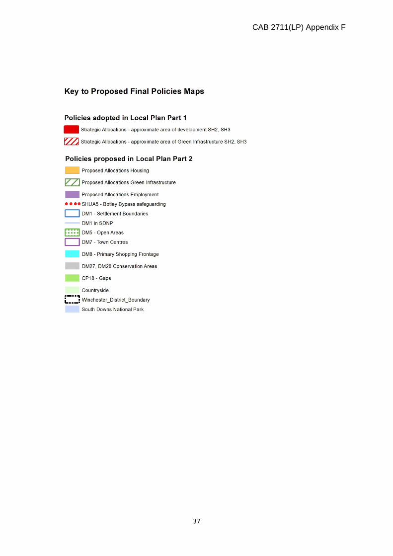
Proposed Changes to Policies Inset Map for Waltham Chase
CAB 2711(LP) Appendix F
36
Polices Map Inset Showing Changes from Adopted Plan for Waltham Chase
CAB 2711(LP) Appendix F
37
CAB 2711(LP) Appendix F
38
Waltham Chase Polices Map