draft victorville 2 hybrid power project · ensr international 1220 avenida acaso camarillo, ca...
TRANSCRIPT

DRAFT Victorville 2 Hybrid Power Project
Biological Resources Technical Report
City of Victorville San Bernardino County, California
Township 6 North, Range 5 West, Sections 2, 11 USGS 7.5’ Helendale and Victorville Northwest Quadrangles
Prepared for: ENSR International 1220 Avenida Acaso
Camarillo, CA 93012-8738 (805) 388-3775 (FAX) 388-3577
Contact: Mr. Arrie Bachrach
Prepared by:
AMEC Earth & Environmental, Inc. 3120 Chicago Avenue, Suite 110
Riverside, CA 92507 (951) 369-8060 (FAX) 369-8035
Principal Investigator:
Michael D. Wilcox Wildlife Biologist/Ecologist [email protected]
AMEC Job # 6554000228
Report Date: 23 February 2007
Victorville 2 Hybrid Power Project DRAFT Biological Resources Assessment ENSR International 23 February 2007
J:\2007 Projects\10855-Inland Energy\001 - Victorville II\AFC document\CD\Appendix H Biological Resources\Appendix H Bio Technical Report.doc Page i
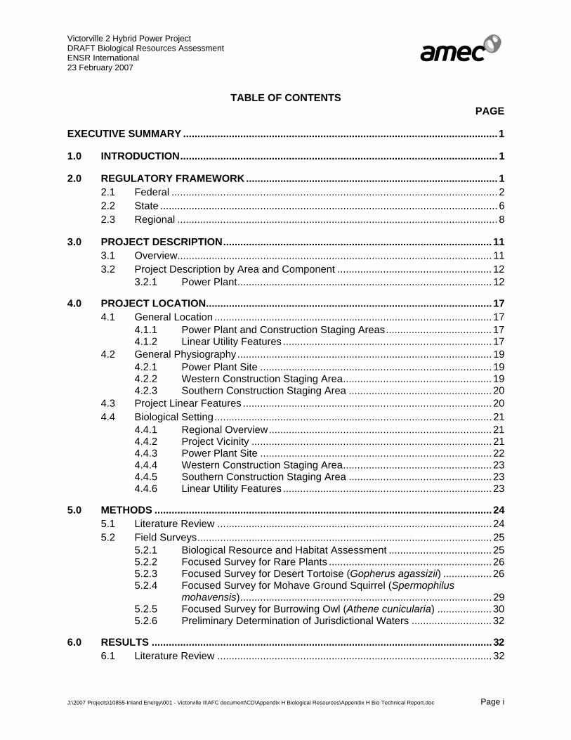
TABLE OF CONTENTS PAGE
EXECUTIVE SUMMARY ..............................................................................................................1
1.0 INTRODUCTION............................................................................................................... 1
2.0 REGULATORY FRAMEWORK ........................................................................................ 1 2.1 Federal .................................................................................................................. 2 2.2 State ...................................................................................................................... 6 2.3 Regional ................................................................................................................ 8
3.0 PROJECT DESCRIPTION.............................................................................................. 11 3.1 Overview.............................................................................................................. 11 3.2 Project Description by Area and Component ...................................................... 12
3.2.1 Power Plant......................................................................................... 12
4.0 PROJECT LOCATION.................................................................................................... 17 4.1 General Location ................................................................................................. 17
4.1.1 Power Plant and Construction Staging Areas..................................... 17 4.1.2 Linear Utility Features ......................................................................... 17
4.2 General Physiography......................................................................................... 19 4.2.1 Power Plant Site ................................................................................. 19 4.2.2 Western Construction Staging Area.................................................... 19 4.2.3 Southern Construction Staging Area .................................................. 20
4.3 Project Linear Features ....................................................................................... 20 4.4 Biological Setting................................................................................................. 21
4.4.1 Regional Overview.............................................................................. 21 4.4.2 Project Vicinity .................................................................................... 21 4.4.3 Power Plant Site ................................................................................. 22 4.4.4 Western Construction Staging Area.................................................... 23 4.4.5 Southern Construction Staging Area .................................................. 23 4.4.6 Linear Utility Features ......................................................................... 23
5.0 METHODS ...................................................................................................................... 24 5.1 Literature Review ................................................................................................ 24 5.2 Field Surveys....................................................................................................... 25
5.2.1 Biological Resource and Habitat Assessment .................................... 25 5.2.2 Focused Survey for Rare Plants ......................................................... 26 5.2.3 Focused Survey for Desert Tortoise (Gopherus agassizii) ................. 26 5.2.4 Focused Survey for Mohave Ground Squirrel (Spermophilus
mohavensis)........................................................................................ 29 5.2.5 Focused Survey for Burrowing Owl (Athene cunicularia) ................... 30 5.2.6 Preliminary Determination of Jurisdictional Waters ............................ 32
6.0 RESULTS ....................................................................................................................... 32 6.1 Literature Review ................................................................................................ 32

Victorville 2 Hybrid Power Project DRAFT Biological Resources Assessment ENSR International 23 February 2007
J:\2007 Projects\10855-Inland Energy\001 - Victorville II\AFC document\CD\Appendix H Biological Resources\Appendix H Bio Technical Report.doc Page ii
6.2 Soils..................................................................................................................... 33 6.3 Vegetation ........................................................................................................... 34
6.3.1 Mojave Creosote Bush Scrub ............................................................. 35 6.3.2 Desert Saltbush Scrub ........................................................................ 35 6.3.3 Non-native Grassland ......................................................................... 36 6.3.4 Disturbed/Developed Lands................................................................ 36 6.3.5 Mojave Riparian Forest....................................................................... 36 6.3.6 “Open Cottonwood-willow Woodland”................................................. 37 6.3.7 Southern Willow Scrub........................................................................ 37 6.3.8 Mojave Wash Scrub............................................................................ 38 6.3.9 Mojavean Juniper Woodland and Scrub ............................................. 38 6.3.10 Rabbitbrush Scrub .............................................................................. 38 6.3.11 Sandy Riverbed .................................................................................. 38 6.3.12 Preliminary Determination of Jurisdictional Waters ............................ 39
6.4 Wildlife................................................................................................................. 42 6.4.1 Reptiles ............................................................................................... 42 6.4.2 Birds.................................................................................................... 43 6.4.3 Mammals ............................................................................................ 43 6.4.4 Wildlife Movement Corridors............................................................... 43
6.5 Fish and Wildlife Species of Commercial or Recreational Value ........................ 44 6.6 Special Status Biological Resources................................................................... 45
6.6.1 Special-status Amphibians.................................................................. 54 6.6.2 Sensitive Reptiles ............................................................................... 57 6.6.3 Special Status Birds............................................................................ 64 6.6.4 Special-Status Mammals .................................................................... 81 6.6.5 Special Status Invertebrates ............................................................... 84
7.0 PROJECT EFFECT/IMPACT ANALYSIS ...................................................................... 85 7.1 Thresholds of Significance .................................................................................. 85 7.2 Impact Definition.................................................................................................. 87
7.2.1 Direct Impacts ..................................................................................... 87 7.2.2 Indirect Impacts................................................................................... 87 7.2.3 Cumulative Impacts ............................................................................ 87 7.2.4 Temporary versus Long Term Impacts ............................................... 88
7.3 VV2 Project Implementation................................................................................ 88 7.3.1 Direct Permanent or Long-term Surface Disturbance Impacts ........... 88 7.3.2 Direct Temporary Surface Disturbance Impacts ................................. 96 7.3.3 Indirect Impacts of the Project .......................................................... 105 7.3.4 Cumulative Impacts of the Project .................................................... 108
8.0 PROPOSED MITIGATION............................................................................................ 108 8.1 Intent and Summary .......................................................................................... 108
8.1.1 General Mitigation............................................................................. 108 8.1.2 Small-flowered Androstephium, Booth’s Evening Primrose, Sagebrush
Loeflingia, and Mojave Monkeyflower............................................... 110 8.1.3 Joshua Trees and All Native Cacti.................................................... 111 8.1.4 Desert Tortoise (Gopherus agassizii) ............................................... 111 8.1.5 Mohave Ground Squirrel (Spermophilus mohavensis) ..................... 115

Victorville 2 Hybrid Power Project DRAFT Biological Resources Assessment ENSR International 23 February 2007
J:\2007 Projects\10855-Inland Energy\001 - Victorville II\AFC document\CD\Appendix H Biological Resources\Appendix H Bio Technical Report.doc Page iii
8.1.6 Burrowing Owl (Athene cunicularia).................................................. 118 8.1.7 Southwestern Pond Turtle ................................................................ 120 8.1.8 San Diego Coast Horned Lizard ....................................................... 120 8.1.9 Mojave River Vole............................................................................. 120 8.1.10 San Emigdio Blue Butterfly ............................................................... 120 8.1.11 Nesting and Migratory Bird Species including Le Conte’s Thrasher,
Loggerhead Shrike, Southwestern Willow Flycatcher, Least Bell’s Vireo, and Western Yellow-billed Cuckoo......................................... 120
8.1.12 Jurisdictional Waters......................................................................... 121
9.0 CONCLUSION .............................................................................................................. 125
10.0 PERSONS AND AGENCIES CONSULTED................................................................. 125
11.0 DOCUMENT PREPARERS .......................................................................................... 126
12.0 LITERATURE CITED AND REFERENCES ................................................................. 126
LIST OF APPENDICES Appendix 1 Maps for the Victorville 2 Hybrid Power Project Appendix 2 Representative Site Photos for the Victorville 2 Hybrid Power Project Appendix 3 Electrical Transmission Line Tower Disturbance Drawings and Figures Appendix 4 Observed Plant Species List for the Victorville 2 Hybrid Power Project Appendix 5 Observed Vertebrate Species List for the Victorville 2 Hybrid Power Project Appendix 6 Desert Tortoise Field Survey Forms Appendix 7 California Native Species Field Survey Forms Appendix 8 Qualifications of Individuals Conducting Studies Appendix 9 Focused Survey for the Mohave Ground Squirrel for the Victorville 2 Hybrid
Power Project Appendix 10 Preliminary Determination of Jurisdictional Limits U.S. Army Corps of
Engineers Section 404 Waters of the United States Including Wetlands and State Waters Subject to California Department of Fish and Game Section 1602 Streambed Alteration Agreement
LIST OF TABLES Table 1. Desert Tortoise (Gopherus agassizii) Survey Data ................................................... 28 Table 2. Burrowing Owl (Athene cunicularia) Survey Data ..................................................... 31 Table 3. Preliminary Jurisdictional Determinations of Ephemeral Drainages Found
within 100 Feet of Linear Corridor Segments of the VV2 Power Plant Project ......... 40 Table 4. Special Status Plants ................................................................................................ 52 Table 5. Special Status Amphibians........................................................................................ 54 Table 6. Special Status Reptiles ............................................................................................. 58 Table 7. Special Status Birds .................................................................................................. 66 Table 8. Special Status Mammals........................................................................................... 82

Victorville 2 Hybrid Power Project DRAFT Biological Resources Assessment ENSR International 23 February 2007
J:\2007 Projects\10855-Inland Energy\001 - Victorville II\AFC document\CD\Appendix H Biological Resources\Appendix H Bio Technical Report.doc Page iv
Table 9. Special Status Insects ............................................................................................... 84 Table 10. Permanent Direct Surface Disturbance Acreage per Affected Plant
Community ................................................................................................................ 88 Table 11. Temporary Direct Surface Disturbance Acreage per Affected Plant
Community ................................................................................................................ 97 KEY TO TABLES ...................................................................................................................... 123
Victorville 2 Hybrid Power Project DRAFT Biological Resources Assessment ENSR International 23 February 2007
J:\2007 Projects\10855-Inland Energy\001 - Victorville II\AFC document\CD\Appendix H Biological Resources\Appendix H Bio Technical Report.doc Page 1
DRAFT Victorville 2 Hybrid Power Project
Biological Resources Technical Report
EXECUTIVE SUMMARY
An assessment of the biological resources with the potential to occur on, and in the vicinity of the proposed Victorville 2 Hybrid Power Project (VV2 or Project) was conducted by AMEC Earth & Environmental, Inc. (AMEC) to identify onsite and nearby vegetation communities as well as special status flora and fauna that may be impacted by the implementation of this Project. This study included: 1) a general biological resources assessment, 2) a focused survey for desert tortoise (Gopherus agassizii), 3) a habitat assessment and focused trapping survey for Mohave ground squirrel (Spermophilus mohavensis), 4) a habitat assessment and focused survey for burrowing owl (Athene cunicularia), 5) a focused survey for potentially occurring rare plant species, and 6) and a delineation of federal “Waters of the United States” and “State Waters”.
The VV2 Project site is primarily located within the City of Victorville, San Bernardino County, California with a portion of the proposed electrical transmission line located within the City of Hesperia. The Project consists of a proposed 275-acre power plant, two adjacent construction staging areas totaling a combined 50 acres, and approximately 21 miles of electrical transmission line including the construction of 275 new transmission line towers. Although the power plant site itself is 275 acres, the disturbance footprint for the site (which includes fill slopes and access) is 338 acres. For this reason, the 338-acre figure is used throughout the remainder of this document to refer to the power plant disturbance footprint. The electrical transmission line is divided into three segments numbered sequentially from north to south. Segment 1 would contain: (1) 4.3 miles of new electrical transmission lines placed on 31 new 230kV single tubular pole towers connecting the power plant to an existing electrical transmission path to the south that serves the existing High Desert Power Project (HDPP), (2) a new underground approximately 1.5-mile reclaimed water pipeline connecting the power plant to the Victor Valley Wastewater Reclamation Authority (VVWRA) facility, and (3) a new approximately 1.25 mile underground wastewater pipeline connecting the power plant to an existing sewer main. Segment 2 is approximately 5.7 miles in length and is located within an existing electrical transmission line corridor and connects Segment 1 to the existing Victor Substation to the south. A total of six new electrical transmission line towers and 300 feet of new access roads would be constructed within Segment 2. Segment 3 also is within existing transmission Right of Way (ROW) and requires the construction of a total of 238 new transmission line towers connecting the Victor Substation to the Lugo Substation approximately 11 miles further south. The total disturbance footprint for the linear features totals approximately 77 acres.
The proposed Project site is primarily located in natural, undisturbed open space largely vegetated with Mojave creosote bush scrub with disturbed/developed areas also present. Other vegetation communities present within portions of the site include Mojavean juniper woodland

Victorville 2 Hybrid Power Project DRAFT Biological Resources Assessment ENSR International 23 February 2007
J:\2007 Projects\10855-Inland Energy\001 - Victorville II\AFC document\CD\Appendix H Biological Resources\Appendix H Bio Technical Report.doc Page 2
and scrub, desert saltbush scrub, non-native grassland, and rabbitbrush scrub. Joshua trees and three species of native cacti are also present throughout the various areas of the site. The most prominent geologic feature near the site is the Mojave River, located approximately 0.5 mile east of the power plant site and approximately 50 feet from portions of Segment 1 (i.e., reclaimed water line and transmission line).
A literature review of pertinent biological data bases, documents, and biologists with local expertise reported occurrences of 49 special status biological resources in the vicinity of the Project site. No designated critical habitat for any species is located within the proposed disturbance footprint of the power plant. Designated critical habitat for the southwestern willow flycatcher, however, is located immediately adjacent (within approximately 150 feet) to portions of the Segment 1 transmission line alignment. Designated critical habitat for the Desert Tortoise is located approximately three miles north of the power plant site.
Several special status species were observed during the general and focused biological field surveys. These included six live desert tortoises, two onsite and four within the Zone of Influence (ZOI) of the site; three live burrowing owls within the Project site 500-foot buffer zone; Le Conte’s thrasher (Segment 1); and a variety of other resident and migratory bird species on the Project site. Additionally, the Project proponent (the City of Victorville) has assumed the presence of Mohave ground squirrel (MGS) throughout the Project site, despite trapping surveys conducted in various areas of the site that did not result in the trapping or observation of any Mohave ground squirrels. A variety of special status plant and wildlife species also have the potential to occur within limited areas of the site. Impacts (if any) to these potentially-occurring special status plant and wildlife species are not expected due to the very limited and marginal quality of habitat present within the Project footprint. A total of 55 federal and state jurisdictional waters were also identified along the Project water pipeline and transmission line routes.
Implementation of the proposed VV2 Project would result in the permanent loss of approximately 342 acres and temporary loss of approximately 66 acres of occupied or otherwise suitable desert tortoise habitat and potentially suitable Mojave ground squirrel habitat. Additionally, a subset of this affected acreage is used periodically by at least three burrowing owls, an unknown number of Le Conte’s thrasher and loggerhead shrike, and a few other migratory bird species. A permanent loss of this upland avian habitat would be expected as a result of implementation of the proposed Project. Appropriate mitigation measures and habitat loss replacement (compensation) programs for impacts resulting from the proposed VV2 Project have been developed and will be implemented as part of the Project.
The southwestern pond turtle has been reported to occur within the VVWRA treatment ponds located immediately adjacent to a small portion of Segment 1 (i.e., reclaimed water pipeline). Project implementation would avoid potential impacts to any natural areas, habitat or individuals of this species, as the reclaimed water pipeline and associated disturbances would be entirely confined within the existing compacted VVWRA sewer pond perimeter roads. Additionally, onsite daily biological monitoring and clearance surveys would be conducted in this area to further ensure that potential impacts are avoided.
Victorville 2 Hybrid Power Project DRAFT Biological Resources Assessment ENSR International 23 February 2007
J:\2007 Projects\10855-Inland Energy\001 - Victorville II\AFC document\CD\Appendix H Biological Resources\Appendix H Bio Technical Report.doc Page 3
Additionally, there is a potential for several special-status bird species to occur within the Project area within riparian habitat located in the Mojave River adjacent to portions of Segment 1. These birds include nesting riparian-bird species, the state and federally listed- endangered southwestern willow flycatcher and least Bell’s vireo and the state listed-threatened western yellow-billed cuckoo. Indirect impacts to nesting individuals of these species could result from noise associated with Project-related construction activities if these activities occur during the nesting season. For this reason, construction activities in the areas adjacent to riparian habitats would occur outside the nesting seasons for these species (Feb. 15 – Aug. 31).
An Endangered Species Act (ESA) Section 7 consultation between the U.S. Environmental Protection Agency (EPA), the expected Federal lead agency for the Project, and the U.S. Fish and Wildlife Service (USFWS) will be required for the VV2 Project regarding anticipated impacts to the federally-listed desert tortoise. A formal biological assessment (BA) will be prepared to facilitate the ESA Section 7 consultation process. The resulting biological opinion (BO) is anticipated to be adopted by California Department of Fish and Game (CDFG) pursuant to California Endangered Species Act (CESA) permitting requirements for the desert tortoise, which is also a California state-listed species. The BA also would be used to facilitate CESA Section 2081 incidental “take” permitting by the CDFG for the state-listed Mohave ground squirrel. Mitigation measures and/or conservation recommendations, in addition to those proposed in the BA, may be identified by EPA, USFWS and/or CDFG.
USFWS will issue an ESA Section 7 BO to the EPA and CDFG will issue a CESA Section 2081 incidental “take” permit to the Project proponent to comply with ESA and CESA requirements for the proposed Project. Terms and conditions outlined in the ESA Section 7 BO, along with measures specified in the “Mitigation and Monitoring Program” (MMRP) associated with the CESA Section 2081 incidental “take” permit, as well as any specific conditions of approval identified by the EPA and CEC, would be binding on the VV2 Project.
Adherence to mandatory terms and conditions included in the ESA Section 7 BO and CESA Section 2081 incidental “take” permit and measures proposed for the VV2 Project would mitigate anticipated biological resource impacts to a less than significant level.

Victorville 2 Hybrid Power Project DRAFT Biological Resources Assessment ENSR International 23 February 2007
J:\2007 Projects\10855-Inland Energy\001 - Victorville II\AFC document\CD\Appendix H Biological Resources\Appendix H Bio Technical Report.doc Page 1
Draft Victorville 2 Hybrid Power Project
Biological Resources Technical Report
1.0 INTRODUCTION
AMEC Earth & Environmental, Inc. (AMEC) was contracted by ENSR to prepare a biological resource assessment and technical report for the development of the proposed Victorville 2 Hybrid Power Project (VV2 or Project) located in the City of Victorville, San Bernardino County, California (see Appendix 1, Map 1). This study included: 1) a general biological assessment/biological resource assessment; 2) a focused survey for desert tortoise (Gopherus agassizii); 3) a habitat assessment and focused survey for Mohave ground squirrel (Spermophilus mohavensis); 4) a habitat assessment and focused survey for burrowing owl (Athene cunicularia); 5) a focused survey for rare plant species known to occur in the Project vicinity; and 6) a delineation of “Waters of the United States” and “State Waters”.
The objectives of this study are to: 1) review and assess the biological resources in the vicinity of the Project site with particular attention to “sensitive biological resources” as defined by the California Energy Commission’s (CEC) power plant siting regulations; 2) address the potential effects to sensitive biological resources resulting from implementation of the proposed Project; and 3) comply with the requirements of California and federal ESAs and CEC power plant siting regulations for biological resources.
To this end, a literature review and general survey was conducted to determine the biological resources with the potential to occur in the vicinity of the Project site. The conservation status and suitable habitat of pertinent sensitive species and the potential for each to occur on or near the site were included in this review. Potential direct, indirect and cumulative Project impacts to these sensitive biological resources were evaluated and are discussed in the context of their "significance" under CEC regulations, federal and state ESAs and local jurisdictional policies (i.e., County of San Bernardino, City of Victorville Joshua Tree Ordinance, and Native Desert Plant Protection Act). Information provided in this technical report is intended to assist all involved regulatory agencies in subsequent reviews of the proposed Project. The involved regulatory agencies include the CEC, U.S. Fish and Wildlife Service (USFWS), California Department of Fish and Game (CDFG), U.S. Army Corps of Engineers (USACE), the City of Victorville (City), the Project Proponent, and the U.S. Environmental Protection Agency (EPA) which is expected to serve as the federal “lead agency” for this Project.
2.0 REGULATORY FRAMEWORK
The following narrative describes biological resource regulatory parameters promulgated at the federal, state and regional levels relative to the VV2 Project.

Victorville 2 Hybrid Power Project DRAFT Biological Resources Assessment ENSR International 23 February 2007
J:\2007 Projects\10855-Inland Energy\001 - Victorville II\AFC document\CD\Appendix H Biological Resources\Appendix H Bio Technical Report.doc Page 2
2.1 Federal
Endangered Species Act (ESA): 16 USC §§1531-1544 (1973, as amended) –. Section 9 of the ESA specifically prohibits the “take” of listed animal species. “Take” is defined therein as “to harass, harm, pursue, hunt, shoot, wound, kill, trap, capture, collect, or attempt to engage in such conduct” relative to listed animals. The ESA also makes it illegal for any person to remove and reduce to possession” or “maliciously damage and destroy” any endangered plant species. Recognizing that “take” cannot always be avoided, Section 10 of the ESA includes provisions for “take” that are incidental to, but not the purpose of, otherwise lawful activities occurring on state or private lands. Section 7 of the Act provides a similar function for incidental take considerations associated with federal agencies that undertake, fund or authorize actions potentially affecting listed species.
Section 7 of the Act also directs the USFWS issuance of “biological opinions” (BO) to requesting federal agencies in consideration of actions which may affect listed species. These binding regulatory documents identify probable impacts to listed species and/or designated critical habitat, and offer an expert opinion as to whether a proposed action would constitute jeopardy to the continued existence of listed species or result in “adverse modification” of critical habitat. This process is initiated with the submission of a “biological assessment” (BA) by the requesting federal agency, which ascertains that a “may-affect” situation exists with regard to the considered action. Terms and conditions designed to minimize anticipated impacts are generally specified in the resulting BO issued by the USFWS, as is a specific level of “incidental take.”
The USFWS Ventura Field Office administers ESA consultation and permitting actions for the Victorville, California region. The U.S. Bureau of Land Management recently also released the West Mojave Plan Amendment to the California Desert Conservation Plan (BLM 2006), which addresses listed species recovery needs locally. A separate Habitat Management Plan which addresses future ESA Section 10 incidental take permitting on state and /private lands is also being prepared by San Bernardino County.
As VV2 Project implementation would result in the incidental take of the state/federally listed-threatened Desert tortoise and the EPA regulatory nexus has been identified; ESA Section 7 consultation between this agency and the USFWS would be necessary to authorize this action. A BA will be prepared for EPA use in Section 7 consultation with the USFWS. The resulting BO issued by USFWS is anticipated to include terms and conditions similar to mitigation measures proposed herein to minimize desert tortoise impact and habitat loss, as well as a specific incidental take allowance.
Federal Clean Air Act (CAA): 42 USC Chapter 85 (1970, as amended) – The primary objective of the CAA is to establish federal standards for air pollutants from stationary and mobile sources and to work with states to regulate polluting emissions. The Project would occur within the Mojave Desert Air Basin (MDAB) in California, which is regulated by the Mojave Desert Air Quality Management District (MDAQMD). The MDAB does not currently meet federal air pollution standards for some criteria pollutants established by the federal EPA, such as ozone and PM-10 (particulate matter under 10 microns in size).

Victorville 2 Hybrid Power Project DRAFT Biological Resources Assessment ENSR International 23 February 2007
J:\2007 Projects\10855-Inland Energy\001 - Victorville II\AFC document\CD\Appendix H Biological Resources\Appendix H Bio Technical Report.doc Page 3
The primary source of ozone for this region is rapid urbanization within the MDAB and the South Coast Air Basin. Primary sources of PM-10 are naturally occurring dust picked up by wind, fugitive dust sources associated with construction, off-highway vehicle travel, unpaved road/parking lot use, industrial activities and military maneuvers. This identified non-attainment with established emission standards warrants special considerations and controls for all project proposals which would further affect air quality of the MDAB.
Fugitive dust emissions are expected to occur as a result of VV2 Project implementation. As such, a specific Fugitive Dust/Pm-10 Control Management Strategy in cooperation with the MDAQMD would be developed for the VV2 Project.
Federal Water Pollution Control Act or “Clean Water Act” (CWA): 33 USC §§1251 - 1376 (1972, as amended) – A comprehensive statute aimed at restoring and maintaining the chemical, physical and biological integrity of the nation’s waters. Per this Act, due regard is to be given improvements found necessary to conserve waters for water supplies, propagation of fish and aquatic life, recreational purposes and agricultural/industrial uses. The primary authority for the implementation and enforcement of the CWA rests with the EPA.
The Act as administered by EPA and other federal agencies, authorizes water quality programs, requires federal effluent limitations/state water quality standards, and requires permits for pollutant discharge into “Waters of the United States.”
Section 401 of the CWA: 33 USC §§1311-1313, 1315-1317 – This section of the CWA is administered by a specific state Regional Water Quality Control Board (RWQCB). For the Victorville area, the RWQCB administers the Section 401 CWA statutes. This agency reviews projects and issues permits for those actions which may result in wastewater discharge or in any way affect state water quality. The RWQCB also ensures that established state water quality standards would not be violated by the discharge of pollutants into waters of the U.S.
Where “Waters of the United States (WUS)” are affected by projects, specific CWA Section 404 permitting by USACE is often required. For affecting projects meeting certain criteria, application for required permits under the Nationwide Permit Program (NWP) administered by USACE can reduce permit processing time. In order to qualify under the NWP program, a project must be certified under Section 401 of the Clean Water Act or a waiver of certification must be obtained. Some actions affecting WUS can qualify for such a waiver if certain precautions are taken during project implementation. Otherwise, an application and requisite fees for a Water Quality Certification must be submitted to the RWQCB through their Lake Tahoe, California Office.
Current VV2 Project design proposes to avoid any and all impacts to WUS by placing all Project features (i.e., transmission line towers, access roads) well outside of jurisdictional areas. If, at a later date, circumstances change such that it is determined that WUS may be affected by the VV2 Project, an agency review and issuance of a Water Quality Certification, or a Waste Discharge Permit, are likely to be required by the RWQCB.

Victorville 2 Hybrid Power Project DRAFT Biological Resources Assessment ENSR International 23 February 2007
J:\2007 Projects\10855-Inland Energy\001 - Victorville II\AFC document\CD\Appendix H Biological Resources\Appendix H Bio Technical Report.doc Page 4
Section 402 of the CWA: 33 USC §1342 – This amendment to the CWA established the National Pollutant Discharge Elimination System (NPDES) to authorize EPA issuance of point source discharge permits. Although originally administered by the EPA under the requirements set forth in the Fish and Wildlife Coordination Act, this regulatory program has been turned over to state administration.
The California State Water Resources Control Board (SWRCB) oversees CWA Section 402 permitting in the vicinity of the VV2 Project. As soil disturbance would be generated by the proposed VV2 Project, a SWRCB review and a NPDES Construction Activities Storm Water General Permit would likely be required. To complete this regulatory process, preparation of a Notice of Intent and accompanying Stormwater Pollution Prevention Plan (SWPPP) is necessary, which are then submitted for agency approval.
Section 404 of the CWA: 33 USC §1344 – This section of the CWA is administered by the U.S. Army Corps of Engineers (USACE) and is used in the regulation of discharged material and/or placement of dredged/fill material into WUS.
The USACE has created a series of nationwide permits (NWP) that authorize certain activities within WUS, provided that the proposed activity does not exceed certain impact thresholds. Per this nationwide program, steps must also be taken to avoid impacts to wetlands where practicable, minimize potential impacts to wetlands, and provide compensation for any remaining, unavoidable impacts.
For projects that exceed identified thresholds for nationwide permits, individual permits under Section 404 of the Clean Water Act are considered for issuance by USACE. The Los Angeles District Office of the USACE oversees CWA Section 404 regulatory permitting for projects in the Victorville area.
The ephemeral washes occurring within the area of effect of the VV2 Project are tributaries of the Mojave River during precipitation events and as such, are classified as WUS. Current VV2 Project design proposes to avoid any and all impacts to WUS by placing all Project features (i.e., transmission line towers, access roads, staging areas, etc.) well outside of these jurisdictional areas. As noted above, if at a later date, it is determined that avoidance of impacts to “Waters of the United States” is not possible, CWA Section 404 permitting would be required. Any construction of roads, work staging areas or Project utilities placed within the jurisdictional washes would generate the need to acquire a CWA Section 404 Permit, either through the nationwide or individual permit systems the USACE administers.
Fish and Wildlife Coordination Act (FWCA) 16 USC §§661- 666 (1934, as amended) – This congressional act is intended to ensure that wildlife conservation receives equal consideration and is coordinated with other features of water resource development through planning and coordination of wildlife conservation. The act mandates consultation with the USFWS for any federal agency project that may modify waters or channel of a body of water.
The consultation ensures that adequate provisions are made for the conservation and management of wildlife resources and habitat. The use of lands or interests for wildlife

Victorville 2 Hybrid Power Project DRAFT Biological Resources Assessment ENSR International 23 February 2007
J:\2007 Projects\10855-Inland Energy\001 - Victorville II\AFC document\CD\Appendix H Biological Resources\Appendix H Bio Technical Report.doc Page 5
conservation must be in accordance with plans approved jointly with the administering department or agency, the Secretary of the Interior and the state agency exercising wildlife resource administration.
As VV2 Project design currently proposes to avoid all impacts to WUS, a review by the USFWS would not be expected under this regulatory program. Should it be determined at a later date that Project impacts to WUS are unavoidable, a review by the USFWS under this program likely would be required.
Migratory Bird Treaty Act (MBTA) 16 USC §§703-711; 50 CFR Subchapter B (1918, as amended) – Compliance with this legislation is maintained with several treaties signed by the United States, Great Britain, Mexico, Japan, and countries of the former Soviet Union to prohibit the pursuit, capture, killing, and/or possession of any migratory bird, nest, egg or parts thereof, except as provided by statute. The USFWS maintain a list of designated migratory birds occurring in the United States.
VV2 Project implementation has been identified to have a potential to impact migratory bird species. As precautionary mitigation, preconstruction nesting bird surveys would be conducted immediately prior to any earth-moving or vegetation disturbing activities during the nesting season (generally 1 Feb. through 31 August) to ensure that nesting bird species protected by the MBTA are not actively nesting at the time. If active bird nests are found, the area immediately supporting these nests would be avoided until seasonal nesting is complete. Other biological monitoring provisions for Project construction phase have also been prescribed to ensure that these activities do not impact migratory bird flight in the Mojave River corridor and to pursue appropriate MBTA direction regarding the removal of any Common Raven nest discovered at the proposed facility.
National Environmental Policy Act (NEPA): 42 USC §4321 (1969, as amended) – This congressional act forms the basic national charter for protection of the environment. The Act provides for interdisciplinary agency review of proposals, allows for public involvement and determines the need for preparation of an Environmental Impact Statement (EIS). The process also facilitates the identification of mitigation measures which can minimize impacts to the human environment. The NEPA process summarily documents the consequences of a considered action and all options analyzed by the reviewing federal agency. NEPA reviews are based upon the Council on Environmental Quality (CEQ) regulations set forth at 40 C.F.R. §§1500-1508.
Portions of the proposed VV2 Project would fall under the jurisdiction of one or more federal agencies (i.e., USACE and EPA). Each of these federal agencies has NEPA compliance requirements relative to permits issued. When such multi-agency federal permitting actions are considered in the NEPA process, a “lead federal agency” is generally required to “determine whether the proposed action would significantly affect the quality of the human environment,” thus necessitating the preparation of an EIS. The preparation of a NEPA document is also generally required prior to permit issuance by involved federal agencies for various regulatory permitting endeavors.

Victorville 2 Hybrid Power Project DRAFT Biological Resources Assessment ENSR International 23 February 2007
J:\2007 Projects\10855-Inland Energy\001 - Victorville II\AFC document\CD\Appendix H Biological Resources\Appendix H Bio Technical Report.doc Page 6
2.2 State
California Environmental Quality Act (CEQA): Title 14 California Code of Regulations (1970, as amended) – CEQA was established by the state legislature to inform both state and local governmental decision-makers and the public about significant environmental effects of proposed activities, to identify ways to avoid or reduce environmental impacts, and to disclose the reasons why a project is approved if significant environmental impacts would result. For California's public agencies, CEQA enables:
• The identification of significant environmental effects;
• The design of measures to avoid significant environmental effects, where feasible; or
• The design of measures which fully mitigate significant environmental effects.
Under the Warren-Alquist Act, the CEC has the sole jurisdiction among state (and local) agencies for power plant licensing, and the Application for Certification (AFC) prepared pursuant to the requirements of the CEC’s power plant licensing process is a CEQA-equivalent document/process.
California Fish and Game Code (CFGC): Title 14 California Code of Regulations (1996, as amended) – California Fish and Game Code laws and regulations protect the state’s diverse fish, wildlife and plant resources, and the habitats upon which they depend, for their ecological values and for their use and enjoyment by the public. The CFGC also specifies the organization and regulatory powers of the California Fish and Game Commission, as well as the organization and general functions of the California Department of Fish and Game (CDFG).
Sections 1600-1603 of the CFGC – These sections of the CFGC, referred to as Streambed Alteration Regulations, address all changes to the natural flow, bed or bank, of any river, stream, or lake that support fish or wildlife resources. A stream is defined broadly as a body of water that flows at least periodically, or intermittently, through a channel that has banks, which supports fish or other aquatic biota. These areas are formally referred to as California Streambeds or “Waters of the State of California (WSC)”.
Included in this definition are watercourses with surface or subsurface flows that support, or have supported in the past, riparian vegetation. Section 1601 governs public projects, while Section 1603 governs private discretionary actions. Public and private interests are required to submit a notice of intent and apply for a “Streambed Alteration Agreement” for any project that may impact WSC. The CDFG has maintained a “no net loss” policy regarding impacts to WSC, generally requiring compensation for loss of such waters in Streambed Alteration Agreements.
Because the ephemeral washes that occur within the proposed VV2 Project area support wildlife resources and meet the criteria for WSC, these regulations are considered applicable to the VV2 Project. Current VV2 Project design proposes to avoid all surface disturbance to state jurisdictional areas by placement or construction of Project components (i.e., transmission line towers, access roads, staging areas, etc.) outside of WSC. Where necessary, directional boring would be used to pass under one state jurisdictional drainage located along a portion of the sanitary wastewater pipeline in Segment 1.

Victorville 2 Hybrid Power Project DRAFT Biological Resources Assessment ENSR International 23 February 2007
J:\2007 Projects\10855-Inland Energy\001 - Victorville II\AFC document\CD\Appendix H Biological Resources\Appendix H Bio Technical Report.doc Page 7
Section 1900-1913 of the CFGC – These sections of the CFGC are commonly referred to as the Native Plant Protection Act (NPPA). It includes measures to preserve, protect, and enhance rare and endangered native plant species. Definitions for “rare and endangered” are different from those contained in CESA. However, the list of species afforded protection in accordance with the NPPA includes those plants listed as rare and endangered under CESA.
NPPA provides limitations on take and transport of identified plants as follows: “no person will import into this state, or take, possess, or sell within this state” any rare or endangered native plants, except in accordance with the provisions outlined in the act. Further, if a landowner is notified by the CDFG pursuant to Section 1903.5 that a rare or endangered plant is growing on his/her property, the landowner shall notify the CDFG at least 10 days prior to impacting land uses to allow the CDFG to salvage the plants.
A subpart of NPPA specifically applies to Desert Native Plants, including Joshua trees (Yucca breviflora) and all species of cacti. Per the latter subpart of the NPPA, official tags and seals issued by the San Bernardino County Agricultural Commissioner are required to transport cacti and Joshua trees on public roadways. As Joshua trees are anticipated to be affected by the proposed VV2 Project, these regulations may be applicable for any transplantation plans designed for the VV2 Project.
Sections 2050 – 2098 of the CFGC (1984, as amended) – These sections of the CFGC, known as the California Endangered Species Act (CESA), are similar to and based on statutes associated with the federal ESA. However, this law is administered by the CDFG according to direction in the California Fish and Game Code and specific legislation adopted by California. CESA provides for the protection and management of flora and fauna listed by state authorities as threatened or endangered, and those species identified as candidates for such listing. Accordingly, CESA prohibits the take of state-listed species except as otherwise provided in this state law.
State lead agencies are required to consult with the CDFG to ensure their actions are not likely to jeopardize the continued existence of any state-listed species or result in the degradation of occupied habitat. Federal agencies usually also confer with CDFG regarding potential impacts to CESA-listed species associated with federal permit authorizations. Where a species is listed under both the ESA and the CESA, the incidental take allowance and mitigation provisions specified in the ESA Section 7 biological opinion or ESA Section 10 Permit issued by the USFWS are generally accepted as sufficient in fulfilling the intent of CESA.
As the state and federally listed-threatened desert tortoise occurs in the VV2 Project area, the ESA Section 7 biological opinion, mitigation measures and incidental take statement issued for the proposed action is expected to be adopted by CDFG as fulfilling regulatory needs associated with CESA.
In addition, the state listed-threatened Mohave ground squirrel has been assumed by the Project proponent to occur with the VV2 Project area. The species was not found during an initial trapping effort within the Project site; however, the CDFG has reported the species in the vicinity of the Project area. Thus, a CESA Section 2081 incidental take permit will be obtained

Victorville 2 Hybrid Power Project DRAFT Biological Resources Assessment ENSR International 23 February 2007
J:\2007 Projects\10855-Inland Energy\001 - Victorville II\AFC document\CD\Appendix H Biological Resources\Appendix H Bio Technical Report.doc Page 8
for the Project based on the assumed presence of the species, pursuant to CESA. Mitigation measures specified in this incidental take permit would be incorporated into the approved Project design.
Section 2081 of the CFGC – This section of the CFGC specifies the specific exceptions to prohibitions on taking designated threatened and endangered species per CESA. Resulting incidental take permits or memoranda of understanding issued by the CDFG authorize individuals or public agencies to import, export, take, or possess state endangered, threatened, or candidate species in California.
These acts, which are otherwise prohibited, may be authorized through permits or “memoranda of understanding” if (1) the take is incidental to otherwise lawful activities, (2) impacts of the take are minimized and fully mitigated, (3) the permit is consistent with regulations adopted in accordance with any recovery plan for the species in question, and (4) the applicant ensures suitable funding to implement the measures required by the CDFG.
The CDFG determines necessary take minimization and mitigation measures based on the best scientific information reasonably available. This determination includes consideration of the species’ continued capability to survive and reproduce.
As the state-threatened Mohave ground squirrel two is anticipated to be affected by the proposed VV2 Project, these CESA Section 2081 incidental take regulations are considered applicable.
Section 3505.5 of the CFGC – This section of the CFGC, referred to as the Protected Raptor Regulations, makes it unlawful to take, possess, or destroy any birds in the order Falconiformes or Strigiformes (birds-of-prey). This section of the CFGC also prohibits the take, possession, or destruction of nests or eggs of any bird-of-prey.
As a bird-of-prey (i.e., burrowing owl) may be affected by the proposed VV2 Project, these regulations are considered applicable to the Project.
Global Warming Solutions Act (2006) – This recently signed state law is considered the nation’s most ambitious effort to combat global warming associated with certain air emissions. The intent of the Act is to limit California’s global warming emissions to 1990 levels by 2020 and to institute a mandatory compliance reporting system administered by the California Air Resources Board.
While specific program details have yet to be determined, the use of market mechanisms to provide emission reduction incentives to businesses while safeguarding local communities is planned. Regulations under this Act may be applicable to the VV2 Project.
2.3 Regional
City of Victorville Joshua Tree Ordinance – The City of Victorville regulates all new development projects proposed within its jurisdiction through the issuance of grading permits.

Victorville 2 Hybrid Power Project DRAFT Biological Resources Assessment ENSR International 23 February 2007
J:\2007 Projects\10855-Inland Energy\001 - Victorville II\AFC document\CD\Appendix H Biological Resources\Appendix H Bio Technical Report.doc Page 9
The City’s municipal code Title 13 (Public Peace, Safety, and Morals), Chapter 13.33 (Preservation and Removal of Joshua Trees) reads as follows:
“It is determined by the city council that proper and necessary steps be taken in order to protect and preserve, to the greatest extent possible, Joshua trees in all areas of the city so as to preserve the unique natural desert environment throughout the city and for the health, safety and welfare of the community. (Ord. 1224 § 1 (part), 1988).”
In addition, Title 15 (Buildings and Construction), Chapter 15.06.080 (Grading), Section 2, Subsection A, Number IV reads as follows:
“All Joshua trees, as per Chapter 13.33 of the Victorville Municipal Code, shall be indicated by showing the exact center of its trunk as established by a licensed surveyor. Its tag number, trunk diameter and height must be indicated. The health and proposed disposition of the tree must be indicated.
The application shall include a detailed plan for protecting, preserving, relocating the tree, which may be affected by the proposed grading. The details of which shall conform to Chapter 13.33 of the Victorville Municipal Code as amended.”
Because Joshua trees within the City of Victorville zone of influence would be affected by implementation of the proposed VV2 Project, these regulations are considered applicable to the proposed Project.
City of Hesperia Joshua Tree Ordinance – The City of Hesperia regulates all new development projects proposed within its jurisdiction through the issuance of grading permits.
The City’s municipal code Title 16 (Development Code), Article II, Chapter 16.24.120 (Scope of Provisions) reads as follows:
“The provisions of this article shall apply to all desert native plants growing on private land within the city and to desert native plants growing on public land owned by the city, county of San Bernardino or the state of California, except as specified by Article I of this chapter and as specified by this section.
Except as otherwise provided by this chapter, any person who willfully removes, or harvests or transplants a living desert native plant shall first obtain approval from the county to do so in accordance with the procedures set forth in Sections 16.24.040 or 16.24.110 et seq. (Ord. 250 (part), 1997; SBCC § 811.0405)”
Chapter 16.24.150 lists the following plant species with stems two inches or greater in diameter or six feet or greater in height as protected:
1. Dalea spinosa (smoketree); 2. All species of the family Agavaceae (century plants, nolinas, yuccas);

Victorville 2 Hybrid Power Project DRAFT Biological Resources Assessment ENSR International 23 February 2007
J:\2007 Projects\10855-Inland Energy\001 - Victorville II\AFC document\CD\Appendix H Biological Resources\Appendix H Bio Technical Report.doc Page 10
3. All species of the genus Prosopis (mesquites). 4. Creosote Rings, ten feet or greater in diameter. 5. All Joshua trees (mature and immature). 6. All plants protected or regulated by the State Desert Native Plants Act (i.e., Food and
Agricultural Code 80001 et seq.) shall be required to comply with the provisions of those statues prior to the issuance of any county development permit or land use application approval. The county agricultural commissioner is the responsible agency for the issuance of any required wood tags, seals or permits (Ord. 250 (part), 1997; SBCC § 811.0420).
Because Joshua trees within the City of Hesperia zone of influence would be affected by implementation of the proposed VV2 Project, these regulations are considered applicable to the proposed Project.
West Mojave Plan Amendment to the California Desert Conservation Area Plan – Over 13 years in the making, the West Mojave Plan (Plan) signed by the Bureau of Land Management (BLM), the City of Barstow and San Bernardino County forms the basis for the largest habitat conservation plan (HCP) ever developed in the United States. This amendment to the BLM’s 1980 California Desert Conservation Area (CDCA) Plan encompasses 9.3 million acres within San Bernardino, Kern, Los Angeles, and Inyo counties and was released in 2005 with a Final Environmental Impact Statement and Environmental Impact Report (BLM 2005a).
The Plan provides a comprehensive regional strategy to conserve and protect more than 100 listed or sensitive wildlife species and their habitats on public lands in the region, including the threatened desert tortoise and Mohave ground squirrel. As envisioned, the Plan provides a streamlined program for various public agencies and private parties to comply with requirements of the State and Federal ESAs. Conceptually, this is to be accomplished through the use of a private land development fee and public land conservation programs for specifically-covered special-status species (desert tortoise, Mojave ground squirrel, Le Conte’s thrasher, burrowing owl, etc.).
The Plan forms the basis for a multi-agency HCP anticipated to be completed by 2008 by State and local governments. When completed, this HCP would ideally streamline CESA and ESA incidental take permitting. The CDFG is currently working with County jurisdictions to devise conservation measures that would fulfill all requirements of the CESA. To date, the public land portion of this process has been completed; conservation area boundaries have been identified, species’ survey requirements specified, and implementing conservation actions designed.
The requisite documents for the forthcoming HCP, including an Implementing Agreement, would be accompanied by additional environmental reviews under the NEPA and/or CEQA, as would be determined necessary by all participating agencies. Incidental take permitting for the VV2 Project is anticipated to be completed prior to the adoption release of this HCP by the State and local governments and its streamlined permit approach.
Victorville 2 Hybrid Power Project DRAFT Biological Resources Assessment ENSR International 23 February 2007
J:\2007 Projects\10855-Inland Energy\001 - Victorville II\AFC document\CD\Appendix H Biological Resources\Appendix H Bio Technical Report.doc Page 11
However, translocation of desert tortoises occurring in proximity to the proposed energy generation facility has been determined necessary for the VV2 Project. The specifics of this desert tortoise relocation action are to be fully detailed in a formal VV2 Desert tortoise Translocation Plan to be approved by USFWS and CDFG.
3.0 PROJECT DESCRIPTION
3.1 Overview
The Proposed Action includes the construction and operation of a new natural gas-fired combined cycle power plant with a thermally integrated solar-thermal facility located on primarily undeveloped lands within the northernmost portions of the City, a short distance north of the Southern California Logistics Airport (SCLA), formerly George Air Force Base (GAFB) and approximately 0.5 mile west of the Mojave River. The Project would also include the construction of several new linear features, including the following: 1) a 4.3-mile 230 kV above-ground electrical transmission line Right of Way (ROW) connecting to the High Desert Power Plant (HDPP) transmission path; 2) 5.7 miles of new transmission line in an existing utility ROW involving the installation of new lines on existing transmission structures with available space and new transmission towers in three locations where the VV2 ROW is crossed by other transmission lines, 3) approximately 11 miles of new 230 kV above-ground transmission line in an existing utility ROW and relocation of a 6.6-mile 115kV above-ground electrical transmission line within the same existing utility ROW; 4) a 1.5-mile reclaimed water supply pipeline delivered from the VVWRA facility; 5) a 1.4-mile sanitary wastewater pipeline, 6) a natural gas supply pipeline, and 7) a backup water supply pipeline. The Project’s natural gas and backup water supply pipelines interconnect with existing pipelines in roadways adjacent to the power plant site. Because the entire lengths of both are either on areas studied as part of the power plant site and thus covered by the discussion of the biological resources of the site, or are within the graded roadway areas that contain no biological resources, these pipelines are not discussed further in this report. Potable water required by the Project will be provided via an onsite well. The initial reach of the reclaimed water and sanitary wastewater pipelines will be installed together within a shared 50-foot ROW trench located adjacent to the northernmost portion of the proposed above-ground electrical transmission line in Segment 1. Within the unshared areas of the pipeline ROWs, the construction footprint would be 25 feet wide along the length of each line respectively. The associated Project components are described separately below. See Appendix 1, Map 2 for a representation of the orientation and layout of all Project facilities. The Project is anticipated to commence construction activities during the summer of 2008 and commercial operations are expected to begin in the summer of 2010.
The EPA is expected to serve as the federal lead agency for the Project and initiate Section 7 consultation with the USFWS for take of the desert tortoise. CDFG is expected to adopt the Section 7 biological opinion for desert tortoise to comply with CESA incidental take requirements for desert tortoise. A CESA Section 2081 take permit from the CDFG for the Mohave ground squirrel would also be required for the Project. Federal Clean Water Act permits under Section 404 and Section 401, and a state Stream Alteration Agreement under Fish & Game Code Section 1602, are not anticipated to be necessary at this time because current VV2 Project plans are designed to avoid any and all impacts to State Waters and

Victorville 2 Hybrid Power Project DRAFT Biological Resources Assessment ENSR International 23 February 2007
J:\2007 Projects\10855-Inland Energy\001 - Victorville II\AFC document\CD\Appendix H Biological Resources\Appendix H Bio Technical Report.doc Page 12
Waters of the United States. If, at a later date, it is determined that impacts to these jurisdictional areas are unavoidable, the appropriate requisite state and federal permits referenced above would be obtained.
3.2 Project Description by Area and Component
3.2.1 Power Plant
The power plant would generally consist of two combustion turbine-generators, two heat recovery steam generators, one steam turbine-generator, a 250-acre solar thermal collection field, one solar steam boiler, and associated auxiliary systems and equipment (see Appendix 1, Map 2). A new 230 kV switchyard is also included in the power plant site. The power plant would occupy a total footprint (inclusive of fill slopes and access) of approximately 338 acres and be permanently fenced with approved desert tortoise exclusion fencing. Approximately 285 acres of this area is either presently occupied by desert tortoise or provides potentially suitable habitat for the desert tortoise and Mohave ground squirrel. The remaining 53 acres is either currently developed or disturbed. In addition to the footprint of the power plant, an additional combined total of 50 acres for two construction equipment staging areas would also be required. These areas are described separately below. All areas within the power plant site and the two construction staging areas would be subject to permanent impacts. No avoidance or restoration areas are proposed for the power plant site.
Western Construction Staging Area
The western construction staging area would occupy a footprint of 30 acres located west of the power plant site. This area would be used for storing Project-related equipment; parking, staging, and maintenance of construction heavy equipment and personnel vehicles; and assembling power plant components. This staging area would be fenced throughout the Project construction phase with approved desert tortoise exclusion fencing. All areas within this 30-acre staging area are considered to be suitable, potentially-occupied desert tortoise habitat and potential Mohave ground squirrel habitat that would be subject to permanent impacts. Upon completion of construction of the power plant and use of this area, fencing would be removed and habitat restoration of this area would be implemented in accordance with agency approvals and methodologies.
Southern Construction Staging Area
The southern construction staging area would occupy a footprint of 20 acres and be located south of the power plant site (see Appendix 1, Map 2). Like the western construction staging area, this area would be used for storing Project-related equipment; parking, staging, maintenance of construction heavy equipment and personnel vehicles; and assembling power plant components. All areas within this 20-acre construction staging area are considered to be suitable, potentially-occupied desert tortoise habitat and potential Mohave ground squirrel habitat that would be subject to permanent impacts. This staging area would be fenced throughout the Project construction phase with approved desert tortoise exclusion fencing. Upon completion of construction of the power plant and use of this area, fencing would be

Victorville 2 Hybrid Power Project DRAFT Biological Resources Assessment ENSR International 23 February 2007
J:\2007 Projects\10855-Inland Energy\001 - Victorville II\AFC document\CD\Appendix H Biological Resources\Appendix H Bio Technical Report.doc Page 13
removed and habitat restoration of this area would be implemented in accordance with agency approvals and methodologies.
Linear Utility Features
The proposed Project would require the construction and installation of several required linear utility features. These include: 1) electrical transmission lines, 2) a reclaimed water pipeline, and 3) a sanitary wastewater pipeline. These linear features are described separately below.
Electrical Transmission Line
The VV2 Project includes the construction of a new above-ground 230kV electrical transmission line linking the proposed Project switchyard to an existing SCE electrical transmission line located south of the site (see Appendix 1, Map 2). Additionally, relocation of an above-ground 115 kV electrical transmission line would be required for one area (a 6.6-mile portion of Segment 3). The Project would require the installation of approximately 275 new towers and the stringing of additional lines attached to the new and existing towers along existing SCE electrical transmission line easements located south of the power plant site. The total length of the electrical transmission line is approximately 21 miles. The electrical transmission line linear feature is divided into three segments numbered sequentially from north to south. The total combined footprint of the electrical transmission line, inclusive of the permanent disturbance to tower sites (footings) and construction of new required access and spur roads, would total 5 acres. Tower footings would be drilled with an auger to minimize the permanent ground disturbance to the greatest extent possible. Temporary impacts, totaling a combined 59 acres, would occur around and adjacent to each tower site, as these areas would be required for the assembly of the tower. Appendix 3 provides the construction drawings and associated impacts resulting from each type of tower proposed for the various areas of the Projects linear segments. These temporary impacts are anticipated to be in the form of crushing and trampling of vegetation by tower components, personnel, heavy equipment and vehicles. Other required staging of equipment and vehicles would be within pre-determined clearly marked previously disturbed areas. No impacts are expected as a result of equipment staging. These proposed actions are detailed separately by segment below.
Segment 1
Segment 1 of the Projects proposed electrical transmission line is approximately 4.3 miles in length and links the project site to an existing SCE electrical transmission line, located south of the HDPP (see Appendix 1, Map 2). Segment 1 would require the construction and placement of 31 new single tubular pole electrical transmission line towers and the stringing of approximately 4.3 miles of new lines along a new proposed transmission line ROW. The total construction ROW for Segment 1 would be up to 150 feet in width in the areas that the transmission line and the two pipelines are located adjacent to one another, up to 125 feet in width in the areas that the transmission line and only one pipeline are adjacent, and 100 feet in width for the areas of the transmission line only. In the areas where the pipelines are co-located
Victorville 2 Hybrid Power Project DRAFT Biological Resources Assessment ENSR International 23 February 2007
J:\2007 Projects\10855-Inland Energy\001 - Victorville II\AFC document\CD\Appendix H Biological Resources\Appendix H Bio Technical Report.doc Page 14
and away from the transmission line, the construction ROW would be 50 feet in width. In the areas where the pipelines are not co-located and are away from the transmission line, the ROW would be 25 feet in width. Additionally, portions of Segment 1 would also require the construction of a single dirt access/patrol road located somewhere within the 100-150 foot ROW. This new access/patrol and necessary adjacent spur roads would be approximately 16 feet in width and a combined total length of approximately 7,200 lineal feet (~1.7 miles). Within the unshared portions of Segment 1 (the approximate southern 2/3), only the actual tower/pole locations (approximately 50 square feet each), associated access/patrol/spur roads, and areas where the equipment would be staged and towers assembled would require any type of site disturbance. Each tower would generally be assembled lying on their sides adjacent to the footprint of each tower construction site. This would require that the assembly to take place on previously undisturbed/natural areas. The assembly would likely result in the crushing of vegetation by tower components, personnel, and vehicles. This specific portion of the associated Project impacts (i.e., tower assembly) does not require grading or removal of vegetation and is therefore considered temporary. Each tower site would require 13,500 feet2 of construction and assembly area and access resulting in a total of approximately eight acres of temporary impact required for tower assembly in Segment 1 (see Appendix 3). Much of the areas between the tower sites would be avoided and therefore remain undisturbed. The total disturbance footprint within Segment 1, inclusive of the pipeline ROWs, the tower sites, the tower staging/assembly areas, the access/patrol roads and spur roads would be approximately seven acres (approximately three acres of disturbed/developed areas have been deducted from the approximate ten total acres) of permanent loss of habitat and nine acres of temporary loss of habitat.
Segment 2
Segment 2 is 5.7 miles in length beginning where Segment 1 ties into the existing HDDP transmission line ROW and ending at the SCE Victor Substation to the south (see Appendix 1, Map 2). Segment 2 is entirely within an existing electrical transmission line corridor, approximately 160 feet in width and currently contains four to five existing power lines. This portion of the Project would require the stringing of approximately 5.7 miles of new electrical lines attached to existing transmission line towers. Six new lattice-style towers would also be constructed within this existing ROW in order to pass under crossing existing transmission lines in several locations in the northern portion of this segment. Each tower site would require a permanent disturbance footprint of approximately 12 feet2, totaling approximately 114 feet2 of permanent impacts resulting from tower footing installation. Each tower site would also require an estimated 100 feet wide by 130 feet long (13,000 ft2/each), totaling 1.8 acres of temporary disturbance area (see Appendix 3). Additionally, two line pulling areas would be required in Segment 2, each approximately 40 feet wide by 200 feet in length (8,000 ft2) and totaling approximately 0.36 acre of associated temporary surface disturbance impacts. In addition to the tower sites, approximately 300 feet of access roads (16 feet wide) would also be required resulting in an estimated permanent road footprint of 4,800 feet2. The total disturbance footprint within Segment 2, inclusive of the six new tower construction sites (684 feet2 or 0.02 acres); two line pulling areas (0.4 acre); construction, staging, and access areas (0.36 acre) would be an estimated 0.1 acre of permanent disturbance and two acres of temporary disturbance to natural

Victorville 2 Hybrid Power Project DRAFT Biological Resources Assessment ENSR International 23 February 2007
J:\2007 Projects\10855-Inland Energy\001 - Victorville II\AFC document\CD\Appendix H Biological Resources\Appendix H Bio Technical Report.doc Page 15
topography, soils, and vegetation. The remaining natural areas within this 5.7-mile segment would be avoided by any Project related disturbance, as existing access roads would be used for transportation, parking and staging where necessary. No federal or state jurisdictional areas would be disturbed.
Segment 3
Segment 3 links the SCE Victor Substation to the SCE Lugo Substation to the south (see Appendix 1, Map 2). Segment 3 is approximately 11 miles in length and located within an existing electrical transmission line corridor currently approximately 160 feet in width. This segment contains three to five existing electrical transmission lines. This portion of the Project would require the construction of a total of 99 new 230 kV lattice-style transmission line towers and 139 new 115 kV single tubular poles located along varying parallel alignments within the existing transmission line ROW; the new 115 kV poles would be used as part of relocation of a 115-kV line that currently exists in the area where the new 230 kV towers would be constructed. The 115kV towers would be constructed through the approximate 6.6-mile northernmost area of Segment 3 and would consist of single poles requiring an estimated 6.3 feet2 of permanent disturbance and an estimated 6,000 feet2 of temporary disturbance for each of the 139 pole sites (see Appendix 3). The 99 230kV transmission line towers would be lattice-constructed structures each having four footings, resulting in 114 feet2 of permanent disturbance and 13,000 feet2 of temporary disturbance for each tower site (see Appendix 3). Stringing of one new electrical line on the new towers would also be required as would the use of seven line pulling areas, each located within existing dirt access roads or previously disturbed areas. The same tower assembly methods as in Segments 1 and 2 (i.e., assembled on their sides) would be used for the new tower sites in Segment 3. No new access roads are proposed for this segment, as existing dirt access roads would be utilized. The total disturbance footprint within Segment 3 inclusive of the 238 new tower sites, adjacent assembly areas, and off-road access/equipment and construction staging area would be an estimated 0.3 acres of permanent disturbance and 55 acres of temporary disturbance to natural topography, soils, and vegetation. The remaining areas within this 11-mile segment would be avoided by Project related disturbance. No federal or state jurisdictional areas would be disturbed.
Reclaimed Water Pipeline
The Project would require the construction and installation of a new 1.5-mile underground reclaimed water pipeline in Segment 1 linking the power plant to the VVWRA facility to the southeast (see Appendix 1, Map 2). The ROW required for installation of the reclaimed water pipeline would be 25 feet in width and located immediately adjacent to the electrical transmission line ROW in some areas and adjacent to the Project’s sanitary wastewater line in other areas. The construction and installation of the reclaimed water line would be concurrent with the installation of the Projects sanitary wastewater pipeline described below. The total disturbance footprint associated with the reclaimed water pipeline is expected to be approximately five acres. No federal or state jurisdictional areas are present along the reclaimed water pipeline route; therefore jurisdictional areas will not be impacted.

Victorville 2 Hybrid Power Project DRAFT Biological Resources Assessment ENSR International 23 February 2007
J:\2007 Projects\10855-Inland Energy\001 - Victorville II\AFC document\CD\Appendix H Biological Resources\Appendix H Bio Technical Report.doc Page 16
Sanitary Wastewater Pipeline
The Project would also require the installation of a new 1.25-mile underground sanitary wastewater pipeline in Segment 1 linking the power plant to the VVWRA facility to the southeast. The sanitary wastewater pipeline ROW would be 25 feet in width and located immediately adjacent to the electrical transmission line ROW in some areas and adjacent to the reclaimed water line in others. The installation of this feature would be conducted concurrently with the installation of the reclaimed water pipeline described above. The total disturbance footprint associated with the sanitary wastewater pipeline is expected to be approximately 4 acres. Two drainages are present along the sanitary wastewater pipeline route. Disturbance to these drainages will be avoided through directional boring the pipeline under the drainage or by avoiding the crossing entirely.

Victorville 2 Hybrid Power Project DRAFT Biological Resources Assessment ENSR International 23 February 2007
J:\2007 Projects\10855-Inland Energy\001 - Victorville II\AFC document\CD\Appendix H Biological Resources\Appendix H Bio Technical Report.doc Page 17
4.0 PROJECT LOCATION
4.1 General Location
Project site is generally located in the northern portion of the City of Victorville corporate boundaries. Portions of the Project area (i.e., Segments 2 and 3 of the electrical transmission line) traverse portions of the City of Hesperia as well as Victorville. These areas are described separately in detail below.
4.1.1 Power Plant and Construction Staging Areas
The proposed VV2 Project site, inclusive of the power plant site and two adjacent construction staging areas, would be located on a collective approximate 388 acres of primarily undeveloped lands within the Mojave Desert north of the SCLA and in the northern portion of the City of Victorville, San Bernardino County, California (see Appendix 1, Map 1). This location does not include the associated linear utility features which are discussed separately below. The legal description of this area of the Project site is Sections 2 and 11, in part, of Township 6 North, Range 5 West, San Bernardino Base Meridian (USGS 7.5’ Helendale and Victorville Northwest Quadrangles).
The power plant site is located at the northeast corner of Colusa and Helendale Roads. The two adjacent construction staging areas would be located to the west (30 acres) and south (20 acres) of the power plant site, one north of Colusa Road and west of Helendale Road; the other south of Colusa Road and east of Helendale Road.
Lands adjacent to the power plant and staging areas consist primarily of undisturbed natural open space largely supporting the same Mojave creosote bush scrub vegetation community that is present on the site. A few rural home sites and dirt roads are also present in the areas surrounding this portion of the Project. The Mojave River is located approximately 0.5 mile east of the eastern edge of the power plant site.
4.1.2 Linear Utility Features
As discussed above, the proposed Project also includes several associated linear utility features (see Appendix 1, Map 2). These include a 230 kV electrical transmission line, an underground reclaimed water pipeline, and an underground sanitary wastewater pipeline. The reclaimed water pipeline and sanitary wastewater pipeline are located between the power plant site and the VVWRA facility to the south. The locations of the pipelines are within Sections 2, 11 and 12 of Township 6 North, Range 5 West San Bernardino Base Meridian (USGS 7.5’ Helendale and Victorville Quadrangles). The electrical transmission line is divided into three connecting segments beginning at the power plant site and ultimately ending at the SCE Lugo Substation to the south. These segments are described separately below:

Victorville 2 Hybrid Power Project DRAFT Biological Resources Assessment ENSR International 23 February 2007
J:\2007 Projects\10855-Inland Energy\001 - Victorville II\AFC document\CD\Appendix H Biological Resources\Appendix H Bio Technical Report.doc Page 18
Segment 1
Segment 1 of the linear utility features begins at the proposed power plant site and ends south of the HDPP (see Appendix 1, Map 2). Both Project pipelines described above are located within or near a portion of the proposed alignment of Segment 1. The reclaimed water line and a portion of the electrical transmission line are also partially located within the VVWRA facility. The legal description of Segment 1 is Sections 2 and 11, 12, 13 and 24, in part, of Township 6 North, Range 5 West, San Bernardino Base Meridian (USGS 7.5’ Helendale, Victorville and Victorville Northwest Quadrangles).
Lands adjacent to Segment 1 consist primarily of undisturbed natural open space largely supporting the same Mojave creosote bush scrub and desert saltbush scrub vegetation community that are present on the site. The VVWRA is located immediately adjacent to areas of Segment 1 as are a few rural home sites and dirt roads are also present in the areas surrounding this portion of the Project. At the closest point, the Mojave River is located immediately adjacent to areas of Segment 1.
Segment 2
Segment 2 begins at the tie in of Segment 1 to the existing HDPP transmission line ROW and ends at the SCE Victor Substation to the south (see Appendix 1, Map 2). The legal description of Segment 2 is Sections 1, 11, 14 and 23 of Township 5 North, Range 5 West; and Section 31 of Township 6 North, Range 4 west, San Bernardino Base Meridian (USGS 7.5’ Victorville Quadrangles).
Lands adjacent to the existing transmission line corridor in Segment 2 consist primarily of undisturbed natural open space largely supporting the same Mojave creosote bush scrub vegetation community that is present on this area of the site. A few residential tracts are also located immediately adjacent to portions of Segment 2.
Segment 3
Segment 3 begins at the SCE Victor Substation and ends at the SCE Lugo Substation to the south (see Appendix 1, Map 2). This segment is approximately 11 miles in length and traverses southwest Victorville as well as a portion of the City of Hesperia. Segment 3 crosses Interstate 15 and the Southern California Aqueduct. The legal description of Segment 3 is T5N, R5W, S22 (USGS 7.5’ Adelanto, California Quadrangle); T5N, R5W, S22, 26, 27, and 35, San Bernardino Base Meridian (USGS 7.5’ Baldy Mesa Quadrangle); T5N, R5W, S35; T4N, R5W, S2,11,13, 14, 24, 25, and 36; T4N, R4W, S31; T3N, R5W, S1; T3N, R4W, S6, San Bernardino Base Meridian (USGS 7.5’ Hesperia California Quadrangle); and T3N, R5W, S1,2,11, and 12, San Bernardino Base Meridian (USGS 7.5’ Silverwood Lake Quadrangle).
Lands adjacent to the existing electrical transmission line corridor in Segment 3 consist of a mix of natural open space largely supporting Mojave creosote bush scrub and Mojavean juniper
Victorville 2 Hybrid Power Project DRAFT Biological Resources Assessment ENSR International 23 February 2007
J:\2007 Projects\10855-Inland Energy\001 - Victorville II\AFC document\CD\Appendix H Biological Resources\Appendix H Bio Technical Report.doc Page 19
woodland and scrub vegetation communities, rural residential housing, and residential tract housing.
4.2 General Physiography
The Project site exhibits flat to slightly hilly terrain. Relatively small rolling hills are located along the eastern and southern areas of the site. Portions of Segment 1 of Project’s electrical transmission line corridor intersect with 40 small to moderate-sized ephemeral washes which drain eastward into the Mojave River (see Appendix 1, Map 7). Additionally, 10 small drainages were delineated within Segment 2 and five small drainages, including Oro Grande Wash, in Segment 3. The western edge of the Mojave River is located approximately 0.5 mile east of the eastern edge of the power plant site. At the closest point, the edge of the river is located within approximately 50 feet of the Project’s the reclaimed water supply line (in the portion of the reclaimed water pipeline route that is within the VVWRA’s fenced facility). The overall highest elevation of the all of the site features combined is 3,720 feet above mean sea level (MSL) and located at the southern terminus of Segment 3 at the tie in to the Lugo Substation. The site’s lowest elevation is 2,600 feet above MSL and located in the vicinity of where the reclaimed water line enters the VVWRA plant; the lowest elevation on the power plant site is 2,730 feet above MSL adjacent to the site’s eastern boundary. Unimproved dirt roads and trails occur throughout the area of the plant site and along the pipeline routes and Segment 1 of the transmission line route.
4.2.1 Power Plant Site
The power plant site (including access roads and areas that will be disturbed by Project grading activities but are outside the area where Project facilities will be located) occupies 338 acres and is located north of the SCLA and extends north and east from the intersection of Colusa Road and Helendale Road (see Appendix 1, Map 2). The western portions of the power plant site are generally flat with relatively little variation in topography, although elevations drop off in the easternmost portions of the site closer to the Mojave River. Thus, the site drains to the east into the Mojave River. The highest elevation on the power plant site is approximately 2,800 feet above MSL, while the lowest elevation is about 2,780 feet above MSL. There are no blue-line streams or drainages mapped within the boundaries of the power plant site. One blue line stream is located off site, to the east, approximately 300 feet east of the southeastern corner of the site. Soils are generally a consolidated mix of loamy sands and lack rocky outcroppings. There currently are a few scattered residences on the power plant site linked by several named and unnamed dirt roads; (the City of Victorville has purchased or is in the process of purchasing the currently residential parcels). The nearest off-site residence is located approximately one mile west of the site on Colusa Road. Colusa Road serves as the power plant site’s southern boundary, while Helendale Road serves as the plant site’s western boundary.
4.2.2 Western Construction Staging Area
The western construction staging or “laydown” area (which also will be used for parking) is located along the north side of Colusa Road, west of the intersection of Colusa Road and Helendale Road and west of the power plant site (see Appendix 1, Map 2). The terrain over this

Victorville 2 Hybrid Power Project DRAFT Biological Resources Assessment ENSR International 23 February 2007
J:\2007 Projects\10855-Inland Energy\001 - Victorville II\AFC document\CD\Appendix H Biological Resources\Appendix H Bio Technical Report.doc Page 20
portion of the site is flat with little variation in topography. The elevation of this area is approximately 2,780 to 2,770 feet above MSL. Like the power plant site, this site drains to the east into the Mojave River. There are no blue-line streams or drainages located on this area of the site. Soils are generally a consolidated mix of loamy sands and lack rocky outcroppings. There are no structures or dirt roads in this area of the site. Colusa Road serves as the western staging area’s southern boundary. Helendale Road runs north-south, approximately 400 feet, east of the nearest edge of the western construction staging area.
4.2.3 Southern Construction Staging Area
The southern construction staging area is located on the south side of Colusa Road, southeast of the intersection of Colusa Road and Helendale Road and immediately adjacent to the south of the power plant site (see Appendix 1, Map 2). The terrain present within this area varies from relatively flat to gently sloping hills. The elevation of this area is approximately 2,780 to 2,770 feet above MSL. There are no blue-line streams or drainages located on the southern staging area. Soils are generally a consolidated mix of loamy sands and lack rocky outcroppings. No structures occur in this area. One unsurfaced road occurs in this area.
4.3 Project Linear Features
As illustrated in Appendix 1, Map 2, the Project’s linear utility features include new electrical transmission lines, a sanitary wastewater pipeline, and a reclaimed water supply pipeline. The three transmission line segments are described separately below; the Project’s other linear facilities (pipelines) all fall within the area covered by Segment 1 of the Project transmission line route and the physiographic setting description of Segment 1 immediately below includes information about the pipelines together with the information about transmission line Segment 1.
Segment 1
The terrain along Segment 1 varies from flat to moderately sloping hillsides. The elevation of this area ranges from approximately 2,600 to 2,800 feet above MSL. Soils are generally a consolidated mix of loamy sands and lack rocky outcroppings. 40 jurisdictional dry washes are crossed by Segment 1. All but one of these washes drain into the Mojave River, which is located to the east of Segment 1. Portions of Segment 1 are located immediately adjacent to (within an estimated 50 feet) of the Mojave River in some areas.
Segment 2
The terrain along Segment 2 varies from flat to moderately sloping hillsides, and elevations vary from approximately 2,700 to 3,100 feet above MSL. Soils are generally a consolidated mix of loamy sands and lack rocky outcroppings. Segment 2 crosses a total of 10 jurisdictional dry washes, most of which are small. These washes ultimately drain into the Mojave River.
Scattered homes are located in the vicinity, and several large subdivisions are being built near the transmission line corridor.

Victorville 2 Hybrid Power Project DRAFT Biological Resources Assessment ENSR International 23 February 2007
J:\2007 Projects\10855-Inland Energy\001 - Victorville II\AFC document\CD\Appendix H Biological Resources\Appendix H Bio Technical Report.doc Page 21
Segment 3
The terrain of along Segment 3 varies from relatively flat to moderately-sloping hills and valleys, with elevations from approximately 3,100 feet to 3,720 feet above MSL. Soils are generally a consolidated mix of loamy sands and lack rocky outcroppings. Segment 3 also bisects five jurisdictional drainages, including the named “Oro Grande Wash.” This segment crosses several major roadways, including Bear Valley Road, Interstate 15, and Main Street (Hesperia). From Interstate 15 south, the corridor is frequently near or adjacent to residential neighborhoods or rural residences.
4.4 Biological Setting
The biological resources of the Project site and surrounding area are described below. This section includes: 1) a regional overview; 2) a general discussion of the Project vicinity (to a one-mile radius around the Project site); and 3) a focused discussion of the Project site including the power plant site, the two construction staging areas, and the various linear features (pipelines and transmission line route.). This description is followed by a detailed discussion of the botanical and wildlife resources present on and in the vicinity of the Project site, as well as the special-status species that occur, or have the potential to occur in the vicinity.
4.4.1 Regional Overview
The Project site, including its linear features is located in what is commonly referred to as the “Victor Valley.” The Victor Valley is located in the western portion of the Mojave Desert. Spanning more than 32 million acres of land across four states, the Mojave Desert encompasses approximately 20 million acres of California. The west Mojave Desert lies in the rain shadow of the Transverse Ranges (i.e., San Bernardino and San Gabriel Mountains) where a diverse array of geologic features is exhibited. These include rocky hills, cliffs, alluvial fans, playas, bajadas, sand dunes, ephemeral washes, and its signature hydrologic feature: the Mojave River. The Mojave River has been called the “Upside-down River,” as water flows underground for a considerable length of its distance toward an inland dry lake, rather than to the Pacific Ocean. Vegetation communities typical of upland areas within the Mojave Desert include, but are not limited to Mojave creosote bush scrub, Joshua tree woodland, desert saltbush scrub, and Mojavean juniper woodland and scrub.
The climate in the Victorville is typical of an arid desert. Clear, sunny skies prevail 95 percent of the time. Temperatures in the summer often exceed 100˚F with low humidity. Fall and winter temperatures can fall below freezing. Snow may fall at times during the winter. Mean rainfall is 5.60 inches (in.) annually, with the bulk (mean 2.77 in.) occurring during the winter months of December, January, and February.
4.4.2 Project Vicinity
For the purpose of this report, the immediate vicinity of the VV2 Project is defined as the area within a one-mile radius of the power plant site and two construction staging areas and a 1,000-foot radius around all linear features (water, sewer, and transmission lines).

Victorville 2 Hybrid Power Project DRAFT Biological Resources Assessment ENSR International 23 February 2007
J:\2007 Projects\10855-Inland Energy\001 - Victorville II\AFC document\CD\Appendix H Biological Resources\Appendix H Bio Technical Report.doc Page 22
The vicinity of the power plant site, staging areas, and Segment 1 of the linear features consist primarily of natural open space lands largely vegetated with Mojave Creosote Bush Scrub. A limited number of disturbed and developed areas exhibiting structural developments are also present throughout the vicinity. Land uses in the vicinity include the SCLA, the VVWRA treatment facility, a small amount of rural residential and ranch-style housing, and agricultural development. The latter occurs primarily on the east side of the Mojave River. A network of paved and unsurfaced roads links the few scattered houses in the vicinity. The Project vicinity is also traversed by two existing multiple-product petroleum product pipelines owned and operated by Kinder Morgan Energy Partners. The scattered houses primarily occur on the power plant site (these will be removed as part of Project implementation) and on the east side of the Mojave River. There is only one off-site residence within one mile of the plant site (a horse ranch on Colusa Road slightly less than one mile west of the plant site. The petroleum pipelines occur just west and south of the power plant site and the electrical transmission line occurs at its southern edge.
The most prominent feature in the vicinity of the Project site is the Mojave River, situated approximately 0.5 mile to the east of the power plant site. The Mojave River supports above-ground water flow in this vicinity and flows north and east to its northern terminus at Soda Dry Lake, near Baker, California. Vegetation communities associated with this reach of the Mojave River include, but are not limited to southern willow scrub, cottonwood-willow woodland, and Mojave riparian forest.
A variety of sensitive biological resources are known to occur in the vicinity of the Project site. These include species associated with the Mojave creosote bush scrub, desert saltbush scrub, and cottonwood-willow riparian vegetation communities.
The plant site and laydown/staging areas are located outside of USFWS designated critical habitat for the desert tortoise, BLM habitat categorizations, and CDFG desert tortoise Crucial Habitat Areas. However, suitable habitat for the desert tortoise, Mohave ground squirrel, burrowing owl, and various other special-status wildlife species is present throughout the Project site. Very limited areas of marginally suitable habitat for several of the special-status plant species known to occur in the vicinity are also present intermittently throughout these areas of the site. Additionally, the site provides suitable habitat for the common wildlife species inhabiting this region of the Mojave Desert including, but not limited to, side-blotched lizard (Uta stansburiana), desert night lizard (Xantusia vigilis), Great Basin whiptail (Aspidoscelis [Cnemidophorus] tigris tigris), Great Basin gopher snake (Pituophis melanoleucus deserticola), coachwhip (Masticophis flagellum), Mojave rattlesnake (Crotalus scutulatus), verdin (Auriparus flaviceps), black-throated sparrow (Amphispiza bilineata), horned lark (Eremophila alpestris), cactus wren (Campylorhynchus brunneicapillus), common raven (Corvus corax), black-tailed jackrabbit (Lepus californicus), white-tailed antelope squirrel (Ammospermophilus leucurus), coyote (Canis latrans), and kit fox (Vulpes macrotis).
4.4.3 Power Plant Site
Two vegetation communities, Mojave creosote bush scrub and non-native grassland, are present on the power plant site (see Appendix 1, Map 6). Disturbed/developed areas are also
Victorville 2 Hybrid Power Project DRAFT Biological Resources Assessment ENSR International 23 February 2007
J:\2007 Projects\10855-Inland Energy\001 - Victorville II\AFC document\CD\Appendix H Biological Resources\Appendix H Bio Technical Report.doc Page 23
present. Dominant plant species within the Mojave creosote bush scrub portions of the site include white bursage (Ambrosia dumosa), creosote bush (Larrea tridentata), and cheesebush (Hymenoclea salsola). Joshua trees (Yucca brevifolia) and cacti (Opuntia ssp.) are sparsely scattered across this area of the site. The areas of non-native grassland occur primarily in association with the scattered home sites and along road sides in some areas. These areas were formerly Mojave creosote bush scrub but were cleared of most of this natural community at some point in the past and now generally support largely barren, open areas that provide opportunities for weedy, disturbance-loving plant growth. Dominant plant species observed within these areas include short-pod mustard (Hirschfeldia incana), checkered fiddleneck (Amsinckia tesselata), red brome (Bromus madritensis ssp. rubens), schismus (Schismus barbatus), and storksbill (Erodium cicutarium).
Common wildlife species inhabiting the power plant site are consistent with, but not limited to, the species referenced above in the Biological Setting section of the Project Vicinity (Section 4.4.2).
4.4.4 Western Construction Staging Area
The terrain of the western construction staging area is flat, exhibiting very little variation in topography and with no existing structures or roads. One vegetation community, Mojave creosote bush scrub, is present; dominant plant species include white bursage, creosote bush, and cheesebush. Joshua trees and cacti are also sparsely scattered across this area of the site. Common wildlife species inhabiting this area of the site are consistent with, but not limited to, the species referenced above in the Biological Setting section of the Project Vicinity (Section 4.4.2).
4.4.5 Southern Construction Staging Area
The terrain of southern staging area is flat to gently sloping, small rolling hills; it contains no existing structures and one unsurfaced dirt road. One vegetation community, Mojave creosote bush scrub, is present; dominant plant species include white bursage, creosote bush, and cheesebush. Joshua trees are also sparsely scattered across this area of the site. One portion in the southeast of the staging area is densely vegetated and dominated by pencil cholla (Opunita ramosissima). Common wildlife species inhabiting the southern construction staging area of the site are consistent with, but not limited to, the species referenced above in the Biological Setting section of the Project Vicinity (Section 4.4.2).
4.4.6 Linear Utility Features
These Project transmission line route is divided into three segments, each of which is described separately below. The discussion of Segment 1 encompasses the Project water supply and sanitary wastewater disposal pipeline routes which are in the same area as the transmission line.
Segment 1
Segment 1 of the VV2 Project transmission line extends approximately 4.3 miles to the point where it joins the existing transmission path that connects the HDPP to the SCE regional grid. The terrain that Segment 1 traverses varies from relatively flat to moderately-sloping hills and

Victorville 2 Hybrid Power Project DRAFT Biological Resources Assessment ENSR International 23 February 2007
J:\2007 Projects\10855-Inland Energy\001 - Victorville II\AFC document\CD\Appendix H Biological Resources\Appendix H Bio Technical Report.doc Page 24
valleys. Segment 1 also bisects 40 ephemeral washes at various locations that will not be disturbed. Plant communities occurring along Segment 1 include Mojave creosote bush scrub, Non-native grassland, and desert saltbush scrub. Dominant plant species within the areas of Mojave creosote bush scrub and non-native grassland are consistent with the species listed in the power plant site above, as are the wildlife species associated with these vegetation communities. The dominant plant species observed within the desert saltbush scrub areas included allscale (Atriplex polycarpa). Joshua trees are sparsely distributed along areas of this portion of the site. Disturbed and developed areas are also present along portions of Segment 1. Common wildlife species inhabiting this area of the site are consistent with, but not limited to, the species referenced above in the Biological Setting section of the Project Vicinity (Section 4.4.2).
Segment 2
Two vegetation communities, Mojave creosote bush scrub and desert saltbush scrub are present along Segment 2. Dominant plant species within the Mojave creosote bush scrub portions of the site include white bursage, creosote bush, and cheesebush. Joshua trees and cacti (Opuntia ssp.) are sparsely scattered throughout the area of the Segment. Dominant plant species of the desert saltbush scrub include Allscale and four-winged saltbush (Atriplex canescens). Common wildlife species inhabiting Segment 2 are consistent with, but not limited to, the species referenced above in the Biological Setting section of the Project Vicinity (Section 4.4.2).
Segment 3
Plant communities occurring along Segment 3 include Mojave creosote bush scrub, nonnative grassland, Mojavean juniper woodland and scrub, and rabbitbrush scrub. Dominant plant species within the areas of Mojave creosote bush scrub and nonnative grassland are consistent with the species listed for the power plant site above, as are the wildlife species associated with these vegetation communities. In the area between Interstate 15 and Main Street, the Mojave greosote bush scrub transitions to Mojavean juniper woodland and scrub. California juniper (Juniperus californica) is the dominant species of this community, along with California buckwheat (Eriogonum fasiculatum), Cooper’s goldenbush (Ericameria cooperi), and rubber rabbitbrush (Chrysothamnus nauseosus). In some previously disturbed areas, the rubber rabbitbrush (a pioneering species) becomes the overwhelming dominant. These areas are referred to as rabbitbrush scrub vegetation community. Joshua trees are also sparsely distributed along portions of Segment 3. Common wildlife species inhabiting this area of the site are consistent with, but not limited to, the species referenced above in the Biological Setting section of the Project Vicinity (Section 4.4.2).
5.0 METHODS
5.1 Literature Review
A literature review was conducted to identify sensitive biological resources known from the vicinity of the site. For the purpose of assessing the occurrence potential of sensitive biological resources, vicinity in this context is defined as areas within 10 miles of the Project site. The literature included a review of CDFG’s Natural Diversity Data Base (CNDDB) via a version 3.0.5

Victorville 2 Hybrid Power Project DRAFT Biological Resources Assessment ENSR International 23 February 2007
J:\2007 Projects\10855-Inland Energy\001 - Victorville II\AFC document\CD\Appendix H Biological Resources\Appendix H Bio Technical Report.doc Page 25
RAREFIND application (CDFG 2003); a review of the California Native Plant Society's (CNPS) Rare and Endangered Vascular Plants of California, Soil Survey of San Bernardino County, California, Mojave River Area, California (U.S.D.A. Soil Conservation Service 1986); and pertinent documents from the AMEC library. The CNDDB review included all elements within the USGS 7.5’ Adelanto, Baldy Mesa, Helendale, Hesperia, Silverwood Lake, Victorville and Victorville California Quadrangles. The review also included an overview of other biological surveys from the general vicinity (i.e., RBF Consulting [2005], Tierra Madre Consultants [1992], Tom Dodson & Associates [2003 & 2005]) and species accounts incorporated into the West Mojave Plan (BLM 2005a). Scientific nomenclature for this report follows standard reference sources: plant communities, Holland (1986) and Sawyer and Keeler-Wolf (1995); flora, Hickman (1993) and Munz (1974); butterflies, Emmel, Emmel and Mattoon (1998), McGinnis (1984); fish, Stebbins (1985, 2003); amphibians and reptiles, American Ornithologists Union (1998); birds, and Laudenslayer and Grenfell (1991); mammals.
5.2 Field Surveys
5.2.1 Biological Resource and Habitat Assessment
Field surveys conducted in support of this biological resources technical report included a general biological and habitat assessment and resource inventory in addition to focused surveys for the desert tortoise, Mohave ground squirrel, burrowing owl and rare plant species. In general, when conducted concurrent with surveys for the desert tortoise, these surveys involved transects spaced no more than 30 feet apart covering 100% of all areas of the Project site involving proposed ground disturbance, inclusive of the power plant site, the two staging areas, and Segments 1, 2 and 3 of the linear features. When conducted nonconcurring with the desert tortoise surveys, the general biological surveys involved walking transects of various widths over various areas of the site, buffer zone, and Zone of Influence (ZOI). Buffer zone transects were spaced 100’ apart out to 500’ from the edge of the various Project areas. ZOI transects around all of these areas were also performed at 100’, 300’, 600’, 1,200’ and 2,400’ intervals, where possible, as required by the desert tortoise survey guidelines. A general habitat assessment was also conducted at the one mile radius mark around the power plant site and the two staging areas and 1,000’ around Segments 1, 2, and 3 of the linear features where possible.
Field surveys were conducted on February 17, 2006; March 15-16, 17, 30-31, 2006; April 11, 18-19, 25-26, 2006; May 5, 11, 25, 2006; November 8-9, 11, 13, 15-16,,2006; December 1, 4-7, 14, 22, 2006; and January 4, 2007. Field surveys were conducted by AMEC Biologists John Green, Dave Kajtaniak, Nathan T. Moorhatch, Stephen J. Myers, Chris Rodriguez, and Michael D. Wilcox. Ted Rado, a biological sub-consultant, also assisted in this effort. All flora and fauna detected (e.g., through direct observation, vocalizations, presence of scat, tracks, and/or bones) on the Project site were recorded in field notes and are included as Appendices 1 and 2.
Special status biological resources observed were plotted by using handheld Global Positioning Systems (GPS) equipment and later transferred to a geographic information system (GIS) ESRI ArcView 9.1 format. Unknown species of plants were collected and identified by Andrew C. Sanders, the Herbarium Collection Curator for the University of California at Riverside (UCR).

Victorville 2 Hybrid Power Project DRAFT Biological Resources Assessment ENSR International 23 February 2007
J:\2007 Projects\10855-Inland Energy\001 - Victorville II\AFC document\CD\Appendix H Biological Resources\Appendix H Bio Technical Report.doc Page 26
Plant communities were described in accordance with Robert F. Holland’s (1986) descriptions of the terrestrial natural communities of California. Sawyer and Keeler-Wolf (1995) series were also referenced as a plant community classification guide where necessary.
5.2.2 Focused Survey for Rare Plants
Focused surveys for rare plant species potentially occurring on the Project site were conducted throughout various areas of the site concurrently with the general biological resources assessment described above and the desert tortoise survey, described below in Section 5.2.3. Areas of the site that were surveyed for rare plants included much of the power plant site (less a 45-acre area located at the southeast corner of the site that was added to the study area after the rare plant survey was completed), the adjacent construction staging areas and a portion of Segment 1. The remaining areas (i.e., the SE corner of the power plant site, the southern approximate 2/3 of Segment 1, Segment 2, and Segment 3) did not receive surveys for rare plants as these areas became available for study only after the 2006 spring season in which most of these species are detectable. The surveys included focused searches for small-flowered androstephium (Androstephium breviflorum), Booth’s evening primrose (Camissonia boothii ssp. boothii), Mojave monkeyflower (Mimulus mohavensis), Mojave fishhook cactus (Sclerocactus polyancistrus) and short-joint beavertail (Opuntia basilaris var. brachyclada), as these species have been reported from the general vicinity of the Project site and are associated with vegetation communities or habitat types present on the site. Surveys were conducted during appropriate flowering periods for the annual species; cacti were detectable during all field surveys.
5.2.3 Focused Survey for Desert Tortoise (Gopherus agassizii)
A focused survey for the desert tortoise was conducted over 100% of the areas of the Project site proposed for ground disturbance in accordance with approved protocols specified in “Field Survey Protocol for Any Non Federal Action That May Occur within the Range of The Desert Tortoise” (USFWS 1992). The one area of the site not surveyed was the water reclamation pipeline alignment within VVWRA lands, as AMEC was informed on March 29, 2006 by Mr. Dan Gallager (VVWRA General Manager) and Mr. Chris Anthony (VVWRA Construction Projects Manager) that this area had been cleared of desert tortoises in the past and tortoise-proof exclusion fence was installed along the perimeter of the facility. This fact is also confirmed in the Initial Study/Mitigated Negative Declaration for the Victor Valley Wastewater Reclamation Authority 18 MGD Regional Wastewater Treatment Facility Expansion Project (RBF 2005). AMEC biologists, however, later reported that some areas of the VVWRA facility fence did not have tortoise proof fencing installed and gaps under the fence where wildlife could easily pass under were also present in these areas. For this reason, desert tortoises may also occupy areas of the VVWRA fenced facility. VVWRA lands outside the fenced area, and containing suitable habitat, were surveyed. Surveys were conducted on March 30-31, 2006; April 11, 18-19, 25-26, 2006; May 5, 11, 25, 2006; November 8-9, 11, 13, 15-16, 2006; December 1, 4-7, 14, 2006; and January 24-25, 29, 2007 by AMEC Biologists John Green, Dave Kajtaniak, Nathan T. Moorhatch, Stephen J. Myers, Chris Rodriguez, and Michael D. Wilcox. Subconsultant Ted Rado also assisted in this effort.

Victorville 2 Hybrid Power Project DRAFT Biological Resources Assessment ENSR International 23 February 2007
J:\2007 Projects\10855-Inland Energy\001 - Victorville II\AFC document\CD\Appendix H Biological Resources\Appendix H Bio Technical Report.doc Page 27
Belt transects of 30 feet in width were walked throughout the various areas proposed for Project development (i.e., power plant site, the two construction staging areas, all of Segment 1, areas of Segment 2 proposed for disturbance, and all of Segment 3 of the proposed electrical transmission line). All desert tortoise sign (i.e., live tortoises, burrows, scat, carcasses and fragments thereof) was documented on appropriate survey forms (Desert Tortoise Handbook 1992). Observed desert tortoise sign was photographed with digital cameras and mapped using handheld GPS equipment. Desert woodrat (Neotoma lepida) middens and animal burrows of various kinds (e.g., desert tortoise, kit fox, coyote, ground squirrel, etc.) were carefully inspected for presence of desert tortoises and/or their sign. ZOI surveys were also conducted in all directions around all areas of the Project site (where possible) at transect intervals of 100’, 300’, 600’, 1,200’, and 2,400’.

Victorville 2 Hybrid Power Project DRAFT Biological Resources Assessment ENSR International 23 February 2007
J:\2007 Projects\10855-Inland Energy\001 - Victorville II\AFC document\CD\Appendix H Biological Resources\Appendix H Bio Technical Report.doc Page 28
Table 1. Desert Tortoise (Gopherus agassizii) Survey Data
Date Surveyor(s) Time Area/Location Weather (% clouds) Wind (mph) Temp. (˚F)
3/30/06 JG, DK, NM, TR, MW 0900-1615 W staging & ZOI, S
staging Clear (0) 0-5 53-70
3/31/06 JG,DK,TR, MW 0900-1500 S staging, W staging
ZOI Cloudy (100) 0-2 51-57
4/11/06 DK,CR,MW 0930-1545 Linears (Segment 1) Cloudy (100) 3-10 54-63 4/18/06 DK,SM,TR 0800-1600 Power Plant Clear (0) 2-10 62-70 4/19/06 DK,SM 0800-1600 Power Plant Clear (0) 0-8 60-77 4/25/06 DK,TR,MW 0900-1530 Power Plant Clear (0) 0-16 62-79
4/26/06 TR,MW 0830-1545 Power Plant & ZOI, Segment 1 & ZOI
Partly cloudy (25) 0-5 52-65
5/5/06 DK,MW 0900-1600 Segment 1 & ZOI Clear (0) 0-3 65-85 5/9/06 NM,MW 0900-1600 Segment 1 & ZOI Clear (0) 0-5 78-93
5/11/06 DK,NM,MW 0815-1445 Power Plant ZOI, W staging ZOI, Segment 1 ZOI
Clear (0) 0-5 75-96
5/25/06 DK,NM 0830-1500 Power Plant ZOI Clear (0) 0-4 69-95 5/25/06 DK,NM 0830-1500 Power Plant ZOI Clear (0) 0-4 69-95 11/8/06 NM, SM, TR 0800-1500 Segment 3 & ZOI Clear (0) 0-5 67-87 11/9/06 JG, NM, TR 0745-1430 Segment 3 & ZOI Clear (0) 0-20 52-75
11/13/06 JG, DK, TR 0740-1555 Segment 3 & ZOI Partly cloudy (60) 2-10 56-73
11/14/06 JG, TR 0735-1345 Segment 3 & ZOI Partly cloudy (10-15) 0-30 52-67
11/15/06 JG, DK, TR 0735-1515 Segment 3 & ZOI Clear (1-3) 0-8 55-60 11/16/06 JG, DK, TR 0745-1115 Segment 3 & ZOI Clear (0-1) 0-5 61-69
12/1/06 SM, MW 0930-1630 Segment 1 realignment Clear (0) 0-3 43-58
12/4/06 NM, SM, MW 0830-1500 Segment 1 realignment & ZOI Clear (0) 0-3 35-58
12/5/06 SM 8:00-1200 Segment 2 Clear (0) Wind 37
12/6/06 SM, MW 0830-1600 Segment 2, Segment 1 realignment & ZOI Clear (0) Wind 40-63
12/7/06 NM, SM, MW 0820-1545 Segment 1 realignment & ZOI Clear (0) 0-3 49-67
12/14/06 SM, MW 0830-1545 Segment 1 realignment & ZOI
Partly Cloudy (50) 0-3 46-65
1/24/07 TR, MW 1200-1500 Power Plant added areas & ZOI Clear (0) 0-5 64
1/25/07 TR, MW 0845-1545 Segment 3 added areas Clear (0) 0-3 43-60
1/29/07 NM, SM, TR 0900-1430 Power Plant added areas & ZOI
Partly Cloudy (20-45) 0-7 47-60
Surveyor Initials: JG = John Green, DK = Dave Kajtaniak, NM = Nathan Moorhatch, SM = Stephen Myers, TR = Ted Rado, CR = Chris Rodriguez, MW = Michael Wilcox
ZOI = Zone of Influence

Victorville 2 Hybrid Power Project DRAFT Biological Resources Assessment ENSR International 23 February 2007
J:\2007 Projects\10855-Inland Energy\001 - Victorville II\AFC document\CD\Appendix H Biological Resources\Appendix H Bio Technical Report.doc Page 29
5.2.4 Focused Survey for Mohave Ground Squirrel (Spermophilus mohavensis)
Surveys for the Mohave ground squirrel (Spermophilus mohavensis; MGS) were conducted in accordance with the latest Mohave ground squirrel Survey Guidelines (guidelines), dated January 2003 (CDFG 2003). See Appendix 9 for the Focused Survey for the Mohave Ground Squirrel for the Victorville 2 Hybrid Power Project report (MGS report). Focused visual surveys and diurnal trapping surveys conducted over various areas of the Project site by authorized biologists, Stephen J. Myers, Ted Rado, Ryan Young, Stephen J. Montgomery and Christine Halley who each are covered under various Memoranda of Understandings (MOUs) with CDFG. The areas of the Project site surveyed/trapped included the power plant site, the two construction staging areas, and a portion of Segment 1 (see Appendix 9).
Focused visual surveys consisting of walking various areas of the site were conducted on the power plant site, the two construction staging areas, and portions of Segment 1 on 15, 16, and March 17, 2006, preceding the trapping surveys (see Appendix 9). Three trapping grids consisting of 100 traps (10 rows of 10 traps) were utilized for the power plant site. Two linear grids consisting of four rows of 25 traps, with similar trap spacing were utilized for a portion (the northern area) of Segment 1 of the Project’s linear corridor. One grid was used for the northwest staging area and one grid for the southeast staging area. 12 inch long Sherman® live-traps were used and spaced 35 meters apart. The bait consisted of a mixture of rolled oats, birdseed, and peanut butter. Each grid was trapped for a minimum of five consecutive days. In all, three 5-day trapping surveys were performed, one each during the periods of March 15 through April 30, May 1 through 31, and June 15 through July 15, 2006. The traps were shaded with cardboard shades, and were opened one hour after sunrise and closed one hour before sunset, as required by the trapping guidelines. The air temperature one foot above the ground was closely monitored, and traps were closed when the temperature exceeded 90º F. Traps remained closed until the temperature dropped below 90º F. Air temperature ranges and weather variables were monitored at intervals throughout each day and are presented in the MGS report. Additionally, survey and trapping forms for each grid was completed by the respective biologists daily and are included in the MGS report (see Appendix 9).
A “Plan of Work,” outlining the proposed MGS trapping protocol for this Project, as well as other biological field work, was submitted to Ms. Tonya Moore, CDFG Environmental Scientist, in early March 2006. A copy of the Plan of Work is included in the attached MGS report (see Appendix 9). Ms. Moore, in an email to Stephen J. Myers dated May 8, 2006, approved the Plan of Work proposed.
Trapping grids, and the dates they were operated, were located on the Project areas as follows:
• Grid # 1 (Northwestern Portion of Power Plant Site): March 20-24, May 1-5, and July 10-14.
• Grid # 2 (Northeastern Portion of Power Plant Site): March 27-31, May 23-27, July 5-9.
• Grid # 3 (Central Portion of Power Plant Site): April 12-16, May 22-26, July 6-10.

Victorville 2 Hybrid Power Project DRAFT Biological Resources Assessment ENSR International 23 February 2007
J:\2007 Projects\10855-Inland Energy\001 - Victorville II\AFC document\CD\Appendix H Biological Resources\Appendix H Bio Technical Report.doc Page 30
• Grid # 4 (Western Staging Area): March 24-28, May 8-12, June 22-26.
• Grid # 5 (Southern Staging Area): March 31 – April 4, May 1-5 , June 15-19.
• Grid # 6 (portion of Segment 1 Water and Transmission Lines): April 24-28, May 14-18, June 25-29.
• Grid # 7 (portion of Segment 1 Transmission Line): April 10-14, May15-19, July 10-14.
5.2.5 Focused Survey for Burrowing Owl (Athene cunicularia)
Focused surveys for the burrowing owl were conducted throughout areas of suitable habitat within the power plant site, the two construction staging areas, and a portion of Segment 1 of the Project’s linear corridor on July 24, 26 2006, and August 2-4, 14-16, 21-22, 25, 28-29, 2006 by AMEC Biologists Dave Kajtaniak, Stephen J. Myers, and Michael D. Wilcox. The recently added areas of Segment 1, as well as Segments 2 & 3 were not surveyed as these areas were not identified as part of this Project until a much later date, after the end of the burrowing owl breeding season. Map 3 in Appendix 1 illustrates the burrowing owl survey areas and locations of all potentially suitable burrows. These areas were surveyed both in the late afternoon (within the recommended time period of two hours before sunset to one hour after sunset) and during the morning (within the recommended time period of one hour before sunrise to two hours after sunrise), in accordance with protocol established by the CDFG Staff Report on Burrowing Owl Mitigation (1995). The survey was conducted using transects spaced no more than 100 feet apart over areas that could potentially support burrowing owls. Binoculars were used to scan fences, posts, and other structures that might be used as perches by burrowing owls. Burrows were examined for sign of burrowing owls (i.e. feathers, whitewash, and/or pellets). Table 2 presents pertinent data of each survey (i.e., date, surveyor(s), survey duration, and weather variables). Several surveys were invalidated and required repeat (make-up) surveys due to excessive wind speeds (see Table 2 below).

Victorville 2 Hybrid Power Project DRAFT Biological Resources Assessment ENSR International 23 February 2007
J:\2007 Projects\10855-Inland Energy\001 - Victorville II\AFC document\CD\Appendix H Biological Resources\Appendix H Bio Technical Report.doc Page 31
Table 2. Burrowing Owl (Athene cunicularia) Survey Data
Date Surveyor(s) Time Cloud Cover (% ) Wind Speed (mph ) Temp. (º F) AREA A 26 July 06 SM 1700-2010 Partly cloudy (60-80) 5-12 93-103 2 Aug 06 SM 1730-2030 Clear (0) 2-5 59-76 4 Aug 06 SM 0530-0830 Clear (0) 2-8 65-76
15 Aug 06 SM 1700-2000 Clear (0) 8-20 (survey
invalidated due to high winds)
80-89
16 Aug 06 (make-up from 15 Aug 06)
SM 1720-20-10 Clear (0)
5-12
81-88
AREA B 24 July 06 MW 1715-2000 Partly cloudy (75) 5-10 95-100 2 Aug 06 MW 1630-1930 Clear (0) 5-10 81-93
14 Aug 06 MW 1700-1930 Clear (0) 10-17 (survey
invalidated due to high winds)
84
21 Aug 06 (make-up from 14 Aug 06)
MW 0645-0845 Clear (0)
0-6
61-73
29 Aug 06 DK 0645-0815 Partly cloudy (15) 0-2 72-80 AREA C
10 Aug 06 MW 1730-2000 Clear (0) 5-15 (survey
invalidated due to high winds)
82-86
16 Aug 06 (make-up from 10 Aug 06)
MW 0615-0830 Clear (0)
0-4
60
22 Aug 06 DK 0630-0815 Clear (0) 0-2 71-81 25 Aug 06 MW 0630-0900 Clear (0) 0-3 69-85 28 Aug 06 MW 0630-0830 Clear (0) 0-3 69-80 AREA D 3 Aug 06 SM 0530-0830 Clear (0) 1-3 38-56
15 Aug 06 SM 0550-0850 Clear (0) Calm (wind speed not recorded) 67-81
16 Aug 06 SM 0545-0845 Clear (0) 0-2 69-80 22 Aug 06 SM 0545-0845 Clear (0) 0-4 70-82
Surveyor Initials: DK = Dave Kajtaniak, SM = Stephen Myers, MW = Michael Wilcox
Victorville 2 Hybrid Power Project DRAFT Biological Resources Assessment ENSR International 23 February 2007
J:\2007 Projects\10855-Inland Energy\001 - Victorville II\AFC document\CD\Appendix H Biological Resources\Appendix H Bio Technical Report.doc Page 32
5.2.6 Preliminary Determination of Jurisdictional Waters
This section describes the preliminary determinations of the jurisdictional limits of WUS as defined by Section 404 of the Clean Water Act (33 U.S.C §1344) that are subject to USACE jurisdiction and WSC as defined by Section 1602 of the California Fish and Game Code that are subject to CDFG jurisdiction. The full delineation report is provided as Appendix 10 to this report.
Jurisdictional determinations were made using methods approved by the USACE and CDFG including identification of Ordinary High Water Mark (OHWM) indicators and presence of bed and bank features, respectively.
The field assessments for Segment 1 were conducted by AMEC biologists Daryl Trumbo and Dave Kajtaniak on December 12 and 13, 2006. The field assessments for Segment 2 and Segment 3 were conducted by AMEC biologists Nick Ricono and Michael Wilcox on January 29 and 30, 2007. The watercourses within the area were assessed on the characteristic physical and biological features associated with desert washes and other dryland fluvial systems. Ephemeral washes were visually identified within 100 feet of the proposed utility line corridor.
Delineations of WUS and WSC within Segment 1 were conducted by walking the streambeds within approximately 100 feet of the proposed utility line corridor and measuring the widths of the jurisdictional limits with the aid of a field measuring tape at approximately 30-foot intervals, based on the geo-morphological configuration of the channel. GPS points were taken with hand-held units at some of the intervals to verify corresponding site linear locations on the map. The jurisdictional width values were then summed for these watercourses and average widths calculated.
Delineation of waterways within Segment 2 and Segment 3 were conducted by walking the streambeds within approximately 100 feet of the proposed utility line corridors. Jurisdictional boundaries were delineated using a Trimble Geo XR Global Positioning System (GPS). The GPS receiver and data collector were operated following manufacturer’s recommendations for obtaining sub-meter accuracy. Post-processing of the data was carried out using Pathfinder Office software and electronic Geographic Information Systems (GIS) shape files were created. GIS data was geo-referenced to aerial photography to produce figures with visible boundary lines of jurisdictional waters. The average widths of jurisdictional waters were calculated using GIS shape files.
6.0 RESULTS
6.1 Literature Review
The literature review consisted of an analysis of the CNDDB, CNPS Inventory, other biological reports, and consultation with other biologists having experience in the vicinity of the Project Site. This review identified 49 special status biological resources known to occur in the vicinity (within approximately 10 miles) of the Project site (see Appendix 1, Map 4). These resources
Victorville 2 Hybrid Power Project DRAFT Biological Resources Assessment ENSR International 23 February 2007
J:\2007 Projects\10855-Inland Energy\001 - Victorville II\AFC document\CD\Appendix H Biological Resources\Appendix H Bio Technical Report.doc Page 33
include: 10 plants, two invertebrates, two amphibians, four reptiles, 28 birds, and three mammals. Tables 4 through 9 provide a complete list of these sensitive biological resources and their respective conservation status and occurrence potential in the Project vicinity.
6.2 Soils
The Soil Survey of San Bernardino County, California, Mojave River Area, California (U.S.D.A.Soil Conservation Service 1986) and the United States Department of Agriculture Natural Resources Conservation Service online Soil Data Mart (http://soildatamart.nrcs.usda.gov/Download.aspx?Survey=CA671&UseState=CA) were referenced to determine the soil types occurring throughout the Project site (see Appendix 1, Map 5). The following mapping units occur across the areas of the site:
• Bryman loamy fine sand, 0 to 2% slopes • Bryman loamy fine sand, 2 to 5% slopes • Bryman loamy fine sand, 5 to 9% slopes • Bryman loamy fine sand, 9 to 15% slopes • Cajon sand, 2 to 9% slopes • Cajon sand, 9 to 15% slopes • Haplargids-calciorthids complex, 15 to 50% slopes • Helendale loamy sand, 0 to 2% slopes • Kimberlina loamy fine sand, cool, 2 to 5% slopes • Lavic loamy fine sand
The Bryman series consists of very deep, well drained, fine-loamy soils located on terraces and ancient alluvial fans. These soils formed in alluvium primarily derived from granitic parent material. Slopes are broad, smooth, convex and nearly level to gently sloping or undulating. Most areas are separated by shallow to moderately deep intermittent drainages. The surface of Bryman series has been reworked by the wind. Included in this unit are small areas of Cajon sand, Helendale loamy sand, Mojave Variant loamy sand and areas having pebbles and cobbles on the surface (U.S.D.A. Soil Conservation Service 1986).
The Cajon series consists of very deep, somewhat excessively drained soils located on alluvial fans and river terraces. These soils formed in alluvium are primarily derived from granitic parent material. Slopes are short to long, smooth to convex, and gently sloping to strongly sloping. Most areas are divided by long, shallow, intermittent drainages. Included in this unit are small areas of Helendale loamy sand, Kimberlina loamy fine sand and areas having pebbles on the surface (U.S.D.A. Soil Conservation Service 1986).
The Haplargids-Calciorthids complex is located on terrace escarpments, dissected hills, and terrace remnants that lie primarily between flood plains of the Mojave River and higher terraces. Most areas are separated by shallow to moderately deep intermittent drainages. Included in this mapped unit are small areas of Badland; Cajon soils, Bryman soils and Mohave Variant loamy sand (U.S.D.A. Soil Conservation Service 1986).

Victorville 2 Hybrid Power Project DRAFT Biological Resources Assessment ENSR International 23 February 2007
J:\2007 Projects\10855-Inland Energy\001 - Victorville II\AFC document\CD\Appendix H Biological Resources\Appendix H Bio Technical Report.doc Page 34
The Helendale loamy sand consists of very deep, well drained soils located on alluvial fans and terraces. These soils are formed in alluvium derived predominantly from granitic parent material. Slopes are broad, smooth, slightly convex and almost level. Many areas are dissected by shallow intermittent drainages. Included within this unit are small areas of Bryman loamy fine sand, Kimberlina loamy fine sand, Cajon sand, small areas that have pebbles in the surface and small areas that have slopes up to 3 percent (U.S.D.A. Soil Conservation Service 1986).
The Kimberlina series consist of very deep, well drained soils located in alluvial fans. These soils were formed in alluvium and derived from mixed sources. Texture is course-loamy. Slopes range from 0 to 9 percent (U.S.D.A. Soil Conservation Service 1986).
The Lavic series consist of very deep, moderately well drained soils which are typically located on alluvial fans and rims of basins. Derived predominantly from granitic parent material, Lavic soils were formed in alluvium. Texture is coarse-loamy. Slopes range from 0 to 5 percent (U.S.D.A. Soil Conservation Service 1986).
All of these soil classifications are suitable for the occurrence of a variety of special-status plant and animal species known from the area including, but not limited to, the desert tortoise, Mohave ground squirrel, and burrowing owl.
6.3 Vegetation
The results of the general biological field assessment indicate that five plant communities occur throughout the various areas of the Project site. These include Mojave creosote bush scrub, desert saltbush scrub, non-native grassland, Mojavean juniper woodland and scrub, rabbitbrush scrub. Also present and mapped within various areas of the site are disturbed/developed lands. Six additional plant communities occur in proximity to the east of the power plant site and portions of Segment 1, along the Mojave River. These include Mojave riparian forest, open cottonwood-willow woodland, southern willow scrub, Mojave wash scrub, and open sandy riverbed. Map 6 in Appendix 1 illustrates the vegetation communities on the Project site, within a one-mile radius of the power plant site and within a 1000-foot radius of the Project’s linear features. These communities are summarized separately below.
During the course of the general biological assessment, 116 plant species, including Joshua trees and three species of cacti, were recorded on the Project. Joshua trees and native cacti are managed as special status plants by the Native Plant Protection Act and regulated by the Cities of Victorville and Hesperia. See Sections 7.3 and 8.1 for impact and mitigation discussions. This number does not reflect the total number of plant species likely to occur on the site as some annual species were undetectable due to the season that the surveys were undertaken and the amount and timing of the rainfall received in 2006. A more comprehensive species list would require a more intensive botanical survey effort covering more than one season and ideally, multiple years. Appendix 4 includes the scientific and common names for all plant species detected on the site.
The spring of 2006, when the general biological assessment field work and focused surveys for the potentially-occurring rare plant species were conducted, seemed to exhibit poor germination

Victorville 2 Hybrid Power Project DRAFT Biological Resources Assessment ENSR International 23 February 2007
J:\2007 Projects\10855-Inland Energy\001 - Victorville II\AFC document\CD\Appendix H Biological Resources\Appendix H Bio Technical Report.doc Page 35
and growth of flowering annual plant species (annuals). Biologists conducting the field work noted the general lack of annuals at that time of the surveys. This paucity of annuals is likely a result of the amount and timing of the rainfall that occurred during the 2005-2006 winter season. Mean rainfall totals for the winter season (i.e., December, January, and February) in Victorville from 1948 through 2005 equal 2.77 in. A total of 1.59 in., slightly more than half (57%) of that average, was recorded during the 2005-2006 winter season. The bulk of the 2006 rainfall, 2.54 in., occurred later, during the spring season (March, April, and May). This late receipt of rainfall may have resulted in a delayed and/or abbreviated blooming period for many of the annuals in this area.
6.3.1 Mojave Creosote Bush Scrub
Mojave creosote bush scrub, as described by Holland (1986), is one of the most common plant communities on the southwestern region of the United States. Sawyer and Keeler-wolf (1995) refer to this community as creosote bush-white bursage series. It is the dominant community throughout much of the California deserts eastward to northwestern Arizona and southern Nevada (Tierra Madre Consultants 1992). This plant community is generally comprised of widely-spaced shrubs of 0.5-3 meter (1.6-9.8 feet) height. Plant growth generally occurs during late winter and early spring months, when annual precipitation is sufficient. A large variety of annual herbaceous plants blooms following such rainfall (Holland 1986).
Dominant plant species present throughout this community within the Project areas primarily include white bursage (Ambrosia dumosa), creosote bush (Larrea tridentata), and cheesebush (Hymenoclea salsola). Less common species recorded include, but are limited to Nevada joint fir (Ephedra nevadensis), winter fat (Krascheninnikovia lanata), freckled milkvetch (Astragalus lentiginosus var. fremontii), Joshua tree (Yucca brevifolia), sandpaper plant (Petalonyx thurberi), and pencil cholla.
Mojave creosote bush scrub is the dominant vegetation community for most areas of the Project site (see Appendix 1, Map 6). Mojave creosote bush scrub encompasses approximately 285 acres of the power plant site, a collective 50 acres of the proposed footprints of the two construction staging areas, and 50 acres of the disturbance footprint of the linear features.
6.3.2 Desert Saltbush Scrub
Desert saltbush scrub (Holland 1986) is characterized by low-growing, grayish, microphyllous shrubs and the presence of some succulent species. Sawyer and Keeler-wolf (1995) refer to this community as the mixed saltbush series. Although the percent cover is typically low, with much bare ground exposed between the widely spaced shrubs, densely vegetated areas are also present. Although a variety of saltbush (Atriplex ssp.) species can be present, this vegetation community is often dominated by a single saltbush species (Holland 1986). The dominant plant species present within most of these areas onsite included allscale (Atriplex polycarpa). Other species recorded include four-winged saltbush (Atriplex canescens), shadscale (Atriplex confertifolia), and spine scale (Atriplex spinifera).
Although this community does not occur extensively anywhere on the site, 0.3 acres of desert saltbush scrub are present along portions of the proposed footprint of the electrical transmission

Victorville 2 Hybrid Power Project DRAFT Biological Resources Assessment ENSR International 23 February 2007
J:\2007 Projects\10855-Inland Energy\001 - Victorville II\AFC document\CD\Appendix H Biological Resources\Appendix H Bio Technical Report.doc Page 36
line corridor within the southern-most areas of Segment 1 (see Appendix 1, Map 6). This community is also present outside the Project area within the one-mile radius from the power plant and staging areas and outside the Segment 1 linear corridor within the 1,000-foot buffer area.
6.3.3 Non-native Grassland
Non-native grassland (Holland 1986) is characterized by a dense to sparse cover of annual grasses and forbs. Sawyer and Keeler-wolf (1995) refer to this community as the California annual grassland series. Although primarily dominated by exotic species, native annual species are often also present within this community, especially during years of ample rainfall.
Non-native grassland is present in one, 3-acre area of the power plant site. This area has been cleared of the pre-existing natural vegetation community, likely Mojave creosote bush scrub, and colonized by exotic annual species (see Appendix 1, Map 6). Vegetative cover of this area varies from being nearly devoid of vegetation to areas exhibiting a sparse overstory vegetation cover (e.g., remnant creosote bush and white bursage) and a dense understory of exotic annual species (e.g., checkered fiddleneck [Amsinckia tessellate], and various mustard [Brassica spp.] species). Non-native grassland encompasses approximately 3 acres of the footprint of the power plant site (see Appendix 1, Map 6).
6.3.4 Disturbed/Developed Lands
Disturbed/developed lands are generally characterized as those areas that are either devoid of vegetation as a result of site grading, or developed or occupied with structures and/or landscaped with non-native ornamental plants or shade trees. In general, these areas are so heavily disturbed that native and non-native vegetation can not become established. Examples of disturbed/developed areas include paved and unsurfaced roads, graded or cleared areas, driveways, parking areas, houses, cement foundations, and existing structures.
Disturbed areas/developed lands are present throughout various areas of the site (see Appendix 1, Map 6). These areas include unsurfaced and paved roads, as well as developed areas supporting structures, and recently graded areas (e.g., areas of the VWWTP facility). Vegetative cover of these areas varies from being entirely void of vegetation to having moderate ornamental landscaping. Garbage dumping is evident in some of these areas and storage of various forms of property (e.g., vehicles, scrap wood, appliances, furniture) occurs on others. Approximately 50 acres of disturbed/developed areas occur on the power plant site, and 3.6 acres along Segment 1.
6.3.5 Mojave Riparian Forest
Mojave riparian forest (Holland 1986) is characterized by a relatively open forest community that occurs along the larger rivers and streams in the Mojave Desert. Sawyer and Keeler-wolf (1995) refer to this community as the Freemont cottonwood series. Unlike forest communities exhibiting a more closed canopy, a dense, shrubby understory is able to become established in this community, which adds to both its species diversity and structural composition (Tierra Madre Consultants 1992). The trees within this community are generally less than 25 m (82 ft.)

Victorville 2 Hybrid Power Project DRAFT Biological Resources Assessment ENSR International 23 February 2007
J:\2007 Projects\10855-Inland Energy\001 - Victorville II\AFC document\CD\Appendix H Biological Resources\Appendix H Bio Technical Report.doc Page 37
in height and consist of Fremont cottonwood (Populus fremontii), which is the dominant species, Goodding’s black willow (Salix gooddingii), red willow (Salix laevigata), California sycamore (Plantanus racemosa), Arizona ash (Fraxinus valutina), and white alder (Alnus rhombifolia). Shrubs and variable surface vegetation provide a ground cover ranging from continuous to infrequent and consist of California rose (Rosa californica), cocklebur (Xanthium strumarium), mulefat (Baccharis salicifolia) and cattail (Typha latifolia) in the wetter areas. Some areas within this plant community are dominated by relatively homogenous stands of Fremont cottonwood. These areas often exhibit very little understory.
Although not present on the Project site, a Mojave riparian forest plant community occurs to the east of the site within the Mojave River. Along one area of the site, where the reclaimed water line is located along the eastern fence line of the VVWRA facility, this plant community is located immediately adjacent (within approximately 50 feet) of the proposed route of the reclaimed water pipeline.
6.3.6 “Open Cottonwood-willow Woodland”
Open cottonwood-willow woodland is characterized by mature stands of Fremont cottonwood and willow species located in the drier areas, outside but often adjacent to the Mojave riparian forest community. As the name suggests, this community is much more open than Mojave riparian forest, and exhibits relatively little understory and contains lower species diversity. Larger willow species may also be present, however in relatively low densities (Tierra Madre Consultants 1992).
A small area of open cottonwood-willow woodland is not present on any area of the Project site. This community is, however, present within the Mojave River, which is adjacent to areas of Segment 1 and within the one-mile radius of the power plant site and the 1000-foot radius of the linear features. One small area of this community also occurs at one location, outside of the Mojave River, adjacent to the portion of Segment 1 near where the transmission line crosses from the west to the east side of Shay Road (see Appendix 1, Map 6).
6.3.7 Southern Willow Scrub
Southern willow scrub (Holland 1986) is characterized by shrubby willow species (primarily Salix exigua with less common occurrences of Salix lasiolepis and Salix gooddingii) that form dense, low-growing thickets. This community is typically present along watercourses, in close proximity to surface water, where regular flooding occurs; it otherwise would succeed to riparian forest communities, most likely Mojave riparian forest within the vicinity of the site (Tierra Madre Consultants 1992). Along the outer edge of this community, away from areas of surface water, Fremont cottonwoods also occur (Tierra Madre Consultants 1992).
Although not present on the Project site, southern willow scrub occurs to the east of the site within the Mojave River. Along one area of the site, where the reclaimed water line is located along the eastern fence line of the VVWRA facility, this plant community is located immediately adjacent (within approximately 60 feet of the water line route).

Victorville 2 Hybrid Power Project DRAFT Biological Resources Assessment ENSR International 23 February 2007
J:\2007 Projects\10855-Inland Energy\001 - Victorville II\AFC document\CD\Appendix H Biological Resources\Appendix H Bio Technical Report.doc Page 38
6.3.8 Mojave Wash Scrub
Mojave wash scrub (Holland 1986) is characterized by a low-growing, shrubby, sparsely vegetated plant community exhibiting scattered to locally dense overstory of microphyllous trees. This vegetation community typically occurs in the sandy bottoms of wide canyons, incised arroyos of upper bajadas, and within braided, shallow washes of the lower bajadas, usually below 5,000 feet.
Although Mojave wash scrub is generally absent from the site, offsite areas of the washes that bisect some of the Project’s proposed transmission line within Segment 1 contain Mojave wash scrub. Additionally, elements of Mojave wash scrub, if not clear-cut examples of this community, also occur intermittently along portions of the Mojave River in the vicinity of the site (see Appendix 1, Map 6).
6.3.9 Mojavean Juniper Woodland and Scrub
Mojavean juniper woodland and scrub (Holland 1986) is a low, open woodland community that is dominated by California juniper. This community is restricted to the southern Sierra Nevada, the Tehachapi Mountains, and the desert slopes of the Transverse and Peninsular ranges. Other species present within this community include Joshua tree, rubber rabbitbrush, and Nevada joint-fir.
Areas of Segment 3, particularly in its southern half most closely resemble Mojavean juniper woodland and scrub (see Appendix 1, Map 6). Approximately 23 acres of this community are present within the proposed footprint of this portion of the Project site.
6.3.10 Rabbitbrush Scrub
This disturbance-maintained community is dominated by rubber rabbitbrush. This community is widespread and quite common in some areas of the Victor Valley region.
Areas of Segment 3 exhibit nearly monotypic stands of rabbitbrush scrub (see Appendix 1, Map 6). These generally occur in areas that have received historic site disturbance (i.e., adjacent to road crossings, along the California Aqueduct). Although areas of rabbitbrush scrub are present along the southern areas of Segment 3, this community is not expected to be impacted by implementation of the Project.
6.3.11 Sandy Riverbed
Neither Holland (1986) or Sawyer and Keeler-Wolf (1995) provide a separate designation for this plant “community”; however these areas do not neatly fit into any of the defined vegetation communities provided by these references. These areas are distinct from the Mojave riparian forest plant community, as they either lack trees and shrubs entirely or have widely scattered individual trees or shrubs, being sparsely vegetated with annuals and/or early stage successional saplings from riparian trees and vegetation. Subsurface flows occur within these areas. Intermittently within these areas may also be elements, if not clear cut examples, of Mojave Wash Scrub. Representative plant species occurring within this area include

Victorville 2 Hybrid Power Project DRAFT Biological Resources Assessment ENSR International 23 February 2007
J:\2007 Projects\10855-Inland Energy\001 - Victorville II\AFC document\CD\Appendix H Biological Resources\Appendix H Bio Technical Report.doc Page 39
Scalebroom (Lepidospartum squamatum), rubber rabbitbrush, and Yerba Santa (Eriodyction trichocalyx).
Although not present on the Project site, areas of open, sparsely-vegetated, sandy riverbed are present within the floodplain of the Mojave River within the one-mile radius of the Project (see Appendix 1, Map 6).
6.3.12 Preliminary Determination of Jurisdictional Waters
A total of 55 jurisdictional waters were documented within the three proposed electrical transmission line corridors during the preliminary determination of the jurisdictional status of WUS and WSC on the VV2 Project site. These jurisdictional waters are described in Table 3 and are shown in Appendix 1, Map 7. Forty jurisdictional waters were identified along Segment 1, ten along Segment 2, and five along Segment 3. No jurisdictional waters were observed within the 338 acre boundary of the proposed power plant facility or within the combined 50 acre boundary of the proposed construction staging areas. All jurisdictional waters found in the Project area are part of dryland fluvial systems that lack wetlands as defined by the USACE and riparian habitat as defined by the CDFG.
A discussion of the preliminary determinations made by AMEC regarding the jurisdictional status of WUS and WSC is provided below. It should be noted that USACE and CDFG maintain the ultimate authority in determining the jurisdictional status of WUS and WSC. Preliminary determinations were made during this investigation using methods approved by the USACE and CDFG, described in Section 5.2.6 of this document, based on hydrogeomorphic characteristics of ephemeral drainages found within 100 feet of the proposed Project, including the visual identification of an OHWM and the identification of bed and bank features.
Waters of the United States
Ephemeral drainages that contained both an observable OHWM and a surface or subsurface connectivity to a federally regulated waterway were considered to be WUS. The majority of ephemeral drainages determined to be WUS had an observable, overland connection with the Mojave River or Oro Grande Wash, both federally regulated WUS. Ephemeral Drainage #49 and #50 on Segment 2 and #51 and #55 on Segment 3 had been physically altered by adjacent housing developments and direct connection with Oro Grande Wash was difficult to observe in the field. However, due to the proximity of these drainages to the Oro Grande Wash and based on topographic contours from relative USGS maps, all washes identified in Segment 2 and Segment 3 have been determined to show connectivity to a federally regulated water (See Table 3). Overall, 54 of the 55 total jurisdictional waters identified in the Project area were determined to be WUS subject to the jurisdiction of the USACE.

Victorville 2 Hybrid Power Project DRAFT Biological Resources Assessment ENSR International 23 February 2007
J:\2007 Projects\10855-Inland Energy\001 - Victorville II\AFC document\CD\Appendix H Biological Resources\Appendix H Bio Technical Report.doc Page 40
Table 3. Preliminary Jurisdictional Determinations of Ephemeral Drainages Found within 100 Feet of Linear Corridor Segments of the VV2 Power Plant Project
Ephemeral Drainage
Average Width (feet)
Jurisdictional Status Connectivity to WUS
Segment 1
1 1.0 WSC Flows into nearby sewer plant and not to Mojave River.
2 103.7 WSC and WUS Disturbed wash flows directly to Mojave River.
3 13.0 WSC and WUS Man-made earthen channel that flows directly to Mojave River.
4 5.8 WSC and WUS Flows directly to Mojave River
5 19.0 WSC and WUS Flows directly to Mojave River
6 6.0 WSC and WUS Flows directly to Mojave River
7 5.0 WSC and WUS Flows directly to Mojave River
8 3.3 WSC and WUS Flows directly to Mojave River
9 7.3 WSC and WUS Flows directly to Mojave River
10 25.7 WSC and WUS Flows directly to Mojave River
11 8.5 WSC and WUS Flows directly to Mojave River
12 1.2 WSC and WUS Flows directly to Mojave River
13 3.7 WSC and WUS Flows directly to Mojave River
14 34.8 WSC and WUS Flows directly to Mojave River
15 4.0 WSC and WUS Flows directly to Mojave River
16 1.2 WSC and WUS Flows directly to Mojave River
17 2.4 WSC and WUS Flows directly to Mojave River
18 1.7 WSC and WUS Flows directly to Mojave River
19 1.3 WSC and WUS Flows directly to Mojave River
20 1.0 WSC and WUS Flows directly to Mojave River
21 1.1 WSC and WUS Flows directly to Mojave River
22 18.5 WSC and WUS Flows directly to Mojave River
23 4.1 WSC and WUS Flows directly to Mojave River
24 4.9 WSC and WUS Flows directly to Mojave River
25 7.6 WSC and WUS Flows directly to Mojave River
26 1.5 WSC and WUS Flows directly to Mojave River
27 2.8 WSC and WUS Flows directly to Mojave River
28 13.2 WSC and WUS Flows directly to Mojave River

Victorville 2 Hybrid Power Project DRAFT Biological Resources Assessment ENSR International 23 February 2007
J:\2007 Projects\10855-Inland Energy\001 - Victorville II\AFC document\CD\Appendix H Biological Resources\Appendix H Bio Technical Report.doc Page 41
Table 3. Preliminary Jurisdictional Determinations of Ephemeral Drainages Found within 100 Feet of Linear Corridor Segments of the VV2 Power Plant Project
Ephemeral Drainage
Average Width (feet)
Jurisdictional Status Connectivity to WUS
29 0 WSC and WUS
Wash flows directly to Mojave River through culvert under the road within the Project area and will not be impacted by the Project. Its width was not calculated.
30 7.7 WSC and WUS Flows directly to Mojave River
31 3.9 WSC and WUS Flows directly to Mojave River
32 3.0 WSC and WUS Flows into larger drainage that flows directly to Mojave River.
33 4.2 WSC and WUS Flows directly to Mojave River
34 2.2 WSC and WUS Man-made earthen channel that flows directly to Mojave River
35 2.8 WSC and WUS Flows directly to Mojave River
36 11.0 WSC and WUS Flows directly to Mojave River
37 4.4 WSC and WUS Flows directly to Mojave River
38 1.0 WSC and WUS Flows directly to Mojave River
39 2.0 WSC and WUS Flows directly to Mojave River
40 1.4 WSC and WUS Flows directly to Mojave River Segment 2
41 8.0 WSC and WUS Channel follows paved road directly to Oro Grande Wash
42 6.7 WSC and WUS Flows directly to Oro Grande Wash
43 8.1 WSC and WUS Channel follows roadbed directly to Oro Grande Wash
44 5.0 WSC and WUS Flows directly to Oro Grande Wash
45 33.6 WSC and WUS Oro Grande Wash located adjacent to corridor
46 7.2 WSC and WUS Wash adjacent to corridor, flows directly to Oro Grande Wash
47 7.7 WSC and WUS Flows directly to Oro Grande Wash
48 43.0 WSC and WUS Wash routed through a development, flows directly to Oro Grande Wash
49 8.1 WSC and WUS Wash routed through a development, flows indirectly to Oro Grande Wash
50 5.6 WSC and WUS Wash routed through a development, flows indirectly to Oro Grande Wash
Segment 3
51 17.3 WSC and WUS Wash routed through a development, flows indirectly to Oro Grande Wash
52 7.4 WSC and WUS Flows directly to Oro Grande Wash

Victorville 2 Hybrid Power Project DRAFT Biological Resources Assessment ENSR International 23 February 2007
J:\2007 Projects\10855-Inland Energy\001 - Victorville II\AFC document\CD\Appendix H Biological Resources\Appendix H Bio Technical Report.doc Page 42
Table 3. Preliminary Jurisdictional Determinations of Ephemeral Drainages Found within 100 Feet of Linear Corridor Segments of the VV2 Power Plant Project
Ephemeral Drainage
Average Width (feet)
Jurisdictional Status Connectivity to WUS
53 11.4 WSC and WUS Flows directly to Oro Grande Wash
54 15.0 WSC and WUS Oro Grande Wash
55 12.2 WSC and WUS Wash routed through a development, flows indirectly to Oro Grande Wash
WSC – Water of the State of California. Jurisdictional to California Department of Fish and Game under Section 1602 of the California Fish and Game Code.
WUS – Water of the United States. Jurisdictional to U.S. Army Corps of Engineers under Section 404 of the Clean Water Act.
Ephemeral Drainage #29 on Segment 1 was observed flowing through a culvert for the entire length of the 100 foot Project corridor. Although still a WUS, the drainage width was not calculated because it was determined that direct impact to the drainage was not possible.
Waters of the State of California
All of the 55 drainages identified within the three proposed electrical transmission line corridors were determined to be WSC subject to the jurisdiction of the CDFG (Table 3). Of these, 54 drainages were also determined to be WUS (see section above). Ephemeral Drainage #1, found along Segment 1, was observed flowing into the VVWRA treatment facility between the proposed Segment 1 corridor and the Mojave River (see Appendix 1, Map 7). No outlet was observed and it was, therefore, determined that Ephemeral Drainage #1 was not connected to the Mojave River and thus is not a WUS but is solely a WSC.
6.4 Wildlife
The general biological assessment surveys detected a total of 131 vertebrate species on the Project site. These included 14 reptile species, 104 bird species, and 13 mammal species. Appendix 5 includes the scientific and common names for these species. It should be noted, however, that relatively short-term inventories of this nature are limited in their scope by the seasonality, timing and duration of surveys, as well as by the nocturnal and fossorial habits of many desert-dwelling animals. Therefore, the list of vertebrate species in Appendix 5 does not necessarily reflect the total number of animals that potentially occupy the site.
6.4.1 Reptiles
A total of 14 reptile species were observed during the surveys. Appendix 5 provides a complete list of reptiles detected on the Project site during the surveys. Representative species included side-blotched lizard, Great Basin whiptail, Great Basin gopher snake, and Mojave rattlesnake. One sensitive species, the desert tortoise was also observed throughout various areas of the Project sites. This species is discussed in detail in Section 6.6.3 below. Table 6 provides a

Victorville 2 Hybrid Power Project DRAFT Biological Resources Assessment ENSR International 23 February 2007
J:\2007 Projects\10855-Inland Energy\001 - Victorville II\AFC document\CD\Appendix H Biological Resources\Appendix H Bio Technical Report.doc Page 43
summary of the sensitive reptiles that have been reported from, or have the potential to occur in the vicinity of the Project site based on suitable habitat and the species’ geographic range.
6.4.2 Birds
A total of 103 bird species were detected during the surveys. A complete list of the bird species observed is included in Appendix 5. These included a mix of resident and migratory species. Representative bird species observed included: Costa’s hummingbird (Calypte costae), Common raven, red-tailed hawk (Buteo jamaicenisis), mourning dove (Zenaida macroura), Say’s phoebe (Sayornis saya), western meadowlark (Sturnella neglecta), lesser nighthawk (Chordeiles acutipennis), barn swallow (Hirundo rustica), northern mockingbird (Mimus polyglottos), and house finch (Carpodacus mexicanus). Sensitive bird species detected onsite or observed adjacent to the site (e.g., flying by) included, but were not limited to: bald eagle (Haliaeetus leucocephalus), Swainson’s hawk (Buteo swainsoni), burrowing owl, Le Conte’s thrasher and loggerhead shrike. All of the sensitive bird species observed, that have been reported from the vicinity, or are considered to have potential to occur on the site are discussed in detail in Section 6.6.4 and Table 7.
6.4.3 Mammals
A total of 13 mammal species were detected during the surveys. Representative species included white-tailed antelope squirrel, desert cottontail (Sylvilagus audubonii), Panamint kangaroo rat (Dipodomys panamintinus), southern grasshopper mouse (Onychomys torridus ramona), kit fox, and coyote. Of these, only the Southern Grasshopper Mouse is considered to be a sensitive species. This species is recognized as a California Species of Special Concern (CSC) by the CDFG. This species is discussed in detail in Section 6.6.5 and Table 8. Other common mammals (e.g., Virginia opossum [Didelphis virginiana], bobcat [Felis rufus], raccoon [Procyon lotor], striped skunk [Mephitis mephitis], etc.) are expected to occur on and adjacent to the site, however were not observed during the surveys due to survey timing, seasonality, and/or the nocturnal activity of many mammal species. A complete list of the mammal species observed is included in Appendix 5.
6.4.4 Wildlife Movement Corridors
Wildlife movement corridors, also referred to as dispersal corridors or landscape linkages, are generally defined as linear features along which animals can travel from one habitat or resource area to another. Corridor areas are also where plants can propagate and genetic interchange can occur. Populations can move through corridors in response to both environmental changes and natural disasters. Declining species can also be replenished from other areas (Bond 2003) via corridors. Many species of wildlife are known to routinely move through the landscape during their daily and/or seasonal activities. Many resident species in a given area may travel only short distances within their home ranges or territories on a daily, annual, or even during their entire lifetime. Other species, such as migratory birds, routinely travel great distances seasonally. Some large mammalian predators are known to have large home ranges and travel significant distances to access the biological resources that they need in order to survive. Predation is a key process in sustaining biodiversity, therefore it is important to preserve

Victorville 2 Hybrid Power Project DRAFT Biological Resources Assessment ENSR International 23 February 2007
J:\2007 Projects\10855-Inland Energy\001 - Victorville II\AFC document\CD\Appendix H Biological Resources\Appendix H Bio Technical Report.doc Page 44
corridors or linkages between preserved large, core habitat areas to allow large predators, and other wildlife (and plants) to disperse or travel.
Extensive long-term species ecology, movement patterns, and dispersal behavior would be required to conclusively demonstrate whether a particular site or feature of a site served as an important movement corridor. This type of data is unavailable for most of the species occurring or potentially occurring on the Project site. However, drainages, ridgelines, and other natural and manmade linear features and barriers often serve as areas that wildlife routinely use to access essential natural resources. Such areas (i.e., onsite drainages, ridgelines, small valleys) within the Project site may serve as potential wildlife corridors. Wildlife that would be most likely to routinely use the onsite corridors would be coyote, kit fox, rabbits, bobcat, and migrating/foraging bird species.
In the vicinity of the proposed Project site, the Mojave River is a corridor for movement of wildlife species, migratory birds in particular, between the San Bernardino Mountains to the south and the Mojave Desert and areas further to the north. This was witnessed on several occasions during the field studies conducted for this Project. Observations of Bald Eagle, Swainson’s Hawk, Turkey Vulture (Cathartes aura), Hermit Warbler (Dendroica occidentalis), Wilson’s Warbler (Wilsonia pusilla), etc. were made either on the Project site or over the Mojave River from the Project site by various biologists conducting the onsite studies. Similarly, areas adjacent to the Mojave River almost certainly serve as movement corridors providing access to the resources associated with the river.
6.5 Fish and Wildlife Species of Commercial or Recreational Value
Species of commercial or recreational value include those species that provide local or regional financial resources to individuals or groups and could include fisheries, small game hunting, etc.
Areas of undeveloped open space lands in the Mojave Desert have the potential to support fish and wildlife species of commercial and/or recreational value to the general public. Examples may include lands used for the legal hunting of, or fishing for, respective game or sport fish species and bird watching or wildlife viewing.
The City of Victorville, in which the Project is primarily located, does not allow hunting within its corporate boundaries. Therefore permanent and temporary loss of habitat within the Project site is not expected to impact legal hunting of game species. Resources for sport fishing activities are not present since the site does not support bodies of water, with the exception of sewage treatment ponds located at the VWWRA facility. Additionally, is unlikely that the site is used by anyone for bird and/or wildlife watching, with the exception of perhaps the current residents of the site, who may bird watch or view wildlife incidentally for several reasons. The site is private property, some of which is posted “No Trespassing.” Additionally, the site does not support any bodies of water (with the exception of a portion of Segment 1 which is adjacent to the VVWRA facility containing sewage ponds), mesic areas or riparian vegetation communities that might be of special interest to bird or wildlife watchers. Bird and/or wildlife watchers would need to acquire permission by the respective property owners, including the VVWRA, to legally access any areas of the site. Furthermore, some areas of the site are

Victorville 2 Hybrid Power Project DRAFT Biological Resources Assessment ENSR International 23 February 2007
J:\2007 Projects\10855-Inland Energy\001 - Victorville II\AFC document\CD\Appendix H Biological Resources\Appendix H Bio Technical Report.doc Page 45
inhabited by people possessing unleashed, free-ranging, sometimes aggressive dogs. More than 20 dogs have been observed roaming the site at a time. Some of these dogs have expressed aggression towards field personnel and are destructive to wildlife habitat.
For the reasons discussed above, mainly lack of suitable habitat and public lands, fish and wildlife species of commercial and recreational value do not occur within the Project site or vicinity.
6.6 Special Status Biological Resources
The literature review identified 49 special status plant and animal species reported to occur in the vicinity of the Project site (See Sections 6.6.1 through 6.6.6 and Tables 4 through 9 below). Plant or animal taxa may be considered "sensitive" or “special status” due to declining populations, vulnerability to habitat change or loss, or because of restricted distributions. Some of these species have been listed as “threatened” or “endangered” by the USFWS and/or the CDFG, and are thus protected by the federal and state Endangered Species Acts respectively. State-listed species and certain other desert-occurring plants are also protected under provisions of the Native Plant Protection Act. Other species have been identified as sensitive or special status by the USFWS and CDFG. Still others have been designated as special status species by private conservation organizations, including the CNPS and Audubon Society. Although some of these species have not been formally listed as “threatened” or “endangered,” they can still be considered significant under CEQA. Pursuant to Title 14. California Code of Regulations, Chapter 3: Guidelines for Implementation of the California Environmental Quality Act, conservation status (endangered, rare or threatened) is also applied to species that may not be included in any formal federal or state listing, however the species is considered to likely become endangered within the foreseeable future throughout all or a significant portion of its range and may be considered "threatened" as that term is used in the Federal ESA. Local jurisdictions (i.e., Cities of Victorville and Hesperia) also regulate specified biological resources (e.g., Joshua trees, cacti, and other plant species) as locally sensitive.
The general biological assessment and focused field surveys for desert tortoise, Mohave ground squirrel, and burrowing owl resulted in the detection of 18 sensitive biological resources throughout various areas of the Project site (see Appendix 1, Map 8). This included one reptile, the desert tortoise, and 17 bird species having various levels of sensitive species status. In addition, for the purposes of this assessment, the Mohave ground squirrel will be assumed to be present throughout the Project site. A summary of these sensitive biological resources is provided in Section 6.6 and the corresponding Tables 4 through 9. CNDDB Sensitive Species Field Survey Forms are also appended to this report (see Appendix 7).
Special-status Plants
The only special-status plant species observed on the Project site during the surveys include Joshua tree, silver cholla, pencil cholla, and beavertail cactus. These species are not listed as endangered or threatened by any of the regulatory agencies, however are regulated by the Native Plant Protection Act and the Cities of Victorville and Hesperia. Ten additional special status plant species have been reported from the vicinity of the site based on the literature

Victorville 2 Hybrid Power Project DRAFT Biological Resources Assessment ENSR International 23 February 2007
J:\2007 Projects\10855-Inland Energy\001 - Victorville II\AFC document\CD\Appendix H Biological Resources\Appendix H Bio Technical Report.doc Page 46
review conducted. These include small-flowered androstephium (Androstephium breviflorum), Palmer’s mariposa lily (Calochortus palmeri var. palmeri), Plummer’s mariposa lily (Calochortus plummerae), Booth’s evening primrose (Camissonia boothii ssp. boothii), sagebrush loeflingia (Loeflingia squarrosa var. artemisiarum), Mojave monkeyflower (Mimulus mohavensis), short-joint beavertail (Opuntia basilaris var. brachyclada), Mojave fishhook cactus (Sclerocactus polyancistrus), southern skullcap (Scutellaria bolanderi ssp. austromontana), and San Bernardino aster (Symphyotrichum defoliatum). Of these, small-flowered androstephium, Booth’s evening primrose, sagebrush loeflingia, and Mojave monkeyflower are considered to have some potential to occur on the site. These species and their potential to occur within the Project site are summarized below.
Joshua Trees and Cacti
Joshua trees and three species of native cacti (i.e., silver cholla, pencil cholla, and beavertail cactus) are not listed as threatened or endangered, or managed as special status species, by either the USFWS or CDFG. This perennial species belonging to the Liliaceae (Lilly family [Joshua tree]) and Cactaceae (Cactus family) respectively are, however, regulated by the Native Plant Protection Act and protected by the municipal codes of the Cities of Victorville and Hesperia.
Joshua trees, silver cholla, pencil cholla, and beavertail cactus were observed throughout the various areas of the Project site. Surveying and mapping of these species will be completed prior to the start of Project construction.
Small-flowered Androstephium
Small-flowered androstephium occurs within Mojave Desert scrub vegetation communities, particularly within desert dunes systems and sand fields at elevations between approximately 220 and 640 m (~720–2,100 ft.). This herbaceous perennial belonging to the Liliaceae (Lily family) is reduced to an underground bulb during the non-blooming period. Small-flowered androstephium is not federally or state listed as threatened or endangered, but designated as a List 2.3 species by the CNPS which means that it is rare, threatened or endangered in California however more common elsewhere and that it is not considered very endangered in California (<20% of occurrences threatened or no current threats known). The CNPS also gives this species a state rank of S1.3 and a global rank of G5 meaning that there are less than 6 known Occurrences or less than 1,000 individuals OR less than 2,000 acres, however there are no known threats to the species. The global rank of G5 means that the population or stand is demonstrably secure to ineradicable due to being commonly found in the world.
Small-flowered androstephium was not observed on the Project site during the focused surveys. This species was been reported to occur approximately one mile west of southern terminus of Segment 2 of the electrical transmission line, on the north side of Highway 18 (CNDDB 2006) (see Appendix 1, Map 4). Sand dunes are not present on the Project site. The very limited sandy areas that are intermittently present are considered to be marginal at best for this species. For these reasons, the occurrence potential for this species is considered to be low.

Victorville 2 Hybrid Power Project DRAFT Biological Resources Assessment ENSR International 23 February 2007
J:\2007 Projects\10855-Inland Energy\001 - Victorville II\AFC document\CD\Appendix H Biological Resources\Appendix H Bio Technical Report.doc Page 47
It should be noted, however that the surveys for rare plants were conducted for 100 percent of the two construction staging areas, but not for 100 percent of the power plant site as areas of the site (approximately 50 acres) were added to the study area after the blooming period for this species. Similarly, only the northern-most portion of Segment 1 of the linear corridor received rare plant surveys, due to changes in the alignment of this Project feature well after the blooming period. In addition, no rare plant surveys were conducted for Segments 2 or 3 as these areas were added to the study area after the blooming period was over. For these reasons, and due to: 1) the presence of suitable habitat throughout the Project site; 2) the proximity of the site to known occurrences of this species; and 3) the (reduced) amount and (late) timing of rainfall that was received in 2006 which may have resulted in a poor germination year for annual flowering plant species in the area, this species may have been undetectable at the time of the focused surveys.
Palmer’s Mariposa Lily
Palmer’s mariposa lily is associated with meadows, seeps, and vernally moist areas in chaparral and lower montane coniferous forest at elevations between approximately 1000 and 2390 m (~3,280–7,841 ft.) (CNDDB 2006, CNPS 2006). This California endemic perennial belonging to the Liliaceae (Lily family) is reduced to an underground bulb during the non-blooming period. Palmer’s mariposa lily is not federally or state listed as threatened or endangered, however designated as a List 1B.2 species by the CNPS which means that it is rare, threatened or endangered in California, and considered fairly endangered in California (<20% of occurrences threatened or no current threats known). The CNPS also gives this species a state rank of S2.1 meaning that there are 6-20 occurrences or 1,000-3,000 individuals or 2,000-10,000 acres in the state. A global rank of G2T2 has also been assigned to this species which essentially means that the same definition applied to the state rank above also applies to both the species as a whole and the subspecies at the global level.
Palmer’s mariposa lily has been reported from Horsethief Canyon, which is approximately 3.5 miles south of the southern terminus of Segment 3 of the electrical transmission line (i.e., Lugo Substation). This species is however, associated with vegetation communities and mesic microhabitats that are not present on the Project site. For this reason, Palmer’s mariposa lily is considered to be absent from the Project site. Thus, focused surveys were not considered to be warranted and thus not performed for this species.
Plummer’s Mariposa Lily
Plummer’s mariposa lily occurs in chaparral, cismontane woodland, coastal sage scrub, lower montane coniferous forest, and valley/foothill grassland vegetation communities between 100-1,700 m (328-5,577 ft.) in elevation (CNPS 2006). This species occurs in rock or sandy substrates, usually derived from granitic or alluvial parent material and often sprouts abundantly following fires. Like its relative above, Plummer’s mariposa lily also a California endemic bulbiferous herb in the Liliaceae (Lily family). This species is also not federally or state listed as threatened or endangered by either the federal or state regulatory agencies; it is however designated as a List 1B.2 species by the CNPS, indicating a considered status of “rare, threatened, or endangered in California and elsewhere” and “fairly endangered (20-80%

Victorville 2 Hybrid Power Project DRAFT Biological Resources Assessment ENSR International 23 February 2007
J:\2007 Projects\10855-Inland Energy\001 - Victorville II\AFC document\CD\Appendix H Biological Resources\Appendix H Bio Technical Report.doc Page 48
occurrences threatened)” in California. The CNPS also provides a state ranking of S3.2 and the global ranking of G3 for this plant species. Please refer to the Key to Tables on page 118 below for CNPS designation definitions.
Plummer’s mariposa lily is known from Summit Valley, approximately four miles southeast of the southern terminus of Segment 3 of the electrical transmission line (i.e., Lugo Substation). Also similar to its relative above, this species is also associated with vegetation communities that are not present on the Project site. For this reason, Palmer’s mariposa lily is considered to be absent from the Project site thus focused surveys were not considered to be warranted and thus not performed for this species.
Booth’s Evening Primrose
Booth’s evening primrose is associated with sandy soils in Joshua tree woodland and pinyon-juniper woodland vegetation communities between approximately 900 to 2,400 m (~2,950 – 7,870 ft.) in elevation. This annual herbaceous species belonging to the Onagraceae (Evening primrose family) is not listed as threatened or endangered by the USFWS or CDFG; however it is designated as a List 2.3 species by the CNPS which means that the plant is “rare, threatened or endangered in California but more common elsewhere” and that it is “not very endangered in California (<20% of occurrences threatened or no current threats known)”. The CNPS also provides the state ranking of S2.3 and the global ranking of G5T4 for this species. Please refer to the Key to Tables on page 118 below for definitions of these designations.
Booth’s Evening Primrose is reported to occur within the Mojave River near Oro Grande, approximately one mile east-southeast of the Project site (CNDDB 2005) (see Appendix 1, Map 4). Additionally, Booth’s Evening Primrose was reported to occur in the immediate vicinity of the site during biological field survey work conducted for the Southern California Logistics Airport (SCLA) Specific Plan Amendment and Rail Service Project (Tom Dodson Associates 2003). This species was not observed during the focused surveys. Sandy soils are limited on the Project site and considered to be marginal at best for this species. For these reasons, the occurrence potential for this species is considered to be low. As discussed above, portions of the plant site and linear facilities routes were not studied for rare plants.
Sagebrush Loeflingia
Sagebrush loeflingia is known to occur in desert dunes and sandy areas exhibiting Great Basin scrub and Sonoran desert scrub vegetation communities at elevations between 700 to 1615 meters (2,300-5,300 ft.). This annual herbaceous species belonging to the Caryophyllaceae (Pink or Carnation family) blooms from April through May. Sagebrush loeflingia is not designated as threatened or endangered by either of the state or federal resource agencies. This species has, however, been given a designation of List 2.2 and a State and Global ranking of 2.2 and G5T2T3, respectively. Please refer to the Key to Tables on page 118 below for definitions of these designations.
Sagebrush loeflingia was not observed during the rare plant surveys conducted. There is a single record of this species occurring at one location approximately 1.5 miles west of the northern portion of Segment 3 (see Appendix 1, Map 4). Sand dunes are not present on the

Victorville 2 Hybrid Power Project DRAFT Biological Resources Assessment ENSR International 23 February 2007
J:\2007 Projects\10855-Inland Energy\001 - Victorville II\AFC document\CD\Appendix H Biological Resources\Appendix H Bio Technical Report.doc Page 49
Project site. The limited sandy areas that are intermittently present are considered to be marginal at best for this species. For these reasons, the occurrence potential for this species is considered to be low.
Mojave Monkeyflower
Mojave monkeyflower occurs in Joshua tree woodland and Mojavean desert scrub, particularly in dry sandy and/or gravelly washes and slopes along the Mojave River at elevations between 600-1,200 m (1,969-3,937 ft.). This California endemic annual herbaceous species belonging to the Scrophulariaceae (Figwort family) is not listed as threatened or endangered by the USFWS or CDFG, however it is designated as a List 1B.2 species by the CNPS, which means it is considered by the CNPS to be “rare, threatened, or endangered in California and elsewhere” and “fairly endangered (20-80% occurrences threatened)” in the state. The CNPS also provides the state ranking of S2.2 and the global ranking of G2 for this species. This species is also managed as sensitive by the BLM. The Key to Tables on page 118 below provides the definitions of these codes.
Mojave monkeyflower is known to occur between Helendale, and Oro Grande, on the east side of the Mojave River (see Appendix 1, Map 4). Mojave monkeyflower was not observed during focused survey efforts. However, since not all areas of the site were surveyed and since 2006 was a poor germination year for annual flowering plant species, this species may have been undetectable at the time of the focused surveys. Despite this, AMEC considers there to be a very low potential for this species to occur on the Project site due to the presence of marginally suitable habitat for this species located onsite.
Short-joint Beavertail
Short-joint beavertail is associated with Joshua tree woodland, Mojave desert scrubs, pinyon-juniper woodland, chaparral, and riparian woodlands with sandy soils or grantic loams. This California endemic member of the Cactaceae (Cactus family) and subspecies of the beavertail cactus occurs between 425 to 1800 m (1,395-5,900 ft.). Short-joint Beavertail is not state or federally listed as threatened or endangered. This subspecies is however designated as a CNPS List 1B.2 species and given a state rank of S1.2 and a global rank of G5T1 by the CNPS. The List 1B.2 designation indicates that the CNPS considers this plant to be “rare, threatened, or endangered in California and elsewhere” and that it is “fairly endangered in California.” The state rank means that there is either less than 6 occurrences, or less than 1,000 individuals, or less than 2,000 acres of this species known. The global rank indicates that the full species population or stand is demonstrably secure to ineradicable due to being commonly found in the world and that the variety (var. brachyclada) is known from less than 6 viable occurrences, or less than 1,000 individuals, or less than 2,000 acres.
Short-joint beavertail was not observed on the Project site during the focused surveys/general biological assessment. For this reason, although suitable habitat is present within areas of Segment 3, this species is considered to be absent from the Project site. This species has been reported to occur in the vicinity of Segment 3 of the Project transmission line corridor (see Appendix 1, Map 4). Nevertheless, should any individuals of this species be found onsite during

Victorville 2 Hybrid Power Project DRAFT Biological Resources Assessment ENSR International 23 February 2007
J:\2007 Projects\10855-Inland Energy\001 - Victorville II\AFC document\CD\Appendix H Biological Resources\Appendix H Bio Technical Report.doc Page 50
preconstruction surveys and/or during monitoring of construction, they would either be avoided by construction or transplanted (as required by City and County ordinance) along with all of the other cacti.
Mojave Fishhook Cactus
Mojave fishhook cactus is associated with well drained soils in rocky, gravelly mesas, slopes, and outcrops in Mojave desert scrub, Joshua tree woodland, and Great Basin scrub often on limestone soils between 640 to 2,320 m (2,100 to 7,610 ft.). This succulent perennial cactus is not federally or state-listed, however managed as a special status species by the CNPS. The CNPS ranks this species as a List 4.2 species meaning that it has a limited distribution and that it is considered fairly endangered in California and considered a “watch list” species. The CNPS also gives this species a state rank of S3.2 meaning that 21-80 EOs or 3,000-10,000 individuals or 10,000-50,000 acres and a global rank of G4 meaning that the population, or stand “is demonstrably secure to ineradicable due to being commonly found in the world”.
Mojave fishhook cactus was not observed on the Project site during the general biological and focused survey work conducted. Several individuals of this species were however, reported occurring in a small “rivulet” located in the hills to the west of the VWWRA during biological field work conducted in 2003 for the SCLA Specific Plan Amendment and Rail Service Project (Tom Dodson & Associates 2003). This location is within the ZOI of a portion the Project’s linear corridor but not within the boundaries of the Project site itself. Given the negative results and overall lack of rocky areas on the Project site, Mojave fishhook cactus is not expected to occur. However, should any individuals of this species be located onsite during preconstruction surveys and/or during monitoring, they would either be avoided by construction or transplanted along with all of the other cacti as required by San Bernardino County ordinance and the Native Desert Plant Protection Act.
Southern Skullcap
Southern skullcap occurs in mesic areas in chaparral, cismontane woodland and lower montane coniferous forest between 600-2,000 m (1,969-6,562 ft.) in elevation. This California endemic rhizomatous herb belonging to the Lamiaceae (Mint family) is not listed as threatened or endangered by the USFWS or CDFG, however it is designated as a List 1B.2 species by the CNPS, which means it is considered by the CNPS to be “rare, threatened, or endangered in California and elsewhere” and “fairly endangered” in the state. The CNPS also provides the state ranking of S2.2? and the global ranking of G4T2 for this species. Please refer to the Key to Tables on page 118 below for definitions of these designations.
Southern skullcap was historically known from two collections made by botanist Samuel Bonsall Parish in 1886 and 1915 respectively, presumably at the same site along the Mojave River located approximately six miles southeast of the Project site. Southern skullcap is considered to be absent from the Project site due to the lack of suitable onsite mesic habitats. Focused surveys were not considered to be warranted and thus not performed for this species.

Victorville 2 Hybrid Power Project DRAFT Biological Resources Assessment ENSR International 23 February 2007
J:\2007 Projects\10855-Inland Energy\001 - Victorville II\AFC document\CD\Appendix H Biological Resources\Appendix H Bio Technical Report.doc Page 51
San Bernardino Aster
San Bernardino aster occurs in cismontane woodland, coastal scrub and lower montane coniferous forest plant communities, as well as in meadows, seeps, marshes, streams, springs, and vernally-mesic valley/foothill grasslands. The species generally occurs at an elevation of 2,000 m (6,500 ft.). This California endemic rhizomatous herb belonging to the Asteraceae (Sunflower family) is not listed as threatened or endangered by the FWS or CDFG. However it is designated as a List 1B.2 species by the CNPS, indicating a considered status of “rare, threatened, or endangered in California and elsewhere” and “fairly endangered (20-80% occurrences threatened)” in California. The CNPS also provides a state ranking of S3.2 and the global ranking of G3 for this plant species. Please refer to the Key to Tables on page 118 below for CNPS designation definitions.
In 1924 San Bernardino aster was collected at a location south of Victorville, which is now the location of the Mojave Narrows Regional Park, approximately 9 miles southeast of the Project site. Focused surveys for this species were not considered warranted for this species as prerequisite habitat is not currently present in the Project area.

Victorville 2 Hybrid Power Project DRAFT Biological Resources Assessment ENSR International 23 February 2007
J:\2007 Projects\10855-Inland Energy\001 - Victorville II\AFC document\CD\Appendix H Biological Resources\Appendix H Bio Technical Report.doc Page 52
Table 4. Special Status Plants
Species
Protective Status
[F=Federal; C=California] Habitat
Flowering Period
Occurrence Probability
Androstephium breviflorum small-flowered androstephium
F: none C: none CNPS: List 2.3 State rank: S1.3 Global rank: G5
desert dunes, Mojavean desert scrub; 220-640 m (720–2,100 ft.)
April - September
Low (Onsite sandy soils marginal and limited. Not observed during focused surveys; however 2006 may have been a poor year for germination of many annual plant species and this species may have been undetectable as a result. One record in vicinity of site.)
Calochortus palmeri var. palmeri Palmer’s mariposa lily
F: none C: none CNPS: List 1B.1 State rank: S2.1 Global rank: G2T2
chaparral, lower montane coniferous forest/springs, seeps, vernally mesic areas; 1000 and 2390 m (~3,280–7,841 ft.)
May – July Absent (Onsite habitat lacking)
Calochortus plummerae Plummer’s mariposa lily
F: none C: none CNPS: List 1B.2 State rank: S3.2 Global rank: G3
Chaparral, cismontane woodland, coastal scrub, lower montane coniferous forest, valley/foothill grassland; 100-1,700 m (328-5,577 ft.)
May-July Absent (Onsite habitat lacking)
Camissonia boothii ssp. boothii Booth’s evening primrose
F: none C: none CNPS: List 2.3 State rank: S2.3 Global rank: G5T4
Joshua tree woodland, pinyon-juniper woodland, sandy areas; 900-2,400 m (2,953–7,874 ft.)
March - April
Low (Onsite sandy soils marginal and limited. Not observed during focused surveys; however 2006 may have been a poor year for germination of many annual plant species and this species may have been undetectable as a result. CNDDB records and reports from vicinity (Tom Dodson Associates [2003])

Victorville 2 Hybrid Power Project DRAFT Biological Resources Assessment ENSR International 23 February 2007
J:\2007 Projects\10855-Inland Energy\001 - Victorville II\AFC document\CD\Appendix H Biological Resources\Appendix H Bio Technical Report.doc Page 53
Table 4. Special Status Plants
Species
Protective Status
[F=Federal; C=California] Habitat
Flowering Period
Occurrence Probability
Loeflingia squarrosa var. artemisiarum sagebrush loeflingia
F: none C: none CNPS: List 2.2 State rank: S2.2 Global rank: G5T2T3
desert dunes, Great Basin scrub, Sonoran desert scrub/sandy; 700 - 1615 meters (2,300-5,300 ft.)
April - May Low (Onsite sandy soils marginal and limited. Not observed during focused surveys; however 2006 may have been a poor year for germination of many annual plant species and this species may have been undetectable as a result. One record nearby)
Mimulus mohavensis Mojave monkeyflower
F: none C: none CNPS: List 1B.2 State rank: S2.2 Global rank: G2 BLM sensitive
Joshua tree woodland, Mojavean desert scrub; dry sandy and/or gravelly washes along the Mojave River, 600-1,200 m (1,969-3,937 ft.)
April - June
Very Low (Onsite habitat limited. Not observed during focused surveys; however 2006 may have been a poor year for germination of many annual plant species and this species may have been undetectable as a result. Records nearby)
Sclerocactus polyancistrus Mojave fishhook cactus
F: none C: none CNPS: List 4.2 State rank: S3.2 Global rank: 4
Mojave desert scrub, Joshua tree woodland, Great Basin scrub; 640-2,320 m (2,100 to 7,610 ft)
April – July
Absent (Not observed; rocky soils generally lacking onsite)
Opuntia bascilaris var. brachyclada Short-joint beavertail
F: none C: none CNPS: List 1B.2 State rank: S1.2 Global rank: G5T1
Mojave desert scrub, Joshua tree woodland, chaparral, riparian woodland, pinyon-Juniper woodland; 425-1,800 m (1,395-5,900 ft)
April – June
Absent (Not observed)
Scutellaria bolanderi ssp. austromontana Southern skullcap
F: none C: none CNPS: List 1B.2 State rank: S2.2?Global rank: G4T2
chaparral, cismontane woodland, lower montane coniferous forest/mesic areas; 600-2,000 m (1,969-6,562 ft.)
June – August
Absent (Not observed; onsite habitat lacking)

Victorville 2 Hybrid Power Project DRAFT Biological Resources Assessment ENSR International 23 February 2007
J:\2007 Projects\10855-Inland Energy\001 - Victorville II\AFC document\CD\Appendix H Biological Resources\Appendix H Bio Technical Report.doc Page 54
Table 4. Special Status Plants
Species
Protective Status
[F=Federal; C=California] Habitat
Flowering Period
Occurrence Probability
Symphyotrichum defoliatum San Bernardino aster
F: none C: none CNPS: List 1B.2 State rank: S3.2 Global rank: G3
cismontane woodland, coastal scrub, lower montane coniferous forest, meadows and seeps, marshes and swamps, valley and foothill grassland (vernally mesic), near ditches, streams & springs; 2-2,040 m (6.5-6,693 ft.)
July – November
Absent (Not observed; onsite habitat lacking)
6.6.1 Special-status Amphibians
No special status amphibian species were observed during the surveys conducted for this Project. Based on the literature search, two sensitive amphibians, the Arroyo Toad (Bufo californicus) and the California Red-legged Frog (Rana [aurora] draytonii) have been reported from the vicinity of the Project site (See Table 5). These species and their potential to occur within the Project site are discussed below.
Table 5. Special Status Amphibians
Species
Protective Status
[F=Federal; C=California] Habitat Occurrence Probability
Bufo californicus arroyo toad
F: endangered C: special concern
high-order streams, rivers, drainages; usually with sandy banks and bottoms
Absent (presumed extinct from segment of Mojave River adjacent to portions of the Project Site)
Rana (aurora) draytonii California red-legged frog
F: threatened C: special concern
variety of aquatic habitats with deep pools and emergent vegetation
Absent (presumed extinct from segment of Mojave River adjacent to portions of the Project Site)
Arroyo Toad
The Arroyo toad (Bufo californicus: ARTO) was federally-listed as endangered by the USFWS in 1994 (USFWS 1994). The ARTO is found in only very restricted areas of southern California and Baja California, Mexico. It is known from only a relatively few number of drainages in the coastal and desert areas, within nine counties, primarily along the southern California coast.

Victorville 2 Hybrid Power Project DRAFT Biological Resources Assessment ENSR International 23 February 2007
J:\2007 Projects\10855-Inland Energy\001 - Victorville II\AFC document\CD\Appendix H Biological Resources\Appendix H Bio Technical Report.doc Page 55
Many (approximately 36%) of these exist on U.S. Forest Service land. The Los Padres National Forest in Santa Barbara, Ventura, and Los Angeles Counties supports the majority of southern California's remaining intact large river systems, and may represent the only extant viable populations of ARTO (USFWS 1993). In the Los Padres National Forest, ARTO populations are concentrated in a relatively small number of areas but are considered to be substantial populations in terms of numbers of individuals. Populations elsewhere in the Angeles, Cleveland, and San Bernardino National Forests and adjacent areas are more numerous but appear to be relatively small in population size.
The northern-most populations of the ARTO exhibit habitat specialization apparently favoring shallow pools and open sand-gravel flood terraces of medium to large order intermittent or perennial streams that are subject to periodic flooding. Southern ARTO populations exhibit utilization of lower order (smaller) streams, deep cut canyons where suitable breeding sites may be patchy, and use adjacent upland habitats (USFWS 1998).
The ARTO is currently thought to have the following specific environmental requirements for breeding:
• Open streamside sand or gravel flats (canopy closure is rare along streams inhabited by arroyo toads because the channel is usually wide, and episodic flooding prevents the establishment of a riparian strip of tall trees), especially those bordering the breeding pools.
• Margins of old flood channels on low terraces, particularly on sand and in association with dense clumps of willows (arroyo toads make extensive use of the canopy margins of willow clumps on sand and gravel flats in the marginal zone during the late spring and summer)
• Canopy margins of live oaks or scrub oaks on higher terraces, or bordering the floodplain (arroyo toads have been observed within about 6 ft of the dripline of the oak canopies, most often where the branches were within 6-8 ft of the ground) (Sweet 1992).
The ARTO has more recently been reported in habitats inconsistent with these parameters, however, primarily in San Diego County (R. Fisher pers. com.). These primarily include recent observations of the ARTO in smaller, 1st order drainages, a-typical of the larger, 2nd order stream and rivers that the ARTO is commonly associated with.
The ARTO typically breeds in pools whose average depth in cross section is 30 cm or less at the time of egg deposition. These pools have extensive areas of their bottoms covered by sand or well-sorted gravel deposits with a minimum of embedded silt. The late breeding season and long periods of dependence on surface water of ARTO larvae and juveniles restrict them from occurring in areas where the riverbed dries out by early summer.
Threats to the survival of this species include habitat degradation (i.e., urbanization, dam construction, etc.), drought, predation, and small population sizes (USFWS 1993). It has been

Victorville 2 Hybrid Power Project DRAFT Biological Resources Assessment ENSR International 23 February 2007
J:\2007 Projects\10855-Inland Energy\001 - Victorville II\AFC document\CD\Appendix H Biological Resources\Appendix H Bio Technical Report.doc Page 56
estimated that as of 1992 the ARTO has been extirpated from an approximate 75% of its former range (Sweet 1992).
On April 13, 2005, the USFWS designated critical habitat for the ARTO. Designated ARTO critical habitat is present upstream in the Mojave River from the Mojave Forks Dam to one mile downstream of the dam (USFWS 2005). This latter area of designated critical habitat for the Arroyo Toad is located approximately 3.5 miles southeast of the southernmost areas of Segment 3 of the Project site.
Although portions of the Mojave River located near/adjacent to portions of Segment 1 appear to be potentially suitable for the ARTO, there have been no confirmed reports of this species from this area of the Mojave River for many years. Stebbins (1951) collected 10 specimens from a sandy beach along the Mojave River approximately 3 miles north of Victorville on 5 May 1946. From 1908 to 1970 many specimens were collected from Victorville, Deep Creek, Miller Creek, and other localities along the Mojave River, an indication that the species was once locally common. Since the 1970s, however, there have been no verified ARTO records from the Victorville area. The closest known remaining populations of the ARTO are from the Mojave Forks Dam, Deep Creek, and the West Fork of the Mojave River, located more than 20 miles upstream of the Project Site (Tierra Madre Consultants 1995). In the 1990’s there were rumors of ARTO occurring in the Victorville area, probably associated with the preceding significant El Nino event; however none of these reports have been confirmed (USFWS 2005). Additionally, The USFWS stated in the final designation of critical habitat for this species that the occupancy of the ARTO in this portion of the river was “questionable at best” and that the recovery plan for this species considers the ARTO “presumed extinct from this reach of the river.” For these reasons, the arroyo toad is considered to be absent from the Project site and vicinity.
California Red-legged Frog
The California red-legged frog was listed as threatened by the USFWS on June 24, 1996. This species is also considered a CSC by the CDFG. It has been extirpated from approximately 70% of its historic range, and is currently being threatened throughout its current known range by a variety of human related impacts (e.g., urbanization, construction of reservoirs and water diversion facilities, and the introduction of exotic species {e.g., bullfrog [Lithobates catesbienus [formerly Rana catesbiana]], mosquito fish [Gambusia affinis], and crayfish [Procambarus sp.]}).
The historic range of the California red-legged frog extended from Point Reyes National Seashore, Marin County, California, coastally and from Redding, Shasta County, California, inland and southward to northwestern Baja California, Mexico (USFWS 1994). The California red-legged frog was once recorded from 46 counties in the state, but today is known from only 248 streams or drainages in 26 counties. Although the subspecies is still locally abundant in portions of the San Francisco Bay area and the central coast, only isolated populations have been recorded from the Sierra Nevada, northern Coast, and northern Transverse ranges. The California red-legged frog was previously thought to be extirpated from most of its range in the southern Transverse ranges and Peninsular ranges, however several previously unknown populations have been discovered in the recent past (USFWS 2001, Tierra Madre Consultants 1999).

Victorville 2 Hybrid Power Project DRAFT Biological Resources Assessment ENSR International 23 February 2007
J:\2007 Projects\10855-Inland Energy\001 - Victorville II\AFC document\CD\Appendix H Biological Resources\Appendix H Bio Technical Report.doc Page 57
The California red-legged frog occupies a fairly distinct habitat, combining both aquatic and riparian components. The species is typically found from sea level elevations to 1,534 m (5,000 feet). Adults prefer dense, shrubby or emergent riparian vegetation in close proximity to deep pools and slow moving water (FWS 1994). This species is highly aquatic, frequenting relatively quiet bodies of water such as pools along streams, ponds, reservoirs, springs, lakes, and marshes. (Stebbins 1951).
Threats to the California red-legged frog include a wide variety of human activities, including urban encroachment, construction of reservoirs and water diversions, release of contaminants, agriculture, and livestock grazing. These activities often destroy, degrade, and fragment habitat. The introduction of non-native predators and competitors (e.g., bullfrogs, crayfish, game fish species) also continues to threaten the viability of many California red-legged frog populations (USFWS 2002).
On April 13, 2006, the USFWS designated critical habitat for the species. The Mojave River (or any areas within San Bernardino County) is not included within designated critical habitat for the California red-legged frog. The nearest designated critical habitat for this species is located approximately 60 miles west of the Project site.
Numerous records of California red-legged frogs exist from the 1930s, along the Mojave River near Victorville, San Bernardino County (USFWS 2002). CNDDB records cite one location from Mojave River in Victorville, approximately 6 miles southeast of the Project site (CNDDB 2005). The year of this record is unknown, but like the records from the 1930’s, this observation is considered historical in nature.
The Project site, although located in close proximity to and in some areas immediately adjacent to the Mojave River, does not contain habitat suitable for this species. Furthermore, the USFWS states that the species was “eliminated, in part by off-road vehicle activities, at the Mojave River above Victorville” and thus considers it to be extirpated from the area (USFWS 2002). For these reasons, the California red-legged frog is considered to be absent from the Project site and vicinity.
6.6.2 Sensitive Reptiles
One sensitive reptile, the desert tortoise was observed on the Project site during the surveys. Three other sensitive reptile species have been reported from the vicinity of the site (See Table 6). These include southwestern pond turtle (Actinemys [Clemmys] marmorata pallida), San Diego coast horned lizard (Phrynosoma coronatum blainvillii), and chuckwalla (Sauromalus ater, formerly S. obesus). Of these three species, the southwestern pond turtle is considered to have a low potential to occur along the site periphery; the San Diego cost horned lizard is considered to have a low potential to occur in the southernmost portion of Segment 1, and the chuckwalla is considered absent from the Project site. Table 6 presents the 14 sensitive reptile species that occur or have potential to occur on the Project site.

Victorville 2 Hybrid Power Project DRAFT Biological Resources Assessment ENSR International 23 February 2007
J:\2007 Projects\10855-Inland Energy\001 - Victorville II\AFC document\CD\Appendix H Biological Resources\Appendix H Bio Technical Report.doc Page 58
Table 6. Special Status Reptiles
Species
Protective Status (F=Federal,
C=California) Habitat Occurrence Probability
desert tortoise (Gopherus agassizi)
F: threatened C: threatened
various desert habitats, creosote bush scrub, saltbush scrub, flats, hillsides, arroyos
Occurs (Live tortoises, burrows, scat, carcasses observed throughout the site)
southwestern pond turtle Clemmys marmorata pallida
F: special concern C: special concern
permanent or near permanent waters in varied habitats, to 8000’
Moderate at VWWRA plant only (2004 CNDDB record from Victorville Wastewater Treatment Plant)
San Diego coast horned lizard (Phrynosoma coronatum blainvillii)
F: none C: special concern Other: BLM Sensitive
many scrub and woodland habitats, grasslands; loose soils
Absent (for most of the site, habitat lacking); Low (for southern-most approximate 1 mi. of Segment 3)
chuckwalla (Sauromalus ater formerly obesus)
F: none C: none Other: CNDDB G5S4
Mojave and Sonoran deserts of southeastern California, southern Nevada and Utah, western Arizona and south to Sonora, Mexico and the mainland and islands of Baja. Requires rocky areas for shelter.
Absent (onsite habitat lacking)
Desert Tortoise
In a 1989 emergency ruling, the USFWS designated the desert tortoise (Mojave Population) as endangered. This included all desert tortoises living north and west of the Colorado River. In a 1990 final ruling, the USFWS designated the Mojave population of the desert tortoise as threatened (FWS 1994).
This member of the Testudinidae (Tortoise family) commonly utilizes creosote bush scrub, saltbush scrub, Joshua tree woodland and mixed Mojave scrub plant communities in the Mojave desert (Holland 1986). Desert tortoises are found in a variety of terrain types, including alluvial fans, valleys, rocky hillsides and washes. The latter terrain appears to be crucial in some areas for foraging in dry years and in social pursuits by the species. Burrows are typically found at the base of shrubs, in the interspaces between shrubs and occasionally in caliche soil bank areas or underneath boulders/rocks. Desert tortoises are known to utilize an average of 7-12 burrows at any given time (BLM 2006). Boarman’s species account in the West Mojave Plan (BLM

Victorville 2 Hybrid Power Project DRAFT Biological Resources Assessment ENSR International 23 February 2007
J:\2007 Projects\10855-Inland Energy\001 - Victorville II\AFC document\CD\Appendix H Biological Resources\Appendix H Bio Technical Report.doc Page 59
2006) also notes that desert tortoises are known to occasionally share a single burrow with several other tortoises.
Tortoise activity is greatest during the spring and early summer, and to a lesser extent during the fall, however tortoises can be active at any time of the year during appropriate weather conditions. Although tortoises hibernate during the winter and typically emerge in late February or early March, dependant on weather, hatchlings and juveniles can be fairly active during the winter months. Adults will also emerge from their burrows to drink if water resources have been limited during the previous activity season and/or winter precipitation has provided standing water. Their activity is usually much reduced during hot summer months, but they may be active following summer rains or if temperatures are moderate. They are herbivores and feed on a variety of plants including annual herbs and perennial grasses.
Desert tortoise home range size has been documented to be between 10-450 acres (4-180 hectares). Desert tortoise home range size varies, however, with sex, age, season, and density or availability of resources (USFWS 1994). Tortoises are most often detected by their scats and burrows. Tortoises themselves can sometimes be detected in burrows by reflecting sunlight inside the burrow with a mirror. Other tortoise sign include carcasses, or fragments thereof, courtship rings and drinking depressions. Any of these signs are an indication that tortoises either occur, or have recently occurred, at that particular location. Sign can be detected at any time of the year and always indicates suitable habitat, if not occupied habitat.
Threats to desert tortoises include loss or degradation of habitat, vandalism, poaching, intentional killing, predation on young tortoises by the common raven and other predators (e.g., kit fox, snakes, etc.), and disease. Off-road vehicles, military training maneuvers, mining, and livestock grazing also affect tortoise habitat by collapsing burrows, eroding soils, reducing availability of food plants, eliminating shrubs which would provide shade for tortoises and support for their burrows, and ultimately results in surface disturbance that promotes conditions more conducive to invasion by exotic plant species, which provide less nutritional value to tortoises than the native species that were replaced. Human activities, including dumping of garbage, landfills, roads, increased nesting opportunities, irrigation, and increased vehicle use have lead to increased numbers of common ravens in California deserts. Ultimately the increased predation on young tortoises by common ravens reduces recruitment into breeding populations.
More recently, a mycoplasmic respiratory disease, Mycoplasmosis, has been detected in desert tortoises. Mycoplasmosis is caused by Mycoplasma agassizzi, the organism responsible for the primary disease, and several secondary diseases and complications often are precipitated by mycoplasmosis which usually are ultimately directly responsible for the animal’s death. The disease is most prevalent in the western Mojave but it also infects tortoises elsewhere in California and in Utah, Nevada, Arizona, Mexico, and in captive tortoise populations. The disease can be fatal and is apparently spreading through wild populations.
In 1992 the USFWS released and circulated the “Field Survey Protocol for any Non-Federal (and Federal) Action that May Occur Within the Range of the Desert Tortoise.” This document details survey methodologies recommended by the USFWS for conducting different types of
Victorville 2 Hybrid Power Project DRAFT Biological Resources Assessment ENSR International 23 February 2007
J:\2007 Projects\10855-Inland Energy\001 - Victorville II\AFC document\CD\Appendix H Biological Resources\Appendix H Bio Technical Report.doc Page 60
desert tortoise surveys. Completed data forms have been appended to this report which document Desert tortoise survey findings (see Appendix 6).
The BLM and CDFG in 1992 developed the California Statewide Desert Tortoise Management Policy (Policy) to address declining populations of desert tortoise in the West Mojave Desert. This Policy was a product of a 1986 multi-interest workgroup and established definitive recommendations for improved protection of desert tortoise populations and habitat.
In this wide-ranging policy document, procedures were established to secure adequate compensation habitat and ensure compatible public land uses in varying quality desert tortoise habitats. Three categories of habitats (I, II and III) were recognized which addressed their importance to maintaining long-term viability of remaining populations on public lands. Four criteria were the basis for this categorization system. They included: 1) importance of the habitat for maintaining viable populations, 2) resolvability of conflicts, 3) tortoise densities, and 4) population statistics (stable, increasing, or decreasing).
The goals for BLM Category I habitat, the highest priority category which encompassed those areas considered to support the highest quality habitats and largest desert tortoise populations, were to “maintain stable, viable populations and protect existing tortoise habitat values; increase populations, where possible.” The goals for BLM Category II habitat were to “Maintain stable, viable populations and halt further declines in tortoise habitat values.” Lastly, the goals for BLM Category III habitat were to “limit tortoise habitat and population declines to the extent possible by mitigating impacts.” BLM Category III Habitats were considered by both BLM and CDFG at the time not essential to maintaining viable populations of the species; These habitats were generally known for irreconcilable land use conflicts or were in proximity to rapidly urbanizing landscapes; where low to medium density habitat is not contiguous with medium or high density habitat areas; and habitat where there a stable or decreasing population is present. Category 3 habitat is generally recognized as having relatively low tortoise densities, previous disturbance to habitat. The 1992 Statewide Policy was envisioned to be applied to both public lands managed by the BLM and private land development regulated by the CDFG.
Because the BLM habitat categorization system, by definition, only applied to public lands, the CDFG subsequently developed a desert tortoise “Crucial Habitat” map applicable to all state and private lands in the region. The boundaries of the CDFG designated Desert tortoise Crucial Habitat Areas closely coincided with the BLM Category I and II Desert Tortoise Habitat Areas. The CDFG, however, did not identify areas consistent with the BLM Category III Habitat or non-habitats. Over time, Crucial Habitat references were virtually replaced with the BLM habitat categories by all involved regulatory agencies in applying the objectives of the California Statewide Desert Tortoise Management Policy to regulatory actions.
In 1994, the USFWS designated approximately 6.4 million acres as “critical habitat” for the Mojave population of the desert tortoise (USFWS 1994). Critical habitat is defined as those areas that contain constituent habitat or biological elements considered essential to the conservation of the species, regardless of whether the species currently occupied those areas (Endangered Species Act of 1973, as amended, Section 3). All areas of the Project site are located outside of designated critical habitat for the desert tortoise. The nearest designated
Victorville 2 Hybrid Power Project DRAFT Biological Resources Assessment ENSR International 23 February 2007
J:\2007 Projects\10855-Inland Energy\001 - Victorville II\AFC document\CD\Appendix H Biological Resources\Appendix H Bio Technical Report.doc Page 61
critical habitat for this species is located approximately 3 miles north of the northern Project boundary within the Fremont-Kramer Desert Wildlife Management Area (DWMA) (see Appendix 1, Map 9).
Also in 1994, the USFWS published the Desert Tortoise (Mojave Population) Recovery Plan. Developed by a national team of specialists referred to as “the Desert Tortoise Recovery Team,” this recovery plan identified threats to the desert tortoise and its habitat. It also recommended actions to recover tortoise populations to the point where the species would persist as viable populations in the wild and eventually be removed from protections provided by the ESA.
The West Mojave Plan, adopted by the BLM in 2006 after 13 years of development by regulatory agencies and involved stakeholders, has provided a basis to fulfill objectives outlined in this recovery plan relative to both the ESA and CESA. It does so by identifying reserve areas to recover the desert tortoise and other special status species, as well as by establishing a fee structure to fund required reserve management actions. Private land development in the rapidly urbanizing portion of the West Mojave Desert, such as that occurring in Victorville, would be required to utilize this fee system in regulatory permitting endeavors. However, the required CEQA documents have not yet been completed to allow this application relative to private land development. Until CEQA documentation has been completed, both ESA and CESA incidental take permitting is required for private land development involving incidental take of the desert tortoise. Actions involving a federal agency nexus and thus requiring Section 7 ESA consultation however, can presumably utilize the West Mojave Plan for purposes of fulfilling federal requirements.
Focused surveys conducted for this Project detected desert tortoise throughout various areas of the site and ZOI (see Appendix 1, Map 10). Six desert tortoises, two within the proposed disturbance footprint of the Project and four within the adjacent ZOI, in addition to 39 desert tortoise burrows, 29 desert tortoise scat and five desert tortoise carcasses, were recorded. Additionally, eight live desert tortoises were reported occurring in the area covered by the SCLA Specific Plan Amendment and Rail Service Project area, which overlaps with portions of the VV2 Project site (Tom Dodson Associates 2003). Although not surveyed as part of the VV2 Project study because the area was reported by VWWRA personnel to have been previously cleared of desert tortoises, the fenced VWWRA facility was reported by Tom Dodson Associates (2003) as having active tortoise burrows. Tortoise exclusion fencing is present within some areas of the perimeter fence surrounding this facility. Although no federal land or designated critical habitat is encompassed within the Project area, adjacent BLM land has been designated Category III Desert Tortoise Habitat with an estimated 1984 density of 0-20 desert tortoises per square mile (BLM 2006). Photographs of representative habitat and species' sign observed in the Project area are presented in Appendix 2. Completed survey data forms are presented in Appendix 6.
Southwestern Pond Turtle
Although not a listed species, the southwestern pond turtle has been designated a species of special concern by the CDFG and is protected under state law. The western pond turtle is also a BLM-designated sensitive species. Its geographic range extends from the Monterey Bay area

Victorville 2 Hybrid Power Project DRAFT Biological Resources Assessment ENSR International 23 February 2007
J:\2007 Projects\10855-Inland Energy\001 - Victorville II\AFC document\CD\Appendix H Biological Resources\Appendix H Bio Technical Report.doc Page 62
south through the coastal regions of California to northwestern Baja California, Mexico, including the Mojave River (Federal Register 1993). The elevational range of this member of the Emydidae (Box and aquatic turtle family) ranges from sea level to 1,830 m. (6,000 ft.). (Zeiner et. al 1988). However, the majority of populations are found below 1,371 m. (4,498 ft.) (Holland 1991). Historically, the southwestern pond turtle occurred in a wide variety of permanent and intermittent aquatic habitats within its geographic range. Currently, it occurs in greatly reduced numbers, or is completely extirpated from areas where it once occurred. Holland (1991) found that the species has been extirpated from most southland rivers (Los Angeles, San Gabriel, and Santa Ana). Reasons for its decline include water projects; grazing; vehicle related mortality; vandalism; predation; loss, degradation and fragmentation of wetland and terrestrial habitats; exploitation by the pet trade, and drought (USFWS 1993).
Holland (1991), Stebbins (1985), and Zeiner (1988) noted that the southwestern pond turtle is found in a variety of natural aquatic habitats including ponds, lakes, marshes, vernal/ephemeral pools, sinkhole ponds, rivers, streams, estuaries, and saltwater. Stebbins (1985) further noted that the southwestern pond turtle is found in woodland, grassland, and open forest habitats. In addition to natural waterways, the southwestern pond turtle may also be found in watercourses altered by humans such as irrigation ditches, canals, reservoirs, excavated farm ponds, mill ponds, and sewage treatment plants (Holland 1991). These "human-modified" aquatic habitats are usually in close proximity to natural watercourses where the turtles occur. Aquatic habitats favored by the southwestern pond turtle usually contain watercress (Rorippa spp.), cattail (Typha spp.), waterlily (Nymphaea spp.), and other aquatic vegetation.
Basking sites in close proximity to the water, providing quick, easy escape from predators and aiding in thermoregulation, are an essential habitat requirement of the species. Basking sites commonly used by the southwestern pond turtle may be partially submerged logs, rocks, cattail mats, mud banks, wooden planks, or other human-generated debris (Stebbins 1985, Holland 1991). In addition to the presence of basking sites, southwestern pond turtles are also associated with areas with an open canopy (i.e. areas with few trees and little shade). This allows for maximum basking opportunities to aid in thermoregulation.
Hatchling and juvenile southwestern pond turtles require more specialized habitats such as shallow water with dense vegetation (e.g. reeds [Juncus spp.], sedges [Carex spp.], cattail [Typha spp.], and tules [Scirpus spp.]) which offers cover from predators such as fishes, bullfrogs, snakes, wading birds, and mammals (Holland 1991, Federal Register 1993, Ziener et. al 1988).
Southwestern pond turtles are active year round in their southern range and can be observed basking on warm, sunny days. Females lay their eggs from April through August, although egg-laying times vary with locality and weather (Stebbins 1985, Holland 1991). Although appropriate nesting criteria has yet to be documented, Holland (1991) reported that the majority of nest sites were located approximately 17 m. to 402 m. away from the water, and were located on dry, well-drained soils with significant clay/silt content and low (<15 degree) slope. Nest sites are associated with open areas dominated by native grasses or herbaceous annuals, with relatively few shrubs or trees.

Victorville 2 Hybrid Power Project DRAFT Biological Resources Assessment ENSR International 23 February 2007
J:\2007 Projects\10855-Inland Energy\001 - Victorville II\AFC document\CD\Appendix H Biological Resources\Appendix H Bio Technical Report.doc Page 63
The Southwestern pond turtle has been reported from several locations along the Mojave River (CNDDB 2006). This includes one 2004 record from “a waste water treatment plant 0.7 miles west of Highway 18, 6 miles north-northwest of Victorville”. This record places the southwestern pond turtle at the VVWRA treatment plant, presumably within one of the sewer treatment ponds, which are located immediately adjacent to where a portion of Segment 1 of the Project’s reclaimed water pipeline is proposed to be constructed (see Appendix 1, Maps 2 and 4). Some of the sewer ponds located within the VVWRA facility provide potentially suitable habitat for this species.
Focused surveys for this species, however, were not conducted due to the following reasons: 1) the proposed reclaimed water pipeline is located entirely within the existing compacted perimeter access road around the VVWRA sewage ponds thereby reducing potential to impact pond turtles and their nests, which might otherwise be located within adjacent habitats; 2) negative results at any given time would be inconclusive as the species may occur at any time (despite negative survey results), as the sewer treatment ponds are located immediately adjacent to the Mojave River and gaps in the fence, under gates, etc. provide permanent access to pond turtles traveling between the river and the VVWRA plant sewer ponds; and 3) biological monitors familiar with this species biology would be aware of the potential of the southwestern pond turtle to occur in this specific area of the site and would conduct preconstruction clearance surveys (as they would be required to do for the desert tortoise) in these areas immediately prior to construction and monitor the activity to prevent potential impacts to this species.
San Diego Coast Horned Lizard
The San Diego coast horned lizard, commonly referred to as "horny toad,” is not listed as threatened or endangered by either the USFWS or CDFG, but is designated a CSC by CDFG. Populations of this member of the Phrynosomatidae (horned lizard, spiny lizard, zebratail, fringe-toed lizard family) are declining due to loss, degradation and fragmentation of suitable habitat, extensive collecting, and introduction of the argentine ant (Linepithema humile [formerly Iridomyrmex humilis]), which out-compete, often eliminating the native harvester ant species (Pogonomyrmex sp.) eaten by horned lizards.
The San Diego coast horned lizard occurs throughout most of southern California, west of the desert and Cascade-Sierran highlands, ranging south through Baja California, Mexico (Stebbins 1985). It has been recorded from Los Angeles, Orange, Riverside, San Bernardino, San Diego, Santa Barbara, and Ventura counties of southern California (Hagar 1992). Its elevational range extends from sea level to about 1,800 m. (6,000 ft.) in southern California Mountains (Zeiner et. al 1988). The San Diego coast horned lizard is found in a variety of habitats including coastal sage scrub, chaparral, broad-leaved woodlands, washes, and grasslands. Its diet consists primarily of harvester ants, although other insects are also readily taken (Hagar 1992). Habitat requirements of the San Diego coast horned lizard include: the presence of harvester ants; loose sandy soil where it buries itself; cover (rocks or brush) to escape from predators; and sunny/warm basking sites (Stebbins 1985, Sherbrooke 1981). Surface water is not considered a primary habitat requirement of this species (Brian McGurty personal communication). Horned lizards have, however, been observed drinking droplets of dew, or rain, off the leaves of vegetation or the surface of smooth rocks (Sherbrooke 1981).

Victorville 2 Hybrid Power Project DRAFT Biological Resources Assessment ENSR International 23 February 2007
J:\2007 Projects\10855-Inland Energy\001 - Victorville II\AFC document\CD\Appendix H Biological Resources\Appendix H Bio Technical Report.doc Page 64
There is one record for the San Diego coast horned lizard from 0.5 miles west of Oro Grande Railroad Station, which would be approximately one mile south of the Project site. Typically, the species is associated with cismontane habitats, however populations are also known from the Mojave Desert along the base of the San Gabriel and San Bernardino Mountains from the Antelope Valley California Poppy State Reserve to Joshua Tree National Park (Jennings and Hayes 1994). The Mojave River, however, provides an uninterrupted riparian corridor through this area of the desert. Other cismontane reptiles such as the southwestern pond turtle, southern alligator lizard (Elgaria multicarinatus), western fence lizard (Sceloporus occidentalis), and western skink (Eumeces skiltonianus) are known to occur throughout the Mojave River within this riparian corridor. This patterns seen with birds and mammals as well and would explain the record of the San Diego coast horned lizard. The species account in the West Mohave Plan for the San Diego coast horned lizard states that the population along the Mojave River, near Oro Grande, is considered to be extirpated (Jennings and Hayes, 1994). There are additional records for this species generally from the foothill areas of the San Bernardino Mountains, which are located in the vicinity of the southern-most portions of Segment 3 of the electrical transmission line (see Appendix 1, Map 4). For these reasons, in addition to the general lack of this species’ preferred habitat outside of the Mojave River riparian corridor, the San Diego coast horned lizard is considered to be absent from most of the Project site; the exception being the southern approximate one mile or so of Segment 3, in which this species is considered to have a low occurrence potential.
Chuckwalla
The chuckwalla is not listed as threatened, endangered, and is not designated as a CSC by the USFWS or CDFG respectively. Nevertheless, the chuckwalla is included on the California Special Animals list (CDFG 2006). This species is assigned a Global rank of G5 and a State rank of S4 by the CNDDB, meaning that the species is “demonstrably secure; commonly found throughout its historic range” both state and nationwide. The chuckwalla is almost exclusively herbivorous, eating annual wildflowers and some perennial plant species and rarely insects. This species occurs throughout the deserts of southeastern California from southern Nevada to northwest Baja and Sonora Mexico, east to central Arizona and southern Utah. The chuckwalla is associated with creosote bush scrub, saltbush scrub, Joshua tree woodland and more specifically, rocky areas. Rocks provide shelter as well as basking sites.
The chuckwalla has been reported from a boulder field along a ridgeline approximately 0.3 miles south of Oro Grande Canyon Road and 1.3 miles west of Quartzite Mountain, 1.5 miles northeast of Oro Grande, which is approximately three miles east of the Project site (CNDDB 2005). Requisite rocky areas are not present on the Project site. As a result, the chuckwalla is considered to be absent.
6.6.3 Special Status Birds
The literature review in combination with the results of the field surveys resulted in a total of 26 special status bird species either being reported from, or occurring in the vicinity of the Project site. A total of 19 of these species were observed during the field surveys. These included a variety of migratory and resident species. Two of the species observed, the bald eagle

Victorville 2 Hybrid Power Project DRAFT Biological Resources Assessment ENSR International 23 February 2007
J:\2007 Projects\10855-Inland Energy\001 - Victorville II\AFC document\CD\Appendix H Biological Resources\Appendix H Bio Technical Report.doc Page 65
(Haliaeetus leucocephalus) and Swainson’s hawk (Buteo swainsoni) are listed as endangered and/or threatened by the USFWS and CDFG, while the remaining 18 species are either designated as CSC by the CDFG, “Watch List” species by the Audubon Society, on the United States Bird Conservation (USBC) “Watch List”, or on the American Bird Conservancy (ABC) “Green List,” or any combination of these. Many of these species are only considered to be sensitive by the resource agencies while they are actively nesting. Additionally, all migratory nongame bird species are protected by the Migratory Bird Treaty Act and also by California Fish and Game Code Section 3513. Impacts to nesting and migratory bird species are addressed in Sections 7.3.1 through 7.3.3. Similarly, mitigation for anticipated impacts to nesting and migratory birds is discussed in Section 8.1.6. Each special status bird species and their respective occurrence potentials within the Project site and vicinity are discussed separately below.
Cooper’s Hawk
Nesting Cooper’s hawks (Accipter cooperi) are managed as a CSC by the CDFG and afforded protection under the MBTA and California Fish and Game Code (Sections 3503, 3503.5, 3513, and 3800). The Breeding Bird Survey conducted between 1980 and 1996 documented an approximate 7.5% decline in this species statewide (Stephenson and Calcarone 1999). A member of the Accipitridae (Hawk family), Cooper’s hawk typically nests in wooded areas, often near streams and forage over adjacent areas, primarily predating other, smaller bird species.
Cooper’s hawk was observed flying over the VV2 Project site on several occasions during the field surveys. Although suitable nesting habitat is not present on the Project site, this species almost certainly nests in the adjacent riparian habitat within the Mojave River and forages over the Project site. During winter, Cooper’s hawk populations increase in the area (due to migratory birds arriving from more northerly latitudes), and a corresponding increase in foraging birds is expected on site.

Victorville 2 Hybrid Power Project DRAFT Biological Resources Assessment ENSR International 23 February 2007
J:\2007 Projects\10855-Inland Energy\001 - Victorville II\AFC document\CD\Appendix H Biological Resources\Appendix H Bio Technical Report.doc Page 66
Table 7. Special Status Birds
Species
Protective Designation (F=Federal,
C=California)
Habitat Occurrence Probability
Cooper’s hawk (Accipter cooperii)
F: MBTA C: special concern (nesting only), F&G Code
nests in woodlands and forests; occurs in many habitats in winter
Nesting: Absent (habitat lacking), may nest in adj. Mojave River. Foraging: Occurs
tricolored blackbird (Agelaius tricolor)
F: MBTA C: special concern (nesting colony)
marshes for nesting; forages in fields and scrub habitats
Nesting: Absent (habitat lacking), may nest in adj. Mojave River. Foraging: Low
long-eared owl (Asio otus)
F: MBTA C: special concern, F&G Code
riparian habitats, live oak stands, and dense thickets of other trees for nesting; occurs in desert as an uncommon winter visitor only.
Nesting: Absent (habitat lacking), may nest in adj. Mojave River. Foraging: Moderate
burrowing owl (Athene cunicularia)
F: Bird of Conservation Concern (BCC), MBTA C: special concern (burrow sites), F&G Code Other: BLM Sensitive
nests in burrows adjacent to grasslands, scrub habitats, and agricultural areas
Nesting: Occurs (observed adjacent to [within 300’] various areas of the site; many burrows exhibiting owl sign observed on- and offsite as well) Foraging: Occurs
Swainson’s hawk (Buteo swainsoni)
F: BCC, MBTA C: threatened (nesting only), F&G Code Other: USBC “Watch List”, Audubon “Watch List”, ABC “Green List”
grasslands, plains, agricultural areas. Nests in tall trees (including Joshua trees) near waterways.
Nesting: Low (rarity of species nesting in area)Foraging: Occurs (during migration only)
Costa’s hummingbird (Calypte costae)
F: MBTA C: F&G Code Other: USBC “Watch List”, Audubon “Watch List”, ABC “Green List” (nesting only)
arid lands in the southwest. Nests in trees and shrubs
Nesting: Moderate Foraging: Occurs

Victorville 2 Hybrid Power Project DRAFT Biological Resources Assessment ENSR International 23 February 2007
J:\2007 Projects\10855-Inland Energy\001 - Victorville II\AFC document\CD\Appendix H Biological Resources\Appendix H Bio Technical Report.doc Page 67
Table 7. Special Status Birds
Species
Protective Designation (F=Federal,
C=California)
Habitat Occurrence Probability
Lawrence’s goldfinch (Carduelis lawrencei)
F: MBTA C: F&G Code Other: USBC “Watch List”, Audubon “Watch List”, ABC “Green List” (nesting only)
nests around riparian thickets, forages in adjacent weedy fields
Nesting: Very Low (onsite habitat marginal) Foraging: Occurs (during migration only)
Vaux’s swift (Chaetura vauxi)
F: MBTA C: special concern (nesting only), F&G Code
nests in hollowed out tree trunks; forages over openings in forest and along stream courses.
Nesting: Absent (out of breeding range) Foraging: Occurs (during migration only)
northern harrier (Circus cyaneus)
F: MBTA C: special concern (nesting only), F&G Code
nests in marshes; forages over grasslands, shrublands, agricultural areas
Nesting: Absent (habitat lacking), may nest in adj. Mojave River. Foraging: Occurs
western yellow-billed cuckoo (Coccyzus americanus occidentalis)
F: Migratory Nongame Bird of Management Concern, MBTA C: endangered, F&G Code
nests in cottonwood-willow forest; in s. Calif., known to nest at Kern River, Prado Basin, Colorado River
Nesting: Absent (habitat lacking), may nest in adj. Mojave River. Foraging: Very Low
hermit warbler (Dendroica occidentalis)
F: MBTA C: F&G Code Other: Audubon “Watch List”, ABC “Green List” (nesting only)
coniferous forest Nesting: Absent (habitat lacking) Foraging: Occurs (during migration only)
yellow warbler (Dendroica petechia)
F: MBTA C: special concern (nesting only), F&G Code
riparian forest and woodland; nests along Mojave River, Santa Ana River, Kern River, and many others in s. Calif.
Nesting: Absent (habitat lacking), may nest in adj. Mojave River. Foraging: Moderate (may nest in adjacent Mojave River)
southwestern willow flycatcher (Empidonax trailii extimus)
F: endangered (subspecies), MBTA C: endangered (full species), F&G Code
riparian woodlands Nesting: Absent (habitat lacking; may nest in adj. Mojave River) Foraging: Low
prairie falcon (Falco mexicanus)
F: MBTA C: special concern (nesting only), F&G Code
nests in cliffs; forages over open terrain, agricultural areas
Nesting: Absent Foraging: Occurs
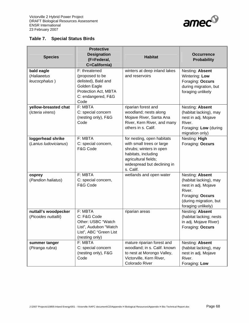
Victorville 2 Hybrid Power Project DRAFT Biological Resources Assessment ENSR International 23 February 2007
J:\2007 Projects\10855-Inland Energy\001 - Victorville II\AFC document\CD\Appendix H Biological Resources\Appendix H Bio Technical Report.doc Page 68
Table 7. Special Status Birds
Species
Protective Designation (F=Federal,
C=California)
Habitat Occurrence Probability
bald eagle (Haliaeetus leucocphalus )
F: threatened (proposed to be delisted), Bald and Golden Eagle Protection Act, MBTA C: endangered, F&G Code
winters at deep inland lakes and reservoirs
Nesting: Absent Wintering: Low Foraging: Occurs during migration, but foraging unlikely
yellow-breasted chat (Icteria virens)
F: MBTA C: special concern (nesting only), F&G Code
riparian forest and woodland; nests along Mojave River, Santa Ana River, Kern River, and many others in s. Calif.
Nesting: Absent (habitat lacking), may nest in adj. Mojave River. Foraging: Low (during migration only)
loggerhead shrike (Lanius ludovicianus)
F: MBTA C: special concern, F&G Code
for nesting, open habitats with small trees or large shrubs; winters in open habitats, including agricultural fields; widespread but declining in s. Calif.
Nesting: High Foraging: Occurs
osprey (Pandion haliatus)
F: MBTA C: special concern, F&G Code
wetlands and open water Nesting: Absent (habitat lacking), may nest in adj. Mojave River. Foraging: Occurs (during migration, but foraging unlikely)
nuttall’s woodpecker (Picoides nuttallii)
F: MBTA C: F&G Code Other: USBC “Watch List”, Audubon “Watch List”, ABC “Green List (nesting only)
riparian areas Nesting: Absent (habitat lacking; nests in adj. Mojave River) Foraging: Occurs
summer tanger (Piranga rubra)
F: MBTA C: special concern (nesting only), F&G Code
mature riparian forest and woodland; in s. Calif. known to nest at Morongo Valley, Victorville, Kern River, Colorado River
Nesting: Absent (habitat lacking), may nest in adj. Mojave River. Foraging: Low

Victorville 2 Hybrid Power Project DRAFT Biological Resources Assessment ENSR International 23 February 2007
J:\2007 Projects\10855-Inland Energy\001 - Victorville II\AFC document\CD\Appendix H Biological Resources\Appendix H Bio Technical Report.doc Page 69
Table 7. Special Status Birds
Species
Protective Designation (F=Federal,
C=California)
Habitat Occurrence Probability
white-faced ibis (Plegadis chihi)
F: MBTA C: special concern, F&G Code
freshwater marsh with dense emergent vegetation for breeding
Nesting: Absent (habitat lacking) Foraging: Absent (occurs in areas of the Mojave River during migration)
rufous hummingbird (Selasphorus rufus )
F: MBTA C: F&G Code Other: Forest Service sensitive, USBC “Watch List”, Audubon “Watch List”, ABC “Green List” (nesting only)
nests in Pacific northwest Nesting: Absent (habitat lacking, out of range) Foraging: Occurs (during migration only)
brewer’s sparrow (Spizella breweri )
F: BCC, MBTA C: F&G Code Other: USBC “Watch List”, Audubon “Watch List”, ABC “Green List” (nesting only)
Great Basin sage scrub Nesting: Absent (habitat lacking) Foraging: Occurs (in winter and migration only)
chipping sparrow (Spizella passerina )
F: MBTA C: F&G Code Other: CNDDB ranking G5S3S4 (nesting only)
oaks and moderate to high elevation habitats
Nesting: Absent (habitat lacking) Foraging: Occurs (in winter and migration only)
California thrasher (Toxostoma redivium)
F: MBTA C: F&G Code Other: USBC “Watch List”, Audubon “Watch List”, ABC “Green List”
thickets Nesting: Absent (habitat lacking) may nest in adj. Mojave River. Foraging: Occurs
Le Conte’s thrasher (Toxostoma lecontei)
F: BCC, MBTA C: Special Concern, F&G Code Other: BLM sensitive, USBC “Watch List”, Audubon “Watch List”, ABC “Green List”
variety of arid habitats, often in open, sparsely vegetated areas (e.g. saltbush scrub, sparse creosote bush scrub), often nests in cactus
Nesting: Moderate Foraging: Occurs (observed along portions of Segment 1)
least Bell’s vireo (Vireo bellii pusillus)
F: endangered, MBTA (nesting), MBTA C: endangered (nesting), F&G Code
willow riparian woodlands Nesting: Absent (habitat lacking), may nest in adj. Mojave River. Foraging: Low

Victorville 2 Hybrid Power Project DRAFT Biological Resources Assessment ENSR International 23 February 2007
J:\2007 Projects\10855-Inland Energy\001 - Victorville II\AFC document\CD\Appendix H Biological Resources\Appendix H Bio Technical Report.doc Page 70
Table 7. Special Status Birds
Species
Protective Designation (F=Federal,
C=California)
Habitat Occurrence Probability
gray vireo (Vireo vicinior)
F: MBTA C: special concern, F&G Code
pinyon-juniper woodland, Mojave juniper scrub, chamise and redshank chaparral
Nesting: Low (in Mojave Juniper Scrub vegetation community in southern ½ of Segment 3 only) Foraging: Low-Moderate
Tricolored Blackbird
The Tricolored blackbird (Agelaius tricolor) is managed as a CSC by the CDFG (while nesting) and protected by the MBTA and Fish and Game Code Section 3513. This highly colonial member of the Icteridae (Blackbird and relatives Family) primarily nests in freshwater wetland areas with tall thickets of cattails or tules, and in willow thickets, blackberry brambles, and wild rose. It typically forages over nearby field and scrub habitats. The Tricolored blackbird is mostly a resident of California, where it is believed to be steadily declining (CDFG 2005).
The Tricolored blackbird was not detected by the field work conducted for this Project. This species was reported occurring within an area of the Mojave River during surveys conducted for the SCLA Specific Plan Amendment and Rail Service Project (Tom Dodson Associates 2003). Requisite nesting habitat for this species is not present on the Project site, although the species may forage over the site.
Long-eared Owl
The Long-eared owl (Asio otus) is not listed as threatened or endangered by either of the state or federal regulatory agencies. This species is however managed as a CSC by the CDFG and protected by the MBTA and California Fish and Game Code Sections 3503, 3503.5, 3513, and 3800. This member of the Strigidae (Typical Owl family) is an uncommon winter visitor of Southern California deserts. Long-eared owls are closely associated with riparian habitats, however also uses stands of live oak and other dense thickets of trees for nesting.
The Long-eared owl was not observed on the Project site during the field work conducted for this Project. It has been reported to occur in the vicinity of the Segment 3 portion of the electrical transmission line corridor. The species may also occur within the Mojave River in the vicinity of the Project site during the winter and possibly forage over the site.
Burrowing Owl
The burrowing owl (Athene cunicularia) is a small, tan, short-tailed, ground-dwelling owl that occupies underground burrows. A member of the Strigidae (Typical Owl family), the burrowing owl is associated with grasslands and other arid open terrain, including Mojave creosote bush

Victorville 2 Hybrid Power Project DRAFT Biological Resources Assessment ENSR International 23 February 2007
J:\2007 Projects\10855-Inland Energy\001 - Victorville II\AFC document\CD\Appendix H Biological Resources\Appendix H Bio Technical Report.doc Page 71
scrub, throughout much of the western United States. Burrowing owls are opportunistic in their selection of burrows, typically utilizing the burrows of small mammals (e.g., kit fox), but also use desert tortoise burrows, drain pipes, culverts, and other suitable cavities at or below ground level. In California, the species often occurs in association with colonies of the California ground squirrel (Spermophilus beecheyi), where it makes use of the squirrel’s burrows. The entrance of the burrow is often adorned with animal dung, feathers, debris, and other small objects. The species is active both day and night, and may be seen perching conspicuously on fence posts or standing at the entrance of their burrows. Due to the characteristic fossorial habits of burrowing owls, nest burrows are a critical component of their habitat. In southern California, burrowing owls are not only found in undisturbed natural areas, but also fallow agricultural fields, margins of active agricultural areas, livestock farms, airports, and vacant lots. In spite of their apparent tolerance to human activities, burrowing owl populations in California are clearly declining and, if declines continue, the species may qualify for listing under the state and/or federal ESA(s) (CDFG 1995). The declines in burrowing owl populations are attributed to loss and degradation of habitat, to ongoing residential and commercial development, and to rodent control programs. The burrowing owl is currently designated a CSC by the CDFG, managed as a Bird of Conservation Concern (BCC) by the USFWS, is considered “sensitive” by the BLM, protected by the MBTA and California Fish and Game Code Sections 3503, 3503.5, 3513, and 3800.
As depicted in Appendix 1, Map 11, evidence of burrowing owls (i.e., borrows exhibiting whitewash, feathers, pellets, etc.) in addition to live burrowing owls were observed throughout various areas of the Project footprint, 500-foot buffer areas, and within the 2,400-foot ZOI during the focused burrow search and during general biological and focused survey work conducted for other species (i.e., Mohave ground squirrel, desert tortoise). A total of at least four live burrowing owls were observed occupying separate burrow locations in and around different areas of the Project site during the surveys. One was in the ZOI of the one of the construction staging areas, approximately 900 feet northwest of the northwest corner of the western construction staging area. Another was in the buffer zone of Segment 1 of the transmission line corridor, approximately 300 feet southwest of the ROW. The two other owls were observed within an area of Segment 2 of the transmission line corridor. One was outside the existing transmission line corridor approximately 120 feet away from one of the proposed pulling areas for line stringing. The other was located within the existing transmission line corridor, directly under the existing Hoover transmission line, approximately 220 feet away from the centerline of the location of the proposed new line. Although most of these owls are technically offsite (outside the proposed disturbance footprint), three are within the 500-foot buffer zone area as defined by the Burrowing Owl Consortium Survey Guidelines. One burrowing owl carcass/remains was also observed at one location along Segment 1. Additionally, at least 40 burrows of small mammals (primarily ground squirrels), 36 burrows or colonies of kit fox, and 39 desert tortoise burrows were observed across much of the site and within the ZOI. These burrows provide ample nesting opportunities for this fossorial species, and many of the burrows observed that exhibited burrowing owl sign are either currently or were historically also occupied by kit foxes and or desert tortoises.
It should be noted, however, that due to the timing of authorizations to conduct biological surveys in some areas, focused surveys for the burrowing owl conducted during the 2006

Victorville 2 Hybrid Power Project DRAFT Biological Resources Assessment ENSR International 23 February 2007
J:\2007 Projects\10855-Inland Energy\001 - Victorville II\AFC document\CD\Appendix H Biological Resources\Appendix H Bio Technical Report.doc Page 72
nesting season were not conducted in some areas (i.e., portions of Segment 1, all of Segment 2 and all of Segment 3) of the Project site.
Swainson’s Hawk
Swainson’s hawk is listed as threatened by the CDFG. Swainson’s hawk is also managed as a sensitive by the U.S. Forest Service, on the USBC and Audubon “Watch Lists” and on the ABC “Green List.” Additionally, this species is also protected by the MBTA and under California Fish and Game Code Sections 3503, 3503.5, 3513, and 3800. The Swainson’s hawk population in California numbers between 700 and 1,000 breeding pairs (most of which nest in the Central Valley), which is approximately 10 percent of the historic population (www.swainsonshawk.org). This 90% decline in the Swainson’s hawk population in California has been ongoing since the early 1900s and is primarily due to new suburban development of agricultural lands. This species has evolved a strong cooperative relationship with agriculture, which is being rapidly replaced with residential and commercial development throughout our state. This large (45.72 cm [18 in.] long), long/broad-winged (1.24 m [49 in.] wingspan), long-tailed hawks diet primarily consists of small mammals, however reptiles, other birds, and insects are also taken. This member of the Accipitridae (Hawk family) nest in tall trees (including Joshua trees), often near rivers, creeks and canals, often adjacent to agriculture and pasture lands. In southern California, this species nests in the Antelope Valley, and nested in the early 1980s in the eastern Mojave Desert (Lanfair Valley).
Swainson’s hawks were observed flying over the Project site on two occasions during the field surveys. These individuals were migrating north along the Mojave River. Swainson’s hawks only very rarely breed or nest in southern California. Considering the thoroughness and timing of the biological surveys on the Project site, AMEC biologists are confident that this species would have been detected, had it been nesting onsite. For this reason, nesting Swainson’s hawks are considered to be absent from the Project site.
Costa's Hummingbird
Costa’s hummingbird (Calypte costae) is not listed as endangered or threatened by either of the state or federal regulatory agencies, nor is it designated as a CSC by the CDFG. However, this species is managed as sensitive by the U.S. Forest Service, on the USBC and Audubon “Watch List,” on the ABC “Green List,” protected by the MBTA, Fish and Game Code Section 3513 and included on the CDFG 2006 Special Animals list. This small, attractive member of the Trochilidae (Hummingbird family) nests in a wide variety of trees, shrubs, cacti, woody forbs, and sometimes vines in a variety of habitats, including Mojave Desert scrubs, throughout the arid southwest (CDFG 2005).
Costa’s hummingbird was detected onsite on several occasions during the field work conducted for the VV2 Project. Although the Project site does not provide an abundance of nesting habitat for this species, they could nest in the ornamental trees surrounding the rural home sites, in the larger washes bisecting the site, and in the riparian habitat located within the adjacent Mojave River. For this reason, Costa’s hummingbird is considered to have a low potential to nest on the Project site.

Victorville 2 Hybrid Power Project DRAFT Biological Resources Assessment ENSR International 23 February 2007
J:\2007 Projects\10855-Inland Energy\001 - Victorville II\AFC document\CD\Appendix H Biological Resources\Appendix H Bio Technical Report.doc Page 73
Lawrence’s Goldfinch
Lawrence’s goldfinch (Carduelis lawrencei) is not listed as endangered or threatened by either of the state or federal regulatory agencies, nor is it designated as a CSC by the CDFG. This species is however, included on the CDFG 2006 Special Animals list, protected by the MBTA, Fish and Game Code Section 3513, on the USBC and Audubon “Watch List”, and on the ABC “Green List”. This colorful, seed-eating member of the Fringillidae (Fringilline and Cardueline Finch family) breeds in open oak or other arid woodlands and chaparral, near water. Typical habitats in southern California include desert riparian, palm oasis, pinyon-juniper, and lower montane habitats. Nearby herbaceous habitats often used for feeding (CDFG 2005)
Lawrence’s goldfinch was detected onsite on several occasions during the field work conducted for this Project. Nesting habitat, however, is not present on the Project site. As a result this species is expected to utilize the site for foraging during migration only.
Vaux’s Swift
Vaux’s swift (Chaetura vauxi) is designated a CSC by the CDFG, protected by the MBTA and Fish and Game Code Section 3513. This drab-colored member of the Apodidae (Swift family) nests in hollowed out tree trunks in coniferous forests from Western British Columbia south to northwestern California. This species generally forages over openings in forest and along stream courses where it eats high flying insects.
Vaux’s swift was observed foraging over the site during spring migration. However, this species does not nest in southern California. Therefore, Vaux’s swift is expected to forage over the site during migration only.
Northern Harrier
The Northern harrier (Circus cyaneus) was observed flying over the Project site on at least one occasion. This medium-sized (41.91 cm [16.5 in. in length), long-winged (1 m [42 in.] wingspan), long-tailed member of the Accipitridae (Hawk family) predates small mammals, reptiles, amphibians, and birds. Northern harriers nest in marshes and use adjacent areas (e.g., sage scrubs, grasslands, riparian, agriculture) for foraging and breeding territories. Nesting Northern Harriers are managed as CSC by the CDFG and afforded protection under the MBTA and under California Fish and Game Code Sections 3503, 3503.5, 3513, and 3800.
Although observed either foraging or migrating over the Project site, nesting habitat for this species is not present on the Project site. The species may nest, however, in the adjacent Mojave River.
Western Yellow-billed Cuckoo
The western yellow-billed cuckoo (Coccyzus americanus occidentalis) is state-listed as endangered and a candidate for federal-listing as threatened or endangered west of the Rocky Mountains. The western yellow-billed cuckoo is also afforded protection under the MBTA and Fish and Game Code (Section 3513). While this distinctive member of the Cuculidae (Cuckoo,

Victorville 2 Hybrid Power Project DRAFT Biological Resources Assessment ENSR International 23 February 2007
J:\2007 Projects\10855-Inland Energy\001 - Victorville II\AFC document\CD\Appendix H Biological Resources\Appendix H Bio Technical Report.doc Page 74
Roadrunner, and Ani family) is relatively common east of the Rocky Mountains, there is concern for loss or degradation of the subspecies’ riparian habitat in the West. Its breeding range formerly included most of North America from southern Canada to Mexico. Western yellow-billed cuckoos breed in large blocks of riparian habitats, particularly woodlands with cottonwoods and willows. Dense understory foliage appears to be an important habitat feature.
The western yellow-billed cuckoo was not detected on the Project site during the surveys conducted. There is a 1978 record of this species from the Mojave River, approximately 11 miles southeast of the Project site (CNDDB data), and it was been detected in the same area several times throughout the late 1980s and early 1990s (S. Myers pers. comm.) . The Project site lacks the requisite riparian habitat for this species. Therefore, the western yellow-billed cuckoo is considered to be absent from the Project site. There is, however, potentially-suitable habitat for this species located within the Mojave River which is immediately adjacent to a portion of the Segment 1 reclaimed water pipeline. For this reason, and due to the rarity of this species in California, AMEC considers there to be a very low potential for this species to occur (for foraging only) on this area of the Project site. Potential indirect impacts to this species as a result of Project activities (i.e., loud noise, operation of heavy equipment, etc.) conducted during the nesting season (generally 15 Feb. through 31 Aug.) are remotely possible, however, due to the proximity of portions of Segment 1 to potentially suitable habitat. For this reason, construction activities (i.e., reclaimed water pipeline installation) within the areas of Segment 1 located in proximity to riparian vegetation communities within the Mojave River would be conducted outside the nesting season of this species. Additionally, biological monitoring during construction in this area of the Project site would further ensure that no impacts to this species or its habitat result from Project activities. A detailed assessment of potential indirect impacts to this species is discussed in Section 7.3.3. Recommended mitigation is discussed in Section 8.1.6.
Hermit Warbler
The hermit warbler (Dendroica occidentalis) is not listed or designated as a sensitive species by either the CDFG or USFWS, however is included on the CDFG 2006 Special Animals list, on the Audubon “Watch List”, the ABC “Green List”, protected under the MBTA and Fish and Game Code (Section 3513). This member of the Parulidae (Wood-Warbler family) is an uncommon spring and fall migrant in the area. Hermit warblers nest in coniferous forests in the Pacific Northwest where it generally prefers mature stands of pine and douglas fir. This species is also found in lower densities in subalpine forests dominated by subalpine fir, lodgepole pine, and other conifers. In the California mountains, Hermit warblers are found in forests of red and white fir, sugar, ponderosa, jeffrey, and lodgepole pine, and giant sequoia. This species generally avoids areas with a high deciduous volume; and does not nest in riparian or clearcut areas.
One pair of hermit warblers was observed within the ZOI surveys conducted for the desert tortoise on Segment 1 of the electrical transmission line corridor. Because this species does not nest in southern California, nesting hermit warblers are considered absent from the site. This species is only expected to forage on the site during migration.

Victorville 2 Hybrid Power Project DRAFT Biological Resources Assessment ENSR International 23 February 2007
J:\2007 Projects\10855-Inland Energy\001 - Victorville II\AFC document\CD\Appendix H Biological Resources\Appendix H Bio Technical Report.doc Page 75
Yellow Warbler
The yellow warbler (Dendroica petechia) is managed as a CSC by the CDFG (while nesting) as well as afforded protection under the MBTA and protected by Fish and Game Code (3513). This species is typically found in riparian deciduous habitats during the summer. This member of the Parulidae (Wood-Warbler family) also breeds in montane shrubbery in open conifer forests. During migration, yellow warblers routinely visit woodlands, forests, and shrub habitats (CDFG 2005).
Yellow warbler was not observed during the surveys conducted for this Project. Furthermore, although the species is considered to have the potential to nest in the riparian habitats within the Mojave River, requisite nesting habitat is not present on the Project site for this species. There is a moderate potential for it to occur on the site during migration and/or for foraging.
Southwestern Willow Flycatcher
The southwestern willow flycatcher (Empidonax trailii extimus) is listed as state and federally endangered by the CDFG and the USFWS, as well as protected by the MBTA and Fish and Game Code Section 3513. This subspecies of the willow flycatcher (E. t. trailii) was formerly considered a common summer resident in southern California’s lowland willow thickets (Grinnell and Miller 1944). This species has suffered significant declines through habitat loss. This factor, along with the large-scale invasion of the coastal lowlands by brown-headed cowbirds (Molothrus ater) in the 1920s, has resulted in the flycatcher being nearly extirpated from southern California (Garrett and Dunn 1981). Recent surveys have revealed surviving populations along the Santa Margarita and San Luis Rey rivers in San Diego County, in the San Bernardino Mountains and along the Mojave River in San Bernardino County, in the lower Colorado River Valley, and along the Santa Ynez River in Santa Barbara County, the Santa Clara River in Ventura County, and the South Fork of the Kern River in Kern County (Unitt 1987, Marshall 2000). On October 19, 2005, the USFWS designated critical habitat for the southwestern willow flycatcher. This final rule divided critical habitat for this species into separate units. The Mojave Management Unit is located within the Mojave River immediately adjacent to (within an approximate 150 feet of) portions of Segments 1 and 2 of the Project site (see Appendix 1, Map 12).
The southwestern willow flycatcher was not observed on the Project site during any of the field work conducted. Obligate riparian nesting habitat, although potentially present within adjacent offsite habitat in the Mojave River, is not present onsite. However, portions of Segment 1 are in close proximity to potentially suitable habitat and designated critical habitat. For this reason, construction activities (i.e., reclaimed water pipeline and transmission line installation) within the areas of Segment 1 located in proximity to riparian vegetation communities within the Mojave River would be conducted outside the nesting season of this species. Additionally, biological monitors familiar with this species would be present during construction of this area of the Project site to further ensure that no impacts to this species or its habitat result from Project activities.
Victorville 2 Hybrid Power Project DRAFT Biological Resources Assessment ENSR International 23 February 2007
J:\2007 Projects\10855-Inland Energy\001 - Victorville II\AFC document\CD\Appendix H Biological Resources\Appendix H Bio Technical Report.doc Page 76
Prairie Falcon
The prairie falcon (Falco mexicanus) is designated a CSC by the CDFG, afforded protection under California Fish and Game Code Sections 3503, 3503.5, 3513, and 3800, as well as by the MBTA. This member of Falconidae (Caracaras and Falcon family) typically nest on cliffs that provide ample nesting niches (e.g., holes, cracks, ledges, rock shelters) and forage widely over varied habitats. Prairie falcons predate mammals, especially ground squirrels and rabbits, and ground-dwelling birds such as California quails and chukars. During the winter, horned larks and western meadowlarks are also significant source of prey for this species.
Several prairie falcons were observed throughout various areas of the Project site during the biological field work (see Appendix 1, Map 8). This species has also been documented nesting in the vicinity of the Project site (CNDDB 2003). Although known to nest in the mountains in the general vicinity, nesting habitat (i.e., cliffs) is not present on the site; therefore, nesting prairie falcons are considered absent from the site. The prairie falcon occurs on site for foraging purposes during migration and especially during winter.
Bald Eagle
The bald eagle is currently listed as endangered by the CDFG and threatened by the USFWS. In 1999, the USFWS was petitioned to delist the species; the petition asserted that recovery efforts had been successful, and therefore the species no longer warranted the federally-threatened status. The USFWS has not ruled on the matter, but it has extended the comment period for this proposed delisting until June 19, 2007. At this time, the bald eagle remains a state and federally-listed species. The bald eagle is also afforded protection under the Bald and Golden Eagle Protection Act of 1940, as amended, the MBTA and under California Fish and Game Code (sections 3503, 3503.5, 3513, and 3800). This large bird (approximately 1 m (3 ft.) in height; 2.3 m (7 ft.) wingspan) is designated the National Bird of the U.S.
Bald eagles are distinctive as adults, having an entirely white head and tail, dark brown body, and a large yellow curved beak. Juveniles lack the solid white head, and have blotches of white on the underside of the wings and tail. This large, distinctive member of the Accipitridae (Hawk family) is both a bird of prey and a scavenger, primarily eating fish, but also feeding on small mammals, waterfowl, wading birds, and carrion.
A single bald eagle was observed flying over a portion of Segment 1 of the electrical transmission line corridor on one occasion. The Mojave River is a well known migratory route for many migratory bird species, including bald eagles. Bald eagles generally migrate to southern California from their northern breeding range to winter around bodies of permanent water (e.g., Silverwood Lake, Big Bear Lake, Lake Arrowhead, Lake Matthews, Lake Hemet, Lake Skinner, etc.). This individual was likely migrating north for the breeding season. Nesting habitat for bald eagles is not present on the Project site.

Victorville 2 Hybrid Power Project DRAFT Biological Resources Assessment ENSR International 23 February 2007
J:\2007 Projects\10855-Inland Energy\001 - Victorville II\AFC document\CD\Appendix H Biological Resources\Appendix H Bio Technical Report.doc Page 77
Yellow-breasted Chat
The yellow-breasted chat (Icteria virens) is designated a CSC by the CDFG and protected under the MBTA and Fish and Game Code Section 3513. This large (6.5 in. length) member of the Parulidae (Wood Warbler family) exhibits a yellow throat and breast, olive green back and wings, and white “spectacle” markings around the eye, all of which make this species distinctive from other species within its range. The yellow-breasted chat is a Neotropical migrant that primarily eats insects, and to a lesser extent, fruit. This species resides in densely vegetated thickets, and is most commonly associated with riparian vegetation communities in southern California. The yellow-breasted chat is declining due to habitat loss, primarily from deforestation and urban development, and is somewhat vulnerable to brood parasitism from brown-headed cowbirds.
The yellow-breasted chat nests fairly commonly along the Mojave River from Victorville to Helendale (as many as 25 nesting pairs, S. Myers pers. comm.). Suitable habitat exists in the riparian habitat within the Mojave River adjacent to the Project site, however not on the site. For this reason, nesting yellow-breasted chat is considered to be absent from the site.
Loggerhead Shrike
The loggerhead shrike (Lanius ludovicianus) is managed as a CSC by the CDFG, a “Bird of Conservation Concern” (BCC) by USFWS, protected under the MBTA and Fish and Game Code Section 3513. This passerine (perching bird) member of the Laniidae (Shrike family) is a highly voracious predator on insects and small vertebrates (e.g., reptiles, birds, and mammals). It nests in trees and shrubs throughout most of the U.S. and portions of southern Canada. This species has declined throughout much of its range, particularly in Canada, as well as the Gulf States and Midwest, where are a variety of factors including habitat loss and pesticide use have impacted this species. Creosote bush scrub and Joshua tree woodland plant communities are favored by the species within the western Mojave Desert. This species is also known to occasionally nest in Joshua trees. Populations occupying inland southern California, currently appear to be relatively stable despite ongoing losses of natural habitats.
The loggerhead shrike was observed on the Project site by AMEC biologists on several occasions throughout the spring and summer months. Because the species appears to be resident on the Project site and because it is known to nest in Joshua trees which are distributed throughout the site, it is likely that the loggerhead shrike nests on the site.
Osprey
The osprey (Pandion haliaetus) is designated a CSC by the CDFG. This species is also afforded protection under California Fish and Game Code Sections 3503, 3503.5, 3513, and 3800 and by the MBTA. This large (56 cm [22 in.] in length) member of the Accipitridae (Hawk family) has a wingspan of 1.37 m. (54 in.). Ospreys primarily eat fish and build large stick nests in trees and on high cliffs or on top of large rock outcrops.
Ospreys were observed flying over the Mojave River and adjacent VVWRA facility on several occasions during the field work. In the Victor Valley area this species is a fairly common

Victorville 2 Hybrid Power Project DRAFT Biological Resources Assessment ENSR International 23 February 2007
J:\2007 Projects\10855-Inland Energy\001 - Victorville II\AFC document\CD\Appendix H Biological Resources\Appendix H Bio Technical Report.doc Page 78
migrant and is uncommon during winter. The site, however, does not afford any nesting or foraging opportunities for this primarily fish-eating species.
Nuttall’s Woodpecker
Nuttall’s woodpecker (Picoides nuttallii) is not listed or designated as a species of concern by the CDFG or USFWS. This species is, however, included CDFG Special Animals list, on the USBC and Audubon “Watch Lists,” on the ABC “Green List,” and protected under the MBTA and Fish and Game Code Section 3513. In the northern parts of their range, this member of the Picidae (Woodpecker family) is most abundant in oak woodlands, however in southern California, it occurs in both oak habitats and streamside deciduous woodlands dominated by willows and/or cottonwoods. Along the Mojave River, it is the most common of the five woodpecker species known to nest in the area (S. Myers pers. comm.)
Nuttall’s woodpecker was detected several times on or adjacent to areas of Segment 1 in proximity to the Mojave River, and is common in the riparian habitat located in the river. Although this species likely nests within the adjacent riparian habitat in the riverbed nesting Nuttall’s woodpeckers are considered to be absent from the Project site.
Rufous Hummingbird
The Rufous hummingbird (Selasphorus rufus) is not listed as endangered or threatened by either the CDFG or USFWS, nor is it designated as a CSC by the CDFG. It is however included on the CDFG Special Animals list, managed as a sensitive species by the U.S. Forest Service, included on the USBC and Audubon “Watch Lists”, ABC “Green List” and protected under the MBTA and Fish and Game Code Section 3513. In southern California, this member of the Trochilidae (Hummingbird family) is a migrant; it breeds from extreme northwestern California north to Alaska, and winters in Mexico.
Although this species was observed in open desert scrub during Mohave ground squirrel trapping and is a common migrant in both spring and fall, rufous hummingbirds do not nest in southern California.
Brewer’s Sparrow
Brewer’s sparrow (Spizella breweri ) is a small sparrow that breeds primarily in the Great Basin. This member of the Emberizidae (Emberizine family) also breeds locally in sagebrush habitats in the San Bernardino Mountains and in the mountain ranges of the eastern Mojave Desert. This species has no special status designation by USFWS or CDFG, however is included on the CDFG Special Animals list, on the USBC and Audubon “Watch Lists”, ABC “Green List”, afforded protection under the MBTA and Fish and Game Code (Section 3513).
Brewer’s sparrow was observed on the Project site often during the months of February, March, and April. It is a migrant and/or winter visitor only, as the species is only breeds in the mountains.

Victorville 2 Hybrid Power Project DRAFT Biological Resources Assessment ENSR International 23 February 2007
J:\2007 Projects\10855-Inland Energy\001 - Victorville II\AFC document\CD\Appendix H Biological Resources\Appendix H Bio Technical Report.doc Page 79
Chipping Sparrow
Also a member of the Emberizidae, the chipping sparrow (Spizella passerina) is a common breeding species of southern California’s mountains. In the Mojave Desert, it is a common migrant and uncommon winter visitor. This species is included on the CDFG Special Animals list, however it has no CDFG or USFWS designations. Nevertheless, the chipping sparrow is protected under the MBTA and Fish and Game Code Section 3513.
The chipping sparrow was observed on the Project site, and winter visitors and migrants are especially common near the Mojave River. Nesting habitat for this species is not present on the Project site.
Summer Tanager
The summer tanager (Piranga rubra) is designated a CSC by the CDFG and protected by the MBTA and Fish and Game Code Section 3513. This small (16.5 cm [6.5 in.] in length), colorful passerine belonging to the Thraupidae (Tanager family) generally inhabits riparian vegetation communities in the southwestern U.S. In the eastern U.S., it is more associated with open woodlands of mixed oak and other hardwood trees. Summer tanagers typically perch on the highest treetops and eat primarily flying insects, which it catches on the wing, and to a lesser extent fruit. The Mojave River provides extensive nesting habitat for this species, and in California its summer tanager population is exceeded only by that of the South Fork Kern River.
The summer tanager was not observed on the Project site. Although the riparian habitat within the adjacent Mojave River is suitable for this species, the onsite habitat is not.
White-faced Ibis
The white-faced ibis (Plegadis chihi) is managed as a CSC by the CDFG as well as afforded protection by the MBTA and Fish and Game Code Section 3513. This member of the Threskiornithidae (Ibis family) is an uncommon summer resident in sections of southern California, however more common and widespread during migration. This species generally forages in fresh emergent wetland, shallow lacustrine waters, muddy ground of wet meadows, and irrigated or flooded pastures and croplands. White-faced ibis nest in densely-vegetated, emergent freshwater wetlands. This species has declined in California and ceased nesting regularly in areas where it once formerly bred, a likely result of destruction of extensive marshes in the state (CDFG 2005).
White-faced ibis was not observed on, or in the vicinity of the site during any of the biological field surveys conducted for this Project. This species was, however, reported occurring along the Mojave River in at least one location during other biological field surveys conducted for the SCLA Specific Plan Amendment and Rail Service Project EIR (Tom Dodson Associates 2003).
Requisite dense freshwater emergent vegetation habitat for this species, although potentially present within the Mojave River in the vicinity of the site, is not present on the Project site. For this reason the white-faced ibis is considered to be absent from the Project site.

Victorville 2 Hybrid Power Project DRAFT Biological Resources Assessment ENSR International 23 February 2007
J:\2007 Projects\10855-Inland Energy\001 - Victorville II\AFC document\CD\Appendix H Biological Resources\Appendix H Bio Technical Report.doc Page 80
California Thrasher
The California thrasher (Toxostoma redivivum) is included on CDFG Special Animals list, on the USBC and Audubon “Watch Lists,” on the ABC “Green List,” and protected by the MBTA and Fish and Game Code Section 3513. This member of the Mimidae (Mockingbird and Thrasher family) is nearly endemic to California, however also occurs in extreme northern Baja California. It is primarily a bird of chaparral and sage scrub habitats, but also occurs in riparian scrub. In the Mojave Desert, it occurs along the Mojave River as far downstream as Helendale.
The California thrasher was observed in the larger washes that bisect portions of Segment 1 of the Project’s electrical transmission line. Nesting is probably confined to the nearby Mojave River bed.
Le Conte’s Thrasher
The Le Conte’s thrasher (Toxostoma lecontei) is designated a CSC by the CDFG and protected by the MBTA and Fish and Game Code Section 3513. This medium sized, non-migratory member of the Mimidae is endemic to four southwestern states and northwestern Mexico. Although widespread, this species is an uncommon to rare resident of desert scrub habitats. Within the West Mojave Desert, the species occurs in the Antelope Valley north to eastern Kern County, including California City, and Ridgecrest. In the southern portion of the West Mojave Desert, the species occurs throughout Joshua Tree National Park and west along the northern bases of the San Bernardino and San Gabriel Mountains. Open desert with scattered shrubs and sandy and/or alkaline soil are preferred by the Le Conte’s thrasher. Creosote bush scrub and Joshua tree woodland vegetation communities are favored by this species within the western Mojave Desert. The nests are typically placed in a cactus, thorny shrub, or small tree, selected to offer protection from predators and the sun.
At least two Le Conte’s thrashers were observed in two locations along Segment 1 of the electrical transmission line during biological surveys (see Appendix 1, Map 8). Additionally, suitable nesting habitat is present throughout much of the site. This species was also reported in the immediate vicinity of the site, possibly on the site, during biological field survey work for the SCLA Specific Plan Amendment and Rail Service Project EIR (Tom Dodson & Associates 2003).
Least Bell’s Vireo
The least Bell's vireo (Vireo bellii pusillus) is listed as endangered by the CDFG and by the USFWS. The least Bell's vireo is a small, migratory, insectivorous bird species that occurs in willow-dominated riparian habitats. Although this species is drab in plumage and can be secretive within its densely vegetated habitat, males are easy to detect on the breeding grounds due to their conspicuous and diagnostic song. Nesting habitat of this member of the Vireonidae (Vireo family) is restricted to willow and/or mulefat dominated riparian scrub along permanent or nearly permanent streams (Grinnell and Miller 1944, Goldwasser 1978, Franzreb 1987, Garrett and Dunn 1981). Least Bell's vireos were formerly widespread and common throughout low-lying riparian habitats of central and southern California, but are now restricted to a limited number of locations in southern California. Habitat reduction has contributed to this species' significant population declines. Nest parasitism by brown-headed cowbirds has also seriously

Victorville 2 Hybrid Power Project DRAFT Biological Resources Assessment ENSR International 23 February 2007
J:\2007 Projects\10855-Inland Energy\001 - Victorville II\AFC document\CD\Appendix H Biological Resources\Appendix H Bio Technical Report.doc Page 81
impacted reproductive success by least Bell's vireo, as well as many other species which build cup nests (Goldwasser 1978). The USFWS designated critical habitat for this species on February 2, 1994. The nearest designated critical habitat for the least Bell’s vireo is located approximately 26 miles south of the Project site.
This species was not observed on the Project site, nor is it expected to occur. Suitable nesting habitat, although potentially present within the adjacent Mojave River riparian vegetation, is not present on the site. Therefore, this species is considered to be absent from the site. Potential indirect impacts to this species as a result of Project activities (i.e., loud noise, operation of heavy equipment, etc.) conducted during the nesting season (generally 15 Feb. through 31 Aug.) are possible, however, due to the proximity of portions of Segment 1 to potentially suitable habitat. For this reason, construction activities (i.e., reclaimed water pipeline installation) within the areas of Segment 1 located in proximity to riparian vegetation communities within the Mojave River would be conducted outside the nesting season of this species. Additionally, biological monitors familiar with this species would be present during construction of this area of the Project site to further ensure that no impacts to this species or its habitat result from Project activities.
Gray Vireo
Gray vireo (Vireo vicinior) is not state or federally listed; however it is designated as a CSC by the CDFG and afforded protection by Fish and Game Code Section. This member of the Vireonidae (Vireo family) is an uncommon, local, summer resident in arid pinyon-juniper, juniper, and chamise-redshank chaparral vegetation communities from 600-2000 m (2000-6500 ft) in mountains of the eastern Mojave desert, on northeastern slopes of the San Bernardino Mts., as well as the San Jacinto Mountains and the southern slopes of the Laguna Mountains.
The gray vireo was not observed on the Project site during the biological surveys. Focused surveys for this species, however, were not conducted for this species. There is a low potential for this species to nest in the juniper scrub habitat along the southern approximate ½ of Segment 3 of the Project transmission line corridor.
6.6.4 Special-Status Mammals
Three sensitive mammal species are known to occur in the vicinity of the Project site. These include the Mohave ground squirrel (Spermophilus mohavensis), Mohave river vole (Microtus californicus mohavensis), and pallid San Diego pocket mouse (Chaetodipus fallax pallidus). Each of these species and their potential to occur with in the Project site and vicinity are presented in Table 8 and discussed separately below.
Mohave Ground Squirrel
The Mohave ground squirrel is restricted to the western Mojave Desert, and occurred historically from near Palmdale on the southwest, southeast to Lucerne Valley, northwest to Olancha, and northeast to the Avawatz Mountains (Gustafson 1993). There are a few recent records of the species in the southern portion of its range (Palmdale to Victorville area), including a juvenile captured in the Victorville area during July 2005. Urbanization and other impacts to its desert

Victorville 2 Hybrid Power Project DRAFT Biological Resources Assessment ENSR International 23 February 2007
J:\2007 Projects\10855-Inland Energy\001 - Victorville II\AFC document\CD\Appendix H Biological Resources\Appendix H Bio Technical Report.doc Page 82
habitats have led to its (probable) near extirpation from this area. The Mohave ground squirrel is about nine inches long, and is pale brown dorsally, with cream colored underparts. It lacks obvious stripes or spots. It is active only seasonally, spending much of the year in torpidity underground, emerging to feed following winter and spring rains. It feeds on the leaves and seeds of forbs and shrubs, with perennial shrubs forming a large part of the diet, especially when annual forbs are not available. Habitats used by this species include creosote bush scrub, various types of saltbush scrub, and Joshua tree woodland. The
Table 8. Special Status Mammals
Species
Protective DesignationF=Federal, C=
California Habitat Occurrence Probability
Mohave ground squirrel (Spermophilus mohavensis)
F: none C: threatened
creosote bush scrub, saltbush scrub; restricted to a small portion of the Mojave Desert
Presumed Present throughout the site (focused visual and trapping surveys negative for specific areas); results good until 15 July 2007. Other areas (portions of Segment 1 and Segments 2 & 3) not trapped.
Mohave River vole (Microtus californicus mohavensis)
F: none C: special concern
damp bottomland of the Mojave River, including riparian forest and freshwater marsh
Very Low (habitat marginal); more likely in adjacent Mojave River
pallid San Diego pocket mouse (Chaetodipus fallax pallidus)
F: none C: special concern
sandy herbaceous areas of desert borders, washes, desert scrub, pinyon-juniper woodlands; usually in association with rocks or coarse gravel
Unknown (Natural history and distribution of taxon poorly known; comprehensive mammal trapping not conducted)
topography throughout its range is primarily flat, but the squirrel can also occur on gentle to moderate slopes, especially in the northern portion of its range. Since 1971, the Mohave ground squirrel has been on the State of California’s Threatened Species list. Loss and degradation of habitat is the primary reason this species is threatened; it is especially sensitive to adverse impacts to its habitats since it appears to have been patchily distributed, even in historic times.

Victorville 2 Hybrid Power Project DRAFT Biological Resources Assessment ENSR International 23 February 2007
J:\2007 Projects\10855-Inland Energy\001 - Victorville II\AFC document\CD\Appendix H Biological Resources\Appendix H Bio Technical Report.doc Page 83
Almost the entire Project site provides suitable habitat for the Mohave ground squirrel. A sighting in 1987 (CNDDB data) was from on or near the proposed southern laydown/staging area. Two visual sightings of this species were reported in 2003 from the vicinity, perhaps even on the overlapping Project site, by biologists conducting surveys for the SCLA Specific Plan Amendment and Rail Service Project (Tom Dodson Associates 2004). The boundaries of the SCLA Specific Plan Amendment and Rail Service Project overlap with the boundaries of portions of this Project (i.e., power plant site, staging areas, water supply and sanitary wastewater pipelines and Segment 1 of the Project transmission line route). The exact locations of these 2003 sightings were not provided. More recently, the species was captured in 2004 from a site along U.S. Highway 395, approximately two miles west-southwest of the Project site (S. Montgomery pers. comm.; T. Moore pers. comm.). The CNDDB (2006) provides additional locality records for this species in proximity to Segments 2 and 3 as well (see Appendix 1, Map 4).
No Mohave ground squirrels were captured or observed on the VV2 Project site during the focused surveys conducted in 2006. It should be noted, however, that only the power plant site, the two adjacent construction staging areas, and a portion of Segment 1 were trapped for this species. The remainder of Segment 1, as well as Segments 2 and 3 were not surveyed or trapped. As noted earlier, the Project proponent has elected to assume presence of the Mohave ground squirrel on the Project site and will consult with CDFG for Project impacts to this species.
Mohave River Vole
The Mohave River vole (also known as Mohave River meadow mouse) is a subspecies of the widespread California Vole. This subspecies is restricted in range to the Mojave River between Victorville/Apple Valley and Helendale. California voles have also been documented at other moist areas in the western Mojave Desert, including Harper Dry Lake and Edwards Air Force Base. These additional populations may also be of this subspecies, but conclusive evidence of this is lacking. The habitat of the Mohave River vole is moist, grassy understory of riparian woodlands, freshwater marsh, meadows, and irrigated pastures. The Mohave River vole is a CDFG species of special concern.
There is a very low potential for the occurrence of the Mohave River vole on very limited areas of the Project site. During flooding of the adjacent Mojave River some individuals may seek refuge in the site’s upland habitats.
Pallid San Diego Pocket Mouse
Little is known of the natural history of the pallid San Diego pocket mouse, a CDFG species of special concern. This species is associated with open, sandy, weedy area of the low desert and foothills in the Lower and Upper Sonoran life zone of southwestern California (Ingles 1965). This subspecies occurs primarily on the margins of the western Mojave Desert and the northern slopes of the San Bernardino and San Gabriel mountains. A record for Oro Grande appears in the literature (Hall 1981, CNDDB data), indicating that the subspecies also occurs, or occurred, in desert scrub or riparian habitats in this area.
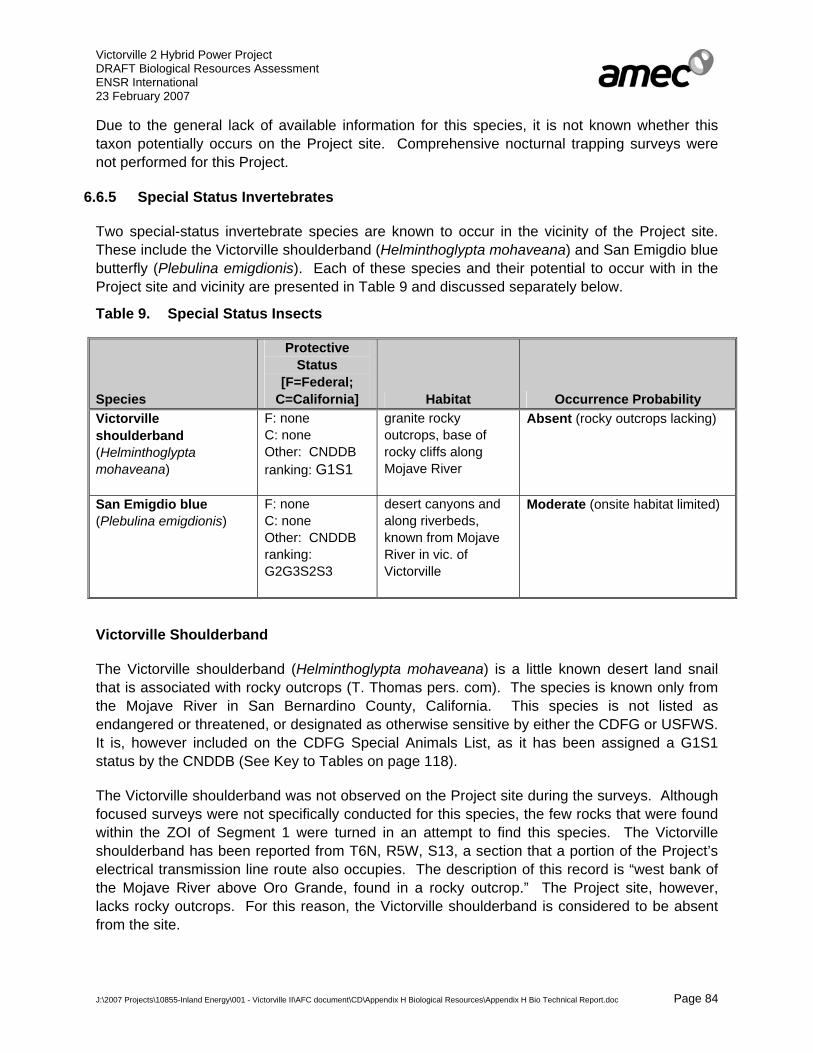
Victorville 2 Hybrid Power Project DRAFT Biological Resources Assessment ENSR International 23 February 2007
J:\2007 Projects\10855-Inland Energy\001 - Victorville II\AFC document\CD\Appendix H Biological Resources\Appendix H Bio Technical Report.doc Page 84
Due to the general lack of available information for this species, it is not known whether this taxon potentially occurs on the Project site. Comprehensive nocturnal trapping surveys were not performed for this Project.
6.6.5 Special Status Invertebrates
Two special-status invertebrate species are known to occur in the vicinity of the Project site. These include the Victorville shoulderband (Helminthoglypta mohaveana) and San Emigdio blue butterfly (Plebulina emigdionis). Each of these species and their potential to occur with in the Project site and vicinity are presented in Table 9 and discussed separately below.
Table 9. Special Status Insects
Species
Protective Status
[F=Federal; C=California] Habitat Occurrence Probability
Victorville shoulderband (Helminthoglypta mohaveana)
F: none C: none Other: CNDDB ranking: G1S1
granite rocky outcrops, base of rocky cliffs along Mojave River
Absent (rocky outcrops lacking)
San Emigdio blue (Plebulina emigdionis)
F: none C: none Other: CNDDB ranking: G2G3S2S3
desert canyons and along riverbeds, known from Mojave River in vic. of Victorville
Moderate (onsite habitat limited)
Victorville Shoulderband
The Victorville shoulderband (Helminthoglypta mohaveana) is a little known desert land snail that is associated with rocky outcrops (T. Thomas pers. com). The species is known only from the Mojave River in San Bernardino County, California. This species is not listed as endangered or threatened, or designated as otherwise sensitive by either the CDFG or USFWS. It is, however included on the CDFG Special Animals List, as it has been assigned a G1S1 status by the CNDDB (See Key to Tables on page 118).
The Victorville shoulderband was not observed on the Project site during the surveys. Although focused surveys were not specifically conducted for this species, the few rocks that were found within the ZOI of Segment 1 were turned in an attempt to find this species. The Victorville shoulderband has been reported from T6N, R5W, S13, a section that a portion of the Project’s electrical transmission line route also occupies. The description of this record is “west bank of the Mojave River above Oro Grande, found in a rocky outcrop.” The Project site, however, lacks rocky outcrops. For this reason, the Victorville shoulderband is considered to be absent from the site.

Victorville 2 Hybrid Power Project DRAFT Biological Resources Assessment ENSR International 23 February 2007
J:\2007 Projects\10855-Inland Energy\001 - Victorville II\AFC document\CD\Appendix H Biological Resources\Appendix H Bio Technical Report.doc Page 85
San Emigdio Blue
The San Emigdio blue (butterfly) (Plebulina emigdionis) is not listed as endangered, threatened, or as a species of concern by any of the state or federal regulatory agencies. This species is however has been given a ranking of G2G3S2S3 by the CNDDB (See Key to Tables on page 118). The San Emigdio blue is associated with desert canyons and riverbeds in the southernmost San Joaquin Valley and along the Mojave River in the vicinity of Victorville. The larval host plant for this species is four-winged saltbush and possibly Spanish Clover (Lotus purshianus). Caterpillars eat the saltbush leaves and are tended by ants. Wild Heliotrope (Heliotropium curassavicum) is a known nectar plant (S. Myers pers. comm.).
San Emigdio blues have been observed in the Mojave River bed less than one mile northeast of the Project site (S. Myers pers. comm.). Several of the onsite dry washes and areas supporting Saltbush Scrub communities may provide suitable habitat for this species, as four-winged saltbush was present in these areas. AMEC considers there to be a moderate potential of occurrence onsite for this species.
7.0 PROJECT EFFECT/IMPACT ANALYSIS
7.1 Thresholds of Significance
Impacts or effects to biological resources have been assessed in accordance with CEQA. These impacts/effects have also been reviewed to ensure consistency with applicable regional resource protection plans and ordinances. The proposed Project would have varying impacts on biological resources. This determination has been made in reference to thresholds established per the following regulatory authorities:
• Federal Endangered Species Act (ESA), administered by the U.S. Fish and Wildlife Service (USFWS);
• California Endangered Species Act (CESA), administered by the California Department of Fish and Game (CDFG);
• Section 404 of the Clean Water Act (CWA), administered by the Army Corps of Engineers (USACE);
• Section 401 of the CWA, administered by the Lahonton Regional Water Quality Control Board (LRWQCB); and
• Section 1600 of the California Fish and Game Code administered by the CDFG; and
• The West Mojave Plan Amendment (WMPA) to the California Desert Conservation Area Plan (CDCAP), administered by the U.S. Bureau of Land Management (BLM).
These anticipated impacts to biological resources would necessitate appropriate agency consultation, pertinent regulatory permitting and the application of site-specific mitigation measures, in order to:

Victorville 2 Hybrid Power Project DRAFT Biological Resources Assessment ENSR International 23 February 2007
J:\2007 Projects\10855-Inland Energy\001 - Victorville II\AFC document\CD\Appendix H Biological Resources\Appendix H Bio Technical Report.doc Page 86
• Minimize the incidental “take” of species listed as “threatened” or “endangered” pursuant to the ESA. Projects that incorporate the terms and conditions of a Section 7 Biological Opinion are typically considered mitigated to a level below the threshold of significance.
• Minimize the incidental “take” of a species listed as “threatened” or “endangered” pursuant to the CESA. Projects that implement suitable mitigation measures to support issuance of a CESA Section 2081 incidental take permit are typically considered to be mitigated to a level that is below the threshold of significance.
• Minimize adverse effects upon plants and animals designated by the State of California as “Protected,” or those designated as “Species of Special Concern.”
• Avoid, minimize or mitigate any impact to the bed or bank of any river, ephemeral/perennial stream, or lake within California; or any alteration of natural water flow. Projects that incorporate adequate mitigation measures to support issuance of a California Streambed Alteration Agreement by the CDFG are typically considered to be mitigated to a level that is below the threshold of significance.
• Avoid, minimize or mitigate any dredging or discharge of fill material into Waters of the United States, pursuant to Section 404 of the Clean Water Act. Projects that fully mitigate impacts to wetland functions and values sufficient to support issuance of a nationwide programmatic or individual permit; or which would result in less than a 0.10 acre impact, are typically considered to be mitigated to a level that is below the threshold of significance.
• Avoid, minimize or mitigate any effect to water quality within the Lahonton Region of California, pursuant to Section 401 of the Clean Water Act. Projects that fully mitigate impacts to established water quality standards sufficient to support issuance of a Water Quality Certification, are typically considered to be mitigated to a level that is below the threshold of significance.
• Reduce disruption effects to native resident or migratory wildlife movement corridors to ensure known populations are not substantially reduced. Projects that implement mitigation measures designed to conserve or create alternative wildlife corridors are typically considered to be mitigated to a level that is below the threshold of significance.
• Reduce adverse effects upon sensitive or locally rare plant communities (e.g., riparian plant communities, Joshua tree woodlands, oak woodlands, etc.) identified in local or regional plans, policies, or regulations or by the USFWS and/or CDFG.
• Avoid conflicts with the objectives or goals of a regionally-adopted HCP, Natural Community Conservation Plan or Federal Land Management Plan.
Anticipated direct, indirect, and cumulative impacts of the Project have been analyzed to determine their degree of “significance.” These impacts have been assessed individually as well as collectively with respect to the Project.
Victorville 2 Hybrid Power Project DRAFT Biological Resources Assessment ENSR International 23 February 2007
J:\2007 Projects\10855-Inland Energy\001 - Victorville II\AFC document\CD\Appendix H Biological Resources\Appendix H Bio Technical Report.doc Page 87
The anticipated incidental “take” of listed and other special status species has been quantified with respect to the Proposed Action, where possible. The significance of impacts to individual species has been premised on the rarity of the species or its habitat and the extent of anticipated impact.
All listed species impacts are considered significant. A determination of significance for other special status species is based on overall species distribution (e.g., impacts to regional core populations), regional and range-wide rarity of the affected species, and conservation afforded the species and its habitat in regional plans.
Affected habitats supporting state or federally listed species, as well as other special status species, are also considered significant resources. Habitat impacts have been quantified on a per-acre basis relative to the affected plant community occurring within impact zones of the Project Area. Mitigation measures specific to the Proposed Action have been designed to address anticipated impacts to both species and habitats.
7.2 Impact Definition
7.2.1 Direct Impacts
Direct impacts are effects to natural resources supporting biological systems caused by a project action which occur at the same time and place as initial construction or operation activities. Examples of direct impacts include any action resulting in the loss or alteration of a native plant community or wildlife habitat component; those actions resulting in the injury/mortality of any wildlife species; or those which cause aberrant animal behavior. Such impacts also include the excavation and removal of native soils during construction or operations from a jurisdictional water or state streambed; the placement of fill material within a jurisdictional water/state streambed during construction or operations; or effects to surface and/or subsurface water quality during construction or project operations.
7.2.2 Indirect Impacts
Indirect impacts are those effects to natural resources supporting biological systems caused by a project action which occur later in time than initial construction/operation actions or those that are removed in distance from the immediate project site. Indirect impacts may include activities that alter adjacent offsite natural resources, including habitat used by listed or special status species. Examples of indirect impacts include, but are not limited to, elevated noise levels from construction or operational activities and night lighting. Such impacts also include alteration of surface water elevations, changes of floodplain flow patterns, fugitive dust generation, increased erosion or sedimentation, runoff of hazardous chemicals or waste, aerial drift of herbicides/pesticides into waters or soils, and/or introduction of non-native species.
7.2.3 Cumulative Impacts
Cumulative impacts are defined as the incremental impacts of a proposed project on the environment considered in the context of other past, present and foreseeable future actions, regardless of what entity undertakes these actions. Cumulative impacts may result from

Victorville 2 Hybrid Power Project DRAFT Biological Resources Assessment ENSR International 23 February 2007
J:\2007 Projects\10855-Inland Energy\001 - Victorville II\AFC document\CD\Appendix H Biological Resources\Appendix H Bio Technical Report.doc Page 88
individually minor, but collectively significant actions taking place over a period of time. A project’s action is considered less than cumulatively significant if:
• The project is required to implement an appropriate share of a mitigation measure intended to alleviate the cumulative impact; or if:
• The project’s contribution to a significant cumulative impact is essentially “de minimis,” or so miniscule that the regional conditions would remain unchanged whether or not the project was implemented.
7.2.4 Temporary versus Long Term Impacts
Long term and permanent impacts are those actions that result in irreversible damage to, or loss of, natural resources associated with biological systems. Long term impacts are defined as those actions that result in the inability to recover or restore an area to a natural state within a period of three years.
Examples of long term/permanent impacts include site grading for construction, as well as surface disturbance associated with equipment staging areas, large vehicle parking and equipment unloading zones, pipeline trench excavation and new access road installation.
Temporary impacts are considered to be those changes in the local environment that do not extend substantially beyond the term of initial project work completion. Examples of temporary impacts include minor damage to vegetation which does not result in the removal of perennial shrub crowns or tree removal, cross-country vehicle travel over undisturbed terrain, assembly or placement of project structures or equipment on undisturbed areas.
7.3 VV2 Project Implementation
7.3.1 Direct Permanent or Long-term Surface Disturbance Impacts
Implementation of the entire proposed Project would result in the excavation and removal of native soils and the permanent loss of native vegetation on approximately 342 acres of land known to be occupied, presumed to be occupied, and/or known to be suitable habitat for a variety of special-status species including the desert tortoise, Mojave ground squirrel, burrowing owl, Le Conte’s thrasher, etc. The loss of these vegetation communities is a direct, permanent impact. The remaining 57 acres is disturbed/developed or non-native grassland that does not provide habitat for special status species. The amount of each vegetation community that will be directly impacted within each project area is depicted in Table 10 and discussed in detail, separately below.
Table 10. Permanent Direct Surface Disturbance Acreage per Affected Plant Community
Vegetation Power West South Linear Utility Feature TOTAL
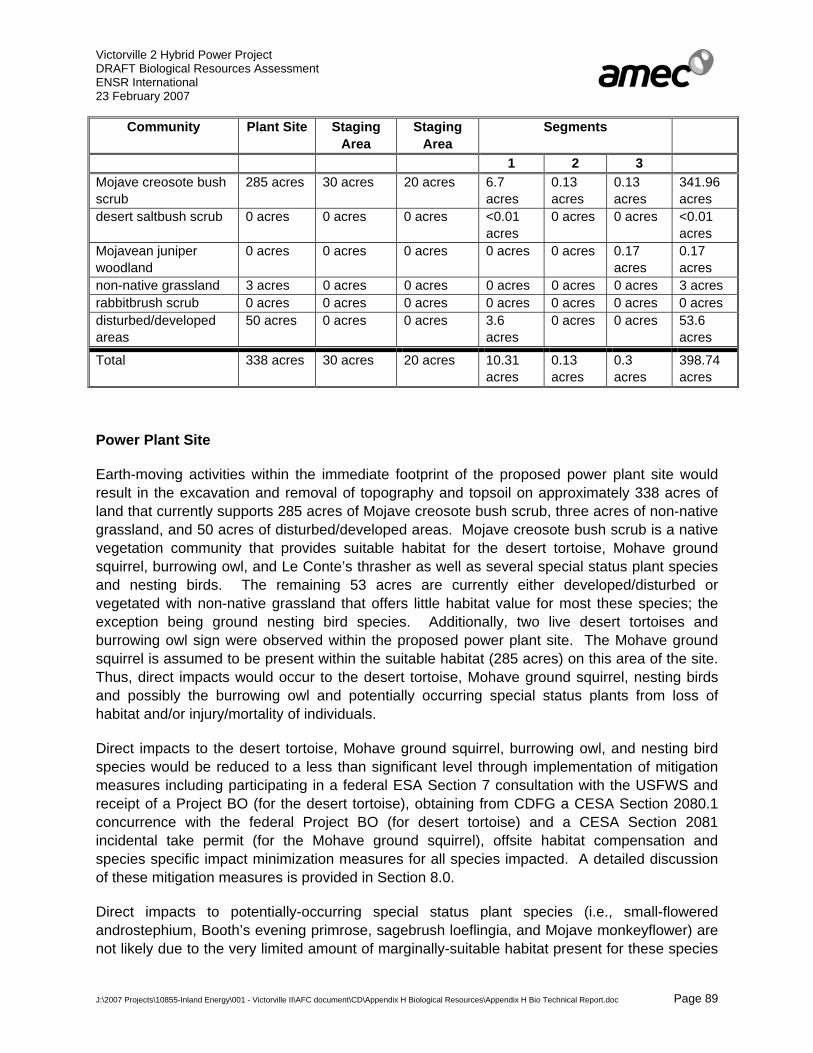
Victorville 2 Hybrid Power Project DRAFT Biological Resources Assessment ENSR International 23 February 2007
J:\2007 Projects\10855-Inland Energy\001 - Victorville II\AFC document\CD\Appendix H Biological Resources\Appendix H Bio Technical Report.doc Page 89
Community Plant Site Staging Area
Staging Area
Segments
1 2 3 Mojave creosote bush scrub
285 acres 30 acres 20 acres 6.7 acres
0.13 acres
0.13 acres
341.96 acres
desert saltbush scrub 0 acres 0 acres 0 acres <0.01 acres
0 acres 0 acres <0.01 acres
Mojavean juniper woodland
0 acres 0 acres 0 acres 0 acres 0 acres 0.17 acres
0.17 acres
non-native grassland 3 acres 0 acres 0 acres 0 acres 0 acres 0 acres 3 acres rabbitbrush scrub 0 acres 0 acres 0 acres 0 acres 0 acres 0 acres 0 acres disturbed/developed areas
50 acres 0 acres 0 acres 3.6 acres
0 acres 0 acres 53.6 acres
Total 338 acres 30 acres 20 acres 10.31 acres
0.13 acres
0.3 acres
398.74 acres
Power Plant Site
Earth-moving activities within the immediate footprint of the proposed power plant site would result in the excavation and removal of topography and topsoil on approximately 338 acres of land that currently supports 285 acres of Mojave creosote bush scrub, three acres of non-native grassland, and 50 acres of disturbed/developed areas. Mojave creosote bush scrub is a native vegetation community that provides suitable habitat for the desert tortoise, Mohave ground squirrel, burrowing owl, and Le Conte’s thrasher as well as several special status plant species and nesting birds. The remaining 53 acres are currently either developed/disturbed or vegetated with non-native grassland that offers little habitat value for most these species; the exception being ground nesting bird species. Additionally, two live desert tortoises and burrowing owl sign were observed within the proposed power plant site. The Mohave ground squirrel is assumed to be present within the suitable habitat (285 acres) on this area of the site. Thus, direct impacts would occur to the desert tortoise, Mohave ground squirrel, nesting birds and possibly the burrowing owl and potentially occurring special status plants from loss of habitat and/or injury/mortality of individuals.
Direct impacts to the desert tortoise, Mohave ground squirrel, burrowing owl, and nesting bird species would be reduced to a less than significant level through implementation of mitigation measures including participating in a federal ESA Section 7 consultation with the USFWS and receipt of a Project BO (for the desert tortoise), obtaining from CDFG a CESA Section 2080.1 concurrence with the federal Project BO (for desert tortoise) and a CESA Section 2081 incidental take permit (for the Mohave ground squirrel), offsite habitat compensation and species specific impact minimization measures for all species impacted. A detailed discussion of these mitigation measures is provided in Section 8.0.
Direct impacts to potentially-occurring special status plant species (i.e., small-flowered androstephium, Booth’s evening primrose, sagebrush loeflingia, and Mojave monkeyflower) are not likely due to the very limited amount of marginally-suitable habitat present for these species

Victorville 2 Hybrid Power Project DRAFT Biological Resources Assessment ENSR International 23 February 2007
J:\2007 Projects\10855-Inland Energy\001 - Victorville II\AFC document\CD\Appendix H Biological Resources\Appendix H Bio Technical Report.doc Page 90
within this Project feature. This area of the site lacks washes, drainages and extensively sandy or gravelly soils. Direct impacts to these species (if any) would be reduced to a less than significant level by: 1) avoiding impacts to the areas most likely to support these species (i.e., washes and drainages); 2) conducting focused surveys for these species throughout all potentially-suitable areas of the site during the appropriate survey period during an adequate rainfall year (2007-2008) prior to project construction; and 3) notification to the CDFG at least 10 days prior to the commencement of Project construction to allow for salvage of these species (if found to be present). Furthermore, clearance surveys and biological monitoring would be conducted throughout all areas of the Project site prior to and during ground disturbance; should any special status plant species be detected during these surveys and monitoring, CDFG would be notified and appropriate action (if any) would be implemented.
Construction Staging Areas
Earth-moving activities within the immediate footprint of the proposed construction staging areas would result in the excavation and removal of topography and topsoil on approximately 50 acres of land supporting Mojave creosote bush scrub. These activities would result in the long term loss of this vegetation community which provides suitable habitat for the desert tortoise, Mohave ground squirrel, burrowing owl, Le Conte’s thrasher, nesting bird species and possibly several special status plant species. Desert tortoise sign, potentially suitable habitat for Mohave ground squirrel, and suitable burrowing owl burrows were observed within the southern construction staging during focused field surveys. Thus, direct impacts would occur to the desert tortoise, Mohave ground squirrel potentially suitable habitat, nesting birds and possibly the owl and potentially occurring special status plants from loss of habitat and/or injury/mortality of individuals.
Direct impacts to desert tortoise, Mohave ground squirrel potentially suitable habitat, nesting birds and possibly the burrowing owl would be reduced to a less than significant level through implementation of mitigation measures including participating in a federal Section 7 consultation with the USFWS and receipt of a Project BO, obtaining from CDFG a CESA Section 2080.1 concurrence with the Project BO and a CESA Section 2081 incidental take permit, offsite habitat compensation and species specific impact minimization measures for all species impacted. A detailed discussion of these mitigation measures are provided in Section 8.0.
Direct impacts to potentially-occurring special status plant species (i.e., small-flowered androstephium, Booth’s evening primrose, sagebrush loeflingia, and Mojave monkeyflower) are not likely due to the very limited amount of marginally-suitable habitat present for these species within this Project feature. These areas of the site lack washes, drainages and extensively sandy or gravelly soils. Nevertheless, significant direct impacts to these species (if any) would be mitigated to less than significant by: 1) avoiding impacts to the areas most likely to support these species (i.e., washes and drainages); 2) conducting focused surveys for these species throughout potentially-suitable areas of the site prior to start of Project construction; and 3) notification to the CDFG at least 10 days prior to the commencement of Project construction to allow for salvage of these species (if found to be present). Furthermore, clearance surveys and biological monitoring would be conducted throughout all areas of the Project site prior to and during ground disturbance; should any special status plant species be detected during these
Victorville 2 Hybrid Power Project DRAFT Biological Resources Assessment ENSR International 23 February 2007
J:\2007 Projects\10855-Inland Energy\001 - Victorville II\AFC document\CD\Appendix H Biological Resources\Appendix H Bio Technical Report.doc Page 91
surveys and monitoring, CDFG would be notified and appropriate action (if any) would be implemented.
Segment 1
Earth-moving activities within the immediate footprint of the combined linear features within Segment 1 would result in the excavation and removal of topography and topsoil on approximately ten acres of land supporting Mojave creosote bush scrub (7 acres), desert saltbush scrub (less than 0.1 acre), and four acres of disturbed/developed areas. Specific impacts due to each of the project features within Segment 1 are detailed separately below:
Electrical Transmission Line
Approximately 3 acres of natural topography and associated topsoil would be permanently removed as a result of construction of the electrical transmission lines within Segment 1. This would include the loss of approximately 3 acres of Mojave creosote bush scrub and 100 sq. ft. of desert saltbush scrub. The Mojave creosote bush scrub and desert saltbush scrub are vegetation communities that can provide suitable habitat for the desert tortoise, Mohave ground squirrel, Le Conte’s thrasher, and San Emigdio blue butterfly. Desert tortoise and burrowing owl sign (i.e., burrows, scat, carcasses, whitewash) were observed within the ROW of the electrical transmission line within Segment 1. Additionally, live desert tortoises and live burrowing owls were observed within the respective ZOI and 500-foot buffer zone areas for these species. Thus, direct impacts would occur to the desert tortoise, Mohave ground squirrel potentially suitable habitat, nesting birds, and possibly the burrowing owl and San Emigdio blue butterfly as a result of the loss of habitat and/or injury/mortality of individuals.
Direct impacts to the desert tortoise, Mohave ground squirrel potentially suitable habitat, burrowing owl, and nesting bird species would be reduced to a less than significant level through implementation of mitigation measures including participating in a federal Section 7 consultation with the USFWS and receipt of a Project BO, obtaining from CDFG a CESA Section 2080.1 concurrence and a 2081 incidental take permit, offsite habitat compensation and species specific impact minimization measures. A detailed discussion of these mitigation measures are provided in Section 8.0.
Direct impacts to the potentially occurring San Emigdio blue butterfly are not considered significant due to the very limited amount (less than 100.5 sq. ft.) of potentially suitable desert saltbush scrub habitat that would be permanently impacted by the two transmission line towers that are proposed to be placed in this vegetation community. The Project has been designed to avoid all washes that may also provide potentially-suitable habitat for this species. This resulting approximate 100 sq. ft. potential impact to potentially suitable habitat for this species is considered to be negligible and less than significant.
Direct impacts to potentially-occurring special status plant species (i.e., small-flowered androstephium, Booth’s evening primrose, sagebrush loeflingia, and Mojave monkeyflower) are not likely due to the limited amount of marginally-suitable habitat present for these species within this Project feature. The sandiest and gravelliest of soils present within this area of the Project site are located within the washes and drainages. The Project has been designed to
Victorville 2 Hybrid Power Project DRAFT Biological Resources Assessment ENSR International 23 February 2007
J:\2007 Projects\10855-Inland Energy\001 - Victorville II\AFC document\CD\Appendix H Biological Resources\Appendix H Bio Technical Report.doc Page 92
avoid all impacts to the onsite washes and drainages. Direct impacts to these species (if any) would be reduced to a less than significant level by: 1) avoiding impacts to the areas most likely to support these species (i.e., washes and drainages); 2) conducting focused surveys for these species throughout potentially-suitable areas of the site prior to the start of Project construction; and 3) notification to the CDFG at least 10 days prior to the commencement of Project construction to allow for salvage of these species (if found to be present). Furthermore, clearance surveys and biological monitoring would be conducted throughout all areas of the Project site prior to and during ground disturbance; should any special status plant species be detected during these surveys and monitoring, CDFG would be notified and appropriate action (if any) would be implemented.
Additionally, 40 ephemeral washes determined to be jurisdictional waters have the potential to be directly impacted by surface disturbing activities associated with construction of the electrical transmission lines and access roads along Segment 1. Direct impacts to these areas would be considered significant if not avoided or mitigated. The Project, however, is currently designed to avoid direct impacts to these areas. However, if it is determined later that direct impacts cannot be avoided, mitigation measures would be implemented to reduce these impacts to a less than significant level. A detailed description of these mitigation measures is provided in Section 8.1.12.
Reclaimed Water Pipeline
Direct impacts to approximately 2.5 acres of topography and soils, as well as long-term loss of Mojave creosote bush scrub, would result from construction and installation of the reclaimed water pipeline. The remaining 2.5 acres of this Project feature are currently developed or disturbed by the VVWRA facility and thus do not provide suitable habitat for the desert tortoise or Mohave ground squirrel. Mojave creosote bush scrub provides suitable habitat for the desert tortoise, Mohave ground squirrel, Le Conte’s thrasher, burrowing owl, nesting birds, and the potentially-occurring special status plant species. Desert tortoise and burrowing owl sign (i.e., burrows, scat, carcasses, whitewash) were observed within the ROW of this pipeline within Segment 1. Additionally, live desert tortoises and live burrowing owls were observed within the respective ZOI and 500-foot buffer zone areas of this Project feature for these species. A portion of the developed/disturbed lands along a portion of the pipeline route within the VVWRA treatment facility is located adjacent to treatment ponds that may provide habitat for the southwestern pond turtle.
Direct impacts to the desert tortoise, Mohave ground squirrel potentially suitable habitat, burrowing owl, and Le Conte’s thrasher would be reduced to a less than significant level through implementation of mitigation measures including participating in a federal Section 7 consultation with the USFWS and receipt of a Project BO, obtaining from CDFG a CESA Section 2080.1 concurrence and a CESA Section 2081 incidental take permit, offsite habitat compensation, habitat restoration, and species specific impact minimization measures.
Potential direct impacts to the southwestern pond turtle are not likely due to the location of the project features within existing compacted roadways and thus are not considered significant; however to minimize the potential for impacts for this species construction activities a biological

Victorville 2 Hybrid Power Project DRAFT Biological Resources Assessment ENSR International 23 February 2007
J:\2007 Projects\10855-Inland Energy\001 - Victorville II\AFC document\CD\Appendix H Biological Resources\Appendix H Bio Technical Report.doc Page 93
monitor will be present to oversee ground disturbance activities and will conduct daily clearance surveys during these activities.
Direct impacts to potentially-occurring special status plant species (i.e., small-flowered androstephium, Booth’s evening primrose, sagebrush loeflingia, and Mojave monkeyflower) are not likely due to the very limited amount of marginally-suitable habitat present for these species within this Project feature Significant direct impacts to these species (if any) would be mitigated to less than significant by: 1) avoiding impacts to the areas most likely to support these species (i.e., washes and drainages); 2) conducting focused surveys for these species throughout potentially-suitable areas of the site during the appropriate survey period prior to the start of Project construction; and 3) notification to the CDFG at least 10 days prior to the commencement of Project construction to allow for salvage of these species (if found to be present). Furthermore, clearance surveys and biological monitoring would be conducted throughout all areas of the Project site prior to and during ground disturbance; should any special status plant species be detected during these surveys and monitoring, CDFG would be notified and appropriate action (if any) would be implemented.
A detailed discussion of these minimization measures are provided in Section 8.0 below.
Sanitary Wastewater Pipeline
Direct impacts to approximately 3 acres of topography and soils, as well as long-term loss of Mojave creosote bush scrub, would result from construction and installation of the sanitary wastewater pipeline. The remaining 1 acre of this Project feature is located within a previously disturbed dirt road adjacent to the VVWRA facility and thus does not provide suitable habitat for the desert tortoise or Mohave ground squirrel. Mojave creosote bush scrub provides suitable habitat for the desert tortoise, Mohave ground squirrel, Le Conte’s thrasher, burrowing owl, nesting birds, and the potentially-occurring special status plant species. Desert tortoise and burrowing owl sign (i.e., burrows, scat, carcasses, whitewash) were observed within the ROW of this pipeline within Segment 1. Additionally, live desert tortoises and live burrowing owls were observed within the respective ZOI and 500-foot buffer zone areas of this Project feature for these species.
Direct impacts to the desert tortoise, Mohave ground squirrel potentially suitable habitat, burrowing owl, and Le Conte’s thrasher would be reduced to a less than significant level through implementation of mitigation measures including participating in a federal Section 7 consultation with the USFWS and receipt of a Project BO, obtaining from CDFG a CESA Section 2080.1 concurrence and a CESA Section 2081 incidental take permit, offsite habitat compensation and species specific impact minimization measures.
Direct impacts to potentially-occurring special status plant species (i.e., small-flowered androstephium, Booth’s evening primrose, sagebrush loeflingia, and Mojave monkeyflower) are not likely due to the very limited amount of marginally-suitable habitat present for these species within this Project feature. Significant direct impacts to these species (if any) would be mitigated to less than significant by: 1) avoiding impacts to the areas most likely to support these species (i.e., washes and drainages); 2) conducting focused surveys for these species

Victorville 2 Hybrid Power Project DRAFT Biological Resources Assessment ENSR International 23 February 2007
J:\2007 Projects\10855-Inland Energy\001 - Victorville II\AFC document\CD\Appendix H Biological Resources\Appendix H Bio Technical Report.doc Page 94
throughout potentially-suitable areas of the site during the appropriate survey period prior to the start of Project construction; and 3) notification to the CDFG at least 10 days prior to the commencement of Project construction to allow for salvage of these species (if found to be present). Furthermore, clearance surveys and biological monitoring would be conducted throughout all areas of the Project site prior to and during ground disturbance; should any special status plant species be detected during these surveys and monitoring, CDFG would be notified and appropriate action (if any) would be implemented.
Additionally, two ephemeral washes, one determined to be a WSC only and the other a WSC and a WUS, have the potential to be directly impacted by surface disturbing activities associated with construction of the sanitary waste water pipeline along Segment 1. Direct impacts (if any) to these areas would be considered significant if not avoided or mitigated. The Project is currently designed to avoid direct surface impacts to these washes by directional boring the pipeline underneath these areas. However, if direct surface impacts can not be avoided, mitigation measures would be implemented to reduce these impacts to a less than significant level.
A detailed discussion of these minimization measures are provided in Section 8.0 below.
Segment 2
Installation of the footings and 300-feet of access roads for the six proposed electrical transmission line poles towers within Segment 2 would require vegetation removal, grading, digging, scraping, and/or blading. These activities will result in the permanent removal of topography and soils on approximately 0.13 acres of land supporting Mojave Creosote Bush Scrub. This vegetation community provides suitable habitat for the desert tortoise, Mohave ground squirrel, burrowing owl, Le Conte’s thrasher, nesting birds, and potentially-occurring special status plant species. Additionally, although focused surveys have not been conducted in this area, two live burrowing owls were observed within the 500-foot buffer zone area to portions of this Project feature. Thus, direct impacts to these species would occur due to loss of habitat.
Direct impacts to the desert tortoise, Mohave ground squirrel potentially suitable habitat, burrowing owl, and Le Conte’s thrasher would be reduced to a less than significant level through implementation of mitigation measures including participating in a federal Section 7 consultation with the USFWS and receipt of a Project BO, obtaining from CDFG a CESA Section 2080.1 concurrence and a CESA Section 2081 incidental take permit, offsite habitat compensation and species specific impact minimization measures.
Direct impacts to potentially-occurring special status plant species (i.e., small-flowered androstephium, Booth’s evening primrose, and sagebrush loeflingia) are not likely due to the very limited amount of marginally-suitable habitat present for these species within this Project feature. Significant direct impacts to these species (if any) would be mitigated to less than significant by: 1) avoiding impacts to the areas most likely to support these species (i.e., washes and drainages); 2) conducting focused surveys for these species throughout potentially-suitable areas of the site during the appropriate survey period prior to the start of Project construction;

Victorville 2 Hybrid Power Project DRAFT Biological Resources Assessment ENSR International 23 February 2007
J:\2007 Projects\10855-Inland Energy\001 - Victorville II\AFC document\CD\Appendix H Biological Resources\Appendix H Bio Technical Report.doc Page 95
and 3) notification to the CDFG at least 10 days prior to the commencement of Project construction to allow for salvage of these species (if found to be present). Furthermore, clearance surveys and biological monitoring would be conducted throughout all areas of the Project site prior to and during ground disturbance; should any special status plant species be detected during these surveys and monitoring, CDFG would be notified and appropriate action (if any) would be implemented.
Additionally, ten ephemeral washed determined to be WSC and WUS have the potential to be directly impacted by surface disturbing activities associated with construction of the electrical transmission lines along Segment 2. Direct impacts to these areas would be considered significant if not avoided or mitigated. The Project is currently designed to avoid direct impacts to these areas. However, if direct impacts cannot be avoided, mitigation measures would be implemented to reduce these impacts to a less than significant level.
A detailed discussion of these minimization measures are provided in Section 8.0 below.
Segment 3
Installation of the proposed electrical transmission line poles towers within Segment 3 would require vegetation removal in the location of the tower footings only. These activities would result in the permanent removal of topography and soils on approximately 0.3 acres of land supporting Mojave creosote bush scrub (0.13 acres) and Mojavean juniper woodland and scrub (0.17 acres). No new roads are proposed for Segment 3. These vegetation communities provide suitable habitat for the desert tortoise, Mohave ground squirrel, Le Conte’s thrasher, San Diego coast horned lizard, nesting birds and potentially-occurring special status plant species. Direct impacts to these species would occur due to loss of habitat. Direct impacts to these species would be reduced to a less than significant level through implementation of mitigation measures including participating in a federal Section 7 consultation with the USFWS and receipt of a Project BO, obtaining from CDFG a CESA Section 2080.1 concurrence and a CESA Section 2081 incidental take permit, offsite habitat compensation and species specific impact minimization measures.
Several burrows that are suitable for burrowing owl occupation were observed within Segment 3. Thus, this species has the potential to be directly impacted by Project activities within this area. Focused surveys were not conducted for this species in this area. Therefore direct impacts to this species in this area are possible. Focused surveys for this species would be conducted in accordance with CDFG survey guidelines prior to the start of Project construction to determine if the species is present in the project area. Direct impacts (if any) to the burrowing owl in this area would be reduced to a less than significant level through mitigation measures outlined in Section 8.1.6.
Direct impacts to potentially-occurring special status plant species (i.e., small-flowered androstephium, Booth’s evening primrose, and sagebrush loeflingia) are not likely due to the very limited amount of marginally-suitable habitat present for these species within this Project feature. Significant direct impacts to these species (if any) would be mitigated to less than significant by: 1) avoiding impacts to the areas most likely to support these species (i.e., washes

Victorville 2 Hybrid Power Project DRAFT Biological Resources Assessment ENSR International 23 February 2007
J:\2007 Projects\10855-Inland Energy\001 - Victorville II\AFC document\CD\Appendix H Biological Resources\Appendix H Bio Technical Report.doc Page 96
and drainages); 2) conducting focused surveys for these species throughout potentially-suitable areas of the site during the appropriate survey period prior to the start of Project construction; and 3) notification to the CDFG at least 10 days prior to the commencement of Project construction to allow for salvage of these species (if found to be present). Furthermore, clearance surveys and biological monitoring would be conducted throughout all areas of the Project site prior to and during ground disturbance; should any special status plant species be detected during these surveys and monitoring, CDFG would be notified and appropriate action (if any) would be implemented.
Additionally, five ephemeral washed determined to be WSC and WUS and have the potential to be directly impacted by surface disturbing activities associated with construction of the electrical transmission lines along Segment 3. Direct impacts to these areas would be considered significant if not avoided or mitigated. The Project is currently designed to avoid direct impacts to these areas. However, if direct impacts cannot be avoided, mitigation measures would be implemented to reduce these impacts to a less than significant level. A detailed description of these mitigation measures is provided in Section 8.1.12.
7.3.2 Direct Temporary Surface Disturbance Impacts
Implementation of the proposed Project would result in approximately 66 acres of direct temporary impacts to natural areas along the electrical transmission line corridor in Segments 1, 2, and 3 due to surface disturbance activities. The amount of each vegetation community that will be temporarily impacted within each project area is depicted in Table 11 and discussed in detail, separately below.
These temporary impacts would occur in tower construction and assembly areas adjacent to each of the proposed new tower sites. These activities would potentially result in the crushing or trampling of vegetation by equipment, vehicles, and personnel. These impacts are discussed separately by segment below.
No temporary surface disturbance impacts are expected to occur on the power plant site, the two construction staging areas, or within the ROWs of the two pipelines, as the impacts associated with these features permanent in nature.

Victorville 2 Hybrid Power Project DRAFT Biological Resources Assessment ENSR International 23 February 2007
J:\2007 Projects\10855-Inland Energy\001 - Victorville II\AFC document\CD\Appendix H Biological Resources\Appendix H Bio Technical Report.doc Page 97
Table 11. Temporary Direct Surface Disturbance Acreage per Affected Plant Community
Vegetation Community
Power Plant Site
West Staging
Area
South Staging
Area Linear Utility Feature
Segments TOTAL 1 2 3
Mojave creosote bush scrub
0 acres 0 acres 0 acres 9 acres 2.2 acres
31.8 acres
43 acres
desert saltbush scrub 0 acres 0 acres 0 acres 0.2 acres 0 acres 0 acres 0.2 acres
Mojavean juniper woodland
0 acres 0 acres 0 acres 0 acres 0 acres 23.2 acres
23.2 acres
non-native grassland 0 acres 0 acres 0 acres 0 acres 0 acres 0 acres 0 acres rabbitbrush scrub 0 acres 0 acres 0 acres 0 acres 0 acres 0 acres 0 acres disturbed/developed areas
0 acres 0 acres 0 acres 0 acres 0 acres 0 acres 0 acres
Total 0 acres 0 acres 0 acres 9.2 acres 2.2 acres
55 acres
66.4 acres
Segment 1
Construction of the structures within Segment 1 would temporarily impact approximately nine acres of Mojave creosote bush scrub and 0.2 acres of desert saltbush scrub. As discussed previously, Mojave creosote bush scrub and desert saltbush scrub provide suitable habitat for the desert tortoise, Mohave ground squirrel, burrowing owl, Le Conte’s thrasher and nesting birds. Temporary impacts to these vegetation communities would not be considered significant. However, injury/mortality to any of these species as well as the potentially-occurring southwestern pond turtle and San Emigdio blue butterfly and within the proposed impact area would be considered significant if not avoided or mitigated. These impacts would be mitigated to a less than significant level through measures outlined in Section 8.0 below.
Segment 2
Construction of the structures within Segment 2 would temporarily impact approximately two acres of Mojave creosote bush scrub. This vegetation community provides suitable habitat for the desert tortoise, Mohave ground squirrel, burrowing owl, Le Conte’s thrasher, and nesting birds. Temporary impacts to this vegetation community would not be considered significant. However, injury/mortality to any of these species as well as the within the proposed impact area would be considered significant if not avoided or mitigated. These impacts would be mitigated to a less than significant level through measures outlined in Section 8.0 below.

Victorville 2 Hybrid Power Project DRAFT Biological Resources Assessment ENSR International 23 February 2007
J:\2007 Projects\10855-Inland Energy\001 - Victorville II\AFC document\CD\Appendix H Biological Resources\Appendix H Bio Technical Report.doc Page 98
Segment 3
Implementation of the structures within Segment 3 would temporarily impact approximately 32 acres of Mojave creosote bush scrub and 23 acres of Mojavean juniper woodland and scrub. These vegetation communities provide suitable habitat for the desert tortoise, Mojave ground squirrel, burrowing owl, Le Conte’s thrasher, San Diego coast horned lizard and nesting birds. Temporary impacts to these vegetation communities would not be considered significant. However, injury/mortality to the special-status species potentially occurring within these communities would be considered significant if not avoided or mitigated. These impacts would be mitigated to a less than significant level through measures outlined in Section 8.0 below.
Direct Impacts (Permanent and Temporary) per Affected Plant Community
Mojave Creosote Bush Scrub
Project development would result in the direct loss of approximately 385 acres of Mojave creosote bush scrub. Approximately 342 acres would be permanently impacted as a result of surface-disturbing activities proposed within the power plant site, two construction staging areas, sanitary and reclaimed water pipeline ROWs, and electrical transmission line Segments 1-3. In addition, 43 acres of Mojave creosote bush scrub would be temporarily impacted as a result of proposed construction activities within transmission line Segments 1, 2, and 3.
Desert Saltbush Scrub
Approximately, 0.21 acres of desert saltbush scrub would be directly impacted by Project activities. Very little (<0.01 acre) of this vegetation community would be permanently and 0.2 acres temporarily impacted in this area.
Mojavean Juniper Woodland and Scrub
Project development would result in the direct loss of approximately 23 acres of Mojavean juniper woodland and scrub. Approximately 0.17 acres would be permanent and 23.2 acres temporarily impacted as a result of surface-disturbing activities associated with the construction of the electrical transmission line in Segment 3.
Non-native Grassland
Development of portions of the power plant site would result in the permanent loss of approximately three acres characterized as non-native grassland. Temporary disturbance to this vegetation community are not expected.
Disturbed/Developed Areas
Disturbed/developed areas include graded areas associated with the VVWRA facility, dirt and paved roads, existing structures, and landscaped areas immediately surrounding dwellings and structures. Development of the Project site would result in the permanent loss of approximately

Victorville 2 Hybrid Power Project DRAFT Biological Resources Assessment ENSR International 23 February 2007
J:\2007 Projects\10855-Inland Energy\001 - Victorville II\AFC document\CD\Appendix H Biological Resources\Appendix H Bio Technical Report.doc Page 99
54 acres of previously disturbed/developed areas including 50 acres on the power plant site, 2.36 acres within the VVWRA portion of the reclaimed water line, and 1.22 acres along the sanitary wastewater pipeline. No temporary impacts are anticipated for the disturbed/developed areas.
Direct Impacts to General Wildlife and Animal Movement Corridors
Onsite vegetation communities provide habitat for wildlife common to each community. Habitat within impact areas of the Project site would be permanently or temporarily lost as a result of temporary surface disturbance.
Animal movement corridors present with the affected habitats would be disrupted as a result of permanent and temporary surface disturbance and human work activity presence associated with the Project. Although no specific wildlife movement corridors have been identified within the Project area (as to do so would require extensive studies over a period of multiple years), movement corridors are nevertheless expected to occur on the site. The most likely areas that such corridors are expected include onsite drainages, ridgelines, small valleys, and along man-made features (e.g., fences, structures, dirt roads) that direct animals in a certain direction. Wildlife most likely to utilize such corridors include, but are not limited to, the larger predatory species such as the coyote, kit fox, bobcat, striped skunk, and Virginia opossum.
Adjacent non-impacted lands provide viable alternative animal movement habitat for the affected species. Wildlife using the onsite areas would largely be displaced to adjacent lands as a result of habitat loss resulting from the proposed project. The Project has been designed to avoid all impacts to onsite washes and drainages, which serve as likely wildlife movement corridors. For this reason and due to the availability of adjacent lands for alternative wildlife movement and in addition to mitigation measures required for other impacts (i.e., offsite habitat compensation, habitat restoration), direct impacts to general wildlife and animal movement corridors are considered to be less than significant.
Direct Impacts to Migratory and Nesting Birds
Birds nesting within the Project area during construction activities would be permanently impacted by project activities. The special status bird species most likely to nest throughout the footprint of the Project site include burrowing owl, Le Conte’s thrasher, loggerhead shrike, and Costa’s hummingbird. This impact would be considered significant if not avoided or mitigated. Mitigation measures outlined in Section 8.1.11 which includes nesting bird clearance surveys during the nesting season and biological monitoring would be implemented to minimize impacts to nesting birds and reduce them to a less than significant level. Additionally, certain features of the Project, once implemented, may provide nesting opportunities for certain birds of prey. Project structures may also provide nesting and foraging habitat for scavenging migratory birds such as the Common Raven.
Elevated Project structures (i.e., transmission line towers) could potentially result in occasional bird collisions. Most recorded bird collisions with ground structures involve species migrating at night during severe weather and/or during conditions with low visibility, colliding with tall guyed
Victorville 2 Hybrid Power Project DRAFT Biological Resources Assessment ENSR International 23 February 2007
J:\2007 Projects\10855-Inland Energy\001 - Victorville II\AFC document\CD\Appendix H Biological Resources\Appendix H Bio Technical Report.doc Page 100
television or radio towers/antennas. Although considered to be possible, bird mortality as a result of collision with Project structures is considered to be less than significant, as the Project will not use any tall guyed antennas and the area of the Project site is not prone to weather conditions exhibiting low visibility. Low visibility in the Victorville area would be considered a very rare event.
Electrocution of large birds of prey by transmission lines has also been well documented in the past. Historically this was a problem resulting from a large bird simultaneously coming in contact with two conductors, or a conductor and a ground. All electrical transmission lines for the VV2 Project would be constructed with sufficient clearance between conductors and grounds to protect raptors and other large birds from electrocution. Installation of transmission lines and towers according to the guidelines recommended in the “Suggested Practices for Raptor Protection on Power Lines: The State of the Art in 2006” (APLIC, 2006) would reduce potential impacts to less than significant.
Direct Impacts to Special Status Species
Special Status Plant Species
No federally or state listed annual plant species are known to occur in proximity to the Project area. However, one annual plant species recognized by the California Native Plant Society (CNPS) as List 1B species and considered BLM sensitive in the West Mojave Plan (i.e., Mojave monkeyflower) and three List 2 species (i.e., small-flowered androstephium, Booth’s evening primrose, and sagebrush loeflingia) are known from the vicinity. None of these species were detected in the survey efforts conducted on portions of the Project area. It should be noted, however, that for various reasons surveys were not conducted throughout all suitable areas of the site. Additionally, 2006 was a poor year for annual flowering plant species in the Mojave Desert (P. McKay pers. com). For these reasons, absence determinations for these species could not be conclusively made.
Additionally, Joshua trees and three species of native cacti (i.e., silver cholla, pencil cholla, and beavertail cactus) were observed throughout various areas of the project site. These species are not designated as sensitive by either the USFWS or CDFG, however are regulated and managed as species requiring special protection measures and/or permits for impacts by the California Native Plant Protection Act, by Title 13 of the City of Victorville Municipal Code (Ordinance No. 1224), and by Title 16 of the City of Hesperia Municipal Code.
Small-flowered Androstephium (Androstephium breviflorum)
Although the species has been reported from one location in the vicinity of the where Segments 2 and 3 converges, only very limited areas of the Project site are considered to have a low potential for occurrence of this species, as much of the site does not support extensively sandy soils. The areas that have the sandiest soils, and thus appear to be the most suitable for this species, are within the onsite washes. The Project has been designed around all of the onsite washes to avoid all impacts to these areas. For this reason, in addition to mitigation measures

Victorville 2 Hybrid Power Project DRAFT Biological Resources Assessment ENSR International 23 February 2007
J:\2007 Projects\10855-Inland Energy\001 - Victorville II\AFC document\CD\Appendix H Biological Resources\Appendix H Bio Technical Report.doc Page 101
required for other impacts (i.e., habitat restoration, offsite habitat compensation) impacts (if any) to this species are not expected to be significant.
Booth’s Evening Primrose (Camissonia boothii ssp. boothii)
Although the species has been reported from the vicinity of the Project site, only very limited areas of the Project site are considered to have a low potential for occurrence of this species, as much of the site does not support extensively sandy soils. The areas that have the sandiest soils, and thus appear to be the most suitable for this species, are within the onsite washes. The Project has been designed around all of the onsite washes to avoid all impacts to these areas. For this reason, in addition to mitigation measures required for other impacts (i.e., habitat restoration, offsite habitat compensation) impacts (if any) to this species are not expected to be significant.
Sagebrush Loeflingia (Loeflingia squarrosa var. artemisiarum)
Although the species has been reported from one location in the vicinity of a portion of Segment 3, only very limited areas of the Project site are considered to have a low potential for occurrence of this species, as much of the site does not support extensively sandy soils. The areas that have the sandiest soils, and thus appear to be the most suitable for this species, are within the onsite washes. The Project has been designed around all of the onsite washes to avoid all impacts to these areas. For this reason, in addition to mitigation measures required for other impacts (i.e., habitat restoration, offsite habitat compensation) impacts (if any) to this species are not expected to be significant.
Mojave Monkeyflower (Mimulus mohavensis)
Relatively little habitat (i.e., gravelly and sandy washes) considered suitable for the species occurs on, or even in the vicinity of the Project site. Additionally, the Project has been designed to avoid all impacts to onsite washes. For these reasons, impacts to this species are not expected as a result of project implementation and thus would not be significant.
Joshua Tree (Yucca brevifolia)
Joshua Trees would be lost as a result of Project activities throughout various areas of the site, particularly on the power plant site, the two adjacent staging areas, and possibly along the three segments comprising the linear features, as this species is present throughout all areas of the site. Direct impacts to Joshua trees from the proposed Project would be considered significant if not avoided or mitigated. The mitigation measures outlined in Section 8.1.3, which including the salvaging of impacted Joshua tress and either relocating them to local adoption program or transplantation into facility landscape design plans and/or site restoration would be implemented to reduce these impacts to a less than significant level.

Victorville 2 Hybrid Power Project DRAFT Biological Resources Assessment ENSR International 23 February 2007
J:\2007 Projects\10855-Inland Energy\001 - Victorville II\AFC document\CD\Appendix H Biological Resources\Appendix H Bio Technical Report.doc Page 102
Cacti (Opunita ssp.)
Three species of native cacti (i.e., Silver Cholla, Pencil Cholla, and Beavertail) were observed throughout the various areas of the Project site. Per the NPPA, all species of native cacti are regulated. Additionally, two sensitive species of cacti (i.e., Mojave fishhook cactus and short-joint beavertail) have been reported from the vicinity of the site. These cacti species would be lost as a result of Project activities throughout various areas of the site, again particularly on the power plant site, the two adjacent staging areas, and possibly along the three segments comprising the linear features, as these species were observed throughout all areas of the site. Direct impacts to native cacti from the proposed Project would be considered significant. The mitigation measures outlined in Section 8.1.3, which including the salvaging of impacted native cacti and transplantation into facility landscape design plans and/or site restoration, would be implemented to reduce these impacts to a less than significant level.
Special Status Wildlife Species
Implementation of the Project would impact a variety of sensitive wildlife species to varying degrees, including the state and federally listed-threatened desert tortoise. Other special status species potentially affected by the Project include Mohave ground squirrel, burrowing owl, southwestern pond turtle, San Diego coast horned lizard, Le Conte’s Thrasher, loggerhead shrike, and San Emigdio blue butterfly. These anticipated impacts to special status wildlife are summarized separately below.
Desert Tortoise (Gopherus agassizii)
Surface disturbance associated with the proposed power plant site would directly impact at least two adult desert tortoises identified onsite and perhaps other adult or immature desert tortoises not yet documented onsite. Additionally, four desert tortoises were observed within the Project ZOI. Since desert tortoises occupy numerous burrows during activity periods and have a home range of up to 450 acres (BLM 2005) tortoises within the ZOI may also use areas of the Project site. Thus, these individuals have the potential to be directly impacted by project activities.
Direct impact would include permanent and temporary loss of approximately 401 acres of desert tortoise habitat and potential “take” of these animals. These impacts are considered significant if not avoided or mitigated. Mitigation measures including participating in a federal Section 7 consultation by the USFWS and receipt of a Project BO, obtaining from CDFG a CESA Section 2080.1 concurrence with the Project BO, offsite habitat compensation and impact minimization measures for this species. A detailed discussion of these mitigation measures are provided in Sections 8.1.1 and 8.1.4 below.
Mohave Ground Squirrel (Spermophilus mohavensis)
The 2006 trapping survey for Mohave ground squirrel conducted on portions of the Project site resulted in negative findings. Despite this, the project proponent has elected to assume presence of this state-threatened species within all potentially suitable habitat affected by the Project and consult with the CDFG for project-related impacts. Direct impacts as a result of Project activities therefore are assumed for approximately 401 acres of Mohave ground squirrel

Victorville 2 Hybrid Power Project DRAFT Biological Resources Assessment ENSR International 23 February 2007
J:\2007 Projects\10855-Inland Energy\001 - Victorville II\AFC document\CD\Appendix H Biological Resources\Appendix H Bio Technical Report.doc Page 103
potential habitat. Direct impacts to this species are considered significant if not avoided or mitigated. Mitigation measures, outlined in Sections 8.1.1 and 8.1.5s would be implemented to reduce the impacts to a less than significant level. Additionally, a CESA Section 2081 incidental take permit will be obtained from CDFG for Mohave ground squirrel.
Burrowing Owl (Athene cunicularia)
At least four live Burrowing Owls were observed at locations throughout the project vicinity during the various biological field studies conducted (see Map 11). Additionally, indications of current and past Burrowing Owl use (i.e., burrows exhibiting whitewash, pellets, feathers, etc.) were observed within various areas of the project footprint. Thus, direct impacts to this species as a result of Project activities are possible. This would include loss of foraging habitat for at least three owls totaling a minimum of 19.5 acres. Additionally, injury or mortality to this species may also occur as a result of Project implementation. Therefore direct impacts to this species are considered significant. Mitigation measures, outlined in Sections 8.1.1 and 8.1.6, would be implemented to reduce the impacts to a less than significant level. These mitigation measures would include a focused nesting season burrowing owl survey conducted within one year prior to construction (i.e., 2007 or 2008) and a 30-day pre-construction survey conducted throughout all suitable areas of the site. Additionally, specific California Protected Raptor impact minimization permitting, habitat loss compensation and CDFG-recommended mitigation measures (see Sections 8.1.1 and 8.1.6 below) would be implemented for all Burrowing Owls detected at any time prior to facility installation.
Le Conte’s Thrasher (Toxostoma lecontei), Loggerhead shrike (Lanius ludovicianus), Costa’s hummingbird (Calypte costae), grey vireo (Vireo vicinior)
Vegetation removal and human activity associated with implementation of the proposed Project would directly impact these species by displacing foraging birds to neighboring lands. Additionally, Project activities conducted during the nesting seasons for these species could cause bird injury/mortality or nest abandonment, to nesting individuals within the planned work areas. These impacts are considered significant if not avoided or mitigated. However, mitigation measures including pre-construction clearance surveys during the breeding season, establishing buffer areas of around nest sites, and postponing Project activities until nestlings have fledged, would be implemented to reduce these impacts to a less than significant level. A detailed description of these measures is provided in Section 8.1.11 below.
Southwestern Pond Turtle (Actinemys [formerly Clemmys] marmorata pallida)
Although considered unlikely, individuals of this species may be injured or taken during Project activities conducted along the portion of the reclaimed water pipeline within the VVWRA treatment facility. Direct impacts to this species would be considered significant if not avoided or mitigated. However, mitigation measures would be implemented to reduce potential impacts to a less than significant level. These measures are outlined in Section 8.1.7 and include: 1) confining all project construction and associated activities to existing compacted perimeter access roads and 2) conducting daily clearance surveys in this area.

Victorville 2 Hybrid Power Project DRAFT Biological Resources Assessment ENSR International 23 February 2007
J:\2007 Projects\10855-Inland Energy\001 - Victorville II\AFC document\CD\Appendix H Biological Resources\Appendix H Bio Technical Report.doc Page 104
San Diego Coast Horned Lizard (Phrynosoma cornatum blainvillii)
Development of the transmission line within the southern portions of Segment 3 has the potential to directly impact the San Diego coast horned lizard. This impact would result from the permanent and temporary direct loss of 23 acres of Mojavean juniper woodland and scrub. Direct impacts to this species would be considered significant if not avoided or mitigated. However, mitigation measures, including avoiding impacts to onsite washes and biological monitoring, would be implemented to reduce potential impacts to a less than significant level. These measures are summarized in Sections 8.1.1 and 8.1.8 below.
Mojave River Vole (Microtus californicus mohavensis)
Development of the Project features within Segment 1 has the potential to directly impact the Mojave River Vole. This potential impact would result from the possibility of direct mortality or injury resulting from Project activities located adjacent to this species habitat. Direct impacts to this species would be considered significant if not avoided or mitigated. However, the Project has been designed to avoid impacts to all onsite washes, in addition to biological monitoring. Implementation of these measures would reduce potential impacts to this species to a less than significant level. These mitigation measures are detailed in Sections 8.1.1 and 8.1.9 below.
San Emigdio Blue Butterfly (Plebulina emigdionis)
Development of the two transmission line tower locations would result in a total of approximately 100 sq. ft. of permanent loss of the desert saltbush scrub vegetation community that may provide suitable habitat for this special status butterfly. Direct impacts to this species are not considered significant due to the very limited amount of potentially suitable desert saltbush scrub habitat that would be permanently impacted and the Project has been designed to avoid all washes that may also provide potentially-suitable habitat for this species. This resulting approximate 100 sq. ft. potential impact to potentially suitable habitat for this species considered to be negligible.
Direct Impacts to Jurisdictional Waters
A total of 55 ephemeral dry washes occur within the Project area. Surface disturbance impacts to these streambeds would require specific permitting by CDFG under Section 1600 of the California Fish and Game Code for impacts to WCS and by the USACE under Section 404 of the CWA for surface disturbance impacts to WUS exceeding a specific acreage limits. Water Quality Certification and/or waste discharge permitting would also be required by the RWQCB under Section 401 of the CWA, if state waters may be impacted by surface disturbance actions.
Current design plans for implementation of the proposed Project include avoidance of surface disturbance to all state and federal jurisdictional waters. No federal or state waters are located within the proposed footprint of the power plant and the adjacent construction staging areas. Proposed transmission line utility features have been designed to span all state/federal waters and avoid any surface disturbance impacts to these jurisdictional areas. New access roads are planned to avoid all state and federal jurisdictional waters. Existing dirt road will be utilized where present for project-related drainage crossings. Directional boring of the sanitary waste

Victorville 2 Hybrid Power Project DRAFT Biological Resources Assessment ENSR International 23 February 2007
J:\2007 Projects\10855-Inland Energy\001 - Victorville II\AFC document\CD\Appendix H Biological Resources\Appendix H Bio Technical Report.doc Page 105
water pipeline under one state jurisdictional waters (Drainage # 1) is proposed. No vegetation clearing, grading, digging, placement of fill, or use of culverts are currently proposed for any of the 55 jurisdictional drainages located throughout the linear features of the Project.
If it is determined at a later date that the Project cannot avoid surface disturbance activities within state/federal waters, specific permitting as outlined above would be necessary. This would likely entail submission of a USACE Nationwide permit application, as well as an application for a LRWQCB Water Quality Certification, according to established guidelines. In addition, mitigation as outlined in Section 8.1.12 would be incorporated into these permit applications.
7.3.3 Indirect Impacts of the Project
Implementation of the Project may also indirectly impact biological resources located offsite in a variety of ways.
Adjacent areas are occupied by the desert tortoise, burrowing owl, potentially by the Mohave ground squirrel, as well as other special status species such as Le Conte’s thrasher and loggerhead shrike. Portions of the Project area are located in close proximity to the Mojave River, which supports a variety special status species including, but not limited to the endangered least Bell’s vireo, endangered southwestern willow flycatcher, and special concern species such as the southwestern pond turtle, Mojave River vole, and yellow warbler. This Mojave River corridor is also an important migratory flyway and nesting/foraging habitat for a wide variety of other species, including birds of prey. The VVWRA facility is also located adjacent, which provides aquatic habitat for a variety of waterfowl, as well as the southwestern pond turtle.
Indirect impacts include “edge effects.” Examples of edge effects include, but are not limited to, the following:
• Human activity in areas not generally having this presence; • Attraction and/or facilitation of human-subsidized scavenger use; • Temporary and/or permanent increases in ambient night lighting as a result of the use of
street, parking lot, and/or building lights; • Runoff of hazardous materials into adjacent areas; • Changes in surface drainage patterns following precipitation events; • Temporary and/or permanent noise increases; • Increases in fugitive dust that may accumulate on offsite plants; and • The introduction of exotic or invasive plants or animals.
Human activity can alter wildlife behavior patterns. Some of this activity can result in the displacement or attraction of some wildlife. Temporary and permanent changes in ambient night lighting can result in higher predation rates upon wildlife by nocturnal predators, due to increased visibility during nighttime hours. Runoff of hazardous materials can adversely affect special status plants and animals, as well as more commonly occurring species. The water table in general, which supports offsite plants and animals, can similarly be affected.
Victorville 2 Hybrid Power Project DRAFT Biological Resources Assessment ENSR International 23 February 2007
J:\2007 Projects\10855-Inland Energy\001 - Victorville II\AFC document\CD\Appendix H Biological Resources\Appendix H Bio Technical Report.doc Page 106
Surface drainage changes can alter the extent and health of native plant communities. Increases in noise can disrupt the normal behavior patterns of wildlife, sometimes resulting in displacement of these animals.
Fugitive dust accumulation can result in a decreased reproductive viability of affected plants, sometimes resulting in the reduction of available food and cover sources for wildlife. The introduction of exotic and/or invasive species can likewise degrade offsite habitats, alter wildlife behavior patterns and/or result in animal displacement, injury or mortality in affected areas.
Variable levels of indirect impact are anticipated to occur as the result of implementing the proposed Project. Construction activities have the potential to result in temporary indirect impacts in a variety of ways (e.g., human presence/activity, increased lighting, noise and dust). Permanent indirect impacts associated with routine operations of the Project are also anticipated as a result of the Project. These would include those impacts resulting from increased permanent noise, light, and human presence activities; as well as potential alterations to drainage patterns and discharge from the VV2 Project site.
Both potential temporary and permanent indirect impacts are summarized separately below.
Indirect Impacts to Desert Tortoise
Indirect impacts to desert tortoise may result from a variety of Project-related factors. Construction of the various Project features may serve as barriers, or function to inhibit/reduce desert tortoise movement. This would effectively fragment a functioning population.
Fugitive dust generated by project construction has the potential to decrease offsite germination of annual plant species, which comprise a large portion of the desert tortoise’s diet.
Additional nesting, perching and shade opportunities would be created for the common raven, a scavenging species known to predate hatchling and juvenile desert tortoises. Simple human presence associated with Project operations, in addition to any trash/garbage generated by Project-related activities, would likely attract common ravens to the area as well.
Additional roads and increased traffic created by the Project would result in an increased potential for desert tortoise injury and/or mortality associated with vehicle travel, illegal collection, as well as possibly improve the ability of some desert tortoise predators to secure prey. Other human actions possibly detrimental to desert tortoises, such as garbage dumping and an increased chance of wildfire creation could be created with the addition of roads in this species’ habitat.
All of these indirect impacts to the desert tortoise are considered significant if not avoided or mitigated. Mitigation measures including participating in a federal Section 7 consultation by the USFWS and receipt of a Project BO, obtaining from CDFG a CESA Section 2080.1 concurrence with the Project BO, offsite habitat compensation and impact minimization measures for this species. A detailed discussion of these mitigation measures are provided in Sections 8.1.1 and 8.1.4 below.

Victorville 2 Hybrid Power Project DRAFT Biological Resources Assessment ENSR International 23 February 2007
J:\2007 Projects\10855-Inland Energy\001 - Victorville II\AFC document\CD\Appendix H Biological Resources\Appendix H Bio Technical Report.doc Page 107
Indirect Impacts to Migratory and Nesting Birds
Indirect impacts to riparian-nesting special status bird species such as the southwestern willow flycatcher, least Bell’s vireo, western yellow-billed cuckoo, Nuttali’s woodpecker and other species may occur as a result of Project related activities and loud noises associated with the installation of portions of Segment 1 located in close proximity to riparian areas (i.e., reclaimed water pipeline in the VVWRA treatment facility) if conducted during the breeding season of these species (Feb 15-Aug 31). For this reason, to avoid the potential to impact these special-status species, impact avoidance measures have been developed. These include conducting the construction activities for the areas in close proximity to riparian habitats potentially suitable for these species outside the breeding season. Additionally, biological monitoring during construction in these areas would further ensure that impacts do not result.
Construction Dust, Lighting and Noise
Various activities, such as the operation of heavy equipment, have the potential to generate levels of disturbance adjacent to the Project area during the initial construction phase. Some bird species may abandon nests if nearby noise levels are excessive. Dust generated by construction activities has the potential to drift off the Project site and settle on adjacent habitats and vegetation. This can result in both adverse plant and insect use effects.
In general, initial Project construction activities would result in temporary reduction of wildlife use on adjacent lands as a result of construction dust, lighting and noise. The latter may also result in a minimal effect on adjacent plants. Wildlife use would be expected to return to pre-construction rates following the completion of construction activities.
Operations Dust, Lighting and Noise
Following initial construction activities, Project operations would also generate varying levels of dust, lighting and noise disturbance adjacent to the proposed power plant and on limited occasion, in proximity to utility features. These levels of impacts, often associated with maintenance actions, would be of smaller magnitude than those associated with construction and would be of short duration. A small, less than significant, increase in these impacts would also be anticipated for day-to-day general Project operations at the proposed power plant.
Indirect Impacts to Jurisdictional Waters
Potential adverse impacts to adjacent areas could occur as a result of inadequate controls or containment of onsite drainage or fluid discharge. Improperly contained or directed precipitation drainage, as well as uncontrolled fluid discharge, could result in erosion and sedimentation indirect impacts. Such impacts can adversely affect offsite vegetation, waterways and/or the underlying water aquifer. Appropriate design of onsite precipitation drainage, storm-water and miscellaneous fluid discharge would reduce this potential indirect impact to a less than significant impact.

Victorville 2 Hybrid Power Project DRAFT Biological Resources Assessment ENSR International 23 February 2007
J:\2007 Projects\10855-Inland Energy\001 - Victorville II\AFC document\CD\Appendix H Biological Resources\Appendix H Bio Technical Report.doc Page 108
7.3.4 Cumulative Impacts of the Project
Impacts associated with the Project, when considered individually, may not be considered significant. However, when considered collectively with other past, present, and future projects in the region, these Project impacts may contribute incrementally to the loss of habitat or individual special-status species. If the Project’s incremental contribution were to be substantial, then the project could be considered to have significant cumulative impacts.
The City of Victorville, like many other areas of the Western Mojave Desert, is currently experiencing expanding development and growth. For example, the City and Burlington Northern Santa Fe Railroad have begun planning for the development of a 1,600-acre intermodal railway logistics facility located at the SCLA that will involve the conversion of lands in the immediate VV2 Project vicinity from undeveloped to developed and thus reduce available habitat.
Due to the high levels of human activity in the area, habitat loss, degradation, and fragmentation are considered significant issues in the West Mojave Plan. The VV2 Project will contribute to the ongoing conversion of land areas from undeveloped to developed and thus reduce the amount of available habitat for a number of special-status species including the desert tortoise, Mohave ground squirrel, and burrowing owl. However, loss of onsite habitat for these species will be mitigated by the requirement for the Project to provide suitable offsite habitat for these species. Providing compensation in the form of permanently protected offsite mitigation acreage, combined with other general mitigation measures described in Section 8.0 to minimize the effects of Project activities on biological resources will reduce the Project’s potential cumulative biological impacts to a level that is less than significant.
8.0 PROPOSED MITIGATION
8.1 Intent and Summary
The recommendations and measures outlined under the specific headings below are intended to mitigate potential significant impacts resulting from the construction, operation and maintenance aspects of the VV2 Project to a less than significant level. As such, this mitigation is considered an integral component of the Proposed Action. Additional mitigation measures and/or impact minimization conditions may also be identified through the course of subsequent Project approval processes.
8.1.1 General Mitigation
1) All Project construction, operation, maintenance and/or termination actions would comply with applicable state and federal laws.
2) All work activities would be restricted to specifically approved and clearly marked areas.
3) A Field Contact Representative (FCR) would be designated to oversee and be responsible for compliance with conditions of Project approval. This FCR would be on

Victorville 2 Hybrid Power Project DRAFT Biological Resources Assessment ENSR International 23 February 2007
J:\2007 Projects\10855-Inland Energy\001 - Victorville II\AFC document\CD\Appendix H Biological Resources\Appendix H Bio Technical Report.doc Page 109
site or easily accessible during all project activities and would have the authority to halt all project activities that are in violation of conditions of Project approval.
4) Only water or gravel placement would be employed to control fugitive dust emissions. Construction and maintenance vehicles would observe a 15-mile per hour speed limit on all unpaved roads in the Project Area to reduce fugitive dust emissions.
5) Prior to mobilization of construction activities on site, all vehicles and equipment would be inspected to ensure these vehicles and equipment are operating correctly and free of fluid leaks. Equipment would be inspected daily to make sure that there are no fluid discharges.
6) All personnel working during the construction, operation or maintenance of the proposed VV2 Project would be required to attend an Environmental Awareness and Project Approval Compliance Training. This training would be presented by a qualified biologist familiar with the Desert Tortoise, Mojave ground squirrel, burrowing owl, and other special-status species with potential to occur within the Project area.
Habitat Restoration
Without revegetation and restoration, areas of the Project would be left heavily disturbed, vulnerable to invasion by exotic plant species, and generally less suitable or unsuitable for native species use. Therefore specific areas of the Project site would be revegetated and restored upon completion of Project activities in those areas.
Upon completion of construction of the power plant site and the need for the adjacent 50 acres of construction staging/laydown areas, these areas would be revegetated and restored. Additionally, upon completion of construction of the 275 new transmission line towers, stringing of new lines, and the installation of the two pipelines for the Project, the temporarily disturbed areas (i.e., the two construction staging areas, all pulling sites, all tower assembly areas, areas needed for off-road vehicular travel) would be reclaimed, revegetated, and/or restored. Techniques used for these efforts will be subject to project-specific approval by the USFWS, CDFG, and/or other involved agencies and may include any or all of the following methods: 1) vertical mulching; 2) raking tracks; 3) imprinting; 4) transplantation of salvaged Joshua trees and cacti; and 5) and hand broadcasting of native seed from locally-collected seed stock.
The “vertical mulching” technique involves the horizontal/vertical planting of whole shrub skeletons within the disturbance footprint areas proposed for revegetation. Appropriate salvage and storage of the shrub skeletons from disturbance areas at the time of initial site clearance/blading is critical for the success of this technique, as it is important to preserve as much of the integrity of the shrubs as possible to replant after completion of construction. Additionally, Joshua Trees and cacti would be salvaged from the disturbance footprint of the power plant site, the construction staging areas, and Segments 1-3 and used in subsequent final site reclamation work in combination with the vertical mulching revegetation technique.

Victorville 2 Hybrid Power Project DRAFT Biological Resources Assessment ENSR International 23 February 2007
J:\2007 Projects\10855-Inland Energy\001 - Victorville II\AFC document\CD\Appendix H Biological Resources\Appendix H Bio Technical Report.doc Page 110
The “raking” technique involves the manual raking of the ground where surface disturbance has occurred to remove any evidence of tire tracks, trampling, staging of equipment, or any other minor surface disruptions. This method is typically reserved for relatively small areas of minor disturbance.
The “imprinting” technique involves the use of a piece of heavy equipment called an “Imprinter” which is specifically designed for the revegetation of large areas of disturbance. This machinery typically contains a built-in container in which seed is placed. As the Imprinter is driven across the disturbed areas of the site the seed is evenly distributed and dropped immediately in front of a large rolling wheel complete with various-shaped projectiles that drive the seed into the ground and create an uneven surface providing safe sites for the seed and other seeds naturally blown in to germinate. The uneven surface created by imprinting in combination with vertical mulching and strategic planting of Joshua Trees and cacti and the placement of rocks, dead Joshua Tree limbs, and other surface material can discourage off-road travel across these areas.
Transplantation of salvaged Joshua Trees and cacti would involve the excavation and relocation of all Joshua Trees and cacti within the disturbance footprint of all portions of the site by a qualified and experienced native desert plant arborist. A tree spade is typically used. All salvaged plants would be stored and cared for at a pre-determined and agency-approved location. Upon completion of site disturbance, transplantation of the salvaged plants would take place.
The “hand broadcasting” method involves the manual spreading of locally-collected seed stock of native plant species across the disturbed areas of the site. This method is generally used for relatively small areas of disturbance and may be substituted by the imprinting method for larger areas of the site.
All revegetation, along with all construction activities, operation of heavy equipment, and/or driving of vehicles across undisturbed areas of the site would be monitored by a qualified biologist to minimize impacts to the Desert Tortoise and project disturbance and ensure compliance with all project-specific environmental regulations and requirements.
Restoration progress monitoring utilizing specified regulatory agency-accepted techniques would be required for a specified time period (usually 5-10 years) following project completion to document progress, provide additional recommendation to achieve the restoration goals (usually a specified % cover of native species) of the overseeing agency.
8.1.2 Small-flowered Androstephium, Booth’s Evening Primrose, Sagebrush Loeflingia, and Mojave Monkeyflower
Direct impacts to the potentially-occurring plant species (i.e., small-flowered androstephium, Booth’s evening primrose, sagebrush loeflingia, and Mojave monkeyflower) will be mitigated in the following ways: 1) avoiding impacts to the areas most likely to support these species (i.e., washes and drainages); 2) conducting focused surveys for these species throughout potentially-

Victorville 2 Hybrid Power Project DRAFT Biological Resources Assessment ENSR International 23 February 2007
J:\2007 Projects\10855-Inland Energy\001 - Victorville II\AFC document\CD\Appendix H Biological Resources\Appendix H Bio Technical Report.doc Page 111
suitable areas of the site during the appropriate survey period prior to the start of Project construction; and 3) notification to the CDFG at least 10 days prior to the commencement of Project construction to allow for salvage of these species (if found to be present). Furthermore, clearance surveys and biological monitoring would be conducted throughout all areas of the Project site prior to and during ground disturbance; should any special status plant species be detected during these surveys and monitoring, CDFG would be notified and appropriate action (if any) would be implemented. Additionally, all habitats temporarily disturbed through project activities will be revegetated and restored in accordance with the Habitat Restoration mitigation measures detailed in the General Mitigation section above (Section 8.1.1).
8.1.3 Joshua Trees and All Native Cacti
In accordance with the California Native Plant Protection Act, Title 13 of the City of Victorville Municipal Code (Ordinance No. 1224), and Title 16 of the City of Hesperia Municipal Code, permits and authorization to remove, transport, or otherwise impact Joshua trees will be obtained prior to Project approval. Joshua tress and native cacti will either be relocated to pre-determined, agency-approved locations, made available to a local adoption program or transplanted per facility landscape design plans and/or used in site habitat restoration as detailed above in the Habitat Restoration section of General Mitigation section above (Section 8.1.1).
8.1.4 Desert Tortoise (Gopherus agassizii)
The following measures have been designed to fully mitigate adverse impacts to this state and federally listed-threatened species, which has been recorded within the Project area. ESA Section 7 consultation initiated by the EPA and incidental take permitting by the USFWS would be required to fully mitigate impacts to this species. Specific terms and conditions incorporating these measures would be specified by the USFWS in an associated BO.
CDFG, as the corresponding responsible state agency, would be expected to adopt the federal BO with regard to the Project. However, CDFG would also have the option of issuing a separate incidental take permit under CESA Section 2081.
Construction Site Clearance, Fencing and Monitoring
Following issuance of Project approvals and incidental take permitting, all areas within the Project footprint would be surveyed for desert tortoises using 100% clearance protocol in accordance with “Procedures for Endangered Species Act Compliance for the Mojave Desert Tortoise” (USFWS 1992).
All recorded desert tortoise burrows, and any other burrows potentially sheltering desert tortoises, would be excavated by authorized biologists utilizing state/federal agency-approved guidelines (Desert Tortoise Council 1994, revised 1999). A Project-specific Desert Tortoise

Victorville 2 Hybrid Power Project DRAFT Biological Resources Assessment ENSR International 23 February 2007
J:\2007 Projects\10855-Inland Energy\001 - Victorville II\AFC document\CD\Appendix H Biological Resources\Appendix H Bio Technical Report.doc Page 112
Relocation Plan would be prepared to address desert tortoises residing in the Project footprint areas.
All live desert tortoises encountered would be relocated by authorized biologists to pre-approved locations and monitored for a period specified by the USFWS and/or CDFG. A translocation plan will be prepared by the Project applicant in conjunction with USFWS and CDFG, and impacts to both translocated tortoises and receiving population tortoises will be fully analyzed and mitigated.
After all onsite burrows have been excavated and all desert tortoises relocated, approved desert tortoise exclusion fencing would be installed to prevent re-entry into the area by the species. Permanent site fencing would be installed around the perimeter of the proposed power plant, under the direction and monitoring of an approved biologist. The USFWS or CDFG may require that permanent desert tortoise exclusion fence installation precede the excavation of burrows and relocation of desert tortoises.
Approved temporary site fencing would also be similarly employed for large temporary construction zones (i.e., staging areas, open trenches along portions of Segment 1, etc,). However, instead of fencing small zones of habitat impact, such as individual transmission tower structure installations, sufficient monitoring personnel with approved desert tortoise handling authorization would be employed to ensure the species is not harmed during the course of construction work in these areas.
Specific desert tortoise impact minimization and animal handling measures are outlined in the Specific Impact Minimization Measures section below.
Offsite Habitat Compensation
Direct and indirect impacts to desert tortoise habitat will be compensated with the acquisition of suitable desert tortoise habitat. The amount and location of the compensation lands will be determined in negotiations with, and approved by, USFWS and CDFG. An implementation agreement with a mitigation banking and land management entity (e.g. the Desert Tortoise Preserve Committee (DTPC) or other third party entity approved by USFWS and CDFG) would be secured to acquire the compensation habitat, initially enhance and manage it over the long term for the benefit of the desert tortoise.
Habitat Restoration
All desert tortoise habitats temporarily disturbed through project activities will be revegetated and restored in accordance with the Habitat Restoration mitigation measures detailed in the General Mitigation section above (Section 8.1.1).
Specific Impact Minimization Measures
1) The designated FCR would oversee and be responsible for compliance with conditions of Project approval. This FCR would be on site or easily accessible during all project activities and would have the authority to halt all project activities that are in violation of conditions of Project approval.

Victorville 2 Hybrid Power Project DRAFT Biological Resources Assessment ENSR International 23 February 2007
J:\2007 Projects\10855-Inland Energy\001 - Victorville II\AFC document\CD\Appendix H Biological Resources\Appendix H Bio Technical Report.doc Page 113
2) In accordance with “Procedures for Endangered Species Act Compliance for the Mojave Desert Tortoise” (USFWS 1992), an Authorized Desert Tortoise Biologist (Authorized Biologist) should possess a bachelor’s degree in biology, ecology, wildlife biology, herpetology, or closely related fields.
The Authorized Biologist must have demonstrated prior field experience using accepted resource agency techniques to survey for desert tortoises and their sign. As a guideline, an Authorized Biologist should have 60 field days of experience. In addition, the biologist shall have the ability to recognize and accurately record survey results.
3) Construction and maintenance personnel in non-desert tortoise exclusion fenced areas would be required to inspect for desert tortoises under vehicles prior to moving the vehicle. If a desert tortoise is found beneath a vehicle, it would not be moved until the desert tortoise had left of its own accord. All desert tortoise observations would be reported to the Authorized Biologist, and subsequently, to the FCR.
4) If a desert tortoise is in imminent danger with immediate death or injury likely (such as from an approaching vehicle or equipment), and the desert tortoise has been given the opportunity to move but has withdrawn in its shell and is not moving, an approved authorized biologist or environmental monitor may capture the desert tortoise and place it in a clean cardboard box or similar container.
5) Upon locating or receiving a report of a dead/injured tortoise in the Project area, the FCR or appointed agent would be required to immediately notify the local CDFG and USFWS representatives.
6) All burrows found during clearance surveys, whether occupied or vacant, would be excavated by the Authorized Biologist and collapsed or blocked to prevent desert tortoise reentry.
7) All burrows would be excavated with hand tools to allow removal of desert tortoises or their eggs. All desert tortoise handling/excavations, including nests, would be conducted by the Authorized Biologist in accordance with USFWS-approved protocol (Desert Tortoise Council 1999).
8) All desert tortoises and their eggs within long-term impact areas would be relocated offsite 300 feet to 2 miles into adjacent undisturbed habitat. Tortoises found above ground would be placed under a bush in the shade. A desert tortoise located in a burrow would be placed in an existing unoccupied burrow of the same size and orientation as the one from which it was taken.
9) If a suitable natural burrow is unavailable or the occupancy status of the burrow is in question, the Authorized Biologist would construct one of the same size/orientation as the one from which it was removed, using the protocol for burrow construction in Section B-5-f (Desert Tortoise Council 1999).

Victorville 2 Hybrid Power Project DRAFT Biological Resources Assessment ENSR International 23 February 2007
J:\2007 Projects\10855-Inland Energy\001 - Victorville II\AFC document\CD\Appendix H Biological Resources\Appendix H Bio Technical Report.doc Page 114
10) Any desert tortoise found within one hour of nightfall would be placed in a separate clean cardboard box and held in a cool, predator-free location. The box would be covered and kept upright at all times to minimize stress to the tortoise.
11) Each box would be used only once and then disposed of properly. The desert tortoise would be released the next day in the same area from which it was collected and using the procedures described above.
12) Each desert tortoise would be handled with new disposable latex gloves. After use, the gloves would be properly discarded and a fresh set used for each subsequent tortoise handling.
13) The Authorized Biologist would be onsite during the periods when desert tortoises are expected to be active, to ensure construction activities are in compliance with an issued biological opinion and to ensure that any desert tortoises wandering on to the construction site via unfenced areas would not be inadvertently harmed.
14) The Authorized Biologist would be responsible for : (a) enforcing a litter-control program; (b) ensuring that desert tortoise exclusion fences are maintained where applicable; (c) ensuring that desert tortoise habitat disturbance is restricted to authorized areas; (d) ensuring that all equipment and materials were stored within the boundaries of previously disturbed areas; (e) ensuring that all vehicles associated with construction activities remain within the proposed construction zones; and (f) ensuring compliance with the terms and conditions of the issued biological opinion.
15) Desert tortoises would be handled according to USFWS-approved protocol (Desert Tortoise Council 1999).
16) Desert tortoises would be treated in a manner to ensure that they do not overheat, exhibit signs of overheating (e.g., gaping, foaming at the mouth, etc.), or are placed in a situation where they can not maintain surface and core temperatures necessary to their well-being.
17) Desert tortoises would be kept shaded at all times until was safe to release them.
18) No desert tortoise would be captured, moved, transported, or purposely caused to leave its burrow for whatever reason when the ambient temperature is above 95°F (35°C). Ambient air temperature would be measured in the shade, protected from the wind, at a height of 2 inches (5 cm) above the ground surface.
19) No desert tortoise would be captured if the ambient air temperature is expected to exceed 95°F (35°C) before handling and relocation can be completed. If the ambient air temperature exceeds 95°F (35°C) during handling or processing, desert tortoises would be kept shaded in an environment that does not exceed 95°F (35°C), and the animals would not be released until ambient air temperature declines to below 95°F (35°C).

Victorville 2 Hybrid Power Project DRAFT Biological Resources Assessment ENSR International 23 February 2007
J:\2007 Projects\10855-Inland Energy\001 - Victorville II\AFC document\CD\Appendix H Biological Resources\Appendix H Bio Technical Report.doc Page 115
20) Project activities that might endanger a desert tortoise would cease if a desert tortoise is found on an active work area. Project activities would resume after the Authorized Biologist removed the desert tortoise from danger of after the animal had moved to a safe area on its own volition.
21) Any common raven nesting incidence encountered during construction, operation or maintenance of the Project would be reported to the appropriate authorities. The integrity of this resource would be maintained pending subsequent investigation and direction by these authorities. Common raven nest removal from proposed facilities, when determined necessary in consultation with the USFWS, would occur during the inactive nesting season.
8.1.5 Mohave Ground Squirrel (Spermophilus mohavensis)
Although the results of the 2006 small mammal trapping conducted in the vicinity of the proposed power plant site, the construction staging areas, and along areas of Segment 1 did not indicate the presence of the state listed-threatened Mohave ground squirrel, the Project proponent has elected to assume the presence of this species and obtain incidental take authorization from CDFG under CESA Section 2081 for the assumed impacts to this species. Associated offsite habitat compensation measures and specific impact minimization measures are outlined below.
Offsite Habitat Compensation
Direct and indirect impacts to Mohave ground squirrel habitat will be compensated with the acquisition of suitable Mohave ground squirrel habitat. The amount and location of the compensation lands will be determined in negotiations with, and approved by, CDFG. An implementation agreement with a mitigation banking and land management entity (e.g. the DTPC or other third party entity approved by CDFG) would be secured to acquire the compensation habitat, initially enhance and manage it over the long term for the benefit of the Mohave ground squirrel.
Habitat Restoration
All Mohave ground squirrel habitats temporarily disturbed through Project activities will be revegetated and restored in accordance with the Habitat Restoration mitigation measures detailed in the General Mitigation section above (Section 8.1.1).
Specific Impact Minimization Measures
1) Before initiating ground-disturbing activities, a representative (Designated Representative) responsible for communications with the CDFG and for overseeing compliance with an acquired CESA Incidental Take Permit would be designated.
The CDFG would be notified in writing prior to commencement of ground-disturbing activities of the representative’s name, business address, and telephone number, and would be notified in writing if a substitute representative is designated.
2) Before initiating ground-disturbing activities, a biologist (Designated Biologist) knowledgeable and experienced in the biology and natural history of the Covered

Victorville 2 Hybrid Power Project DRAFT Biological Resources Assessment ENSR International 23 February 2007
J:\2007 Projects\10855-Inland Energy\001 - Victorville II\AFC document\CD\Appendix H Biological Resources\Appendix H Bio Technical Report.doc Page 116
Species would be designated to monitor construction activities in areas of Mohave ground squirrel habitat to help avoid the take of individual animals and to minimize habitat disturbance. The CDFG would be notified in writing prior commencement of ground-disturbing activities of the Designated Biologist’s name, business address, and telephone number. The Designated Biologist would be subject to the approval by the CDFG.
3) Similar to the desert tortoise awareness training, an orientation program for all project personnel who will work on-site during project implementation and construction would be prepared and presented. The program would consist of a brief presentation from the Designated Biologist. It would include a discussion of the biology of the Mohave ground squirrel, the habitat needs of these species, their status under the California ESA, and the management measures provided in the associated incidental take permit. A fact sheet containing this information would also be prepared and distributed to personnel working onsite.
Upon completion of the orientation, employees would sign a form stating that they attended the program and understand all protection measures. These forms would then be filed at City of Victorville offices, to be made available to the CDFG upon request.
4) A trash abatement program would be initiated during pre-construction phases of The Project, and would continue through the duration of the Project. Trash and food items would be contained in closed (common raven-proof) containers and removed regularly (at least once a week) to avoid attracting opportunistic predators such as ravens, coyotes, and feral dogs.
5) The CDFG would be notified relative to compliance with all pre-construction Conditions of Approval before any ground-disturbing activities are initiated. Compliance inspections would be conducted at least once a week during construction activities to assess compliance with all construction-phase impact minimization and mitigation measures, especially those requiring creation and maintenance of exclusion zones.
6) Every month for the duration of construction activities, the CDFG would be provided with a written Compliance Report to communicate observations made during compliance monitoring, as well as all other relevant information obtained by monitoring personnel.
7) An Annual Status Report would be provided to the CDFG no later than January 31st of every year, beginning with issuance of the CESA incidental take permit and continuing for the life of the Project.
Each Status Report would include, at a minimum: 1) a general description of the status of the project, including actual or projected completion dates, if known; 2) a copy of this table with notes showing the current implementation status of each mitigation measure; and 3) an assessment of the effectiveness of each mitigation measure in minimizing Project impacts.
8) The CDFG would be immediately notified in writing if any of the mitigation measures specified in the CESA incidental take permit were not implemented during the period indicated for their application.

Victorville 2 Hybrid Power Project DRAFT Biological Resources Assessment ENSR International 23 February 2007
J:\2007 Projects\10855-Inland Energy\001 - Victorville II\AFC document\CD\Appendix H Biological Resources\Appendix H Bio Technical Report.doc Page 117
9) All observations of Mohave ground squirrel and their sign during Project activities would be conveyed to the Designated Representative or Biologist. This information would be included in monthly compliance reports to the CDFG.
10) The Designated Biologist would have authority to immediately stop any activity that is not in compliance with the issued CESA incidental take permit, and to order any reasonable measure to avoid the take of Mohave ground squirrel.
11) Work personnel would access the Project area using existing routes and would not cross Mohave ground squirrel habitat outside of the Project area. To the extent possible, previously disturbed areas within the Project area would be used for temporary storage areas, material laydown sites, and any other surface-disturbing activities. If construction of offsite routes of travel would be required, the CDFG would be contacted prior to carrying out such an activity.
12) Any fuel or hazardous waste leaks or spills would be stopped and repaired immediately, as well as cleaned up at the time of occurrence. The storage and handling of hazardous materials would be excluded from the construction zone and any unused or leftover hazardous products would be properly disposed of offsite.
13) All Project-related parking and equipment storage would be confined to the Project area. Off-site Mohave ground squirrel habitat would not be used for parking or equipment storage. Project-related vehicle traffic would be restricted to established roads, staging, and parking areas. Signs or posting stakes, flags, and/or rope, cord or fencing would be installed as necessary to minimize the disturbance of Mohave ground squirrel habitat. Vehicle speeds would not exceed 20 mph in order to avoid Mohave ground squirrels potentially on roads or traveling through the Project area.
14) If a Mohave ground squirrel was found in a burrow during Project-related activities, it would be immediately relocated to a burrow at a protected off-site location approved by the CDFG’s Regional Representative. The Mohave ground squirrel would only be relocated by a qualified biologist to a relocation burrow prepared according to CDFG guidelines.
15) If a Mohave ground squirrel was injured as a result of Project-related activities, it would be immediately taken to a CDFG-approved wildlife rehabilitation facility. Any costs associated with the care or treatment of such injured Mohave Ground Squirrels would be borne by the Project. The CDFG would be notified immediately unless the incident occurred outside of normal business hours. In that event the CDFG would be notified no later than 12:00 noon on the next business day. Notification to the CDFG would be via telephone or email, followed by a written incident report.
16) Agency notification of take would include the date, time, location and circumstances of the incident, and the name of the facility to which the animal was taken.
17) If a Mohave ground squirrel was killed by project-related activities during construction, or if a Mohave ground squirrel was otherwise found dead, a written report would be sent to

Victorville 2 Hybrid Power Project DRAFT Biological Resources Assessment ENSR International 23 February 2007
J:\2007 Projects\10855-Inland Energy\001 - Victorville II\AFC document\CD\Appendix H Biological Resources\Appendix H Bio Technical Report.doc Page 118
the CDFG within two (2) calendar days. The report would include the date, time of the finding or incident, location of the carcass, and the circumstances.
18) To remedy a violation of issued incidental take permit conditions (including but not limited to failure to comply with reporting, monitoring, or habitat acquisition obligations) or to prevent the illegal take of an endangered, threatened, or candidate species, any stop-work order issued by the CDFG would be complied with immediately upon receipt thereof.
19) Upon Project construction completion, all associated refuse, including, but not limited to, broken equipment parts, wrapping material, cords, cables, wire, rope, strapping, twine, buckets, metal or plastic containers, and boxes would be removed from the site and properly disposed of.
20) No later than 45 days after completion of the Project construction activities, including completion of all mitigation measures, a Final Mitigation Report would be provided to the CDFG. This report would be prepared by the Designated Biologist and would include, at a minimum: 1) a table with notes showing when each of the incidental take permit mitigation measures was implemented; 2) all available information about project-related incidental take of species named in the incidental take permit; 3) information about other Project impacts on the Mohave ground squirrel; 4) construction dates; 5) an assessment of the effectiveness of each mitigation measure in minimizing Project impacts; 6) recommendations on how mitigation measures might be changed to more effectively minimize and mitigate the impacts of future projects on the Mohave ground squirrel.
8.1.6 Burrowing Owl (Athene cunicularia)
Biological surveys in 2006 resulted in documentation of the occurrence of the burrowing owl within one area of Segment 1 as well as areas of the 500-foot buffer zones for Segments 1 and 2 of the electrical transmission line corridor. Specifically, one live owl was observed approximately 300 feet to the west of a portion of the proposed alignment of Segment 1 and two live owls were observed in the immediate vicinity of a portion of Segment 2, one of these was located within approximately 40 feet of a proposed pulling area. Additionally, at least two other live owls were observed outside the requisite 500-foot buffer area required by CDFG, but within the 2,400-foot desert tortoise ZOI. Furthermore, evidence of the past presence of this California-protected raptor within proposed footprint of various areas of the Project site was also documented. No live owls were specifically observed within the project footprint, however older sign (i.e., whitewash, pellets, and feathers in association with onsite burrows) indicative of previous locality use by the species was recorded in several areas. There is also a potential for burrowing owl use in other portions of the proposed Project area, such as areas along Segment 3. For these reasons, offsite habitat compensation for species’ habitat impacts and specific impact minimization measures will be required. These measures are outlined below.
To ensure no burrowing owls have established territories onsite between initial surveys and receipt of all Project approvals, preconstruction surveys of suitable habitat at the project site would be conducted within a 30-day period prior to construction. If burrowing owls are identified

Victorville 2 Hybrid Power Project DRAFT Biological Resources Assessment ENSR International 23 February 2007
J:\2007 Projects\10855-Inland Energy\001 - Victorville II\AFC document\CD\Appendix H Biological Resources\Appendix H Bio Technical Report.doc Page 119
onsite, all mitigation measures identified herein would be applied prior to surface disturbance taking place.
Offsite Habitat Compensation
The CDFG requires a minimum of 6.5 acres of foraging habitat permanently protected per pair or unpaired resident birds to offset the associated loss of foraging and burrowing habitat. The protected land would be located adjacent to occupied burrowing owl habitat in a locality acceptable to the CDFG.
An implementation agreement with a mitigation banking and land management entity (e.g., the Desert Tortoise Preserve Committee [DTPC], or other third party entity approved by CDFG) would be secured to acquire 6.5 acres of replacement burrowing owl habitat for each pair/unpaired bird, initially enhance and manage the acquired land over the long term for the benefit of the species.
To compensate for the loss of burrowing owl habitat resulting from project implementation, a total of 19.5 acres of compensatory habitat would be required, per current CDFG direction. To determine the total number of owls affected a focused survey would be conducted for the Project site during the breeding season prior to the start of Project construction.
Habitat Restoration
All burrowing owl habitats temporarily disturbed through Project activities will be revegetated and restored in accordance with the Habitat Restoration mitigation measures detailed in the General Mitigation section above (Section 8.1.1).
Specific Impact Minimization Measures
1) Occupied burrows would not be disturbed during the nesting season (February 1 through August 31) unless a qualified biologist approved by the CDFG verifies through non-invasive methods that either: (1) the birds have not begun egg-laying and incubation; or (2) that juveniles from the occupied burrows are foraging independently and are capable of independent survival.
2) A buffer zone of 75 meters around an active nest should be established, appropriately flagged and monitored by a qualified biologist.
3) When destruction of occupied burrows is unavoidable, existing unsuitable burrows would be enhanced (enlarged or cleared of debris) or new burrows created (by installing artificial burrows) at a ratio of 2:1 on the protected lands site.
4) If burrowing owls must be moved away from the disturbance area, passive relocation techniques would be used rather than actual avian trapping. At least one or more weeks would be necessary to accomplish this and allow the birds to acclimate to alternate burrows.
5) The Project would provide funding for long-term management and monitoring of the

Victorville 2 Hybrid Power Project DRAFT Biological Resources Assessment ENSR International 23 February 2007
J:\2007 Projects\10855-Inland Energy\001 - Victorville II\AFC document\CD\Appendix H Biological Resources\Appendix H Bio Technical Report.doc Page 120
protected lands acquired for burrowing owl impacts. This monitoring would include an annual report submittal to the CDFG.
8.1.7 Southwestern Pond Turtle
All construction-related activities in the area along the VVWRA treatment ponds would be confined entirely to existing compacted perimeter roads. Treatment ponds, their embankments, and any and all vegetation communities in this specific area would be avoided by the reclaimed water pipeline installation proposed. Additionally, a biological monitor familiar with the species would be present for all activities involving operation of heavy equipment or ground disturbance in this area. The biological monitor would conduct daily clearance surveys along the ROW and vicinity to further ensure that the southwestern pond turtle would not be impacted.
8.1.8 San Diego Coast Horned Lizard
All construction activities would be located outside of washes and drainages, areas that this species is most likely to occur. Additionally, a biological monitor familiar with the species would be present for all activities involving operation of heavy equipment or ground disturbance in this area. The biological monitor would conduct daily clearance surveys along the ROW and vicinity to further ensure that the San Diego coast horned lizards are not be impacted. Individual San Diego coast horned lizards be found within the project site would be relocated to offsite areas away from harm. Upon completion of project activities all temporarily disturbed areas would be revegetated and restored, including the Mojavean juniper woodland and scrub habitat that represents portions of the potentially-suitable habitat for this species on the Project site.
8.1.9 Mojave River Vole
The Project will avoid impacts to onsite washes and drainages that represent this species potentially suitable habitat along the transmission line ROW within Segment 1. For this reason, the Mojave River vole is not expected to occur within the Project site. Nevertheless, should the Mojave River vole be found during construction activities on the project site, these animals would be safely relocated to offsite nearby suitable habitat.
8.1.10 San Emigdio Blue Butterfly
The Project will avoid impacts to the onsite washes and drainages that represent the majority of this species potentially suitable habitat along the transmission line ROW within Segment 1. Upon completion of project activities within the desert saltbush scrub that potentially serves as this species habitat onsite, all temporarily disturbed areas would be revegetated and restored.
8.1.11 Nesting and Migratory Bird Species
In order to comply with the Federal Migratory Bird Treaty Act, any vegetation removal or grading occurring during the nesting season (generally Feb. 1 through Aug. 31) of bird species potentially nesting on the Project (e.g., Le Conte’s Thrasher, loggerhead shrike, and Costa’s hummingbird) would require at least one nesting bird survey (more if deemed necessary) to be conducted by a qualified Biologist. If no nests are found, construction would proceed. If nests are found, impact avoidance measures would be required.

Victorville 2 Hybrid Power Project DRAFT Biological Resources Assessment ENSR International 23 February 2007
J:\2007 Projects\10855-Inland Energy\001 - Victorville II\AFC document\CD\Appendix H Biological Resources\Appendix H Bio Technical Report.doc Page 121
Project activities occurring in close proximity to the Mojave River corridor, such as portions of the Linear Utility Features, would be scheduled to avoid the nesting season (Feb. 15 – Aug. 31) of the southwestern willow flycatcher, least Bell’s vireo, western yellow-billed cuckoo and other special status riparian-nesting species. Biological monitors having experience with these species would be present during operations in these areas to further ensure that impacts to these species do not result. Should it be determined that any of these above-reference species are being impacted or alteration of avian migratory flight patterns be detected, precipitating Project activities would be halted in the area until further impact avoidance measures are determined or for the remainder of the migratory movement.
Common raven nest removal measures recommended for desert tortoise conservation purposes would be conducted with appropriate agency approvals. Such removals would be conducted outside the nesting season.
Specific Impact Minimization Measures
1) Planned surface disturbance activities in areas containing suitable nesting substrate would to the extent feasible be scheduled outside of the primary avian nesting season (Feb. 15 – Aug. 31) to avoid impacts to all nesting bird species. Where seasonal avoidance is not feasible, a nesting bird survey would be conducted prior to surface-disturbing activities to ensure no nests would be impacted. If nests were located, a suitable non-disturbance buffer area would be established until such time as nesting birds have left.
2) Seasonal avoidance and/or avian use monitoring would be conducted to ensure no alteration of avian flight patterns is precipitated in proximity to the Mojave River corridor by Project activities. Where seasonal avoidance is infeasible, monitoring of avian migratory movements along this corridor would be conducted. Should an alteration of avian migratory flight patterns be detected, precipitating Project activities would be halted for the remainder of the migratory movement.
3) Any common raven (Corvus corax) nesting incidence encountered during construction, operation or maintenance of the Project would be reported to the appropriate authorities. The integrity of this resource would be maintained pending subsequent investigation and direction by these authorities.
4) Common raven nest removal from proposed facilities, when determined necessary in consultation with the USFWS, would occur outside the nesting season.
8.1.12 Jurisdictional Waters
Proposed Project features are currently designed to avoid all federal and state jurisdictional waters. Should aspects of the proposed Project necessitate surface disturbance within these areas, specific offsite habitat compensation and impact minimization measures would be required, as outlined below.

Victorville 2 Hybrid Power Project DRAFT Biological Resources Assessment ENSR International 23 February 2007
J:\2007 Projects\10855-Inland Energy\001 - Victorville II\AFC document\CD\Appendix H Biological Resources\Appendix H Bio Technical Report.doc Page 122
Offsite Habitat Compensation
Should impacts to California streambeds and/or federal waters become necessary during Project activities, affected acreage would be replaced to offset the loss of this acreage. Replacement lands would have intact streambed habitat within their perimeter and would be managed for the long-term protection of this resource.
An implementation agreement with a mitigation banking and land management entity (e.g., the Desert Tortoise Preserve Committee [DTPC], or third party entity approved by CDFG) would be secured to replacement streambed habitat and provide funds to initially enhance this acquired habitat; as well as to manage it over the long term for the benefit of the streambed resource.
Specific Impact Minimization Measures (if necessary)
1) Construction and maintenance of access routes would not result in alteration of existing drainage flow patterns. All road shoulder “berms” associated with route construction would be leveled to re-establish original drainage flow patterns.
2) All applicable state and federal hazardous materials and waste management laws, along with all implementing regulations. These laws include the Comprehensive Environmental Response, Compensation, and Liability Act; the Resource Conservation and Recovery Act; and the Clean Water Act.
3) Appropriate spill containment material would be kept on site and personnel instructed on how to use this equipment. All fuels and other materials used would be contained and equipment/materials stored with appropriate containers. All hazardous materials associated with construction activities would be removed from the site upon completion of construction activities.
4) Road installation across washes would be designed to not affect the wash banks or bed; nor utilize culverts.

Victorville 2 Hybrid Power Project DRAFT Biological Resources Assessment ENSR International 23 February 2007
J:\2007 Projects\10855-Inland Energy\001 - Victorville II\AFC document\CD\Appendix H Biological Resources\Appendix H Bio Technical Report.doc Page 123
KEY TO TABLES F: Federal (endangered, threatened, candidate, Migratory Bird Treaty Act [MBTA]) C: California (endangered, threatened, special concern, California Fish and Game Code [F&G Code]) CEQA: mandatory consideration for CEQA CEQA?: CNPS recommends consideration for CEQA California Native Plant Society (CNPS) designations: List 1B: Plants rare and endangered in California and throughout their range. List 2: Plants rare, threatened or endangered in California but more common elsewhere. List 3: Plants for which more information is needed. List 4: Plants of limited distribution; a "watch list." CA Endemic = Taxa that occur only in California (Note: According to CNPS [Smith and Berg 1988], plants on Lists 1B and 2 meet definitions for listing as threatened or endangered under Section 1901, Chapter 10 of the California Fish and Game Code.) CNPS Threat Code:
.1 - Seriously endangered in California (over 80% of occurrences threatened/high degree and immediacy of threat)
.2 – Fairly endangered in California (20-80% occurrences threatened)
.3 – Not very endangered in California (<20% of occurrences threatened or no current threats known) Note that all List 1A (presumed extinct in California) and some List 3 (need more information- a review list) plants lacking any threat information receive no threat code extension. Also, these Threat Code guidelines represent a starting point in the assessment of threat level. Other factors, such as habitat vulnerability and specificity, distribution, and condition of occurrences, are also considered in setting the Threat Code. Global Rank The global rank (G-rank) is a reflection of the overall condition of an element throughout its global range.
G1 = Less than 6 viable element occurrences (EOs) OR less than 1,000 individuals OR less than 2,000 acres G2 = 6-20 EOs OR 1,000-3,000 individuals OR 2,000-10,000 acres G3 = 21-80 EOs OR 3,000-10,000 individuals OR 10,000-50,000 acres
G4 = Apparently secure; this rank is clearly lower than G3 but factors exist to cause some concern; e.g. there is some threat, or somewhat narrow habitat
G5 = Population or stand demonstrably secure to ineradicable due to being commonly found in the world Subspecies receive a T-rank attached to the G-rank. With the subspecies, the G-rank reflects the condition of the entire species, whereas the T-rank reflects the global situation of just the subspecies or variety (For example: Chorizanthe robusta var. hartwegii. This plant is ranked G2T1. The G-rank refers to the whole species range i.e., Chorizanthe robusta. The T-rank refers only to the global condition of var. hartwegii.) State Rank The state rank (S-rank) is a reflection of the overall condition of an element throughout its California range. The number after the decimal point represents a threat designation attached to the S-rank. S1 =Less than 6 Element Occurrences (EOs) OR less than 1,000 individuals OR less than 2,000 acres S1.1 = very threatened S1.2 = threatened S1.3 = no current threats known S2 = 6-20 EOs OR 1,000-3,000 individuals OR 2,000-10,000 acres S2.1 = very threatened S2.2 = threatened S2.3 = no current threats known S3 = 21-80 EOs OR 3,000-10,000 individuals OR 10,000-50,000 acres S3.1 = very threatened S3.2 = threatened S3.3 = no current threats known
S4 = Apparently secure within California; this rank is clearly lower than S3 but factors exist to cause some concern; e.g. there is some threat, or somewhat narrow habitat. NO THREAT RANK.
S5 = Demonstrably secure to ineradicable in California. NO THREAT RANK GH: All sites are historical; the element has not been seen for at least 20 years, but suitable habitat still exists, SH: All California sites are historical. GX: All sites are extirpated; this element is extinct in the wild, SX: All California sites are extirpated. GXC: Extinct in the wild; exists in cultivation. G1Q: The element is very rare, but there are taxonomic questions associated with it. T Rank applies to a subspecies or variety
KEY TO TABLES (CONTINUED)

Victorville 2 Hybrid Power Project DRAFT Biological Resources Assessment ENSR International 23 February 2007
J:\2007 Projects\10855-Inland Energy\001 - Victorville II\AFC document\CD\Appendix H Biological Resources\Appendix H Bio Technical Report.doc Page 124
CNPS R-E-D Code (Pre-2006 CNPS ranking system. Replaced by “Threat Code” [See above]):
Rarity 1: Rare, but found in sufficient numbers and distributed widely enough that the potential for extinction or extirpation is low at this time.
2: Occurrence confined to several populations or one extended population. 3: Occurrence limited to one or a few highly restricted populations, or present in such small numbers that it is
seldom reported. Endangerment 1: Not endangered. 2: Endangered in a portion of its range. 3: Endangered throughout its range. Distribution 1: More or less widespread outside California. 2: Rare outside California. 3: Endemic to California (i.e., does not occur outside California). Audubon: WatchList: WatchList species are those facing population declines and/or threats such as habitat loss on their breeding and wintering grounds, or with limited geographic ranges. The WatchList is a science-based system that focuses attention on atrisk bird species so that limited resources are spent where they are most needed. More information is available at: http://www.audubon.org/bird/watchlist/index.html. United States Bird Conservation (USBC): Watch List: The United States Bird Conservation Watch List. Includes the Partners in Flight (PIF) Watch List, the United States Shorebird Conservation Plan Watch List, and the Waterbird Conservation for the Americas Watch List. This combined watch list is available through the American Bird Conservancy at: http://www.abcbirds.org/watchlist/index.htm. Information on Partners in Flight is available at: http://www.partnersinflight.org/. Information on the United States Shorebird Conservation Plan is available at: http://shorebirdplan.fws.gov/ . Information on the North American Waterbird Conservation Plan is available at: http://www.pwrc.usgs.gov/nacwcp/testarea/nacwcp/pubs/continentalplan.cfm . American Bird Conservancy (ABC): Green List: The American Bird Conservancy Green List contains all the highest priority birds for conservation in the continental United States and Canada. It builds on the species assessments conducted for many years by Partners in Flight (PIF) for land birdsand expands it to include shorebirds, waterbirds and waterfowl. The list is available at: http://www.abcbirds.org/greenlist.htm . Definitions of occurrence probability: Occurs: Observed on the site by AMEC biologists, or recorded on-site by other qualified biologists. High: Observed in similar habitat in region by qualified biologists, or habitat on the site is a type often utilized by the species
and the site is within the known range of the species. Moderate: Reported sightings in surrounding region, or site is within the known range of the species and habitat on the site is a
type occasionally used by the species. Low: Site is within the known range of the species but habitat on the site is rarely occupied by the species. Absent: A focused study failed to detect the species, no suitable habitat is present, or the location is outside the species range Unknown: Distribution and habitat use has not been clearly determined.

Victorville 2 Hybrid Power Project DRAFT Biological Resources Assessment ENSR International 23 February 2007
J:\2007 Projects\10855-Inland Energy\001 - Victorville II\AFC document\CD\Appendix H Biological Resources\Appendix H Bio Technical Report.doc Page 125
9.0 CONCLUSION
General biological surveys and biotic inventories, including focused surveys for the federally-listed Desert Tortoise, state-listed Mohave Ground Squirrel and state-protected Burrowing Owl, were conducted throughout the affected area of the proposed VV2 Project and site vicinity (i.e., within the planned disturbance footprint and Zone of Influence). These efforts detected the Desert Tortoise, Burrowing Owl and various migratory bird species both on and adjacent to the Project site. Although focused small mammal trapping did not detect any Mohave Ground Squirrel, the Project proponent has elected to assume presence of this state-listed species based on the presence of potentially suitable habitat in the Project area.
Implementation of the proposed VV2 Project would result in a permanent loss of 342 acres of occupied or otherwise suitable Desert Tortoise habitat. The temporary loss of 59 acres of suitable Desert Tortoise habitat is also anticipated. A like amount of presumed-occupied Mohave Ground Squirrel habitat (i.e., 342 acres), would be permanently lost and 59 acres temporary habitat loss would also result. In addition, a subset of this affected acreage is used periodically by at least three Burrowing Owls, an unknown number of Le Conte’s Thrasher and Loggerhead Shrike, as well as a few other migratory bird species. A permanent loss of this avian habitat would also be expected as a result of the Proposed Action. Appropriate mitigation measures and habitat loss replacement (compensation) programs for impacts resulting from the proposed VV2 Project are provided in this report.
A Biological Assessment (BA) currently is being prepared to facilitate ESA Section 7 consultation between the EPA and the USFWS on anticipated VV2 Project impacts to the federally-listed Desert Tortoise. The CDFG is anticipated to concur with the Biological Opinion (BO) issued by the USFWS pursuant to CESA Section 2080.1 to satisfy CESA permitting requirements for the Desert Tortoise, which is also a state-listed species. This BA also will be used to facilitate CESA Section 2081 incidental “take” permitting by the CDFG for the state-listed Mohave Ground Squirrel. Mitigation measures and/or conservation recommendations in addition to those proposed in the BA may be identified by the EPA, the USFWS and/or the CDFG.
Issuance of a ESA Section 7 BO by the USFWS, and CESA Section 2080.1 concurrence and a CESA Section 2081 incidental “take” permit by CDFG, would be required for authorization of the Proposed Action. Terms and conditions outlined in the BO, measures specified in the “Mitigation and Monitoring Program” (MMRP) included in the CESA Section 2081 incidental “take” permit, and any specific conditions of approval identified by any of the state and federal permitting agencies, would be binding on the proposed VV2 Project and together would fully mitigate all anticipated biological resource impacts to a less than significant level.
10.0 PERSONS AND AGENCIES CONSULTED
Mr. Chris Anthony, VVWRA Project Construction Manager Mr. Dan Gallager , VVWRA General Manager

Victorville 2 Hybrid Power Project DRAFT Biological Resources Assessment ENSR International 23 February 2007
J:\2007 Projects\10855-Inland Energy\001 - Victorville II\AFC document\CD\Appendix H Biological Resources\Appendix H Bio Technical Report.doc Page 126
Pam MacKay, PhD. Botanist Tonya Moore, CDFG Biologist Tim Thomas, Biologist
11.0 DOCUMENT PREPARERS
Principal Author: Michael D. Wilcox Wildlife Biologist/Ecologist AMEC Earth & Environmental, Inc.
Contributing Author: Tom Egan Senior Ecologist AMEC Earth & Environmental, Inc.
12.0 LITERATURE CITED AND REFERENCES
Abrams, L. 1923, 1944, 1941. Illustrated Flora of the Pacific States, vol. I-III. Stanford Univ. Press, Stanford, Calif.
Abrams, L. and R.S. Ferris. 1960. Illustrated Flora of the Pacific States, vol. IV. Stanford Univ. Press, Stanford, Calif.
American Ornithologists' Union. 1998. Check-list of North American Birds, 7th ed. Am. Ornithol. Union, Washington, D.C.
Avian Power Line Interaction Committee (APLIC). 2006. Suggested Practices for Raptor Protection on Power Lines: The State of the Art in 2006. Edison Electric Institute, APLIC, and the California Energy Commission. Washington, D.C. and Sacramento, CA.
Boarman, W. 2003. Desert tortoise species account. In Final Environmental Impact Report and Statement for the West Mojave Plan (BLM 2005). California Desert Conservation Area District Office, Riverside, California.
Bond, M. 2003. Principles of Wildlife Corridor Design. Center for Biological Diversity.
Burrowing Owl Consortium. 1997. Burrowing Owl Survey Protocol and Mitigation Guidelines. J. Raptor Res. Report 9: 171-177.
California Department of Fish and Game. 2005. California Wildlife Habitat Relationship System. Website: http://www.dfg.ca.gov/whdab/html/cawildlife.html
California Energy Commission. 2000. Rules of Practice and Procedure & Power Plant Site Certification Regulations: Siting Regulations.
California Energy Commission. 2006. Rules of Practice and Procedure & Power Plant Site Certification Regulations 04-SIT-2: Siting Regulations dated August 29, 2006.
Victorville 2 Hybrid Power Project DRAFT Biological Resources Assessment ENSR International 23 February 2007
J:\2007 Projects\10855-Inland Energy\001 - Victorville II\AFC document\CD\Appendix H Biological Resources\Appendix H Bio Technical Report.doc Page 127
California Department of Fish and Game. 1995. Staff report on Burrowing Owl mitigation. CDFG, Sacramento, CA.
California Department of Fish and Game. 2003. Adelanto, Helendale, Hesperia, Victorville, and Victorville Northwest Quadrangles printout, California Natural Diversity Data Base, RareFind, Version 3.0.5.
California Department of Fish and Game. 2003. Mohave Ground Squirrel survey guidelines. Unpublished document distributed to biologists authorized for trapping surveys under a Memorandum of Understanding with CDFG.
California Native Plant Society. 2001. Inventory of Rare and Endangered Plants of California, Special Publication #1, Sixth Edition. 387 pgs.
Emmel, J.F., T.C. Emmel, and S.O. Mattoon. 1998. A Checklist of the Butterflies and Skippers of California, In Systematics of Western North American Butterflies, T.C. Emmel, ed., Mariposa Press, Gainesville, Florida.
Franzreb, K. E. 1987. Endangered status and strategies for conservation of the Least Bell's Vireo (Vireo bellii pusillus) in California. W. Birds 18: 43-49.
Garrett, K. and J. Dunn. 1981. Birds of Southern California: Status and Distribution. Los Angeles Audubon Society, Los Angeles, California.
Grinnell, J. and A.H. Miller. 1944. The Distribution of the Birds of California. Cooper Ornithological Club, Berkeley (1986 reprint, Artemisia Press, Lee Vining, California).
Goldwasser, S. 1978. Distribution, reproductive success and impact of nest parasitism by Brown-headed Cowbirds on Least Bell's Vireo. Proj. rep. W-54-R-10, Calif. Dept. Fish Game, Sacramento, California.
Gustafson, J.R. 1993. A status review of the Mohave Ground Squirrel (Spermophilus mohavensis). California Department of Fish and Game. Nongame Bird and Mammals Report 93-9.
Hall, E.R. 1981. The Mammals of North America. John Wiley and Sons, New York.
Hagar, S. B. 1992. Surface activity, movement, and home range of the San Diego horned lizard, Phrynosoma coronatum blainvillei. Master’s Thesis, California State University, Fullerton. Hickman, J.C., ed. 1993. The Jepson Manual: Higher Plants of California. Univ. Calif. Press, Berkeley.
Holland, R.F. 1986. Preliminary descriptions of the terrestrial natural communities of California. Calif. Fish Game, Sacramento.

Victorville 2 Hybrid Power Project DRAFT Biological Resources Assessment ENSR International 23 February 2007
J:\2007 Projects\10855-Inland Energy\001 - Victorville II\AFC document\CD\Appendix H Biological Resources\Appendix H Bio Technical Report.doc Page 128
Holland, D. C. 1991. A synopsis of the ecology and status of the western pond turtle (Clemmys marmorata) in 1991. Unpub. report prepared for the USFWS, National Ecology Research Center, San Simeon Field Station. 141 pp.
Ingles, L.G. 1965. Mammals of the Pacific States. Stanford University Press, Stanford.
Jennings, M.R. 1988. Natural History and Decline of Native Ranids in California. Proceedings of the conference on California Herpetology edited by De Lisle H.F. et al.
Jennings, M.R. and M.P. Hayes. 1994. Amphibian and Reptile Species of Special Concern in California. California Department of Fish and Game, Sacramento.
Laudenslayer, W.F., Jr., W.E. Grenfell, and D.C. Zeiner. 1991. A check-list of the amphibians, reptiles, birds, and mammals of California. Calif. Fish and Game 77:109-141.
Mackay, P. 2003. Mojave Desert Wildlflowers. The Globe Pequot Press, Guilford, Connecticut.
McGinnis, S.M. 1984. Freshwater Fishes of California. Univ. Calif. Press, Berkeley.
Munz, P.A. 1974. A Flora of Southern California. Univ. Calif. Press, Berkeley.
National Geographic Society. 1999. Field Guide to Birds of North America (Third Edition). National Geographic Society, Washington D.C.
RBF Consulting. 2005. Initial Study/Mitigated Negative Declaration: Victor Valley Wastewater Reclamation Authority 18 MGD Regional Wastewater Treatment Facility Expansion Project. Unpub. report prepared for the Victor Valley Wastewater Reclamation Authority.
Sherbrooke, W.C. 1981. Horned Lizards: Unique reptiles of western North America. Southwest Parks and Monuments Assoc. Globe, Arizona. Stebbins, R.C. 1951. Amphibians and Reptiles of Western North America. McGraw-Hill, New York.
Stebbins, R.C. 1954. Amphibians and Reptiles of Western North America. McGraw-Hill, New York.
Stebbins, R.C. 1985. A Field Guide to Western Reptiles and Amphibians. Houghton Mifflin Company, Boston, Mass.
Stebbins, R.C. 2003. A Field Guide to Western Reptiles and Amphibians. Houghton Mifflin Company, Boston, Mass.
Tierra Madre Consultants. 1992. Natural Resources Inventory of the Mojave River Corridor. Unpub. report prepared for the Mojave River Corridor Task Force c/o the City of Victorville Parks and Recreation Department.

Victorville 2 Hybrid Power Project DRAFT Biological Resources Assessment ENSR International 23 February 2007
J:\2007 Projects\10855-Inland Energy\001 - Victorville II\AFC document\CD\Appendix H Biological Resources\Appendix H Bio Technical Report.doc Page 129
Tom Dodson & Associates. 2003. Focused Desert Tortoise, Focused Burrowing Owl, and General Biological Survey for The SCLA Specific Plan Amendment and Rail Service Project. Unpublished report dated July 2003 (Revised October 20, 2003) prepared for RBF Consulting.
Tom Dodson & Associates. 2005. Updated General Biological Survey and Focused Desert Tortoise Survey (Gopherus agassizii) for Victor Valley Wastewater Reclamation Authority’s Proposed Wastewater Treatment Facility Expansion Project. Unpub. report prepared for Victor Valley Wastewater Reclamation Authority.
Unit, P. 1987. Empidonax traillii extimus: An Endangered Subspecies. Western Birds 18(3):137-162.
U.S.D.A Soil Conservation Service, 1986. Soil Survey of San Bernardino County, California, Mojave River Area, California.
U.S.D.A. Natural Resources Conservation Service online Soil Data Mart (http://soildatamart.nrcs.usda.gov/Download.aspx?Survey=CA671&UseState=CA
U.S. Bureau of Land Management and California Department of Fish and Game. 1992. California statewide desert tortoise management policy. Unpublished report prepared by the California Desert District. Riverside, CA.
U.S. Bureau of Land Management. 2006. West Mojave Plan. Land management plan prepared by BLM.
U.S. Fish and Wildlife Service. 1973. Endangered Species Act of 1973, As Amended Through the 100th Congress. U.S. Department of the Interior, Washington D.C. 20240, 1988.
U.S. Fish and Wildlife Service. 1992. Field survey protocol for any federal action (or non-federal action) that may occur within the range of the Desert Tortoise. Regions, 1, 2, and 6 of the Fish and Wildlife Service. October 1992. 18 pp. plus appendices.
U.S. Fish and Wildlife Service. 1992. Procedures for Endangered Species Act Compliance for the Mojave Desert Tortoise. Unpublished paper distributed by the USFWS.
U.S. Fish and Wildlife Service. 1994. Endangered and Threatened Wildlife and Plants; Designation of Critical Habitat for the Mojave Population of the Desert Tortoise; Final Rule. U.S. Fish and Wildlife Service, Federal Register, Vol. 59, No. 26: 5820-5866.
U.S. Fish and Wildlife Service. 1994. Endangered and Threatened Wildlife and Plants; Designation of Critical Habitat for Southwestern Willow Flycatcher (Empidonax traillii extimus); Final Rule. Federal Register, Vol. 70, No. 201: 60886-61009.
U.S. Fish and Wildlife Service. 1994. Desert Tortoise (Mojave Population) Recovery Plan. USFWS, Portland, Oregon. 73pp. + appendices.

Victorville 2 Hybrid Power Project DRAFT Biological Resources Assessment ENSR International 23 February 2007
J:\2007 Projects\10855-Inland Energy\001 - Victorville II\AFC document\CD\Appendix H Biological Resources\Appendix H Bio Technical Report.doc Page 130
U.S. Fish and Wildlife Service. 1994. Endangered and Threatened Wildlife and Plants; Final Determinations of Critical Habitat for the California Red-legged Frog; Final Rule. U.S. Fish and Wildlife Service, Federal Register, Vol. 66, No. 49: 14626-14674.
U.S. Fish and Wildlife Service. 2002. Recovery Plan for the California Red-legged Frog (Rana aurora draytonii). U.S. Fish and Wildlife Service, Portland, Oregon. viii + 173 pp.
U.S. Fish and Wildlife Service. 2004. Endangered and Threatened Wildlife and Plants; Designation of Critical Habitat for the Least Bell’s Vireo; Final Rule. U.S. Fish and Wildlife Service, Federal Register, Vol. 59, No. 22: 4845-4876.
U.S. Fish and Wildlife Service. 2005. Endangered and Threatened Wildlife and Plants; Designation of Critical Habitat for the Arroyo Toad; Final Rule. U.S. Fish and Wildlife Service, Federal Register, Vol. 70, No. 70: 19562-19633.
U.S. Fish and Wildlife Service. 2006. Endangered and Threatened Wildlife and Plants; Designation of Critical Habitat for the California Red-legged Frog, and Special Rule Exemption Associated with Final Listing for Existing Routine Ranching Activities; Final Rule. U.S. Fish and Wildlife Service, Federal Register, Vol. 71, No. 71: 19244-19292.
Whitson, T.D. (ed.) et al. 1996. Weeds of the West, 5th Edition. Western Society of Weed Science, Newark, CA.
Wright, A.H. and A.H. Wright. 1949. Handbook of Frogs and Toads. Comstock Publishing Co., Ithaca, New York.
www.swainsonshawk.org
Zeiner, D.C., W.F. Laudenslayer, Jr., and K.E. Mayer. 1988. California’s wildlife. Volume I. Amphibians and reptiles. California Statewide Wildlife Habitat Relationships System, California Department of Fish and Game, Sacramento, California

APPENDIX 1
Victorville 2 Hybrid Power Project
MAPS FOR THE VICTORVILLE 2 HYBRID POWER PROJECT

APPENDIX 2
Victorville 2 Hybrid Power Project
REPRESENTATIVE SITE PHOTOS FOR THE VICTORVILLE 2 HYBRID POWER PROJECT
APPENDIX 3
Victorville 2 Hybrid Power Project
ELECTRICAL TRANSMISSION LINE TOWER DISTURBANCE DRAWINGS AND FIGURES

APPENDIX 4
Victorville 2 Hybrid Power Project
OBSERVED PLANT SPECIES LIST FOR THE VICTORVILLE 2 HYBRID POWER PROJECT

APPENDIX 4
Vascular Plants Observed on Victorville 2 Hybrid Power Project, City of Victorville, San Bernardino County, California
This list reports only the plants observed on this site by this study. Other species may have been overlooked or undetectable due to their growing/activity season. Plants were identified from keys, descriptions and drawings in Hickman (ed.) 1993, and Munz 1974. Some specimens were identified or confirmed by Andrew C. Sanders (UC Riverside Herbarium). Unless noted otherwise, nomenclature and systematics follows Hickman (ed.) 1993. SYMBOLS AND ABBREVIATIONS: * Non-native (introduced) species. ** Sensitive species (see text). cf. Uncertain identification, but plant specimen "compares favorably" to named species
(from Latin confer: compare [with]). sp. Identified only to genus; species unknown (plural = spp.). CONIFERAE CONE BEARING PLANTS GNETAE JOINT FIRS Cupressaceae Cypress Family Juniperus californica California juniper Ephedraceae Ephedra Family Ephedra nevadensis Nevada joint fir ANGIOSPERMAE DICOT FLOWERING PLANTS DICOTYLEDONEAE Amaranthaceae Amaranth Family Amaranthus sp. Identified to genus only Apiaceae Carrot Family Lomatium mohavense Mojave lomatium Asteraceae Sunflower Family Acamptopappus sphaerocephalus rayless goldenhead

Ambrosia acanthicarpa burweed Ambrosia dumosa burrobush Artemisia tridentate big sagebrush Aster subulatus No common name Brickellia cf. desertorum No common name Chaenactis fremontii desert pincushion Chrysothamnus nauseosus rabbitbrush Conyza canadensis horseweed Ericameria cooperi Cooper’s goldenbush Ericameria linearifolia interior goldenbush Eriophyllum wallacei Wallace’s woolly daisy Filago sp. Identified to genus only * Gnaphalium luteoalbum No common name Gutierrezia sp. Identified to genus only Helianthus annus annual sunflower Heterotheca grandiflora telegraph weed Hymenoclea salsola cheesebush * Lactuca serriola Prickly Lettuce Lessingia lemmonii No common name Malacothrix glabrata desert dandelion Senecio flaccidus No common name * Sonchus oleraceus common sow thistle Stephanomeria exigua No common name Tetradymia stenolepis Mojave cottonthorn Tetradymia cf. spinosa or axillaris Identified to genus, uncertain species Bignoniaceae Bignonia Family Chilopsis linearis desert willow Boraginaceae Borage Family Amsinckia tessellata checkered fiddleneck Cryptantha micrantha var. micrantha purple-root cryptantha Cryptantha pterocarya wingnut cryptantha Pectocarya linearis pectocarya Pectocarya penicillata sleeping combseed Pectocarya platycarpa broadfruit combseed Brassicaceae Mustard Family *Brassica tournifortii Sahara mustard Descurainia pinnata tansy mustard *Hirschfeldia incana short-pod mustard *Sisymbrium altissimum tumble mustard Streptanthella longirostris longbeak streptanthella Cactaceae Cactus Family

Opuntia basilaris beavertail cactus Opuntia echinocarpa silver cholla *Opuntia ficus-indica Indian fig Opuntia ramossissima pencil cholla Caryophyllaceae Pink Family Loeflingia squarrosa No common name Chenopodiaceae Goosefoot Family Atriplex canescens four-winged saltbush Atriplex confertifolia shadscale Atriplex polycarpa all scale *Atriplex semibaccata Australian saltbush Atriplex spinifera spine scale Krascheninnikovia lanata winter fat *Salsola tragus Russian thistle Cusctaceae Dodder Family Cuscuta denticulata dodder Euphorbiaceae Spurge Family Chamaesyce albomarginata rattlesnake spurge Croton californica California croton Eremocarpus setigerus dove weed Stillingia linearifolia narrow-leaved stillingia Fabaceae Pea Family Astragalus lentiginosus var. fremontii freckled milkvetch Lotus scoparius California broom Geraniaceae Geranium Family *Erodium cicutarium red-stemmed filaree Hydrophyllaceae Waterleaf Family Eriodictyon trichocalyx No common name Nama demissum desert nama Lamiaceae Mint Family *Marrubium vulgare horehound Salazaria mexicana paperbag bush Salvia carduacea thistle-sage Salvia columbariae chia Salvia dorrii desert sage, purple sage Loasaceae Loasa Family Petalonyx thurberi sandpaper plant

Malvaceae Mallow Family Eremalche exilis white mallow Nyctaginaceae Four O’ Clock Family Abronia pognantha Mojave sand verbena Abronia villosa desert sand verbena Mirabilis bigelovii wishbone bush Onagraceae Evening Primrose Family Camissonia boothii ssp. desertorum desert sun cup Camissonia brevipes yellow cups Camissonia campestris Mojave sun cup Camissonia claviformis brown-eyed primrose Camissonia pallida white evening primrose Oenothera deltoides devil’s lantern Oenothera primaveris desert evening primrose Papaveraceae Poppy Family Dendromecon rigida bush poppy Eschscholtzia minutiflora little gold poppy Polemoniaceae Phlox Family Eriastrum sapphirinum sapphire woollystar Loeseliastrum matthewsii desert calico Polygonaceae Buckwheat Family Chorizanthe brevicornu brittle spineflower Chorizanthe thurberi Thurber’s spineflower Eriogonum convilleanum No common name Eriogonum davidsonii No common name Eriogonum fasciculatum California buckwheat Eriogomun inflatum desert trumpet Eriogonum plumatella flat-topped buckwheat Rumex hymenosepalus wild-rhubarb Rhamnaceae Buckthorn Family Rhamnus ilicifolia holly-leaf redberry Rosaceae Rose Family Prunus fasciculata desert almond Salicaceae Willow Family Populus fremontii Fremont cottonwood Salix exigua narrow-leaved willow
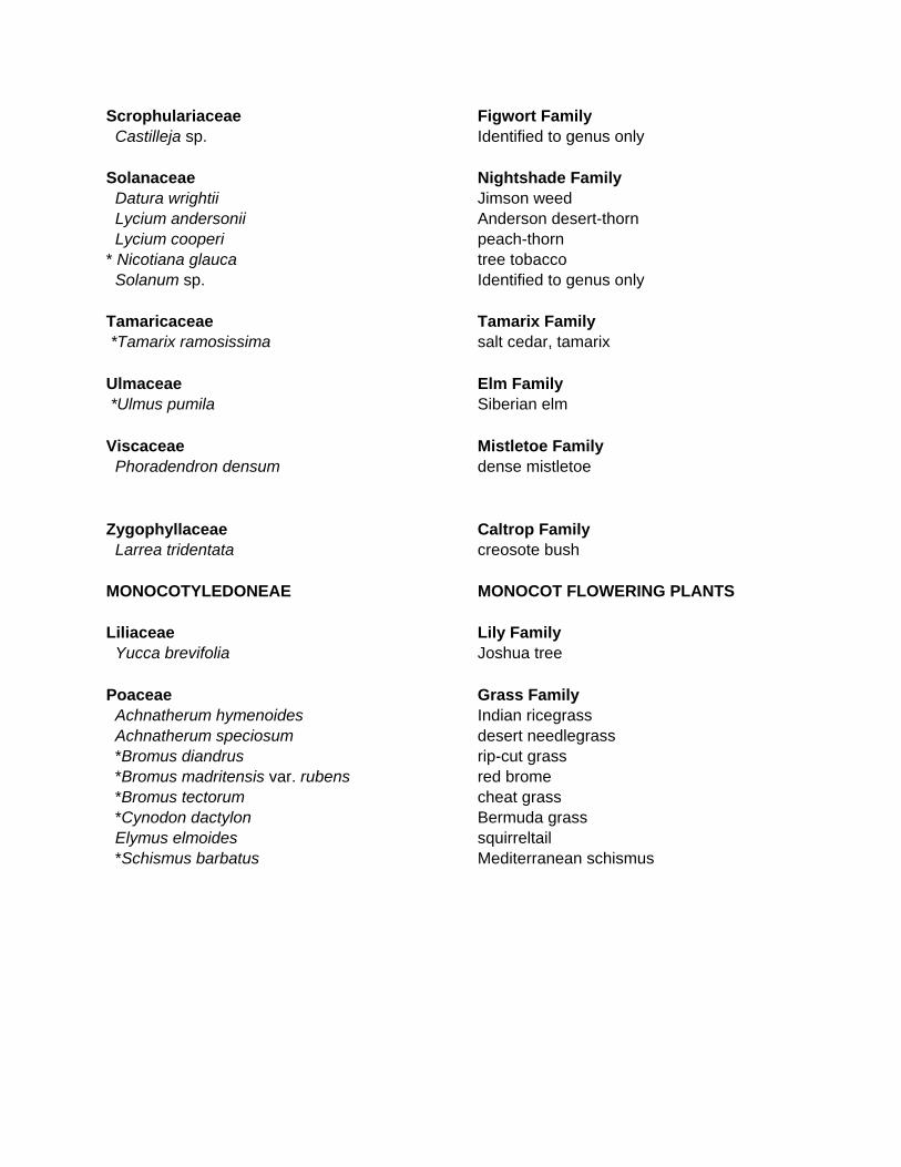
Scrophulariaceae Figwort Family Castilleja sp. Identified to genus only Solanaceae Nightshade Family Datura wrightii Jimson weed Lycium andersonii Anderson desert-thorn Lycium cooperi peach-thorn * Nicotiana glauca tree tobacco Solanum sp. Identified to genus only Tamaricaceae Tamarix Family *Tamarix ramosissima salt cedar, tamarix Ulmaceae Elm Family *Ulmus pumila Siberian elm Viscaceae Mistletoe Family Phoradendron densum dense mistletoe Zygophyllaceae Caltrop Family Larrea tridentata creosote bush MONOCOTYLEDONEAE MONOCOT FLOWERING PLANTS Liliaceae Lily Family Yucca brevifolia Joshua tree Poaceae Grass Family Achnatherum hymenoides Indian ricegrass Achnatherum speciosum desert needlegrass *Bromus diandrus rip-cut grass *Bromus madritensis var. rubens red brome *Bromus tectorum cheat grass *Cynodon dactylon Bermuda grass Elymus elmoides squirreltail *Schismus barbatus Mediterranean schismus

APPENDIX 5
Victorville 2 Hybrid Power Project
OBSERVED VERTEBRATE SPECIES LIST FOR THE VICTORVILLE 2 HYBRID POWER PROJECT

APPENDIX 5
Vertebrates Observed on Victorville 2 Hybrid Power Project, City of Victorville, San Bernardino County, California
This list reports only plants and animals observed on or adjacent to the site while conducting field activities (i.e., surveys and monitoring) for this Project. Other species may have been overlooked or undetectable due to their activity season. Nomenclature and taxonomy for fauna observed on site follows Stebbins (1985) and Collins (1990) for herpetofauna, American Ornithologists' Union Checklist (1983 and supplements) for avifauna, and Laudenslayer et al. (1991) for mammals. SYMBOLS AND ABBREVIATIONS: * Non-native (introduced) species. ** Sensitive species (see text). cf. Uncertain identification, but plant specimen "compares favorably" to named species
(from Latin confer: compare [with]). sp. Identified only to genus; species unknown (plural = spp.). HERPETOFAUNA REPTILES & AMPHIBIANS TESTUDINES TURTLES Testudinidae Land Tortoises **Gopherus agassizii desert tortoise SQUAMATA LIZARDS & SNAKES Crotaphytidae Collared and Leopard Lizards Crotaphytus wislizenii long-nosed leopard lizard Iguanidae Iguanids Sceloporus magister desert spiny lizard Sceloporus occidentalis western fence lizard
Uta stansburiana side-blotched lizard
Phrynosomatidae Spiny Lizards & Relatives Callisaurus draconoides zebra-tailed lizard

Phrynosoma platyrhinos desert horned Lizard Teiidae Whiptails & Racerunners Aspidoscelis (Cnemidophorus) tigris tigris Great Basin whiptail
Xantusiidae Night Lizards
Xantusia vigilis Yucca night lizard Coluberidae Colubrids Arizona elegans glossy snake Masticophis flagellum piceus coachwhip Pituophis catenifer deserticola Great Basin gopher snake Viperidae Vipers Crotalus cerastes sidewinder Crotalus scutulatus Mojave rattlesnake AVIFAUNA BIRDS Anatidae Swans, Geese, and Ducks Aix sponsa wood duck Anas strepera gadwall Anas americana American wigeon Anas platyrhynchos mallard Anas cyanoptera cinnamon teal Anas clypeata northern shoveler Anas crecca green-winged teal Aythya americana redhead Aythya collaris ring-necked duck Aythya affinis lesser scaup Bucephala albeola bufflehead Oxyura jamaicensis ruddy duck Odontophoridae New World Quail Callipepla californica California quail Podicipedidae Grebes Podilymbus podiceps pied-billed grebe Podiceps nigricollis eared grebe Ardeidae Herons and Egrets Ardea alba great egret Cathartidae Vultures Cathartes aura turkey vulture

Accipitridae Hawks, Old World Vultures, Harriers **Pandion haliaetus osprey **Circus cyaneus northern harrier Buteo jamaicenisis red-tailed hawk **Buteo swainsoni Swainson's hawk **Haliaeetus leucocephalus bald eagle Accipiter striatus sharp-shinned hawk **Accipter cooperii Cooper’s hawk Falconidae Caracaras and Falcons **Falco mexicanus prairie falcon Falco sparverius American kestrel Rallidae Rails, Gallinules, and Coots Fulica americana American coot Charadriidae Plovers and Relatives
Charadrius vociferus killdeer
Recurvirostridae Stilts and Avocets Himantopus mexicanus black-necked stilt Scolopacidae Sandpipers Tringa melanoleuca greater yellowlegs Actitis macularius spotted sandpiper Calidris mauri western sandpiper Calidris minutilla least sandpiper Laridae Skuas, Gulls, Terns, and Skimmers Larus delawarensis ring-billed gull Larus californicus California gull Columbidae Pigeons and Doves
Columba livia rock pigeon Zenaida macroura mourning dove
Cuculidae Cuckoos, Roadrunners, and Anis Geococcyx californianus greater roadrunner Strigidae Typical Owls **Athene cunicularia burrowing owl Tytonidae Barn Owls Tyto alba barn owl

Caprimulgidae Goatsuckers Chordeiles acutipennis lesser nighthawk Apodidae Swifts **Chaetura vauxi Vaux’s swift
Aeronautes saxatalis white-throated swift Trochilidae Hummingbirds Archilochus alexandri black-chinned hummingbird Calypte anna Anna's hummingbird **Calypte costae Costa's hummingbird **Selasphorus rufus rufous hummingbird Picidae Woodpeckers and Allies **Picoides nuttallii Nuttall’s woodpecker Picoides pubescens downy woodpecker Picoides scalaris ladder-backed woodpecker Colaptes auratus Northern Flicker Tyrannidae Tyrant Flycatchers Contopus sordidulus western wood-pewee Empidonax hammondii Hammond's flycatcher Empidonax difficilis/occidentalis “western” flycatcher
Sayornis nigricans black phoebe Sayornis saya Say's phoebe Myiarchus cinerascens ash-throated flycatcher Tyrannus vociferans Cassin's kingbird Tyrannus verticalis western kingbird
Laniidae Shrikes **Lanius ludovicianus loggerhead shrike Corvidae Jays, Magpies, and Crows Corvus corax common raven Alaudidae Larks Eremophila alpestris horned lark Hirundinidae Swallows Hirundo rustica barn swallow Petrochelidon pyrrhonota cliff swallow Stelgidopteryx serripennis northern rough-winged swallow Tachycineta bicolor tree swallow Tachycineta thalassina violet-green swallow Remizidae Verdin

Auriparus flaviceps verdin Aegithalidae Long-tailed Tits and Bushtits Psaltriparus minimus bushtit Troglodytidae Wrens Campylorhynchus brunneicapillus cactus wren Thryomanes bewickii Bewick's wren Troglodytes aedon house wren Regulidae Kinglets Regulus calendula ruby-crowned kinglet Sylviidae Old World Warblers and Gnatcatchers
Polioptila caerulea blue-gray gnatcatcher Turdidae Solitaires, Thrushes, and Allies Sialia mexicana western bluebird Catharus guttatus hermit thrush
Mimidae Mockingbirds and Thrashers
Mimus polyglottos northern mockingbird Oreoscoptes montanus sage thrasher
**Toxostoma lecontei Le Conte’s thrasher **Toxostoma redivivum California thrasher Sturnidae Starlings Sturnus vulgaris European starling Motacillidae Wagtails and Pipits Anthus rubescens American pipit Ptilogonatidae Silky-flycatchers Phainopepla nitens phainopepla Parulidae Wood-Warblers Vermivora celata orange-crowned warbler Dendroica coronata yellow-rumped warbler Dendroica nigrescens black-throated gray warbler **Dendroica occidentalis hermit warbler Geothlypis trichas common yellowthroat Wilsonia pusillla Wilson’s warbler Thraupidae Tanagers Piranga ludoviciana western tanager
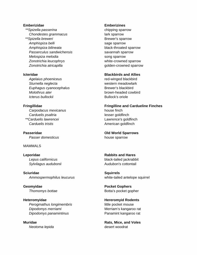
Emberizidae Emberizines **Spizella passerina chipping sparrow Chondestes grammacus lark sparrow **Spizella breweri Brewer's sparrow Amphispiza belli sage sparrow Amphispiza bilineata black-throated sparrow Passerculus sandwichensis savannah sparrow Melospiza melodia song sparrow Zonotrichia leucophrys white-crowned sparrow Zonotrichia atricapilla golden-crowned sparrow Icteridae Blackbirds and Allies Agelaius phoeniceus red-winged blackbird Sturnella neglecta western meadowlark Euphagus cyanocephalus Brewer’s blackbird Molothrus ater brown-headed cowbird Icterus bullockii Bullock's oriole Fringillidae Fringilline and Cardueline Finches Carpodacus mexicanus house finch Carduelis psaltria lesser goldfinch **Carduelis lawrencei Lawrence's goldfinch Carduelis tristis American goldfinch Passeridae Old World Sparrows Passer domesticus house sparrow MAMMALS Leporidae Rabbits and Hares Lepus californicus black-tailed jackrabbit Sylvilagus audubonii Audubon's cottontail Sciuridae Squirrels Ammospermophilus leucurus white-tailed antelope squirrel Geomyidae Pocket Gophers Thomomys bottae Botta’s pocket gopher Heteromyidae Hereromyid Rodents Perogmathus longimembris little pocket mouse Dipodomys merriami Merriam’s kangaroo rat Dipodomys panamintinus Panamint kangaroo rat Muridae Rats, Mice, and Voles Neotoma lepida desert woodrat

Onychomys torridus ramona southern grasshopper mouse Canidae Foxes, Wolves, Coyotes Canis latrans coyote Vulpes macrotis kit fox

APPENDIX 6
Victorville 2 Hybrid Power Project
SURVEY FORMS FOR PRESENCE-OR-ABSENCE AND CLEARANCE SURVEYS FOR DESERT TORTOISE SIGN
APPENDIX 7 Victorville 2 Hybrid Power Project
CALIFORNIA NATURAL DIVERSITY DATA BASE SENSITIVE SPECIES FORMS

APPENDIX 8
Victorville 2 Hybrid Power Project
QUALIFICATIONS OF INDIVIDUALS CONDUCTING STUDIES

APPENDIX 9
Victorville 2 Hybrid Power Project
FOCUSED TRAPPING SURVEY FOR MOJAVE GROUND SQUIRREL

APPENDIX 10
Victorville 2 Hybrid Power Project
PRELIMINARY DETERMINATION of JURISDICITONAL LIMITS U.S. ARMY CORPS of ENGINEERS SECTION 404 WATERS of the UNITED STATES INCLUDING WETLANDS and STATE WATERS SUBJECT TO CALIFORNIA DEPARTMENT of FISH and GAME SECTION
1602 STREAMBED ALTERATION AGREEMENT