draft scope of work - welcome to nyc.gov | city of new … pier 57: draft scope of work for an...
TRANSCRIPT

1
Pier 57: Draft Scope of Work for an Environmental Impact Statement
A. INTRODUCTION
The applicant—Young Woo & Associates, through the entity Hudson Eagle LLC (“Hudson Eagle”)—proposes to redevelop the Pier 57 site, which is located within Hudson River Park at approximately West 15th Street (see Figure 1), with retail, restaurant and other commercial uses; a marina; and educational and cultural and public open spaces uses. As part of the proposed project, the Pier 57 supporting caissons and pier structure would be rehabilitated and repaired.
In order to develop this proposed project, discretionary actions would be required from the Hudson River Park Trust (HRPT), the New York City Planning Commission (CPC), the New York City Board of Standards and Appeals (BSA), and the New York State Department of Environmental Conservation (NYSDEC), and possibly other agencies, including the New York State Department of Transportation (NYSDOT). Thus, the proposed Pier 57 project is subject to environmental review under the State Environmental Quality Review (SEQR) and City Environmental Quality Review (CEQR) regulations and guidelines. HRPT will act as the lead agency for this proposal. In addition, the project will be subject to review under the Uniform Land Use Review Procedure (ULURP). Federal approvals would be necessary for permits for work on the pier structure and would be subject to environmental review under the National Environmental Policy Act.
Development of the proposed project may result in potentially significant adverse environmental impacts, requiring that an Environmental Impact Statement (EIS) be prepared. Scoping is the first step in the EIS preparation and provides an early opportunity for the public and other agencies to be involved in the EIS process. It is intended to determine the range of issues and considerations to be evaluated in the EIS. This draft EIS scope has been prepared to describe the proposed project, present the proposed framework for the EIS analysis, and discuss the procedures to be followed in the preparation of the Draft EIS (DEIS). The 2010 City Environmental Quality Review (CEQR) Technical Manual will serve as a general guide on the methodologies and impact criteria for evaluating the project’s potential effects on the various environmental areas of analysis.
B. PROJECT DESCRIPTION
PROJECT SITE
The project site consists of historic Pier 57, adjacent lands underwater, and some associated frontage area, all of which are located in Hudson River Park at approximately West 15th Street. Immediately adjacent to and east of the site are other portions of Hudson River Park and the Route 9A bikeway and roadway.

East R
iver P
ark
E. 23rd St.
E. 34th St.
E. 42nd St.
E. 57th St.
E. 59th St.
Canal St.
Six
th
Ave
.
Fift
h A
ve.
Sev
enth
A
ve.
Eig
hth
Ave
.
Ten
th
Ave
.
Ele
vent
h A
ve.
Par
k A
ve.
Thi
rd A
ve.
Sec
ond
Ave
.
Fir
st A
ve.
Nin
th
Ave
.
Lexi
ngto
n A
ve.
Broadw
ay
Bro
adw
ay
Chambers St.
Gansevoort St.
Christopher S
t.
Battery Pl.
E. 14th St.
Houston St.
FDR Drive
W. 23rd St.
W. 34th St.
W. 42nd St.
W. 59th St.
W. 55th St.
W. 14th St.
Brooklyn Bridge
HU
DS
ON
RIV
ER
EA
ST
RIV
ER
Queensboro Bridge
Manhattan Bridge
BatteryPark
Battery Park City
Con
vent
ion
Cen
ter
NEWJERSEY
QUEENS
BROOKLYN
999897
94
92
90
88
86
84
83
81
79
78
76
72
62
61
60
59
54
57
53
52
51
49
46
45
40
34
32
2625
64
66
3.22
.11
HUDSON RIVER PARK PIER 57
Project LocationFigure 1
N
SCALE
0 2000 4000 FEET
Project Site
Hudson River Park

Pier 57 Redevelopment
2
The pier, at 15th Street west of 9A, was constructed in 1952 and consists of three underwater caissons, which are concrete boxes that form most of the pier’s substructure. Above the caissons are the pier’s headhouse and “finger” building.
The pier, which is listed on the State and National Registers of Historic Places, was historically used for the Grace Lines cruises (through 1967). Between 1967 and 2003 it was used as a bus garage and maintenance facility by the Manhattan and Bronx Surface Transportation Operating Authority and later the Metropolitan Transportation Authority. The pier has been vacant since 2004.
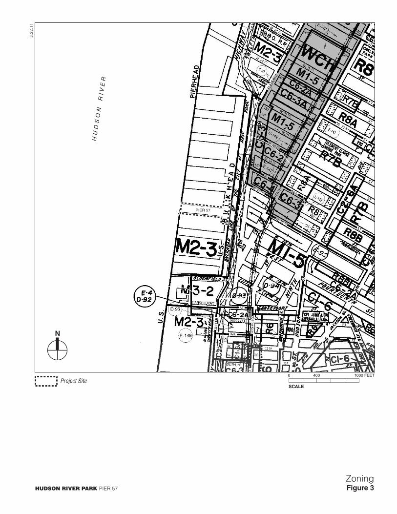
The pier is zoned M2-3, which allows commercial or manufacturing uses at a maximum floor area ratio of 2.0 (see Figure 3).
Pier 57 is part of the 550-acre Hudson River Park, the creation of which was the subject of an environmental review in the late 1990s (Hudson River Park Final Environmental Impact Statement, May 1998). In 1998, the New York State Legislature passed the “Hudson River Park Act,” Chapter 592 of the Laws of 1998 (“the Act”) which created Hudson River Park and HRPT to design, build and operate it.
PROPOSED PROJECT
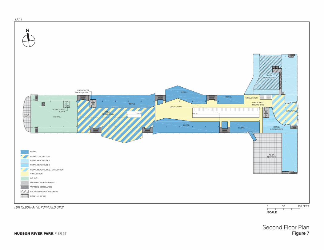
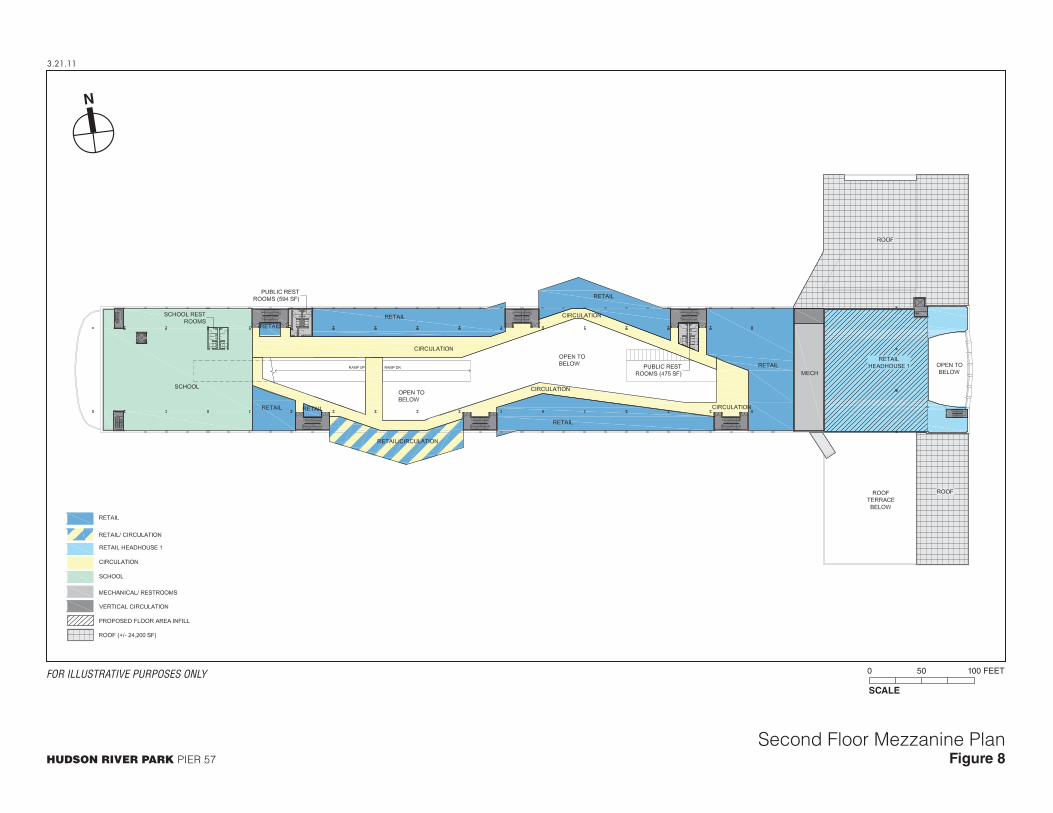
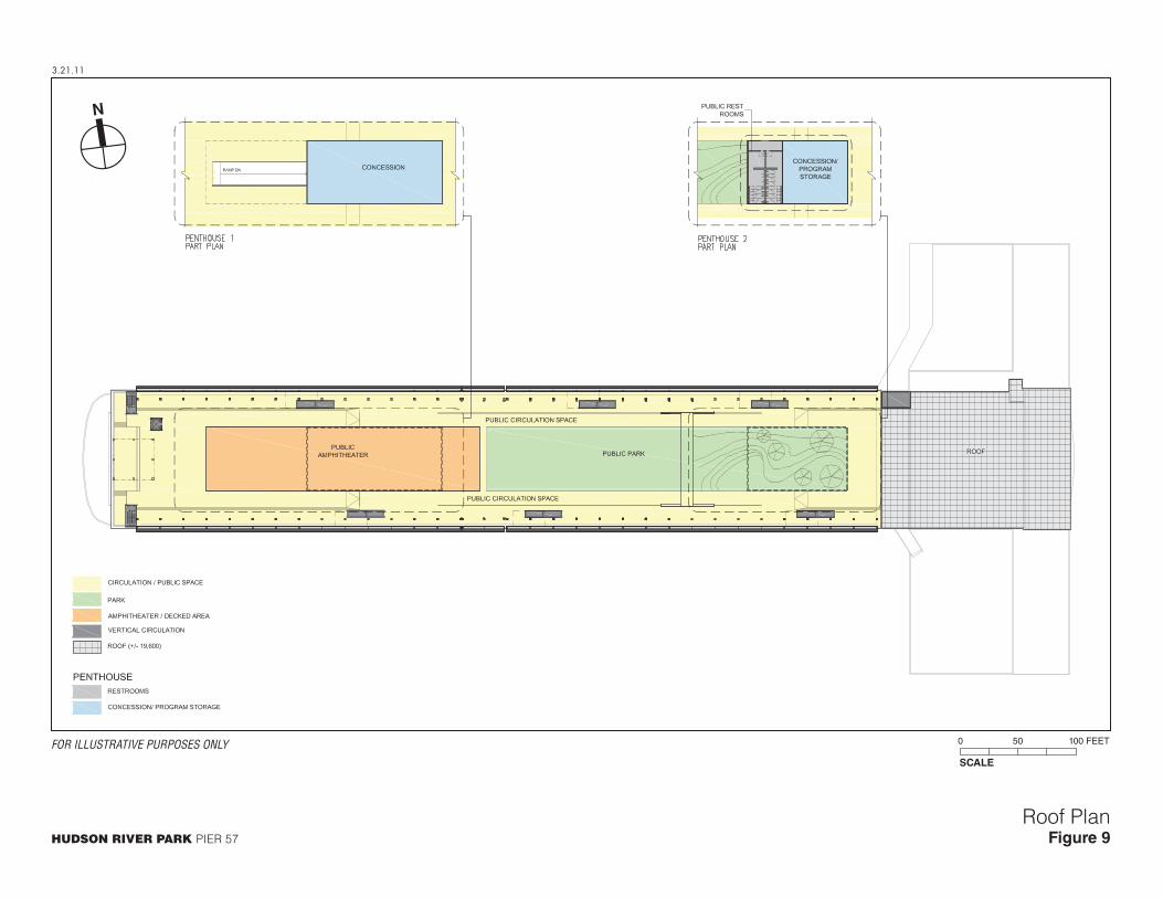
The rehabilitated pier is expected to include a public retail market, restaurant and other commercial uses, as well as educational, cultural and public open spaces uses and a marina. The pier would become an important component of this section of Hudson River Park, generate needed revenue to support the Park’s operations, and improve the visual and programming links between the Park and the inland communities. The project would also preserve an important physical component of the waterfront’s history and reintroduce some maritime uses to a pier once built explicitly for that purpose while also introducing innovative architectural components designed to respect and enliven the historic structure. Table 1 summarizes the program elements; the project uses are preliminary and subject to refinement based on project design and market conditions. Figures 4 through 9 show the project’s floor plans, and Figure 10 shows the exterior elevations of the proposed project.
Table 1Preliminary Program of Project Uses
Use Location within the Pier Gross Square
Footage Work/Sell Marketplace Center Level II/Level IIM 49,200 Gallery/Spa/Storage/other uses Caisson Level 40,000 Technical Art School and Ancillary Facilities Level II/Level IIM 32,700 Food Market and Restaurants Level I/Level IM/Rooftop 109,400 Restaurant Terrace Level II 13,500 Flexible Retail Space Level I / Level II/ Level IIM 45,200 General Retail Level I/Level II/Level IIM 44,600 Circulation Caisson/Level I/Level IM/Level II/Level IIM 82,400 Theater/Cultural Use Level I/Level IM 11,000 Public Open Space Level I/Rooftop 114,800 Marina Level I 115 slips Parking Caisson Level 150 spaces Source: Hudson Eagle

TENT
H AV
TENT
H AV
EIG
HTH
AV
EIG
HTH
AV
W 11 STW 11 ST
WE
ST
ST
WE
ST
ST
W 14 STW 14 ST
W 15 STW 15 ST
W 12 STW 12 ST
W 16 STW 16 ST
W 17 STW 17 ST
W 18 STW 18 ST
W 19 STW 19 ST
W 20 STW 20 ST
W 21 STW 21 ST
NINT
H AV
NINT
H AV
NINT
H AV
NINT
H AV
JANE STJANE ST
W 22 STW 22 ST
W 23 STW 23 ST
W 13 STW 13 ST
W 24 STW 24 ST
W 25 STW 25 ST
PERRY STPERRY ST
W 4 ST
W 4 ST
W 26 STW 26 ST
HORATIO STHORATIO ST
JOE
DIM
AGG
IO H
WY
JOE
DIM
AGG
IO H
WY
RO
UTE
9A
RO
UTE
9A
WA
SHIN
GTO
N S
TW
ASH
ING
TON
ST
ES
PLA
NA
DE
ES
PLA
NA
DE
BANK STBANK ST
HU
DSO
N S
TH
UD
SON
ST
GR
EEN
WIC
H S
TG
REE
NW
ICH
ST
SEVE
NTH
AV S
SEVE
NTH
AV S
BETHUNE STBETHUNE ST
ELEV
ENTH
AV
ELEV
ENTH
AV
GREENW
ICH AV
GREENW
ICH AV
GANSEVOORT STGANSEVOORT ST
LITTLE W 12 ST
LITTLE W 12 ST
BLEECKER
STBLEEC
KER ST
W 27 STW 27 ST
WAVER
LY PLW
AVERLY PL
BANK STBANK ST
W 13 STW 13 ST
HU
DSO
N S
TH
UD
SON
ST
W 4
ST
W 4
ST
HU
DS
ON
R
IV
ER
PIER 57
PIER 59
PIER 60
PIER 61
PIER 62
PIER 63
PIER 64
PIER 54
PIER 53
PIER 52
PIER 51
CH
EL
SE
A
PI
ER
S
N Y CD E P T O F
S A N I T A T I O N
F D N Y
4.5.11
HUDSON RIVER PARK PIER 57
Project Site LocationFigure 2
SCALE
0 400 1000 FEET
N
CHELSEACHELSEA
WEST VILLAGEWEST VILLAGE
MEAT PACKINGDISTRICT
MEAT PACKINGDISTRICT
Project Site
Hudson River Park
PIER 57
H U
D S
O N
R
I V
E R
3.22
.11
HUDSON RIVER PARK PIER 57
ZoningFigure 3
N
SCALE
0 400 1000 FEET
Project Site

3.21.11
HUDSON RIVER PARK PIER 57
First Floor PlanFigure 4
SCALE
0 50 100 FEET
N
FOR ILLUSTRATIVE PURPOSES ONLY

4.21.11
HUDSON RIVER PARK PIER 57
Cellar PlanFigure 5
SCALE
0 50 100 FEET
N
FOR ILLUSTRATIVE PURPOSES ONLY

3.21.11
HUDSON RIVER PARK PIER 57
First Floor Mezzanine PlanFigure 6
SCALE
0 50 100 FEET
N
FOR ILLUSTRATIVE PURPOSES ONLY
TERRACE
TERRACE
4.7.11
HUDSON RIVER PARK PIER 57
Second Floor PlanFigure 7
SCALE
0 50 100 FEET
N
FOR ILLUSTRATIVE PURPOSES ONLY
3.21.11
HUDSON RIVER PARK PIER 57
Second Floor Mezzanine PlanFigure 8
SCALE
0 50 100 FEET
N
FOR ILLUSTRATIVE PURPOSES ONLY
3.21.11
HUDSON RIVER PARK PIER 57
Roof PlanFigure 9
SCALE
0 50 100 FEET
N
FOR ILLUSTRATIVE PURPOSES ONLY

3.21.11
HUDSON RIVER PARK PIER 57
ElevationsFigure 10
FOR ILLUSTRATIVE PURPOSES ONLY

Draft Scope of Work
3
PROGRAM
Retail, Restaurant, and Other Commercial/Educational/Cultural Uses
The programming and design concepts at Pier 57 have been shaped by the west side neighborhoods in which the pier is located as well as the dramatic pier itself. While specific tenants have not yet been finalized, the primary retail use on the second floor is a planned public marketplace modeled on several existing year-round markets located in the United Kingdom (Spitalfields and Camden Locke). The UK operator of these markets has a US arm, which is the anticipated Pier 57 market operator and also operates the holiday markets at Grand Central Terminal and Union Square in Manhattan, among others.
At Pier 57, the public marketplace concept draws specific inspiration from existing businesses in West Chelsea and the Meatpacking District in the realms of fashion, design, art and food. Repurposed shipping containers would be stacked to create two market levels (ground floor and “mezzanine”). The stacking is possible because the ground floor ceiling height is 28 feet, which can accommodate two levels of stacked containers. Throughout the length of the piershed new vertical circulation would be provided to facilitate access, including ADA access.
In combination with some traditional walled enclosures, these containers would create multiple “work/sell” retail stores and showrooms ranging in size between approximately 160 square feet and 640 square feet. These retail uses would be oriented primarily toward a collection of independent designers and food purveyors. The market would be an incubator of small businesses as well as a community gathering place. Towards the western end of the piershed, the design would open to a large double-height market square with views of the water to the north and south, featuring rotating kiosks and food exhibitions. Some larger retail could also be located in the pier, as well as a theater or other cultural use.
The proposed project would also include a wide range of uses oriented towards food, including a potential cooking school, test kitchen and ancillary facilities, as well as restaurants and rotating food exhibition and sales spaces. These are anticipated to be located primarily on the second floor which would also have a mezzanine level over portions of the piershed. A limited number of containers are envisioned to project from the piershed; if approved, these containers would offer views over the water.
Under the terms of the Trust’s proposed lease with the applicant, “big box” retail would be prohibited. Similarly, the lease would prohibit tenancies and uses that are primarily trade shows, event or ballroom spaces. The lease would further require at least one publicly accessible sit-down restaurant at the western end of the piershed.
Marina
The Pier 57 project would include a marina of approximately 115 slips located to the north, south or on both sides of Pier 57. The marina would include a breakwater that would be located on the western end of the pier, and would include slips for one or more historic vessels and a non-motorized boat launch; it may also include a water taxi stop. No dredging would be required for the marina.
Public Open Space and Outdoor Programming
The Pier 57 project would add approximately 2.5 acres of open space to Hudson River Park in three main areas:

Pier 57 Redevelopment
4
Existing Perimeter walkway. The existing perimeter walkway extending around most of the pier would be repaired and extended to connect with the public esplanade to the east of the pier, consistent with existing permits previously received by HRPT. The walkway would have a continuous width of 15 feet.
New perimeter walkway. New public walkways parallel to the existing bulkhead, also previously approved and permitted, would extend to the north and south, enlarging the currently limited public circulation space along the bulkhead. Treatments would be compatible with existing designs within Hudson River Park for areas bordering the river.
Rooftop open space. On the pier’s finger building, nearly 2 acres of open space would be created. The roof is roughly divided into four zones. The western end of the piershed, where most visitors would enter the space, would be unprogrammed, providing flexible space for seating, relaxation, and views of the river. The center of the rooftop contains pitched seating (the amphitheater) and a flat surface for public use; at times, the area would be programmed with film, art, or sports related installations. The easternmost section of the piershed roof would have a pitched landscaped platform that would also be for public recreational use.
The outdoor rooftop open space, with a capacity of up to 3,000 persons, would function primarily as public open space. It would also be developed to allow the Tribeca Film Festival to periodically provide a variety of rooftop programming, ranging from film screenings to outdoor art installations to exhibitions linked to film subjects—for example, a temporary skate park to coincide with a sports-related film series. While free, some of these events would require tickets to control capacity. Attendance for such events typically would not exceed 1,500 people.
Caissons
Pier 57 has three underwater caissons that support the pier structure. The caissons are unique in Hudson River Park and are a major reason for the pier’s historic significance. Because these “basement” structures are not connected to each other, access and code considerations limit plans for future uses. The project proposes to use the easternmost caisson for vehicular circulation and parking of up to approximately 150 accessory vehicles using triple height stackers. This caisson was historically used for vehicle parking and circulation. If code concerns can be satisfied, ideas for the middle and western caissons include ancillary storage related to uses in the pier, art galleries or large rotating art installations, spa, wine cellar, and one or more areas accessible to the general public, potentially in small organized groups, to view and tour these underwater spaces.
PROJECT DESIGN
The revitalized headhouse at Pier 57 would become an iconic gateway and a greatly improved entrance into the park from Chelsea and the Meatpacking District, further connecting these neighborhoods to the waterfront. It would restore the building’s 1950s façade and open the ground floor to the public and welcome visitors from the north, south, and east.
The center of the headhouse entrance would be a virtual extension of 15th Street, drawing visitors across Route 9A, through the headhouse and up an existing interior ramp to the second floor. This “interior street” is continued through the addition of a new ramp from the second floor to the roof; visitors to the pier would have a continuous pathway to the new public rooftop.
Retail on the ground floor and second floors would flank this “interior street” and would extend west beyond the ramps. The repurposed-stacked shipping containers would be a distinctive

Draft Scope of Work
5
feature in these sections of the piershed. Another distinctive feature is the 20-foot-wide modular vertical doors spanning the length of the piershed. Historically these were often open to allow goods to be loaded onto adjacent ships. The Pier 57 design seeks to take advantage of these openings during good weather to allow the pier to be naturally ventilated. On the ground floor some openings would provide a direct link to the public perimeter walkway.
The signature feature on the public rooftop would be a new pitched seating area which would be designed to function as both an amphitheatre and a great place to look back at the City. Like the existing burtoning system which would be retained, the new amphitheatre would have a lightweight, industrial character. The balance of the rooftop would have a mixture of lawn, landscaped areas, decorative pavements and fixed and flexible seating. It is expected a moveable screen for the Tribeca Film Festival would also reflect the industrial character of the existing rooftop.
There are four proposed rooftop additions:
On the north side of the lower headhouse rooftop, a new enclosure measuring approximately 15,500 sf would be built and another enclosure measuring approximately 8,100 sf would be constructed on the upper level of the head-house roof. Both areas would provide additional space for retail and other support services. Their elevations would be lower than the existing art deco façade.
The new ramp from the second floor to the rooftop is being designed to emerge onto the rooftop under the amphitheatre, creating an additional enclosure; this space under the amphitheatre would provide climate conditioning within the piershed. It would also offer additional space for restrooms, food service, storage and other support functions. The fourth small rooftop addition at the Eastern end of the piershed; beneath the pitched landscaped area would contain additional support space and storage for rooftop seating and equipment. Several code required stair tower and elevator enclosures would also be added to the roof to allow for egress for roof occupants. None of the rooftop additions would be higher than the existing elevator enclosures which would be removed in order to provide the open rooftop plan.
PIER ACCESS / CIRCULATION
To efficiently utilize the pier, the existing access routes would be modified to improve pedestrian access, and to allow for proper servicing. Figure 11 shows the project’s access plan.
Vehicles would access the site via a new right turn lane between West 16th and West 17th streets, directing vehicles to a circulation road parallel to Route 9A with exits at West 14th Street. From this access road, cars, vans and small trucks would enter the pier via a ramp at the south end of the pier building down to approximately 150 accessory parking spaces and a loading area for vans and small trucks located in the Eastern most caisson. In addition, trucks would enter the center of the pier at grade for servicing during the off-hours of the project.
Pedestrians would access the site via the Hudson River Park walkway from the north and south, or five (5) nearby crosswalks which cross Route 9A (south side of West 17th Street, south side of West 16th Street, north and south side of West 15th Street and the south side of West 14th Street). The east facade of the Pier is intended to have multiple pedestrian access doors, or pedestrians could access the Pier via the Public access walkway which would surround the pier on the south, west and northern sides.

3.24
.11
HUDSON RIVER PARK PIER 57
Access PlanFigure 11
N
SCALE
0 40 80 FEET
Project Site
Hudson River Park

Pier 57 Redevelopment
6
The Route 9A bikeway, also providing access to the site, would be realigned to the east, maintaining its full width.
Access from the ground floor to the upper levels is via the existing vehicle ramp which leads from the Eastern entrance to the pier to the second floor, as well as from a new ramp which would lead from the second floor to the newly adapted roof. This new access route, aligned to West 15th Street, would be a virtual extension of that street and lead to the roof; it would improve air circulation on the second floor during warm weather seasons and increase opportunities for the public to enjoy the rooftop park.
In addition to the ramps, pedestrians would have access to enclosed stairwells (both new and existing) which would be adapted for use by pedestrians, and via some new and existing staircases which also serve as means of egress.
IN-WATER CONSTRUCTION
The project would require a number of in-water construction activities. This would include repairs to the caissons; repairs to the piles and beams around the caissons, including pile repair and replacement; repairs to girders supporting the apron walkway; repairs to the timber fender system attached to the pier apron; a new breakwater at the western most end of the pier; construction of new walkways along portions of the apron; and construction a 115-slip marina. In-water activities associated with the construction of the marina would include the installation of the guide piles, walkways and fingerfloats.
PROPOSED ACTIONS
To develop the proposed project, various discretionary actions would be required.
In addition, coordination would be required with the New York State Office of Parks, Recreation and Historic Preservation, State Historic Preservation Office (SHPO) under Section 14.09 of the New York State Parks, Recreation and Historic Preservation Law and Section 106 of the National Historic Preservation Act as the project is seeking state and federal permits (see below). Coordination is also required because the project is seeking federal tax credits to rehabilitate Pier 57 to the Secretary of the Interior’s Standards for Rehabilitation of Historic Properties. Also, because the project will require Federal permits, it will be subject to review by NYSDOS for consistency with the NY State Coastal Management Program.
HRPT APPROVAL
HRPT would need to approve lease terms with Hudson Eagle.
CITY ACTIONS
Zoning map amendment. The applicant would seek an amendment to the New York City zoning map to rezone the project site from M2-3 to a district that would allow the public market and anticipated floor area.
Zoning text change. The applicant would seek a zoning text change to allow community facility uses (e.g., cooking school) in certain manufacturing zoning districts.
Relief from various Waterfront Zoning Regulations related to bulk, height and setback, yards, public access and visual corridors, and design requirements. The applicant will

Draft Scope of Work
7
continue to have discussions with the New York City Department of City Planning as design concepts progress.
BSA approval to modify certain building and fire code provisions. The applicant would seek approval to modify certain Building and Fire Code provisions pursuant to Section 666 of the New York City Charter, including but not limited to, those provisions regarding egress.
Special permit for retail in excess of 10,000 sf.
STATE ACTIONS
NYSDEC—The applicant would seek a Part 608 Protection of Waters permit for in-water work.
NYSDOT—Approvals related to site access at Route 9A.
FEDERAL ACTIONS
U.S. Army Corps of Engineers (USACE). The applicant would seek Section 10 and Section 404 permits for work in the navigable waters of the United States.
OTHER APPROVALS
Other approvals as necessary to effectuate the project.
PURPOSE AND NEED
Consistent with the Hudson River Park Act, the purpose of the Pier 57 project is to reuse this portion of the Hudson River waterfront for the public benefit, making it an asset for the city and the region. The Pier 57 project would increase public access to the waterfront, provide additional open space resources and cultural space within Hudson River Park, and include program components that are compatible with park uses and that would generate funds to contribute to the operation and maintenance of the park. The Pier 57 project would restore and modernize the Pier 57 structure, which is listed on the State and National Registers of Historic Places.
C. ANALYSIS FRAMEWORK
In analyzing impacts, the EIS considers a proposed project’s potential adverse impacts on the environmental setting. Because the proposed project would be operational by approximately 2015, its environmental setting is not the current environment, but the future environment when the project would be completed. Therefore, the technical analyses and consideration of alternatives assess current conditions and forecast these conditions to 2015 for the purposes of determining potential impacts. The DEIS will provide a description of “Existing Conditions” for the 2011 analysis year and assessments of future conditions without the proposed project in 2015 (“Future Without the Proposed Project”) and with the proposed project (“Future With the Proposed Project”).
The future baseline in all technical chapters—future without the proposed project—will assume that none of the discretionary approvals proposed as part of the Pier 57 project are adopted. It is expected that if the proposed actions are not approved, the project site will remain in its current vacant condition. The DEIS will analyze the cumulative impacts of other projects expected to be complete by 2015 that will affect conditions in any of the relevant study areas (each individual task in Section D, below, identifies the proposed study area for analysis).

Pier 57 Redevelopment
8
The analysis of the future with the proposed project will assess the potential for impacts from the proposed project described in Section B, “Project Description.” The project as described represents the reasonable worst-case development that could occur under the proposed rezoning and other approvals.
D. PROPOSED SCOPE OF THE ENVIRONMENTAL IMPACT STATEMENT
The EIS will contain:
A. A description of the proposed project and its environmental setting;
B. A statement of the significant environmental impacts of the proposed project, including its short- and long-term effects and typical associated environmental effects;
C. An identification of any significant adverse environmental impacts that cannot be avoided if the project is implemented;
D. A discussion of reasonable alternatives to the proposed project;
E. An identification of irreversible and irretrievable commitments of resources that would be involved if the proposed project is built; and
F. A description of mitigation proposed to minimize any significant adverse environmental impacts.
The specific areas to be included in the EIS, as well as their respective tasks, are described below.
TASK 1: PROJECT DESCRIPTION
The first chapter of the EIS introduces the reader to the project and sets the context in which to assess impacts. This chapter will contain a project identification detailing the different elements of the proposed Pier 57 development program, including the public open space and possible marina uses; the background and purpose and need for the proposed project, including the project’s context within the larger Hudson River Park project and overall development in the neighborhood; figures to depict the proposed project, including the treatment of the Pier 57 building’s interior spaces. This chapter will also include a discussion of the project schedule and a discussion of the approvals required, procedures to be followed, and the role of the EIS in the process. The chapter is the key to understanding the proposed actions.
TASK 2: LAND USE, ZONING, AND PUBLIC POLICY
Under CEQR, a land use analysis characterizes the uses and development trends in the area that may be affected by a proposed project, describes the zoning and public policies that guide development, and determines whether a proposed project is compatible with those conditions and policies or whether it may affect them. The Pier 57 project would result in the redevelopment of a vacant pier with retail, restaurant and other commercial uses, a marina, and education, cultural and public open space uses as elements in the overall development of Hudson River Park.
This section will present a description of existing conditions within ¼-mile of the project site, and describe the project and its potential effects on land use, zoning, and public policy. This

Draft Scope of Work
9
assessment will also provide a baseline for other analyses in the EIS. Information sources will include the Hudson River Park Trust, Department of City Planning, Department of Buildings, and field reconnaissance. The chapter will:
A. Provide a brief development history of the project site and surrounding area, including a discussion of the status of Hudson River Park development and the planning context of the project. Describe conditions on the project site, including existing conditions and the underlying zoning. Establish the ¼-mile study area surrounding the site (the area in which potential impacts could occur).
B. Describe predominant land use patterns in the study area, including a description of recent development trends.
C. Describe the existing zoning and recent zoning actions in the study area.
D. Describe the public policies that apply to the project site and the study area, including the Hudson River Park Act and specific development projects and plans for public improvements. As part of the analysis of public policy, the proposed project’s consistency with PlaNYC 2030, the Waterfront Revitalization Program (WRP), and Vision 2020 and the new Comprehensive Waterfront Plan, will be assessed. The analysis will assess, for those relevant policies identified on the project’s WRP Consistency Assessment Form, the consistency of the project with the WRP policies.
E. Gather information on projects expected to occur in the study area in the future without the proposed project, including plans for the changing use at the Gansevoort peninsula, the High Line, and other developments in this section of the west side, and describe how these projects might affect land use patterns and development trends in the study area in the future without the project. Also, identify pending zoning actions (including those associated with the proposed No Build projects) or other public policy actions that could affect land use patterns and trends in the study area in the future without the proposed project.
F. Assess impacts of the proposed project on land use and land use trends, zoning, and public policy.
TASK 3: SOCIOECONOMIC CONDITIONS
The socioeconomic character of an area includes its population, housing, and economic activity. Socioeconomic changes may occur when a project directly or indirectly changes any of these elements. Although socioeconomic changes may not result in impacts under CEQR, they are disclosed if they would affect land use patterns, low-income populations, the availability of goods and services, or economic investment in a way that changes the socioeconomic character of an area. The objective of the CEQR analysis is to disclose whether any changes created by the project would have a significant impact compared to what would happen in the future without the project.
According to the CEQR Technical Manual, the five principal issues of concern with respect to socioeconomic conditions are whether a proposed action would result in significant adverse impacts due to: (1) direct residential displacement; (2) direct business displacement; (3) indirect residential displacement; (4) indirect business displacement; and (5) adverse effects on specific industries. The following details the scope of analyses warranted by the proposed project for each of these five principal issues of concern.

Pier 57 Redevelopment
10
DIRECT RESIDENTIAL DISPLACEMENT
The proposed project would not result in direct residential displacement. Therefore, an assessment of potential impacts due to direct residential displacement is not warranted.
DIRECT BUSINESS DISPLACEMENT
The proposed project would not directly displace any businesses. Therefore, no further assessment of this concern is warranted.
INDIRECT RESIDENTIAL DISPLACEMENT
The proposed project would not introduce a residential use. Based on CEQR Technical Manual preliminary assessment guidelines, if a project does not add a new population, no further analysis of potential indirect residential displacement is warranted.
INDIRECT BUSINESS DISPLACEMENT
Indirect Business Displacement due to Increased Commercial Rents
The proposed project would provide more than 200,000 square feet of commercial space, which is a CEQR Technical Manual threshold for assessing the potential indirect effects of an action. The concern with respect to indirect business displacement is to determine whether a proposed project may introduce trends that make it difficult for businesses to remain in the area.
The indirect business displacement analysis will characterize employment and business trends within the study area, which is expected to conform to the ¼-mile land use study area described in Task 2, although adjustments may be made to the ¼-mile delineation to conform to Census tract boundaries. This analysis will consider the most recent available data from public and private sources such as New York State Department of Labor, the U.S. Census Bureau, and ESRI, as well as discussions with local real estate brokers as necessary. This information will be used in a preliminary assessment to consider:
Whether the proposed project would introduce enough new economic activity to alter existing economic patterns;
Whether the proposed project would add to the concentration of a particular sector of the local economy enough to alter or accelerate existing economic patterns; and
Whether the proposed project would indirectly displace residents, workers, or visitors who form the customer base of existing businesses in the area.
If the preliminary assessment finds that the proposed project could introduce trends that would make it difficult for businesses to remain in the area, a detailed analysis will be conducted. The detailed analysis would determine whether the proposed project would increase property values and thus increases rents for a potentially vulnerable category of businesses, and whether relocation opportunities exist for those firms.
Indirect Business Displacement due to Retail Market Saturation
Since the project would introduce more than 200,000 square feet of local-serving or regional-serving retail on a single development site, an assessment of indirect business displacement due to retail market saturation is appropriate. The purpose of the preliminary analysis is to determine whether the project may capture retail sales in a particular category of goods to the extent that
Draft Scope of Work
11
the market for such goods would become saturated as a result, potentially resulting in vacancies and disinvestment on neighborhood commercial streets.
Based on methodology presented in the CEQR Technical Manual, the analysis will estimate sales volume and expenditure potential of “relevant” retail stores within the trade area.1 It will also estimate sales for the project’s tenants and evaluate whether the proposed project would have the potential to saturate the market for particular retail goods within the trade area. Retail sales and expenditure data will be estimated from data from ESRI Business Analyst. Sales estimates for the project’s tenants will be based on Urban Land Institute’s Dollars and Cents of Shopping Centers.
If the preliminary assessment identifies the potential for the proposed project to create market saturation for particular categories of retail goods, a detailed assessment will be conducted to assess whether the proposed project may result in an increase in vacancy in retail store fronts, affecting the viability of neighborhood shopping areas in the study area. This analysis would first develop a profile of existing retail conditions within the trade area and would develop a profile of stores that provide goods similar to those of the proposed project. It would discuss retail conditions expected in the future without the proposed project, and then determine the proposed project’s impacts on local shopping areas.
ADVERSE EFFECTS ON SPECIFIC INDUSTRIES
The proposed project is not expected to affect conditions within a specific industry, and therefore, an assessment of this concern is not warranted.
TASK 4: COMMUNITY FACILITIES AND SERVICES
The proposed project would not introduce any residents to the project site, and therefore would not warrant analyses of public schools, day care, health care, or library facilities. In addition, because the proposed project would not directly cause the displacement of a police or fire facility, no detailed assessment of such services is required, and the EIS will provide a screening-level analysis of police and fire protection facilities. This chapter will identify and locate/map police precinct and fire houses community facilities within the study area.
TASK 5: OPEN SPACE
Open space is defined as publicly or privately owned land that is publicly accessible and operates, functions, or is available for leisure, play, or sport, or set aside for the protection and/or enhancement of the natural environment. An analysis of open space is conducted to determine whether or not a proposed project would have direct effects resulting from the elimination or alteration of open space, and/or an indirect effects resulting from overtaxing available open space. According to the CEQR Technical Manual, an assessment of a project’s potential direct effects may be appropriate if the project would result in a physical loss of public open space; change the use of an open space so that it no longer serves the same user population (e.g., elimination of playground equipment); limit public access to an open space; or cause increased noise or air pollutant emissions, odors, or shadows on public open space that would affect its usefulness, whether on a permanent or temporary basis. Indirect effects may occur when the
1 “Relevant” retail stores include those establishments that would be expected to sell categories of goods
similar to those sold in stores in the proposed project.

Pier 57 Redevelopment
12
population generated by a project would be sufficiently large to noticeably diminish the ability of an area’s open space to serve the future population. The population thresholds for CEQR assessment of indirect effects vary depending upon the current adequacy of open space in the project’s study area; for this area of Manhattan, an assessment is typically conducted if the proposed project’s population is greater than 200 residents or 500 employees.
As described above in Section B, “Project Description,” the Pier 57 project would create substantial new public open space within Hudson River Park and would not create any new open space demand on the part of residential users. However, the project would introduce new employees, shoppers and visitors to the site, who can be expected to utilize the project’s new open spaces and other nearby sections of Hudson River Park.
The EIS will provide a qualitative discussion of the proposed project’s benefits with respect to the new public open space that would be provided. In addition, a quantified screening level assessment will be conducted to evaluate the potential for impacts from the project’s population; if that preliminary assessment does not rule out the potential for impacts, a more detailed quantitative analysis will be prepared in conformance with the guidelines of The CEQR Technical Manual. The proposed project’s potential shadows impacts on public open space will be analyzed in the shadows task, as noted below.
TASK 6: SHADOWS
The CEQR Technical Manual requires a shadow analysis for proposed projects that have the potential to cast new shadows on a publicly-accessible open space or historic resource with sun-sensitive features. The project site is adjacent to, as well as part of, a public park, and the proposed project may increase the height of some sections of the pier structure. Therefore, a screening analysis will be performed to determine whether new shadows cast by the proposed project could impact adjacent public open space. If the screening analysis indicates that a more detailed shadows analysis is warranted, a detailed shadows analysis will be undertaken.
The potential for shadows from the proposed project to affect aquatic resources is addressed in Task 9, “Natural Resources.”
TASK 7: HISTORIC AND CULTURAL RESOURCES
Historic and cultural resources include resources of archaeological value and architectural value. The project’s potential to impact archaeological resources will rely on the studies undertaken for the Hudson River Park project. As part of the environmental review undertaken for that project, archaeological studies were prepared which concluded that there was no potential for significant precontact or historic-period archaeological resources to be located at Pier 57. Therefore, this task focuses only on architectural resources, and the EIS will not include an analysis of archaeological resources although the EIS will document the archaeological conclusions set forth above.
With respect to architectural resources, Pier 57, built in 1952, is listed on the State and National Registers of Historic Places (S/NR). As set forth in the Programmatic Agreement executed under Section 106 of the National Historic Preservation Act for the Hudson River Park project in 2000, modifications to this structure require consultation with the New York State Office of Parks, Recreation and Historic Preservation (OPRHP) to avoid, minimize and/or mitigate any adverse impacts to this architectural resource. In addition, the project is seeking federal tax credits to
Draft Scope of Work
13
rehabilitate Pier 57 to the Secretary of the Interior’s Standards for Rehabilitation of Historic Properties.
Alterations to the S/NR-eligible Hudson River bulkhead between Battery Place and West 59th Street, including the bulkhead at Pier 57, which is primarily composed of a granite wall built circa 1899-1915, will need to be undertaken in conformance with stipulations in the Hudson River Park Programmatic Agreement.
The architectural resources analyses will include the following tasks
A. Map and briefly describe designated architectural resources on the project site and within a 400-foot study area of the project site. These comprise National Historic Landmarks, properties listed on or determined eligible for listing on the State and National Register of Historic Places (S/NR, S/NR eligible), New York City Landmarks (NYCLs), properties listed within New York City Historic Districts (NYCHD), and properties pending NYCL and NYCHD designation.
B. Updating surveys conducted as part of the 1998 Hudson River Park FEIS, determine whether there are any potential architectural resources that could be impacted by the proposed project. Potential architectural resources comprise properties that may be eligible for listing on the S/NR and/or designation as an NYCL. Identification of potential architectural resources will be based on criteria for listing on the National Register as found in the Code of Federal Regulations, Title 36, part 60, and the New York City Landmarks Preservation Commission (LPC) criteria for NYCL/NYCHD designation. Map and describe any identified architectural resources. In consultation with OPRHP and LPC, seek determinations of eligibility for any potential resources in the study area that would be impacted by the proposed project.
C. Based on planned development projects expected to occur within the study area, qualitatively discuss any impacts on architectural resources that are expected in the future without the proposed project.
D. Assess any direct physical impacts of the proposed project on architectural resources. This analysis will include a description of the consultation undertaken with OPRHP. In conjunction with the urban design task, assess the proposed project’s potential to result in any visual and contextual impacts on architectural resources.
TASK 8: URBAN DESIGN AND VISUAL RESOURCES
Under CEQR, urban design is defined as the totality of components that may affect a pedestrian’s experience of public space. These components include streets, buildings, visual resources, open spaces, natural resources, wind, and sunlight. An urban design assessment under CEQR must consider whether and how a project may change the experience of the pedestrian in the surrounding area.
The 2010 CEQR Technical Manual recommends an analysis of pedestrian wind conditions for projects that result in the construction of large buildings at locations (such as along the waterfront) that experience high wind conditions, which may result in an exacerbation of wind conditions due to “channelization” or “downwash” effects that may affect pedestrian safety. As substantial new building construction affecting wind conditions would not occur, an analysis of pedestrian wind conditions is not necessary.

Pier 57 Redevelopment
14
The CEQR Technical Manual guidelines recommend the preparation of a preliminary assessment of urban design and visual resources when a project would have the potential for a pedestrian to observe, from street level, a physical alteration at the project site beyond that allowed by existing zoning. The Manual recommends the preparation of a detailed analysis if warranted based on the conclusions of the preliminary assessment.
Therefore, this section of the EIS will consider the effects of the proposed project on the urban design character of the project site and surrounding area. In addition, the project’s potential effects on views of the Hudson River waterfront and other visual resources will be assessed. The urban design and visual resources analysis will consist of the following:
A. Prepare a preliminary assessment of urban design and visual resources. The preliminary assessment will include a concise narrative of the existing project area, the future Build condition, and the future No Build condition and will present photographs, zoning and floor area calculations, building heights, project drawings and site plans, and view corridor assessments. The study area for the preliminary assessment will be consistent with the study area for the land use, zoning and public policy analysis. The preliminary assessment will determine whether the proposed project would create a change to the pedestrian experience that requires greater explanation and further study. If a detailed analysis is warranted, the EIS will include such analysis.
TASK 9: NATURAL RESOURCES
Following the methodologies presented in the CEQR Technical Manual, a natural resources assessment is conducted when such resources are present on or near a project site, and when an action involves disturbance to natural resources. The CEQR Technical Manual defines natural resources as “(1) the City’s biodiversity (plants, wildlife and other organisms); (2) any aquatic or terrestrial areas capable of providing suitable habitat to sustain the life processes of plants, wildlife, and other organisms; and (3) any areas capable of functioning in support of the ecological systems that maintain the City’s environmental stability.”
The project site is Pier 57, located on the west side of Route 9A/West Street at West 15th Street. The proposed actions would result in the redevelopment of a currently vacant, former bus garage for primarily retail, cultural, and open space uses. The project calls for a number of activities that have the potential for impacts to the aquatic environment, including rehabilitating the pier structure and caissons. Additional activities will include the development of a marina to be located on the north and south sides of the pier, a kayak launch, and a new breakwater at the western end of the pier. The proposed development of a marina would not require dredging of the Hudson River. Some repair and stabilization of the caissons may also be necessary. While sections of perimeter walkway along the edge of the pier apron would be rebuilt, this work was previously assessed and permits have already been issued to HRPT for this work. The proposed development of vegetated open space on the roof would have the potential to benefit terrestrial wildlife.
The EIS will include an assessment of the proposed actions’ effects on natural resources, including water and sediment quality in nearby water bodies and terrestrial and aquatic habitats and wildlife on and near the project sites. The EIS will also consider the proposed actions’ consistency with relevant USACE and U.S. Coast Guard Public Interest Factors.
Draft Scope of Work
15
WATER QUALITY
The following tasks will be undertaken for the analysis of water quality:
A. Using existing information available from sources such as the published literature, New York-New Jersey Harbor Estuary Program (HEP), NYSDEC, the New York City Department of Environmental Protection (DEP), the United States Environmental Protection Agency (USEPA), and the National Oceanic and Atmospheric Administration (NOAA), summarize the existing water and sediment quality of the lower Hudson River within the vicinity of Pier 57.
B. Assess water and sediment quality within the project area in the future with and without the proposed project. The assessment of potential impacts from the proposed project will consider activities associated with project construction and operation (e.g., stormwater, operation of the marina and presence of wave attenuation structures).
NATURAL RESOURCES
The following work tasks will be undertaken as part of the natural resource analysis:
C. Using the results of site visit(s) and existing information available from published literature and sources such as NOAA-National Marine Fisheries Service (NMFS) Essential Fish Habitat (EFH) guidance documents; New York Natural Heritage Program on-line resources; existing NYSDEC datasets (e.g., Breeding Bird Atlas data, etc.); information on state and federally listed species from NYSDEC, and the United States Fish and Wildlife Service (USFWS), describe the terrestrial and aquatic resources (e.g., phytoplankton, benthic invertebrates, and fish), threatened or endangered species and EFH within the project area, as well as designation of the lower Hudson River as a Significant Coastal Fish and Wildlife Habitat at a level of detail appropriate to the proposed project.
D. Assess the terrestrial and aquatic resources in the future with and without the proposed project. The assessment of potential impacts from the proposed project will consider activities related to construction and operation (e.g., mooring of historic vessels, operation of the marina, shading from new overwater structures, and presence of wave attenuation structures) of the proposed project and potential habitat improvements that may result from the proposed project (e.g., improved terrestrial habitat from landscaping of the rooftop public open space).
TASK 10: HAZARDOUS MATERIALS
This section of the EIS will examine the potential for impacts related to contamination, including an evaluation of any potential for impacts in areas where the pier building and project site would be modified. This chapter will summarize the results of any hazardous materials studies performed for the site. It will also include discussion of any measures required to be implemented prior to or during construction of the proposed project to avoid significant adverse impacts, such as implementation of a remedial action plan and construction health and safety plan.
TASK 11: WATER AND SEWER INFRASTRUCTURE
The CEQR Technical Manual outlines thresholds for analysis of a project’s water demand and its generation of wastewater and stormwater. For the proposed project, an analysis of water

Pier 57 Redevelopment
16
supply is not warranted since the project would not result in a demand of more than 1 million gallons per day (gpd) and it is not located in an area that experiences low water pressure. A preliminary analysis of the project’s effects on wastewater and stormwater infrastructure is warranted since the project would result in a substantial commercial development in Manhattan on a pier.
The analysis will consist of the following:
A. Existing Conditions.
The existing stormwater drainage system and surfaces (pervious or impervious) on the project site will be described, and the amount of stormwater generated on the site will be estimated using DEP’s volume calculation worksheet. Drainage areas with direct discharges (i.e., the pier) and overland flow will be presented.
The existing sewer system serving the project site will be described based on records obtained from DEP. Records obtained will include sewer network maps, drainage plans, capacity information for sewer infrastructure components, and other information if warranted (such as sewer backup complaint and repair history data). The existing flows to the wastewater treatment plant (WTP) that serves the project site will be obtained for the latest 12-month period, and the average dry weather monthly flow will be presented. Existing capacity information for pump stations, regulators, etc. within the affected drainage area will be presented based on information provided by DEP.
B. Future No Build Condition.
As described above, absent the proposed actions, the site will remain in its current state. Therefore, no changes to the site’s stormwater drainage system and surface area are expected in the future without the proposed project. This will be described.
Any changes to the sewer system expected to occur in the future without the proposed project will be described based on information provided by DEP.
C. Assess Project Impacts. The analysis of project impacts will identify and assess the effects of the incremental sanitary and stormwater flows on the capacity of the sewer infrastructure.
The future stormwater generation from the proposed project will be estimated and assessed for its potential to result in significant adverse impacts. Any planned sustainability elements that are intended to reduce storm water runoff and that are proposed as part of the project will be described, as will any changes to the site’s surface area (pervious or impervious). Runoff coefficients and runoff for each surface type/area will be presented. Volume and peak discharge rates of stormwater from the site will be determined based on the DEP volume calculation worksheet.
Sanitary sewage generation for the project will be estimated. The effects of the incremental demand on the system will be assessed to determine the potential impact on operations of the WTP.
Based on the analyses of future stormwater and wastewater generation, the change in flows and volumes to the sewer system and/or waterbodies due to the proposed project will be determined.

Draft Scope of Work
17
TASK 12: SOLID WASTE AND SANITATION SERVICES
Under CEQR, an analysis of solid waste and sanitation services assesses whether a project has the potential to cause a substantial increase in solid waste production that may overburden available waste management capacity or be inconsistent with the City’s Solid Waste Management Plan or with other state policy related to the City’s integrated solid waste management system. This chapter will assess the project’s generation of solid waste and demand for sanitation service. The following tasks will be undertaken:
A. Describe existing and future New York City solid waste disposal practices;
B. Estimate solid waste generation under existing conditions and in the future No Build condition;
C. Disclose the potential for additional solid waste generation and discuss the solid waste management practices that would apply to the collection and disposal of the project’s solid waste. The proposed project’s consistency with the City’s Solid Waste Management Plan will also be assessed.
TASK 13: ENERGY
According to the CEQR Technical Manual, because all new structures requiring heating and cooling are subject to the New York State Energy Conservation Code, which reflects State and City energy policy, actions resulting in new construction would not create significant energy impacts, and as such would not require a detailed energy assessment. For CEQR purposes, an energy impact analysis focuses on an action’s consumption of energy. Therefore, in accordance with the CEQR Technical Manual, this section of the EIS will project the amount of energy consumption required by the proposed project.
TASK 14: TRANSPORTATION
TRAFFIC AND TRANSPORTATION
The proposed development would generate a substantial number of new trips during several critical time periods as shown by the preliminary trip generation estimates presented in Tables 2, 3A, and 3B. The CEQR Technical Manual states that a quantified transportation analysis may be warranted if a proposed action results in more than 50 vehicle-trips and/or 200 transit/pedestrian trips during a given peak hour. Limited parking will be provided on-site, but it is not expected to be sufficient to meet the project’s parking demand. The transportation impact assessment will include an analysis of the potential traffic impacts that the project-generated trips may have on vehicular traffic at area intersections; pedestrian traffic at sidewalks, crosswalks, and intersection corners; service levels at transit stations; and on-street and off-street parking availability.
The transportation scope will include the following tasks:
A. Level 1 and Level 2 screenings will be prepared based on methodologies described in the CEQR Technical Manual. These estimates—based on specific land uses—will include a detailed breakdown of project-generated trips by vehicles, taxi, subway, bus, bicycles, and pedestrians. Project-generated trips will be distributed throughout the surrounding roadway network in order to identify potential study area locations. Trip distribution for pedestrians arriving and departing on foot or via transit will also be estimated to determine the number and location of pedestrian elements (crosswalks, sidewalks, intersection corners, etc.) that

Pier 57 Redevelopment
18
may require detailed analyses. Preliminary trip generation and trip distribution assumptions will be detailed in a travel demand factors memorandum. The time periods for the detailed analyses are the weekday midday, weekday PM, weekday evening (i.e., pre-event), Saturday midday, and Saturday evening for the traffic analyses and the weekday PM peak only for the transit analyses. The analysis will consider the worst-case scenario for the rooftop for each of the five study peak hours. The weekday evening and Saturday evening peak hour analyses will reflect a 1500-person rooftop event condition, while the weekday midday, weekday PM, and Saturday midday peak hour analyses will reflect the more typical condition when the rooftop would consist of an art installation/exhibition and open space.
B. Define the study area. The traffic study area will include key intersections along the travel corridors that provide access to and egress from the project site. Based on preliminary trip estimates, a study area that includes 16 intersections has been identified for detailed analysis. These intersections are listed below:
1. Route 9A and Tenth Avenue/Horatio Street 2. Route 9A and West 14th Street 3. Route 9A and West 15th Street 4. Route 9A and West 16th Street 5. Route 9A and West 17th Street 6. Route 9A and West 18th Street 7. Route 9A and West 22nd Street 8. Route 9A and West 24th Street 9. Tenth Avenue and West 14th Street 10. Tenth Avenue and West 15th Street 11. Tenth Avenue and West 16th Street 12. Tenth Avenue and West 17th Street 13. Ninth Avenue and West 14th Street 14. Ninth Avenue and West 17th Street 15. Eighth Avenue and West 14th Street 16. Eighth Avenue and West 17th Street
C. Perform Traffic Data Collection. Traffic volumes, pedestrian volumes, bicycle volumes along the Route 9A bikeway, and other relevant data will be collected during the study peak periods as per CEQR guidelines via a combination of manual and machine counts. A field inventory of all study area locations will be performed to gather information on lane widths, sidewalk/crosswalk widths, traffic control, pavement markings and usage, bus stop locations, parking regulations, etc. Traffic signal timings will be obtained from NYCDOT. For use in the air quality analyses, speed and delay runs will be performed during the same peak periods as the vehicle counts.
D. Conduct existing conditions analysis. The data collected will be reduced and balanced Existing Condition flow diagrams will be prepared to show peak hour traffic volumes and pedestrian volumes at study area intersections. Using the latest approved Highway Capacity Software (HCS), capacity analyses will be performed to determine v/c ratios, delays, and levels of service (LOS) at the study locations.
E. Develop the future No Build condition. Existing Condition volumes will be grown to the project’s build year. The growth rate applied will be based on CEQR criteria. In addition, the volume of trips generated by other proposed developments in the area that would impact study area intersections will be estimated and distributed based on standard sources, census

Draft Scope of Work
19
data, and information from other environmental studies. The future volumes will also incorporate any unrelated roadway projects or approved mitigation that would impact travel patterns and/or capacity within the study area. Using HCS, future No Build v/c ratios, delays, and LOS will be determined for the study locations.
F. Perform traffic impact assessment for the proposed project. Project-generated volumes will be distributed throughout the surrounding roadway network to determine the changes in traffic volumes at each study location due to the proposed actions. This increment will be added to the background No-Build volumes to create the future Build Condition volume network. Using HCS, future Build v/c ratios, delays, and LOS will be determined for the study locations and compared to the No Build capacity analysis results. Significant impacts in LOS will be noted in accordance with CEQR criteria.
G. Analyze current and future parking conditions. On-street parking regulations will be obtained and the number of legal on-street parking spaces within ¼-mile of the project site with be inventoried, along with the capacity and utilization of off-street locations within ¼-mile of the project site. Future parking demand projections will be prepared based on the projected accumulation of parking generated by the proposed actions. A parking shortfall is expected on-site; therefore, it will be determined if the on-street system and off-street locations can accommodate the overflow from the site.
H. Quantitative transit analysis. Preliminary trip generation estimates show that bus trip generation would be lower than CEQR thresholds during all peak hours; therefore, a detailed bus analysis or line-haul capacity analysis are not required. However, a quantitative transit analysis will be performed for the 14th Street and Eighth Avenue subway station (A, C, E, and L subway lines) during the PM peak hour. The analysis will be performed in accordance with CEQR guidelines and will consist of an assessment of the key station elements such as stairways, control booths, and turnstile areas. Since the proposed project is located to the west of the subway station, it is anticipated that only the west side subway stairways will need to be analyzed. Stairways and fare control areas will be measured and analyzed to determine levels of service for the Existing, No Build, and Build conditions. Existing counts will be conducted on the appropriate station elements and fare control point data will be collected by fare control type. Future volumes at these analysis locations will be increased by a background growth rate as per CEQR guidelines. The future No Build condition and project-generated subway riders will be added to the transit network and analyzed. Project-generated impact criteria will be in accordance with the CEQR and/or NYCT guidelines. Data will be gathered for the weekday AM and PM peak hours to determine current subway loading to determine if a subway line-haul and capacity analysis should be performed. If so, the analysis will be prepared based on methodologies set forth in New York City Transit’s Station Planning and Design Guidelines as well as the CEQR Technical Manual.
I. Quantitative pedestrian element analyses. It is preliminarily anticipated that a detailed pedestrian analysis will be performed for the five peak periods for 14 crosswalks, 23 corners, and 11 sidewalks. Using CEQR guidelines, the analysis locations for the DEIS may change based on the final travel demand estimates and the pedestrian distribution assumptions. Each element will be analyzed to determine existing and future (No Build and Build) conditions, and mitigation measures will be recommended to offset any identified impacts. The 48 pedestrian elements assumed for the quantitative impact analyses include the following:
- Crosswalks

Pier 57 Redevelopment
20
1. Route 9A and West 16th Street south crosswalk 2. Route 9A and West 15th Street north crosswalk 3. Route 9A and West 15th Street south crosswalk 4. Route 9A and West 14th Street south crosswalk 5. Route 9A and West 14th Street east crosswalk 6. Tenth Ave and West 15th Street north crosswalk 7. Tenth Ave and West 15th Street south crosswalk 8. Tenth Ave and West 14th Street south crosswalk 9. Washington Street and West 14th Street south crosswalk 10. Ninth Ave and West 15th Street north crosswalk 11. Ninth Ave and West 15th Street south crosswalk 12. Ninth Ave and West 14th Street north crosswalk 13. Ninth Ave and West 14th Street south crosswalk 14. Hudson Place and West 14th Street south crosswalk
- Corners
1. Route 9A and West 16th Street southeast corner 2. Route 9A and West 15th Street northeast corner 3. Route 9A and West 15th Street southeast corner 4. Route 9A and West 14th Street northeast corner 5. Route 9A and West 14th Street southeast corner 6. Tenth Avenue and West 15th Street northwest corner 7. Tenth Avenue and West 15th Street southwest corner 8. Tenth Avenue and West 15th Street northeast corner 9. Tenth Avenue and West 15th Street southeast corner 10. Tenth Avenue and West 14th Street southwest corner 11. Tenth Avenue and West 14th Street northeast corner 12. Tenth Avenue and West 14th Street southeast corner 13. Washington Street and West 14th Street southwest corner 14. Washington Street and West 14th Street southeast corner 15. Ninth Avenue and West 15th Street northwest corner 16. Ninth Avenue and West 15th Street southwest corner 17. Ninth Avenue and West 15th Street northeast corner 18. Ninth Avenue and West 15th Street southeast corner 19. Ninth Avenue and West 14th Street northwest corner 20. Ninth Avenue and West 14th Street southwest corner 21. Ninth Avenue and West 14th Street northeast corner 22. Hudson Place and West 14th Street southwest corner 23. Hudson Place and West 14th Street southeast corner
Draft Scope of Work
21
- Sidewalks
1. West 15th Street northern sidewalk between Route 9A and Tenth Ave 2. West 15th Street southern sidewalk between Route 9A and Tenth Ave 3. West 14th Street southern sidewalk between Route 9A and Tenth Ave 4. West 15th Street northern sidewalk between Tenth Ave and Ninth Ave 5. West 15th Street southern sidewalk between Tenth Ave and Ninth Ave 6. West 14th Street northern sidewalk between Tenth Ave and Ninth Ave 7. West 14th Street southern sidewalk between Tenth Ave and Washington Street 8. West 14th Street southern sidewalk between Washington Street and Ninth Ave 9. West 15th Street northern sidewalk between Ninth Ave and Eighth Ave 10. West 14th Street northern sidewalk between Ninth Ave and Eighth Ave 11. West 14th Street southern sidewalk between Ninth Ave and Eighth Ave
J. Safety assessment. Crash data will be obtained from the New York State Department of Transportation (NYSDOT) and a safety review for the three most recent years available will be performed to determine if any study locations are identified as high vehicular and/or pedestrian crash locations. Improvements and mitigation measures will be recommended at high crash locations. The assessment will focus on the Route 9A corridor and bikeway, as well as the intersection of West 14th Street with Tenth Avenue.
TASK 15: AIR QUALITY
The proposed project will generate emissions from both direct and indirect sources. Direct sources of emissions will primarily be from heating, ventilation, and air conditioning (HVAC) systems (stationary sources). Potential indirect effects will stem from vehicles carrying visitors to and from the project site.
MOBILE SOURCE ANALYSIS
The mobile source air quality impact analysis will address two distinct issues:
The potential effects of traffic-generated emissions on pollutant levels (i.e., carbon monoxide [CO] and particulate matter [PM10 and PM2.5] concentrations) at representative locations within the study area; and
The proposed development’s consistency and compliance with the applicable National Ambient Air Quality Standard (NAAQS) State Implementation Plan (SIP) for the area and the de minimis criteria for CO.
During events, the number of project-generated trips is expected to exceed the CEQR Technical Manual carbon monoxide (CO) screening threshold of 140 vehicles in a peak hour at area intersections, and the projected number of heavy-duty trucks or equivalent vehicles may potentially exceed the applicable PM2.5 screening threshold specified in the CEQR Technical Manual. Therefore, a microscale analysis of mobile emissions air quality impacts at affected intersections is necessary.
Using computerized dispersion modeling techniques, the effects of project-generated traffic on CO and PM (PM10 and PM2.5) levels at critical intersection locations will be determined. In

Pier 57 Redevelopment
22
addition, the impact of the proposed parking garages on air quality will be analyzed, and the results from that analysis will be combined with the intersection analyses, where applicable.
The work program will consist of predicting (using computerized dispersion modeling techniques) the effects of traffic under both the Build and No Build conditions on PM and CO levels at intersection locations within the study area, and, if significant impacts are predicted to occur due to the action, developing feasible traffic measures to alleviate those impacts. The analysis methodology is as follows: selection of appropriate sites for intersection analysis, calculation of vehicular emissions, calculation of pollutant concentration levels using dispersion models that have been approved by the applicable air quality review agencies (i.e., U.S. Environmental Protection Agency [EPA], NYSDEC, and DEP), and the determination of impacts. Specifically:
2. Collect and summarize existing ambient air quality data for the study area. Ambient air quality monitoring data published by the NYSDEC will be compiled for the analysis of existing conditions.
3. Calculate emission factors. Select emission calculation methodology and “worst-case” meteorological conditions. Compute vehicular cruise and idle emission factors for the intersection modeling using the EPA-developed MOBILE6.2.03 model and applicable assumptions based on guidance by EPA, NYSDEC and DEP. Compute re-suspended road dust emission factors based on the EPA procedure defined in AP–42.
4. Select appropriate background levels. Select appropriate background levels for the study area.
5. Select appropriate analysis sites. Based on the background and project-increment traffic volumes and levels of service, select intersections for analysis, representing locations with the worst potential total and incremental pollution impacts.
6. Use EPA’s first-level CAL3QHC intersection model to predict the maximum change in CO concentrations, and the refined CAL3QHCR intersection model to predict the maximum change in respirable PM (PM10) and in fine respirable PM (PM2.5). At each analysis site calculate for each peak period the maximum 1- and 8-hour average CO concentrations for: (i) existing conditions; (ii) No Build conditions; and (iii) the Future with the proposed project. For selected intersections, the maximum 24-hour and annual average PM10 and PM2.5 concentrations will be determined for: (i) No Build conditions; and (ii) the Future with the proposed project.
7. Perform an analysis of CO for the proposed project’s parking facility. The analyses will use the procedures outlined in the CEQR Technical Manual for assessing potential impacts from proposed parking facilities. Cumulative impacts from on-street sources and emissions from the parking facility will be calculated, where appropriate.
8. Compare with benchmarks and evaluate impacts. Evaluate potential impacts by comparing predicted future CO and PM10 pollutant levels with standards, comparing the predicted CO increment with de minimis criteria, and comparing the PM2.5 increments with the City’s interim guidance criteria. If significant adverse impacts due to CO concentrations are predicted, refine results by performing detailed dispersion analysis at affected locations using EPA’s refined CAL3QHCR intersection model and compare refined results to benchmarks.
Draft Scope of Work
23
9. For locations where significant adverse impacts are predicted, identify and analyze appropriate mitigation measures.
10. Provide a qualitative discussion of the effects of project related traffic on NO2 concentrations at affected roadways.
STATIONARY SOURCE ANALYSIS
The stationary source air quality impact analysis will determine the effects of emissions from the proposed project’s HVAC systems on criteria pollutant levels (i.e., sulfur dioxide, PM and/or nitrogen dioxide concentrations). In addition, emissions from existing large-scale residential, commercial, and institutional sources will be assessed to determine their potential effects on the proposed project. Specifically:
11. A screening analysis will be performed to determine whether emissions from any on-site fuel-fired heating, ventilation and air conditioning (HVAC) equipment (e.g., boilers, space heaters) are significant. The screening analysis will use the procedures outlined in the CEQR Technical Manual. The procedure involves determining the distance (from the exhaust point) within which potential significant impacts may occur, on elevated receptors (e.g., open windows) that are of an equal or greater height when compared to the height of the proposed project’s HVAC exhaust. The distance within which a significant impact may occur is dependent on a number of factors, including the height of the discharge, type(s) of fuel burned and development size. The stationary air quality analysis will include an assessment of the potential impacts associated with emissions from commercial, institutional, or large-scale residential developments within 400 feet of the project site. Future predicted concentrations on the proposed project will be evaluated using the screening procedures outlined in the CEQR Technical Manual.
12. An analysis of uses surrounding the project site will be conducted to determine the potential for impacts from industrial emissions. A field survey will be conducted to confirm the operational status of any sources identified in the review and to determine if there are any additional processing or manufacturing facilities within 400 feet of the site. The DEP’s Bureau of Environmental Compliance (BEC) files will be examined to determine if there are permits to construct or certificates to operate for any industrial facilities that are identified. A review of federal and state air permits and registrations will also be conducted. Based upon this information, a determination will be made of whether further analysis is necessary.
13. If active industrial sources are found within 400 feet of the project site, an industrial source analysis will be performed using the screening procedures detailed in the CEQR Technical Manual. Predicted worst-case impacts on the project will be compared with the short-term guideline concentrations (SGC) and annual guideline concentrations (AGC) reported in NYSDEC’s DAR-1 AGC/SGC Tables guidance document to determine the potential for significant impacts. In the event that exceedances of guidance concentrations are predicted, more refined dispersion modeling (using EPA’s AERMOD dispersion model) may be employed as a separate task, or measures to reduce pollutants to within guidance levels will be examined.

Pier 57 Redevelopment
24
TASK 16: GREENHOUSE GAS EMISSIONS
In accordance with the CEQR Technical Manual, project-generated greenhouse gas (GHG) emissions will be quantified and assessed for consistency with the City’s established GHG reduction goal. Emissions will be estimated for the analysis year and reported as carbon dioxide equivalent (CO2e) metric tons per year. GHG emissions other than carbon dioxide (CO2) will be included if they would account for a substantial portion of overall emissions, adjusted to account for the global warming potential (GWP). Relevant measures to reduce energy consumption and GHG emissions that could be incorporated into the proposed project will be discussed, and the potential for those measures to reduce GHG emissions from the proposed project will be assessed to the extent practicable. Since the proposed site is on the waterfront, the potential impact of climate change on sea level and storm surge in the vicinity of the proposed project and the implications of this for the project will be discussed.
The GHG analysis will consist of the following subtasks:
A. The potential effects of climate change on the proposed development will be discussed. The discussion will focus on the potential impacts of sea level rise and changes in storm frequency on the proposed project, the implications of this for the project and project-related infrastructure.
B. Direct Emissions—emissions from on-site boilers used for heat and hot water and on-site electricity generation, if any, will be quantified. Emissions will be based on available project specific information on the expected energy and fuel use or the carbon intensity factors specified in the CEQR Technical Manual.
C. Indirect Emissions—emissions from purchased electricity and/or steam generated off‐site and consumed on‐site during the project’s operation will be estimated.
D. Indirect Mobile Source Emissions—emissions from vehicle trips to or from the project site will be quantified using trip distances provided in the CEQR Technical Manual and vehicle emission factors from the MOVES model.
E. Emissions from project construction and emissions associated with the extraction or production of construction materials will be qualitatively discussed. Opportunities for reducing GHG emissions associated with construction will be discussed.
F. Proposed measures to reduce energy use and GHG emissions will be discussed and quantified to the extent practicable.
G. Consistency with the City’s GHG reduction goal will be assessed. While the City’s overall goal is to reduce GHG emissions by 30 percent below 2005 levels by 2030, individual project consistency is evaluated based on proximity to transit, on-site renewable power and distributed generation, efforts to reduce carbon fuel intensity or improve vehicle efficiency for project-generated vehicle trips, and other efforts to reduce the project’s carbon footprint.
TASK 17: NOISE
Under CEQR, a noise analysis determines whether a proposed project would result in increases in noise levels that could have a significant adverse impact on nearby sensitive receptors and also considers the effect of existing noise levels at the project site on proposed uses.
The noise analysis for the proposed project would be undertaken in three sections:

Draft Scope of Work
25
Identification of potential impacts due to traffic generated by the proposed project,
Identification of potential impacts due to the proposed project’s rooftop open space programming, and
Determination of the necessary window/wall attenuation to achieve acceptable interior noise levels according to CEQR criteria.
Each section of the analysis would have a separate methodology, each of which is described below.
NOISE DUE TO TRAFFIC GENERATED BY THE PROPOSED PROJECT
The amount of vehicular traffic generated as a result of the proposed project is not expected to be large enough to necessitate a detailed analysis of noise due to traffic—i.e., it is unlikely that the proposed project would result in a doubling of PCEs which would result in a 3 dBA increase in noise levels. Therefore, the EIS will present a screening analysis to determine whether a detailed mobile source noise analysis is warranted.
NOISE DUE TO THE PROPOSED ROOFTOP OPEN SPACE PROGRAMMING
As part of the analysis of potential noise impacts resulting from the proposed project’s rooftop open space programming, the following tasks will be performed in compliance with CEQR Technical Manual guidelines:
Select appropriate noise descriptors. Appropriate noise descriptors that characterize the noise environment and the impact of the proposed project will be selected based on current CEQR criteria. Consequently, the 1-hour equivalent (Leq(1)) will be examined.
Select noise receptor locations. These receptor sites would include locations where the proposed project would have the greatest potential to affect ambient noise levels. Particular attention will be paid to sensitive land uses—parks, open space, residences, etc.
Determine existing noise levels. At the identified locations, existing noise readings will be determined by performing 1-hour equivalent (20 minutes readings as per CEQR Technical Manual guidelines) continuous noise levels (Leq) and statistical percentile noise levels. The noise levels will be measured in units of “A” weighted decibels (dBA) as well as one-third octave bands. The monitoring periods will coincide with the expected peak periods of use of the project. These would be the weekday midday and PM and Saturday midday time periods.
If appropriate, perform sound level measurements at an outdoor facility comparable to the proposed rooftop open space. Measurements will be performed during an event or concert so that the noise level during events at the proposed project’s rooftop open space can be predicted. The level generated by the comparable facility will be determined by performing 1-hour equivalent (20 minutes readings as per CEQR Technical Manual guidelines) continuous noise levels (Leq) and statistical percentile noise levels. The noise levels will be measured in units of “A” weighted decibels (dBA) as well as one-third octave bands.
Determine future noise levels. Following procedures outlined in the CEQR Technical Manual, Future No Build and Build noise levels will be estimated at the proposed sensitive land uses. Existing noise levels, noise levels measured at a comparable facility or the characteristics of the proposed sound system for the rooftop open space, and mathematical models based on acoustic fundamentals will be used to determine Future No Build and Future Build noise levels.

Pier 57 Redevelopment
26
Determine noise impacts. Noise impacts will be determined by comparing Future Build project noise levels with Future No Build noise levels following the CEQR methodology. Additionally, the predicted noise levels generated by the project will be compared to the performance standards in the New York City Zoning Code as well as the New York Ctiy Noise Code in order to determine compliance.
BUILDING ATTENUATION ANALYSIS
Structures with noise sensitive uses constructed as part of the proposed project would be required to provide sufficient window/wall attenuation to ensure acceptable interior L10(1) noise levels to comply with CEQR criteria. The CEQR Technical Manual recommended L10 descriptor will be used to characterize noise in this analysis. The following tasks would be performed for the building attenuation analysis in compliance with guidelines contained in the CEQR Technical Manual:
Selection of noise measurement locations. Measurement sites will be selected at the project site. These measurement sites would be placed in areas to be analyzed for building attenuation. This would focus on areas of potentially high ambient noise at the project site.
Determine existing noise levels. At the identified locations, existing noise readings will be determined by performing one-hour equivalent (20 minutes readings as per CEQR Technical Manual guidelines) continuous noise levels (Leq) and statistical percentile noise levels. The noise levels will be measured in units of “A” weighted decibels (dBA) as well as one-third octave bands. The monitoring periods will coincide with the expected peak periods of use of the project. These would be the weekday AM, midday, PM and Saturday midday time periods.
Determine future noise levels. Following procedures outlined in the CEQR Technical Manual, future Build noise levels will be estimated at the receptor locations. Existing noise levels, relevant measured noise levels, and mathematical models based on acoustic fundamentals will be used to determine future Build noise levels.
Determine the required amount of building attenuation. The level of building attenuation necessary to satisfy CEQR requirements is a function of the exterior noise levels. Predicted values will be compared to appropriate standards and guideline levels. As necessary, attenuation measures will be recommended for the proposed project.
TASK 18: NEIGHBORHOOD CHARACTER
Neighborhood character is determined by a number of factors, including land use, socioeconomic conditions, open space, historic and cultural resources, urban design, visual resources, shadows, transportation, and noise. According to the guidelines of the CEQR Technical Manual, an assessment of neighborhood character is generally needed when a proposed project has the potential to result in significant adverse impacts in one of the technical areas presented above, or when a project may have moderate effects on several of the elements that define a neighborhood’s character.
The proposed project—new commercial, cultural, and open space uses on an unutilized, derelict site formerly occupied by a bus garage—represents a dramatic change and will affect the character of the surrounding area. Methodologies outlined in the CEQR Technical Manual will be used to provide an assessment of neighborhood character. The EIS analysis will consist of the following tasks:

Draft Scope of Work
27
A. Summarize the predominant factors that contribute to defining the character of the neighborhood.
B. Based on planned development projects, public policy initiatives, and planned public improvements, changes that can be expected in the character of the neighborhood in the future without the project will be described.
C. The project’s impact on neighborhood character will be assessed and summarized using the analysis of impacts as presented in other pertinent DEIS sections.
TASK 19: CONSTRUCTION
The CEQR Technical Manual calls for an assessment of construction-related impacts, with a focus on historic resources, transportation, air quality, noise, hazardous materials, and natural resources. For the purposes of assessing potential impacts in the EIS, a construction scheme will be formulated focusing on phasing and duration, likely staging areas, placement of equipment, the temporary loss of traffic lanes, and number of workers. The likely construction schedule for development at the site and an estimate of activity on-site will be described. Because substantial construction activities are expected to be completed in less than two years, a detailed construction assessment is not necessary. Technical areas to be analyzed include:
A. Cultural Resources. Measures to protect the S/NR-eligible Pier 57 structure during construction will be described, and any potential construction-period impacts on historic resources will be considered.
B. Transportation Systems. This assessment will qualitatively consider losses in lanes, sidewalks, and other transportation services during the various phases of construction, and identify the increase in vehicle trips from construction workers and equipment. Measures to minimize conflicts between construction activities and users of the adjacent open spaces will also be identified and described.
C. Air Quality. The construction air quality impact section will contain a qualitative discussion of both mobile air source emissions from construction equipment and worker and delivery vehicles, and fugitive dust emissions. It will discuss measures to reduce emissions.
D. Noise. The construction noise impact section will contain a qualitative discussion of noise from construction activity.
E. Hazardous Materials. In coordination with the work performed for hazardous materials, above, the construction chapter will include a summary of actions to be taken during project construction to limit exposure of construction workers to potential contaminants.
F. Other Technical Areas. As appropriate, discuss the other areas of environmental assessment—such as natural resources and water quality—for potential construction-related impacts.
TASK 20: PUBLIC HEALTH
According to the guidelines of the CEQR Technical Manual, a public health assessment may be warranted if an unmitigated significant adverse impact is identified in other CEQR analysis areas, such as air quality, water quality, hazardous materials, or noise. If unmitigated significant adverse impacts are identified in any of these technical areas and the lead agency determines that a public health assessment is warranted, an analysis will be provided for the specific technical area or areas.

Pier 57 Redevelopment
28
TASK 21: ALTERNATIVES
The purpose of an alternatives analysis is to examine reasonable and practicable options that avoid or reduce project-related significant adverse impacts and achieve the stated goals and objectives of the proposed actions.
The specific alternatives to be analyzed will be finalized with the lead agency as project impacts become clarified. However, they must include the No Build Alternative and an alternative that reduces any identified significant adverse impacts. The alternatives analysis will be qualitative, except where significant adverse impacts of the project have been identified. The level of analysis depends on an assessment of project impacts determined by the analysis connected with the appropriate tasks.
In addition to alternatives addressing potential impacts, the EIS will consider an alternative that includes a pedestrian bridge that would extend over Route 9A from the project site (see Figure 12).
TASK 22: MITIGATION
Where significant project impacts have been identified in the analyses discussed above, any practicable measures that have the potential to avoid or mitigate those impacts will be identified. This task summarizes the findings of the relevant analyses and discusses potential mitigation measures. Where impacts cannot be mitigated, they will be described as unavoidable adverse impacts.
TASK 23: SUMMARY CHAPTERS
Several summary chapters will be prepared, focusing on various aspects of the EIS, as set forth in the regulations and the CEQR Technical Manual. They are as follows:
A. Executive Summary. Once the EIS technical sections have been prepared, a concise executive summary will be drafted. The executive summary will use relevant material from the body of the EIS to describe the proposed project, its environmental impacts, measures to mitigate those impacts, and alternatives to the proposed project.
B. Unavoidable Adverse Impacts. Those impacts, if any, which could not be avoided and could not be practicably mitigated, will be presented in this chapter.
C. Growth-Inducing Aspects of the Proposed Project. This chapter will focus on whether the proposed project has the potential to induce new development within the surrounding area.
D. Irreversible and Irretrievable Commitments of Resources. This chapter focuses on those resources, such as energy and construction materials, that would be irretrievably committed if the project is built.

ONLY
ONLY
ONLY
ONLY
ONLY
ONLYONLY
ONLYONLYONLY
ONLY
ONLY
ONLYONLY
ONLY
ONLY
ONLY
ONLY
ONLY
ONLYONLY
HUDSON RIVER
W 14 STW 14 ST
W 15 STW 15 ST
W 16 STW 16 ST
TENT
H AV
E
TENT
H AV
E
JOE
DIM
AGG
IO H
WY
JOE
DIM
AGG
IO H
WY
RO
UTE
9A
RO
UTE
9A
4.21.11
HUDSON RIVER PARK PIER 57
Project Alternative:Pedestrian Bridge Concept
Figure 12
N
SCALE
0 100 200 FEET
Pedestrian Bridge