draft methodology for the nexus assessment for discussion , version april … · 2015-05-04 ·...
TRANSCRIPT

Draft Methodology for the Nexus Assessment for discussion , version April 2015 [email protected]
Transboundary River Basin Nexus Assessment Methodology

The Royal Institute of Technology, KTH dESA: division of Energy Systems Analysis
Modelling of energy and related resources systems to support decision makers.

The Need for Inter Sector, Trans-Boundary Planning Food, water and energy services: • Billions of people are without secure/affordable/safe access • Demands are growing but resources are limited • Traded on global markets • Rely on:
• Resources: land, energy, water & Infrastructure: – Man made (dams, farms, etc.) – Natural (ecosystems: terrestrial, aquatic etc.)
• Resources > infrastructure > service chains are inter-related • They are managed and analyzed in silos • They transverse: scale, sector and countries • They are affected by and affect climate change

Traditional approaches are not enough
Traditional approaches include: • Strategic Environmental Assessments (SEA): National • Environmental Impact assessment (EIA): Project • Integrated Assessment Modeling (IAM): Global • Sector specific activities are lacking:
• Integrated Land-Use Analysis (ILUA), Integrated Water Resource Management (IWRM), Integrated Resource/Energy Planning (IRP/IEP), Mitigation / Adaptation planning etc
• Typically assume related sector scenarios are constant: – Feedbacks are ignored – Stresses are not considered through all sector futures – Normally do not look beyond specific linkages

Making resource go further …
• Significant threats if inter-relations are ignored • Especially where demand are growing and resources
are limited • And Geopolitical and climate change uncertainties are
emerging • Significant gains if inter-relations are embraced
• The Trans-boundary, River Basin Nexus Assessment
(TRBNA) approach is to identify and justify where new inter-sector, trans-boundary coordination is needed.

Water as an entry point
• In the context of trans-boundary basins, water provides a useful point of entry to a nexus analysis.
• Water resources are used by almost all economic sectors and the society for different purposes and by different users.
• The physical link it creates between countries calls for trans-boundary coordination. As such, the TRBNA approach can be seen as a subsequent (or even parallel) step to IWRM.
• It is made for the purpose of strengthening trans-boundary cooperation by actively involving all sectors whose action can improve synergies.
Principals
Participatory process - Participation of representatives of the countries sharing the basin and the active sectors for ownership and takes into account the views of all the relevant stakeholders. Knowledge mobilization - using to the maximum possible degree the expertise available in the basins assessed. Sound scientific analysis – it complements the process and draws from past experiences to ensure high quality in the assessment outcome. Capacity building - the process will help all parties gaining experience in efficient management of natural resources by sharing examples, promoting constructive discussion across states and sectors, and providing the tools required to address nexus issues at the basin level. Collective effort - the outcome of the nexus assessment will reflect the broad range of views and expertise involved throughout the procedure, including both Parties to the Water Convention and non-Parties.

Outcomes
• An improved knowledge base about linkages between sectors, to support decision-making at national, basin and transboundary levels;
• The analysis and quantification of selected interesting aspects of the nexus, the identification of possible knowledge gaps and their improvement;
• Joint identification of opportunities for benefits and of solutions for capitalizing on the synergies, addressing trade-offs and reconciling different resource uses;
• Promotion of dialogue between the different sectors from the riparian countries at the basin level; bring together authorities, private sector, civil society
• Exchange of good practices across countries and between basins; • Capacity building through workshops, exchanges, self-assessments and
knowledge mobilization during the assessment process; • Creation or increase of awareness and stimulation for further action on
cross-sectoral issues.
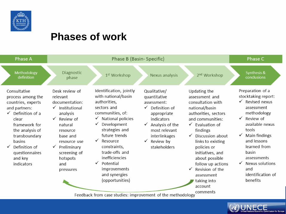
Phases of work

Nexus Assessment The Assessment Process
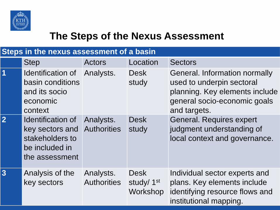
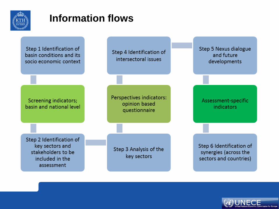
The Steps of the Nexus Assessment Steps in the nexus assessment of a basin Step Actors Location Sectors 1 Identification of
basin conditions and its socio economic context
Analysts. Desk study
General. Information normally used to underpin sectoral planning. Key elements include general socio-economic goals and targets.
2 Identification of key sectors and stakeholders to be included in the assessment
Analysts. Authorities
Desk study
General. Requires expert judgment understanding of local context and governance.
3 Analysis of the key sectors
Analysts. Authorities
Desk study/ 1st Workshop
Individual sector experts and plans. Key elements include identifying resource flows and institutional mapping.

Step Actors Location Sectors 4 Identification of
intersectoral issues
Stakeholders
1st Workshop
Sectoral group discussion on interlinkages (input needs, impacts and trade-offs), and discussion on sectoral plans
5 Nexus dialogue and future developments
Stakeholders
1st Workshop
Agreeing on a prioritization of main interlinkages. How the interlinkages are expected to change according jointly identified development trends, noting key uncertainties and most important drivers
6 Identification of opportunities for improvement (across the sectors and countries)
Stakeholders and analysts
1st Workshop/ 2nd Workshop / Desk study
Within the context of 5, there is an identification of solutions with multiple impacts between sectors, scales and boundaries. Such solutions could eventually be integrated into policies and programmes in the countries/basins.

TRBNA Methodology - Identification of basin conditions and its socio economic. context
Characterize: • the needs of the population living in the basin area, • national needs that rely on the basin for their fulfillment. (e.g. meeting basic human needs (such as water, food, energy and environmental security), or serving as the regional ’breadbasket’, ’water-tank’ etc.) Alazani/Ganikh examples i. lack of access to safe water in rural areas, ii. polluting household biomass fuel burning, iii. expensive modern fuels, iv. Water quality degradation and salination, v. hydropower growth potential, vi. agricultural growth potential, vii. deforestation, viii. land degradation, ix. flood protection etc.
Step
1
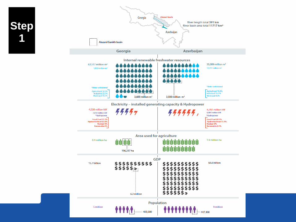
Step
1
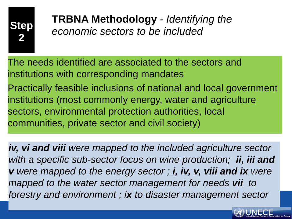
TRBNA Methodology - Identifying the economic sectors to be included The needs identified are associated to the sectors and
institutions with corresponding mandates Practically feasible inclusions of national and local government institutions (most commonly energy, water and agriculture sectors, environmental protection authorities, local communities, private sector and civil society)
iv, vi and viii were mapped to the included agriculture sector with a specific sub-sector focus on wine production; ii, iii and v were mapped to the energy sector ; i, iv, v, viii and ix were mapped to the water sector management for needs vii to forestry and environment ; ix to disaster management sector
Step
2

Step
3
TRBNA Methodology – Sector analysis
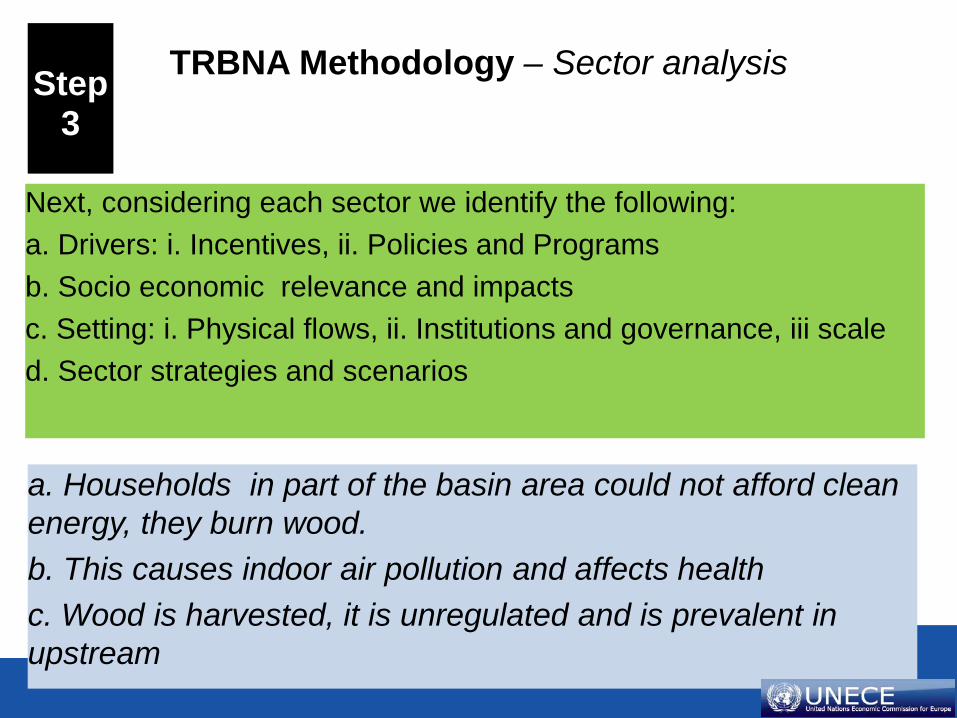
Next, considering each sector we identify the following: a. Drivers: i. Incentives, ii. Policies and Programs b. Socio economic relevance and impacts c. Setting: i. Physical flows, ii. Institutions and governance, iii scale d. Sector strategies and scenarios
a. Households in part of the basin area could not afford clean energy, they burn wood. b. This causes indoor air pollution and affects health c. Wood is harvested, it is unregulated and is prevalent in upstream
Step
3

TRBNA Methodology – Inter sector mapping
Step
4

TRBNA Methodology – Inter sector mapping
Taking sector growth plans (desk study and workshop presentations) An opinion based questionnaire on the level of inter-sector integration Inter-sector linkages are mapped. Consider perspectives (a)-(e).
Fuelwood is harvested from forests Forests provide important ecosystem services: Flood control, CO2 sink etc. Down stream flooding results in expenditure on infrastructure
Step
4

TRBNA Methodology – The nexus dialogue
Mixed sector groups • Development of each sector
simultaneously capturing common: • ‘impacts’ (e.g. climate change) • Indirect and feedback effects
People continue to burn fuel-wood Fuel wood is harvested. Forests are depleted. Water is not retained upstream (Georgia) Flooding impacts are propagated down stream.
Step
5

Nexus interaction diagram Impacts of fuelwood use Nexus solution – modern
energy
The nexus interaction diagram is a simplified RSS diagram that allows analysts to sketch out interactions between sectors. Both in terms of issues and evolving trends as well as charting out inter-sector relationships of solutions. Note that rather than attempting to draw all interactions as is done in the CLEW RRS approach, one issues and its compound effect is traced. This has the advantage of allowing joint discovery by participating experts and limits clutter.
The impacts of the use of fuel wood in upstream Georgia in the Alazani basin (1) have important knock on effects. (2) Fuelwood harvesting leads to deforestation. (3) The loss of forest results in a loss of ecosystem service. Woods no longer retain water tempering runoff. (4) This increases the severity of flash floods resulting in expensive damage control in downstream Azerbaijan. (5) In turn hydro generation infrastructure is utilized in a sub-optimal way.
A solution that has multiple benefits and potentially cheaper than flood control measures would be (1) to substitute wood with modern fuels improving indoor air. (2) decreased harvesting leading to greater forest mass and carbon sink (3). Increased ecosystem service including natural flood control (4) less disruptive flooding and damage and (5) better hydro generation performance.
Step
5
TRBNA Methodology – Synergies across countries and sectors
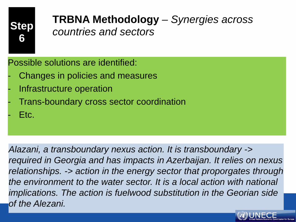
Possible solutions are identified: - Changes in policies and measures - Infrastructure operation - Trans-boundary cross sector coordination - Etc.
Alazani, a transboundary nexus action. It is transboundary -> required in Georgia and has impacts in Azerbaijan. It relies on nexus relationships. -> action in the energy sector that proporgates through the environment to the water sector. It is a local action with national implications. The action is fuelwood substitution in the Georian side of the Alezani.
Step
6

On economic activities Beyond economic activities From improved Land-/Energy-/Water-management
Economic benefits • Expanded activity and productivity in
economic sectors (aquaculture, irrigated agriculture, mining, energy generation, industrial production, nature-based tourism)
• Reduced cost of carrying out productive activities
• Reduced economic impacts of water-related hazards (floods, droughts)
• Increased value of property
Social and environmental benefits • Health impacts from improved water quality
and reduced risk of water-related disasters. • Employment and reduced poverty impacts of
the economic benefits • Improved access to services (such as
electricity and water supply) • Improved satisfaction due to preservation of
cultural resources or access to recreational opportunities.
• Avoided/reduced habitat degradation and biodiversity loss
From enhanced trust
Regional economic cooperation benefits • Development of regional markets for
goods, services and labour • Increase in cross-border investments • Development of transnational
infrastructure networks
Peace and security benefits • Strengthening of international law • Increased geopolitical stability • New opportunities from increased trust • Reduced risk and avoided cost of conflict • Savings from reduced military spending
TRBNA Methodology – Synergies across countries and sectors
Step
6
Information flows

Group Screening indicators Qualitative indicators Assessment-specific indicators
Type National Indicators Socio-economy, demography, poverty, environment, access to resources. Resource base*: availability, quality and uses at basin level. Resource uses and intensity*. World Development Indicators: Progress towards MDGs, demography and society, environment, economy, states and markets Basin Indicators (including GIS) Geo-spatial analysis: land use types, location of important ecosystems and key infrastructure. Resource base*: availability, quality and uses at basin level. Resource uses and intensity*. Indicators related to water resources and uses.
Issues related to energy, water, land use and environment according to local authorities (who have good knowledge of the basin) The opinions are in the form of ranking (very important to not important, high intensity to low intensity of impact).
Indicators related to basin-specific issues and solutions. These can be quantitative, qualitative, semi-quantitative. If specific indicators are not available, national and basin indicators can be used as proxies.

Group Screening indicators Qualitative indicators Assessment-specific indicators
Use Used in the initial phases of the assessment. If needed, they can be validated or adjusted via country/ stakeholder consultations. At basin level, data available can differ very much in levels of aggregation, accuracy, reliability, etc. In a final stage of the assessment, if better data is missing, they can be used as proxies for potential calculations. Data on energy and water consumption by sector (A) are also used to determine their energy efficiency and water efficiency Qualitative and semi-quantitative indicators can be very useful information to complement the indicators (for example, types of groundwater use in the basin or water quality)
Used to appreciate the differences in perspective by country and by sectoral affiliation. These can be presented in the course of the workshop to show what “everyone agrees upon” and what is viewed differently from different sectors or countries.
Used to substantiate the in-depth analysis of the identified issues and solutions. Wherever possible, their quantification can help determining the entity of major issues across sectors and the costs and benefits of synergic solutions Given the specificity of the focus of the in-depth analysis, the type of evaluation and/or quantification highly depends on the data available.

Comments & Questions very welcome Thank you (!)