draft location hydraulic report - us 98 pd&e studyus98highlands.com/images/us 98...
TRANSCRIPT

US 98 PD&E Studyfrom West of US 27 to East of Airport Road
Highlands County
Financial Project ID: 414511 1 22 01ETDM Number: 3150
DraftLocation Hydraulic Report
August 2013

DRAFT
Location Hydraulic Report
US 98Project Development and Environment Study
from West of US 27 to East of Airport RoadHighlands County, Florida
Financial Project ID: 414511 1 22 01ETDM Number: 3150
The Location Hydraulic Report includes a summary of data collection efforts and designanalysis for the floodplain impacts associated with the US 98 PD&E Study from West ofUS 27 to East of Airport Road. I acknowledge that the procedures and references usedto develop the results contained in this report are standard to the professional practiceof civil engineering as applied through design standards and criteria set forth by thefederal, state, and local regulatory agencies as well as professional judgment andexperience.
Florida Department of TransportationDistrict One
Prepared By:Inwood Consulting Engineers, Inc.
Oviedo, FL
Prepared For:AIM Engineering & Surveying, Inc.
Tampa, Florida
August 2013

US 98 PD&E Study Location Hydraulic ReportAugust 2013 FPID: 414511 1 22 01
TABLE OF CONTENTS
Section Page
Executive Summary .............................................................................................................. I
Section 1.0 Introduction............................................................................................... 1-1
1.1 Purpose................................................................................................................ 1-11.2 Project Description ............................................................................................... 1-21.3 Need for the Project ............................................................................................. 1-3
Section 2.0 Alternatives Considered............................................................................ 2-1
2.1 Corridor Analysis.................................................................................................. 2-12.2 No-Build Alternative.............................................................................................. 2-12.3 Transportation System Management.................................................................... 2-22.4 Build Alternatives ................................................................................................. 2-2
2.4.1 Alternative 1 Rural........................................................................................ 2-22.4.2 Alternative 2 Suburban................................................................................. 2-3
2.5 Evaluation of Alternatives..................................................................................... 2-42.6 Selection of Preferred Alternative ......................................................................... 2-6
Section 3.0 Recommended Build Alternative............................................................... 3-1
3.1 Typical Section..................................................................................................... 3-13.2 Alternative 2 Suburban......................................................................................... 3-1
Section 4.0 Data Collection ......................................................................................... 4-1
Section 5.0 Existing Site Conditions............................................................................ 5-1
5.1 Topography & Hydrologic Features ...................................................................... 5-15.2 Soils Data & Geotechnical Investigations ............................................................. 5-15.3 Environmental Characteristics.............................................................................. 5-3
5.3.1 Land Use Data ............................................................................................. 5-35.3.2 Cultural Features ......................................................................................... 5-35.3.3 Natural and Biological Features ................................................................... 5-3
5.4 Existing Drainage Conditions ............................................................................... 5-45.5 Cross Drains ........................................................................................................ 5-55.6 Floodplains/Floodways......................................................................................... 5-5
5.6.1 Establishing Floodplain Impacts................................................................... 5-5

TABLE OF CONTENTS
US 98 PD&E Study Location Hydraulic ReportAugust 2013 FPID: 414511 1 22 01
Section 6.0 Proposed Drainage Conditions ................................................................. 6-1
6.1 Longitudinal & Traverse Floodplain Impacts......................................................... 6-16.2 Project Classification............................................................................................ 6-26.3 Risk Evalulation.................................................................................................... 6-26.4 PD&E Manual Requirements with Minimal Encroachments.................................. 6-2
Section 7.0 Conclusion................................................................................................ 7-1

TABLE OF CONTENTS
US 98 PD&E Study Location Hydraulic ReportAugust 2013 FPID: 414511 1 22 01
LIST OF EXHIBITS
Exhibit 1-1 Project Location Map ...................................................................................... 1-1
Exhibit 1-2 US 98 – Looking East ..................................................................................... 1-2
Exhibit 2-1 Rural Typical Section Widening South with Border Width Variation ................ 2-3
Exhibit 2-2 Rural Typical Section Widening North with Border Width Variation................. 2-3
Exhibit 2-3 Suburban Typical Section............................................................................... 2-4
Exhibit 3-1 Proposed Suburban Typical Section............................................................... 3-1

TABLE OF CONTENTS
US 98 PD&E Study Location Hydraulic ReportAugust 2013 FPID: 414511 1 22 01
LIST OF TABLES
Table 1 – Summary of Floodplain Impacts ...........................................................................III
Table 2 – Evaluation Matrix .............................................................................................. 2-5
Table 3 – NRCS Soil Survey Information........................................................................... 5-1
Table 4 – Summary of Existing and Proposed Drainage Basins........................................ 5-4
Table 5 – Summary of Existing Cross Drains .................................................................... 5-5

TABLE OF CONTENTS
US 98 PD&E Study Location Hydraulic ReportAugust 2013 FPID: 414511 1 22 01
LIST OF APPENDICES
Appendix 1 – Figures
Appendix 2 – Floodplain Impact/Compensation Calculations
Appendix 3 – Correspondence

US 98 PD&E Study Location Hydraulic ReportAugust 2013 I FPID: 414511 1 22 01
EXECUTIVE SUMMARY
The Florida Department of Transportation (FDOT) has conducted a Project Developmentand Environment (PD&E) study to evaluate the proposed widening of approximately 4.6miles of US 98 from west of US 27 to east of Airport Road in Highlands County. The projectlimits are shown in Exhibit 1-1.
The purpose of the PD&E study is to evaluate engineering and environmental data anddocument information that will aid Highlands County, FDOT and the Federal HighwayAdministration (FHWA) in determining the type, preliminary design and location of theproposed improvements. The study was conducted in order to meet the requirements of theNational Environmental Policy Act (NEPA) and other related federal and state laws, rulesand regulations.
The purpose of the Location Hydraulic Report is to address base floodplain encroachmentsresulting from the roadway improvements evaluated in the PD&E study. In accordance withExecutive Order 11988 “Floodplain Management,” USDOT Order 5650.2, “FloodplainManagement Protection,” and Federal-Aid Policy Guide 23 CFR 650A, floodplains must beprotected. The intent of these regulations is to avoid or minimize highway encroachmentswithin the 100-year (base) floodplains and to avoid supporting land use developmentincompatible with floodplain values.
Existing Drainage Conditions
The project is located along the Lake Wale Ridge and the Kissimmee River Watershed,within the Southwest Florida Water Management District (SWFWMD) from GeorgeBoulevard to Airport Road and the South Florida Water Management District (SFWMD) fromAirport Road to Elliott Road. US 98 has been further subdivided into six (6) local drainagesub-basins for stormwater management. There are no Outstanding Florida Waters (OFW)within the project limits.
The limits of the project study area traverse five (5) Water Body ID's (WBID) as defined byFDEP. Basin 1 is located within WBID 1860C: Jackson Creek, which is impaired forDissolved Oxygen (DO) and Nutrients (Chlorophyll-a) as of November 2, 2010, with TotalNitrogen (TN) and Total Phosphorous (TP) listed as the limiting nutrient, therefore apollutant loading reduction analysis will be performed on this basin. Basins 2, 3, and 4 arelocated within WBID 1891A: Red Beach Lake and WBID 1891: Yellow Bluff Creek, both ofwhich have insufficient data to define impairment as of November 2, 2010. Basins 5, and 6are located within WBID 1761J: Arbuckle Creek, which has no impairments as of November2, 2010. Based on the available information at the time of this PD&E Study, nutrient loadingcalculations do not need to be performed. At the time of final design a review of DEP's303(d) list of Impaired Water Bodies should be performed for additional informationregarding TMDL's.

EXECUTIVE SUMMARY
US 98 PD&E Study Location Hydraulic ReportAugust 2013 II FPID: 414511 1 22 01
Existing land use is predominantly agricultural and residential between George Boulevardand Bay Blossom Drive, wetlands and wooded uplands between Bay Blossom Drive andTubbs Ranch Road, Industrial from Tubbs Ranch Road to Airport Road, and Residential forthe remainder of the project. Large tracts of conservation lands (Flamingo Villas Unit LakeWales Ridge National Wildlife Refuge) also exist within the project corridor. Theseconservation lands are made up of wetlands and wooded uplands as well. It is anticipatedthat the proposed roadway widening will results in a large amount of wetland impacts. Pondalternative recommendations will be based on avoidance of wetland impacts wheneverpossible. The topography surrounding the project vicinity is best characterized as rollingterrain near Red Beach Lake and virtually flat for the remainder of the project; however,ground elevations along US 98 rise to around 114 feet and drop as low as 62 feet within thestudy limits.
Currently, the stormwater runoff from US 98 is collected by roadside swale systems that flowto existing cross drains and wetlands. There are seven (7) cross drains that conveystormwater runoff under US 98 and serve as outfall locations for the roadway. Table 5shows a Summary of Existing Cross Drains. Stormwater runoff currently goes untreatedto wetland systems.
Future Drainage Conditions
The existing drainage boundaries and local drainage basins will be maintained in theproposed condition. The stormwater runoff from US 98 will be collected by a roadside swalesystem which will flow to stormwater management ponds because of the proposedsuburban typical section. The water quality treatment will be achieved through theconstruction of offsite dry and wet ponds, which would require the acquisition of additionalright-of-way.
This project will have no adverse impact to the area’s water quality. Stormwater runoff ofthe project area will be treated as required by the rules set forth by the Southwest FloridaWater Management District (SWFWMD). Refer to the US 98 PD&E Study Pond SitingReport for descriptions of the sub-basins and stormwater management facilities.
Floodplain Impacts
The Federal Emergency Management Agency (FEMA) has developed a Flood InsuranceRate Map (FIRM) for Highlands County. The 100-year floodplain boundaries are located atvarious locations along the corridor and adjacent to US 98, on both sides of the road. Theseareas are designated as Zone AE floodplains (floodplain boundaries in which elevationshave been established). These floodplains are associated with Red Beach Lake and YellowBluff Creek at approximately elevation 75.80 feet NAVD (77.00 feet NGVD). Yellow BluffCreek is considered a regulatory floodway, therefore; a FEMA no-rise certification will berequired during the design phase of this Study. FIS Flood Profile for Yellow Bluff Creek isshown in Figure 8, Appendix 1.

EXECUTIVE SUMMARY
US 98 PD&E Study Location Hydraulic ReportAugust 2013 III FPID: 414511 1 22 01
This project will impact the 100-year floodplain in two different ways:
Longitudinal roadway impacts resulting from filling the floodplain areas associatedwith Red Beach Lake and Yellow Bluff Creek;
Transverse impacts resulting from the replacement of the existing cross drainculverts to accommodate the wider roadway footprint;
The longitudinal roadway impacts cannot be avoided since the floodplain associated withthe water bodies extend both to the north and south of US 98. During the PD&E Study, two(2) alignment alternatives were analyzed. During the final design phase of the project, everyeffort should be taken to minimize the floodplain impacts. Refer to Appendix 2 for theFloodplain Impact/Compensation Exhibits for each floodplain location. Table 1 - Summaryof Floodplain Impacts shows the anticipated impacts to the 100-year floodplain due toroadway widening for each alternative roadway alignment.
Table 1 – Summary of Floodplain Impacts
RoadwayAlignmentAlternative
Side of Roadway Length of Impact (ft)ImpactVolume(ac-ft)
Total ImpactVolume(ac-ft)
Alternative 1 Right 3350 9.67 9.67
Alternative 2Right 3350 6.51
10.88Left 6100 4.37
*Preferred alternative is highlighted in bold font
The transverse impacts resulting from the replacement of the culverts are analyzed in thePD&E phase of the project. It is expected that impacts will occur to the floodplainassociated with the replacements of all the cross drains. No additional right-of-way isproposed in this area to compensate for the loss of storage created by the longer crossdrains. The longer cross drains themselves provide volume within the pipes and it ispossible to provide compensation within the existing right-of-way through excavated areas.However, during the final design phase of the project, every necessary action should betaken to minimize upstream impacts. To minimize upstream impacts, FDOT design criteriafor conveyance systems (e.g. culverts) allows no significant increase in flood stages at theupstream end of the structures.
No adverse impacts are anticipated to the floodplain. The SWFWMD and FDOT criteriarequire replacement of floodplain storage lost as a result of encroachments. There is nochange in flood “Risk” associated with this project. The floodplain is located in low densityland uses and some urbanized areas, however the encroachments are classified as"minimal". Minimal encroachments on a floodplain occur when there is a floodplaininvolvement but the impacts on human life, transportation facilities, and natural andbeneficial floodplain values are not significant and can be resolved with minimal efforts.

EXECUTIVE SUMMARY
US 98 PD&E Study Location Hydraulic ReportAugust 2013 IV FPID: 414511 1 22 01
Normally, these minimal efforts to address the impacts will consist of applying the FDOT’sdrainage design standards and following the Water Management District’s procedures toachieve the results that will not increase or significantly change the flood elevations and/orlimits.
The following floodplain statement is a slightly modified version of statement Number 4 inthe FDOT PD&E Manual, tailored for this project:
The proposed cross drains will perform hydraulically in a manner equal to or greater thanthe existing condition, and backwater surface elevations are not expected to increase. As aresult, there will be no significant change in flood risk, and there will not be a significantchange in the potential for interruption or termination of emergency service or in emergencyevacuation routes. Therefore, it has been determined that this encroachment is notsignificant.

US 98 PD&E Study Location Hydraulic ReportAugust 2013 1-1 FPID: 414511 1 22 01
SECTION 1.0 INTRODUCTION
1.1 Purpose
The Florida Department of Transportation (FDOT) has conducted a Project Developmentand Environment (PD&E) study to evaluate the proposed widening of approximately 4.6miles of US 98 from west of US 27 to east of Airport Road in Highlands County. The projectlimits are shown in Exhibit 1-1.
Exhibit 1-1 Project Location Map
The purpose of the PD&E study is to evaluate engineering and environmental data anddocument information that will aid Highlands County, FDOT and the Federal HighwayAdministration (FHWA) in determining the type, preliminary design and location of theproposed improvements. The study was conducted in order to meet the requirements of theNational Environmental Policy Act (NEPA) and other related federal and state laws, rulesand regulations.
The purpose of this Location Hydraulic Report is to address base floodplain encroachmentsresulting from the roadway improvements evaluated in the Project Development andEnvironment (PD&E) study. In accordance with Executive Order 11988 “FloodplainManagement”, USDOT Order 5650.2, “Floodplain Management Protection”, and Federal-AidPolicy Guide 23 CFR 650A, floodplains must be protected. The intent of these regulations isto avoid or minimize highway encroachments within the 100-year (base) floodplains and toavoid supporting land use development incompatible with floodplain values. All projectfigures for this report are included in Appendix 1. For ease of review, Floodplain Impact

SECTION 1.0 INTRODUCTION
US 98 PD&E Study Location Hydraulic ReportAugust 2013 1-2 FPID: 414511 1 22 01
data is included in Appendix 2. The datum used for all calculations is 1988 NAVD unlessotherwise specified. Other supporting information and data are included in the remainingappendices.
1.2 Project Description
The proposed action involves developing alternatives to improve the operational capacity ofUS 98 from US 27 to east of Airport Road to accommodate future travel demand generatedby population and employment growth in Highlands County by widening the existing two-lane road to four-lane road. US 98 is classified as a two-lane ‘Rural Principal Arterial’roadway that extends from US 27 to East of Airport Road in Highlands County and has aright-of-way width of 100 feet for the majority of the project.
As shown in Exhibit 1-2, US 98 is a two-lane undivided road with two 12-foot lanes and 12-foot shoulders (5-foot paved). Stormwater runoff is collected in roadside swales. The postedspeed limit for the majority of the US 98 project limits is 55 miles per hour (mph). The postedspeed limit is reduced to 45 mph from approximately 0.25 miles on either side of the US98/US 27 intersection.
Exhibit 1-2 US 98 – Looking East
There are seven (7) culverts crossing under US 98 within the project limits. These culvertsrange in size from 18 inches to triple – 48 inches. There are no bridges located within theproject limits.
SECTION 1.0 INTRODUCTION
US 98 PD&E Study Location Hydraulic ReportAugust 2013 1-3 FPID: 414511 1 22 01
1.3 Need for the Project
The purpose of this project is to increase the capacity of US 98 from US 27 to east of AirportRoad to accommodate future traffic demand generated by population and employmentgrowth in Highlands County. The 2012 Annual Average Daily Traffic (AADT) volumes onUS 98 range from 6,400 vehicles per day (vpd) to 7,700 vpd. Portions of the study corridorare currently operating at Level of Service (LOS) D.
Design year 2036 AADT volumes were developed using the 2035 Highlands County TravelDemand Model. Though current economic conditions have slowed growth in the area, the2036 traffic on US 98 is projected to range between 15,700 vpd and 25,100 vpd. With theproposed improvements, the corridor is projected to operate at LOS C in 2036. However,without the proposed widening to four lanes, the project corridor will experience high levelsof congestion and operating conditions will deteriorate to LOS E.
US 98 is a regional east-west arterial traversing all of Highlands County. This roadwayconnects the City of Lakeland in Polk County with the City of Avon Park and City of Sebringin Highlands County to the City of Okeechobee in Okeechobee County. US 98 also providesdirect access to the Sebring Regional Airport and Sebring International Raceway. Inaddition, US 98 serves several freight rail-oriented industrial uses proximate to the corridor,along with local commercial and residential areas.
The proposed widening is consistent with the adopted Highlands County ComprehensivePlan. US 98 currently serves as part of the emergency evacuation route network designatedby the Florida Division of Emergency Management. Also designated as a Highlands Countyevacuation facility, US 98 is critical in facilitating east-west traffic movement and evacuatingresidents of central Highlands County. The widening of US 98 to four lanes is anticipated toenhance connectivity and accessibility to other major arterials designated on the stateevacuation route network (including US 27), increase the volume of traffic that can beevacuated during an emergency event, and provide improved access for emergencyresponders.
The actual five-year average crash rate (i.e., crashes per million vehicle-miles of travel) forthis project corridor was obtained, along with the statewide five-year average crash rate forsimilar facilities, from the Florida Department of Transportation Safety Office. During thefive-year period from 2007 through 2011, the actual crash rate was equal to 1.750 while thestatewide crash rate was equal to 0.576. This data indicates that the US 98 project corridorhas experienced an average crash rate that is approximately three times higher than thestatewide average rate for similar facilities.

US 98 PD&E Study Location Hydraulic ReportAugust 2013 2-1 FPID: 414511 1 22 01
SECTION 2.0 ALTERNATIVES CONSIDERED
The objective of the alternatives analysis process is to identify technically andenvironmentally sound alternatives that meet the needs of the project, are cost-effective andare acceptable to the community. This section describes the alternatives considered andresults of the alternatives evaluation.
2.1 Corridor Analysis
The objective of the corridor analysis process is to identify viable corridors in whichtechnically and environmentally sound alignment alternatives can be developed.Constructing a new roadway in a corridor outside of the existing US 98 corridor would resultin significant environmental impacts, relocations, and an overall cost that would beprohibitive. Based on the analysis of the study area, the existing US 98 corridor is the onlyviable corridor for the proposed improvements.
2.2 No-Build Alternative
The No-Build Alternative assumes that US 98 will remain as a two-lane undivided roadwaythrough the design year 2036, with only routine maintenance being performed during thisperiod. The traffic analysis conducted for the No-Build Alternative indicates that US 98 willoperate at a LOS E by 2036 without the proposed widening. This is below the acceptableLOS C standard for a two-lane facility in a rural area.
The following are the advantages and limitations associated with the No-Build Alternative:
Advantages of the No-Build Alternative
No additional right-of-way needed.
No design, right-of-way or construction costs.
No delays to motorists or inconveniences to property owners during construction.
No construction impacts to the adjacent natural, physical and social environment.
Limitations of the No-Build Alternative
Increased potential for crashes due to congested lanes and intersections.
Increased traffic congestion and user costs associated with increased delays andreduced level of service at the intersection.
Increased emergency vehicle response times.

SECTION 2.0 ALTERNATIVES CONSIDERED
US 98 PD&E Study Location Hydraulic ReportAugust 2013 2-2 FPID: 414511 1 22 01
Incompatibility with the adopted Highlands County Comprehensive Plan.
Increased vehicle emission pollutants due to higher levels of traffic congestion.
The No-Build Alternative will remain a viable alternative throughout this PD&E study.
2.3 Transportation System Management
Transportation Systems Management (TSM) alternatives involve improvements designed tomaximize the utilization and efficiency of the existing facility through improved system anddemand management. The various TSM options generally include traffic signal andintersection improvements, access management improvements and transit improvements.The additional capacity required to meet the projected traffic volumes along US 98 cannotbe provided solely through the implementation of TSM improvements. However, the TSMstrategy of access management is included as part of the build alternatives.
2.4 Build Alternatives
According to the traffic analysis conducted, four through lanes are needed on US 98 by theyear 2016 to meet the criteria of LOS C or better. Various roadway typical sections andalignment alternatives were developed to meet the needs of this project and were evaluated.
2.4.1 Alternative 1 RuralAlternative 1 would widen the existing two-lane rural typical section to a four-lane dividedrural typical section with a design speed of 60 mph. This typical section would save theexisting two lanes of pavement and construct two new 12-foot travel lanes outside of a 40-foot depressed grass median. The existing pavement cross slope would not be modified andthe existing shoulders would remain to maximize the construction cost savings. The borderwidth adjacent to the existing lanes would remain 38 feet, which is 2 feet shy of the 40 feetrequired for arterials and would require a border width variation. The proposed border widthwill include an 8-foot shoulder (5 feet paved), a ditch to collect stormwater runoff, and a 10-foot multiuse path. The total right-of-way width needed for the four-lane rural typical sectionis 185 feet, which is 85 feet in addition to the existing 100 feet of right-of-way.
The alignment would shift from south to north to minimize impacts to residences, businessesand environmentally sensitive areas. The proposed alignment would entail constructing thetwo new lanes south of the existing lanes from west of US 27 to west of the South CentralFlorida Express Railroad. After transitioning over the railroad, the two new lanes would shiftto the north side of the existing lanes from east of the railroad to Elliot Road. The 10-footmultiuse path would cross US 98 from the south side to the north side between Jahna Circleand Afton Road, west of the railroad crossing. This rural typical section is illustrated inExhibit 2-1 and Exhibit 2-2.

SECTION 2.0 ALTERNATIVES CONSIDERED
US 98 PD&E Study Location Hydraulic ReportAugust 2013 2-3 FPID: 414511 1 22 01
Exhibit 2-1 Rural Typical Section Widening South with Border Width Variation
Exhibit 2-2 Rural Typical Section Widening North with Border Width Variation
2.4.2 Alternative 2 SuburbanAlternative 2 consists of constructing four new travel lanes to create a high speed suburbantypical section with a design speed of 55 mph. This typical section would not save the

SECTION 2.0 ALTERNATIVES CONSIDERED
US 98 PD&E Study Location Hydraulic ReportAugust 2013 2-4 FPID: 414511 1 22 01
existing pavement. The typical section would include four 12-foot travel lanes, a 30-footraised median, 4-foot paved inside shoulders, 8-foot outside shoulders (5 feet paved), andditches on both sides. A 10-foot multiuse path would be constructed on the south side and a5-foot sidewalk would be included along the north side. The total right-of-way width neededfor the four-lane suburban typical section is 155 feet, which is 55 feet more than what exists.This typical section is illustrated in Exhibit 2-3.
The alignment would shift north and south to minimize impacts. With two exceptions, themajority of the alignment would be shifted to the north of the existing alignment. Theseexceptions include between Desert Wind Avenue and CR 17 South to increase the radius ofthe existing horizontal curve and from the limits of the Flamingo Villas Unit of the LakeWales Ridge National Wildlife Refuge to Deer Trail East to avoid the need to acquire right-of-way from the Flamingo Villas Unit.
Exhibit 2-3 Suburban Typical Section
2.5 Evaluation of Alternatives
Each build alternative was evaluated based on environmental effects, right-of-way needs,project costs and engineering factors. The matrix shown as Table 2 – Evaluation Matrixwas displayed at the public information workshop to share the results of the alternativesevaluation process. It quantifies considerations such as potential residential and businessrelocations, impacts to environmental resources, and the acres of right-of-way needed forroadway improvements and stormwater facilities. The potential for the proposed widening toimpact archaeological/historical sites, noise sensitive sites, and threatened and endangeredspecies were qualified in the matrix.

SECTION 2.0 ALTERNATIVES CONSIDERED
US 98 PD&E Study Location Hydraulic ReportAugust 2013 2-5 FPID: 414511 1 22 01
The bottom half of the matrix details cost estimates for wetland mitigation, right-of-wayacquisition, construction, design, and construction engineering and inspection. Theestimates were based on 2013 unit costs. The cost for design and construction engineeringand inspection is estimated as 10% and 15% of the total construction cost, respectively.
Table 2 – Evaluation Matrix
Evaluation CriteriaNo-Build
AlternativeAlternative 1
RuralAlternative 2
Suburban
Business Impacts
Number of business relocations 0 8 4
Residential Impacts
Number of residential relocations 0 9 4
Environmental Effects
Archaeological/Historical sites (potential) None Medium Medium
Public parks, recreation areas, or wildlife refuges (potential) None Low Low
Noise (potential) None Medium Medium
Wetlands (acres) 0 1.9 1.8
Floodplains (acres) 0 6.0 10.1
Threatened and endangered species (potential) None Medium Medium
Contamination sites (high/medium) None 0 / 2 0 / 2
Right-of-Way Needs
Right-of-way to be acquired for roadway improvements (acres) 0 46.5 34.2
Right-of-way to be acquired for stormwater facilities (acres) 0 11.2 11.2
Right-of-way to be acquired for flood plain compensation (acres) 0 2.8 2.8
Estimated Total Project Costs (2013 Cost)
Design(1) $0 $1,599,000 $1,895,000
Wetland mitigation $0 $306,000 $304,000
Right-of-way cost for roadway $0 $14,019,000 $12,344,000
Right-of-way cost for stormwater facilities $0 $1,372,000 $1,372,000
Total Right-of-Way Cost(2) $0 $15,391,000 $13,716,000
Total Construction Cost(3) $0 $15,992,000 $18,953,000
Construction Engineering & Inspection(4) $0 $2,399,000 $2,843,000
Preliminary Estimate of Total Project Cost (2013 Cost) $0 $35,687,000 $37,711,000
Notes: (1) Design cost is estimated at 10% of the Total Construction Cost.(2) Right-of-way cost estimates were prepared by FDOT in February 2013.(3) Roadway and stormwater facilities construction cost are based on the LRE completed in March 2013.(4) Construction Engineering and Inspection cost is estimated at 15% of Total Construction Cost.

SECTION 2.0 ALTERNATIVES CONSIDERED
US 98 PD&E Study Location Hydraulic ReportAugust 2013 2-6 FPID: 414511 1 22 01
2.6 Selection of Preferred Alternative
Reviewing the evaluation matrix Alternative 2 project costs are approximately $2 milllionmore expensive than Alternative 1 but the majority of the remaining criteria are theequivalent or less.
Alternative 2 is preferred over Alternative 1 in the following areas:
Four less business relocations. Five less residential relocations. 12.3 acres less of right-of-way to be acquired.
Based on the comparison of both alternatives and input received at the public informationworkshop, Alternative 2 with the suburban typical section was selected as the PreferredAlternative.

US 98 PD&E Study Location Hydraulic ReportAugust 2013 3-1 FPID: 414511 1 22 01
SECTION 3.0 RECOMMENDED BUILD ALTERNATIVE
Based on the evaluation of the alternatives described in Section 2.0, Alternative 2 with thesuburban typical section is recommended by FDOT as the build alternative to meet thedocumented purpose and need for this project. This section presents the engineeringconsiderations associated with Alternative 2.
3.1 Typical Section
Alternative 2 consists of one typical section for US 98 that consists of four 12-foot travellanes, a 30-foot raised median, 4-foot paved inside shoulders, 8-foot outside shoulders (5feet paved), and ditches on both sides. A 10-foot multiuse path would be constructed on thesouth side and a 5-foot sidewalk would be included along the north side. The total right-of-way width needed for the four-lane suburban typical section is 155 feet, which is 55 feetmore than what exists. This typical section is illustrated in Exhibit 3-1.
Exhibit 3-1 Proposed Suburban Typical Section
3.2 Alternative 2 Suburban
Alternative 2 consists of constructing four new travel lanes to create a high speed suburbantypical section with a design speed of 55 mph. The alignment would shift north and south tominimize impacts. With two exceptions, the majority of the alignment would be shifted to thenorth of the existing alignment. These exceptions include between Desert Wind Avenue andCR 17 South to increase the radius of the existing horizontal curve and from the limits of theFlamingo Villas Unit of the Lake Wales Ridge National Wildlife Refuge to Deer Trail East toavoid the need to acquire right-of-way from the Flamingo Villas Unit.

US 98 PD&E Study Location Hydraulic ReportAugust 2013 4-1 FPID: 414511 1 22 01
SECTION 4.0 DATA COLLECTION
The study team collected and reviewed data from the following sources:
FDOT Drainage Manual, July 2013.
FDOT Drainage Handbook: “Stormwater Management Facility”, January 2004
FDOT Project Development and Environment Manual (PD&E), Part 2, Chapter 24“Floodplains,” January 2008
SWFWMD Basis of Review: “Management and Storage of Surface Waters”,December 2010
SWFWMD, Chapter 40D-42 F.A.C., Environmental Resource Permit (ERP),“Regulation of Stormwater Management Systems”, December 2010
Federal Emergency Management Agency (FEMA) Flood Insurance Rate Maps(FIRM) for Highlands County. Panel # 1201110075B, and 1201110100B.
Soil Conservation Service (NRCS) maps
FDEP 303(d) list of Impaired Water Bodies
United States Geological Survey (USGS) Quad maps
Site Visit (May 2012)
Highlands County Tax maps
Topographic Survey (2-foot LIDAR Contours)
Wetland/Protected Species Assessment Report
Contamination Screening Evaluation Report
Cultural Resource Assessment Survey
US 98 Straight Line Diagrams

US 98 PD&E Study Location Hydraulic ReportAugust 2013 5-1 FPID: 414511 1 22 01
SECTION 5.0 EXISTING SITE CONDITIONS
5.1 Topography & Hydrologic Features
The topography surrounding the project vicinity is best characterized as rolling terrain nearRed Beach Lake and virtually flat for the remainder of the project; however, groundelevations along US 98 rise to around 114 feet (US 27) and drop as low as 62 feet (ElliotRoad) over the 4.6 mile span. The projected topography is shown in the USGS QuadrangleMap Figure 2 located in Appendix 1.
5.2 Soils Data & Geotechnical Investigations
The Soil Survey of Highlands County, Florida, published by USDA NRCS (dated 2009) hasbeen reviewed for the project vicinity. The soil survey map for the project vicinity isillustrated in Figure 4– NRCS Soils Map, in Appendix 1.
Thirteen (13) types of soils were encountered along the project limits. The soil types varyand range from Hydrological Soil Group (HSG) A to HSG B/D. Type A soils are very welldrained soils with low water tables and Type D soils are very poorly or poorly drained soilswith high water tables. Table 3 – NRCS Soil Survey Information summarizes and lists thesoil types and relevant information.
Table 3 – NRCS Soil Survey Information
SoilNo.
Highlands County USDA Soil Name
Seasonal High Ground Water
HSG
Soil Classification
Duration
(months)
Depth*
(feet)Depth
(inches)
Unified AASHTO
BEG END HIGH LOW
1
Paola
--- --- --- >6 A
0-5 SP A-3
5-17 SP A-3
17-80 SP A-3
6Tavares
Jun Dec 3.5 6.0 A0-6 SP, SP-SM A-3
6-80 SP, SP-SM A-3
8
Immokalee
Jun Nov 0 1.0 B/D
0-6 SP, SP-SM A-3
6-37 SP, SP-SM A-3
37-80 SP-SM, SM A-3, A-2-4
9Astatula
--- --- 6 >6 A0-7 SP, SP-SM A-3
7-80 SP, SP-SM A-3
SECTION 5.0 EXISTING SITE CONDITIONS
US 98 PD&E Study Location Hydraulic ReportAugust 2013 5-2 FPID: 414511 1 22 01
SoilNo.
Highlands County USDA Soil Name
Seasonal High Ground Water
HSG
Soil Classification
Duration
(months)
Depth*
(feet)Depth
(inches)
Unified AASHTO
BEG END HIGH LOW
10 Mayakka Jun Nov 0 1.0 B/D
0-24 SP, SP-SM A-3
24-58 SM, SP-SM A-3, A-2-4
58-80 SP, SP-SM A-3
11 Orsino Jun Dec 3.5 6.0 A 0-46 SP A-3
46-80 SP, SP-SM A-3
12 Basinger Jun Feb 3.5 6.0 A 0-6 SP A-3
6-80 Sp, SP-SM A-3, A-2-4
14 Satellite Jun Nov 1.0 3.5 C 0-4 SP A-3
4-80 SP A-3
20 Samsula Jan Dec +2 0 B/D 0-36 PT ---
36-65 SP-SM, SM, SP A-3, A-2-4
28 Archibold Jun Nov 3.5 6.0 A 0-4 SP A-3
4-80 SP A-3
33
Basinger Jun Feb 0 1.0 B/D 0-6 SP A-3
6-80 SP, SP-SM A-3, A-2-4
St. Johns Jun Apr 0 1.0 B/D
0-11 SP, SP-SM A-3
11-26 SP, SP-SM A-3
26-49 SP-SM, SM A-3, A-2-4
49-70 SP, SP-SM A-3
70-80 SP-SM, SM A-3, A-2-4
Placid Jun Apr 0 1.0 B/D SP, SP-SM, SM A-3, A-2-4
SP, SP-SM, SM A-3, A-2-4
36Pomello
Jul Nov 2.0 3.5 C0-56 SP, SP-SM A-3
56-62 SP-SM, SM A-3, A-2-4
62-80 SP, SP-SM A-3
44
Satellite Jun Nov 1.0 3.5 C 0-3 SP A-3
3-80 SP A-3
Basinger Jun Nov 0 1.0 B/D 0-6 SP A-3
6-80 SP, SP-SM A-3, A-2-4
Urban Land --- --- --- >2.0 --- --- --- ---
* Depth is referenced below existing grade.

SECTION 5.0 EXISTING SITE CONDITIONS
US 98 PD&E Study Location Hydraulic ReportAugust 2013 5-3 FPID: 414511 1 22 01
5.3 Environmental Characteristics
5.3.1 Land Use DataExisting land use is predominantly agricultural and residential between George Boulevardand Bay Blossom Drive, wetlands and wooded uplands between Bay Blossom Drive andTubbs Ranch Road, Industrial from Tubbs Ranch Road to Airport Road, and Residential forthe remainder of the project. Large tracts of conservation lands (Flamingo Villas Unit LakeWales Ridge National Wildlife Refuge) also exist within the project corridor. Theseconservation lands are made up of wetlands and wooded uplands as well. The future landuses in the project area will not be altered. Please see Figure 5, Existing Land Use Map,in Appendix 1.
5.3.2 Cultural FeaturesCultural features preserve and enhance the cultural nature of a community and includeparks, schools, churches and other religious institutions. Also included are historic sites,archaeologically significant sites and neighborhood gathering places. Community servicesinclude facilities that provide necessary services such as fire stations, police stations, publicand private schools, hospitals, cemeteries, public buildings, and civic facilities. Thefollowing is a list of sites in or near the project area:
Houses
Flamingo Villas Unit Lake Wales National Wildlife Refuge
Spring Lake United Methodist Church
Additional information regarding cultural features can be found in the US 98 PD&E Study,Pond Siting Report, Appendix 6 – Cultural Resource Assessment Report.
5.3.3 Natural and Biological FeaturesThe project corridor was evaluated for the presence of potentially-occurring species. It wasdetermined that 8 federally protected species could potentially occur within the project areaincluding 6 avian, and 2 reptile species. It was also determined that 8 state protectedspecies could potentially occur within the project area including 3 mammal, 9 avian, 1amphibian, 2 reptile and 20 plant species. The likelihood of each species occurring withinthe project corridor was evaluated based on historic ranges, literature review, aerialphotography interpretation to identify suitable habitat, and field investigations.
All six (6) Pond sites and the Floodplain Compensation Area (FPC) fall within the USFWSConsultation Area (CA) for the Florida scrub-jay, sand skink, snail kite, caracara,grasshopper sparrow, and Lake Wales ridge plants. They are also within the core foragingarea for one wood stork colony. The closest bald eagle nest is approximately one (1) milenorth of the project. The project is not within the USFWS CA for the Florida panther,however telemetry data exist for the species within the project area and the most recent

SECTION 5.0 EXISTING SITE CONDITIONS
US 98 PD&E Study Location Hydraulic ReportAugust 2013 5-4 FPID: 414511 1 22 01
siting was 1998. Several gopher tortoise burrows were observed within the project limits,however none were observed within the pond sites or the FPC.
The proposed project has potential to involve several State and/or Federally listed wildlifespecies. Those species and their anticipated involvement are identified in the US 98 PD&EStudy, Pond Siting Report, Appendix 7 – Wetlands / Protected Species Assessment.
The identification of Wetlands has been investigated and is included within the US 98 PD&EStudy, Pond Siting Report, Appendix 7 – Wetlands / Protected Species Assessment. Itis likely that this project will impact wetlands regulated by the State and FederalGovernments. Pond alternative recommendations will be based on avoidance of wetlandimpacts whenever possible.
5.4 Existing Drainage Conditions
The project is located along the Lake Wale Ridge and the Kissimmee River Watershed,within the Southwest Florida Water Management District (SWFWMD) from GeorgeBoulevard to Airport Road and the South Florida Water Management District (SFWMD) fromAirport Road to Elliott Road. US 98 has been further subdivided into six (6) local drainagesub-basins for stormwater management. There are no Outstanding Florida Waters (OFW)within the project limits. The limits of the basins are shown in Table 4 for Summary ofExisting and Proposed Drainage Basins.
Table 4 – Summary of Existing and Proposed Drainage Basins
Basin Name From To Outfall Location1 481+60 503+07 or 53+22 Josephine Creek
2 503+07 or 53+22 105+35 Red Beach Lake/Yellow Bluff Creek
3 105+35 130+84 Red Beach Lake/Yellow Bluff Creek
4 130+84 199+12 Red Beach Lake/Yellow Bluff Creek
5 199+12236+30 - Existing
Arbuckle Creek224+82 - Proposed
6236+30 - Existing
279+80 Lake Istokpoga224+82 - Proposed
The limits of the project study area traverse five (5) Water Body ID's (WBID) as defined byFDEP. Basin 1 is located within WBID 1860C: Jackson Creek, which is impaired forDissolved Oxygen (DO) and Nutrients (Chlorophyll-a) as of November 2, 2010, with TotalNitrogen (TN) and Total Phosphorous (TP) listed as the limiting nutrient, therefore apollutant loading reduction analysis will be performed on this basin. Basins 2, 3, and 4 arelocated within WBID 1891A: Red Beach Lake and WBID 1891: Yellow Bluff Creek, both ofwhich have insufficient data to define impairment as of November 2, 2010. Basins 5, and 6are located within WBID 1761J: Arbuckle Creek, which has no impairments as of November2, 2010. Based on the available information at the time of this PD&E Study, nutrient loadingcalculations do not need to be performed. At the time of final design a review of DEP's

SECTION 5.0 EXISTING SITE CONDITIONS
US 98 PD&E Study Location Hydraulic ReportAugust 2013 5-5 FPID: 414511 1 22 01
303(d) list of Impaired Water Bodies should be performed for additional informationregarding TMDL's.
Currently, the stormwater runoff from US 98 is collected by roadside swale systems that flowto existing cross drains and wetlands.
5.5 Cross Drains
There are seven (7) cross drains that convey stormwater runoff under US 98 and serve asoutfall locations for the roadway. Stormwater runoff currently goes untreated to Red BeachLake, wetland systems associated with Red Beach Lake and Yellow Bluff Creek, wetlandsystems associated with Arbuckle Creek and wetland systems associated with LakeIstokpoga for this segment of US 98. Table 5 shows a Summary of Existing CrossDrains.
Table 5 – Summary of Existing Cross Drains
Cross Drain Approximate Location Description OutfallCD – 01 70+90 1 - 18" RCP Red Beach LakeCD – 03 130+84 3 - 48" RCP Yellow Bluff CreekCD – 04 141+60 1 - 36" RCP Yellow Bluff CreekCD – 05 151+30 1 - 36" RCP Yellow Bluff CreekCD – 06 190+00 1 - 18" RCP Yellow Bluff CreekCD – 07 224+82 2 - 36" RCP Arbuckle CreekCD – 08 271+87 1 - 24" RCP Lake Istokpoga
Note: CD-02 is not referenced on this table or in the report because it is no longer a true cross drain as it isshown on the Straight Line Diagram (SLD). Please see phone log in the Correspondence located inAppendix 3.
5.6 Floodplains/Floodways
The Federal Emergency Management Agency (FEMA) has developed a Flood InsuranceRate Map (FIRM) for Highlands County. The 100-year floodplain boundaries are located atvarious locations along the corridor and adjacent to US 98, on both sides of the road. Theseareas are designated as Zone AE floodplains (floodplain boundaries in which elevationshave been established). These floodplains are associated with Red Beach Lake and YellowBluff Creek at approximately elevation 75.80 feet NAVD (77.00 feet NGVD). Yellow BluffCreek is considered a regulatory floodway, therefore; a FEMA no-rise certification will berequired during the design phase of this Study. FIS Flood Profile for Yellow Bluff Creek isshown in Figure 8, Appendix 1.
Please see the FEMA Flood Insurance Rate Maps in Appendix 1, Figure 6. Minimalimpacts to the 100-year floodplain are expected to occur with the US 98 widening.
5.6.1 Establishing Floodplain ImpactsDuring the PD&E Study, two (2) alignment alternatives were examined and analyzed forfloodplain impacts. Since US 98 extends through Zone AE of the 100-year floodplain in

SECTION 5.0 EXISTING SITE CONDITIONS
US 98 PD&E Study Location Hydraulic ReportAugust 2013 5-6 FPID: 414511 1 22 01
Highlands County, a base flood elevation has already been established by the FIRM. First,the area (acres) of proposed impacts to the floodplain was quantified between the existingshoulder and the proposed right-of-way. Based on the 2-foot LiDAR contours an averageexisting ground elevation could be determined and examined against the 100-year floodelevation (75.80 feet NAVD) and an approximate impact depth (feet) could be computed.By multiplying the approximate impact depth (feet) by the area of proposed floodplainimpacts (acres), the result is an estimated impact volume (acre-feet). A slope reduction of10% was then applied to this volume to account for roadway tie-down slopes.
An offsite floodplain compensation area of 2.81 acres is proposed in the parcel adjacent tothe east of Pond 4. For more information regarding this site please refer to the US 98 PD&EStudy Pond Siting Report. Floodplain Impact and Compensation calculations can befound in Appendix 2 of this report.
Table 1 – Summary of Floodplain Impacts provides a summary of impact volume for eachalignment alternative.

US 98 PD&E Study Location Hydraulic ReportAugust 2013 6-1 FPID: 414511 1 22 01
SECTION 6.0 PROPOSED DRAINAGE CONDITIONS
The stormwater runoff from US 98 will be collected by roadside swales which will flow tooffsite wet detention or dry retention treatment ponds because of the suburban typicalsection proposed. Basins 1 and 2 are proposed dry ponds and basins 3, 4, 5, and 6 areproposed as wet ponds. The water quality treatment will be achieved through theconstruction of offsite wet and dry ponds, which would require the acquisition of additionalright-of-way. The existing drainage patterns will be maintained in the future condition. Theproject will have no adverse impacts to the area’s water quality. Water quality treatment willbe provided as required by the rules set forth by the SWFWMD and FDOT. For moreinformation regarding the proposed drainage conditions, please refer to the US 98 PD&EStudy Pond Siting Report.
6.1 Longitudinal & Traverse Floodplain Impacts
This project will impact the 100-year floodplain in two different ways:
1) Longitudinal roadway impacts resulting from filling the floodplain areas associatedwith Red Beach Lake and Yellow Bluff Creek;
2) Transverse impacts resulting from the replacement of the existing cross drainculverts to accommodate the wider roadway footprint;
The longitudinal roadway impacts cannot be avoided since the floodplain associated withthe water bodies extend both to the north and south of US 98. During the final design phaseof the project, every effort should be taken to minimize the floodplain impacts. It isanticipated that the project will impact 10.88 ac-ft of the 100-year floodplain with theroadway improvements from the preferred alignment alternative. Refer to Appendix 2 forthe Floodplain Impact and Compensation Calculations for each roadway alignmentalternative.
The transverse impacts resulting from the replacement of the culverts are analyzed in thePD&E phase of the project. It is expected that impacts will occur to the floodplain associatedwith the replacements of all the cross drains. Per the conversation with FDOT maintenancein Correspondence located in Appendix 3, all of the cross drains are to be replacedbecause of their current condition. No additional right-of-way is proposed in this area tocompensate for the loss of storage created by the longer cross drains. The longer crossdrains themselves provide volume within the pipes and it is possible to providecompensation within the existing right-of-way through excavated areas. However, duringthe final design phase of the project, every necessary action should be taken to minimizeupstream impacts. To minimize upstream impacts, FDOT design criteria for conveyancesystems (e.g. culverts) allows no significant increase in flood stages at the upstream end ofthe structures.

SECTION 6.0 PROPOSED DRAINAGE CONDITIONS
US 98 PD&E Study Location Hydraulic ReportAugust 2013 6-2 FPID: 414511 1 22 01
6.2 Project Classification
The floodplain is located in low density land uses and some urbanized areas, however theencroachments are classified as "minimal". Minimal encroachments on a floodplain occurwhen there is a floodplain involvement but the impacts on human life, transportationfacilities, and natural and beneficial floodplain values are not significant and can be resolvedwith minimal efforts. Normally, these minimal efforts to address the impacts will consist ofapplying the FDOT’s drainage design standards and following the Water ManagementDistrict’s procedures to achieve the results that will not increase or significantly change theflood elevations and/or limits.
6.3 Risk Evalulation
There is no change in flood “Risk” associated with this project. The proposed floodplainencroachments are classified as “minimal”. The encroachments will not have a significantpotential for interruption or termination of transportation facilities needed for emergencyvehicles or used as an evacuation route. In addition, no significant adverse impacts onnatural and beneficial floodplain values are anticipated and no significant impacts tohighway users are expected.
6.4 PD&E Manual Requirements with Minimal Encroachments
Chapter 24 Floodplains of the FDOT’s PD&E Manual, Part 2, defines four categories ofencroachments as they pertain to base floodplain involvement; significant, minimal, noneand no involvement, and also lists the report criteria corresponding to these encroachmentcategories. The FDOT has different requirements based on the category of theencroachment. The proposed US 98 widening project was determined to have minimalencroachments and as a result the requirements for this category are listed as follows:
1. The history of flooding of the existing facilities and/or measures to minimize anyimpacts due to the proposed project improvements.
Response: According to the FDOT District One and Highlands County maintenancestaff, there are no areas of flooding concern along US 98 within the project studyarea. Compensating areas will be constructed to mitigate loss of storage in thefloodplain due to the project improvements. The project will have no adverse impacton the existing condition.
2. Determination of whether the encroachment is longitudinal or transverse, and if it is alongitudinal encroachment an evaluation and discussion of practicable avoidancealternatives.
Response: With the increase in the number of travel lanes proposed, there will belongitudinal and transverse impacts to the floodplain. Longitudinal impacts will beminimized by utilizing the maximum allowable roadway embankment slope.

SECTION 6.0 PROPOSED DRAINAGE CONDITIONS
US 98 PD&E Study Location Hydraulic ReportAugust 2013 6-3 FPID: 414511 1 22 01
The transverse floodplain impacts from the project occur due to the replacement ofthe existing cross drains. These impacts have been analyzed during this study andwill need to be addressed during the design phase.
The existing roadway bisects the floodplain. There are no economically feasibleavoidance alternatives.
3. The practicability of avoidance alternatives and/or measures to minimize impacts.
Response: This project will take every effort to minimize the floodplain impactsresulting from the roadway fill. The maximum allowable roadway embankment slopewill be used within the floodplain area to minimize the floodplain impacts. Thefloodplain impacts will be compensated by constructing floodplain mitigation areas.
4. Impact of the proposed improvements on emergency services and evacuation.
Response: The proposed cross drains will perform hydraulically in a manner equal toor greater than the existing condition, and backwater surface elevations are notexpected to increase. As a result, there will be no significant change in flood risk,and there will not be a significant change in the potential for interruption ortermination of emergency service or in emergency evacuation routes.
5. Impacts of the proposed improvement on the base flood, likelihood of flood risk,overtopping, location of overtopping, backwater, etc.
Response: The proposed cross drains will perform hydraulically in a manner equal toor greater than the existing condition, and backwater surface elevations are notexpected to increase. As a result, there will be no significant change in flood risk orovertopping.
6. Determination of the impact of the proposed improvements on regulatory floodways,if any, and documentation of coordination with FEMA and local agencies todetermine the project’s consistency with the regulatory floodway.
Response: Yellow Bluff Creek is considered a regulatory floodway. A FEMA no-risecertification will be required during the design phase of the project.
7. The impacts on natural and beneficial floodplain values, and measures to restoreand preserve these values (this information may also be addressed as part of thewetland impact evaluation and recommendations).
Response: See the US 98 PD&E Study Pond Siting Report, Wetlands/ ProtectedSpecies Assessment – Appendix 6. (Revised May 17th, 2013)

SECTION 6.0 PROPOSED DRAINAGE CONDITIONS
US 98 PD&E Study Location Hydraulic ReportAugust 2013 6-4 FPID: 414511 1 22 01
8. Consistency of the proposed improvements with the local floodplain developmentplan or the land use elements in the Comprehensive Plan, and the potential impactsof encouraging development within the 100year base floodplain.
Response: The project will remain consistent with local floodplain developmentplans. The project will not support base floodplain development that is incompatiblewith existing floodplain management programs.
9. A map showing project, location and impacted floodplains. Provide copies of allapplicable FIRM maps should be included within the final LHR report appendix.
Response: See US 98 PD&E Location Hydraulic Report; Figure 6.
10. Results of any and all project risk assessments performed.
Response: The proposed cross drains will perform hydraulically in a manner equal toor greater than the existing condition, and backwater surface elevations are notexpected to increase. As a result, there will be no significant change in flood risk.

US 98 PD&E Study Location Hydraulic ReportAugust 2013 7-1 FPID: 414511 1 22 01
SECTION 7.0 CONCLUSION
During final design, the modifications to cross drains included in the project should result inan insignificant change in their capacity to carry floodwater. This change will cause minimalincreases in flood heights and flood limits. The proposed cross drains will performhydraulically in a manner equal to or greater than the existing condition, and backwatersurface elevations are not expected to increase. As a result, there will be no significantchange in flood risk, and there will not be a significant change in the potential for interruptionor termination of emergency service or in emergency evacuation routes. Therefore, it hasbeen determined that this encroachment is not significant.

US 98 PD&E Study Location Hydraulic Report FPID: 414511 1 22 01
APPENDIX 1
Figures
Figure 1 – Location Map Figure 2 – USGS Quadrangle Map Figure 3 – Existing/Proposed Typical Section Figure 4 – NRCS Soils Map Figure 5 – Existing Land Use Map Figure 6 – FEMA FIRM Map Figure 7 – Overall Basin/Watershed Map Figure 8 – FIS Flood Profile for Yellow Bluff Creek

CD-1 CD-3
CD-4CD-5
CD-6
CD-7CD-8
POND 1
POND 6POND 5
POND 4
POND 3POND 2
FPC 1
SW
FW
MD
SF
WM
D
Florida Departmentof Transportation
District 1
PROJECT LOCATION MAPFigureUS 98 PD&E Study
From West of US 27 to East of Airport RoadHighlands County, Florida
Financial Project ID: 414511-1-22-011
BEGIN PROJECT
END PROJECT
){
0 875 1,750
Feet
Legend
Project Limits
State Roads
Rail Tracks
County Boundary
Water Management Districts
±
?ø
)s
)s
kk

POND 1
POND 6POND 5
POND 4
POND 3POND 2
FPC 1
CD-1 CD-3
CD-4CD-5
CD-6
CD-7CD-8
SW
FW
MD
SF
WM
D
Florida Departmentof Transportation
District 1
USGS QUADRANGLE MAPFigureUS 98 PD&E Study
From West of US 27 to East of Airport RoadHighlands County, Florida
Financial Project ID: 414511-1-22-012
BEGIN PROJECT
END PROJECT
){
0 875 1,750
Feet
Legend
Project Limits
Water Management Districts
±
?ø
)s
)s kk

Florida Departmentof Transportation
District 1
EXISTING/PROPOSED TYPICAL SECTIONFigureUS 98 PD&E Study
From West of US 27 to East of Airport RoadHighlands County, Florida
Financial Project ID: 414511-1-22-013

POND 1
POND 6POND 5
POND 4
POND 3POND 2
FPC 1
CD-1 CD-3
CD-4CD-5
CD-6
CD-7CD-8
9
8
6
34
20
33
22
12
99
10
44
12
1
36
6
3
6
22
14
43
7
20
28
14
10
36
5
20
3
33
33
3
3
3
8
6
33
10
20
28
12
39
8
7
14
8
14
8
1399
42
39
21
3942
3
39
39
21
24
28
8
24
14
17
2833
20
10
30
17
33
10
20
33 3
28
3
7
99
32
14
99
32
10
3
33
811
10
33
20
12
33
10
3
99
28
16
8
3136
10
20
20
12
36
21
12
36
8
11
36
12
36
8
36
36
14
33
10
1212
Florida Departmentof Transportation
District 1
NRCS SOILS MAPFigureUS 98 PD&E Study
From West of US 27 to East of Airport RoadHighlands County, Florida
Financial Project ID: 414511-1-22-014
BEGIN PROJECT
END PROJECT
){
0 875 1,750
Feet
±
?ø
)s
)s
Date Source: NRCS, 2010
Florida Departmentof Transportation
District 1
EXISTING LAND USE MAPFigureUS 98 PD&E Study
From West of US 27 to East of Airport RoadHighlands County, Florida
Financial Project ID: 414511-1-22-015
BEGIN PROJECT
END PROJECT
){
0 875 1,750
Feet
±
?ø
)s
)s
kkS
WF
WM
D
SF
WM
D
Land Use (SFWMD)
1110 Fixed Single Family
1190 Low Density Under
1210 Fixed Single Family
1230 Mixed Units, Fixed
1330 Multiple Dwelling,L
1400 Commercial and Ser
1550 Other Light Industr
1700 Institutional
1820 Golf Course
2110 Improved Pastures
2120 Unimproved Pastures
2156 Sugar Cane
2210 Citrus Groves
3100 Herbaceous (Dry Pra)
3200 Upland Shrub and Bru
3300 Mixed Rangeland
4110 Pine Flatwoods
4120 Longleaf Pine - Xeri
4200 Upland Hardwood Fore
4270 Live Oak
4340 Upland Mixed Conifer
5110 Natural River, Strea
5120 Channelized Waterway
5200 Lakes
5300 Reservoirs
6110 Bay Swamps
6172 Mixed Shrubs
6210 Cypress
6216 Cypress - Mixed Hard
6250 Wet Pinelands Hydric
6300 Wetland Forested Mix
6410 Freshwater Marshes/G
6430 Wet Prairies
6440 Emergent Aquatic Veg
7430 Spoil Areas
8110 Airports
8330 Water Supply Plants
Land Use (SWFWMD)
110, RESIDENTIAL LOW DENSITY < 2 DWELLING UNITS
120, RESIDENTIAL MED DENSITY 2->5 DWELLING UNIT
130, RESIDENTIAL HIGH DENSITY
140, COMMERCIAL AND SERVICES
150, INDUSTRIAL
160, EXTRACTIVE
180, RECREATIONAL
190, OPEN LAND
210, CROPLAND AND PASTURELAND
220, TREE CROPS
240, NURSERIES AND VINEYARDS
260, OTHER OPEN LANDS <RURAL>
320, SHRUB AND BRUSHLAND
410, UPLAND CONIFEROUS FOREST
411, PINE FLATWOODS
434, HARDWOOD CONIFER MIXED
440, TREE PLANTATIONS
510, STREAMS AND WATERWAYS
520, LAKES
530, RESERVOIRS
610, WETLAND HARDWOOD FORESTS
615, STREAM AND LAKE SWAMPS (BOTTOMLAND)
630, WETLAND FORESTED MIXED
641, FRESHWATER MARSHES
643, WET PRAIRIES
644, EMERGENT AQUATIC VEGETATION
653, INTERMITTENT PONDS
740, DISTURBED LAND
810, TRANSPORTATION
830, UTILITIES

POND 1
POND 6POND 5
POND 4
POND 3POND 2
FPC 1
CD-1 CD-3
CD-4CD-5
CD-6
CD-7CD-8
AE
AE
X
X
XA
AE
A
AE
AE
AE
A
X
A
AE
AE
AE
AE
AE
AE
SR 700/US 98
CR
17
SR
25
/US
27
US
27
/98 S
R 2
5/7
00
AIRPORT RO
AD
SKIPPER ROAD
HAY
WO
OD
TAY
LOR
BLV
D
FLORIDA CRACKER TRL
CR
17
Florida Departmentof Transportation
District 1FEMA FIRM MAP
FigureUS 98 PD&E StudyFrom West of US 27 to East of Airport RoadHighlands County, Florida
Financial Project ID: 414511-1-22-016
BEGIN PROJECT
END PROJECT
){
0 875 1,750
Feet
±
?ø
)s
)s
EL. 75EL. 75
EL. 78
EL. 77
EL. 76
EL. 74
EL. 72
EL. 70
EL. 69
EL. 64
EL. 55
EL. 53
EL. 42
EL. 42
Panel Number: 1201110075B & 1201110100BEffective Date: 02/16/1983
Flood Zones:A - Subject to 100-year flood. Base flood elevation undetermined.AE - Subject to 100-year flood with base flood elevation determined.X - Areas outside the 500-year flood plain with less than 0.2% annual probability of flooding.
BASIN 1
BASIN 2
BASIN 3
BASIN 4 BASIN 5
BASIN 6
POND 1
POND 6POND 5
POND 4
POND 3POND 2
FPC 1
CD-1 CD-3
CD-4CD-5
CD-6
CD-7CD-8
YELLOW BLUFF CREEK
JOSEPHINE CREEK
ARBUCKLE CREEK
LAKE ISTOKPOGA
Florida Departmentof Transportation
District 1
OVERALL BASIN/WATERSHED MAPFigureUS 98 PD&E Study
From West of US 27 to East of Airport RoadHighlands County, Florida
Financial Project ID: 414511-1-22-017
BEGIN PROJECT
END PROJECT
){
0 1,000 2,000
Feet
±
?ø
)s
)s
WBID: 1860C
WBID: 1891A
WBID: 1891
WBID: 1761J
WBID: 1761J

Florida Departmentof Transportation
District 1FIS FLOOD PROFILE for YELLOW BLUFF CREEK
FigureUS 98 PD&E StudyFrom West of US 27 to East of Airport RoadHighlands County, Florida
Financial Project ID: 414511-1-22-018

US 98 PD&E Study Location Hydraulic Report FPID: 414511 1 22 01
APPENDIX 2
Floodplain Impact/Compensation Calculations

Made by: SVC Date: 07/25/13Inwood Consulting Engineers, Inc. Ck. by: REC Date: 07/25/133000 Dovera Drive, Suite 200 Project Number: 414511-1-22-01Oviedo, FL 32765p. 407.971.8850 f. 407.971.8955
PROJECT: US 98 PD&E Study - From West of US 27 to East of Airport Road
Elevation: 77.00NGVD
Elevation: 75.80NAVD
Basin Station Station Side Length of Fill(ft) Width of Fill (ft) Area Filled
(Ac)FEMA 100-yr
Flood ElevationAverage ExistingGround Elev. (ft)
Approx. Fill Depth(ft)
Impact Volume(Ac-Ft)
3 109 + 50.00 130 + 84.00 RT 2,134 77.6 3.80 75.80 74.00 1.80 6.844 130 + 84.00 143 + 00.00 RT 1,216 77.7 2.17 75.80 74.00 1.80 3.90
10%9.67
Elevation: 77.00NGVD
Elevation: 75.80NAVD
Station --- Station Side Length of Fill(ft) Width of Fill (ft) Area Filled
(Ac)
AverageExisting
Roadway Elev.(ft)
Average ExistingGround Elev. (ft)
Approx. ImpactDepth (ft)
Impact Volume(Ac-Ft)
109 + 00.00 --- 170 + 00.00 LT 6,100 43.3 6.06 78.00 75.00 0.80 4.85109 + 50.00 --- 143 + 00.00 RT 3,350 52.3 4.02 78.00 74.00 1.80 7.24
10%10.88
Height (ft) Volume (ac-ft)
11.08
Pond Impacts(ac-ft)
FPC 1Compensation
(ac-ft)
Total Impacts(ac-ft)
Net Impact(ac-ft)
75.80 2.784.40 11.08
Bottom 71.40 2.25
Elevation (ft) Area (ac) Floodplain CompensationFloodplain Compensation Pond (FPC 1)
Existing Ground 76.00 2.81N/A N/A
100-Yr Flood
Alternative 1 9.67
Floodplain Impact Calculations (Roadway Alt. 1 - Rural)
Slope Reduction %
Floodplain Elevation based upon FEMA FIRM, Panel Number: 1201110075B
Floodplain Elevation based upon FEMA FIRM, Panel Number: 1201110075B
Total Floodplain Impact (ac-ft)
Floodplain Impact Calculations (Roadway Alt. 2 - Suburban)
Slope Reduction %Total Floodplain Impact (ac-ft)
Alternative Roadway Impacts(ac-ft)
Description
Total compensation volume
Summary of Floodplain Impacts
Pond Impacts(ac-ft)
FPC 1Compensation
(ac-ft)
Total Impacts(ac-ft)
Net Impact(ac-ft)
0.00 11.08 9.67 -1.400.00 11.08 10.88 -0.2010.88
Alternative 1 9.67Alternative 2
Alternative Roadway Impacts(ac-ft)

US 98 PD&E Study Location Hydraulic Report FPID: 414511 1 22 01
APPENDIX 3
Correspondence


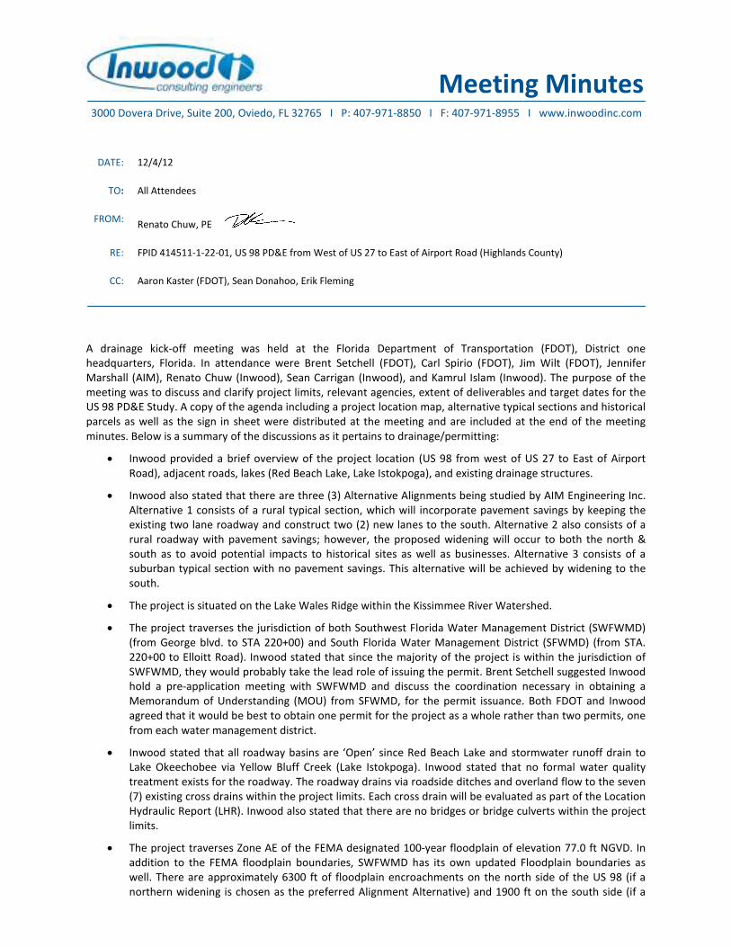
Meeting Minutes
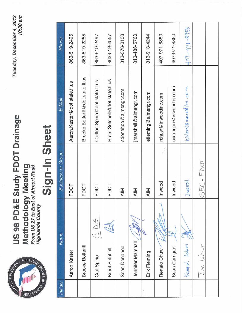
A drainage kick-off meeting was held at the Florida Department of Transportation (FDOT), District one
headquarters, Florida. In attendance were Brent Setchell (FDOT), Carl Spirio (FDOT), Jim Wilt (FDOT), Jennifer
Marshall (AIM), Renato Chuw (Inwood), Sean Carrigan (Inwood), and Kamrul Islam (Inwood). The purpose of the
meeting was to discuss and clarify project limits, relevant agencies, extent of deliverables and target dates for the
US 98 PD&E Study. A copy of the agenda including a project location map, alternative typical sections and historical
parcels as well as the sign in sheet were distributed at the meeting and are included at the end of the meeting
minutes. Below is a summary of the discussions as it pertains to drainage/permitting:
• Inwood provided a brief overview of the project location (US 98 from west of US 27 to East of Airport
Road), adjacent roads, lakes (Red Beach Lake, Lake Istokpoga), and existing drainage structures.
• Inwood also stated that there are three (3) Alternative Alignments being studied by AIM Engineering Inc.
Alternative 1 consists of a rural typical section, which will incorporate pavement savings by keeping the
existing two lane roadway and construct two (2) new lanes to the south. Alternative 2 also consists of a
rural roadway with pavement savings; however, the proposed widening will occur to both the north &
south as to avoid potential impacts to historical sites as well as businesses. Alternative 3 consists of a
suburban typical section with no pavement savings. This alternative will be achieved by widening to the
south.
• The project is situated on the Lake Wales Ridge within the Kissimmee River Watershed.
• The project traverses the jurisdiction of both Southwest Florida Water Management District (SWFWMD)
(from George blvd. to STA 220+00) and South Florida Water Management District (SFWMD) (from STA.
220+00 to Elloitt Road). Inwood stated that since the majority of the project is within the jurisdiction of
SWFWMD, they would probably take the lead role of issuing the permit. Brent Setchell suggested Inwood
hold a pre-application meeting with SWFWMD and discuss the coordination necessary in obtaining a
Memorandum of Understanding (MOU) from SFWMD, for the permit issuance. Both FDOT and Inwood
agreed that it would be best to obtain one permit for the project as a whole rather than two permits, one
from each water management district.
• Inwood stated that all roadway basins are ‘Open’ since Red Beach Lake and stormwater runoff drain to
Lake Okeechobee via Yellow Bluff Creek (Lake Istokpoga). Inwood stated that no formal water quality
treatment exists for the roadway. The roadway drains via roadside ditches and overland flow to the seven
(7) existing cross drains within the project limits. Each cross drain will be evaluated as part of the Location
Hydraulic Report (LHR). Inwood also stated that there are no bridges or bridge culverts within the project
limits.
• The project traverses Zone AE of the FEMA designated 100-year floodplain of elevation 77.0 ft NGVD. In
addition to the FEMA floodplain boundaries, SWFWMD has its own updated Floodplain boundaries as
well. There are approximately 6300 ft of floodplain encroachments on the north side of the US 98 (if a
northern widening is chosen as the preferred Alignment Alternative) and 1900 ft on the south side (if a
DATE: 12/4/12
TO: All Attendees
FROM: Renato Chuw, PE
RE: FPID 414511-1-22-01, US 98 PD&E from West of US 27 to East of Airport Road (Highlands County)
CC: Aaron Kaster (FDOT), Sean Donahoo, Erik Fleming
3000 Dovera Drive, Suite 200, Oviedo, FL 32765 I P: 407-971-8850 I F: 407-971-8955 I www.inwoodinc.com

F:\Projects\AIM-005-01\Admin\Meetings\Minutes\Meeting Minutes (12-4-2012).doc Page 2
southern widening is chosen as the preferred Alternative Alignment). FDOT suggested that potential for
floodplain encroachments should be identified and the necessary recommendations should be made in
the PD&E study, such as an offsite Floodplain Compensation Area, if the impacts cannot be compensated
for within the proposed pond sites, or within the roadway right of way.
• There are three waterbodies near the project: Red Beach Lake (WBID 1891A), Yellow Bluff Creek (WBID
1891), and Arbuckle Creek (WBID 1761J). Inwood stated that out of the three waterbodies, two have
insufficient data, WBID 1891A and WBID 1891, and one is not impaired, WBID 1761J. FDOT agreed that
pollutant loading analyses is not required.
• Inwood stated that during the proposal phase, it was anticipated that the project would be divided into
four (4) roadway basins. However, with the extension of the project limits west of US 27 and east of
Airport Road, the number of roadway drainage basins could increase to six (6) total. For each roadway
basin, one (1) offsite pond alternative will be identified. Inwood then stated that since much of the
project is situated upon well drained type A soils, linear swales could also be a viable treatment option.
Brent stated that as a most conservative option for the study offsite ponds should be sited; however, the
Pond Siting Report (PSR) may also recommend the dry linear swale option if it is determined that they
work.
• There are no Outstanding Florida Waterbodies (OFW) in the project limits, therefore, the required
treatment volume will follow the guidelines set forth by the SWFWMD: 1” of runoff over the DCIA for Wet
Detention ponds and 0.5” of runoff over the DCIA for Dry retention ponds. Brent Setchell stated that per
House Bill 599 (HB599), the treatment volume should only take into account the onsite DCIA. The ponds
will also be sized to attenuate the difference in pre-development and post-development runoff volume
for the 25yr/24hr storm event.
• Inwood stated that a coordination meeting took place earlier in 2012 with the Spring Lake Improvement
District (SLID) and joint use facilities were discussed. Brent reiterated that although the joint use facility
with SLID should be mentioned in the PSR, as a conservative approach, an offsite pond alternative should
be sited.
• Preliminary pond sites will be identified and provided to AIM by December 14, 2012.
• Inwood also stated that the Draft Pond Siting report will be submitted in January 2013.
***** END OF MEETING MINUTES *****
Note: The above reflects the writer’s understanding of the contents of the meeting. If any misinterpretations or
inaccuracies are included, please contact Sean Carrigan or Renato Chuw at (407) 971-8850 as soon as possible for
resolution and revisions if necessary.

Renato Chuw
From: Sean Donahoo [[email protected]]
Sent: Tuesday, July 30, 2013 10:07 AM
To: Renato Chuw; Erik Fleming
Cc: Sean Carrigan; Justin Christensen
Subject: RE: Interagency Agreements for ERPs
Page 1 of 2
7/31/2013
Thank you Renato.
Sean
From: Renato Chuw [mailto:[email protected]]
Sent: Tuesday, July 30, 2013 9:47 AM To: Sean Donahoo; Erik Fleming Cc: Sean Carrigan; Justin Christensen
Subject: FW: Interagency Agreements for ERPs
Sean, Please see the email string below regarding the permitting coordination required for the US 98 PD&E Study. I spoke with Bob Dasta this morning and we actually sent me the information back in January 2012 regarding the details of the SWFWMD/SFWMD permitting agreement. I believe we can include a copy of this email in our correspondence section of our drainage reports as backup documentation in regards to the permitting approach. Thanks, Renato
Renato E. Chuw, P.E. Associate Principal - Senior Drainage Engineer
INWOOD CONSULTING ENGINEERS
3000 Dovera Dr., Suite 200, Oviedo, FL 32765
P: 407-971-8850
C: 407-212-8391
From: Bob Dasta [mailto:[email protected]] Sent: Tuesday, July 30, 2013 9:40 AM To: Renato Chuw
Subject: FW: Interagency Agreements for ERPs
Renato,
I found this past email regarding our discussion today.
Thanks,
Bob
Robert A. Dasta, P.E.
Sr. Professional Engineer, Environmental Resource Permitting Bureau
Southwest Florida Water Management District
7601 US Highway 301 North
Tampa, FL 33637-0797
(800) 492-7862 or (813) 985-7481, ext. 6105
From: Renato Chuw [mailto:[email protected]]
Sent: Friday, January 06, 2012 11:21 AM To: Bob Dasta Cc: Jan Burke; Amy Brennan
Subject: RE: Interagency Agreements for ERPs
Bob, Thank you for the information and quick response. Regards, Renato
From: Bob Dasta [mailto:[email protected]] Sent: Friday, January 06, 2012 11:17 AM
To: Renato Chuw Cc: Jan Burke; Amy Brennan Subject: Interagency Agreements for ERPs
Renato,

As we discussed this morning, the (future) U.S. 98 project in Highlands County (from approximately U.S. 27 to Airport Road) will be located within the SWFWMD and the SFWMD. Since the
majority of the project (you indicated approximately 95-99%) is within the SWFWMD (including the surface water management system), you are proposing that our agency be the
permitting agency. This would need to be accomplished through an interagency agreement between our agency and the SFWMD for designation of regulatory responsibility to SWFWMD.
However, this agreement must be reviewed and approved by each District’s governing board.
This is in accordance with Section 373.046(6), F.S., which provides that when the geographic area of a project crosses Water Management District boundaries, the affected Districts may
designate a single affected District by interagency agreement to implement in that area, under the rules of the designated District, all or part of the applicable regulatory responsibilities
under Chapter 373. Interagency agreements entered into under subsection (6) must have the concurrence of the affected local government. This documentation will need to be included
in the future ERP application submittal.
We also discussed that your project discharges to Yellow Bluff Creek, then to Josephine Creek, and ultimately to Lake Istokpoga. You indicated that SFWMD rule criteria requires additional
water quality treatment volume for projects discharging to these systems. Since these receiving systems are located on SFWMD land with additional water quality requirements, their
agency may desire to review and permit the project to ensure compliance with these criteria. We also discussed the need to verify whether or not your project discharges to an FDEP
impaired waterbody.
Thanks,
Bob
Robert A. Dasta, P.E.
Sr. Professional Engineer
Bartow Regulation Department
Southwest Florida Water Management District
170 Century Boulevard
Bartow, FL 33830
(800) 492-7862 or 863-534-1448, ext. 6105
IMPORTANT NOTICE: All E-mail sent to or from this address are public record and archived. The Southwest Florida Water Management District does not allow use of District equipment and E
Page 2 of 2
7/31/2013

MEMO
This memo serves as the record of telephone conversation between Sean Carrigan of Inwood Consulting Engineers
and Brent Unger of the Florida Department of Transportation (FDOT) which took place on January 15, 2013. Mr.
Unger is the Maintenance field supervisor for Highlands County, Florida. Mr. Unger stated that there was no
flooding concerns along this segment of US 98 and the stormwater runoff drains well.
Mr. Carrigan then asked Mr. Unger if he had ever experienced and maintenance concerns with any of the cross
drains. Mr. Unger stated that the triple 48" RCP at mile post (MP) 1.462 (CD-3) on the Straight Line Diagram, has
some sinkhole depressions on the shoulder due to leaky joints within the cross drain. He stated that the holes
have been filled several times. He also stated that the single 36" RCP at MP 1.667 (CD-4) has had similar issues
except the depressions are closer to the headwall on the north end which is causing it to lean. Additionally the
dual 36" RCP (CD-7) at MP 3.245 has had sleeves put in it to prevent the leaving joints from washing away the
roadway base.
One item to note is that the single 15" RCP (CD-2) at MP 0.600 is no longer a cross drain and consists of a ditch
bottom inlet on the south side of US 98 which connects to a manhole on the north side of US 98 and is conveyed
east via stormsewer to a roadside ditch on the north side of US 98.
***END OF TELEPHONE RECORD***
DATE: 1/15/2013
TO: FILE
FROM: Sean Carrigan, P.E.
RE: FPID 414511-1-22-01 - US 98 PD&E from West of US 27 to East of Airport Road - Interview with FDOT maintenance
staff
CC: Renato Chuw
3000 Dovera Drive, Suite 200, Oviedo, FL 32765 I P: 407-971-8850 I F: 407-971-8955 I www.inwoodinc.com