draft environmental impact statement renewal of the ... 3.pdf · draft environmental impact...
TRANSCRIPT
BLM/AK/PT-02/026+2880+990
Draft Environmental Impact Statement
Renewal of the Federal Grant for the Trans-AlaskaPipeline System Right-of-Way
Volume 3: Sections 4.7 through 4.9and Chapters 5 through 9
U.S. Department of the InteriorBureau of Land Management
July 2002


iii
DOCUMENT CONTENTS
VOLUME 1
Executive SummaryChapter 1: IntroductionChapter 2: AlternativesChapter 3: Affected Environment
VOLUME 2
Section 4.1: Existing Mitigation MeasuresSection 4.2: Impacting FactorsSection 4.3: Proposed Action Alternative Analysis − Routine OperationsSection 4.4: Spills Analysis for Proposed ActionSection 4.5: Less-Than-30-Year Renewal Alternative AnalysisSection 4.6: No-Action Alternative Analysis
VOLUME 3
Section 4.7: Cumulative EffectsSection 4.8: Other NEPA ConsiderationsSection 4.9: References for Chapter 4Chapter 5: Consultation and CoordinationChapter 6: Review and Analysis of Comments Received on the Draft
Environmental Impact Statement (Reserved for Final EIS)Chapter 7: List of PreparersChapter 8: GlossaryChapter 9: Glossary of Laws, Executive Orders, and Regulations Cited
in This DEIS
VOLUME 4
Appendix A: Methodology DescriptionsAppendix B: TAPS ROW Map AtlasAppendix C: Hazardous Materials and Waste ManagementAppendix D: Subsistence in the Vicinity of the TAPSAppendix E: ANILCA Section 810 Analysis of Subsistence ImpactsAppendix F: Federal Agreement and Grant of Right-of-Way for the
Trans-Alaska Pipeline

iv

v
VOLUME 3 CONTENTS
4.7 Cumulative Effects .......................................................................................................... 4.7-14.7.1 Introduction......................................................................................................... 4.7-14.7.2 Regions of Interest ............................................................................................. 4.7-34.7.3 Time Frames of Actions ..................................................................................... 4.7-134.7.4 Types of Actions................................................................................................. 4.7-13
4.7.4.1 Oil and Gas Exploration, Development, and Production ................... 4.7-194.7.4.2 Oil Refining ........................................................................................ 4.7-364.7.4.3 Oil Storage ......................................................................................... 4.7-364.7.4.4 Oil and Natural Gas Transportation ................................................... 4.7-364.7.4.5 Habitation and Development.............................................................. 4.7-384.7.4.6 Transportation.................................................................................... 4.7-424.7.4.7 Legislative Actions Related to Land Use ........................................... 4.7-434.7.4.8 Land Management ............................................................................. 4.7-444.7.4.9 Natural Resource Use........................................................................ 4.7-464.7.4.10 Petroleum and Hazardous Materials Spills........................................ 4.7-48
4.7.5 Impacting Factors of Reasonably Foreseeable Actions..................................... 4.7-564.7.6 Physical Environment......................................................................................... 4.7-62
4.7.6.1 Soil and Permafrost ........................................................................... 4.7-624.7.6.2 Sand, Gravel, and Quarry Resources................................................ 4.7-634.7.6.3 Paleontology ...................................................................................... 4.7-644.7.6.4 Surface Water Resources.................................................................. 4.7-644.7.6.5 Groundwater Resources .................................................................... 4.7-674.7.6.6 Physical Marine Environment ............................................................ 4.7-704.7.6.7 Air Quality .......................................................................................... 4.7-724.7.6.8 Noise.................................................................................................. 4.7-734.7.6.9 Transportation.................................................................................... 4.7-744.7.6.10 Wastes ............................................................................................... 4.7-754.7.6.11 Human Health and Safety .................................................................. 4.7-79
4.7.7 Biological Resources ......................................................................................... 4.7-874.7.7.1 Terrestrial Vegetation and Wetlands ................................................. 4.7-874.7.7.2 Fish .................................................................................................... 4.7-894.7.7.3 Birds and Mammals ........................................................................... 4.7-944.7.7.4 Threatened, Endangered, and Protected Species ............................. 4.7-102
4.7.8 Social Systems................................................................................................... 4.7-1084.7.8.1 Subsistence ....................................................................................... 4.7-1084.7.8.2 Sociocultural Systems ....................................................................... 4.7-1114.7.8.3 Economics ......................................................................................... 4.7-1154.7.8.4 Cultural Resources ............................................................................ 4.7-1184.7.8.5 Land Use and Coastal Zone Management ........................................ 4.7-1184.7.8.6 Recreation, Wilderness, and Aesthetics ............................................ 4.7-1204.7.8.7 Environmental Justice........................................................................ 4.7-123
4.7.9 Summary ............................................................................................................ 4.7-123
4.8 Other NEPA Considerations............................................................................................ 4.8-14.8.1 Unavoidable Adverse Impacts ........................................................................... 4.8-14.8.2 Relationship Between Local Short-Term Uses of the Environment
and Long-Term Productivity ............................................................................... 4.8-14.8.3 Irreversible and Irretrievable Commitment of Resources................................... 4.8-24.8.4 Mitigation of Adverse Effects.............................................................................. 4.8-2
4.9 References for Chapter 4 ................................................................................................ 4.9-1

vi
VOLUME 3 CONTENTS (Cont.)
5 Consultation and Coordination.................................................................................................. 5-1
5.1 Public Scoping ................................................................................................................ 5-15.2 Government-to-Government Consultation ...................................................................... 5-25.3 State of Alaska Coordination........................................................................................... 5-25.4 Other BLM Planning Activities......................................................................................... 5-25.5 Agency Consultation ....................................................................................................... 5-35.6 References for Chapter 5 ................................................................................................ 5-3
6 Review and Analysis of Comments Received on the DraftEnvironmental Impact Statement .............................................................................................. 6-1
7 List of Preparers........................................................................................................................ 7-1
8 Glossary.................................................................................................................................... 8-1
9 Glossary of Laws, Executive Orders, and Regulations Cited in This DEIS .............................. 9-1
9.1 Federal Laws................................................................................................................... 9-19.2 Executive Orders............................................................................................................. 9-39.3 Federal Regulations ........................................................................................................ 9-39.4 State Laws....................................................................................................................... 9-59.5 State Regulations ............................................................................................................ 9-5
VOLUME 3 FIGURES
4.7-1 Cumulative Assessment Approach for this DEIS ............................................................... 4.7-3
4.7-2 General Regions of Interest in Alaska for Cumulative Effects to Physicaland Ecological Resources from the TAPS and Other Actions............................................ 4.7-5
4.7-3 Areas and Locations in the Beaufort Sea and North Slope Regions .................................. 4.7-7
4.7-4 Areas and Locations in Interior Alaska............................................................................... 4.7-9
4.7-5 Areas and Locations in the Prince William Sound Region ................................................. 4.7-11
4.7-6 Oil and Gas Development on the North Slope over Time .................................................. 4.7-21
4.7-7 Generalized Schematic of Prudhoe Bay Oil Production..................................................... 4.7-34
4.7-8 Proposed Route of the Alcan Project.................................................................................. 4.7-39
VOLUME 3 TABLES
4.7-1 Regions of Interest for the Cumulative Assessment........................................................... 4.7-4
4.7-2 Potential Contributions to Cumulative Effects in the Beaufort Sea, North Slope,Interior Alaska, and Prince William Sound ......................................................................... 4.7-14

vii
VOLUME 3 TABLES (Cont.)
4.7-3 Oil Fields Located in Alaska and the Arctic Outer Continental Shelf ................................. 4.7-31
4.7-4 Spill Scenarios for the North Slope..................................................................................... 4.7-49
4.7-5 Transportation Spill Scenarios ........................................................................................... 4.7-52
4.7-6 Spill Scenarios for Tanker Accidents in the Prince William Sound .................................... 4.7-54
4.7-7 Activities and Impacting Factors Associated with the Reasonably ForeseeableActions That Would Contribute to a Cumulative Effect....................................................... 4.7-57
4.7-8 Toxics Release Inventory Reportable Emissions for the State of Alaska in 1999.............. 4.7-82
4.7-9 Cumulative Impacts to Threatened, Endangered, and Protected Species onthe North Slope and Beaufort Sea...................................................................................... 4.7-103
4.7-10 Cumulative Impacts on Threatened, Endangered, and Protected Speciesin Interior Alaska................................................................................................................. 4.7-104
4.7-11 Cumulative Impacts on Threatened, Endangered, and Protected Speciesin Prince William Sound ..................................................................................................... 4.7-105
4.7-12 Summary of Anticipated Cumulative Impacts Under the Proposed Action......................... 4.7-125
4.7-13 Summary of Cumulative Effects ......................................................................................... 4.7-129

viii

ix
Notation
The following is a list of acronyms and abbreviations (including units of measure) used in this document.Certain abbreviations used only in tables, equations, and as reference callouts are not included here butare defined in the respective tables, equations, and reference lists.
Acronyms and Abbreviations
AAAQS Alaska Ambient Air Quality StandardsAAC Alaska Administrative CodeAADT annual average daily trafficACEC areas of critical environmental concernACM asbestos-containing materialsACMA Alaska Coastal Management ActACMP Alaska Coastal Management ProgramACS Alaska Clean SeasADEC Alaska Department of Environmental ConservationADF&G Alaska Department of Fish and GameADGC Alaska Department of Government CoordinationADNR Alaska Department of Natural ResourcesADT average daily trafficAFB Air Force BaseAFFF aqueous film-forming foamAFN Alaska Federation of NativesAK AlaskaAKOSH Alaska Occupational Safety and HealthALOHA Areal Locations of Hazardous AtmospheresAMHS Alaska Marine Highway SystemAMM asset maintenance managementANCSA Alaska Native Claims Settlement ActANILCA Alaska National Interest Lands Conservation ActANSI American National Standards InstituteANUA Alaska Native Utilization AgreementANWR Arctic National Wildlife RefugeAO Authorized Officer (Joint Pipeline Office)AOGCC Alaska Oil and Gas Conservation CommissionAPHIS Animal and Plant Health Inspection ServiceAPI American Petroleum InstituteAPSC Alyeska Pipeline Service CompanyAQCR Air Quality Control RegionAQRV air-quality-related valueARCO Atlantic Richfield CompanyARRC Alaska Railroad CorporationARRT Alaska Regional Response TeamAS Alaska StatuteASME American Society of Mechanical EngineersATV all-terrain vehicle
BE biological evaluationBLM Bureau of Land Management (U.S. Department of the Interior)BLS Bureau of Labor StatisticsBMP best management practiceBOD biochemical oxygen demand

x
BOD5 biochemical oxygen demand measured over a five-day periodBP British PetroleumBPXA British Petroleum Exploration (Alaska), Inc.BS&W basic sediments and waterBTEX benzene, toluene, ethylbenzene, xyleneBTT biological treatment tankBWT ballast water treatmentBWTF Ballast Water Treatment FacilityBWTS ballast water treatment system
CBR Constitutional Budget ReserveCBRF Constitutional Budget Reserve FundCCP Central Processing PlantCDMS Corrosion Data Management SystemCEO chief executive officerCEQ Council on Environmental QualityCFC chlorofluorocarbonCFR Code of Federal RegulationsCMP coastal management programCNG compressed natural gasCO carbon monoxideCO2 carbon dioxideCP Contingency PlanCPF Central Production FacilityCS containment siteCSU conservation system unitCY calendar yearCZ coastal zoneCZM coastal zone managementCZMA Coastal Zone Management Act
DAF dissolved air flotationDBGC designated big-game crossingDCE design contingency earthquakeDDT dichloro-diphenyl-trichloro-ethaneDEIS draft environmental impact statementDHCMA Dalton Highway Corridor Management AreaDOE U.S. Department of EnergyDOI U.S. Department of the InteriorDOT Department of TransportationDOT/OPS Department of Transportation, Office of Pipeline SafetyDRA drag reducing agentDRO diesel-range organicsDS drill siteDSMA digital strong-motion accelerograph
EIA Energy Information AdministrationEFH essential fish habitate.g. exempli gratia (for example)EGHP exhaust-gas horsepowerEIA Energy Information AdministrationEIS environmental impact statementEMS environmental monitoring systemEPA U.S. Environmental Protection AgencyEPCRA Emergency Planning and Community Right-to-Know ActER environmental reportERPG emergency response planning guidelineERV Escort Response Vessel
xi
ESA Endangered Species Actet al. and others
FAA Federal Aviation AdministrationFACA Federal Advisory Committee ActFDA U.S. Food and Drug AdministrationFDS Fire Dynamics Simulation (computer model)Fe ironFe2O3 ferric oxideFEIS final environmental impact statementFR Federal RegisterFSIH Fire Safety and Industrial HygieneFTE full-time equivalent
GAO General Accounting OfficeGC Gathering CenterGHG greenhouse gasGIS geographic information systemGMU Game Management UnitGNOME General NOAA Oil Modeling EnvironmentGRO gasoline-range organicsGSP gross state product
H2O2 hydrogen peroxideH2S hydrogen sulfideHAP hazardous air pollutantHAZCORE Hazardous Materials Consolidation and RedistributionHAZMAT hazardous materialHC hydrocarbonHCFC hydrochlorofluorocarbonHCl hydrogen chlorideHg mercuryHRR heat release rateHVAC heating, ventilation, and air conditioning
i.e. that is (id est)IMPROVE Interagency Monitoring of Protected Visual EnvironmentsIRIS Integrated Risk Information SystemIRT Initial Response TeamISC3 Industrial Source Complex Model (Version 3)ISCST Industrial Source Complex Short TermIWSS industrial wastewater sewer system
JPO Joint Pipeline Office
Ldn day-night average sound levelLeq equivalent steady sound levelLEFM leading-edge flow meterLNG liquefied natural gasLVB line volume balance
MAP Man in the Arctic ProgramMCCF mobile contingency camp facilityMCL maximum contaminant levelMEI maximally exposed individualMEK methyl ethyl ketoneMGV manual gate valveMLA Mineral Leasing Act

xii
MLR Mainline RefrigerationMMC Marine Mammal CommissionMMPA Marine Mammal Protection ActMMS Minerals Management ServiceMOA memorandum of agreementMP milepostMSDS Material Safety Data SheetsMSFCMA Magnuson-Stevens Fisheries Conservation and Management ActMSGP Multi-Sector General (NPDES) PermitMSWLF municipal solid waste landfill
N nitrogenNAAQS National Ambient Air Quality StandardsNADP National Atmospheric Deposition ProgramNAICS North American Industry Classification SystemNANA Northwest Alaska Native AssociationNEPA National Environmental Policy ActNF National ForestNFRAP no further remedial action plannedNGL natural gas liquidNH3 ammoniaNHPA National Historic Preservation ActNMDS National Missile Defense SystemNMFS National Marine Fisheries Serviceno. numberNOx nitrogen oxidesNO2 nitrogen dioxideNO3- nitrateNOAA National Oceanic and Atmospheric AdministrationNOD Notice of DisposalNOI Notice of IntentNORM naturally occurring radioactive materialNP national parkNPDES National Pollutant Discharge Elimination SystemNPP national park and preserveNPR National Petroleum ReserveNPR-A National Petroleum Reserve-AlaskaNPS National Park ServiceNRA national recreation areaNRHP National Register of Historic PlacesNS North SlopeNSB North Slope BoroughNSC National Safety CouncilNSPTS North Slope Production and Transportation SystemNWR national wildlife refugeNWS National Weather Service
O3 ozoneO&M operation and maintenanceOCC Operations Control CenterOCS Outer Continental ShelfODC ozone-depleting chemicalODP ozone-depleting potentialODS ozone-depleting substanceOMB Office of Management and BudgetOMS operational material siteOPA Oil Pollution ActOPS Office of Pipeline Safety (U.S. Department of Transportation)

xiii
ORC oxygen-releasing compoundORV off-road vehicleOSHA Occupational Safety and Health AdministrationOSHTF (Alaska) Oil Spill Health Task ForceOSPPR Oil Spill Prevention, Preparedness, and ResponseOSV oil spill volume
P phosphorusPA Programmatic AgreementPAH polycyclic aromatic hydrocarbonPAI Phillips Alaska, Inc.Pb leadPBT persistent, bioaccumulative, and toxicPCB polychlorinated biphenylPDF pipeline design floodPELs permissible exposure limitsPF Permanent FundPG Pasquill-GiffordpH hydrogen ion concentrationP.L. Public LawPM particulate matterPM2.5 particulate matter with a diameter less than or equal to 2.5 micrometersPM10 particulate matter with a diameter less than or equal to 10 micrometersPMP probable maximum precipitationPO4
3- phosphatePOP persistent organic pollutantPOTW publicly owned treatment worksPPE personal protective equipmentPPV peak particle velocityPRT prevention and response tugPS pump stationPSD Prevention of Significant DeteriorationPWS Prince William Sound
QA quality assurance
RCM reliability-centered maintenanceRCRA Resource Conservation and Recovery ActREAA Regional Educational Attendance AreaRGV remote gate valveRMP Resource Management PlanROD Record of DecisionROS recreation opportunity spectrumROW right-of-wayRRO residual-range organicsRSC reduced sulfur compounds
SARA Superfund Amendments and Reauthorization ActSCADA supervisory control and data acquisitionSD standard deviationSDWA Safe Drinking Water ActSERVS Ship Escort/Response Vessel SystemSHPO State Historic Preservation OfficerSi siliconSIC Standard Industrial ClassificationSIP state implementation planSO2 sulfur dioxideSOx sulfur oxides
xiv
SPC State Pipeline Coordinatorspp. speciesSRS state recreation siteStat. statuteSWDS solid waste disposal siteSWPPP Storm Water Pollution Prevention PlanSWTP sanitary waste treatment plant
TAPAA Trans-Alaska Pipeline Authorization ActTAPS Trans-Alaska Pipeline SystemTAGS Trans-Alaska Gas SystemTCA 1,1,1-trichloroethaneTCP traditional cultural propertyTEEL temporary emergency exposure limitTEF toxic equivalency factorTLV threshold limit valueTPQs Threshold Planning QuantitiesTRI Toxics Release InventoryTSDF treatment storage and disposal facilityTSP total suspended particulatesTSS total suspended solidsTVB transient volume balanceTVR tanker vapor recovery
UAA University of Alaska-AnchorageUIC underground injection controlUSACE U.S. Army Corps of EngineersUSC United States CodeUSCG United States Coast GuardUSDA U.S. Department of AgricultureUSFS United States Forest ServiceUSFWS United States Fish and Wildlife ServiceUSGS United States Geological SurveyUV ultra-violet
VAHS Valdez Air Health StudyVHF very high frequencyVHS viral hemorrhagic septicemiaVMT Valdez Marine TerminalVOC volatile organic compoundVRM visual resource managementVSM vertical support memberVTS Vessel Traffic Service
WSR Wild and Scenic River
ZRAs Zone of Restricted Activities

xv
Units of Measure
acre-ft acre-foot (feet)bbl barrel(s)Btu British thermal unit(s)°C degrees centigradecm centimeter(s)cm3 cubic centimeterscSt centistoke(s)d daydB decibel(s)dBA A-weighted decibel(s)°F degrees Fahrenheitft foot (feet)ft2 square foot (feet)ft3 cubic foot (feet)g gravitational accelerationgal gallon(s)GW gigawatt(s)h hour(s)ha hectare(s)hp horsepowerin. inch(es)in.2 square inch(es)j joule(s)K kelvin degree(s)kg kilogram(s)km kilometer(s)km2 square kilometer(s)knot nautical mile(s) per hourkW kilowatt(s)L liter(s)lb pound(s)m meter(s)m2 square meter(s)
m3 cubic meter(s)mg milligram(s)mi mile(s)mi2 square mile(s)min minute(s)mL milliliter(s)mm millimeter(s)mmole millimole(s)mph mile(s) per hourMW megawatt(s)MYA million years agong nanogram(s)pCi picocurie(s)ppb part(s) per billionppm part(s) per millionpsi pound(s) per square inchpsig pound(s) per square inch gaugerpm revolution(s) per minutes second(s)scf standard cubic foot (feet)scfm standard cubic foot (feet) per minutewk week(s)YA years agoyd yard(s)yd3 cubic yardsyr year(s)µg microgram(s)µg-atoms microgram-atomsµm micrometer(s)µmole micromole(s)µR microroentgen(s)$/bbl dollar per barrel

xvi

4.7-1
4.7 Cumulative Effects
4.7.1 Introduction
4.7.1.1 Approach
Cumulative effects result from theincremental impact of the proposed action andalternatives when added to other past, present,and reasonably foreseeable future actions,regardless of what government agency or privateentity undertakes such actions. Cumulativeeffects can result from individually minor impactsthat when viewed collectively over space andtime can produce significant impacts.
The approach used in this cumulative impactassessment is to first evaluate the cumulativeimpacts of all actions, including the proposedaction and other reasonably foreseeable futureactions. Then the degree to which the proposedaction contributes to those impacts is presented.Finally, the cumulative impacts of thealternatives (less-than-30-year renewal and noaction), together with other reasonablyforeseeable actions, are discussed andcompared with cumulative impacts of theproposed action of all other actions.
For this DEIS, the relationship of theproposed action to the no action alternative isreversed from the usual situation found in NEPAanalyses of proposed actions for new facilities ornew plans. For this DEIS, the proposed action isreauthorization, and the potential impacts wouldbe largely related to forecasts of futurecontinuing operations of an existing system. Atthe time of grant expiration, this system will havebeen in operation for 30 years, and its impactshave received continuous study. For this DEIS,the no-action alternative (the alternative in whichthe responsible agency takes no action)addresses a new action, which is to ceaseoperating and remove the existing system. Noaction has not received engineering andenvironmental study and its description remainssomewhat speculative. No action involves manymajor activities, including construction-likeactivities; removal of facilities would require alarge workforce and generate large amounts ofwastes, and other industries that depend upon
the TAPS operation would be affected. Theassessment of the no-action alternative inSection 4.6 concludes that in most cases, theenvironmental impacts of the no-actionalternative would result in a greater change inimpacts to the existing environment than theimpacts of the proposed action. Where thiscumulative impact assessment (Section 4.7)differs from the earlier impact sections, is thatthe resultant effect of no action on otherreasonably foreseeable future actions is alsoconsidered in the impact assessment. Theoperation of the TAPS supports and is arequirement for other ongoing activities, and isan integral part of the Alaskan economy.
4.7.1.2 Method
The analysis of cumulative impacts focuseson specific human resources or environmentalreceptors that can be affected by the incrementalimpacts. Generally, the geographic area for acumulative impact analysis is defined by thespecific resource or receptor of concern and thespatial extent of the interacting (cumulative)impact generators. The temporal extent of thecumulative analysis extends from the pasthistory of impacts to each receptor through theanticipated life of the project, including additionaltime necessary for decommissioning andrestoration, if appropriate.
Cumulative impact analysis, by definition,incorporates an extensive range of potentialstressors and thus provides a decision maker
Cumulative Effects
These effects constitute the impact on theenvironment that results from theincremental impact of the action underconsideration when added to other past,present, and reasonably foreseeable futureactions, regardless of what agency (federalor nonfederal) or person undertakes suchother actions (40 CFR 1508.7).

ENVIRONMENTAL CONSEQUENCES 4.7-2
and the public with an overview of the condition(past, present, future) of a receptor or resourcewithin a regional or landscape context. A broaderoverview of the set of potential impacts to aresource allows the decision maker to place thedirect and indirect impacts of the proposedaction within the context of other potentialstressors.
The Council on Environmental Qualitydiscussed the assessment of cumulative effectsin detail in its report entitled ConsideringCumulative Effects under the NationalEnvironmental Policy Act (CEQ 1997). Althoughit is not formal guidance, the handbook providesassistance in developing an analysis. Thehandbook identifies 10 steps for assessingcumulative impacts prior to implementation of aproposal. In the words of the handbook, thesesteps are listed here and in Figure 4.7-1.
1. Identify the significant cumulativeeffects issues associated with theproposed action and define theassessment goals.
2. Establish the geographic scope forthe analysis.
3. Establish the time frame for theanalysis.
4. Identify other actions affecting theresources, ecosystems, and humancommunities of concern.
5. Characterize the resources,ecosystems, and humancommunities identified duringscoping in terms of their response tochange and capacity to withstandstresses.
6. Characterize the stresses affectingthese resources, ecosystems, andhuman communities and theirrelation to regulatory thresholds.
7. Define baseline conditions for theresources, ecosystems, and humancommunities.
8. Identify the important cause-and-effect relationships between humanactivities and resources,
ecosystems, and humancommunities.
9. Determine the magnitude andsignificance of cumulative effects.
10. Modify or add alternatives to avoid,minimize, or mitigate significantcumulative effects.
The approach used for the cumulativeimpact assessment discussed in this DEISincludes the 10 steps identified in the CEQapproach (Figure 4.7-1). Cumulative effectissues were initially identified during scopingand in consultations with Alaska Native groups(Step 1), as discussed in Chapters 1 and 2.Additional issues and actions were added lateras they were identified. Next in the analysis, theregion of interest (Step 2) and the time frame(Step 3) were established. Then other actionsthat previously had, now have, or would havesimilar impacts to those of the proposed actionwere identified (Step 4). The affectedenvironment described in Chapter 3 was used tocharacterize the resources, ecosystems, andhuman communities of concern (Step 5);characterize the stresses affecting theseelements (Step 6); and establish baselineconditions (Step 7). Both the proposed actionand these other actions were found to generatefactors that could cause impacts to the physical,ecological, human, and/or economicenvironment. These individual contributionswere evaluated (Step 8) and aggregated, and itis this aggregate (the total contributions from allactions to the impacting factor) that was used toassess the cumulative effect (Step 9). In caseswhere the contributions of individual actions toan impacting factor were uncertain or not wellknown, a qualitative evaluation of cumulativeimpacts was necessary. A qualitative evaluationof cumulative effects covered the locations ofactions, times they occurred, degrees to whichthe impacted resource is at risk, and potential forlong-term or synergistic effects. Recommenda-tions for future modifications to the alternativesand the means for future monitoring or mitigationof effects were identified if needed (Step 10). Afurther discussion of the approach used forcumulative effects analysis is found inAppendix A, Section A.16.

4.7-3 ENVIRONMENTAL CONSEQUENCES
Define Goals: CEQ Step 1 (Sections 4.7.1.1 and 4.7.1.2)
Establish Region of Interest and Time Frame: CEQ Steps 2 and 3(Sections 4.7.2 and 4.7.3)
Identify Other Actions: CEQ Step 4(Section 4.7.4)
Characterize Resources and Baseline Conditions: CEQ Steps 5 and 7(Chapter 3 and Section 4.1)
Identify Stresses, Cause, and Effect: CEQ Steps 6 and 8(Sections 4.7.5, 3, and 4.1 – 4.6)
Determine Cumulative Effects; Need to Modify, Avoid, and Mitigate: CEQ Steps 9 and 10
(Sections 4.7.6 – 4.7.8)
Impacts ofProposed Action and Alternatives
(Sections 4.3 – 4.6)
Impacts of Other Actions
JKA50204
FIGURE 4.7-1 Cumulative Assessment Approach forThis DEIS
4.7.2 Regions of Interest
In order to determine which actions shouldbe included in a cumulative effects analysis inthis DEIS, the region of interest must first bedefined. This region should not be limited to justthe location of the proposed action but shouldalso take into account the distance that effectsmay travel and the regional characteristics of theaffected resources.
The cumulative impact analysis in this DEISconsiders past, present, and future actions that
previously occurred, occur now, or are expectedto occur near the TAPS or within the areasaffected by the TAPS. Table 4.7-1 summarizesthe regions of interest examined for cumulativeeffects for different subjects. For the purposes ofthe physical and ecological environmentanalyses in this DEIS, these areas include the(1) Beaufort Sea, (2) North Slope, (3) InteriorAlaska, and (4) Prince William Sound regions(Figure 4.7-2). Actions and impacts in theBeaufort Sea and North Slope are described foran area extending from Barrow in the west to theU.S./Canadian border (east of the Arctic National
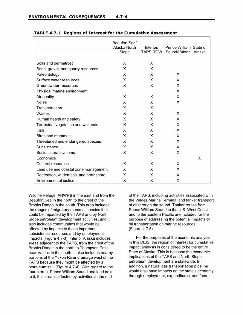
ENVIRONMENTAL CONSEQUENCES 4.7-4
TABLE 4.7-1 Regions of Interest for the Cumulative Assessment
Beaufort Sea/Alaska North
SlopeInterior/
TAPS ROWPrince WilliamSound/Valdez
State ofAlaska
Soils and permafrost X XSand, gravel, and quarry resources X XPaleontology X X XSurface water resources X X XGroundwater resources X X XPhysical marine environment XAir quality X X XNoise X X XTransportation X XWastes X X XHuman health and safety X X XTerrestrial vegetation and wetlands X X XFish X X XBirds and mammals X X XThreatened and endangered species X X XSubsistence X X XSociocultural systems X X XEconomics XCultural resources X X XLand use and coastal zone management X X XRecreation, wilderness, and northshore X X XEnvironmental justice X X X
Wildlife Refuge [ANWR]) in the east and from theBeaufort Sea in the north to the crest of theBrooks Range in the south. This area includesthe ranges of migratory mammal species thatcould be impacted by the TAPS and by NorthSlope petroleum development activities, and italso includes communities that would beaffected by impacts to these importantsubsistence resources and by employmentimpacts (Figure 4.7-3). Interior Alaska includesareas adjacent to the TAPS, from the crest of theBrooks Range in the north to Thompson Passnear Valdez in the south. It also includes nearbyportions of the Yukon River drainage west of theTAPS because they might be affected by apetroleum spill (Figure 4.7-4). With regard to thefourth area, Prince William Sound and land nextto it, this area is affected by activities at the end
of the TAPS, including activities associated withthe Valdez Marine Terminal and tanker transportof oil through the sound. Tanker routes fromPrince William Sound to the U.S. West Coastand to the Eastern Pacific are included for thepurpose of addressing the potential impacts ofoil transportation on marine resources(Figure 4.7-5).
For the purposes of the economic analysisin this DEIS, the region of interest for cumulativeimpact analysis is considered to be the entireState of Alaska. This is because the economicimplications of the TAPS and North Slopepetroleum development are statewide. Inaddition, a natural gas transportation pipelinewould also have impacts on the state�s economythrough employment, expenditures, and fees.
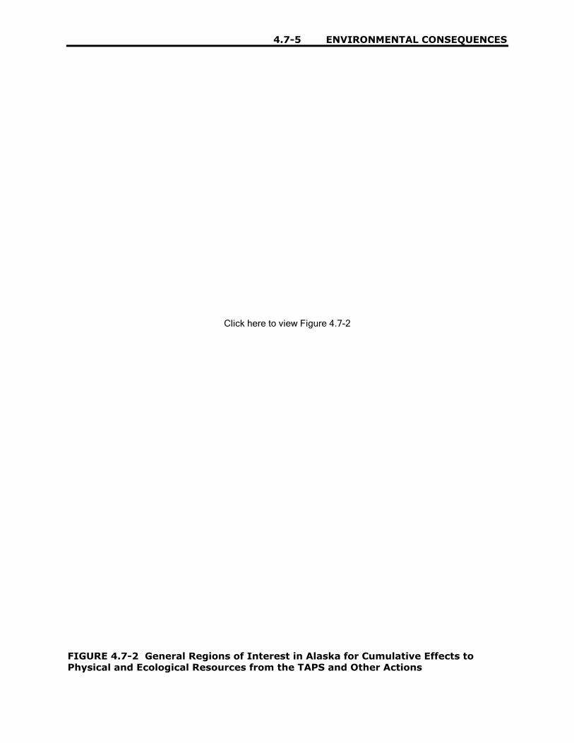
4.7-5 ENVIRONMENTAL CONSEQUENCES
Click here to view Figure 4.7-2
FIGURE 4.7-2 General Regions of Interest in Alaska for Cumulative Effects toPhysical and Ecological Resources from the TAPS and Other Actions
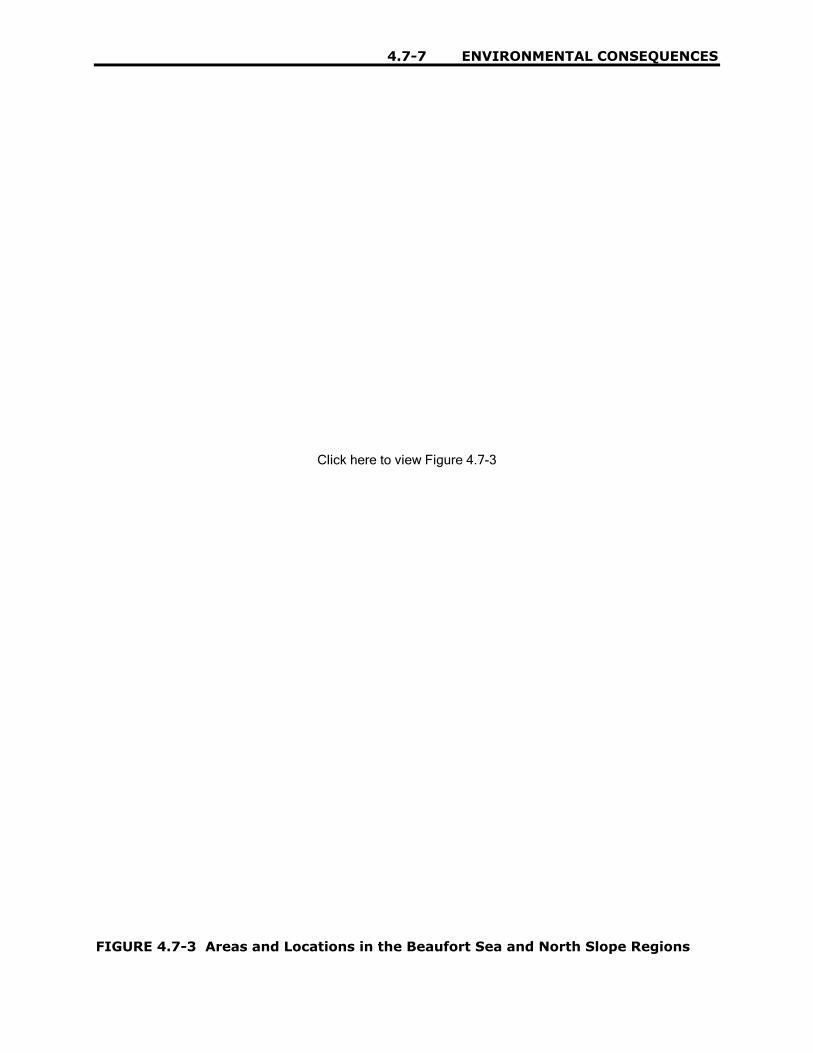
4.7-7 ENVIRONMENTAL CONSEQUENCES
Click here to view Figure 4.7-3
FIGURE 4.7-3 Areas and Locations in the Beaufort Sea and North Slope Regions

4.7-9 ENVIRONMENTAL CONSEQUENCES
Click here to view Figure 4.7-4
FIGURE 4.7-4 Areas and Locations in Interior Alaska

4.7-11 ENVIRONMENTAL CONSEQUENCES
Click here to view Figure 4.7-5
FIGURE 4.7-5 Areas and Locations in the Prince William Sound Region
4.7-13 ENVIRONMENTAL CONSEQUENCES
4.7.3 Time Frames of Actions
4.7.3.1 ReasonablyForeseeable FutureActions
A cumulative impact analysis shouldincorporate the sum of the effects of past,present, and future actions, because the pastinfluences the future, and impacts mayaccumulate or develop over time. The futureactions specifically and generally described inthis cumulative analysis are those that are�reasonably foreseeable.� As a general rule, timeframes for these actions fall within a planninghorizon of less than the proposed action. Theseactions have either already occurred, areongoing, are currently being implemented, arefunded for future implementation, or are includedin firm near-term plans. They are discussedfurther in Section 4.7.4. Types of proposals withfirm near-term plans include these:
1. Proposals for which NEPAdocuments are in preparation orfinalized;
2. Proposals in a detailed designphase;
3. Proposals listed in formal Notices ofIntent published in the FederalRegister or state publications;
4. Proposals that are funded;
5. Proposals for which enablinglegislation has been passed; and
6. Proposals that have been submittedto federal and state regulators tobegin the permitting process.
4.7.3.2 Proposals Consideredbut Excluded
Proposals that are in early stages ofdevelopment and potential projects described inlong-range planning documents are considereduncertain and speculative. These include thehigh-visibility and controversial proposalcurrently being discussed in Alaska and
throughout North America for oil and gasproduction in the ANWR. The other proposal isfor the construction and operation of a naturalgas pipeline along a northern route through theBeaufort Sea into the Mackenzie Delta and fromthere to southern Canada and the United States.The proposal to develop oil and gas productionin ANWR, while it has strong proponents, iscurrently not feasible under existing regulationsand laws. This proposal has not reached a stateof development where legislative approval,regulatory review, funding, or permitting hasbegun. The proposal for a natural gas pipelinefrom the North Slope oil fields into theMackenzie Delta would not be permitted underexisting Alaska regulations dealing with rights-of-way through state lands. Neither of theseproposals is considered in this cumulativeeffects analysis.
One other proposal, which would otherwisehave been included in this cumulative effectanalysis because environmental analysis hasbeen completed, is also considered uncertainand speculative at this time. This is the LibertyProject, designed to develop offshore oilreserves in the Beaufort Sea. It no longer hasthe support of its proponent.
4.7.4 Types of Actions
Table 4.7-2 lists the potential cumulativeactions considered in this TAPS DEIS. Indeveloping this list, descriptions and proposalsprior to April 1, 2002 were used. These actionsinclude those of various federal and stateagencies, communities, and individuals. Theactions listed in the table include past, present,and future actions in the region of interest. Bothactions related to the TAPS and actionsunrelated to TAPS are described. Uncertain orspeculative actions are not required to beincluded. Cumulative effects are not limited tothe actions of one agency, one type oforganization, or individuals. Because severalagencies or individuals can create a similar typeof environmental effect, all agencies andindividuals having the same effect are included.
The actions listed in Table 4.7-2 are listed byregion. Because actions in the Beaufort Sea, onthe shore, or in upland North Slope areas mightaffect more than one of these areas, they are

EN
VIR
ON
ME
NT
AL C
ON
SE
QU
EN
CE
S4
.7-1
4
TABLE 4.7-2 Potential Contributions to Cumulative Effects in the Beaufort Sea, North Slope, Interior Alaska, andPrince William Sound
Type of Action Beaufort Sea/North Slope Interior Prince William Sound
Oil and gas exploration,development, andproduction
� Locations (producingand undeveloped)- Alpine- Badami- Burger- Cascade- Colville Delta-North
(Nanuq)- Colville Delta-
South (fiord)- East Barrow- East Kurupa- East Umiat- Eider- Endicott- Fish Creek- Flaxman- Gubik- Gwydyr Bay- Hammerhead
- Hemi Springs- Kavik- Kalubik- Kuvlum- Kuparuk River- Lisburne- Meade- Mikkelson- Midnight Sun- Milne Point- Niakuk- North Prudhoe Bay- Northstar- Prudhoe Bay- Pt. McIntyre- Pt. Thomson- Sag Delta- Sag Delta North
- Sagavanirktok River- Sandpiper- Schrader Bluff- Sikulik- Simpson- South Barrow- Sourdough- Square Lake- Stinson- Tabasco- Tarn- Thetis Island- Ugnu- Umiat- Walakpa- West Beach- West Sak- Wolf Creek
� Locations (undeveloped)- Copper River- Mid-Tanana
� None
� Facilities and infrastructure- Central production facilities (CPFs)- Gas processing plants- Seawater treatment plants- Carrier pipelines- Power plants- Service industries at Deadhorse- Gravel sources- Roads- Landing strips- Waste treatment

4.7
-15
EN
VIR
ON
ME
NT
AL C
ON
SE
QU
EN
CE
S
TABLE 4.7-2 (Cont.)
Type of Action Beaufort Sea/North Slope Interior Prince William Sound
Oil refining � Prudhoe Bay� Kuparuk
� Williams Alaska Petroleum(North Pole)
� Petro Star (North Pole)
� Petro Star (Valdez)
Oil and refined productstorage
� TAPS pump stations� Prudhoe Bay� Kuparuk� Communities
� Williams Terminal(Fairbanks InternationalAirport)
� TAPS Pump Stations� Communities
� Valdez MarineTerminal
� Communities
Oil and gastransportation
� TAPS� Natural gas pipeline� Carrier pipelines� Fuel transfer from barges and other vessels
� TAPS� Natural gas pipeline� Interconnections of the
TAPS to Williams andPetro Star Refineries(North Pole)
� TAPS� Interconnection of
the TAPS to PetroStar Refinery
� Valdez MarineTerminal
� Oil tankeroperations
� Natural gas pipeline
Human habitation anddevelopment
� Towns and villages- Anaktuvuk Pass- Atqasuk- Barrow- Deadhorse- Kaktovik- Nuiqsut
� North Slope Borough
� Cities, towns, villages- Arctic Village- Beaver- Chalkyitsik Chicken- Chistochina- Chitina- Coldfoot and Wiseman- Copper Center- Delta Junction- Eagle- Evansville/Bettles- Fort Yukon- Gakona
� Cities, towns,villages- Chenega Bay- Cordova- Eyak- Tatitlek- Tonsina- Valdez- Whittier
� Kenai Peninsula- Borough

EN
VIR
ON
ME
NT
AL C
ON
SE
QU
EN
CE
S4
.7-1
6
TABLE 4.7-2 (Cont.)
Type of Action Beaufort Sea/North Slope Interior Prince William Sound
Human habitation anddevelopment (Cont.)
- Glennallen- Gulkana- Livengood- Manley Hot Springs- McCarthy- Paxson- Rampart- Slana- Stevens Village- Tanana- Venetie
� Fairbanks-North StarBorough
Transportation � Air fields and strips� Dalton Highway� Private and commercial watercraft
� Air fields and strips� Railroads� Alaska Highway� Dalton Highway� Richardson Highway� Other roads� Private and commercial
watercraft
� Air fields and strips� Railroads� Roads� Marine Terminals� Alaska Marine
Highway� Personal and
commercial- Watercraft- Fishing vessels- Tour boats- Container and
bulk carriers

4.7
-17
EN
VIR
ON
ME
NT
AL C
ON
SE
QU
EN
CE
S
TABLE 4.7-2 (Cont.)
Type of Action Beaufort Sea/North Slope Interior Prince William Sound
Legislative actionsrelated to land use
� Alaska Native Claims Settlement Act� Alaska National Interest Lands Conservation Act� Federal Coastal Zone Management Act� Alaska Coastal Zone Management Act
� Alaska Native ClaimsSettlement Act
� Alaska National InterestLands Conservation Act
� Alaska NativeClaims SettlementAct
� Alaska NationalInterest LandsConservation Act
� Federal CoastalZone ManagementAct
� Alaska Coastal ZoneManagement Act
� Prince WilliamSound RegionalAdvisory Board
Land management � U.S. Department of the Interior� North Slope Borough (Coastal Zone Management Program and
Comprehensive Plan)� Native corporations
� U.S. Department of theInterior
� U.S. Department ofAgriculture
� Alaska Department ofNatural Resources
� Dalton Highway AdvisoryBoard
� Military- Ft. Greely (Delta
Junction)- Ft. Wainwright
(Fairbanks)- Eielson Air Force Base
(near Fairbanks)� North Star Borough� Native corporations
� U.S. Department ofthe Interior
� U.S. Department ofAgriculture
� Alaska Departmentof NaturalResources
� Military� City of Valdez� Native corporations

EN
VIR
ON
ME
NT
AL C
ON
SE
QU
EN
CE
S4
.7-1
8
TABLE 4.7-2 (Cont.)
Type of Action Beaufort Sea/North Slope Interior Prince William Sound
Natural resource use � Subsistence� Recreational development
- Tourism- Hunting and fishing
� Mining (gravel)
� Subsistence� Recreational
development- Tourism- Hunting, fishing- Pipeline viewing areas- Campgrounds- Boat launches- Visitor centers
� Commercial development� Commercial fishing� Mining (minerals, gravel)� Logging
� Subsistence� Recreational
development- Tourism- Hunting, fishing- Pipeline viewing
areas- Campgrounds- Boat launches,
harbors- Visitor centers
� Commercialdevelopment
� Commercial fishing� Mining (minerals)� Logging
Petroleum spills � Production and exploration� Transportation
� Transportation � Transportation

4.7-19 ENVIRONMENTAL CONSEQUENCES
listed together. However, when appropriate,certain cumulative impact analyses mayconsider impacts in the Beaufort Sea and theNorth Slope separately, depending on thedistribution of the affected resources. Similaractions have been grouped together and listedby type in Table 4.7-2. Included are variousactions associated with the petroleum industry,human habitation (these actions include varioushuman and industrial activities), transportation,legislation affecting land control and use, landmanagement activities and plans, naturalresource use, and petroleum spills.
4.7.4.1 Oil and GasExploration,Development, andProduction
4.7.4.1.1 Resources. Oil and gasexploration, development, and production havebeen ongoing for a number of years on the NorthSlope (see Figure 4.7-6). The state of Alaskacurrently estimates that the North Slope oilreserves contain 12.8 billion bbl (ADNR 2000).The federal government estimates that anadditional 22.5 billion bbl of oil and22.5 trillion ft3 of natural gas are contained in theArctic Outer Continental Shelf. An estimated2.1 billion bbl of oil and 8.5 trillion ft3 of gas arecontained in NPR-A, and between 5.7 and16 billion bbl of oil are contained in structuresunder the coastal plain of ANWR. Whiledevelopment within ANWR cannot be assumed,it is likely that oil and gas exploration,development, and production will continue on theNorth Slope, including NPR-A and offshore.
Current and projected oil and gasexploration, development and production aresummarized in Table 4.7-3 (National EnergyPolicy Development Group 2001). In addition tothe areas listed in the table, the Mid-Tanana andCopper River Basins in the Interior Alaska arebeing studied to determine their oil and gaspotential, and lease sales are planned.
4.7.4.1.2 Facilities andInfrastructure. Petroleum productioninvolves a number of ancillary facilities and
supporting infrastructures, including well pads,gas processing plants, seawater treatmentplants, carrier pipelines, power plants, gravelsources, roads, landing strips, and serviceindustries. Oil development and production siteson the North Slope and in the Beaufort Sea usedifferent technologies as a function of the timethey were constructed and their remoteness fromexisting logistics sites. However, a generalizeddiagram is presented in Figure 4.7-7. Over the35-year interval since the first wells were drilledat Prudhoe Bay, the technology and operatingpractices have changed considerably, resultingin a reduction in the size of the sites. Facilitiesenabled in remote locations, such as offshore,vary in configuration from those closer toprincipal infrastructure centers.
Future producing sites would be connectedvia a pipeline to the oil transfer network linkedwith the TAPS. The fields in the Prudhoe Bayarea are serviced via the road network in thatarea. Nearshore operations, such as Endicott,are connected to the road network viacauseways. Offshore operations, such as NorthStar, and potential new fields in the Beaufort Seaare or would be connected to shore only by airand marine transport. The newer onshore fieldsoutside the existing road network, such asAlpine, are not connected to other oil fields by apermanent gravel road; instead, winter ice roadsare used to move heavy equipment andmaterials. Aircraft and marine transport, wherepractical, are used to transport changing crewsand lighter cargo items.
Well pads are gravel pads containing thewellheads and the equipment and personnelrequired to get oil out of the ground intogathering lines, to processing facilities, then intocarrier pipelines. Drill sites (or productionstations) are both individually smaller and fewerin number to produce a given deposit. Wellspacing is tighter, both because drillingtechnology has improved and because earlierconcerns about potential well damage caused bypermafrost melting have been resolved. A widersubsurface area can now be reached from asingle surface location through directionaldrilling, and multilateral and horizontal drillingtechniques expand the oil reservoir that can bereached by a single well. Theoretically, a singledrill site of 13 acres which is large even by

ENVIRONMENTAL CONSEQUENCES 4.7-20
Prudhoe Bay standards could cover asubsurface area that is 8 mi in diameter (morethan 32,000 acres) (National Energy PolicyDevelopment Group 2001). Drill sites today onthe North Slope are much less than thishypothetical figure.
Site-specific conditions and availabletechnology dictate the facilities� requirementsand the size of the site footprint. Small fields witha single production pad and airstrip could have afootprint of approximately 50 acres. Larger fieldswith multiple pads and service roads could havefootprints of up 200 acres. The newer productionsites have well spacings of 10 to 20 ft on a pad(well spacings for older sites were 120 to 160 ft).Some of these wells are needed for reinjectinggas, water, or other fluids into the oil reservoir toimprove oil recovery or for disposal of producedwater into other authorized formations. Thenumber of wellheads per production pad isdetermined by the economics and geologyassociated with developing the oil reservoir.
The number of pads needed depends on themethods of drilling and the depth to the oilreservoir. Conventional, vertically drilled wellshave a horizontal distance (reach)-to-depth ratioof 1:1. Thus, for a reservoir at a depth of 8,000 ft,the reach for each pad would be 8,000 ft, so theproduction pads would be separated by roughly16,000 ft. Currently, the greatest reach-to-depthratio on the North Slope is 2:1. It occurs at a wellin the Niakuk field (ratio of 18,098-ft reach to anoil reservoir depth of 9,445 ft) (BLM 1998).
A central production center (CPF) (alsoknown as a flow station [Prudhoe Bay] orfathering center [western operating area])manages well production and produces sales-quality crude oil by separating oil, water, andgas. In addition to oil production equipment, theCPF or nearby areas commonly include livingquarters, eating and recreational areas,administrative areas, maintenance shops,vehicle parking, fuel and water storage tanks,power generators, wastewater managementfacilities, and a communications center. Thetypes of services provided at a CPF, its crewsize, and the size of its facilities depend on thesize of the operations and the CPF�s proximity toexisting logistical support. Buildings aresupported on pilings to mitigate ground settlingor frost heaving. Production equipment includes
oil, gas, and water separators and otherequipment that condition and transport the oiland that manage the water and gas that haveseparated from the oil. Each oil-gas-waterseparation facility is equipped with gasdetection, fire, and trouble alarm systems;several fire suppression systems; and fire waterstorage tanks. Each facility can also flare naturalgas when the need arises to rapidly shut down afacility (BLM 1998; BP 2002a).
The maintenance of existing oil fields andthe development of new fields require continuedsupport activities, including the extraction ofgravel from borrow areas and the use of localwater supplies, except where salt water can beused. To maintain existing facilities, theseresources would likely be used at the currentrate. The pace of new development woulddetermine if additional personnel and logisticssupport beyond the current levels would beneeded on the North Slope. However, newdevelopment would require the transport ofadditional equipment and materials to, andwithin, the North Slope and Beaufort Sea areas.
It is possible that sources of gravel for thedevelopment of new fields in the NPR-A may belimited to existing sources, although gravelrequirements for NPR-A development have notbeen established. Gravel might have to betransported from borrow pits used by the existingoil fields, roadways, and the TAPS. However, thegravel need within the NPR-A has not beenquantified, and the possibility exists that locallygenerated crushed rock and other materialscould substitute for gravel (BLM 1998). In thevicinity of Prudhoe Bay and along the TAPS,numerous material sites provide gravel. Gravelsources include state-permitted deposits nearthe rivers and stream that parallel the TAPS(e.g., Sagavanirktok River, Atigun River, andKuparuk River.
The reservoirs tapped by the North Slopewells are under pressure. To increase the oilrecovered, other wells are drilled to inject wateror gas into the field to maintain the pressurewithin the reservoirs. Gas is produced from thewell with the oil and is reinjected into thereservoir. Water is obtained from the waterextracted with the oil and from water wells andsurface sources. Seawater may be used as a

4.7-21 ENVIRONMENTAL CONSEQUENCES
Click here to view Figure 4.7-6, page 1
FIGURE 4.7-6 Oil and Gas Development on the North Slope over Time

4.7-23 ENVIRONMENTAL CONSEQUENCES
Click here to view Figure 4.7-6, page 2
FIGURE 4.7-6 (Cont.)

4.7-25 ENVIRONMENTAL CONSEQUENCES
Click here to view Figure 4.7-6, page 3
FIGURE 4.7-6 (Cont.)

4.7-27 ENVIRONMENTAL CONSEQUENCES
Click here to view Figure 4.7-6, page 4
FIGURE 4.7-6 (Cont.)

4.7-29 ENVIRONMENTAL CONSEQUENCES
Click here to view Figure 4.7-6, page 5
FIGURE 4.7-6 (Cont.)

4.7
-31
EN
VIR
ON
ME
NT
AL C
ON
SE
QU
EN
CE
S
TABLE 4.7-3 Oil Fields Located in Alaska and the Arctic Outer Continental Shelf
Field Unit Product Status OperatorBegan
Production
ProjectedEnd of
Production
Alpine Colville River Oil Producing Phillips Alaska, Inc. 2000Badami Badami Oil and
gasProducing BP Exploration (Alaska), Inc. 1998 2008
Burger Outer Continental Shelf Oil and gas
Undeveloped Shell
Cascade Milne Point Oil Producing BP Exploration (Alaska), Inc. 1996Colville Delta Colville Oil Undeveloped Phillips Alaska, Inc.East Barrow Gas Producing North Slope Borough 1981East Kurupa Gas UndevelopedEast Umiat Gas Shut UMC PetroleumEider Duck Island Oil Producing BP Exploration (Alaska), Inc. 1998Endicott Duck Island Oil Producing BP Exploration (Alaska), Inc. 1987Fiord Colville River Oil Undeveloped Phillips Alaska, Inc.Fish Creek NPR-A Oil UndevelopedFlaxman Point Thomson Oil Undeveloped ExxonMobilGubik Gas UndevelopedGwydyr Bay Oil Undeveloped BP Exploration (Alaska), Inc.Hammerhead Outer Continental Shelf Oil Undeveloped ChevronHemi Springs Oil UndevelopedKalubik Oil Undeveloped Phillips Alaska, Inc.Kavik Gas Undeveloped Phillips Alaska, Inc.Kuparuk River Kuparuk River (Greater
Kurak Area) KuraOil and gas
Producing Phillips Alaska, Inc. 1981
Kuukpik Kuukpik Oil and gas
Exploration Phillips Alaska, Inc.
Kuvlum Outer Continental Shelf Oil Undeveloped ChevronLiberty Outer Continental Shelf Oil Undeveloped BP Exploration (Alaska), Inc.Lisburne Prudhoe Bay Oil and
gasProducing BP Exploration (Alaska), Inc.; Phillips Alaska, Inc. 1986
Meade NPR-A Gas UndevelopedMidnight Sun Prudhoe Bay Oil Producing BP Exploration (Alaska), Inc.; Phillips Alaska, Inc.Mikkelson Oil Undeveloped ExxonMobil; Phillips Alaska, Inc.

EN
VIR
ON
ME
NT
AL C
ON
SE
QU
EN
CE
S4
.7-3
2
TABLE 4.7-3 (Cont.)
Field Unit Product Status OperatorBegan
Production
ProjectedEnd of
Production
Milne Point Milne Point Oil and gas
Producing BP Exploration (Alaska), Inc; 1985
Niakuk Prudhoe Bay Oil Producing BP Exploration (Alaska), Inc.; Phillips Alaska, Inc. 1994North Prudhoe Bay
Prudhoe Bay Oil and gas
Producing BP Exploration (Alaska), Inc.; Phillips Alaska, Inc. 1993 2006
Northstar Northstar Oil and gas
Producing BP Exploration (Alaska), Inc; 2001 2015
Point McIntyre Prudhoe Bay Oil and gas
Producing BP Exploration (Alaska), Inc.; Phillips Alaska, Inc. 1993
Point Thomson Oil and gas
Undeveloped ExxonMobil
Prudhoe Bay Prudhoe Bay Oil Producing BP Exploration (Alaska), Inc.; Phillips Alaska, Inc. 1977Sag Delta North
Duck Island Oil Producing BP Exploration (Alaska), Inc. 1989
Sagavanirktok River
Milne Point Oil Producing BP Exploration (Alaska), Inc. 1994
Sandpiper Outer Continental Shelf Oil Undeveloped MurphySchrader Bluff Milne Point Oil and
gasProducing BP Exploration (Alaska), Inc. 1991
Sikulik Gas Undeveloped North Slope BoroughSimpson NPR-A Oil UndevelopedSourdough Point Thomson Oil Undeveloped BP Exploration (Alaska), Inc.South Barrow Gas Producing North Slope BoroughSquare Lake NPR-A Gas UndevelopedStinson Oil Undeveloped Phillips Alaska, Inc.Tabasco Kaparuk River (Greater
Kurak Area) KuraOil and gas
Producing Phillips Alaska, Inc. 1999
Tarn Kaparuk River (Greater Kurak Area) Kura
Oil and gas
Producing Phillips Alaska, Inc. 1999
Thetis Island Oil Undeveloped AnardarkoUgnu Kaparuk River (Greater
Kurak Area) KuraOil Undeveloped Phillips Alaska, Inc.

4.7
-33
EN
VIR
ON
ME
NT
AL C
ON
SE
QU
EN
CE
S
TABLE 4.7-3 (Cont.)
Field Unit Product Status OperatorBegan
Production
ProjectedEnd of
Production
Umiat Oil Producing U.S. Department of the InteriorWalakpa Oil Producing North Slope Borough 1992West Beach Prudhoe Bay Oil and
gasProducing BP Exploration (Alaska), Inc.; Phillips Alaska, Inc. 1994 2016
West Sak Kuparuk River (Greater Kurak Area) Kura
Oil Producing Phillips Alaska, Inc. 1998
Wolf Creek NPR-A Gas UndevelopedSource: ADNR (2000).

EN
VIR
ON
ME
NT
AL C
ON
SE
QU
EN
CE
S4
.7-3
4
Pro
du
ced
Wat
er(E
OR
)
Gas
,Oil
&W
ater
Sea
wat
er(E
OR
)
Mis
cib
leG
as(E
OR
)
JKA50205
Prudhoe Bay
Crude oil at Prudhoe Bay is located in the Sadlerochitzone, a sandstone formation at approximately 9,000 feetbelow the earth's surface. Pressure from the formation,pushes the crude up a well to the surface where awellhead controls the flow of crude. Wellheads are located on gravel drillsites and are covered by a wellhouse for worker and equipment protection against the harsh arctic environment. From here the crude flows through the manifold building, also located on the drillsite, where oil/gas/water ratio is determined. Crude thentravels to a processing center and is separated into oil,gas and water. Natural gas is sent to the gas handlingfacilities for reinjection back into the field. Producedwater is sent back to the drillsites and reinjected intothe formation to help in the oil recovery. Oil continuesits journey to Alyeska's Pump Station 1 to begin its800 mile trip to Valdez.
CentralCompressor Plant
Gas Injection Wells
Trans-AlaskaPipeline
Pump Station(one of nine)
Pump Station No.1Flow Station
Manifold Building
Valdez
Gas Cap
WaterWater
Oil
Drillsite
Beaufort Sea
SeawaterTreatment Plant
SeawaterInjection Plant
CentralGas Facility
Miscible Gasfor Injection
Seawater
Produced Water
NGL
Gas Return
Gas
Approx. 1800' Permafrost
Oil deposits Approx.9,000' below surface
How we get the oil from theground to the Trans-Alaska pipeline.
Gas Cap
WaterWater
Oil
FIGURE 4.7-7 Generalized Schematic of Prudhoe Bay Oil Production (Source: BP 2002c)

4.7-35 ENVIRONMENTAL CONSEQUENCES
water source for sites where it is practical toconstruct a seawater intake, treatment plant, andinsulated pipeline delivery system. A PrudhoeBay pressure maintenance program thatincluded seawater injection into the reservoirwas initiated in 1984. The scope of the $2 billionprogram includes a distribution system,seawater treatment plant, and pumping systems.Today, produced water has increased in volumeand has largely replaced seawater as asecondary recovery fluid.
The need for water for new development andproduction would be met from local freshwatersupplies or seawater. The water suppliescurrently used by the existing oil fields andTAPS would not be affected. However,wastewater would likely be placed in existingEPA-approved injection wells that are used bythe existing oil fields and TAPS facilities.
Similarly, solid waste management facilitiesused by existing oil fields and TAPS would likelybe used in new development and production(BLM 1998). Waste generation rates would likelybe similar to the rates of existing facilities.Today, for existing fields as well as newdevelopment, grinding and subsurface injectionare used to dispose of drilling muds and cuttingsafter sand and gravel have been reclaimed forreuse (BLM 1998). This practice reduces theamount of oil field waste. The total quantities ofwastes generated from new oil fields cannotcurrently be predicted because the extent of thenew development and production cannot bepredicted.
BP operates a Central Compression Plantand Central Gas Facility on the North Slope.This facility is devoted primarily to processingand handling the enormous quantities of naturalgas produced by oil wells in Prudhoe Bay. Thisgas is then reinjected into the reservoir. Inaddition, this facility provides compressednatural gas (CNG) for fueling trucks and othervehicles. The facility is designed to fuel 20vehicles per hour. A total of 70 CNG vehicleshave already been added to BP�s Prudhoe Bayfleet, and plans are to convert the entire450-vehicle fleet from diesel fuel to CNG overthe next 3 years (BP 2002a).
Carrier pipelines are used to transfer oil fromthe production stations at the oil fields to the
TAPS. Elevated pipelines are typically used inthe North Slope oil fields to prevent heat transferfrom the hot oil in the pipeline to frozen soils,since heat would degrade the permafrost.Carrier pipelines from offshore productionfacilities are on the sea floor. Elevated pipelinesare relatively easy to maintain and are visuallyinspected for leaks. Because they can restrictthe movements of caribou and other wildlife,both TAPS and North Slope producers haveimplemented resources to allow for safepassage of caribou and other large mammals.Buried pipelines are feasible in the Arcticprovided that the integrity of the frozen soils ismaintained. Such pipeline configurations havebeen used in the Milne Point area. Buried pipe ismore difficult to monitor and maintain and mustbe insulated and operated so that the oiltemperature will ensure that thaw settlement willbe within tolerable limits. According to State ofAlaska regulations, pipelines must be located toenable the containment and cleanup of spills,avoid significant changes in the migrationpatterns of herd animals, and allow fish passage(ADNR 1999).
Power is supplied to the oil fields by natural-gas-fueled turbines. Natural gas is obtained fromthe oil production wells. Diesel fuel is also usedfor some purposes and is supplied either bysmall refineries at the oil fields or by truck fromFairbanks.
Exploration is now generally limited to winterin order to minimize the impact of movingequipment over exposed tundra to avoidinterference with animals, and avoid the need tobuild permanent roads. Ice roads and drillingpads spread the weight of the equipment overthe ground surface and minimize the contact ofthe equipment with the soil surface. Theirlocations are almost undetectable when theymelt. Production areas remote from permanentroads may be built and maintained by using onlyice roads in the winter and access by air strip orwater during the summer.
Major aviation facilities are located atBarrow, Deadhorse, and Kuparuk. In addition,there is a gravel airstrip at Nuiqsut. Smallerairstrips link remote oil sites with the largeraviation facilities. These airstrips are typicallymade of gravel, measure 150 to 200 ft wide and

ENVIRONMENTAL CONSEQUENCES 4.7-36
5,000 to 6,000 ft long, and are built to serve theneeds of the site and not the local area.
Deadhorse was established to support oildevelopment at Prudhoe Bay and is not acommunity in the traditional sense. It is notcontrolled or managed by the North Slopeproducers. The private support companies arelocated on state-leased land. Services includethree hotels that offer meals, a general store thatdoubles as a post office, and two gas stations.Tire and vehicle repair facilities are alsoavailable, as are an auto parts store andhardware store. The North Slope Boroughoperates a solid waste facility at Deadhorse.
Public access is restricted beyondDeadhorse. Areas to the north, including theArctic Ocean, can only be accessed viacommercial tours, which operate from the hotels(Morris Communications 2001).
4.7.4.2 Oil Refining
Alaska has four merchant refineries and twosmaller crude oil tapping plants in North Slopefields dedicated to producing oil for field use.Three of the merchant refineries are in theregion of interest: two are at North Pole (nearFairbanks), and one is at Valdez. Most of thepetroleum products produced by these refineriesare used within Alaska. Williams AlaskaPetroleum, Inc., owns and operates one of thepetroleum refineries at North Pole. The refineryproduces approximately 62,000 bbl/d of variouspetroleum products, including motor gasoline,naphtha, jet fuel, heating fuels, diesel fuels, gas,oil, and asphalt for both local supply and export.Approximately 60% of the refinery�s product isjet fuel, which is supplied to various domesticand international airlines as well as to theU.S. military (Williams Energy 2002).
Petro Star operates the other refinery atNorth Pole. It produces 3,750 bbl/d of product,including kerosene, diesel fuel, and jet fuel foruse in interior and northern Alaska (Petro Star2002a). Petro Star also operates a refinery atValdez that produces 10,000 bbl/d of refinedproduct (ADNR 2000). The refinery produces jetfuel, marine diesel and heating fuel for use insouth-central and south coastal Alaska. Themajority of the products are shipped out of the
Valdez Petroleum Terminal, locatedapproximately 6 mi from the refinery. Theproducts are shipped to Anchorage, Kodiak,Dutch Harbor, and coastal Alaska by a leasedbarge (Petro Star 2002b).
These refineries obtain oil acquired by spurpipelines from the TAPS. Each extracts thelighter fractions from the crude oil to produce anarray of refined products. The heavier fractionsare returned to the TAPS via pipeline.
4.7.4.3 Oil Storage
Williams Energy operates a 20,000-bbl jet-fuel terminal at Fairbanks International Airport(Williams Energy 2002). Commercial fuel salesin Alaska increased from 1,507 million gal in1995 to 1,788 million gal in 1999. Most of thisincrease was due to the increase in sales of jetfuel, which account for more than half of the totalfuel sales in the state (900 million gal in 1999)(ADNR 2000). Other storage facilities exist at theTAPS pump stations at Kuparuk and PrudhoeBay and in communities throughout the region ofinterest.
4.7.4.4 Oil and Natural GasTransportation
In addition to the major systems describedbelow, refined products are shipped by truckfrom the three refineries to various end points.
4.7.4.4.1 Trans-Alaska PipelineSystem. The TAPS has been described indetail in the earlier sections of this DEIS. It islisted here for completeness. The TAPS systemassessed here includes the pipeline, pumpstations, access roads, and the Valdez MarineTerminal.
4.7.4.4.2 Alaska North SlopeNatural Gas Commercialization. ThisDEIS assumes that it is reasonably foreseeablethat sometime in the next 30 years natural gaswill be transported from the North Slope tomarket in Canada and the United States. At thistime, it is premature to guess which proposalwould ultimately be selected and implemented.

4.7-37 ENVIRONMENTAL CONSEQUENCES
There is a large quantity of natural gas within thePrudhoe Bay reservoir. In addition, there areundeveloped discoveries of natural gas in thearea with projections for the discovery ofsubstantially more gas if it were marketable.Since the discovery of the Prudhoe Bay field in1968, planning for the commercialization ofthese gas deposits has been underway. Anumber of projects to market the gas have beenproposed or conceptualized. These includeseveral pipeline routes from the North Slope tothe lower 48 states through Canada, a liquefiednatural gas (LNG) project at Valdez, and a gas-to-liquids project on the North Slope. Althougheach of these projects has been studied, someextensively, none has been financed or built,principally because long-term natural gas pricesin the target markets have not justified the costand risk of the project. While it is not entirelyclear that this gas will be commercialized, twopossible gas commercialization projects aredescribed in some detail below for purposes ofthis analysis to be the surrogate for whateverproject might eventually be built.
A �southern� pipeline has been proposed tocarry natural gas into Canada. One possibleproposed route would parallel the TAPS until itreaches the Fairbanks vicinity, then it would runroughly parallel to the Alaska Highway throughthe Yukon Territory and British Columbia intoAlberta (Figure 4.7-8). This proposal has beenthe subject of detailed study by the TAPSOwners, and legislation has been proposed fordevelopment of this proposal (BP 2002b).Another proposal is for a northern route fromPrudhoe Bay through the Beaufort Sea to theMacKenzie Delta then south through Canada. Asalready discussed, this proposal was notconsidered reasonably foreseeable. A thirdproposal is for a pipeline parallel to the TAPSinto Valdez, where the natural gas would beliquefied for shipment. Although it is not clearwhich proposal might eventually be developed, itwas considered reasonably foreseeable thatsometime in the next 30 years a natural gaspipeline might be constructed. For the sake ofanalysis a hypothetical description of such asystem follows.
A natural gas pipeline could consist of alarge-diameter, 735-mi-long buried pipeline. Itwould run parallel to the TAPS from Prudhoe
Bay to the vicinity of Fairbanks near DeltaJunction, and from there, it would turn east, andof the TAPS region of interest. Key elements ofsuch a project would be (1) a large CO2treatment plant on the North Slope, (2) thepipeline itself, (3) valve stations and compressorstations along the route, and (4) a possiblenatural gas liquid (NGL) recovery plant.
The gas treatment facility would remove acidgases (CO2, H2S) and compress and chill thegas to make it ready for transport. The pipelinewould be 48 in. in diameter and constructed ofhigh-strength steel. Compressor stations, valvestations, and intermediate pigging facilitieswould maintain gas pressure (about 2,500 psi),allow maintenance and pigging of the line, andprovide safety features. Because the gas wouldcontain ethane, propane, and other gas liquids, aNGL recovery plant might be needed to removethe heavier hydrocarbons (C2+) for sale.
Construction of a natural gas pipeline couldinvolve about 600 mi of buried pipeline inAlaska. The total project cost could beapproximately $10 billion, of which $1 billioncould be for the gas treatment facility and$2.5 billion could be for actual pipelineconstruction. Construction of the gas treatmentfacility could require about 3,000 person-years oflabor, while construction of the pipeline couldrequire about 7,500 person-years of labor. It isanticipated that the main construction effortcould occur over a period of 3 to 5 years. Thefacilities could be labor-efficient and capital-efficient to operate, and could create directemployment of 300 to 400 permanent jobs(Goldsmith 2001; McGraw 2002).
Alternatively, conditioned natural gas couldbe transported by pipeline from the North Slopeto Valdez, where the gas would be liquefied by acryogenic process. The LNG would then betransported to various countries in speciallydesigned cryogenic LNG tankers. Likely marketswould include Japan, Korea, Taiwan, andpossibly Mainland China (TAPS Owners 2001).
This proposal could involve the constructionof an 800-mi-long, 36- to 42-in. diameter, chilledpipeline, which could be buried adjacent to theTAPS. A 300-acre gas-conditioning facility couldbe built on the North Slope, and 10 main linecompressor stations could be constructed along

ENVIRONMENTAL CONSEQUENCES 4.7-38
the pipeline route to maintain required operatingpressures. The gas could be liquefied forshipment at an LNG plant that could beconstructed at Anderson Bay, 3.5 mi west of theValdez Marine Terminal. Additional constructionat Anderson Bay could include storage tanks forthe LNG and a marine terminal with two berthsand loading facilities to accommodate LNGtankers with a capacity of 165,000 m3.
It is projected that the gas volume would beabout 2 billion ft3/d for both the LNG and thepipeline export project. The capacity of theliquefaction facilities could be compatible, at14 million tons/yr (29.3 m3/yr). Fifteen tankers,each with a capacity of 125,000 m3, would makeabout 275 loaded voyages per year to the PacificRim.
It is estimated that construction of thissystem would cost $4 billion for the pipeline and$8−10 billion for the other elements, includingthe tanker fleet. The estimated constructionperiod would be 10 years. Public revenue,including property taxes, severance taxes, androyalties, would amount to about $377 millionannually, depending on future energy prices.The economic life of the project is estimated tobe 30 years.
4.7.4.4.3 Valdez ContainerTerminal Dock. The Valdez ContainerTerminal Dock is a 700-ft concrete floating dock,extending to 1,200 ft. The container dock is tiedto a 21-acre marshalling yard by two 200-ftramps. The dock is designed as a multipurposeberth to handle containerized, roll-on/roll-off andlift-on/lift-off operations. The marshalling yardcontains a total area of 21 acres of land. A grainterminal consisting of nine concrete silos that are112 ft tall and 33 ft in diameter and have a totalcapacity of 522,000 bushels is also located onthe container terminal grounds (Valdez 2002).
4.7.4.4.4 Oil Tanker Operations. Oiltankers with cargo capacities ranging from660,000 to 2,000,000 bbl are loaded with NorthSlope crude oil at the Valdez Marine Terminalwhich is controlled by the U.S. Coast Guard.North Slope crude oil is transported primarily tothe west coast of the United States, with othershipments to Kenai, Alaska; the Hawaiian
Islands; and the Asia Pacific market (TAPSOwners 2001a). In 1999, an average of37 tankers per month were loaded at the ValdezMarine Terminal.
Tankers approach the Valdez MarineTerminal from the Gulf of Alaska viaHinchinbrook Entrance, and they followdedicated traffic lanes to Valdez Arm and ValdezNarrows. The Prince William Sound VesselTraffic System (VTS) controls the movement oftanker traffic into and out of the area. VTS closesValdez to tanker traffic if conditions arehazardous.
Currently, the fleet serving the ValdezMarine Terminal consists of 26 tankers,including three with double hulls and 13 withdouble sides. However, the composition of thefleet will change to comply with the Oil PollutionAct of 1990, which requires that all tankerscalling on U.S. ports have double hulls (doublebottoms and sides) by the year 2015. Accordingto the planned phaseout schedule for PrinceWilliam Sound tankers, the fleet will consistexclusively of double-hulled tankers beginning in2014. The number of tankers will be reduced to8 to 10 by 2020 (TAPS Owners 2001a).
APSC�s SERVS is responsible for the safetransit of oil tankers from the Valdez MarineTerminal to international waters. Nine SERVSvessels have escort, docking, and responseduties. At least two escort vessels are requiredfor each laden tanker exiting Prince WilliamSound, and an additional escort may be added ininclement weather (TAPS Owners 2001a).
4.7.4.5 Habitation andDevelopment
4.7.4.5.1 Beaufort Sea and NorthSlope. The North Slope Borough is the largestborough in Alaska, making up more than 15% ofthe state�s total land area. It consists primarily ofthe north and northeastern coast of Alaska,including the Brooks Range, north of the ArcticCircle. Communities or areas of developmentlocated within the Borough within the region ofinterest include Anaktuvuk Pass, Atqasuk,Deadhorse/Prudhoe Bay, Kaktovik, and Nuiqsut(Figure 4.7-3).

4.7-39 ENVIRONMENTAL CONSEQUENCES
Click here to view Figure 4.7-8
FIGURE 4.7-8 Potential Routes for Natural Gas Transportation

4.7-41 ENVIRONMENTAL CONSEQUENCES
With the exception of Deadhorse/Prudhoe Bay,these communities are composed of primarilyAlaska Natives or part Natives, and mostinhabitants maintain lifestyles that rely heavilyon subsistence activities. The oil and gasindustry is also an important source ofemployment. The populations within thesecommunities range from 200 to 500 people. TheBorough population is about 4,600.
Deadhorse at Prudhoe Bay is a towndedicated to supporting the oil industry. Althoughit has only six permanent residents, more than5,000 oil petroleum industry workers passthrough Deadhorse on rotating work shifts.Development in Deadhorse is almost entirelyrelated to the petroleum industry.See Section 4.7.4.1.2 for more information onDeadhorse.
4.7.4.5.2 Interior. Interior Alaska has anumber of communities that could contribute tocumulative impacts (Figure 4.7-4). However,with the exception of Delta Junction/Big Delta,Fairbanks, and Glennallen/Copper Center, thesecommunities are small, with populations of fewerthan 200 people and no major industrial orcommercial activities.
Delta Junction and Big Delta(no organized borough). Delta Junction islocated at the convergence of the Richardsonand Alaska Highways, approximately 95 misoutheast of Fairbanks. The city developedalong the east bank of the Delta River, south ofits junction with the Tanana River. Big Delta islocated on the Richardson Highway at thejunction of the Delta and Tanana Rivers. DeltaJunction and Big Delta businesses provideservices to traffic along the Richardson Highway.Fort Greely is located nearby. The surroundingarea supports agriculture. The populations ofDelta Junction and Big Delta in 2000 were 880and 749, respectively.
Fairbanks North Star Borough. TheFairbanks North Star Borough is located incentral Alaska and includes the cities ofFairbanks and North Pole. According to the2000 census, the Borough�s population was82,840. The main campus of the University of
Alaska is located at College in Fairbanks.Currently the Fort Knox and True North GoldMines are expanding operations. TheInternational Air Cargo landings at the FairbanksInternational Airport have also expanded. TheFairbanks area serves as a regional service andsupply center. The Alaska Railroad providesservice to Fairbanks from Anchorage andSeward in the south and Eielson AFB in the east.The Borough is developing a plan for futuregrowth and for an increase in population to98,000 by 2018. Eielson AFB and FortWainwright are located nearby.
Glennallen/Copper Center. Thecommunities of Glennallen and Copper Centerare along the Richardson Highway, 189 mi (byroad) east of Anchorage. The visitor�s center andpark headquarters for Wrangell-St. Elias NPP islocated in Copper Center. Glennallen is thebusiness hub of the Copper River region. Localbusinesses serve area communities andhighway traffic, providing gasoline, supplies andservices, schools, and medical care. Statehighway maintenance and federal offices are inGlennallen. The Wrangell-St. Elias VisitorCenter and National Park Headquarters wererecently completed (ADCED 2002).
4.7.4.5.3 Prince William Sound.Most of the communities bordering PrinceWilliam Sound are small (fewer than200 people), with limited commercial andindustrial activities (Figure 4.7-5). In general,people in these communities have lifestyles thatrely on subsistence or commercial fishing.Cordova, Kenai Pennisula Borough, and Valdezare larger areas of human habitation and thushave the potential to make a greater contributionto cumulative impacts.
Cordova is located on the southeastern endof Prince William Sound and is readilyaccessible to other communities only by air andwater routes. Cordova serves as a fishing portand a tourist and recreational sports center. Thepopulation of Cordova in 2001 was about 2,500,including Eyak, a federally recognized Nativevillage within the City of Cordova.
The Kenai Peninsula Borough lies directlysouth of Anchorage and is bordered by the Gulf

ENVIRONMENTAL CONSEQUENCES 4.7-42
of Alaska and Prince William Sound on the southand east. Cook Inlet divides the borough intotwo land masses. Cities within the KenaiPeninsula Borough include Homer, Kachemak,Kenai, Seldovia, Seward, and Soldotna. Allcommunities are expanding in population anddevelopment. The population in 2000 was about41,000.
Valdez is located on the north shore ofPrince William Sound. In addition to being thesouthern terminus of the TAPS and ValdezMarine Terminal, the city is host to commercialfishing and shipping operations and is a port forcommercial shipping, cruise ships, tour boatoperations, and fishing. Valdez serves as atourist and recreational sports center.Richardson Highway connects Valdez toAnchorage, Fairbanks, and Canada. Thepopulation in 2002 was estimated to be about4,500 (Valdez 2002).
4.7.4.6 Transportation
4.7.4.6.1 Highways and PublicAirstrips. In the areas traversed by the TAPS,the Richardson Highway connects Valdez withFairbanks and the Dalton Highway connectsFairbanks with the North Slope. The DaltonHighway was formerly known as the �Haul Road�and was originally built and maintained by theTAPS Owners; it was closed to the public. It isnow a state highway, is open to the public, and ismaintained by Alaska�s Department ofTransportation and Public Facilities (AlaskaDepartment of Transportation and PublicFacilities 2002).
4.7.4.6.2 Railroads. The state-ownedAlaska Railroad and ferry system transportspassengers and freight between Anchorage,Seward, and Whittier and Interior Alaska. Futureexpansion will be made to link the existing linesto the Ted Stevens Anchorage InternationalAirport. The Alaska Railroad is also constructinga new depot and passenger facilities inFairbanks and Whittier; realigning its track in theFairbanks and North Pole area to minimize thenumber of railroad crossings; repairing bridgesin the Kenai Peninsula; and repairingmaintenance facilities in Seward and Whittier.
The railroad operations employ nearly700 people (Alaska Railroad 2002).
4.7.4.6.3 Marine Terminals. Marineshipments to the North Slope are limited to theice-free period between late July and earlySeptember. Dock facilities for unloading bargesare located at Prudhoe Bay and Oliktok Point.One dock head, which is no longer used, is atEast Dock of Prudhoe Bay. Two others arelocated at West Dock, with drafts ranging from4 to 10 ft. The dock at Oliktok Point extends750 ft from shore, with a depth of about 10 ft atthe dock face. Because of the lack of deep-waterports, cargo is usually off-loaded to shallow- ormedium-draft ships for transport to shore or fortransport upriver to communities such asNuiqsut.
No port facilities exist in Barrow. Cargo istransported to the area by barges and cargoships and off-loaded to smaller vessels fortransport to the shore north of Barrow.
On Prince William Sound, oil is shipped fromthe Valdez Marine Terminal at Port Valdez.Deep-water cargo ports are located at Valdez,Seward, and Whittier. Rail links exist at Sewardand Whittier.
4.7.4.6.4 Alaska Marine Highway.The state-owned Alaska Railroad and ferrysystem is constructing two docks in Whittier toaccommodate the unloading of barges. Sewardand Valdez serve as cargo and cruise ship ports.The Alaska Railroad is also constructing a newfreight dock and overhauling an existing dock toserve passengers in Seward (Alaska Railroad2002). The Alaska Marine Highway Systemconnects the communities of Cordova, Valdez,and Whittier along the Prince William Sound withferry services.
4.7.4.6.5 Personal andCommercial Watercraft (fishingvessels, tour boats). Commercial fishingvessels use ports at Valdez and Cordova.Private and charter vessels also use the ports forrecreational boating, which includes wildlife andsightseeing cruises and sport fishing excursions.Alaska state ferries stop at Valdez, Cordova,
4.7-43 ENVIRONMENTAL CONSEQUENCES
Seward, and Whittier. Cruise ships use ports atValdez and Seward (Morris Communications2001). Section 4.7.4.9.2 on tourism andSection 4.7.4.9.4 on commercial fishing havemore details.
4.7.4.7 Legislative ActionsRelated to Land Use
4.7.4.7.1 Alaska Native ClaimsSettlement Act. Shortly after its purchase ofthe territory of Alaska, the U.S. Congressabandoned its policy of establishing treaties withNative Americans (Alaska Commission on RuralGovernance and Empowerment 1999). As aresult, Alaska Native land claims were neverresolved, and the status of Alaska Nativesrelative to the federal government was uncertain.The Alaska Native Claims Settlement Act(ANCSA) (PL 92-203; 43 USC 1601) was passedin 1971 to settle multiple Alaska Native landclaims. The act extinguished all prior aboriginalland claims and conveyed 44 million acres to the12 regional corporations established under theact.
The passage of ANCSA cleared land titlesand facilitated granting of the TAPS ROW. It alsoestablished, through the for-profit regionalcorporations, the contemporary structure forAlaska Native economic and political affairs(Alaska Commission on Rural Governance andEmpowerment 1999).
4.7.4.7.2 Alaska National InterestLands Conservation Act. The AlaskaNational Interest Lands Conservation Act(ANILCA) (PL 96-487; 16 USC 3101) waspassed in 1980 to provide for the designationand conservation of certain public lands in theState of Alaska. ANILCA establishes more than100 million acres of federal land in Alaska asCSUs in order to preserve these lands and theirresources for the national interest. The CSUsinclude National Parks, Preserves, Monuments,Wildlife Refuges, Wilderness Areas, and Wildand Scenic Rivers and are managed by federalagencies. Thirty-four CSUs are within a fewmiles of the TAPS ROW.
4.7.4.7.3 Federal and AlaskaCoastal Zone Management Acts. TheFederal Coastal Zone Management Act (CZMA)was enacted in 1972 and last amended in 2001.The Alaska Coastal Management Act (ACMA)was enacted in 1977 as Alaska�s version ofcoastal zone management as envisioned in thenational CZMA, and it was last amended in1994. Both statutes guide land use in coastalzones to provide a balance betweendevelopment and protection of coastal resources(BLM 1998; State of Alaska 2001).
ACMP, approved in 1979, was developed toimplement the ACMA. The ACMP encouragescoastal districts to develop and adopt districtcoastal management programs (CMPs) thatbecome part of the ACMP once they are fullyapproved. CMPs include enforceable policies,and all activities that occur within a coastal zoneor that may affect coastal resources must beconsistent with an approved CMP. The AlaskaDepartment of Governmental Coordination andState of Alaska resource agencies conductconsistency reviews on proposed and existingprojects within coastal zones (BLM 1998; Stateof Alaska 2001).
4.7.4.7.4 Prince William SoundRegional Citizens� Advisory Council.The Prince William Sound Regional Citizens�Advisory Council is an independent, nonprofitcorporation dedicated to the environmentallysafe operation of the Valdez Marine Terminaland oil tankers within Prince William Sound. Thecouncil reviews and comments on APSC�soperations, oil spill response and preventionplans and capabilities, and the design ofmitigation measures. The advisory council helpsmonitor and assess the environmental impactsof terminal and tanker operations of oil-relatedaccidents (Prince William Sound RegionalCitizens� Advisory Council 2002b).
The council also works to increase thepublic�s awareness of the actual and potentialenvironmental impacts from terminal and tankeroperations and of the APSC�s environmentalprotection capabilities, which include oil spillprevention and response. Citizens organized thecouncil after the Exxon Valdez oil spill in 1989 toincrease public involvement in decision makingin the Prince William Sound, Gulf of Alaska, and

ENVIRONMENTAL CONSEQUENCES 4.7-44
Lower Cook Inlet regions of Alaska. The OilPollution Act of 1990 later required citizenoversight councils for Prince William Sound andCook Inlet. Although APSC funds the advisorycouncil, it has no control over its operation(Prince William Sound Regional Citizens�Advisory Council 2002a).
4.7.4.8 Land Management
4.7.4.8.1 National Parks,Preserves, Monuments,and Other Land Units
Arctic National Wildlife Refuge(ANWR). This refuge ranges from south of theBrooks Range to the Beaufort Sea. A smallportion of the refuge comes within 1/4 mi of theTAPS, but the vast majority lies 60 mi or moreeast of TAPS. The ANWR encompasses morethan 19 million acres and is the northernmostrefuge in the United States. It contains the8-million-acre federally designated Mollie BeattieWilderness, which is the second largestWilderness Area in the United States. Therefuge contains part of the migration routes andcalving grounds of the Porcupine caribou herds.Visitors are allowed in the refuge. Arctic Village� an Alaska Native community � is located onthe south side of the refuge (Alaska InternetTravel Guide 2000a; Patterson 2001).
Chugach National Forest. The5.5-million-acre Chugach NF occurs astwo noncontiguous components. A portion of theforest is located south/southwest of the ValdezMarine Terminal and comes within 1/4 mi of theValdez Marine Terminal at its closest point.Another portion is located on the KenaiPeninsula. The area near the Valdez MarineTerminal is used primarily for recreation and forsubsistence hunting, fishing, and logging. Somecommercial logging occurs on the Kenai. TheChugach NF is the northernmost national forestin the United States and is administered by theUSDA Forest Service (Behrends 2002; ForestService 2002).
Gates of the Arctic National Parkand Preserve. Gates of the Arctic NPP islocated in the Brooks Range west of the TAPSand comes within 2 to 3 mi of the pipeline at theclosest point. It is composed primarily of federallands and encompasses a 7.2-million-acrefederally designated Wilderness Area thethird largest in the United States. The park isaccessible by air and is open year round. Thereare no roads to or within the park, and it containsno established trails or facilities. Gates of theArctic NPP receives about 4,000 visitors peryear. A park ranger station is located in Coldfoot.No major construction is planned in the park(Uhler 2001a; Ulvi 2001).
Kanuti National Wildlife Refuge.The 1.6-million-acre Kanuti NWR is locatedabout 150 mi northwest of Fairbanks. It is about8 mi west of the TAPS at its closest point, butmost of the refuge is more than 24 mi away. Therefuge is undeveloped but contains no federallydesignated or proposed wilderness. Kanutireceives few visitors, and most visits are madeby subsistence hunters and fisherman. Someriver floating and hiking are done in the park(Alaska Internet Travel Guide 2000b; Schultz2001).
White Mountains NationalRecreation Area (NRA). This NRA isadministered by the BLM and is located about30 mi north of Fairbanks between Elliott andSteese Highways. It encompasses about1 million acres and is the largest NRA in theUnited States. The recreation area offers anabundance of year-round recreationopportunities (Great Outdoor Recreation Pages2002).
Wrangell-St. Elias National Parkand Preserve. This NPP reaches from theCopper Center and Glennallen area to theU.S./Canadian border and south to the Gulf ofAlaska. The NPP headquarters and a point ofaccess to the NPP are located near CopperCenter and Glennallen. The NPP is 2 to 5 mieast of the TAPS at its closest point, but most ofit is more than 26 mi away. At 13.2 millionacres, Wrangell-St. Elias is the largest nationalpark in the United States and is entirely

4.7-45 ENVIRONMENTAL CONSEQUENCES
undeveloped. It encompasses the largestfederally designated wilderness area in theUnited States: 8.9 million acres. The AhtnaCorporation, an Alaska Native Corporation, ownsabout 1 million acres of the NPP. Road accessinto the interior of the park is limited. Wrangell-St. Elias is open year round and averages25,000 visitors a year, primarily in the summer.An abandoned mine site of Kennecott MiningCompany is located within the park. No majorconstruction is planned in the NPP (Uhler 2002;Ulvi 2001).
Yukon Flats National WildlifeRefuge. This 8.6-million-acre NWR is locatedeast of the Dalton Highway and about 100 minorth of Fairbanks and is bisected by the YukonRiver. The refuge is about 2 mi east of the TAPSat its closest point, but most of it is more than6 mi away. Yukon Flats is undeveloped butcontains no federally designated wilderness. Aportion of the refuge has been proposed as afederal wilderness area. The refuge is visitedprimarily by subsistence hunters and fishermen.Summer use is mainly confined to the majorwaterways (Alaska Internet Travel Guide 2000c;Huer 2001).
4.7.4.8.2 Alaska Department ofNatural Resources
Alaska Interior. Several small parks andrecreation areas are in the Delta Junction andFairbanks area. These parks provide access tolakes, rivers, and streams; camping; and limitedfacilities. No state-designated wilderness existswithin 100 mi of the TAPS (ADNR 2001a). TheChena River State Recreation Area east ofFairbanks is a quarter of a million acres in sizeand draws more than 150,000 visitors a year.The park has limited facilities, and most of thearea is closed to vehicles. The Chena RiverState Recreation Site is within the city ofFairbanks on the banks of the Chena River andis a popular recreation spot (ADNR 2001b).
Prince William Sound. There areseveral state marine parks in the Prince WilliamSound and Resurrection Bay area. Most of theseparks can be accessed only by floatplane or
boat, except for Shoup Bay, which can beentered by a foot trail. Seven parks are nearWhittier, six are near Seward, three are nearValdez, and three are near Cordova. Theseparks are undeveloped but contain no state-designated wilderness (ADNR 2001c).
4.7.4.8.3 Military
Fort Greely. Fort Greely, near DeltaJunction, is currently being closed andtransferred to other uses by the Department ofthe Army under Base Realignment and Closure(BRAC). However, Fort Greely is the preferredalternative for the deployment of the ground-based interceptors and for deployment of thebattle management, command, and controlsystem of the National Defense Missile System.The former are guided missiles designed tointercept and destroy intercontinental ballisticmissiles. The latter is the control and controlsystem for the interceptors (U.S. Army Spaceand Missile Defense Command 2000).
Fort Wainwright. Fort Wainwright,located near Fairbanks, has nearly4,600 soldiers and 6,100 family members. Itsmission is to provide the services, facilities, andinfrastructure needed to support the rapiddeployment of the 172nd Separate InfantryBrigade and elements of the Arctic SupportBrigade. These include field training exercises inAlaska, which involve the use of aviation, all-terrain, and winter vehicles and thus requirefacilities for refueling operations.
Eielson Air Force Base. This Air Forceinstallation is located south of Fairbanks. Thebase mission includes support of combataircraft, mid-air refueling, logistics support, andarctic survival training (Eielson AFB 2002).
Army Proposed Projects in theRegion of Interest. Projects currently underconstruction at Fort Wainwright include centralvehicle wash facilities, barracks renewals,central heat and power plant repairs, anammunition surveillance facility, and a collectivetraining facility for military operations in urban
ENVIRONMENTAL CONSEQUENCES 4.7-46
terrain. Other Army projects that were recentlybuilt at Fort Wainwright include barracksupgrades, several phases of housing projects, anew ski chalet, a coal car preheat facility, and amissile test facility. A munitions storage facilitywas recently built at Fort Greely. The AlaskaDistrict Corps of Engineers solicited requests forproposals in October 2001 for a new hospital toreplace the existing Bassett Army CommunityHospital at Fort Wainwright. The proposedproject is a 259,000-ft2, 32-bed facility.
Air Force Proposed Projects in theRegion of Interest. Eielson AFB (354thWing) projects include a repair runway, aparking ramp, a weapons and release systemsfacility, consolidated munitions, and anA-10 squad/ops facility. Projects in design forfiscal year 2000 at Eielson AFB included ahazardous materials storage facility, dormitory,joint mobility complex, and utility upgradePhase I and II (USACE 2001).
4.7.4.9 Natural Resource Use
4.7.4.9.1 Subsistence. Subsistencemeans the customary and traditional uses of fishand game in Alaska�s rural areas. A personadopting a rural way of living in Alaska maylegally fish and hunt for subsistence underfederal law. In 1999, about 123,000 (21%) ofAlaskans lived in rural areas. Since 1989, allAlaskan residents have qualified for subsistenceunder state law. While both Alaska Natives andnon-Natives may subsistence hunt and fish, onlyAlaska Natives may hunt marine mammals, suchas seals, whales, polar bears, and sea otters.Food is one of the most important subsistenceuses of wild resources. Other subsistence usesinclude clothing, fuel, transportation (food fordogs), construction, home goods, sharing,customary trade, ceremony, and arts and crafts.In rural Alaska, about 75−98% of sampled ruralhouseholds harvest fish and 48−70% harvestwildlife; actual use is probably higher, sinceharvested resources are often shared. Itemsharvested by weight included fish (60%), landmammals (20%), marine mammals (14%), birds(2%), shellfish (2%), and plants (2%). Althoughwild food harvests are high (up to 613 lb perperson in the rural interior in the region of
interest), subsistence harvest represents only2% of the fish and game harvested annually inAlaska. Commercial fisheries harvest about97%, while the sport harvest is only about 1%. Inthe region of interest, wild food harvests in 1999were about 16 lb per person in the Fairbanks-Delta Area, 153 lb per person in the rural southcentral, 516 lb per person in the Arctic, and613 lb per person in the rural Interior Alaska(ADF&G 2002c).
4.7.4.9.2 Tourism. Tourism is Alaska�ssecond largest industry in terms of employment.The basis for much of Alaska�s tourism industryis its natural resources. In 1999, more than1.4 million people traveled to Alaska, and theyspent about $1 billion in the state. Natural-resource-based tourism includes visits tonational and state parks, viewing wildlife andscenery, back country travel, rafting and boating,skiing and winter sports, ship cruises,photography, fishing, and hunting. In addition,Alaska�s cultural diversity and history help makeit a major tourist attraction. In 1999, 53% ofvisitors to Alaska came by air, 31% came bycruise ship, and the balance came by highway,Alaska Marine Highway or international air(Alaska Travel Industry Association undated).
4.7.4.9.3 Hunting, Fishing, andTrapping. Hunting occurs for both subsistenceand sport, while fishing and trapping occur forsubsistence, sport, and commerce. In 2001,more than 565,000 sport fishing, hunting, andtrapping licenses were sold. Of these, 51% wereissued to nonresidents (ADF&G 2000a).Hunting, fishing, and trapping occur throughoutthe region of interest. Hunting seasons varyaccording to the region, species, sex of theanimal, and classification of the hunter asresident or nonresident. In some cases, theissuance of a permit to hunt is based on alottery. The situation for trapping is similar. Theseason and limits are adjusted by the ADF&G. Ingeneral, sport fishing is allowed year round inthe Prince William Sound area and on theTanana River, Yukon River drainage, and NorthSlope. Catch limits are placed on most speciesand typically do not exceed 10 per day. Theseason and limits are adjusted by the ADF&G.These regulations also apply on federal lands.

4.7-47 ENVIRONMENTAL CONSEQUENCES
However, the federal government controlsfishing and hunting on federal lands.
4.7.4.9.4 Commercial Fishing. In thePrince William Sound area, commercial fishingis mainly composed of sole operaters. In PrinceWilliam Sound and the Copper River District, thesalmon season runs from mid-May to mid-October, and during this time, specific dates areset for each species and method of fishing.Herring season is in January for seine nets andfrom April into May for other methods. Shellfishseason runs from April through December, withthe specific dates set for each species andmethod of fishing. Groundfish, pollock, and codfisheries operate year round. Six hatcheriesoperate in the area (ADF&G 2002b).Commercial fishing operations for salmoninvolve the use of purse seines, drift gillnets, andset gillnets. During the 1999 season, 523 driftgillnet permit holders, 21 set gillnet permitholders, and 139 seine permit holdersparticipated in the fishery. However, three of thefour seasons for herring and the fall season forfood/bait fish were cancelled. Commercialfishing is a highly regulated industry; strictcontrols are placed on the days and hoursfished, fishing locations, and methods.
4.7.4.9.5 Mining. Mining for gold andother minerals has been an important industry inAlaska, and this activity would continuethroughout the period of TAPS operation.Mineral exploration, development, andproduction occur in a number of mining districtsthroughout the area traversed by the TAPS. In1998, mining (except for oil and gas) was valuedat about $900 million, with an annualemployment of 3,452 (Szumigala andSwainbank 1999). The major new explorationactivity was in the interior near Goodpasture andthe Pogo Prospect, and exploration continued inthe Fairbanks mining district. Explorationactivities also concentrated on the north flank ofthe Alaska Range. During 1998, up to 12,000new claims totaling 480,000 acres were stakedon state land, while 5,800 claims wereabandoned. The number of active claims onstate land in 1998 was 41,157 on1.65 million acres. Coal, copper, gemstones,gold, lead, sand and gravel, silver, stone, zinc,and other minerals were mined. The State of
Alaska and several federal agencies regulate themineral industry with regard to safety andenvironmental protection.
On the North Slope, mining of sand andgravel from river floodplains and stone from theBrooks Range support road construction andmaintenance, river training, pipelinemaintenance, and oil exploration anddevelopment. The Red Dog Mine (zinc, lead,and silver) in the Kotzebue area is severalhundred miles from the TAPS and outside theregion of interest for this cumulativeassessment.
In Interior Alaska, coal is mined, and lodeand placer are mined for gold and other metalsand coal. In the Brooks Range, the Middle ForkKoyukuk River near Wiseman and Coldfoot wasan important gold mining area, and mining stilloccurs there today. Numerous placer goldmining operations (i.e., the removal of gold fromstream-bed gravel deposits) occur throughoutthe region around Fairbanks, and exploration isongoing. The Fort Knox Mine, an open pit mineabout 25 mi northeast of Fairbanks, is the largestoperating gold mine in the state. The mineemploys 260 people and produces 1,000 oz ofgold per day. Probable reserves are estimated at3,686,000 oz. In addition, gold-bearing sand andgravel are taken from the True North Mine, whichis about 8 mi from the Fort Knox Mine and beingdeveloped. At the projected rate of production,this mine will be in operation for at least ninemore years. The Teck-Sumitomo Pogo goldmine site is being developed northeast of DeltaJunction. Once in production, it is estimated thatthe mine will operate for 12 years. Threemedium-sized placer mines and about50 smaller operations operate in the 10 interiormining districts. Small placer gold operationsoccur between Fairbanks and the North Slopeand between Fairbanks and Valdez. Theseoperations are widely scattered, and sites tendto shift depending on the potential for newdiscoveries of gold and the price of gold(Szumigala and Swainbank 1999).
In addition to gold mines, several smallmining pits produce peat for local use in theFairbanks and Palmer-Anchorage area. Severalsand and gravel pits are located in the Fairbanksarea, to the east of Delta Junction, in the Palmerarea, and in the Kenai area. These materials are

ENVIRONMENTAL CONSEQUENCES 4.7-48
primarily used for roadwork. About 100 mi southof Fairbanks, the Usibella Coal Mine in Healyproduces about 1.5 million tons of coal per year.Coal mining operations are also expected tobegin at a location just north of the existing minesite. A portion of the coal removed at the mine isexported out of Alaska. A portion was also usedin the Healy Clean Coal Project; it was enoughto potentially generate 50 MW of baseloadelectric power (Szumigala et al. 2000).
In the early 1900s, copper was mined nearMcCarthy and transported by railroad along theChitina and Copper Rivers to ships at Cordova.During that period, gold was also extracted fromthe area. Today, mining still occurs on privatelands within the region.
Mineral exploration and mining occurredhistorically in the Prince William Sound area.Mineral resources in the Prince William Soundarea include placer and lode gold deposits,chromium, copper, oil, and coal.
4.7.4.9.6 Logging. Both commerciallogging and harvesting for personal use occur inAlaskan forests. In the vicinity of the TAPS, mostcommercial logging occurs on state lands;minimal logging occurs on federal lands.Logging on state lands is regulated by theAlaska Division of Forestry, and logging onfederal lands is regulated by the agencyadministering the land where the timber saleoccurs. Both state and federal land managementagencies develop forest/land management plansthat (1) identify areas suitable for harvesting,(2) determine appropriate harvest levels, and(3) ensure that commercial operations complywith harvest management practices that protectresources, such as soils and surface water.
Commercial logging occurs throughout statelands near the TAPS. However, most loggingoccurs in Tanana Valley State Forest, which liesnorth, northeast, and southeast of Delta Junctionin several separate parcels. Logging on federallands occurs in the Chugach National Forest andin BLM lands in the Copper River Basin.
Harvesting for personal use occursthroughout forests on public lands in the vicinityof the TAPS. Wood is harvested for both fuel andhousing.
4.7.4.10 Petroleum andHazardous MaterialsSpills
For the purposes of this DEIS, petroleumspills are identified as an �action,� although theydo not occur independently of other actions.Petroleum spills can occur during any actioninvolving petroleum and its products, includingexploration and development, transportation,and refining. These actions can be theresponsibility of any industry, agency, orindividual that is carrying them out. Petroleumspills may be large, such as those resulting froma pipeline or tanker accident, or they may bevery small, such as a diesel fuel or oil spillduring refueling or equipment maintenance.Because of the nature of the proposed actionaddressed in this DEIS, this cumulative impactanalysis emphasizes petroleum spills resultingfrom the exploration, development, andtransportation of North Slope oil resources. Thefollowing text emphasizes spills on the NorthSlope and in Prince William Sound. Petroleumspills related to TAP operations are describedelsewhere in this DEIS, as part of theassessment of the proposed action andno-action alternative.
4.7.4.10.1 North Slope PetroleumSpill Scenarios. Twelve crude oil, diesel fuel,and saltwater spill scenarios were developed forthe North Slope (Table 4.7-4). The first sevenspills would be similar to spills that haveoccurred historically over the 25 years of TAPSoperations, as logged in the TAPS ROWRenewal Oil Spill Database (TAPS Owners2001a). More than 1,500 North Slope crude oilspills, about 2,300 diesel fuel spills, and morethan 70 saltwater spills are cataloged in thedatabase. The �moderate� spill of saltwater(Scenario 6) occurred on March 17, 1997, atArco�s Drill Site 4 in East Prudhoe Bay. Thecause of the spill is unknown. Between 750,000and 1,000,000 gal of seawater were releasedfrom six to nine wellheads, each at 10 to20 bbl/min (ADEC 1997). Information onsaltwater spills on the North Slope is limited.Information is available from ADEC for theperiod from July 1995 to June 2001 (6 years).The largest recorded saltwater spill volume (onthe order of 1 million gal) is used as a surrogate

4.7
-49
EN
VIR
ON
ME
NT
AL C
ON
SE
QU
EN
CE
S
TABLE 4.7-4 Spill Scenarios for the North Slope
Frequency Range
No. Description/LocationaSpill
MaterialFrequency
(1/yr)Anticipated(> 0.5/yr)
Likely(0.03 to0.5/yr)
Unlikely(10-3 to0.03/yr)
VeryUnlikely(10-6 to10-3/yr)
SpillVolume
Range (bbl)ReleaseDuration
ReleasePoint
DoesSpill
ReachWater?
1 Small spill in the North Slope (NLS)
Crude oil 5.0E-01 X ∼0 to 500 Short Land No
2 Small spill in the North Slope (NLS)
Diesel 5.0E-01 X ∼0 to 170 Short Land No
3 Small spill in the North Slope (NLS)b
Saltwater 5.0E-01 X ∼0 to 500 Short Land (65−80% of crude oil spills on pad)
No
4 Moderate spill in the North Slope (NLS)
Crude oil 3.0E-02 X 501 to 925 Short Land (65−80% of crude oil spills on pad)
No
5 Moderate spill in the North Slope (NLS)
Diesel 3.0E-02 X 171 to 450 Short Land No
6 Moderate spill in the North Slope (NLS)b
Saltwater 3.0E-02 X 501 to 23,810
Short Land No
7 Rupture of aboveground water- flood pipeline (saltwater spill)b
Saltwater 2.0E-01 X 2,400 to 82,000
Prolonged Land No

EN
VIR
ON
ME
NT
AL C
ON
SE
QU
EN
CE
S4
.7-5
0
TABLE 4.7-4 (Cont.)
Frequency Range
No. Description/LocationaSpill
MaterialFrequency
(1/yr)Anticipated(> 0.5/yr)
Likely(0.03 to0.5/yr)
Unlikely(10-3 to0.03/yr)
VeryUnlikely(10-6 to10-3/yr)
SpillVolume
Range (bbl)ReleaseDuration
ReleasePoint
DoesSpill
ReachWater?
8 Rupture of alpine pipeline near the Colville River
Crude oil 1.4E-03 X 50 to 2,800 Prolonged Land, water
Yes
9 Platform spill in the Beaufort Sea (proposed Northstar field as a surrogate)
Crude oil 2.3−2.7E-02 X 1,500 Instantaneous Water Yes
10 Pipeline spill in the Beaufort Sea (proposed Northstar field as a surrogate)
Crude oil 2.3−2.7E-02 X 4,600 Instantaneous Water Yes
11 Well blowout at Phillips Alaska�s Alpine Pad 1 during breakup
Crude oil 1.8−3.8E-03 X 3,000 to 34,000
Prolonged Land,water
Yes
12 Rupture of Kuparuk pipeline over Kuparuk River to open water
Crude oil 1.0E-03 X 10,516 Instantaneous Land, water
Yes
a NLS = scenario is not location-specific.
b There is limited information on saltwater spills in the North Slope. Because ADEC information covers only the period from July 1, 1995, to June 29, 2001(6 years), extrapolation to a 30-year return period is highly uncertain. The largest recorded saltwater spill volume (on the order of 1 million gal) is used as asurrogate for the maximum spill that would be encountered during 30 years of operations in the North Slope.

4.7-51 ENVIRONMENTAL CONSEQUENCES
for the maximum spill that could be encounteredduring 30 years of TAPS operations in the NorthSlope.
The next three spills (Scenarios 8, 9, and 10)were taken from environmental assessmentsassociated with the Alpine crude oil pipeline andthe proposed Northstar well field. The Alpinecrude oil field is located in the western ColvilleRiver Delta, about 34 mi west of the KuparukRiver oil field. The Alpine field is connected tothe Kuparuk River delta via three 34-mi crude oil,diesel, and water transport pipelines. At theColville River crossing, the depth of the pipelineis about 100 ft. The Alpine pipeline spill(Scenario 8) is an �extreme worst-case� scenarioinvolving a rupture of the pipeline transportingcrude oil. A fracture of the 14-in. Alpine pipelineis assumed to occur approximately 300 ft fromthe Colville River, causing crude oil to spill onthe ground and then migrate into the river. Thenext two spills in the proposed Northstar Field(Scenarios 9 and 10) would result from a leak onthe drilling well platform and in the pipeline thattransports crude oil from the Beaufort Sea toshore terminal.
4.7.4.10.2 Catastrophic EventsConsidered in the North Slope SpillAnalysis. Two spill scenarios (a spill of crudeoil due to a well blowout; a rupture of a pipelineover open water) have the potential to releasecatastrophic amounts of hazardous materials onthe North Slope.
The first catastrophic scenario (Scenario 11;crude oil from a well blowout) was previouslyassessed as a �reasonable worst-case� spill atAlpine Pad 1 (Alpine 1997). It is assumed thatthe plume fallout and oil would spread from thewellhead and drill pad, flow over snow and icesurfaces that are breaking up, and deposit onthem. Oil flowing from the drill pad would initiallyspread downslope following the terrain, then flowinto adjacent lakes, the Sakoonang Channel,and eventually Harrison Bay. The frequency ofthis postulated spill scenario was estimated by
using information from BLM (1998), whichindicates that one well blowout occurred in the9-year period from 1987 to 1996, a time when2,933 wells were drilled. Ice breakup generallyoccurs on 10 to 21 days per year.
The last event in Table 4.7-4 (Scenario 12)is a crude oil pipeline rupture over Kuparuk Riverto open water. The rupture occurs where theKuparuk 24-in. pipeline crosses the KuparukRiver. It instantaneously releases more than10,000 bbl of crude oil into open water. Thespilled oil moves downstream under theinfluence of the current and impacts theshoreline.
4.7.4.10.3 Transportation SpillScenarios. Cumulative impacts associatedwith transportation accidents involving spills ofhazardous material were evaluated for truckshipments from the North Pole Refinery to theNorth Slope (Deadhorse) and for rail shipmentsfrom the North Pole Refinery to StevensInternational Airport. Three scenarios wereassessed; frequencies and spill volumes aresummarized in Table 4.7-5. The frequencies ofall three scenarios would be considered likely,except for Scenario 2b (a fire variant of 2a),which would be considered unlikely. Allscenarios, including the variant, involve theshipment of refined petroleum products, exceptfor Scenario 3, which involves of a shipment ofhydrochloric acid (HCl). Acid stimulation is oneof the primary methods for improving productivityof oil, gas, injection, and disposal wells in theNorth Slope. The HCl acid is pumped down thewell and into the producing fields to increase oilflow.
Scenario 1. In this event, a tanker truckthat is transporting an HCl solution (37%concentration of HCl) overturns on the DaltonHighway while en-route to Prudhoe Bay(Deadhorse). The tanker�s liquid cargo tank(MC 312/412)1 contains approximately 4,500 galof HCl. The incident occurs near MP 280 on the
____________________________
1 MC (motor carrier) 312 or 412 cargo tanks are cylindrical tanks designed to carry high-densitycorrosive liquids and are typically constructed of stainless steel or aluminum and lined with materialto resist degradation or reaction with its contents.

EN
VIR
ON
ME
NT
AL C
ON
SE
QU
EN
CE
S4
.7-5
2
TABLE 4.7-5 Transportation Spill Scenariosa
Frequency Range
Spill Volume(bbl)
No. Description/Location Spill Material Frequency (1/yr)Anticipated(> 0.5/yr)
Likely(0.03 to0.5/yr)
Unlikely(10-3 to0.03/yr)
VeryUnlikely(10-6 to10-3/yr) Low High
ReleaseDuration
1 Rollover of tanker truck on the Dalton Highway
HCl (37%) 1.7E-01 X 17 17 Short
2a Overturn of fuel truck between North Pole Refinery and Deadhorse (Prudhoe Bay)
Arctic grade diesel
2.2 to 3.9 E-02 X 119 190 Instantaneous
2b Overturn of fuel truck with subsequent fire between North Pole Refinery and Deadhorse (Prudhoe Bay)
Arctic grade diesel
2.4 to 4.3 E-03 X 119 190 Instantaneous
3 Derailment of freight train between North Pole Refinery and Stevens International Airport
Aviation jet fuel A
1.3 to 1.6 E-01 X 195 488 Short (hours)
a All release points are aboveground, on land.

4.7-53 ENVIRONMENTAL CONSEQUENCES
Dalton Highway. The TAPS pipeline is locatedless than 1/2 mi from the accident site. It isestimated that the accident would result in a spillof approximately 700 gal of HCl, released over aperiod of about 30 min.
This event is considered likely, with anoccurrence frequency of once in every 6 years(0.17/yr). The accident frequency is based on asingle event that occurred near Fairbanks onDecember 6, 1995, when 90 gal of 35%-HClsolution (muriatic acid) spilled when a drum felloff a truck and split because of the coldtemperature (ADEC 2001a).
Scenarios 2a and 2b. A fuel truckcarrying arctic-grade diesel from the WilliamsNorth Pole Refinery to Deadhorse leaves thehighway and overturns on Dalton Highway. Alarge spill of diesel fuel (between 5,000 and8,000 gal) (USDA-FS AND WEFSEC 1998)without a fire would be considered a likely event,occurring at a frequency of about 2.2 to3.9 × 10-2/yr. A variant of this scenario wouldinvolve a fire in addition to the spill and wouldhave a probability of occurring about 2.4 to4.3 × 10-3/yr, based on adjustments to nationalHAZMAT transportation statistics (DOT 2001).
Scenario 3. A freight train towing anaverage of 50 loaded petroleum tank cars filledwith aviation jet fuel A (turbine jet fuel) partiallyderails. Up to two railcars are damaged and leakaviation jet fuel at a rate of 2 to 3 gal/min. A largerailcar spill ranging from about 200 to 500 bbl ofjet fuel would be considered a likely event, with afrequency of occurrence of once in 6 to 8 years(based on frequencies taken from USDA-FS[1998]). The spill magnitude was estimated onthe basis of 30,000-gal railcar spill size scenario(AIChE 1989), adjusted for frequency data basedon railcar tanker capacities of 20,000 to 25,000gal and Alaska railroad accident statistics thatindicate that two hazardous material (HAZMAT)railcars are damaged for each train derailmentover a 5-year period (ADEC 2001b).
4.7.4.10.4 Prince William Soundand North Slope SpillScenarios
Prince William Sound SpillScenarios. A total of 33 crude oil and dieselfuel spill scenarios were developed for thePrince William Sound (Table 4.7.4-6). They relyprimarily on data from previous riskassessments prepared in support of crude oilspill emergency response planning in the sound(Det Norske Veritas et al. 1996; Merrick et al.2000). It is expected that most pollution incidentsin Prince William Sound would be minor,involving spills of diesel oil, lubricating oil, crudeoil, and waste bilge oil. The probability of ahazardous substance discharge is low.
The first four spill scenarios listed inTable 4.7-6 represent small to moderate spillsthat are anticipated or likely to occur in PrinceWilliam Sound during the TAPS renewal period.The scenarios cover spills of North-Slope-produced crude oil and diesel fuel as a crude oilrefined petroleum product. The scenarios weredeveloped by considering more than 180documented crude oil spills into the PrinceWilliam Sound during the first 25 years ofoperation of the pipeline (TAPS Spill Database2001). In addition, 70 diesel fuel spills are alsodocumented in the database for Prince WilliamSound for a similar period. Spill initiators orcauses ranged from small fuel line ruptures tovery large storage tank failures. The spillvolumes for these scenarios ranged from lessthan 1 gal to 60 bbl of crude oil and 12 bbl ofdiesel fuel. All of these spills were of shortduration (a few hours to about a day).
4.7.4.10.5 Catastrophic EventsConsidered in the Prince WilliamSound Spill Analysis. The source of amedium or major oil spill would most likely be atank vessel laden with crude oil. An incidentinvolving a tank vessel has the most potential tobe catastrophic (ARRT 1999). The last29 scenarios (5 through 33) represent unlikely or

EN
VIR
ON
ME
NT
AL C
ON
SE
QU
EN
CE
S4
.7-5
4
TABLE 4.7-6 Spill Scenarios for Tanker Accidents in the Prince William Sounda
Frequency Range
Frequency Very(1/yr) Likely Unlikely Unlikely Spill Volume (bbl)
Material Anticipated (0.03 to (10-3 to (10-6 to ReleaseNo. Spill Scenario Spilled Location Low High (> 0.5/yr) 0.5/yr) 0.03/yr) 10-6/yr) Low High Duration
1 Small spill Crude oil NLSb 5.0E-01 X ~0 10 Short2 Moderate spill Crude oil NLS 3.0E-02 X 11 60 Short3 Small spill Diesel NLS 5.0E-01 X ~0 1 Short4 Moderate spill Diesel NLS 3.0E-02 X 2 12 Short5 Collision Crude oil Arm 4.E-04 8.E-03 X 110,000 170,000 Prolonged6 Drift grounding Crude oil Arm 2.E-05 1.E-03 X 50,000 190,000 Prolonged7 Fire and explosion Crude oil Arm 2.E-05 1.E-04 X 270,000 320,000 Prolonged8 Powered grounding Crude oil Arm 1.E-04 9.E-04 X 80,000 200,000 Prolonged9 Structural and foundering Crude oil Arm 3.E-05 2.E-04 X 100,000 260,000 Prolonged10 Collision Crude oil Central Sound 4.E-04 3.E-03 X 110,000 180,000 Prolonged11 Drift grounding Crude oil Central Sound 6.E-06 6.E-04 X 0 190,000 Prolonged12 Fire and explosion Crude oil Central Sound 4.E-05 2.E-04 X 250,000 300,000 Prolonged13 Powered grounding Crude oil Central Sound 1.E-08 7.E-04 X 0 190,000 Prolonged14 Structural and foundering Crude oil Central Sound 5.E-05 4.E-04 X 130,000 210,000 Prolonged15 Collision Crude oil Gulf 6.E-05 5.E-04 X 170,000 190,000 Prolonged16 Drift grounding Crude oil Gulf 2.E-05 6.E-04 X 150,000 320,000 Prolonged17 Fire and explosion Crude oil Gulf 2.E-05 1.E-04 X 230,000 280,000 Prolonged18 Structural and foundering Crude oil Gulf 4.E-05 2.E-04 X 100,000 210,000 Prolonged19 Collision Crude oil Hinchinbrook 1.E-04 1.E-03 X 100,000 270,000 Prolonged20 Drift grounding Crude oil Hinchinbrook 3.E-04 3.E-03 X 150,000 180,000 Prolonged21 Fire and explosion Crude oil Hinchinbrook 2.E-05 1.E-04 X 280,000 330,000 Prolonged22 Powered grounding Crude oil Hinchinbrook 1.E-04 1.E-03 X 190,000 160,000 Prolonged23 Structural and foundering Crude oil Hinchinbrook 3.E-05 2.E-04 X 130,000 200,000 Prolonged24 Collision Crude oil Narrows 3.E-04 8.E-03 X 120,000 80,000 Prolonged25 Drift grounding Crude oil Narrows 1.E-08 2.E-06 0 0 Prolonged26 Fire and explosion Crude oil Narrows 1.E-05 6.E-05 X 290,000 340,000 Prolonged27 Powered grounding Crude oil Narrows 2.E-04 2.E-03 X 70,000 180,000 Prolonged28 Structural and foundering Crude oil Narrows 1.E-05 8.E-05 X 110,000 280,000 Prolonged29 Collision Crude oil Port 6.E-04 9.E-03 X 110,000 90,000 Prolonged
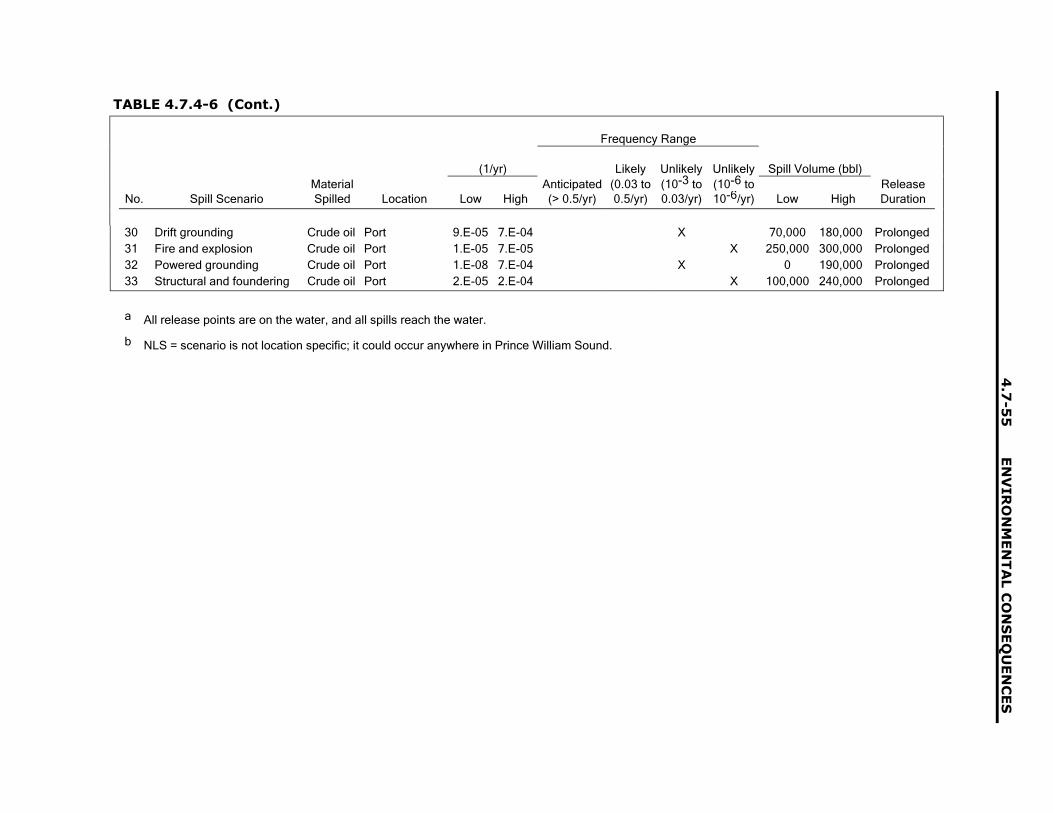
4.7
-55
EN
VIR
ON
ME
NT
AL C
ON
SE
QU
EN
CE
S
TABLE 4.7.4-6 (Cont.)
Frequency Range
(1/yr) Likely Unlikely Unlikely Spill Volume (bbl)Material Anticipated (0.03 to (10-3 to (10-6 to Release
No. Spill Scenario Spilled Location Low High (> 0.5/yr) 0.5/yr) 0.03/yr) 10-6/yr) Low High Duration
30 Drift grounding Crude oil Port 9.E-05 7.E-04 X 70,000 180,000 Prolonged31 Fire and explosion Crude oil Port 1.E-05 7.E-05 X 250,000 300,000 Prolonged32 Powered grounding Crude oil Port 1.E-08 7.E-04 X 0 190,000 Prolonged33 Structural and foundering Crude oil Port 2.E-05 2.E-04 X 100,000 240,000 Prolonged
a All release points are on the water, and all spills reach the water.
b NLS = scenario is not location specific; it could occur anywhere in Prince William Sound.

ENVIRONMENTAL CONSEQUENCES 4.7-56
very unlikely spill events. The analysis considerspossible occurrences in seven different locationsin Prince William Sound (or designatedsubareas) caused by five different tanker vesselaccident types or initiators. The Prince WilliamSound subareas, identified in a risk assessmentstudy by Merrick et al. (2000), are as follows:2
• Port of Valdez,
• Valdez Narrows,
• Valdez Arm,
• Central Sound,
• Anchorage,
• Hinchinbrook Entrance, and
• Gulf of Alaska.
The five types of tanker accidentsconsidered are: (1) collision, (2) drift grounding,(3) fire and explosion, (4) powered grounding,and (5) structural and foundering. The potentialfor a catastrophic release of crude oil isidentified with regard to the spill scenarioinitiators as follows (Det Norske Veritas et al.1996):
• Collision occurs when an underway tankerand another underway vessel collide intoeach other or strike each other as a result ofhuman error or mechanical failure and lackof vigilance (intervessel collision) or when afloating object is struck by an underwaytanker (e.g., ice collision).
• Drift grounding occurs when a drifting tankercontacts the shore or bottom because it isnot under control as the result of apropulsion or steering failure.
• Fire and explosion occurs either when thereis a fire in the machinery, hotel, navigational,or cargo space of a tanker or when there isan explosion in the machinery or cargospaces.
• Powered grounding occurs when anunderway tanker contacts the shore orbottom because of navigational error orsteering failure and lack of vigilance.
• Structural failure and foundering occurswhen a structural failure due to the hull orframe cracking or erosion is serious enoughto affect the structural integrity of the tanker.It is then assumed that the tanker willfounder or sink as a result of water ingressor loss of stability.
As Garrick (1984) notes, an accident is not asingle event, but the culmination of a series ofevents. A triggering incident is defined to be theimmediate precursor of an accident. In thePrince William Sound Risk Assessment (DetNorske Veritas et al. 1996), triggering incidentswere separated into mechanical failures andhuman errors. The mechanical failures that wereconsidered to be triggering incidents werepropulsion failures, steering failures, electricalpower failures, and hull failures. Human errorswere classified as diminished ability; hazardousshipboard environment; lack of knowledge, skillsor experience; poor management practices; orfaulty perceptions or understanding.
The volume of crude oil spilled for a givenscenario identified in Table 4.7-6 was estimatedon the basis of the methodology in DNV (1996)and by taking into account the decreasingnumber of crude oil tanker shipments due todepletion of North Slope crude oil and themandatory phase-out of single hull tankers on orbefore 2015 (FR 1998).
4.7.5 Impacting Factors ofReasonably ForeseeableActions
Section 4.7.4 describes past, present, andreasonably foreseeable actions for each of theregions of interest (Beaufort Sea and the NorthSlope, Interior Alaska, and Prince William
____________________________
2 This Prince William Sound risk assessment study had three primary objectives: to (1) identify and evaluate therisks of oil transportation in Prince William Sound; (2) identify, evaluate, and rank proposed risk reductionmeasures; and (3) develop a risk management plan and tools that could be used to support a riskmanagement program.
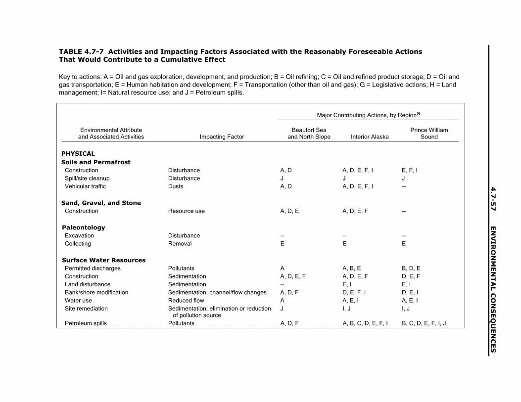
4.7
-57
EN
VIR
ON
ME
NT
AL C
ON
SE
QU
EN
CE
S
TABLE 4.7-7 Activities and Impacting Factors Associated with the Reasonably Foreseeable ActionsThat Would Contribute to a Cumulative Effect
Key to actions: A = Oil and gas exploration, development, and production; B = Oil refining; C = Oil and refined product storage; D = Oil andgas transportation; E = Human habitation and development; F = Transportation (other than oil and gas); G = Legislative actions; H = Landmanagement; I= Natural resource use; and J = Petroleum spills.
Major Contributing Actions, by Regiona
Environmental Attributeand Associated Activities Impacting Factor
Beaufort Seaand North Slope Interior Alaska
Prince WilliamSound
PHYSICALSoils and Permafrost
Construction Disturbance A, D A, D, E, F, I E, F, ISpill/site cleanup Disturbance J J JVehicular traffic Dusts A, D A, D, E, F, I --
Sand, Gravel, and StoneConstruction Resource use A, D, E A, D, E, F --
PaleontologyExcavation Disturbance -- -- --Collecting Removal E E E
Surface Water ResourcesPermitted discharges Pollutants A A, B, E B, D, EConstruction Sedimentation A, D, E, F A, D, E, F D, E, FLand disturbance Sedimentation -- E, I E, IBank/shore modification Sedimentation; channel/flow changes A, D, F D, E, F, I D, E, IWater use Reduced flow A A, E, I A, E, ISite remediation Sedimentation; elimination or reduction
of pollution sourceJ I, J I, J
Petroleum spills Pollutants A, D, F A, B, C, D, E, F, I B, C, D, E, F, I, J

EN
VIR
ON
ME
NT
AL C
ON
SE
QU
EN
CE
S4
.7-5
8
TABLE 4.7-7 (Cont.)
Major Contributing Actions, by Regiona
Environmental Attributeand Associated Activities Impacting Factor
Beaufort Seaand North Slope Interior Alaska
Prince WilliamSound
Groundwater ResourcesPermitted discharges Pollutants A -- --Site remediation Elimination or reduction of pollution
sourceJ I, J I, J
Petroleum spills Pollutants A, D, F A, B, C, D, E, F, I B, C, D, E, F, I, J
Marine EnvironmentNoise -- -- E, F, I, JOil/fuel spills -- -- E, F, I, J
Air QualityFacility and equipment operations Emissions from fuel combustion A, D, E A, B, D, E, I B, C, D, E
Fugitive emissions A, C, F A, C, F C, FConstruction Exhaust emissions A, D, E A, D, E, I D, E, I
Fugitive dust A, D, E A, D, E, I D, E, IVehicles Exhaust emissions D, F D, F D, F
Fugitive dust D, F D, F D, FAccidental spills Evaporative emissions from crude oil,
petroleum products, hazardous chemicals
J J J
NoiseConstruction activities Equipment, blasting A, D, E, F A, D, E, F, I D, E, F, IOperations Equipment, blasting A, D, E, F A, D, E, F, I D, E, F, I
TransportationMarine railway Materials, equipment, supplies A, D A, D, E, I E, IDalton/Alaska highways Materials, equipment, supplies A, D A, B, D, E, H, I B, D, E, I
Workers -- A, D, E, H, I B, C, D, E, H, IResidents -- E ETourists E, H, I E, H, I E, H, I

4.7
-59
EN
VIR
ON
ME
NT
AL C
ON
SE
QU
EN
CE
S
TABLE 4.7-7 (Cont.)
Major Contributing Actions, by Regiona
Environmental Attributeand Associated Activities Impacting Factor
Beaufort Seaand North Slope Interior Alaska
Prince WilliamSound
Airports/airstrips Workers, supplies A, H E, H, I E, H, IResidents E E ETourists E, H, I E, H, I E, H, I
Permanent/seasonal roads Materials, equipment, supplies, workers A A, D, E, H, I E, H, IIce/winter roads Materials, equipment, supplies A A, D, E, H, I --
Human Health and SafetyExploration Occupational hazards A A --Construction Occupational hazards A, D, E, I, D, E, I E
Operations Occupational hazards A, D, H, J B, C, D, E, H, I B, C, D, E, H, IToxic releases A, D B, C, D, E, I B, C, D, E, I
Transportation Vehicle emissions F F FAccidents F F F
Persistent environmentalcontaminants
Persistent organic pollutants (POPs) A, D, E, F, H, I, globalsources
B, C, D, E, F H, I,global sources
B, C, D, E, F H, I,global sources
Heavy metals A, E, F, J, naturalsources
E, F, I, naturalsources
E, F, I, natural sources
Radionuclides A, natural sources B, E, I, naturalsources
B, E, I, natural sources
BIOLOGICALVegetation and WetlandsConstruction Disturbance A, D, E D, E, F, I E, I
Dusts A, D, F D, E, F, I E, IErosion A, D, E D, E, F, I E, I
Transportation Dusts A, D, F B, C, D, E, F, I C, E, F, H, IRestoration Disturbance A, D B, C, D, I B, C, D, I
Nonnative species A, D B, C, D, I B, C, D, I

EN
VIR
ON
ME
NT
AL C
ON
SE
QU
EN
CE
S4
.7-6
0
TABLE 4.7-7 (Cont.)
Major Contributing Actions, by Regiona
Environmental Attributeand Associated Activities Impacting Factor
Beaufort Seaand North Slope Interior Alaska
Prince WilliamSound
Petroleum spills Spills A, D, F B, C, D, E, F, I B, C, D, E, F, IPermafrost changes Habitat loss/alteration F F -.-
FishConstruction Habitat loss/alternation A, D, E D, E, F, I E, I
Obstruction A, D, F D, F ITransportation Harvest A, D, F D, E, F, H, I D, E, F, H, IPetroleum spills Habitat loss/alteration A, D, E B, C, D, E, F, I B, C, D, E, I
Birds and MammalsConstruction Habitat loss/alteration A, D, `E D, E, F, I E, I
Displacement A, D, E D, E, F, I E, IOperations Obstruction A, D D, E, F, I I
Disturbance A, D, E D, E, F, H, I B, C, D, E, IPetroleum spills Habitat loss/alteration A, D, E B, C, D, E, F, I B, C, D, E, F, I
Mortality A, D, E B, C, D, E, F, I B, C, D, E, F, ITransportation Mortality A, D, F B, C, D, E, F, I B, C, D, E, I
HUMANSubsistenceConstruction/operation Employment A, D, E, H B, C, D, E, F, H, I B, C, D, E, F, H, I
Permanent Fund Dividend A, D D DEffects on resources A, D, E, H, I B, C, D, E, F, H, I B, C, D, E, F, H, INonsubsistence use H, I E, H, I E, H, I
Petroleum spills Effects on resources A, D, F J J
Sociocultural SystemsTaxes and revenues Public services and education All actions All actions All actions
Roads, airports, infrastructure All actions All actions All actions

4.7
-61
EN
VIR
ON
ME
NT
AL C
ON
SE
QU
EN
CE
S
TABLE 4.7-7 (Cont.)
Major Contributing Actions, by Regiona
Environmental Attributeand Associated Activities Impacting Factor
Beaufort Seaand North Slope Interior Alaska
Prince WilliamSound
Employment Cash economy A, D, E, H, I B, C, D, E, F, H, I B, C, D, E, F, H, IAcculturation A, D, E, H, I B, C, D, E, F, H, I B, C, D, E, F, H, IFragmentation A, D, E, H, I B, C, D, E, F, H, I B, C, D, E, F, H, I
EconomicsConstruction/operations Expenditures A, D, E, H, I B, C, D, E, F, H, I B, C, D, E, F, H, I
Employment A, D, E, H, I B, C, D, E, F, H, I B, C, D, E, F, H, ITaxes/revenues A, D, E, H, I B, C, D, E, F, H, I B, C, D, E, F, H, I
Petroleum spills Expenditures A, D, F B, C, D, E, F, I B, C, D, E, F, IEmployment A, D, F B, C, D, E, F, I B, C, D, E, F, I
Land UseConstruction/operations Use conflicts A, D, G, H D, G, H G, HPetroleum spills Fire A, D B, C, D B, C, D
Coastal Zone ManagementConstruction/operations Visual changes A, D -- B, C, D
Use conflicts A, D, G, H -- B, C, D, E, F, G, H, ISubsistence impacts A, D, G, H -- B, C, D, E, F, G, H, I
RecreationConstruction/operations Increased demand -- D, E, I --
Conflict with use -- D, E, I --
AestheticsConstruction/operations Visible effects A, D B, C, D, E, F, I B, C, D, E, F, I
Noise A, D B, C, D, E, F, I B, C, D, E, F, IPetroleum spills Fire A, D B, C, D B, C, D
a See Table 4.7.5-1 for further details.
b A hyphen indicates not applicable.

ENVIRONMENTAL CONSEQUENCES 4.7-62
Sound) that are the focus of the cumulativeanalysis (see Table 4.7-2). Table 4.7-7translates these major actions in each region ofinterest into sets of activities relevant to eachenvironmental attribute considered in thecumulative impact analysis. For example,surface water resources (an environmentalattribute) could be affected by oil development(an action) through permitted discharges,construction, land disturbance, water use, orspills (the activities). The activities, in turn, canbe further translated into impacting factors(e.g., chemical pollutants, sedimentation,reduced flow) that can be used to evaluate theimpacts of the action on the environmentalattribute. The sum of these effects, then,represents the cumulative impacts on thespecific environmental attribute in the region.Thus, impacting factors constitute themechanism by which cumulative effects areanalyzed and presented. While each activity inTable 4.7-7 has one or more correspondingimpacting factors, each impacting factor can alsobe a component of more than one activity. Forexample, sedimentation can be an impactingfactor for surface water resources for bothconstruction and land disturbance.
4.7.6 Physical Environment
4.7.6.1 Soil and Permafrost
Activities associated with oil and gasexploration, development, and production andthe construction of a natural gas pipeline coulddisturb vegetative cover and affect soils andpermafrost in the North Slope and Beaufort Seaareas and Interior Alaska. These activities couldinclude constructing roads, drilling pads, andpipeline; delivering heavy equipment; logging;and building support facilities. As the vegetativecover would be disturbed, the permafrost belowthe ground surface could be degraded, causingchanges in the local hydrology, slope stabilityproblems, and surface subsidence (seeSection 4.3.2 on soils and permafrost).
The impacts would vary by location, sincethey would depend on the local geology,hydrology, and permafrost conditions. Theimpacts on the soil and permafrost wouldprimarily occur in the local areas where the
activities occurred. Therefore, since otheractivities in the Beaufort Sea and North Slopeareas would affect local areas, there would be anegligible cumulative impact with any similarlocalized impacts of TAPS operations.
Construction of a gas pipeline from the NorthSlope either to Delta Junction in Interior Alaskaor on to Valdez would require excavation in thevicinity of the TAPS ROW. Activities associatedwith TAPS and natural gas pipeline constructionand operation would therefore act cumulativelyto disturb vegetative cover and affect soils andpermafrost. The disturbance caused byconstruction of the natural gas pipeline would besubstantially larger than that caused bymaintaining the TAPS; the contribution of theTAPS to cumulative impacts of soil disturbancein the region is expected to be small.
Under the less-than-30 year renewalalternative, cumulative impacts would be asstated for the proposed action. For the no-actionalternative, the cumulative impacts on soildisturbance from oil exploration anddevelopment on the North Slope would declineas these activities declined, pendingdevelopment of an alternative means of oiltransportation. However, the combined effects ofshutting down TAPS operations, removingfacilities, and construction of a natural gaspipeline would have cumulative effects greaterthan those for the proposed action. This isbecause the activities involve extensiveexcavation and movement of heavy equipment.In summary, the cumulative impact on soil andpermafrost caused by physical disturbance onthe ground surface would be smaller under theproposed action than under the no-actionalternative.
Permafrost is affected by road dustgenerated by traffic on unpaved roads; snowmelt due to dust deposition can lead to flooding,ponding, and hydrological changes in soil(see Section 3.3.2.2 on permafrost degradationand aggradation). Because the Dalton Highwayand other roads on the North Slope and inInterior Alaska are not paved, all activities thatgenerate vehicle traffic on roadways generatedust. Thus, continuing oil and gas exploration,development, and production; construction of anatural gas pipeline; the operation of the TAPS;and other activities requiring road travel would

4.7-63 ENVIRONMENTAL CONSEQUENCES
add cumulatively to the volume of road dustgenerated. The quantitative increase in thesettled dust layer, as well as increases in thefrequency of dusting may increase effects onvegetation and snow cover, thus ultimatelyaffecting soils and permafrost.
The road dust generated from TAPSactivities would be about the same or largerunder the proposed action than under theno-action alternative because expected trafficvolumes would be less under no action(Section 4.6.2.11). Under the no-actioncumulative case, the amount of traffic due to oilexploration, development, and production wouldalso decline. Depending on the balance of thetransportation effects of these changes, thecumulative impact of road dust on soil andpermafrost could be smaller, the same, or largerin the proposed action case than in the no-actioncase, while the contribution of the gas lineconstruction to the total impact caused by theroad dust in both alternatives would be thesame.
If oil and gas exploration, development, andproduction in the North Slope and Beaufort Seaareas were expanded, or a gas pipeline parallelto the TAPS is constructed, the amount of roadtraffic caused by these activities would increasegreatly over the traffic caused by regularmaintenance operations for the TAPS. Thecumulative impact of road dust on soil andpermafrost would be smaller in the proposedaction case than in the no-action case. Similarly,the cumulative impact on soil and permafrostcaused by physical disturbance on the groundsurface would be smaller under the proposedaction than under the no-action alternative.
In summary, if oil and gas exploration,development, and production in the North Slopeand Beaufort Sea areas continued and if thenatural gas pipeline were constructed, theamount of road traffic caused by these activitiescould be greater than the traffic caused byregular maintenance operations for the TAPS. Itis likely that the TAPS contribution to the totaldust load would be smaller than that from theother activities in the North Slope area.
4.7.6.2 Sand, Gravel, andQuarry Resources
Sand, gravel, and quarry stones are neededto build the access roads, air strips, workpads,drilling pads, and gravel islands needed for oiland gas exploration, development, andproduction. These materials are mined inquarries in the Brooks Range and in floodplainsthroughout the region.
To reduce construction costs, most of themining sites, to the maximum extent possible,would be located near areas where the materialswould be needed. With continuing oil and gasexploration, development and production in theBeaufort Sea, North Slope, and Interior Alaska,and with development of the natural gas pipelineand with other industrial and communitydevelopment, additional quantities of sands,gravels, and quarry stones would be needed.Other actions in Interior Alaska, such as mineraldevelopment, logging, and urban development,would require roads and other facilities, which, inturn, would require sand and gravel. The sandand gravel requirements for the natural gaspipeline on the North Slope and in the InteriorAlaska are not known, but these resources mightbe required along the ROWs and access points.Rip rap might be needed at river crossings. Themajority of these materials would be mined andimpact areas would be outside the areas wherethe TAPS is located. However, some of thematerials could be extracted in areas near theTAPS or from the same quarries or gravel pits asthose used by the TAPS. The latter actionswould contribute to a cumulative impact.However, taken as a whole, sand, gravel, andstone resources are abundant, and allrequirements are unlikely to deplete theseresources.
The requirement designed to protect thetundra environment to use ice roads in winterand ice pads in exploratory drilling pads reduces the quantity of gravel that wouldotherwise be used for roads to reach remoteareas. However, ice roads or ice pads might notbe used in places where continued accessduring summer (for maintenance) or operationalaccess is required. Sands and gravels would berequired at remote locations for padconstruction, production facilities, and

ENVIRONMENTAL CONSEQUENCES 4.7-64
associated infrastructure. On the North Slope,the source for rock for rip rap and river framing islimited to quarries in the Brooks Range. Thecontribution of the TAPS to the total impactwould likely be much smaller than that of theother continuing and new activities in the NorthSlope area.
Under the less-than-30-year renewalalternative, cumulative impacts would be asstated for the proposed action. Under theno-action alternative, sand, gravel, and quarrystone requirements might increase while TAPSfacilities were dismantled and removed.However, sand, gravel, and quarry stones wouldno longer be needed for the TAPS after earlyphases of the termination activities werecompleted, and requirements for oil exploration,development, and production would decline.However, the gas pipeline would require sand,gravel, and quarry stone resources. Therefore,the cumulative impact on these resources wouldbe smaller under the no-action alternative thanunder the long-term proposed action.
4.7.6.3 Paleontology
Any action that involves ground disturbancecreates a potential for impacts to paleontologicalresources existing in the affected area.Paleontological resources may also be impactedby collecting and disturbance by the presence ofpeople associated with these actions. However,given the variability of the scientific importanceof paleontological resources, there is thepotential for significant adverse cumulativeimpacts when all other actions are consideredtogether. Mitigating this cumulative impact wouldrequire addressing protection of paleontologicalresources for these other actions on a case-by-case basis. However, impacts to paleontologicalresources from continuing operations of theTAPS will be avoided according to provisions inthe Federal Grant that address paleontologicalmaterials, and continued operation of TAPSwould not add to any significant impact onpaleontological resources. Under the no-actionalternative and the less-than-30-year renewalalternative, the cumulative impacts would besimilar to cumulative impacts with the proposedaction. Construction of a natural gas pipelinewould be a major ground disturbing activity of afew years� duration. These impacts would be
offset by declining oil and gas developmentactivities on the North Slope. In summary, anyground disturbing activity involves the potentialfor impacts to paleontological resourcesrequiring mitigation on a case-by-case basis.
4.7.6.4 Surface WaterResources
A number of foreseeable actions have beenidentified (Section 4.7.3) that could produceimpacts to surface water resources in threeregions associated with the TAPS ROW: theNorth Slope, Interior Alaska (along the TAPSROW), and Prince William Sound. These actionscould interact cumulatively with impacts from theproposed action and the no-action alternative.Impacting factors related to these foreseeableactivities include permitted discharges; erosion;sedimentation; bank, channel, and shoremodifications; water use; site remediation; andspills. Potential impacts of these factors onsurface water resources include reducedquantities of water and degraded water quality.
Oil and gas exploration, development, andproduction require the use of large quantities ofwater. Maximum bounding estimates for oneproject are that construction of 1 mi of ice roadrequires about 1 million gal of water; an ice padthat is square and 600 ft on a side requires about21 million gal of water; and construction of an iceairstrip requires about 8 million gal of water (BPExploration 2000). For the same project, drill riguse would require about 9 million gal of waterannually, rig-camp use for 120 people would beabout 2 million gal of water annually; mobilecamp water use for 60 people would be about0.5 million gal of water per year; and ice pad,road, and airstrip maintenance would useanother 9 million gal of water per year. For theNorth Slope as a whole, the typical annual wateruse for oil exploration is about 27 billion gal(ADNR 2001). This value represents about0.27% of the total water available on the NorthSlope in any given year.
Water requirements on the North Slope insummer would be met by using water from lakesand river pools. Water from taliks (unfrozenwater in deep pools below the surface of riversand lakes) would be used in winter when thesurface water was frozen (BLM 1983). Water
4.7-65 ENVIRONMENTAL CONSEQUENCES
withdrawals from taliks could be limited bypermit to no more than 15% of the availablewater (ADNR 2001). For the town of Barrow, theBarrow Utilidor System, which is owned andoperated by the North Slope Borough, providesabout 200,000 gal/d of water from the IsatkoakReservoir (AWWA 2002).
Impacts to the quantity of surface water fromforeseeable activities would be cumulative if thewater withdrawals occurred in the samewatershed. Because the total water use for theNorth Slope is about 0.27% of the availablewater, impacts from the foreseeable actionscould be small in magnitude and local. Impactsfrom continued operation of the TAPS would becumulative with other activities on the NorthSlope only if the same source area was used.Some major water users, such as oil and gasdevelopment, are not located along the TAPSROW. However, water for construction of anatural gas pipeline may affect surface waters inthe TAPS ROW, however, these effects wouldbe small in magnitude and local. By following theguidelines on the permissible levels of waterwithdrawal specified in Alaska water-usepermits, impacts of surface water use on thequantity of surface water could be minimized.
The quality of surface water resources(dissolved constituents and sediment) could alsobe affected by oil and gas exploration,development, and production; oil and gastransportation; and human habitation anddevelopment in the North Slope and BeaufortSea area. Since water would be withdrawn fromtaliks during winter, oxygen demand bysediments and water could reduce theconcentration of oxygen in the water needed byoverwintering fish. However, only 15% of waterunder the ice sheet may be withdrawn (ADNR2001), which would reduce the potential foroxygen reduction or loss and the release ofharmful substances from the sediments. Thequality of surface water in other areas could beaffected by discharges during drilling,sedimentation and runoff from road construction,discharges from homes and developments, andspills. Impacts of these activities would becumulative if the surface discharges or spillsoccurred in the same watershed. Impacts fromthe foreseeable actions could be small inmagnitude and local. Impacts from continued
operation of the TAPS would be similarly smallin magnitude and local on the North Slope.However, the effects on water quality if a largespill was released directly to surface water couldbe large and extensive, and the magnitude of theeffects would depend on the speed of cleanupresponse teams and the local conditionsaffecting oil dispersion. The probability of thistype of spill occurring is very small. Impacts fromanticipated or likely small spills would producesmall and local impacts on surface water quality.By following guidelines established forappropriate Alaska discharge permits, limits onthe volume of water that can be withdrawn underice cover, meeting restrictions on the storage oftoxic construction and operations materials, andmeeting requirements for cleanup of all toxicmaterials as part of construction and normaloperations, cumulative impacts on water qualitycould be minimized.
In Interior Alaska (i.e., along the TAPSROW), quantity and quality of surface watercould be cumulatively affected by oil and gasexploration, development, and production; oiland gas transportation; oil refining; and humanhabitation and development. Surface waterwould be used for activities such as drilling, oilrefining, construction (including a natural gaspipeline), dust control, and human consumption.Water requirements would be met by using waterfrom lakes, river pools, taliks (during the winter;BLM 1983), and groundwater wells (seeSection 4.7.6.5). Large construction projects,such as the natural gas pipeline, would probablyobtain water from nearby rivers and streams.Impacts of these activities on surface waterwould be cumulative with those from theproposed action, if the water withdrawalsoccurred in the same watershed. As discussedin Section 4.3.6, impacts of the proposed actionon surface water would be negligible inmagnitude, local, and temporary because mostwater needs are met by using groundwater wellsalong the TAPS ROW. It is anticipated that thecumulative impacts of the foreseeable actionswould be minimized as much as possible byusing good engineering practices.Implementation of the foreseeable actions wouldrequire compliance with all applicable permitrestrictions, laws, and regulations.
ENVIRONMENTAL CONSEQUENCES 4.7-66
The quality of surface water resources inInterior Alaska could also be affected by oil andgas exploration, development, and production;oil refining; and human habitation anddevelopment. Surface water quality is affectedby both dissolved constituents and sediment.Similar to withdrawal from taliks on the NorthSlope, water withdrawal from taliks in InteriorAlaska could affect overwintering fish if a largeproportion of liquid water were withdrawn. Thiseffect is limited by water withdrawal permitconditions. Similarly, the quality of surface watercould be affected by discharges during drilling,sedimentation and runoff from road construction(particularly during construction of a natural gaspipeline), refinery construction and operation,human habitation and development, and spills.Impacts of these activities would be cumulativewith those from the proposed action if thesurface discharges or spills occurred in thesame watershed. Depending on the quantities ofpollutants released, impacts from theforeseeable actions could be large in magnitudeand local. Impacts from continued operation ofthe TAPS would, in general, be small and localbecause of existing permit conditions. However,impacts from a large spill could be major inmagnitude and extensive, depending on thespeed of cleanup response and the conditionsaffecting dispersal. (For example, a guillotinebreak caused by a helicopter or fixed-wingaircraft crash could spill oil directly into a river orstream at an elevated crossing.) In the case ofsmaller spills, cleanup response would limit theextent of contamination and effect on waterquality. By following guidelines established forappropriate Alaska discharge permits, meetingrestrictions on the storage of toxic constructionand operations materials, and meetingrequirements for cleanup of all toxic materials aspart of construction and normal operations,cumulative impacts on water quality would beminimized.
In the area of Prince William Sound, oilrefining; oil and gas transportation; and humanhabitation and development could affect both thequantity and quality of available surface water.The quantity of surface water available could bereduced by activities such as road constructionand dust control, building construction, andhuman habitation and development, however,water in the Valdez area is supplied by four
primary groundwater wells (Vacation Alaska1999). If the foreseeable project water needswere met by using groundwater from these wellsor other new wells, there would be no impact tosurface water quantities. Impacts fromanticipated or likely small spills would producesmall and local impacts because of the smallvolumes of oil released. (Cumulative impacts togroundwater are discussed in Section 4.7.6.5).Impacts from continued operation of the TAPSfor the proposed action would, then, be the onlycomponent of the cumulative impact to surfacewater quantities in the Prince William Soundarea. These impacts, as previously discussed,would be small in magnitude, local, andregulated by applicable permits for water use atthe Valdez Marine Terminal.
The quality of surface water resources in thearea of Prince William Sound could also beaffected by oil refining; oil and gastransportation; and human habitation anddevelopment. Surface water quality is affectedby both dissolved constituents and sediment.The quality of surface water could be affected byrunoff from road construction, refineryconstruction and operation, human habitationand development, and spills. Impacts of theseactivities would be cumulative with those fromthe proposed action if the surface discharges orspills occurred in the same watershed. Impactsfrom the foreseeable actions could be large inmagnitude and local. Impacts from continuedoperation of the TAPS would, in general, besmall in magnitude and local, except for impactsfrom spills, which could be major and extensive(e.g., a catastrophic failure of an oil storage tankat the Valdez Marine Terminal). For anticipatedor likely small spills, impacts to surface waterquality would be small and local because of thesmall volumes of oil released. The recipients ofmost of these impacts would be marine waters(see Section 4.7.6.7) rather than freshwaterrivers or streams, which are limited in numberand size in the vicinity of the Valdez MarineTerminal. By following guidelines established forappropriate Alaska discharge permits, meetingrestrictions on the storage of toxic constructionand operations materials, and meetingrequirements for cleanup of all toxic materials aspart of construction and normal operations,cumulative impacts on water quality would beminimized.
4.7-67 ENVIRONMENTAL CONSEQUENCES
For the less-than-30-year renewalalternative, cumulative impacts would be asstated for the proposed action. Under theno-action alternative, the Federal Grant of ROWwould not be renewed, and oil would no longerflow through the pipeline to the Valdez MarineTerminal. Oil production on the North Slopewould cease, and there would be no exploratorydrilling for oil. However, it is assumed gasproduction on the North Slope would continue,as would exploratory drilling for gas. Because oilproduction and exploratory drilling for oil wouldcease, water use on the North Slope would begreatly reduced, and impacts to surface waterquality from activities (e.g., ice roadconstruction, other construction, and camp use),discharges from homes and developments, andspills would also be greatly reduced.
In Interior Alaska, cumulative impacts alongthe TAPS ROW would be temporarily increasedduring removal of the oil pipeline and associatedstructures. These impacts would include wateruse and modification of the existing waterquality. Impacts from TAPS removal would becumulative with those from construction of a newgas pipeline. Although construction and removalimpacts would only occur for a short time, thecumulative impacts along the TAPS ROW wouldbe large in magnitude and extensive (occurringalong a substantial portion of the 800-mi lengthof the pipeline). Once the pipeline was removed,impacts from any TAPS-related spills would nolonger be possible, and impacts to surface waterquality would be limited to other non-TAPS-related projects.
In the Prince Williams Sound area, impactsto surface water quantity and quality would beinitially high as TAPS facilities were removed;however, these impacts would be temporary.Once removal activities were completed,impacts would be produced by other non-TAPSrelated projects. Because surface water wouldnot be used for these other activities, impacts tothe quantity of surface water available would benegligible. Impacts to water quality would beminimized, to the extent possible, by followinggood engineering practices and provisions inappropriate Alaska discharge permits.
In summary, the cumulative impacts of allactivities would have small and local impacts onsurface water quantity and quality. Permit
requirements related to water withdrawals anddischarges to surface waters, as well as cleanupof small petroleum spills, would protect surfacewater resources. The impacts of TAPSoperations on surface water resources would besmall in comparison to other actions such as oilexploration and development, waterrequirements for construction of a natural gastransportation system, and the requirements ofother industrial and municipal systems.
4.7.6.5 GroundwaterResources
A number of foreseeable actions have beenidentified that could produce impacts togroundwater resources in three regionsassociated with the TAPS ROW: the NorthSlope, Interior Alaska (along the TAPS ROW),and Prince William Sound. These actions couldinteract cumulatively with impacts from theproposed action. Specific impacting factors forthese foreseeable activities include water use,permitted discharges, site remediation, andspills. Impacts to groundwater resources includereduced quantities of water available anddegraded water quality.
In the North Slope area, oil and gasexploration, development, and production; oiland gas transportation; and human habitationand development could affect the quantity andquality of groundwater directly or indirectly.While groundwater resources could be used forsuch activities as drilling, road construction(particularly ice roads), construction and dustcontrol, and human consumption, water needson the North Slope are typically met by usingsurface water resources (BLM 1983) (seeSection 4.7.6.4). Therefore, cumulative impactsto the available groundwater from theforeseeable actions, together with the proposedaction would be none to negligible.
The quality of groundwater resources couldalso be affected by oil and gas exploration,development, and production; oil and gastransportation; and human habitation anddevelopment in the North Slope. Both direct andindirect impacts could occur. Direct impacts onwater quality would result from direct dischargesto the groundwater from drilling operations(e.g., disposal of production water in deep

ENVIRONMENTAL CONSEQUENCES 4.7-68
formations) and septic systems. However,disposal of production water in deep formationswould not impact water available for humanconsumption. Indirect impacts on water qualitywould result from the infiltration of contaminatedsurface water derived from petroleum spills.Impacts from these sources would be cumulativewith the proposed action only if contaminantsreached the same aquifers. However, theseimpacts would be controlled and minimized byprompt cleanup actions. Impacts on water qualityfrom the foreseeable actions would be small inmagnitude and local because of the presence ofthe permafrost in this region. Impacts from spillsfrom all actions could be large and extensive ifcontamination from unlikely or very unlikely largespill events were allowed to reach thegroundwater. Impacts to water quality fromcontinued operation of the TAPS would be smallin magnitude and local on the North Slope (nocumulative impacts along the TAPS ROW wouldbe derived from North Slope actions), except forspills, which could produce large and extensiveimpacts if allowed to reach the groundwater. Thecumulative impact of foreseeable actions and theproposed action would be small in magnitudeand local. Impacts from anticipated spills wouldbe small and local because of the small volumesreleased. By following guidelines established forappropriate Alaska discharge permits, meetingrestrictions on the storage of toxic constructionand operations materials, and meetingrequirements for cleanup of all toxic materials aspart of construction and normal operations,cumulative impacts on water quality would beminimized.
In Interior Alaska (i.e., along the TAPSROW), groundwater quantity and quality couldbe cumulatively impacted by oil and gasexploration, development, and production; oiland gas transportation; oil refining; and humanhabitation and development. The quantity ofgroundwater available may be locally reducedbecause water would be used for industrialactivities such as drilling, oil refining,construction; dust control, and humanconsumption. Within Interior Alaska, waterneeds are usually met by using groundwaterwells. For example, the City of Fairbanksacquires all of its water from wells. In 1996, themonthly mean water withdrawal was about6 million gal/d (USGS 2002b).
For the foreseeable actions in InteriorAlaska, water requirements would be met byusing groundwater wells, although surface waterresources could be used to meet natural gaspipeline construction needs. Impacts of theseactivities on groundwater resources would becumulative with those from the proposed action,if the water withdrawals were from the sameaquifer. Impacts produced by the foreseeableactions could be large in magnitude and local ifwithdrawals were a substantial proportion of theavailable resource. As discussed inSection 4.3.6, impacts of the proposed action ongroundwater quantities would be negligible andwould be a small component of the cumulativeimpact. The cumulative impacts of theforeseeable actions would be minimized asmuch as possible by using good engineeringpractices. Implementation of the foreseeableactions would require compliance with allapplicable permit restrictions, laws, andregulations.
The quality of groundwater resources inInterior Alaska could also be affected by oil andgas exploration, development, and production;oil refining; and human habitation anddevelopment. Both direct and indirect impactscould occur. Direct impacts could result fromdirect discharges to the groundwater fromindustrial activities and septic fields. Indirectimpacts could result from the infiltration ofcontaminated surface water from industrial andmunicipal sources and from spills which werenot cleaned up. Impacts of these activities wouldbe cumulative with those from the proposedaction, if the direct discharges were to the sameaquifer or if contaminated surface waterinfiltrated the same aquifer. Impacts from theforeseeable actions could be large in magnitudeand local if any wastewaters were disposed of bydeep well injection. Impacts from continuedoperation of the TAPS would, in general, besmall and local, except for impacts from unlikelyor very unlikely large spills, which could be largeand extensive (e.g., a very unlikely undergroundguillotine break caused by seismic activity or alandslide). The cumulative impact of foreseeableactions and the proposed action would be largein magnitude and local, with the contributionfrom continued TAPS operation being negligibleto small in magnitude, except for the impactsfrom spills. In the case of spills, the cumulative

4.7-69 ENVIRONMENTAL CONSEQUENCES
impacts could be very large in magnitude andextensive, particularly if a large unlikely spill wasreleased directly to groundwater. For anticipatedspills, impacts would be small and local becauseof the small volumes of contaminants releasedand because they would be promptly cleaned up.By following guidelines established forappropriate Alaska discharge permits, meetingrestrictions on the storage of toxic constructionand operations materials, and meetingrequirements for cleanup of all toxic materials aspart of construction and normal operations,cumulative impacts on water quality could beminimized.
In the area of Prince William Sound, oil andgas transportation, and human habitation anddevelopment could affect both the quantity andquality of groundwater. The quantity ofgroundwater could be reduced because waterwould be used for activities such as industrialrequirements, road construction and dustcontrol, building construction, and humanconsumption and development. Water in theValdez area is supplied by four primarygroundwater wells (Vacation Alaska 1999).Water is stored in two 750,000-gal reservoirsbefore it is piped throughout Valdez. Ifforeseeable project water needs were met byusing groundwater from these wells or other newwells, the impacts on the groundwater systemcould be large, and the water table would belowered. Water for operation of the ValdezMarine Terminal is obtained from surface waterresources. Impacts from continued operation ofthe TAPS under the proposed action would thusbe a negligible component of the cumulativeimpact to groundwater quantities in the PrinceWilliam Sound area.
The quality of groundwater resources in thearea of Prince William Sound could also beaffected by oil refining; oil and gastransportation; and human habitation anddevelopment. Both direct and indirect impactscould occur. Direct impacts would result fromdirect discharges to the groundwater from septicfields. Indirect impacts would result from theinfiltration of contaminated surface water.Impacts from continued operation of the TAPSwould, in general, be small in magnitude andlocal, except for impacts from spills, which couldbe larger and more extensive (e.g., a very
unlikely catastrophic failure of an oil storage tankat the Valdez Marine Terminal). The cumulativeimpact of foreseeable actions and the proposedaction would be large in magnitude and local,with the contribution from continued TAPSoperation being small in magnitude, except forthe impacts from spills. In the case of spills, thecumulative impacts could be very large andextensive for unlikely to very unlikely spillscenarios. For anticipated spills, impacts couldbe small and local because of the small volumesof contaminants released. By followingguidelines established for appropriate Alaskadischarge permits, meeting restrictions on thestorage of toxic construction and operationsmaterials, and meeting requirements for cleanupof all toxic materials as part of construction andnormal operations, cumulative impacts ongroundwater quality would be minimized.
Under the less-than-30-year renewalalternative, cumulative impacts would be thesame as those under the proposed action. Underthe no-action alternative, the Federal Grant ofROW would not be renewed, and oil would nolonger flow through the pipeline to the ValdezMarine Terminal. Oil production on the NorthSlope would cease, and there would be noexploratory drilling for oil. However, it isassumed gas production on the North Slopewould continue, as would exploratory drilling forgas. Because oil production and exploratorydrilling for oil would cease, water use on theNorth Slope would be greatly reduced. Becausethis water is normally supplied from surfacewater resources, there would be no effect on thegroundwater resources. However, groundwaterquality could still be impacted by such activitiesas exploratory drilling for gas (e.g., brinedisposal), discharges from septic fields, andspills. With the curtailment of oil field drilling,impacts from normal operations to groundwaterquality would be greatly reduced. Although theimpacts of spills could still be high, theoccurrence of spills would be reduced with thecurtailment of oil production and exploratorydrilling for oil.
In Interior Alaska, cumulative impacts alongthe TAPS ROW would be increased duringremoval of the oil pipeline and associatedstructures and construction of a natural gaspipeline. These impacts include water use and
ENVIRONMENTAL CONSEQUENCES 4.7-70
modification of the existing water quality.Impacts from TAPS removal would be less thanthose from construction of a new natural gaspipeline. Because construction and removalimpacts would only occur for a short time, thecumulative impacts along the TAPS ROW wouldbe extensive in area (occurring along asubstantial portion of the 800-mi length of thepipeline) and temporary. Once the TAPSpipeline was removed, impacts from any TAPS-related spills would no longer be possible, andimpacts to groundwater quality would be limitedto those produced by other non-TAPS-relatedprojects.
In the Prince William Sound area, impacts togroundwater quantity and quality would beinitially high as TAPS facilities were removed;these impacts would be temporary, however.Once removal activities were completed,impacts would be produced by other non-TAPS-related projects. Because groundwater is theprimary source of water in the area, impacts tothe resource could be large. Impacts togroundwater resources could be minimized, tothe extent possible, by following goodengineering practices and provisions inappropriate Alaska discharge permits.
In summary, cumulative impacts ongroundwater would be small and local. Theseimpacts would be related to oil and gasexploration, development, and production, andby other industry and community withdrawals. Inthe event of an unlikely or very unlikely largespill, groundwater could also be affected ifcontamination was allowed to reach thegroundwater. Continued operation of the TAPSwould be a small contributor to the cumulativeimpacts on groundwater resources.
4.7.6.6 Physical MarineEnvironment
Potential cumulative impacts to the physicalmarine environment associated with the TAPSwould come from tankers traveling from theValdez Marine Terminal through Prince WilliamSound to the Hinchinbrook Entrance. Thesetransits would create noise and involve the risksof petroleum spills or other accidents. Otheractions that would be cumulative with theimpacts from tanker traffic are commercial
fishing, recreational fishing/sightseeing,commercial sightseeing/tours, and othercommercial cargo operations in Port Valdez andPrince William Sound. With the exception of therisks from larger oil spills, these cumulativeimpacts on the physical marine environmentwould be small and short-lived. Small spills fromall vessels are rapidly responded to and cleanedup by the spill response infrastructure supportingthe oil transportation industry.
Section 4.7.4.10.5 discusses potential spillsand accidents that could impact Port Valdez andPrince William Sound. The GNOME computerprogram (NOAA 2000b) was used to estimatethe spread of oil from the various release pointsidentified in Table 4.7-4 GNOME uses locationfiles to specify local conditions; this analysisused the Prince William Sound location filecompiled by NOAA (2002b). The Prince WilliamSound location file includes the effects of fivecurrent patterns to simulate the circulation andtides in Prince William Sound and Port Valdez.NOAA (2002b) states:
�The tides at Hinchinbrook Strait,Port Wells, Montague Strait, and ValdezArm are each simulated with separatecurrent patterns. The tidal circulation ofLatouche Passage, Elrington Passageand Prince of Wales Passage are allsimulated with two current patterns: (1) amodified portion of the Montague Straitcurrent pattern and (2) a backgroundcurrent pattern. The background currentpattern models the net surface currentsthrough each of these passages:Latouche Passage (−0.3 knots);Elrington Passage (0.3 knots); andPrince of Wales Passage (−0.9 knots).The tidal current pattern for MontagueStrait was extended to each of thesepassages with relative amplitudes thatapproximate the residual tides. Sincethe phase differences between theseareas were on the order of an hour, thisapproximation was consideredacceptable.�
The spill scenarios assume that a volume ofNorth Slope crude oil ranging from 50,000 to290,000 bbl would be released instantaneouslyat various locations in Port Valdez, the ValdezNarrows, and Prince William Sound, and that it

4.7-71 ENVIRONMENTAL CONSEQUENCES
would spread for 6 hours before response andcontainment. This is the range of oil spillvolumes that would be expected to be releasedfrom a tanker accident (see Table 4.7-4). Theactual response time might be significantlydifferent (either higher or lower) from theassumed 6-hour value, depending on weatherconditions, the location of the spill, and otherfactors. If the spills occurred under extremeweather conditions in which the winds andcurrents were different from those used in themodel, response times could be longer, and thereleased oil could travel more rapidly, so a muchlarger area would be impacted by the potentialoil spills than the area estimated here.
Prevailing winds in Port Valdez and PrinceWilliam Sound are generally from the northeast,with speeds up to 15 knots. The other prevalentwind direction in Port Valdez is from thesouthwest at about 12 knots (TAPS Owners2001). Both of these prevailing winds were usedin the model runs to estimate the impacts of thevarious spill scenarios. Because specificlocations for these spills were not known, anumber of locations from Port Valdez to theHinchinbrook Entrance were evaluated. Inaddition to the effects of wind variability, thedifferences in currents at different times of theday were also incorporated into the calculations.
For all the release scenarios modeled, theoil slick moved out from the release point andexpanded radically, except the expansion waslarger in the direction of the prevailing winds andcurrents. The general direction of the oilmovement depended on the wind direction.
The best estimate of the shape of the area inwhich 99% of the oil would be in the water within6 hours after the release is that it would be analmost-circular ellipse, if the spill could not reachthe shoreline. This area would extend about4-1/2 mi in diameter from the release point. Thegeneral shape of this estimated area would bedifferent for different release points, since itwould be influenced by winds and currents in thespill location.
The GNOME program also has thecapability to evaluate the relative uncertainties ofvarious parameters used in the modelprojections. These calculations are implementedby using a �minimum regret� approach (see
Section 4.4.4.5.2). The estimated areas thatwould contain the oil spill plume after 6 hourswould be ellipses about 10 mi in diameter,approximately centered on the release point, inan almost circular shape.
Spills starting at locations near the center ofPrince William Sound would not reach theshoreline within the assumed 6-hour responsetime; spills starting at locations within 5 mi of theshore could potentially reach the shoreline withinthe 6-hour assumed time limit. Potential oil spilllocations within Port Valdez and the ValdezNarrows would release oil over large portions ofthe shoreline, up to 10 mi (5 mi on each side ofPort Valdez or the narrows) in the assumed6-hour response window. Potential oil spilllocations near the Hinchinbrook Entrance wouldalso release oil over large amounts of shoreline,up to 6 mi or more, depending on prevailing winddirections at the time of the spill.
All spills within the range of spill volumesevaluated would behave in a similar manner,and the oil would be transported overcomparable distances. The only differencewould be in the concentration of oil within theplume.
It is assumed that at the 6-hour point, thespill would be contained, and further spreadingof the oil would stop. However, it is possible thatsome oil would escape the initial containmentand could impact other areas in Port Valdez andPrince William Sound. The impacts outside thecontainment area would be small and localized.Within the containment area, the impacts wouldbe significant.
It is assumed that once the oil wascontained, removal actions would begin. Asnoted in Section 4.4.4.5.4, North Slope crude oildoes not significantly dissolve into the watercolumn during the first 24 hours after a spill;however, some dissolution does take place.Dissolved constituents resulting from the spillcould have minor local impacts, but dilutioneffects would limit the impacts away from thespill areas. As noted in Section 3.9.3 on affectedmarine environment, the waters of Port Valdezand Prince William Sound are well-mixed andwould dilute dissolved constituents from the spill.

ENVIRONMENTAL CONSEQUENCES 4.7-72
Releases near the shore would heavily oilthe shoreline, and the waters immediatelyaround the area would also be affected. Theoiled shoreline could also continue to affect thewaters of Port Valdez and Prince William Soundin the immediate area of the spill for a long timeafter the initial release. However, because ofdilution and the existing hydrocarbonbackground concentrations, changes inseawater hydrocarbon concentrations would beminimal and localized. Impacts could also occurin other areas of Port Valdez and Prince WilliamSound away from the release point or oiledshoreline; these impacts on seawater hydro-carbon concentrations would also be small andlocalized. As noted in Section 3.11.3, significanthydrocarbon background concentrations alreadyexist in Port Valdez waters. Low concentrationsresulting from long-term releases from an oiledshoreline would not be distinguishable frombackground concentrations at any locationsexcept the areas very near the source location.
Mitigation for spills occurring during tankertransit from Port Valdez and in Prince WilliamSound would include (1) minimizing the time forresponse and the time required to contain arelease, (2) deploying containment systemsquickly, and (3) starting removal actions beforeweather or other adverse conditions could makecontainment difficult.
Under the less-than-30-year renewalalternative, the impacts from any oil spill wouldbe the same as those discussed for theproposed action. Under the no-action alternative,oil shipments from the TAPS would cease, andthere would be no risk of an oil spill from aTAPS-related tanker. However, risks from an oilspill from other marine traffic would remain. If thespill emergency response infrastructure was notmaintained, the environmental effects of fuel oroil spilled by non-TAPS-related vessels could belarger than those under the proposed action.
4.7.6.7 Air Quality
Reasonably foreseeable actions that mightimpact air quality and AQRVs (visibility and aciddeposition) include exploration, development,production, storage, refining, and transportationof oil and gas; human habitation anddevelopment; land management activities; and
natural resource uses. Specific factors inherentto these actions impacting air quality andAQRVs include emissions from (1) the operationof facilities and equipment (exhaust emissionsfrom fuel-burning equipment and fugitiveemissions of dust and VOCs); (2) constructionactivities (exhaust emissions from heavyequipment and vehicles and fugitive emissionsof dust from land disturbance); (3) accidentalspills of crude oil, petroleum products, andhazardous chemicals (evaporative emissions);and (4) transportation activities (exhaust androad dust emissions from vehicles).
Emissions associated with the operation ofindustrial facilities and equipment are usuallycontinuous and long-term, while thoseassociated with construction activities or spillsare usually intermittent and short-term.Emissions from transportation activities can beeither short-term or long-term, depending onwhether they are associated with facilityconstruction or operational activities. Potentialimpacts on air quality (and AQRVs) fromoperational, construction, and transportationactivities and those from accidental spills underthe proposed action are described inSections 4.3.9 and 4.4.4.6, respectively. Resultsof air quality impact modeling of emissions fromTAPS facilities, including pump stations and theValdez Marine Terminal, show that ambient airquality in the vicinity of the TAPS ROW wouldremain in compliance with applicable ambient airquality standards under the proposed action. Inaddition, available ambient air quality monitoringdata in the vicinity of the TAPS ROW indicatethat cumulative air quality impacts from theTAPS and other existing industrial facilities aswell as from other human activities would notresult in ambient air quality exceeding applicableambient air quality standards (Table 3.13-10).Potential impacts on air quality (and AQRVs)from termination activities under the no-actionalternative are estimated to be less than thoseunder the proposed action (Section 4.6.2.9).
Twelve TAPS facilities are located along the800 mi of the TAPS ROW. They include11 pump stations (4 are currently in ramp-downmode) and the Valdez Marine Terminal.Therefore, it is likely that many locations ofreasonably foreseeable actions would bespatially separated from the TAPS facilities by

4.7-73 ENVIRONMENTAL CONSEQUENCES
considerable distances. In these cases, therewould be little long-term cumulative impacts dueto the potential long-term emissions fromreasonably foreseeable actions in combinationwith the proposed action. In cases wherereasonably foreseeable actions would be locatedclose to TAPS facilities, there could beobservable cumulative impacts. However, allnew or modified industrial facilities that wouldhave a significant amount of new emissions oremission increases (major new source ormodification) would have to comply with thePrevention of Significant Deterioration of AirQuality regulations (18 AAC 50.020), which limitthe maximum allowable incremental increases inambient concentrations above establishedbaseline levels (Table 3.13-8). Therefore, anypotential long-term cumulative air qualityimpacts due to reasonably foreseeable actionsin combination with various activities under theproposed action would be limited and would notresult in deterioration that would exceedapplicable ambient air quality standards.
It is also likely that many locations ofconstruction activities or spills associated withthe reasonably foreseeable actions would beseparated spatially from the TAPS facilities ortemporally from the TAPS-related constructionactivities or spills under the proposed action, orfrom termination activities under the no-actionalternative. In these cases, there would be littleor no short-term cumulative impacts due to thepotential emissions from construction activitiesor spills associated with the reasonablyforeseeable actions in combination with theproposed action or the no-action alternative. Incases where construction activities or spillsassociated with the reasonably foreseeableactions would be located close to TAPS facilitiesor occur simultaneously and in close proximity toTAPS-related construction or terminationactivities, there could be observable cumulativeimpacts. However, the potential air qualityimpacts of emissions from these constructionactivities or spills would be short-term andlocalized to the immediate vicinity ofconstruction or spill sites. Mitigation measures,
such as watering to control fugitive dust atconstruction sites and containment and recoveryof spilled materials by spill response teams,would minimize the potential impacts on ambientair quality. Thus, any potential short-termcumulative air quality impacts due toconstruction activities or spills associated withthe reasonably foreseeable actions incombination with the proposed action or the no-action alternative would be limited and would notresult in deterioration that would cause ambientair quality to exceed applicable standards.
Transportation of personnel, equipment,materials, and supplies for construction activitiesassociated with reasonably foreseeable actions,such as the natural gas pipeline, would result inincreased traffic volumes on the roadways nearthe TAPS. Potential increases in traffic volumealong Dalton Highway due to the natural gaspipeline construction and operation would beexpected to be small (see Section 4.7.6.9).Existing traffic volumes on these highways arealso low.3 Thus, it is estimated that potentialcumulative air quality impacts due to theemissions from small increases in trafficvolumes in combination with the proposed actionor the no-action alternative would be limited andwould not result in deterioration of ambient airquality along these highways that would causeambient air quality to exceed applicablestandards.
In summary, little or no potential long-termand short-term impacts on air quality (andAQRVs) are estimated to result from reasonablyforeseeable actions in combination with theproposed action or the no-action alternative.Such impacts would not result in deterioration ofair quality that would cause ambient air quality toexceed applicable standards.
4.7.6.8 Noise
The construction and operation of industrialfacilities and equipment, transportation, andmining can produce annoying or harmful levelsof noise. Potential noise impacts due to
____________________________
3 Annual average daily traffic volumes along Dalton Highway range from about 200 to 300 vehicles per day,and those along the Alaska Highway range from about 400 to 3,000 vehicles per day. These values can becompared with tends of thousands to more than 100,000 vehicles per day for a busy urban highway.

ENVIRONMENTAL CONSEQUENCES 4.7-74
operational and construction activities under theproposed action are described in Section 4.3.10.It is estimated that there would be no adversenoise impacts beyond TAPS facility siteboundaries from the noise emitted during TAPSfacility operations. Potential noise impacts due toany construction activities under the proposedaction or termination activities under the no-action alternative would also be limited to withinthe TAPS facility site boundaries or theimmediate vicinity of construction sites.Therefore, any cumulative noise impacts due tonoise emitted from the reasonably foreseeableactions, in combination with noise emitted fromTAPS operational or construction activities underthe proposed action or termination activitiesunder the no-action alternative, would be limitedto within the facility site boundaries or theimmediate vicinity of construction sites.
4.7.6.9 Transportation
The transportation network currently plays akey role in North Slope oil and gas exploration,development, and production. One major routeby which equipment, materials, and suppliesenter Alaska is via the rail marine servicebetween Seattle and Whittier. From Whittier, thecargo is shipped by rail to Fairbanks. The cargois then shipped by truck from Fairbanks viaDalton Highway to the North Slope for use. TheDeadhorse Airport also plays an important rolein North Slope operations as a terminus forpersonnel and some cargo.
Aside from the existing road network, someroads and workpads need to be constructed onthe North Slope for oil and gas exploration. Iceroads and pads are employed when possible toreduce impacts to water, soil, and vegetation. Oiland gas exploration and development on theNorth Slope is an ongoing process in which arelatively constant number of contractors movefrom area to area to locate more producing wellfields. Over time, the number of production wellsdoes not change significantly because older wellfields eventually become uneconomical. Theolder wells are taken off-line, while newproducing wells are brought on-line as a result ofthe exploration and development. Thus, NorthSlope activities would not be expected to changesignificantly in the foreseeable future, and theassociated demands on the area�s transportation
infrastructure from oil and gas exploration,development, and production could be readilyaccommodated.
The construction of a natural gas pipelinemight impact the transportation corridor that isalso used by the TAPS. The existingtransportation network is expected to be capableof transporting personnel, equipment, materials,and supplies for natural gas pipelineconstruction. This infrastructure has beenincrementally upgraded over the years since theconstruction of the TAPS. (Transportation ofmaterial, goods, and services for the natural gaspipeline construction might temporarily increaseuse on the roadways.) It is expected that anynatural gas pipeline would follow existingroadways to facilitate construction andmaintenance. The most noticeable impactswould occur in the immediate vicinity of thecurrent focus of construction along the affectedhighways as a result of the entry and exit ofworkers and construction equipment. However,proper staging of equipment and gas pipelinecomponents along the affected highways wouldminimize delays along the routes associatedwith deliveries to the current construction site. Ingeneral, any impacts to travel along the affectedhighways would be expected to be smallbecause daily traffic volumes are relatively low.Annual average daily traffic volumes alongDalton Highway range from about 200 to300 vehicles per day. Traffic volumes along themajor highways south of Fairbanks varysignificantly and fall into the range ofapproximately 300 to 2,000 vehicles per dayaway from the larger communities such asAnchorage, Delta Junction, Fairbanks,Glennallen, and Valdez (ADOTPF 2001;Richards 2002). Commercial truck trafficconstitutes approximately 10% to 40% of thesevolumes. Traffic in mid-summer is close todouble the annual averages in some locations.Because of these relatively low traffic volumes,additional traffic from natural gas pipelineconstruction would not be expected to causesignificant impacts, such as traffic delays.
Under the less-than-30-year renewalalternative, the impacts discussed above for theproposed action also would apply. However,should the TAPS ROW renewal not be granted,a number of changes might occur. Without the

4.7-75 ENVIRONMENTAL CONSEQUENCES
pipeline, an alternative means of transporting oilfrom the North Slope to the refineries and PrinceWilliam Sound would need to be identified.Should further transportation of oil from theNorth Slope prove to be infeasible, railroadtransport of petroleum products from the NorthPole refinery to Anchorage would cease,resulting in approximately a one-third cut in therailroad�s annual revenue. A decrease orcessation of oil exploration and production onthe North Slope would also decrease the needfor rail shipments of materials and supplies toFairbanks and subsequent shipment by truck upthe Dalton Highway. In addition, personnel andsupply transport into the Deadhorse Airportwould also decrease.
4.7.6.10 Wastes
Waste impacts would result from many ofthe past, present, and reasonably foreseeableactivities that contribute to the cumulativeimpact. In most instances, the majority of wasteimpacts from those activities would result fromhuman habitation or presence (i.e., thegeneration of domestic solid wastes anddomestic and sanitary wastewaters). With theexception of North Slope activities, humanhabitation related to these cumulative actions(i.e., the workforce engaged in those actions)would likely occur at or near population centersor established communities. It is thereforeassumed that solid wastes and domestic andsanitary wastewaters attributable to thatworkforce would be managed in existingmunicipal treatment or disposal facilities. It isfurther assumed that the (1) relative sizes of theworkforces engaged in most cumulative actionswould be small relative to the sizes of thecommunities in which they would reside or workand (2) cumulative actions would thus have onlysmall incremental impacts on existing wastemanagement systems. Consequently, thosewaste impacts were not analyzed further, and nodiscussion is included here. Such assumptionsare only partially correct for the North Slope,however, thus waste impacts from the presenceof a workforce in the North Slope are discussedin this analysis. Among the potential cumulativeactions identified in Table 4.7-2, three ongoingactions have substantial waste impacts: NorthSlope oil exploration, development, and
production (including maintaining the NorthSlope workforce); oil refining at three of the fouroperating refineries in Alaska; and tankerloading activities at the Valdez Marine Terminal.One proposed action, the construction of anatural gas pipeline, could also have substantialwaste impacts.
The potential cumulative actions for each ofthe ongoing actions identified above arediscussed briefly below. For a more detaileddiscussion of these actions and their impacts,see Appendix C.
4.7.6.10.1 Waste ImpactsAssociated with Oil Exploration,Development, and Production. Impactsassociated with oil exploration, development,and production on the North Slope result fromthe management and disposal of productionwaters, domestic and sanitary wastewaters,other wastes from North Slope operations(e.g., NORM wastes) and solid wastes.
Production water recovered from eachwellhead is either reinjected into the productionwell from which it was removed or injected intoany of the underground injection wells locatedthroughout the North Slope. More than 20 suchClass I underground injection wells are inoperation on the North Slope. Thus, water isreturned to the geologic formation from which itoriginated or into a formation of similar depthand characteristics. Other industrialwastewaters, such as drilling muds, welldevelopment solutions, snow meltwater removedfrom impoundment structures, andnonhazardous industrial wastewaters associatedwith activities at the central processing facility,are also routinely disposed of through deep wellinjection. TAPS operations do not have anyimpacts on any of the formations that receiveproduction water or well development wastesthat are disposed of through deep well injection.
Some wastes associated with oil explorationand production on the North Slope exhibithazardous waste characteristics. These wastesare transported to out-of-state permitted TSDFs.Hazardous wastes associated with TAPSoperations are also delivered to out-of-stateTSDFs. Thus, there might be some cumulativeimpacts at those out-of-state TSDFs that receive

ENVIRONMENTAL CONSEQUENCES 4.7-76
hazardous waste from both TAPS and NorthSlope operators. However, these impacts aregoverned by the permit limitations under whichsuch facilities operate.
Domestic and sanitary wastewatersassociated with North Slope operations aremanaged by (1) biological treatment followed bydischarge of treated effluents to area lakes or theBeaufort Sea or (2) injection into Class IIunderground injection wells located on the NorthSlope. Domestic and sanitary wastewaters fromPS 1 are managed by stack injection. However,currently the TAPS PS 1 workforce lives in NorthSlope dormitories maintained by the North Slopecompanies; therefore, the domestic and sanitarywastewater resulting from TAPS workforceresidents is combined with similar wastewaterfrom the North Slope workforce. Thus, TAPS andNorth Slope operations have a cumulativeimpact on the area lakes and the Beaufort Seaand on underground formations as a result of thedischarge of treated sanitary wastewater. Theseimpacts are, however, limited by the conditionsof the NPDES and Class II injection well permits,respectively, under which discharges to surfacewater or underground injection occur.
Other waste associated with North Slopeoperations includes retired well production andoil handling equipment that is contaminated withscale that may contain NORM precipitates thatwere present in production waters. This NORMwaste is generated by all North Slope drillers tovarying degrees that depend on thecharacteristics of the formations from which oiland water are being recovered. However, allsuch waste is centrally managed at the MuklukStorage Yard and then transported tocommercial firms in Louisiana for treatment.Surveys conducted by those responsible for theMukluk Yard have demonstrated that NORMcontamination of surrounding soils has notoccurred during storage. Thus, impactsassociated with NORM generation andmanagement do not occur at the North Slope.Because acceptance criteria for oil delivered toPS 1 limit the amount of water allowed and thusthe accumulation of contaminated scales, TAPSoperations do not contribute to the generation ofNORM wastes.
Finally, solid wastes are generated inassociation with North Slope activities. While
some nonhazardous solid industrial waste isgenerated, the majority of solid waste isnonhazardous solid domestic waste fromactivities that support the workforce. Allnonhazardous solid domestic and industrialwastes from North Slope operations aredelivered to the Oxbow Landfill for disposal.Combustible solid wastes delivered to theOxbow landfill are incinerated there before landdisposal. Similarly, solid wastes from TAPSoperations at PS 1 are also delivered to theOxbow Landfill. TAPS solid waste that iscombustible is incinerated at PS 1, and the ashis delivered to the Oxbow Landfill. Thus, impactsto the environment from the operation of theOxbow Landfill are cumulative, resulting from themanagement of wastes from both North Slopeoperations and TAPS operations. However,TAPS solid waste volumes are estimated to beonly a minor portion of all the wastes delivered toOxbow.
Under the no-action alternative, oilexploration, development, and production wouldcease, pending development of anothertransportation means. Consequently, therewould be a dramatic decrease in the North Slopeoil company workforce and a proportionaldecrease in wastes associated with the supportof that workforce (e.g., domestic solid waste,domestic and sanitary wastewaters). Maintainingoil production facilities until an alternative oiltransportation option is established would resultin small amounts of maintenance-relatedwastes; a small fraction of which might behazardous waste. However, no production water,industrial wastewaters, or other wastesassociated with oil exploration and production(e.g., retired well production and oil handlingequipment) would be generated.
4.7.6.10.2 Waste ImpactsAssociated with Oil RefiningOperations. Petroleum refining is thephysical, thermal, and chemical separation ofcrude oil into its major distillation fractions,which are then processed through a series ofseparation and conversion steps into finishedpetroleum products. Currently, four petroleumrefineries operate in Alaska: Petro Star Refineryon the Kenai peninsula, Petro Star ValdezRefinery, Petro Star North Pole Refinery, andWilliams Alaska Petroleum Co. North Pole

4.7-77 ENVIRONMENTAL CONSEQUENCES
Refinery (formerly the MAPCO Refinery). Onlythe last three receive crude oil from the TAPS.Consequently, for the purposes of this DEIS,only activities at the three refineries in NorthPole and Valdez are considered to be within thearea of interest and to result in cumulativeimpacts.
The nature and volumes of wastesgenerated at refineries are functions of thequality and throughput of the raw materials(crude oil) as well as the products beinggenerated. The petroleum refining industry usesrelatively large volumes of water. Four types ofwastewater are produced: surface water runoff(precipitation draining from industrialized landareas), cooling water, process water, anddomestic/sanitary wastewaters. Federalregulations governing the discharge of stormwater from industrial areas require the captureand treatment of storm water at all petroleumrefineries, including the removal of a largefraction of both conventional pollutants(e.g., suspended solids and constituents thatcontribute to the water�s biological oxygendemand) and toxic pollutants (e.g., certainmetals and organic compounds).
Most cooling water is recycled. Anydischarge of cooling water, even though it doesnot come into direct contact with the oil, istreated to remove any oil residues that mighthave resulted from leaks and to remove anychemicals that were added to the cooling water(e.g., descalers). Process waters require primaryand secondary wastewater treatment. Primarywastewater treatment is the separation of oil,water, and solids. After primary treatment,wastewater can be discharged to a publiclyowned treatment works (POTW) or undergosecondary treatment before being dischargeddirectly to surface waters under an appropriateNPDES permit. For example, Williams NorthPole Refinery holds an NPDES permit, issued byEPA Region 10, for the discharge of treatedwastewater into a former gravel pit located onthe Williams property. In addition, treatedprocess wastewater is discharged to the City ofNorth Pole�s municipal sewage treatment plant(EPA 2002). Domestic/sanitary wastewaters andindustrial wastewaters (including process watersand cooling waters) from the oil refiningoperations are not discharged to the same
watercourses or publicly owned treatmentfacilities as TAPS wastewaters. Surface waterrunoff discharged from the North Pole Refinerymay impact the same watercourses as stormwaters discharged from the TAPS North Polemetering station and from segments of the ROWin the immediate vicinity.
Hazardous wastes, including oily wastesthat may contain hazardous constituents(e.g., benzene), are generated during refineryoperations. In addition, certain EPA-listedwastes are associated with oil refineryprocesses, including slop oil emulsion solids(EPA Hazardous Waste No. K049), dissolved airflotation floats (EPA Hazardous Waste No.K048), and heat exchanger bundle sludge (EPAHazardous Waste No. K050). As discussedabove, all hazardous wastes generated inAlaska are transported to out-of-state TSDFs forultimate treatment and disposal. For example,Williams North Pole Refinery is a large-quantitygenerator of RCRA hazardous wastes. In 1997,Williams North Pole Refinery generated 43 tonsof hazardous waste, all of which was shipped offsite to out-of-state TSDFs (EPA 2002). Therecould be some cumulative impacts at out-of-state TSDFs that receive hazardous wastes fromboth TAPS operations and from oil refiningoperations. However, permit conditions wouldlimit the extent of those impacts to acceptablelevels.
Solid, nonhazardous wastes are alsogenerated during refinery operations. (Theyinclude packing materials and nonhazardoussludge). These can be disposed of in on-sitelandfills; disposed of in off-site, local solid wastelandfills; or shipped out of state to appropriatelypermitted landfills. If local disposal is selected,there may be a cumulative impact to the areasanitary landfills also being used by the TAPS.However, these landfills also serve theirrespective communities and the percentages ofinput to the landfills from either the TAPS or anyof the refineries are expected to be small. Someoutputs, such as sulfur, acetic acid, phosphoricacid, and recovered metals, are sold as by-products and transported off site.
Under the no-action alternative, althoughthere are other sources of Alaska crude oil thatcould be processed at these oil refineries,transportation via other transportation modes

ENVIRONMENTAL CONSEQUENCES 4.7-78
(e.g., truck) would be costly, and it is assumedoil refinery production would dramatically declineat the three refineries that rely on TAPS oil astheir primary feedstocks. There would be acomparative decline in oil refining wastes(including waste related to workforce support).
4.7.6.10.3 Waste ImpactsAssociated with Tanker Operations atthe Valdez Marine Terminal. Wastesassociated with oil tanker visits to the ValdezMarine Terminal include tanker ballast and bilgewater and domestic solid wastes generated onboard (which could include some medicalwastes) during the ship�s voyage to the ValdezMarine Terminal. Oil tankers berthing at theValdez Marine Terminal discharge their ballastand bilge waters to the BWTF at the ValdezMarine Terminal for treatment before dischargeto Prince William Sound (e.g., removal of oil).Appendix C provides a detailed description ofwastes associated with TAPS operations.Section C.5 provides details regarding theoperation of the BWTF.
Conversion of the Valdez Marine Terminaltanker fleet to comply with double-hullrequirements will dramatically reduce but notcompletely eliminate the volume of ballast watertreated in the BWTF. It can be reliably assumedthat the maximum reduction in ballast watervolumes will be realized by January 2015.However, a schedule for reductions in the interimperiod is difficult to predict, since many vesselowners are reconfiguring their fleet orpurchasing new vessels on more aggressiveschedules than those required by the statute.Regardless of their hull design, tankers visitingthe Valdez Marine Terminal will still have bilgewater that will require treatment beforedischarge. Under the no-action alternative, oiltanker visits to the Valdez Marine Terminalwould decline to zero, and no bilge water orballast water would be treated at the BWTF.
Domestic solid wastes generated on boardare managed as �international wastes� or�regulated wastes� and are treated as potentiallybiohazardous. As a service to the berthingtankers, upon request, the Valdez MarineTerminal accepts domestic solid wastes,separately bags those wastes, and delivers themto a commercial firm for sterilization and ultimate
disposal in a municipal landfill. Under the no-action alternative, oil tanker visits would declineto zero and the solid waste generated from thetankers also would cease.
Valdez Marine Terminal personnel reportthat the Valdez Marine Terminal does not treatdomestic and sanitary wastewaters generated bythe tankers. These wastewaters are treatedunder existing US Coast Guard and ADECregulations and discharged to the ocean. Noneof the tankers commingle domestic or sanitarywastewaters with ballast waters or other TAPSwastewater (Edwards 2002). Finally, wastesgenerated during the vessel�s trip to PrinceWilliam Sound as a result of maintenance orrepair of on-board mechanical systems are notoff-loaded at Valdez (Edwards 2002).
4.7.6.10.4 Waste ImpactsAssociated with Natural Gas Pipelines.The construction and operation of the proposednatural gas pipeline would generate wastes. Inaddition to the pipeline, the system wouldinclude construction of a natural gas separationand treatment facility on the North Slope andcompressor stations along the pipeline route. Ifnatural gas was transported to Valdez, a gasliquefication facility and marine terminal might belocated at Anderson Bay in Prince WilliamSound. Waste impacts would be both short term(associated with initial construction) and longterm (associated with subsequent operation).During construction, substantial amounts ofdomestic solid waste and domestic and sanitarywastewaters would be generated in support ofthe construction workforce.
Wastes associated with operation of thenatural gas pipeline would include wastesresulting from the support of a workforce andwastes associated with pipeline maintenance.Although less complex in its design than theTAPS, the natural gas pipeline would still requiremaintenance, and related activities would alsogenerate wastes, many of which would besimilar to those resulting from maintenance ofthe TAPS. Because the natural gas pipelineproject is only at a preliminary conceptualdevelopment stage, no additional details can beprovided regarding the amounts or types ofoperation wastes that would result or theirultimate disposal.

4.7-79 ENVIRONMENTAL CONSEQUENCES
The LNG plant would generate industrialwastewater related to plant operations as well asdomestic and sanitary wastewater from supportof the workforce. In addition, LNG tankersvisiting the LNG plant could generatebilge/ballast wastewaters that would have to betreated and discharged under the auspices ofappropriate NPDES permits. Prince WilliamSound would then receive treated wastewatersfrom both the Valdez Marine Terminal and anynew LNG plant.
In addition, the LNG plant would generatesolid waste that could be disposed of in the Cityof Valdez municipal landfill. This would becumulative to any solid waste generated at theValdez Marine Terminal and disposed of at themunicipal landfill. Under the no-actionalternative, solid wastes from the LNG plantcould continue to be disposed of at the municipallandfill, even though Valdez Marine Terminaloperations would have ceased. However, underthe no-action alternative, solid wastes generatedduring pipeline and Valdez Marine Terminalclosure and dismantlement could also bedisposed of at the municipal landfill.
Finally, the construction and operation of theLNG plant might cause increases in thepopulations of Valdez and other nearbycommunities, together with increases indomestic solid wastes and domestic andsanitary wastewaters, the management of whichwould represent cumulative impacts to thosealready resulting from other activities, includingthose associated with the Valdez MarineTerminal operational workforces. Under theno-action alternative, these cumulative impactswould be less, since employment related to theValdez Marine Terminal would decline.
4.7.6.11 Human Health andSafety
Actions considered, which, together with theproposed action, could have cumulative impactson human health and safety include oil and gasexploration, development, and production on theNorth Slope; construction and operation ofnatural gas pipelines; land managementactivities; human habitation and development;and natural resource use. Possible cumulativeimpacts of these actions (in conjunction with the
proposed action, the less-than-30-year renewalalternative, or the no-action alternative) toworkers and the general public are considered inthis section.
4.7.6.11.1 Occupational Hazards.
Physical Hazards. Unintentional(including accidental) injuries are the fifthleading cause of death in the United States,primarily from motor vehicle crashes, falls,poisonings, and drownings (National SafetyCouncil 2001). While unintentional injuries, as awhole, are the third leading cause of death inAlaska (43.4 per 100,000 population), in 1998,Alaska had the second greatest decrease(−19%) in unintentional injury death rates to thegeneral public (National Safety Council 2001). ANational Institute for Occupational Safety andHealth study of death certificate surveillancedata collected for the period 1980−1995 showedthat Alaska was the state with the highest overalloccupational injury fatality rate of 24.3 per100,000 workers (Marsh and Layne 2001). WhileAlaska still has the highest worker death rate inthe nation, occupation-related fatalities havebeen decreasing in recent years (20.5 to 13.4during 1996−2000) (ADHSS 2002). Nationwide,the highest average annual fatality rates duringthe same period 1980−1995 were for workers inthe mining industry (30.4) and for farmers/foresters/fishers (21.9) (Marsh and Layne 2001).However, the rates of traumatic occupationalfatalities from 1980−1995 were much higher inAlaska, with the highest rates in agriculture/forestry/fishing (295.4 per 100,000 workers)and in associated farming/forestry/fishingoccupations (383.2 per 100,000 workers). Otherhazardous industries in Alaska includemanufacturing and mining, which had 64.0 and18.7 fatalities per 100,000 workers, respectively,in 1983−1995 (Marsh and Layne 2001).
The two industry divisions of transportation/communications/public utilities and construction,which were found to have occupational fatalityrates of 39.0 and 31.5 per 100,000 workers,respectively, over the same period, are probablythe most inclusive of pipeline-related activitiesand many of the associated cumulative actions.(The total number of fatalities from incidentsdirectly related to TAPS pipeline construction

ENVIRONMENTAL CONSEQUENCES 4.7-80
and operations-related incidents are 31 and 9,respectively [APSC 2001; Elleven 2002b].) It isapparent that the risk faced by workers, asdefined by traumatic occupational fatality rates,is already considerably elevated in Alaska,particularly as a result of the water and airtransport required for various hazardousoccupations there (e.g., fishing, farming, logging,mining, and manufacturing). With the exceptionof workers involved in the proposed natural gaspipeline, relatively small numbers of workers willbe involved in other cumulative actions (e.g., oilrefining, oil and gas exploration, oil storage), andtheir risks of injuries and fatalities from physicalhazards are expected to be in line with thehistorical rates, especially for the transportation/communications/public utilities-related andconstruction-related cumulative activities. Theuse of best management practices foroccupational health and safety compliance isrecommended to reduce statewide fatality andinjury incidence rates in all of these sectors inthe future.
Of the actions considered (e.g., oil and gasexploration, development and production and oilrefining, storage, and transportation [seeSection 4.7.4]), the natural gas pipeline couldemploy the most workers during the constructionphase. Key components of the project would beconstruction of a large CO2 treatment plant, alarge-diameter pipeline, high-efficiencycompressor stations, and a natural gas liquid(NGL) recovery plant. Multiple constructionprojects would be spread out over 2 to 3 years.At the peak of construction, the pipeline projectcould employ as many as 10,000 workers. Afterconstruction, the project could directly employ600 permanent employees. Similar to the TAPS,potential fatalities and injuries from a natural gaspipeline would be expected on the basis ofincidence rates in the construction and pipelineindustries, the number of FTEs, and the numberof years of construction and operation. Whilesuch occupational hazards can be minimizedwhen workers adhere to safety standards anduse appropriate protective equipment, fatalitiesand injuries from on-the-job accidents can stilloccur. The use of best management practices foroccupational health and safety compliance isrecommended to reduce statewide fatality and
injury incidence rates from all of the actions incombination (i.e., the proposed action, less-than-30-year renewal alternative, and the no-actionalternative). The rates of occupational fatalitiesand injuries are expected to be similar for allalternatives.
Radiation Hazards. Another concernwith respect to occupational exposures isNORM. NORM may be deposited in oilproduction pipes and vessels as the temperatureand pressure of oil and water brought to thesurface decreases. When equipment is taken outof production, actions are taken to avoid hazardsfrom NORM exposure (N S Health Team Leader2001). The equipment is surveyed for thepresence of NORM, and any pieces withcontamination greater than a minimal level(50 µR/h) are segregated, labeled, sealed inplastic, and secured in a special storage area.Such equipment is shipped off site for cleaningby a specifically licensed NORM contractor. Withsuch procedures in place, there is little potentialfor any NORM exposure from oil productionoperations on the North Slope or during pipelinedismantlement. NORM is not an issue for the no-action alternative because it is assumed that oilproduction would cease.
Petroleum Spills. The cumulativeassessment of human health and safety impactsfrom environmental releases is limited to thegeneral public and does not include occupationalexposures for cleanup workers or employees atthe plants or compression facilities. Protection ofthese workers is regulated under theOccupational Health and Safety Act and isbeyond the scope of this assessment.
4.7.6.11.2 Hazards to the Public.As stated above, cumulative impacts of concernwith respect to public impacts include cumulativeair emissions and uptake of persistent,bioaccumulative, and toxic (PBT) substancesfrom multiple sources into the food chain.Potential cumulative impacts in these categoriesare discussed below both for normal operationsand accidents and spills.

4.7-81 ENVIRONMENTAL CONSEQUENCES
Cumulative Impacts of Emissionsto Air.
Volatile Organic Compounds. Table 4.7-8summarizes 1999 Alaska statewide emissions ofchemicals to air as reported under EPA's ToxicsRelease Inventory (TRI) (EPA 2002). The TRIcontains information on releases of nearly650 chemicals and chemical categories frommany industries, mainly manufacturing(including petroleum refining), metal and coalmining, electric utilities, and commercialhazardous waste treatment. Although the TRIdata are informative about emissions from manysources, the emissions inventory is notexhaustive because not all industrial emitters arerequired to report. For example, APSC has astandard industrial classification (SIC) of 4612(transportation crude petroleum pipelines)and is not required to report emissions. TheNorth Slope oil producer facilities (SIC of 1311)are also not required to report emissions. Forperspective, note that industrial sources areestimated to contribute only about 14% of allbenzene emissions in the United States (Ott andRoberts 1998).
Of the TRI-reported emitted chemicals listedin Table 4.7-8, benzene, ethylbenzene,formaldehyde, n-hexane, toluene, and xyleneare emitted from TAPS facility sources(i.e., pump stations or the Valdez MarineTerminal, see Table 3.13-6). For each of thesechemicals, emissions from TAPS facilities(assuming maximum throughput) exceed thosefrom the TRI-reported sources, with the majorityof emissions from the Valdez Marine Terminal atValdez. The TRI-reported emissions aregenerally quite distant from the Valdez MarineTerminal and the pump stations and, with theexception of some emissions in Fairbanks andNorth Pole, mostly from petroleum refineries.Note that for an unknown reason, emissionsfrom the Petro Star refinery at Valdez were notincluded in the reported TRI data. It is estimatedthat this refinery would emit about 0.65 ton/yr ofbenzene and 2 ton/yr of the other VOCs (incomparison with 43 tons/yr of benzene and69 tons/yr of the other VOCs from the ValdezMarine Terminal only).
An assessment of potential health impactsfrom Valdez Marine Terminal air toxics
emissions was provided in Section 4.3.13.2.2. Itconcluded that no adverse health impacts wouldbe expected in association with inhalation ofthose emissions throughout the authorizationperiod. Some possible future projects in theregions of interest (e.g., new natural gaspipelines and perhaps a gas liquefication facilityat Valdez, should a natural gas pipeline berouted there) could result in additional VOCemissions, presumably with maximum emissionssimilar to or less than those associated withTAPS facilities. Even with these facilities, thereshould be no adverse health impacts frominhalation of VOCs from all the industrial sourcescombined (under the proposed action, less-than-30-year renewal alternative, and no-actionalternative).
Another important source of some of thesame VOCs that are emitted from TAPS facilitiesis motor vehicle emissions. For example, in theUnited States, automobile emissions areestimated to account for approximately 82% ofall the benzene emitted to the atmosphere(although auto emissions contribute only 18% oftotal benzene exposures; cigarette smokingcontributes about 45% to exposures [Ott andRoberts 1998]). The annual average benzeneconcentration in U.S. metropolitan areas in 1999was approximately 2 µg/m3 (EPA 2001c). Autoemissions would be expected to increase overthe renewal period as the state population andautomobile transportation increase (the annualincrease in population is estimated to be 1.5%,resulting in a 60% population increase by 2034;see Section 4.3.19.3.1). A cancer risk of about3 × 10-5 has been estimated for residents ofValdez from benzene inhalation from all sources(Section 4.3.13.2.2). As sources such as motorvehicle emissions increase over the next30 years, additional emission controls on mobileas well as point sources might be needed tominimize increasing cancer risks under any ofthe alternatives.
Criteria Pollutants. During construction of anatural gas pipeline, the main type of emission ofconcern during the 2- to 3-year constructionperiod would most likely be criteria pollutantsgenerated from excavation, heavy equipmentoperation, and vehicles used for transportingworkers and raw materials. Unless residentialareas were located in close proximity to the

ENVIRONMENTAL CONSEQUENCES 4.7-82
TABLE 4.7-8 Toxics Release Inventory Reportable Emissions for the Stateof Alaska in 1999
ChemicalName
Number ofSources
Total 1999Statewide
Emissions (tons)
Cities WhereEmissionsOccurred
(% of total)Industry Sectors (in order of emissions
amount contributed)
1,2,4- Trimethyl- benzene
6 3.1 Anchorage (14), Fairbanks (<1), Kenai (67), North Pole (18)
Manufacturing (petroleum refining); wholesale trade-petroleum products (bulk stations and terminals)
Ammonia 3 684 Fairbanks (<1), Kenai (99)
Mining-gold and silver ores; manufacturing- petroleum refining and chemicals
Antimony compounds
1 0.008 Juneau Mining-lead and zinc ores
Arsenic compounds
1 0.25 Juneau Mining-lead and zinc ores
Barium compounds
2 172 Healy (>99), Juneau (<1)
Electric services (power plant); mining-lead and zinc ores
Benzene 7 13 Anchorage (4), Kenai (68), North Pole (28)
Wholesale trade-petroleum products (bulk stations and terminals); manufacturing (petroleum refining)
Cadmium compounds
2 1.5 Kivilina (95), Kotzebue (5)
Mining-lead and zinc ores
Chromium compounds
3 0.046 Fairbanks(30), Juneau (1), Kotzebue (69)
Mining-lead and zinc ores; manufacturing (chemicals)
Cobalt compounds
1 0.013 Kotzebue Mining-lead and zinc ores
Copper compounds
3 0.21 Fairbanks (<1), Juneau (<1), Kotzebue (99)
Mining-lead and zinc ores
Cyclohexane 5 11 Anchorage (3), Kenai (80), North Pole (17)
Wholesale trade-petroleum products (bulk stations and terminals); manufacturing (petroleum refining)
Ethylbenzene 6 3.7 Anchorage (4), Fairbanks (1), Kenai (77), North Pole (21)
Wholesale trade-chemical and allied products; wholesale trade-petroleum products (bulk stations and terminals); manufacturing (petroleum refining)
Ethylene glycol
2 0.35 Anchorage (11), Kenai (89)
Wholesale trade-petroleum products (bulk stations and terminals); manufacturing (chemicals)
Formaldehyde 1 0.078 Kenai Manufacturing (chemicals)
Hydrochloric acid
1 20 Healy Electric services (power plant)
Hydrogen cyanide
1 1.8 Fairbanks Mining-gold and silver ores
Hydrogen fluoride
1 23 Healy Electric services (power plant)
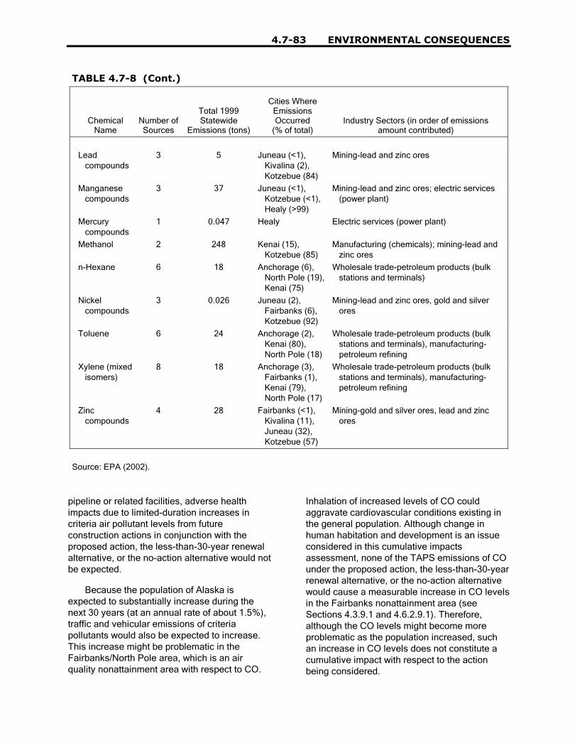
4.7-83 ENVIRONMENTAL CONSEQUENCES
TABLE 4.7-8 (Cont.)
ChemicalName
Number ofSources
Total 1999Statewide
Emissions (tons)
Cities WhereEmissionsOccurred
(% of total)Industry Sectors (in order of emissions
amount contributed)
Lead compounds
3 5 Juneau (<1), Kivalina (2), Kotzebue (84)
Mining-lead and zinc ores
Manganese compounds
3 37 Juneau (<1), Kotzebue (<1), Healy (>99)
Mining-lead and zinc ores; electric services (power plant)
Mercury compounds
1 0.047 Healy Electric services (power plant)
Methanol 2 248 Kenai (15), Kotzebue (85)
Manufacturing (chemicals); mining-lead and zinc ores
n-Hexane 6 18 Anchorage (6), North Pole (19), Kenai (75)
Wholesale trade-petroleum products (bulk stations and terminals)
Nickel compounds
3 0.026 Juneau (2), Fairbanks (6), Kotzebue (92)
Mining-lead and zinc ores, gold and silver ores
Toluene 6 24 Anchorage (2), Kenai (80), North Pole (18)
Wholesale trade-petroleum products (bulk stations and terminals), manufacturing- petroleum refining
Xylene (mixed isomers)
8 18 Anchorage (3), Fairbanks (1), Kenai (79), North Pole (17)
Wholesale trade-petroleum products (bulk stations and terminals), manufacturing- petroleum refining
Zinc compounds
4 28 Fairbanks (<1), Kivalina (11), Juneau (32), Kotzebue (57)
Mining-gold and silver ores, lead and zinc ores
Source: EPA (2002).
pipeline or related facilities, adverse healthimpacts due to limited-duration increases incriteria air pollutant levels from futureconstruction actions in conjunction with theproposed action, the less-than-30-year renewalalternative, or the no-action alternative would notbe expected.
Because the population of Alaska isexpected to substantially increase during thenext 30 years (at an annual rate of about 1.5%),traffic and vehicular emissions of criteriapollutants would also be expected to increase.This increase might be problematic in theFairbanks/North Pole area, which is an airquality nonattainment area with respect to CO.
Inhalation of increased levels of CO couldaggravate cardiovascular conditions existing inthe general population. Although change inhuman habitation and development is an issueconsidered in this cumulative impactsassessment, none of the TAPS emissions of COunder the proposed action, the less-than-30-yearrenewal alternative, or the no-action alternativewould cause a measurable increase in CO levelsin the Fairbanks nonattainment area (seeSections 4.3.9.1 and 4.6.2.9.1). Therefore,although the CO levels might become moreproblematic as the population increased, suchan increase in CO levels does not constitute acumulative impact with respect to the actionbeing considered.

ENVIRONMENTAL CONSEQUENCES 4.7-84
Air Emissions, Accidents, andSpills. Under the proposed action and theno action alternative, it was determined that thepotential for serious adverse health impactsexists from inhalation of contaminants emittedfrom spills or fires for people who remain withinmaximum impact distance areas (0.02, 0.4, and4 km; and 0.2 km, respectively). Numeroushazardous materials would be used and storedin association with some of the actionsconsidered in this cumulative impactsassessment, especially oil and gas exploration,development, and production; oil refining; and oiland gas transportation. Human health and safetyimpacts from accidental releases of hazardousmaterials could result in exposures tocontaminated air, soils, groundwater, or food.However, the potential for additional cumulativeadverse impacts from accidental releases issmall for the following reasons. First, it isunlikely that accidental releases would occur atthe same time and in close proximity to eachother. Second, existing regulations require timelycleanup of environmental media contaminatedby spills, so that the possibility of prolongedhuman exposure would be limited.
The potential for ingestion or dermalexposure of the general public to soils andgroundwater contaminated due to spills ofhazardous materials is very low, because thereis extensive regulation with regard to thecontainment and cleanup of spill sites. Becausespills onto gravel or soil surfaces must becleaned up according to the ADECrequirements, there should be no completeexposure pathways or elevated concentrationsremaining after remediation of these types ofspill sites and, therefore, no long-term healthimpacts from exposure to contaminants in soil.
The cumulative assessment of human healthand safety impacts from environmental releasesis limited to the general public and does notinclude occupational exposures for cleanupworkers or employees at the various plants andfacilities. Protection of these workers isregulated under the Occupational Health andSafety Act and is beyond the scope of thisassessment.
Potential for Exposure toPersistent, Bioaccumulative, andToxic Chemicals. An extensive discussion ofthe sources and toxicity of PBT chemicals ofconcern is provided in Section 3.17. The PBTcontaminants include persistent organicpollutants (POPs) such as certain pesticides,PCBs, some PAHs, and the heavy metalmercury. (Radionuclides are not listed as PBTsby the EPA but are also of some concern.)These persistent contaminants generallyoriginate outside of Alaska but are depositedthere as a result of long-range transport. Theymay persist longer in the Arctic environment thanin other locations because of the lowertemperatures. In the Arctic ecosystem, the PBTsaccumulate and are concentrated in the fat andorgan meats of animals at upper levels of thefood chain. Traditional use of these animals aspart of the diet is a pathway of exposure to thesecontaminants, especially for Alaska Natives.
As discussed in Section 3.17, levels of PCBsand mercury in tissues of Alaska Natives andothers regularly consuming contaminated gamemay be elevated, and these exposures couldcause a variety of adverse health impacts. Themajor source of these contaminants is long-range atmospheric transport from industrializedareas in many countries. PCB production hasbeen stopped in most countries, but poordisposal practices may result in continuedreleases to the atmosphere. The major sourcesof mercury in the atmosphere are burning ofcoal, municipal waste, medical waste, andhazardous waste; operation of motor vehicles;and production of chlorine (EPA 2001a). Theoperation of the TAPS is not known to result inany emissions of PCBs or mercury; thesechemicals are also not expected to beassociated with the no-action alternative norwould the no action or less-than-30-year renewalalternatives reduce the cumulative emissions,PCBs, or mercury. Similarly, the otherforeseeable actions considered in thiscumulative impact assessment (i.e., oil and gasexploration, development, and production on theNorth Slope; construction and operation of fuelgas pipelines; land management activities;

4.7-85 ENVIRONMENTAL CONSEQUENCES
human habitation and development; and naturalresource use) would not be expected to result inemissions of PCBs or mercury. Therefore,additional cumulative adverse health impactsfrom exposure to these contaminants would notbe likely.
The PAH benzo[a]pyrene has also beendesignated as a PBT (EPA 2001b). PAHs are aconstituent of crude oil and refined oil productsand were a major contaminant of concern withrespect to food pathways after the Exxon Valdezoil spill (Field et al. 1999). There is also anongoing debate about the sources of PAHs inPWS, including past anathropogenic sourcesand natural background from oil seeps, oilyshales, and coal (see Section 3.11.3). Oil spillsin the marine environment have the mostpotential for foodchain impacts, because ofbioaccumulation in shellfish (seeSection 4.4.4.7.3). Of the actions assessed inthis cumulative impacts evaluation, oil and gasexploration, development, production, andtransportation involve risk of a spill in either theNorth Slope or Prince William Sound marineenvironment. On the basis of an analysis of thedata from the Exxon Valdez oil spill, the long-term human health impacts of these spills fromuptake in the foodchain are not insignificant butare on the same order as those from ingestion ofsmoked meats and fish. It is possible thatincreased digestive cancer incidence ratesamong Alaska Natives (see Section 3.17) areassociated with dietary PAH exposures, but thisspeculation has not been confirmed with data.
4.7.6.11.3 Summary. Possiblecumulative impacts of reasonably foreseeableactions, in conjunction with the proposed action,the less-than-30-year renewal alternative, or theno-action alternative, to workers and the generalpublic were considered in this section. The typesof actions that could have cumulative impacts onhuman health and safety include oil and gasexploration, development, and production on theNorth Slope; construction and operation of fuelgas pipelines (e.g., the natural gas pipeline);land management activities; human habitationand development; and natural resource use.
Occupational. The risk faced by workers,as defined by traumatic occupational fatality
rates, is already considerably elevated inAlaska, particularly as a result of the water andair transport required for various hazardousoccupations there (e.g., fishing, farming, logging,mining, and manufacturing). With the exceptionof workers involved in the construction ofproposed natural gas project, relatively smallnumbers of workers would be involved in othercumulative actions (e.g., oil refining, oil and gasexploration, oil storage), and their risks ofinjuries and fatalities from physical hazards areexpected to be in line with the historical rates,especially for the transportation/communications/public utilities-related andconstruction-related cumulative activities.Similar to the TAPS, potential fatalities andinjuries from a natural gas pipeline would beexpected on the basis of construction andpipeline industry incidence rates, the number ofFTEs, and the number of years of constructionand operation. While such occupational hazardscan be minimized when workers adhere to safetystandards and use appropriate protectiveequipment, fatalities and injuries from on-the-jobaccidents can still occur. The use of bestmanagement practices for occupational healthand safety compliance is recommended toreduce statewide fatality and injury incidencerates from all of the actions in combination.
Another concern with respect tooccupational exposures is NORM. However,with standard operating procedures in place,there is little potential for any NORM exposurefrom oil production operations on the NorthSlope or during pipeline dismantlement.
The cumulative assessment of human healthand safety impacts from environmental releasesis limited to the general public and does notinclude occupational exposures for cleanupworkers or employees at the plants orcompression facilities. Protection of theseworkers is regulated under the OccupationalHealth and Safety Act and is beyond the scopeof this assessment.
Public. An assessment of potential healthimpacts from Valdez Marine Terminal air toxicsemissions was provided in Section 4.3.13.2.2. Itwas concluded that no adverse health impactswould be expected in association with theinhalation of those emissions throughout the

ENVIRONMENTAL CONSEQUENCES 4.7-86
renewal period. Some planned future projects inthe regions of interest (e.g., new natural gaspipelines) could result in additional VOCemissions, presumably with maximum emissionssimilar to or less than those associated withTAPS facilities. Unless a large new source ofVOC emissions is placed in the Valdez area(none currently planned), there should be noadverse health impacts from inhalation of VOCsfrom all the industrial sources combined.
Another important source of some of thesame VOCs that are emitted from TAPS facilitiesis motor vehicle emissions. Auto emissionswould be expected to increase over the renewalperiod as the state population and automobiletransportation increased. An increased cancerrisk of about 3 × 10⁻⁵ has been estimated forresidents of Valdez from benzene inhalationfrom all sources. As sources such as motorvehicle emissions increase over the next30 years, additional emission controls on mobileand point sources might be needed to minimizeincreasing cancer risks, under any of thealternatives.
During construction of a natural gas pipeline,the main type of emission of concern during the2- to 3-year construction period would mostlikely be criteria pollutants generated fromexcavation, heavy equipment operation, andvehicles used for transporting workers and rawmaterials. Unless residential areas were locatedin close proximity to the pipeline or relatedfacilities, adverse health impacts due to limited-duration increases in criteria air pollutant levelsfrom future construction actions in conjunctionwith the proposed action or the no-actionalternative would not be expected.
The projected increase in the population ofAlaska over the next 30 years might beproblematic in the Fairbanks/North Pole area,which is an air quality nonattainment area withrespect to CO. However, none of the TAPSemissions of CO under the proposed action oralternatives would cause a measurable increasein CO levels in the Fairbanks nonattainmentarea (see Sections 4.3.9.1 and 4.6.2.9.1).Therefore, although the CO levels might becomemore problematic as the population increased,such an increase in CO levels does not
constitute a cumulative impact with respect tothe action being considered.
Numerous hazardous materials would beused and stored in association with some of theactions considered in this cumulative impactsassessment, especially oil and gas exploration,development, and production; oil refining; and oiland gas transportation. Human health and safetyimpacts from accidental releases of hazardousmaterials could result in exposures tocontaminated air, soils, groundwater, or food.However, the potential for additional cumulativeadverse impacts from accidental releases isrelatively small.
The potential for ingestion or dermalexposure of the general public to soils andgroundwater contaminated due to spills ofhazardous materials is very low, because thereis extensive regulation with regard to thecontainment and cleanup of spill sites. Becausespills onto gravel or soil surfaces must becleaned up according to these ADECrequirements, there should be no completeexposure pathways or elevated concentrationsremaining after remediation of these types ofspill sites and, therefore, no long-term healthimpacts from exposure to contaminants in soil.
Levels of two PBT contaminants (PCBs andmercury) in tissues of Alaska Natives and othersregularly consuming contaminated game may beelevated, and these exposures could cause avariety of adverse health impacts. The operationof the TAPS is not known to result in anyemissions of PCBs or mercury. Similarly, theother foreseeable actions considered in thiscumulative impact assessment would not beexpected to result in emissions of PCBs ormercury. Therefore, additional cumulativeadverse health impacts from exposure to thesecontaminants would not be likely.
Oil spills in the marine environment have themost potential for foodchain impacts, because ofbioaccumulation of PAHs in shellfish (seeSection 4.4.4.7.3). The long-term human healthimpacts of these spills from uptake in thefoodchain are not insignificant but are on thesame order as those from ingestion of smokedmeats and fish.

4.7-87 ENVIRONMENTAL CONSEQUENCES
4.7.7 Biological Resources
4.7.7.1 Terrestrial Vegetationand Wetlands
This section evaluates the cumulativeeffects of the proposed action, in combinationwith other past, present, and foreseeable futureactions, on terrestrial vegetation and wetlandscommunities. This cumulative effectsassessment evaluates impacts in and along theBeaufort Sea, North Slope, Interior Alaska, andPrince William Sound.
The cumulative effects of past actions haveresulted in the existing conditions described inSection 3.18. In general, the greatest overalleffects within the region of TAPS influence havebeen caused by oil and gas production andtransportation. However, the cumulative effectson the major vegetative zones through which theTAPS passes have generally been minor. Futureactions that have the potential to affect terrestrialand wetland vegetative communities arepresented in Table 4.7-2 and include oil and gasexploration, development, and production; oilrefining; oil and gas transport; oil storage; humanhabitation and development; transportation; landmanagement activities and plans; naturalresource use; and petroleum spills.
These actions could impact vegetation bymeans of a number of impacting factors.Table 4.7-7 identifies the activities and impactingfactors associated with these actions.Construction activities would disturb soil andprobably involve physical injury to vegetation orremoval of vegetation within the disturbed area.In areas with a high proportion of wetlands, suchas the Arctic Coastal Plain, or duringconstruction of large projects, such as a naturalgas pipeline, wetlands could be filled in. Theplacement of gravel to construct drilling pads,workpads, or service roads would eliminate localvegetation and alter local hydrologic regimes,which could adversely affect terrestrial andwetland communities. These activities wouldalso produce fugitive dust, which could injure orkill vegetation and alter vegetative communitiesby reducing vegetative cover, altering local soiland permafrost conditions, and changingspecies composition. Erosion from construction
sites could result in the sedimentation ofvegetative communities, particularly wetlandcommunities. Sediments could injure or killvegetation and alter vegetative communities.
Disturbances to vegetative communitieswould generally require restoration of theaffected site and revegetation efforts. Vegetativecommunities that would then becomeestablished might not represent local naturalcommunity types and might include non-nativespecies, which could become dominant orinvade undisturbed natural areas. Activities thatdisturbed the soil or remove vegetation couldresult in changes to the underlying permafrost,causing thermokarst. Terrestrial vegetativecommunities and some wetland communitiesmight be eliminated by thermokarst-inducedinundation.
Spills of crude oil, diesel oil, or other fluidsmight result from activities associated with anyof the major actions contributing to cumulativeeffects. Spills could injure or kill vegetation,potentially leaving affected areas unvegetated orsparsely vegetated. Impacted soils might requireextended periods of time to revegetate. Smallspills, however, which would be consideredlikely or anticipated events (see Section 4.4.1 forspill frequency definitions) would be cleaned upand would generally have negligible to minorcumulative effects on the terrestrial vegetationand wetland communities of the four majorvegetation zones. Large spills, which would beconsidered unlikely or very unlikely events,would have greater effects but would not beconsidered reasonably foreseeable futureevents. (See Section 4.4.4.9 for a discussion ofthe effects of spills on terrestrial vegetation andwetlands.)
Activities associated with transportationmight result in impacts to terrestrial vegetationand wetlands from the generation of fugitivedust, particularly along unpaved highways,such as the Dalton Highway. Oil and gastransportation might also involve theconstruction of pipelines. The elimination ofterrestrial and wetland communities might occuron a large scale during the construction of anextensive pipeline system, such as a natural gaspipeline, resulting in major impacts tovegetation. Large-scale restoration andrevegetation activities might be required. Past

ENVIRONMENTAL CONSEQUENCES 4.7-88
construction projects, such as TAPS and theconstruction of drilling pads on the North Slope,have involved extensive vegetation restoration.Pipeline construction and operation might alsoresult in permafrost changes and accidentalpetroleum spills. The loading and transport of oiltankers might also result in accidental spills ofcrude oil.
Other than oil and gas production, miningand logging are the primary activities that useresources. Mining includes the extraction ofminerals (such as gold, silver, lead, and zinc)and sand and gravel mining for constructionmaterials, primarily for oil field development.Mining operations for sand and gravel and placergold mining might remove large quantities ofstream bed deposits and also riparian vegetativecommunities. The alteration of hydrologicregimes or surface water drainage patternscould adversely affect vegetation by increasingor decreasing soil moisture or inundation. Miningactivities might result in soil disturbance, dust,erosion, and sedimentation. Logging operationswould remove or alter existing vegetation onlogged sites and could also result in soildisturbance, dust, erosion, and sedimentation.Logged sites generally progress throughsuccessional stages to mature forest over time.Harvesting of plant material from naturalvegetative communities is often associated withhuman settlements. The acquisition of firewood,building materials, and edible plants or fruitmight result in local impacts to vegetativecommunities.
Certain phenomena can also impactterrestrial and wetland vegetation. For example,global warming might result in changes topermafrost and alter many vegetativecommunities throughout the state of Alaska.Natural pests, such as the spruce bark beetle,might also cause changes in the structure orcomposition of forest communities.
4.7.7.1.1 Beaufort Sea. Theconstruction and operation of facilities for oilexploration and production would includeoffshore gravel islands, Beaufort Sea shoremodifications, new access roads, and pipelines.Losses of vegetative communities might resultfrom direct removal, sedimentation, or spills andmight include marine vegetative communities or
coastal marshes. The cumulative impacts ofthese actions on the Beaufort Sea would beexpected to be minor. For cumulative impactsunder both the proposed action and the less-than-30-year renewal alternative, there would bea negligible effect on vegetation near theBeaufort Sea, unless there was a large oil spill(see Section 4.4.4.9). The contribution tocumulative effects from TAPS to impactvegetation near the Beaufort Sea would benegligible because TAPS does not occur in thatarea. Under the no-action alternative, structuresfor oil exploration and drilling in the Beaufort Seawould not be constructed, and associatedimpacts to vegetation would not occur. Impactsto the Beaufort Sea from TAPS terminationactivities would not be expected, since thesystem does not extend into this region.
4.7.7.1.2 North Slope. Impacts tovegetation would result from the constructionand use of drilling pads, modifications of streambanks and channels, new access roads,pipelines, and use of sand and gravel miningsites. Although oil and gas exploration,development, and production are expected tocontinue on the North Slope, the area of impactfrom individual drilling or production sites hasbecome considerably smaller over the past30 years as advances in technology havereduced the area required for well pads. Lossesof vegetative communities might result fromdirect removal, sedimentation, or spills; thesecommunities might include lowland and uplandtundra. However, less than 1% of the vegetationof the Arctic Coastal Plain would likely beimpacted by oil development (BLM 1998).Construction of a natural gas transportationsystem would also impact vegetation on theNorth Slope in the vicinity of existing oilproduction facilities and near the TAPS ROW.The cumulative effects of these activities onNorth Slope terrestrial vegetation and wetlandswould be expected to be minor. Very little newconstruction or other major disturbance ofvegetation on the North Slope is anticipated forcontinued operation of the TAPS. Thecontribution to cumulative impacts from thecontinued operation of the TAPS would beminor, unless there was a large oil spill (seeSection 4.4.4.9). Under the no-action alternative,impacts to vegetation from the construction of oil
4.7-89 ENVIRONMENTAL CONSEQUENCES
exploration and drilling structures would notoccur. Impacts to the North Slope vegetationcommunities from TAPS termination activitieswould result in a small temporary contribution tocumulative impacts and an increase in NorthSlope communities over the long-term, althoughthe increase would be very small relative to thetotal area of upland and lowland tundravegetation zones.
4.7.7.1.3 Interior Alaska. Impacts tovegetation would result from the constructionand use of new access roads, a natural gaspipeline, modifications of stream banks andchannels, use of sand and gravel mining sitesland development, logging, and other naturalresource use. Losses of vegetative communitiesmight result from direct removal, sedimentation,or spills; these communities might includeupland tundra, boreal forest, and coastal forest.The cumulative effects of these activities on theinterior terrestrial vegetation and wetlands wouldbe expected to be minor. Very little newconstruction or other major disturbance ofvegetation in Interior Alaska is anticipated forcontinued operation of the TAPS. Thecontribution to cumulative impacts from thecontinued operation of the TAPS, under both theproposed action and the less-than-30-yearrenewal alternative, would be minor, unlessthere was a large oil spill (see Section 4.4.4.9).Impacts to boreal forest, coastal forest, andupland tundra communities from terminationactivities under the no-action alternative wouldresult in a small temporary contribution tocumulative impacts and a long-term increase invegetation communities, although the increasewould be very small relative to the boreal forest,coastal forest, and upland tundra vegetationzones.
4.7.7.1.4 Prince William Sound.Loss of vegetative communities might resultfrom direct removal, sedimentation, or spills;these communities might include marinevegetative communities or coastal marshes. Thecumulative effects of activities affecting theseresources, such as oil storage andtransportation, land development, logging, andnatural resource use on the terrestrial vegetationand wetlands would be expected to be minor.The continued operation of the TAPS would
have a negligible effect on Prince WilliamSound, under the proposed action and less-than-30-year renewal alternative, unless there was alarge oil spill (see Section 4.4.4.9). Thus, thecontribution to cumulative effects from the TAPSwould be negligible. Under the no-actionalternative, oil storage and transportation wouldcease and associated impacts to terrestrialvegetation and wetlands would not occur.Impacts to Prince William Sound communitiesfrom TAPS termination activities would make avery small contribution to cumulative impacts.Cumulative impacts to vegetation wouldcontinue from all other activities not related to oiltransportation.
4.7.7.1.5 Summary. The cumulativeeffects on terrestrial vegetation and wetlandswould be minor, relative to the extent of the fourmajor vegetation zones (lowland tundra, uplandtundra, boreal forest, coastal forest) within theTAPS region of influence, and the Beaufort Seaand Prince William Sound.
The contribution to cumulative effects onterrestrial vegetation and wetlands from thecontinued operation of the TAPS under theproposed action, less-than-30-year renewalalternative, and no-action alternative would besmall.
4.7.7.2 Fish
This section evaluates the cumulativeimpacts of the proposed action (Section 4.3.16)in combination with other past, present, andforeseeable future activities on fish. Thus,impacts associated with actions in the BeaufortSea, the North Slope, Interior Alaska, and inPrince William Sound are considered foranadromous, diadromous (freshwater fish thatoverwinter in freshwater but disperse into low-salinity coastal waters during the summer tofeed) and strictly freshwater fishes. The �otheractions� that are considered in this cumulativeimpacts evaluation include (1) oil and gasexploration, development, and production; (2) oiland gas transportation; (3) human habitation anddevelopment; (4) legislative actions; (5) landmanagement activities; (6) natural resource use;and (7) spills (Table 4.7-2). Additionalinformation on the scopes of these activities is

ENVIRONMENTAL CONSEQUENCES 4.7-90
presented in Section 4.7.4. As for the proposedaction (Section 4.3.16), these other actions canaffect fish in a variety of ways that can bebroadly categorized into impacts that result from:
• Alteration and loss of fish habitat;
• Obstructions to fish passage;
• Increased human access; and
• Effects of oil, fuel, and chemical spills.
4.7.7.2.1 Alteration and Loss ofHabitat. Actions on the North Slope, in theBeaufort Sea, and in Prince William Sound mightall cumulatively contribute to the alteration andloss of resources and habitat for fish that occurthere and use habitats along the TAPS ROW. Oilexploration activities, offshore constructiondischarges, and offshore dredging or trenchingmight alter marine habitats and influenceplanktonic and benthic marine invertebrates andfish (USACE 1984, 1999) that serve as food foranadromous and diadromous fish. Similarimpacts to anadromous fish could occur inPrince William Sound as a result of constructionactivities, dredging, or runoff from industrialsites. Affected areas would probably be moreturbid than normal, and this turbidity could affectvisual distances for feeding fish. Because mostNorth Slope construction occurs in the winterwhen there is prolonged darkness and thick icecover, phytoplankton photosynthesis would notlikely be substantially affected. Heavydownstream sedimentation from construction oroil production activities could smother thebenthos in localized areas, but effects wouldprobably not to be widespread. In general,species occupying these areas have adapted todynamic conditions, and they react to short-termfluctuations in water quality and habitat by eitherenduring and functioning under those conditionsor moving out of the impact zone. Recolonizationof affected areas by benthic organisms insurrounding areas would probably occurrelatively rapidly in most cases. An exceptionwould be the Boulder Patch community that liesabout 6 mi seaward of the Sagavanirktok Riverdelta. This community of epilithic flora and faunainhabits an isolated area of rock substrate inStefansson Sound (Dunton and Schonberg2000). Organisms occupying the Boulder Patch
are at risk from localized impacts because theyare immobile, occupy a relatively smallgeographic area, and are an isolated communitythat cannot easily be repopulated fromsurrounding stocks. Offshore construction andtrenching in this area may require specialconsideration.
Another habitat alteration that may affect fishresources in Prince William Sound is theintroduction of nonnative organisms from theballast water of oil tankers. Some inboundtankers, especially the newer double-hulledtankers that are expected to become prevalentwithin the next 10 years, carry segregatedballast water (i.e., ballast water is separatedfrom the oil cargo compartments) that isdischarged directly into Port Valdez. Thesegregated ballast water can contain organismsthat are not native to Prince William Sound.Organisms introduced from other areas of theworld may become a nuisance in the absence ofpredator species to control population growth.Once established, nonindigenous species mayalso ecologically displace native species orsome species in the food chain upon which fishor other native aquatic organisms depend forsurvival. Hines and Ruiz (2000) investigated thenumbers and types of nonindigenous organismstransported into Prince William Sound in ballastwater. They concluded that large numbers ofplanktonic organisms are released into PrinceWilliam Sound with segregated ballast water andthat there is a high potential for the types oforganisms observed to survive in the waterconditions in Prince William Sound. On average,they found about 360 organisms per cubic foot ofwater in segregated ballast water samples.Although not all of these organisms werenonnative species, 14 nonnative species wererecorded (13 crustacean species and 1 fishspecies) from the 169 tankers sampled. Aprevious study (Ruiz and Hines 1997) found thatwhen nonsegregated ballast water (i.e., theballast water that is carried in oil-holdingcompartments) was introduced, it contained veryfew viable nonindigenous organisms. In addition,such water is processed in the BWTF beforebeing discharged into Port Valdez, making itunlikely that nonindigenous organisms would beintroduced. The tanker traffic used in support ofthe gas pipeline may be about 275/yr (TAPSOwners 2001a). This could add incrementally to

4.7-91 ENVIRONMENTAL CONSEQUENCES
the potential to introduce nonnative species intoPrince William Sound. However, ballast watertreatment would minimize this impact.
Oil and gas exploration and developmentcan affect fish, if ground- or vegetation-disturbing activities occur in or near waterwaysor if chemicals or wastes are discharged intowaterways. Loss of habitat in freshwatersystems can result from bank hardening,draining of water bodies, changes or temporarydiversions in river or stream channels,excavations of streambed materials, removal ofriparian vegetation, and changes in water qualityparameters. Permits are required under AlaskaTitle 16 for activities in or near streams thatcould affect anadromous fish and theirfreshwater habitat or the free and efficientmigrations of resident fish. Discharges of wastesand treated water from oil facilities must alsocomply with the Clean Water Act and NPDESpermits. Compliance minimizes the cumulativeeffects from the described actions on aquatichabitats.
Removal of freshwater from lakes toconstruct ice roads and pads and for otheroperations could also affect fish in these waterbodies. Withdrawal of water can reduce waterdepth in overwintering areas, thereby reducingtheir ability to support fish, and it can entrain fishthrough the pumps. Design considerations andmitigation are incorporated into these operationsto minimize impacts on fish. Water withdrawalswould continue to be required for future NorthSlope oil field developments, but efficient andappropriate regulation, compliance, andenforcement would reduce the potential impacts.Use of other options for obtaining water for iceroads and pads (e.g., desalination, use ofsnowmelt water, and water from floodingabandoned mine sites) may also limit potentialimpacts.
Construction of and maintenance operationsfor a gas pipeline would have impacts onfreshwater habitats similar to those of the TAPS.Inspection, monitoring, and prompt correctiveaction would be required to limit impacts.Increased public access as a result of newpipeline construction or development wouldprobably have only small impacts on fish habitat,primarily due to the increased erosion of streambanks by off-road vehicles and the increased
amount of dust deposited by vehicles travelingon unpaved roads. The development of otherindustries in the vicinity of the TAPS could alsohave impacts on freshwater habitats, dependingon the location and operational needs.
Alterations to freshwater habitats couldreduce fish survival and potentially affect fishpopulations. The Interior column of Table 4.7-2lists the activities that may impact freshwaterhabitats. These impacts would more likely occurif the alterations were allowed to persist formultiple years and if overwintering habitat wasaffected. However, such alterations wouldtypically be minor in scope and would notsubstantially affect fish populations. In addition,many potential impacts would probably beidentified and corrected before impacts topopulations ever occurred. Overall, cumulativeimpacts from alterations of freshwater habitats inthe vicinity of the TAPS would be low tomoderate under the proposed action.
Overall, the magnitude and geographicscope of impacts to fish habitats are likely to below. However, it is difficult to predict the potentialimpacts associated with biological organismsthat could be introduced via ballast water.
4.7.7.2.2 Obstructions to FishPassage. Drainage structures, such asculverts and low water crossings can impedefish migration and obstruct fish passage(Section 4.3.16). Generally, such impacts mayoccur intermittently at some, but not all, streamcrossings that require drainage structures or thatrequire vehicles to cross streams. Impacts atstream crossings are typically addressedthrough proper design and maintenance ofroads, pipeline river crossings, and culverts,coupled with regulation, monitoring, andcorrective actions.
Little or no discernable impact to fishpassage in freshwater habitats has occurred inNorth Slope oil fields as a result of pastactivities, and it is anticipated that this will alsobe the case for future North Slope oil fields.Construction and operation of a natural gaspipeline would likely have impacts similar tothose from the TAPS. For example, new roads,workpads, and buried pipeline crossings for anatural gas pipeline could impact new areas
ENVIRONMENTAL CONSEQUENCES 4.7-92
outside the TAPS ROW. Construction ofadditional roads and increased numbers ofworkers could result in more stream crossingsand more vehicles crossing streams in thevicinity of the TAPS. This may increase thefrequency of impacts to fish from obstructedpassage at disturbed stream crossing areas.Other activities that may be developed on theNorth Slope or in Interior Alaska (Table 4.7-2)could further increase such impacts, dependingon the applicable location, extent ofdevelopment, level of mitigation, and regulatorycontrol.
Inhibiting fish movement in streams canreduce access to spawning areas and potentiallyaffect fish populations. These results are morelikely if the obstructions are allowed to persist formultiple years. Fish passage in freshwaterhabitats has been a continuous maintenanceissue along the TAPS ROW, and it is also likelyto be an issue relatively frequently as a result ofthe cumulative actions described above.However, obstructions to fish passage wouldprobably be identified and corrected beforeimpacts to populations would occur. Given thegeographic extent and the large number ofstreams that could be affected by existing andproposed activities, fish populations in somefreshwater habitats may be affected over therenewal period. Overall, cumulative impactsfrom blocking fish passage in freshwater habitatsin the vicinity of the TAPS would be low tomoderate under the proposed action.
Cumulative impacts to anadromous ordiadromous species may occur as a result ofactivities that obstruct fish movement in marineenvironments. Under certain meteorologicalconditions, structures along the Beaufort Seamainland coast can also block the movements ofdiadromous fishes, particularly juveniles(Gallaway and Fechhelm 2000 and referencescited therein). Because many of these speciesavoid high-salinity, marine conditions, they tendto remain nearshore, where they forage up anddown the coast within a narrow band of warm,low-salinity water (Craig 1984). Causeways canimpede coastal movement either by directlyblocking fish or by modifying nearshore waterconditions to the point where they might becometoo cold and saline for these species. On theNorth Slope, this impact was identified as a
concern at West Dock and the EndicottCauseway, although actual impacts wereidentified only at West Dock. However, currentconstruction practices and mitigation effortshave shown that breaching can alleviateblockage (Gallaway and Fechhelm 2000 andreferences cited therein).
The locations of causeways relative tocoastal topography, local bathymetry, andfreshwater drainages also is critical indetermining their impact on the nearshoremigration corridor (Niedoroda and Colonell1990). For example, West Dock was constructedat the eastern end of an extensive brackish-water lagoon system (Simpson Lagoon) throughwhich fish disperse and migrate. The causewayextends seaward into the marine environmentenough beyond the 6-ft isobath to exacerbatecoastal mixing processes that sometimes blockthe movements of those fish. In contrast, theentire Endicott Causeway was constructedinside the 6-ft isobath and does not protrudeinto deeper marine waters. The onshoreencroachment of marine water is furtherimpeded by the freshwater discharge of theSagavanirktok River (Niedoroda and Colonell1990). As a result, cells of upwelled marinewater that develop at the Endicott Causeway arerestricted to the seaward tip of the causeway�swestern leg and do not reach the mainlandshore, where the water might otherwise disruptfish migrations (Hachmeister et al. 1991;Gallaway et al. 1991).
The proper siting of any future causeway tobe constructed along the Beaufort Sea is themost important consideration with regard to fishmovements. In many cases, breaching might beappropriate, depending on the site location andhydrography. Other structures constructed atoffshore facilities and artificial islands would notaffect diadromous fish habitat and would have alimited influence on anadromous species.
Although the impact from docks orcauseways may occur in the marine environmentof the Beaufort Sea, it is believed that there hasbeen little or no impact on fish movements fromdocks or causeways at the Valdez MarineTerminal or in Prince William Sound. Because ofthe extensive distributions and coastalmovements of marine and anadromous species,any additional terminal structures would

4.7-93 ENVIRONMENTAL CONSEQUENCES
probably affect only an insignificant number ofindividuals and a small geographic area.
4.7.7.2.3 Effects on FishPopulations from Increased HumanAccess. With an increase in human populationassociated with foreseeable future activities(Table 4.7-2), there would likely be additionalrecreational fishing pressure on fish populations.Currently, recreational fisheries are regulated tomaintain adequate stocks and are adjusted tocompensate for changes in fishing pressure.However, increased access could result inoverharvest if regulations and enforcement wereinadequate. The BLM and USACE (1988)reported that individuals of the species preferredfor harvest were smaller and less numerous afterthe construction of the TAPS in areas accessibleto anglers. While developments in remote areashave allowed access to previously unavailableharvest opportunities, large increases in fishingeffort and catches of desirable species such asArctic char, Arctic grayling, and lake trout werenot reflected in statewide harvest surveys (Burr2001) after the entire length of the DaltonHighway was opened in 1994. The potential foroverharvest is expected to be greater in northernareas because fish productivity is low.
In the North Slope oil fields and BeaufortSea, increased human access, with itsaccompanying increased fishing pressure, hasnot affected fish populations, although somesubsistence, sport, and commercial fishingoccur. Public access into Prince William Soundis increasing, and the combined effects ofcommercial, subsistence/personal use, andsport fishing could impact populations. Fishingactivities are managed by the ADF&G and theNational Marine Fisheries Service. Maintenanceof fish at the desired sizes and population levelshas been largely accomplished by regulationsestablished by the Alaska Board of Fish andenforced by ADF&G. In the vicinity of PrinceWilliam Sound, a number of anadromous fishhatcheries are also utilized to produce enoughfish to increase harvest above natural levels andto manage stocks. Consequently, the cumulativeimpact of increased human access to fishpopulations is expected to be minor.
4.7.7.2.4 Effects of Oil, Fuel, andChemical Spills on Fish. Oil, fuel, andchemical spills are a primary concern withregard to oil and gas development, production,and transportation. The potential impacts offreshwater spills (see Section 4.4.4.12) areprimarily localized and restricted to gravel padsat facilities or roads. Large spills into freshwaterhave not occurred. However, should one occurin the future, it could have substantial impacts onfish in the impacted area.
Large marine spills, such as the ExxonValdez oil spill, could potentially have largeimpacts on fish. Such spills could causemortality and injury to plankton, marineinvertebrates, and fish (USACE 1999). Whiledirect mortality of fish due to oil spills hasseldom been documented, impacts on fish innatural environments have been inferred on thebasis of laboratory studies. The Exxon Valdez oilspill probably had some impacts on fish,including pink salmon and herring, but there isno consensus on the extent and duration ofimpacts on these species (see Section 4.4.10.2).However, it appears that by 1995, fishpopulations and habitats had largely recovered.
Past oil spills along the TAPS and in theNorth Slope oil fields have been mainly confinedto land, but future leaks could reach watershedsand impact fish. The future operation of theTAPS, a gas pipeline, and other industrialactivity carry the risk of small-scale spills of oil,fuel, and chemicals from vehicles andmachinery. Present and future North Slope oilfield developments might have an impact on fish,particularly in the marine environment. Thepotential for spills from subsea pipelines andother sources for offshore developments in theBeaufort Sea was assessed previously (USACE1999). Impacts of spills in solid ice or broken icein this region may be particularly difficult to cleanup.
Gas production activities could increase therisk of impacts as a result of the increasedvolume of liquids transported through the gaspipeline and in tankers. The magnitude of therisk of such impacts would partly depend onfacility locations. Increased public access couldresult in some small spills from highwayvehicles, off-road vehicles, and boats.

ENVIRONMENTAL CONSEQUENCES 4.7-94
Although there is a potential for largeimpacts to fish from large oil spills, the risk ofsuch spills is relatively small (Section 4.4.1). Theprobability of smaller spills is higher, but theimpacts from such spills if they enteredfreshwater or marine habitats would probably besmall, temporary, and unlikely to severely affectfish populations; especially in light of spillresponse activities that are undertaken whenspill events occur.
4.7.7.2.5 Summary. On the NorthSlope and Beaufort Sea, the most importantfuture activities that could contribute tocumulative impacts on fish would be planned oiland gas development activities, oil and gastransportation, and natural resource use(e.g., subsistence). In Interior Alaska, futureactions that could contribute to cumulativeimpacts on fishes include oil and gas transport,other transportation activities, human habitationand development, and land managementactions. In Prince William Sound, future actionscontributing to cumulative impacts on fishinclude oil transport, other transportationactivities, (e.g., barging and cruise ships),human habitation, natural resource use(e.g., commercial, subsistence, and recreationalfishing), and land management activities.However, none of these activities are expectedto significantly increase cumulative impacts onfish or affect the viability of species� populations.Oil spills would not significantly add tocumulative impacts, except for an unlikely largespill to aquatic habitats, in which case impactssimilar to the Exxon Valdez oil spill could occur(see Section 4.4.4.10).
TAPS operations are only a smallcomponent of the cumulative impacts associatedwith the activities listed in Table 4.7-2. However,the indirect effects of the TAPS are a significantcontribution to cumulative impacts to fish,because of the interdependence of current andforeseeable future oil development, production,and transportation activities with the TAPS.
Cumulative impacts of the less-than-30-yearrenewal alternative on fish would be similar tothose of the proposed action. TAPS operations,monitoring, and maintenance activities; andother present and foreseeable actions wouldessentially be the same for both alternatives
(except for years of the TAPS renewal period).The shorter renewal period would not precludeany other current or foreseeable actions listed inTable 4.7-2 from occurring. Also, a subsequentrenewal option may be a possibility followingthe less-than-30-year renewal period. Thus,the differences in cumulative impacts betweenthe two alternatives would be negligible(e.g., differences would likely be within thesame order of magnitude).
Differences in cumulative impacts betweenthe no-action and the proposed-actionalternatives on fish would be more evident thanthose between the less-than-30-year renewalalternative and the proposed action, particularlywithin the North Slope. While activitiesassociated with gas production andtransportation would occur under bothalternatives; oil production and transportationwould be reduced to very low levels for the no-action alternative. Thus, most oil productionfacilities would be idled. Also, the incrementalchanges that would have occurred from future oilfield developments would not occur. Therefore,the level of impacts to fish within the North Slopewould be less for the no-action alternative,except for subsistence harvest levels that mayincrease. The potential for accidental oil spillswould also decline within the North Slope, alongthe TAPS ROW, and within Prince WilliamSound. However, the infrastructure required topromptly clean up any spills that might occurwithin these areas might not be available(e.g., response equipment and teams associatedwith the TAPS would not be present). Thepotential for introduction of nonnative organismswithin Prince William Sound would decreasefrom the decrease or elimination of oil tankertraffic within Prince William Sound.
4.7.7.3 Birds and Mammals
This section evaluates the cumulativeimpacts of the proposed action in combinationwith other reasonably foreseeable actions onbirds and terrestrial mammals. Past and presentactivities that contribute to cumulative impactsare part of the existing baseline and arediscussed in Sections 3.20 (birds) and 3.21(terrestrial mammals). Actions directlyassociated with the oil and gas industry thatcould contribute to cumulative impacts include

4.7-95 ENVIRONMENTAL CONSEQUENCES
ancillary facilities and infrastructure (e.g., pipe-lines, roads, landing strips, gravel mines, andpump stations), refineries, terminals, and tankertransport. Other actions within the region ofinfluence that could contribute to cumulativeimpacts include human habitation anddevelopment, transportation systems, naturalresource use (including subsisence and sporthunting), spills, and natural events (e.g., forestfires and insect infestations) (Section 4.7.4).Legislative actions and land managementactivities could also have a controlling influenceon the environment.
It is expected that in general, the cumulativeimpacts on birds and terrestrial mammals wouldbe similar to the impacts associated with theproposed action (Sections 4.3.17 and 4.4.4.11).Thus, cumulative actions could impact thesewildlife resources by (1) habitat loss, alteration,or enhancement; (2) disturbance or displace-ment; (3) mortality; (4) obstruction to movement;and (5) spills. The effects that these actions maycause include (1) immediate physical injury ordeath; (2) increased energy expenditures orchanges in physiological condition that mayreduce survival or reproduction rates; or(3) long-term changes in behavior, including thetraditional use of ranges (Calef et al. 1976).Possible differences between cumulativeimpacts and the impacts from the proposedaction would depend on the intensity(magnitude), scale (geographic area), duration,timing and frequency, synergy (impactinteraction), and likelihood of the impactsassociated with the cumulative actions (USACE1999).
4.7.7.3.1 Habitat Loss, Alteration,or Enhancement. Within the North Slope, oiland gas exploration, development, andproduction, along with the construction andoperation of ancillary facilities (e.g., gravelmines, roads, pipelines, and drill pads), couldresult in a cumulative reduction in habitat forwildlife. Future developments within the NorthSlope could result in continued habitat alteration,although new developments would have smallerfootprints and result in a relatively smallerimpact than in the past (TAPS Owners 2001a).The cumulative loss from all listed projects in theNorth Slope may have localized effects on thedistribution or density of some wildlife species
over the life of the oil fields (MMS 1998). Overall,fragmentation of the tundra by oil facilities hasnot been a major factor affecting bird use of thePrudhoe Bay oil field. There may have been arearrangement of birds, but there was probablyno net change in bird abundance (Troy andCarpenter 1990; TERA 1993). The potentialeffect on species such as caribou might not bemeasurable because of the natural variability,including productivity, of a large population(ADNR 1999).
Within the North Slope, more than21,550 acres have been filled and covered bygravel for airstrips, drill pads, roads, and otherstructures. This total includes 10,653 acresdistributed by mine sites and gravel placementwithin the oil fields and 10,900 acreas occupiedby the portion of TAPS within the North Slope(Ambrosius 2000; Gilders and Cronin 2000).However, this represents a very small portion(~0.02%) of the more than 56.8 million acres thatoccur within the Arctic Coastal Plain (Gildersand Cronin 2000).
The loss of wildlife habitat from thedevelopment projects represent a smalldecrease in the amount of available tundrahabitat in the North Slope (MMS 1998). Theavoidance by wildlife of areas near industrialdevelopments that might otherwise be usablehabitat (i.e., functional habitat loss) alsocontributes to the cumulative loss of habitatassociated with facility development (Cameronet al. 1995; Nellemann and Cameron 1998;James and Stuart-Smith 2000). However,cumulative impacts would be negligible becausethe amount of habitat physically affected wouldbe small compared to the amount available(ADNR 1999).
Gravel fill generally eliminates tundrahabitat. However, it can provide habitat for somespecies. For example, it provides insect reliefareas for caribou; denning habitat for arctic foxesand ground squirrels; and nesting sites forsemipalmated plover, ruddy turnstone, andBaird�s sandpiper; and feeding habitat forLapland longspurs (Pollard et al. 1990;Truett et al. 1994 and references cited therein).Arctic fox den density was found to be greaterwithin developed areas than on adjacentundeveloped tundra; using culverts and roadembankments as den sites (Ballard et al. 2000).

ENVIRONMENTAL CONSEQUENCES 4.7-96
Although structures may occasionally be abarrier to wildlife movements, they can provide ahaven from predators, pests, or weather, or aplatform for feeding, hunting, or nesting (Truettet al. 1994). In general, birds use gravel padsmore for feeding and resting than for nesting;while mammals rest and, less often, feed on thegravel pads (Pollard et al. 1990). Caribou usegravel pads and roads as insect relief habitatduring the mosquito season (June to mid-July)and use the shade of oil field structures whenoestrid flies are abundant (mid-July to earlyAugust). The availability of man-made insect-relief habitats may allow caribou to remain nearpreferred foraging habitats, thereby lesseningthe energy demands normally imposed uponcaribou during the insect season (Pollard et al.1996a).
Shorebirds and waterfowl commonly feedand rest on impoundments associated withgravel pads (Pollard et al. 1990). Pacific loonsnest and rear their young in impoundmentscreated by oil field developments (Kertell 1996).
Dust shadows might be increased by theaddition of roads, facility pads, and greater trafficloads associated with gas commercialization onthe North Slope. Construction of the natural gaspipeline would increase traffic loads on theDalton Highway, contributing to the effect in theTAPS study area. The dust shadows affect alimited amount of habitat but will continue aslong as heavy traffic occurs on gravel roads.Cumulative impacts of dust shadows on wildlifewould be similar to those addressed inSection 4.3.17.1.
A new North Slope oil field could requirepermanent gravel roads and pads for productionfacilities, which would incrementally increase thearea affected by changes in drainage patterns.However, the footprint for new developmentswould require less area than in the past. Forexample, the �P� Pad built in the Prudhoe BayOil Field is 70% smaller than the �A� Pad built inthe 1970s (Gilders and Cronin 2000). Theconstruction of a natural gas pipeline would alsocontribute to these types of effects on wetlands,because trenching for the pipeline, burial of thepipeline, and placement of gravel for compressorstations and access roads would cover wetlandsites and affect natural drainage patterns. If thegas pipeline was routed approximately parallel to
the TAPS alignment, impacts could beminimized if the existing TAPS workpad, accessroads, stream crossings, and material sites wereused when feasible (TAPS Owners 2001a).
Construction of natural gas pipeline woulddisturb up to 23,216 acres of habitat (TAPSOwners 2001a). Because the gas pipeline wouldbe buried, impacts would be short term, lastingduring the construction period and time requiredfor revegetation. However, to allow access to thepipeline, the overlying ROW would bemaintained in an early stage of succession(i.e., in boreal forest areas), similar to that of theTAPS ROW. This could total up to about8,425 acres during the period of gas pipelineoperation (TAPS Owners 2001a). The gascondition facility would require an area of about300 acres (TAPS Owners 2001a) within the56.8 million acre North Slope. A further390 acres of habitat may be disturbed forconstruction of a gas liquefication plant atValdez, if this option were selected (TAPSOwners 2001a).
Several studies have documented that birdssuch as raptors perch and nest on oil field andpipeline structures and that swallows and otherbirds nest on structures at several TAPS pumpstations (see Section 4.3.17.1). Similarly, Pollardet al. (1990) and Rodrigues (1992) documentedextensive use of gravel pads and adjacentdisturbed sites in the North Slope oil fields bybirds. Offshore artificial drilling islands wouldprovide new artificial habitats that would attractbirds (USACE 1999). This situation wasdocumented on the Endicott Causeway, whichwas colonized by common eiders. In addition,molting long-tailed ducks aggregate on theleeward side of the causeway (TAPS Owners2001a). Present and future oil and gasdevelopment on the North Slope, particularlyoffshore in the Beaufort Sea, might involve theconstruction of more offshore islands, whichwould likely provide more nesting and moltinghabitat for birds.
4.7.7.3.2 Disturbance orDisplacement. High levels of air and vehicletraffic are associated with the petroleum industryin the North Slope. For example, up to 1,200helicopter trips per year have taken place just tosupport offshore development. Such activities

4.7-97 ENVIRONMENTAL CONSEQUENCES
could cause short-term displacement of nesting,feeding, and/or molting birds (MMS 1998).Traffic and human activity associated with theTAPS and the Dalton Highway can disturbfemale caribou with young calves (Cameron andWhitten 1980); while roads, pipelines, andhuman activitiy may block, delay, or deflectindividual caribou as they move through thePrudhoe Bay oil field (Pollard et al. 1996a).Nevertheless, movements of large groups ofcaribou do occur through the oil fields(Pollard et al. 1996b). Pregnant and maternalcows are sensitive to human activities within theNorth Slope (Cameron et al. 1985). They willavoid roads with relatively low traffic levels(e.g., < 100 vehicles/day) for about two weeksfollowing partuition and tend to remain > 0.6 mifrom roads (Cronin et al. 1994). Caribou bullsin general and all caribou during the insectharassment are least likely to avoiddevelopments (Wolfe et al. 2000).Cameron et al. (1992) observed that the calvingcaribou of the Central Arctic caribou herd weredisplaced outward after construction of the MilnePoint road system; relative densities within1.2 mi of the road system decreased by overtwo-thirds. Similarly, Nellemann and Cameron(1998) observed that increasing density of roadsin the Kuparuk Development Area near PrudhoeBay decreased caribou density. Cariboudensities declined by 63% when there were0.0 to 0.5 mi of roads/mi2 and declined by 86%when there were more than 1.9 to 2.8 mi ofroads/mi2. The higher road densities virtuallyexcluded cow-calf pairs (Nellemann andCameron 1998). In contrast, Carruthers andJakimchuk (1987) did not observe traditionalmigration of the Nelchina caribou herd (in theGulkana River area) to be affected by the TAPSand the Richardson Highway.
During the post-calving season, cariboudistribution is largely unrelated to distance frominfrastructure; they regularly occur within the oilfields, and they often occur close toinfrastructure (Cronin et al. 1998a). Althoughsome level of cumulative effect to caribou islikely from petroleum development, clearseparation of the cumulative effects from naturalvariation in caribou habitat use and demographyis difficult (Wolfe et al. 2000). No population-level impacts to any wildlife species have been
documented (reviewed in Truett and Johnson2000).
Helicopter and fixed-wing aircraft flightsassociated with the multitude of North Slopeprojects could result in combined or repeateddisturbances to wildlife. Such impacts could beeffectively reduced by restricting flight paths toavoid sensitive nesting areas during activebreeding and brood-rearing periods and byestablishing minimum flight altitudes to reduceground-level noise (USACE 1999). While a fewspecies, such as wolves and foxes, habituate tohuman presence, they are neverthelessdisturbed by aircraft and other vehicles (ADNR1999). Brant react to aircraft by alert posturing,running, or entering water. Interruptions offeeding may have deleterious effects on bodyreserves; and molting birds that move toundisturbed areas would be exposed topredators within the open tundra. A singleaircraft could disturb birds from dozens of lakesin its flight path (Simpson et al. 1982). Repeatedexposure of caribou to low-level military jetoverflights, especially during sensitive periods,may reduce calf survival and increase dailyactivities (Calef et al. 1976; Maier et al. 1998;Wolfe et al. 2000). Females of the Delta caribouherd with newborn calves apparently move awayfrom areas where they are disturbed by jetaircraft overflights (Murphy et al. 1993).However, Valkenburg and Davis (1984) believethat the effects of disturbance from hunters onsnowmobiles may be more important thanaircraft overflights.
Traffic along hundreds of miles of existingand future pipeline roads could disturb anddisplace wildlife. Disturbance to caribou wouldbe generally short-term (e.g., a few hours orless). Less time spent lying and more timemoving about are the two consistent reactions bycaribou to disturbance. Disruption of the feedingand resting cycle, accompanied by increasedenergy expenditures by running may contributeto energetic stress (Murphy and Curatolo 1987).If calving caribou are displaced from a high-quality forage area, there is a potential forlowered calf survival (ADNR 1999). To date, thecumulative impacts of North Slope oil and gasdevelopments have caused minor displacementof the Central Arctic caribou herd from a smallportion of its calving range without an apparent
ENVIRONMENTAL CONSEQUENCES 4.7-98
adverse effect on herd abundance or overallproductivity.
Future North Slope oil field developmentsmay contribute to the disturbance anddisplacement of wildlife. However, mitigationmeasures, such as restricting the timing of theactivity and locating facilities away from nestingor calving areas, could minimize impacts.Operation of the gas pipeline project would havea negligible impact. Localized disturbances towildlife would occur during its construction.
In Prince William Sound, the cumulativeeffect of aircraft and vessel traffic associatedwith the oil industry, commercial andrecreational fishing, tourism, and othercommercial and recreational activities couldresult in long-term displacement of birds fromnesting and feeding habitats (MMS 1995).However, most effects of disturbance anddisplacement would be local and minor at thepopulation level because most species haverelatively low density (BLM 1998).
4.7.7.3.3 Mortality. The DaltonHighway has provided access to previouslyremote areas north of the Yukon River. Concernexists that this increased access has adverselyaffected moose, caribou, wolf, and bearpopulations as a result of increased harvests(McLellan 1989; Yokel 1999). The increase inAlaska�s human population since TAPSconstruction has also increased the huntingpressure on the state�s wildlife. ADF&G hasresponded to this pressure where necessary byrestricting seasons and bag limits and byimplementing predator control programs toincrease the number of ungulates available tohunt (see TAPS Owners 2001a).
Increased densities of predators andscavengers attracted to areas of human activitymay result in increased predation pressure onprey populations. This situation has recentlybecome a management issue, mainly forground-nesting birds on the North Slope (Day1998), but it is difficult to document. Increases inthe abundance of foxes are well-documented inthe North Slope oil fields (Burgess 2000).However, because pipeline facilities are moredispersed than are oil field facilities, this problemwould be small south of PS 1. Within the North
Slope, losses of birds due to elevated levels ofpredators would be in addition to lossesassociated with habitat loss, displacement, andso forth (BLM 1998).
Similarly, increased densities of predatorsand scavengers might increase the occurrenceand rate of transmission of wildlife diseases,including rabies (Follmann et al. 1988). Theprimary reservoir of rabies in the North Slopearea is the arctic fox, whereas south of theBrooks Range, the red fox and other carnivoresare sources of greater concern (Winkler 1975).
Other causes of wildlife mortality in Alaskainclude intentional mortality (i.e., sport andsubsistence harvest, management and researchmortality) and unintentional mortality(i.e., railroad and road kills; unreported harvests;defense of life and property mortality) (TAPSOwners 2001a). Vehicle collisions with terrestrialmammals, particularly moose, are an issue ofpublic safety as well as a source of wildlifemortality (TAPS Owners 2001a). Black bearscontinue to be a problem in Valdez as a result ofcity garbage management and lack of fencing atthe Valdez Marine Terminal (Schmidt 1999;Lawlor 1999; Shoulders 1999; Brown 1999).
Birds, especially those using early green-upareas in dust shadows along the TAPS ROW,could be killed by vehicles (Shoulders 1999;Schmidt 1999). Road kills have not been aproblem in the North Slope oil fields, althoughthere have been occasional mortalities ofcaribou and bears. The same trend would belikely during present and future North Slope oilfield developments and a gas transmission lineproject. A gas pipeline might increase traffic onhighways, particularly during construction. Thissituation would be unlikely to impact largenumbers of animals. Increased public accessmight increase the numbers of road kills fromValdez to the North Slope, while the NationalMissile Defense System is unlikely to have animpact. Traffic associated with other industrialactivities might result in road kills, depending onthe location and extent of developments.
Birds might also fly into structures,particularly offshore structures during periods offog. Also, some birds (e.g., cliff swallows) thatnest at the TAPS pump stations might fly into thepump station structures. Structures and bright

4.7-99 ENVIRONMENTAL CONSEQUENCES
lights at the Valdez Marine Terminal mightattract birds during inclement weather (Senner1999). Collisions normally occur during springand fall when birds are migrating through thearea. Although they could result in the loss ofindividual birds, the cumulative effect would notbe considered significant (USACE 1999).
In the North Slope oil fields, there is someanecdotal evidence for bird mortality atnearshore structures such as Endicott and at theseawater treatment plant at the end of the WestDock causeway. Bird mortality at suchstructures, however, has been intermittent andlocal and has involved only a few individuals.Present and future North Slope oil and gasdevelopments could also cause some birdmortalities. It has been postulated that lights atoffshore facilities such as Northstar might attractmigrating birds that could then collide withstructures (USACE 1999).
High predator populations in the North Slopeoil fields are associated with natural factors suchas high prey availability and natural den sites.However, because of the availability ofsupplemental food at the North Slope BoroughLandfill and in dumpsters throughout the NorthSlope oil fields, populations of predators, suchas bears, foxes, gulls, and ravens, haveincreased over the past three decades. Althoughthere is no definite cause-and-effect relationshipbetween human food and predator numbers,predators have adversely affected nestingsuccess of birds that nest on the ground,especially colonial nesting snow geese, andpossibly some ducks and shorebirds (TAPSOwners 2001a).
The introduction of exotic animals (mostlyfoxes, but also rats, voles, ground squirrels, andrabbits) has been among the most damagingsource of direct mortality to seabirds of all thefactors associated with human activity (Bailey1993). Unlike an oil spill or some other one-timecatastrophe, predators have a continuingnegative impact on seabird populations.Combined with this source of seabird loss is thedetrimental impact of large fish harvests onseabirds (e.g., seabirds are accidentally killed indrift gill nets, major shifts in fish stocks havealtered seabird food supplies, and possibleeffects of fish biomass) (Hatch and Piatt 2001).Disease, predation, fluctuations in prey, and
severe weather are among the naturalphenomena that also contribute to cumulativeimpacts on wildlife (MMS 1998).
The natural gas pipeline and other industrialdevelopments could result in more workerswithin remote areas and could increase huntingpressure depending on location and extent ofdevelopment. However, it is likely that firearmswill be prohibited from gas-pipeline constructionsites and facilities (as with APSC facilities today)and that hunting will be prohibited from the ROWof a gas pipeline, as with the TAPS ROW.Increased public access could result in thegreatest impact to wildlife through sport hunting,while an NMDS may bring more militarypersonnel who hunt, although hunting may beprohibited on the military site (TAPS Owners2001a).
The Central Arctic caribou herd hasincreased in size since oil field development andoperation began. Similar increases haveoccurred to all major caribou herds in northernAlaska and Canada, and are presumed to beindependent from the effects of oil fielddevelopment (Klein 1991). In fact, thepopulations of many wildlife populations thatspend at least part of the year in the vicinity of oilfields are either stable or larger than when oilfield development began. In addition to caribou,these include muskox, brown bear, polar bear,arctic fox, snow goose, brant, and otherwaterfowl and shorebirds (see Cronin et al.1986b).
4.7.7.3.4 Obstruction toMovement. Present and future North Slope oilfield developments could further obstruct wildlifemovements. For example, during the brood-rearing period when species such as brant areflightless, roads, causeways, and otherstructures could present a barrier to movement(ADNR 1999). Roby (1978) reported that duringsummer, caribou with calves were the groupmost sensitive to the Dalton Highway. Cariboucows with calves may be underrepresentedalong the Dalton Highway during the calvingseason due to avoidance of the road, habitatselection, or predator avoidance. Roads (withoutadjacent pipelines) that have heavy traffic(e.g., >60 vehicles/h) appear to impede cariboumovement. Pipeline-road combinations tend to

ENVIRONMENTAL CONSEQUENCES 4.7-100
have a synergistic effect on impeding cariboumovements (Curatolo and Murphy 1986;Cronin et al. 1994). Regardless, the CentralArctic Herd of caribou has grown in numberssince the mid-1970s (i.e., from about 5,000 in1978 to 20,000 in 1998), and any redistributionof caribou in the spring has apparently notadversely affected population growth (TAPSOwners 2001a). The ADF&G managementobjectives for this herd (10,000 individuals) arebeing met, and herd-levels impacts due to the oilfield are not apparent (Cronin et al. 1998b).
It is reasonable to expect that measuresdesigned to provide caribou and other largemammals with unimpeded movement(e.g., pipelines at least 5 ft aboveground andminimizing permanent roads alongsidepipelines) would also be used in the future.Therefore, cumulative impacts that wouldobstruct wildlife movements would be minor(USACE 1999).
The natural gas pipeline would have little orno impact on animal movements because only afew aboveground structures would be requiredon the North Slope and along the pipeline route.The gas pipeline would be buried and have noimpact, except during construction. The NMDSwould have very localized impacts in the area ofdevelopment. Increased public access couldresult in more highway traffic and increasedobstruction of wildlife movements. The impactfrom other industrial activity would depend on itsextent and location (TAPS Owners 2001a).
4.7.7.3.5 Spills. About 400 spills ofdiesel, crude, and hydraulic oils and othersubstances (e.g., drilling wastes and seawater)occur yearly in the North Slope. Many of the oilspills occur as a result of corroded infrastructure(Schmidt 2002). Multiple spills could adverselyaffect wildlife if more disturbances occurredwhile populations were still recovering from theinitial disturbance (USACE 1999). Potentially,tens of thousands of birds (e.g., long-tailedducks, common eider, and other sea ducks)could be killed as a result of oil spills within theBeaufort Sea over the life of the oil fields. Otherspecies, such as brant and snow geese, couldbe similarly affected by oil spills into coastal saltmarshes or the Sagavanirktok River delta,respectively (MMS 1998). Based on experience,
land-based spills of crude oil in the oil fields areuncommon and have only impacted tens ofacres. Diesel spills have been more commonand have affected hundreds of acres but mostlywithin gravel pads. Current management andcleanup techniques are effective in reducing theoccurrence of spills and in removing spills whenthey occur (Jorgenson 1997).
Present and future North Slope oil fielddevelopments could include more offshorefacilities, which would increase the potential formarine oil spills (USACE 1999). For example, oilpipelines will be used for the Northstardevelopment in the Alaskan Beaufort Sea, andfuel barges will be used for supply. Dependingon the time of year and the volume of the oilspill, several thousand birds could be affected bya spill in the Beaufort Sea (USACE 1999).Significant impacts could occur to post-nestingbirds that concentrate along the coast for broodrearing, molting, premigratory staging, ormigration (BLM 1998). Caribou could beimpacted by a large oil spill in the North Slope ifit occurred during the spring or insect-harassment period, when caribou are found incoastal waters or on beaches. However, onlyseveral hundred caribou, at most, might die fromoiling, and recovery would probably occur withinone generation (MMS 1998).
As discussed in Section 4.4.4.11, a land-based oil spill can contaminate individualanimals, their habitats, and their food resources.Species such as foxes may be attracted by deadoiled wildlife at a spill site or by human activityassociated with spill cleanup. A large spill wouldprobably disturb and displace most animals(other than foxes and other scavengers) from thearea due to extensive activities associated withspill cleanup activities (ADNR 1999). Leavingsome residual oil in place may be less damagingthan the potential long-term effects of intensivecleanup activities (Jorgenson and Cater 1996).
A large oil spill (e.g., from a tanker spill) inPrince William Sound could have deleteriousimpacts similar to those that resulted from theExxon Valdez oil spill. They could include theloss of hundreds of thousands of marine andcoastal birds, hundreds of eagles, and scores ofriver otters, bears, and deer. Smaller oil spillsand contamination routinely occur (e.g., fromnatural crude oil seeps, and from bunker and

4.7-101 ENVIRONMENTAL CONSEQUENCES
diesel fuel spills) (Burger and Fry 1993). Smalloil spills would have an additive effect, perhapscausing death to several thousand marine andcoastal birds, only a few river otters, and veryfew bears or deer. Bird losses would be anincremental addition to the hundreds ofthousands of birds that annually die in driftnetswithin the North Pacific, Bering Sea, and Gulf ofAlaska (MMS 1998). However, present andfuture oil transport through Prince William Soundis now safer than before the Exxon Valdez oilspill because of the implementation of theSERVS vessel escort system. In addition, theuse of double-hulled tankers in the future willadd further protection against potential tankerspills (TAPS Owners 2001a).
4.7.7.3.6 Summary. On the NorthSlope and in the Beaufort Sea, the mostimportant future activities that could contribute tocumulative impacts on birds and terrestrialmammals would be planned oil and gasdevelopment activities, oil and gastransportation, and natural resource use(e.g., subsistence). In Interior Alaska, futureactions that could contribute to the cumulativeimpacts on these species would include oil andgas transport, other transportation activities,human habitation and development, and landmanagement actions. For example, timberharvests and post-harvest management maydirectly and indirectly affect winter habitat ofcaribou through loss of lichen (Wolfe et al.2000). In Prince William Sound, future actionsthat could contribute to cumulative impacts onbirds and terrestrial mammals would includeoil transport, other transportation activities(e.g., barging and cruise ships), humanhabitation, natural resource use(e.g., commercial and recreational fishing,hunting, and trapping), and land managementactivities. However, it is expected that none ofthese activities would significantly increasecumulative impacts or affect the viability ofspecies� populations. Oil spills would notsignificantly add to cumulative impacts, exceptfor an unlikely to very unlikely large spill toaquatic habitats; in this case, impacts similar tothose from the Exxon Valdez oil spill could occur(see Section 4.4.4.11).
Impacts associated directly with the TAPSare only a small component of the cumulative
impacts associated with the activities listed inTable 4.7-2. However, the indirect effects of theTAPS are a significant contributor to cumulativeimpacts to birds, and terrestrial mammalsbecause of the interdependence of current andforeseeable oil development, production, andtransportation activities with the TAPS.
Cumulative impacts of the less-than-30-yearrenewal alternative on birds and terrestrialmammals would be similar to those of theproposed action. TAPS operations, monitoring,and maintenance activities; and other presentand foreseeable actions would essentially be thesame for both alternatives (except for theduration of the TAPS renewal period). Theshorter renewal period would not coincide withany other current or foreseeable actions listed inTable 4.7-2. Also, a subsequent renewal optionmight be a possibility following the less-than-30-year renewal period. Thus, the differences incumulative impacts between the two alternativeswould be negligible (e.g., differences wouldlikely be within the same order of magnitude).
Differences in cumulative impacts betweenthe no-action alternative and the proposed actionon birds and terrestrial mammals would be moreevident, particularly within the North Slope.While activities associated with gas productionand transportation would occur under bothalternatives, oil production and transportationwould be reduced to very low levels for theno-action alternative. Thus, most oil productionfacilities would be idled. Also, the incrementalchanges that would have occurred from future oilfield developments would not occur. Therefore,the level of disturbance to wildlife within theNorth Slope would be less for the no-actionalternative as the level of vehicle use and humanactivity would reduced. For example, caribouusing gravel pads during periods of insectharassment would not be disturbed on padshousing idled facilities. The potential foraccidental oil spills would also decline within theNorth Slope, along the TAPS ROW, and withinPrince William Sound. However, theinfrastructure required to promptly clean up anyspills that may occur within these areas may notbe available (e.g., response equipment andteams associated with the TAPS would not bepresent).

ENVIRONMENTAL CONSEQUENCES 4.7-102
4.7.7.4 Threatened,Endangered, andProtected Species
Cumulative impacts to threatened,endangered, and protected species result frompast, present, and reasonably foreseeable futureactions in the three regions crossed by theTAPS: (1) North Slope and Beaufort Sea;(2) Interior Alaska; and (3) Prince WilliamSound. Cumulative impacts are consideredseparately for species in these three regionsbecause there are few species that occur inmore than one. Past and present activities thatcontribute to cumulative impacts are part of theexisting baseline and are described inSection 3.22. Only past activities or eventswhose impacts still influence the status of listedor protected species are considered here. Nocritical habitat, as designated by the ESA, occursin the area affected by TAPS; therefore,cumulative impacts on critical habitats are notdiscussed here.
Tables 4.7-9, 4.7-10, and 4.7-11 provide anoverview of the relative contributions of theproposed action and past, present, andreasonably foreseeable future actions tocumulative impacts on listed and protectedspecies. Five categories of impact areconsidered:
• No effect: Activity has not produced or is notexpected to produce an effect on thespecies.
• Negligible effect: Activity has produced or isexpected to produce an adverse effect, butthe effect is or would not be distinguishablefrom natural variability in population size.
• Minor effect: Activity has produced or isexpected to produce a small but measurabledecrease (about 5% or less) in populationsize that does or would not affect the viabilityof the population.
• Moderate effect: Activity has produced or isexpected to produce a moderate measurabledecrease (more than about 5%) inpopulation size that does or would not affectthe viability of the population.
• Large effect: Activity has produced or isexpected to produce a measurable decreasein population size that does or would affectthe viability of the population.
The same five categories are used todescribe the overall cumulative effect (i.e., theeffect of all past, present, and future actionstogether on the species of concern). Thesedesignated levels of impact are consistent withthe definitions of �threatened� and �endangered�as provided in the ESA and presented inSection 3.22.
For listed species (i.e., those listed asthreatened or endangered by the federalgovernment or the state), the effects of past andpresent activities as represented in the existingbaseline are considered moderate if the speciesis threatened and large if the species is listed asendangered. The effects of past and presentactivities on state species of special concern areconsidered minor. The effects of past andpresent actions on other species were based onthe current status of populations relative topredisturbance population estimates, asdescribed in Section 3.22.
The relative impacts of future actions onlisted and protected species were estimated onthe basis of information presented inSection 4.7.4. The impacting factors associatedwith future actions that affect listed andprotected species are similar to those describedfor the proposed action (see Section 4.3.14). Therelative magnitude of impacts was determinedfrom the area that would be affected by thefuture action and the nature of the impact(i.e., habitat alteration, noise, air emissions,changes in hydrology).
Only petroleum spills that are anticipated orlikely to occur are considered in this cumulativeimpact evaluation. These include spills thatresult from vandalism or sabotage, because, onthe basis of past frequencies of occurrence,these types of spills are likely to occur. Onlylarge spills (which are considered unlikely orvery unlikely to occur) would contributesubstantially to the cumulative impact on listedand protected species. Since these spills are not�reasonably foreseeable,� their effects are notdescribed here. It is important to note that theproposed action would not affect the waters of
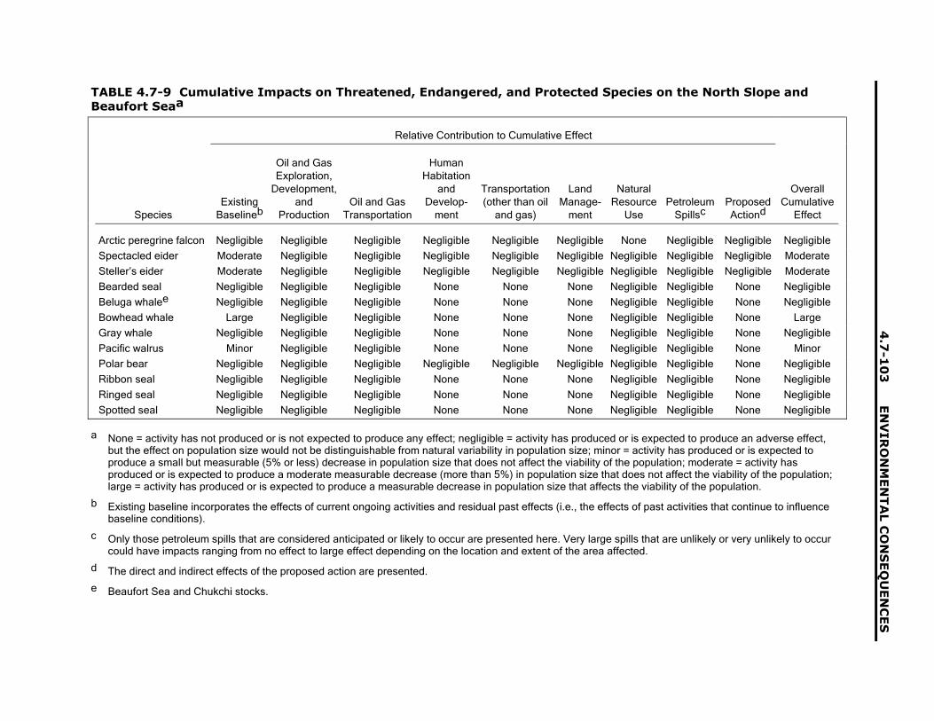
4.7
-10
3E
NV
IRO
NM
EN
TA
L C
ON
SE
QU
EN
CE
S
TABLE 4.7-9 Cumulative Impacts on Threatened, Endangered, and Protected Species on the North Slope andBeaufort Seaa
Relative Contribution to Cumulative Effect
SpeciesExisting
Baselineb
Oil and GasExploration,
Development,and
ProductionOil and Gas
Transportation
HumanHabitation
andDevelop-
ment
Transportation(other than oil
and gas)
LandManage-
ment
NaturalResource
UsePetroleum
SpillscProposedActiond
OverallCumulative
Effect
Arctic peregrine falcon Negligible Negligible Negligible Negligible Negligible Negligible None Negligible Negligible Negligible
Spectacled eider Moderate Negligible Negligible Negligible Negligible Negligible Negligible Negligible Negligible Moderate
Steller�s eider Moderate Negligible Negligible Negligible Negligible Negligible Negligible Negligible Negligible Moderate
Bearded seal Negligible Negligible Negligible None None None Negligible Negligible None Negligible
Beluga whalee Negligible Negligible Negligible None None None Negligible Negligible None Negligible
Bowhead whale Large Negligible Negligible None None None Negligible Negligible None Large
Gray whale Negligible Negligible Negligible None None None Negligible Negligible None Negligible
Pacific walrus Minor Negligible Negligible None None None Negligible Negligible None Minor
Polar bear Negligible Negligible Negligible Negligible Negligible Negligible Negligible Negligible None Negligible
Ribbon seal Negligible Negligible Negligible None None None Negligible Negligible None Negligible
Ringed seal Negligible Negligible Negligible None None None Negligible Negligible None Negligible
Spotted seal Negligible Negligible Negligible None None None Negligible Negligible None Negligible
a None = activity has not produced or is not expected to produce any effect; negligible = activity has produced or is expected to produce an adverse effect,but the effect on population size would not be distinguishable from natural variability in population size; minor = activity has produced or is expected toproduce a small but measurable (5% or less) decrease in population size that does not affect the viability of the population; moderate = activity hasproduced or is expected to produce a moderate measurable decrease (more than 5%) in population size that does not affect the viability of the population;large = activity has produced or is expected to produce a measurable decrease in population size that affects the viability of the population.
b Existing baseline incorporates the effects of current ongoing activities and residual past effects (i.e., the effects of past activities that continue to influencebaseline conditions).
c Only those petroleum spills that are considered anticipated or likely to occur are presented here. Very large spills that are unlikely or very unlikely to occurcould have impacts ranging from no effect to large effect depending on the location and extent of the area affected.
d The direct and indirect effects of the proposed action are presented.
e Beaufort Sea and Chukchi stocks.

EN
VIR
ON
ME
NT
AL C
ON
SE
QU
EN
CE
S4
.7-1
04
TABLE 4.7-10 Cumulative Impacts on Threatened, Endangered, and Protected Species in Interior Alaskaa
Relative Contribution to Cumulative Effect
SpeciesExisting
Baselineb
Oil and GasExploration,
Development,and
ProductionOil and Gas
Transportation
HumanHabitation
andDevelop-
ment
Transportation(other than oil
and gas)
LandManage-
ment
NaturalResource
UsePetroleum
SpillscProposedActiond
OverallCumulative
Effect
American peregrine falcon
Negligible Negligible Negligible Negligible Negligible Negligible None Negligible Negligible Negligible
Blackpoll warbler Minor Negligible Negligible Negligible Negligible Negligible None Negligible Negligible Minor
Gray-cheeked thrush Minor Negligible Negligible Negligible Negligible Negligible None Negligible Negligible Minor
Olive-sided flycatcher Minor Negligible Negligible Negligible Negligible Negligible None Negligible Negligible Minor
Townsend�s warbler Minor Negligible Negligible Negligible Negligible Negligible None Negligible Negligible Minor
a None = activity has not produced or is not expected to produce any effect; negligible = activity has produced or is expected to produce an adverse effect,but the effect on population size would not be distinguishable from natural variability in population size; minor = activity has produced or is expected toproduce a small but measurable (5% or less) decrease in population size that does not affect the viability of the population; moderate = activity hasproduced or is expected to produce a moderate measurable decrease (more than 5%) in population size that does not affect the viability of the population;large = activity has produced or is expected to produce a measurable decrease in population size that affects the viability of the population.
b Existing baseline incorporates the effects of current ongoing activities and residual past effects (i.e., the effects of past activities that continue to influencebaseline conditions).
c Only those petroleum spills that are considered anticipated or likely to occur are presented here. Very large spills that are unlikely or very unlikely to occurcould have impacts ranging from no effect to large effect depending on the location and extent of the area affected.
d The direct and indirect effects of the proposed action are presented.

4.7
-10
5E
NV
IRO
NM
EN
TA
L C
ON
SE
QU
EN
CE
S
TABLE 4.7-11 Cumulative Impacts on Threatened, Endangered, and Protected Species inPrince William Sounda
Relative Contribution to Cumulative Effect
SpeciesExisting
BaselinebOil and Gas
Transportation
HumanHabitation
andDevelop-
ment
Transportation(other than oil
and gas)
LandManage-
ment
NaturalResource
UsePetroleum
SpillscProposedActiond
OverallCumulative
Effect
Steller�s eider Moderate None None None None Negligible Negligible Negligible Moderate
Beluga whalee Moderate Negligible None Negligible None Negligible Negligible Negligible ModerateDall�s porpoise Negligible Negligible None Negligible None Negligible Negligible Negligible NoneFin whale Large Negligible None Negligible None Negligible Negligible Negligible LargeGray whale Negligible Negligible None Negligible None Negligible Negligible Negligible NoneHarbor porpoise Negligible Negligible None Negligible None Negligible Negligible Negligible NoneHarbor seal Minor Negligible Negligible Negligible Negligible Negligible Negligible Negligible MinorHumpback whale Large Negligible None Negligible None Negligible Negligible Negligible LargeKiller whale Negligible Negligible None Negligible None Negligible Negligible Negligible NegligibleMinke whale Negligible Negligible None Negligible None Negligible Negligible Negligible NegligiblePacific white-sided dolphin Negligible Negligible None Negligible None Negligible Negligible Negligible NegligibleSea otter Moderate Negligible Negligible Negligible Negligible Negligible Negligible Negligible ModerateSteller sea lion Large Negligible Negligible Negligible Negligible Negligible Negligible Negligible Large
a None = activity has not produced or is not expected to produce any effect; negligible = activity has produced or is expected to produce anadverse effect, but the effect on population size would not be distinguishable from natural variability in population size; minor = activity hasproduced or is expected to produce a small but measurable (5% or less) decrease in population size that does not affect the viability of thepopulation; moderate = activity has produced or is expected to produce a moderate measurable decrease (more than 5%) in population size thatdoes not affect the viability of the population; large = activity has produced or is expected to produce a measurable decrease in population sizethat affects the viability of the population.
b Existing baseline incorporates the effects of current ongoing activities and residual past effects (i.e., the effects of past activities that continue toinfluence baseline conditions).
c Only those petroleum spills that are considered anticipated or likely to occur are presented here. Very large spills that are unlikely or very unlikelyto occur could have impacts ranging from no effect to large effect depending on the location and extent of the area affected.
d The direct and indirect effects of the proposed action are presented.
e Beaufort Sea and Chukchi stocks.

ENVIRONMENTAL CONSEQUENCES 4.7-106
the Beaufort Sea, except in the case of anunlikely or very unlikely catastrophic oil spill intothe Sagavanirktok River that could not becontained before it entered the Beaufort Sea.
The proposed action would result in anegligible contribution to cumulative impacts onlisted and protected species on the North Slope(spectacled eider, Steller�s eider, and Arcticperegrine falcon) and no contribution tocumulative impacts on species in the BeaufortSea because the proposed action would notaffect the water of the Beaufort Sea(Table 4.7-9).
The largest contribution to cumulativeimpacts on species occupying the North Slopeand Beaufort Sea would result from past andcurrent activities, including activities and effectsin other portions of the ranges of these species.For example, for the spectacled eider, theingestion of lead shot and ecosystem-levelchanges elsewhere in its range might have beenmajor contributors to the declines in thepopulation of the species (USFWS 1999).Population status and factors affecting the statusof listed and protected species are discussed inSection 3.22. The most important future activitiesthat could contribute to cumulative impacts onthe North Slope and Beaufort Sea are plannedoil and gas development activities, oil and gastransportation, and natural resource use(subsistence harvests). However, on the basis ofinformation available none of these activities areexpected to noticeably increase the cumulativeimpact or affect the viability of species�populations.
Spectacled and Steller�s eiders could beaffected by future activities and facilities thatwould disturb their habitat, including thedevelopment of new production facilities and oiland gas transportation infrastructure. Increasedpredator abundance associated with humanoccupation and the subsequent increasedmortality of eider eggs and young have beenidentified as a concern on the North Slope butcould be mitigated with proper disposal andmanagement of food waste (USFWS 2002). Newdevelopment is expected to have relatively minoreffects, given the overall availability of habitatacross the North Slope; consequently, theoverall cumulative impact on eiders would berelatively unchanged. Cumulative impacts are
not expected to threaten the population viabilityof either the spectacled or Steller�s eider.
Concern has been raised about the effect ofunderwater noise and disturbances associatedwith oil and gas development on whalesinhabiting the Beaufort Sea. All whale speciesthat have been examined show some aversion tounderwater noise (see Section 3.22). A recentevaluation of the cumulative impacts of leasingand exploration activities on bowhead whales ofthe Outer Continental Shelf portion of theU.S. Beaufort Sea concluded that these activitieswere not likely to jeopardize the continuedexistence of this species, but that adverseeffects of noise on whale behavior were possible(Knowles 2001).
None of the species in Interior Alaska arecurrently listed by the federal government asthreatened or endangered. The Americanperegrine falcon has been de-listed because thepopulation has recovered. Several neotropicalmigrant bird species are considered species ofspecial concern by the state (blackpoll worbler,gray-cheeked thrush, olive-sided flycatcher,Townsend�s warbler), but past and presentactions affecting existing populations mostlyresult from impacts in other portions of theranges of these species. Future actions inInterior Alaska that could contribute to thecumulative impact on these species include oiland gas transport, human habitation anddevelopment, other transportation activities, landmanagement actions, and petroleum spills(Table 4.7-10). The contributions to thecumulative impact from all of these activities andfrom the proposed action are expected to benegligible given the area of habitat potentiallyaffected compared to that available.
Future actions contributing to cumulativeimpacts on listed and protected species inPrince William Sound include oil transport(tankering), other transportation activities(e.g., barge traffic), human habitation, naturalresource use (e.g., commercial and recreationalfisheries), land management, and petroleumspills.The largest contribution to the cumulativeimpact results from past and existing impacts.The Exxon Valdez oil spill has affected severalspecies in the Sound, including the sea otter andSteller sea lion (Section 3.22.3; Table 4.7-11).Past and present impacts to fin whale,
4.7-107 ENVIRONMENTAL CONSEQUENCES
humpback whale, beluga whale, and Steller�seider, for the most part, occur in other portions ofthe ranges of these species (see Section 3.22).Reasonably foreseeable future actions in theSound, because of their nature and size (seeSection 4.7.4), would contribute relatively minorincrements to the overall cumulative impact, andthese increments are not expected to reduce theviability of existing populations in Prince WilliamSound.
The proposed action would result in anegligible contribution to cumulative impacts onlisted and protected species in Prince WilliamSound (Table 4.7-11). Very minor amounts ofwater pollutants would be released as effluent toPort Valdez during normal operations of theTAPS. On the basis of past monitoring results,these permitted discharges would not affectoverall water quality in the Sound. Similarly,anticipated or likely spills associated with theproposed action are expected to be relativelysmall, and, if existing oil spill contingency plansfor response and cleanup are followed, anyimpacts from the spills should be short induration. Large spills (not included inTable 4.7-11) that are considered unlikely orvery unlikely could contribute substantially to thecumulative impacts on listed and protectedspecies in Prince William Sound. The impacts ofsuch a spill would depend on many factorsincluding location, weather, time of year, andarea affected.
The effects on marine mammals ofunderwater noise associated with boat andtanker traffic is a concern in Prince WilliamSound, much as it is in the Beaufort Sea. Unlikein the Beaufort Sea, however, no substantialincreases in noise are anticipated in PrinceWilliam Sound, since tanker and boat traffic isnot expected to increase substantially over theTAPS renewal period. Decreasing throughputduring the renewal period could result indecreased tanker traffic and reduced noiselevels.
The cumulative impact of the less-than-30-year renewal alternative on listed andprotected species would be very similar to that ofthe proposed action. The only differencebetween the proposed action and this alternativeis the length of the renewal period. As for theproposed action, a decision could be made to
renew the Federal Grant at the end of therenewal period. Therefore, ultimately, the periodof time during which the TAPS would operateunder the less-than-30-year renewal alternativecould be identical to that under the proposedaction. A shorter renewal period would notpreclude any other existing or foreseeableactions from occurring. Consequently, thecumulative impact of this alternative could be thesame as that of the proposed action.
The cumulative impact of the no-actionalternative on listed and protected species wouldbe quite different from that of the proposedaction. Differences result from the relationshipbetween the TAPS and oil and gas production onthe North Slope. For the no-action alternative itis assumed that oil exploration and productionactivities would cease pending development ofanother means of transporting the oil to market,but that gas production and transportation wouldoccur via a natural gas pipeline. Thus, thecumulative impact of the no-action alternativewould be less than that of the proposed actionbecause of the reduction in impacts associatedwith oil exploration and production on the NorthSlope and oil transportation in Prince WilliamSound. Although there would be some potentialfor a short-term increase in impacts resultingfrom termination activities for productionfacilities on the North Slope and on PrinceWilliam Sound, the overall cumulative impact onlisted and protected species of the no-actionalternative would be minor and less than that ofthe proposed action.
In summary, the impacts of the proposedaction would represent a small incrementalcontribution to the cumulative impact on listedand protected species. For all of these species,the largest contributions to cumulative impactwould occur in other portions of the species�range. On the North Slope, past and present oiland gas production activities would be thelargest contributors to cumulative impact, whileimportant future contributors would include oiland gas exploration and development activities;oil and gas transportation; and use of naturalresources (subsistence harvest). Activities inInterior Alaska, including the proposed action,would result in negligible contributions to thecumulative impact on species that occur there. InPrince William Sound, the largest contributors to

ENVIRONMENTAL CONSEQUENCES 4.7-108
cumulative impacts would be associated withpast, present, and future oil and gastransportation (tankering) and use of naturalresources (commercial fishing).
The cumulative impact of the less-than-30-year renewal alternative on listed andprotected species would be very similar to that ofthe proposed action because TAPS operationand associated activities would continue and theimpacts of other future activities would besimilar. In contrast, the cumulative impact of theno-action alternative on listed and protectedspecies would be quite different from that of theproposed action. Differences would result fromthe relationship between the TAPS and oil andgas production on the North Slope. Under theno-action alternative, the cumulative impactwould be less than it would be under theproposed action because of the reduction inimpacts associated with oil exploration andproduction on the North Slope and oiltransportation in Prince William Sound. Althoughthere would be some potential for a short-termincrease in impacts resulting from terminationactivities for production facilities on the NorthSlope and Prince William Sound, the overallcumulative impact on listed and protectedspecies under the no-action alternative would beminor and less than that under the proposedaction.
4.7.8 Social Systems
4.7.8.1 Subsistence
The evaluation of impacts to subsistenceunder the proposed action concluded that anynegative impacts that occurred would beextremely small (see Section 4.3.20). Thisconclusion was tentative because of theabsence of data necessary to make a morecertain assessment, including assigning impactsto the TAPS (as opposed to other activities) anddetermining the magnitude of possible impacts.Similar data inadequacies limited the strength ofconclusions drawn for subsistence under theless-than-30-year renewal alternative (seeSection 4.5.2.20) and the no-action alternative(see Section 4.6.2.20); these inadequacies alsoaffect the evaluations conducted in this section.
For cumulative impacts, several effects of allactions on subsistence would be possible.These effects, in turn, would vary in importancedepending on the geographic area beingconsidered.
• Larger amounts of cash would probably beavailable to individuals pursuing subsistenceactivities, enabling them to purchaseimproved subsistence-related technologies(though the precise impact of cash orsubsistence activity has not beenmeasured).
• Larger amounts of cash would probably beavailable to individuals pursuing recreationalhunting and fishing, enabling them to buyimproved technologies for sport harvestsand to take advantage of general conditionsconducive to such activities (though theprecise impact of cash on recreationalhunting and fishing has not been measured).
• More access to rural Alaska may beprovided by the construction andmaintenance of additional access roadsassociated with other current or potentialactivities, such as oil and gas exploration onthe North Slope and construction, operation,and maintenance of a natural gas pipeline.
• Increased numbers of outsiders would beintroduced to rural Alaska through theirinvolvement in reasonably foreseeable otheractions, increasing the number of potentialcompetitors for fish and game resourceswith those currently relying on theseresources for subsistence, The number ofpeople involved directly and indirectly inother actions, however, would not be largeand in many cases would be temporary(TAPS Owners 2001a).
• The overall state population may grow inresponse to the direct and indirect economiceffects of current and reasonablyforeseeable actions, and the increasednumber of residents would possibly generateincreased competition for subsistenceresources.
• More activity would potentially increasedisruption to the movement of terrestrialmammals and fish, although such disruption

4.7-109 ENVIRONMENTAL CONSEQUENCES
is expected to be small-scale (i.e., not at apopulation level) and often temporary (seeSections 4.7.7.2 and 4.7.7.3).
• Additional projects, which would introducemore infrastructure, people, and activities,could further limit the areas wheresubsistence could be pursued.
On the North Slope, many of the currentand reasonably foreseeable actions tend toinvolve the oil and gas oil industry throughexploration, development, production, support,and transportation. A second important futureaction there would be the construction andoperation of a natural gas pipeline with facilitieson the North Slope. Finally, the northern part ofGates of the Arctic NPP is located on theNorth Slope, where it overlaps with portionsof tranditional subsistence harvest areas forAnaktuvuk Pass and Nuiqsut (seeFigures 3.24-1 and 3.27-2, and Appendix D).Likely cumulative impacts to subsistence in theNorth Slope would include the following:
• Improved subsistence by enhanced travel toand from subsistence areas, increasedharvest levels or efficiency, or both, throughthe availability of additional cash;
• Improved sport harvests by enhanced travelto and from hunting and fishing areas,increased harvest levels, increasedopportunities to pursue recreational huntingand fishing, or combinations of theseconsequences through the availability ofadditional cash;
• Restrictions against using certain areastraditionally used for subsistence;
• Disruption to the movement of subsistenceresources; and
• Introduction of additional competitors toareas traditionally relied upon by local ruralcommunities for subsistence.
The Alaska Native communities ofAnaktuvuk Pass and Nuiqsut, both heavilyreliant on subsistence in general and caribouhunting in particular, likely would experience theabove cumulative impacts to subsistence on theNorth Slope. In part these impacts would be
directly associated with various activities andland management strategies and have beenidentified elsewhere. The presence ofinfrastructure and crews associated with oil andgas exploration and development restrictssubsistence in areas traditionally used for thatpurpose (Haynes and Pedersen 1989). Althoughthe establishment of Gates of the Arctic NPP didnot disallow subsistence activities in the parkarea, it did introduce certain restrictions(e.g., allowable modes of transportation) thatincreased the difficulty of subsistence (Ned1992; Reakoff 1992). The impact of the TAPSand other human activities on caribou remains ahotly debated issue. Although scientific evidenceindicates that human activities could changemovement patterns (Horejsi 1981; Lenart 2000;Murphy and Lawhead 2000; Tyler 1991;Wolfe et al. 2000), and traditional ecologicalknowledge from several of the rural communitiesin the vicinity of the TAPS associate the pipelineand related activity with changes in herdmovement (ADF&G 2001; Moses 1993),disruption to movement patterns does notappear to have occurred at a large scaleinvolving more than relatively few individualanimals (see Sections 3.20 and 3.21). Increasedcompetition for subsistence resources could alsooccur from nonlocal hunters and fishermen as aresult of introducing more individuals to this partof Alaska through employment-related activities.Although likely levels of hunting and fishing areunkown, residents from both Anaktuvuk Passand Nuiqsut have identified competition forresources as key problems for subsistence(ADF&G 2001). Indirect impacts resulting fromcumulative actions also are likely, mainly byfurther reducing the flexibility of subsistencepractitioners to pursue resources where andwhen they are available, and by reducingharvests in an area felt to be experiencingreduced subsistence resources (Ned 1992;Nelson 1992). Nevertheless, the large size oftraditional subsistence harvest areas forAnaktuvuk Pass and Nuiqsut (seeFigure 3.24-1), coupled with evidence forincreased populations of key subsistenceresources in recent years (TAPS Owners 2001a)and the successful regulation of harvests byADF&G (see Sections 4.7.7.2 and 4.7.7.3),suggests that the magnitude of impacts fromcompetition and restricted use likely would beminor. The TAPS contribution to cumulative

ENVIRONMENTAL CONSEQUENCES 4.7-110
impacts to subsistence on the North Slope wouldbe relatively small.
Cumulative impacts to subsistence wouldalso occur in Interior Alaska. Impacts here wouldrelate in particular to oil and gas developmentand transportation, coupled with continuedmanagement of Gates of the Arctic NPP andWrangell-St. Elias NPP. The most importantcumulative impacts to subsistence associatedwith the proposed action would include:
• Improved subsistence by enhanced travel toand from subsistence areas, increasedharvest levels or efficiency, or both, throughthe availability of additional cash;
• Improved sport harvests by enhanced travelto and from hunting and fishing areas,increased harvest levels, increasedopportunities to pursue recreational huntingand fishing, or combinations of theseconsequences through the availability ofadditional cash;
• Restrictions against using certain areastraditionally used for subsistence; and
• Disruption to the movement of subsistenceresources.
A number of interior communities would beexpected to experience cumulative impacts tosubsistence: Alatna, Allakaket, Big Delta,Chitina, Coldfoot, Copperville, Copper Center,Delta Junction, Evansville, Gakona, Glennallen,Gulkana, Hughes, Kenny Lake, Livengood,Manley Hot Springs, Minto, Paxson, Rampart,Stevens Village, Tanana, Tazlina, Tonsina, andWiseman (see Figure 3.24-1). However, themagnitude of the impacts would vary, dependingon the community�s proximity to one or moreactivities included in the cumulative analysis.For instance, Alatna, Allakaket, Evansville, andWiseman all have part of their respectivesubsistence harvest areas within Gates of theArctic NPP (Figure 3.24-1). Parts of thesubsistence harvest areas of Chitina, CopperRiver, Gakona, Glennallen, Gulkana, KennyLake, Paxson, and Tonsina, in turn, lie withinWrangell-St. Elias NPP. Although subsistencefor traditional and personal use is allowed withinthe parks, many subsistence practitioners feelthat restrictions on subsistence in the parks
makes that activity unduly difficult (e.g., Mekiana1992; Moses 1992). As noted in Section 3.24,the subsistence harvest areas of several interiorcommunities intersect the TAPS, and itspresence restricts hunting from certain areas.Construction of a natural gas pipeline through alarge portion of Alaska could add additionalrestrictions. However, once again the large sizeof traditional subsistence harvest areas forInterior Alaska communities (see Figure 3.24-1),increased populations of key subsistenceresources in recent years (TAPS Owners2001a), and harvest regulation by ADF&G (seeSections 4.7.7.2 and 4.7.7.3), suggests that theoverall cumulative impacts associated with theproposed action would be minor. The TAPScontribution to cumulative impacts tosubsistence in the Interior Alaska would berelatively small.
Cumulative impacts on subsistence inPrince William Sound would be possible as aresult of past, current, and reasonablyforeseeable future actions. These impacts couldinclude those from anticipated and likelyhazardous materials spills that is, smallervolume spills that are reasonably foreseeable(see Section 4.7.4.10). The most importantpossible cumulative impacts to subsistence inPrince William Sound would include these:
• Improved subsistence by enhanced travel toand from subsistence areas, increasedharvest levels or efficiency, or both throughthe availability of additional cash;
• Improved sport harvests by enhanced travelto and from hunting and fishing areas,increased harvest levels, increasedopportunities to pursue recreational huntingand fishing, or combinations of theseconsequences through the availability ofadditional cash; and
• Disruption to the movement of subsistenceresources.
Although all three of the impacts listedimmediately above might affect subsistence inPrince William Sound, the greatest potentialimpact would be caused by the disruption due toa tanker accident. Table 4.7-4 identifies sevenspill scenarios under anticipated and likelyfrequency ranges that would release varying

4.7-111 ENVIRONMENTAL CONSEQUENCES
amounts of crude oil or diesel fuel into thesound; the releasing as much as 82,000 bbl ofoil. The release of such a large volume of oilwould have negative impacts on certain speciesof fish, birds, and mammals. The magnitude ofthe impacts would be determined in part by thelocation of the release point and the duration ofthe spill. Moreover, current oil spill contingencyplans for spills in Prince William Sound, coupledwith the SERVS tanker escort system (withaccident prevention and spill containmentcapabilities), likely would help to limit the size ofthe area affected and thus the impacts. Thelocation and size of traditional subsistenceharvest areas in Prince William Sound (forChenega Bay and Tatitlek) would enableavoidance of spill areas. That capability, coupledwith evidence of successful regulation ofharvests by ADF&G (see Sections 4.7.7.2 and4.7.7.3), suggests that the magnitude of impactsto subsistence in and around Prince WilliamSound due to cumulative impacts likely would beminor. The TAPS contribution to cumulativeimpacts to subsistence in Prince William Soundwould be very small. The direct effects primarilywould be associated with occasional disruptionsto the movement of small numbers ofsubsistence resources due to human.
Cumulative impacts for the cases of theother alternatives considered in this DEIS wouldvary slightly from those just discussed for theproposed action. Under the less-than-30-yearrenewal alternative, impacts likely would beabout as small as those outlined earlier in thissection; if anything, they would be smallerbecause there would be less time for impacts toaccumulate (see also Section 4.5.2.20).Cumulative impacts of the no-action alternativelikely would change, in part as a result ofreduced employment opportunities, which wouldresult in less cash to finance subsistenceactivities at the same time the need forsubsistence to meet basic living requirementsincreased. In addition, although competition withrecreational hunting and fish might be reduced,certain geographical restrictions would beeliminted. On the whole, cumulative impacts onsubsistence under the no-action alternative andproposed action would be different but the neteffect might be the same.
In summary, cumulative impacts tosubsistence likely would vary for the three broadgeographic regions the North Slope, InteriorAlaska, and Prince William Sound area. In allcases, negative cumulative impacts tosubsistence should not be large. Thoseoccurring in the North Slope likely would be thegreatest, due primarily to the relatively largeamount of oil and gas exploration, development,and production occurring there and theassociated human activity and restrictions onsubsistence in certain areas (see BLM 1998).However, the size of subsistence harvest areasin all three regions would leave much of theseareas unaffected by cumulative impacts�that is,still available for subsistence, and outside thegeographic influence of various cumulativeactivities that might cause minor disruptions tosubsistence resource movements. Moreover, theincrease in size of certain subsistence resourcepopulations over the past several years suggeststhat improved availability of certain species mayhelp compensate for reduced access to certainsubsistence areas. Negative cumulative impactsassociated with the less-than-30-year renewalalternative likely would be less than thoseassociated with the proposed action, while thoseassociated with the no-action alternative wouldprobably be less still.
4.7.8.2 Sociocultural Systems
Impacts on sociocultural systems take theform of changes to Alaska Native and rural non-Native sociocultural systems because of one ofthe alternative actions considered, or inconjunction with other past, present, andreasonably foreseeable actions in the cumulativecase. Although it is the nature of socioculturalsystems to evolve in response to shiftingchallenges or surrounding conditions, rapid,large-scale change that often accompaniesclose interaction with other, more modernsocieties can be cause for concern. Large shiftsand rapid changes prevent sociocultural systemsfrom incrementally adjusting to conditions anddiscarding those changes that do not help themsurvive. Moreover, such large-scale changesplace members of a sociocultural system underpressure, since they may face situations forwhich there are no established culturalguidelines to help them respond. With the

ENVIRONMENTAL CONSEQUENCES 4.7-112
consideration of additional actions undercumulative impacts, one adds furtheropportunities for interaction between modernindustrialized American society and AlaskaNative and rural non-Native socioculturalsystems, providing the potential for extremelyrapid change in the latter two.
Similar to the analysis of impacts under theproposed action alone (see Section 4.3.21),cumulative impacts associated with theproposed action likely would include positive andnegative effects. For example, although theirassociation with sociocultural systems isindirect, in addition to the TAPS, manycumulative actions contribute (or will contribute)revenues that help support a variety of stateprograms, public services, and infrastructureconstruction and maintenance. Such programsinclude the state revenue sharing program, thesafe communities (municipal assistance)program, legislative grants, and capital projectmatching grants, which provide funds to eligiblecommunities for a range of infrastructuredevelopment and maintenance activities andpublic services (Alaska Department ofCommunity and Business Development2002a,b). Access to such public programs canhave tangible positive effects. For instance,infant mortality among Alaska Nativesdecreased from approximately 36% between1988−1990 and 1996−1998, while overallmortality fell by more than 12% over the sametime period (Alaska Department of Health andSocial Services 2001b). In 1998, nearly 70% ofresidents in the North Slope Borough had aminimum of a high school education in 1998,despite being one of the most geographicallyremote parts of the United States (North SlopeBorough 1999). Despite improvements in certainconditions, it is worth noting that Alaska Nativesunfortunately continue to lag behind in severalindicators. For example, of the 15 indicators ofhealth status for which Alaska Natives can besplit out separately from all Alaskans (includingthe two mentioned immediately above), AlaskaNatives rated poorer than the entire state in 12(Alaska Department of Health and HumanServices 2001b).
Negative effects of the past, present, andreasonably foreseeable future actions similarlyappear to be associated with the sociocultural
systems considered in this DEIS, some moredirectly than others. For instance, Strohmeyer(1997) speaks of the fragmentation during the1970s of Alaska Native nuclear and extendedfamilies that form the core of indigenoussociocultural systems in Alaska, as growingnumbers of individuals relocated to takeadvantage of wage employment on constructionof the TAPS (see also Reckord 1979). Moretroubling, certain measures of societal healthand mental health indicate that Alaska Nativesociocultural systems are out of balance. Suiciderates for Alaska Natives, which had grown to69 per 100,000 by the end of the late 1980s (seeSection 3.25), fluctuated considerably during the1990s �declining to about 41 in 1997 beforerising again to 53 in 1998 (which was more thanfive times the rate for the United States as awhole in 2000; Alaska Department of Health andHuman Services 2001b). Substance abuseamong Alaska Natives, which began to growshortly after statehood (see Section 3.25), alsocontinues to be a problem. Alaska Natives arenearly two to three times more likely to havelifetime alcohol dependence, more likely thanany ethnic group in Alaska to engage in bingedrinking, more likely to have fetal alcoholsyndrome than non-Natives, and four times morelikely to be amphetamine dependent than Whitesin Alaska (Alaska Department of Health andSocial Services 1999, 2001b). Violence inAlaska Native society remains much greaterthan for Alaska as a whole, with the rate ofhomicide among Alaska Natives nearly twicethat of all Alaskans in 1998 (Alaska Departmentof Health and Human Services 2001b).
The reason for citing improvements as wellas problems among Alaska Natives is to providea sense of the complicated situation facing thesesociocultural systems (as well as the evaluationof impacts of possible actions). Although onecan argue for a link between improvements andmodern services and programs, such asimproved health care and a widespread schoolsystem, the causes of social maladies are not asclear. However, in the case of suicide, manyresearchers have postulated that high ratesamong Alaska Natives are associated with thesudden introduction of money and modernAmerican culture (Hlady and Middaugh 1988;Kettl and Bixler 1991, 1993; Kraus and Buffler1979). Acculturation also has been linked to

4.7-113 ENVIRONMENTAL CONSEQUENCES
alcohol use as well (Kelso and DuBay 1989).This evaluation of cumulative impacts uses thepossible association between rapid acculturationof Alaska Native (and, to a lesser extent, ruralnon-Native) sociocultural systems and persistingsocial problems as a means of assessingcumulative impacts to those systems.
The cumulative impacts to socioculturalsystems would be expected to affect the NorthSlope and Interior Alaska more than otherregions. Of particular concern with regard to theNorth Slope would be the additional activitiesthat would accompany oil and gas exploration,development, and production slated for thatportion of Alaska over the coming years. Asdiscussed in Section 4.3.21, it is true that the(largely) Alaska Native sociocultural systems ofthe North Slope have experienced considerableand fairly constant interaction with outsiders overthe past three decades, largely as aconsequence of oil-related activities. Thesepeople have thus become somewhataccustomed to interacting with modern Westernsociety. However, key components of both theNunamiut and Taremiut traditional socioculturalsystems contrast dramatically with the additionalchanges likely to occur under cumulativeimpacts. More than two decades ago, somenegative impacts (violence and substanceabuse) were documented in these societies(e.g., Kruse et al. 1981. Over the lastthree decades, additional impacts occurred withthe enormous surge of income to the NorthSlope Borough, its development (much involvingdramatic improvements to infrastructure), theneed to guide this development, and themanagement of funds made available through oildevelopment (Strohmeyer 1997). Some of thesefactors introduced authority structures and statusdifferences unknown in traditional Iñupiatsociety. In addition to the two Northern Eskimosociocultural systems noted above, cumulativeimpacts would also be likely to affect thecommunities of Anaktuvuk Pass and Nuiqsut(see Figure 3.24-1) as well as other Iñupiatcommunities. As described in Section 3.24 andAppendix D, Section D.3, both of thesecommunities have mixed economies thatcombine subsistence and wage labor (ADCED2001). The association of the cumulative actionsconsidered in this DEIS (particularly oil- andgas-related activities and the possible
construction of a natural gas pipeline) with anynegative impacts is not clear or direct, given themodernization that continues to occur throughoutAlaska resulting from many causes, althoughthey certainly contribute to acculturation on theNorth Slope. TAPS contributions to socioculturalimpacts on the North Slope, both positive andnegative, would be relatively small comparedwith the other activities occurring there.
Cumulative impacts to sociocultural systemswould also be likely in Interior Alaska, to both the(largely) Athabascan Alaska Native socioculturalsystems and to non-Native sociocultural systemslocated there. In Interior Alaska, other activitiesthat occurred in the recent past, are currentlyunder way, or are reasonably foreseeable wouldnot be as geographically concentrated as on theNorth Slope; thus their potential impacts wouldalso be dispersed geographically. As a result, insome cases, it is unlikely that the cumulativeimpacts on rural sociocultural systems would beas great in Interior Alaska as they would be onthe North Slope. One exception likely would bepositive impacts of public services, state-fundedprograms, and infrastructure, which InteriorAlaska in particular relies upon (the North SlopeBorough, with incoming tax revenues from the oilindustry, funds certain services and programsthemselves). The construction and operation of anatural gas pipeline would probably causesociocultural impacts of the sort outlined above;these would generally be associated withincreased acculturation and modernization andwith the increased influence of a cash economy(though the latter likely would serve to replacethe current mission at Fort Greely). Socioculturalsystems of particular concern would be thosewith members located near the TAPS. Nativesystems of particular concern would be (south tonorth) the Ahtna, Tanana, Koyukon, andGwich�in Athabascans. Alaska Native and ruralnon-Native communities of particular concernwould include Alatna, Allakaket, Big Delta,Chitina, Coldfoot, Copperville, Copper Center,Delta Junction, Evansville, Gakona, Glennallen,Gulkana, Hughes, Kenny Lake, Livengood,Manley Hot Springs, Minto, Paxson, Rampart,Stevens Village, Tanana, Tazlina, Tonsina, andWiseman (see Figure 3.24-1). The extent of thecumulative impacts experienced in each villagewould likely vary with the degree to which it wasaffected by current and foreseeable future
ENVIRONMENTAL CONSEQUENCES 4.7-114
actions, in terms of the involvement ofcommunity members in these actions or in termsof the effects on the community itself from anincreased influx of outsiders and increasedexposure to the outsiders� sociocultural systems.Negative cumulative impacts likely would be lessto rural non-Native sociocultural systems, suchas found in Wiseman, in part because manyhave their roots in American society. Asdescribed in Section 3.24 and Appendix D,Section 3, all of these communities have mixedeconomies that combine subsistence and wagelabor; those with larger non-Native populationslocated close to major roads tend to rely more onthe latter (ADCED 2001). The association of thecumulative actions considered in this DEIS(particularly oil- and gas-related activities andthe possible construction of a natural gaspipeline) with any negative impacts in InteriorAlaska is not clear or direct, given themodernization that continues to occur throughoutthe state due to many causes, although theycertainly contribute to acculturation in InteriorAlaska. TAPS contributions to socioculturalimpacts in the Interior, both positive andnegative, likely would be relatively smallcompared with the other activities occurringthere.
Cumulative impacts would probably occur tothe sociocultural systems in Prince WilliamSound, but they would probably be lessextensive than those that would occur in InteriorAlaska or the North Slope. There are tworeasons for this conclusion. First, in the PrinceWilliam Sound area, there are generally fewertotal actions taking place that would disruptAlaska Native or rural non-Native socioculturalsystems than there are in the other two regions,especially the North Slope. Second, thesociocultural systems in the Prince WilliamSound area that are examined in this DEIS areprimarily Chugach Alutiiq and Eyak. These twoAlaska Native systems have already beensubject to considerable cultural change over thepast two centuries (see Section 3.25).Communities anticipated to experiencesociocultural impacts include three AlaskaNative villages: Chenega Bay, Eyak, and Tatitlek(Figure 3.24-1).
Impacts from tanker spills might also affectsociocultural systems in Prince William Sound.
One possible source of sociocultural impactsfrom spills associated solely with the TAPSwould be the disruption of subsistence orcommercial fishing activities. This could causea reorientation of economic activities (seeSection 4.4.4.15). However, as discussed inSection 4.7.8.1, reasonably foreseeable spills(anticipated or likely frequency categories)would tend to be smaller, and current spill-response capabilities would likely limit impacts.Moreover, the only documented subsistenceareas in Prince William Sound are in ChenegaBay and Tatitlek (see Figure 3.24-1). Potentialeconomic-related sociocultural impacts due tothe disruption of commercial fisheries would begreater, though the relatively small size ofanticipated and likely spills, coupled with spillprevention and cleanup contingency plans andthe use of the SERVS system for tanker escort(TAPS Owners 2001a), likely would limit impactsto much less than those experienced from theExxon Valdez spill (see Sections 4.7.6.6 and4.7.7.2.4). As described in Section 3.24 andAppendix D, Section D.3, Chenega Bay,Cordova, and Tatitlek occur in the Prince WilliamSound area and have mixed economies thatcombine subsistence and wage labor (ADCED2001). As above, the association of thecumulative actions considered in this DEIS(particularly oil-related activities) with anynegative impacts to sociocultural systems in thePrince William Sound area is not clear or direct,given the modernization that continues to occurthroughout Alaska due to many causes. TAPScontributions to sociocultural impacts in thePrince William Sound area, both positive andnegative, would be relatively small comparedwith the other activities occurring there.
Cumulative impacts associated with theless-than-30-year-renewal alternative likelywould be similar to those just described forproposed action-associated cumulative impacts.Cumulative impacts associated with theno-action alternative also likely would be similarto those discussed under the proposed actioncumulative case, though the magnitude likelywould be less both for positive and negativeconsequences. Reduced negative impacts couldresult from a reduction in potential acculturationwere the TAPS discontinued removing somesources of interaction with personnel maintainingthe pipeline and related facilities as well as

4.7-115 ENVIRONMENTAL CONSEQUENCES
sources of wage employment. Reduced positiveimpacts likely would be of particular concern.Not renewing the Federal Grant would remove asource of wage employment for rural Alaskans,which as noted can have positive as well asnegative consequences. It would also remove aconsiderable amount of state and local (NorthSlope Borough) tax revenues used to fund publicservices, programs, and infrastructure (seeSection 4.6.2.19). Under the less-than-30-yearrenewal alternative, the TAPS contribution tocumulative sociocultural impacts would berelatively small compared with the likely effectsof other cumulative actions. Under the no-actionalternative, in contrast, the relative contributionof discontinuing the TAPS would be quite large.In certain cases, it would likely affect thefeasibility of other actions (e.g., oil exploration,development, and production on the NorthSlope) considered in the cumulative cases aswell.
Overall, cumulative impacts to socioculturalsystems likely would be a mix of positive andnegative consequences. Both probably are aconsequence of continued acculturation andinfluence by modern American society,particularly affecting Alaska Native socioculturalsystems but also influencing rural non-Nativesystems. As was the case when evaluatingsociocultural impacts under the proposed action(see Section 4.3.21), clearly linking acculturationwith the TAPS or any of the cumulative actionsconsidered in this DEIS is largely impossible,given the general modernization that continuesto occur throughout Alaska for a variety ofreasons.
4.7.8.3 Economics
The assessment of the cumulative economicimpacts of the TAPS covers the impacts fromcontinued operation (including several for lessthan 30 years) and no action, together withimpacts from other existing and projectedeconomic development activities likely to occurin the state during the proposed lease renewalperiod. The economic impacts of any spills thatcould potentially occur in Prince William Soundduring tanker operations are also included. Theanalysis combines the impacts from the TAPScontinued operation and no action with thosefrom the most important major projects expected
to occur during the period 2004 to 2034 andqualitatively assesses the resulting aggregateimpact on the economy of the state and pipelinecorridor region. Although numerous projects areslated for development in Alaska (seeSection 4.7.4), the only projects considered to belikely to create significant cumulative impacts inassociation with the continued operation of theTAPS and no action are the natural gas pipelinedesigned to transport gas from the North Slopeto Canada and the proposed National MissileDefense System (NMDS) at Fort Greely. Theimpacts of all oil field development consideredare likely to occur under the proposed action.Other economic development activities, such asthe Wrangell-St. Elias NPP and miningdevelopment near Fairbanks, although theywould add to the overall level of economicactivity in the state, would not be as significantas the pipeline project, NMDS, and a largepotential oil spill.
The largest planned activity likely to occurduring the renewal period would be theconstruction and operation of the proposednatural gas pipeline from the North Slope. Gaswould be transported through the pipeline toserve markets in both Canada and the UnitedStates. The total capital cost associated with thepipeline would be between $5 and $6 billion, andit would take up to 7 years to build (CERA 1999).The largest impact of the pipeline to the stateand local economy would be the tax revenues itwould generate. On the basis of the impact ofthe Trans Alaska Gas System (TAGS), apipeline that was proposed to transport liquidpetroleum gas from the North Slope to Valdezand that would have had a throughput rate(2 billion ft3/d) similar to that of the proposedpipeline, it is estimated that revenues from thepipeline would amount to $189 million annuallyin royalties and severance taxes and$188 million annually in property taxes (TAPSOwners 2001a). The exact size of revenueswould depend on tax rates, actual dailythroughput rates, and the market price of naturalgas. Additional benefits of the pipeline would bethe possibility of further North Slope economicdevelopment, and the potential for reduction inthe cost of natural gas throughout the state.
Employment that would be created by thepipeline is difficult to estimate, given the

ENVIRONMENTAL CONSEQUENCES 4.7-116
provisional status of the project. Since the lengthof time required for its construction is assumedto be less than that estimated for the TAGS,given that it would be a shorter pipeline and thatthere would be processing facilities (CERA1999), it is likely that the employment impactsfrom the project would be less than thoseestimated from the TAGS. The TAGSemployment impact is assumed to be7,200 direct workers during the peak year of an8- to 10-year construction period, and anadditional 3,300 jobs would be created indirectlyin the state as a whole. Annual operations jobsare estimated to be 550, with an additional1,250 indirect jobs (TAPS Owners 2001a). It islikely that the pipeline would employ a largenumber of construction workers from outside thestate, and while wages and salaries wouldproduce local spending and state tax revenues,a significant portion of wages and salaries duringconstruction would leave the state, and workerwages would be used to support families locatedelsewhere in the United States. Deterioration inthe provision of local public services might alsooccur in some communities along the proposedroute in the short term as a large number of in-migrating workers arrive, especially if some areaccompanied by their families.
The NMDS includes a facility to be located inAlaska to support an anti-ballistic missilesystem, most likely at Fort Greely, near DeltaJunction. The system would cost $626 millionand create 300 direct construction jobs over afive-year period and create an additional620 jobs in the state (U.S. Army Space andMissile Defense Command 1999). A total of360 direct operations jobs and an additional110 indirect jobs would be created. Currently,600 civilian and military jobs are under threat aspart of the plan to close the base at Fort Greely(TAPS Owners 2001a). A large number ofconstruction workers from outside the statecould be expected as a result of the project, anddepending on the where these workers liveduring construction, they could strain the abilityof local governments to provide adequate publicservices to the local communities in the vicinityof the site.
In addition to new economic developmentactivity projected for the state, oil spills in PrinceWilliam Sound could also result in additional
spending and tax revenues at the state level andin local communities. For example, as a result ofthe Exxon Valdez oil spill in 1989, ExxonCorporation spent more than $2.6 billion oncleanup activities in the following three-yearperiod (Etkin 1998), creating an average of2,500 direct cleanup jobs and approximately2,500 indirect jobs over the period (ADOL 1990).These jobs more than offset losses in the fishingand tourism industries (IAI 1990). The localeconomy, in particular, was stimulated byincome generated by the oil spill; incomedoubled and employment increased by 30% inthe Valdez-Cordova Census Region in 1989(TAPS Owners 2001a). Many of the cleanup jobswere filled by temporary in-migrants from outsidethe state, reducing the benefits to the state andlocal economy. In addition to the economicbenefits associated with employment andincome generated as a result of the spill,significant compensation was paid by Exxon tovarious parties in the state. Almost $300 millionwas paid to commercial fishermen, while$1,025 million was paid to the state and federalgovernment in criminal and civil settlements fordamage to the environment in Prince WilliamSound. In addition, APSC paid $98 million tocommercial fishermen and has significantlyincreased its annual spill response expendituresto $60 million, primarily benefiting the Valdezlocal economy (TAPS Owners 2001a).
While the Exxon Valdez oil spill was asignificant event in the operation of the TAPS,creating significant benefits to the state and localeconomy that more than offset the economicdamage to the fishing and tourism industries inPrince William Sound, it is unlikely that a spill ofsuch magnitude, even if it occurred again, wouldcreate the same level of economic activity.Considerable efforts have been made to providemore adequate response capabilities for spills ofthe same magnitude. It may be reasonable toassume, therefore, that the economic impactsresulting from the Exxon Valdez oil spill,excluding those associated with compensation,represent the upper bound for any potentialaccidental spill. The local and state economicimpacts from smaller spills that would be wellwithin the capability of the spill responseauthorities would therefore probably be far lesssignificant. The possibility of compensatoryclaims in the event of a spill might still remain,
4.7-117 ENVIRONMENTAL CONSEQUENCES
however, since the long-term effect of the ExxonValdez oil spill on the environment of PrinceWilliam Sound has not been clearly established(TAPS Owners 2001a). Even in the absence ofsignificant local employment and incomeimpacts like those that occurred as a result ofthe Exxon Valdez spill, the ultimate distributionof compensation among parties (in the event of alawsuit and settlement following a serious spill)would mean that local and state economicimpacts might still be significant.
Although the natural gas pipeline wouldimpact the economy of the state, the cumulativeeconomic impacts of North Slope and continuedTAPS operations, together with the pipelineproject, would probably not be significantlylarger than the impacts of current North Slopeand TAPS operations. The gas pipeline wouldprobably be the most important new project forthe state in the next decade, and its mostsignificant impact would be tax revenues in theform of severance taxes, royalties and propertytaxes for the state, and additional property taxesfor local governments. However, it is likely thatgas pipeline construction would not begin untilafter 2010 during a period of declining revenuesfrom North Slope production and TAPSthroughput that will begin in 2006 (seeSection 4.3.19.1). Impacts from the gas pipelinemight therefore merely partially offset the declinein state oil revenues over the renewal period.Employment impacts at the state level, whilesignificant during construction, would be likely toimpact the economy only in the short term; thelonger-term overall impact on the state wouldprobably be small, even though pipelineoperations workers are likely to be relativelyhighly paid.
At the local level, impacts of continuedTAPS operations and the gas pipeline in theshort term would also probably be significant,with a major influx of workers expected duringthe construction period. Depending on wherethese workers reside during pipelineconstruction, there might be substantial impactson local employment and income in the smallercommunities as well as impacts on the ability oflocal governments to provide adequate publicservices, especially if many workers areaccompanied by their families. There might alsobe major impacts at the local level if construction
of the gas pipeline project and the NMDSoccurred simultaneously in the Fairbanks/DeltaJunction area, but such impacts are unlikely,given the proposed schedules for the twoprojects.
Cumulative employment and incomeimpacts associated with NMDS and oil spills inPrince William Sound would probably be muchless significant with regard to the economy of thestate than they would be with regard to the localeconomies in which each is located.Employment and income impacts of the NMDSwould only offset the decline in employmentresulting from base realignment at Fort Greely,with no major impacts to local public serviceprovision expected. Any major employment andincome impacts resulting from a spill would beunlikely, given the significant upgrading of spillresponse capability since the Exxon Valdezaccident. Any increases in activity would mostlikely be concentrated in Valdez. Any in-migrating workers would probably not have amajor impact on the ability of local governmentto provide adequate local public services.
Construction and operation of the gaspipeline project and the NMDS under theno-action alternative would partially offset thelosses in employment, income, and tax revenuesthat would occur at both the state and locallevels with the end of TAPS operation and NorthSlope production. Construction of the pipelineproject would not conflict with the latter stages ofTAPS termination activities or the NMDS, andpipeline operation would likely provide analternative basis of support for state and localrevenue generation and continuing effortstoward diversifying the state�s economy awayfrom natural resource extraction activities.
The impacts of continued TAPS operationfor the less-than-30-year renewal alternative,together with the gas pipeline and NMDS, wouldbe less than those for the proposed action. Lessoil-related investment would occur in the NorthSlope fields and other parts of the oil sector, andsupporting industries, together with lower levelsof private and public investment in the non-oil-related parts of the economy, would produceless employment, income, and tax revenues.

ENVIRONMENTAL CONSEQUENCES 4.7-118
4.7.8.4 Cultural Resources
No cumulative impacts are anticipated forcultural resources. Although other projects mightadversely affect cultural resources, adherence tofederal and state laws pertaining to culturalresources should mitigate adverse effectsassociated with the additional projects. As statedin Section 4.3.22, the renewal of the TAPS ROWcould adversely affect known cultural resources,but these impacts could be mitigated on aproject-by-project basis through avoidance,monitoring, data recovery, etc.
4.7.8.5 Land Use and CoastalZone Management
4.7.8.5.1 Land Use. The TAPS andother actions in the vicinity of the pipeline havehad cumulative effects on land ownership anduse near the ROW during the past 25 years.Valid legal access for TAPS operation andmaintenance has been acquired on the lands itcrosses. Access to public and some privatelands has increased in the vicinity of the pipelinedue to construction of the Dalton Highway, TAPSaccess roads, and airstrips. Some trespassingand conflict of use issues have resulted onnative lands. Some increases in recreational,residential, municipal, and commercial land useshave occurred; some of which can be attributedto the pipeline. Commercial development hasoccurred at three development nodes along theDalton Highway. The existence of the pipelinehas contributed to the increase in oil exploration,development, and transportation activities at theNorth Slope during the past 25 years.
Other actions unrelated to the TAPS havegreatly affected land ownership and use inAlaska. The passage of the Alaska NationalInterest Lands Conservation Act (ANILCA) in1980 resulted in numerous designations ofconservation system units. Lands have alsobeen conveyed from federal to stategovernment, and from state to local governmentand Native Alaskans.
The largest new development reasonablyforeseeable in the vicinity of the TAPS is anatural gas pipeline project. In this project, aburied natural gas pipeline would run parallel to
the TAPS ROW. A gas processing facility wouldbe constructed on the North Slope, andcompressor, pigging, and valve stations wouldbe constructed intermittently along the pipeline.
The gas pipeline and its relatedinfrastructure would have some effects on landuse in the vicinity of the TAPS. Aesthetics wouldbe affected along and/or within the TAPS ROW,with resulting effects on recreation likely(see Section 4.7.8.6). Noise from construction,operation, and maintenance of the gas pipelineand related structures would likely be audiblefrom some recreation areas and could interferewith recreational activities. During construction,a temporary increase in noise might also occuron lands set aside for wildlife habitatconservation, disturbing wildlife. Effects onmilitary, residential, municipal, commercial, orprivate land use could also occur, not only fromincreased noise, but from preclusion orinterference of use from the gas pipeline andrelated structures. Conflicts with mining andother natural resource use would be possible,depending on the route of the pipeline andlocations of structures.
Finally, although there would be an influx ofpersonnel associated with the gas pipeline, itwould be unlikely to result in an increase inresidential, municipal, or commercialdevelopment. The new personnel associatedwith the project would probably just offset theworkforce reductions that have recently resultedfrom the closure of Fort Greely and proposedAPSC reorganization.
Additional recreational development and/orincreased use of existing developed recreationareas would also be unlikely. However,increased access would likely result fromconstruction of the gas pipeline and couldcontribute to an increase in recreational use ofundeveloped public lands.
Spills (see Sections 4.4.4.17.1 and4.6.2.23.1) could also occur as the result of avariety of actions, including oil exploration anddevelopment, oil refining, oil storage activities,and transportation. Small spills could disruptother land uses, although a large spill wouldhave the greatest impact. If there was a spillfrom the natural gas pipeline, resulting involatilization of the gas, the potential for a fire

4.7-119 ENVIRONMENTAL CONSEQUENCES
would exist. A fire would result in temporaryevacuation of nearby areas, long-term aestheticimpacts to the landscape, and potential long-term interference with land uses.
If there were no spills, renewal of the TAPSROW would continue to have only small impactson land use in the vicinity of the pipeline.However, the anticipated construction of thenatural gas pipeline and related infrastructurewould have larger impacts on land use. Thecombined effects from both pipelines wouldincrease the currently existing impacts on landuse in the vicinity of the TAPS, depending inlarge part on the location of the natural gaspipeline and related structures. If the TAPSROW were renewed for less than 30 years, thecumulative effects would be similar to thoseunder the proposed action.
However, the cumulative effects under theno-action alternative would be much differentfrom those under either the proposed action orthe less-than-30-year renewal alternative. Lesscommercial, municipal, and residentialdevelopment would be expected to occur due toa downturn in the state economy resulting fromlost oil revenues. Use of state recreation areas,sites, and parks would decline because ofclosures resulting from state funding reductions.Oil exploration, development, and transportationactivities at the North Slope would cease,although natural gas development at the NorthSlope and construction of a natural gas pipelinemight still occur.
Cumulative effects on land use from theTAPS will continue to occur, whether the ROW isrenewed for 30 years, less than 30 years, or notat all. Few, if any, additional effects on landownership would be expected, regardless ofrenewal.
4.7.8.5.2 Coastal ZoneManagement. The TAPS and other actions inthe vicinity of the pipeline have had cumulativeeffects on the North Slope Borough and Valdezcoastal zones during the past 25 years.Aesthetic and land use impacts from the TAPSand other activities are evident in both zones.However, the operation and maintenance of theTAPS and related facilities, including the ValdezMarine Terminal are permitted activities in
compliance with the enforceable policies inboth the North Slope Borough CMP and theValdez CMP. The TAPS is also a developmentactivity consistent with both CMPs. (SeeSection 4.3.23.2 for effects on coastal zonemanagement from the proposed action.) Othercurrently existing development in the coastalzones would be expected to be consistent and incompliance with the CMPs as would futuredevelopment, and therefore would be unlikely tohave a large cumulative impact on coastal zonemanagement. Spills from the TAPS, a futurenatural gas pipeline, or oil and gas developmentrepresent actions that could have the greatestpotential cumulative effect on coastal zonemanagement with regard to either the NorthSlope Borough or Valdez CMP.
North Slope Borough CoastalManagement Program. Oil and gasexploration, development, and productionactivities would be expected to continue withinthe North Slope Borough coastal zone.Construction of a natural gas processing facilityhas been proposed. The facility would service agas pipeline that would parallel the TAPS, eitherwithin or adjacent to the ROW. The pipelinewould be buried along most of its length.
The natural gas processing facility wouldadd to the existing visual impact within the NorthSlope Borough. The gas pipeline would alsorepresent a visual impact if any segment of itwas above ground. However, the North SlopeBorough CMP allows for development activitiesas long as they do not substantially interfere withsubsistence activities in the borough orjeopardize the continued availability ofsubsistence resources. The additionalprocessing facility, the natural gas pipeline, andongoing oil and gas activities would not beexpected to interfere with or jeopardizesubsistence within the borough, although animpact would be expected to occur (see thecumulative effects discussion on subsistence).
Impacts to subsistence resources within theNorth Slope Borough coastal zone could occurfrom a land or water-based petroleum spill. Themagnitude of the impacts would depend on thevolume, location, duration of the spill, as well asthe time of year it occurred. Aesthetic impactswould also occur, and cleanup activities could be

ENVIRONMENTAL CONSEQUENCES 4.7-120
substantial and long term. Potential effects to theNorth Slope Borough coastal zone from TAPSspills are discussed in Section 4.4.4.19.2.Similar impacts would result from petroleumspills from other resources. Spills could alsooccur from the natural gas pipeline if it wasconstructed, resulting in volatilization that couldtemporarily impair air quality. Volatilized gascould lead to a fire, resulting in damage tosubsistence resources and temporaryevacuation of areas within the borough, therebydisrupting subsistence activities. Disruption toother development activities within the boroughwould also be likely.
As discussed in Section 4.4.4.19.2, renewalof the Federal Grant would continue to beconsistent with the North Slope Borough CMPand in compliance with enforceable policies. Inthe absence of spills, continued operation andmaintenance of TAPS would have very littleadditional effect on coastal resources andactivities within the borough. The cumulativeeffects from the renewal of the ROW for lessthan 30 years would be similar to those underthe proposed action.
If the no-action alternative wereimplemented, TAPS-related activities wouldcease in the North Slope Borough coastal zone.Land occupied by the TAPS and related oilexploration, production, and transportationfacilities would be available for otherdevelopment activities, consistent with ACMPstatewide standards and the North SlopeBorough CMP. Some aesthetic and land useimpacts would likely result.
Some cumulative effects on the North SlopeBorough coastal zone from the TAPS willcontinue to occur, whether the ROW is renewedfor 30 years, less than 30 years, or not at all.Because of required compliance with statewideACMP standards and the North Slope BoroughCMP, additional effects would likely be small.
Valdez Coastal ManagementProgram. The Valdez CMP allows for a varietyof activities within the coastal zone, includingdevelopment, and those activities would beexpected to continue. No major developmentsare currently planned within the Valdez coastalzone, but any additional development would add
to the existing visual impact of the ValdezMarine Terminal.
Normal operation and maintenance of theTAPS and the Valdez Marine Terminal would notimpact the Valdez coastal zone. However,impacts to other activities within the coastal zonecould occur from small spills, although a majorland- or water-based petroleum spill at theValdez Marine Terminal, or from an oil tanker,other commercial vessel, or private vessel wouldbe most disruptive. A spill at the Valdez MarineTerminal that erupted into fire or a spill to waterwithin the coastal zone, especially to PrinceWilliam Sound, would likely damage coastalresources (including aesthetics) and interferewith other coastal zone activities. These impactswould be similar to the potential impacts on theValdez coastal zone from TAPS spills discussedin Section 4.4.4.19.2.
As discussed in Section 4.4.4.19.2, renewalof the Federal Grant would continue to be incompliance with the enforceable policies in theValdez CMP. In the absence of spills, continuedoperation and maintenance of the TAPS and theValdez Marine Terminal would have very littleadditional effect on coastal resources andactivities within the Valdez coastal zone. Thecumulative effects under the less-than-30-yearrenewal alternative would be similar to thoseunder the proposed action. Under the no-actionalternative, TAPS and related activities wouldcease, and the Valdez Marine Terminal would beremoved. Other permitted activities could thenoccur in those areas, which would likely haveassociated aesthetic and land use impacts.
4.7.8.6 Recreation,Wilderness, andAesthetics
4.7.8.6.1 Recreation. The TAPS andother actions have had some cumulative effectson recreation on federal and state lands in thevicinity of the pipeline. Access to public landshas increased since construction of the TAPS,particularly as a result of the construction of theDalton Highway, resulting in an increase inrecreational opportunities and use in someareas. The pipeline is visible from somerecreation areas, sites, and parks. At some
4.7-121 ENVIRONMENTAL CONSEQUENCES
locations, noise from TAPS-related infrastructure(such as pump stations) is audible.
The passage of ANILCA in 1980, whichcreated numerous conservation system units inAlaska, greatly increased recreationalopportunities in the vicinity of the TAPS. Theexistence of these opportunities has increasedrecreational use of public lands near the TAPS.Oil revenues have allowed for greater funding ofstate recreational areas, sites, and parks, whichhas also increased recreational opportunitiesand use.
These impacts from the TAPS wouldcontinue with renewal of the ROW. The onlylarge development recreational or otherwise reasonably foreseeable at or near recreationareas, sites, or parks in the vicinity of the TAPSis the potential construction of a buried naturalgas pipeline within or adjacent to the TAPSROW, beginning about the year 2010. Theanticipated route of the pipeline would parallelthe TAPS. A gas processing facility would beconstructed on the North Slope, andcompressor, pigging, and valve stations wouldbe constructed intermittently along the pipeline.
The gas pipeline and its relatedinfrastructure would substantially add to thecurrently existing visual impacts along, andwithin, the TAPS ROW. Only temporary visualimpacts would occur from burying the gaspipeline but construction of the relatedinfrastructure would represent long-termaesthetic impacts. Since sight-seeing is a verypopular recreational activity in Alaska, thesevisual impacts would somewhat diminish thequality of that recreational experience for somepeople. Infrastructure visible from recreationareas, sites, or parks might also reduce thequality of other recreational experiences such ashiking or camping.
In addition, noise from construction of thegas pipeline and compressor, pigging, or valvestations could be audible from some recreationareas, sites, and parks, depending on thelocation of the pipeline and related infrastructure,which is currently uncertain. Additional vehicularand air traffic resulting from the construction,operation, and maintenance of the natural gaspipeline would also add to current noise audiblefrom recreation areas, sites, or parks,
particularly those in proximity to a highway.Lastly, increased access resulting fromconstruction of the gas pipeline could contributeto an increase in recreational use ofundeveloped public lands.
Recreation in the vicinity of the TAPS couldalso be affected in the future by a major land- orwater-based TAPS spill, particularly a majorspill. Visual and noise impacts could occur,especially from long-term cleanup activities.Both temporary evacuation and long-termclosure of recreation areas would be possible.Potential effects to recreation from TAPS spillsare discussed in Section 4.4.4.18.3.
Spills could also occur from the natural gaspipeline if it was constructed, resulting involatilization that could temporarily impair airquality. Volatilized gas could lead to a fire,resulting in evacuation of recreation areas, long-term aesthetic impacts to the landscape, andpotential closure of sites.
In the absence of spills, renewal of theFederal Grant of ROW, either for 30 years or alesser term, would continue to have only smallimpacts to recreation in the vicinity of thepipeline. However, the anticipated constructionof the natural gas pipeline and relatedinfrastructure would also impact recreation. Thecombined effects from both pipelines wouldincrease the currently existing impacts onrecreation in the vicinity of the TAPS, dependingin large part on the location of the natural gaspipeline and related structures. The effects fromrenewal of the TAPS for less than 30 yearswould be similar to those under the proposedaction.
The cumulative effects on recreation fromthe no-action alternative would likely be greaterthan those from either the proposed action or theless-than-30-year renewal alternative. Thecurrently existing visual and noise impacts fromthe TAPS would end after termination activitieswere completed. Oil revenues would decline andeventually cease, resulting in decreased fundingof state recreation areas, sites, and parks. Thereduced funding would be expected to forceclosure of some state areas, sites, and parks,resulting in a decrease in recreationalopportunities and use levels in the vicinity of theTAPS.

ENVIRONMENTAL CONSEQUENCES 4.7-122
Cumulative effects on recreation from theTAPS and other actions would continue to occur,regardless of the length of the renewal, or evenin the event of no action. In spite of some visualand noise impacts from TAPS infrastructure andincreased traffic, the overall cumulative effectson recreation from the TAPS are generallyfavorable, since oil revenues generated by theTAPS help to fund state recreation areas, sites,and parks. However, decreased throughputduring the renewal period would result indecreased state revenues, which could impactstate recreational funding, although not as muchas no action.
4.7.8.6.2 Wilderness. The WildernessArea within the Gates of the Arctic NPP is theonly federally designated Wilderness Area withina few miles of the TAPS or in the vicinity of theproposed gas pipeline. No state designated, orfederal or state proposed, wilderness areas existin the vicinity of the TAPS or the proposed gaspipeline.
The only large action that has occurred inthe past near the eastern portion of the Gates ofthe Arctic NPP Wilderness Area is theconstruction of the TAPS. The pipeline continuesto be the only large development in the vicinity.The currently existing cumulative effects on theWilderness Area are due to the TAPS.
The construction of a buried natural gaspipeline within or adjacent to the TAPS ROW asit passes the Gates of the Arctic NPP is areasonably foreseeable future activity and wouldadd to the indirect impacts of the TAPS.Temporary visual impacts would occur fromburying the pipeline and would persist untilrevegetation occurred. Any compressor, pigging,or valve stations constructed along the pipelineand visible from the Gates of the ArcticWilderness Area would add to the existing visualimpact. Noise from construction could be audiblewithin the wilderness, and the additionalvehicular and air traffic resulting from theconstruction, operation, and maintenance of thenatural gas pipeline would also add to currentnoise audible from the Wilderness Area. Lastly,an increase in personnel in the area due to theadditional pipeline could potentially result in anincrease in recreational use in the Gates of theArctic Wilderness Area.
Spills in the vicinity of the Gates of the ArcticNPP could occur from the natural gas pipeline ifit was constructed, and they could result in a firethat would impair air quality in the vicinity of theWilderness Area. Long-term aesthetic impacts tothe landscape could occur from a fire, andpotentially be visible from the Gates of the ArcticNPP Wilderness Area. See Section 4.4.4.18.2for a discussion of potential impacts onwilderness from TAPS spills.
In the absence of spills, renewal of the TAPSROW would continue to have only small visualand noise impacts to the Wilderness Area.However, the anticipated construction of thenatural gas pipeline and related infrastructurewould also have indirect impacts to wilderness.The combined effects from both pipelines wouldlikely have a more substantial impact on theGates of the Arctic NPP Wilderness Area thanthe current impact, depending in large part onthe location of the natural gas pipeline. Thecumulative impacts would be similar under theproposed action and the less-than-30-yearrenewal alternative.
Cumulative effects on wilderness from theno-action alternative would result in eliminationof the currently existing visual impact of theTAPS as well as some of the noise associatedwith the pipeline and related traffic on the DaltonHighway. Increased access and a small increasein use would be expected to continue.
4.7.8.6.3 Aesthetics. The TAPS andseveral other actions have resulted in a largecumulative visual impact in the vicinity of thepipeline. The TAPS and its related infrastructurerepresent one of the more substantial visualimpacts on the landscape along much of itslength. The highways that it parallels alsorepresent major aesthetic impacts, as do thecommunities and other developments within thepipeline viewshed. Other existing visual impactsinclude additional pipelines and oil developmentinfrastructure on the North Slope; commercial,industrial, residential, and recreationaldevelopment along the Dalton and RichardsonHighways; mining operations; pipeline viewingstations; and the Valdez Marine Terminal.
All of these visual impacts currently existand have existed for many years or decades

4.7-123 ENVIRONMENTAL CONSEQUENCES
along the length of the pipeline. Development inthe vicinity of the pipeline is expected to occurslowly, as it has in the past. No major municipal,commercial, industrial, recreational, or miningdevelopment has been identified adjacent to theTAPS, and no major additional TAPS-relatedconstruction is anticipated. However, a 200- to300-acre residential development and anapproximately 2,000-acre agriculturaldevelopment have been proposed about 5 misouth of Copper Center.
In addition, the TAPS corridor has beenproposed for the construction of a natural gaspipeline within the next decade. The anticipatedroute of the pipeline would parallel the TAPS. Agas processing facility would be constructed onthe North Slope, and compressor, pigging, andvalve stations would be constructedintermittently along the pipeline. These stationswould add to the currently existing visualimpacts along, and within, the TAPS ROW. Eventhough the gas pipeline would be buried, theROW would be visible and would likely bemaintained in a state visually different fromsurrounding areas. This would be similar toburied segments of the TAPS, which are visuallydifferent from surrounding areas.
Aesthetics could also be affected in thefuture by a land- or water-based petroleumspills from oil exploration, development, orproduction; oil storage; or oil transportation bytanker. Visual impacts, including cleanupactivities, could be long-term and similar to theaesthetic impacts from a TAPS spill, asdiscussed in Section 4.4.4.18.3. Spills could alsooccur from the natural gas pipeline if it wasconstructed, resulting in volatilization that couldtemporarily impair air quality. Volatilized gascould lead to a fire, further degrading air qualityuntil it was extinguished. Long-term aestheticimpacts to the landscape could occur from a fire,depending on its extent.
As discussed in Section 4.3.24.3, renewal ofthe TAPS ROW would continue to have mostlylocalized impacts to aesthetics in the vicinity ofthe pipeline. In the absence of spills, continuedoperation and maintenance of the TAPS wouldhave very little additional aesthetic effect on thelandscape. However, the anticipatedconstruction of the natural gas pipeline andrelated infrastructure would have additional
visual impacts on the landscape in the vicinity ofthe TAPS. That potential project, combined withexisting aesthetic impacts from the TAPS, aswell as other probable future development in thevicinity of the pipeline, would combine to createa major aesthetic impact in the vicinity of theTAPS ROW, under the proposed action or less-than-30-year renewal alternative.
The cumulative effects to aesthetics wouldbe lessened somewhat under the no-actionalternative because the TAPS and relatedinfrastructure would be removed. The rate ofdevelopment in the vicinity of the pipeline wouldalso be expected to slow because of theeconomic impacts of lost oil revenues. However,the gas pipeline would still likely be built, and theresidential and agricultural development nearCopper Center would also probably still occur.Overall, the aesthetic impacts would be lessunder the no-action alternative than under eitherof the renewal options.
4.7.8.7 Environmental Justice
The evaluation of cumulative impacts withimplications for environmental justice dependsfirst on the identification of high and adversecumulative impacts in other impact areas(groundwater, human health, etc.) and then onwhether these impacts would affect minority andlow-income populations disproportionately.Disproportionate impacts can occur two ways:(1) because the environmental justice populationunder consideration is present at a percentagehigher than that found in the state as a whole, or(2) because the environmental justice populationunder consideration is more susceptible to suchimpacts. In either case, it is a necessaryprecondition that the cumulative impacts havealready been determined to be high andadverse. Analyses indicate that high andadverse impacts would not be anticipated forcumulative actions combined with the proposedaction, less-than-30-year renewal alternative, orthe no-action alternative (Table 4.7-12; seeSections 4.7.6, 4.7.7., and 4.7.8).
4.7.9 Summary
Many activities in the TAPS region ofinterest (TAPS ROW, North Slope, and Prince

ENVIRONMENTAL CONSEQUENCES 4.7-124
William Sound) contribute to cumulative effectson the environment. These activities are listed inTable 4.7-13. If it were not for the construction ofthe TAPS, some of these activities would nottake place, including oil and gas exploration,development, and production on the NorthSlope; refinery operations; potential natural gastransport; and oil transport from Valdez tomarket. However, other petroleum industryactivity would still occur in the TAPS region ofinterest even in the absence of the TAPS,including the transport of petroleum products intoand within Alaska and the storage of oil forindustrial, transportation, and domestic use. Thepetroleum industry affects many segments of theAlaskan economy by creating jobs, providingrevenue for government services, and providingincome to support subsistence lifestyles. Thesesecondary effects are most evident wheneconomic and social issues are the subject of anassessment. However, some activities within theTAPS region of interest are independent of theoil industry. These include activities based onAlaska�s other natural resources, such asmining, forestry, tourism, and fishing.
The cumulative impact assessmentspresented in Sections 4.7.6 through 4.7.8integrate the effects of all actions taken togetherunder three scenarios. The first scenario, whichis analyzed in the most detail, considers theimpacts from all actions, including the operationof the TAPS, for another 30 years. This is theproposed action. The second scenario considersall actions taken together with a less-than-30-year authorization of TAPS operations. The
third scenario considers all actions takentogether with no action, which would involveending TAPS operation and removing TAPSfacilities. The cumulative impacts associatedwith these three scenarios are summarized inTable 4.7-13. The impacts of the latter twoscenarios are described by being compared withthe impacts of the first (proposed action)scenario.
Many of these impacts are secondary.Three major cross-cutting impacts are identifiedin this analysis. First, the generation of roaddusts affects vegetation, soils, and permafrost;this impact, in turn, affects surface hydrologyand snowmelt; and this impact affects birds andmammals. Second, activities associated withpetroleum exploration and development uselarge quantities of water that are taken fromsurface water under ice, which constitutes animportant habitat for overwintering fish. Third,developments in all areas affect fish andmammal populations, which are importantsubsistance resources for Alaskans; in addition,the income and access provided by thesedevelopments affect the ability of and need forpeople to utilize these subsistence resources.Although the cumulative impacts on theseresources, as analyzed in Sections 4.6 through4.8, are, in general, minor and local, knowledgeabout their relationships is still important toreach an understanding of the environmentalconsequences of the proposed action. No majorsynergistic effects were identified in thecumulative analysis.

4.7
-12
5E
NV
IRO
NM
EN
TA
L C
ON
SE
QU
EN
CE
S
TABLE 4.7-12 Summary of Anticipated Cumulative Impacts under the Proposed Action
Issue Area EIS Section Summary of Impactsa
Soils and permafrost 4.7.6.1 All negative cumulative impacts to the North Slope, Interior Alaska, and PrinceWilliam Sound area are anticipated to be highly localized and limited to theareas disturbed.
Sand, gravel, and quarry resources 4.7.6.2 Negative cumulative impacts are anticipated to be highly localized; to belimited to areas where sand, gravel, and quarry resources are extracted; andto occur on a project-by-project basis.
Paleontology 4.7.6.3 Negative cumulative impacts could occur in areas disturbed by any additionalprojects; such impacts would be monitored and mitigated on a case-by-casebasis.
Surface water impacts 4.7.6.4 Negative cumulative impacts could be small and local on the North Slope, inInterior Alaska, and Prince William Sound; following good engineeringpractices and adhering to regulatory guidelines should help to minimizeimpacts.
Groundwater resources 4.7.6.5 Negative cumulative impacts on both water quality and quantity mightaccompany reasonably foreseeable construction; on the North Slope, impactsto water quality likely would be less than elsewhere because of the widepresence of permafrost; impacts to the Fairbanks and Valdez areas could begreater because of their larger concentrations of population and reliance onwells for domestic water supply; following good engineering practices shouldhelp to minimize impacts.
Physical marine environment 4.7.6.6 Negative cumulative impacts primarily would accompany spills in the BeaufortSea or Prince William Sound, but the volumes of any reasonably foreseeablespills would be low enough to be readily cleaned up and to limit the magnitudeof their effects.
Air quality 4.7.6.7 Negative cumulative impacts should be constrained by regulatory limits toacceptable levels or should be relatively low in general (e.g., impacts fromincreased traffic).

EN
VIR
ON
ME
NT
AL C
ON
SE
QU
EN
CE
S4
.7-1
26
TABLE 4.7-12 (Cont.)
Issue Area EIS Section Summary of Impactsa
Noise 4.7.6.8 Negative cumulative impacts should be localized and short term, primarilyduring construction of any infrastructure; contributions from the TAPS areanticipated to be relatively minor.
Transportation 4.7.6.9 Negative cumulative impacts should not be large, since anticipated increasesin traffic volume would not be large and could be accommodated by theexisting infrastructure; contributions by the TAPS are anticipated to berelatively minor.
Wastes 4.7.6.10 Negative cumulative impacts could accompany wastes generated by NorthSlope oil exploration, development, and production; oil refining at threerefineries; tanker loading at the Valdez Marine Terminal; and (possibly) theconstruction and operation of a gas pipeline; the magnitude of impacts areanticipated to be within acceptable limits, as set by regulatory standards; theTAPS would be a relatively small contributor to the aggregation of wastes frompast, current, and reasonably foreseeable activities.
Human health and safety 4.7.6.11 Negative cumulative impacts to workers could occur as physical hazards butcould be minimized by employing safety practices in each project considered;negative impacts to workers from NORM are expected to be negligible;negative impacts to the public from VOCs are not anticipated to be large undercumulative impacts, unless a large new source of such compounds is locatednear the Valdez Marine Terminal; an increase of CO likely would accompanygrowths in population and the amount of vehicular traffic, but the TAPScontribution to this growth would be negligible; possible negative impacts tothe public might accompany spills accumulating from different actions.Impacts, however, would be localized, and it is extremely improbable that spillsassociated with different activities would occur at the same time and location(near human settlement); negative impacts due to TAPS from persistent,bioaccumulative, and toxic chemicals are not anticipated.

4.7
-12
7E
NV
IRO
NM
EN
TA
L C
ON
SE
QU
EN
CE
S
TABLE 4.7-12 (Cont.)
Issue Area EIS Section Summary of Impactsa
Biological resources 4.7.7 (Biological Resources,Overview), 4.7.7.1 (TerrestrialVegetation and Wetlands),4.7.7.2 (Fish), 4.7.7.3 (Birdsand Terrestrial Mammals), and4.7.7.4 (Threatened,Endangered, and ProtectedSpecies)
Negative cumulative impacts on terrestrial vegetation and wetlands areanticipated to be minor to negligible; negative cumulative impacts on fish dueto habitat loss/alteration, obstruction to fish movement, increased humanaccess, and small (reasonably foreseeable) spills are anticipated to be minor;negative cumulative impacts to birds and terrestrial mammals due to habitatloss, alteration, or enhancement; disturbance or displacement; mortality;obstruction to movement; and small (reasonably foreseeable) spills could belarge in certain local areas but overall are anticipated to be minor at thepopulation level; negative cumulative impacts to threatened, endangered, andprotected species are anticipated to be negligible to minor and should notthreaten population viability.
Subsistence 4.7.8.1 Negative cumulative impacts would affect subsistence hunting and fishing,particularly on the North Slope (and, to a lesser extent, Interior Alaska),primarily as a result of restrictions on areas where subsistence could bepursued and possible disruptions to subsistence resource movements fromhuman presence and activities; however, both of these main impacts are notanticipated to be particularly severe, with restricted access affecting relativelysmall portions of large subsistence harvest areas, and changes in animalmovement patterns often being temporary and usually affecting only relativelyfew individual animals; contributions of the TAPS to these cumulative impactsare expected to be relatively small.
Sociocultural systems 4.7.8.2 Negative cumulative impacts might accompany continued interaction withmodern American society and continued growth in importance of the casheconomy in sociocultural systems founded on cooperation and subsistence;these changes, however, are largely a part of changes occurring throughoutAlaska and not attributable solely to cumulative actions considered in thisDEIS; contributions of the TAPS to these cumulative impacts are expected tobe relatively small.

EN
VIR
ON
ME
NT
AL C
ON
SE
QU
EN
CE
S4
.7-1
28
TABLE 4.7-12 (Cont.)
Issue Area EIS Section Summary of Impactsa
Economics 4.7.8.3 Temporary, local, negative cumulative economic impacts might occur duringthe construction of a gas pipeline and the NMDS, primarily testing thecapabilities of local services; no long-term or statewide negative cumulativeimpacts are anticipated; anticipated positive economic impacts of these twoprojects likely would help to offset declines in economic activity expected toaccompany reduced oil volumes transported through the TAPS over thecoming decade.
Cultural resources 4.7.8.4 Negative cumulative impacts to cultural resources are expected to be minor, inpart because existing state and federal regulations regarding such resourceswould be adhered to in the context of project development and operation.
Land use and coastal zone management 4.7.8.5 Negative cumulative impacts on land use are anticipated to be minor; negativecumulative impacts similarly are anticipated to be minor, both on the NorthSlope and in Prince William Sound; contributions of the TAPS to thesecumulative impacts are expected to be relatively small.
Recreation, wilderness, and aesthetics 4.7.8.6 Negative cumulative impacts to recreation (sightseeing) could accompany theaddition of a gas pipeline, depending on its location and design, althoughthese effects should be localized; negative cumulative impacts to wildernesssimilarly could accompany a gas pipeline, although it would occur primarilyduring construction; negative cumulative impacts to aesthetics couldaccompany the addition of a gas pipeline and associated infrastructure to theTAPS ROW, although this infrastructure would be located in areas withmodified visual surroundings already in place; contributions of the TAPS torecreation, wilderness, and aesthetics cumulative impacts would be relativelyminor.
a Impacts are summarized here for the convenience of the reader. Details of the impact evaluations could not be included because of space limitations;additional information may be found in the referenced DEIS section.

4.7
-12
9E
NV
IRO
NM
EN
TA
L C
ON
SE
QU
EN
CE
S
Table 4.7-13 Summary of Cumulative Effects
Cumulative Effects (Effects from All Actions)
Topic Section Proposed AlternativeLess-Than-30-YearRenewal Alternative No Action
Soils and Permafrost 4.7.6.1
Disturbance Minor and local impacts on soils. TAPSoperation would be a minor contributor tocumulative effects.
Same impacts asthose under theproposed action.
Temporary increases in soil disturbancefrom TAPS facility removal. Longer-termimpacts would be reduced as a result ofdecline in oil exploration and development.
Road dust Minor and local effects on vegetation wouldaffect soils; minor and local effect onpermafrost affects local ponding, flooding,and soils. TAPS operation would be asubstantial contributor, but not the majorcontributor, to this effect. All activities northof Fairbanks on unpaved roads wouldgenerate road dusts.
Same impacts asthose under theproposed action.
Temporary reduction in traffic-generatedroad dust during removal of TAPS facilities.Longer-term reduction in road dust wouldresult from decline in oil exploration anddevelopment.
Sand, Gravel, andQuarry Resources
4.7.6.2 .
Use of resource Local sources of sand and gravel would beused. Quarry stones would be transportedto the North Slope from Brooks Range.There would be minor impacts on resources.TAPS operation would be a minorcontributor to this effect.
Same impacts asthose under theproposed action.
Use would decline with decline in oilexploration, development, and production.
Paleontology 4.7.6.3
Disturbance and collecting Potential negative impacts from actionswould require mitigation or protection on acase-by-case basis. TAPS operations wouldinclude procedures to protect resources.
Same impacts asthose under theproposed action.
Same impacts as those under the proposedaction. There would be less potentialdisturbance with decline in oil exploration,development, and production.

EN
VIR
ON
ME
NT
AL C
ON
SE
QU
EN
CE
S4
.7-1
30
Table 4.7-13 (Cont.)
Cumulative Effects (Effects from All Actions)
Topic Section Proposed AlternativeLess-Than-30-YearRenewal Alternative No Action
Surface Water 4.7.6.4
Quantity of surface water The large amount of water required for iceroads for oil and gas development andproduction on the North Slope would be metfrom surface sources. Impacts on talikswould be small when winter withdrawalswere limited by permit restrictions. TAPSoperation would have a very small effect onsurface water quantity.
Same impacts asthose under theproposed action.
Surface water requirements would bereduced with a decline in oil exploration anddevelopment.
Quality of surface water Potential impacts of withdrawals from taliksfor ice roads could affect quality of waterneeded for overwintering fish. Impact wouldbe small when withdrawals were limited bypermit restrictions. TAPS operation wouldhave a negligible effect on surface waterquality.
There would be small local impacts causedby discharges to surface water from otheractions and by reasonably foreseeablesmall spills from other actions and TAPSoperations.
Same impacts asthose under theproposed action.
Potential effects of water withdrawals onwater quality are less likely with reducedwater requirements for oil and gasdevelopment.
Discharges to surface water from otheractions would continue. Risk of small spillswould decrease because of the reduction inoil exploration, development, and productionactivity and the removal of the TAPS.
Groundwater Resources 4.7.6.5
Quantity of groundwater Withdrawals from all activities would havesmall and local effects. Fairbanks andValdez are the largest groundwater users.Municipal use would have minor impacts.
Same impacts asthose under theproposed action.
Same impacts as those under the proposedaction.
Quality of groundwater Releases would have local effects. Impactsof produced water injection in deep aquiferswould not affect supplies for humanconsumption.
Same impacts asthose under theproposed action.
Produced water injections would be reducedwith declining oil industry.

4.7
-13
1E
NV
IRO
NM
EN
TA
L C
ON
SE
QU
EN
CE
S
Table 4.7-13 (Cont.)
Cumulative Effects (Effects from All Actions)
Topic Section Proposed AlternativeLess-Than-30-YearRenewal Alternative No Action
Physical MarineEnvironment
4.7.6.6
Spills (oil, fuel, other liquids) Spills in Prince William Sound could occurfrom all forms of marine traffic. Reasonablyforeseeable spills would be rapidly cleanedup and of local consequence.
Same impacts asthose under theproposed action.
Risk of spills from transportation of NorthSlope oil would be reduced. Reduction inthe spill cleanup and response infrastructurecould increase impact of spills.
Air Quality 4.7.6.7
Releases Negative cumulative impacts should beconstrained to acceptable levels byregulatory limits, or should be relatively lowin general (e.g., impacts from increasedtraffic). The TAPS would be a minorcontributor to air pollutant releases.
Same impacts asthose under theproposed action.
Releases would be reduced as a result ofdeclining oil industry.
Noise 4.7.6.8
Construction and operations Local impacts from all activities. Same impacts asthose under theproposed action.
Same impacts as those under the proposedaction.
Transportation 4.7.6.9
System requirements Anticipated increases in traffic volume wouldnot be large and could be accommodated byexisting infrastructure. No increases in trafficwould result from continued TAPSoperations.
Same impacts asthose under theproposed action.
Same impacts as those under the proposedaction.
Wastes 4.7.6.10
Disposal requirements Waste impacts from all actions are expectedto be within acceptable limits, as set byregulatory standards.
Same impacts asthose under theproposed action.
Same impacts as those under the proposedaction. Oil industry wastes would decrease.

EN
VIR
ON
ME
NT
AL C
ON
SE
QU
EN
CE
S4
.7-1
32
Table 4.7-13 (Cont.)
Cumulative Effects (Effects from All Actions)
Topic Section Proposed AlternativeLess-Than-30-YearRenewal Alternative No Action
Human Health andSafety
4.7.6.11
Occupational hazards Best management practices could reducefatality and injury rates for all industries.Operating procedures could limit exposureto naturally occuring radionuclides (NORM).TAPS operation does not produce NORM.
Same impacts asthose under theproposed action.
Same impacts as those under the proposedaction; however decline in oil productionwould reduce NORM production.
Public hazards toxicemissions
No adverse health impacts would beexpected from inhalation of industrial airemissions in the Valdez area. TAPSoperation is a contributor to organic airpollutant emissions in the Valdez area.
Same impacts asthose under theproposed action.
Same impacts as those under the proposedaction; however, organic air pollutantemissions from TAPS would cease.
Public health persistentorganic pollutants and mercury
Levels of PCBs and mercury in tissues ofAlaska Natives and others consumingcontaminated natural food supplies wouldbe elevated from past actions and globalsources. There would be no impact fromother actions or from TAPS operation.
Same impacts asthose under theproposed action.
Same impacts as those under the proposedaction.
Terrestrial Vegetationand Wetlands
4.7.7.1 Impacts from all actions would be minor tonegligible and local.
Same impacts asthose under theproposed action.
Declining oil exploration and developmentwould reduce impacts. A temporary increasein disturbance would result from removal ofTAPS facilities.
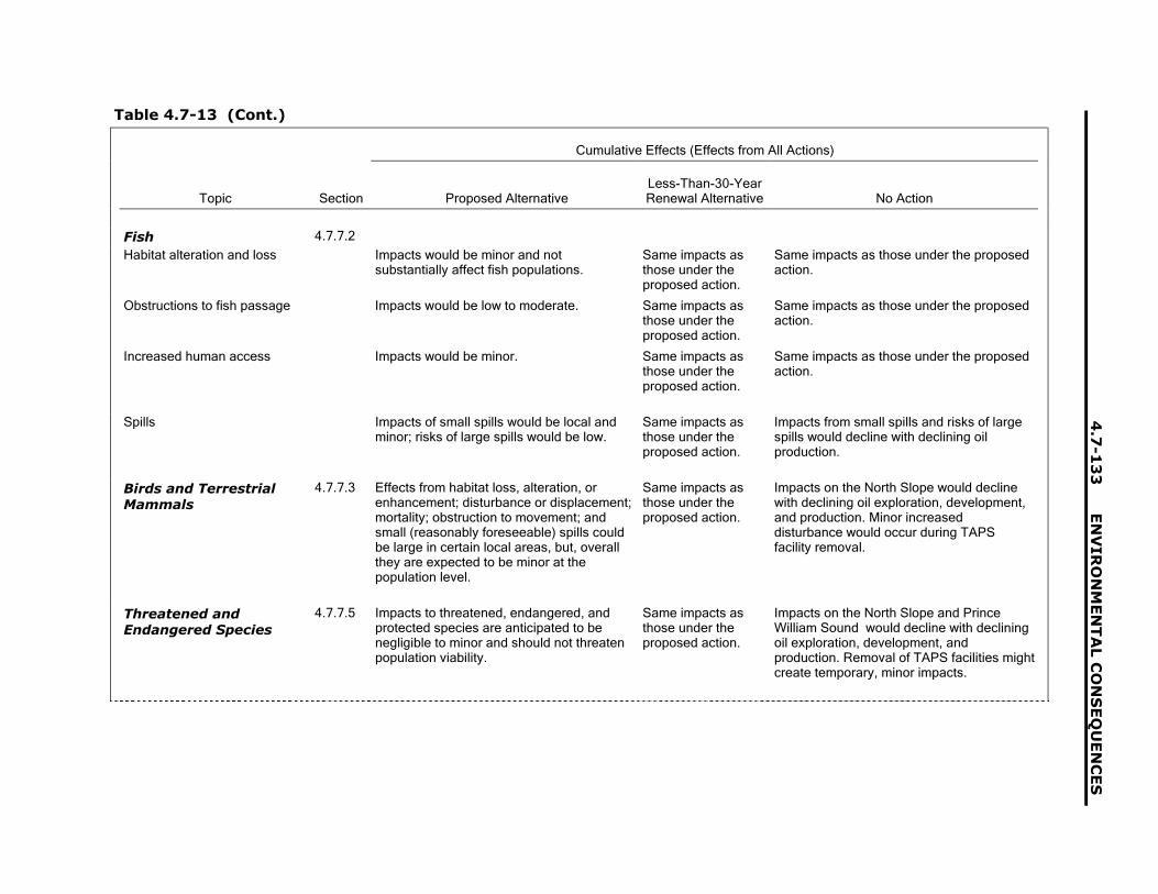
4.7
-13
3E
NV
IRO
NM
EN
TA
L C
ON
SE
QU
EN
CE
S
Table 4.7-13 (Cont.)
Cumulative Effects (Effects from All Actions)
Topic Section Proposed AlternativeLess-Than-30-YearRenewal Alternative No Action
Fish 4.7.7.2
Habitat alteration and loss Impacts would be minor and notsubstantially affect fish populations.
Same impacts asthose under theproposed action.
Same impacts as those under the proposedaction.
Obstructions to fish passage Impacts would be low to moderate. Same impacts asthose under theproposed action.
Same impacts as those under the proposedaction.
Increased human access Impacts would be minor. Same impacts asthose under theproposed action.
Same impacts as those under the proposedaction.
Spills Impacts of small spills would be local andminor; risks of large spills would be low.
Same impacts asthose under theproposed action.
Impacts from small spills and risks of largespills would decline with declining oilproduction.
Birds and TerrestrialMammals
4.7.7.3 Effects from habitat loss, alteration, orenhancement; disturbance or displacement;mortality; obstruction to movement; andsmall (reasonably foreseeable) spills couldbe large in certain local areas, but, overallthey are expected to be minor at thepopulation level.
Same impacts asthose under theproposed action.
Impacts on the North Slope would declinewith declining oil exploration, development,and production. Minor increaseddisturbance would occur during TAPSfacility removal.
Threatened andEndangered Species
4.7.7.5 Impacts to threatened, endangered, andprotected species are anticipated to benegligible to minor and should not threatenpopulation viability.
Same impacts asthose under theproposed action.
Impacts on the North Slope and PrinceWilliam Sound would decline with decliningoil exploration, development, andproduction. Removal of TAPS facilities mightcreate temporary, minor impacts.

EN
VIR
ON
ME
NT
AL C
ON
SE
QU
EN
CE
S4
.7-1
34
Table 4.7-13 (Cont.)
Cumulative Effects (Effects from All Actions)
Topic Section Proposed AlternativeLess-Than-30-YearRenewal Alternative No Action
Subsistence 4.7.8.1 Subsistence hunting and fishing, particularlyon the North Slope (and, to a lesser extent,in Interior Alaska) could be negativelyimpacted, primarily as a result of restrictionsin areas where subsistence can be pursuedand possible disruptions to the movement ofsubsistence resources from humanpresence and activities. However, both ofthese main impacts are not anticipated to besevere, with restricted access affectingrelatively small portions of large subsistenceharvest areas and with changes in animalmovement patterns often temporary andusually affecting only a relatively fewindividual animals. Contributions from theTAPS to these cumulative impacts areexpected to be relatively small.
Same impacts asthose under theproposed action.
Impacting factors would be different fromthose described under the proposed action(e.g., reduced employment, reducedcompetition from sport hunting andrecreation, increased need for resources,removal of barriers), but the overallcumulative effect might be the same.
Sociocultural Systems 4.7.8.2 In sociocultural systems founded oncooperation and subsistence, negativecumulative impacts might accompany theircontinued interaction with modern Americansociety and the continued growth in theimportance of a cash economy. However,these changes are largely a part of changesoccurring throughout Alaska and are notattributable solely to cumulative actionsconsidered in this DEIS. The contribution ofthe TAPS to these cumulative impactswould be relatively small.
Same impacts asthose under theproposed action.
Same impacts as those under the proposedaction.

4.7
-13
5E
NV
IRO
NM
EN
TA
L C
ON
SE
QU
EN
CE
S
Table 4.7-13 (Cont.)
Cumulative Effects (Effects from All Actions)
Topic Section Proposed AlternativeLess-Than-30-YearRenewal Alternative No Action
Economics 4.7.8.3 Temporary, local negative cumulativeeconomic impacts might occur during theconstruction of a gas pipeline and theNMDS; they would primarily test thecapabilities of local services. No long-termor statewide negative cumulative impactsare anticipated. Anticipated positiveeconomic impacts of these two projectslikely would help to offset declines ineconomic activity expected to accompanyreduced oil volumes transported through theTAPS over the coming decade.
Less-oil relatedinvestment wouldoccur in the NorthSlope oil fields, aswould lower levels ofnon-oil-related publicand privateinvestments. Theresult would be lessemployment,income, and taxrevenues.
Construction of a natural gas transportationsystem might partially offset the losses inemployment, income, and tax revenues thatwould accompany the end of TAPSoperation and North Slope oil production.
Cultural Resources 4.7.8.4 Negative cumulative impacts to culturalresources are expected to be minor, in partas a result of adhering to existing state andfederal regulations on such resourcesduring project development and operation.
Same impacts asthose under theproposed action.
Same impacts as those under the proposedaction.
Land Use and CoastalZone Management
4.7.8.5 Negative cumulative impacts on land useare anticipated to be minor. Negativecumulative impacts similarly are anticipatedto be minor both on the North Slope and inPrince William Sound. The contribution ofTAPS operation to these cumulative impactsis expected to be relatively small.
Same impacts asthose under theproposed action.
Same impacts as those under the proposedaction.

EN
VIR
ON
ME
NT
AL C
ON
SE
QU
EN
CE
S4
.7-1
36
Table 4.7-13 (Cont.)
Cumulative Effects (Effects from All Actions)
Topic Section Proposed AlternativeLess-Than-30-YearRenewal Alternative No Action
Recreation, Wilderness,and Aesthetics
4.7.8.6 Negative cumulative impacts to recreation(sightseeing) could accompany the additionof a gas pipeline, depending on its locationand design, although these impacts shouldbe localized. Negative cumulative impacts towilderness similarly could accompany a gaspipeline, primarily during construction.Negative cumulative impacts to aestheticscould accompany the addition of a gaspipeline and associated infrastructure to theTAPS ROW, this infrastructure would belocated in areas where visual surroundingshave already been modified. Thecontribution of TAPS operation torecreation, wilderness, and aestheticscumulative impacts would be relativelyminor.
Same impacts asthose under theproposed action.
Same impacts as those under the proposedaction.
Environmental Justice 4.7.8.7 There would be no high or adversecumulative impacts to minority or low-income populations.
Same impacts asthose under theproposed action.
Same impacts as those under the proposedaction.

4.8-1
4.8 Other NEPA Considerations
4.8.1 Unavoidable Adverse Impacts
The unavoidable adverse impacts under theproposed action (i.e., renew the ROW for30 years) and the less-than-30-year renewalalternative (i.e., renew the ROW for less than30 years) are discussed in detail in Sections 4.3through 4.7 and are summarized in this section.In general, these impacts are small and may bemitigated or offset by the positive aspects of theactions. There would be continued localizedimpacts to the environment as a result ofoperation, construction, and maintenanceactivities, such as soil and vegetationdisturbances, the use of surface andgroundwater resources, and air emissions.However, such impacts are readily mitigatedthrough measures already in place, asdiscussed in Section 4.1. The potential impactsfrom spills would remain, and those impactscould be adverse. However, preventive andmitigative measures are in place to limit andrepair the damage from spills.
Under both alternatives to renew the ROW,impacts on subsistence and socioculturalsystems would continue. However, numerousfactors are involved that would negate or limitadverse effects. For example, while localdisruption of animal movement patterns wouldcontinue, the ability of subsistence resourceusers to meet their needs would continue to beenhanced by the availability of the financialresources to purchase modern technology.
The no-action alternative (i.e., not renew theROW) would have localized unavoidableadverse impacts on fish and wildlife duringpipeline dismantlement, removal, and restorationactivities. These impacts would cease after thecompletion of these activities and would notthreaten entire fish or wildlife populations.However, the potentially adverse impacts oneconomics would last for a number of years.Initially, the pipeline termination activities wouldcreate jobs and revenue. However, as
termination activities ceased, those jobs andadditional revenue would end. The largereduction in revenues from terminating the TAPSoperations would adversely impact the ability ofthe state to provide public services, and areduction of the Permanent Fund would impactall Alaskans. The no-action alternative wouldindirectly affect North Slope oil production, aswell as other industries.
4.8.2 Relationship BetweenLocal Short-Term Uses ofthe Environment andLong-Term Productivity
The comparison of the proposed action andthe less-than-30-year renewal alternative showsthat the impacts over the possible 30-yearrenewal period vary little on an annualized basisbetween the two alternatives. The use of theenvironment under the alternatives to renewallows the continued passage of North Slopecrude oil to the Port of Valdez. The use of theTAPS further facilitates the development andproduction of North Slope oil fields. This allowsthe continued generation of revenues from theoperation of the North Slope oil fields, TAPS,and contributions into Alaska�s Permanent Fund.These monies would be used by Alaska and itsresidents beyond any renewal period.
At the end of the TAPS activities under theproposed action, the less-than-30-yearalternative, and the no-action alternative, therewould be continued use of the environment forthe duration of termination activities. At the endof termination activities, the impacts from TAPSon the physical environment would end, andrestoration of the environment would continue.As the impacts of the operation of the TAPSwould be small and temporary, the long-termproductivity of the physical environment wouldnot be affected by any of the alternatives.
ENVIRONMENTAL CONSEQUENCES 4.8-2
4.8.3 Irreversible andIrretrievableCommitment ofResources
Within the physical environment, thecontinued disturbance of soil and withdrawal ofsands, gravels, and quarry resources under theproposed action and the less-than-30-yearalternative to support TAPS construction andmaintenance activities would result in the partialloss of these resources. Similarly, othermaterials (such as fuels, structural steel, andlumber) would be consumed in continuing TAPSoperations and in TAPS termination activities, toinclude actions under the no-action alternative.Some of the material would be available forreuse after TAPS termination activities.
In general, the impacts of the threealternatives on biological resources would notconstitute irreversible and irretrievablecommitment of resources. While there would beimpacts on individuals, entire populations wouldnot be adversely impacted. In localized areas,vegetation and animal life and habitats would beaffected by the TAPS and TAPS terminationactivities (e.g., oil spills). However, the affectedindividuals would be replaced by other membersof their population. The restoration of habitatunder the various stipulations would reverse theloss of wildlife resources over time.
The trend of effects of modernization onAlaska Native cultural systems would continueunder all alternatives. The subsistence
resources used by Alaska Native groups,although possibly disrupted by the activitiesunder all three alternatives, would not beirreversibly and irretrievably committed. Asstated above, these subsistence resourceswould recover for biological resources.
Cultural and paleontological resources arenonrenewable. The continued operation of theTAPS would create the potential for damage tocultural and paleontological resources from oilspills and construction and maintenanceactivities. This irreversible and irretrievablecommitment of resources also would potentiallyexist during termination activities under theno-action alternative.
Under the proposed action and the less-than-30-year renewal alternative, the continuedoperation of the TAPS would allow continueduse of North Slope oil resources. Potential oilspills from the continued operation of the TAPSwould result in the economic loss of the spilledmaterial and the resources needed to managethe materials. Under the no-action alternative,the ability to use North Slope oil resources wouldcease until an alternative means oftransportation was developed.
4.8.4 Mitigation of AdverseEffects
During the analysis and assessmentconducted for this DEIS, no new mitigationmeasures were identified. Existing mitigationmeasures are presented in Section 4.1.

4.9-1
4.9 References for Chapter 4
ACGIH (American Conference of GovernmentalIndustrial Hygienists), 2000, TLVs and BEIs,Based on the Documentations of the ThresholdLimit Values for Chemical Substances andPhysical Agents and Biological ExposureIndices, Cincinnati, Ohio.
ACS (Alaska Clean Seas), 1999a, Alaska CleanSeas Technical Manual, ACS Industry/AgencyNorth Slope Spill Response Project Team,Prudhoe Bay, Alaska, March.
ACS, 1999b, Alaska Clean Seas TechnicalManual, Vol. 2, Map Atlas, Prudhoe Bay, Alaska.Available at http://www.alaskacleanseas.org.Accessed March 5, 2002.
ADCBD (Alaska Department of Community andBusiness Development), 2002a, CommunityGrants. Available at http://www.dced.state.ak.us/cbd/grt/communitygrants.htm. AccessedApril 27, 2002.
ADCBD, 2002b, Financial Assistance toCommunities. Available at http://www.dced.state.ak.us/cbd/srs.htm. Accessed April 27,2002.
ADCED (Alaska Department of Community andEconomic Development), 2001, AlaskaCommunity Database: Detailed CommunityInformation. Available at http://www.dced.state.ak.us/mra/CF_BLOCK.cfm. AccessedDec. 7, 2001.
ADCED, 2002, Glennallen. Available athttp://www.dced.state.ak.us/mra/CF_BLOCK.cfm. Accessed Feb. 1, 2002.
ADEC (Alaska Department of EnvironmentalConservation), 1997, Quarterly Provisional DataRelease, Oil and Hazardous SubstanceReleases, Prevention and Emergency ResponseProgram, Division of Spill Prevention andResponse January 1−March 31. Available athttp://www.state.ak.us/dec/pubs/97q3.pdf.Accessed Jan. 21, 2002.
ADEC, 2000, Risk Assessment ProceduresManual, Juneau, Alaska, June 8.
ADEC, 2001a, Contaminated Site RemediationProgram Handbook, Juneau, Alaska, July 17.
ADEC, 2001b, State of Alaska Spills Database,e-mail from ADEC to M. Lazaro (ArgonneNational Laboratory), June 30.
ADEC, 2001c, Oil Discharge and ContingencyPlan, Appendix K, Rev. Aug. 29, 2001. Availableat http://www.akrr.com/employment/resources/CPlan/Appendix-K.pdf.
ADEC, 2002, Calendar. Available at www.state.ak.us/dec/dec_cal.htm.
ADF&G (Alaska Department of Fish and Game),2000, Fish and Game License Statistics.Available at http://www.state.ak.us/local/akpages/FISH.GAME/admin/license/general/2001info.htm.
ADF&G, 2001, Community Profiles Database.Available at www.state.ak.us/local/akpages/FISH.GAME. Accessed Dec. 1, 2000.
ADF&G, 2002a, Scientific or Education PermitNo. FG 02-SP0-001, issued by ADF&G toAlyeska Pipeline Service Company, Jan. 10.
ADF&G, 2002b, Scientific or Education PermitNo. FG 02-SP0-002, issued by ADF&G toAlyeska Pipeline Service Company, Jan. 10.
ADF&G, 2002c, Articles and Presentations.Available at http://www.state.ak.us/adfg/subsist/geninfo/publctns/articles.htm. Accessed Feb. 2,2002.
ADF&G, 2002d, Commercial Fisheries.Available at http://www.cf.adfg.state.ak.us.Accessed Feb. 2, 2002.
ADHSS (Alaska Department of Health andSocial Services), 2002, Healthy Alaskans 2010,Targets and Strategies for Improved Health,Volume 1: Targets for Improved Health, Divisionof Public Health, April.

ENVIRONMENTAL CONSEQUENCES 4.9-2
ADNR (Alaska Department of NaturalResources), 1999a, Beaufort Sea Areawide1999 Oil and Gas Lease Sale: Final Finding ofthe Director, Alaska Department of NaturalResources, Division of Oil and Gas, Anchorage,Alaska.
ADNR, 1999b, Specific Issue Relating to Oil andGas Exploration, Development, Production, andTransportation, Division of Oil and Gas, Aug. 6.Available at http://204.126.119.8/oil/products/publications/northslope/nsa1999%5Ffinal%5Ffinding/87ch6.htm.
ADNR, 2000a, Annual Report, Division of Oiland Gas, Anchorage, Alaska.
ADNR, 2000b, Copper River Basin Oil and GasExploration License, Final Finding of theDirector, Alaska Department of NaturalResources, Division of Oil and Gas, Anchorage,Alaska. Available at http://www.dog.dnr.state.ak.us/oil/products/publications/copperriver/cr_final_finding/cr_finding_contents. AccessedSept. 5, 2001.
ADNR, 2001a, Individual State Park Units inAlaska, Division of Parks and OutdoorRecreation. Available at http://www.dnr.state.ak.us/parks/units/index.htm. Accessed Dec. 4,2001.
ADNR, 2001b, Chena River State RecreationArea, Division of Parks and Outdoor Recreation.Available at http://www.dnr.state.ak.us/parks/units/chena/index.htm. Accessed Aug. 3,2001.
ADNR, 2001c, State Marine Parks in the PrinceWilliam Sound and Resurrection Bay, Division ofParks and Outdoor Recreation. Available athttp://www.dnr.state.ak.us/parks/units/pwssmp/smppws.htm. Accessed Aug. 31, 2001.
ADNR, 2001d, Alaska State Parks StatewideBrochure, Division of Parks and OutdoorRecreation, Anchorage, Alaska. Available athttp://www.dnr.state.ak.us/parks/aspbro/index.htm.
ADNR, 2001e, AS 46.15.080 Finding andDetermination, Temporary Water UseAuthorization TWUP A2001-11, Funding andDetermination for 143,420,000 Gallons of Waterper Year (440 acre feet per year) from 90 Lakesfor Ice Road and Ice Pad Construction, Grantedto BP for Trailblazer NPR-A ExplorationProgram, Jan. 4.
ADOL (Alaska Department of Labor), 1990,�1989: Economic Revival Plus Oil Spill Boom,�Alaska Economic Trends, April.
ADTPF (Alaska Department of Transportationand Public Facilities), 2001, Northern RegionTraffic Data, 1998−1999−2000, Annual TrafficVolume Report, Northern Region Planning andAdministrative Services, Fairbanks, Alaska.
ADTPF, 2002, Statewide and AreaTransportation Plans. Available athttp://www.dot.state.ak.us/. Accessed Feb. 2,2002.
AEIC (Alaska Earthquake Information Center),2001, Earthquake Database, 1978 to 2001,Large Historic Earthquakes, GeophysicalInstitute, University of Alaska-Fairbanks.
AEIC, 2002, Seismology, Geophysical Institute,University of Alaska-Fairbanks. Available athttp://www.aeic.alaska.edu/Seis/. AccessedJan. 16, 2002.
AIChE (American Institute of ChemicalEngineers), 1989, Guidelines for ChemicalProcess Quantitative Risk Analysis, New York,N.Y.
AIHA (American Industrial Hygiene Association),2001, Emergency Response PlanningGuidelines, Cincinnati, Ohio.
Alaska Commission on Rural Governance andEmpowerment, 1999, Final Report to theGovernor, June. Available at http://www.deed.state.ak.us/cbd/RGC/cover.pdf.
Alaska Department of Health and SocialServices, 1999, A Summary of Recent FindingsRegarding Substance Abuse in Alaska, Divisionof Alcoholism and Drug Abuse, Juneau, Alaska,Dec.

4.9-3 ENVIRONMENTAL CONSEQUENCES
Alaska Department of Health and SocialServices, 2001a, Health Status in Alaska,Division of Public Health, Juneau, Alaska
Alaska Department of Health and SocialServices, 2001b, Healthy Alaskans, Juneau,Alaska.
Alaska Internet Travel Guide, 2000a, ANWR.Available at http://www.alaskaone.com/nwr/arct.htm.
Alaska Internet Travel Guide, 2000b, KanutiNWR. Available at http://www.alaskaone.com/nwr/kanu.htm.
Alaska Internet Travel Guide, 2000c, YukonNWR. Available at http://www.alaskaone.com/nwr/yfla.htm.
Alaska Railroad, 2002, Alaska Railroad.Available at http://www.akrr.com. AccessedFeb. 2, 2002.
Alaska Travel Industry Association, undated,The Tourism Industry: An Economic Engine forAlaska. Available at http://www.alaskatia.org.
Alpine, 1977, Alpine Development Project:Environmental Evaluation Document, Sept. Rev.,pp. 4−159.
Ambrosius, K., 2000, Area Covered by NorthSlope Oil Field Development, memorandumfrom Ambrosius (Aeromap US, Inc.) toR. Jakubczak (BP Exploration [Alaska] Inc.),Feb. 29.
American Petroleum Institute, 2002, Oil SpillPrevention and Response Natural WeatheringProcesses. Available at http://www.api.org/oilspills/weather.htm. Accessed Jan. 20, 2002.
Anderson, B., 2002, personal communicationfrom Anderson (TAPS Owners ROW RenewalTeam, Anchorage, Alaska) to W. Vinikour(Argonne National Laboratory), April 15.
Anderson, B.A., et al., 1992, GHX-1 Waterbirdand Noise Monitoring Program, prepared byAlaska Biological Research, Inc., and BBNSystems and Technologies for ARCO Alaska,Inc., Anchorage, Alaska.
Andon, H.B., 1997, �Patterns of Injury Mortalityamong Athapaskan Indians in Interior Alaska,�American Indian and Alaska Native MentalHealth Research 7:11�33.
APSC (Alyeska Pipeline Service Company),1973, Summary Report Basis for EarthquakeDesign for the Trans Alaska Pipeline System,Appendix A-3.1051A, Houston, Texas.
APSC, 1983, Trans-Alaska Pipeline SystemDismantling, Removal, and Restoration CostEstimate Report, April.
APSC, 1990a, Prevention of SignificantDeterioration Permit Application, PumpStation #2, Anchorage, Alaska, Oct.
APSC, 1990b, Prevention of SignificantDeterioration Permit Application, PumpStation #7, Rim Cooling Project, Anchorage,Alaska, Oct.
APSC, 1990c, Applications for Prevention ofSignificant Deterioration Approval and AirQuality Control Permit to Operate, PumpStations 2 and 7, Rim Cooling Projects,submitted to Alaska Department ofEnvironmental Conservation, Oct. 25.
APSC, 1991, Fuel Sulfur, Proposed Changes toDraft Compliance Order and Modeling SummaryReport, Anchorage, Alaska, May.
APSC, 1993, Environmental Atlas of the TransAlaska Pipeline System, 1st Ed., Anchorage,Alaska.
APSC, 1995, Mixing Zone Application forNPDES Permit Renewal for the Ballast WaterTreatment Plant and Sewage Treatment Plant atthe Valdez Marine Terminal Trans AlaskaPipeline System, Valdez, Alaska, Anchorage,Alaska, July.
APSC, 1996, TAPS Design Criteria and DesignBasis Core Documents Volume 1, DB-180Vol. 1, First Ed., Rev. 0; Anchorage, Alaska, Jan.
APSC, 1997, Final Report for DispersionModeling of a Generic Pump Station along theTrans-Alaska Pipeline, Anchorage, Alaska,June.

ENVIRONMENTAL CONSEQUENCES 4.9-4
APSC, 1998a, Letter No 98-12682, NPDESPermit AK005056-3 Permit Renewal, byL.C. Jones, APSC, Jan. 29.
APSC, 1998b, Trans-Alaska Pipeline SystemEnvironmental Protection Manual, EN-43,5th Ed., Rev. 0, Anchorage, Alaska, July.
APSC, 1998c, Best Management Practices Plan,Ballast Water Treatment Facility, Alyeska MarineTerminal, MP-69-1, 2nd Ed., Anchorage, Alaska.
APSC, 1998d, Alaska Native UtilizationAgreement, Anchorage, Alaska, Oct.
APSC, 1998e, Erosion Control Plan forMaintenance Operations, EP-106, 2nd Ed.,Rev. 0, Anchorage, Alaska, Dec. 31.
APSC, 1999a, Quality Program Manual, QA-36,1st Ed., Rev. 9, Anchorage, Alaska, Oct.
APSC, 1999b, Corrosion Control ManagementPlan for Mainline Sections of the Trans AlaskaPipeline System, Fairbanks, Alaska, March.
APSC, 2000a, Trans-Alaska Pipeline SystemEnvironmental Protection Manual, EN-43-1,6th Ed., Rev. 1, Feb.
APSC, 2000b, Environmental ManagementSystem Compliance Manual, 1st Ed., Rev. 0,Anchorage, Alaska, Dec.
APSC, 2000c, Wildlife Hazing Plan, Fairbanks,Alaska, March.
APSC, 2000d, Pulses Pose No Threat toPipeline, News Bulletin 1314, March 30.Available at http://www.alyeska-pipe.com/Inthenews/Newsbulletins/2000/bulletin1314.html. Accessed Feb. 2002.
APSC, 2000e, Design Basis Update (DB-180),3rd Ed., Rev. 1, Anchorage, Alaska, Dec.
APSC, 2001a, TAPS Engineering Manual,PM-2001, 3rd Ed., Rev. 0, Anchorage, Alaska,March.
APSC, 2001b, APSC Design Basis Update DB-180, 3rd Ed., Rev. 3, Anchorage, Alaska,Feb. 14.
APSC, 2001c, Maintenance System Manual,MP-167, 2nd Ed., Rev. 7, Anchorage, Alaska,July.
APSC, 2001d, Trans-Alaska Pipeline SystemEnvironmental Protection Manual, WasteManagement, EN-43-2, 6th Ed., Rev. 1, March.
APSC, 2001e, Corporate Safety Manual, SA-38,5th Ed., Rev. 2, Anchorage, Alaska, May 31.
APSC, 2001f, Guide for Packaging andTransporting Hazardous Materials/DangerousGoods by Highway and by Aircraft, HZ-134,3rd Ed., Rev. 00, Anchorage, Alaska, Oct.
APSC, 2001g, Trans-Alaska Pipeline System OilDischarge Prevention and Contingency Plan,CP-35-1, Anchorage, Alaska.
APSC, 2001h, Valdez Marine Terminal OilDischarge Prevention and Contingency Plan,CP-35-2, 4th Ed., Rev. 2, Anchorage, Alaska,July 17.
APSC, 2001i, Trans Alaska Pipeline SystemFacts, Anchorage, Alaska, June.
APSC, 2001j, Trans-Alaska PipelineMaintenance and Repair Manual, MR-48,2nd Ed., Rev. 17, Anchorage, Alaska, June 11.
APSC, 2001k, SRCM® Evaluation of AlyeskaPipeline Service Company�s Pump Station 01,Draft, Anchorage, Alaska, Aug.
APSC, 2001m, Trans-Alaska Pipeline SystemOil Discharge Prevention and Contingency Plan,General Provisions, CP-35-1, GP Ed. 4, Rev. 0,Anchorage, Alaska.
APSC, 2001n, Duration of Right of Way Renewalfor the Trans Alaska Pipeline System,Section A2.3, March 23.
APSC, 2001o, e-mail from R. Roehner (AlyeskaPipeline Service Company, Fairbanks, Alaska)to M. Lazaro (Argonne National Laboratory),Dec. 19.
APSC, 2002a, Environmental Report for Trans-Alaska Pipeline System Right-of-Way Renewal,Potential TAPS Upgrades, May.

4.9-5 ENVIRONMENTAL CONSEQUENCES
APSC, 2002b, Alaska Native Program. Harmonyand Balance, 2001 Annual Report, Anchorage,Alaska.
APSC, 2002c, Valdez Marine Terminal, Fire-Fighting Operations in Crude Oil Storage Tanks Guidelines, Feb.
APSC, 2002d, Valdez Marine Terminal FireProtection System, TAPS Right-of-WayRenewal, March.
ARRC (Alaska Railroad Corporation), 2000,Annual Report 1999, Anchorage, Alaska.
ARRT (Alaska Regional Response Team), 1999,�Background,� Section E in North Slope SubareaContingency Plan for Oil and HazardousSubstance Discharges/Releases A SubareaPlan of the Unified Plan for the State of Alaska,Dec. Available at http://www.akrrt.org/NSplan/E-Background.pdf. Accessed Jan. 21, 2002.
ARRT, 2000, Interior Alaska SubareaContingency Plan for Oil and HazardousSubstance Discharges/Releases A SubareaPlan of the Unified Plan for the State of Alaska,June. Available at http://www.akrrt.org/INTplan/int_toc.shtml. Accessed Sept. 25, 2001.
ARRT et al., 1999, Unified Federal/State,Coastal/Inland Oil and Hazardous SubstancePreparedness Plan. Available atwww.akrrt.org/UnifiedPlan.
Aus, W.T., et al., 2000, �Mainline ValveOperations and Maintenance Program on theTrans Alaska Pipeline,� Paper ETCE2000/OGPT-10264 in Energy for the New Millennium,Proceedings of the ETCE/OMAE 2000Conference, held in New Orleans, La., publishedby the American Society of MechanicalEngineers.
AWWA (American Water Works Association),2001, Flowing Water, Frozen Ground. Availableat http://www.awwa.org/mainstream/archives/2001/January/ms0101alaska.htm.Accessed April 10, 2002.
Bailey, E.P., 1993, Introduction of Foxes toAlaskan Islands History, Effects on Avifauna,and Eradication, U.S. Fish and Wildlife Service,Homer, Alaska.
Baker, M.T., 2001, Material Data Safety Sheet,Kerosene. Available at http://www.jtbaker.com/msds/k2175.htm. Accessed Jan. 20.
Ballard, W., and H. Whitlaw, 2002, personalcommunication from Ballard and Whitlaw (TAPSOwners ROW Renewal Team, Anchorage,Alaska) to W. Vinikour (Argonne NationalLaboratory), April 15.
Ballard, W.B., et al., 2000, �Arctic Fox, Alopexlagopus, Den Densities in the Prudhoe Bay OilField, Alaska,� Canadian Field-Naturalist11(3):453−456.
Barsdate, R.J., et al., 1980, �Oil Spill Effects,�pp. 388−407 in Limnology of Tundra Ponds,J.E. Hobbie (editor), Dowden, Hutchinson andRoss, Inc., Stroudsberg, Penn.
Behrends, B., 2002, personal communicationfrom Behrends (Chugach National Forest,Cordova, Alaska) to C. Adornetto (ArgonneNational Laboratory), Feb. 6.
Berger, T.R., 1985, Village Journey: The Reportof the Alaska Native Review Commission, Hilland Wang, New York, N.Y.
Berkes, F., 1993, �Traditional EcologicalKnowledge in Perspective,� in TraditionalEcological Knowledge: Concepts and Cases,J.T. Inglis (editor), International Program onTraditional Ecological Knowledge andInternational Development Research Centre,Ottawa, Ontario, Canada.
Berry, M.C., 1975, The Alaska Pipeline: ThePolitics of Oil and Native Land Claims, IndianaUniversity Press, Bloomington, Ind.
BLM (Bureau of Land Management), 1972, FinalEnvironmental Impact Statement, ProposedTrans-Alaska Pipeline, prepared by BLM, AlaskaOffice, Anchorage, Alaska, for the Federal TaskForce on Alaskan Oil Development.
BLM 1983a, River Management Plan for theDelta National Wild River, Anchorage District,Alaska. Available at http://www.glennallen.ak.blm.gov/delta/index.html.
ENVIRONMENTAL CONSEQUENCES 4.9-6
BLM, 1983b, River Management Plan for theGulkana National Wild and Scenic River,Anchorage District, Alaska. Available athttp://www.glennallen.ak.blm.gov/gulkana/index.html.
BLM, 1983c, Final Environmental ImpactStatement on Oil and Gas Leasing in theNational Petroleum Reserve in Alaska,Anchorage, Alaska.
BLM, 1989, Utility Corridor Proposed ResourceManagement Plan and Final EnvironmentalImpact Statement, Arctic District Office,Fairbanks, Alaska.
BLM, 1991, Recreation Area Management PlanDalton Highway, Arctic District Office, Fairbanks,Alaska.
BLM, 1998, Northeast National PetroleumReserve-Alaska, Final Integrated ActivityPlan/Environmental Impact Statement, Vols. 1and 2, prepared by U.S. Department of theInterior, BLM, in cooperation with the MineralsManagement Service, Aug. Available athttp://.blm/ak/pl-98/016+3130+930.
BLM, 2001a, Identification of Tribes forConsultation for TAPS Renewal, Anchorage,Alaska.
BLM, 2001b, Dalton Highway VisitationStatistics, Northern Field Office, Fairbanks,Alaska.
BLM and USACE (U.S. Army Corps ofEngineers), 1988, Trans-Alaska Gas System,Final Environmental Impact Statement, BLM-Alaska-PT-88-003-1792-910, prepared by BLMand USACE, Alaska District, Anchorage, Alaska.
Bolger, M., and C.D. Carrington, 1999, �Hazardand Risk Assessment of Crude Oil inSubsistence Seafood Samples from PrinceWilliam Sound: Lessons Learned from the ExxonValdez,� Chapter 9 in Field et al. 1999.
Bolger, M., et al., 1996, �Hazard and RiskAssessment of Crude Oil Contaminants inSubsistence Seafood Samples from PrinceWilliam Sound,� pp. 837−843 in Proceedings ofAmerican Fisheries Society Symposium 18.
BP Exploration (Alaska) Inc., 2000, NPR-A FiveYear Trailblazer Winter Exploration Program,Plan of Operations, Atttachment 1,Updates/Clarifications to BPXA, Oct. 18.
BP, 2002a, Exploring Alaska: BP Operations inAlaska. Available at http://www.bp.com/alaska/index_alaska.htm. Accessed Feb. 3,2002.
BP, 2002b, Alaska Natural Gas The Options.Available at http://www.bp.com/alaska/index_juneau.htm. Accessed Feb. 8, 2002.
BP, 2002c, Prudhoe Bay. Available athttp://www.bp.com/alaska/education/teachers/pdf/ pru_bay.pdf.
BP Amoco Alaska, 2001, Naturally OccurringRadioactive Material (NORM) Procedure, Rev.March 23.
Brannon, E.L., et al., 1995, �An Assessment ofOil Spill Effects on Pink Salmon Populationsfollowing the Exxon Valdez Oil Spill Part 1:Early Life History,� pp. 548−584 in Proceedingsof the 3rd Symposium on EnvironmentalToxicology and Risk Assessment: Aquatic,Plant, and Terrestrial, 26−28 April 1993, Atlanta,Georgia, P.G. Wells et al. (editors), SpecialTechnical Publication 1219, American Societyfor Testing and Materials, Philadelphia, Penn.
Brannon, E.L., et al., 2001, �ResolvingAllegations of Oil Damage to Incubating PinkSalmon Eggs in Prince William Sound,�Canadian Journal of Fisheries and AquaticSciences 58:1070−1076.
Briggs, G. A., 1984, �Plume Rise and BuoyancyEffects,� pp. 327−361 in Atmospheric Scienceand Power Production, DOE/TC-27601(DE84005177), U.S. Department of Energy,Office of Scientific and Technical Information,Technical Information Center, Washington, D.C.
Bronczyk, S., 2002, Comments on Sand, Gravel,and Quarry Resources, interoffice memorandumfrom Bronczyk to J. Dygas (Joint Pipeline Office,Anchorage, Alaska), Feb. 4.
4.9-7 ENVIRONMENTAL CONSEQUENCES
Brossia, J., and W.G. Britt, Jr., 2001, RevisedJPO Brushing Policy, letter with attachment fromBrossia and Britt (Joint Pipeline Office,Anchorage, Alaska) to R.I. Shouf (AlyeskaPipeline Service Company, Anchorage, Alaska),Jan. 19.
Brossia, J., and J. Kerrigan, 2001, RestorationPerformance Requirements Pursuant toStipulation 2-12-1, letter from Brossia andKerrigan (Joint Pipeline Office, Anchorage,Alaska) to R.I. Shouf (Alyeska Pipeline ServiceCompany, Anchorage Alaska), June 18.
Brown, D., 1999, record of meeting betweenBrown (Alyeska Security, Alyeska PipelineService Company, Fairbanks, Alaska) andM. Cronin (LGL Alaska Research Associates,Inc., Anchorage, Alaska), Nov. 1.
Brown, D. F., et al., 1997, FIREPLUME Model forPlume Dispersion from Fires: Application toUranium Hexafluoride Cyclinder Fires,ANL/EAD/TM-69, Argonne National Laboratory,Argonne, Ill., June.
Brown, D. F., et al., 2000a, A NationalTransportation Risk Assessment for HazardousMaterials in Transportation, ANL/DIS-01-1,Argonne National Laboratory, Argonne, Ill., Dec.
Brown, D. F., et al., 2000b, �The FIREPLUMEand SMOKE Models: Tools for EventualApplications to Wildland Fires and PrescribedBurn,� in Vol. II of Crossing the Millennium:Conference and Workshop, Integrating SpatialTechnologies and Ecological Principals for aNew Age in Fire Management, Proceedings ofthe Joint Fire Science Conference andWorkshop, University of Idaho, Moscow, Idaho.
Brown, M.K., 2002, Oil Spill Modeling 2.1MMBPD, e-mail from Brown (Alyeska PipelineService Company, Anchorage, Alaska) toJ.D. Norton (TAPS Owners ROW RenewalTeam, Anchorage, Alaska), Jan. 3.
Bue, B.G., et al., 1996, �Effects of the ExxonValdez Oil Spill on Pink Salmon Embryos andPreemergent Fry,� American Fisheries SocietySymposium 18:619−627.
Bureau of Economic Analysis, 2001, GDP andRelated Data, U.S. Department of Commerce.Available at http://www.bea.doc.gov/.
Burger, A.E., and D.M. Fry, 1993, �Effects of OilPollution on Seabirds in the Northeast Pacific,�pp. 254−263, in The Status, Ecology, andConservation of Marine Birds of the NorthPacific, K. Vermeer et al. (eds.), CW66-124-1993E, Canadian Wildlife Service, Ottawa,Ontario, Canada.
Burgess, R.M., 2000, �Arctic Fox,� Chapter 8,pp. 159−178 in The Natural History of an ArcticOil Field Development and the Biota, J.C. Truettand S.R. Johnson (editors), Academic Press,San Diego, Calif.
Burgess, R.M., and R.J. Ritchie, 1987, �SnowGeese,� Vol. 7, Part VII, in 1985 EndicottEnvironmental Monitoring Program, prepared byEnvirosphere Company, Anchorage, Alaska, forU.S. Army Corps of Engineers, Alaska District,Anchorage, Alaska.
Burgess, R.M., and R.J. Ritchie, 1990, �SnowGeese,� Vol. 8, Part VI, Chapter 1 in 1986Endicott Environmental Monitoring Program,prepared by Envirosphere Company,Anchorage, Alaska, for U.S. Army Corps ofEngineers, Alaska District, Anchorage, Alaska.
Burgess, R.M., and R.J. Ritchie, 1991, �SnowGeese,� Vol. 8, Part V, Chapter 1 in 1987Endicott Environmental Monitoring Program,prepared by Envirosphere Company,Anchorage, Alaska, for U.S. Army Corps ofEngineers, Alaska District, Anchorage, Alaska.
Burr, J., 2001, Fishery Management Report forSport Fisheries in the Arctic-Yukon-KuskokwimManagement Area, 1999−2000, FisheryManagement Report No. 01-3, AlaskaDepartment of Fish and Game, Anchorage,Alaska, March.
Calef, G.W., et al., 1967, �The Reaction ofBarren-Ground Caribou to Aircraft,� Arctic29(4):201−212.

ENVIRONMENTAL CONSEQUENCES 4.9-8
Cameron, R.D., and K.R. Whitten, 1980,�Influence of the Trans-Alaska Pipeline Corridoron the Local Distribution of Caribou,�pp. 475−484 in Proceedings of the 2ndInternational Reindeer/Caribou Symposium,Roros, Norway, 1979, E. Reimers et al. (editors),Direktoratet for Vilt og Ferskvannsfisk,Trondheim.
Cameron, R.D., et al., 1985, Effects of the Trans-Alaska Pipeline on the Distribution andMovements of Caribou, Final Report, FederalAid in Wildlife Restoration, Project W-17-7through W-17-11, W-21-1, W21-2, and W-22-1through W-22-4, Job 3.18R, Alaska Departmentof Fish and Game, Juneau, Alaska, Aug.
Cameron, R.D., et al., 1992, �Redistribution ofCalving Caribou in Response to Oil FieldDevelopment of the Arctic Slope of Alaska,�Arctic 45(4):338−342.
Cameron, R.D., et al., 1995, �Abundance andMovements of Caribou in the Oilfield Complexnear Prudhoe Bay, Alaska,� Rangifer 15(1):3−7.
Capstone (Capstone Engineering Services, Inc.),2001, Screening Risk Analysis, Trans AlaskaPipeline System, Final Report (Rev. 1), preparedby Capstone, Houston, Texas, for AlyeskaPipeline Service Company, Anchorage, Alaska,Dec.
Carpenter, P., 1997, TAPS Oil Spill ContingencyPlan Oil Spill Volume Program, Version 2 forWindows 95/NT, Serrano Services and Systems,July 3.
Carruthers, D.R., and R.D. Jakimchuk, 1987,�Migratory Movements of the Nelchina CaribouHerd in Relation to the Trans-Alaska Pipeline,�Wildlife Society Bulletin 15:414−420.
Cederquist, S., 1999, �A Multi-ComponentApproach to Cathodic Protection Monitoring,�Materials Performance, pp.19−25, Nov.
Center for Chemical Process Safety, 2000,Guidelines for Chemical Process QuantitativeRisk Analysis, Second Edition, AmericanInstitute of Chemical Engineers, New York, N.Y.
CEQ (Council on Environmental Quality), 1997,Considering Cumulative Effects under theNational Environmental Policy Act, Jan.
CERA (Cambridge Energy ResearchAssociates), 1999, Alaska Natural Gas, preparedfor BP Exploration (Alaska) Inc., Anchorage,Alaska.
Chardine, J., and V. Mendenhall, 1998,Conservation of Arctic Flora and Fauna: HumanDisturbance at Arctic Seabird Colonies, TechReport No. 2, CAFF Circumpolar SeabirdWorking Group. Available at www.grida.no/caff/tr2_hdr.htm. Accessed Aug. 6, 2001.
Clark, R.B., 1984, �Impact of Oil Pollution onSeabirds,� Environmental Pollution (Series A)33:1−22.
Coates, P.A., 1993, The Trans-Alaska PipelineControversy. Technology, Conservation, and theFrontier, University of Alaska Press, Fairbanks,Alaska.
Collins, C.M., et al., 1994, �The Physical,Chemical, and Biological Effects of Crude OilSpills after 15 Years on a Black Spruce Forest,Interior Alaska,� Arctic 47(2):164−175.
Colonell, J.M., 1980, �Port Valdez, Alaska:Environmental Studies 1976−1979,� pp. 11−35 inOccasional Publication No. 5, Institute of MarineScience, University of Alaska-Fairbanks, Dec.
CONCAWE, 1998, Western European Cross-Country Oil Pipelines 25-Year PerformanceStatistics, Report No. 2/98. Available athttp://www.concawe.org/Download/Reports/Rpt_98-2.pdf. Accessed Feb. 8, 2002.
CPUC (California Public Utilities Commission),1998, Carson to Norwalk Pipeline, Santa FePacific Pipeline Partners, L.P., FinalEnvironmental Impact Report, May. Available athttp://www.aspeneg.com/SFPP-EIR/feir/feir-toc.htm. Accessed Feb. 22, 2002.
CPUC and USFS (U.S. Forest Service), 1996,Pacific Pipeline System, Inc.(PPSI),Environmental Impact Statement andSubsequent Environmental Impact Report(EIS/SEIR), 1996, Angeles National Forest.Available at http://www.aspeneg. com/PPSI-FEIR/final/toc.html. Accessed July 11, 2001.

4.9-9 ENVIRONMENTAL CONSEQUENCES
Craig, A., et al., 1995, �A Compilation ofHistorical Preemergent Fry and Egg DepositionSurvey Data from Prince William Sound,1961−1995,� pp. 1−17 in Regional InformationReport No. 2A95-49, Alaska Department of Fishand Game, Division of Commercial Fisheries,Management and Development, Anchorage,Alaska.
Craig, P.C., 1984, �Fish Use of Coastal Watersof the Alaskan Beaufort Sea: A Review,�Transactions of the American Fisheries Society113:265−282.
Cronin, M., 2002, personal communication fromCronin (TAPS Owners ROW Renewal Team,Anchorage, Alaska) to W. Vinikour (ArgonneNational Laboratory), April 15.
Cronin, M.A., et al. (compilers), 1994, Mitigationof the Effects of Oil Field Development andTransportation Corridors on Caribou, FinalReport, prepared by LGL Alaska ResearchAssociates, Inc., Anchorage, Alaska, for AlaskaCaribou Steering Committee, July.
Cronin, M.A., et al., 1998a, �Caribou Distributionduring the Post-Calving Period in Relation toInfrastructure in the Prudhoe Bay Oil Field,Alaska,� Arctic 51(2):85−93.
Cronin, M.A., et al., 1998b, �Northern Alaska OilFields and Caribou: A Commentary,� BiologicalConservation 83(2):195−208.
Curatolo, J.A., and S.M. Murphy, 1986, �TheEffects of Pipelines, Roads, and Traffic on theMovements of Caribou, Rangifer tarandus,�Canadian Field-Naturalist 100:218−224.
Day, R.H., 1998, Predator Populations andPredation Intensity on Tundra-Nesting Birds inRelation to Human Development, prepared byABR, Inc., Fairbanks, Alaska, for NorthernAlaska Ecological Services, Fairbanks, Alaska,May.
Delaney, R., 2001, personal communication fromDelaney (Bureau of Land Management, NorthernField Office, Fairbanks, Alaska) to C. Adornetto(Argonne National Laboratory), Sept. 5.
DenBeste, J., and P. McCart, 1984, Overview ofStudies of the Long-Term Effects of the Trans-Alaska Pipeline System of Fish and AquaticHabitats, Vol. I, prepared by AquaticEnvironments, Inc., for Alyeska Pipeline ServiceCompany, Anchorage, Alaska.
Det Norske Veritas et al., 1996, Prince WilliamSound Alaska: Risk Assessment Study, FinalReport, prepared for Prince William Sound RiskAssessment Steering Committee, Dec.
Devereux, D., 2001, e-mail from Devereux(Alyeska Pipeline Service Company, PrudhoeBay, Alaska) to M. Wilkinson (AlaskaDepartment of Environmental Conservation,Fairbanks, Alaska), Sept. 13.
Dixon, M., 1978, What Happened to Fairbanks?The Effects of the Trans-Alaska Oil Pipeline onthe Community of Fairbanks, Alaska, WestviewPress, Boulder, Colo.
DOE (U.S. Department of Energy), 1996,Accident Analysis of Aircraft Crashes intoHazardous Facilities, Standard DOE-STD-3014-96, Oct. Available at http://tis.eh.doe.gov/techstds/standard/standfrm.html.
DOE (U.S. Department of Energy), 2001a,Future Oil Production for the Alaska North Slope,Energy Information Administration, Office of Oiland Gas. Available at http://www.eia.doe.gov/oil_gas/petroleum/analysis_publications/pet_analysis_publications.html.
DOE, 2001b, Annual Energy Outlook, 2002,Energy Information Administration. Available athttp://www.eia.doe.gov/oiaf/aeo/index.html.
DOI et al. (U.S. Department of the Interior et al.),1997, Programmatic Agreement on Protection ofHistoric Properties during EmergencyContingency Plan, Annex M; AlaskaFederal/State Preparedness Plan for Responseto Oil and Hazardous SubstanceDischarges/Releases, agreement among10 federal and state agencies. Available atwww.achp.gov/NCP-PA.html.
DOT (U.S. Department of Transportation),2001a, Office of Pipeline Safety, Research andSpecial Programs Administration. Available athttp://ops.dot.gov.

ENVIRONMENTAL CONSEQUENCES 4.9-10
DOT, 2001b, Natural Gas Transmission Data.Available at http://ops.dot.gov/IA98.htm.Accessed Aug. 24.
DOT, 2001c, Hazard Liquid Accident Data 1986−Present. Available at http://ops.dot.gov/IA98.htm. Accessed Aug. 24.
DOT, 2001d, Hazardous Material IncidentSystem Database. Available athttp://hazmat.dot.gov/files/hazmat/hmisframe.htm. Accessed March 2002.
DuBois, S.D., and R. Rogers, 1999, Draft DeltaBison Management Plan 1999−2004, AlaskaDepartment of Fish and Game, Division ofWildlife Conservation, Anchorage, Alaska.
Duffy, L.K., et al., 1996, �Acute Phase Proteinsand Cytokines in Alaskan Mammals as Markersof Chronic Exposure to EnvironmentalPollutants,� pp. 809−813 in Proceedings of theExxon Valdez Oil Spill Symposium, Rice et al.(editors), sponsored by American FisheriesSociety, Bethesda, Md.
Dunton, K.H., and S.V. Schonberg, 2000, �TheBenthic Faunal Assemblage of the BoulderPatch Kelp Community,� in The Natural Historyof an Arctic Oil Field, J.C. Truett and S.R.Johnson (editors), Academic Press, San Diego,Calif.
Dygas, J., and D. Keyes, 2002, personalcommunication between Dygas and Keyes (JointPipeline Office, Anchorage, Alaska) and R.Kolpa (Argonne National Laboratory), April 18.
ECA (Everest Consulting Associates), 1999a,Federal Revenues, memorandum toS. Goldsmith, Cranbury, N.J.
ECA, 1999b, Future (2000−2034) Demand forTankers to Serve ANS Trade: A Working Paper,Cranbury, N.J.
Edwards, L., 2002, personal communicationfrom Edwards (Alyeska Pipeline ServiceCompany, Valdez, Alaska) to R. Kolpa (ArgonneNational Laboratory), March 21.
Eide, S.H., et al., 1986, �Oil Pipeline CrossingSites Utilized in Winter by Moose, Alces alces,and Caribou, Rangifer tarandus, in SouthcentralAlaska,� Canadian Field-Naturalist 100:197−207.
Eielson AFB (Air Force Base), 2002, EielsonAFB. Available at http://www.linkupalaska.com/rolodex/military/ eielsonafb/.
Elleven, R., 2002a, Evaluation of Agreement andGrant of Right-of-Way Lease Stipulation 1.20Health and Safety, TAPS Assessment, JPO No.ANC-02-A-001, prepared for Joint PipelineOffice, Anchorage, Alaska, Feb.
Elleven, R., 2002b, e-mail from Ellevan (JointPipeline Office, Anchorage, Alaska) toK. Wescott (Argonne National Laboratory),March.
Elliott, G.V., 1982, Evaluation of StreamCrossings and Effects of Channel Modificationson Fishery Resources along the Route of theTrans-Alaska Pipeline, Final Report, U.S. Fishand Wildlife Service, Special Studies,Anchorage, Alaska.
EMCON Alaska, Inc., 1999, Final GlacierGeohazard Identification, prepared by EMCON,Fairbanks, Alaska, for Alyeska Pipeline ServiceCompany, Anchorage, Alaska, Dec.
Emerald (Emerald Consulting Group), 2001,Valdez Marine Terminal Oil Spill RiskAssessment, Final Report, March 30.
EPA (U.S. Environmental Protection Agency),1990, �National Oil and HazardousSubstances Pollution Contingency Plan; FinalRule (40 CFR Part 300),� Federal Register55(46):8666−8865, March 8.
EPA, 1993, Provisional Guidance forQuantitative Risk Assessment of PolycyclicAromatic Hydrocarbons, EPA/600/R-93/089,Office of Research and Development,Washington, D.C.
EPA, 1995, User�s Guide for the IndustrialSource Complex (ISC3) Dispersion Models,Vols. 1 and 2, EPA-454/B-95-003a and b(version 02035), Office of Air Quality Planningand Standards, Research Triangle Park, N.C.,Sept.
EPA, 2001a, Priority PBTs: Mercury andCompounds, Office of Pollution Prevention andToxics, Persistent Bioaccumulate and ToxicChemical Program. Available athttp://www.epa.gov/pbt/ mercury.htm.

4.9-11 ENVIRONMENTAL CONSEQUENCES
EPA, 2001b, 2000 PBT ProgramAccomplishments, EPA-742-R-01-003, Office ofPollution Prevention and Toxics, Nov. Availableat www.epa.gov/pbt.
EPA, 2001c, Integrated Risk Information System(IRIS), Office of Remedial and EmergencyResponse. Available at http://www.epa.gov/ngispgm3/iris/index.html. Accessed Dec.
EPA, 2001d, National Air Quality and EmissionTrends Report, 1999, OAQPS, RTP,EPA 454/R-01-004, March.
EPA, 2002a, Responding to Oil Spills. Availableat http://www.epa.gov/oilspill/response.htm.Accessed Jan. 6, 2002.
EPA, 2002b, Envirofacts Warehouse. Availableat http://oaspub.epa.gov/enviro. AccessedMarch 18, 2002.
EPA, 2002c, TRI State Data Files, ToxicsRelease Inventory (TRI) Program. Available atwysiwyg://6/http://www.epa.gov/tri/tridata/state_data_files.htm.
EPA and NOAA (National Oceanic andAtmospheric Administration), 1999, ArealLocations of Hazardous Atmospheres (ALOHA)User�s Manual, Washington, D.C., Aug.
ESSO, 2001, General Oil Spill Response Plan.Available at http://www.esso.com/eaff/essochad/documentation/documentation_frame2.html.Accessed Jan. 6, 2002.
Etkin, D.S., 1998, Financial Costs of Oil Spills inthe U.S., Cutter Information Corporation,Arlington, Mass.
Everett, K.R., 1980, �Distribution and Propertiesof Road Dust along the Northern Portion of theHaul Road,� Chapter 3 in EnvironmentalEngineering and Ecological Investigations alongthe Yukon River-Prudhoe Bay Haul Road,CRREL Report 80-19, J. Brown and R.L. Berg(editors), U.S. Army Cold Regions ResearchEngineering Laboratory, Hanover, N.H.
Exxon Valdez Oil Spill Trustee Council, 1999a,Exxon Valdez Oil Spill Restoration Plan Updateon Injured Resources and Services, March 1999,Bald Eagle, Anchorage, Alaska. Available athttp://www.oilspill.state.ak.us/publications/upbaea.htm. Accessed Dec. 6, 2001.
Exxon Valdez Oil Spill Trustee Council, 1999b,Exxon Valdez Oil Spill Restoration Plan Updateon Injured Resources and Services, March 1999,Black Oystercatcher, Anchorage, Alaska.Available at http://www.oilspill.state.ak.us/publications/upbloy.htm. Accessed Aug. 27,2001.
Exxon Valdez Oil Spill Trustee Council, 1999c,Exxon Valdez Oil Spill Restoration Plan Updateon Injured Resources and Services, March 1999,Common Loon, Anchorage, Alaska. Available athttp://www.oilspill.state.ak.us/publications/upcolo.htm. Accessed Aug. 27, 2001.
Exxon Valdez Oil Spill Trustee Council, 1999d,Exxon Valdez Oil Spill Restoration Plan Updateon Injured Resources and Services, March 1999,Common Murre, Anchorage, Alaska. Available athttp://www.oilspill.state.ak.us/publications/upcomu.htm. Accessed Aug. 27, 2001.
Exxon Valdez Oil Spill Trustee Council, 1999e,Exxon Valdez Oil Spill Restoration Plan Updateon Injured Resources and Services, March 1999,Pelagic Redfaced and Double-CrestedCormorants, Anchorage, Alaska. Available athttp://www.oilspill. state.ak.us/publications/upcorm.htm. Accessed Dec. 6, 2001.
Exxon Valdez Oil Spill Trustee Council, 1999f,Exxon Valdez Oil Spill Restoration Plan Updateon Injured Resources and Services, March 1999,Harlequin Duck, Anchorage, Alaska. Available athttp://www.oilspill.state.ak.us/publications/uphadu.htm. Accessed Aug. 27, 2001.
Exxon Valdez Oil Spill Trustee Council, 1999g,Exxon Valdez Oil Spill Restoration Plan Updateon Injured Resources and Services, March 1999,Kittlitz�s Murrelet, Anchorage, Alaska. Availableat http://www.oilspill.state.ak.us/publications/upkimu.htm. Accessed Aug. 27, 2001.

ENVIRONMENTAL CONSEQUENCES 4.9-12
Exxon Valdez Oil Spill Trustee Council, 1999h,Exxon Valdez Oil Spill Restoration Plan Updateon Injured Resources and Services, March 1999,Marbled Murrelet, Anchorage, Alaska. Availableat http://www.oilspill.state.ak.us/publications/upmamu.htm. Accessed Aug. 27, 2001.
Exxon Valdez Oil Spill Trustee Council, 1999i,Exxon Valdez Oil Spill Restoration Plan Updateon Injured Resources and Services, March 1999,Pigeon Guillemot, Anchorage, Alaska. Availableat http://www.oilspill.state.ak.us/publications/uppigu.htm. Accessed Aug. 27, 2001.
Exxon Valdez Oil Spill Trustee Council, 1999j,Exxon Valdez Oil Spill Restoration Plan Updateon Injured Resources and Services, March 1999,River Otters, Anchorage, Alaska. Available athttp://www.oilspill.state.ak.us/publications/upriot.htm. Accessed Aug. 27, 2001.
Fall, J.A., 1999a, �Changes in Subsistence Usesof Fish and Wildlife Resources following theExxon Valdez Spill,� pp. 51−103 in Evaluatingand Communicating Subsistence SeafoodSafety in a Cross-Cultural Context: LessonsLearned from the Exxon Valdez Oil Spill,L.J. Field et al. (editors), Society ofEnvironmental Toxicology and Chemistry,Pensacola, Fla.
Fall, J.A., 1999b, �Overview of Lessons Learnedfrom the Exxon Valdez Oil Spill: A 10-YearRetrospective,� Chapter 11 in Field et al. 1999.
FDA (U.S. Food and Drug Administration), 1990,Estimation of Risk Associated with Consumptionof Oil-Contaminated Fish and Shellfish byAlaskan Subsistence Fishermen Using aBenzo[a]pyrene Equivalency Approach, Reportof the Quantitative Risk Assessment Committee,Center for Food Safety and Applied Nutrition,Aug. 9, Appendix 3 in Field et al. 1999.
Feder, H.M., and D.G. Shaw, 2000, Final Report Environmental Studies in Port Valdez, Alaska:1999, submitted by the Institute of MarineScience, School of Fisheries and OceanSciences, University of Alaska-Fairbanks, toAlyeska Pipeline Service Company, Valdez,Alaska, June.
Ferrians, O.J., Jr., 1966, Effects of theEarthquake of March 27, 1964, in the CopperRiver Basin Area, Alaska, U.S. GeologicalSurvey Professional Paper 543-E, pp. E1�E28.
Field, L.J., et al. (editors), 1999, Evaluating andCommunicating Subsistence Seafood Safety in aCross-Cultural Context: Lessons Learned fromthe Exxon Valdez Oil Spill, Society ofEnvironmental Toxicology and Chemistry(SETAC), Pensacola, Fla.
Fingas, M.F., 1996, �The Evaporation of OilSpills: Variation with Temperature andCorrelation with Distillation Data,� pp. 29−72 inProceedings of the Nineteenth Arctic and MarineOilspill Program (AMOP) Technical Seminar,June 12−14, 1996, Calgary, Alberta, Canada,Vol. 1, Environment Canada, Ottawa, Ontario,Canada.
Fingas, M.F., et al., 1996, �Emissions fromMesoscale In-Situ Oil Fires: The Mobile 1997Experiments,� Spill Science and TechnologyBulletin 3(3):123−137.
Fischer, H.B., et al, 1979, Mixing in Inland andCoastal Waters, Academic Press, Inc., NewYork, N.Y.
Fluor and TRC (Fluor Daniel Inc. and TRCEnvironmental Corporation), 1995, Applicationfor Prevention of Significant DeteriorationApproval and Air Quality Control Permit toOperate Valdez Marine Terminal Vapor ControlProject, prepared for Alyeska Pipeline ServiceCompany, Anchorage, Alaska, July.
Folga, S., et al., 2002, Spill ScenariosConsidered in the Trans Alaska Pipeline SystemRight-of-Way Renewal Environmental ImpactStatement, letter report to J. Krummel, ArgonneNational Laboratory, Argonne, Ill., May.
Follmann, E.H., et al., 1980, RecommendedCarnivore Control Program for the NorthwestAlaskan Pipeline Project, Including a Review ofHuman-Carnivore Encounter Problems andAnimal Deterrent Methodology, Final Report,prepared by Institute of Arctic Biology, Universityof Alaska-Fairbanks, for NW Alaska PipelineCompany.

4.9-13 ENVIRONMENTAL CONSEQUENCES
Follmann, E.H., et al., 1988, �Immunization ofArctic Foxes (Alopex Lagopus) with Oral RabiesVaccine,� Journal of Wildlife Diseases24(3):477−483.
Forman, R.T., and L.E. Alexander, 1998, �Roadsand Their Major Ecological Effects,� AnnualReview of Ecological Systematics 29:207−231.
FR (Federal Register), 1998, �Oil Pollution Act of1990 (OPA 90) Phase-Out Requirements forSingle Hull Tank Vessels,� Vol. 63, p. 220.
Gallaway, B.J., and R.G. Fechhelm, 2000,�Anadromous and Amphidromus Fish,�Chapter 17 in The National History of an ArcticOil Field Development and the Biota, J.C. Truettand S.R. Johnson (editors), Academic Press,San Diego, Calif., pp. 349−369.
Gallaway, B.J., et al., 1991, �The EndicottDevelopment Project Preliminary Assessmentof Impacts from the First Major Offshore OilDevelopment in the Alaskan Arctic,� pp. 42−80 inFisheries and Oil Development on theContinental Shelf, C.S. Benner andR.W. Middleton (editors), Symposium 11,American Fisheries Society, Bethesda, Md.
Galt, J.A., et al., 1996, Digital DistributionStandard for NOAA Trajectory AnalysisInformation, Hazmat Report 96-4, NationalOceanic and Atmospheric Administration,Hazardous Materials Response and AssessmentDivision, Seattle, Wash., and Florida MarineResearch Institute, Florida Department ofEnvironmental Protection, St. Petersburg, Fla.
GAO (General Accounting Office), 1999,Alaskan North Slope Oil: Limited Effects ofLifting Export Ban on Oil and Shipping Industriesand Consumers, GAO/RCED-99-191,Washington, D.C.
Garrick, G. J., 1984, �Recent Case Studies andAdvancements in Probabilistic RiskAssessment,� Risk Analysis 4(4):267−279.
Gilders, M.A., and M.A. Cronin, 2000, �NorthSlope Oil Field Development,� Chapter 2,pp. 15−33 in The Natural History of an Arctic OilField Development and the Biota, J.C. Truett andS.R. Johnson (editors), Academic Press,San Diego, Calif.
Gnath, D.G., 2001, Assessment of Compliancewith ADF&G Requirements and Grant of Right-of-Way and Lease of Right-of-WayStipulation 2.5 Fish and Wildlife Protection,Assessment No. ANC-01-A-011, AlaskaDepartment of Fish and Game, Joint PipelineOffice, Anchorage, Alaska, Nov.
Goldsmith, S., 2001, Employment and theDevelopment of Alaska�s North Slope GasResources: Thoughts for the Commonwealth,North Gas Commercialization Study Group,University of Alaska-Anchorage, May. Availableat http://www.commonwealthnorth.org/gasstudy/goldsmith/ sld014.htm.
Goldsmith, S., 2002, personal communicationfrom Goldsmith (Institute of Social and EconomicResearch, University of Alaska-Anchorage) toT. Allison (Argonne National Laboratory) March.
Goldstein, B.D., et al., 1992, Valdez Air HealthStudy Technical Report, prepared for AlyeskaPipeline Service Company, Anchorage, Alaska,June 15.
Golet, G.H., et al., in press, Long-Term Directand Indirect Effects of the Exxon Valdez Oil Spillon Pigeon Guillemots in Prince William Sound,Alaska, Marine Ecology Progress Series.
Gosnik, T.A., 1979, �Trace Element Baselines,�Chapter 5 in Continuing Environmental Studiesof Port Valdez, Alaska 1976−1979 FinalReport, Report No. R79-2, Institute of MarineScience, University of Alaska-Fairbanks, May.
Great Outdoor Recreation Pages, 2002,Destinations: White Mountains NaturalRecreation Area. Available athttp://www.gorp.com/gorp/resource/us_nra/ak_white.htm. Accessed May 1, 2002.
Gucinski, H., et al., (editors), 2001, ForestRoads: A Synthesis of Scientific Information,General Technical Report PNW-GTR-509,U.S. Department of Agriculture, Forest Service,Pacific Northwest Research Station, Portland,Ore.

ENVIRONMENTAL CONSEQUENCES 4.9-14
Gustafson, J., 1977, An Evaluation of Low WaterCrossings at Fish Streams along the Trans-Alaska Pipeline System, Special ReportNo. 16.JFWAT, Joint State and Federal Fish andWildlife Advisory Team, Anchorage, Alaska.
Hachmeister, L.E., et al., 1991, �Effects of Solid-Fill Gravel Causeways on the Coastal BeaufortSea,� pp. 81−96 in Fisheries and OilDevelopment on the Continental Shelf,C.S. Benner and R.W. Middleton (editors),Symposium 11, American Fisheries Society,Bethesda, Md.
Hansen, M., 2002, e-mail from Hansen (JointPipeline Office, Anchorage, Alaska) toC. Adornetto (Argonne National Laboratory),May 10.
Hart, J., 2002, personal communication fromHart (Land Resources, Ahtna, Inc., Glennallen,Alaska) to L. Gorenflo (Argonne NationalLaboratory), Jan. 17.
Harting, A.L., 1987, �Road, Highway, Aircraft andGarbage Impacts,� pp. 69−74 in Grizzly BearCompendium, M.N. LeFranc et al. (editors),sponsored by the Interagency Grizzly BearCommittee, produced by the National WildlifeFederation, Washtington, D.C.
Hatch, S.A., and J.F. Piatt, 2001, Seabirds inAlaska, U.S. Department of the Interior, NationalBiological Services. Available at http://biology.usgs.gov/s+t/noframe/b023.htm. AccessedAug. 31, 2001.
Haycox, S., 2002, Alaska, An American Colony;A New History, University of Washington Press,Seattle, Wash.
Hayes, M.O. et al., 1992, An Introduction toCoastal Habitats and Biological Resources forOil Spill Response, National Oceanic andAtmospheric Administration, HazardousMaterials Response and Assessment Division,Seattle, Wash.
Haynes, T.L., 2000, Subsistence Information forAlyeska Pipeline Service CompanyEnvironmental Report, Alaska Department ofFish and Game, Division of Subsistence,Fairbanks, Alaska, Nov.
Haynes, T., and S. Pedersen, 1989,�Development and Subsistence,� Alaska Fishand Game 21(6):24−27.
Hemming, C.R., 1995, Fisheries EnhancementInvestigations in the Prudhoe Bay and KuparukRiver Oilfields, 1993, Technical Report 95-3,Alaska Department of Fish and Game, Habitatand Restoration Division, Juneau, Alaska.
Hines, A.H., and G.M. Ruiz, 2000, BiologicalInvasions of Cold-Water Coastal Ecosystems:Ballast-Mediated Introductions in PortValdez/Prince William Sound, Alaska, FinalProject Report, Regional Citizens� AdvisoryCouncil of Prince William Sound, Valdez,Alaska, March.
Hlady, W., and J. Middaugh, 1988, �Suicides inAlaska: Firearms and Alcohol,� AmericanJournal of Public Health 78:179−180.
Haynes, T., and S. Pedersen, 1989,�Development and Subsistence,� Alaska Fishand Game 21(6):24−27.
Hobbie, J.E., 1982, Effects of Oil on TundraPonds and Stream, Final Report,DOE/EV/02989-2, U.S. Department of Energy,Energy Research and DevelopmentAdministration, Washington, D.C.
Holly, S., 1992, Taped Interview (16 September1992), Tape H93-15-40, Gates of the ArcticNational Park Project, Department of Alaska andPolar Regions, Rasmuson Library, University ofAlaska-Fairbanks. Available at RasmusonLibrary.
Hom, T., et al., 1999, �Measuring the Exposureof Subsistence Fish and Marine MammalSpecies to Aromatic Compounds following theExxon Valdez Oil Spill,� Chapter 8 in Field et al.1999.
Hood, D.W., et al., 1973, Environmental Studiesof Port Valdez, Occasional Publication No. 3,Institute of Marine Science, University of Alaska-Fairbanks.
Horejsi, B.L., 1981, �Behavioral Response ofBarren Ground Caribou to a Moving Vehicle,�Arctic 34:180−185.

4.9-15 ENVIRONMENTAL CONSEQUENCES
Hudson, S., 1986, Taped Interview (7 November1985), Tape H90-06-97, Elders in ResidenceProject, Department of Alaska and PolarRegions, Rasmuson Library, University ofAlaska�Fairbanks. Available at RasmusonLibrary.
Huer, T., 2001, personal communication fromHuer (Yukon Flats National Wildlife Refuge,Fairbanks, Alaska) to C. Adornetto (ArgonneNational Laboratory), Oct. 16.
IAI (Impact Assessment, Inc.), 1990, Economic,Social and Psychological Impacts of the ExxonValdez Oil Spill, prepared for the Oiled MayorsSubcommittee, Alaska Conference of Mayors,Nov.
Irons, D.B., et al., 2000, �Nine Years after theExxon Valdez Oil Spill: Effects on Marine BirdPopulations in Prince William Sound, Alaska,�The Condor 102:723−737.
IT Alaska, Inc., 2001, Oil Spill Air EmissionsModeling (COA-3), Valdez Marine Terminal,Valdez, Alaska, prepared for Alyeska PipelineService Company, Anchorage, Alaska, Nov.
ITOPF (International Tankers Owners PollutionFederation Limited), 2002, Aerial Observation ofOil. Available at http://www.itopf.com/aerial.html.Accessed Jan. 7, 2002.
Jackson, M.D., and A.M. White, 2000, �MainlineValve Testing on the Trans Alaska PipelineSystem,� Paper ETCE2000/OGPT-10250 inEnergy for the New Millennium, Proceedings ofthe ETCE/OMAE Conference, held in NewOrleans, La., published by the American Societyof Mechanical Engineers.
Jakimchuk, R.D., et al., 1984, The Relationshipbetween Dall Sheep and the Trans-AlaskaPipeline in the Northern Brooks Range, preparedby Renewable Resources Consulting Services,Ltd., Sidney, British Columbia, Canada, forAlyeska Pipeline Service Company, Anchorage,Alaska.
James, A.R.C., and A.K. Stuart-Smith, 2000,�Distribution of Caribou and Wolves in Relationto Linear Corridors,� Journal of WildlifeManagement 64:154−159.
Jeffrey, D.E., 1993, �Ecotourism Potential ofAbandoned and Deserted Corridors, HalifaxCounty, Nova Scotia,� abstract, p. 548 inProceedings of the Fifth InternationalSymposium on Environmental Concerns inRights-of-Way Management, 19−22 September1993, G.J. Doucet et al. (editors).
JMM (James M. Montgomery ConsultingEngineers, Inc.), 1990, Final EnvironmentalEvaluation for the Atigun Pipeline ReplacementProject, prepared for Alyeska Pipeline ServiceCompany, May.
Johnson, E.R., 2000, 1999 Glacier SurgeMonitoring Report, interoffice memorandum withattachment from Johnson to PS09ATM andPS12ATM (Alyeska Pipeline Service Company,Anchorage, Alaska), March 31.
Johnson, S.R., 2000a, �Lesser Snow Goose,�Chapter 12, pp. 233−257 in The Natural Historyof an Arctic Oil Field: Development and theBiota, J.C. Truett and S.R. Johnson (editors),Academic Press, San Diego, Calif.
Johnson, S.R., 2000b, �Pacific Eider,� Chapter13, pp. 259−275 in The Natural History of anArctic Oil Field: Development and the Biota,J.C. Truett and S.R. Johnson (editors),Academic Press, San Diego, Calif.
Johnson, W., 1992, Taped Interview (20 August1992), Tape H93-15-20, Gates of the ArcticNational Park Project, Department of Alaska andPolar Regions, Rasmuson Library, University ofAlaska-Fairbanks. Available at RasmusonLibrary.
Jorgenson, M.T., 1997, �Effects of PetroleumSpills on Tundra Ecosystems,� in Science,Traditional Knowledge, and the Resources of theNortheast Planning Area of the NationalPetroleum Reserve-Alaska, NPR-A SymposiumProceedings, K.L. Mitchell (project coordinator),Anchorage, Alaska, April 16−18, prepared forU.S. Department of the Interior, MineralsManagement Service, Anchorage, Alaska, June.Available at http://wwwndo.ak.blm.gov/npra/sympos/html/paper12.html. Accessed onSept. 4, 2001.
ENVIRONMENTAL CONSEQUENCES 4.9-16
Jorgenson, M.T., and T.C. Cater, 1996,�Minimizing Ecological Damage during Cleanupof Terrestrial and Wetland Oil Spills,�Chapter 10, pp. 257−293, in Storage TanksAdvances in Environmental Control TechnologySeries, Gulf Publishing Company, Houston,Texas.
JPO (Joint Pipeline Office), 1995, 1994 AnnualReport, Anchorage, Alaska, Jan.
JPO, 1996, Annual Report: 1995, A Year ofPerformance, Anchorage, Alaska.
JPO, 1997, 1996 Annual Report, Anchorage,Alaska.
JPO, 1998a, Comprehensive MonitoringProgram Report: Evaluation of Alyeska PipelineService Company�s Project Performance forTAPS, Anchorage, Alaska, Sept.
JPO, 1998b, Comprehensive MonitoringProgram Report: Alyeska Pipeline ServiceCompany�s TAPS Environmental ProtectionProgram, Anchorage, Alaska, March.
JPO, 1998c, Comprehensive MonitoringProgram Report: Evaluation of Alyeska PipelineService Company�s TAPS Employee SafetyProgram, Anchorage, Alaska, April.
JPO, 1999a, Comprehensive MonitoringProgram Report: An Evaluation of SelectedPortions of the TAPS Maintenance Program,January 1997�1999, Anchorage, Alaska, April.
JPO, 1999b, Comprehensive MonitoringProgram Report: Evaluation of Alyeska PipelineService Company�s Operation of the Trans-Alaska Pipeline System, Anchorage, Alaska,Feb.
JPO, 2000a, Employee Concerns Program 2000Survey Results, Executive Summary. Availableat http://www.corecom.net/JPO. AccessedDec. 14, 2001.
JPO, 2000b, Valdez Marine Terminal BallastWater Treatment Plant: Compliance withAgreement and Grant Section 23, TAPSEngineering Report JPO No. 00-E-018,Anchorage, Alaska.
JPO, 2000c, TAPS National Electrical CodeCompliance, Report JPO-00-E-006, Anchorage,Alaska, Feb.
JPO, 2001a, Comprehensive MonitoringProgram Report: TAPS Maintenance Program1999/2000, Anchorage, Alaska, Jan.
JPO, 2001b, Comprehensive MonitoringProgram Report: TAPS Construction Program1999/2000, Anchorage, Alaska, Jan.
JPO, 2001c, Comprehensive MonitoringProgram Report: A Look at Alyeska PipelineService Company�s Operation of the Trans-Alaska Pipeline System 1999/2000, Anchorage,Alaska, Feb.
JPO, 2001d, Memorandum of Agreementbetween the U.S. Department of Interior, Bureauof Land Management, and U.S. Department ofTransportation Research and Special ProgramsAdministration, July 2.
JPO, 2002a, Joint Pipeline Office. Available athttp://www.corerom.net/JPO/agencies.htm#state.Accessed April 24, 2002.
JPO, 2002b, Letters Imposing Provisions underAuthority of Stipulations, Feb. 15.
JSFFWAT (Joint State/Federal Fish and WildlifeAdvisory Team), 1977, List of DesignatedWildlife Crossings for the Trans-Alaska OilPipeline, Special Report Number 11A,Anchorage, Alaska, Dec.
Kaercher, J.L., 2001, Conceptual Study PS-3 &PS-4, Wastewater System Upgrade Study, FinalDraft, Kuskokwim Architects and Engineers, asubsidiary of VECO Corporation, Anchorage,Alaska, Aug.
Kelso, D., and W. DuBay, 1989, �AlaskanNatives and Alcohol: A Sociocultural andEpidemiolocal Review,� pp. 223−238 in AlcoholUse and Abuse among U.S. Ethnic Minorities,D.L. Spleger et al. (editors), U.S. Department ofHealth and Human Services, Rockville, Md.
Kertell, K., 1996, �Response of Pacific Loons(Gavia Pacifica) to Impoundments at PrudhoeBay, Alaska,� Arctic 49:356−366.
4.9-17 ENVIRONMENTAL CONSEQUENCES
Kertell, K., 2000, �Pacific Loon,� Chapter 9,pp. 118−195 in The Natural History of an ArcticOil Field Development and the Biota, J.C. Truett,and S.R. Johnson (editors), Academic Press,San Diego, Calif.
Kettl, P., and E.O. Bixler, 1991, �Suicide inAlaska Natives (1979−1984),� Psychiatry54:55−63.
Kettl, P., and E.O. Bixler, 1993, �Alcohol andSuicide in Alaska Natives (1979−1984),�American Indian and Alaska Native HealthResearch 5(2):34−45.
Keyes, D., 2002 personal communication fromKeyes (Joint Pipeline Office, Anchorage, Alaska)to D. Tomasko (Argonne National Laboratory),Feb. 14.
Kinney, D.G., and N.E. Ramos, 2001, PumpStation 3 and 4 Stack Injection ReliabilityAnalysis and Wastewater Treatment AlternativesStudy, Alyeska Pipeline Service Company,Anchorage, Alaska.
Klein, D.R., 1991, �Caribou in the ChangingNorth,� Applied Animal Behaviour Science29:279−291.
Knight, R.L., and D.N. Cole, 1991, �Effects ofRecreational Activity on Wildlife in Wildlands,�Transactions of the North American Wildlife andNatural Resource Conference 56:238−247.
Knowles, D.R., 2001, Endangered Species Act,Section 7 Consultation, Biological Opinion, Oiland Gas Leasing and Exploration Activities inthe Beaufort Sea, Alaska; and Authorization ofSmall Takes under the Marine MammalProtection Act, National Marine FisheriesService, Silver Spring, Md., May.
Koscki, H., and Mulholland, G.W., 1991, �TheEffect of Diameter on the Burning of Crude OilPool Fires,� Fire Technology, pp. 54−64, Feb.
Kramer, C.M., 2001, personal communicationfrom Kramer (Alyeska Pipeline ServiceCompany, Anchorage, Alaska) to B.M. Biwer(Argonne National Laboratory), Dec. 3.
Kraus, R.F., and P.A. Buffler, 1979,�Sociocultural Stress and the American Native inAlaska: An Analysis of Changing Patterns ofPsychiatric Illness and Alcohol Abuse amongAlaska Natives,� Culture, Medicine andPsychiatry 3:111−151.
Kreig, R.A., and R.D. Reger, 1982, Air-PhotoAnalysis and Summary of Landform SoilProperties along the Route of the Trans-AlaskaPipeline System, Geologic Report 66149, AlaskaDivision of Geological and Geophysical Surveys.
Kropp, K.G., and P.M. Fedorak, 1998, �A Reviewof the Occurrence, Toxicity, and Biodegradationof Condensed Thiophenes Found in Petroleum,�Canadian Journal of Microbiology 44:605−622.
Kruse, J., et al., 1981, Energy Development andthe North Slope Inupiat: Quantitative Analysis ofSocial and Economic Change, Man in the ArcticProgram, Monograph No. 1, Institute of Socialand Economic Research, University of Alaska-Fairbanks.
LaGory, K.E., et al., 2001, A Study of the Effectsof Gas Well Compressor Noise on Breeding BirdPopulations of the Rattlesnake Canyon HabitatManagement Area, San Juan County, NewMexico, DOE/BC/W-31-109-ENG-38-10,U.S. Department of Energy, June.
Lalla, D., 2001, Agreement and Grant of Right-of-Way Lease Stipulation 3.4.1.2, Performanceof the APSC Earthquake Monitoring System,Joint Pipeline Office, Anchorage, Alaska,Dec. 18.
Lanier, A.P., et al., 2000, Alaska Native CancerUpdate, 1985−97, Alaska Native Health Board,Anchorage, Alaska, May.
Laughlin, K., 2002, personal communicationfrom Laughlin (Project Review, Division ofGovernmental Coordination, Anchorage, Alaska)to C. Adornetto (Argonne National Laboratory),Jan. 25.
Lawlor, J., 1999, record of meeting betweenLawlor (Alyeska Pipeline Service Company,Anchorage, Alaska) and M. Cronin (LGL AlaskaResearch Associates, Inc., Anchorage, Alaska),Oct. 30.
ENVIRONMENTAL CONSEQUENCES 4.9-18
Lenart, E.A., 2000, Central Arctic Caribou FieldWork Summary for 2000, unpublished report,Alaska Department of Fish and Game,Fairbanks, Alaska.
Loss Control Associates and A.J. Semenza,2001, Report on VMT Fire Team and Valdez FireDepartment October 25, 2001 Training Exercise,prepared for Prince William Sound RegionalCitizens� Advisory Council, Valdez, Alaska,Nov. 30.
Lounsbury, G., 1992, Taped Interview(17 December 1992), Tape H93-15-59, Gates ofthe Arctic National Park Project, Department ofAlaska and Polar Regions, Rasmuson Library,University of Alaska-Fairbanks. Available atRasmuson Library.
Lunseth, B.G., 1987, �Browse Production andUtilization on a Pipeline Right-of-Way,� inProceedings Fourth Symposium onEnvironmental Concerns in Rights-of-WayManagement, W.R. Byrnes and H.A. Holt(editors), Purdue University, Department ofForestry and Natural Resources, West Lafayette,Ind.
Mach, J., 2001, personal communication fromMach (Alaska Department of EnvironmentalConservation, Juneau, Alaska) to R. Kolpa(Argonne National Laboratory), Oct. 16.
Maier, J.A.K., et al., 1998, �Responses ofCaribou to Overflights by Low-Altitude JetAircraft,� Journal of Wildlife Management62(2):752−766.
Maki, A.W., et al., 1995, �An Assessment of OilSpill Effects on Pink Salmon Populationsfollowing the Exxon Valdez Oil Spill Part 2:Adults and Escapement,� pp. 585−625 inProceedings of the 3rd Symposium onEnvironmental Toxicology and Risk Assessment:Aquatic, Plant, and Terrestrial, 26−28 April 1993,Atlanta, Georgia, P.G. Wells et al. (editors),Special Technical Publication 1219, AmericanSociety for Testing and Materials, Philadelphia,Penn.
Malvick, M., 2002, personal communication fromMalvick (Alyeska Pipeline Service Company,Anchorage, Alaska) to J. Krummell (ArgonneNational Laboratory), April 15.
Manci, K.M., et al., 1988, Effects of AircraftNoise and Sonic Booms on Domestic Animalsand Wildlife: A Literature Synthesis, NERC-88/29, U.S. Fish and Wildlife Service, NationalEcology Research Center, Fort Collins, Colo.,June.
MAPCO (MAPCO Alaska Petroleum, Inc.), 2002,No. 2 Fuel Oil. Available at http://siri.org/msds/f/bpk/bpkkz.html. Accessed May 1, 2002.
Marsh, S.M., and L.A. Layne, 2001, Fatal Injuriesto Civilian Workers in the United States,1908−1995, Publication No. 2001-129S, NationalInstitute for Occupational Safety and Health,Centers for Disease Control and Prevention,U.S. Department of Health and Human Services,July.
Martin, L.R., et al., 1993, Assessment of FishOverwintering and Habitat Conditions in theSagavanirktok River near Trans-Alaska PipelineMilepost 47, prepared for Alyeska PipelineService Company, Anchorage, Alaska.
McGrattan, K.B., et al., 1995, Smoke PlumeTrajectory from In Situ Burning of Crude Oil inAlaska: Field Experiments, NISTIR 5764,National Institute of Standards and Technology(NIST), Gaithersburg, Md., Nov.
McGrattan, K.B., et al., 1997, Smoke PlumeTrajectory from In Situ Burning of Crude Oil inAlaska: Field Experiments and Modeling ofComplex Terrain, NISTIR 5958, NIST,Gaithersburg, Md., Jan.
McGratten, K.B., et al., 2001, Fire DynamicsSimulator (Version 2) Technical ReferenceGuide, NISTIR 6783, NIST, Gaithersburg, Md.,Nov.
McGrown, C., 2002, Backbone Standing Upfor Alaska�s Future. Available at http://www.alaskabackbone.com/SectionII.html.
McKechnie, A.M., and D.N. Gladwin, 1993,National Park Service Aircraft Overflight Study:Aircraft Overflight Effects on Wildlife Resources,prepared by Harris, Miller, Miller, and Hanson,Inc., for National Park Service.
McKendrick, J.D., 1987, �Plant Succession onDisturbed Sites, North Slope, Alaska, U.S.A.,�Arctic and Alpine Research 19(4):554−565.

4.9-19 ENVIRONMENTAL CONSEQUENCES
McKendrick, J.D., 1997, �Long-Term TundraRecovery in Northern Alaska,� pp. 503−518 inDisturbance and Recovery in Arctic Lands,R.M.M. Crawford (editor), Kluwer AcademicPublishers, Dordrecht, The Netherlands.
McKendrick, J., 1999, Long-Term GravelRevegetation Project Data Report, 1993 to 1998,prepared by Lazy Mountain Research, Palmer,Alaska, for BP Exploration (Alaska), Inc.,Anchorage, Alaska, July.
McKendrick, J., 2002, Soils and Vegetation ofthe Trans-Alaska Pipeline Route, a 1999 Survey,Bulletin 109, University of Alaska Agriculturaland Forestry Experiment Station, Palmer,Alaska, Jan.
McKendrick, J.D., and W.W. Mitchell, 1978a,�Fertilizing and Seeding Oil-Damaged ArcticTundra to Effect Vegetation Recovery PrudhoeBay, Alaska,� Arctic 31(3):296−304.
McKendrick, J.D., and W.W. Mitchell, 1978b,�Effects of Burning Crude Oil Spilled onto SixHabitat Types in Alaska,� Arctic 31(3):277−295.
McLellan, B.N., 1989, �Dynamics of a GrizzlyBear Population during a Period of IndustrialResource Extraction. II. Mortality Rates andCauses of Death,� Canadian Journal of Zoology67:1861−1864.
McLellan, B.N., and D.M. Shackleton, 1988,�Grizzly Bears and Resource-ExtractionIndustries: Effects of Roads on Behavior, HabitatUse and Demography,� Journal of AppliedEcology 25:451−460.
McNabb, S., 1990, �Native Health Status andNative Health Policy: Current Dilemmas at theFederal Level,� Arctic Anthropology 27(1):20−35.
Mekiana, J., 1992, Taped Interview(15 December 1992), Tape H93-15-61, Gates ofthe Arctic National Park Project, Department ofAlaska and Polar Regions, Rasmuson Library,University of Alaska-Fairbanks. Available atRasmuson Library.
Merrick, J.R.W., et al., 2000, The Prince WilliamSound Risk Assessment, VirginiaCommonwealth University et al. Available athttp://www.people.vcu.edu/~jrmerric/PWSInterfaces.pdf. Accessed Jan. 21, 2002.
Michel, J., et al., 1994, Mechanical ProtectionGuidelines, Research Planning, Inc., Columbia,S.C., National Oceanic and AtmosphericAdministration, and U.S. Coast Guard NationalStrike Force, June.
Mikkelsen, D. 1997, interoffice memorandumfrom Mikkelsen to J. Riordan (Alyeska PipelineService Company, Anchorage, Alaska), June 23.
Milke, G., 1977, Animal Feeding: Problems andSolutions, Special Report No. 14, JointState/Federal Fish and Wildlife Advisory Team,Anchorage, Alaska.
Miller, F.L., and A. Gunn, 1979, �Responses ofPeary Caribou and Muskoxen to HelicopterHarassment, Prince of Wales Island, NorthwestTerritories, July−August 1976,� CanadianWildlife Service Progress Notes, No. 79.
Mitchell, D., 2001, Take My Land, Take MyHeart, University of Alaska Press, Fairbanks,Alaska.
Mitchell, W.W., et al., 1979, �Effects of Tillageand Fertilization on Persistence of Crude OilContamination in an Alaskan Soil,� Journal ofEnvironmental Quality 8(4), Oct.�Dec.
MMS (Minerals Management Service), 1995,Cook Inlet Planning Area, Oil and Gas LeaseSale 149, Final Environmental ImpactStatement, OCS EIS/EA, MMS 95-0066,U.S. Department of the Interior, Alaska OuterContintental Shelf Region, Anchorage, Alaska,Jan.
MMS, 1996, Beaufort Sea Planning Area, Oiland Gas Lease Sale 144, Final EnvironmentalImpact Statement, OCS EIS, MMS 96-0012,U.S. Department of the Interior, MMS, AlaskaOuter Continental Shelf Region, Anchorage,Alaska, May.
MMS, 1998, Beaufort Sea Planning Area, Oiland Gas Lease Sale 170, Final EnvironmentalImpact Statement, OCS EIS/EA, MMS 98-0002,U.S. Department of the Interior, Alaska OuterContinental Shelf Region, Anchorage, Alaska,Feb.

ENVIRONMENTAL CONSEQUENCES 4.9-20
Montgomery, K., 2002, personal communicationfrom Montgomery (Alyeska Pipeline ServiceCompany, Fairbanks, Alaska) to R. Kolpa(Argonne National Laboratory), April 15.
Moore, N., 1992, Assessment of Erosion andPlant Cover on the Trans Alaska Pipeline Rightof Way Mileposts 0 to 800, State PipelineCoordinators Office, Alaska Department ofNatural Resources, Anchorage, Alaska, Sept.
Morehouse, T.A., et al., 1984, Alaska�s Urbanand Rural Governments, University Press ofAmerica, Lanham, Md.
Morgantini, L.E., 1985, �Ungulate Encounterswith Construction Materials (Pipe, Berms, etc.)during the Building of an Underground GasPipeline in Western Alberta, Canada,� Alces21:215−230.
Morris Communications Corporation, 2001, TheMilepost, Augusta, Ga.
Moses, J., 1993, Taped Interview (April 1993),Tape H93-15-24, Gates of the Arctic NationalPark Project, Department of Alaska and PolarRegions, Rasmuson Library, University ofAlaska-Fairbanks. Available at RasmusonLibrary.
Moulton, L.L., and J.C. George, 2000,�Freshwater Fishes in the Arctic Oil-field Regionand Coastal Plain of Alaska,� pp. 327−348 inThe Natural History of an Arctic Oilfield,J.C. Truett. and S.R. Johnson (editors),Academic Press, San Diego, Calif.
Mudan K.S., 1994, �Thermal Radiation Hazardsfrom Hydrocarbon Pool Fires,� Progress inEnergy Combustion Science (10):59−80.
Mueller, C., et. al., 1996, Analysis of AccidentSequences and Source Terms at WasteTreatment and Storage Facilities for WasteGenerated by U.S. Department of Energy WasteManagement Operations, Vol. 3, ANL/EAD/TM-29, Argonne National Laboratory, Argonne,Ill., Dec.
Murphy, K., 2001, �Exxon Oil Spill�s CleanupCrews Share Years of Illness,� The World,Nov. 5. Available at http://alaskagroupsix.org/20001213_Alaska_Pipeline _Valdez_Vanguard_2.asp. Accessed Dec. 14, 2001.
Murphy, S.M., and B.A. Anderson, 1993,Lisburne Terrestrial Monitoring Program: TheEffects of the Lisburne Development Project onGeese and Swans, 1985�1989, prepared byAlaska Biological Research, Inc., for ARCOAlaska, Inc., Anchorage, Alaska.
Murphy, S.M., and J.A. Curatolo, 1987, �ActivityBudgets and Movement Rates of CaribouEncountering Pipelines, Road, and Traffic inNorthern Alaska,� Canadian Journal of Zoology65:2483−2490.
Murphy, S.M., and B.E. Lawhead, 2000,�Caribou,� pp. 59−84 in The Natural History of anArctic Oil Field: Development and the Biota,J.C. Truett and S.R. Johnson (editors),Academic Press, San Diego, Calif.
Murphy, S.M., et al., 1993, �Behavioral Effects ofJet Aircraft on Caribou in Alaska,� pp. 479−486in Report for the Proceedings of the 6thInternational Congress of Noise as a PublicHealth Problem, Vol. 3 INCRETS, Arcueilcedex,France.
Mylius, D., 2002, e-mail from Mylius (ResourceAssessment and Development Section, AlaskaDepartment of Natural Resources, Anchorage,Alaska) to C. Adornetto (Argonne NationalLaboratory), Jan. 16.
N S Health Team Leader, 2001, NaturallyOccurring Radioactive Material (NORM)Procedure, Rev. March 23.
National Energy Policy Development Group,2001, National Energy Policy: Report of theNational Energy Policy Development Group.
National Research Council, 1985, Oil in the Sea:Inputs, Fates, and Effects, Chapter 1: ChemicalComposition of Petroleum HydrocarbonSources, National Academy Press, Washington,D.C.
National Research Council, 1991, Tanker Spills:Prevention by Design, Committee on TankVessel Design, Commission on Engineering andTechnical Systems, Washington, D.C., publishedby National Academy Press, Washington, D.C.

4.9-21 ENVIRONMENTAL CONSEQUENCES
National Research Council, 1998, Double-HullTanker Legislation, An Assessment of the OilPollution Act of 1990, Marine Board,Commission on Engineering and TechnicalSystems, Washington, D.C., published byNational Academy Press, Washington, D.C.
National Research Council, 2001, EnvironmentalPerformance of Tanker Designs in Collision andGrounding: Method for Comparison, SpecialReport 259, Marine Board, TransportationResearch Board, published by, NationalAcademy Press, Washington, D.C.
Naylor, L., and L. Gooding, 1978, Alaska NativeHire on the Trans-Alaska Oil Pipeline Project,Vol. 15, No. 1, Alaska Review of Social andEconomic Conditions, Institute of Social andEconomic Research, University of Alaska-Anchorage, Feb.
Ned, S., 1992, Taped Interview (10 December1992), Tape H93-15-51, Gates of the ArcticNational Park Project, Department of Alaska andPolar Regions, Rasmuson Library, University ofAlaska-Fairbanks. Available at RasmusonLibrary.
Nellemann, C., and R.D. Cameron, 1998,�Cumulative Impacts of an Evolving Oil-FieldComplex on the Distribution of Calving Caribou,�Canadian Journal of Zoology 76:1425−1430.
Nelson, R., 1992, Taped Interview(22 September 1992), Tape H93-15-30, Gates ofthe Arctic National Park Project, Department ofAlaska and Polar Regions, Rasmuson Library,University of Alaska-Fairbanks. Available atRasmuson Library.
NFPA (National Fire Protection Association),1997, Fire Protection Handbook, A.E. Cote(editor), 18th Ed., Quincy, Mass.
Niedoroda, A.W., and J.M. Colonell, 1990,�Beaufort Sea Causeways and Coastal OceanDynamics,� pp. 203−218 in NineteenthProceedings of the Eighth Offshore MechanicalEngineering Conference, American Society ofMechanical Engineers, New York, N.Y.
Nisbet, I.C.T., and P.K. LaGoy, 1992, �ToxicEquivalency Facotrs (TEFs) for PolycyclicAromatic Hydrocarbons (PAHs),� RegulatoryToxicology and Pharmacology 16:290�300.
NOAA (National Oceanic and AtmosphericAdministration), 1996, Questions and Answers:Spill Trajectory Analysis, HAZMAT Report 96-6,Office of Ocean Resources Conservation andAssessment, Hazardous Materials Responseand Assessment Division, Seattle, Wash.
NOAA, 2000, GNOME, General NOAA OilModeling Environment Users Manual, Office ofResponse and Restoration, Hazardous MaterialsResponse and Assessment Division, Seattle,Wash., June.
NOAA, 2001, Oil Spill Aids. Available athttp://response.restoration.noaa.gov/job_aid/glossary.html. Accessed Jan. 6, 2002.
NOAA, 2002a, Fact Sheet: Alaska North SlopeCrude Blends, Hazardous Materials Responseand Assessment Division, Seattle, Wash.Available at http://response.restoration.noaa.gov/ oilaids.html. Accessed Feb. 2002.
NOAA, 2002b, Prince William Sound LocationFile User�s Guide, Hazardous MaterialsResponse and Assessment Division, Seattle,Wash. Available at http://response.restoration.noaa.gov/software/ gnome/ locfiles.html.Accessed March 2002.
North Slope Borough, 1988, North SlopeBorough Coastal Management ProgramEnforceable Policies, May 6.
North Slope Borough, 1999, 1998/99 EconomicProfile and Census Report, Department ofPlanning and Community Services, Barrow,Alaska.
Norton, J.D., 2001a, personal communicationfrom Norton (Alyeska Pipeline ServiceCompany, Anchorage, Alaska) to B.M. Biwer(Argonne National Laboratory), Nov. 14.
Norton, J.D., 2001b, Oil Spill Modeling forArgonne, e-mail from Norton (TAPS OwnersROW Renewal Team, Anchorage, Alaska) toH. Avci (Argonne National Laboratory), Nov. 26.
ENVIRONMENTAL CONSEQUENCES 4.9-22
Norton, J.D., 2002a, e-mail from Norton (TAPSOwners ROW Renewal Team, Anchorage,Alaska) to M. Lazaro (Argonne NationalLaboratory), March 13.
Norton, J.D., 2002b, Oil Spill Modeling forArgonne, e-mail from Norton (TAPS ROWRenewal Team, Anchorage, Alaska) to M.H. Avci(Argonne National Laboratory), Feb. 20.
Norton, J.D., 2002c, e-mail from Norton (AlyeskaPipeline Service Company, Anchorage, Alaska),to M. Lazaro (Argonne National Laboratory),Feb. 15.
Norton, J.D., 2002d, e-mail from Norton (AlyeskaPipeline Service Company, Anchorage, Alaska)to R. Kolpa (Argonne National Laboratory),Jan. 22.
Norton, J.D., 2002e, personal communicationfrom Norton (Alyeska Pipeline ServiceCompany, Anchorage, Alaska) to ArgonneNational Laboratory, April 15.
Notarianni, K.A., et al., 1993, �Smoke from LargeOil Pool Fires,� pp. 111�119 in Proceedings forthe 6th International Fire Conference,Interfam 93, Fire Safety, London, UnitedKingdom.
Nowak, R.M., 1991, Walker�s Mammals of theWorld, Vols. I and II, 5th Ed., John HopkinsUniversity Press, Baltimore, Md.
NSB (North Slope Borough), 1988, North SlopeBorough Coastal Management ProgramEnforceable Policies, May 6.
NSC (National Safety Council), 2000, WorkInjury and Illness Rates 2000, Itasca, Ill.
NSC, 2001, Injury Facts, 2001 Edition, Itasca, Ill.
Nyman, D., 2001, personal communication,Dec. 17.
OASIS Environmental, 1998, Risk-BasedCorrective Action at Happy Valley Camp 1997Project Report, prepared for Alyeska PipelineService Company, Anchorage, Alaska, April 30.
OGJD (Oil and Gas Journal Databook), 2000,Alaska North Slope (ANS), U.S.A.-Light EndsStreams, Penn Well Corporation, Tulsa, Okla.
Ott, W.R., and J.W. Roberts, 1998, �EverydayExposure to Toxic Pollutants,� in ScientificAmerican, Feb. Available at http://www.sciam.com/1998/0298issue/0298ott.htm.
Overbaugh, W., 2001, personal communicationfrom Overbaugh (Outdoor Recreation Planner,Bureau of Land Management, State Office,Anchorage, Alaska) to C. Adornetto (ArgonneNational Laboratory), Oct. 23.
Overstreet, R., and J.A. Galt, 1995, PhysicalProcesses Affecting the Movement andSpreading of Oils in Inland Waters, HAZMATReport 95-7, National Oceanic and AtmosphericAdministration, Hazardous Materials Responseand Assessment Division, Seattle, Wash., Sept.
Oxley, D.J., et al., 1974, �The Effects of Roadson Populations of Small Mammals,� Journal ofApplied Ecology 11:51−59.
Panarese, P., 2002, personal communicationfrom Panarese (Chief of Field Operations,Division of Parks and Recreation, AlaskaDepartment of Natural Resources, Anchorage,Alaska) to C. Adornetto (Argonne NationalLaboratory), Feb. 5.
Patterson, D., 2001, personal communicationfrom Patterson (Regional Public Use Specialist,U.S. Fish and Wildlife Service, Anchorage,Alaska) to C. Adornetto (Argonne NationalLaboratory), Oct. 15.
Petro Star, 2002a, North Pole Refinery.Available at http://www.petro-star.com/PSNPR.htm. Accessed Jan. 31, 2002.
Petro Star, 2002b, Valdez Refinery. Available athttp://www.petro-star.com/PSVR.htm. AccessedJan. 31, 2002.
Piatt, J.F., et al., 1990, �Immediate Impact of the�Exxon Valdez� Oil Spill on Marine Birds,� TheAuk 107:387−397.
Piatt, J.F., et al., 1991, �Effects of Oil Pollutionon Marine Bird Populations,� pp. 125−141 in TheEffects of Oil on Wildlife; Proceedings from theOil Symposium, Herndon, VA, Oct. 16−18, 1990,Sheridan Press, Hanover, Penn.

4.9-23 ENVIRONMENTAL CONSEQUENCES
Pollard, R.H., et al., 1990, Wildlife Use ofDisturbed Habitats in Arctic Alaska, 1989 FinalReport, prepared by LGL Alaska ResearchAssociates, Inc., Anchorage, Alaska, for BPExploration (Alaska) Inc., Anchorage, Alaska.
Pollard, R.H., et al., 1996a, �Parasitic InsectAbundance and Microclimate of Gravel Padsand Tundra within the Prudhoe Bay Oil Field,Alaska, in Relation to Use by Caribou, Rangifertarandus granti,� Canadian Field-Naturalist110(4):649−658.
Pollard, R.H., et al., 1996b, �Summer Distributionof Caribou, Rangifer tarandus granti, in the Areaof the Prudhoe Bay Oil Field, Alaska,1990−1994,� Canadian Field-Naturalist110(4):659−674.
Power, G., 1997, �A Review of Fish Ecology inArctic North America,� pp. 13−39 in Fish Ecologyin Arctic North America, J. Reynolds (editor),American Fisheries Society Symposium 19,Bethesda, Md.
Prince William Sound Regional Citizens�Advisory Council, 2002a, home page. Availableat http://pwsrcac.org/index.html. AccessedApril 8, 2002.
Prince William Sound Regional Citizens�Advisory Council, 2002b, old web site. Availableat http://pwsrcac.org/oldsite/index.html.Accessed April 8, 2002.
Prince William Sound Tanker Plan Holders,1999, Prince William Sound Oil DischargePrevention and Contingency Plan, 2nd Ed.,Rev. 0, Nov.
R&M Engineering and Geological Consultants,1974, Terrain Unit Maps Trans-Alaska PipelineSystems, Appendix A-3.1148, APSC DocumentNo. 3214 A-O, March.
Reakoff, J., 1992, Taped Interview(14 September 1992), Tape H93-15-44, Gates ofthe Arctic National Park Project, Department ofAlaska and Polar Regions, Rasmuson Library,University of Alaska-Fairbanks. Available atRasmuson Library.
Reckord, H. 1979, A Case Study of CopperCenter, Alaska, Technical Report No. 7, AlaskaOuter Continental Shelf Socioeconomic StudiesProgram, Bureau of Land Management,Anchorage, Alaska.
Reuters World Environment News, 2000a, OilSpill Cuts off Canadian Town�s Water Supply.Available at http://ens.lycos.com/ens/aug2000/2000L-08-03-12.html. Accessed Jan. 6, 2002.
Reuters World Environment News, 2000b,Pipeline Oil Threatens Canadian Town.Available at http://www.planetark.org/dailynewsstory.cfm?newsid=7669. AccessedJan. 6, 2002.
Reynolds, J.B., 1997, �Ecology of OverwinteringFishes in Alaskan Freshwaters,� pp. 281−302 inFreshwaters of Alaska: Ecological Synthesis,A.M. Milner and M.W. Oswood (editors),Springer-Verlag, New York, N.Y.
Reynolds, P.E., 1998, �Dynamics and RangeExpansion of a Reestablished MuskoxPopulation,� Journal of Wildlife Management62:734−744.
Rice, S.D., et al. (editors), 1996, Proceedings ofthe Exxon Valdez Oil Symposium, Anchorage,Alaska, 2−5 February 1993, Symposium 18,American Fisheries Society, Bethesda, Md.
Richards, T., 2002, personal communicationfrom Richards (Alaska Department ofTransportation and Public Facilities, Fairbanks,Alaska) to TAPS archives, March 15.
Riffell, S.K., et al., 1996, �Does RepeatedHuman Intrusion Cause Cumulative Declines inAvian Richness and Abundance?� EcologicalApplications 6(2):492−505.
Riley, R.G., et al., 1980, �Changes in the VolatileHydrocarbon Content of Prudhoe Bay Crude OilTreated under Different Simulated WeatheringConditions,� Marine Environmental Research4(2):109−119.
ENVIRONMENTAL CONSEQUENCES 4.9-24
Ritchie, R.J., and B.A. Anderson, 1997,�Potential Effects of Ground-Related OilfieldActivities on Birds,� in Science, TraditionalKnowledge, and the Resources of the NortheastPlanning Area of the National PetroleumReserve-Alaska, NPR-A SymposiumProceedings, S. Iverson (compiler), prepared forMinerals Management Service, Alaska OuterContinental Shelf Region, Anchorage, Alaska,June. Available at http://wwwndo.ak.blm.gov/npra/sympos/html/paper24. html. AccessedSept. 4, 2001.
Ritchie, R.J., and J.G. King, 2000, �TundraSwans,� pp. 197−220 in The Natural History ofan Arctic Oil Field: Development and the Biota,J.C. Truett and S.R. Johnson (editors),Academic Press, San Diego, Calif.
Roby, D.D., 1978, Behavioral Patterns of Barren-Ground Caribou of the Central Arctic Herdadjacent to the Trans-Alaska Oil Pipeline,M.S. Thesis, University of Alaska-Fairbanks.
Rockwell, J., Jr., 1978, Criteria for CrossingSmall Drainages Containing Fish, AlaskaPipeline Office Narrative Surveillance Report,Attachment G, U.S. Alaska Pipeline Office,Anchorage, Alaska.
Rodrigues, R., 1992, Bird Use of AbandonedGravel Pads in Arctic Alaska: 1990 and 1991,prepared by LGL Alaska Research Associates,Inc., Anchorage, Alaska, for BP Exploration(Alaska) Inc., Anchorage, Alaska.
Roehner, R.M., 2001 TBP Characterization ofTAPS Mix Oil, e-mail from Roehner (AlyeskaPipeline Service Company, Salt Lake City, Utah)to M. Lazaro (Argonne National Laboratory),Dec. 19.
Rogers, R., 2002, personal communication fromRogers (Land Resources and Tourism, ChugachCorporation, Anchorage, Alaska) to L. Gorenflo(Argonne National Laboratory), Jan. 17.
Ruiz, G.M., and A.H. Hines, 1997, The Risk ofNonindigenous Species Invasions in PrinceWilliam Sound Associated with Tanker Trafficand Ballast Water Management: Pilot Study,Technical Report, Regional Citizens� AdvisoryCouncil of Prince William Sound, Valdez,Alaska.
Rutz, C., et al., 1991, �Biological Oxidation ofPetroleum Wastewater at Valdez, Alaska,� PaperAC91-038-003 presented at Water PollutionControl Federation 64th Annual Conference andExposition, Toronto, Ontario, Canada, Oct. 7−10.
Rutz, C., et al., 1992, �Low-Head Air StripperTreats Oil Tanker Ballast Water,� WaterEnvironment & Technology 4(2), Feb.
Sallenave, J., 1994, �Giving TraditionalEcological Knowledge Its Rightful Place inEnvironmental Impact Assessment,� NorthernPerspectives 22(1).
Schmidt, C.W., 2002, �Possibilities in thePipeline,� Environmental Health Perspectives110(1):A22−A29.
Schmidt, D., 1999, record of meeting betweenSchmidt (Alyeska Pipeline Service Company,Fairbanks, Alaska) and M. Cronin (LGL AlaskaResearch Associates, Inc., Anchorage, Alaska),Oct. 30.
Schneider, W.S., 1986, �On the Back Slough;Ethnohistory of Interior Alaska,� pp. 147−194 inInterior Alaska: A Journey Through Time,J. Aigner et al. (editors), The Alaska GeographicSociety, Anchorage, Alaska.
Schultz, B., 2001, personal communication fromSchultz (Manager, Kanuti National WildlifeRefuge, Fairbanks, Alaska) to C. Adornetto(Argonne National Laboratory), Oct. 16.
Scott, C.P., 1998, Invitation to Dialogue: Landand Renewable Resource Use over Time inWiseman, Alaska, Technical ReportNPS/CCSOUW/NRTR-98-03, NPS D-31,College of Forest Resources, University ofWashington, Seattle, Wash.
Sears, F.W., 1953, An Introduction toThermodynamics, the Kinetic Theory of Gases,and Statistical Mechanics, Addison-WesleyPublishing Company, Palo Alto, Calif.
Sedinger, J., and A. Stickney, 2000, �BlackBrant,� Chapter 11, pp. 221−232 in The NaturalHistory of an Arctic Oil Field: Development andthe Biota, J.C. Truett and S.R. Johnson (editors),Academic Press, San Diego, Calif.

4.9-25 ENVIRONMENTAL CONSEQUENCES
Senner, R., 1999, personal communicationbetween Senner (LGL Alaska ResearchAssociates, Inc., Anchorage, Alaska) andS. Johnson (LGL Limited, Sidney, BritishColumbia, Canada), Oct. 30.
Seward, B., 2001a, New Solid Waste DisposalSite Permit for 117-1B, Alyeska Pipeline ServiceCompany, Anchorage, Alaska.
Seward, B., 2001b, Memorandum: New SolidWaste Disposal Site Permits for 100-1 and 38-1,Alyeska Pipeline Company, Fairbanks, Alaska.
Seward, B., 2001c, Bragaw Waste, e-mail fromSeward (Alyeska Pipeline Service Company,Fairbanks, Alaska) to R. Kolpa (ArgonneNational Laboratory), Dec. 19.
Seward, B., 2001d, Fbks Waste, e-mail fromSeward (Alyeska Pipeline Service Company,Fairbanks, Alaska) to R. Kolpa (ArgonneNational Laboratory), Dec. 19.
Seward, B., 2001e, PS 11 and 12 Waste, e-mailfrom Seward (Alyeska Pipeline ServiceCompany, Fairbanks, Alaska) to R. Kolpa(Argonne National Laboratory), Dec. 19.
Seward, B., 2001f, Incinerated Solid and MedicalWaste, e-mail from Seward (Alyeska PipelineService Company, Fairbanks, Alaska) toR. Kolpa (Argonne National Laboratory),Dec. 19.
Seward, B., 2002, personal communication fromSeward (Alyeska Pipeline Service Company,Fairbanks, Alaska) to R. Kolpa (ArgonneNational Laboratory), Jan. 3.
Shen, H.T., and P.D. Yapa, 1988, �Oil SlickTransport in Rivers,� Journal of HydraulicEngineering 114(5):529−543.
Shideler, R.T., and J. Hechtel, 2000, �GrizzlyBear,� pp. 105−132 in The Natural History of anArctic Oil Field: Development and the Biota,J.C. Truett and S.R. Johnson (editors),Academic Press, San Diego, Calif.
Shoaf, R., 2002, personal communication fromShoaf (Alyeska Pipeline Service Company,Anchorage, Alaska) to R. Kolpa (ArgonneNational Laboratory), April 15.
Shoulders, M., 1999, record of meeting betweenShoulders (Alyeska Pipeline Service Company,Anchorage, Alaska) and M. Cronin (LGL AlaskaResearch Associates, Inc., Anchorage, Alaska),Oct. 30.
Simpson, S.G., et al., 1982, Behaviour andDisturbance of Moulting Pacific Black Brant inArctic Alaska, unpublished report prepared byU.S. Fish and Wildlife Service, Anchorage,Alaska.
Slaughter, C., 1990, Cold Regions Hydrologyand Hydraulics, Technical Council on ColdRegions Engineering Monograph, AmericanSociety of Civil Engineers, New York, N.Y.
Slye, O.M., and A.J. Semenza, 2001, Fire SafetyUpdate Review of the Alyeska Valdez MarineTerminal, prepared for Prince William SoundRegional Citizens� Advisory Council, Valdez,Alaska, July 2.
Sopuck, L.G., and D.J. Vernam, 1986a, LateWinter Distribution and Movements of Moose inRelation to the Trans-Alaska Pipeline in InteriorAlaska, prepared by Renewable ResourcesConsulting Services Ltd., Sidney, BritishColumbia, Canada, for Alyeska Pipeline ServiceCompany, Anchorage, Alaska, March.
Sopuck, L.G., and D.J. Vernam, 1986b,�Distribution and Movements of Moose (Alcesalces) in Relation to the Trans-Alaska OilPipeline,� Arctic 39(2)138−144, June.
SPCO (State Pipeline Coordinator�s Office),1993, 1993 Annual Report, Anchorage, Alaska.
SPCO, 1995, 1994 Annual Report, Anchorage,Alaska.
State of Alaska, 2001, Alaska Coastal Program.Available at http://www.alaskacoast.state.ak.us.
Stearns, T., 2002, personal communication fromStearns (Alyeska Pipeline Service Company,Anchorage, Alaska) to C. Adornetto (ArgonneNational Laboratory), April 1.
Stears, C.D., et al., 1998, �Use of Coupons toMonitor Cathodic Protection of an UndergroundPipeline,� Material Performance, pp. 23 et seq.,Feb.

ENVIRONMENTAL CONSEQUENCES 4.9-26
Stockard, H., 2001a, personal communicationfrom Stockard (Alaska Department ofEnvironmental Conservation, Juneau, Alaska) toR. Kolpa (Argonne National Laboratory),Nov. 20.
Stockard, H., 2001b, personal communicationfrom Stockard (Alaska Department ofEnvironmental Conservation, Juneau, Alaska) toR. Kolpa (Argonne National Laboratory),Nov. 21.
Stockard, H., 2001c, personal communicationfrom Stockard (Alaska Department ofEnvironmental Conservation, Juneau, Alaska) toR. Kolpa (Argonne National Laboratory),Dec. 13.
Stockard, H., 2002, personal communicationfrom Stockard (Alaska Department ofEnvironmental Conservation, Juneau, Alaska) toR. Kolpa (Argonne National Laboratory),April 19.
Strohmeyer, J., 1997, Extreme Conditions, BigOil and the Transformation of Alaska, CascadePress, Anchorage, Alaska.
Sweeney, J., 2002, personal communicationfrom Sweeney (Alyeska Pipeline ServiceCompany, Anchorage, Alaska) to R. Kolpa(Argonne National Laboratory), April 15.
Szumigala, D.J., and R.C. Swainbank, 1999,Alaska�s Mineral Industry 1998: A Summary,Information Circular 45, Alaska Department ofNatural Resources, Division of Geological andGeophysical Surveys, March.
TAPS Owners (Trans Alaska Pipeline SystemOwners), 2001a, Environmental Report for TransAlaska Pipeline System Right-of-Way Renewal,Draft, Anchorage, Alaska.
TAPS Owners, 2001b, TAPS Right of WayRenewal Oil Spill Database, Anchorage, Alaska.
Tart, R.G., Jr., and J.M. Hughes, 1998, �In-SituEvaluation of Pipeline Bedding and PaddingSpring Constants,� in Vol. 2 of Proceedings ofthe International Pipeline Conference, held inCalgary, Alberta, Canada, June 7−11, sponsoredby the American Society of MechanicalEngineers.
Technica (Technica, Inc.), 1991, Trans-AlaskaPipeline System Risk Assessment FinalReport, prepared by Technica, Inc., Columbus,Ohio, for Alyeska Pipeline Service Company,Anchorage, Alaska.
TERA (Troy Ecological Research Associates),1993, Bird Use of the Prudhoe Bay Oil Field,prepared by TERA, Anchorage, Alaska, for BPExploration (Alaska) Inc., Anchorage, Alaska.
TERA, 1995, Distribution and Abundance ofSpectacled Eiders in the Vicinity of Prudhoe Bay,Alaska: 1991−1993, prepared by TERA,Anchorage, Alaska, for BP Exploration (Alaska),Inc., Anchorage, Alaska.
Trombulak, S.C., and C.A. Frissell, 2000,�Review of Ecological Effects of Roads onTerrestrial and Aquatic Communities,�Conservation Biology 14(1):18−30.
Troy, D.M., 2000, �Shorebirds,� Chapter 14,pp. 277−303 in The Natural History of an ArcticOil Field Development and the Biota, J.C. Truettand S.R. Johnson (editors), Academic Press,San Diego, Calif.
Troy, D.M., and T.A. Carpenter, 1990, The Fateof Birds Displaced by the Prudhoe Bay Oil Field:The Distribution of Nesting Birds before and afterP-Pad Construction, TERA 90-2, Final Report,prepared by Troy Ecological ResearchAssociates, Anchorage, Alaska, for BPExploration (Alaska) Inc., Anchorage, Alaska,Dec.
Trudgen, D., 1999, personal communicationfrom Trudgen (OASIS Environmental Inc.,Anchorage, Alaska) to M. Cronin (LGL AlaskaResearch Associates, Inc., Anchorage, Alaska),Oct. 30.
Truett, J.C., and S.R. Johnson (editors), 2000,The Natural History of an Arctic Oil FieldDevelopment and the Biota, Academic Press,San Diego, Calif.
Truett, J.C., et al., 1994, �Wildlife Responses toSmall-Scale Disturbances in Arctic Tundra,�Wildlife Society Bulletin 22:317−324.

4.9-27 ENVIRONMENTAL CONSEQUENCES
Tyler, B.L., 1991, �Short-Term BehavioralResponses of Svalbard Reindeer Rangifertarandus platyrhynchus to Direct Provocation bya Snowmobile,� Biological Conservation56:179−194.
U.S. Army Space and Missile DefenseCommand, 1999, National Missile Defense,Draft Environmental Impact Statement,Huntsville, Alabama.
U.S. Army Space and Missile DefenseCommand, 2000, Final Environmental ImpactStatement for Deployment of the National MissileDefense System, Hunstsville, Ala., Dec. 8.
U.S. Bureau of the Census, 2002a, PopulationProjections. Available at http://www.census.gov/population/www/projections/popproj.html.Accessed Feb. 8, 2002.
U.S. Bureau of the Census, 2002b, data onaverage family size based on 2000 Censusresults. Available at http:/factfinder.census.gov/servlet/DTTable?ts=38326733723.
Uhler, J., 2001a, Gates of the Arctic NationalPark. Available at http://www.gates.of.the.arctic.national-park.com/visit.htm.
Uhler, J., 2001b, Kenai Fjords National Park.Available at http://www.kenai.fjords.national-park.com.
Uhler, J., 2002, Wrangell-Saint Elias NationalPark. Available at http://www.wrangell.st.elias.national-park.com.
Ulvi, S., 2001, personal communication from Ulvi(National Park Service, Gates of the ArcticNational Park and Preserve, Fairbanks, Alaska)to C. Adornetto (Argonne National Laboratory),Oct. 23.
USACE (U.S. Army Corps of Engineers), 1984,Prudhoe Bay Oil Field, Endicott DevelopmentProject. Final Environmental Impact Statement,Alaska District, Anchorage, Alaska.
USACE, 1999, Final Environmental ImpactAssessment, Beaufort Sea Oil and GasDevelopment/Northstar Project, BSOGD/NP EIS,Alaska District, Anchorage, Alaska, Feb.
USACE, 2001, Military Construction Program,Alaska District. Available at http://www.poa.usace.army.mil/pao/index.htm. Accessed Aug.2001.
USDA (U.S. Department of Agriculture), 2000,Water Quality Management for Forest SystemLands in California, Best Management Practices.Available at http://www.r5.fs.fed.us/water_resources/waterquality. AccessedJan. 20, 2002.
USFS (U.S. Forest Service), 1999, YellowstonePipeline Missoula to Thompson Falls RerouteEIS, Final Specialist Report, System Safety andReliability, July 1999. Available athttp://www.aspeneg.com/YPL-EIS/spec-rep/system/systemsafety-exec.htm. AccessedJuly 11, 2001.
USFS and WEFSEC (Washington EnergyFacility Site Evaluation Council), 1998, CrossCascade Pipeline Draft Environmental ImpactStatement, Sept. Available at http://www.efsec.wa.gov/oplarchive/deisarchive.html. AccessedFeb. 22, 2002.
USFWS (U.S. Fish and Wildlife Service), 1970,A Reconnaissance Report on the Impact on Fishand Wildlife Resources of the North Slope OilDevelopment, the Trans-Alaska Pipeline Systemand the Marine Terminal Sites, Juneau, Alaska.
USFWS, 1999, Spectacled Eider (Somateriafisheri), Anchorage, Alaska, Dec.
USFWS, 2002, Draft Biological Opinion for theProposed Liberty Development Project,Fairbanks, Alaska, Jan.
USGS (U.S. Geological Society), 2002a, USGS15904800 Atigun River near Pump Station 4.Available at http://waterdata.usgs.gov/ak/nwis/uv/?site_no=15904800&PARAmeter_cd=00065,00060. Accessed April 4, 2002.
USGS, 2002b, Water Resources of Alaska,Water Use. Available at http://ak.water.usgs.gov/Publications/Water-Data/WY96/wateruse.summary.html. Accessed April 4, 2002.
Vacation Alaska, 1999, Valdez. Available athttp://www.vacationalaska.com/Alaska/valdezmain.htm. Accessed April 11, 2002.

ENVIRONMENTAL CONSEQUENCES 4.9-28
Valdez, 1987, Valdez Coastal ManagementProgram Enforceable Policies, Valdez, Alaska,Feb. 4.
Valdez, 1988, Valdez Coastal ManagementProgram Enforceable Policies, Valdez, Alaska,May 6.
Valdez, 2002, Port of Valdez. Available athttp://www.ci.valdez.ak.us/port/marine.html.Accessed Feb. 9, 2002.
Valkenburg, P., and J.L. Davis, 1984, �TheReaction of Caribou to Aircraft: A Comparison ofTwo Herds,� pp. 7−9 in Caribou and HumanActivity, Proceedings of the First North AmericanCaribou Workshop, held in Whitehorse, YukonTerritories, Sept. 28−29, 1983, A.M. Martell andD.E. Russell (editors), Canadian WildlifeService, Special Publication, Ottawa, Ontario,Canada.
Van Ballenberghe, V., 1978, Final Report on theEffects of the Trans-Alaska Pipeline on MooseMovements, Special Report Number 23, JointState/Federal Fish and Wildlife Advisory Team,Anchorage, Alaska.
Varanasi, U., et al., 1993, Volume II:Supplemental Information Concerning a Surveyof Alaskan Subsistence Fish, Marine Mammal,and Invertebrate Samples Collected 1989−91 forExposure to Oil Spilled from the Exxon Valdez,Technical Memo NMFS-NWFSC-13,U.S. Department of Commerce, NationalOceanic and Atmospheric Administration.Available at http://www.nwfsc.noaa.gov/pubs/nwfscpubs.html#93.
Walker, D., et al., 1978, �Effects of Crude andDiesel Oil Spills on Plant Communities atPrudhoe Bay, Alaska, and the Derivation of OilSpill Sensitivity Maps,� Arctic 31(3):242−259.
Wall, I.B., 1974, �Probabilistic Assessment ofAircraft Risk for Nuclear Power Plants,� NuclearSafety 15(3):276−284.
Walton, W.D., et al., 1992, �In Situ Burning of OilSpills: Mesoscale Experiments and Analysis,�pp. 679−734 in Proceedings of the 16th Arcticand Marine Oil Spill Program TechnicalSeminar, Vol. 2, June 7−9, 1993, Edmonton,Alberta, Canada, Environment Canada, Ottawa,Ontario.
Warnock, N.D., and D.M. Troy, 1992,Distribution and Abundance of SpectacledEiders at Prudhoe Bay, Alaska: 1991, preparedby Troy Ecological Research Associates,Anchorage, Alaska, for BP Exploration (Alaska)Inc., Anchorage, Alaska.
Watson, J.W., 1993, �Responses of Nesting BaldEagles to Helicopter Surveys,� Wildlife SocietyBulletin 21:171−178.
Weber, B., and M. Malvick, 2000, �Trans AlaskaPipeline System Mainline Block Valve RiskAssessment,� Paper ETCE2000/OGPT-10263 inEnergy for the New Millennium, Proceedings ofthe ETCE/OMAE 2000 Conference, held in NewOrleans, La., sponsored by the AmericanSociety of Mechanical Engineers.
Weil, J.C., 1982, �Source Buoyancy Effects inBoundary Layer Diffusion,� in Workshop on theParameterization of Mixed Layer Diffusion,R. Cionco (editor), Physical SciencesLaboratory, New Mexico State University,Las Cruces, N.M.
Weil, J.C., 1988, �Plume Rise,� pp. 119−157 inLectures on Air Pollution Modeling,A. Venkatram and J. C. Wyngaard (editors),American Meteorological Society, Boston, Mass.
Wells, P.G., et al. (editors), 1995, Exxon ValdezOil Spill: Fate and Effects in Alaskan Waters,STP 1219, American Society for Testing andMaterials, Philadelphia, Penn.
Wesson, R.L., et. al., 1999, Probabilistic SeismicHazard Maps of Alaska, Open-File ReportNo. 99-36, U.S. Department of the Interior,U.S. Geological Survey.

4.9-29 ENVIRONMENTAL CONSEQUENCES
West Virginia University Extension Service,2002, Best Management Practices Soiland Water Conservation. Available athttp://www.wvu.edu/~agexten/forestry/bestprac.htm. Accessed Jan. 30, 2002.
Williams Energy, 2002, Williams Alaska.Available at http://www.williamsenergy.com/petroleum/alaska.asp. Accessed Jan. 31, 2002.
Williams, C.E., 1995, �Effects of PowerlineCorridors on Forest Ecosystem Integrity,�Chapter 6, pp. 76−86 in EnvironmentalContaminants, Ecosystems and Human Health,S.K. Majumdar et al. (editors), The PennsylvaniaAcademy of Science.
Winkler, W.G., 1975, �Fox Rabies,� Chapter 1,pp. 3−32, in Vol. 2 of The Natural History ofRabies, Academic Press, New York, N.Y.
Wolfe, R.J., and R.J. Walker, 1987, �SubsistenceEconomies in Alaska: Productivity, Geography,and Development Impacts,� Arctic Anthropology24(2):56−81.
Wolfe, S.A., et al., 2000, �Response of Reindeerand Caribou to Human Activities,� PolarResearch 19(1):63−73.
Woodward-Clyde Consultants, 1980, GravelRemoval Studies in Arctic and SubarcticFloodplains in Alaska, FWS/OBS-80/08,prepared for U.S. Fish and Wildlife Service,Washington, D.C.
Wooley, C., 1995, �Alutiiq Culture before andafter the Exxon Valdez Oil Spill,� AmericanIndian Culture and Research Journal19(4):125−155.
WSMS (Westinghouse Safety ManagementSolutions), 2002, ERPGs and TEELs forChemicals of Concern: Rev. 18, Jan. 10, WSMS-SAE-02-001. Available at http://tis-hq.eh.doe.gov/web/ chem_safety/teel.html.
Yapa, P.D., and H.T. Shen, 1994, �ModellingRiver Oil Spills: A Review,� Journal of HydraulicResearch 32(5):765−782.
Yaws, C.L., 1994, Handbook of Vapor Pressure,Gulf Publishing Company, Houston, Texas.
Yokel, D., 1999, record of meeting betweenYokel (Bureau of Land Management, Alaska)and S. Murphy (ABR, Inc., EnvironmentalResearch & Services, Anchorage, Alaska),Nov. 3.
Zhubrin, S.V., 2001, PHOENICS in Forecastingthe Transport and Fate of Pollutants in Rivers.Available at http://www.cham.co.uk/phoenics/d_polis/d_enc/enc_rosa.htm. Accessed Jan. 6,2002.

ENVIRONMENTAL CONSEQUENCES 4.9-30

5-1
5. Consultation and Coordination
5.1 Public Scoping
The BLM published a Notice of Intent �ToPrepare an Environmental Impact Statement(EIS) for the Renewal of the Federal Agreementand Grant of Right-of-Way (ROW) for the Trans-Alaska Pipeline System (TAPS)� in the FederalRegister (Vol. 66, No. 147) on July 31, 2001. TheNotice of Intent initiated the public scopingprocess and invited public comments on thecontent and issues that should be addressed inthe EIS. The BLM conducted scoping for theproposal to renew the TAPS ROW grant fromJuly 31 to October 19, 2001. During that period,the BLM invited the public and interested groupsto provide information and guidance, suggestissues that should be examined, and expresstheir concerns and opinions on all aspects (past,present, and future) of the proposal to renew theFederal Grant.
During the scoping process, seven wayswere provided for the public to submit commentsto the BLM on the proposal to renew the TAPSROW:
• Open public meetings held in Anchorage,Barrow, Delta Junction, Fairbanks,Glennallen, and Valdez, Alaska;
• Traditional mail;
• Hand delivery;
• Toll-free facsimile transmission;
• Toll-free voice message;
• Electronic mail; and
• Directly through a Web site on the Internet.
This variety of ways to communicate issues andsubmit comments was provided so as toencourage maximum participation. Allcomments, regardless of how they weresubmitted, received equal consideration.
More than 1,700 people participated in thescoping process by providing comments,
requesting information, attending public or tribalconsultation meetings, or visiting the TAPSRenewal EIS Web Site. In addition, more than100 organizations, including Alaska Nativeorganizations; environmental organizations;private industry; and local, state, and federalgovernment agencies, provided comments.Several comments were documented duringconversations and facilitated discussions at thepublic meetings. More than 230 individuals andorganizations provided comments. Thosecomments were submitted in the following ways:
• 53% via the TAPS Renewal EIS Web Site,
• 15% orally at public meetings,
• 11% by fax,
• 9% by regular mail,
• 7% by e-mail,
• 4% delivered by hand, and
• 1% by telephone.
Comments originated from 37 states and theDistrict of Columbia. Of those comments, 48%were from Alaska and 52% were from the otherstates. States with the most commentors wereAlaska, 100; California, 19; Wisconsin, 8; andTexas, 6. Georgia, New York, and Pennsylvaniaeach had 5 commentors. Other states had 4 orfewer commentors, with 11 states having justone commentor. No comments were receivedfrom other countries. During the scoping period,a total of 2,411 visits were made by1,370 visitors to the TAPS Renewal EIS WebSite.
The BLM published a scoping report(BLM 2001) that summarized and categorizedthe major themes, issues, concerns, andcomments expressed by private citizens,government agencies, Alaska Natives, privatefirms, and nongovernmental organizations. TheBLM considered the comments in developing thealternatives and analytical issues that arecontained in this EIS.
CONSULTATION 5-2
5.2 Government-to-GovernmentConsultation
The BLM works on a government-to-government basis with Alaska Native Tribes.The government-to-government relationship wasformally recognized by the federal governmenton November 6, 2000, with Executive Order13175. The BLM coordinates and consults withtribal governments, Native communities, andindividuals whose interests might be directly andsubstantially affected by renewing the FederalGrant of ROW. The BLM strives to provide theTribes a sufficient opportunity for productiveparticipation in BLM planning and resourcemanagement decision making.
In addition to implementing the publicscoping process, the BLM initiated agovernment-to-government consultation processfor issues related to renewal with affected AlaskaNative villages and tribes. For example, the BLMidentified 21 affected villages within the TAPScorridor and developed a formal consultationprocess with those affected villages. Thegovernment-to-government consultation processincludes a number of communication tools, suchas, certified letters to the affected Tribesproviding information and meeting opportunities,meetings with tribal organizations and regionalcorporations to seek input and facilitatecommunication, opportunities for early previewsof NEPA documentation, and facilitatedworkshops. The BLM will continue to conductgovernment-to-government interactions withAlaska Natives throughout the NEPA process,extending to the issuance of a Record ofDecision.
5.3 State of AlaskaCoordination
The BLM, through the JPO, maintains closecooperation and communication with the State ofAlaska in the renewal process for the TAPSROW. The ADNR is the State of Alaska leadagency for renewal of the State Leasecomponent of the TAPS ROW. The ADNR andBLM are working together in an integratedrenewal process that satisfies both federal and
state requirements. The coordination specificallyaddresses the production of the federal EIS andthe state compliance report. By scheduling thecoincident preparation of these two documents,the BLM and ADNR can coordinate publiccomment and publication cycles. It is expectedthat this coordination will allow for more efficientpublic input and permit a coordinated approachto interactions with the applicant.
5.4 Other BLM PlanningActivities
The BLM has three multiple use land useplans that encompass portions of the TAPS. TheSouthcentral Management Framework Plan wasissued in 1980 (BLM 1980). It covers portions ofthe TAPS on BLM lands south of the AlaskaRange but discusses no management decisionsaffecting the TAPS. The Fort Greely ResourceManagement Plan (RMP) was issued in 1994(BLM and USARAK 1994). It acknowledges theprior existence of the TAPS and states that theBLM will protect �valid existing rights,� whichinclude the TAPS ROW through this militaryinstallation south of Delta Junction. The UtilityCorridor Proposed RMP (BLM 1989) is the thirdplan. In this plan, the BLM makes thepreeminence of the pipeline very clear for itslands north of the Yukon River. The 1991 ROD(BLM 1991) states that �the primarymanagement direction and use of BLM-administered lands in the Utility Corridor is forenergy transportation.� The Utility CorridorProposed RMP also states, �No proposedmanagement action [in the plan] should beinterpreted as limiting current or future energytransportation needs in the Utility Corridor. Theneed for the transportation of energy mineralssupersedes all other uses of the Utility Corridor�(BLM 1989).
5.5 Agency Consultation
As part of Section 7 of the Threatened andEndangered Species Act (16 USC §1536), theBLM has submitted a Biological Evaluation (BE)of the proposed action contained in the DEIS toboth the USFWS and the NMFS. The BEresponds to a formal request by USFWS andNMFS to evaluate project impacts on threatened

5-3 CONSULTATION
and endangered species or critical habitat thatoccur within the vicinity of TAPS.
The BLM has begun negotiations with theAlaska SHPO to develop a programmaticagreement (PA) that will clarify the procedurespertaining to cultural resources in associationwith future TAPS operation. A PA defines theprocedures for considering historic propertieswith respect to an entire agency program withinthe framework of Section 106 of the NHPA andformalizes the relationships between the variousagencies responsible for compliance withSection 106 (16 USC §470f).
5.6 References forChapter 5
BLM (Bureau of Land Management), 1980,Management Framework Plan for theSouthcentral Planning Area, Anchorage DistrictOffice, Anchorage, Alaska.
BLM, 1989, Utility Corridor Proposed ResourceManagement Plan and Final EnvironmentalImpact Statement, Arctic District Office,Fairbanks, Alaska.
BLM, 1991, Utility Corridor ResourceManagement Plan/Environmental ImpactStatement Record of Decision, Arctic DistrictOffice, Fairbanks, Alaska, Jan. 11.
BLM, 2001, Summary of Public ScopingComments, Trans-Alaska Pipeline SystemRight-of-Way Renewal Environmental ImpactStatement, Joint Pipeline Office, Anchorage,Alaska, Nov.
BLM and USARAK (U.S. Army AlaskaCommand), 1994, Fort Greely ProposedResource Management Plan FinalEnvironmental Impact Statement, Anchorage,Alaska.

CONSULTATION 5-4

6-1
6. Review and Analysis of CommentsReceived on the Draft EnvironmentalImpact Statement
Reserved for Final EIS

COMMENTS ON DEIS 6-2

7-1
7. List of Preparers
The following is the list of individuals who participated in the preparation of this DEIS.
Name Education/Experience Contribution
Joint Pipeline Office
James H. Ducker Ph.D. History, M.A. History; 6 yearsof experience in historical research,15 years in planning and environmentalassessment
TAPS renewal NEPA coordinator;introduction; alternativedescriptions
Argonne National Laboratory
Joseph J. Adduci B.A. Geography; 7 years of experiencein geographic information system (GIS)applications
GIS data acquisition, integration,management and analysis;preparation of maps and figures
Cynthia A. Adornetto MEPM (Masters in EnvironmentalPolicy and Management), B.S. NaturalResources Management; 17 years ofexperience in environmental planningand permitting, 8 years inenvironmental assessment
Technical lead for land use andcoastal management; and forrecreation, wilderness, andaesthetics
Timothy Allison M.S. Mineral and Energy ResourceEconomics, M.A. Geography; 14 yearsof experience in regional analysis andeconomic impact analysis
Technical lead for economics
Georgia A. Anast B.A. Mathematics/Biology; 12 yearsof experience in environmentalassessment
Comment/responsemanagement; glossary
Halil I. Avci Ph.D. Nuclear Engineering; 21 yearsof experience in safety analysis;17 years in environmental assessmentand waste management
Technical lead for the spill team
Bruce M. Biwer Ph.D. Chemistry; 12 years ofexperience in environmentalassessment, 10 years involvingtransportation risk
Transportation systems
James P. Butler Ph.D. Environmental Health Sciences;21 years of experience in health riskassessment
Technical lead for human healthand safety
Brian L. Cantwell B.S. Forestry; 20 years of experiencein cartography and geographicresearch, 5 years in geographicalinformation system (GIS) applications
GIS data acquisition, integration,management and analysis;preparation of maps and figures

LIST OF PREPARERS 7-2
Name Education/Experience Contribution
Young-Soo Chang Ph.D. Chemical Engineering; 20 yearsof experience in meteorology, airquality, and noise impact assessments
Climate and meteorology; airquality; and noise
Kyong C. Chun Ph.D. Environmental HealthEngineering, M.S. ChemicalEngineering; 30 years of experiencein air pollution dispersion modeling, airquality monitoring and noisepropagation modeling, andenvironmental impact assessments
Technical lead for climate andmeteorology; air quality; andnoise
John D. DePue M.S. Biology; 27 years of experience intechnical and environmentalassessment editing
Lead technical editor
Stephen M. Folga Ph.D. Gas Engineering; 8 years ofexperience in technology assessmentand waste management
Spill scenarios
Larry J. Gorenflo Ph.D. Geography, M.A. Anthropology;24 years of experience inanthropological and geographicalresearch, 15 years in environmentalassessment
Technical lead for subsistence;sociocultural systems; culturalresources; and environmentaljustice
Matthew Greby B.A. Anthropology; 20 years ofexperience in archeological research
Paleontology
Rebecca A. Haffenden J.D., B.A. Psychology; 12 years ofexperience in environmental regulationand environmental impact analysis
Hazardous materials and wastemanagement
Heidi M. Hartmann M.S. Environmental Toxicology andEpidemiology; 15 years of experiencein exposure and risk analysis andpublic health assessment
Human health and safetyanalysis
John Hayse Ph.D. Zoology; 16 years of experiencein ecological research andenvironmental assessment
Biological resources analysis(fish)
Patricia E. Hollopeter M.A. Philosophy; 20 years ofexperience in technical editing
Technical editor
Elizabeth K. Hocking J.D.; 12 years of experience inregulatory and policy analysis.
Glossary of environmental laws
Philip H. Kier ScD Nuclear Engineering, J.D.;40 years experience in engineering,12 years in environmental assessment
Spill scenarios

7-3 LIST OF PREPARERS
Name Education/Experience Contribution
Ronald L. Kolpa M.S. Inorganic Chemistry, B.S.Chemistry; 30 years of experience inenvironmental regulation, auditing,and planning
Technical lead for hazardousmaterials and wastemanagement; lead author forsections on existing mitigativemeasures and impacting factors
John R. Krummel Ph.D. Ecology; 20 years of experiencein ecological research andenvironmental assessment
Argonne program manager
James A. Kuiper M.S. Biometrics, Certificate in RemoteSensing; 15 years of experience ingeographic information systems (GIS),programming, and remote sensing
Technical lead for GIS dataacquisition, integration,management and analysis;preparation of maps and figures
Kirk E. LaGory Ph.D. Zoology, M.En. EnvironmentalScience; 27 years of experience inecological research, 16 years inenvironmental assessment
Technical lead for biologicalresources; threatened andendangered species
Michael A. Lazaro M.S. Environmental Science(Atmospheric Physics), M.S. NuclearEngineering; 30 years of experience inatmospheric modeling, environmentalengineering, policy analysis, andenvironmental assessment
Technical lead for developmentof spill scenarios; fire analysis ofspill events
John C. Molburg Ph.D. Engineering and Public Policy,B.S. Mechanical Engineering; 20 yearsof experience in process andmechanical design of power andchemical plants and engineeringanalysis of environmental issues andtechnologies
Spill scenarios
Marita Moniger B.A. English; 24 years of experiencein editing and writing
Technical editor
Robert H. Moore B.S. Forest Management andEngineering; 40 years of experiencein natural resource management (withthe U.S. Bureau of Land Management),7 years in natural resource programmanagement and coordination
Summary
Leslie A. Nieves M.S. Agricultural Economics, B.A.Economics; 21 years of experience inenvironmental sciences and economics
Human health and safety
Daniel J. O=Rourke M.S. Industrial Archaeology; 10 yearsof experience in cultural resourcesmanagement, 6 years in historicalproperty issues
Cultural resources

LIST OF PREPARERS 7-4
Name Education/Experience Contribution
Edgar C. Portante MSEE Power Systems, M.M. (Mastersin Management) Business, MSEEEnergy Markets (candidate); 18 yearsof experience in power systemsresearch and analysis, 6 years in gasand oil infrastructure analysis
TAPS infrastructure
David A. Poyer Ph.D. Economics, M.A. Economics,B.S. Chemistry; 20 years of experiencein applied economic theory and publicpolicy analysis
Economics
Elizabeth A. Stull Ph.D. Zoology; 35 years of experiencein ecological research, 26 years inenvironmental impact assessment
Technical lead for cumulativeimpacts analysis
Bobby Templin M.S. Environmental Engineering,Professional Engineer, AmericanAcademy of Environmental Engineers;24 years of experience inenvironmental management,hazardous waste disposal, andweapons disposal
Argonne deputy programmanager
David Tomasko Ph.D. Civil Engineering; 24 years ofexperience in hydrogeology and fluidmechanics
Technical lead for geology andwater resources, includinghydrological analysis of spillevents
Robert A. Van Lonkhuyzen B.A. Biology; 10 years of experience inecological research and environmentalassessment
Biological resources (vegetationand wetlands)
William S. Vinikour M.S. Biology with environmentalemphasis; 26 years of experience inecological research and environmentalassessment
Biological resources (birds andmammals); assistant technicallead for cumulative impactsanalysis
Konstance L. Wescott M.A. Anthropology, B.A. Mathematicsand Sociology/Anthropology; 15 yearsof experience in archaeology, 13 yearsin environmental assessment
Document manager
Gustavious P. Williams Ph.D. Civil Engineering, B.A. AsianStudies, B.S. Civil Engineering;16 years of experience inenvironmental sciences, 11 years inenvironmental impact assessment
Physical marine environment;marine chemistry
C. Ron Yuen Ph.D. Geology; 21 years of experiencein engineering geology, environmentalgeology, and hydrogeology
Physiography and geology; soilsand permafrost; seismicity; sand,gravel, and quarry resources
8-1
8. Glossary
100-year flood: A flood which on theaverage will be equaled or exceeded once inevery 100 years.
aboriginal: In general, the term aboriginalapplies to persons who can trace their origins tothe native people who inhabited a region whenthe first Europeans arrived.
abutment (bridge): The outermost endsupports on a bridge. Abutments support thebridge at each shore of a stream.
acceleration (g): The rate at which velocitychanges, either by increasing or decreasing.Velocity is the distance traveled per unit of time.
acute effect: An adverse effect that developsrapidly and often subsides after the exposurestops.
acid: A corrosive liquid with a pH of less than 7.
acre-foot: The amount of water required tocover one acre of land to a depth of one foot(approximately 325,900 gallons).
active fault: A fault that is likely to haveanother earthquake sometime in the future. Afault is commonly considered to be active if ithas moved one or more times in the last10,000 years.
active layer: A seasonally thawed surfacelayer of soil that lies above permanently frozenground (permafrost). It can be between a fewcentimeters and about 3 meters thick.
active zone: The zone in which thepermafrost thaws.
acute hazardous waste: Hazardous wastethat is very toxic and can be fatal to humans insmall amounts.
advection: The process by which substancesare transported along with the bulk motion offlowing gas or liquid; moving along with thecurrent.
aerobic: A biological process that occurs in thepresence of oxygen.
aesthetics: Things that can be appreciatedthrough the five senses (e.g., visual resources).
affected environment: For anenvironmental impact statement, a description ofthe existing environment covering informationnecessary to assess or understand the impacts.It must contain enough detail to support theimpact analyses and must highlightenvironmentally sensitive resources.
aggradation: Propagation; filling in or levelingby deposition.
airblast overpressure: Increased airpressure (above normal atmospheric pressure)resulting from the explosion of unconfinedcharges.
air pollutant: Any substance in air that could,if present in a high enough concentration, harmhumans, other animals, vegetation, or material.Pollutants may include almost any natural orartificial composition of matter capable of beingairborne.
air quality: A measure of the quantity ofpollutants, measured individually, in the air.These levels are often compared to regulatorystandards.
Air Quality Control Region (AQCR): Aninterstate or intrastate area designated by theU.S. Environmental Protection Agency for theattainment and maintenance of National AmbientAir Quality Standards.
air quality standards: The level of selectedpollutants set by law that may not be exceededin outside air. They are used to determine theamount of pollutants that may be emitted byindustry.
airshed: A term used to describe those areaswhere significant portions of emissions result indeposition of various air pollutants to a region.

GLOSSARY 8-2
air toxics: Substances that have adverseimpacts on human health when present in theambient air.
Alaska Coastal Management Program(AS 46.40): See Chapter 9.
Alaska Historic Preservation Act (AS41.35): See Chapter 9.
Alaska Natives: The indigenous people ofAlaska.
Alaska National Interest LandsConservation Act: See Chapter 9.
Alaska Native Allotment Act of 1906:See Chapter 9.
Alaska Native Claims Settlement Act:See Chapter 9.
Alaska Permanent Fund Dividend: Anannual per capita (per person) payment from asavings account established in 1976 using aportion of royalties paid to the State from oilproduction on State land.
Alaska Statehood Act of 1958: SeeChapter 9.
alcids: A family of marine birds with a stout bill,short wings and tail, webbed feet, a large headand heavy body, and thick, compact plumage.They are found in the northern parts of theNorthern Hemisphere and include auks,guillemots, murrelets, and puffins.
alevin: A young fish, particularly a youngsalmon, that is still attached to the yolk sac.
alkane chains: A series of organiccompounds with general formula CnH2n+2.Examples are propane (with n=3) and octane(with n=8).
alkaline: Having the properties of a base witha pH of more than 7.
alkalinity: The total measurable bases in avolume of water; a measure of the material=scapacity to neutralize acids.
alluvial: Formed by the action of runningwater; of or relating to river and stream deposits.
alluvial deposits: Relating to mud and/orsand deposited by flowing water.
alluvial fan: A gently sloping mass of alluviumdeposited where a stream leaves a narrowcanyon and enters a plain or valley floor. Thematerial is deposited because the change from asteep gradient to a flatter gradient causes thestream to suddenly lose transporting power.Viewed from above, it has the shape of an openfan. An alluvial fan can be thought of as the landcounterpart of a delta.
alluvium: A general term for clay, silt, sand,gravel, or similar unconsolidated materialdeposited by a stream or other body of runningwater.
ALOHA model: A computer model (ArealLocations of Hazardous Atmospheres) used toassess the impacts of potential chemicalreleases.
ambient: Undisturbed, natural conditions suchas temperature; surrounding conditions.
ambient air: The surrounding atmosphere,usually the outside air, as it exists aroundpeople, plants, and structures. It is not the air inimmediate proximity to emissions sources.
Ambient Air Quality Standards:Regulations prescribing the levels of airbornepollutants that may not be exceeded during aspecified time in a defined area.
ambient noise: The background noise in anarea or environment. It is a composite of soundsfrom many sources near and far.
American Indian Religious FreedomAct: See Chapter 9.
ammonia (NH3): A colorless gas with astrong, pungent odor, formed from the naturalbreakdown of manure, plants, and animals. It ispresent in water, soil, and air and acts as asource of nitrogen for plants and animals. It canbe very toxic to fish and other aquatic life.

8-3 GLOSSARY
ammonites: Spiral-shaped mollusks, relatedto the modern-day octopus and squid.
amphipods: Small crustaceans living in ornext to the water, including sand fleas and whalelice. They are often abundant on the bottom ofcoastal bays and estuaries.
amplitude: The amplitude of a seismic waveis the amount the ground moves as the wavepasses by. The amplitude of an ocean wave isone-half the distance between the peak andtrough of the wave.
anadromous fish: Fish (e.g., salmon andsteelhead) that spend their adult lives in the seabut swim upriver into fresh water to breed. Theyusually return to the area where they were born.
anaerobic: Referring to an environment inwhich oxygen is absent; a biological process thatoccurs in the absence of oxygen; an organismthat lives in the absence of oxygen.
anode: The positive electrode in a battery,diode, or other electrical device.
anoxic: Greatly deficient in oxygen; withoutoxygen.
anthropogenic: Human made; produced as aresult of human activities.
Antiquities Act: See Chapter 9.
aquifer: A permeable underground formationthat will yield usable amounts of water to a wellor spring. The formation could be sand, gravel,limestone, and/or sandstone.
Archeological District: A significantconcentration, linkage, or continuity of sitesimportant in history or prehistory.
archeological resources: Any materialremains or physical evidence of past human lifeor activities that are of archeological interest,including the record of the effects of humanactivities on the environment.
Archeological Resources ProtectionAct: See Chapter 9.
archaeological site: Any location wherehumans have altered the terrain or discardedartifacts during prehistoric or historic times.
area of critical environmentalconcern: Places within Bureau of LandManagement public lands where specialmanagement attention is required to protect andprevent irreparable damage to important historic,cultural, or scenic values; fish and wildliferesources; or other natural systems or processesor to protect life and safety from natural hazards.
armoring: Placing riprap to control erosion.
aromatic hydrocarbons: A group ofhydrocarbon compounds containing one or moresix-carbon rings characteristic of the benzeneseries. They are called aromatic because of thestrong odor that many of them have(e.g., turpentine and wintergreen oil).
arsenic: A highly toxic, naturally occurringmetal. In the past, it was used in pesticides.
artifacts: An object produced or shaped byhuman beings and of archaeological or historicalinterest.
asbestos: A mineral fiber that can pollute air orwater and cause cancer or asbestosis wheninhaled. The EPA has banned or severelyrestricted the use of asbestos in manufacturingand construction.
aspect: The direction toward which a slopefaces with respect to the compass or the rays ofthe sun.
assemblage (aquatic): An association ofinteracting populations of organisms in a givenbody of water; for example, a fish assemblage.
atomize: To break up a liquid into extremelyfine particles.
attainment area: An area considered tohave air quality as good as or better than theNational Ambient Air Quality Standards for agiven pollutant. An area may be in attainment forone pollutant and in nonattainment for others.

GLOSSARY 8-4
aufeis: New ice that continues to form on top ofolder ice. These ice-forming situations occurwherever there are continuous sources of waterand freezing temperatures.
autoclaving: Sterilization via a pressurized,high-temperature steam process.
Bald and Golden Eagle Protection Act:See Chapter 9.
ballast water: Water taken on board a ship toimprove the ship=s stability.
barrel: A liquid-volume measure for petroleumproducts equal to 42 U.S. gallons at 60°F.
barrens: A level area with poor soil that issparsely forested or unable to support normalvegetative cover and that generally has a lowlevel of productivity. Plants growing in barrensare usually smaller and stunted in comparison tothose grown on more fertile soils.
barrier islands: Elongated, narrow landformscomposed of sand and other loose sedimentstransported by waves, currents, and winds.
base: A liquid with a pH of greater than 7.
bathymetry: The measurement ocean depthsin order to determine the locations and depths ofunderwater hills, plains, valleys, etc. Theequivalent land term is topography.
bedload: Sediment moving on or near thestreambed and frequently in contact with it.
bedrock: A general term for the solid rock thatis underneath the soil and other unconsolidatedmaterial or that is exposed at the surface.
belemnites: A group of extinct cephalopodswith an internal, bullet-shaped shell, related tosquids, octopuses and cuttlefish.
benches (mitigation): Surface configura-ions added to storm-water basins that create flatedges, usually installed for safety and tominimize erosion.
benthic: Occurring at the bottom of a body ofwater, such as a seabed, river bottom, or lakebottom. The presence or absence of certainbenthic organisms can be used as in indicator ofwater quality.
berm: An elongated earthen structure that actsto control the flow of a liquid (for example,surface water or an oil spill).
berth: The water area, terminal, or wharf andmooring facilities used by a ship.
biennial: Occurring every two years.
bilge water: Water generated in the bilge ofthe ship=s machinery spaces and therebycontaminated with oil and other substances,some of which may be harmful.
bioaccumulation: The process by whichchemicals are retained in fatty tissue andincrease in concentration over time.
biochemical oxygen demand (BOD): Ameasure of the amount of oxygen needed byaerobic bacteria to break down organic materialsin water at a certain temperature over a specifiedtime. Higher organic loads in the water requirelarger amounts of oxygen and may reduce theamount of oxygen available for fish and otheraquatic life to below acceptable levels.
biochemical oxygen demand over5 days (BOD5): The biochemical oxygendemand measured over five days. This value isused by regulatory agencies for monitoringwastewater treatment facilities and monitoringsurface water quality.
biodegradation: Breaking down ofsubstances by bacteria.
biodiversity: The number and variety ofdifferent organisms in an ecosystem. It is used todescribe species richness, ecosystemcomplexity, and genetic variation.
biohazard: Material of biological origin thatpresents a risk or potential risk to the well-beingof humans, other animals, or plants, eitherdirectly through infection or indirectly throughdisruption of the environment.
8-5 GLOSSARY
biomagnification: The process by whichsome chemical contaminants become moreconcentrated in the tissues of organisms(through diet) at higher levels in the food chain.The contaminants are stored in the fatty tissuesof animals and are passed along to theirpredators. The concentration of thesecontaminants eventually reaches harmful levelsat the top of the food chain.
biota: The living organisms in a given region.
bivalve: A mollusk whose body is enclosed bytwo hinged shells (e.g., mussels, clams, andoysters).
block valve: A valve that can block the flow ofoil in a pipeline in both directions. Block valvesinclude manual gate valves and remote gatevalves.
bluff (landform): A high bank with a broad,precipitous, and sometimes rounded cliff faceoverlooking a plain or body of water.
body burden: The amount of a chemicalstored in the body at a given time, especially apotential toxin present in the body as the resultof exposure.
bog: Waterlogged, spongy ground consistingprimarily of mosses and containing acidic,decaying vegetation that may develop into peat.
boom: A temporary floating barrier used tocontain oil on a body of water.
boreal: Related to or growing in northernregions.
boreal forest: A subarctic forest that isdominated by conifers, stretching across NorthAmerica, Europe, and northern Asia. It is foundsouth of the tundra in the Northern Hemisphereand often contains peaty or swampy areas.
borrow pit: A pit or excavation area used forgathering earth materials (borrow) such as sandor gravel.
borrow sites: An area that is used forexcavating earthen material.
bounding: A condition, consequence, or riskthat provides an upper limit that is not exceededby other conditions, consequences, or risks. Theterm is also used to identify conservativeassumptions that will likely overestimate actualrisks or consequences.
brachiopods: A group of marine invertebrateswith an asymmetrical two-valved shell. Duringadult life, many brachiopods are attached to theseabed by a stalk or by one shell. They werevery abundant in the oceans of the PaleozoicEra.
brackish: Water that is salty, but not as saltyas seawater.
braided river or stream: A river or streamconsisting of a network of interwoven smallchannels and resembling the strands of acomplicated braid.
browse (noun): Shrubs, trees, and herbsthat provide food for wildlife.
bryozoa: Microscopic aquatic animals that livein large colonies of interconnected individuals.Because these colonies are usually made ofsecreted calcite, they commonly form fossils.Bryozoa are abundant in modern marineenvironments and are also an important part ofthe fossil record. They are commonly referred toas sea mats, moss animals, or lace corals.
Bureau of Land Management (BLM):An agency of the U.S. Department of the Interiorthat is responsible for managing public lands.
cache: A deliberate store of equipment, food,furs, or other resources placed in or on theground or raised above the ground on a platform.
catchment area: An area that �catches�rainfall or snow to supply a river, aquifer, or lake.
caldera: A large, basin-shaped volcanicdepression, formed by explosion and/orcollapse, that surrounds a volcanic vent; acrater.
calving: The breaking away of ice from thefront of a glacier when it ends in a lake or anocean. Calving produces icebergs.

GLOSSARY 8-6
Cambrian Period: The period of geologictime from 500 to 570 million years ago.
candidate species: Species for which theU.S. Fish and Wildlife Service has substantialinformation on hand to support the biologicalappropriateness of proposing to list the speciesas endangered or threatened.
canopy: The upper forest layer of leavesconsisting of tops of individual trees whosebranches sometimes cross each other. (Seeclosed canopy and open canopy.)
carbon dioxide (CO2): A colorless,odorless, nonpoisonous gas that is a normal partof earth's atmosphere. Carbon dioxide is aproduct of fossil-fuel combustion as well as otherprocesses. It is considered a greenhouse gasbecause it traps heat radiated into theatmosphere and thereby contributes to thepotential for global warming.
carbon monoxide (CO): A colorless,odorless gas that is toxic if breathed in highconcentrations over an extended period. Carbonmonoxide is one of the six criteria air pollutantsspecified under Title I of the Clean Air Act.
carcinogenic: Capable of causing cancer.
carrying capacity (animals): Themaximum average number of animals that canbe sustained on a long-term basis in a givenarea. It can vary throughout the year and fromyear to year depending on conditions within thehabitat.
cathode: The negative electrode in a battery,diode, or other electrical device.
cathodic protection: A technique to preventcorrosion of a metal surface by making it thecathode of an electrochemical cell.
Cenozoic Era: A geologic era dating fromapproximately 65 million years ago to thepresent. It is known as the age of mammals.
census blocks: Census blocks are defined bythe U.S. Bureau of the Census and are thesmallest geographic unit for which that agencytabulates data.
census block groups: Geographic entitiesconsisting of groups of individual census blocks.Census blocks are grouped together so that theycontain between 250 and 550 housing units.
centistoke (cSt): A unit of measurerepresenting 1/100th of a stoke (S), which is thefundamental unit of kinematic viscosity.
cephalopods: A class of marine mollusks withan internal or external shell and tentacles thatincludes nautiloids, squids, octopuses, cuttlefish,and other extinct belemnites.
channel morphology: The general shape ofa stream channel.
check valves: Check valves operate one wayand prevent the reverse flow of oil in a pipeline.They are designed to be held open by flowing oiland to drop closed automatically when the flowof oil stops or is reversed.
chert: A very fine-grained sedimentary rockmade of quartz with excellent fracturingproperties, producing good cutting edges onstone tools.
chlordane: A pesticide made up of about 10major components.
chlorofluorocarbons (CFCs): A family ofchemicals commonly used in air conditionersand refrigerators as coolants. They are alsoused as solvents and aerosol propellants. CFCsdrift into the upper atmosphere, where theirchlorine components destroy ozone. The CFCHalon 1301� (bromotrifluoromethane) is used infire-suppression systems at pump stations andat the Valdez Marine Terminal.
chronic effect: A (health) effect resultingfrom long-term exposure to a substance orpersistent (months, years, or permanent)adverse effects resulting from a short-term(acute) exposure.
circumpolar: Surrounding or found in thevicinity of the North or South Pole.

8-7 GLOSSARY
cirque: A semicircular recess with steep wallslocated at the head of a mountain valley. Theupper edges have the steepest slopes,approaching vertical, and the base may be flat orhollowed out and occupied by a small lake orpond.
Class I landfill: A landfill that accepts fordisposal 20 tons or more of municipal solidwaste daily (based on an annual average); orone that does not qualify as a Class II or Class IIImunicipal solid waste landfill.
Class II landfill: A landfill that (1) acceptsless than 20 tons daily of municipal solid waste(based on an annual average); (2) is located ona site where there is no evidence of groundwaterpollution caused or contributed by the landfill;(3) is not connected by road to a Class Imunicipal solid waste landfill, or, if connected byroad, is located more than 50 miles from aClass I municipal solid waste landfill; and(4) serves a community that experiences (for atleast 3 months each year) an interruption inaccess to surface transportation, preventingaccess to a Class I landfill, or a community withno practicable waste management alternative.
Class III landfill: A landfill that is notconnected by road to a Class I landfill or alandfill that is located at least 50 miles from aClass I landfill. Class III landfills can accept nomore than an average of 1 ton daily of ash fromincinerated municipal solid waste or less than5 tons daily of municipal solid waste.
clastic: Pertaining to rocks or sediment madeup primarily of fragments of preexisting rocks orminerals.
clay: A rock or mineral fragment of anycomposition that is smaller than very fine siltgrains, having a diameter of less than0.00016 inch (1/256 millimeter).
Clean Air Act: See Chapter 9.
Clean Water Act: See Chapter 9.
climax: The final stage of succession in anecosystem. Also, a community that reached asteady state under a particular set ofenvironmental conditions.
closed canopy: A forest canopy that is denseenough that the tree crowns fill or nearly fill thecanopy layer so that light cannot reach the forestfloor directly.
closed forest: A forest with a tree canopycoverage of 60 to 100%. (See closed canopy.)
Coastal Zone Management Act: SeeChapter 9.
Code of Federal Regulations (CFR): Acompilation of the general and permanent rulespublished in the Federal Register by theexecutive departments and agencies of thefederal government of the United States ofAmerica. It is sometimes referred to as the�United States Code�or �USC.�
colluvial: Pertaining to or composed ofcolluvium.
colluvium: Loose deposits of rock, usuallylocated at the foot of a slope or cliff, having beenbrought there under the influence of gravity (aprocess known as mass wasting).
commercial waste: Waste that originatesfrom wholesale, retail, or service establishments.
conditionally exempt small quantitygenerator: A waste generator who, in acalendar month, generates no more than100 kilograms (200 pounds) of hazardous wastein that month.
confluence (of a stream or river): Themeeting of junction of two or more streams orrivers; the place where these streams meet.
congener: Any of two chemical substancescomposed of the same elements in the sameproportions but which have difference propertiesbecause of different molecular structures.
conglomerate: A coarse-grained, clasticsedimentary rock composed of rounded rockfragments mixed with sand and finer material.
conifer: Cone-bearing trees, mostlyevergreens, that have needle-shaped or scale-like leaves.
GLOSSARY 8-8
convergence line: A line on the watersurface where floating objects and oil collect. Aconvergence can be the interface between twodifferent types of bodies of water, or it can becaused by a significant depth change, tidalchanges, or other common phenomena.
corrosive: A chemical agent that reacts withthe surface of a material causing it to deteriorateor wear away.
corrosivity: One of the characteristics ofhazardous waste. A liquid waste exhibits thecharacteristic of corrosivity if it is strongly acidicor strongly basic (pH #2.0 or $12.5).
Council on Environmental Quality(CEQ): The President=s Council onEnvironmental Quality was established by theNational Environmental Policy Act and is theagency responsible for the oversight anddevelopment of national environmental policy.
Cretaceous Period: A period of geologictime lasting from 65 to 145 million years ago.
crinoids: Also known as feather-stars and sea-lilies, they are a class of echinoderms with manymovable arms and often attached to the sea floorby a long stalk. They have a long fossil historyextending back to the Cambrian Period.
criteria air pollutants: Six common airpollutants for which National Ambient Air QualityStandards have been established by the EPAunder Title I of the Clean Air Act. They are sulfurdioxide, nitrogen oxides, carbon monoxide,ozone, PM10, PM2.5, and lead. Standards forthese pollutants were developed on the basis ofscientific knowledge about their health effects.
critical habitat: Specific areas within thegeographical range of a threatened orendangered species that are formally designatedby the U.S. Fish and Wildlife Service under theEndangered Species Act as essential forconservation of the species.
crustacean: A diverse group of arthropods(jointed-legged animals, such as centipedes,millipedes, insects, crustaceans, and spiders),mostly aquatic, that includes crabs, lobsters,shrimps, and wood lice. They have anexoskeleton, a pair of often modified
appendages on each segment, and two pairs ofantennae.
cryogenic: Related to the production andeffects of extremely low temperatures. Cryogenicconditions are conditions under whichtemperatures are low enough for gases tocondense to become liquids or solids.
cultural resources: Archaeological sites,architectural structures or features, traditional-use areas, and Native American sacred sites orspecial-use areas that provide evidence of theprehistory and history of a community.
cumulative impacts: The impacts assessedin an environmental impact statement that couldpotentially result from incremental impact of theaction when added to other past, present, andreasonable foreseeable future actionsregardless of what agency (federal ornonfederal), private industry, or individualundertakes such other actions. Cumulativeimpacts can result from individually minor butcollectively significant actions taking place overa period of time.
cushion plants: A low-growing mat formedby tightly massed individuals of the samespecies of plant. Generally associated withtundra or high alpine communities.
dabbling: A means of foraging for food (oftenused by ducks) whereby the body is tipped intothe water, bill first, tail in the air.
deadweight: The carrying capacity of a shipin terms of the weight in tons of the cargo, fuel,provisions, and passengers that the vessel cancarry.
decennial: Occurring every 10 years.
decibel (dB): A standard unit for measuringsound-pressure levels based on a referencesound pressure of 0.0002 dyne per squarecentimeter. This is the softest sound a humancan hear. In general, a sound doubles inloudness with every increase of 10 decibels.
decibel, A-weighted (dBA): Ameasurement of sound approximating thesensitivity of the human ear and used tocharacterize the intensity or loudness of sound.

8-9 GLOSSARY
deciduous: Plants having structures that areshed at regular intervals or at a given stage ofdevelopment, such as trees that shed theirleaves in the autumn.
deciduous forest: A forest of trees that shedtheir leaves at some season of the year.
delta: An alluvial deposit at the mouth of a riverwhere it discharges into the sea or a lake. Deltasoccur when a sediment-laden current enters anopen body of water. At this point, the reduction invelocity of the current results in the rapiddeposition of sediment.
demographics: Specific populationcharacteristics such as age, gender, education,and income level.
denuded: Stripped of all vegetative cover.
depleted stock: A species or population thatis below its optimum sustainable population.
dermal exposure: Exposure to a substancethrough the skin.
design contingency earthquake: A rare,intense earthquake with an estimatedoccurrence frequency (return period) of500 years.
design operating earthquake: A lowerintensity earthquake that has ground motionamplitudes one-half of those associated with thedesign contingency earthquake.
Devonian Period: A period of geological timefrom 365 to 408 million years ago.
dewater: To remove or drain water from anarea.
diatom: A one-celled plant with a silicaframework that grows in oceans and lakes.
dike (containment): An embankment toconfine or control water or other liquid, such asspilled oil.
direct impact: An effect that results solelyfrom the construction or operation of a proposedaction without intermediate steps or processes.Examples include habitat destruction, soildisturbance, air emissions, and water use.
dispersion (of spilled oil): The break-upof an oil slick into small droplets that are mixedinto the water column by breaking waves andother turbulence at the water surface.
dispersion model (air): A mathematicalprediction of how pollutants from a discharge oremission source will be distributed in thesurrounding environment under given conditionsof wind, temperature, humidity, and otherenvironmental factors.
domestic wastewater: See sanitarywastewater.
double-hulled tanker: A hull constructiontechnique in which a ship has an inner and outerbottom or hull separated by a void space, usuallyseveral feet in width.
draft: The depth of a loaded vessel in thewater, taken from the level of the waterline to thelowest point of the hull of the vessel; the depth ofwater, or distance between the bottom of theship and waterline.
drag-reducing agent: A substance that,when dissolved in crude oil, reduces the frictionof the flowing oil along the wall of a pipe, makingthe oil easier to pump.
drainage lakes: Lakes fed primarily bystreams and with outlets into streams or rivers.
dust shadow: A darkened, often linear, patchwhere the ground was exposed to settling dust.The dust may accumulate, leaving a permanentstain.
dynamic volume (related to spills): Thequantity of oil that would be pumped through thesection of the pipe where the break occurredfrom the time of the break until the pumpsupstream are shut down and the mainline valvesare closed.
echinoderms: A group of marineinvertebrates with skeletal plates in the skin andoften five axes of symmetry (e.g., sea urchins,sea cucumbers, sea stars, and sea lilies).

GLOSSARY 8-10
ecological succession: The chronologicalsequence of vegetation and associated animalsin an area; or, continuous colonization,extinction, and replacement of speciespopulations at a particular site, due either toenvironmental changes or to the properties ofthe plants and animals themselves.
ecology: The study of the interrelationshipsbetween organisms and their naturalenvironment.
ecosystem: A group of organisms and theirphysical environment.
effects range�low: Concentration of achemical in sediment below which toxic effectsare rarely observed among sensitive species.
effluent: A gas or fluid discharged into theenvironment, treated or untreated. Mostfrequently, the term applies to wastewaterdischarged from a point source (such as a pipe)to surface waters.
egalitarian: Referring to societies in which allpeople are equal in terms of economic andpolitical rights.
elevation: The distance above or below meansea level.
Emergency Planning and CommunityRight-To-Know Act: See Chapter 9.
emergent (vegetation): Erect plantsrooted underwater that grow above (emergefrom) the surface of the water (e.g., cattails).
emergent wetlands: Wetlands, commonlycalled marshes and wet meadows, that aredominated by grasses, sedges, and othernonwoody plants.
emissions: Substances that are dischargedinto the air from industrial processes andvehicles as well as living organisms.
emulsification: The formation of a water-in-oil mixture. An emulsified mixture of water in oilis commonly called mousse. The presence ofmousse indicates that a spill has been on thewater for some time.
endangered species: Any species (plant oranimal) that is in danger of extinction throughoutall or a significant part of its range.Requirements for declaring a speciesendangered are found in the EndangeredSpecies Act.
Endangered Species Act: See Chapter 9.
entrainment (oil spill): The loss of oil fromcontainment when it is pulled under a boom by astrong current.
environment: All external conditions thataffect an organism during its lifetime.
environmental impact statement(EIS): A document required of federal agenciesby the National Environmental Policy Act formajor proposals or legislation that will or couldsignificantly affect the environment.
environmental justice: The fair treatmentof people of all races, cultures, incomes, andeducational levels with respect to thedevelopment, implementation, and enforcementof environmental laws, regulations, and policies.
Environmental Protection Agency(EPA): The EPA is responsible for working withstate and local governments to set standardsthat help control and prevent pollution andminimize the potential health effects in areas ofsolid and hazardous waste, pesticides, water,air, drinking water, and toxic and radioactivesubstances. It was created in 1970.
Eocene: A geologic epoch early in theCenozoic Era, dating from approximately 56 to34 million years ago.
eolian: Pertaining to the wind or deposits thathave been laid down by the wind.
eolian deposits: Sand, silt, or clay-sizedclastic material transported and depositedprimarily by wind.
eon: The longest unit of geologic time.
EPA Region 10: The Pacific Northwest regionof the EPA, serving Alaska, Idaho, Oregon,Washington, and Native Tribes.

8-11 GLOSSARY
epicenter: The point on the Earth=s surfacedirectly above the focus of an earthquake.
epilithic: Living on rocks or other stony matter.
epoch: A division of geologic time next shorterthan a period.
era: A division of geologic time shorter than aneon and larger than a period.
ericaceous: Of, or relating to, the heath familyof plants, which are mostly shrubby and oftenevergreen plants that thrive on open, barren soilthat is usually acidic and poorly drained.
erosion: The wearing away of the land surfaceby running water, wind, ice, or other geologicalprocesses.
essential fish habitat (EFH): Thosewaters and substrate necessary for fish tospawn, breed, feed, or grow to maturity.
estuarine: Pertaining to or found in anestuary.
estuary: A region between rivers and near-shore ocean waters, where tidal action and riverflow mix fresh and salt water. Estuaries includebays, mouths of rivers, salt marshes, andlagoons.
ethnography: A method of studying andlearning about a person or group of people.Typically, ethnography involves the study of asmall group of subjects in their ownenvironment.
ethnohistory: The ethnographic study ofcultures through historical records.
euphotic zone: The upper layer of water thatreceives enough light for photosynthesis and thegrowth of green plants.
evapotranspiration: The combined loss ofwater from the soil both by evaporation and bytranspiration from plants growing in the soil.
extant: Currently existing.
extirpate: To destroy or eliminate completely.Extirpate is not necessarily synonymous withextinction, since the term may be applied to
certain populations within the range of a givenspecies.
factor of 10: To increase something by afactor of 10 is to increase it 10 times.
facultative biological decomposition:Decomposition that occurs either with oxygen(aerobic) or without oxygen (anaerobic).Facultative bacteria can be found in aerobic oranaerobic environments.
family: In the hierarchy of taxonomy, the rankor category below order and above genus.Families consist of a number of similar genera.(See genus.)
fast-ice: Sea ice that is attached or fastened tothe shoreline or seafloor.
fatigue life: Number of cycles of stress andstrain of a specified nature that a material willsustain before failure occurs.
fauna: Animals, especially those of a specificregion, considered as a group.
faunal remains: Animal remains.
fault (geologic): A fracture in rock alongwhich movement of one side relative to the otherhas occurred.
Federal Cave Resources ProtectionAct: See Chapter 9.
Federal Land Policy and ManagementAct: See Chapter 9.
fen: A marshy, low-lying wetland covered byshallow, usually stagnant, and often alkalinewater that originates from groundwater sources;waterlogged, spongy ground containing alkalinedecaying vegetation that develops into peat.
Fiber-optic cable: Cables consisting of thinfilaments of glass (or other transparentmaterials), which can carry beams of light.
fjord: A former glacial valley with steep sidesnow occupied by the sea.
fledge: To leave the nest, usually with theability to fly or run.

GLOSSARY 8-12
flocculent: A chemical that causes adispersed colloidal system (such as clay) tocoagulate and form flocs (coagulated masses ofparticles in a liquid).
flocculation: The process by which clays,polymers, or other small charged particlesbecome attached and form a fragile structure,called a floc.
floodplain: Mostly level land along rivers andstreams that may be submerged by floodwater.
floral analysis: Analysis of the remnants ofpast vegetation found in archaeological sites.
fluvial: Pertaining to rivers or to deposits laiddown by rivers.
footslope: The hillslope position that forms theinner, gently inclined surface at the base of aslope.
forbs: Nonwoody plants that are not grasses orgrasslike.
fossil: An impression or trace of an animal orplant of a past geologic age that has beenpreserved in the earth=s crust.
fossil fuel: Natural gas, petroleum, coal, andany form of solid, liquid, or gaseous fuel derivedfrom such materials for the purpose of creatinguseful heat.
frost creep: Slow mass movement of soildownslope caused by frost heaving andsubsequent settling after thawing (freeze-thawaction).
frost heave or jacking: Expansion in soilvolume due to the formation of ice; generallyexpressed as an upward movement of theground surface.
frost mound: A localized uplift of land surfacecaused by frost heaving or by groundwaterpressure. (See hummock and pingo.)
fugitive dust: The dust released fromactivities associated with construction,manufacturing, or transportation.
fugitive emissions: Emissions (airpollutants) released to the air other than thosefrom stacks or vents. They are often due toequipment leaks, evaporative processes, andwindblown disturbances.
full-time equivalent worker (FTE): Theequivalent of a full-time worker. For example,two people who each work half time correspondto one FTE.
fungi: Plural of fungus.
fungus: Colorless (lacking chlorophyll) plantwith practically no differentiation of cell structure(e.g., yeasts and molds).
fur-bearers: Species that are of primaryeconomic importance for their fur rather than asa food source.
gabion: Wire mesh baskets (filled withcobblestones that range in size from4 to 8 inches) used to control erosion.
gastropods: A large class of aquatic andterrestrial mollusks, usually with a univalve shellor no shell, including slugs and snails.
gelifluction: Form of mass movement in aperiglacial environment where a permafrost layerexists. It is characterized by the movement ofsoil material over the permafrost layer and theformation of lobe-shaped features.
genera: Plural of genus.
General Accounting Office: The arm ofCongress that investigates the performance ofthe federal government, including the use ofpublic funds.
genus: A grouping of one or several speciesthat possess common characteristics; aclassification above species and below family.
geographic information system (GIS):A computer hardware and software systemdesigned to collect, manipulate, analyze, anddisplay spatially referenced data for solvingcomplex resource, environmental, and socialproblems.
8-13 GLOSSARY
geology: The science that deals with the studyof the materials, processes, environments, andhistory of the earth, including the rocks and theirformation and structure.
geomorphic processes: Processes(physical, chemical, or biological) at the earth=ssurface that shape the landscape and result inspecific deposits.
gigawatt (GW): A measurement of powerequal to a thousand million watts.
glacial: Involving glaciers and moving ice.
glacial surge: A period of unusually rapidmovement (tens of meters a day) of a glacier.
glacial till: Material (e.g., sand, pebbles, andboulders) deposited by a glacier.
glacier: A large mass of ice, formed by thecompaction of snow, that persists all year andflows slowly over the surface of the ground ordown a valley. Glaciers originate in snow fieldsand end at lower elevations in a warmerenvironment, where they melt. They vary in sizefrom small valley glaciers to huge ice sheets thatcover large parts of continents.
glaciofluvial: Pertaining to meltwater streamsflowing from glaciers or to the deposits made bysuch streams.
glaciolacustrine: Pertaining to, orcharacterized by, glacial and lacustrineprocesses or conditions. The term is appliedespecially to deposits made in lakes.
global warming: The progressive, gradualrise of the earth�s surface temperature thought tobe caused by the greenhouse effect andresponsible for changes in global climatepatterns.
gradient: The slope, expressed as apercentage of change in elevation per unit ofdistance traveled.
gram-atoms: The mass of one mole of anelement equal in grams to the atomic weight ofthe element. (A gram-atom of oxygen is16 grams.)
graminoid plants: Grasses and grasslikeplants, such as sedges.
greenhouse gases: Heat-trapping gasesthat cause global warming. Natural and human-made greenhouse gases include water vapor,carbon dioxide, methane, nitrogen oxides,ozone, and chlorofluorocarbons.
gross state product (GSP): The sum ofvalue added in the production of all goods andservices in the state in a year. It is a measure ofthe level of economic activity in the state.
ground ice: A general term used to describeall bodies of ice in the ground surface of thepermafrost layer.
groundwater: The supply of water foundbeneath the earth=s surface, usually in porousrock formations (aquifers), which may supplywells and springs; generally, all water containedin the ground.
guillotine (pipeline) break: A break in thepipeline that involves the entire circumference ofthe pipe.
habitat: The place, including physical andbiotic conditions, where a plant or animal lives.
halons: Bromine-containing compounds thatare used in firefighting. They have longatmospheric lifetimes, and their breakdown inthe stratosphere causes depletion of ozone.
halophytic: Referring to a plant that cantolerate or thrive in alkaline soil rich in sodium orcalcium salts; tolerant of saline (salty)conditions.
hanging glacier: A glacier that terminates ator near the top of a cliff.
hanging valley: A glacial valley whosemouth is at a relatively high level on the steepside of a larger glacial valley.
haulout areas: Areas where seals and othermarine mammals climb up out of the water.

GLOSSARY 8-14
hazard index: The sum of the hazardquotients for all chemicals to which an individualis exposed. A hazard index of less than oneindicates that adverse health effects (noncancer)are unlikely.
hazard quotient: A comparison of theestimated intake level or dose of a chemical inair, water, or soil with its reference dose orconcentration, expressed as a ratio. A hazardquotient of less than one indicates that theexposure is unlikely to cause adverse noncancerhealth effects.
hazardous material: Any material thatposes a threat to human health and/or theenvironment. Hazardous materials are typicallytoxic, corrosive, ignitible, explosive, orchemically reactive.
hazardous substance: See hazardousmaterial.
hazardous waste: According to theResource Conservation and Recovery Act, thisterm refers to a waste that because of itscharacteristics may (1) cause or significantlycontribute to an increase in mortality or anincrease in serious irreversible illness or(2) pose a substantial hazard to human health orthe environment when improperly treated,stored, transported, disposed of, or otherwisemanaged. Hazardous wastes possess at leastone of the following characteristics: ignitability,corrosivity, reactivity, or toxicity. Hazardouswaste is nonradioactive.
heavy metals: A metallic element with a highspecific gravity, such as antimony, bismuth,cadmium, copper, gold, lead, mercury, nickel,silver, tin, and zinc. These metal are toxic evenin low concentrations. They persist in theenvironment and can accumulate to levels thatstunt plant growth and interfere with animal life.
herbaceous plants (herbs): Nonwoodyplants.
herbicides: Chemicals used to kill undesirablevegetation.
high-centered polygons (landform): Apolygon with a center that is higher than itsmargins.
historic context: Information about historictrends and properties grouped by an importanttheme in the prehistory or history of acommunity, state, or the nation during aparticular period of time. Historic contexts areorganized by theme, place, and time and linkproperties to important historic trends.
historic district: A geographically definablearea with a significant concentration of buildings,structures, sites, or objects unified by pastevents.
historic site: The site of a significant event,prehistoric or historic occupation or activity, orstructure or landscape (existing or vanished),where the site itself possesses historical,cultural, or archeological value apart from thevalue of any existing structure or landscape.
historic structure: A standing structure thathas historic significance.
hummock: A small hill of broken ice whichhas been forced upward by pressure.
hydraulic: Related to water or other liquid inmotion.
hydraulic head: The force per unit areaexerted by a column of liquid at a height above adepth (and pressure) of interest. Fluids flowdown a hydraulic gradient, from points of higherto lower hydraulic head.
hydrocarbon: A naturally occurring organiccompound made up of carbon and hydrogenatoms arranged in chains or rings. Fossil fuelsare made up of hydrocarbons; somehydrocarbons are major air pollutants.
hydrology: The study of water relating to theoccurrence, properties, distribution, circulation,and transport of water, including groundwater,surface water, and rainfall.
hydrophytic vegetation: Plants that haveadapted to living in aquatic (water)environments.
hydrostatic testing: A method of leak-testing components by pressurizing them insidewith water.
hypoxic: Deficient in oxygen.

8-15 GLOSSARY
ice field: An extensive area of interconnectedglaciers in a mountain region, or of pack ice atsea.
ice surge: The fast advance of a glacier inresponse to melting.
ice wedge: A buildup of ice in frozen soil thatis wedge-shaped in cross-section.
igneous rock: Rock formed by solidificationof molten magma from deep in the earth.Volcanics (e.g., basalt) are formed by the coolingof lava from a volcano; intrusives (e.g., granite)are formed when molten material is forced intocracks or between layers of preexisting rocks.
ignitability: A liquid exhibits the characteristicof ignitability if it has a flash point lessthan 140ºF.
impoundment: A natural or artificial body ofwater confined by a dam, dike, floodgate, orother barrier.
increased lifetime cancer risk: An upper-bound estimate of the likelihood that anindividual will develop cancer as a result ofexposure to a cancer-causing chemical.
Indian Reorganization Act of 1934:See Chapter 9.
indigenous: A species that occurs naturally inan area; native.
indirect impact: An effect that is related tobut removed from a proposed action by anintermediate step or process. An example wouldbe changes in surface-water quality resultingfrom soil erosion at construction sites.
industrial waste: Liquid, gaseous, solid, orother waste substance or a combination of themresulting from processes of industry,manufacturing, trade, or business or from thedevelopment of natural resources.
influent: Water, wastewater, or other liquidflowing into a reservoir, basin, or treatment plant.
infrastructure: The basic facilities, services,and utilities needed for the functions of anindustrial facility or site. Transportation, water
supply, and electrical systems are part of theinfrastructure.
ingestion: The taking in of a substancethrough the mouth.
in-situ: In its natural position or place.
intermontane basin: A generic term for awide structural depression between mountainranges that is partly filled with alluvium.Commonly called a valley.
intertidal zone: Shoreline area occurringbetween the highest normal tide and the lowestnormal tide.
intrusive (rock): Igneous rock formed whenmolten material is forced into cracks or betweenlayers of preexisting rocks and does not reachthe earth=s surface.
inundation: The covering by water of landsnormally not covered.
Jurassic Period: A period of geologic timelasting from 145 to 210 million years ago.
kilowatt (kW): A measurement of powerequal to 1,000 watts.
kinematic viscosity: The time required for afixed amount of an oil to flow through a capillarytube under the force of gravity. The unit ofkinematic viscosity is the stoke or centistoke(1/100th of a stroke). Kinematic viscosity may bedefined as the quotient of the absolute viscositydivided by the specific gravity of a fluid, both atthe same temperature.
kinematics: The study of objects in motion.
krill: Small crustaceans similar to small shrimpbut with bristled tails. They are generally 1 to6 centimeters long and are found at depths of upto 2,000 meters in the ocean.
Ldn: A 24-hour average sound level that givesadditional weight to noise that occurs during thenight (10:00 p.m. to 7:00 a.m.).
Leq: For sounds that vary with time, Leq is thesteady sound level that would contain the sametotal sound energy as the time-varying soundover a given time.

GLOSSARY 8-16
lacustrine: Pertaining to, produced by, orliving in lakes.
laden tanker: A tanker that is carrying cargo.
lagoon: A shallow body of water that is near orconnected to a larger body of water.
lagoon (for wastewater treatment): Ashallow, artificial pond where sunlight, bacterialaction, and oxygen work to purify wastewater.
laminar flow: A flow in which fluid movessmoothly in parallel layers or sheets. It ischaracteristic of the movement of groundwater.
land use: The way land is developed and usedby humans.
landfill: An area of land, or an excavation, inwhich solid wastes are placed for permanentdisposal; a method for final disposal of solidwaste on land.
landform: Any physical, recognizable form onthe earth=s surface, having a characteristicshape and produced by natural causes.
leachfield: The area of land into which aseptic tank drains or wastewater is discharged.
lead (Pb): A gray-white metal that is listed asa criteria air pollutant. Health effects fromexposure to lead include brain and kidneydamage and learning disabilities.
lichen: An organism consisting of a fungus andan alga living together in symbiotic association.
limnetic: Pertaining to lakes or to other bodiesof standing fresh water.
line volume balance: A leak detectionsystem that compares the volume of oil enteringthe line with the volume leaving the line.
lipids: A general term for fats, waxes, andrelated products in living tissues.
liquefaction: A process by whichwater-saturated sediment temporarily losesstrength and acts as a fluid. This effect can becaused by earthquake shaking.
littoral: The region along the shore of anonflowing body of water. It corresponds toriparian for a flowing body of water.
littoral zone: The shallow area near theshore of a nonflowing body of water where lightpenetration is sufficient for the growth of plants.
loam: A soil consisting of an easily crumbledmixture of clay, silt, sand, and organic matter. Itis rich soil, typically good for plant growth.
loess: Material transported and deposited bywind. Loess is usually composed of unstratifiedfine sand or silt.
low-centered polygon: A polygon whosecenter is depressed (low) relative to itsboundary.
Magnuson-Stevens FisheryConservation and Management Act:See Chapter 9.
Marine Mammal Protection Act: SeeChapter 9.
marsh: A wetland where the dominantvegetation is nonwoody plants, such as saltgrasses and sedges, as opposed to a swamp,where the dominant vegetation is woody plantssuch as trees and shrubs.
mass movement: General term thatdescribes the downslope movement of sediment,soil, and rock material.
mass wasting: A general term used todescribe geologic processes that are primarilydriven by the action of gravity.
material safety data sheets (MSDS):Material safety data sheets provide details onchemical and physical dangers, safetyprocedures, and emergency responses forchemicals.
mean (statistical): The sum of a set ofobservations divided by the number ofobservations.
meander: The winding of a stream channel.

8-17 GLOSSARY
median value: The point that divides thedistribution of values in half. Numerically, half ofthe values are equal to or larger than the medianand half of the values are equal to or smallerthan the median.
medical waste: Medical waste is generallydefined as any solid waste that is generated inthe diagnosis, treatment, or immunization ofhuman beings or animals, in research pertainingthereto, or in the production or testing ofbiologicals.
megawatt (MW): A measurement of powerequal to one million watts.
mélange: Rock that includes fragmentedblocks of all sizes embedded in a fragmentedand fine-grained matrix.
memorandum of agreement (MOA): Aformal memorandum defining and explainingagreements and decisions reached on specificissues by two or more parties.
memorandum of understanding(MOU): An agreement between organizationsdefining the roles and responsibilities of eachorganization in relation to the other.
mercury (Hg): A naturally occurring shiny,silver-white, liquid metal. It enters the air frommining ore deposits, burning coal and waste,and from manufacturing plants and is known tobioaccumulate in the food chain. The nervoussystem is very sensitive to all forms of mercury,and effects include irritability, shyness, tremors,changes in vision or hearing, and memoryproblems. Exposure to high levels of mercurycan permanently damage the brain, kidneys, andlungs.
mesic: Intermediate in moisture, withoutextremes; neither wet (hydric) nor dry (xeric).
Mesozoic Era: An era of geologic time lastingfrom 65 to 248 million years ago.
metal fatigue: Cracking and/or breaking ofmetal parts because of repeated stresses, suchas flexing or bending.
metamorphic rock: Preexisting rock that isrestructured by high temperature and pressure.Examples are slate (formerly shale) and marble(formerly limestone).
meteorology: The science dealing with theatmosphere and its phenomena, especially asrelating to weather.
Migratory Bird Treaty Act: See Chapter 9.
millimole: One-thousandth of a mole.
Mineral Leasing Act: See Chapter 9.
mineral: A component of rocks; a naturallyoccurring inorganic solid with a crystallinestructure and a specific chemical composition.More than 2,000 types of minerals have beenclassified.
mineral lick: A naturally occurring mineralsource, which supplies animals with criticalnutrients.
mitigation: Actions taken to avoid, minimize,rectify, or compensate for any adverseenvironmental impact.
mixing height: The depth through whichpollutants released to the atmosphere aretypically mixed by dispersion.
mixing layer: See mixing height.
mole (unit of measure): A unit of massequal to the molecular weight of the substance.The amount of pure substance that contains thesame number of elementary entities as there areatoms in exactly 12 grams of the isotopecarbon-12.
mollusk: An organism whose soft,unsegmented body parts are frequently enclosedin a shell (e.g., snails, clams, or squids).
moment magnitude: A measure ofearthquake size (magnitude) in which thestiffness of the rock, the average slip on therupture plane, and the area of the rupture planeare taken into account.

GLOSSARY 8-18
moraine: A mound or ridge of rock consistingof boulders, stones, or other debris carried anddeposited by a glacier.
mousse: An emulsified mixture of water in oil.It ranges in color from dark brown to nearly redor tan and typically has the consistency ofpudding. (See emulsification.)
mulching: Covering an area loosely with somematerial (e.g., straw or bark) to hold soil in placeand facilitate revegetation.
muskeg: A type of bog that has developedover thousands of years in depressions, on flatareas, and on gentle to steep slopes. They havepoorly drained, acidic, or organic soils.
mutagenic: Causing mutation, or the abruptchange in the genotype of an organism.
National Ambient Air QualityStandards (NAAQS): Air quality standardsestablished by the Clean Air Act, as amended.The primary NAAQS are intended to protect thepublic health with an adequate margin of safety,and the secondary NAAQS are intended toprotect the public welfare from any known oranticipated adverse effects of a pollutant.
National Environmental Policy Act: SeeChapter 9.
National Historic Preservation Act: SeeChapter 9.
National Landmark Status: The highestrecognition that the U.S. Department of Interiorgives an historic property. (Note: Nationalhistoric landmarks are buildings, sites, districts,structures, and objects that have beendetermined by the Secretary of the Interior to benationally significant in American history andculture.)
National Park Service (NPS): An agencyin the U.S. Department of the Interiorresponsible for protection and preservation ofnatural and cultural units throughout the UnitedStates.
National Petroleum Reserve-Alaska:The area currently known as the NationalPetroleum Reserve-Alaska was originallydesignated in 1923 as Naval Petroleum Reserve
No. 4. It was one of four U.S. regions thought tocontain significant amounts of oil that were to bereserved for national crises.
National Pollutant DischargeElimination System (NPDES): A federalpermitting system controlling the discharge ofeffluents to surface waters of the United Statesand regulated through the Clean Water Act, asamended.
National Register of Historic Places: Acomprehensive list of districts, sites, buildings,structures, and objects that are significant inAmerican history, architecture, archeology,engineering, and culture. The National Registeris administered by the National Park Service,which is part of the U.S. Department of theInterior.
Native American Graves Protectionand Repatriation Act: See Chapter 9.
naturally occurring radioactivematerial (NORM): Material containing nosignificant amounts of radionuclides other thannaturally occurring radionuclides.
nautical mile: A nautical mile is equal to1,852 meters (about 6,076 feet).
nitrate (NO3): A nitrogen-containingcompound that is water soluble and mobile in theenvironment. Nitrates are toxic at elevatedconcentrations.
nitrite (NO2): The product in the first step ofthe two-step process of conversion ofammonium (NH4) to nitrate (NO3).
nitrogen oxides (NOx): The oxides ofnitrogen, primarily nitrogen oxide (NO) andnitrogen dioxide (NO2), that are produced in thecombustion of fossil fuels. Nitrogen dioxideemissions constitute an air pollution problem, asthey contribute to acid deposition and theformation of ozone. Nitrogen oxides are one ofsix criteria air pollutants specified under Title I ofthe Clean Air Act.
Noise Control Act as Amended by theQuiet Communities Act: See Chapter 9.

8-19 GLOSSARY
nonattainment area: The U.S.Environmental Protection Agency=s designationfor an air quality control region (or portionthereof) in which ambient air concentrations ofone or more criterial pollutants exceed NationalAmbient Air Quality Standards.
Occupational Safety and HealthAdministration (OSHA): Congress createdOSHA under the Occupational Safety and HealthAct on December 29, 1970. Its mission is toprevent work-related injuries, illnesses, anddeaths.
Oil Pollution Act: See Chapter 9.
oil seep: A natural flow of oil to the earth'ssurface.
old-growth: Referring to an ecosystem orcommunity (particularly a forest) that has notexperienced intense or widespread disturbancefor a long time relative to the life span of thedominant species and that has entered a latesuccessional stage. It is usually associated withhigh diversity of species, specialization, andstructural complexity.
oleophilic: Having a strong affinity for oil.
omnivorous: Eating both plants and animals.
open canopy: A canopy with frequentopenings between the tree crowns (leaves). Anopen forest has a tree canopy coverage of 25 to60%.
open forest: See open canopy.
operational material sites (OMSs): Seeborrow pit.
organic compounds: Natural or syntheticcompounds based on carbon. They also usuallycontain hydrogen, nitrogen, and oxygen. Allliving organisms are made up of organiccompounds.
oriented thaw lake: A lake or pond in apermafrost area formed by the thawing of groundice and enlarged by wind currents.
ostracods: A group of small marine orfreshwater crustacean with a bivalved shell.There are more than 2,000 species of living
ostracods and many that are known as fossils.They are also called Aseed shrimp.@
outfall: The discharge point of a drain, sewer,or pipe into a body of water.
outwash: A glaciofluvial sediment that isdeposited by meltwater streams from a glacier.
outwash fan: A fan-shaped body ofsediments deposited by streams of a meltingglacier.
oxbow lake: A lake formed in the channel ofan abandoned meander or river bend. The riverforms a new channel, isolating the bend ormeander and forming a lake.
ozone (O3): A strong-smelling, pale blue,reactive toxic chemical gas consisting of threeoxygen atoms chemically attached to each other.It is the product of the photochemical processinvolving the sun=s energy and ozoneprecursors, such as hydrocarbons and oxides ofnitrogen. Ozone is one of six criteria airpollutants specified under Title I of the Clean AirAct and is a major constituent of smog.
pack ice: Floating ice that has been driventogether into a single mass.
packline conditions: A pipeline flowcondition in which the oil stream completely fillsthe pipe cross-section. (See slackline.)
paleontology: The study of plant and animallife that existed in former geologic times,particularly through the analysis of fossils.
Paleozoic Era: An era of geologic time lastingfrom 248 to 570 million years ago.
palustrine: Pertaining to wet or marshyhabitats.
parameters: Data, or values, that are input tocomputer codes or equations.

GLOSSARY 8-20
particulate matter (PM): Fine liquid orsolid particles such as dust, smoke, mist, fumes,or smog, found in air or emissions. The size ofthe particulates is measured in micrometers(µm); a micrometer is 1 millionth of a meter(0.000039 inch). Particle size is importantbecause the Environmental Protection Agencyhas set standards for PM10 and PM2.5 designedto protect human health and welfare.
particulates: Solid or solid particles such asdust, smoke, mist, or smog small enough tobecome airborne.
parts per million (ppm): One ppm equalsone unit of measurement per million units of thesame measurement. The equivalent tomicrogram per gram or milliliter per liter.
passerine: Perching birds or songbirds.
patterned ground: A mosaic of polygons(up to 20 feet in diameter) at the surface ofunconsolidated, weathered rock, that are formedby freeze/thaw cycles. Patterned ground is foundin the tundra.
peak acceleration: The largest accelerationrecorded by a particular station during anearthquake.
peat: Unconsolidated soil material consistinglargely of undecomposed, or slightlydecomposed, organic matter accumulated underconditions of excessive moisture.
pelagic: Referring to or occurring in the opensea.
pelecypods: Bivalved mollusks such asoysters, clams, and mussels.
per capita: Per person.
perched lake: A lake that is isolated abovethe groundwater table by a layer of rock ororganic material.
perched saturated zone: A saturated zoneheld above a lower body of groundwater by anunsaturated zone.
percolation: The downward movement ofwater through porous material such as soil orrock.
period: In the geologic time scale, a unit oftime less than an era and greater than an epoch.
permafrost: Ground that has remainedcontinuously frozen for two or more years.
Permian Period: A period of geologic timefrom 248 to 290 million years ago.
permeable: Able to transmit water or otherfluids.
permissible exposure limit (PEL): Themaximum amount or concentration of a chemicalthat a worker may be exposed to under OSHAregulations.
petrified: Turned to stone through a processthat replaces organic molecules with inorganicminerals.
petroleum hydrocarbons: Liquids that aregenerated through the action of time andtemperature on organic matter buried below theearth=s surface.
pH: A measure ranging from 0 to 14 thatdescribes the acidity or alkalinity of a solutionbased on the concentration of hydrogen ions inthe solution. A pH of 7 is neutral; values below 7are acid, and above 7 are alkaline (bases).
phenols: A group of organic compounds thatare by-products of petroleum refining, tanning,and other manufacturing processes. In very lowconcentrations they produce a taste and odorproblem in water; in higher concentrations theyare toxic to aquatic life.
physiographic province: A region in whichthe landforms are similar in geologic structureand differ significantly from the landform patternsin adjacent regions.
physiography: The physical geography of anarea, or the description of its physical features.
phytoplankton: Minute plant life(e.g., algae), usually containing chlorophyll, thatpassively drifts or weakly swims in a body ofwater.

8-21 GLOSSARY
pigs: Instrumented probes in a pipeline used todetermine the condition and operation of thepipeline.
pingo: A rounded or conical mound containingice at its core. It is formed when the hydrostaticpressure of freezing groundwater causes theupheaval of a layer of frozen ground. Pingos arecommonly 30 to 50 meters high and up to400 meters in diameter.
pinnacle: A tall, slender, tapering pillar of rock.
pioneer species: The first species orcommunity to colonize or recolonize a barren ordisturbed area.
placer: Glacial or alluvial deposits of sand orgravel that contain gold particles or othervaluable minerals.
placer mining: The removal of ore fromplacers.
plankton: Animals and plants (especiallyminute organisms) floating in the water of seas,rivers, ponds, and lakes.
Pleistocene: The epoch of the QuaternaryPeriod of geologic time from 1.6 million to10,000 years ago; the AIce Age.@
Pliocene: The last epoch of the TertiaryPeriod, from 1.6 to 5.2 million years ago.
PM10: Particulate matter with a diameter lessthan 10 micrometers (0.0004 inch). Particlesless than this diameter as small enough to bebreathable and could be deposited in the lungs.PM10 is one of the six criteria air pollutantsspecified under Title I of the Clean Air Act.
PM2.5: Particulate matter with a diameter lessthan 2.5 micrometers (0.0001 inch). A standardfor this material as a criteria air pollutant hasbeen defined but has not yet been implemented.
point source: A source of effluents that issmall enough in dimensions that it can betreated as if it were a point. A point source canbe either a continuous source or a source thatemits effluents only in puffs for a short time.
pollutant: Any material entering theenvironment that has undesired effects.
pollution: The addition of an undesirableagent to the environment in excess of the rate atwhich natural processes can degrade,assimilate, or disperse it.
polychlorinated biphenyls (PCBs): Agroup of manufactured organic compoundsmade up of carbon, hydrogen, and chlorine.They were used in the manufacture of plasticsand as insulating fluids for electrical equipment.Because they are very stable compounds andare also fat-soluble, they accumulate in ever-higher concentrations as they move up the foodchain. The use of PCBs was banned in theUnited States in 1979.
polycyclic aromatic hydrocarbons(PAHs): Organic compounds that include onlycarbon and hydrogen with a fused ring structurecontaining at least two benzene (six-sided) rings.PAHs are commonly found in petroleum oils(e.g., gasoline and fuel oils) and are emittedfrom various combustion processes(e.g., automobile exhausts). Some PAHs arepotent human carcinogens.
polygonal ground: A type of patternedground outlined by cracks that are filled with icewedges and produced by frost action.
polynuclear aromatic hydrocarbons:See polycyclic aromatic hydrocarbons.
ponding: Runoff that collects in depressionsand cannot drain out, creating a temporary pond.
potable water: Water that can be used forhuman consumption.
potlatches: A ceremonial feast where one�sproperty is given away in order to repay debts orachieve a position of status in the community.
ppm: See parts per million.
prehistoric: That part of the past beginningwith the emergence of human beings andcontinuing until the introduction of writtenrecords.
GLOSSARY 8-22
primary waste treatment: Mechanicalseparation of solids, grease, and scum fromwastewater.
proglacial lake: A lake formed by thedamming action of moraines in front of a glacieras the glacier melts.
protected species: Species that areprotected by law, including the EndangeredSpecies Act. This includes all threatened,endangered, and candidate species.
Proterozoic Era: An era of geologic timelasting from 570 to 2,500 million years ago.
Public Money, Property or Records:See Chapter 9.
putrescible waste: Solid waste that containsorganic matter capable of being decomposed bymicroorganisms and of such a character andproportion as to cause obnoxious odors and tobe capable of attracting or providing food forbirds or animals.
Quaternary Period: The period of theCenozoic Era of geologic time extending fromabout 1.8 million years ago to the present. It isnoted for numerous major ice sheet advances inthe Northern Hemisphere.
radioactive waste: Materials that areradioactive or are contaminated with radioactivematerials, and for which use, reuse, or recoveryare impractical.
radionuclide: An atom that exhibitsradioactive properties. Radionuclides can beman-made or naturally occurring, can have along life, and have potentially mutagenic orcarcinogenic effects on the human body.
raptor: Bird of prey.
reach (of a river): Any specified length of ariver; a relatively homogeneous section of a riverhaving a repetitious sequence of physicalcharacteristics and habitat types.
reactivity: A substance exhibits thecharacteristic of reactivity if it reacts violently,forms explosive mixtures, or emits significantquantities of toxic vapors when mixed with water.
recreation opportunity spectrum(ROS): A system for planning and managingrecreation resources that categorizes recreationopportunities into three classes: semi-primitive,roaded natural, and rural.
recycling: The process by which a materialthat would otherwise be destined for disposal iscollected, reprocessed, and then reused.
reef: A ridge of rock or coral lying at, near, orbeneath the surface of the water.
reference concentration: Theconcentration of a chemical in air that is veryunlikely to have adverse effects if inhaledcontinuously over a lifetime.
reference dose: The oral intake level of achemical that is very unlikely to have adverseeffects. It is measured in units of milligrams perkilogram of body weight per day.
relict permafrost: Permafrost that persistsin places where it could not presently form.Relict permafrost reflects past climaticconditions, usually colder temperatures, thatdiffer from current conditions.
remediation: The cleanup, removal,containment, isolation, treatment, or monitoringof hazardous substances released into theenvironment.
remote gate valves: A remotely controlledblock valve used primarily to protect segments ofa pipeline in the event of a catastrophic pipelinebreak.
Resource Conservation and RecoveryAct (RCRA): See Chapter 9.
return period: Recurrence interval; astatistical parameter used in frequency analysisas a measure of the average time intervalbetween the occurrence of a given quantity andthat of an equal or greater quantity.
revetment: A facing of stone, concrete, orother material placed on a riverbank to protect itfrom erosion. Revetments are used to preventfurther movement of rivers towards a pipeline.

8-23 GLOSSARY
Richter Scale: A logarithmic scale used toexpress the total amount of energy released byan earthquake. The scale has 10 divisions, from1 (not felt by humans) to 10 (nearly totaldestruction).
riparian: Relating to, living in, or located onthe bank of a river, lake, or tidewater.
riprap: Material, usually large, blocky stones,placed to stabilize and prevent erosion along ariverbank or shoreline.
riverine: Relating to or formed by a river.
rookery: A breeding or nesting place for somegregarious mammals and birds.
runoff: Water on land (usually fromprecipitation) that runs off to a body of water.
Safe Drinking Water Act: See Chapter 9.
salinity: A measurement of the amount ofdissolved salts in water.
sandstone: Sedimentary rock containingmostly sand-sized clastic materials.
sanitary (domestic) wastewater:Wastewater, including toilet, sink, shower andkitchen flows, originating from human domesticactivities. It is collected from residences,commercial buildings, institutions, or similarstructures.
schist: A crystalline metamorphic rock that canbe readily split into thin flakes or slabs.
scientific notation: For example, 4,900 =4.9 × 103 = 4.9E+03, or 0.049 = 4.9 × 10-2 =4.9E-02.
scour: Erosion that occurs underwater, as inthe case of a streambed.
scrub-shrub: Woody vegetation less thanabout 20 feet tall. Species include true shrubs,young trees, and trees or shrubs that are smallor stunted because of environmental conditions.
secondary wastewater treatment:Biological removal of organics and solids fromwastewater.
sedges: Perennial nonwoody plants (genusCarex) common to most fresh water wetlands;they resemble grasses.
sediment: Materials that sink to the bottom ofa body of water or materials that are depositedby wind, water, or glaciers.
sedimentary rock: Rock formed at or nearthe earth�s surface from the consolidation ofloose sediment that has accumulated in layersthrough deposition by water, wind, or ice, ordeposited by organisms. Examples aresandstone and limestone.
sedimentation: The removal, transport, anddeposition of sediment particles by wind orwater.
seismic: Pertaining to any earth vibration,especially that of an earthquake.
semidiurnal tides: Tides having cycles ofapproximately 12 hours. The predominant typeof tide throughout the world is semidiurnal, withtwo high waters and two low waters each tidalday.
sensitive species: A plant or animal specieslisted by the state or federal government asthreatened, endangered, or as a species ofspecial concern.
sewage: The water-carried human or animalwastes from residences, buildings, industrialestablishments, or other places, together withgroundwater infiltration and surface water thatmay be present.
shallow sills: A bedrock ridge at a shallowdepth near the mouth of a fjord. It separates thedeep water of the fjord from the deep oceanwater.
sheen: A very thin layer of oil (less than0.0001 inch thick) floating on the water surface.Depending on thickness, sheen ranges in colorfrom dull brown for the thickest sheens torainbows, grays, silvers, and near-transparencyfor the thinnest sheens.
shrub wetlands: Wetlands, including shrubswamps and bogs, that are represented bymedium-height (less than 20 feet tall) woodyplants.
GLOSSARY 8-24
silt: A sedimentary material consisting of finemineral particles intermediate in size betweensand and clay.
siltation: The deposition or accumulation ofsilt.
skimmers: Devices used to remove oil fromthe water=s surface.
slackline conditions: A pipeline flowcondition in which the oil stream does notcompletely fill the pipe cross-section. (Seepackline.)
slick: Oil spilled on the water, which absorbsenergy and dampens out surface waves, makingthe oil appear smoother � or slicker � than thesurrounding water.
slope factor: An upper-bound estimate of achemical=s probability of causing cancer over a70-year lifetime.
slopewash: The action of water from rain ormelted snow carrying (washing) soil down aslope.
slough: A swamp, marsh, or muddy backwater.
sludge: The residue (solids and some water)produced as a result of raw or wastewatertreatment. Also, oil residues normally found atthe bottom of oil tanks.
slumps: A generic term for various types oflandslides.
small quantity generator: A wastegenerator who generates less than1,000 kilograms (2,200 pounds) of hazardousmaterial in a calendar month.
smolt: The stage in life of salmon and similarfishes in which the subadult individuals migratedown the river to begin their adult lives in theopen sea.
soil: The unconsolidated material on thesurface of the earth that serves as a naturalmedium for the growth of land plants.
solid waste: All unwanted, abandoned, ordiscarded solid or semisolid material whether ornot subject to decomposition, originating fromany source.
solifluction: The slow creeping of fragmentedmaterial such as soil down a slope caused by acombination of frost creep and downslopemovement of wet, unfrozen soil.
sorbents: Substances that take up and holdwater or oil.
spawning: In aquatic organisms, the act ofproducing eggs.
special waste: Waste (not hazardous) thatrequires special handling considerations duringdisposal.
species: A group of organisms formallyrecognized as distinct from other groups.Members of a species are genetically similar andnormally mate only with other members of thesame species.
species of special concern: Any speciesor subspecies of fish or wildlife or population ofmammal or bird native to an area that hasentered a long-term decline in abundance or isvulnerable to significant decline due to lownumbers, restricted distribution, dependence onlimited habitat resources, or sensitivity toenvironmental disturbance.
spit: A sandy bar built out from the land into abody of water.
spur dikes: Elongated structures having oneend on the bank of a stream and the other endprojecting perpendicularly into the current, usedto protect eroding stream banks.
squalene: An oil (hydrocarbon) that wastraditionally obtained from shark liver.
squall: A sudden, intense wind storm of shortduration, often accompanied by rain.
staging area: A traditional area, usually alake, where birds that migrate in flocks rest andfeed either immediately before or duringmigration. Many flocks may use the samestaging area.

8-25 GLOSSARY
strangmoor ridges: Alternating ridges andhollows oriented perpendicular to water flow.
State Historic Preservation Officer(SHPO): The State officer charged with theidentification and protection of prehistoric andhistoric resources in accordance with theNational Historic Preservation Act.
static volume (related to spills): Theamount of oil spilled from a break in a pipelinebecause of hydraulic heads established atelevations higher than the break location.
streamers: A narrow line of oil, mousse, orsheen on the water surface, surrounded on bothsides by clean water. Streamers result from thecombined effects of wind, currents, and/ornatural convergence zones. Streamers are alsocalled �fingers� or �ribbons.�
subalpine: The zone just below the treeline ontemperate mountains, usually dominated by aconiferous forest ecologically similar to borealforest. The elevation of this zone increases aslatitude decreases.
subsidence: The process of sinking or settlingof a land surface because of natural or artificialcauses.
subsistence: The noncommercial acquisitionof naturally occurring renewable resourcesharvested for traditional and customary uses.Subsistence activities can involve hunting,fishing, trapping, and collecting.
subtidal: The benthic ocean environmentbelow low tide that is always covered by water.
succession: See ecological succession.
sulfur dioxide (SO2): A compound of sulfurproduced by the burning of sulfur-containingcompounds and considered to be a major airpollutant. Sulfur dioxide is one of six criteria airpollutants specified under Title I of the Clean AirAct.
suprapermafrost water: Free water in theground above the permafrost.
surface water: Water on the earth=s surfacethat is directly exposed to the atmosphere, asdistinguished from water in the ground(groundwater).
surfactant: A substance, such as a detergent,wetting agent, or emulsifier, that breaks oil intosmall droplets by reducing surface tensionamong liquids and solids.
taiga: A subarctic, evergreen coniferous forestlocated just south of the tundra and dominatedby firs and spruces. It is sometimes referred toas a boreal forest.
taliks: Unfrozen zones that occur beneathlakes and rivers that are either underlain bypermafrost at depth or completely open tosubpermafrost groundwater.
talus: Accumulation of rock debris at the baseof cliffs.
tanker: A ship designed to carry liquid cargo inbulk. The cargo space consists of many tanks.
tarballs: Weathered oil that has formed pliableballs or patches that float on the water. Tarballsrange in diameter from a few millimeters to afoot.
teratogen: Any substance that causes growthabnormalities in embryos, genetic modificationsin cells, etc.
terrestrial: Living or growing on land ratherthan in water or air.
Tertiary Period: The first period of theCenozoic Era, from 1.8 to 65 million years ago. Itwas marked by formation of high mountains andthe dominance of mammals on land.
thaw bulb: In permafrost, an area of thawedground below a building, pipeline, river, or otherheat source.
thermokarst: A landscape characterized byshallow pits and depressions caused byselective thawing of ground ice or permafrost.
GLOSSARY 8-26
thermokarst lake: A lake formed in adepression by the thawing of ground ice in soilabove permafrost.
threatened species: Any species that islikely to become an endangered species withinthe foreseeable future throughout all or asignificant portion of its range. Requirements fordeclaring a species threatened are contained inthe Endangered Species Act.
throughput: The amount of material that canbe handled or processed by a facility in specifiedperiod of time.
tide rips: A heavy boil on the sea surface oftenaccompanied by breaking waves. Rips areproduced by strong tidal currents over irregularsea bottoms.
till: Unstratified glacial material depositeddirectly by the ice and consisting of clay, sand,gravel, and boulders.
topography: The shape of the earth�s surface.The relative position and elevations of naturaland human-made features of an area.
topping unit: A mini-refinery that draws crudeoil from a pipeline and produces turbine fuel topower a pump station.
total suspended solids (TSS): A measureof the suspended solids in wastewater, effluent,or water bodies, determined by tests for totalsuspended nonfilterable solids. Suspendedsolids are particles of soil, sediment, livingmaterial, or dead organisms suspended in water.
toxic equivalency factor: A numericalindex that is used to compare the toxicity ofdifferent congeners and substances.
toxicity: The ability of a substance to causedamage to cells or tissues of living organismswhen the substance is inhaled, ingested, orabsorbed by the skin.
Trans-Alaska Pipeline AuthorizationAct: See Chapter 9.
transient volume balance: A leak-detection system that compares reported flowwith calculated flow and can identify theprobable location of a leak by pipeline section.
treeline: The upper limits of tree growth inmountains or at high latitudes.
Triassic Period: The first period of theMesozoic Era, dating from approximately 210 to246 million years ago.
trilobites: Ancient marine arthropods,abundant in the Early and Middle Paleozoic Era,but extinct since the Permian Period. They hadthree lobes running the length of the body andranged in size from a few millimeters to about90 centimeters.
trophic level: Describes the residence ofnutrients in various organisms along a foodchain ranging from the plants to the predatorycarnivorous animals.
tsunami: A large, destructive wave caused byseafloor movements in an earthquake.
tundra: A level or rolling treeless plain in thearctic or subarctic regions. The soil is black andmucky, the subsoil is permanently frozen, andthe vegetation is dominated by mosses, lichen,herbs, and dwarf shrubs.
turbidity: A measure of the cloudiness oropaqueness of water. Typically, the higher theconcentration of suspended material, the greaterthe turbidity.
tussock: A compact tuft of grass or sedges, oran area of raised solid ground that is heldtogether by roots of low vegetation. Tussocksare found in wetlands or tundra.
ungulate: Any four-footed, hoofed, grazingmammal (e.g., cattle, pigs, camels, horses, andelephants).
vagrants (species): Individuals of a speciesthat move, by natural means, from onegeographical region to another outside theirusual range, or away from usual migratoryroutes, without establishing a new population inthe region.
viscosity: A measure of the resistance to flow,or internal friction, of a fluid. Material with higherviscosity is more resistant to flow.

8-27 GLOSSARY
visual resource management (VRM)classification system: A process devisedby the Bureau of Land Management to assessthe aesthetic quality of a landscape and todesign proposed activities in a way that wouldminimize their visual impact on that landscape.The process consists of a rating of site=s visualquality followed by a measurement of the degreeof contrast between the proposed developmentactivities and the existing landscape.
visual resources: The composite of basicterrain, geologic features, hydrologic features,vegetative patterns, and land use effects thattypify a land unit and influence the visual appealthat the unit may have.
volatile: Evaporating readily at normaltemperature and pressures.
volatile organic compounds (VOCs): Abroad range of organic compounds that readilyevaporate at normal temperatures andpressures. Examples include certain solvents,paint thinners, degreasers (benzene),chloroform, and methyl alcohol. Suchcompounds can react with other substances,principally nitrogen oxides, to form ozone. Theycontribute significantly to photochemical smogproduction and certain health problems.
waste stream: A waste or group of wastesfrom a process or a facility with similar physical,chemical, or radiological properties.
watershed: An area from which water drainsto a particular body of water. Watersheds rangein size from a few acres to large areas of thecountry.
watt: A measurement of power, commonlyused to define the rate of electricity consumptionof an appliance.
weathering (of oil): A combination ofphysical and environmental processes, such asevaporation, dissolution, dispersion, andemulsification, that act on spilled oil to changeits physical properties and composition.
wetlands: Areas that are soaked or flooded bysurface or groundwater frequently enough orlong enough to support plants, birds, animals,and aquatic life. Wetlands generally includeswamps, marshes, bogs, estuaries, and otherinland and coastal areas, and are federallyprotected.
Wild and Scenic Rivers Act: SeeChapter 9.
Wilderness Act of 1964: See Chapter 9.
wind rose: A circular diagram showing, for aspecific location, the percentage of time the windis from each compass direction. A wind rose foruse in assessing consequences of airbornereleases also shows the frequency of differentwind speeds for each compass direction.
year-class: Fish of a given species spawnedor hatched in a given year.
zooplankton: Small, often microscopic,animals that drift in currents.

GLOSSARY 8-28

9-1
9. Glossary of Laws, Executive Orders, andRegulations Cited in This DEIS
The laws, executive orders, and regulationslisted and described below are only thosereferenced in the text of this document. Thedescriptions are very brief explanations of whatare often very complicated laws and regulations;readers wishing more information are directed tothe source included in the description.
9.1 Federal Laws
Alaska National Interest LandsConservation Act (16 USC §3101 et seq.)established more than 100 million acres offederal land in Alaska as conservation systemunits to preserve the land and associatedresources for the national interest. The law alsoestablished a subsistence preference for ruralAlaskans.
Alaska Native Allotment Act of 1906(formerly 43 USC §270-1 to §270-3) provided foran allotment of up to 160-acre homesteads onnonmineral land to Eskimos or Alaska Indians offull or mixed blood, 21 years old, and heads offamilies. The Act was repealed by Section 18 ofthe Alaska Native Claims Settlement Act.
Alaska Native Claims Settlement Act(43 USC §1601 et seq.) was passed in 1971 tosettle multiple Alaska Native land use claims byextinguishing all prior aboriginal land claims.The Act established 12 regional corporations,provided $962,500,000 in cash, and conveyed44 million acres to the corporations.
Alaska Statehood Act of 1958 (48 USCnote preceding Chapter 21) admitted Alaska tothe United States as the 49th state.
American Indian Religious FreedomAct (42 USC §1996 et seq.) requires federalagencies to consult with Tribal officials to ensureprotection of religious cultural rights andpractices.
Antiquities Act (16 USC §431 et seq.)prohibits excavating, injuring, or destroying anyhistoric or prehistoric ruin or monument or objectof antiquity on federal lands without the priorapproval of the agency with jurisdiction over theland.
Archeological Resources ProtectionAct (16 USC §470(aa) et seq.) requires a permitfor excavation or removal of archeologicalresources from public or Native American lands.
Bald and Golden Eagle Protection Act(16 USC §668 et seq.) makes it unlawful to take,pursue, molest, or disturb bald and goldeneagles, their nests, or their eggs. Permits mustbe obtained from the U.S. Department of theInterior in order to relocate nests that interferewith resource development or recovery.
Clean Air Act (42 USC §7401 et seq.)establishes national ambient air qualitystandards (NAAQS) and requires facilitycompliance with emission limits or reductionlimits stipulated in state implementation plans(SIPs). The law requires construction andoperating permits, as well as reviews of newstationary sources and major modifications toexisting sources. It also prohibits the federalgovernment from approving actions that do notconform to SIPs.
Clean Water Act (33 USC §1251 et seq.)requires National Pollutant DischargeElimination System (NPDES) permits fordischarges of effluents to surface waters,permits for storm-water discharges related toindustrial activity, and notification of oildischarges to navigable waters of the UnitedStates. The State of Alaska certifies NPDESpermits issued by the federal government.
Coastal Zone Management Act (16 USC§1451 et seq.) encourages states to developmanagement plans for the water and land oftheir coastal zones. Plans must identify the
LEGAL GLOSSARY 9-2
boundaries of the area covered by the plan andpermissible land and water uses.
Emergency Planning and CommunityRight-To-Know Act (42 USC §11001et seq.) requires emergency planning,emergency release notification, hazardouschemical inventory reporting, and toxic chemicalrelease inventory reporting by facilities,depending on the chemicals stored or used andtheir amounts.
Endangered Species Act (16 USC §1531et seq.) requires consultation with the U.S. Fishand Wildlife Service and/or the National MarineFisheries Service to determine if endangered orthreatened species or their habitats will beimpacted by a proposed activity and what, if any,mitigation measures are needed to address theimpacts.
Federal Advisory Committee Act (5 USCApp1) outlines the appointment, recordkeeping,and meeting procedures applicable tocommittees established to provide advice to thefederal government.
Federal Cave Resources Protection Act(16 USC §4301 et seq.) allows the collection andremoval of resources from federal caves onlywith a permit authorized by the Secretary ofAgriculture or the Secretary of the Interior.
Federal Land Policy and ManagementAct (43 USC §1701 et seq.) requires theSecretary of the Interior to issue regulations tomanage public lands and the property locatedthereon for the long term.
Indian Reorganization Act of 1934(25 USC §461 et seq.) authorized Indian tribes toorganize, adopt constitutions and bylaws, andrequest charters of incorporation if desired, andit banned dividing reservation lands into privateallotments.
Jones Act of 1920 (Merchant MarineAct of 1920) (46 USC §861 et seq.) requiresthat vessels used to transport cargo andpassengers between U.S. ports be owned byU.S. citizens, built in U.S. shipyards, andmanned by U.S. citizen crews.
Magnuson-Stevens FisheryConservation and Management Act(16 USC §1801 et seq.) establishes regionalfishery management councils to develop fisherymanagement plans describing the conservationand management measures necessary toprotect, restore, and promote the long-termhealth and stability of fisheries.
Marine Mammal Protection Act (16 USC§1361 et seq.) protects marine mammalsthrough regulating takings of them.
Migratory Bird Treaty Act (16 USC §703)requires consultation with the U.S. Fish andWildlife Service to determine the effects of aproposed activity on migratory birds andconsider opportunities to minimize their effects.The list of migratory birds protected by the Act isfound at 50 CFR 10.13.
Mineral Leasing Act (30 USC §185(h)(2))allows the Secretary of the Interior to grant aright-of-way on federal land, such as that issuedfor the TAPS. A right-of-way is an authorizationto use specific parcels of public land for specificfacilities or operations for periods up to 30 years.
National Environmental Policy Act(42 USC §4321 et seq.) requires federalagencies to prepare a detailed statement on theenvironmental impacts of their proposed majoractions significantly affecting the quality of thehuman environment.
National Historic Preservation Act(16 USC §470(a) et seq.) requires federalagencies to take into account the effects of theiractions on historical and archaeologicalresources and consider opportunities tominimize their impacts.
Native American Graves Protectionand Repatriation Act (25 USC §3001)establishes the priority for ownership or controlof Native American cultural items excavated ordiscovered on federal or Tribal land after 1990and the procedures for repatriation of items infederal possession. The act allows theintentional removal from or excavation of NativeAmerican cultural items from federal or Triballands only with a permit or upon consultationwith the appropriate tribe.

9-3 LEGAL GLOSSARY
Noise Control Act as Amended by theQuiet Communities Act (42 USC §4901et seq.) requires that the noise levels of facilitiesor operations do not jeopardize public health andsafety. States are authorized to establish theirown noise levels.
Oil Pollution Act (33 USC §2701 et seq.)requires double-hulled vessels by 2014 anddevelopment of Area Contingency Plans to beimplemented in conjunction with the NationalContingency Plan described at 40 CFR 300.
Pollution Prevention Act of 1990(42 USC §13101 et seq.) establishes a hierarchyof responses to waste to reduce pollution in thefollowing descending order: source reduction,recycling, treatment, and disposal.
Resource Conservation and RecoveryAct (42 USC §6901 et seq.) regulates thestorage, treatment, and disposal of hazardousand nonhazardous wastes.
Safe Drinking Water Act (42 USC §300et seq.) authorizes development of maximumcontaminant levels for drinking water applicableto public water systems (i.e., systems thatserve at least 25 people or have at least15 connections).
Trans-Alaska Pipeline AuthorizationAct (43 USC §1651 et seq.) authorized theSecretary of the Interior to expedite the issuanceof a Mineral Leasing Act grant of right-of-way onfederal land for the TAPS. It provided broadoversight authority over the TAPS to theU.S. Department of the Interior.
Wild and Scenic Rivers Act (16 USC§1271 et seq.) allows rivers and their adjacentland areas to be designated as Wild, Scenic, orRecreational Areas. Water resource projectsabove or below a designated river can beapproved if they will not invade the area orunreasonably diminish the values present in thearea.
Wilderness Act of 1964 (16 USC §1131et seq.) authorizes the U.S. Congress todesignate federally owned areas as WildernessAreas and defines the criteria for determining ifan area qualifies as a Wilderness Area.
9.2 Executive Orders
Executive Order 12898, FederalActions to Address EnvironmentalJustice in Minority Populations andLow-Income Populations, requires federalagencies to identify and address, as appropriate,any disproportionately high and adverse humanhealth or environmental effects of its actions onminority and low-income populations.
Executive Order 13007, NativeAmerican Religious Practices, requiresfederal agencies to accommodate access to andceremonial use of Indian sacred sites by Indianreligious practitioners and avoid adverselyaffecting the physical integrity of the sites to theextent practicable, allowed by law, andconsistent with agency functions.
Executive Order 13175, Consultationand Coordination with Indian TribalGovernments, requires federal agencies toconsult with Tribal officials in the development ofpolicies with Tribal implications.
Executive Order 13211, ActionsConcerning Regulations ThatSignificantly Affect Energy Supply,Distribution, or Use, requires federalagencies to prepare a Statement of EnergyEffects for any significant energy action topresent information on any adverse effects onthe energy supply of the action.
9.3 Federal Regulations
40 CFR 50, National Primary andSecondary Ambient Air QualityStandards, establishes the primary standardsthat define the level of air quality judgednecessary, with an adequate margin of safety, toprotect the public health and the secondarystandards that define levels of air quality judgednecessary to protect the public welfare fromknown or anticipated adverse effects of apollutant.
40 CFR 52.21, Prevention ofSignificant Deterioration of AirQuality, defines terms and establishesconditions for state implementation plans (SIPs)for the prevention of significant deterioration

LEGAL GLOSSARY 9-4
(PSD) of air quality in portions of states wherethe existing air quality is better than the nationalambient air quality standards.
40 CFR 60, Subpart E, Standards ofPerformance for Incinerators,establishes, for incinerators of more than45 metric tons per day charging rate, standardsfor particulate matter, and the test method andprocedures to determine compliance.
40 CFR 81.402, Alaska, lists the areas inAlaska identified as mandatory Class I federalareas where visibility is an important value(Bering Sea Wilderness, Simeonof Wilderness,Tuxedni Wilderness, and Mt. McKinley NationalPark).
40 CFR 82 Subpart A, Protection ofStratospheric Ozone, implements theMontreal Protocol on Substances That Depletethe Ozone Layer and Clean Air Act provisionslimiting the production and consumption ofcertain ozone-depleting substances according tolisted schedules.
40 CFR 82 Subpart G, Significant NewAlternatives Policy Program, establishesthe acceptable and unacceptable substitutes forbanned ozone-depleting substances.
40 CFR 122.26(b)(14)(ii), StormwaterDischarges Associated with IndustrialActivity, defines conditions under whichNational Pollutant Discharge Elimination System(NPDES) permits are required.
40 CFR 144.6, Classification of Wells,lists and describes the five classes of injectionwells authorized by the Safe Drinking Water Act.
40 CFR 145, State UIC ProgramRequirements, specifies the procedures thatthe U.S. Environmental Protection Agency willuse in approving, revising, and withdrawingapproval from states requesting or alreadyhaving authority to operate their ownunderground injection control program.
40 CFR 261.3, Definition of HazardousWaste, describes the bases for declaring asolid waste a hazardous waste.
40 CFR 261.4(b)(5), Solids Which AreNot Hazardous Wastes, excludes drillingfluids, produced waters, and other wastesassociated with exploration, development, orproduction of crude oil, natural gas, orgeothermal energy from being managed ashazardous waste.
40 CFR 261.5, Special Requirementsfor Hazardous Waste Generated byConditionally Exempt Small QuantityGenerators, describes requirementsapplicable when no more than 100 kg ofhazardous waste is generated in a calendarmonth.
40 CFR 261.24(a), ToxicityCharacteristic, defines the required testmethod to determine if a solid waste exhibits thetoxicity characteristic and is therefore subject tothe Resource Conservation and Recovery Act.
40 CFR 262.34, Accumulation Time,Subsections (a) and (b), describe theconditions and timing under which hazardouswastes can be accumulated without subjectingthe waste generator to the permit requirementsof the Resource Conservation and Recovery Act.
40 CFR 300, National Oil andHazardous Substances PollutionContingency Plan, describes the notificationrequirements for oil discharge or hazardoussubstance releases and the responseprocedures that must be followed.
40 CFR 370.2 (no title) describes theterms used in regulation 40 CFR 370,Hazardous Chemical Reporting: CommunityRight-to-Know.
40 CFR 761.3(1), Small Capacitor,defines a capacitor as small if it contains lessthan 1.36 kg (3 lb) of dielectric fluid.

9-5 LEGAL GLOSSARY
40 CFR 1508.7, Cumulative Impact,describes cumulative impact as theenvironmental impact resulting from incrementalimpacts of the action when added to otheractions.
40 CFR 1508.25, Scope, requires thatagencies preparing environmental impactstatements under the National EnvironmentalPolicy Act take into account connected actions,cumulative actions, and similar actions;alternatives; and mitigation measures.
43 CFR 2881.1-1(f) (no heading)describes the conditions under which a right-of-way will be renewed and establishes theauthority for modifying its terms and conditions.
49 CFR 192, Transportation of Naturaland Other Gas by Pipeline: MinimumFederal Standards, describes the followingrequired features related to gas pipelines:material, pipe design, pipeline designcomponents, welding, construction, corrosioncontrol, testing, operations, maintenance,uprating, and pipeline personnel qualifications.
49 CFR 195.2, Definitions, definesbreakout tanks by describing their use to eitherrelieve surges in hazardous liquid pipelinesystems or receive and store hazardous liquidtransported by pipeline for subsequentreinjection and continued transportation.
9.4 State Laws
AS 16, Fish and Game, establishes stateauthority for fish and game management.
AS 16.05.789, Prohibition on HuntingAdjacent to Highway between YukonRiver and Arctic Ocean, prohibits huntingwith firearms north of the Yukon River in the areawithin 5 miles on either side of the highwaybetween the Yukon River and the Arctic Ocean.
AS 16.05.840, Fishways Required,requires fishways, if necessary, for dams orobstructions of streams frequented by salmon orother fish.
AS 16.05.870, Protection of Fish andGame, authorizes the identification of the rivers,
lakes, and streams important for spawning,rearing, or migration of anadromous fish and anapproval process for activities that could affectthem.
AS 16.05.940, Definitions,Subsection (32), defines subsistence usesas �the noncommercial, customary andtraditional uses of wild, renewable resources bya resident domiciled in a rural area of the statefor direct personal or family consumption asfood, shelter, fuel, clothing, tools, ortransportation, for the making and selling ofhandicraft articles out of nonedible by-productsof fish and wildlife resources taken for personalor family consumption, and for the customarytrade, barter, or sharing for personal or familyconsumption; in this paragraph, �family� meanspersons related by blood, marriage, or adoption,and a person living in the household on apermanent basis.�
AS 19.40.210, Prohibition of Off-RoadVehicles, prohibits off-road vehicles on landwithin 5 miles of the right-of-way of the DaltonHighway, with several exceptions.
AS 38.35, Right-of-Way Leasing Act,reserves to the State of Alaska right-of-wayleasing of state land for pipeline construction,transmission, or operation within its boundaries.Subsection 38.35.100 describes the criteria forthe State to make a decision on a right-of-wayapplication.
AS 41.35, Alaska Historic PreservationAct, reserves to the State title to all historic,prehistoric, and archeological resources on landowned or controlled by the State. The Actrequires permits for investigation, excavation, orremoval of historic, prehistoric, or archeologicalresources of the State.
AS 46.40, Alaska Coastal ManagementAct, requires coastal resource districts todevelop coastal management programs.
9.5 State Regulations
5 AAC 93.020, Endangered Species,lists the following as endangered species inAlaska: Eskimo curlew, short-tailed albatross,humpback whale, right whale, and blue whale.

LEGAL GLOSSARY 9-6
5 AAC 95.010, Waters Important toAnadromous Fish, adopts, by reference, theCatalog of Waters Important for Spawning,Rearing or Migration of Anadromous Fishes andthe Atlas to the Catalog to identify the rivers,lakes, and streams, or parts of them, that areimportant for the spawning, rearing, or migrationof anadromous fish.
18 AAC 50.010, Ambient Air QualityStandards, establishes the State�s standardsfor concentrations of contaminants in ambient airfor PM10 (particulate matter), sulfur dioxide,carbon monoxide, ozone, nitrogen dioxide, lead,and ammonia.
18 AAC 50.020, Baseline Dates,Maximum Allowable Increases, andMaximum Allowable AmbientConcentrations, establishes standards forthe prevention of significant deterioration (PSD)of air quality.
18 AAC 50.725 to 50.735, GeneralConformity: Incorporation byReference of Federal Regulations,incorporates the federal conformity regulationsat 40 CFR 51.850 to 51.859 into State of Alaskaregulations and requires reporting of anymitigation measures intended to offset air qualityimpacts of federal actions.
18 AAC 60.300, Purpose, Scope, andApplicability; Classes of MSWLF,establishes the minimum standards for ownersand operators of municipal solid waste landfills(MSWLFs); the MSWLF classes are described in18 AAC 60.300(c).
18 AAC 70, State of Alaska WaterQuality Standards, species the degree ofdegradation that may not be exceeded in a waterbody as a result of human actions byestablishing an antidegradation policy, waterquality criteria, protected water use classes andsubclasses, and protocols for granting variancesand establishing site-specific criteria.
18 AAC Chapter 75, Oil and OtherHazardous Substance Pollution oilControl, describes requirements related to oilpollution prevention, financial responsibility fordischarges, discharge reporting and cleanup, oildischarge prevention and contingency plans,and civil penalties for petroleum dischargers.18 AAC 75.341 describes soil cleanup levels fordifferent soil types, geographic zones, andcontaminants; 18 AAC 75.445(k) stipulates thecriteria for determining if the oil discharge andcontingency plan relies on the best availabletechnology.
18 AAC 78, Underground StorageTanks, establishes requirements forunderground storage tanks, corrective actionsfor leaking tanks, and cleanup standards.
18 AAC 80, State of Alaska DrinkingWater Standards, establishes minimumseparation distances between drinking watersources and potential sources of contamination,classifications for public water systems,maximum contaminant levels (MCLs), samplingrequirements, and public notice requirements forviolations of MCLs, treatment techniques,variances, and exemptions.