draft environmental assessment - noaa … · research (oar), great lakes ... michigan field station...
TRANSCRIPT
DRAFT
ENVIRONMENTAL ASSESSMENT
Proposed National Oceanic and Atmospheric Administration
Office of Oceanic and Atmospheric Research
Great Lakes Environmental Research Laboratory
Prepared for:
ADG Engineering
3909 W. Congress Street, Suite 201
Lafayette, LA 70506
Prepared by:
AECOM Technical Services, Inc.
February 2018

[Page intentionally blank to facilitate double-sided printing]
Executive Summary Draft Environmental Assessment
NOAA Office of Oceanic and Atmospheric Research 2018
Great Lakes Environmental Research Laboratory i
EXECUTIVE SUMMARY
The National Oceanic and Atmospheric Administration (NOAA) Office of Oceanic and Atmospheric
Research (OAR), Great Lakes Environmental Research Laboratory (GLERL), operates the Lake
Michigan Field Station (LMFS) in western Michigan. The purpose of GLERL is to conduct scientific
research on the Great Lakes and coastal ecosystems essential for understanding and developing future
ecological practices and decision-making. GLERL is comprised of 12 NOAA employees including
research professionals, a vessel crew, a marine superintendent and administrative personnel.
NOAA is proposing to demolish, remove and rebuild Building #3 at the LMFS due to structural
deformities and inadequate space for its current and continuing use as a marine laboratory and repository
for marine specimen storage. The proposed action would remedy serious structural deformities and other
challenges caused by foundation subsidence, and consolidate space for laboratory work and specimen
storage at LMFS to better meet its administration, office, maintenance and other storage functions.
Three action alternatives are being evaluated by NOAA per Section 102 of the National Environmental
Policy Act of 1969 (NEPA) under 42 U.S. Code (USC) §4332, and Council on Environmental Quality
Regulations for Implementing Procedural Provisions of NEPA at 40 Code of Federal Regulations (CFR)
1500-1508.
Action Alternative 1 would provide a new 5,000 SF wood-frame, two-story structure that would set on
the existing building exterior foundation footprint. Action Alternative 2 would provide a new pre-
engineered metal 2-story structure placed on the existing building foundation footprint. Action
Alternative 3 would provide a new wood-frame, single-story structure placed on the existing building
foundation and cantilever out to provide square footage needed to meet a minimum space requirement of
4,500 SF. All Action Alternatives would provide for architectural consistency with nearby structures,
including Building #1. The No-Action Alternative is a condition in which LMFS Building #3 is not
replaced or removed.
NOAA has prepared this environmental assessment (EA) analyzing the potential environmental
consequences of implementing any one of three action alternatives, as well as effects of the No-Action
Alternative. In accordance with NOAA Administrative Order 216-6A, Environmental Review
Procedures for Implementing the NEPA, as amended April 2016 and the Companion Manual for NOAA
Administrative Order 216-6A, NOAA has analyzed and considered the potential environmental
consequences of its preferred action, the two viable action alternatives, and the No-Action Alternative,
before committing to a specific course of action. Should NOAA conclude that the EA supports a Finding
of No Significant Impact (FONSI), an Environmental Impact Statement (EIS) would not be required.
This EA identifies anticipated environmental consequences and, if applicable, presents mitigation
measures that could be expected to reduce environmental effects.
No significant effects to the resources analyzed in the environmental assessment would result. A
summary of anticipated impacts and recommended mitigation measures are presented in Table ES-1.

Executive Summary Draft Environmental Assessment
NOAA Office of Oceanic and Atmospheric Research 2018
Great Lakes Environmental Research Laboratory ii
Table ES-1: Summary of Anticipated Environmental Impacts and Suggested Mitigation
Resources Anticipated Impact Suggested Mitigation
Land Use
Water Resources
Recreational Resources
Flora and Fauna
Wetlands
Floodplains
Coastal Zone Management
Farmlands
Noise
Transportation
Utilities and Solid Waste
Hazardous Materials
Environmental Justice
Cumulative
Action Alternative 1:
No adverse effect
Action Alternative 2:
No adverse effect
Action Alternative 3:
No adverse effect
Action Alternative 1:
No mitigation measures are
recommended.
Action Alternative 2:
No mitigation measures are
recommended.
Action Alternative 3:
No mitigation measures are
recommended.
Air Quality Action Alternative 1:
No adverse effect
Action Alternative 2:
No adverse effect
Action Alternative 3:
No adverse effect
Action Alternative 1:
Standard and customary BMPs during
construction should be applied to
minimize construction-related emissions.
Action Alternative 2:
Standard and customary BMPs during
construction should be applied to
minimize construction-related emissions.
Action Alternative 3:
Standard and customary BMPs during
construction should be applied to
minimize construction-related emissions.
Visual Impacts Action Alternative 1:
Minor effect
Action Alternative 2:
Minor effect
Action Alternative 3:
Minor effect
Action Alternative 1:
No mitigation measures are
recommended.
Action Alternative 2:
No mitigation measures are
recommended.
Action Alternative 3:
No mitigation measures are
recommended.
Geological Resources Action Alternative 1:
Less than Significant
Action Alternative 2:
Less than Significant
Action Alternative 3:
Less than Significant
Action Alternative 1:
Best management practices would be
utilized for soil erosion control.
Action Alternative 2:
Best management practices would be
utilized for soil erosion control.
Action Alternative 3:
Best management practices would be
utilized for soil erosion control.
Cultural Resources Action Alternative 1:
Less than Significant Action Alternative 1:
No mitigation measures are
Executive Summary Draft Environmental Assessment
NOAA Office of Oceanic and Atmospheric Research 2018
Great Lakes Environmental Research Laboratory iii
Action Alternative 2:
Less than Significant
Action Alternative 3:
Less than Significant
recommended.
Action Alternative 2:
No mitigation measures are
recommended.
Action Alternative 3:
No mitigation measures are
recommended.
This Draft EA will be made available for public comment over a 30-day period, Wednesday, February 28 through Friday, March 30, 2018. An announcement in the Public Notices section of the Muskegon
Chronicle will be issued in printed and e-editions for seven days notifying the public of the availability
of the Draft EA on a NOAA website, with instructions provided for receiving a printed copy for
review and comment prior to the end of the comment period.
Comments received prior to the end of the 30-day comment period will be reviewed and considered by
NOAA. Where appropriate, these comments will be further addressed in a Final EA and considered in
advance of any determination by NOAA to issue a FONSI or prepare an EIS.

Executive Summary Draft Environmental Assessment
NOAA Office of Oceanic and Atmospheric Research 2018
Great Lakes Environmental Research Laboratory iv
[Page intentionally blank to facilitate double-sided printing]
Table of Contents Draft Environmental Assessment
NOAA Office of Oceanic and Atmospheric Research 2018
Great Lakes Environmental Research Laboratory v
TABLE OF CONTENTS
EXECUTIVE SUMMARY ...................................................................................................................................... I
TABLE OF CONTENTS ........................................................................................................................................ V
1.0 PURPOSE AND NEED ........................................................................................................................... 1-1 1.1 Introduction .................................................................................................................................. 1-1 1.2 Proposed Action ........................................................................................................................... 1-4 1.3 Purpose and Need ......................................................................................................................... 1-7
2.0 ACTION ALTERNATIVES................................................................................................................... 2-1 2.1 Action Alternative 1 ..................................................................................................................... 2-1 2.2 Action Alternative 2 ..................................................................................................................... 2-1 2.3 Action Alternative 3 ..................................................................................................................... 2-1 2.4 No-Action Alternative .................................................................................................................. 2-1
3.0 EXISTING ENVIRONMENT ................................................................................................................ 3-1
4.0 AFFECTED RESOURCES AND ENVIRONMENTAL CONSEQUENCES ................................... 4-1 4.1 Land Use ...................................................................................................................................... 4-1 4.2 Geological Resources ................................................................................................................... 4-4 4.3 Air Quality .................................................................................................................................... 4-6 4.4 Water Resources ......................................................................................................................... 4-10 4.5 Recreational Resources .............................................................................................................. 4-12 4.6 Cultural Resources ..................................................................................................................... 4-14 4.7 Flora and Fauna .......................................................................................................................... 4-28 4.8 Wetlands ..................................................................................................................................... 4-33 4.9 Floodplains ................................................................................................................................. 4-35 4.10 Coastal Zone Management ......................................................................................................... 4-39 4.11 Farmlands ................................................................................................................................... 4-43 4.12 Noise ........................................................................................................................................... 4-45 4.13 Transportation/Traffic ................................................................................................................ 4-50 4.14 Utilities and Solid Waste ............................................................................................................ 4-52 4.15 Visual Impacts ............................................................................................................................ 4-54 4.16 Hazardous Materials ................................................................................................................... 4-57 4.17 Environmental Justice ................................................................................................................ 4-61 4.18 Cumulative Effects ..................................................................................................................... 4-64
5.0 COMMUNITY INVOLVEMENT ......................................................................................................... 5-1
6.0 SUMMARY OF ANTICIPATED IMPACTS AND SUGGESTED MITIGATION ......................... 6-1
7.0 FINDINGS ............................................................................................................................................... 7-1
8.0 PREPARERS ........................................................................................................................................... 8-1
9.0 REFERENCES ........................................................................................................................................ 9-1
Table of Contents Draft Environmental Assessment
NOAA Office of Oceanic and Atmospheric Research 2018
Great Lakes Environmental Research Laboratory vi
LIST OF FIGURES
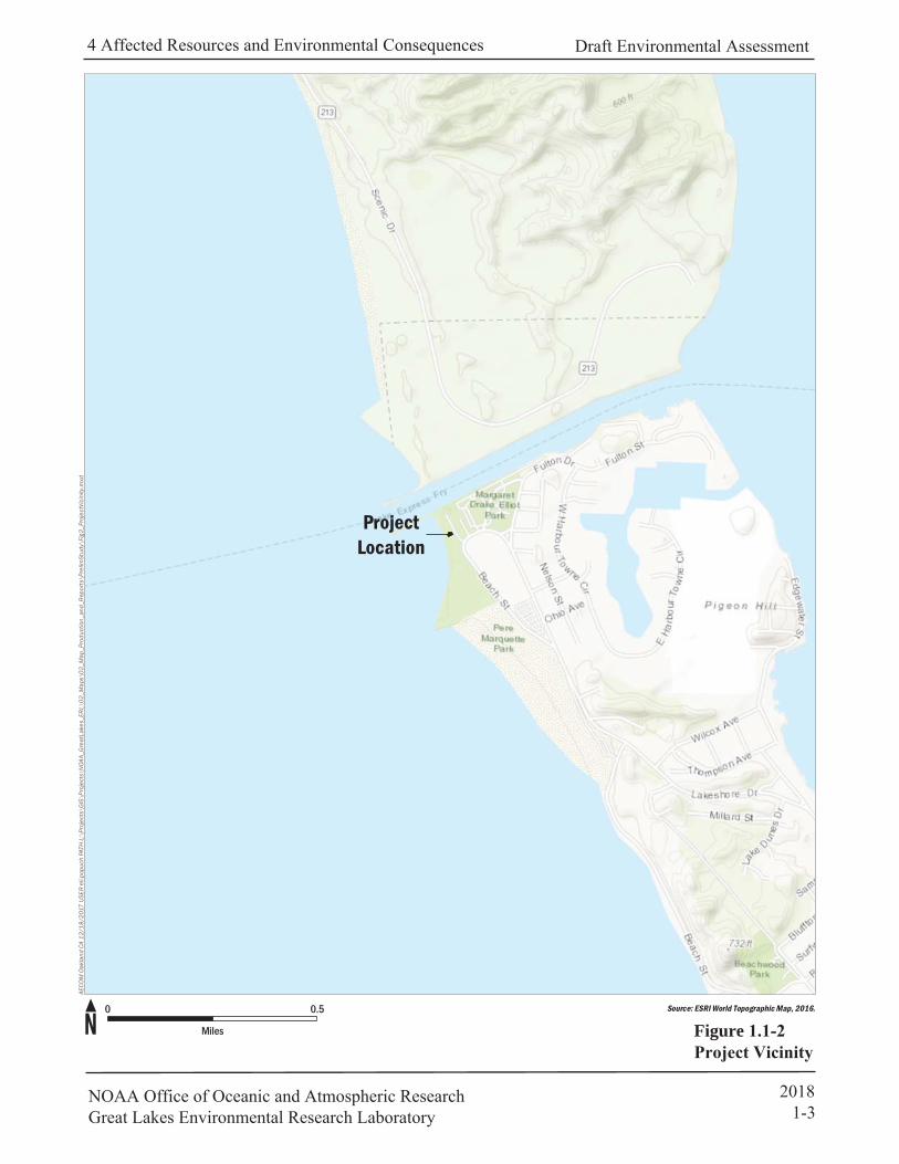
Figure 1.1-1 Project Location ……………………………………………………………………...…1-2
Figure 1.1-2 Project Vicinity……………………………………………………………………….....1-3
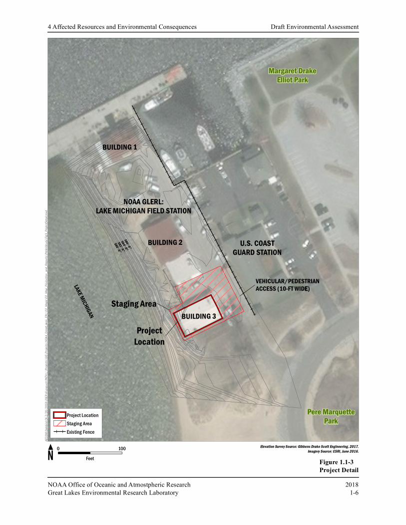
Figure 1.1-3 Project Detail……………………………………………………………………………1-6
Figure 4.6-1 Muskegon Life-Saving Station, circa 1950…………………………………………....4-18
Figure 4.6-2 Muskegon Life-Saving Station, circa 1905…………………………………………....4-18
Figure 4.6-3 Area of Potential Effect………………………………………………………………..4-20
Figure 4.6-4 Building #1 (left), Building #2 (center), and Building #3 (right)……………………...4-21
Figure 4.6-5 Building #1, Southside………………………………………………………………...4-22
Figure 4.6-6 Building #1, North (left) and West (right) sides……………………………………….4-22
Figure 4.9-1 FEMA Flood Insurance Rate Map……………………………………………………..4-37
LIST OF TABLES
Table ES-1 Summary of Anticipated Environmental Impacts and Suggested Mitigation…………….ii
Table 4.6-1 Resources Surveyed in Study Area……………………………………………………4-19
Table 4.12-1 Anticipated Aggregate Construction Activity Noise…………………………………..4-47
Table 4.17-1 Population Change by Geographic Area………………………………………………4-61
Table 4.17-2 Racial Profile by Geographic Area…………………………………………………….4-62
Table 4.17-3 Socioeconomic Factors by Geographic Area………………………………………….4-62
Table 6.0-1 Summary of Anticipated Impacts and Suggested Mitigation…………………………...6-1
LIST OF APPENDICES
Appendix A: List of Tribal Consultations Initiated and template of letter sent to tribes
Appendix B: Biological Site Inspection Photographs
Appendix C: Michigan Natural Feature Inventory Information
Appendix D: Reference Materials
List of Acronyms Draft Environmental Assessment
NOAA Office of Oceanic and Atmospheric Research 2018
Great Lakes Environmental Research Laboratory vii
LIST OF ACRONYMS
ACHP Advisory Council on Historic
Preservation
APE Area of Potential Effects
ANT Aids to Navigation
BGS Below Ground Surface
BLM Bureau of Land Management
BMPs Best Management Practices
CAA Clean Air Act
CDA Critical Dune Areas
CESQG Conditionally Exempt Small Quantity
Generator
CFR Code of Federal Regulations
CO Carbon Monoxide
CO2 Carbon Dioxide
CO2e Carbon Dioxide Equivalent
CWA Clean Water Act
CZMA Coastal Zone Management Act
CZMP Coastal Zone Management Program
DARD Department of Agricultural and Rural
Development
dB Decibel
dBA A-Weighted Decibel
DLARA Department of Licensing and
Regulatory Affairs
DNL Day-Night Average Sound Level
DPW Department of Public Works
EA Environmental Assessment
EIS Environmental Impact Statement
EO Executive Order
ESA Endangered Species Act
FEMA Federal Emergency Management
Agency
FHWA Federal Highway Administration
FIRMs Flood Insurance Rate Maps
FONSI Finding of No Significant Impact
FPPA Farmland Protection Policy Act
FTA Federal Transit Administration
GCR General Conformity Rule
GLERL Great Lakes Environmental Research
Laboratory
GSF Gross Square Feet
HVAC Heating, Ventilation, and Air
Conditioning
IGLD International Great Lakes Datum
Ldn Day-night sound level
LEED Leadership in Energy and
Environmental Design
LMFS Lake Michigan Field Station
LOS Level of Service
MBTA Migratory Bird Treaty Act
MDEQ Michigan Department of Environmental
Quality
MDNR Michigan Department of Natural
Resources
MIOSHA Michigan Occupational Safety and
Health Administration
MSA Metropolitan Statistical Areas
MSP Michigan State Police
NAAQS National Ambient Air Quality
Standards
NHPA National Historic Preservation Act
NO2 Nitrogen Dioxide
NOAA National Oceanic and Atmospheric
Administration
NEPA National Environmental Policy Act
NPDES National Pollutant Discharge
Elimination System
NRCS Natural Resources Conservation
Service
NREPA National Resources and Environmental
Protection Act
NRHP National Register of Historic Places
NSA Noise-sensitive Area
NWI Natural Wetland Inventory
O3 Ozone

List of Acronyms Draft Environmental Assessment
NOAA Office of Oceanic and Atmospheric Research 2018
Great Lakes Environmental Research Laboratory viii
OAR Office of Oceanic and Atmospheric
Research
OHWM Ordinary High Water Mark
OSR Open Space Recreation District
OSHA Occupational Safety and Health
Administration
Pb Lead
PM Particulate Matter
RCNM Roadway Construction Noise Model
RCRA Resource Conservation and Recovery
Act
RECs Recognized Environmental Conditions
RMS Root-Mean-Square
SARDET Search and Rescue Detachment
SHPO State Historic Preservation Officer
SIP State Implementation Plans
SO2 Sulfur Dioxide
SPL Sound Pressure Level
SWPPP Stormwater Pollution Prevention Plan
TES Threatened and Endangered Species
U.S. United States
USACE United States Army Corps of Engineers
USDA United States Department of
Agriculture
USC United States Code
USCG United States Coast Guard
USDEA United States Drug Enforcement
Administration
USDOT United States Department of
Transportation
USEPA United States Environmental Protection
Agency
USFWS United States Fish and Wildlife Service
USNRC United States Nuclear Regulatory
Commission
UST Underground Storage Tank
VdB Decibels of root-mean-square vibration
velocity
WRD Water Resources Division
1 Purpose and Need Draft Environmental Assessment
NOAA Office of Oceanic and Atmospheric Research 2018
Great Lakes Environmental Research Laboratory 1-1
1.0 PURPOSE AND NEED
1.1 INTRODUCTION
1.1.1 Background
The National Oceanic and Atmospheric Administration (NOAA) Office of Oceanic and Atmospheric
Research (OAR), Great Lakes Environmental Research Laboratory (GLERL), operates the Lake
Michigan Field Station (LMFS) in western Michigan (see Figure 1.1-1). The LMFS is located at the
channel entry between Lake Michigan and Muskegon Lake in Muskegon, Michigan (see Figure 1.1-2).
The NOAA LMFS address is 1431 Beach Street, Muskegon, MI 49441-1098. The mission of this
GLERL field station is to promote and conduct long-term observations, field work, and freshwater
process studies essential for understanding and developing future ecological practices and decision-
making.
There are currently 12 NOAA employees assigned to the LMFS facility, which includes research
professionals, vessel crew, a marine superintendent and administrative personnel. Science at LMFS is
primarily focused on field-based long-term observations and field-based shorter-term process studies in
Lake Michigan. The LMFS facilities can also provide a base and accommodations for visiting
researchers from GLERL and partner agencies. There are three main structures, Buildings #1, #2 and #3,
plus two garage structures and vessel berths, at LMFS (see Figure 1.1-3). These assets support GLERL's
Ecosystem Dynamics theme with on-site offices, laboratory, and storage facilities, and direct access to
ship resources.
Assets at the LMFS provide a platform for long-term observations and research programs on Lake
Michigan and a home port for NOAA Great Lakes research vessels operating throughout the Great
Lakes. The proximity of the field station to Lake Michigan and its historic and recreational amenities
provides a unique opportunity for engagement with visitors, non-profit organizations, recreational users,
and members of the community. The LMFS also provides support to the local and regional community
by further developing NOAA’s role in freshwater ecology, ecosystems management, coastal
management, and water-based commerce.
Due to foundation subsidence, structural deformation and laboratory space inefficiencies, NOAA
GLERL is proposing to replace Building #3 at LMFS, used primarily for laboratory functions and
marine specimen storage. Building #3 presently supports to following functions:
Filtration Laboratory for water filtration, bottle preparation, and short-term sample storage
Dark Room for light-sensitive work and currently accommodates water maker and hood
Ancillary Office Space/Instrument Room available to technicians for data entry, instrumentation
set-up and uploading instrument data
Storage space for chemicals and archiving preserved samples
Field staging area to temporarily store field gear and prepare for vessel cruises
Auxiliary benchtop space for visiting scientists

55
88
90 294
355
194
496
80
290
94
80
65
69
57
94
196
96
75
43
ProjectLocation
AECO
M O
akla
nd C
A 12
/18/
2017
USE
R el
i.pop
uch
PATH
L:\
Proj
ects
\GIS
\Pro
ject
s\N
OAA_
Gre
atLa
kes_
ERL\
02_M
aps\
02_M
ap_P
rodu
ctio
n_an
d_R
epor
ts\P
relim
Stud
y\Fi
g1_P
roje
ctLo
catio
n.m
xd
0 50
Miles
Source: ESRI World Topographic Map, 2016.
Figure
ProjectLocation
AECO
M O
akla
nd C
A 12
/18/
2017
USE
R el
i.pop
uch
PATH
L:\
Proj
ects
\GIS
\Pro
ject
s\N
OAA_
Gre
atLa
kes_
ERL\
02_M
aps\
02_M
ap_P
rodu
ctio
n_an
d_R
epor
ts\P
relim
Stud
y\Fi
g2_P
roje
ctVi
cini
ty.m
xd
0 0.5
Miles
Source: ESRI World Topographic Map, 2016.
Figure

1 Purpose and Need Draft Environmental Assessment
NOAA Office of Oceanic and Atmospheric Research 2018
Great Lakes Environmental Research Laboratory 1-4
1.2 PROPOSED ACTION
NOAA is proposing to demolish and rebuild Building #3 at the LMFS. A recent facility condition
assessment of that structure has determined that it is undergoing gradual internal deformation, creating a
tripping hazard and uneven flooring. The occupied and storage spaces within the current facility are also
undersized and inefficient given its current and continuing use as a marine laboratory and repository for
marine specimen storage. The Proposed Action is to demolish and remove the 2,500 square-foot (SF)
building and its interior foundation slabs, replace soils beneath the interior foundation with engineering-
grade fill, install a replacement slab foundation inside the existing perimeter foundation and construct a
5,000 SF laboratory building within the existing footprint.
Extracted soils from under the existing building slabs would be tested by a soils engineer upon removal
and considered for reuse, blending or other treatments. Soil testing would examine contamination, and
load-bearing capacity, among other characteristics. Replacement soils would meet allowable soil
bearing values and geotechnical requirements. All materials removed from the site would be directed to
an approved, legal fill site location or as required by a Part 353 permit under the Natural Resources and
Environmental Protection Act, 1994 PA 451, administered by the Michigan Department of
Environmental Quality (MDEQ).
For the design of Building #3, NOAA will adhere to the Secretary of the Interior (SOI) Standards for
Rehabilitation (36 CFR 67) and have an SOI-qualified architectural historian conduct a review at 30%
Design, confirm design changes at the 60% Design, and approve the 90% Design drawings, particularly
for exterior elements. This process would be recorded in a memo to the project file. In general, to
substantively meet the SOI Standards, the proposed design of Building #3 would be compatible, but not
confused with, Building #1 (a structure eligible to the National Register of Historic Places). The
proposed design would neither closely imitate Building #1 to the point that an observer would believe it
was built in the same historic period, nor overwhelm Building #1’s setting with an obtrusive or
incompatible design. This action would avoid adverse effects under the National Historic Preservation
Act and NEPA relative to effects to historic structures.
Three action alternatives were identified that are expected to accomplish this Proposed Action.
Construction Activities and Schedule
The design and construction of the proposed replacement laboratory building would include demolition,
foundation removal, utility relocation, and the repurposing or recycling of materials followed by testing
and preparation of sandy soils within the foundation envelope. Following established design codes and
other engineering parameters, replacement of foundation slabs and construction of a wood or metal
framed structure would occur. This includes interior ceiling, flooring, doors, windows, partitions,
insulation, cabinetry, hardware, interior finishes, heating, ventilation, and air conditioning (HVAC),
exhaust, electrical, plumbing, fixtures, appliances and exterior improvements, including site drainage,
landscaping, parking, lighting and security systems. The proposed building’s design goal is to achieve
Leadership in Engineering and Environmental Design (LEED) Silver certification.
A crane, backhoe, front loader, bobcat loader, and haul trucks would be mobilized for demolition and/or
construction, and any remnant or unnecessary underground utility infrastructure removed, over an
estimated construction period beginning July 18, 2018, through April 18, 2019. High-bay door

1 Purpose and Need Draft Environmental Assessment
NOAA Office of Oceanic and Atmospheric Research 2018
Great Lakes Environmental Research Laboratory 1-5
installation and utility/fire protection measures would be installed and connected, followed by
completion of interior framing, drywall, flooring and painting. During the construction work, NOAA
employees that work in Building #3 would be temporarily relocated to Building #1.
Existing parking areas, adjacent to Buildings #3 and Building # 2, would be used for material staging
during construction. The northern portion of the parking lot, adjacent to Building #1 and Building #2,
would remain open for NOAA employees to use. Additionally, NOAA employees could utilize street
parking and the public parking lot just east of the U.S. Coast Guard (USCG) station. Roughly10 feet of
driveway, between the staging area and fence located at the edge of the NOAA station, would be
maintained throughout the construction period to provide vehicular and pedestrian access to the northern
portion of the parking lot and the Muskegon South Pierhead Lighthouse and jetty (see Figure 1.1-3).
Operation and Maintenance
Upon completion of construction activities, NOAA would move laboratory equipment, furniture and
storage containers into ready spaces and allow occupation by assigned personnel. A net increase of one
full-time equivalent staff would result from the proposed laboratory replacement. Operations at the
proposed facility would include laboratory analysis, specimen storage, and administrative/report
preparation tasks in support of freshwater marine fisheries and aquatic resource studies.
Periodic delivery of supplies would occur periodically (approximately quarterly) during operations and
to support laboratory functions and archival practices.
LAKE MICHIGAN
580'-0"582'-0"
584'-0"586'-0"
BUILDING 1
BUILDING 2
BUILDING 3Project
Location
Staging Area
AECO
M Oa
kland
CA 2/
20/2
018 U
SER e
li.pop
uch P
ATH L
:\Proj
ects\
GIS\P
rojec
ts\NO
AA_G
reatLa
kes_
ERL\
02_M
aps\
02_M
ap_P
roduc
tion_
and_
Repo
rts\P
relim
Study
\Fig3
_Proj
ectD
etail.m
xd
Project LocationStaging AreaExisting Fence
0 100Feet
Elevation Survey Source: Gibbens Drake Scott Engineering, 2017.Imagery Source: ESRI, June 2016.
NOAA Office of Oceanic and Atmostpheric ResearchGreat Lakes Environmental Research Laboratory
U.S. COASTGUARD STATION
NOAA GLERL:LAKE MICHIGAN FIELD STATION
Pere MarquettePark
Margaret DrakeElliot Park
VEHICULAR/PEDESTRIAN ACCESS (10-FT WIDE)
20181-6
Figure 1.1-3Project Detail
4 Affected Resources and Environmental Consequences Draft Environmental Assessment

1 Purpose and Need Draft Environmental Assessment
NOAA Office of Oceanic and Atmospheric Research 2018
Great Lakes Environmental Research Laboratory 1-7
1.3 PURPOSE AND NEED
1.3.1 Purpose
The purpose of the proposed action is to remedy serious structural deformities and other challenges
caused by foundation subsidence, and to consolidate space for laboratory work and specimen storage at
LMFS to better meet its administration, office, maintenance and other storage functions. A replacement
for Building #3 would provide an efficient, hazard-free work space that would complement the
surrounding GLERL campus of buildings, garages, storage areas and grounds.
1.3.2 Need
Building #3 is a 2,600 square foot pre-engineered steel building constructed circa 1970 (actual date is
unknown) and is used for storage and laboratory space. Based on a facility condition assessment report
prepared by Cardno Government Services Division in January 2017, and a foundational subsidence
analysis conducted in April 2016, it has been determined that Building #3 is in need of replacement due
to structural deterioration from subsidence below its interior foundation and is subject to further
degradation of its structural integrity. Subsidence and cracking of the interior floor foundation,
consisting of four independent concrete slabs within to a perimeter foundation, has created trip hazards
at the exterior doors and caused damage to interior walls. An assessment of the Building #3 foundation,
conducted by a Structural Engineer and Geotechnical Consultant found the following:
The subsidence appears to be due to the existing soils below the slab being
improperly prepared during construction of the building. The structure shows no
signs of stress in the framing or siding, and visible connections of columns and
beams were observed to be properly aligned, and the perimeter foundation
appears to have remained at its original elevation while the interior slabs have
subsided.
GLERL personnel have indicated that the layout of the existing building is not optimum for its current
use and existing building services. When evaluated against the laboratory programs and facilities needed
for existing fisheries research efforts at LMFS, the laboratory and storage functions currently at Building
#3 are both undersized and inefficient. In addition, electrical and HVAC systems have little or no
capacity for future expansion of laboratory work.
Given these limitations, a complete replacement of Building #3 is proposed. The OAR and PPMD have
determined that, with proper design and layout, an approximately 5,000 SF structure will meet the
LMRL research and storage needs for a Building #3 replacement.
NEPA Analysis
Per Section 102 of the National Environmental Policy Act of 1969 (NEPA) under 42 U.S. Code [USC]
§4332, and Council on Environmental Quality Regulations for Implementing Procedural Provisions of
NEPA at 40 Code of Federal Regulations (CFR) 1500-1508, NOAA has prepared this Environmental
Assessment (EA) analyzing the potential environmental consequences of implementing any one of two
action alternatives, as well as effects of the No-Action Alternative. In accordance with NOAA

1 Purpose and Need Draft Environmental Assessment
NOAA Office of Oceanic and Atmospheric Research 2018
Great Lakes Environmental Research Laboratory 1-8
Administrative Order 216-6A, Compliance with the National Environmental Policy Act, and the
associated Companion Manual, and Executive Orders 11988, Floodplain Management, and 11990,
Protection of Wetlands, NOAA has analyzed and considered the potential environmental consequences
of its proposed action under three viable action alternatives, and the No-Action Alternative, before
making a commitment to a specific course of action. A No-Action Alternative is presumed to be a
condition in which the operations continue until occupancy is no longer considered appropriate due to
impending structure instability or failure.
This EA identifies anticipated environmental consequences and, if applicable, presents mitigation
measures that could be expected to reduce environmental effects. Should NOAA conclude that the EA
supports a Finding of No Significant Impact (FONSI), an Environmental Impact Statement (EIS) would
not be required.

2 Action Alternatives Draft Environmental Assessment
NOAA Office of Oceanic and Atmospheric Research 2018
Great Lakes Environmental Research Laboratory 2-1
2.0 ACTION ALTERNATIVES
To achieve its Proposed Action and meet the design criteria and space requirements for GLERL, three
action alternatives, a preferred action and two viable action alternatives are being evaluated by NOAA in
addition to a no-action alternative, as required under NEPA.
2.1 ACTION ALTERNATIVE 1
Provide a new 5,000 SF wood-frame, two-story structure that would be set on the existing building
exterior foundation footprint. Provide for architectural consistency with nearby structures, including
Building #1, as appropriate.
2.2 ACTION ALTERNATIVE 2
Provide a new pre-engineered metal two-story structure that would be set on the existing building
foundation footprint. Provide for architectural consistency with nearby structures, including Building #1,
as appropriate.
2.3 ACTION ALTERNATIVE 3
Provide a new wood-frame, single-story structure that would be set on the existing building foundation
and cantilevers out to provide square footage needed to meet a minimum space requirement of 4,500 SF.
Provide for architectural consistency with nearby structures, including Building #1, as appropriate.
2.4 NO-ACTION ALTERNATIVE
The No-Action Alternative is a condition in which LMFS Building #3 is not replaced or removed. The
existing operations at this structure would continue indefinitely until a change is required in response to
eventual degradation of the structure and its habitability.
2 Action Alternatives Draft Environmental Assessment
NOAA Office of Oceanic and Atmospheric Research 2018
Great Lakes Environmental Research Laboratory 2-2
[Page intentionally blank to facilitate double-sided printing]
3 Existing Environment Draft Environmental Assessment
NOAA Office of Oceanic and Atmospheric Research 2018
Great Lakes Environmental Research Laboratory 3-1
3.0 EXISTING ENVIRONMENT
The GLERL LMFS is a NOAA research facility located in Muskegon, MI. The LMFS property was
originally developed in 1905 by the U.S. Life Saving Service. The facility was transferred to the USCG
in 1915 and then to NOAA’s Office of Oceanic and Atmospheric Research (OAR) branch in 1990. The
LMFS currently has three main occupied buildings.
Building #1, which houses administrative offices and some laboratory space, is a two-
story wood-framed structure at the north end of the site. It was constructed prior to 1905,
then renovated in 2003, restoring the historic exterior appearance of the structure.
Building #2, which provides storage and shop space for vessel maintenance, is located in
the center portion of the site. The original building is a 2 story concrete block structure,
constructed in the mid-1970s, then renovated in 2013. A high-bay pre-engineered steel
building addition was also constructed in 2013.
Building #3 is a typical pre-engineered steel building, measuring 40 feet (north-south) by
65 feet (eastwest). There is a perimeter footing, with eight integral spread footings
supporting the columns (one at each corner and two at equal spaces along each of the
long sides). The roof of the building is framed with steel beams and purlins supporting a
steel panel roof with batt insulation. The exterior walls are framed with steel wind girts
spanning between the columns, with steel panel siding and batt insulation. The interior
walls are predominantly wood stud-framed with a variety of finishes including gypsum
wallboard, plywood and metal panels.
According to an April 2016 Draft Subsurface Exploration and Geotechnical Engineering Evaluation
report by ESC Midwest, LCC, the Sand “FILL” soils encountered immediately below the Building #3
floor slabs and to depths ranging from about 5½ to 6½ feet below the floor slab, where groundwater was
encountered, and did not exhibit any odors or other obvious evidence of having been impacted by
contaminants, leaking sewer or water lines.
A parking area and driveway are located immediate to the east of the site, with the USCG Station
Muskegon further east beyond the property fence. The west side contains large rock rip-rap and the Lake
Michigan shoreline. To the north are the remaining structures within LMFS campus and the waterway
between Lake Michigan and Muskegon Lake. Refer to Figure 1.1-3 for an aerial view of the area at and
near Building #3.

3 Existing Environment Draft Environmental Assessment
NOAA Office of Oceanic and Atmospheric Research 2018
Great Lakes Environmental Research Laboratory 3-2
[Page intentionally blank to facilitate double-sided printing]

4 Affected Resources and Environmental Consequences Draft Environmental Assessment
NOAA Office of Oceanic and Atmospheric Research 2018
Great Lakes Environmental Research Laboratory 4-1
4.0 AFFECTED RESOURCES AND ENVIRONMENTAL CONSEQUENCES
This section describes the existing conditions for key resource topics, the anticipated environmental
consequences from implementation of the Proposed Action (at each alternative) and the No-Action
Alternative, and any mitigation measures that would avoid, reduce, or minimize any adverse effects of
the Proposed Action.
4.1 LAND USE
4.1.1 Regulatory Setting
The City of Muskegon Master Land Use Plan, adopted on April 1997, is a tool used by local land use
planners to guide the process of administering zoning and other land ordinances; developing,
coordinating and preparing specialized plans; addressing issues such as neighborhoods, natural resources
and land development proposals; analyzing future use; and augmenting current land development
regulations.
The project site area has been designated by the City of Muskegon’s Zoning Ordinance as an Open
Space Recreation Districts (OSR), which is intended to provide permanent spaces in the City for
recreational activities including: hiking, biking, jogging or ski trails; fishing docks and piers; parks,
playgrounds and playfields and wildlife preserves. Special land uses must be permitted by the City. The
intent of the Recreation Districts zoning is to allow mixed land uses which are compatible to each other,
while prohibiting uses which would not be compatible or harmonious with permitted uses (City of
Muskegon, 2012).
The Public Buildings Amendments of 1988 (40 USC 601), Public Law 100-678, requires a federal
agency to comply with a nationally recognized model building code and other applicable nationally
recognized codes, such as electrical, life safety, and plumbing codes. Federal agencies shall consider
state or local zoning and similar laws and consult with appropriate officials and make plans available
upon request. State and local government may make recommendations and the federal agency should
give due consideration to those recommendations and local conditions. However, no action, fine or
penalty may be brought against the federal government for failure to meet the requirements of this
Public Law, or for failure to carry out any State or local government recommendation.
Executive Order (EO) 12372, Intergovernmental Review of Federal Program, directs federal agencies to
provide opportunities for consultation to elected officials of state and local governments and to provide
state and local officials the opportunity to comment on actions that could affect their jurisdictions. The
EO was issued with the intent to foster intergovernmental partnership and to increase the reliance of
state and local processes coordination and review of proposed Federal financial assistance and direct
federal development (OMB, 2015).
4.1.2 Affected Resources
The project site is located at 1431 Beach Street, Muskegon, Michigan. The site is located adjacent to the
eastern shore of Lake Michigan. Immediately north of the project area at Building #3 are NOAA’s other

4 Affected Resources and Environmental Consequences Draft Environmental Assessment
NOAA Office of Oceanic and Atmospheric Research 2018
Great Lakes Environmental Research Laboratory 4-2
LMFS facilities and buildings, including Building #1, Building #2, a garage structure and a storage
shelter.
To the east of the LMFS is USCG Station Muskegon, one of only six stations in the Coast Guard with
both aids to navigation and Search and Rescue capabilities. To the north of LMFS is a public walkway
to the Muskegon South Pierhead Lighthouse and the Muskegon Ship Channel. To the south is
undeveloped recreational areas and lake beachfront. To the west is Lake Michigan. The surrounding
community is mainly comprised of dune and beachfront properties, City parks, and residential
developments. The City of Muskegon’s Zoning Ordinance has designated the general area as OSR
District. The project site within LMFS is currently occupied by Building #3, used as a laboratory and
marine specimen storage facility.
4.1.3 Environmental Consequences
Action Alternative 1 (Preferred Alternative)
The Preferred Alternative would be consistent with the City of Muskegon’s allowable land use and
associated restrictions. The area is zoned for recreational oriented facilities. However, special land uses
are permitted under the purview of Section 2332 after review and approval of the use. The LMFS
facilities have been an allowable use by the City as NOAA’s LMFS since 1990 and as a USCG station at
this location since 1905 (US Coast Guard, no date). The proposed replacement building at Building #3
would meet City building height, setback and site coverage requirements per its OSR zoning. In
addition, NOAA intends to seek review and input from local building officials regarding the design and
architecture of the proposed construction project and adhere to local recommendations to the extent
practicable. There would be no change in land use and no adverse effect to existing city, state or federal
land uses under the Preferred Alternative.
The proposed action at this alternative would result in no adverse effect to land use.
Action Alternative 2
Similar to the Preferred Alternative, Action Alternative 2 would be consistent with the City of
Muskegon’s Master Land Use Plan and zoning requirements, since the current use of the site would
remain unchanged.
The Action Alternative 2 would result in no adverse effect to land use.
Action Alternative 3
Except for the potential for articulated structural elements extending beyond existing lot boundaries
under NOAA control, Action Alternative 3 would be consistent with the City of Muskegon’s Master
Land Use Plan and zoning requirements, since the current use of the site would remain unchanged.
The Action Alternative 3 would result in no adverse effect to land use.

4 Affected Resources and Environmental Consequences Draft Environmental Assessment
NOAA Office of Oceanic and Atmospheric Research 2018
Great Lakes Environmental Research Laboratory 4-3
No-Action Alternative
Under No-Action Alternative, the demolition and rebuilding of Building # 3 would not occur. No
adverse effects to existing land use would result.
4.1.4 Mitigation Measures
No mitigation measures are required for each of the Action Alternatives or for the No-Action
Alternative in relation to land use management.

4 Affected Resources and Environmental Consequences Draft Environmental Assessment
NOAA Office of Oceanic and Atmospheric Research 2018
Great Lakes Environmental Research Laboratory 4-4
4.2 GEOLOGICAL RESOURCES
4.2.1 Regulatory Setting
The GLERL facility is situated on the shore of Lake Michigan in a designated Critical Dune Area
(CDA), but not located within a designated high risk erosion area. It is surrounded by critical dune, high
risk erosion, and local recreational areas. The facility is Public Act 451 of 1994 includes provisions in
Part 323 for the protection and management of shorelands within the State of Michigan, in particular,
those located in environmental sensitive or areas subject to erosion. A Part 353 permit under the Natural
Resources and Environmental Protection Act, 1994 PA 451, is required for the removal and construction
of new structures in CDA (MDEQ, 2003). A MDEQ/USACE Joint Permit Application would be used to
describe and quantify proposed activities regulated by the MDEQ and/or the USACE. A Soil Erosion
permit is required before a Part 353 permit can be issued (Occhipinti, 2018).
4.2.2 Affected Resources
The GLERL facility is located south of the Muskegon Ship Channel on the shore of Lake Michigan.
Quaternary geology in this area is predominantly dune sand underlain by the Marshall Formation
(bedrock). Major geologic units found in Muskegon County consist of the Marshall Sandstone,
Michigan Formation, Coldwater Shale, and Bayport Limestone, all Mississippian in age. The Marshall
Formation overlies the Coldwater Shale (conformably) and underlies the Michigan Formation
(conformably) and is primarily comprised of gray to tan fine to coarse grained sandstone with minor
amounts of siltstone. Maximum thickness of the Marshall formation is found within the center of the
Michigan basin decreasing towards the rim. Outcrops of the Marshall Formation are typically found
within the southern rim of the basin. Quaternary geology is comprised of dune sand. Geotechnical
reports prepared for recent renovations to the adjacent Building #2 at LMFS indicate loose to very loose
sands to a depth of at least 15 feet below ground surface (bgs). General Quaternary geology of
Michigan is comprised of glacial till, which likely exists beneath the dune sand.
The GLERL facility at LMFS is located within the Central Stable Tectonic Region, an area of low
seismic activity. Therefore, the probability of liquefaction of the soils at the site due to seismic activity
is low.
4.2.3 Environmental Consequences
Action Alternative 1 (Preferred Alternative)
No adverse impacts to geological resources or high risk erosional areas are anticipated for the
reconstruction of Building #3 under Action Alternative 1. As described under Section 1.2, Proposed
Action, extracted soils from under the existing building slabs would be tested for removal and/or reuse,
blending or other treatments, by a soils engineer. Soils would have to meet allowable soil bearing values
and design recommendations and would be tested to examine contamination, strength, load-bearing
capacity among other characteristics. All materials removed from the site would have to go to an
approved, legal fill site location or as required under a Part 353 permit from MDEQ. A Soil Erosion
permit and Part 353 permit will be required before the removal and construction of Building #3
commences to ensure proper management and protection of environmental sensitive areas.

4 Affected Resources and Environmental Consequences Draft Environmental Assessment
NOAA Office of Oceanic and Atmospheric Research 2018
Great Lakes Environmental Research Laboratory 4-5
Additionally, a submittal of draft and final design specifications to the Water Resources Division
(WRD) is recommended to confirm this finding remains accurate prior to project implementation.
The project would comply with Part 353, Sand Dune Protection and Management Act and best
management practices (BMPs) would be utilized for soil erosion control. Therefore, impacts to
geological resources would be less than significant.
Action Alternative 2
The project would comply with Part 353, Sand Dune Protection and Management Act and BMPs would
be utilized for soil erosion control. Similar to the Preferred Alternative, impacts to geological resources
or high risk erosional areas from the reconstruction of Building #3 under Action Alternative 2 would be
less than significant.
Action Alternative 3
The project would comply with Part 353, Sand Dune Protection and Management Act and BMPs would
be utilized for soil erosion control. Similar to the Preferred Alternative, impacts to geological resources
or high risk erosional areas from the reconstruction of Building #3 under Action Alternative 3 would be
less than significant.
No-Action Alternative
Under No-Action Alternative, the demolition and rebuilding of Building #3 would not occur. No adverse
effects to geological resources would result.
4.2.4 Mitigation Measures
BMPs would be utilized for soil erosion control.
4 Affected Resources and Environmental Consequences Draft Environmental Assessment
NOAA Office of Oceanic and Atmospheric Research 2018
Great Lakes Environmental Research Laboratory 4-6
4.3 AIR QUALITY
4.3.1 Regulatory Setting
Pursuant to the federal Clean Air Act (CAA) and its amendments, the U.S. Environmental Protection
Agency (USEPA) identifies air pollutants that cause or contribute to the endangerment of human health
and or environmental welfare, and establishes air quality “criteria” that guide the establishment of air
quality standards to regulate these pollutants (42 U.S.C. §7408 - §7409). To date, USEPA has
established such criteria for six air pollutants: carbon monoxide (CO), lead (Pb), nitrogen dioxide
(NO2), ozone (O3), fine and respirable particulate matter (PM2.5 and PM10), and sulfur dioxide (SO2),
and has subsequently promulgated National Ambient Air Quality Standards (NAAQS) meant to
safeguard public health (i.e., primary NAAQS) and environmental welfare (i.e., secondary NAAQS).
For the purposes of appraising compliance with the NAAQS, and conjunction with the MDEQ, USEPA
collects and evaluates ambient (i.e., “outdoor”) monitoring data on a geographic basis, delineated by
Core Based Statistical Areas (CBSA) or Metropolitan Statistical Areas (MSA) established by the U.S.
Office of Management and Budget and U.S. Census Bureau. From each ambient monitor within a
CBSA/MSA, USEPA derives criteria pollutant design values, which are statistics that describe the air
quality status of a given location relative to the level of the NAAQS. Areas where monitored ambient air
concentrations (i.e., design values) are within an applicable NAAQS are considered in attainment of that
NAAQS. If sufficient data are not available to make a determination, the area is instead deemed
attainment/unclassifiable. Areas where monitored ambient air concentrations exceed the NAAQS are
designated by USEPA as nonattainment areas. Lastly, areas that have historically violated the NAAQS,
but have since instituted controls and programs that have successfully remedied these violations are
known as maintenance areas.
States with nonattainment areas within their jurisdiction are charged with developing air quality control
plans, called State Implementation Plans (SIP), that include strategies and measures to bring the area
back into compliance with the NAAQS by an USEPA-prescribed regulatory deadline, or maintain
compliance once attainment is achieved.
The USEPA promulgated a General Conformity Rule (GCR) (Section 110 of the CAA and Title 40 CFR
Part 51.853) that requires responsible federal agencies to make a determination of conformity with the
SIP for a major undertaking. Each federal action within a non-attainment or maintenance area must be
reviewed to determine whether it (1) qualifies for an exemption listed in the GCR; (2) results in
emissions that are below GCR de minimis emissions thresholds (e.g., 100 tons per year for VOC, NOX,
PM2.5, and 25,000 tons per year for CO2); or (3) would produce emissions above the GCR de minimis
thresholds applicable to the specific area, requiring a detailed air quality conformity analysis.
On December 7, 2009, the Final Endangerment and Cause or Contribute Findings for Greenhouse Gases
under Section 202(a) of the CAA was signed. The endangerment finding states that current and
projected concentrations of the six key well-mixed GHGs in the atmosphere—carbon dioxide (CO2),
methane, nitrous oxide, hydrofluorocarbons, perfluorocarbons and sulfur hexafluoride—threaten the
public health and welfare of current and future generations. Furthermore, it states that the combined
emissions of these well-mixed GHGs from new motor vehicles and new motor vehicle engines
contribute to the greenhouse gas pollution which threatens public health and welfare (USEPA, 2010d).

4 Affected Resources and Environmental Consequences Draft Environmental Assessment
NOAA Office of Oceanic and Atmospheric Research 2018
Great Lakes Environmental Research Laboratory 4-7
The EPA has moved forward under the endangerment finding by developing vehicle emission standards
under the CAA. The EPA and the Department of Transportation’s National Highway Traffic Safety
Administration have issued a joint proposal to establish a national program consisting of new emission
standards for light-duty vehicles, model year 2012 through 2016, that will reduce GHG emissions and
improve fuel economy. This proposal marks the first GHG standards proposed by the EPA under the
CAA as a result of the endangerment and cause or contribute findings.
On February 18, 2010, the CEQ released draft guidance on the consideration of GHG in federally
proposed actions. The draft guidelines include a presumptive threshold of 25,000 metric tons of carbon
dioxide equivalent (CO2e) emissions from a proposed action to trigger a quantitative analysis. However,
the document does not provide guidance on when to determine GHG emissions are “significant’ for
NEPA purposes, but rather poses the question to the public (CEQ, 2010).
4.3.2 Affected Resources
According to the MDEQ, the entire state of Michigan is in attainment for and therefore meeting the
NAAQS for the following pollutants:
Ozone
Nitrogen Dioxide
Lead
Carbon Monoxide
Particulate Matter
Only areas located in and near Detroit, Michigan are in nonattainment for sulfur dioxide and have an
approved SIP for sulfur dioxide.
The Proposed Action in Muskegon, Michigan, is an area presently designated as in attainment with
respect to all NAAQS; therefore, the General Conformity regulations do not apply to the Proposed
Action (Action Alternatives 1, 2, and 3) and the No-Action Alternative.
4.3.3 Environmental Consequences
Action Alternative 1 (Preferred Alternative)
Action Alternative 1 includes demolition and complete removal of the Building #3 structure and interior
foundation slabs. A replacement foundation and supporting soil layer would be installed inside the
existing perimeter foundation and a 5,000 SF laboratory building constructed within the footprint of the
current building. Demolition would result in releases of dust and exhaust emissions from equipment
used for the removal of pavement, utility connections, and other appurtenances. During demolition and
construction, equipment would include crane, backhoe, front loader, bobcat loader, and haul trucks over
an estimated 4-6 month period. Operations, including the extent of use of air exhaust equipment, at the
proposed facility would be similar to those currently conducted at the existing Building #3. A net
increase of one full-time equivalent staff would result from the proposed laboratory replacement; a
potential de minimus source of auto emissions.
4 Affected Resources and Environmental Consequences Draft Environmental Assessment
NOAA Office of Oceanic and Atmospheric Research 2018
Great Lakes Environmental Research Laboratory 4-8
Construction-related emissions are temporary in nature and occur due to (1) construction equipment and
vehicle operations, and (2) demolition, earthworks, ground disturbance and paving activities. Building
#3 would be designed to meet LEED Silver standards and reduce GHG emissions. The limited area,
duration and intensity of construction would be temporary and short-term. Long-term air quality effects
pertain to the emissions associated with the operation of Building #3 and support equipment. Operations
at Building #3 would result in similar emissions as existing operations, resulting in no significant net
increase of emissions in the air shed of the Proposed Action at Action Alternative 1. Emissions resulting
from construction and operations would be de minimus and not cause the air basin to be in
nonattainment/nonconformity.
No adverse impacts to air quality would result from implementation of Action Alternative 1.
Action Alternative 2
Alternative 2 would result in similar construction–related air emissions as Alternative 1. The limited
area, duration and intensity of construction would be temporary and short term. Operational air
emissions would be the same as Alternative 1and equivalent to emissions as existing operations,
resulting in no significant net increase of emissions. Emissions resulting from construction and
operations would not cause the air basin to be in nonattainment/nonconformity.
No adverse impacts to air quality would result from implementation of Action Alternative 2.
Action Alternative 3
Construction and operational air emissions under Alternative 3 would be similar to Alternative 1 and not
result in a significant net increase of emissions in the air shed. Emissions resulting from construction
and operations would not cause the air basin to be in nonattainment/nonconformity.
No adverse impacts to air quality would result from implementation of Action Alternative 3.
No-Action Alternative
Under the No-Action Alternative, no construction-related emissions would occur. Emissions associated
with NOAA operations would remain unchanged. No increase in GLERL staff at LMFS would occur.
The existing Building #3 is not attain the goals of LEED Silver certification or meet the associated
benefits of improved technology and efficiency of space, including reduced energy and environmental
design associated with air emissions.
No adverse impacts to air quality would result under the No-Action Alternative.
4.3.4 Mitigation Measures
The Proposed Action, and the No-Action Alternative, is located in an area considered by USEPA as
attainment with respect to the NAAQS. No air quality thresholds for a significant impact would be
exceeded. No mitigation measures are required.

4 Affected Resources and Environmental Consequences Draft Environmental Assessment
NOAA Office of Oceanic and Atmospheric Research 2018
Great Lakes Environmental Research Laboratory 4-9
However, standard and customary BMPs during construction should be applied to minimize
construction-related emissions, including (but not limited to) dust suppression on unpaved areas,
minimization of vehicle and equipment idling, covering of materials stockpiles, and recycling
construction and demolition materials where possible.

4 Affected Resources and Environmental Consequences Draft Environmental Assessment
NOAA Office of Oceanic and Atmospheric Research 2018
Great Lakes Environmental Research Laboratory 4-10
4.4 WATER RESOURCES
4.4.1 Regulatory Setting
Under Section 404 of the Clean Water Act (CWA), the U.S. Army Corps of Engineers (USACE) has
jurisdiction of waters of the U.S., including Lake Michigan and the Muskegon River channel, piers,
breakwalls, and Point Betsie lighthouse. The MDEQ regulates water quality in the State of Michigan
including storm water, point, and non-point discharge. Direct discharges to surface water are regulated
by the issuance of National Pollutant Discharge Elimination System (NPDES) permits.
In Michigan, the Federal Water Pollution Control Action amendments of 1972 initiated the NPDES
permit process. In October of 1973, the EPA delegated authority to administer and carry out this
program to Michigan. This act requires discharge permits in order to utilize public resources for waste
disposal. It also limits the amount of pollutants that may be discharged. Construction activities which
disturb one or more acres of land and/or have a point source discharge of storm water to waters of the
state (streams, rivers, lakes, and wetlands) are required to obtain a NPDES) permit from the MDEQ
WRD.
Also, construction projects in close proximity to Lake Michigan are subject to the Construction Storm
Water Program and Part 91 “Soil Erosion and Sediment Control” (SESC) of Act 451 regulations. Under
Part 91, any construction activity within 500 feet of waters of the state, or disturbing one or more acres,
must obtain Part 91 coverage via an SESC permit (unless designated an Authorized Public Agency
(APA) and NPDES coverage. The WRD has adopted a process called "Permit-by Rule" (Rule 2190,
promulgated under Part 31, NEPA) for issuing the necessary storm water coverage. Automatic storm
water coverage is received upon obtaining a Part 91 permit (or undertaking the project as an APA).
Although the coverage is automatic, the permittee shall comply with the requirements of Permit by Rule.
4.4.2 Affected Resources
The GLERL facility is located within the Muskegon River watershed. Surface runoff discharges directly
into Lake Michigan, which bounds the site to the west. Uppermost soils beneath the site are comprised
of loose to medium density sand fine to medium grained sands. The relative hydraulic conductivity of
sand is 10-7 to 10-2 (m/s), with a saturated conductivity of 4.234-5 to 14.114-5 as described by the U.S.
Department of Agriculture (USDA) soil survey. Observed depth to groundwater is 7.5 feet bgs and is
hydraulically controlled by the surface water elevation of Lake Michigan.
The Muskegon river ship channel bounds the site to the north and is connected to Muskegon Lake.
Muskegon Lake is an approximately 4,150 acre freshwater lake fed by the Muskegon River, which
originates at Houghton Lake. Muskegon Lake is also fed by Ruddiman Creek, Ryerson Creek, and the
Bear Lake Channel. Waters from Muskegon Lake flow through the Muskegon Ship Channel and into
Lake Michigan.
4 Affected Resources and Environmental Consequences Draft Environmental Assessment
NOAA Office of Oceanic and Atmospheric Research 2018
Great Lakes Environmental Research Laboratory 4-11
4.4.3 Environmental Consequences
Action Alternative 1 (Preferred Alternative)
Any excavation proximal to a surface water body of the State introduces the potential for increased
sedimentation as surface water runoff. Increased sedimentation to a surface water body decreases water
quality. A permit under Part 91 SESC would be required and would invoke NPDES coverage. Under
Action Alternative 1, permissible surface water runoff is not expected to increase since no additional
impermeable surface area would be installed.
The required excavation for the replacement of Building 3 is anticipated to be installed to the same
location and depth as the existing structure. Given the relatively shallow depth and limited extent of
excavation, groundwater flow towards Lake Michigan is not expected to be affected either during or
after construction activities. SESC control measures will be inspected weekly and within 24 hours of a
significant rain event by a certified storm water operator. An SESC permit will be obtained by the
Muskegon County Department of Public Works and a NPDES permit for discharging storm water will
be obtained via Permit by Rune from the MDEQ WRD.
Potable water at the GLERL facility and surrounding parcels is supplied to the site via the City of
Muskegon public water supply and is not likely to be affected by construction activities.
No adverse effects to surface or groundwater resources, including man-made resources, would result due
to implementation of Action Alternative 1.
Action Alternative 2
The effects of Alternative 2 would be the same as the Preferred Alternative. No adverse effects to
surface or groundwater resources, including man-made resources, would result due to implementation of
Action Alternative 2.
Action Alternative 3
The effects of Alternative 3 would be the analogous to those under the Preferred Alternative. A
negligible increase in surface area would be present to capture stormwater runoff and be discharged off-
site. An NPDES permit would be required from the MDEQ Water Resource Division.
No adverse effects to surface or groundwater resources, including man-made resources, would result due
to implementation of Action Alternative 3.
No-Action Alternative
No adverse effects to water resources would result under the No-Action Alternative.
Mitigation Measures
No mitigation measures are required or recommended.

4 Affected Resources and Environmental Consequences Draft Environmental Assessment
NOAA Office of Oceanic and Atmospheric Research 2018
Great Lakes Environmental Research Laboratory 4-12
4.5 RECREATIONAL RESOURCES
4.5.1 Regulatory Setting
National, state and regional recreational resources incorporate established parks, hiking trails, camping,
boating and touring facilities potentially affected by the Proposed Action. Local or regional recreational
resources may include city, county and tribal owned facilities and properties, or locations informally
established for recreational activities. The project site area has been designated by the City of
Muskegon’s Zoning Ordinance as an OSR, which is intended to provide permanent spaces in the City
for recreational activities including: hiking, biking, jogging or ski trails; fishing docks and piers; parks,
playgrounds and playfields and wildlife preserves. Other uses must be permitted by the City (City of
Muskegon, 2016).
4.5.2 Affected Resources
The project site is located in the OSR District, situated on an artificial landform between Lake Michigan
and Muskegon Lake. Two city parks, Margaret Drake Elliot Park and Pere Marquette Park, are located
adjacent to the both the LMFS and US Coast Guard (USCG) Station Muskegon to the east and south,
respectively. Lighthouse Park is located less than a half of a mile from the project site to the northeast.
The NOAA station is adjacent to a pier located northwest of the site. At the end of the pier is the
Muskegon South Pierhead Lighthouse, which is accessible to the public via a pedestrian walkway
between the GLERL LMFS and USCG Station Muskegon. The lighthouse has tours during the summer
and fall months in which pedestrian access is accommodated through the LMFS asphalt parking area via
marked walkway and signage. The Pierhead is utilized for fishing year-around. There is a recreational
and commercial harbor located less than a one-half mile east of the GLERL LMFS. Additionally, there
is the Muskegon State Park Channel Campground and Muskegon State Park located on the opposite
shore of the entry channel between Lake Michigan and Muskegon Lake.
4.5.3 Environmental Consequences
Action Alternative 1 (Preferred Alternative)
Action Alternative 1 would involve the demolition and replacement of Building #3 and would not
change the current land area or use of marine laboratory facilities within the project site. Construction
and operation at the project site would not interfere or displace existing recreational resources or
opportunities to expand those resources nearby. Existing coastal access and shoreline recreation areas
would not be disrupted. Roughly 10 feet of asphalt through the LMFS parking area connecting Beach
Street to the Muskegon South Pierhead Lighthouse and jetty would be maintained throughout
construction period to provide public access to the Muskegon South Pierhead (see Figure 1.1-3).
Action Alternative 1 would have no adverse effect upon recreational resources.
Action Alternative 2
The effects of Alternative 2 would be the same as the Preferred Alternative. No adverse environmental
effects with respect to recreational resources would result from the proposed Action Alternative 2.

4 Affected Resources and Environmental Consequences Draft Environmental Assessment
NOAA Office of Oceanic and Atmospheric Research 2018
Great Lakes Environmental Research Laboratory 4-13
Action Alternative 3
The effects of Alternative 3 would be the same as the Preferred Alternative. No adverse environmental
effects with respect to recreational resources would result from the proposed Action Alternative 3.
No-Action Alternative
Under No-Action Alternative, the demolition and rebuilding of Building # 3 would not occur. No
adverse effects to recreational resources would result.
4.5.4 Mitigation Measures
No mitigation measures are required for each of the three Action Alternatives or for the No-Action
Alternative in relation to recreational resources.

4 Affected Resources and Environmental Consequences Draft Environmental Assessment
NOAA Office of Oceanic and Atmospheric Research 2018
Great Lakes Environmental Research Laboratory 4-14
4.6 CULTURAL RESOURCES
4.6.1 Regulatory Setting
This section addresses cultural resources that may be affected by the proposed project. Cultural
resources include heritage-related resources defined in several federal laws, including the National
Historic Preservation Act (NHPA). The NHPA focuses on historic properties such as prehistoric and
historic sites, buildings, structures, objects, or districts that are related to significant human activity.
Historic properties are listed in or eligible for the National Register of Historic Places (NRHP).
Because federal funding would be required for project improvements, compliance with the following
applicable laws is required:
Section 106 of the NHPA (54 U.S.C. 306108) and its implementing regulations (36 C.F.R. §
800)
Archaeological and Historic Preservation Act (16 U.S.C. §§ 469–469(c)-2)
Archaeological Resources Protection Act (16 U.S.C. § 470(a)-11)
American Indian Religious Freedom Act (42 U.S.C. § 1996)
Native American Graves Protection and Repatriation Act (NAGPRA) (25 U.S.C. §§ 3001–
3013)
American Antiquities Act (16 U.S.C. §§ 431–433)
Section 106 of the NHPA requires NOAA to take into account the effect of its federally funded,
licensed, or permitted undertakings on historic properties, which are listed in or eligible for the NRHP,
and to afford the Advisory Council on Historic Preservation (ACHP), consulting parties, and the public
an opportunity to comment on potential effects to historic properties.
Historic properties that meet NRHP criteria are buildings, structures, sites, objects, or districts that are
significant to American history, architecture, archeology, engineering, or culture, and:
A. that are associated with events that have made a significant contribution to the broad patterns
of our history; or
B. that are associated with the lives of persons significant in our past; or
C. that embody the distinctive characteristics of a type, period, or method of construction, or
that represent the work of a master, or that possess high artistic values, or that represent a
significant and distinguishable entity whose components may lack individual distinction; or
D. that have yielded, or may be likely to yield, information important in prehistory or history.
Additionally, significant resources must retain integrity of location, design, setting, materials,
workmanship, feeling, and association to be eligible for listing in the NRHP.
4.6.2 Affected Resources
Physical Setting
The GLERL LMFS property is located west of Muskegon’s urban areas along the east bank of Lake
Michigan, and north of Beach Street Road and Pere Marquette Park. It is adjacent to and was once part

4 Affected Resources and Environmental Consequences Draft Environmental Assessment
NOAA Office of Oceanic and Atmospheric Research 2018
Great Lakes Environmental Research Laboratory 4-15
of the U.S. Coast Guard Station Muskegon. The GLERL LMFS property is approximately 1.3 acres,
contains three primary buildings, paved roadways, open areas with sand and grass, and a paved parking
lot. The north end of the property adjoins a concrete pier with public access extending east to the
Muskegon Lighthouse. The property is surrounded by a chain link fence with gates along the eastern and
southern property boundaries of the property. The western boundary on the lakeside is lined with riprap.
Historical Setting and Resources
The Muskegon area was inhabited by various bands of the Ottawa and Pottawatomi tribes before the
arrival of Europeans through the mid-19th century. The name "Muskegon" is derived from the Ottawa
term “Masquigon” meaning “marshy river” or “swamp.” Early French explorers passed through the area
in the late 17th century, and French Canadian fur traders and trappers established trading posts around
Muskegon Lake between 1810 and 1820. Muskegon Township was organized in 1837, and more settlers
arrived as the first sawmill was established. Muskegon Lake was surrounded by thick, hardwood forests.
The local economy shifted to lumber production, particularly during the Civil War. By 1860, there were
13 sawmills in Muskegon. At its peak in the 1880s, there were 47 sawmills around Muskegon Lake, and
Muskegon became known as “Lumber Queen of the World.” Muskegon developed into a valuable port
and prosperous community (Yakes, 2013).
By the mid-19th century, the port and harbor leading to Muskegon Lake needed improvement. In 1851,
the first lighthouse was established. Light stations and other navigation aids were operated by the U.S.
Lighthouse Establishment (precursor to the USCG) from 1789 to 1852, then by the U.S. Lighthouse
Board until 1910. In 1863, the Muskegon Harbor Company straightened the 190-foot-wide, 15-foot-
deep channel to Muskegon Lake and installed concrete slab piers on the north and south sides of the
port, which was then known as Port Sherman. In the late 19th century, other improvements were made
to the port and harbor, including widening the port entrance, extension of the piers, and construction of a
new lighthouse in 1870, supplemented by a beacon light and an elevated catwalk. In 1903, the new 48-
foot-tall, cast iron Muskegon South Pierhead Lighthouse was constructed along with an elevated catwalk
to access the beacon light and fog signal on the south pier (Hyde, 1982; Shook, 2018).
In 1879, the new U.S. Life-Saving Service (precursor to the USCG) established the Muskegon Life-
Saving Station on the north side of the channel to operate lifeboats via a marine railway launch. It was
part of an expansion of the U.S. government’s lifesaving program originally established by the Treasury
Department in 1848 on the East Coast. As maritime traffic on the Great Lakes increased in the late 19th
century, new stations were created along the Lake Michigan shore. The Muskegon Life-Saving Station
was a lifeboat station, a common type in the Great Lakes (Shook, 2018; USCG, 2014).
In 1903, it was determined that erosion threatened the station, and plans were made to tear down the
existing station and build a larger station on a new site on the south side of the channel. The land was
acquired in July 1904 from the Pere Marquette Railroad (Michigan Lighthouse Conservancy, 2007).
Plans were in place to move the station to the new location in the spring of 1905. On December 28,
1904, a severe snow storm caused major damages to the existing station on the north pier and several
other port structures (Detroit Free Press, 1904). The new station was built at the south pier site (current
location of GLERL LMFS) in 1905 (Figure 4.6-1).
Following standard plans designed by the U.S. Life-Saving Service Office of Construction’s architect
Albert Burnley Bibb circa 1889, the station was designed in the Shingle Style. Bibb designed four
4 Affected Resources and Environmental Consequences Draft Environmental Assessment
NOAA Office of Oceanic and Atmospheric Research 2018
Great Lakes Environmental Research Laboratory 4-16
different station plans that were used widely across the service, as well as two custom stations, and
several plans for additions to older stations. The Muskegon Life-Saving Station was based on Bibb’s
Marquette-type station plan, named for the life-saving station at Marquette, Michigan, which featured a
separate station house and boathouse. Typically, the station house was one-and-a-half stories, with a
symmetrical facade clad in drop siding, gabled dormers, and side gables clad in wood shingles. Thirteen
Marquette-type stations were built across the United States, with a concentration in the Great Lakes and
the West Coast. Variations of the standard plan were often employed by local contractors to adapt to
local materials and conditions, and lookout towers were frequent additions to the standard design
(Historic Preservation Northwest, no date).
The Muskegon station included a Shingle Style station house (Building #1), a boathouse, and a docking
area (Figure 4.6-2). The station house contained offices and living quarters for the keeper and the crew,
and had a prominent lookout tower. Led by the station keeper, the crew of about six men drilled
frequently and operated heavy lifeboats and other means of rescue. John A. Nelson was appointed
station keeper in1902 and served until 1915 (Michigan Lighthouse Conservancy, 2007).
The U.S. Life-Saving Service eventually merged with the U.S. Revenue Cutter System to create the
USCG in 1915, when the Muskegon Life-Saving Station came under USCG control. The U.S.
Lighthouse Service, which still operated the Muskegon South Pierhead Lighthouse and presumably
owned the adjacent property containing the lighthouse keeper’s quarters (current location of USCG
Station Muskegon), would not merge with the USCG until 1939. In the interim, the harbor was further
improved with construction of a new arrowhead breakwater in the 1920s. As a result, the south pier was
shortened, the outer beacon light and fog horn structure were dismantled, and the new South Breakwater
Light was constructed in 1931(Shook, 2018).
The USCG constructed additional utilitarian buildings to the property by 1969. An aerial photograph of
the property dated 1969 shows two buildings located south of Building #1. The building directly south
of Building #1 (Building #2) is a rectangular utilitarian building with a flat roof on the eastern edge of
the current property. The third building is a small, square, utilitarian shed or garage; also on the eastern
edge of the current property (the building does not match the location or footprint of the current
Building #3). Also depicted in the 1969 aerial photograph, the 1905 boathouse and launch were already
removed, and the dockage was enlarged (historicaerials.com). By 1972, an expanded Building #2 and
Building #3 appeared on the USGS topographical map (USGS, 1972). Based on USGS records, it
appears that Building #2 was expanded by 1972, and Building #3 was built circa 1970 or at some point
between 1969 and 1972 (USGS, 1972). A facility condition assessment prepared in 2017 by Cardno
Government Services Division estimated Building #3 to be built in 1965; however, that estimate appears
to be in error. Building #3, in its current configuration, appears in a 1997 aerial image from USGS
retrieved from Google Earth (USGS, 1997).
The USCG removed the lighthouse keeper’s quarters circa 1970, and eventually constructed the new
USCG Station Muskegon Headquarters Building. The USCG vacated Building #1 and transferred the
property to NOAA in 1990. The station’s responsibilities shifted to serve both as a seasonal Search and
Rescue Detachment (SARDET) and an additional Aids to Navigation (ANT) unit in the early 2000s. The
station maintains aids to navigation from Frankfort, Michigan, to Michigan City, Indiana, covering
roughly 200 miles of Lake Michigan's eastern shoreline. Within that area, the station is responsible for
all Search and Rescue and federal maritime law enforcement from Stony Lake to Mona Lake, Michigan.
The USCG added a new boathouse circa 2005 and shed circa 2014.
4 Affected Resources and Environmental Consequences Draft Environmental Assessment
NOAA Office of Oceanic and Atmospheric Research 2018
Great Lakes Environmental Research Laboratory 4-17
NOAA took over the property, including Buildings #1, #2 and #3, and attached garage structures for the
GLERL LMFS in 1990. The LMFS’s proximity to Lake Michigan provides support for long-term
observations, field work, and experiments that are essential for understanding ecological issues in the
Great Lakes and coastal areas. NOAA completed extensive renovations of Building #1 in 2005 and
Building #2 in 2013.
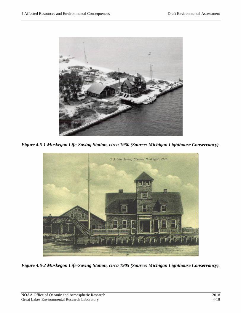
4 Affected Resources and Environmental Consequences Draft Environmental Assessment
NOAA Office of Oceanic and Atmospheric Research 2018
Great Lakes Environmental Research Laboratory 4-18
Figure 4.6-1 Muskegon Life-Saving Station, circa 1950 (Source: Michigan Lighthouse Conservancy).
Figure 4.6-2 Muskegon Life-Saving Station, circa 1905 (Source: Michigan Lighthouse Conservancy).

4 Affected Resources and Environmental Consequences Draft Environmental Assessment
NOAA Office of Oceanic and Atmospheric Research 2018
Great Lakes Environmental Research Laboratory 4-19
Historic Properties
A cultural resources survey was conducted to locate and record cultural resources in the Area of
Potential Effects (APE) (Figure 4.6 -3), which includes the project area and its immediate vicinity, and
to evaluate resources under the NRHP criteria. Background research included a review of existing
documentation pertaining to the project area, and primary and secondary sources generally found online.
Archival research included a search of the Michigan State Historic Preservation Office’s database of
archaeological and built environment resources for previously recorded resources within a ¼-mile study
area around the project site. The nearby Muskegon South Pierhead Lighthouse and the South
Breakwater Light are listed in the NRHP, but are outside of the APE. Only one resource, Building #1,
was identified in the APE, and it was previously determined eligible for the NRHP in 2000. No
resources in the study area are listed in the local register or are located within a City of Muskegon
Historic District.
Native American consultation was initiated on January 3, 2018. The Tribes with a potential interest in
actions at the project location were contacted with a letter soliciting them to identify any potentially
affected traditional properties. The list of Tribes consulted and a template of the letter sent to these tribes
is provided in Appendix A.
The survey identified five buildings within the study area for potential significance (Table 4.6-1):
Table 4.6-1 Resources Surveyed in Study Area
Name Date NRHP Status
Building #1 1905 Eligible
Building #2 c. 1965 (2013) Not Eligible
Building #3 c. 1970 Not Eligible
USCG Station Muskegon Headquarters Building 1990 Not Eligible
USCG Station Muskegon Boathouse c. 2005 Not Eligible
Two buildings were identified that were more than 50 years old (Figure 4.6-4). Building #1, built in
1905, was previously determined eligible for the NRHP in 2000. Building #2, originally built circa
1965, was substantially altered in 2013 in appearance and massing, and did not exhibit historic
characteristics; therefore, it did not warrant further evaluation under NRHP criteria and is not eligible for
the NRHP. The remaining buildings are less than 50 years old, did not exhibit exceptional historical or
architectural significance, and are not eligible for the NRHP.

GLERL LMFSBuilding 2
GLERL LMFSBuilding 1
USCG MuskegonStation Headquarters
GLERL LMFSBuilding 3
USCG MuskegonStation Boat House
Figure 4.6-3Area of Potential Effects
Source: ESRI Imagery, NOAA
Scale: 1 = 1,200; 1 inch = 100 feet
0 100 20050 Feet
I
Area of Potential Effects (APE)Buildings within APE
LEGEND
Margaret DrakeElliot Park
PereMarquette
Park
Beach Street Rd
LAKEMICHIGAN
NOAA Office of Oceanic and Atmospheric Research 2018Great Lakes Environmental Research Laboratory 4-20
4 Affected Resources and Environmental Consequences Draft Environmental Assessment

4 Affected Resources and Environmental Consequences Draft Environmental Assessment
NOAA Office of Oceanic and Atmospheric Research 2018
Great Lakes Environmental Research Laboratory 4-21
Figure 4.6-4 Building #1 (left), Building #2 (center), and Building #3 (right).
Building #1
Building #1 is a one-and-a-half-story Shingle Style frame building that originally served as the station
house for the Muskegon Life-Saving Station. Its form is based on plans for Marquette-type life-saving
stations. The building was rehabilitated in 2005 with a new roof, siding, windows, doors, and many
interior features. The building has a rectangular plan and sits on a poured concrete slab foundation with
basement walls. The side-gabled roof has a steep pitch with gabled and shed dormers, is covered with
composite shingles, and has an off-center brick chimney at the ridge, and aluminum gutters and
downspouts at the rakes. The exterior walls are covered with shingle siding, and contain hollow steel
exterior doors and three-over-one vinyl frame replacement windows. Decorative features include
diamond-shaped windows, band courses, and incandescent light fixtures. The south side of the building
(front elevation) facing a small lawn has a central cross-gable with paired sash windows and shed
dormers on each side, a full-width covered porch with a low-pitch hipped roof supported by square posts
(Figure 4.6-5). The north side of the building (rear elevation) facing the channel has a prominent, central
four-story square-plan lookout tower with a pyramidal roof, and shed dormers on each side of the tower
(Figure 4.6-6). Central steps are flanked by open porches. The east and west sides contain two sash
windows in each story and a diamond shaped window in each gable. The west side of the building has
an access ramp. The building currently functions as the office, meeting, and laboratory space for
GLERL. The setting of the property is visually dominated by the south pier, channel, navigation aids,
and breakwater structures extending into Lake Michigan, including two lighthouses.

4 Affected Resources and Environmental Consequences Draft Environmental Assessment
NOAA Office of Oceanic and Atmospheric Research 2018
Great Lakes Environmental Research Laboratory 4-22
Figure 4.6-5 Building #1, South Side.
Figure 4.6-6 Building #1, North (left) and West (right) Sides.
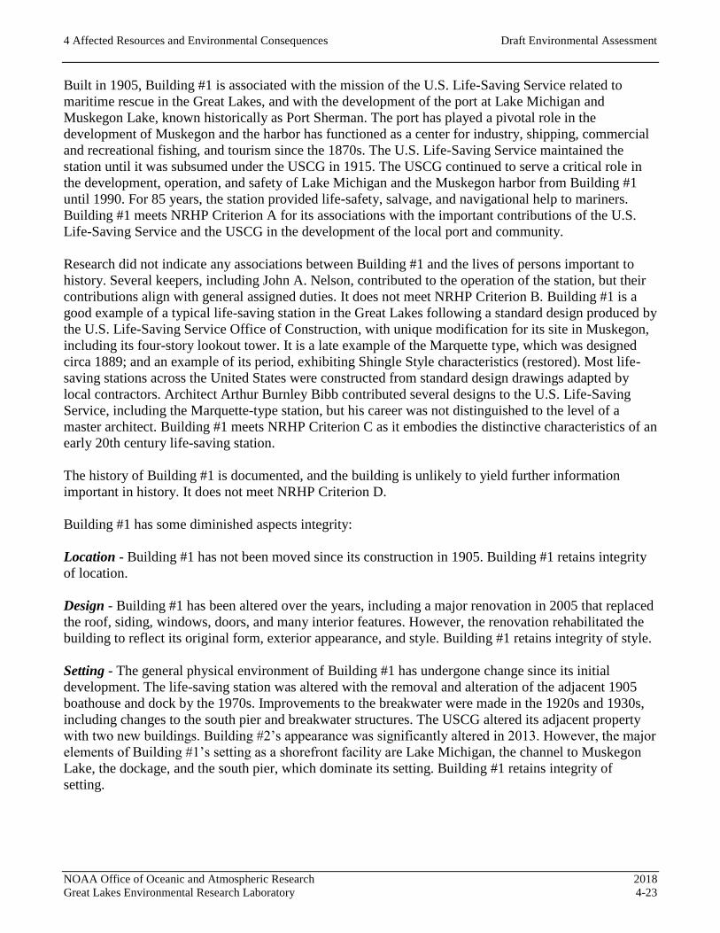
4 Affected Resources and Environmental Consequences Draft Environmental Assessment
NOAA Office of Oceanic and Atmospheric Research 2018
Great Lakes Environmental Research Laboratory 4-23
Built in 1905, Building #1 is associated with the mission of the U.S. Life-Saving Service related to
maritime rescue in the Great Lakes, and with the development of the port at Lake Michigan and
Muskegon Lake, known historically as Port Sherman. The port has played a pivotal role in the
development of Muskegon and the harbor has functioned as a center for industry, shipping, commercial
and recreational fishing, and tourism since the 1870s. The U.S. Life-Saving Service maintained the
station until it was subsumed under the USCG in 1915. The USCG continued to serve a critical role in
the development, operation, and safety of Lake Michigan and the Muskegon harbor from Building #1
until 1990. For 85 years, the station provided life-safety, salvage, and navigational help to mariners.
Building #1 meets NRHP Criterion A for its associations with the important contributions of the U.S.
Life-Saving Service and the USCG in the development of the local port and community.
Research did not indicate any associations between Building #1 and the lives of persons important to
history. Several keepers, including John A. Nelson, contributed to the operation of the station, but their
contributions align with general assigned duties. It does not meet NRHP Criterion B. Building #1 is a
good example of a typical life-saving station in the Great Lakes following a standard design produced by
the U.S. Life-Saving Service Office of Construction, with unique modification for its site in Muskegon,
including its four-story lookout tower. It is a late example of the Marquette type, which was designed
circa 1889; and an example of its period, exhibiting Shingle Style characteristics (restored). Most life-
saving stations across the United States were constructed from standard design drawings adapted by
local contractors. Architect Arthur Burnley Bibb contributed several designs to the U.S. Life-Saving
Service, including the Marquette-type station, but his career was not distinguished to the level of a
master architect. Building #1 meets NRHP Criterion C as it embodies the distinctive characteristics of an
early 20th century life-saving station.
The history of Building #1 is documented, and the building is unlikely to yield further information
important in history. It does not meet NRHP Criterion D.
Building #1 has some diminished aspects integrity:
Location - Building #1 has not been moved since its construction in 1905. Building #1 retains integrity
of location.
Design - Building #1 has been altered over the years, including a major renovation in 2005 that replaced
the roof, siding, windows, doors, and many interior features. However, the renovation rehabilitated the
building to reflect its original form, exterior appearance, and style. Building #1 retains integrity of style.
Setting - The general physical environment of Building #1 has undergone change since its initial
development. The life-saving station was altered with the removal and alteration of the adjacent 1905
boathouse and dock by the 1970s. Improvements to the breakwater were made in the 1920s and 1930s,
including changes to the south pier and breakwater structures. The USCG altered its adjacent property
with two new buildings. Building #2’s appearance was significantly altered in 2013. However, the major
elements of Building #1’s setting as a shorefront facility are Lake Michigan, the channel to Muskegon
Lake, the dockage, and the south pier, which dominate its setting. Building #1 retains integrity of
setting.

4 Affected Resources and Environmental Consequences Draft Environmental Assessment
NOAA Office of Oceanic and Atmospheric Research 2018
Great Lakes Environmental Research Laboratory 4-24
Materials - As stated above, the 2005 renovation replaced many of Building #1’s finishes and features,
including the roof, siding, windows, doors, and many interior. By 2005, vinyl siding and windows had
replaced the original shingle siding and wood sash windows. The 2005 rehabilitation replaced vinyl
siding with shingles, and replaced windows with modern sash in a three-over-one pattern. The
replacement materials reflect the original materials and follow the building’s original pattern of
configuration of materials. Building #1’s integrity of materials is diminished, but intact.
Workmanship - Despite the removal and replacement of some of its original elements, Building #1
continues to convey evidence of early 20th century construction crafts; it retains integrity of
workmanship.
Feeling - Due to the 2005 renovation, Building #1 expresses both the aesthetic and historic sense of the
early 20th century life-saving station house. It retains integrity of feeling.
Association - Since 1990, Building #1 stopped functioning as a life-saving station. However, it remains
adjacent to USCG Station Muskegon, and NOAA’s maritime research requires use of the station for
observation of Lake Michigan and Muskegon Lake. Due to the proximity and collaboration of NOAA
and the USCG, Building #1 retains integrity of association.
In summary, Building #1 is eligible for listing in the NRHP at the local level of significance for its
contributions as the Muskegon Life-Saving Station in the areas of military, humanitarianism, and
transportation. The property is eligible under Criterion A for its associations related to life-saving
services and port development during 85 years of service, and under Criterion C as it embodies the
distinctive characteristics of its type. The period of significance is 1905 to 1990; from the year it was
constructed to the end of the USCG use of the station house. In 2000, Building #1 was determined
eligible for the NRHP, and it currently retains sufficient integrity for listing in the NRHP.
4.6.3 Environmental Consequences
The analysis of impacts, or potential effects, on historic properties is based on the Criteria of Adverse
Effect described in regulations implementing Section 106 of the NHPA (36 CFR 800.5). An undertaking
has an effect on a historic property when the undertaking may alter, directly or indirectly, the
characteristics of the property that may qualify the property for inclusion in the NRHP [36 CFR
800.5(a)]. An effect is considered adverse when it diminishes the integrity of the property’s location,
design, setting, materials, workmanship, feeling, or association.
Adverse effects may include reasonably foreseeable effects caused by the undertaking that may occur
later in time, be farther removed in distance, or be cumulative. Adverse effects on historic properties
include: physical destruction of or damage to all or part of the property; alteration of a property that is
not consistent with the Secretary’s Standards for the Treatment of Historic Properties (36 CFR 68) and
applicable guidelines; removal of the property from its historic location; change of the character of the
property’s use or of physical features within the property’s setting that contribute to its historic
significance; introduction of visual, atmospheric, or audible elements that diminish the integrity of the
property’s significant historic features; neglect of a property which causes its deterioration, with certain
exceptions; and transfer, lease, or sale of property out of federal ownership or control without adequate
and legally enforceable restrictions or conditions to ensure long-term preservation of the property’s
historic significance.

4 Affected Resources and Environmental Consequences Draft Environmental Assessment
NOAA Office of Oceanic and Atmospheric Research 2018
Great Lakes Environmental Research Laboratory 4-25
Action Alternative 1 (Preferred Alternative)
Under this option, a two-story wood-frame building with design considerations for a historical look
would be constructed on the existing foundation to replace Building #3. Although Building #3 is not a
historic property, the proximity of Building #3 to Building #1 within the GLERL LMFS complex has
the potential to affect Building #1’s integrity of setting and feeling. The enlarged replacement of
Building #3 would be visible from Building #1, but separated by Building #2, which is located between
the two buildings and forms a partial visual barrier.
To retain the integrity of Building #1, the improvements will be consistent with the Secretary of the
Interior’s Standards for the Treatment of Historic Properties, particularly the Secretary of the Interior’s
Standards for Rehabilitation and Guidelines for Rehabilitating Historic Buildings.
Of the 10 Standards for Rehabilitation, three standards pertain to new construction as proposed in this
alternative.
Standard 3: Each property shall be recognized as a physical record of its time, place, and use. Changes
that create a false sense of historical development, such as adding conjectural features or architectural
elements from other buildings, shall not be undertaken.
The new design for Building #3 must avoid the inclusion of conjectural historical or architectural
features.
Standard 9: New additions, exterior alterations, or related new construction shall not destroy historic
materials that characterize the property. The new work shall be differentiated from the old and shall be
compatible with the massing, size, scale, and architectural features to protect the historic integrity of the
property and its environment.
The new design for Building #3 must balance differentiation and compatibility in massing, size, scale,
and architectural features related to Building #1.
Standard 10: New additions and adjacent or related new construction shall be undertaken in such a
manner that if removed in the future, the essential form and integrity of the historic property and its
environment would be unimpaired.
Replacement of the existing one-story Building #3 would be independent from Building #1, and its
removal would not impair the historic property.
In summary, the design would adhere to the Secretary of the Interior’s Standards for Rehabilitation.
Based on the analysis of potential effects to historic properties from implementation of the proposed
action, no significant impacts would result under Action Alternative 1. A FONSI is warranted for the
proposed action evaluated in this EA.

4 Affected Resources and Environmental Consequences Draft Environmental Assessment
NOAA Office of Oceanic and Atmospheric Research 2018
Great Lakes Environmental Research Laboratory 4-26
Action Alternative 2
Under this option, a prefabricated two-story metal building would replace the existing Building #3 on
the existing foundation. Although Building #3 is not a historic property, the proximity of Building #3 to
Building #1 within the GLERL LMFS complex has the potential to affect Building #1’s integrity of
setting and feeling. The enlarged replacement of Building #3 would be visible from Building #1, but
separated by Building #2, which is located between the two buildings and forms a partial visual barrier.
As described under Action Alternative 1, the design for Building #3 must be consistent with the
Secretary of the Interior’s Standards for Rehabilitation and Guidelines for Rehabilitating Historic
Buildings, specifically Standards 3, 9, and 10. Under Standard 3, the replacement of the existing one-
story Building #3 with a similar two-story prefabricated metal building would not add any conjectural
historical features that could impact the historic property. Under Standard 9, Building #3 as proposed in
this alternative would not be architecturally compatible with Building #1, but would resemble its current
appearance. Because the architectural aesthetic would essentially remain the same, and the visual
intrusion of the additional massing would be minimized by the visual barrier of Building #2 between
Building #1 and Building #3, the proposed building is unlikely to impact the historic property. Under
Standard 10, the replacement of the existing one-story Building #3 with an enlarged wood-frame
building would be independent from Building #1, and its removal would not impair the historic
property.
In summary, the design would adhere to the Secretary of the Interior’s Standards for Rehabilitation.
Based on the analysis of potential effects to historic properties from implementation of the proposed
action, no significant impacts would result under Action Alternative 2.
Action Alternative 3
Under this option, a new one-story wood-frame building (minimum of 4,500 square feet) would be
constructed to replace the existing Building #3 on the existing foundation. Although Building #3 is not a
historic property, the proximity of Building #3 to Building #1 within the GLERL LMFS complex has
the potential to affect Building #1’s integrity of setting and feeling. The enlarged replacement of
Building #3 would be visible from Building #1, but separated by Building #2, which is located between
the two buildings and forms a partial visual barrier.
As described under Action Alternative 1, the design for Building #3 must be consistent with the
Secretary of the Interior’s Standards for Rehabilitation and Guidelines for Rehabilitating Historic
Buildings, specifically Standards 3, 9, and 10. Under Standard 3, the new design for Building #3 must
avoid the inclusion of conjectural historical or architectural features. Under Standard 9, the new
Building #3 as proposed in this alternative would not be architecturally compatible with Building #1, but
would resemble its current appearance. Because the architectural aesthetic would essentially remain the
same, and the visual intrusion of the additional massing would be minimized by the visual barrier of
Building #2 between Building #1 and Building #3, the proposed building is unlikely to impact Building
1’s integrity. Under Standard 10, the replacement of the existing one-story Building #3 with an enlarged
wood-frame building would be independent from Building #1, and its removal would not impair the
historic property.

4 Affected Resources and Environmental Consequences Draft Environmental Assessment
NOAA Office of Oceanic and Atmospheric Research 2018
Great Lakes Environmental Research Laboratory 4-27
In summary, the design would adhere to the Secretary of the Interior’s Standards for Rehabilitation.
Based on the analysis of potential effects to historic properties from implementation of the proposed
action, no significant impacts would result under Action Alternative 3.
No-Action Alternative
Under a No-Action Alternative, there would be no changes to the existing buildings or setting within the
APE as a result of this project. Therefore, the No-Action Alternative would have no adverse effects on
Building #1. Based on the analysis of potential effects to historic properties due to the proposed action,
no significant impacts would result from the implementation of the No-Action Alternative.
4.6.4 Mitigation Measures
No mitigation measures are required for each of the three Action Alternatives or for the No-Action Alternative in
relation to cultural resources.

4 Affected Resources and Environmental Consequences Draft Environmental Assessment
NOAA Office of Oceanic and Atmospheric Research 2018
Great Lakes Environmental Research Laboratory 4-28
4.7 FLORA AND FAUNA
4.7.1 Regulatory Setting
The Endangered Species Act of 1973 (ESA) is administered by the U.S. Fish and Wildlife Service and
the Commerce Department, National Marine Fisheries Service, and directs all Federal agencies on the
conservation of endangered and threatened species of fish, wildlife, and plants. Section 7 of the ESA
requires Federal agencies to carry out conservation programs to benefit endangered and threatened
species. If listed species or designated critical habitat are present and could be affected by the proposed
action, a biological assessment must be prepared to analyze the potential effects of the proposed action
and make a determination of effect.
The Michigan Department of Natural Resources (MDNR) manages the Michigan’s Official List of
Endangered and Threatened Species (effective April 9, 2009), the Michigan’s Special Animals, and the
Michigan Special Plants lists. These lists include endangered, threatened, and probably extirpated plant
and animal species in Michigan that are protected under the ESA of the State of Michigan (Part 365 of
PA 451, 1994 Michigan Natural Resources and Environmental Protection Act). Also, included in these
lists are species of Special Concern. Special Concern species do not have legal protection under the
ESA; however, many of these species are of concern because of their declining or relict population in
the State of Michigan.
The Migratory Bird Treaty Act (MBTA) protects all migratory birds listed in the 50 CFR 10.13, their
occupied nests, and eggs. The U.S. Fish and Wildlife Service (USFWS) is the agency with statutory
authority and responsibility for enforcing the MBTA. According to the USFWS, the MBTA provides
that it is unlawful to pursue, hunt, take, capture, kill, possess, sell, purchase, barter, import, export, or
transport any migratory bird, nest, or egg, unless authorized under a permit.
4.7.2 Affected Resources
On November 29, 2017, the site was inspected by a biologist for presence of TES habitats. Photographs
from the site inspection of affected areas are provided in Appendix B. The project area consists of the
footprint of the existing Building #3 and surrounding asphalt areas immediately north (adjacent to
Building #2) and east. Adjacent to the project area are built environments associated with the LMFS
and channel liking Lake Michigan to Muskegon Lake to the north, the USCG Station Muskegon to the
east and roads, City park or remnant dune areas and beaches lie to the south. Lake shore and dune sand
stabilized by rip rap are located adjacent to the project area to the west.
A list of state and federally threatened and endangered species (TES) that have been observed within the
project area and nearby areas (4 mile radius) was obtained from the Michigan Natural Features
Inventory. The Michigan Natural Features Inventory’s list is provided in Appendix C. In addition, the
Michigan County Distribution of Federally-Listed Threatened, Endangered, Proposed and Candidate
Species website was reviewed and additional species were added as necessary.
4 Affected Resources and Environmental Consequences Draft Environmental Assessment
NOAA Office of Oceanic and Atmospheric Research 2018
Great Lakes Environmental Research Laboratory 4-29
4.7.3 Environmental Consequences
Available site-specific literature and data were reviewed to characterize habitat features and land use
patterns for each action alternative and the no-action alternative. For state-listed TES to be considered
potentially present, the site must be within the specie’s range, and a suitable habitat for the species must
be present in the project area. Three state TES, the lake sturgeon, piping plover, and Pitcher’s thistle,
are listed for the area. Special concern species listed by the MDNR includes the dune cutworm and pink
healsplitter. For federally-listed TES to be considered potentially present, the species should be
observed in Muskegon County and suitable habitat for the species must be present in the project area.
Seven federal TES, Indiana bat, northern long-eared bat, rufa red knot, Karner blue butterfly, eastern
massasauga rattlesnake, piping plover (a shore bird), and Pitcher’s thistle (a sand dune plant) are listed
for the area. Based on an evaluation of site-specific literature and a field inspection, the state- and
federally-listed TES species that have the potential to occur within or adjacent to the project area are
evaluated below. Details regarding the state- and federally-listed TES status, last observation date,
habitat, and whether the habitat exists in the project area are also discussed.
Lake Sturgeon (Acipenser fulvescens)
The lake sturgeon is listed as a threatened by the MDNR. This species was last observed in this area of
Lake Michigan in 2008. The lake sturgeon is generally a benthic species that occurs in the shallow areas
of large fresh water rivers and lakes. They are associated with un-vegetated habitats with deep runs and
pools in rivers. The lake sturgeon typically spawns in gravel bottom streams while rocky lake shores are
used when riverine habitats are unavailable (MNFI, 2017). Areas potentially affected by the proposed
action do not include the nearby channel or lake habitat. Suitable habitat for the lake sturgeon is not
available in the project area.
Piping Plover (Charadrius melodus)
The piping plover is listed as endangered by the MDNR and the USFWS. This species was last
observed in this area in 2015. The piping plover’s habitat resides on beaches along the Great Lakes.
Piping plovers breed on sparsely vegetated beaches, cobble pans, or sand pits in the sand dunes
(USFWS, 2017a). The nearest designated critical habitat for piping plover is located at the Muskegon
State Park, which is located on the opposite shore of the entry channel between Lake Michigan and
Muskegon Lake (USFWS, 2017b). A critical habitat is a specific geographic area that contain features
essential to the conservation of a TES and that may require special management and protection. A
critical habitat for the piping plover is not present in the project area. Furthermore, a suitable habitat for
this piping plover is not available in the project area.
Pitcher’s Thistle (Cirsium pitcheri)
Pitcher’s thistle is listed as threatened by the MDNR and the USFWS. This species was last observed in
this area in 2012. Pitcher’s thistle is found on the dunes and shorelines of the Great Lakes (MNFI,
2017). During the site inspection, the shoreline was inspected for Pitcher’s thistle and none was
observed. A suitable habitat for the Pitcher’s thistle is not available in the project area.
Dune Cutworm (Euxoa aurulenta)
The dune cutworm is listed as a special concern species by the MDNR. Special-concern species are not
protected by Michigan’s ESA, but are of concern because of their population decline within the State of
Michigan. This species was last observed in this area in 1989. The dune cutworm has been reported

4 Affected Resources and Environmental Consequences Draft Environmental Assessment
NOAA Office of Oceanic and Atmospheric Research 2018
Great Lakes Environmental Research Laboratory 4-30
occurring in disjunct populations in sandy areas. The habitat typically consists of sparsely vegetated,
high quality coastal dune habitats (MNFI, 2017). During the site inspection, no dune cutworms were
observed. A suitable habitat, as described above, for the dune cutworm is not available in the project
area.
Pink Heelsplitter (Potamilus alatus)
The pink heelsplitter (a freshwater mussel) is listed as a special concern species by the MDNR. The
pink heelsplitter can be found in various types of substrate, and in slower moving waters. The habitat
consists of freshwater rivers and streams. No work will be conducted in the channel or lake near the
project area. A suitable aquatic habitat for this the pink heelsplitter is not available in the project area.
Lake Cress (Rorippa aquatica)
The lake cress is listed as threatened by the USFWS. This species was last observed in this area in 1898.
The lake cress is an aquatic plant found in lake margins and slowly moving streams (MNFI, 2017). No
work will be conducted in the channel or lake near the project area. A suitable aquatic habitat for this
lake cress is not available in the project area.
Bladderwort (Utricularia subulata)
The bladderwort is listed as threatened by the USFWS. This species was last observed in the area in
1992. The bladderwort’s habitat consists of damp sand in the marginal area of interdunal wetlands
(MNFI, 2017). There are no wetlands in the project area. A suitable habitat for this bladderwort is not
available in the project area.
Indiana Bat (Myotis sodalist)
The Indiana bat is listed as endangered by the USFWS. The Indiana bat’s habitat in Michigan consists
of roosts in the bark or in hollows and cavities of sun-exposed trees (USFWS, 2017b). Building #3 was
examined for bats roosting and none were documented. In addition, there are no trees suitable for
roosting within the project area. A suitable habitat for the Indiana bat is not available in the project area.
Northern Long-Eared Bat (Myotis septentrionalis)
The northern long-eared bat is listed as threatened by the USFWS. The northern long-eared bat
hibernates in caves and mines and occupies wooded areas in the Fall. In the Spring and Summer, the
bats roost and forage in upland forests (USFWS, 2017b). There are no upland forests or wooded areas
within the project area. A suitable habitat for the Indiana bat is not available in the project area.
Rufa Red Knot (Calidris canutus rufa)
The rufa red knot (a shore bird) is listed as threatened by the USFWS. Red knots are an uncommon
migrant in Michigan and are never abundant (USFWS, 2017b). The rufa red knots migrate along the
shores and nest in the artic. A suitable habitat for the rufa red knot is not available in the project area.
Eastern Massasauga Rattlesnake (Sistrurus catenatus)
The eastern massasauga rattlesnake is listed as endangered by the USFWS. The eastern massasauga
habitat consists of open to forested wetlands and adjacent upland areas (USFWS, 2017b). There are no
wetlands and adjacent uplands within the project area. A suitable habitat for this the eastern massasauga
is not available in the project area.
Karner Blue Butterfly (Lycaeides Melissa sameulis)

4 Affected Resources and Environmental Consequences Draft Environmental Assessment
NOAA Office of Oceanic and Atmospheric Research 2018
Great Lakes Environmental Research Laboratory 4-31
The Karner blue butterfly is listed as endangered by the USFWS. The Karner blue butterfly’s habitat
consists of pine barrens and oak savannas on sandy soils with wild lupines (USFWS, 2017b). There are
no pines or oak savannas in the project area. A suitable habitat for the Karner blue butterfly is not
available in the project area.
Anticipated impacts for each alternative relative to the resources analyzed above are presented below for
each Action Alternative and the No-Action Alternative.
Action Alternative 1 (Preferred Alternative)
Based on the analysis of potentially affected species listed as endangered, threatened or species of
concern, no adverse effect to these species is anticipated to occur due to the proposed action
implemented under Action Alternative 1. In addition, no ‘take’ of migratory birds would result from
implementation of this Action Alternative.
No adverse effects to flora and fauna resources would result under Action Alternative 1.
Action Alternative 2
Based on the analysis of potentially affected species listed as endangered, threatened or species of
concern, no adverse effect to these species is anticipated to occur due to the proposed action
implemented under Action Alternative 2. In addition, no ‘take’ of migratory birds would result from
implementation of this Action Alternative.
No adverse effects to flora and fauna resources would result under Action Alternative 2.
Action Alternative 3
Based on the analysis of potentially affected species listed as endangered, threatened or species of
concern, no adverse effect these species is anticipated to occur due to the proposed action implemented
under Action Alternative 3. In addition, no ‘take’ of migratory birds would result from implementation
of this Action Alternative.
No adverse effects to flora and fauna resources would result under Action Alternative 3.
No-Action Alternative
Based on the analysis of potentially affected species listed as endangered, threatened or species of
concern, no adverse effect to these species is anticipated under the No-Action Alternative. In addition,
no ‘take’ of migratory birds would result from implementation of this Action Alternative.
No adverse effects to flora and fauna resources would result under the No-Action Alternative.

4 Affected Resources and Environmental Consequences Draft Environmental Assessment
NOAA Office of Oceanic and Atmospheric Research 2018
Great Lakes Environmental Research Laboratory 4-32
4.7.4 Mitigation Measures
No mitigation measures are required or recommended relative to effect upon flora and fauna resources.

4 Affected Resources and Environmental Consequences Draft Environmental Assessment
NOAA Office of Oceanic and Atmospheric Research 2018
Great Lakes Environmental Research Laboratory 4-33
4.8 WETLANDS
4.8.1 Regulatory Setting
The U.S. Army Corps of Engineers (USACE) regulates wetlands and navigable waters under Section
404 of the CWA and Section 10 of the Rivers and Harbors Action, respectively. The Ordinary High
Water Mark (OHWM) is the jurisdictional limit for actions within waterways. The OHWM is 581.5 feet
International Great Lakes Datum (IGLD) 1985 for Lake Michigan. Any work conducted below the
OHWM requires a federal CWA Permit under Section 404 and a permit pursuant to Part 325 of the
Michigan Natural Resources and Environmental Protection Act.
The proposed action alternatives were reviewed for presence of wetlands in accordance with the
Regional Supplement to the Corps of Engineers Wetland Delineation Manual: Northcentral and
Northeast Region (USACE, 2012).
4.8.2 Affected Resources
Action Alternative 1 (Preferred Alternative)
Prior to the field visit, site-specific literature and available information was reviewed to characterize
habitat features and land use patterns within the vicinity of the site. A review of Michigan’s Wetland
Inventory Maps and National Wetland Inventory (NWI) maps was completed to determine the potential
for impacts to wetlands due to the proposed action. On November 29, 2017, a site visit was completed
by a biologist familiar with Michigan’s natural communities to field verify the background data
reviewed and to determine if any wetlands existed at the site.
Action Alternative 1 does not propose work below the OHWM. Wetlands were not identified on the
Michigan or NWI maps, and no wetlands were observed within the project area during the field visit.
Lake Michigan and the connecting channel between Lake Michigan and Muskegon Lake are adjacent to
the site. These surface waters will not be affected by the proposed action.
The proposed action alternatives would have no adverse effect on state or federal jurisdictional wetlands
and surface water.
Action Alternative 2
The effects of Alternative 2 would be the same as the Preferred Alternative. No adverse environmental
effects with respect to wetlands resources or waters of the U.S. would result from the proposed Action
Alternative 2.
Action Alternative 3
The effects of Alternative 3 would be the same as the Preferred Alternative. No adverse environmental
effects with respect to wetlands resources or waters of the U.S. would result from the proposed Action
Alternative 3.

4 Affected Resources and Environmental Consequences Draft Environmental Assessment
NOAA Office of Oceanic and Atmospheric Research 2018
Great Lakes Environmental Research Laboratory 4-34
No-Action Alternative
No adverse effects to wetlands resources or waters of the U.S. would result from the No-Action
Alternative.
4.8.3 Mitigation Measures
Other than standard BMPs for erosion preventions and stormwater pollution prevention planning, no
mitigation measures are recommended or required.

4 Affected Resources and Environmental Consequences Draft Environmental Assessment
NOAA Office of Oceanic and Atmospheric Research 2018
Great Lakes Environmental Research Laboratory 4-35
4.9 FLOODPLAINS
4.9.1 Regulatory Setting
The 100-year floodplain is an area with a flood elevation that has a one-percent chance of being equaled
or exceeded each year. Although the name implies such a flood every 100 years, in reality, a 100-year
flood could occur in any year. EO 11988, Floodplain Management, dated May 24, 1977, requires that
federal agencies locate facilities outside the 100-year or base floodplain unless there is no practicable
alternative location. If locating outside the floodplain is unavoidable, structures should be built so that
the finished floor elevation is above the 100-year flood elevation as determined by Federal Emergency
Management Agency (FEMA) and depicted on their Flood Insurance Rate Maps (FIRMs), or the
structures should be flood-resistant. Floodplain management is intended to minimize the potential for
property damage and to maintain functions of the hydrologic cycle. EO 11988 and NOAA Floodplain
Guidance, Guidance on Compliance with the Implementing Procedures for EO 11988 and 11990 (2012)
are applied to determine effects to these resources.
Under the provisions of EO 11988 Section 2(a)(1), “before taking an action, each agency shall
determine whether the proposed action will occur in a floodplain--for major Federal actions significantly
affecting the quality of the human environment, the evaluation required below will be included in any
statement prepared under Section 102(2) (C) of the NEPA. This Determination shall be made according
to a Department of Housing and Urban Development (HUD) floodplain map or a more detailed map of
an area, if available. If such maps are not available, the agency shall make a determination of the
location of the floodplain based on the best available information.” (President of the US, 1977). Per
HUD Guidance, FEMA designates floodplains and the FEMA Map Service Center provides this
information in the form of FIRMs (HUD, 2016).
Likewise, NOAA Guidance on implementing EO 11988 states that in order to determine whether a
proposed action will occur in a 100-year (or 500-yr for a critical action) floodplain, the first reference
should be the FEMA FIRM. If the maps prepared by FEMA do not adequately characterize the flood
hazard potential for the proposed action, other sources that merit investigation may be used, such as
flood hazard studies, hydrologic studies, soil surveys, and other investigations. The proposed project site
is owned by the federal government where other regional or local floodplain regulation would not apply
to federally-owned lands.
4.9.2 Affected Resources
The floodplain of the LMFS is delineated by FEMA in the FIRM Panel No. 26121C0252D with the
effective date of July 6, 2015. The existing structure, Building #3, is located outside of the 100-year
floodplain in an area designated on the FIRM as Zone X, Area of Minimal Flood Hazard. The nearest
100-year floodplain is located approximately 25 feet west of the existing structure. The proposed
footprint for the Proposed Action under each action alternative would be at the same location as the
existing structure, and outside of the 100-year floodplain in an area designated in the FIRM as Zone X,
Area of Minimal Flood Hazard (see Figure 4.9-1). The proposed action under Action Alternative 3 may
occur over the 100-year floodplain with the structural element or prospective cantilever design
potentially above the 100-year floodplain base flood elevation.
4 Affected Resources and Environmental Consequences Draft Environmental Assessment
NOAA Office of Oceanic and Atmospheric Research 2018
Great Lakes Environmental Research Laboratory 4-36
4.9.3 Environmental Consequences
Action Alternative 1 (Preferred Alternative)
Proposed actions occurring under Action Alternative 1 would not be located in the 100-year floodplain.
Construction or installation of equipment in the floodplain that would be classified as “fill” in the
floodplain would not occur. This alternative would not alter the existing natural or beneficial values of
the floodplain. Therefore, no adverse effects to the floodplain would occur.
As this alternative is not located in the 100-year floodplain, no additional action is required by NOAA
for compliance with EO 11988.
Action Alternative 2
Proposed actions occurring under Action Alternative 2 would not be located in the 100-year floodplain.
Construction or installation of equipment in the floodplain that would be classified as “fill” in the
floodplain would not occur. This alternative would not alter the existing natural or beneficial values of
the floodplain. Therefore, no adverse effects to the floodplain would occur.
As this alternative is not located in the 100-year floodplain, no additional action is required by NOAA
for compliance with EO 11988.
Action Alternative 3
Proposed actions occurring under Action Alternative 3 would not be located in the 100-year floodplain.
Construction or installation of equipment in the floodplain that would be classified as “fill” in the
floodplain would not occur. Structural elements may be cantilevered to the west above the 100-year
floodplain; however, this alternative would not temporarily or permanently place fill (including
equipment) within the floodplain or alter its existing natural or beneficial values. Therefore, no adverse
effects to the floodplain would occur.
As this alternative is not located in the 100-year floodplain, no additional action is required by NOAA
for compliance with EO 11988.

ProjectLocation
AECO
M Oa
kland
CA 2/
8/20
18 US
ER el
i.pop
uch P
ATH L
:\Proj
ects\
GIS\P
rojec
ts\NO
AA_G
reatLa
kes_
ERL\
02_M
aps\
01_A
nalys
is_an
d_Da
ta_De
velop
ment\
DFirm
_Prel
im.m
xd
2018
4-37
Project LocationFEMA National Hazard Flood LayerFEMA Flood Insurance Rate Map Panel ID No. 26121C0252D
Zone AE, 1% annual chance floodplain (Flood elevation: 584.4 ft, NAVD88)Zone X500, 0.20% annual chance floodplainZone X, area of minimal flooding (outside of 1% and 0.20% annual chance floodplain)
0 200Feet
NOAA Office of Oceanic and Atmospheric Research Great Lakes Environmental Research Laboratory
Source: FEMA National Flood Hazard Layer Panel 26121C0252D, 07/06/15; ESRI Imagery, 2016.
1:1,2001 inch = 100 feet
4 Affected Resources and Environmental Consequences Draft Environmental Assessment
Figure 4.9-1FEMA Flood Hazards
4 Affected Resources and Environmental Consequences Draft Environmental Assessment
NOAA Office of Oceanic and Atmospheric Research 2018
Great Lakes Environmental Research Laboratory 4-38
No-Action Alternative
As this alternative is not located in the 100-year floodplain, no additional action is required by NOAA
for compliance with EO 11988.
4.9.4 Mitigation Measures
No mitigation measures are required or recommends with regarding impacts to floodplain resources.
4 Affected Resources and Environmental Consequences Draft Environmental Assessment
NOAA Office of Oceanic and Atmospheric Research 2018
Great Lakes Environmental Research Laboratory 4-39
4.10 COASTAL ZONE MANAGEMENT
4.10.1 Regulatory Setting
The Coastal Zone Management Act (CZMA) was passed by Congress in 1972, as amended, authorizes
certain coastal states to actively manage and protect coastal and shoreline resources from residential,
recreational, commercial and industrial uses. States have the primary role of managing coastal areas via
an approved Coastal Zone Management Program (CZMP), which describes how the state will manage
its coastal zones and resources.
Federal consistency is the CZMA provision that federal actions that have reasonably foreseeable effects
on any land or water use or natural resource of the coastal zone (also referred to as coastal uses or
resources, or coastal effects) should be consistent, to the maximum extent practicable, with the
enforceable policies of a coastal state’s federally approved CZMP. Federal consistency requirements are
described in Section 307 of the CZMA and at 15 CFR Section 930. A Federal Consistency
Determination under each state’s approved CZMP is typically required for federal actions.
MDEQ is responsible for implementing the CZMP and coordinating consistency review in the State.
However, the CZMP and consistency coordination is managed out of MDNR by Ronda Wuycheck. The
CZMP, which was approved in 1978, relies on specific State policies and objectives that promote the
protection of freshwater coastline resources contained within the coastal area. The components of the
program include: natural hazard to development; sensitive to alteration or disturbance; fulfilling
recreational or cultural needs; natural economic potential (e.g. water transportation, mineral and energy,
prime industrial and agricultural areas); and intensive or conflicting use, which encompass coastal lakes,
river moths, bays and urban areas (MDEQ, 1978). State shoreline statutes include: Shorelands
Protection and Management Act; Great Lakes Submerged Lands Act; and Sand Dunes Act.
A focus of the Michigan CZMP is to improve administration of existing State shoreline statutes,
including the Shorelands Act, Submerged Lands Act and Sand Dune Act. Critical dune areas (CDA) are
protected by Part 353 of the Sand Dune Protection and Management Act. CDA represent the tallest and
largest dunes extending along much of Lake Michigan's shoreline and the shores of Lake Superior,
totaling about 74,000 acres in size. The State legislature has found that CDA of the state are unique,
irreplaceable, and fragile resources that provide significant recreational, economic, scientific, geological,
scenic, botanical, educational, agricultural, and ecological benefits (State of Michigan, 2017).
CDA includes public and private properties where developmental, silvicultural and recreational
activities are regulated by Part 353, Sand Dune Protection and Management Act. A permit is required
for any activity that would significantly alter the physical characteristics of a CDA or for a contour
change in a CDA, such activities including the construction of a house or a garage, building a roadway
or driveway, installing a septic system, installing retaining walls, and sand removal activities. Project
review is conducted by the State and US Army Corps of Engineers (USACE) to ensure that
unreasonable depletion or degradation of the diversity, quality or function of CDA does not occur. Local
units of government have the right to submit a model zoning ordinance to the MDEQ for review and
approval (MDEQ, 2017b).
4 Affected Resources and Environmental Consequences Draft Environmental Assessment
NOAA Office of Oceanic and Atmospheric Research 2018
Great Lakes Environmental Research Laboratory 4-40
4.10.2 Affected Resources
The project site is located approximately 30 feet from the edge of Lake Michigan and 0.7 miles from
Muskegon Lake, which flows out to Lake Michigan via a manmade channel. According to MDEQ, the
site is located in both the coastal zone and a CDA (MDEQ, 2003). However, the affected area is in a
built area and the proposed action would take place at a site that is already developed with the existing
Building #3. The project site no longer meets the definition of CDA; however immediately south of
Building #3, is an undeveloped property with remnant dune characteristics.
The LMFS and adjacent shoreline properties are not within established High Risk Erosion Areas
established for state of Michigan shoreline environments and depicted on maps prepared for Norton
Shores Township (MDNR, 2017).
4.10.3 Environmental Consequences
The CZMP, established in 1978, includes a number of state legislated areas that are of particular concern
in the coastal zone. Impacts to these areas could result in environmental impacts to coastal zone
resources. These areas are described below.
Public Access Sites
The State has three designated public access fishing sites and 121 coastal recreational harbors and
launching sites. The access through the project area to the Muskegon South Pierhead Lighthouse is not
identified in the CZMP, but is subject to consistency review as a coastal access. Access to the
Muskegon South Pierhead Lighthouse is provided via an asphalt pathway through the LMFS parking
area which connects Beach Street to the pier. The pierhead is used for fishing year-around. Access to the
pierhead will remain open during the 197 days of construction. According to a DNR map, this location
is assessed as “potential public access” (DNR, 2016).
State Game and Wildlife Area
The Michigan CZMP states that there are 19 coastal state game and wildlife areas in the State of
Michigan. State Game Areas are areas established primarily for hunting. State Wildlife Areas are areas
established for both hunting and conservation or protection of wildlife (DNR, 2018). No coastal State
Game or Wildlife Areas are within or nearby the project area.
State Parks
The Michigan CZMP states there are 37 state parks located along the coast. Muskegon State Park is
approximately 1 mile from the project site, located on the opposite shore of the entry channel between
Lake Michigan and Muskegon Lake. No direct or indirect effects to this resource would occur as a result
of implementing any of the action alternatives.
Harbors of Refuge and Mooring Facilities
Harbors of Refuge and Mooring Facilities are established to provide for specialized recreational boating
needs under respective provisions of Act No. 320 of the Public Acts of 1947 and Act No. 337 of the
Public Acts of 1939. There are recreational and commercial harbors beginning less than a one-half mile
east of the GLERL LMFS. These facilities would not be directly or indirectly affected as a result of
implementing any action alternatives.
4 Affected Resources and Environmental Consequences Draft Environmental Assessment
NOAA Office of Oceanic and Atmospheric Research 2018
Great Lakes Environmental Research Laboratory 4-41
Port Districts
Port Districts were established to provide for commercial navigation needs under respective provisions
of the Port Districts Act. Two port districts established for commercial navigation needs under the Port
Districts Act are the Detroit Port District and the Monroe Port District. The project site is not located in
a Port District established under the Michigan CZMP.
Historic Districts
The Michigan CZMP states there are 6 historic districts located along the coast. Historic Districts within
the Michigan coastal zone are established under the provisions of the State Historic Districts Act (Act
number 169 of the Public Acts of 1969). The Michigan CZMP established in 1978 states there are six
historic districts along the Michigan coast. None of the buildings in the project area are within the limits
of a state or City of Muskegon Historic District or are individually listed in local registers.
Farmland or Open Space Areas
These areas are voluntarily enrolled by landowners, which legally restricts nonagricultural development
under provisions of the Farmland and Open Space Preservation Act. As previously stated above, there
are no farmlands located in or around the project area. However, the project area is located in an OSR
district, but is not enrolled as an open space area.
State Wilderness Areas, Wild Areas and Natural Areas
Natural Areas are regulated under the State Wilderness and Natural Areas Act (Act Number 241 of the
Public Acts of 1972). Three natural areas border the Michigan coast. The project area for the Proposed
Action does not possess the features or characteristics typical of state-identified special natural areas,
including a Wilderness Area, Wild Area, Research Natural Area, Nature Study Area or Managed
Natural Area.
Natural Rivers Areas
These areas are preserved under the provisions of the State Natural Rivers Act (Act Number 231 of the
Public Acts of 1970). According to the CZMP, there are four natural rivers established in the State’s
coastal areas. No natural rivers are present in or near the project area. The project area and LMFS is
adjacent to a man-made channel between Lake Michigan and Muskegon Lake.
Great Lakes designated Sand Dune Areas
Protection, management and reclamation of Great Lakes sand dunes is provided under the Act Number
222 of the Public Acts of 1976. The project site is within a critical sand dunes area, but is neither
ecologically sensitive nor natural dunes. The project footprint would not change from the existing
Building #3 foundation, and therefore is not considered an area of new development as defined in Part
353, Sand Dune Protection and Management Act.
Action Alternative 1 (Preferred Alternative)
The preferred alternative is not expected to have significant adverse impacts to coastal zone resources,
since a replacement building would be constructed on the footprint of existing Building #3 foundation.
The existing perimeter foundation would be retained while the interior slab foundation and unsuitable
soil underneath Building #3 would be removed and replaced down to approximately 6 feet or a total of

4 Affected Resources and Environmental Consequences Draft Environmental Assessment
NOAA Office of Oceanic and Atmospheric Research 2018
Great Lakes Environmental Research Laboratory 4-42
about 556 cubic yards. While the predominantly sandy soil beneath the slab foundation would be
removed and available for placement in undeveloped, upland portions of the CDA near the project site,
the action would not adversely alter the physical characteristics of undeveloped portions of the CDA or
make any extractive contour changes to undeveloped portions of the CDA. Additionally, no dune
vegetation would be removed or disturbed during the construction and operation of the proposed action.
However, because the project would involve the removal and construction of a new structure, a Part 353
permit would be required by MDEQ. As discussed in the Section 4.2, Geological Resources, A
MDEQ/USACE Joint Permit Application would be used to describe and quantify proposed activities
regulated by the MDEQ and/or the USACE.
A Part 353 permit would be obtained and excavation of sandy soils would occur only within the
footprint of Building #3. Excavation of these remnant dune soils would be placed in appropriate
locations within the CDA, consistent with Michigan’s CZMP.
Existing coastal access and shoreline recreation areas would not experience long-term disruption.
Roughly10 feet of driveway, between the staging area and fence located at the edge of the NOAA
station, would be maintained throughout the construction period to provide vehicular and pedestrian
access to the northern portion of the parking lot and the Muskegon South Pierhead Lighthouse and jetty
(see Figure 1.1-3).
As a direct federal action, a coastal consistency determination by NOAA with concurrence by MDEQ
would be required to document that the proposed action is consistent with enforceable policies
established in the State’s CZMP.
No significant adverse effects to coastal resources would result.
Action Alternative 2
The effects of Alternative 2 would be the same as the Preferred Alternative. There would be no adverse
effects from Alternative 2 with respect to coastal resources.
Action Alternative 3
The effects of Alternative 3 would be the same as the Preferred Alternative. There would be no adverse
effects from Alternative 3 with respect to coastal resources.
No-Action Alternative
Under No-Action Alternative, the demolition and rebuilding of Building # 3 would not occur. No
adverse effects to coastal zone resources would result.
4.10.4 Mitigation Measures
No mitigation measures are required for any of the three Action Alternatives, or for the No-Action
Alternative in relation to Coastal Zone Management.

4 Affected Resources and Environmental Consequences Draft Environmental Assessment
NOAA Office of Oceanic and Atmospheric Research 2018
Great Lakes Environmental Research Laboratory 4-43
4.11 FARMLANDS
4.11.1 Regulatory Setting
The Farmland Protection Policy Act (FPPA) became law in 1981, as a result of millions of acres of
farmland being converted to non-agricultural uses in the U.S. each year (NRCS, 2016). FPPA is
intended to minimize the impact of federal programs converting farmland to nonagricultural uses.
Farmland includes: prime farmland, unique farmland, and land of Statewide or local importance. The
U.S. Department of Agriculture (USDA) defines prime farmland as land that has the best combination of
physical and chemical characteristics for producing food, feed, forage, fiber, and oilseed crops and is
available for these uses, including cultivated land, pastureland, forest land, or other land.
Under the FPPA, federal agencies must examine whether potentially adverse effects to prime or unique
farmlands or farmlands of state or local importance would occur before approving any action that would
irreversibly convert farmland to non-agricultural uses. Soil units and land surface conditions are
provided in survey data available from the Natural Resources Conservation Service (NRCS) for each
county. Regulations at 7 CFR 658.2(a) exclude land from definition of farmland as those lands already
in urban use or committed to urban development or water storage (NRCS, 2002).
For projects that have the potential to convert important farmland to non-farm use, USDA Service
Center uses a land evaluation and site assessment system to establish a farmland conversion impact
rating score on proposed sites. This score is used as an indicator for the project sponsor to consider
alternative sites if the potential adverse impacts on the farmland exceed the recommended allowable
level. In instances where the conversion of prime farmland is necessary, the USDA has created the
Farmland Conversion Impact Rating system.
4.11.2 Affected Resources
The project site is located City of Muskegon, County of Muskegon, Michigan. Currently, the project site
houses NOAA’s GLERL, Building #3. According to soil survey data prepared by the NRCS, the site and
surrounding area are classified as Dune Land and Lakes and Beaches (NRCS, 2017).
The project site is not in a current or prospective area defined as prime farmland, and does not support
agricultural practices. There are no FPPA resources, including prime farmland, unique farmland, and
land of Statewide or local importance, present on or within areas of the proposed action area (NRCS, no
date).
The areas surrounding the project site are primarily used for recreational, marine research, marine vessel
and residential purposes.
4.11.3 Environmental Consequences
Action Alternative 1 (Preferred Alternative)
As discussed in the Affected Resources section the project site is within an area utilized for recreational,
research and residential purposes. Prime farmland, unique farmland, and land of Statewide or local

4 Affected Resources and Environmental Consequences Draft Environmental Assessment
NOAA Office of Oceanic and Atmospheric Research 2018
Great Lakes Environmental Research Laboratory 4-44
importance are not present in areas where the proposed action would take place. Thus, there would be no
adverse effect on any FPPA resources under Action Alternative 1.
Action Alternative 2
The effects of Action Alternative 2 would be the same as the Preferred Alternative. There would be no
adverse effects from Action Alternative 2 with respect to agricultural resources.
Action Alternative 3
The effects of Action Alternative 3 would be the same as the Preferred Alternative. There would be no
adverse effects from Action Alternative 3 with respect to agricultural resources.
No-Action Alternative
Under No-Action Alternative, the demolition and rebuilding of Building # 3 would not occur. No
adverse effects to agricultural resources would result.
4.11.4 Mitigation Measures
No mitigation measures are required for any of the three Action Alternatives, or for the No-Action
Alternative in relation to agricultural resources.

4 Affected Resources and Environmental Consequences Draft Environmental Assessment
NOAA Office of Oceanic and Atmospheric Research 2018
Great Lakes Environmental Research Laboratory 4-45
4.12 NOISE
4.12.1 Regulatory Setting
Potential adverse noise and vibration effects are assessed with respect to applicable standards at the
federal, State, and local jurisdictional level. Relevant standards based on known existing laws,
ordinances, regulations, policies, and guidance are summarized in the following subsections.
Federal
Aside from Occupational Health and Safety Administration (OSHA) regulations with respect to
occupational exposure to noise, there are no federal laws, regulations, ordinances, or standards that
would directly affect the proposed project with respect to noise. However, there are guidelines at the
federal level that direct the consideration of a broad range of noise issues. The US EPA has published
guidance that specifically addresses issues of community noise. This guidance, is commonly referred to
as the “levels document” (EPA, 1974), contains goals for noise levels affecting residential land uses.
These goals are set at less than 55 dBA (measured as day-night sound level [Ldn]) for exterior levels and
less than 45 dBA (measured as Ldn) for interior levels. The Department of Housing and Urban
Development (HUD) Noise Guidebook also recommends that exterior areas of frequent human use
follow the EPA guideline of 55 Ldn. Thus, in the absence of quantified State or local noise limits,
project-attributed noise in excess of 55 dBA Ldn would serve as a reasonable indicator of adverse effect
at a noise-sensitive area (NSA).
Occupational exposure to noise is regulated by Title 29 CFR Section 1910.95, Occupational Noise
Exposure, which identifies the requirements for an employer to implement: feasible administrative or
engineering controls, personal protective equipment, and/or a hearing conservation program to protect
employees against the effects of noise exposure when it exceeds an average of 90 dBA for an 8 hour
period.
State of Michigan
Chapter 26 of the Michigan Guide to Environmental, Health, and Safety Regulations (State of Michigan,
2016) describes Michigan Occupational Safety and Health Administration (MIOSHA) occupational
noise levels that would apply to noise exposure for project construction workers, but there are no
apparent State-wide noise regulations with respect to construction noise as received by surrounding
NSA.
City of Muskegon
Section 26-46 of the Muskegon City Code limits allowable construction hours to the period between 7
a.m. and 6 p.m., but also provides an opportunity to have permitted construction activity outside of these
hours for a period no longer than three days—or as extended by the building inspector for emergencies.
No noise level thresholds are specified during these allowable construction hours.
4.12.2 Affected Resources
Acoustical Fundamentals
Noise is generally defined as unwanted or objectionable sound. The effects of noise on people can
include general annoyance, interference with speech communication, sleep disturbance, and in the

4 Affected Resources and Environmental Consequences Draft Environmental Assessment
NOAA Office of Oceanic and Atmospheric Research 2018
Great Lakes Environmental Research Laboratory 4-46
extreme, hearing impairment. Noise effects can be caused by pitch or loudness. Pitch is the number of
complete vibrations or cycles per second of a wave that result in the range of tone from high to low;
higher-pitched sounds are louder to humans than lower-pitched sounds. Loudness is the intensity or
amplitude of sound. The sound pressure level (SPL) is the descriptor most commonly used to
characterize the loudness of a sound level. Because sound pressure can vary enormously within the
range of human hearing, the logarithmic decibel scale (dB) is used to quantify sound levels.
The human ear is not equally sensitive to all frequencies within the audible sound spectrum, so SPL
measurements can be weighted to better represent frequency-based sensitivity of average healthy human
hearing. One such specific “filtering” of sound is called “A weighting.” Because humans are less
sensitive to low-frequency sound than they are too high-frequency sound, A-weighted decibel (dBA)
levels deemphasize low-frequency sound energy. A logarithmic scale is used to quantify sound intensity
that approximates the range of sensitivity of the human ear that normally extends from 0 dBA to about
140 dBA. A 10 dBA increase in the level of continuous noise represents a perceived doubling of
loudness. With respect to traffic noise, increases of 3 dBA are barely perceptible to people, while a 5
dBA increase is readily noticeable.
Different descriptors for sound-level measurements are used to characterize the time-varying nature of
sound. Several rating scales have been developed to analyze the adverse effect of community noise on
people. Because environmental noise fluctuates over time, these scales consider that noise effects are
dependent on the total acoustical energy content and the time and duration of occurrence. For example,
the Ldn value is the energy average of the A-weighted hourly equivalent sound levels occurring during a
24 hour period, with 10 dB added to the A-weighted sound levels occurring between 10 p.m. and 7 a.m.
(nighttime).
For a stationary point source of sound, sound typically attenuates at a rate of 6 dB per doubling of
distance from the source. For a line source of sound, such as free-flowing traffic on a freeway, sound
attenuates at a rate of approximately 3 dB per doubling of distance. Atmospheric conditions such as
wind, temperature gradients, and humidity can change how sound propagates over distance and can
affect the level of sound received at a given location. The degree to which the ground surface absorbs
acoustical energy also affects sound propagation. Sound traveling over a porous, acoustically absorptive
surface such as grass attenuates at a greater rate than sound traveling over a smooth or hard surface such
as pavement or open water. Barriers such as buildings and topography that block the line of sight
between a source and receiver also increase the effective attenuation of sound over distance.
Existing Conditions
Per sound level estimation guidance from the Federal Transit Administration (FTA), the Beachwood-
Bluffton neighborhood of the City of Muskegon that adjoins the project area is anticipated to have a
day-night sound level (Ldn) of 52 dBA based on its population density of 915 people per square mile
(Weichert, 2018). Actual sound pressure levels of the area may be higher based on proximity of a
listener’s position to the shore of Lake Michigan and its wave activity.
The nearest likely NSA appears to be a number of residences along Beach Street between Watson
Avenue and Simpson Avenue that are approximately 750 feet east of the existing LMFS Building #3.
To the north, south, and west, the project is bounded by land uses and geographic areas (including the
open water of Lake Michigan) that do not appear to have nearby residences or other typical NSA.
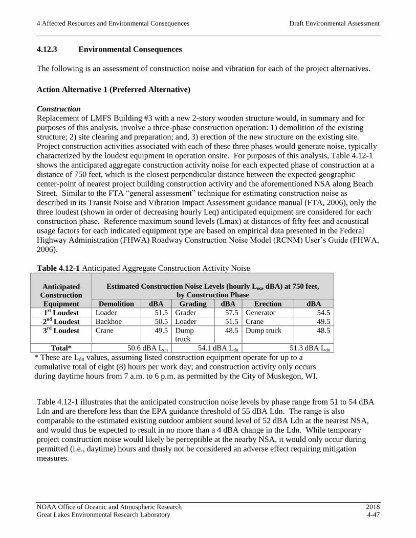
4 Affected Resources and Environmental Consequences Draft Environmental Assessment
NOAA Office of Oceanic and Atmospheric Research 2018
Great Lakes Environmental Research Laboratory 4-47
4.12.3 Environmental Consequences
The following is an assessment of construction noise and vibration for each of the project alternatives.
Action Alternative 1 (Preferred Alternative)
Construction
Replacement of LMFS Building #3 with a new 2-story wooden structure would, in summary and for
purposes of this analysis, involve a three-phase construction operation: 1) demolition of the existing
structure; 2) site clearing and preparation; and, 3) erection of the new structure on the existing site.
Project construction activities associated with each of these three phases would generate noise, typically
characterized by the loudest equipment in operation onsite. For purposes of this analysis, Table 4.12-1
shows the anticipated aggregate construction activity noise for each expected phase of construction at a
distance of 750 feet, which is the closest perpendicular distance between the expected geographic
center-point of nearest project building construction activity and the aforementioned NSA along Beach
Street. Similar to the FTA “general assessment” technique for estimating construction noise as
described in its Transit Noise and Vibration Impact Assessment guidance manual (FTA, 2006), only the
three loudest (shown in order of decreasing hourly Leq) anticipated equipment are considered for each
construction phase. Reference maximum sound levels (Lmax) at distances of fifty feet and acoustical
usage factors for each indicated equipment type are based on empirical data presented in the Federal
Highway Administration (FHWA) Roadway Construction Noise Model (RCNM) User’s Guide (FHWA,
2006).
Table 4.12-1 Anticipated Aggregate Construction Activity Noise
Anticipated
Construction
Equipment
Estimated Construction Noise Levels (hourly Leq, dBA) at 750 feet,
by Construction Phase
Demolition dBA Grading dBA Erection dBA
1st Loudest Loader 51.5 Grader 57.5 Generator 54.5
2nd
Loudest Backhoe 50.5 Loader 51.5 Crane 49.5
3rd
Loudest Crane 49.5 Dump
truck
48.5 Dump truck 48.5
Total* 50.6 dBA Ldn 54.1 dBA Ldn 51.3 dBA Ldn
* These are Ldn values, assuming listed construction equipment operate for up to a
cumulative total of eight (8) hours per work day; and construction activity only occurs
during daytime hours from 7 a.m. to 6 p.m. as permitted by the City of Muskegon, WI.
Table 4.12-1 illustrates that the anticipated construction noise levels by phase range from 51 to 54 dBA
Ldn and are therefore less than the EPA guidance threshold of 55 dBA Ldn. The range is also
comparable to the estimated existing outdoor ambient sound level of 52 dBA Ldn at the nearest NSA,
and would thus be expected to result in no more than a 4 dBA change in the Ldn. While temporary
project construction noise would likely be perceptible at the nearby NSA, it would only occur during
permitted (i.e., daytime) hours and thusly not be considered an adverse effect requiring mitigation
measures.
4 Affected Resources and Environmental Consequences Draft Environmental Assessment
NOAA Office of Oceanic and Atmospheric Research 2018
Great Lakes Environmental Research Laboratory 4-48
Although the anticipated construction activities would involve some heavy equipment that can produce
ground-borne vibration, the 750-foot distance to the closest NSA would be expected to attenuate
vibration velocity to levels that are likely to be indistinguishable from existing ambient vibration sources
(e.g., vehicles on local roadways) and far less than FTA-based guidance assessment criteria for human
annoyance and building damage risk. By way of example, a loaded truck produces 86 VdB (decibels of
root-mean-square [rms] vibration velocity, referenced to one micro-inch) at a distance of 25 feet; but at
750 feet, and under typically expected soil/strata conditions, the vibration velocity would only be 42
VdB and much less than the 80 VdB guidance threshold for FTA “Category 2” receivers where people
normally sleep.
Operation
As described by the Purpose and Need section of this EA, replacement of LMFS Building #3 with a new
2-story wooden structure would be expected to create little or no net change in building occupancy and
functions. Hence, for purposes of this analysis, the new HVAC and other noise-producing mechanical
systems replacing existing equipment would not be expected to have substantially different loads, power
consumption, or other factors that influence sound emission. On this basis, project-attributed operation
noise would be anticipated to be comparable to—or potentially less than—existing operation sound
levels experienced at the nearest NSA and therefore not result in an adverse effect requiring noise
mitigation measures.
Action Alternative 2
Replacement of LMFS Building #3 with a new 2-story metal-framed structure would, in summary and
for purposes of this analysis, involve construction activity similar to what has been described and
assessed for Alternative 1. Likewise, expected project-attributed operation noise from the metal-framed
new building and its HVAC/mechanical systems would also be comparable to noise produced from
existing conditions.
For these reasons, construction and operation noise from Alternative 2 would not be expected to create
an adverse effect at nearby NSA requiring noise mitigation measures.
Action Alternative 3
Replacement of LMFS Building #3 with a new single-story structure would, in summary and for
purposes of this analysis, involve construction activity similar to what has been described and assessed
for Alternative 1. Likewise, expected project-attributed operation noise from the new building and its
HVAC/mechanical systems would also be comparable to noise produced from existing conditions.
For these reasons, construction and operation noise from Alternative 3 would not be expected to create
an adverse effect at nearby NSA requiring noise mitigation measures.
No-Action Alternative
The No-Action alternative would not involve any construction activity, and LMFS Building #3 would
continue to operate and produce noise that already contributes to the existing outdoor ambient sound
environment at the nearby NSA.
4 Affected Resources and Environmental Consequences Draft Environmental Assessment
NOAA Office of Oceanic and Atmospheric Research 2018
Great Lakes Environmental Research Laboratory 4-49
Hence, Alternative 3 would not be expected to create an adverse effect at nearby NSA requiring noise
mitigation measures.
4.12.4 Mitigation Measures
Given the lack of expected noise and vibration adverse effects attributed to either construction or
operation for the three project Alternatives and the No Action Alternative, no mitigation measures are
anticipated. However, this analysis assumes that project construction activities would be adequately
managed and performed to reflect—to the extent practical—good construction practices with respect to
site noise control and sound abatement that could include (but not be limited to) the following:
Locate stationary, “steady-state” sources of noise (e.g., portable electrical generator or air
compressor) as far away from NSA as possible, and behind trailers or other onsite structures or
walls that can occlude direct sound paths between the noise sources and the NSA.
Reduce construction equipment and vehicle idling times.
Ensure that construction equipment and vehicles feature factory-approved engine combustion
exhaust mufflers and other noise control or sound abatement and that these features are properly
maintained or are otherwise in good working order.
Provide advanced notice to occupants of nearby NSA that construction activity is expected to
occur over some defined period of time during daytime-only hours. In particular, such prior
notice is strongly recommended if activity is anticipated outside of normally-permitted hours.

4 Affected Resources and Environmental Consequences Draft Environmental Assessment
NOAA Office of Oceanic and Atmospheric Research 2018
Great Lakes Environmental Research Laboratory 4-50
4.13 TRANSPORTATION/TRAFFIC
4.13.1 Regulatory Setting
The transportation impact analysis assesses the effects of the proposed action on the transportation
network in the community. A qualitative analysis is used to assess whether the proposed action has the
potential to result in a significant impact, and whether a quantitative analysis and prospective
improvements to transportation infrastructure may be necessary. The approach applied involves the use
of trip generation data, essentially the number of inbound and outbound vehicle trips expected to be
generated due to the proposed action during an average day or during peak hour traffic. The expected
trip generation is compared to accepted thresholds to determine whether a more comprehensive traffic
analysis is needed. The trip generation process applied provides an estimate of the number of trips that
would be generated under worst-case conditions. Trip generation rates are then compared to the latest
available traffic counts. When available, a roadway Level of Service (LOS) is identified and the
potential to change to the LOS to a more adverse condition due to the proposed action is considered.
LOS is a qualitative measurement used to describe traffic conditions of a transportation route.
The City of Muskegon Department of Public Works (DPW) is responsible for the operation and
maintenance of the City’s streets, highways, bridges and traffic control.
4.13.2 Affected Resources
The City roadways primarily used to access the project area are also used for access to portions of the
Lake Michigan shore and include adjacent beaches, parks and residential neighborhood access. There
are two main through routes from central City of Muskegon that are used to reach the project site:
Route 1: Via Lakeshore Drive westbound to Beach Street northbound into the project area
Route 2: Via Sherman Boulevard westbound to Beach Street northbound to the project area.
These are two-lane paved roads. Segments of Beach Street are one-way, including at the entry driveway
to the GLERL LMFS property. Based on 2016 data received from the West Michigan Shoreline
Regional Development Commission, the 2-way volume count for Lakeshore Drive was 8,161 and
Sherman Boulevard was 3,978 (West Michigan Shoreline Regional Development Commission, 2016).
4.13.3 Environmental Consequences
Action Alternative 1 (Preferred Alternative)
Implementation of the preferred alternative would not result in a detectable increase in traffic volume on
the roads leading to and from the project site. The proposed action would increase the number of NOAA
employees working at and commuting to and from the station by an estimated 1 employee.
Implementation of the proposed action would not result in an increase of delivery vehicles or other
vehicles coming to and from the station. During construction, equipment and worker vehicles would be
located within the LMFS property, and equipment staged at that location during demolition and
construction phases of the project.

4 Affected Resources and Environmental Consequences Draft Environmental Assessment
NOAA Office of Oceanic and Atmospheric Research 2018
Great Lakes Environmental Research Laboratory 4-51
There would be no discernable changes to existing volume count to roadways or in the estimated LOS of
affected intersections due to the proposed action. Based on the negligible number of vehicles associated
with construction and operation of the proposed replacement of Building #3, as well as the current level
of vehicles using affected roadways and the observed capacity of the roads to accommodate traffic, no
adverse effects would result.
Action Alternative 1 would have no adverse effect on transportation resources.
Action Alternative 2
The effects of Action Alternative 2 would be the same as the Preferred Alternative. No adverse
environmental effects with respect to transportation would result from the proposed Action Alternative
2.
Action Alternative 3
The effects of Action Alternative 3 would be the same as the Preferred Alternative. No adverse
environmental effects with respect to transportation would result from the proposed Action Alternative
3.
No-Action Alternative
Under No-Action Alternative, the demolition and rebuilding of Building # 3 would not occur. No
adverse effects to transportation would result.
4.13.4 Mitigation Measures
No mitigation measures are required or recommended in relation to transportation systems and
circulation.

4 Affected Resources and Environmental Consequences Draft Environmental Assessment
NOAA Office of Oceanic and Atmospheric Research 2018
Great Lakes Environmental Research Laboratory 4-52
4.14 UTILITIES AND SOLID WASTE
4.14.1 Regulatory Setting
There are no directly applicable federal regulations pertaining to effects of federal actions on local
utilities and public services (i.e., solid waste disposal). Regulatory constraints related to the existing
capacity and distribution of utility services is typically considered through local zoning or land use law.
While the federal government is not required to follow local regulations under the Public Building
Amendments of 1988 (Public Law 100-678), they strive to assess potential effects of projects and
conform to local requirements to the extent practicable. Muskegon County provides solid waste disposal
via its Solid Waste Management System. The land fill offers disposal for municipal solid waste,
demolition debris, and other materials; no hazardous waste is accepted.
This assessment considers the apparent capacity of utility services and the effects of extending those
services to the project area.
4.14.2 Affected Resources
The City of Muskegon supplies the project site with potable water and sewage disposal services.
Electrical power service is provided be Consumers Energy and natural gas service is provided by DTE
Energy. Frontier Communications serves the LMFS with telephone and internet connectivity.
The Muskegon Water Filtration Plant is a conventional water treatment plant with a treatment capacity
of 40 million gallons per day, though it typically treats about 25 million gallons. Customers include the
City of Muskegon and Norton Shores Township, among other communities. An expansion built in 2015,
expands capacity to serve new customers in Fruitport Township and Norton Shores. System wide
storage capacity is currently 19.266 million gallons of treated water storage. The system draws water
from Lake Michigan and the intake pipe extends about a mile shore at a depth of 33 feet (City of
Muskegon, 2017).
Surface features indicating utility locations at the LMFS were identified in a 2011 Prein & Newhof
Topographic Survey (see Appendix D: Reference Materials). Based on conversations with NOAA,
sewer and water utility services pass beneath the adjacent USCG station, and the sewer line from
Building #3 is connected directly to a main sewage line on the USCG facility. Water service is first fed
to Building #1, then to Building #2, and passes under Building #2 to supply water to Building #3.
4.14.3 Environmental Consequences
Action Alternative 1 (Preferred Alternative)
Existing utility services have supported Building #3, which provides space for laboratory,
administration, maintenance and storage space. The Proposed Action would double the size of Building
#3 and is expected to meet Leadership in Energy and Environmental Design (LEED) Silver certification.
Action Alternative 1 would not result in a substantive increase in staff. The potential increase in the
demand for existing public services, such as water, sewer, gas and electric, solid waste disposal and
communication infrastructure, is negligible.
4 Affected Resources and Environmental Consequences Draft Environmental Assessment
NOAA Office of Oceanic and Atmospheric Research 2018
Great Lakes Environmental Research Laboratory 4-53
No adverse environmental effects with respect to utilities and service systems would result from the
preferred alternative.
Action Alternative 2
The effects of Action Alternative 2 would be the same as the Preferred Alternative. No adverse
environmental effects with respect to utilities and service systems would result from the proposed
Action Alternative 2.
Action Alternative 3
The effects of Action Alternative 3 would be the same as the Preferred Alternative. No adverse
environmental effects with respect to utilities and service systems would result from the proposed
Action Alternative 3.
No-Action Alternative
Under No-Action Alternative, the demolition and rebuilding of Building # 3 would not occur. No
change to existing utility services or infrastructure would result.
No adverse effects to utilities and service systems would result.
4.14.4 Mitigation Measures
No mitigation measures are required for any of the three Action Alternatives, or for the No-Action
Alternative in relation to utility services and infrastructure.

4 Affected Resources and Environmental Consequences Draft Environmental Assessment
NOAA Office of Oceanic and Atmospheric Research 2018
Great Lakes Environmental Research Laboratory 4-54
4.15 VISUAL IMPACTS
4.15.1 Regulatory Setting
Federal Land Policy and Management Act of 1976
Federal Land Policy and Management Act, 43, U.S.C. Section 1701 (a)(8) states that public lands must
be managed in a manner that will protect the quality of the scenic values. Additionally, Section 1701(c)
identifies scenic values as a resource that should be managed by the public.
National Environmental Policy Act of 1969
While NEPA does not establish particular guidance for determining the significance of visual/aesthetic
resources impacts, in 43 U.S.C. Section 4331(b)(2), it requires measures be taken to assure that
esthetically pleasing surroundings are available for all Americans.
Bureau of Land Management’s Visual Resource Management System
The Bureau of Land Management (BLM) developed a system for analysis of visual effects on federal
lands. This system is called Visual Resource Management, which involves inventorying scenic values
and establishing management objectives for those values. While Visual Resource Management is
typically applied to large federal landholdings requiring an EIS, these concepts can be applied to provide
a basis for assessing effects within an EA for less expansive federal actions proposed on non-federal
land parcels.
The concepts include actions to:
Identify those views potentially affected and for which the public may express concern.
Describe the existing visual conditions and potentially affected critically sensitive views.
Estimate the intensity of possible adverse visual impacts on those views.
Evaluate the significance of the possible impacts; mitigate, as needed.
Visual/scenic resources, such as, national, state or local parks, areas adjacent to designated wild and
scenic rivers, and regionally scenic byways, routes or views from designated viewing areas have a social
setting, which includes public expectations, values, awareness, and concern regarding visual quality.
This social setting is addressed as “visual sensitivity,” and is important to assessing how important a
visual impact may be and whether or not it represents a significant impact. The visual condition and
degree of visual sensitivity is expressed as one of the following four levels:
High sensitivity: A great potential for the public to react strongly to a threat to visual quality.
Moderate sensitivity: A substantial potential for the public to express concern.
Low sensitivity: A small minority of the public may have a concern.
No sensitivity: There is no ‘sensitivity’ where the potentially affected views are not “public” (not
accessible to the general public).
Levels of visual quality consist of three components evaluated using the following general definitions:
Low quality: Landscape is common to the region and exhibits few, if any, memorable features or
patterns which provide visual diversity.

4 Affected Resources and Environmental Consequences Draft Environmental Assessment
NOAA Office of Oceanic and Atmospheric Research 2018
Great Lakes Environmental Research Laboratory 4-55
Moderate: Landscape exhibits reasonably attractive natural and human-made features.
High: Landscape exhibits distinctive and memorable visual features.
4.15.2 Affected Resources
The anticipated level of visual sensitivity at surrounding LMFS is considered to be low given the
existing and long-established facilities and other visual elements at LMFS and USCG Station
Muskegon. These consist of one- and two-story structures from different periods and a range of exteriors
(e.g., wood, metal), with chain link fencing and shoreline rip rap. Despite the low sensitivity in the
region, there is a moderate level of visual quality is estimated to be present from public vantage points.
The public access areas within the City of Muskegon Margaret Drake Elliot Park lie to the east
immediately beyond the USCG Station Muskegon facility and its structures. To the south of the LMFS
is the City of Muskegon Pere Marquette Park between Lake Michigan and Beach Street. To the west
approximately 700 feet is the Muskegon Lighthouse. To north beginning about 600 feet from Building
#3 in LMFS is Muskegon State Park. It is an area of natural landscapes situated across the navigation
channel linking Lake Michigan and Muskegon Lake, within which are trails and beaches.
Approximately 2,000 feet northeast is the state park’s Channel Campground. View from Lake Michigan
by recreational boaters, mariners and Milwaukee-Muskegon route ferry passengers is also of interest and
have direct views of structures with the LMFS.
Views of Lake Michigan, the Muskegon Lighthouse and the architecture of Building #1 at LMFS
represent an assemblage of attractive natural and man-made physical features; however, they are not
considered highly distinctive, as similar features (lighthouses or early-20th Century structures) are
represented in other locales throughout the Great Lakes region’s shorelines and harbors.
4.15.3 Environmental Effects
Action Alternative 1 (Preferred Alternative)
The level of visual sensitivity at LMFS is considered to be low. While a moderate level of visual quality
exists based on the natural and man-made features described above, the existing setting would not be
substantially changed due to implementation of Action Alternative 1. The project would replace an
existing single-story metal frame laboratory building with a two-story wood replacement structure. The
exterior design would be guided by measures described in Section 4.7 Cultural Resources, and therefore,
consistent with the Secretary of the Interior’s Standards for Rehabilitation and Guidelines for
Rehabilitating Historic Buildings, specifically Standards 3, 9, and 10. However, the footprint
(horizontal extent) of the structure would be unchanged, and a second story would change the height of
the existing roof top from approximately 16 feet to 26 feet above ground level. This would result in a
minor degree of change when viewed from adjacent public areas, including state and city parks, beaches
and from Lake Michigan.
The impact to visual resources would be minor due to implementation of Action Alternative 1.

4 Affected Resources and Environmental Consequences Draft Environmental Assessment
NOAA Office of Oceanic and Atmospheric Research 2018
Great Lakes Environmental Research Laboratory 4-56
Action Alternative 2
The effects of Alternative 2 would be the same as Action Alternative 1, the Preferred Alternative. The
impact to visual resources would be minor due to implementation of Action Alternative 2.
Action Alternative 3
The level of visual sensitivity at LMFS is considered to be low. While a moderate level of visual quality
exists based on the natural and man-made features described above, the existing setting would not be
substantially changed due to implementation of Action Alternative 3. The project would replace an
existing single-story metal frame laboratory building with another single-story replacement structure on
the same foundational area would be built with articulated horizontal elements to add to the gross square
footage. The design would be guided by measures described in Section 4.7: Cultural Resources and,
therefore, consistent with the Secretary of the Interior’s Standards for Rehabilitation and Guidelines for
Rehabilitating Historic Buildings, specifically Standards 3, 9, and 10. However, the footprint
(horizontal extent) of the structure would be expanded by 50%, and little to no change the height of the
existing roof top of approximately 16 feet above ground level would occur. This would result in a minor
degree of change when viewed from adjacent public areas, including state and city parks, beaches and
from Lake Michigan.
The impact to visual resources would be minor due to implementation of Action Alternative 3.
No-Action Alternative
Under the No-Action Alternative, NOAA would retain its existing Building #3. No visual impacts would
result.
4.15.4 Mitigation Measures
No mitigation measures are required for either of the Action Alternatives, or for the No-Action
Alternative, relative to aesthetics and visual resources.

4 Affected Resources and Environmental Consequences Draft Environmental Assessment
NOAA Office of Oceanic and Atmospheric Research 2018
Great Lakes Environmental Research Laboratory 4-57
4.16 HAZARDOUS MATERIALS
4.16.1 Regulatory Setting
In an effort to promote safe handling, storage, and disposal of hazardous materials, hazardous materials
and waste management in the State of Michigan are subject, but not limited, to Federal regulatory
requirements contained in 40 CFR of the Resource Conservation and Recovery Act (RCRA) as well as
State regulatory requirements contained in the NREPA 451 of 1994 and the Michigan Department of
Licensing and Regulatory Affairs (DLARA). These laws and regulations seek to promote the safe
handling, storage, and disposal of hazardous materials to prevent unnecessary harm to human and
environmental health.
At the Federal level, the USEPA, U.S. Department of Transportation (USDOT), U.S. Nuclear
Regulatory Commission (USNRC), and the U.S. Drug Enforcement Administration (USDEA) provide
oversight of proper waste management practices. Many of the State rules have adopted federal
requirements set forth by the USEPA under RCRA. In Michigan, oversight of proper waste management
at the local level is conducted by the MDEQ, DLARA, the Michigan Department of Agricultural and
Rural Development (DARD) and the Michigan State Police (MSP). Local jurisdiction regarding proper
waste management may also be conducted by solid waste management authorities, wastewater treatment
plant authorities, fire department, and county health departments.
The following hazardous waste regulations (as overseen by the MDEQ) potentially to pertain to the
proposed action at the GLERL LMFS for the replacement of Building #3:
Solid waste regulations under Part 115 of NREPA Public Act 451 of 1994, as amended;
Liquid industrial by-product regulations under Part 121 of NREPA Public Act 451 of
1994;
Transportation of hazardous materials (DEQ requirements) under the Hazardous
Materials Transportation Act (Public Act 138 of 1998);
Wastewater regulations under Part 2(Water Resource Protection) of NREPA Act 451;
and
Air pollution regulations under Part 55 (Air Pollution Control) of NREPA Act 451.
Other Federal regulations include:
RCRA Title 40 CFR Parts 260-279;
Federal wastewater regulations under the CWA; and
Federal air pollution regulations under the CAA.
Safety during construction and workplace activities are also subject to the MIOSHA requirements. This
includes training for persons working with asbestos and asbestos-containing materials (ACM) under Part
602 “Asbestos Standards for Construction” as amended.

4 Affected Resources and Environmental Consequences Draft Environmental Assessment
NOAA Office of Oceanic and Atmospheric Research 2018
Great Lakes Environmental Research Laboratory 4-58
4.16.2 Affected Resources
Building #3 at the GLERL LMFS in Muskegon, Michigan, is an approximately 2,600 gross square feet
(GSF) marine laboratory building predominantly used for preparing and working with small preserved
samples and for sample storage. Subsidence of the sub-slab has created hazardous walking conditions
within the building and at exterior doors. The cause of subsidence was determined to be improperly
prepared soils below the construction of the building in the mid-1960s.
Building #3 contains a small staging area used to prepare equipment and materials for sample collection,
refrigerators for sample storage, and several overhead lofts utilized for preserved sample storage. Also
housed in Building #3 is a filtration desktop (water filtration, bottle preparation, short-term sample
storage in incubators), dark room, and office space. Several hazardous chemicals, including formalin
(Formaldehyde) and ethanol are stored in Building #3 within corrosive materials and flammable
materials cabinets and are mostly used for preserving chlorophyll samples.
The GLERL LMFS is situated atop of a near-shore dune environment on Lake Michigan coast. The
Point Betsie Lighthouse and marine ship channel leading into Muskegon Lake border the site to the
north, while the USCG Station Muskegon, Pere Marquette City Park, and Lake Michigan bound the site
to the east, south, and west, respectively. A geotechnical report prepared in 2011 for construction
activities immediately north of the project area at Building #2 indicates groundwater depth to be
approximately 6 to 7 feet bgs.
Environmental databases and governmental records, provided by Environmental Data Resources Inc.
on December 3, 2017, were utilized and reviewed (“environmental records review”) to characterize the
obvious and apparent uses of the site and surrounding properties, and identify potential recognized
environmental conditions that might affect the project site. The GLERL LMFS is listed under the
RCRA database as a Conditionally Exempt Small Quantity Generator (CESQG). CESQG’s produce less
than 220 pounds (100 kilograms) of non-acute hazardous waste per month and never accumulate 2,200
pounds (1,000 kilograms) or more at a time. Regulatory requirements for CESQG’s do not limit how
long waste can be accumulated, provided the following conditions are not exceeded. Database search
results also indicate that a gasoline service station was operated approximately 600 feet from the
GLERL LMFS from 1998 to 2014 and may correspond to the historical underground storage tank
(UST) installed at the Point Betsie Lighthouse located roughly 600 feet from the site. A small hydraulic
fluid spill (250 milliliters) was reported during maintenance activities on the research vessel (R/V)
Shenohan in 1997; however, no other spills or violations associated at or near the GLERL LMFS were
obtained.
The USCG facility adjacent to the eastern property border of the LMFS property is also listed in the
RCRA database as a CESQG. The USCG Station Muskegon also houses an active 2,000 gallon above
ground diesel storage tank. No reports of leaks or spills associated with the USCG facility were
obtained.
4 Affected Resources and Environmental Consequences Draft Environmental Assessment
NOAA Office of Oceanic and Atmospheric Research 2018
Great Lakes Environmental Research Laboratory 4-59
4.16.3 Environmental Consequences
Action Alternative 1 (Preferred Alternative)
It is assumed that prior to demolition of the existing Building #3, all samples, preservatives, and
hazardous waste would be removed from the construction site. Hazardous waste should be removed
from the site prior to construction activities as outlined in Michigan’s Part 121 Liquid Industrial By-
Products of NREPA Act 451 of 1994, as amended. Archived samples no longer needed should also be
discarded appropriately to minimize, if not eliminate, the amount of hazardous materials encountered
and handled during construction activities. A hazardous materials management plan should be prepared
in advance of construction activities detailing how to properly handle, transport, and store materials, if
encountered, during construction activities.
The proximity of the project area to Lake Michigan would require adherence to Michigan’s Part 91 (Soil
Erosion and Sediment Control) Rules which typically require a permit when a construction project is
within 500 feet from a lake or stream regardless of size. Additionally, observed depth to groundwater,
reported to be between 6 and 7 feet bgs, would require dewatering of the construction site. Wastewater
from discharging groundwater is subject to permit requirements under Act 451.
Construction equipment utilizing diesel fuel, hydraulic oil, and other fuel/oils may also cause adverse
environmental impacts in the event of a spill. Loose to very loose sands at the site and the proximity to
surface water increase the potential for adversely impacting the environment during the event of a spill
and as such, spill prevention procedures should be considered. Catch basins and storm water runoff
must be considered by NOAA and its construction contractor when devising erosion control measures
and in the preparation and execution of a stormwater pollution prevention plan (SWPPP).
Building #3 was constructed in approximately circa1970, prior to the majority of EPA bans regarding
ACM and lead-based paint. Therefore, the demolition of Building #3, including ceiling and floor tiles,
may expose workers to ACM and/or lead-based based. If an ACM or lead-based paint survey has not
already been completed prior to demolition within Building #3, an ACM survey shall be conducted by
an approved contractor in compliance with State and Federal requirements.
Action Alternative 1 would have no adverse effects associated with interactions with known hazardous
materials provided standard mitigation measures are implemented and associated permits are acquired.
Action Alternative 2
The effects of implementing Action Alternative 2 would be the same as the Preferred Alternative.
Action Alternative 2 would have no adverse effects associated with known hazardous materials provided
standard mitigation measures are implemented and associated permits are acquired.
Action Alternative 3
The effects of implementing Action Alternative 3 would be the same as the Preferred Alternative.
Action Alternative 3 would have no adverse effects associated with hazardous materials provided
standard mitigation measures are implemented and associated permits are acquired.
4 Affected Resources and Environmental Consequences Draft Environmental Assessment
NOAA Office of Oceanic and Atmospheric Research 2018
Great Lakes Environmental Research Laboratory 4-60
No-Action Alternative
The No-Action Alternative would have no adverse effects associated with known hazardous materials.
4.16.4 Mitigation Measures
Given the proximity of the proposed construction site to Lake Michigan, appropriate erosional control
measures would be necessary.
Given the likely need for dewatering of the construction site, conditions of approval within required
state permits would be followed prior to implementing construction/demolition activities.

4 Affected Resources and Environmental Consequences Draft Environmental Assessment
NOAA Office of Oceanic and Atmospheric Research 2018
Great Lakes Environmental Research Laboratory 4-61
4.17 ENVIRONMENTAL JUSTICE
4.17.1 Regulatory Setting
EO 12898, known as the Federal Environmental Justice Policy, requires all federal agencies to identify
and develop strategies to address disproportionately high and adverse human health and environmental
impacts of its programs, policies and activities on minority and low-income populations in the United
States and its territories to the greatest extent practicable and permitted by law (Federal Register, 1994).
Federal agencies are required to make all documents, notices and hearings related to human health and
the environment accessible to the public. The EO is intended to promote nondiscrimination in federal
programs, as well as provide minorities and low income populations with access to information and
public participation.
Impact assessment criteria associated with environmental justice require that a significant adverse
impact will not be predominately borne by a minority population and/or a low-income population, and
that the impact not be appreciably more severe or greater in magnitude than would be suffered by the
non-minority population and/or non-low-income population. This section evaluates regional and census
tract population and economic data from the U.S. Census Bureau to assess affected populations and the
potential for disproportionately high adverse effects to occur.
4.17.2 Affected Resources
The proposed action would be implemented in the City of Muskegon, County of Muskegon, Michigan.
Muskegon is located in western Michigan, adjacent to Muskegon Lake to the north and the eastern
shores of Lake Michigan to the west. The City of Muskegon population in 2015 was estimated at
37,861, the County of Muskegon was estimated at 171,483 and Census Tract 10 was 1,181. The City
and Census Tract 10 experienced a population decline, while the County experienced a slight population
increase between the years 2000 to 2015. Table 4.17-1 summarizes the change in the population for the
City, County and U.S. Census Tract 10 between the years 2000, 2010 and 2015.
Table 4.17-1 Population Change by Geographic Area
Geographic Area 2000 2010
(% Change ) 2015 (% Change 2000-
2015)
US Census Tract 10 1,301 1,339 1,181 -9.2%
City of Muskegon 40,105 38,401 37,861 -5.6%
County Muskegon 170,200 172,188 171,483 0.75%
Sources: U.S. Census Bureau, 2000, 2010, 2015
Individuals identified as White made up over half of the population in the City and were the
predominate race identified in the County and Census Tract 10 during 2015 (US Census Bureau, 2015).
Between the years 2000 to 2015, minorities represented in the City, County and Census Tract 141.05
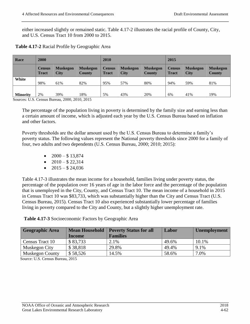
4 Affected Resources and Environmental Consequences Draft Environmental Assessment
NOAA Office of Oceanic and Atmospheric Research 2018
Great Lakes Environmental Research Laboratory 4-62
either increased slightly or remained static. Table 4.17-2 illustrates the racial profile of County, City,
and U.S. Census Tract 10 from 2000 to 2015.
Table 4.17-2 Racial Profile by Geographic Area
Race 2000 2010 2015
Census
Tract
Muskegon
City
Muskegon
County
Census
Tract
Muskegon
City
Muskegon
County
Census
Tract
Muskegon
City
Muskegon
County
White
98% 61% 82% 95% 57% 80% 94% 59% 81%
Minority 2% 39% 18% 5% 43% 20% 6% 41% 19%
Sources: U.S. Census Bureau, 2000, 2010, 2015
The percentage of the population living in poverty is determined by the family size and earning less than
a certain amount of income, which is adjusted each year by the U.S. Census Bureau based on inflation
and other factors.
Poverty thresholds are the dollar amount used by the U.S. Census Bureau to determine a family’s
poverty status. The following values represent the National poverty thresholds since 2000 for a family of
four, two adults and two dependents (U.S. Census Bureau, 2000; 2010; 2015):
2000 – $ 13,874
2010 – $ 22,314
2015 – $ 24,036
Table 4.17-3 illustrates the mean income for a household, families living under poverty status, the
percentage of the population over 16 years of age in the labor force and the percentage of the population
that is unemployed in the City, County, and Census Tract 10. The mean income of a household in 2015
in Census Tract 10 was $83,733, which was substantially higher than the City and Census Tract (U.S.
Census Bureau, 2015). Census Tract 10 also experienced substantially lower percentage of families
living in poverty compared to the City and County, but a slightly higher unemployment rate.
Table 4.17-3 Socioeconomic Factors by Geographic Area
Geographic Area Mean Household
Income
Poverty Status for all
Families
Labor Unemployment
Census Tract 10 $ 83,733 2.1% 49.6% 10.1%
Muskegon City $ 38,818 29.8% 49.4% 9.1%
Muskegon County $ 58,526 14.5% 58.6% 7.0% Source: U.S. Census Bureau, 2015

4 Affected Resources and Environmental Consequences Draft Environmental Assessment
NOAA Office of Oceanic and Atmospheric Research 2018
Great Lakes Environmental Research Laboratory 4-63
4.17.3 Environmental Consequences
Action Alternative 1 (Preferred Alternative)
The Preferred Alternative would have negligible socioeconomic effects. Existing conditions in housing,
incomes and poverty rates are expected to remain unchanged due to the proposed actions. Some short-
term economic benefits to the communities in or near Muskegon may be experienced, as Building #3
demolition and replacement would require a small number of workers related to construction and
evaluation activities. Imperceptible increases in noise and air emissions may occur during the project
construction period. However, these effects are temporary and not expected to be substantial based on
the analysis of these topics in other sections of this EA.
Therefore, no minority or low-income populations are present that would be adversely affected. There
would be no adverse effects from the Preferred Alternative with respect to environmental justice.
Action Alternative 2
The effects of Action Alternative 2 would be the same as the Preferred Alternative. Therefore, no
minority or low-income populations are present that would be adversely affected.
There would be no adverse effects from Action Alternative 2 with respect to environmental justice.
Action Alternative 3
The effects of Action Alternative 3 would be the same as the Preferred Alternative. Therefore, no
minority or low-income populations are present that would be adversely affected.
There would be no adverse effects from Action Alternative 3 with respect to environmental justice.
No-Action Alternative
Under No-Action Alternative, the demolition and rebuilding of Building # 3 would not occur. No
adverse effects to environmental justice or socioeconomic resources would result.
4.17.4 Mitigation Measures
No mitigation measures are required for any of the three Action Alternatives, or for the No-Action
Alternative in relation to environmental justice and socioeconomics.

4 Affected Resources and Environmental Consequences Draft Environmental Assessment
NOAA Office of Oceanic and Atmospheric Research 2018
Great Lakes Environmental Research Laboratory 4-64
4.18 CUMULATIVE EFFECTS
4.18.1 Regulatory Setting
A cumulative impact must be evaluated under the NEPA and is defined as “the impact on the
environment which results from the incremental impact of the action when added to other past, present,
and reasonably foreseeable future actions regardless of what agency (federal or non-federal) or person
undertakes such other actions.” Cumulative impacts can result from individually minor but collectively
significant actions taking place over a period of time (40 CFR, Part 1508.7).
Cumulative impacts result when the effects of an action are added to or interact with other effects in a
particular place and within a particular time. It is the combination of these effects, and any resulting
environmental degradation, that is the focus of this cumulative impact analysis. While impacts can be
differentiated by direct, indirect, and cumulative, the concept of cumulative impacts takes into account
all foreseeable disturbances, since cumulative impacts result in the compounding of the effects of all
actions over time. Thus, the cumulative impacts of an action can be viewed as the total effects on a
resource, ecosystem, or human community no matter what entity (federal, non-federal, or private) is
taking the action.
This analysis of cumulative effects summarizes the evaluation of resources, ecosystems, and human
communities identified and discussed in this EA relative to other foreseeable future actions. It considers
the proximity and timing of other concurrent or future foreseeable actions and the potential for
exacerbated effects or conflicts that would result in a potentially significant impact. The evaluation
considers resources subject to potential cumulative effects and refers back, if necessary, to information
presented in the earlier discussion of project-only effects.
In general, the proposed action is not reliant upon or connected to other actions, nor is it relied upon for
the occurrence of other actions. For each of the subject areas analyzed, the contribution of the proposed
action is not expected to be considerable provided that appropriate mitigation measures are
implemented.
4.18.2 Affected Resources
Recent, on-going and foreseeable future projects were considered that may occur at and near LMFS.
This information is based on readily available publications and websites. No foreseeable and
substantive actions were identified.
The focus of the City of Muskegon regarding its adjacent parklands is to concentrate its resources on
maintaining and upgrading existing facilities, rather that expansion. Given the lack of available funding,
not substantial projects within adjacent parklands and open space were identified. One exception may be
the purchase of land for the Lakeshore Trail bike path following the sale and conversion of the Chase
Hammond Golf Course. Additional property may be needed as sections of the trail are linked
throughout the city to the State of Michigan Trail System and additional linkages to the lakeshore are
desired.
No specific, local projects were identified for the residential, recreational, and commercial land use
areas existing along the banks of Muskegon Lake. A 2015 evaluation of benefits for development in this
4 Affected Resources and Environmental Consequences Draft Environmental Assessment
NOAA Office of Oceanic and Atmospheric Research 2018
Great Lakes Environmental Research Laboratory 4-65
lakeshore region was conducted (Development Research Partners, 2015). The study generally examined
the potential temporary and on-going economic and fiscal benefits of expanded commercial activities
and port revitalization to Muskegon County. While clear benefits were identified, specific and
foreseeable programs or projects were not introduced.
4.18.3 Environmental Consequences
Action Alternative 1 (Preferred Alternative)
No readily available or foreseeable development actions were identified that would be considered as a
cumulative impact, in addition to project-specific impacts. No adverse cumulative effects with respect
to Cumulative Impacts upon each of the resources analyzed are anticipated to occur under Action
Alternative 1.
Action Alternative 2
The effects of Alternative 2 would be the same as the Preferred Alternative. No adverse environmental
effects with respect to Cumulative Impacts upon each of the resources analyzed would result from the
proposed Action Alternative 2.
Action Alternative 3
The effects of Alternative 3 would be the same as the Preferred Alternative. No adverse environmental
effects with respect to Cumulative Impacts upon each of the resources analyzed would result from the
proposed Action Alternative 3.
No-Action Alternative
Under the No-Action Alternative, no contribution to regional development would occur at or near the
project area. No adverse effects would result.
4.18.4 Mitigation Measures
No mitigation measures are recommended or required relative to Cumulative Impacts.

4 Affected Resources and Environmental Consequences Draft Environmental Assessment
NOAA Office of Oceanic and Atmospheric Research 2018
Great Lakes Environmental Research Laboratory 4-66
[Page intentionally blank to facilitate double-sided printing]

5 Community Involvement Draft Environmental Assessment
NOAA Office of Oceanic and Atmospheric Research 2018
Great Lakes Environmental Research Laboratory 5-1
5.0 COMMUNITY INVOLVEMENT
This Draft EA will be made available for public comment over a 30-day period, Wednesday, February 28 through Friday, March 30, 2018. An announcement in the Public Notices section of the Muskegon
Chronicle will be issued in printed and e-editions for seven days notifying the public of the availability
of the Draft EA on a NOAA website, and instructions provided for receiving a printed copy, for
review and comment prior to the end of the comment period.
Comments received prior to the end of the 30-day comment period will be reviewed and considered by
NOAA. Where appropriate, these comments will be further addressed in a Final EA and considered in
advance of any determination by NOAA to issue a FONSI or prepare an EIS.
5 Community Involvement Draft Environmental Assessment
NOAA Office of Oceanic and Atmospheric Research 2018
Great Lakes Environmental Research Laboratory 5-2
[Page intentionally blank to facilitate double-sided printing]
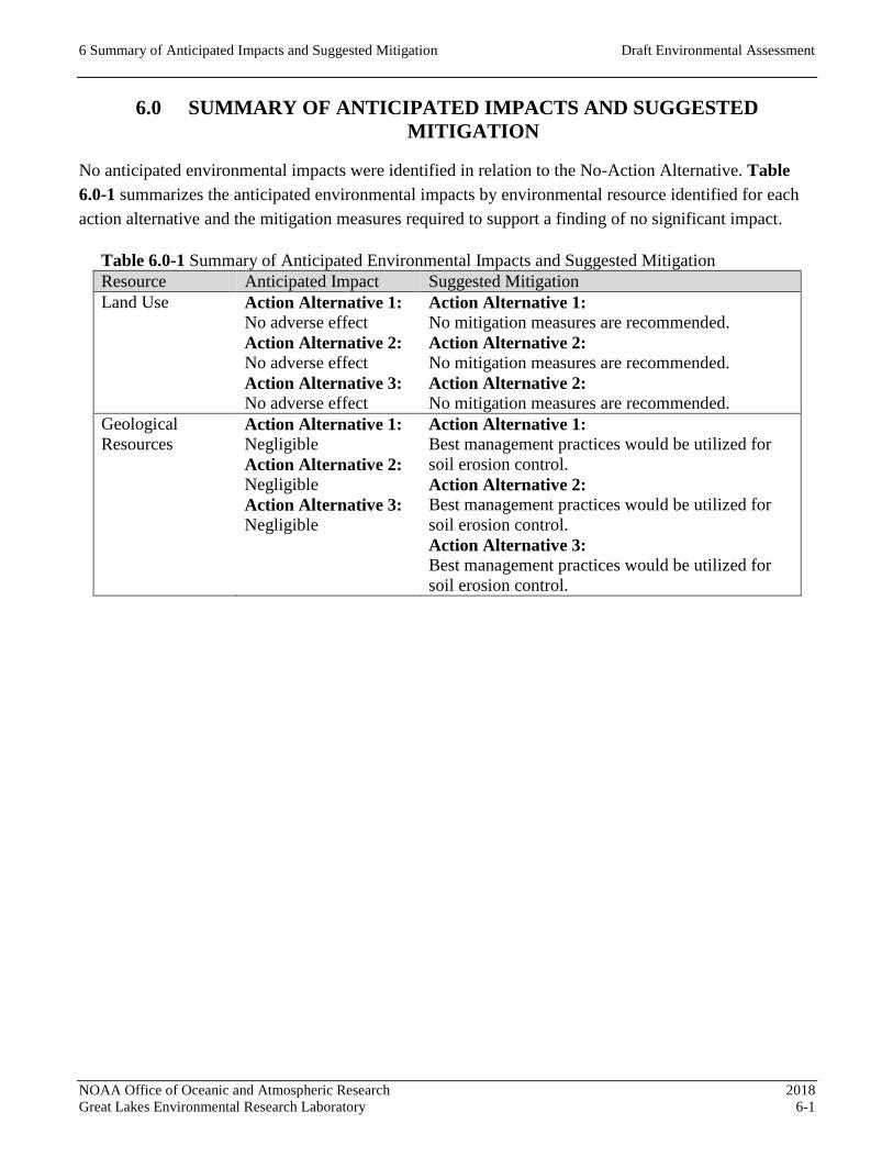
6 Summary of Anticipated Impacts and Suggested Mitigation Draft Environmental Assessment
NOAA Office of Oceanic and Atmospheric Research 2018
Great Lakes Environmental Research Laboratory 6-1
6.0 SUMMARY OF ANTICIPATED IMPACTS AND SUGGESTED
MITIGATION
No anticipated environmental impacts were identified in relation to the No-Action Alternative. Table
6.0-1 summarizes the anticipated environmental impacts by environmental resource identified for each
action alternative and the mitigation measures required to support a finding of no significant impact.
Table 6.0-1 Summary of Anticipated Environmental Impacts and Suggested Mitigation
Resource Anticipated Impact Suggested Mitigation
Land Use Action Alternative 1:
No adverse effect
Action Alternative 2:
No adverse effect
Action Alternative 3:
No adverse effect
Action Alternative 1:
No mitigation measures are recommended.
Action Alternative 2:
No mitigation measures are recommended.
Action Alternative 2:
No mitigation measures are recommended.
Geological
Resources
Action Alternative 1:
Negligible
Action Alternative 2:
Negligible
Action Alternative 3:
Negligible
Action Alternative 1:
Best management practices would be utilized for
soil erosion control.
Action Alternative 2:
Best management practices would be utilized for
soil erosion control.
Action Alternative 3:
Best management practices would be utilized for
soil erosion control.

6 Summary of Anticipated Impacts and Suggested Mitigation Draft Environmental Assessment
NOAA Office of Oceanic and Atmospheric Research 2018
Great Lakes Environmental Research Laboratory 6-2
Table 6.0-1 Summary of Anticipated Environmental Impacts and Suggested Mitigation
Resource Anticipated Impact Suggested Mitigation
Air Quality Action Alternative 1:
No adverse effect
Action Alternative 2:
No adverse effect
Action Alternative 3:
No adverse effect
Action Alternative 1:
Standard and customary BMPs during construction
should be applied to minimize construction-related
emissions, including (but not limited to) dust
suppression on unpaved areas, minimization of
vehicle and equipment idling, covering of materials
stockpiles, and recycling construction and
demolition materials where possible.
Action Alternative 2:
Standard and customary BMPs during construction
should be applied to minimize construction-related
emissions, including (but not limited to) dust
suppression on unpaved areas, minimization of
vehicle and equipment idling, covering of materials
stockpiles, and recycling construction and
demolition materials where possible.
Action Alternative 3:
Standard and customary BMPs during construction
should be applied to minimize construction-related
emissions, including (but not limited to) dust
suppression on unpaved areas, minimization of
vehicle and equipment idling, covering of materials
stockpiles, and recycling construction and
demolition materials where possible.
Water Resources Action Alternative 1:
No adverse effect
Action Alternative 2:
No adverse effect
Action Alternative 3:
No adverse effect
Action Alternative 1:
No mitigation measures are recommended.
Action Alternative 2:
No mitigation measures are recommended.
Action Alternative 3:
No mitigation measures are recommended.
Recreational
Resources
Action Alternative 1:
No adverse effect
Action Alternative 2:
No adverse effect
Action Alternative 3:
No adverse effect
Action Alternative 1:
No mitigation measures are recommended.
Action Alternative 2:
No mitigation measures are recommended.
Action Alternative 3:
No mitigation measures are recommended.
Cultural
Resources
Action Alternative 1:
Less than significant
Action Alternative 2:
Less than significant
Action Alternative 3:
Less than significant
Action Alternative 1:
No mitigation measures are recommended.
Action Alternative 2:
No mitigation measures are recommended.
Action Alternative 3:
No mitigation measures are recommended.
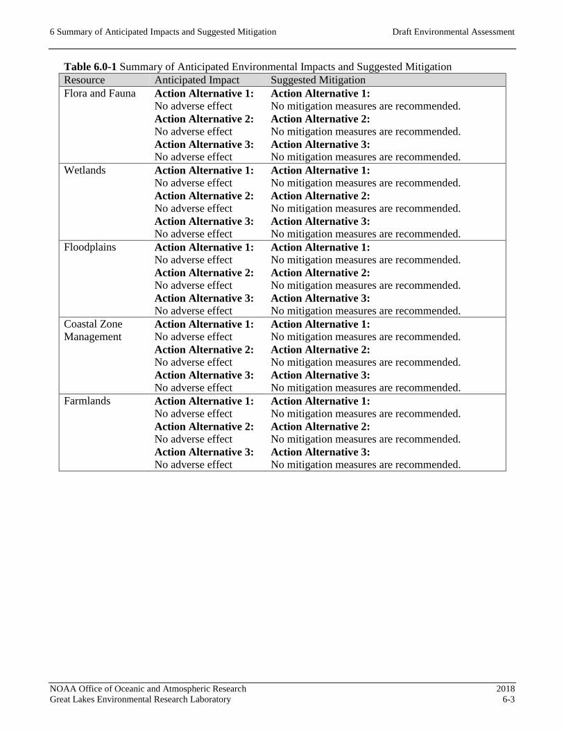
6 Summary of Anticipated Impacts and Suggested Mitigation Draft Environmental Assessment
NOAA Office of Oceanic and Atmospheric Research 2018
Great Lakes Environmental Research Laboratory 6-3
Table 6.0-1 Summary of Anticipated Environmental Impacts and Suggested Mitigation
Resource Anticipated Impact Suggested Mitigation
Flora and Fauna Action Alternative 1:
No adverse effect
Action Alternative 2:
No adverse effect
Action Alternative 3:
No adverse effect
Action Alternative 1:
No mitigation measures are recommended.
Action Alternative 2:
No mitigation measures are recommended.
Action Alternative 3:
No mitigation measures are recommended.
Wetlands Action Alternative 1:
No adverse effect
Action Alternative 2:
No adverse effect
Action Alternative 3:
No adverse effect
Action Alternative 1:
No mitigation measures are recommended.
Action Alternative 2:
No mitigation measures are recommended.
Action Alternative 3:
No mitigation measures are recommended.
Floodplains Action Alternative 1:
No adverse effect
Action Alternative 2:
No adverse effect
Action Alternative 3:
No adverse effect
Action Alternative 1:
No mitigation measures are recommended.
Action Alternative 2:
No mitigation measures are recommended.
Action Alternative 3:
No mitigation measures are recommended.
Coastal Zone
Management Action Alternative 1:
No adverse effect
Action Alternative 2:
No adverse effect
Action Alternative 3:
No adverse effect
Action Alternative 1:
No mitigation measures are recommended.
Action Alternative 2:
No mitigation measures are recommended.
Action Alternative 3:
No mitigation measures are recommended.
Farmlands Action Alternative 1:
No adverse effect
Action Alternative 2:
No adverse effect
Action Alternative 3:
No adverse effect
Action Alternative 1:
No mitigation measures are recommended.
Action Alternative 2:
No mitigation measures are recommended.
Action Alternative 3:
No mitigation measures are recommended.

6 Summary of Anticipated Impacts and Suggested Mitigation Draft Environmental Assessment
NOAA Office of Oceanic and Atmospheric Research 2018
Great Lakes Environmental Research Laboratory 6-4
Table 6.0-1 Summary of Anticipated Environmental Impacts and Suggested Mitigation
Resource Anticipated Impact Suggested Mitigation
Noise Action Alternative 1:
No adverse effect
Action Alternative 2:
No adverse effect
Action Alternative 3:
No adverse effect
Action Alternative 1:
Reduce construction equipment and vehicle idling
times. Provide advanced notice to occupants of
nearby NSA that construction activity is expected
to occur. Ensure that construction equipment and
vehicles feature factory-approved engine
combustion exhaust mufflers and other noise
control or sound abatement, and that these features
are properly maintained or are otherwise in good
working order.
Action Alternative 2:
Reduce construction equipment and vehicle idling
times. Provide advanced notice to occupants of
nearby NSA that construction activity is expected
to occur. Ensure that construction equipment and
vehicles feature factory-approved engine
combustion exhaust mufflers and other noise
control or sound abatement, and that these features
are properly maintained or are otherwise in good
working order.
Action Alternative 3:
Reduce construction equipment and vehicle idling
times. Provide advanced notice to occupants of
nearby NSA that construction activity is expected
to occur. Ensure that construction equipment and
vehicles feature factory-approved engine
combustion exhaust mufflers and other noise
control or sound abatement, and that these features
are properly maintained or are otherwise in good
working order.
Transportation Action Alternative 1:
No adverse effect
Action Alternative 2:
No adverse effect
Action Alternative 3:
No adverse effect
Action Alternative 1:
No mitigation measures are recommended.
Action Alternative 2:
No mitigation measures are recommended.
Action Alternative 3:
No mitigation measures are recommended.
Utilities and
Solid Waste
Action Alternative 1:
No adverse effect
Action Alternative 2:
No adverse effect
Action Alternative 3:
No adverse effect
Action Alternative 1:
No mitigation measures are recommended.
Action Alternative 2:
No mitigation measures are recommended.
Action Alternative 3:
No mitigation measures are recommended.
Visual Impacts Action Alternative 1:
Minor effect Action Alternative 1:
No mitigation measures are recommended.

6 Summary of Anticipated Impacts and Suggested Mitigation Draft Environmental Assessment
NOAA Office of Oceanic and Atmospheric Research 2018
Great Lakes Environmental Research Laboratory 6-5
Table 6.0-1 Summary of Anticipated Environmental Impacts and Suggested Mitigation
Resource Anticipated Impact Suggested Mitigation
Action Alternative 2:
Minor effect
Action Alternative 3:
Minor effect
Action Alternative 2:
No mitigation measures are recommended.
Action Alternative 3:
No mitigation measures are recommended.
Hazardous
Materials Action Alternative 1:
No adverse effect
Action Alternative 2:
No adverse effect
Action Alternative 3:
No adverse effect
Action Alternative 1:
Apply appropriate erosional control measures and
dewatering of the construction site.
Action Alternative 2:
Apply appropriate erosional control measures and
dewatering of the construction site.
Action Alternative 3:
Apply appropriate erosional control measures and
dewatering of the construction site.
Environmental
Justice Action Alternative 1:
No adverse effect
Action Alternative 2:
No adverse effect
Action Alternative 3:
No adverse effect
Action Alternative 1:
No mitigation measures are recommended.
Action Alternative 2:
No mitigation measures are recommended.
Action Alternative 3:
No mitigation measures are recommended.
Cumulative Action Alternative 1:
No adverse effect
Action Alternative 2:
No adverse effect
Action Alternative 3:
No adverse effect
Action Alternative 1:
No mitigation measures are recommended.
Action Alternative 2:
No mitigation measures are recommended.
Action Alternative 3:
No mitigation measures are recommended.
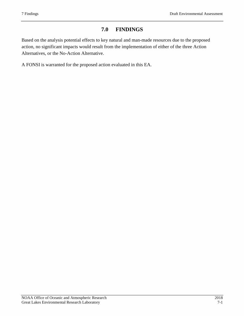
7 Findings Draft Environmental Assessment
NOAA Office of Oceanic and Atmospheric Research 2018
Great Lakes Environmental Research Laboratory 7-1
7.0 FINDINGS
Based on the analysis potential effects to key natural and man-made resources due to the proposed
action, no significant impacts would result from the implementation of either of the three Action
Alternatives, or the No-Action Alternative.
A FONSI is warranted for the proposed action evaluated in this EA.

7 Findings Draft Environmental Assessment
NOAA Office of Oceanic and Atmospheric Research 2018
Great Lakes Environmental Research Laboratory 7-2
[Page intentionally blank to facilitate double-sided printing]
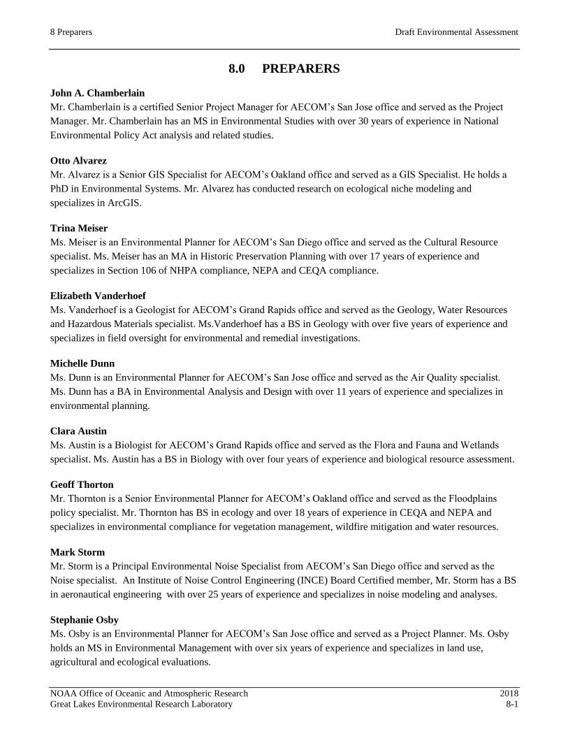
8 Preparers Draft Environmental Assessment
NOAA Office of Oceanic and Atmospheric Research 2018
Great Lakes Environmental Research Laboratory 8-1
8.0 PREPARERS
John A. Chamberlain
Mr. Chamberlain is a certified Senior Project Manager for AECOM’s San Jose office and served as the Project
Manager. Mr. Chamberlain has an MS in Environmental Studies with over 30 years of experience in National
Environmental Policy Act analysis and related studies.
Otto Alvarez
Mr. Alvarez is a Senior GIS Specialist for AECOM’s Oakland office and served as a GIS Specialist. He holds a
PhD in Environmental Systems. Mr. Alvarez has conducted research on ecological niche modeling and
specializes in ArcGIS.
Trina Meiser
Ms. Meiser is an Environmental Planner for AECOM’s San Diego office and served as the Cultural Resource
specialist. Ms. Meiser has an MA in Historic Preservation Planning with over 17 years of experience and
specializes in Section 106 of NHPA compliance, NEPA and CEQA compliance.
Elizabeth Vanderhoef
Ms. Vanderhoef is a Geologist for AECOM’s Grand Rapids office and served as the Geology, Water Resources
and Hazardous Materials specialist. Ms.Vanderhoef has a BS in Geology with over five years of experience and
specializes in field oversight for environmental and remedial investigations.
Michelle Dunn
Ms. Dunn is an Environmental Planner for AECOM’s San Jose office and served as the Air Quality specialist.
Ms. Dunn has a BA in Environmental Analysis and Design with over 11 years of experience and specializes in
environmental planning.
Clara Austin
Ms. Austin is a Biologist for AECOM’s Grand Rapids office and served as the Flora and Fauna and Wetlands
specialist. Ms. Austin has a BS in Biology with over four years of experience and biological resource assessment.
Geoff Thorton
Mr. Thornton is a Senior Environmental Planner for AECOM’s Oakland office and served as the Floodplains
policy specialist. Mr. Thornton has BS in ecology and over 18 years of experience in CEQA and NEPA and
specializes in environmental compliance for vegetation management, wildfire mitigation and water resources.
Mark Storm
Mr. Storm is a Principal Environmental Noise Specialist from AECOM’s San Diego office and served as the
Noise specialist. An Institute of Noise Control Engineering (INCE) Board Certified member, Mr. Storm has a BS
in aeronautical engineering with over 25 years of experience and specializes in noise modeling and analyses.
Stephanie Osby
Ms. Osby is an Environmental Planner for AECOM’s San Jose office and served as a Project Planner. Ms. Osby
holds an MS in Environmental Management with over six years of experience and specializes in land use,
agricultural and ecological evaluations.

8 Preparers Draft Environmental Assessment
NOAA Office of Oceanic and Atmospheric Research 2018
Great Lakes Environmental Research Laboratory 8-2
[Page intentionally blank to facilitate double-sided printing]
9 References Draft Environmental Assessment
NOAA Office of Oceanic and Atmospheric Research 2018
Great Lakes Environmental Research Laboratory 9-1
9.0 REFERENCES
Cardno Government Services Division, 2017. Final Report: Office of Oceanic and Atmospheric Research Facility
Condition Assessment, Great Lakes Environmental Research Laboratory (GLERL).City of Muskegon,
2017. Draft Source Water Intake Protection Plan, City of Muskegon Water Supply, WSSN 4570,
prepared by Tetra Tech, Inc., October 2017.
City of Muskegon, 2016. Muskegon Parks & Recreation Master Plan, Watch Muskegon, 2016.
City of Muskegon, 2012. City of Muskegon: Zoning Ordinance Article 17. Available online at
http://www.muskegon-mi.gov/departments/planning/zoning/. Accessed December 13, 2017.
Department of Housing and Urban Development, 2016. Floodplain Management. Available online at:
https://www.hudexchange.info/environmental-review/floodplain-management. Accessed December 5,
2018.
Detroit Free Press, 1904. New Station for Muskegon. Printed on December 28, 1904.
Development Research Partners, 2015. The Economic and Fiscal Benefits of the Port of Muskegon, A Study of
the Current Port Benefits and Potential for Increased Economic Activity by 2020, prepared by
Development Research Partners for Consumers Energy, December 2015.
Environmental Data Resources Inc., 2017. EDR report for NOAA Muskegon, 1431 Beach Street, Muskegon, MI.,
49441, Inquiry Number 5124594.2s. Accessed December 3, 2017.
Federal Emergency Management Agency, 2015. Flood Insurance Rate Map Muskegon County, Michigan, Panel
252 of 475, Map Number 26121C0252D, July 6, 2015.
Federal Highway Administration, 2006 (January). Roadway Construction Noise Model User’s Guide. Final
Report. FHWA-HEP-05-054, DOT-VNTSC-FHWA-05-01. Prepared for FHWA Office of Natural and
Human Environment, Washington, DC. Prepared by U.S. Department of Transportation, Research and
Innovative Technology Administration, John A. Volpe National Transportation Systems Center,
Acoustics Facility, Cambridge, MA.
Federal Transit Administration, 2006 (May). Transit Noise and Vibration Impact Assessment. Final Report. FTA-
VA-90-1003-06. Washington, DC.
Historicaerials.com. Interactive historic aerials 1969 search of NOAA Muskegon, 1431 Beach Street, Muskegon,
MI., 49441. Available online at: https://www.historicaerials.com/viewer.
Historic Preservation Northwest, no date. Chapter III, Architecture. Available online at http://www.hp-
nw.com/images/Thesis/Chap03%20Architecture.pdf. Accessed December 5, 2017.
Hyde, Charles K., 1982. United States Coast Guard Lighthouses and Light Stations on the Great Lakes, National
Register of Historic Places Inventory Nomination Form.

9 References Draft Environmental Assessment
NOAA Office of Oceanic and Atmospheric Research 2018
Great Lakes Environmental Research Laboratory 9-2
Koski-Karell, D., M. Wiedenfeld, C. Blackwell, M. Mowick, K. Plimpton, and L. Vermass, 2013. U.S.
Government Lifesaving Stations, Houses of Refuge, and Pre-1950 U.S. Coast Guard Lifeboat Stations.
U.S. Coast Guard Office of Environmental Management, Washington, D.C.
Michigan Department of Environmental Quality, 2017a. Atlas of Critical Dunes - Township Maps of Critical
Dune Areas. Available online at http://www.michigan.gov/deq/0,4561,7-135-3311_4114_4236-70207--
,00.html. Accessed December 5, 2017.
Michigan Department of Environmental Quality, 2017b. Critical Dunes Area Program Webpage. Available online
at http://www.michigan.gov/deq/0,4561,7-135-3311_4114-9832--,00.html. Accessed December 12, 2017.
Michigan Department of Environmental Quality, 2016. Michigan Guide to Environmental, Health, and Safety
Regulations. Available online at http://www.michigan.gov/documents/deq/deq-tou-EHSguide-
complete_604181_7.pdf. Accessed January 4, 2018.
Michigan Department of Environmental Quality, 2003. Political Townships Containing Designated Critical Dune
Areas Map. Available online at http://www.michigan.gov/documents/deq/wrd-dune-cda-
statewide_557624_7.pdf. Accessed December 12, 2017.
Michigan Department of Environmental Quality, 1978. State of Michigan Coastal Management Program and
Final Environmental Impact Statement. Available online at http://www.michigan.gov/deq/0,4561,7-135-
3313_3677_3696-379671--,00.html. Accessed December 6, 2017.
Michigan Department of Environmental Quality. Attainment Status for National Ambient Air Quality Standards
(NAAQS). Updated July 31, 2017. Available online at: http://www.michigan.gov/documents/deq/deq-
aqd-aqe-mi_attainment_status_map_407842_7.pdf Accessed December 26, 2017.
Michigan Department of Natural Resources, 2017. Land and Water management Division, Map of High Risk
Erosion Areas & Critical Dune Areas, Cities of Muskegon and Norton Shores, Michigan, updated May 3,
2017.
Michigan Lighthouse Conservancy, 2007. “Muskegon Life Saving Station,” Available online at
http://www.michiganlights.com/MuskegonLSS.htm. Accessed December 5, 2017.
MNFI, 2017. Michigan Natural Features Inventory. Accessed December 12, 2017.
Muskegon City Code. Chapter 26 – Environment. Last accessed January 4, 2018 at http://www.muskegon-
mi.gov/documents/pdf/1396.pdf.
Muskegon County, 2017. “History,” Available online at:
http://www.co.muskegon.mi.us/history_of_muskegon.htm.
Muskegon Lights, 2017. “History of the Muskegon Lighthouses,” Available online at:
http://www.muskegonlights.org/about-the-lights/history/.
9 References Draft Environmental Assessment
NOAA Office of Oceanic and Atmospheric Research 2018
Great Lakes Environmental Research Laboratory 9-3
National Oceanic and Atmospheric Administration, 2012. Guidance on Compliance with the Implementing
Procedures for Executive Orders 11988 and 11990.
National Oceanic and Atmospheric Administration Great Lakes Environmental Research Laboratory, 2016.
“Happy Birthday to the U.S. Coast Guard –Our Nearest Neighbors in Muskegon.” Available online at:
https://noaaglerl.blog/2016/08/04/happy-birthday-to-the-u-s-coast-guard-our-nearest-neighbors-in-
muskegon/.
National Park Service., 2017. “Surfmen of the U.S. Life-Saving Service.” Available online at:
http://www.nps.gov/calo/historyculture/surfmen.htm.
National Park Service. “U.S. Government Lifesaving Stations, Houses of Refuge, and pre-1950 U.S. Coast Guard
Lifeboat Stations Multiple Property Submission Cover.” Available online at:
https://www.nps.gov/nr/feature/places/64501177.htm.
Natural Resources Conservation Service, 2017. Custom Soil Resource Report for the project site at the NOAA
field station. December 4, 2017. Downloaded from NRCS Web Soil Survey website:
www.websoilsurvey.nrcs.usda.gov/.
Natural Resources Conservation Service, no date. Custom Soil Resource Report for City of Muskegon, County of
Muskegon, Michigan. Downloaded from NRCS WebSoil Survey website:
www.websoilsurvey.nrcs.usda.gov/. Accessed December 4, 2017.
Natural Resources Conservation Service, 2002. USDA Environmental Compliance Library Farmland Protection
Policy Act (2002), Available online at: http://www.nrcs.usda.gov/Internet/FSE
DOCUMENTS/stelprdb1042432.pdf. Accessed December 4, 2017.
Natural Resources Conservation Service, 2016. Farmland Protection Policy Act. Available online at:
http://www.nrcs.usda.gov/wps/portal/nrcs/detail/?ss=16&navtype=SUBNAVIGATION&cid=nrs143_008
275&navid=100170180000000&position=Welcome.Html&ttype=detail. Accessed December 4, 2017.
Occhipinti, Matthew, 2018. Department of Environmental Quality Water Resources Division, email
communication, January 11, 2018.
Office of Management and Budget, 2015. Intergovernmental Review (SPOC List). Available online at:
https://obamawhitehouse.archives.gov/omb/grants_spoc. Accessed December 13, 2017.
President of the United States of America, 1977. Executive Order (EO) 11988, Floodplain Management, dated
May 24, 1977.
Shook, Jeff, 2018. A History of Muskegon Lighthouses. Available online at
http://www.muskegonlights.org/about-the-lights/history/. Accessed December 4, 2017.
State of Michigan, 2017. Natural Resources and Environmental Protection Act (Excerpt); Act 451 of 1994; Part
353, Sand Dunes Protection and Management. Available online at

9 References Draft Environmental Assessment
NOAA Office of Oceanic and Atmospheric Research 2018
Great Lakes Environmental Research Laboratory 9-4
http://www.legislature.mi.gov/(S(33fn5m45bnvdug55etykedzl))/documents/mcl/pdf/mcl-451-1994-III-1-
LAND-HABITATS-353.pdf. Accessed December 4, 2017.
U.S. Army Corps of Engineers, 2012. Regional Supplement to the Corps of Engineers Wetland Delineation
Manual: Northcentral and Northeast Region. January 2012.
U.S. Census Bureau, 2000. Poverty Threshold, Table. Available online at
https://www.census.gov/data/tables/time-series/demo/income-poverty/historical-poverty-thresholds.html.
Accessed December 1, 2017.
U.S. Census Bureau, 2010. Poverty Threshold, Table. Available online at
https://www.census.gov/data/tables/time-series/demo/income-poverty/historical-poverty-thresholds.html.
Accessed December 1, 2017.
U.S. Census Bureau, 2015. Poverty Threshold, Table. Available online at
https://www.census.gov/data/tables/time-series/demo/income-poverty/historical-poverty-thresholds.html.
Accessed December 1, 2017.
U.S. Census Bureau, 2000. United States Census Bureau data for 2000 for County of Muskegon County, City of
Muskegon, Census Tract 10.
U.S. Census Bureau, 2010. United States Census Bureau data for 2010 for County of Muskegon County, City of
Muskegon, Census Tract 10.
U.S. Census Bureau, 2015. United States Census Bureau data for 2015 for County of Muskegon County, City of
Muskegon, Census Tract 10.
U.S. Coast Guard, 2014. “U.S. Coast Guard: Historical Overview.” Available online at:
http://www.uscg.mil/history/articles/h_USCGhistory.asp.
U.S. Coast Guard, no date. Coast Guard Station (ANT) Muskegon History webpage. Available online at
http://www.atlanticarea.uscg.mil/Our-Organization/District-9/Ninth-District-Units/Sector-Lake-
Michigan/Units/Muskegon/History/. Accessed December 1, 2017.
U.S. Environmental Protection Agency. 1974. Information on Levels of Environmental Noise Requisite to Protect
Public Health and Welfare with an Adequate Margin of Safety. 550/9-74-004. Last accessed January 4,
2018 at https://nepis.epa.gov/Exe/ZyPURL.cgi?Dockey=2000L3LN.TXT.
U.S. Fish and Wildlife Service, 2017a. U. S. Fish and Wildlife Service; All About Piping Plovers. Available at:
http://www.fws.gov/plover/facts.html. Accessed December 12, 2017.
U.S. Geological Survey, 1997. USGS 1997 aerial image of NOAA Muskegon Station, 1431 Beach Street,
Muskegon, MI., 49441 retrieved from Google Earth on DATE?.
U.S. Geological Survey, 1972. Muskegon West [map], 1:24000 Topographic Quadrangle Map. Available online
at http://historicalmaps.arcgis.com/usgs/index.html.

9 References Draft Environmental Assessment
NOAA Office of Oceanic and Atmospheric Research 2018
Great Lakes Environmental Research Laboratory 9-5
Weichert, 2018. Beachwood-Bluffon Muskegon, MI Overview. Last accessed January 31, 2018 at
https://www.weichert.com/search/community/neighborhood.aspx?hood=62212.
West Michigan Shoreline Regional Development Commission, 2016. Traffic Count Database System (TCDS).
Available online at http://wmsrdc.ms2soft.com/tcds/tsearch.asp?loc=Wmsrdc&mod. Accessed January 2,
2018.
Water Resources Council, 2015. “Guidelines for Implementing Executive Order 11988, Floodplain Management,
and Executive Order 13690” Dated October 8, 2015.
Yakes, Daniel J., 2013. History. Muskegon County Michigan. Available online at
http://www.co.muskegon.mi.us/history_of_muskegon.htm. Accessed December 7, 2017.

Appendices Draft Environmental Assessment
NOAA Office of Oceanic and Atmospheric Research 2018
Great Lakes Environmental Research Laboratory
Appendix A: List of Tribal Consultations Initiated and template of letter sent to tribes
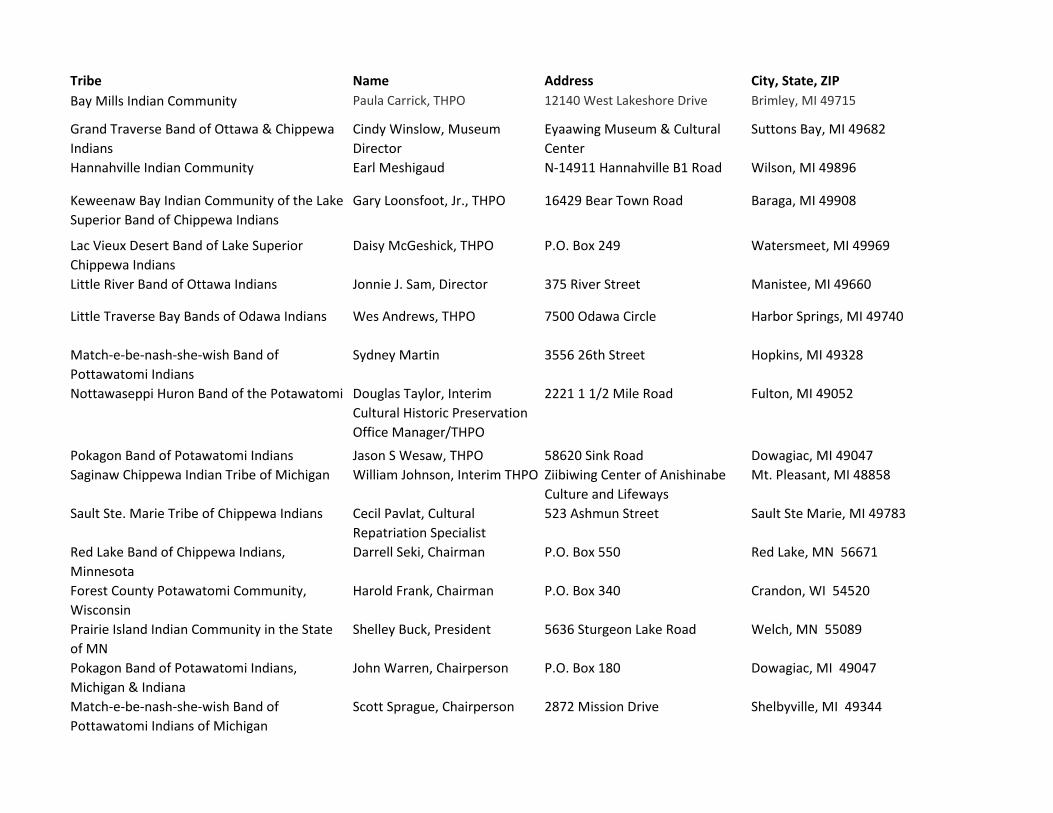
Tribe Name Address City, State, ZIP
Bay Mills Indian Community Paula Carrick, THPO 12140 West Lakeshore Drive Brimley, MI 49715
Grand Traverse Band of Ottawa & Chippewa
Indians
Cindy Winslow, Museum
Director
Eyaawing Museum & Cultural
Center
Suttons Bay, MI 49682
Hannahville Indian Community Earl Meshigaud N-14911 Hannahville B1 Road Wilson, MI 49896
Keweenaw Bay Indian Community of the Lake
Superior Band of Chippewa Indians
Gary Loonsfoot, Jr., THPO 16429 Bear Town Road Baraga, MI 49908
Lac Vieux Desert Band of Lake Superior
Chippewa Indians
Daisy McGeshick, THPO P.O. Box 249 Watersmeet, MI 49969
Little River Band of Ottawa Indians Jonnie J. Sam, Director 375 River Street Manistee, MI 49660
Little Traverse Bay Bands of Odawa Indians Wes Andrews, THPO 7500 Odawa Circle Harbor Springs, MI 49740
Match-e-be-nash-she-wish Band of
Pottawatomi Indians
Sydney Martin 3556 26th Street Hopkins, MI 49328
Nottawaseppi Huron Band of the Potawatomi Douglas Taylor, Interim
Cultural Historic Preservation
Office Manager/THPO
2221 1 1/2 Mile Road Fulton, MI 49052
Pokagon Band of Potawatomi Indians Jason S Wesaw, THPO 58620 Sink Road Dowagiac, MI 49047
Saginaw Chippewa Indian Tribe of Michigan William Johnson, Interim THPO Ziibiwing Center of Anishinabe
Culture and Lifeways
Mt. Pleasant, MI 48858
Sault Ste. Marie Tribe of Chippewa Indians Cecil Pavlat, Cultural
Repatriation Specialist
523 Ashmun Street Sault Ste Marie, MI 49783
Red Lake Band of Chippewa Indians,
Minnesota
Darrell Seki, Chairman P.O. Box 550 Red Lake, MN 56671
Forest County Potawatomi Community,
Wisconsin
Harold Frank, Chairman P.O. Box 340 Crandon, WI 54520
Prairie Island Indian Community in the State
of MN
Shelley Buck, President 5636 Sturgeon Lake Road Welch, MN 55089
Pokagon Band of Potawatomi Indians,
Michigan & Indiana
John Warren, Chairperson P.O. Box 180 Dowagiac, MI 49047
Match-e-be-nash-she-wish Band of
Pottawatomi Indians of Michigan
Scott Sprague, Chairperson 2872 Mission Drive Shelbyville, MI 49344
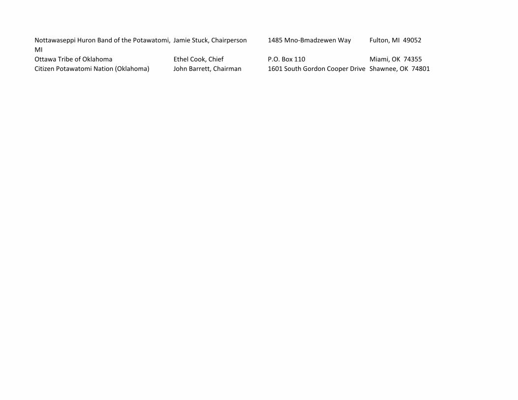
Nottawaseppi Huron Band of the Potawatomi,
MI
Jamie Stuck, Chairperson 1485 Mno-Bmadzewen Way Fulton, MI 49052
Ottawa Tribe of Oklahoma Ethel Cook, Chief P.O. Box 110 Miami, OK 74355
Citizen Potawatomi Nation (Oklahoma) John Barrett, Chairman 1601 South Gordon Cooper Drive Shawnee, OK 74801

December XX, 2017
Contact Name, Contact Title
Tribal Entity Name
Address
Address
City, State ZIP
Subject: National Oceanic and Atmospheric Administration Great Lakes Environmental
Research Laboratory (GLERL) Lake Michigan Field Station (LMFS) Building 3
Replacement Project in Muskegon, Muskegon County, Michigan
Dear Mr./Ms.____________,
The National Oceanic and Atmospheric Administration (NOAA) Office of Oceanic and Atmospheric
Research (OAR) is proposing to replace its existing Great Lakes Environmental Research Laboratory
(GLERL) Lake Michigan Field Station (LMFS) Building 3 in Muskegon, Muskegon County, Michigan (the
“Project”). The LMFS is located at 1431 Beach Street, Muskegon, MI 49441-1098. NOAA has retained
AECOM Technical Services, Inc. (AECOM) to provide support services to the Project. The attached maps
depict the Project location (Figures 1 and 2).
The three main structures at the LMFS campus support GLERL's Ecosystem Dynamics theme with on-
site researchers, laboratory facilities and storage, and direct access to ship resources. The LMFS also
provides a base and accommodations for offsite researchers from GLERL and partner agencies. Science
at LMFS is primarily focused on field-based long-term observations and field-based shorter-term process
studies in Lake Michigan.
Specifically, Building 3 is a 2,600 square-foot (SF) pre-engineered steel building constructed circa 1969
and is currently used for storage and laboratory space. Subsidence and cracking of the interior floor
foundation, consisting of four independent concrete slabs within a perimeter foundation, has created trip
hazards at the exterior doors and caused damage to interior walls.
Due to this deterioration, the Project Proposed Action is to demolish and remove the existing Building 3
structure and interior foundation slabs, then prepare a replacement foundation within the existing
perimeter foundation and construct a new 5,000 SF, two-story laboratory. The design and construction of
the proposed replacement laboratory building would include demolition, removal of all pavements, utilities,
and other appurtenances, and the repurposing or recycling of materials, and testing and preparation of
sandy soils within the foundation envelop. Following established design parameters, construction would
include new concrete foundation slabs, a wood or metal framed structure, interior finishes, HVAC, exhaust,
electrical, plumbing, fixtures, appliances, and other improvements, such as site drainage, landscaping,
exterior lighting and security systems.
The new building construction is not expected to require any new land, but will be a replacement of the
existing building and surrounding pavement and utilities. AECOM requested an archaeological records
check of the Project area from the Michigan State Historic Preservation Office (MI SHPO) of the Michigan
State Housing Development Authority (MSHDA). According to the MI SHPO Archaeologists, no
previously reported archaeological sites have been found at the NOAA building location or within a 0.25-
mile radius of the GLERL Lake Michigan Field Station.
NOAA respectfully requests your review and comment regarding the potential for the Project to affect
cultural resources of tribal concern. If you have any questions regarding the information presented in this
letter or wish to review additional cultural resources information pertaining to the Project, please do not
hesitate to contact Lynn Gierek, AECOM Senior Archaeologist, at the email address:
We appreciate your dedication of time and attention to this matter. Thank you for your assistance
regarding the Project.
Sincerely,
Randolph Ghertler
Federal Preservation Officer
Enclosure: Figure 1: Project Location Map
Figure 2: Project Area Map

Figure 1Project Location
NOAA GLERL LMFS Building 3 Replacement Project, Muskegon County, Michigan
Source: National Geographic Society 2013; USGS 7.5' Quad: Muskegon West; Township 10 North, Range 17 West, Section 28
Scale: 1 = 24,000; 1 inch = 2,000 feet
Path: O:\Practices\Cultural\ARCHY\Lauren\60556155 GLERL\mxd\Fig01_NOAA_Muskegon _topo.mxd, 12/8/2017, downsl1
0 2,000 4,0001,000 Feet
I
Project Location
!\
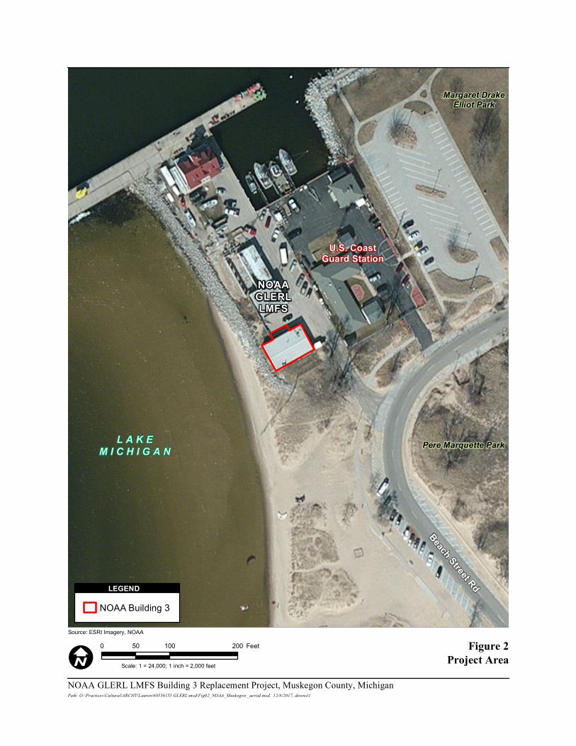
Figure 2Project Area
NOAA GLERL LMFS Building 3 Replacement Project, Muskegon County, Michigan
Source: ESRI Imagery, NOAA
Scale: 1 = 24,000; 1 inch = 2,000 feet
Path: O:\Practices\Cultural\ARCHY\Lauren\60556155 GLERL\mxd\Fig02_NOAA_Muskegon _aerial.mxd, 12/8/2017, downsl1
0 100 20050 Feet
I
NOAA Building 3LEGEND
Margaret DrakeElliot Park
Pere Marquette Park
Beach Street Rd
L A K EM I C H I G A N
U.S. CoastGuard Station
NOAAGLERLLMFS

Appendices Draft Environmental Assessment
NOAA Office of Oceanic and Atmospheric Research 2018
Great Lakes Environmental Research Laboratory
[Page intentionally blank to facilitate double-sided printing]

Appendices Draft Environmental Assessment
NOAA Office of Oceanic and Atmospheric Research 2018
Great Lakes Environmental Research Laboratory
Appendix B: Biological Site Inspection Photographs

A
Bldg 3 (east side) looking NW
Bldg 3 (west side) looking N
Bldg 3 (west side) looking SSE
Bldg 3 (south side) looking WNW
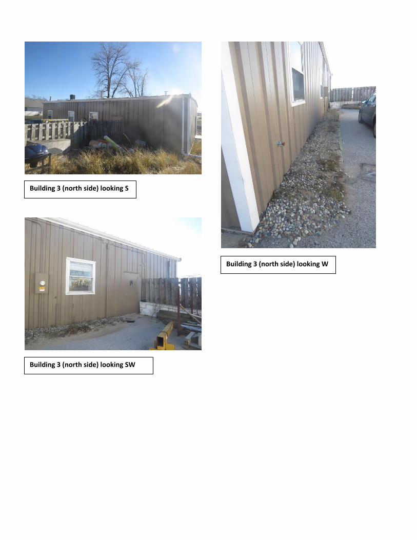
Building 3 (north side) looking S
Building 3 (north side) looking SW
Building 3 (north side) looking W

Building 3 (west side) looking NE
Building 3 (south side) looking NW
NOAA vehicle-pedestrian access looking N

Appendices Draft Environmental Assessment
NOAA Office of Oceanic and Atmospheric Research 2018
Great Lakes Environmental Research Laboratory
[Page intentionally blank to facilitate double-sided printing]

Appendices Draft Environmental Assessment
NOAA Office of Oceanic and Atmospheric Research 2018
Great Lakes Environmental Research Laboratory
Appendix C: Michigan Natural Feature Inventory Information
Michigan Natural Features Inventory Information Request
Clara Austin
GLERL LMFS Bldg Replacement
Muskegon, MI
November 21, 2017
Requestor:
Project:
Location:
Request submission date:
November 21, 2017Print Date:
Detailed information on the species listed in this report can be found in abstracts and the rare species explorer on the Michigan Natural Features Inventory (MNFI) website. The MNFI website can be found at: http :// mnfi . anr . msu . edu /
The species in this report are listed alphabetically by scientific name. Each record from the database is listed individually. Therefore you may see multiple listings for the same species. The locational and survey date information may be the only differentiating factors when looking at multiple occurrences for a given species. Heritage methodology is followed when entering species occurrences into the MNFI database. Detailed information on heritage methodology can be obtained on NatureServe’s website at the link listed below. http :// www . natureserve . org / prodServices / heritagemethodology . jsp
By acceptance of the information services made available through MNFI the recipient understands that access to the information is provided for primary use only. MNFI requests that the user respect the confidential and sensitive nature of the information. There should be no redistribution of the information. Indiscriminate distribution of information regarding locations of many rare species represents a threat to their protection. Additionally, since the information is constantly being updated MNFI requests that any information service provided by MNFI is destroyed upon completion of the primary use. This information should be considered valid for one year only.
Any comments or questions can be directed to MNFI via our e-mail at mnfi @ msu . edu < mailto : mnfi @ msu . edu > or by calling 517-373-1552.

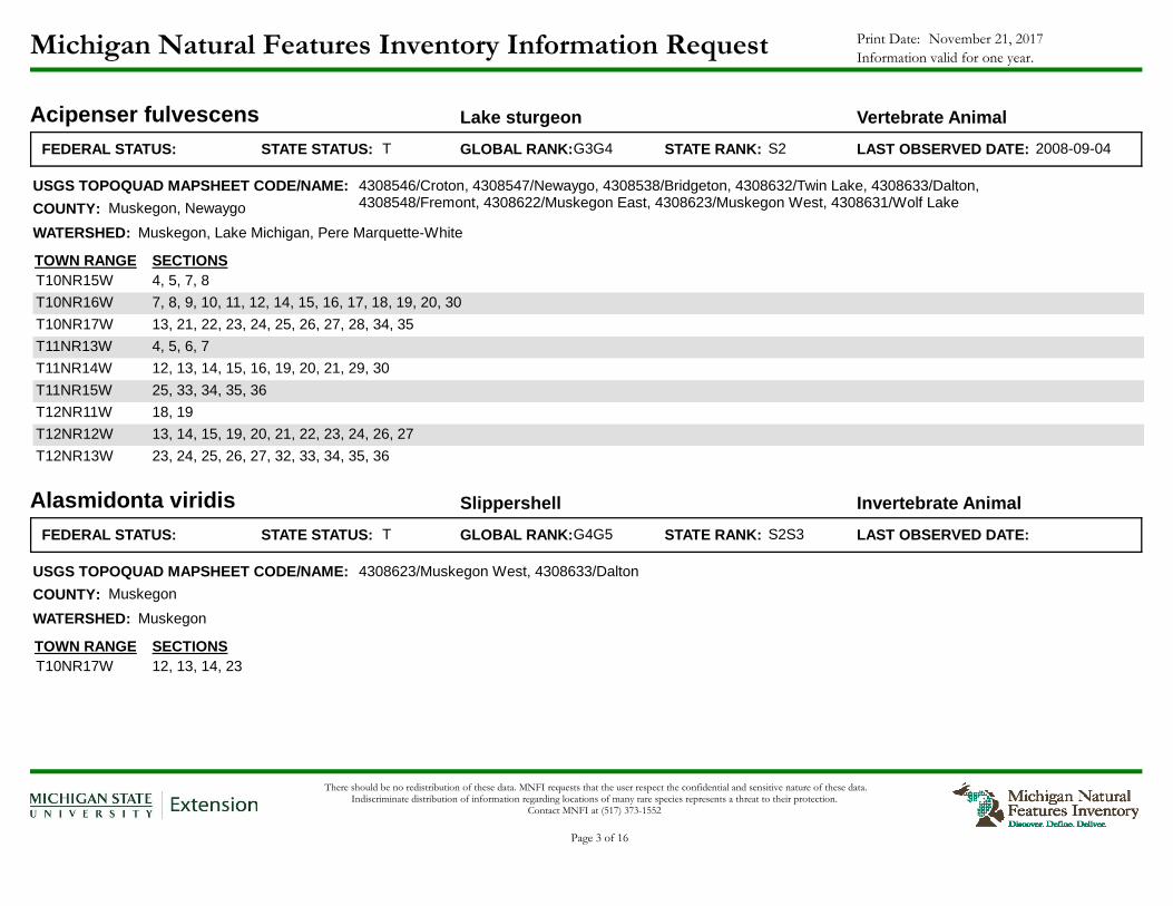
Michigan Natural Features Inventory Information Request November 21, 2017Print Date:
Information valid for one year.
Acipenser fulvescens Lake sturgeon Vertebrate Animal
FEDERAL STATUS: TSTATE STATUS: GLOBAL RANK: S2STATE RANK:G3G4 LAST OBSERVED DATE: 2008-09-04
USGS TOPOQUAD MAPSHEET CODE/NAME:
COUNTY:
WATERSHED:
TOWN RANGE SECTIONS4, 5, 7, 8T10NR15W
7, 8, 9, 10, 11, 12, 14, 15, 16, 17, 18, 19, 20, 30T10NR16W
13, 21, 22, 23, 24, 25, 26, 27, 28, 34, 35T10NR17W
4, 5, 6, 7T11NR13W
12, 13, 14, 15, 16, 19, 20, 21, 29, 30T11NR14W
25, 33, 34, 35, 36T11NR15W
18, 19T12NR11W
13, 14, 15, 19, 20, 21, 22, 23, 24, 26, 27T12NR12W
23, 24, 25, 26, 27, 32, 33, 34, 35, 36T12NR13W
4308546/Croton, 4308547/Newaygo, 4308538/Bridgeton, 4308632/Twin Lake, 4308633/Dalton, 4308548/Fremont, 4308622/Muskegon East, 4308623/Muskegon West, 4308631/Wolf LakeMuskegon, Newaygo
Muskegon, Lake Michigan, Pere Marquette-White
Alasmidonta viridis Slippershell Invertebrate Animal
FEDERAL STATUS: TSTATE STATUS: GLOBAL RANK: S2S3STATE RANK:G4G5 LAST OBSERVED DATE:
USGS TOPOQUAD MAPSHEET CODE/NAME:
COUNTY:
WATERSHED:
TOWN RANGE SECTIONS12, 13, 14, 23T10NR17W
4308623/Muskegon West, 4308633/Dalton
Muskegon
Muskegon
There should be no redistribution of these data. MNFI requests that the user respect the confidential and sensitive nature of these data. Indiscriminate distribution of information regarding locations of many rare species represents a threat to their protection.
Contact MNFI at (517) 373-1552
Page 3 of 16

Michigan Natural Features Inventory Information Request November 21, 2017Print Date:
Information valid for one year.
Buteo lineatus Red-shouldered hawk Vertebrate Animal
FEDERAL STATUS: TSTATE STATUS: GLOBAL RANK: S4STATE RANK:G5 LAST OBSERVED DATE: 2006-06-02
USGS TOPOQUAD MAPSHEET CODE/NAME:
COUNTY:
WATERSHED:
TOWN RANGE SECTIONS8T10NR17W
4308633/Dalton
Muskegon
Pere Marquette-White, Muskegon
Charadrius melodus Piping plover Vertebrate Animal
FEDERAL STATUS: ESTATE STATUS:LE GLOBAL RANK: S2STATE RANK:G3 LAST OBSERVED DATE: 2015
USGS TOPOQUAD MAPSHEET CODE/NAME:
COUNTY:
WATERSHED:
TOWN RANGE SECTIONS20, 21, 28, 29T10NR17W
4308623/Muskegon West
Muskegon
Pere Marquette-White
Cirsium pitcheri Pitcher's thistle Vascular Plant
FEDERAL STATUS: TSTATE STATUS:LT GLOBAL RANK: S3STATE RANK:G2G3 LAST OBSERVED DATE: 2012-07-24
USGS TOPOQUAD MAPSHEET CODE/NAME:
COUNTY:
WATERSHED:
TOWN RANGE SECTIONS21T10NR17W
4308623/Muskegon West
Muskegon
Pere Marquette-White
There should be no redistribution of these data. MNFI requests that the user respect the confidential and sensitive nature of these data. Indiscriminate distribution of information regarding locations of many rare species represents a threat to their protection.
Contact MNFI at (517) 373-1552
Page 4 of 16
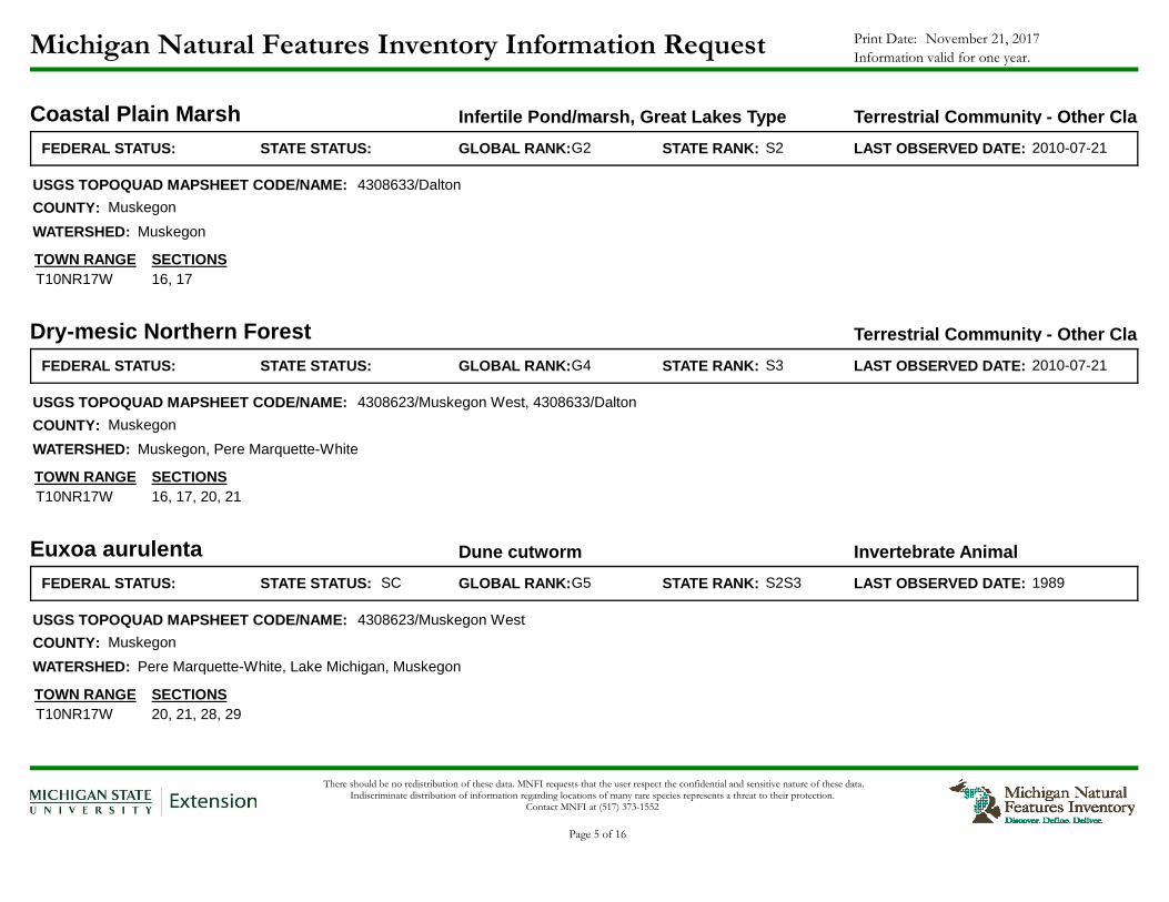
Michigan Natural Features Inventory Information Request November 21, 2017Print Date:
Information valid for one year.
Coastal Plain Marsh Infertile Pond/marsh, Great Lakes Type Terrestrial Community - Other Classification
FEDERAL STATUS: STATE STATUS: GLOBAL RANK: S2STATE RANK:G2 LAST OBSERVED DATE: 2010-07-21
USGS TOPOQUAD MAPSHEET CODE/NAME:
COUNTY:
WATERSHED:
TOWN RANGE SECTIONS16, 17T10NR17W
4308633/Dalton
Muskegon
Muskegon
Dry-mesic Northern Forest Terrestrial Community - Other Classification
FEDERAL STATUS: STATE STATUS: GLOBAL RANK: S3STATE RANK:G4 LAST OBSERVED DATE: 2010-07-21
USGS TOPOQUAD MAPSHEET CODE/NAME:
COUNTY:
WATERSHED:
TOWN RANGE SECTIONS16, 17, 20, 21T10NR17W
4308623/Muskegon West, 4308633/Dalton
Muskegon
Muskegon, Pere Marquette-White
Euxoa aurulenta Dune cutworm Invertebrate Animal
FEDERAL STATUS: SCSTATE STATUS: GLOBAL RANK: S2S3STATE RANK:G5 LAST OBSERVED DATE: 1989
USGS TOPOQUAD MAPSHEET CODE/NAME:
COUNTY:
WATERSHED:
TOWN RANGE SECTIONS20, 21, 28, 29T10NR17W
4308623/Muskegon West
Muskegon
Pere Marquette-White, Lake Michigan, Muskegon
There should be no redistribution of these data. MNFI requests that the user respect the confidential and sensitive nature of these data. Indiscriminate distribution of information regarding locations of many rare species represents a threat to their protection.
Contact MNFI at (517) 373-1552
Page 5 of 16

Michigan Natural Features Inventory Information Request November 21, 2017Print Date:
Information valid for one year.
Fuirena pumila Umbrella-grass Vascular Plant
FEDERAL STATUS: TSTATE STATUS: GLOBAL RANK: S2STATE RANK:G4 LAST OBSERVED DATE: 2000
USGS TOPOQUAD MAPSHEET CODE/NAME:
COUNTY:
WATERSHED:
TOWN RANGE SECTIONS16, 17T10NR17W
4308633/Dalton
Muskegon
Muskegon
Haliaeetus leucocephalus Bald eagle Vertebrate Animal
FEDERAL STATUS: SCSTATE STATUS: GLOBAL RANK: S4STATE RANK:G5 LAST OBSERVED DATE: 2012
USGS TOPOQUAD MAPSHEET CODE/NAME:
COUNTY:
WATERSHED:
TOWN RANGE SECTIONS21T10NR17W
4308623/Muskegon West
Muskegon
Muskegon
Hardwood-Conifer Swamp Terrestrial Community - Other Classification
FEDERAL STATUS: STATE STATUS: GLOBAL RANK: S3STATE RANK:G4 LAST OBSERVED DATE: 2010-06-11
USGS TOPOQUAD MAPSHEET CODE/NAME:
COUNTY:
WATERSHED:
TOWN RANGE SECTIONS21T10NR17W
4308623/Muskegon West
Muskegon
Muskegon
There should be no redistribution of these data. MNFI requests that the user respect the confidential and sensitive nature of these data. Indiscriminate distribution of information regarding locations of many rare species represents a threat to their protection.
Contact MNFI at (517) 373-1552
Page 6 of 16
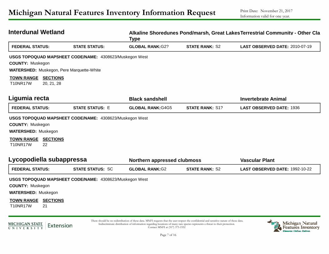
Michigan Natural Features Inventory Information Request November 21, 2017Print Date:
Information valid for one year.
Interdunal Wetland Alkaline Shoredunes Pond/marsh, Great Lakes Type
Terrestrial Community - Other Classification
FEDERAL STATUS: STATE STATUS: GLOBAL RANK: S2STATE RANK:G2? LAST OBSERVED DATE: 2010-07-19
USGS TOPOQUAD MAPSHEET CODE/NAME:
COUNTY:
WATERSHED:
TOWN RANGE SECTIONS20, 21, 28T10NR17W
4308623/Muskegon West
Muskegon
Muskegon, Pere Marquette-White
Ligumia recta Black sandshell Invertebrate Animal
FEDERAL STATUS: ESTATE STATUS: GLOBAL RANK: S1?STATE RANK:G4G5 LAST OBSERVED DATE: 1936
USGS TOPOQUAD MAPSHEET CODE/NAME:
COUNTY:
WATERSHED:
TOWN RANGE SECTIONS22T10NR17W
4308623/Muskegon West
Muskegon
Muskegon
Lycopodiella subappressa Northern appressed clubmoss Vascular Plant
FEDERAL STATUS: SCSTATE STATUS: GLOBAL RANK: S2STATE RANK:G2 LAST OBSERVED DATE: 1992-10-22
USGS TOPOQUAD MAPSHEET CODE/NAME:
COUNTY:
WATERSHED:
TOWN RANGE SECTIONS21T10NR17W
4308623/Muskegon West
Muskegon
Muskegon
There should be no redistribution of these data. MNFI requests that the user respect the confidential and sensitive nature of these data. Indiscriminate distribution of information regarding locations of many rare species represents a threat to their protection.
Contact MNFI at (517) 373-1552
Page 7 of 16

Michigan Natural Features Inventory Information Request November 21, 2017Print Date:
Information valid for one year.
Mesic Northern Forest Terrestrial Community - Other Classification
FEDERAL STATUS: STATE STATUS: GLOBAL RANK: S3STATE RANK:G4 LAST OBSERVED DATE: 2010-07-21
USGS TOPOQUAD MAPSHEET CODE/NAME:
COUNTY:
WATERSHED:
TOWN RANGE SECTIONS17, 20, 21T10NR17W
4308623/Muskegon West, 4308633/Dalton
Muskegon
Pere Marquette-White, Muskegon
Mikania scandens Mikania Vascular Plant
FEDERAL STATUS: TSTATE STATUS: GLOBAL RANK: S1STATE RANK:G5 LAST OBSERVED DATE: 1894-09-23
USGS TOPOQUAD MAPSHEET CODE/NAME:
COUNTY:
WATERSHED:
TOWN RANGE SECTIONS13, 14, 15, 22, 23, 24T10NR17W
4308633/Dalton, 4308623/Muskegon West
Muskegon
Muskegon
Open Dunes Beach/shoredunes, Great Lakes Type Terrestrial Community - Other Classification
FEDERAL STATUS: STATE STATUS: GLOBAL RANK: S3STATE RANK:G3 LAST OBSERVED DATE: 2010-07-19
USGS TOPOQUAD MAPSHEET CODE/NAME:
COUNTY:
WATERSHED:
TOWN RANGE SECTIONS20, 21, 28T10NR17W
4308623/Muskegon West
Muskegon
Muskegon, Pere Marquette-White
There should be no redistribution of these data. MNFI requests that the user respect the confidential and sensitive nature of these data. Indiscriminate distribution of information regarding locations of many rare species represents a threat to their protection.
Contact MNFI at (517) 373-1552
Page 8 of 16

Michigan Natural Features Inventory Information Request November 21, 2017Print Date:
Information valid for one year.
Open Dunes Beach/shoredunes, Great Lakes Type Terrestrial Community - Other Classification
FEDERAL STATUS: STATE STATUS: GLOBAL RANK: S3STATE RANK:G3 LAST OBSERVED DATE: 2015-09-04
USGS TOPOQUAD MAPSHEET CODE/NAME:
COUNTY:
WATERSHED:
TOWN RANGE SECTIONS10, 11, 14, 15T09NR17W
4308623/Muskegon West
Muskegon
Pere Marquette-White
Polygala cruciata Cross-leaved milkwort Vascular Plant
FEDERAL STATUS: SCSTATE STATUS: GLOBAL RANK: S3STATE RANK:G5 LAST OBSERVED DATE: 2000
USGS TOPOQUAD MAPSHEET CODE/NAME:
COUNTY:
WATERSHED:
TOWN RANGE SECTIONS16T10NR17W
4308633/Dalton
Muskegon
Muskegon
Potamilus alatus Pink heelsplitter Invertebrate Animal
FEDERAL STATUS: SCSTATE STATUS: GLOBAL RANK: SNRSTATE RANK:G5 LAST OBSERVED DATE:
USGS TOPOQUAD MAPSHEET CODE/NAME:
COUNTY:
WATERSHED:
TOWN RANGE SECTIONS21, 28T10NR17W
4308623/Muskegon West
Muskegon
Muskegon
There should be no redistribution of these data. MNFI requests that the user respect the confidential and sensitive nature of these data. Indiscriminate distribution of information regarding locations of many rare species represents a threat to their protection.
Contact MNFI at (517) 373-1552
Page 9 of 16
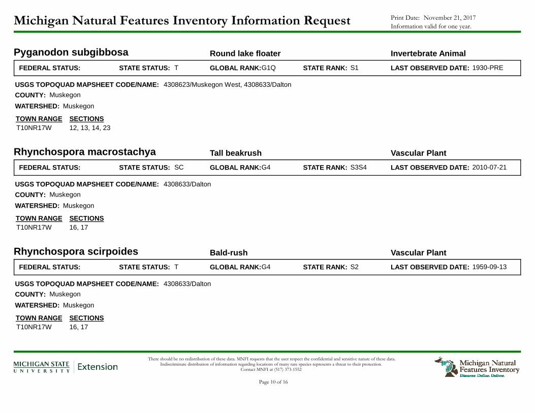
Michigan Natural Features Inventory Information Request November 21, 2017Print Date:
Information valid for one year.
Pyganodon subgibbosa Round lake floater Invertebrate Animal
FEDERAL STATUS: TSTATE STATUS: GLOBAL RANK: S1STATE RANK:G1Q LAST OBSERVED DATE: 1930-PRE
USGS TOPOQUAD MAPSHEET CODE/NAME:
COUNTY:
WATERSHED:
TOWN RANGE SECTIONS12, 13, 14, 23T10NR17W
4308623/Muskegon West, 4308633/Dalton
Muskegon
Muskegon
Rhynchospora macrostachya Tall beakrush Vascular Plant
FEDERAL STATUS: SCSTATE STATUS: GLOBAL RANK: S3S4STATE RANK:G4 LAST OBSERVED DATE: 2010-07-21
USGS TOPOQUAD MAPSHEET CODE/NAME:
COUNTY:
WATERSHED:
TOWN RANGE SECTIONS16, 17T10NR17W
4308633/Dalton
Muskegon
Muskegon
Rhynchospora scirpoides Bald-rush Vascular Plant
FEDERAL STATUS: TSTATE STATUS: GLOBAL RANK: S2STATE RANK:G4 LAST OBSERVED DATE: 1959-09-13
USGS TOPOQUAD MAPSHEET CODE/NAME:
COUNTY:
WATERSHED:
TOWN RANGE SECTIONS16, 17T10NR17W
4308633/Dalton
Muskegon
Muskegon
There should be no redistribution of these data. MNFI requests that the user respect the confidential and sensitive nature of these data. Indiscriminate distribution of information regarding locations of many rare species represents a threat to their protection.
Contact MNFI at (517) 373-1552
Page 10 of 16

Michigan Natural Features Inventory Information Request November 21, 2017Print Date:
Information valid for one year.
Rorippa aquatica Lake cress Vascular Plant
FEDERAL STATUS: TSTATE STATUS: GLOBAL RANK: S2STATE RANK:G4? LAST OBSERVED DATE: 1898-06-22
USGS TOPOQUAD MAPSHEET CODE/NAME:
COUNTY:
WATERSHED:
TOWN RANGE SECTIONS7, 17, 18, 19, 20, 30T10NR16W
13, 15, 21, 22, 23, 24, 25, 26, 27, 28, 33, 34, 35T10NR17W
4308622/Muskegon East, 4308623/Muskegon West, 4308632/Twin Lake, 4308633/Dalton
Muskegon
Muskegon
Setophaga discolor Prairie warbler Vertebrate Animal
FEDERAL STATUS: ESTATE STATUS: GLOBAL RANK: S3STATE RANK:G5 LAST OBSERVED DATE: 1998-06
USGS TOPOQUAD MAPSHEET CODE/NAME:
COUNTY:
WATERSHED:
TOWN RANGE SECTIONS21T10NR17W
4308623/Muskegon West
Muskegon
Muskegon
There should be no redistribution of these data. MNFI requests that the user respect the confidential and sensitive nature of these data. Indiscriminate distribution of information regarding locations of many rare species represents a threat to their protection.
Contact MNFI at (517) 373-1552
Page 11 of 16

Michigan Natural Features Inventory Information Request November 21, 2017Print Date:
Information valid for one year.
Strophostyles helvula Trailing wild Bean Vascular Plant
FEDERAL STATUS: SCSTATE STATUS: GLOBAL RANK: S3STATE RANK:G5 LAST OBSERVED DATE: 1961-08-25
USGS TOPOQUAD MAPSHEET CODE/NAME:
COUNTY:
WATERSHED:
TOWN RANGE SECTIONS3, 4, 5, 6, 7, 8, 9, 17, 18T09NR16W
1, 2, 3, 4, 10, 11, 12, 13, 14, 15T09NR17W
3, 4, 5, 6, 7, 8, 9, 10, 15, 16, 17, 18, 19, 20, 21, 22, 27, 28, 29, 30, 31, 32, 33, 34T10NR16W
1, 2, 3, 4, 5, 6, 7, 8, 9, 10, 11, 12, 13, 14, 15, 16, 17, 20, 21, 22, 23, 24, 25, 26, 27, 28, 29, 33, 34, 35, 36T10NR17W
29, 30, 31, 32, 33T11NR16W
25, 26, 33, 34, 35, 36T11NR17W
4308622/Muskegon East, 4308623/Muskegon West, 4308632/Twin Lake, 4308633/Dalton
Muskegon
Pere Marquette-White, Muskegon, Lake Michigan
Truncilla donaciformis Fawnsfoot Invertebrate Animal
FEDERAL STATUS: TSTATE STATUS: GLOBAL RANK: S1STATE RANK:G5 LAST OBSERVED DATE: 1936-pre
USGS TOPOQUAD MAPSHEET CODE/NAME:
COUNTY:
WATERSHED:
TOWN RANGE SECTIONS12, 13, 14, 23T10NR17W
4308623/Muskegon West, 4308633/Dalton
Muskegon
Muskegon
There should be no redistribution of these data. MNFI requests that the user respect the confidential and sensitive nature of these data. Indiscriminate distribution of information regarding locations of many rare species represents a threat to their protection.
Contact MNFI at (517) 373-1552
Page 12 of 16

Michigan Natural Features Inventory Information Request November 21, 2017Print Date:
Information valid for one year.
Utricularia subulata Bladderwort Vascular Plant
FEDERAL STATUS: TSTATE STATUS: GLOBAL RANK: S1STATE RANK:G5 LAST OBSERVED DATE: 1992-10-22
USGS TOPOQUAD MAPSHEET CODE/NAME:
COUNTY:
WATERSHED:
TOWN RANGE SECTIONS21, 28T10NR17W
4308623/Muskegon West
Muskegon
Muskegon
Zizania aquatica Wild rice Vascular Plant
FEDERAL STATUS: TSTATE STATUS: GLOBAL RANK: S2S3STATE RANK:G5 LAST OBSERVED DATE: 1916-08-10
USGS TOPOQUAD MAPSHEET CODE/NAME:
COUNTY:
WATERSHED:
TOWN RANGE SECTIONS6T09NR15W
1, 2, 3, 4, 5, 6, 7, 8, 9, 10, 11, 12, 14, 15, 16, 17, 18T09NR16W
1, 2, 3, 11, 12, 13T09NR17W
6, 7, 17, 18, 19, 20, 29, 30, 31T10NR15W
1, 2, 3, 4, 5, 6, 7, 8, 9, 10, 11, 12, 13, 14, 15, 16, 17, 18, 19, 20, 21, 22, 23, 24, 25, 26, 27, 28, 29, 30, 31, 32, 33, 34, 35, 36T10NR16W
1, 2, 3, 10, 11, 12, 13, 14, 15, 22, 23, 24, 25, 26, 27, 34, 35, 36T10NR17W
27, 28, 29, 31, 32, 33, 34, 35, 36T11NR16W
36T11NR17W
4308621/Sullivan, 4308622/Muskegon East, 4308632/Twin Lake, 4308623/Muskegon West, 4308633/Dalton
Muskegon
Muskegon, Pere Marquette-White
There should be no redistribution of these data. MNFI requests that the user respect the confidential and sensitive nature of these data. Indiscriminate distribution of information regarding locations of many rare species represents a threat to their protection.
Contact MNFI at (517) 373-1552
Page 13 of 16

Michigan Natural Features Inventory Information Request November 21, 2017Print Date:
Information valid for one year.
Zizania aquatica Wild rice Vascular Plant
FEDERAL STATUS: TSTATE STATUS: GLOBAL RANK: S2S3STATE RANK:G5 LAST OBSERVED DATE: 2000-10-02
USGS TOPOQUAD MAPSHEET CODE/NAME:
COUNTY:
WATERSHED:
TOWN RANGE SECTIONS21T10NR17W
4308623/Muskegon West
Muskegon
Muskegon
There should be no redistribution of these data. MNFI requests that the user respect the confidential and sensitive nature of these data. Indiscriminate distribution of information regarding locations of many rare species represents a threat to their protection.
Contact MNFI at (517) 373-1552
Page 14 of 16

Michigan Natural Features Inventory Information Request November 21, 2017Print Date:
Information valid for one year.
Enclosed is the data requested from Michigan Natural Features Inventory (MNFI). This information is a list of Element Occurrences (EO) at the section level. In some cases, the extent of an animal's range or a community type may extend past the sections listed.
The MNFI database is an ongoing and continuously updated information base. The database is the only comprehensive single source of existing information on Michigan's endangered, threatened, or otherwise significant plant and animal species, natural plant communities, and other natural features. This database cannot provide a definitive statement on the presence, absence, or condition of the natural features in any given locality, since most sites have not been specifically or thoroughly surveyed for their occurrence. Furthermore, plant and animal populations and natural communities change with time. Therefore, the information services provided should not be regarded as a complete statement on the occurrence of special natural features of the area in question. In many cases the information may require the interpretation of a trained scientist.
The recipient(s) of the information understand that state endangered and threatened species are protected under state law (Act 451 of 1994, the Natural Resources and Environmental Protection Act, Part 365, Endangered Species Protection). Any questions, observations, new findings, violations or clearance of project activities should be conducted with the Michigan Department of Natural Resources, Wildlife Division. Contact Lori Sargent or Todd Hogrefe at (517) 373-1263. The recipient(s) of the information understand that federally endangered and threatened species are protected under federal law (Endangered Species Act of 1973). Any questions, observations, new findings, violations or clearance of project activities should be conducted with the U.S. Fish and Wildlife Service in East Lansing. Their phone number is (517) 351-2555. Recipients of the information are responsible for ensuring the protection of protected species and obtaining proper clearance before project activities begin.
By acceptance of the information services made available through MNFI the recipient understands that access to the information is provided for primary use only. MNFI requests that the user respect the confidential and sensitive nature of the information. There should be no redistribution of the information. Indiscriminate distribution of information regarding locations of many rare species represents a threat to their protection. Additionally, since the information is constantly being updated MNFI requests that any information service provided by MNFI is destroyed upon completion of the primary use. This information should be considered valid for one year only.
This information is used to guide conservation and land management activities. Some of the element records are historical. While this information may not be important for regulatory purposes, it is important for management and restoration purposes and for scientific use.
State Protection Status Code DefinitionsE = Endangered T = Threatened SC = Special concern X = Presumed extirpated (legally 'threatened' if rediscovered)
Federal Protection Status Code DefinitionsLE = Listed endangered LT = Listed threatened LELT = Partly listed endangered and partly listed threatened PDL = Proposed delist E(S/A) = Endangered based on similarities/appearance PS = Partial status (federally listed in only part of its range) C = Species being considered for federal status
Global Heritage Status Rank DefinitionsThe priority assigned by NatureServe < http :// www . natureserve . org >'s national office for data collection and protection based upon the element's status throughout its entire world-wide range. Criteria not based only on number of occurrences; other critical factors also apply. Note that ranks are frequently combined.
G1 = Critically imperiled globally because of extreme rarity (5 or fewer occurrences range-wide or very few remaining individuals or acres) or because of some factor(s) making it especially vulnerable to extinction. G2 = Imperiled globally because of rarity (6 to 20 occurrences or few remaining individuals or acres) or because of some factor(s) making it very vulnerable to extinction throughout its range. G3 = Either very rare and local throughout its range or found locally (even abundantly at some of its locations) in a restricted range (e.g. a single western state, a physiographic region in the East) or because of other factor(s) making it vulnerable to extinction throughout its range; in terms of occurrences, in the range of
21 to 100. G4 = Apparently secure globally, though it may be quite rare in parts of its range, especially at the periphery. G5 = Demonstrably secure globally, though it may be quite rare in parts of its range, especially at the periphery. GH = Of historical occurrence throughout its range, i.e. formerly part of the established biota, with the expectation that it may be rediscovered (e.g. Bachman's Warbler). GU = Possibly in peril range-wide, but status uncertain; need more information. GX = Believed to be extinct throughout its range (e.g. Passenger Pigeon with virtually no likelihood that it will be rediscovered). G? = Incomplete data Q = Taxonomy uncertain T = Subspecies U = Unmappable through out the global geographic extent ? = Questionable
Subnational Heritage Status Rank DefinitionsThe priority assigned by the Michigan Natural Features Inventory for data collection and protection based upon the element's status within the state. Criteria not based only on number of occurrences; other critical factors also apply. Note that ranks are frequently combined.
S1 = Critically imperiled in the state because of extreme rarity (5 or fewer occurrences or very few remaining individuals or acres) or because of some factor(s) making it especially vulnerable to extirpation in the state. S2 = Imperiled in state because of rarity (6 to 20 occurrences or few remaining individuals or acres) or because of some factor(s) making it very vulnerable to extirpation from the state. S3 = Rare or uncommon in state (on the order of 21 to 100 occurrences). S4 = Apparently secure in state, with many occurrences. S5 = Demonstrably secure in state and essentially ineradicable under present conditions. SA = Accidental in state, including species (usually birds or butterflies) recorded once or twice or only at very great intervals, hundreds or even thousands of miles outside their usual range. SE = An exotic established in the state; may be native elsewhere in North America (e.g. house finch or catalpa in eastern states). SH = Of historical occurrence in state and suspected to be still extant. SN = Regularly occurring, usually migratory and typically nonbreeding species. SR = Reported from state, but without persuasive documentation which would provide a basis for either accepting or rejecting the report. SRF = Reported falsely (in error) from state but this error persisting in the literature. SU = Possibly in peril in state, but status uncertain; need more information. SX = Apparently extirpated from state.
There should be no redistribution of these data. MNFI requests that the user respect the confidential and sensitive nature of these data. Indiscriminate distribution of information regarding locations of many rare species represents a threat to their protection.
Contact MNFI at (517) 373-1552
Page 15 of 16
Michigan Natural Features Inventory Information Request November 21, 2017Print Date:
Information valid for one year.
There should be no redistribution of these data. MNFI requests that the user respect the confidential and sensitive nature of these data. Indiscriminate distribution of information regarding locations of many rare species represents a threat to their protection.
Contact MNFI at (517) 373-1552
Page 16 of 16

Appendices Draft Environmental Assessment
NOAA Office of Oceanic and Atmospheric Research 2018
Great Lakes Environmental Research Laboratory
[Page intentionally blank to facilitate double-sided printing]

Appendices Draft Environmental Assessment
NOAA Office of Oceanic and Atmospheric Research 2018
Great Lakes Environmental Research Laboratory
Appendix D: Reference Materials
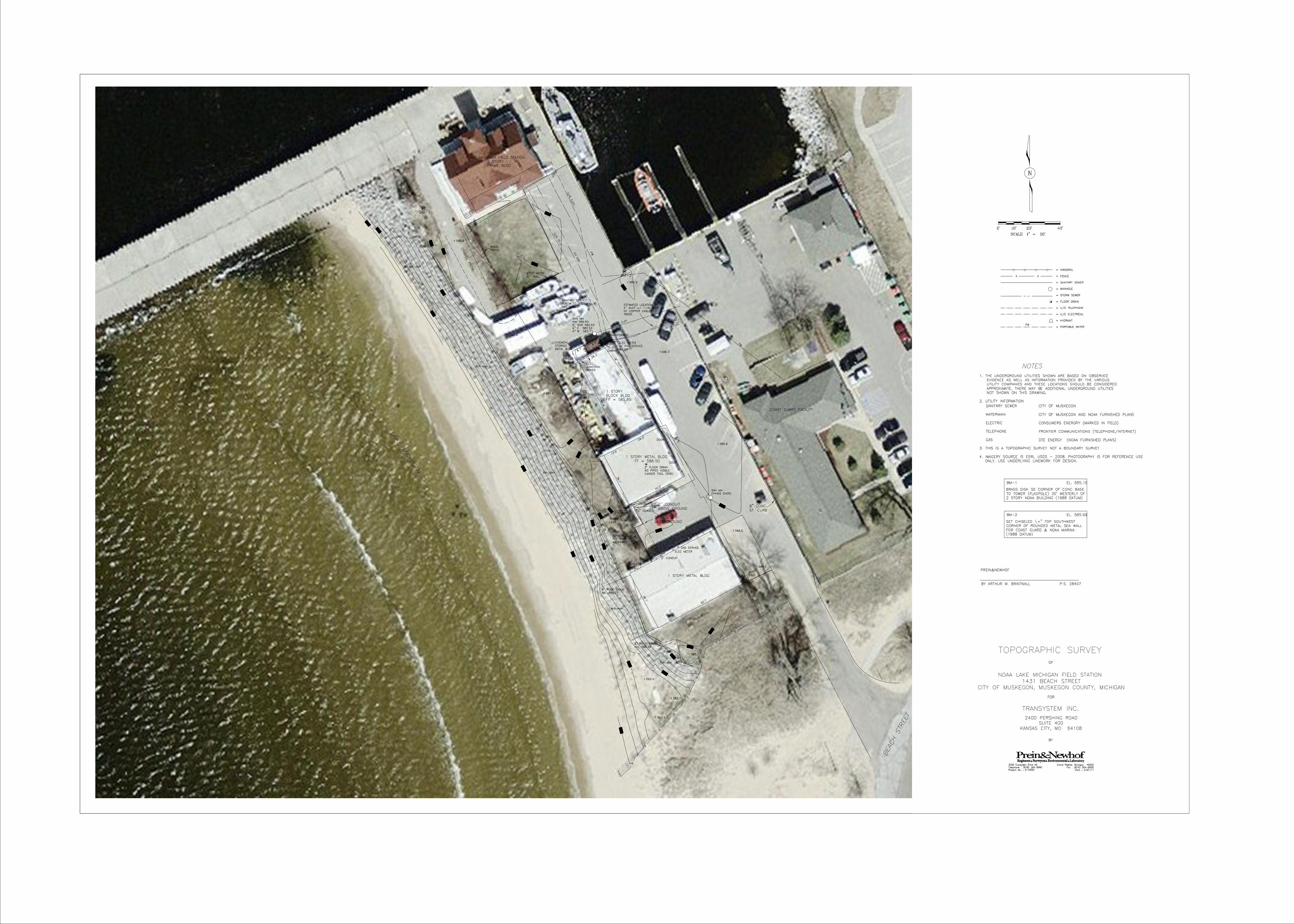
U/
G
TELE
U/
G
ELE
C
U/G T
ELE
U/G E
LEC
SAN MH
RIM 585.93
6" SSW 582.63
6" E 582.53
4" W 583.73
4" METAL
6" CLAY
6"
CLA
Y
SAN MH
(PAVED OVER)
62.7’
36.1’
2’ TELE
PANEL
A/C
UNIT1 STORY METAL BLDG
2" CONDUIT
GAS SERVICE
ELEC METER
8" ROOF DRAIN
INV. 585.73
2" CONDUIT
2" CONDUIT
TOWER
LEGS
CONC BLOCK
RET WALL
w/ FENCE
36.1’
40.2’
13.9’
26.3’
2’ FLOOR DRAIN
NO PIPES VISIBLE
(UNDER TOOL CRIB)
DOOR
DOOR
1 STORY METAL BLDG
61.6’
61.6’
36.1’
DOOR
DOOR
8.0’
5.9’
SHED
CHEMICAL
STORAGE
METAL BLDG8.
7’
6.7’
26.3’
ELEC
JUNCTION
BOXES
ELEC
JUNCTION
BOXES
TELE
CABINET
ELEC METER
w/ GAS SERVICE
BELOW
GR
AVEL P
ATH
6"X6" WOOD
RET WALL
SEA WALL
METAL HANDRAIL
WATER ELEV 577.5
2-01-11
WOOD
FENCE
ELEC
PANELS
8" ROOF DRAIN
INV. 585.23
1 STORY
BLOCK BLDG
2 STORY
FRAME BLDG
COVERED PORCH
LAKE
MIC
HIG
AN
8" CONC
ST. CURB
ELEC
TRANSFORMER
FF = 586.50
FF = 585.85
BE
AC
H STR
EET
NOAA
LAKE MICHIGAN FIELD STATION
BM
BM-1
BM
BM-2
584.9X
586.7X
585.5X
585.3X
585.8X
585.6X
585.3X
585.9X
586.5X
586.5X
583.4X
583.4X
583.7X
RIP-RAP
RIP-RAP
RIP-RAP
RIP-RAP
RIP-RAP
2" CONDUIT
ABOVE GROUND
2" CONDUIT
UNDERGROUND
EX
GAS
EX
GAS
ESTIMATED LOCATION OF
4" DUCT w/ 1-50 PAIR
OF COPPER CABLES
INSIDE.
SANITARY SERVICE
NORTH TO 2 STORY
NOT VISIBLE
COAST GUARD FACILITY
PW
PW
MUSKEGON CHANNEL
BMBM
BM
585
580
585
580
580
583
585
588
587
587
585
589
581
586
587
589
588
588
587
586
585
586
586
580
579
585
584
587
SUITE 400
TOPOGRAPHIC SURVEY
NOAA LAKE MICHIGAN FIELD STATION
CITY OF MUSKEGON, MUSKEGON COUNTY, MICHIGAN
TRANSYSTEM INC.
2400 PERSHING ROAD
Grand Rapids, Michigan 49525
Fax : (616) 364-6955
Date : 2/07/11Project No. : 2110057
Telephone : (616) 364-8491
3355 Evergreen Drive NE
OF
BY
1431 BEACH STREET
KANSAS CITY, MO 64108
FOR
N
SCALE: 1" = 20’
40’20’10’0’
= HANDRAIL
= FENCE
= SANITARY SEWER
= MANHOLE
= STORM SEWER
= FLOOR DRAIN
= U/G TELEPHONE
= U/G ELECTRICAL
= HYDRANT
1. THE UNDERGROUND UTILITIES SHOWN ARE BASED ON OBSERVED
EVIDENCE AS WELL AS INFORMATION PROVIDED BY THE VARIOUS
UTILITY COMPANIES AND THESE LOCATIONS SHOULD BE CONSIDERED
APPROXIMATE. THERE MAY BE ADDITIONAL UNDERGROUND UTILITIES
NOT SHOWN ON THIS DRAWING.
2. UTILITY INFORMATION
SANITARY SEWER CITY OF MUSKEGON
WATERMAIN
ELECTRIC
TELEPHONE
GAS
CITY OF MUSKEGON AND NOAA FURNISHED PLANS
CONSUMERS ENERGRY (MARKED IN FIELD)
FRONTIER COMMUNICATIONS (TELEPHONE/INTERNET)
DTE ENERGY (NOAA FURNISHED PLANS)
NOTES
= PORTABLE WATERPW
BRASS DISK SE CORNER OF CONC BASE
BM-1 EL. 585.15
TO TOWER (FLAGPOLE) 30’ WESTERLY OF
2 STORY NOAA BUILDING (1988 DATUM)
SET CHISELED \+" TOP SOUTHWEST
BM-2 EL. 585.69
CORNER OF ROUNDED METAL SEA WALL
FOR COAST GUARD & NOAA MARINA
(1988 DATUM)
3. THIS IS A TOPOGRAPHIC SURVEY NOT A BOUNDARY SURVEY
BY ARTHUR W. BRINTNALL P.S. 28407
PREIN&NEWHOF
4. IMAGERY SOURCE IS ESRI, USGS - 2008. PHOTOGRAPHY IS FOR REFERENCE USE
ONLY. USE UNDERLYING LINEWORK FOR DESIGN.
Appendices Draft Environmental Assessment
NOAA Office of Oceanic and Atmospheric Research 2018
Great Lakes Environmental Research Laboratory
[Page intentionally blank to facilitate double-sided printing]