draft environmental and social impact assessment - govt.lc · appendix d environmental and social...
TRANSCRIPT

717 Market Street, Suite 650, San Francisco, CA 94111 650-373-1200 www.panoramaenv.com
Government of Saint Lucia
Draft Environmental and Social Impact Assessment Saint Lucia Geothermal Resource Exploration Project
February 2018


717 Market Street, Suite 650, San Francisco, CA 94111 650-373-1200 www.panoramaenv.com
Government of Saint Lucia
Draft Environmental and Social Impact Assessment Saint Lucia Geothermal Resource Exploration Project
February 2018 Prepared for: Government of Saint Lucia Department of Sustainable Development Point Seraphine, Castries Saint Lucia Prepared by: Panorama Environmental, Inc. 717 Market Street, Suite 650 San Francisco, CA 94111 650-373-1200 [email protected]

TABLE OF CONTENTS
Saint Lucia Geothermal Resource Development Project Draft ESIA ● February 2018
i
TABLE OF CONTENTS
Executive Summary ............................................................................................................................... 1 ES.1 Overview ................................................................................................................................ 1 ES.2 Purpose and Need .................................................................................................................. 1 ES.3 Project Description .................................................................................................................. 3 ES.4 Key Project Impacts and Mitigation Measures .................................................................. 3 ES.5 Conclusions ............................................................................................................................... 6
1 Introduction ................................................................................................................................ 1-1 1.1 Overview .............................................................................................................................1-1 1.2 Significant Previous Geothermal Investigations .................................................................1-2 1.3 Pre-Feasibility Study ..................................................................................................................1-2 1.4 Project Location and Site Selection .....................................................................................1-4 1.5 Project Need .............................................................................................................................1-4
2 Legal and Institutional Framework .......................................................................................... 2-1 2.1 Overview .............................................................................................................................2-1 2.2 World Bank .............................................................................................................................2-1 2.3 Equator Principles .....................................................................................................................2-6 2.4 Government of Saint Lucia ....................................................................................................2-7 2.5 World Heritage Designation for the Pintons management Area ...................................2-9 2.6 Relevant Threshold Standards ............................................................................................ 2-11
3 Project Description .................................................................................................................... 3-1 3.1 Overview .............................................................................................................................3-1 3.2 Potential Drilling Areas .............................................................................................................3-1 3.3 Project Components ...............................................................................................................3-5 3.4 Water Demand ...................................................................................................................... 3-14 3.5 Erosion and Sediment Management ................................................................................ 3-15 3.6 Hazardous Material Management .................................................................................... 3-15 3.7 Waste and Effluent Disposal ................................................................................................ 3-15 3.8 Schedule and Workforce..................................................................................................... 3-16
4 Baseline Data/Existing Environment ....................................................................................... 4-1 4.1 Overview .............................................................................................................................4-1

TABLE OF CONTENTS
Saint Lucia Geothermal Resource Development Project Draft ESIA ● February 2018
ii
4.2 Environmental Conditions .......................................................................................................4-1 4.3 Social Conditions ................................................................................................................... 4-27 4.4 Cumulative Development ................................................................................................... 4-30 4.5 Data Gaps for Future Development ................................................................................. 4-30
5 Environmental and Social Risks and Impacts ........................................................................ 5-1 5.1 Approach to Impact Analysis ................................................................................................5-1 5.2 Environmental Risks and Impacts ..........................................................................................5-4 5.3 Social Risks and Impacts ...................................................................................................... 5-24 5.4 Health and Safety ................................................................................................................. 5-31 5.5 Cumulative Impacts ............................................................................................................. 5-33
6 Mitigation Measures.................................................................................................................. 6-1 6.1 Overview .............................................................................................................................6-1 6.2 Environmental Mitigation Measures .....................................................................................6-2 6.3 Social Mitigation Measures.................................................................................................. 6-13 6.4 Health and Safety Mitigation Measures ........................................................................... 6-15
7 Analysis of Alternatives ............................................................................................................ 7-1 7.1 Overview .............................................................................................................................7-1 7.2 Alternatives Considered but Rejected ................................................................................7-2
8 Stakeholder Engagement and Community Consultations .................................................. 8-1 8.1 Project Stakeholders ................................................................................................................8-1 8.2 Stakeholder Engagement During Preparation of the ESIA ..............................................8-2 8.3 Community Consultation on Draft ESIA ...............................................................................8-3 8.4 Communications and Outreach Campaign .....................................................................8-4 8.5 Stakeholder Engagement Plan .............................................................................................8-4 8.6 Grievance Redress ...................................................................................................................8-4
Appendices Appendix A List of ESIA Preparers and Contributors Appendix B References Appendix C Scoping Studies Report Appendix D Environmental and Social Management Plan Appendix E Resettlement Action Plan Appendix F Resettlement Policy Framework Appendix G Stakeholder Engagement Plan
TABLE OF CONTENTS
Saint Lucia Geothermal Resource Development Project Draft ESIA ● February 2018
iii
List of Tables
Table ES.5-1 Summary of Mitigation Measures ............................................................................. ES-7 Table 2.5-1 Threshold Standards for Effluent Discharge ........................................................... 2-11 Table 2.5-2 Threshold Standards for Soil Toxicity ........................................................................ 2-12 Table 2.5-3 Threshold Standards for Air Emissions ...................................................................... 2-14 Table 2.5-4 Noise Level Guidelines ............................................................................................... 2-15 Table 2.5-5 Occupational Noise Exposure Limits and Required Hearing Protection.......... 2-15 Table 3.3-1 Comparison of Potential Drilling Operations ......................................................... 3-11 Table 3.8-1 Anticipated Workforce and Schedule ................................................................... 3-16 Table 3.8-2 Anticipated Workhours .............................................................................................. 3-16 Table 4.2-1 Existing Daytime Ambient Noise Levels ......................................................................4-6 Table 4.2-2 Habitat and Dominant Floristic Species by Area .................................................. 4-14 Table 4.2-3 Faunal Species and Conditions in the Area of Influence ................................... 4-17 Table 4.3-1 Population and Unemployment Rates of Affected Communities .................... 4-27 Table 4.3-2 Household Employment Rates of Affected Communities .................................. 4-28 Table 5.1-1 Types of Impacts ............................................................................................................5-1 Table 5.1-2 Risk and Impact Significance Matrix ..........................................................................5-2 Table 5.2-1 Estimated Hydraulic Flow Rates ..................................................................................5-6 Table 5.2-2 Summary of Water Resource Impacts and Mitigation ...........................................5-7 Table 5.2-3 Summary of Air Quality Impacts and Mitigation ......................................................5-9 Table 5.2-4 Summary of Geology and Soil Impacts and Mitigation ...................................... 5-11 Table 5.2-5 Typical Noise from the Proposed Activities ............................................................ 5-12 Table 5.2-6 Summary of Noise Impacts and Mitigation............................................................ 5-14 Table 5.2-7 Summary of Natural Habitats and Biodiversity Impacts and Mitigation .......... 5-16 Table 5.2-8 Summary of Archaeological and Cultural Impacts and Mitigation ................. 5-17 Table 5.2-9 Summary of Landscape and Visual Quality Impacts and Mitigation .............. 5-18 Table 5.2-10 Summary of Traffic Circulation and Safety Impacts and Mitigation ................. 5-20 Table 5.2-11 Summary of Utility and Communication System Impacts and Mitigation ....... 5-20 Table 5.2-12 Summary of Hazards and Hazardous Materials Impacts and Mitigation ........ 5-22 Table 5.2-13 Summary of Fire Impacts and Mitigation ............................................................... 5-23 Table 5.2-14 Summary of Solid Waste Impacts and Mitigation................................................. 5-24 Table 5.3-1 Summary of Livelihood Impacts and Mitigation ................................................... 5-26 Table 5.3-2 Summary of Tourism Impacts and Mitigation ........................................................ 5-28 Table 5.3-3 Summary of Resettlement Impacts and Mitigation ............................................. 5-29 Table 5.3-4 Summary of Equality and Working Conditions Impacts and Mitigation .......... 5-30 Table 5.3-5 Summary of Recreation Impacts and Mitigation ................................................. 5-30 Table 5.4-1 Summary of Worker Health and Safety Impacts and Mitigation ....................... 5-32 Table 5.4-2 Summary of Community Health and Safety Impacts and Mitigation .............. 5-33 Table 6.2-1 Environmental Mitigation Measures ...........................................................................6-2 Table 6.3-1 Social Mitigation Measures ....................................................................................... 6-13 Table 6.4-1 Health and Safety Mitigation Measures ................................................................. 6-15

TABLE OF CONTENTS
Saint Lucia Geothermal Resource Development Project Draft ESIA ● February 2018
iv
List of Figures
Figure ES.2-1 Project Location ........................................................................................................... ES-2 Figure 1.3-1 Areas of Geothermal Exploration Interest and Potential Drilling Areas ...............1-3 Figure 3.2-1 Potential Drilling Area near Belle Plaine.....................................................................3-2 Figure 3.2-2 Potential Drilling Areas near Mondesir-Saltibus ........................................................3-3 Figure 3.2-3 Potential Drilling Areas Near Fond St. Jacques ........................................................3-4 Figure 3.3-1 Primary Access Roads ...................................................................................................3-7 Figure 3.3-2 Typical Layout of a Full-Sized Well Pad ......................................................................3-9 Figure 3.3-3 Typical Layout of a Slim-Hole Well Pad ................................................................... 3-10 Figure 3.3-4 Example Well Pad and Drill Rig for a Slim-hole Well ............................................. 3-13 Figure 3.3-5 Example Well Pad and Drill Rig for a Full-sized Well.............................................. 3-13 Figure 4.2-1 Water Storage Infrastructure in Fond St. Jacques ...................................................4-2 Figure 4.2-2 Schematic Conceptual Hydrogeologic Model .......................................................4-3 Figure 4.2-3 Residences near Potential Drilling Areas at Belle Plaine ........................................4-7 Figure 4.2-4 Residences near Potential Drilling Areas at Mondesir-Saltibus..............................4-8 Figure 4.2-5 Residences near Potential Drilling Areas at Fond St. Jacques ..............................4-9 Figure 4.2-6 Belle Plaine Habitat/Land Use .................................................................................. 4-11 Figure 4.2-7 Mondesir-Saltibus Habitat/Land Use (MS-1 and MS-2 Only) ............................... 4-12 Figure 4.2-8 Fond St. Jacques Habitat/Land Use ........................................................................ 4-13 Figure 4.2-9 Belle Plaine Historically Sensitive Areas ................................................................... 4-20 Figure 4.2-10 Mondesir-Saltibus Historically Sensitive Areas (MS-1 and MS-2 Only) ................ 4-21 Figure 4.2-11 Belle Plaine Active Farmland .................................................................................... 4-22 Figure 4.2-12 Mondesir-Saltibus Fallow Area .................................................................................. 4-23 Figure 4.2-13 Mondesir-Saltibus Sports Field ................................................................................... 4-23 Figure 4.2-14 Fond St. Jacques West ............................................................................................... 4-24 Figure 4.2-15 Fond St. Jacques East ................................................................................................ 4-24 Figure 4.2-16 Flood Hazard Areas .................................................................................................... 4-26 Figure 5.3-1 Tourist Destinations in the Project Vicinity ............................................................... 5-27

EXECUTIVE SUMMARY
Saint Lucia Geothermal Resource Exploration Project Draft ESIA ● February 2018
ES-1
EXECUTIVE SUMMARY
ES.1 OVERVIEW The Government of Saint Lucia (GoSL) proposes to conduct the Saint Lucia Geothermal Resource Exploration Project (project) within the Soufrière, Choiseul, and Laborie regions of Saint Lucia (Figure ES.2-1) to assess the feasibility of commercial development of geothermal resources in Saint Lucia. The project would initially include drilling slim-diameter and potentially full-size geothermal exploration wells to obtain information on the geothermal resource believed to underlie the area.
The GoSL has obtained financial assistance and technical support from a number of development partners in support of the project. To date, the World Bank has assisted Saint Lucia in accessing grant financing from the Global Environmental Facility and the SIDS DOCK Support Program for the project. Technical assistance has also been received from the Government of New Zealand and the Clinton Climate Initiative. The Environmental and Social Impact Assessment (ESIA) was prepared for the project in accordance with Government of Saint Lucia laws, World Bank Operational Policies, World Bank Environmental and Social Standards, and World Bank Environmental, Health, and Safety (EHS) Guidelines, to provide an assessment of the environmental and social risks and impacts of the project. The organization of the ESIA follows the draft World Bank Environmental and Social Framework (World Bank 2017).
This ESIA focuses on the exploration phase of geothermal development and does not address development of a power plant in the event that an economically viable geothermal resource is identified. A separate ESIA would be prepared to address potential impacts from power plant development, although much of the information presented in this ESIA could serve as a starting point for evaluation of the existing environmental conditions.
ES.2 PURPOSE AND NEED The geothermal exploration drilling project is needed to evaluate the geothermal resource outside of the Sulphur Springs and Pitons Management Area (PMA) and determine the viability of commercial geothermal power generation in Saint Lucia. The outcome of the drilling program would provide the GoSL and LUCELEC with valuable information that will support future capital investment decisions regarding further exploration of the geothermal resource and potential development for electric power generation.

EXECUTIVE SUMMARY
Saint Lucia Geothermal Resource Exploration Project Draft ESIA ● February 2018
ES-2
Figure ES.2-1 Project Location
Sources: (ESRI 2017, Jan Kindsay 2002)

EXECUTIVE SUMMARY
Saint Lucia Geothermal Resource Exploration Project Draft ESIA ● February 2018
ES-3
Geothermal resource development in Saint Lucia would include the following benefits:
• Reduce consumption of non-renewable fossil fuels by providing a reliable source of clean renewable energy
• Help Saint Lucia meet its Paris Accord targets for renewable energy production • Increase Saint Lucia’s energy independence by reducing reliance on imported
fossil fuels
ES.3 PROJECT DESCRIPTION The proposed project includes drilling slim-hole wells and potentially full-size geothermal exploration wells to evaluate the feasibility of commercial geothermal development in Saint Lucia. Slim-hole wells would be drilled first. Slim-hole wells (3.78-inch bottom hole diameter) typically require less capital investment and cause less environmental and social impact than deep full-sized wells because they are drilled with smaller drill rigs on smaller well pads, drilling takes less time, and less fluid is produced. An exploratory drilling program using slim-hole wells is a cost-effective method for geothermal exploration.
Full-sized (7-inch+ bottom hole diameter) geothermal exploration wells may be drilled in Belle Plaine or Mondesir-Saltibus if the slim-hole drilling results suggest the presence of a commercial geothermal resource.
The project description and analysis in the ESIA address the possibility of drilling full-sized wells in addition to slim-hole wells to provide a range of options for the exploratory drilling program. The feasibility of drilling full-sized wells would depend on the results of slim-hole drilling, access to funds, access to sufficient workspace, and the presence or absence of environmental resources and receptors that may be impacted.
The project would include the following activities and components:
• Civil works and site development at three potential drilling areas • Drilling up to four slim-holes and up to two full-size wells • Well testing • Well abandonment and site reclamation
ES.4 KEY PROJECT IMPACTS AND MITIGATION MEASURES The findings presented in this ESIA identify environmental and social impacts that would result from the project. Most impacts would be temporary and focused within the drilling area during

EXECUTIVE SUMMARY
Saint Lucia Geothermal Resource Exploration Project Draft ESIA ● February 2018
ES-4
well drilling and testing. The project would not result in significant residual negative impacts that could not be mitigated.
ES.4.1 Potential Adverse Risks Impacts Potentially adverse environmental and social impacts that could occur as a result of the project include:
• Soil Erosion and Water Quality. The project would require grading roads and well pads, which could mobilize sediment and impact water quality. The drill cuttings could contain high levels of heavy metals. Implementation of sediment and erosion control best management practices, testing drill cuttings, testing water quality on nearby streams, and implementing protective and remedial actions (if necessary) will protect water quality during drilling. Site restoration/reclamation activities will restore the well pad and avoid long-term soil loss.
• Water Supply. Constructing the well pads and access roads could impact water supply infrastructure, such as buried pipelines. Using water from area streams for drilling could impact downstream, water supply availability. Avoiding water supply infrastructure, and coordinating water use with the Water and Sewerage Company of Saint Lucia (WASCO) and Water Resource Management Agency (WRMA) of Sant Lucia will avoid significant impacts on water supply.
• Air. Geothermal testing could result in a temporary increase in carbon dioxide (CO2) and hydrogen sulphide (H2S) levels in proximity to the wells. Air quality will need to be monitored and emergency evacuation procedures would be implemented if CO2 or H2S levels exceeded standards at receptors. The risk of exceeding air quality standards is low and would most likely be attributed to an upset condition, such as a well blowout (which is rare). Any potential exceedance of air standards would be short in duration because the geothermal gases would disperse quickly after the geothermal gases are contained. The mitigation would adequately manage the risk of geothermal gas emissions.
• Geologic Hazards. Widening roads at sharp turns could cause a landslide if the roadway is not properly constructed. One of the drilling areas is located in an area with saturated soils. A geotechnical investigation is required prior to civil works to address the potential for induced slope stability, landslide risk, and unstable soil conditions. The risk of slope failure or subsidence would be mitigated through implementation of the geotechnical recommendations. The mitigation would adequately manage the risk from geologic hazards.
• Noise. Operating construction and drilling equipment would result in a temporary increase in noise in proximity to the well pads. Well drilling (and potentially well testing) would occur 24 hours a day and could result in elevated noise levels at residences near the drilling sites. The mitigation includes installing noise control devices on the drilling equipment, noise barriers where drilling would occur within 300 meters (1,000 feet) of residences, and a mechanism to receive and

EXECUTIVE SUMMARY
Saint Lucia Geothermal Resource Exploration Project Draft ESIA ● February 2018
ES-5
respond to noise complaints. The mitigation would adequately manage temporary noise impacts.
• Natural Habitats and Biodiversity. The project areas would be positioned in open agricultural or previously disturbed areas absent of natural and sensitive habitats. Project noise could impact bird nesting behavior in forested habitat adjacent to the drilling areas. Mitigation includes buffers from the forested habitat and pre-construction surveys for sensitive bird species. The mitigation would adequately manage the risk to biodiversity.
• Archaeology and Cultural Resources. The project area contains sensitive cultural resources. Grading and excavation activities could impact archaeological and historical resources. Mitigation includes testing for subsurface resources and archaeological monitoring during excavation and grading if the area contains subsurface resources. The mitigation would adequately manage the risk to archaeological resources.
• Landscape and Visual Quality. The project area is outside of the PMA and would not be in view from established tourist viewpoints. The drill rigs and equipment would have a minor and temporary impact on landscapes and views. Grading and vegetation removal could impact the landscape. Mitigation includes restoration of the well pads and revegetation after the project is completed. Implementation of site restoration would adequately manage this risk.
• Traffic and Road Safety. The project will include transporting large equipment to the drilling areas. Temporary lane closures may be required during equipment transport. Mitigation includes use of traffic controls and flaggers. The mitigation would adequately manage the risk on traffic and safety.
• Utilities. Transporting large equipment could damage low-hanging utility lines. The mitigation requires minimum clearance for overhead utilities or temporary relocation of the line. The mitigation would adequately manage the risk on utilities.
• Fires. Construction equipment, welding, or worker smoking could ignite a fire in brush near the work sites. Mitigation includes worker training and maintaining fire suppression equipment at the work sites. The mitigation would adequately manage the risk of wildfire.
• Waste. The project would generate non-hazardous waste from packaging, containers, and the worker camp. The construction equipment would also require the use of small quantities of hazardous materials, such as fuel, oils, and lubricants. Drilling will produce drill cuttings that will be tested and buried on site if non-hazardous; any hazardous drilling waste would be removed and disposed of in an appropriate facility. Produced geothermal fluids (if the well encounters the geothermal resource) would be contained in pits or tanks. Effluent (liquid waste) from drilling activities would be tested and disposed of appropriately. Mitigation includes preparation and implementation of a waste management plan and hazardous materials management plan to adequately manage the risk from solid, liquid, and hazardous waste.

EXECUTIVE SUMMARY
Saint Lucia Geothermal Resource Exploration Project Draft ESIA ● February 2018
ES-6
• Livelihoods and Resettlement. The project will not require resettlement of any structures or people. Portions of the project are located in areas where active agriculture production occurs, and the project could temporarily impact the livelihoods of individual farm owners and farmworkers. Mitigation includes compensation for loss of agricultural production in accordance with the Resettlement Action Plan and Resettlement Policy Framework (Appendix E and F, respectively). The mitigation would adequately manage the impact on livelihoods.
• Recreation. Two potential drilling areas are located within a community recreational area. The mitigation includes avoidance of drilling within the community recreational field and use of the field as a temporary staging area only. Avoidance of recreational areas during drilling activities will adequately manage the risk.
• Health and Safety. The project would expose workers to occupational hazards associated with heavy equipment, the drill rig, and potentially production of geothermal steam and hot water. Workers would also be at risk of exposure to geothermal gases including H2S and CO2. The mitigation includes a worker safety program and worker safety training. The mitigation would adequately manage the risk to health and safety.
ES.4.2 Potential Beneficial Impacts The project could result in potentially beneficial social impacts through creation of temporary local jobs during construction and drilling operations. The project would provide opportunities for training and increased knowledge of geothermal drilling and testing. The project would also create good working conditions with fair employment practices in accordance with all laws and policies governing labor rights and working conditions. If the project is successful, it could lead to development of a geothermal power plant to reduce Saint Lucia’s reliance on fossil fuels and reduces emissions of pollutants.
ES.5 CONCLUSIONS All impacts associated with the project could be avoided or mitigated by implementing the mitigation measures identified in this ESIA. The project would comply with the World Bank’s Environmental and Social Policy for Investment Project Financing and Environmental and Social Standards (ESS) through implementation of the mitigation measures listed in Table ES.5-1.

EXECUTIVE SUMMARY
Saint Lucia Geothermal Resource Exploration Project Draft ESIA ● February 2018
ES-7
Table ES.5-1 Summary of Mitigation Measures Resource Mitigation Measure
Water Resources Water-1: Stormwater, Erosion, and Sediment Control Water-2: Water Quality Monitoring Program Water-3: Drilling Waste and Effluent Management Water-4: Blowout Prevention Water-5: Water Supply System Protection Water-6: Water Extraction Strategy
Air Quality Air-1: Fugitive Dust Management Air-2: Construction Emissions Controls Air-3: Air Quality Monitoring and Noxious Gas Management
Geology and Soils Soils-1: Topsoil Preservation and Restoration Soils-2: Geotechnical Investigation
Noise Noise-1: Noise Abatement and Community Coordination
Natural Habitats and Biodiversity Biodiversity-1: Pre-Construction Surveys is MS-3 and MS-4 Biodiversity-2: Invasive Weed Control Biodiversity-3: Nesting Bird Avoidance and Impact Minimization
Archaeological and Cultural Resources
Cultural-1: Archaeological Testing or Monitoring Cultural 2: Pre-Construction Surveys in MS-3 and MS-4 Cultural 3: Worker Cultural Resources Sensitivity Training
Landscape and Visual Character Landscape-1: Site Reclamation and Restoration
Traffic Circulation and Safety Traffic-1: Traffic Control Traffic-2: Road Hazard Avoidance
Utilities and Communication Systems
Utilities-1: Protect Overhead Utility Lines
Hazards and Hazardous Materials Hazards-1: Hazardous Materials Management Plan
Fires Fires-1: Fire Prevention and Response
Solid Waste Waste-1: Waste Management Plan
Livelihoods Social-1: Compensation for Loss of Agricultural Production
Working Conditions and Equality Social-2: Working Conditions and Equality Social-3: Community Engagement and Sensitivity
Recreation Social-4: Recreation
Worker Health and Safety Safety-1: Health and Safety Plan Safety-2: Personal Protection Equipment Safety-3: First Aid and Emergency Response Equipment
Community Health and Safety Safety-4: Community Safety

EXECUTIVE SUMMARY
Saint Lucia Geothermal Resource Exploration Project Draft ESIA ● February 2018
ES-8
This page is intentionally left blank.
INTRODUCTION
Saint Lucia Geothermal Resource Exploration Project Draft ESIA ● February 2018
1-1
1 INTRODUCTION
1.1 OVERVIEW The Government of Saint Lucia (GoSL) proposes to conduct a geothermal exploration drilling program (the project) in Saint Lucia. The project involves drilling geothermal exploration wells to evaluate the feasibility of commercial geothermal energy-fueled electric power generation. The GoSL seeks funding for the project from the World Bank. The World Bank requires borrowers to prepare an Environmental and Social Impact Assessment (ESIA) prior to approving funding in accordance World Bank Operational Protocols.
The primary purpose of the ESIA is to present a detailed analysis of the risks and impacts the project would have on the existing environmental and social conditions in the project area. Feasible mitigation measures are defined in the ESIA to avoid, minimize, or compensate for the impacts. The ESIA specifies costs of proposed mitigation measures, and their suitability under local conditions; and the institutional, training, and monitoring requirements for the proposed mitigation measures.
The GoSL contracted Panorama Environmental, Inc. (Panorama) to prepare an ESIA for the project. This ESIA was prepared in accordance with the draft World Bank Environmental and Social Framework (World Bank 2017) and is organized as follows:
• Section 1: Introduction. Summarizes the purpose and contents of the ESIA, previous geothermal investigations, and Pre-Feasibility Study conducted by GeothermEx and Power Engineers (2017).
• Section 2: Legal and Institutional Framework. Summarizes environmental and social laws that are applicable to the ESIA process.
• Section 3: Project Description. Describes the proposed geothermal exploration program in detail, including the specific locations, procedures, and scheduled of the project.
• Section 4: Baseline Data/Existing Environment. Summarizes the findings of the literature review and field studies presented in the Scoping Studies Report that was prepared for the project (Panorama Environmental, Inc. 2017).
• Section 5: Environmental and Social Risks and Impacts. Describes the specific risks and impacts that would result from the project.
• Section 6: Mitigation Measures. Provides the full text of mitigation measures that would implemented to avoid or minimize impacts, including the specific tasks, roles, and responsibilities (e.g., GoSL, civil contractor, and drilling contractor).
• Section 7: Analysis of Alternatives. Summarizes alternatives that were considered and screened out when developing the project description.

INTRODUCTION
Saint Lucia Geothermal Resource Exploration Project Draft ESIA ● February 2018
1-2
• Section 8: Key Measures and Actions for the Environmental and Social Commitment Plan. Lists the important plans and actions that would ensure implementation of the required mitigation measures and compliance with the World Bank’s polices and standards.
• Appendices A through H. Provides additional information and documents that are an integral part of the ESIA.
1.2 SIGNIFICANT PREVIOUS GEOTHERMAL INVESTIGATIONS Geothermal resource investigations were previously conducted in the Sulphur Springs area in the 1970s and 1980s (Barthelmy 1990). Slim-diameter geothermal wells were drilled in 1975 to 1976 and steam was encountered in four of the seven wells. Production-size geothermal wells were drilled in 1987 and 1988 at Sulphur Springs. One of the deep exploratory wells was dry and the second well encountered a high gas and acidic geothermal system (Barthelmy 1990). The productive well produced high temperature fluids but was not considered commercially viable due to the high acid content (which would corrode power plant equipment).
Jacobs of New Zealand (Jacobs) conducted a geoscientific study in 2015 and 2016 (Jacobs New Zealand Limited 2016) to evaluate areas of potential geothermal resource development outside of the acidic and high-gas system near Sulphur Springs. The study results suggested the presence of a geothermal resource in areas southeast of Sulphur Springs. Jacobs identified three areas with geothermal potential (Areas 1A, Area 1B, and Area 2) where further exploration of geothermal resources could be focused (Figure 1.3-1).
1.3 PRE-FEASIBILITY STUDY GeothermEx and Power Engineers have been contracted by the GoSL to conduct a pre-feasibility study that integrates the findings of previous geothermal investigations and assists the GoSL in planning for the next phase of exploration (drilling exploratory wells). Drilling exploratory geothermal wells is necessary to verify the resource and its suitability for commercial electric power generation. GeothermEx and Power Engineers reviewed the Jacobs 2016 study (Jacobs New Zealand Limited 2016) and further refined the potential exploratory drilling area to focus on Areas 1A and 1B (refer to Figure 1.3-1). Area 2 is not desirable for initial exploration because it is located within the most sensitive area of the PMA (GeothermEx and Power Engineers 2017). GeothermEx and Power Engineers identified three resource target zones where exploratory drilling could be conducted with less cost and environmental and social effects. These areas were further refined after conducting preliminary environmental review and the final potential resource target areas were identified. Well pads may be located within the potential drilling areas shown in Figure 1.3-1.
The project drilling areas in Belle Plaine and Mondesir-Saltibus (MS-1) are positioned just outside the boundary of the areas of geothermal interest identified in the Jacobs report. Depending on the type of exploratory drilling and subsurface conditions, horizontal directional drilling techniques can be used to reach the geothermal resource area from the periphery.

INTRODUCTION
Saint Lucia Geothermal Resource Exploration Project Draft ESIA ● February 2018
1-3
Figure 1.3-1 Areas of Geothermal Exploration Interest and Potential Drilling Areas
Sources: (Jacobs New Zealand Limited 2016, GeothermEx and Power Engineers 2017)

INTRODUCTION
Saint Lucia Geothermal Resource Exploration Project Draft ESIA ● February 2018
1-4
1.4 PROJECT LOCATION AND SITE SELECTION The project is located in the Soufrière, Choiseul, and Laborie districts of Saint Lucia. The drilling areas are located in or near Belle Plaine, Mondesir-Saltibus, and Fond St. Jacques. The Belle Plaine and Fond St. Jacques areas would be accessed from the west via Soufrière. The Mondesir-Saltibus area would be accessed from the south via Vieux Fort.
Panorama consulted with GeothermEx to define the potential drilling areas based on accessibility/cost and reduced environmental and social conflicts. The drilling areas were identified within, or in close proximity to, the resource target zones identified in the reports by Jacobs (Jacobs New Zealand Limited 2016) and GeothermEx (GeothermEx and Power Engineers 2017). The resource target areas were then expanded in November 2017 to include additional locations in Area 1b that would only be used for slim-hole wells (due to limited available land for geothermal exploration and potential for environmental and social impacts).
The resource target areas were reduced to relatively flat and open areas where drilling would have the least logistical constraints and impacts on the local communities and still meet the desired parameters for evaluating the geothermal resource. The project could include geothermal exploration drilling on well pads in the following areas shown on Figure 1.3-1:
• Belle Plaine • Mondesir-Saltibus (MS-1, MS-2, MS-3, and MS-4) • Fond St. Jacques (East and West)
1.5 PROJECT NEED The project is needed to evaluate the geothermal resource outside of the Sulphur Springs area and determine the viability of commercial geothermal power generation in Saint Lucia. The outcome of the exploration program would provide the GoSL and Saint Lucia Electricity Services Limited (LUCELEC) with valuable information that will support future capital investment decisions regarding further exploration of the geothermal resource and potential development for electric power generation.
Geothermal resource development in Saint Lucia would include the following benefits:
• Reduce consumption of non-renewable fossil fuels by providing a reliable source of clean renewable energy
• Help Saint Lucia meet its Paris Accord targets for renewable energy production • Increase Saint Lucia’s energy independence by reducing reliance on imported
fossil fuels

LEGAL AND INSTITUTIONAL FRAMEWORK
Saint Lucia Geothermal Resource Exploration Project Draft ESIA ● February 2018
2-1
2 LEGAL AND INSTITUTIONAL FRAMEWORK
2.1 OVERVIEW This section provides a legal context for the ESIA, identifies Saint Lucia’s legal requirements, and the World Bank’s policies and guidance on environmental and social impact assessment. This ESIA has been prepared to fully comply with environmental and social legislation and procedures in Saint Lucia and with the World Bank’s environmental and social safeguard policies.
2.2 WORLD BANK
2.2.1 Operational Policies Applicants seeking financing from the World Bank are required to comply with the applicable bank environmental and social safeguards operational policies (OPs). A summary of the key objectives of relevant OPs are provided below.
OP 4.01: Environmental Assessment. OP 4.01 requires that an Environmental Assessment be prepared for projects submitted for World Bank funding. The Environmental Assessment must include an assessment of the risks that the project may present to the environment, identify alternatives to the project, define methods to enhance the positive impacts of the project, and define mitigation to avoid, minimize, and compensate for negative impacts of the project. The Environmental Assessment must take into account the natural environment (i.e., air, land, and water); the health and safety of the population; social aspects including involuntary displacement of peoples, indigenous peoples, and cultural heritage; and transboundary and global environmental issues. OP 4.01 requires stakeholder outreach prior to preparation of the Environmental Assessment and dissemination of information in the Environmental Assessment. All Category A and Category B1 projects must take into account views of any
1 Projects submitted for World Bank funding must be categorized to determine the level of environmental review necessary to analyze the environmental impacts of the project. “Projects are assigned to one of [three] categories on the basis of the nature, magnitude and sensitivity of the environmental issues” (World Bank 1999). Category A. Project that may have diverse and significant environmental impacts. Requires a full Environmental Assessment.

LEGAL AND INSTITUTIONAL FRAMEWORK
Saint Lucia Geothermal Resource Exploration Project Draft ESIA ● February 2018
2-2
group that may be affected by the project. Information about the project should be disseminated prior to consultation and in a language that the group understands. Appendix C of OP 4.01 defines the requirements for a project-specific environmental management plan.
OP 4.04: Natural Habitats. OP 4.04 recognizes that the conservation of natural habitats is essential to safeguard their unique biodiversity and to maintain ecosystem services for long-term use. Natural habitats are defined as terrestrial, freshwater, coastal, and marine ecosystems, including areas that have been slightly modified by human activities, but have kept their ecological functions and majority of their biodiversity.
OP 4.11: Physical Cultural Properties. OP 4.11 emphasizes the need to protect historical and cultural heritage. Cultural resources are defined as objects, sites, physical structures, or landscapes that have historical, cultural, aesthetic, or religious importance. The OP requires that the destruction of known resources be avoided. If there are previously undiscovered resources, the OP recommends consulting national experts or institutions for the protection of the cultural heritage.
OP 4.12: Involuntary Resettlement. OP 4.12 recognizes that involuntary resettlement may cause severe long-term hardship, impoverishment, and environmental damage unless appropriate measures are carefully planned and carried out. OP 4.12 outlines the requirements for a Resettlement Action Plan (RAP) or Resettlement Policy Framework (RPF).
OP 4.36: Forests. OP 4.36 recognizes that the management, conservation, and sustainable development of forest ecosystems and their associated resources are essential for lasting poverty reduction and sustainable development. In accordance with OP 4.01, the Environmental Assessment addresses the potential impact of the project on forests.
2.2.2 Environmental and Social Performance Standards The International Finance Corporation’s (IFC) Environmental and Social Performance Standards define IFC clients’ responsibilities for managing their environmental and social risks. The 2012 edition of IFC’s Sustainability Framework includes Performance Standards (PSs). The PSs that may be relevant to the project are described below.
IFC PS1 – Social and Environmental Assessment and Management System. PS1 requires that an Environmental and Social Management System (ESMS) be implemented throughout the life of the project. An effective ESMS identifies and evaluates environmental and social risks and impacts of the project, and defines a mitigation hierarchy to anticipate and avoid, or where
Category B. Project may have specific environmental impacts. Full Environmental Assessment not required, but environmental analysis is appropriate. Category C. Project is unlikely to have significant environmental impacts. Environmental analysis is normally unnecessary.

LEGAL AND INSTITUTIONAL FRAMEWORK
Saint Lucia Geothermal Resource Exploration Project Draft ESIA ● February 2018
2-3
avoidance is not possible, minimize, and where residual impacts remain, compensate/offset for risks and impacts to workers, Affected Communities, and the environment.
IFC PS2 – Labor and Working Conditions. PS2 recognizes that the pursuit of economic growth through employment creation and income generation should be accompanied by protection of the fundamental rights of workers. PS2 is in part guided by international conventions and instruments, including the International Labour Organization and the United Nations. It recognizes that the client adopt and implement human resources policies and procedures.
IFC PS3 – Pollution Prevention and Abatement. PS3 recognizes that increased economic activity and urbanization often generate increased levels of pollution to air, water, and land, and consume finite resources in a manner that may threaten people and the environment at the local, regional, and global levels. This Performance Standard outlines a project-level approach to resource efficiency and pollution prevention and control in line with internationally disseminated technologies and practices.
IFC PS4 – Community Health, Safety and Security. PS4 recognizes that project activities, equipment, and infrastructure can increase community exposure to risks and impacts. This Performance Standard addresses the client’s responsibility to avoid or minimize the risks and impacts to community health, safety, and security that may arise from project-related activities, with particular attention to vulnerable groups.
IFC PS5 – Land Acquisition and Involuntary Resettlement. PS5 recognizes that project-related land acquisition and restrictions on land use can have adverse impacts on communities and persons that use this land. It requires that the client consider feasible alternative project designs to avoid or minimize physical and/or economic displacement, and when it cannot be avoided, the client will offer displaced communities and persons compensation for loss of assets at full replacement cost and other assistance to help them improve or restore their standards of living or livelihoods.
IFC PS6 – Biodiversity Conservation and Sustainable Natural Resources Management. PS6 recognizes that protecting and conserving biodiversity, maintaining ecosystem services, and sustainably managing living natural resources are fundamental to sustainable development. The client should seek to avoid impacts on biodiversity and ecosystem services. When avoidance is not possible, measures to minimize impacts and restore biodiversity and ecosystem services should be implemented.
IFC PS8 – Cultural Heritage. PS8 recognizes the importance of cultural heritage for current and future generations. In addition to complying with applicable law on the protection of cultural heritage, including national law implementing the host country’s obligations under the Convention Concerning the Protection of the World Cultural and Natural Heritage, the client will identify and protect cultural heritage by ensuring that internationally recognized practices for the protection, field-based study, and documentation of cultural heritage are implemented.

LEGAL AND INSTITUTIONAL FRAMEWORK
Saint Lucia Geothermal Resource Exploration Project Draft ESIA ● February 2018
2-4
2.2.3 Draft Environmental and Social Standards The World Bank developed a draft Environmental and Social Framework document that includes ten Environmental and Social Standards (ESSs). The ESSs support the World Bank’s OPs and associated environmental and social safeguards, and identify the requirements for Borrowers regarding the identification and assessment of environmental and social risks and impacts associated with projects supported by the Bank through Investment Project Financing (World Bank 2017). Once the World Bank adopts the final (expected in 2018), the Environmental and Social Framework will apply to all new Bank investments. Although it is not required at this time, the ESIA is intended to satisfy the relevant requirements set forth in the draft Environmental and Social Framework and ESSs for future investment opportunities and to follow the World Bank’s most recent guidance.
Certain ESSs (ESS7: Indigenous Peoples/Sub-Saharan African Historically Underserved Traditional Local Communities and ESS9: Financial Intermediaries) do not apply to the project because it is not located in an area with indigenous peoples and no financial intermediaries are proposed. A summary of the key objectives of relevant ESSs are provided below:
• ESS1: Assessment and Management of Environmental and Social Risks and Impacts. ESS1 applies to all projects for which Bank Investment Project Financing is sought. ESS1 establishes the importance of: (a) the Borrower’s existing environmental and social framework in addressing the risks and impacts of the project; (b) an integrated environmental and social assessment to identify the risks and impacts of a project; (c) effective community engagement through disclosure of project-related information, consultation and effective feedback; and (d) management of environmental and social risks and impacts by the Borrower throughout the project life cycle. The Bank requires that all environmental and social risks and impacts of the project be addressed as part of the environmental and social assessment conducted in accordance with ESS1.
• ESS2: Labor and Working Conditions. ESS2 recognizes the importance of employment creation and income generation in the pursuit of poverty reduction and inclusive economic growth. Borrowers can promote sound worker-management relationships and enhance the development benefits of a project by treating workers in the project fairly and providing safe and healthy working conditions.
• ESS3: Resource Efficiency and Pollution Prevention and Management. ESS3 recognizes that economic activity and urbanization often generate pollution to air, water, and land, and consume finite resources that may threaten people, ecosystem services and the environment at the local, regional, and global levels. This ESS sets out the requirements to address resource efficiency and pollution prevention and management throughout the project life-cycle.
• ESS4: Community Health and Safety. ESS4 addresses the health, safety, and security risks and impacts on project-affected communities and the corresponding responsibility of Borrowers to avoid or minimize such risks and impacts, with

LEGAL AND INSTITUTIONAL FRAMEWORK
Saint Lucia Geothermal Resource Exploration Project Draft ESIA ● February 2018
2-5
particular attention to people who, because of their particular circumstances, may be vulnerable.
• ESS5: Land Acquisition, Restrictions on Land Use and Involuntary Resettlement. Involuntary resettlement should be avoided. Where involuntary resettlement is unavoidable, it will be minimized and appropriate measures to mitigate adverse impacts on displaced persons (and on host communities receiving displaced persons) will be carefully planned and implemented.
• ESS6: Biodiversity Conservation and Sustainable Management of Living Natural Resources. ESS6 recognizes that protecting and conserving biodiversity and sustainably managing living natural resources are fundamental to sustainable development and recognizes the importance of maintaining core ecological functions of habitats, including forests, and the biodiversity they support. ESS6 also addresses sustainable management of primary production and harvesting of living natural resources, and recognizes the need to consider the livelihood of project-affected parties, including Indigenous Peoples, who access to, or use of, biodiversity of living natural resources may be affected by a project.
• ESS8: Cultural Heritage. ESS8 recognizes that cultural heritage provides continuity in tangible and intangible forms between the past, present, and future. ESS8 sets out measures designed to protect cultural heritage throughout the project life-cycle.
• ESS10: Stakeholder Engagement and Information Disclosure. ESS10 recognizes the importance of open and transparent engagement between the Borrower and project stakeholders as an essential element of good international practice. Effective stakeholder engagement can improve the environmental and social sustainability of projects, enhance project acceptance, and make a significant contribution to successful project design and implementation.
2.2.4 Environmental, Health, and Safety Guidelines
General Guidelines The World Bank’s General Environmental, Health, and Safety (EHS) Guidelines are technical reference documents with general and industry-specific examples of Good International Industry Practice. The applicability of the EHS Guidelines should be tailored to the hazards and risks established for each project on the basis of the results of the environmental assessment. The General EHS Guidelines cover the following topics: Environmental, Occupational Health and Safety, Community Health and Safety, and Construction and Decommissioning.
Geothermal Power Generation Guidelines The World Bank’s Environmental, Health, and Safety Guidelines for Geothermal Power Generation provides specific recommendations for management of EHS issues associate with geothermal power generation (IFC and World Bank Group 2007b) The guidelines were designed to be used in tandem with Environmental, Health, and Safety General Guidelines, which provides guidance on common EHS issues for all industry sectors. Although this project does not include power
LEGAL AND INSTITUTIONAL FRAMEWORK
Saint Lucia Geothermal Resource Exploration Project Draft ESIA ● February 2018
2-6
generation, the guidelines provide recommendations for management of drillings fluids and cuttings, air emissions (i.e., H2S), solid waste, well blowouts and pipeline failures, and water consumption and extraction. The guidelines also specify worker protection requirements for confined spaces, heat, noise, and infrastructure safety.
2.3 EQUATOR PRINCIPLES The Equator Principles is a risk management framework that has been adopted by 91 financial institutions in 37 countries for determining, assessing and managing environmental and social risk in projects that are financed by the Equator Principle Financial Institutions (EPFIs). There are ten principles that are primarily intended to provide a minimum standard for due diligence to support responsible risk decision-making. Currently, there are no financial institutions involved with the project that have adopted the Equator Principles. The Equator Principles are addressed in the ESIA in an effort to attract private investors that have adopted the principles. A summary of the key objectives of relevant principles are provided below.
Principle 1: Review and Categorization. Principle 1 includes a screening and categorization process based on the environmental and social categorization process of the International Finance Corporation (IFC) and World Bank. Refer to World Bank OP 4.01.
Principle 2: Environmental and Social Assessment. For all Category A and Category B Projects, this principle requires the client to conduct an Assessment to address the relevant environmental and social risks and impact of the proposed project. The Assessment Documentation should propose measures to minimize, mitigate, and offset adverse impacts in a manner relevant and appropriate to the nature and scale of the proposed project. The Assessment Documentation will be an adequate, accurate and objective evaluation and presentation of the environmental and social risks and impacts, whether prepared by the client, consultants, or external experts.
Principle 3: Applicable Environmental and Social Standards. The Assessment process should, in the first instance, address compliance with relevant host country laws, regulations and permits that pertain to environmental and social issues.
Principle 4: Environmental and Social Management System and Equator Principles Action Plan. For all Category A and B projects, an Environment and Social Management Plan (ESMP) will be prepared by the client to address issues raised in the Assessment process and incorporate actions required to comply with the applicable standards. Where the applicable standards are not met to the adopting financial institution’s satisfaction, the client and the financial institution will agree to an Action Plan to outline the shortcomings and establish commitments to meet the requirements set forth in the applicable standards.
Principle 5: Stakeholder Engagement. For all Category A and Category B projects, this principle requires that the client to demonstrate effective stakeholder engagement as an ongoing process in a structured and culturally appropriate manner with affected communities

LEGAL AND INSTITUTIONAL FRAMEWORK
Saint Lucia Geothermal Resource Exploration Project Draft ESIA ● February 2018
2-7
and, where relevant, other stakeholders. For projects with potentially significant adverse impacts on affected communities, the client will conduct an Informed Consultation and Participation process.
Principle 6: Grievance Mechanism. For all Category A and, as appropriate, Category B projects, this principle requires that the client, as part of the environmental and social management system, to establish a grievance mechanism designed to receive and facilitate resolution of concerns and grievances about the project’s environmental and social performance.
Principle 7: Independent Review. For all Category A and, as appropriate, Category B Projects, an Independent Environmental and Social Consultant, not directly associated with the client, will carry out an Independent Review of the Assessment Documentation including the ESMPs, the ESMS, and the Stakeholder Engagement process documentation in order to assist the EPFI’s due diligence, and assess Equator Principles compliance. The Independent Environmental and Social Consultant will also propose or opine on a suitable Equator Principles AP capable of bringing the Project into compliance with the Equator Principles, or indicate when compliance is not possible.
Principle 8: Covenants. For all Projects, the client will covenant in the financing documentation to comply with all relevant host country environmental and social laws, regulations and permits in all material respects. Where a client is not in compliance with its environmental and social covenants, the EPFI will work with the client on remedial actions to bring the Project back into compliance to the extent feasible. If the client fails to re-establish compliance within an agreed grace period, the EPFI reserves the right to exercise remedies, as considered appropriate.
Principle 9: Independent Monitoring and Reporting. To assess Project compliance with the Equator Principles and ensure ongoing monitoring and reporting after Financial Close and over the life of the loan, the EPFI will, for all Category A and, as appropriate, Category B Projects, require the appointment of an Independent Environmental and Social Consultant, or require that the client retain qualified and experienced external experts to verify its monitoring information which would be shared with the
Principle 10: Reporting and Transparency. The EPFI will report publicly, at least annually, on transactions that have reached Financial Close and on its Equator Principles implementation processes and experience, taking into account appropriate confidentiality considerations.
2.4 GOVERNMENT OF SAINT LUCIA
2.4.1 Environmental Laws Forest, Soil and Water Conservation Act (1945 and 1983). This legislation establishes a legal framework for the management of forests and forest resources. Removal of and dealing in timber are regulated by a permit system. It establishes the guidelines for maintaining protected forests.

LEGAL AND INSTITUTIONAL FRAMEWORK
Saint Lucia Geothermal Resource Exploration Project Draft ESIA ● February 2018
2-8
Saint Lucia National Trust Act (1975). The Saint Lucia Nation Trust Act of 1975 established the Saint Lucia National Trust, which is a membership organization set up to help conserve the natural and cultural heritage of sites of Saint Lucia. The objectives of the Saint Lucia National Trust include the listing of buildings, objects and monuments of prehistoric, historic and architectural interest, and places of natural beauty.
Wildlife Protection Act (1980). This act creates a legal framework for wildlife protection, conservation, and management. A Chief Wildlife Protection Officer is responsible for administration and enforcement of the Act, research and data collection.
Fisheries Act (1984). This act defines fisheries management and development, marine reserves and conservation measures, enforcement measures and other regulations applying to fisheries in the fishery waters.
Land Conservation and Improvement Act (1992). This act provides for the conservation of land in Saint Lucia and establishes the Land Conservation Board. The main functions of the Board shall be to advise the Minister responsible for Agriculture and Lands on the general supervision of land.
National Conservation Authority Act (1999). The National Conservation Authority was established in 1999 “to identify, manage, conserve, and generally provide stewardship over natural assets including beaches, coastal, protected and other declared or designated areas, in a sustainable manner and to provide ancillary amenities thereby contributing to the social and economic development of Saint Lucia.”
National Physical Planning and Development Act (2001 and 2005). The objectives of this Act include ensuring that appropriate and sustainable use is made of all publicly and privately-owned land in Saint Lucia in the public interest. The act also promotes the protection and conservation of the natural and cultural heritage of Saint Lucia.
2.4.2 Environmental Policies National Environment Policy and National Environmental Strategy (2005). In 2005, the Government of Saint Lucia approved a five-year National Environmental Management Strategy and a National Environmental Policy. The 2005 Policy, with a pending update initiated in 2014, is intended to guide implementation of national environmental goals and targets and track progress towards these goals and targets. The focus is on a clearly defined results-based operational strategy and action plan detailing specific modalities for interventions by national agencies as well as by regional and international development partners.
National Land Policy (2007). This policy is intended to guide the use, management, development and administration of land resources in Saint Lucia in order to optimize the contribution of land to sustainable development.
National Energy Policy (2010). The objective of the National Energy Policy is to create an enabling environment, both regulatory and institution, for the introduction of indigenous

LEGAL AND INSTITUTIONAL FRAMEWORK
Saint Lucia Geothermal Resource Exploration Project Draft ESIA ● February 2018
2-9
renewable energy to the national energy mix, thus achieving greater energy security and independence.
National Climate Change Adaptation Policy (2013). The National Climate Change Adaptation Policy provides a framework for addressing the impacts of climate change, in an integrated manner, across all key sectors. While the Policy specifically addresses climate change adaptation, it is recognized that some activities provide meaningful adaptation, as well as mitigation, co-benefits, thereby increasing resilience in the face of existing and emerging climate change impacts.
National Water Policy (2004). The goal of the policy is to sustain economic growth, human development and environmental sustainability by promoting and facilitating the use and management of freshwater resources in an efficient, sustainable, and equitable manner that is consistent with the social, economic, and environmental needs of current and future generations as well as with the country’s international obligations.
2.4.3 International Labour Convention Commitments Saint Lucia is a member of the International Labour Organization. The International Labour Organization produces Conventions, which are legally binding international treaties that may be ratified by member states. Saint Lucia has ratified a total of 28 Conventions (International Labour Organization 2009).
2.5 WORLD HERITAGE DESIGNATION FOR THE PINTONS MANAGEMENT AREA
The PMA is designated as a World Heritage Site by United Nations Educational, Scientific and Cultural Organization (UNESCO) for its Outstanding Universal Value. The management of the PMA must adhere to the Operational Guidelines for the Implementation of the World Heritage Convention (UNESCO 2017). An Integrated Development Plan was prepared for the PMA and surrounding Soufriere Region that identifies policy areas and development goals to preserve the PMA and World Heritage Site designation (Hyder Consulting Limited 2008). In 2013, a study on the Limits of Acceptable Change (LAC) was prepared to identify acceptable development within the PMA policy areas, including a “green buffer” zone, as well as development that could conflict with the World Heritage Site designation (The Landmark Practice 2013). As shown in Figure 2.5-1, the potential drilling areas would be outside of the PMA policy areas, but within the green buffer zone.
The LAC study included an assessment of possible geothermal energy development within the PMA and green buffer zone. The LAC study states that “exploratory boreholes beyond the PMA are unlikely to have any effect on the PMA” (The Landmark Practice 2013). Further, the LAC study indicates that geothermal exploration, and potentially development of power plant infrastructure, may be acceptable within PMA Policy Area 2 (Sulphur Springs); however, an environmental impact assessment would be necessary to evaluate such possibilities (The Landmark Practice 2013). The LAC study also notes any power lines and support structures

LEGAL AND INSTITUTIONAL FRAMEWORK
Saint Lucia Geothermal Resource Exploration Project Draft ESIA ● February 2018
2-10
Figure 2.5-1 PMA Policy Areas and Green Buffer Zone
Sources: (McElhanney Consulting Services Ltd. 2015, The Landmark Practice 2013)

LEGAL AND INSTITUTIONAL FRAMEWORK
Saint Lucia Geothermal Resource Exploration Project Draft ESIA ● February 2018
2-11
associated with geothermal development could have an adverse effect on scenic views, even if they were outside of the PMA boundary; further study would be necessary depending on their location (The Landmark Practice 2013).
Further evaluation of the PMA “buffer area” will be required prior to development of geothermal resources within the PMA “buffer area”. The previous evaluations of the PMA do not define activities that are allowable or excluded within the “buffer area”. Further evaluation and definition of acceptable land use changes or impacts within the “buffer area” is required to determine whether future geothermal development in the “buffer area” could conflict with the PMA.
2.6 RELEVANT THRESHOLD STANDARDS
2.6.1 Effluent Discharge The IFC and World Bank Group Environmental, Health, and Safety General Guidelines (IFC and World Bank Group 2007a) have developed guidelines for effluent discharge to waters such as lakes, streams, rivers, or the ocean. The IFC and World Bank effluent threshold standards for mining, which has similar processes to geothermal drilling, are presented in Table 2.6-1 for informational purposes. The temperature threshold standard is a differential of less than 3 degrees Celsius (C).
Table 2.6-1 Threshold Standards for Effluent Discharge Effluent Parameter Threshold Standards (mg/L)
Total suspended solids 50.0
pH 6 to 9
Chemical oxygen demand 150.0
Five-day biological oxygen demand 50.0
Oil and grease 10.0
Arsenic 0.1
Cadmium 0.05
Chromium (hexavalent) 0.1
Copper 0.3
Cyanide (total) 1.0
Cyanide (free) 0.1
Cyanide (weak acid dissociable) 0.5
Iron 2.0
Lead 0.2
Mercury 0.002

LEGAL AND INSTITUTIONAL FRAMEWORK
Saint Lucia Geothermal Resource Exploration Project Draft ESIA ● February 2018
2-12
Effluent Parameter Threshold Standards (mg/L)
Nickel 0.5
Phenols 0.5
Zinc 0.5
Source: (IFC and World Bank Group 2007b)
2.6.2 Soil Toxicity The GoSL and World Bank have not developed toxicity standards for soils. The toxicity standards codified in the United States (U.S.) Code of Federal Regulation Title 40 Section 261.24 are used here because these standards underwent substantial study of impacts on human health during their adoption. Table 2.6-2 provides threshold standards for soil toxicity.
Table 2.6-2 Threshold Standards for Soil Toxicity Pollutant Threshold Standards (mg/L)
Arsenic 5.0
Barium 100.0
Benzene 0.5
Cadmium 1.0
Carbon tetrachloride 0.5
Chlordane 0.03
Chlorobenzene 100.0
Chloroform 6.0
Chromium 5.0
o-Cresol 4200.0
m-Cresol 4200.0
p-Cresol 4200.0
Cresol 4200.0
1,4-Dichlorobenzene 7.5
1,2-Dichlorobenzene 0.5
1,1-Dichloroethylene 0.7
2,4-Dinitrotoluene 30.13
Endrin 0.02
Heptachlor (or its epoxide) 0.008
Hexachlorobenzene 30.13
Hexachlorobutadiene 0.5

LEGAL AND INSTITUTIONAL FRAMEWORK
Saint Lucia Geothermal Resource Exploration Project Draft ESIA ● February 2018
2-13
Pollutant Threshold Standards (mg/L)
Hexachloroethane 3.0
Lead 5.0
Lindane 0.4
Mercury 0.2
Methoxychlor 10.0
Methyl ethyl ketone 200.0
Nitrobenzene 2.0
Pentrachlorophenol 100.0
Pyridine 35.0
Selenium 1.0
Silver 5.0
Tetrachloroethylene 0.7
Toxaphene 0.5
Trichloroethyleene 0.5
2,4,5-Trichlorophenol 400.0
2,4,6-Trichlorophenol 2.0
2,4,5-TP (Silvex) 1.0
Vinyl chloride 0.2
Source: (U.S. Code of Federal Regulation Title 40 §261.24 n.d.)
2.6.3 Air Emissions The World Health Organization (WHO) maintains air quality guidelines designed to “offer guidance in reducing the health impacts of air pollution” (WHO 2005). Table 2.6-3 summarizes the WHO’s threshold standards for air emissions.

LEGAL AND INSTITUTIONAL FRAMEWORK
Saint Lucia Geothermal Resource Exploration Project Draft ESIA ● February 2018
2-14
Table 2.6-3 Threshold Standards for Air Emissions Pollutant Averaging Period Threshold Standards (µg/m3) 1
Sulfur dioxide (SO2) Annual mean 125 (interim target 1) 50 (interim target 2) 20 (guideline)
10-minute mean 500
Nitrogen dioxide (NO2) Annual mean 40
1-hour mean 200
Particulate matter with particle size between 2.5 µm and 10 µm (PM10)
Annual mean 70 (interim target 1) 50 (interim target 2) 30 (interim target 3) 20 (guideline)
24-hour mean 150 (interim target 1) 100 (interim target 2) 75 (interim target 3) 50 (guideline)
Particulate matter with particle size smaller than 2.5 µm (PM2.5)
Annual mean 35 (interim target 1) 25 (interim target 2) 15 (interim target 3) 10 (guideline)
24-hour mean 75 (interim target 1) 50 (interim target 2) 37.5 (interim target 3) 25 (guideline)
Ozone (O3) 8-hour mean 160 (interim target 1) 100 (guideline)
Hydrogen sulfide (H2S) 24-hour mean 150
30-minute mean 7
Note: 1 The standards for SO2, NO2, PM10, PM2.5, and O3 are listed in the “WHO Air Quality Guidelines for
Particulate Matter, Ozone, Nitrogen Dioxide and Sulfur Dioxide” (2005). The standards for hydrogen sulfide are listed in the “Air Quality Guidelines for Europe” (WHO 2000). While these standards apply to Europe, the analysis of the effects of hydrogen sulfide on human health is universally applicable; therefore, the standards in this document are applied to the proposed project.
Sources: (WHO 2000, WHO 2005)
LEGAL AND INSTITUTIONAL FRAMEWORK
Saint Lucia Geothermal Resource Exploration Project Draft ESIA ● February 2018
2-15
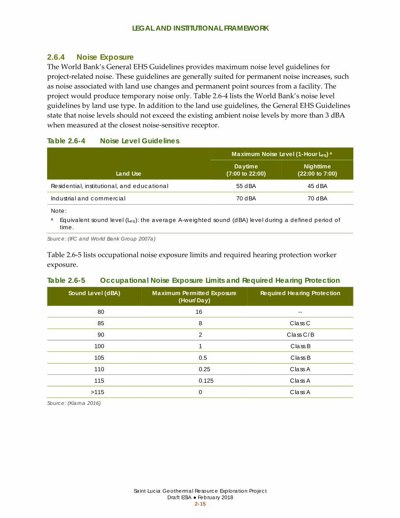
2.6.4 Noise Exposure The World Bank’s General EHS Guidelines provides maximum noise level guidelines for project-related noise. These guidelines are generally suited for permanent noise increases, such as noise associated with land use changes and permanent point sources from a facility. The project would produce temporary noise only. Table 2.6-4 lists the World Bank’s noise level guidelines by land use type. In addition to the land use guidelines, the General EHS Guidelines state that noise levels should not exceed the existing ambient noise levels by more than 3 dBA when measured at the closest noise-sensitive receptor.
Table 2.6-4 Noise Level Guidelines
Land Use
Maximum Noise Level (1-Hour Leq) a
Daytime (7:00 to 22:00)
Nighttime (22:00 to 7:00)
Residential, institutional, and educational 55 dBA 45 dBA
Industrial and commercial 70 dBA 70 dBA
Note: a Equivalent sound level (Leq): the average A-weighted sound (dBA) level during a defined period of
time.
Source: (IFC and World Bank Group 2007a)
Table 2.6-5 lists occupational noise exposure limits and required hearing protection worker exposure.
Table 2.6-5 Occupational Noise Exposure Limits and Required Hearing Protection Sound Level (dBA) Maximum Permitted Exposure
(Hour/Day) Required Hearing Protection
80 16 --
85 8 Class C
90 2 Class C/B
100 1 Class B
105 0.5 Class B
110 0.25 Class A
115 0.125 Class A
>115 0 Class A
Source: (Kiama 2016)

LEGAL AND INSTITUTIONAL FRAMEWORK
Saint Lucia Geothermal Resource Exploration Project Draft ESIA ● February 2018
2-16
This page is intentionally blank.
PROJECT DESCRIPTION
Saint Lucia Geothermal Resource Exploration Project Draft ESIA ● February 2018
3-1
3 PROJECT DESCRIPTION
3.1 OVERVIEW This section describes the drilling areas, project components, and activities that would be undertaken during implementation of the project.
3.2 POTENTIAL DRILLING AREAS The project would involve geothermal exploration drilling in the three areas shown on Figure 1.3-1. The geothermal exploration program would include drilling slim-diameter wells to obtain information on the geology and temperature gradient in the area. Deep geothermal wells may eventually be drilled with larger drilling rigs if the initial drilling is successful. The approach for selecting the specific locations of exploration wells, including their depth and diameter, would depend on a range of factors such as access to funds, land accessibility, environmentally and culturally sensitive areas, identification of feasible well pad locations, and eventual power plant development potential. The potential drilling areas shown on Figure 3.2-1, Figure 3.2-2, and Figure 3.2-3 include more land than would be needed during the geothermal exploration program. Larger areas were identified to provide flexibility for selecting suitable drilling sites.
3.2.1 Belle Plaine Belle Plaine has the most logistically favorable conditions for drilling and the fewest constraints of the three potential drilling areas due to the availability of flat open agricultural land near established roads (refer to Figure 3.2-1). The total area where project activities could be located is approximately 26.3 hectares (65.1 acres); however, only a small percentage of the total area would be needed (well pads require 0.1 to 1.6 hectares [0.25 to 4 acres]).
3.2.2 Mondesir-Saltibus Two medium-sized areas (MS-1 and MS-2) and two small-sized areas (MS-3 and MS-4) may be suitable for drilling in the vicinity of Mondesir-Saltibus. These areas are shown on Figure 3.2-2. MS-1 is approximately 6.5 hectares (16.1 acres) and is located on flat and open government-owned farmland. MS-2 is approximately 2.1 hectares (5.3 acres) and includes a soccer field and agricultural area within government-owned land. MS-3 and MS-4 are approximately 0.1 hectare (0.3 acre) and 0.2 hectare (0.5 acre), respectively. MS-3 is located adjacent to two residences on private property. MS-4 is located on a small private parcel adjacent to the road and has several residences nearby. Either slim-hole or full-sized well drilling may occur at MS-1 and MS-2. Due to the limited space, geothermal exploration at MS-3 and MS-4 would be limited to slim-hole well drilling.

PROJECT DESCRIPTION
Saint Lucia Geothermal Resource Exploration Project Draft ESIA ● February 2018
3-2
Figure 3.2-1 Potential Drilling Area near Belle Plaine
Source: (McElhanney Consulting Services LTD 2015)
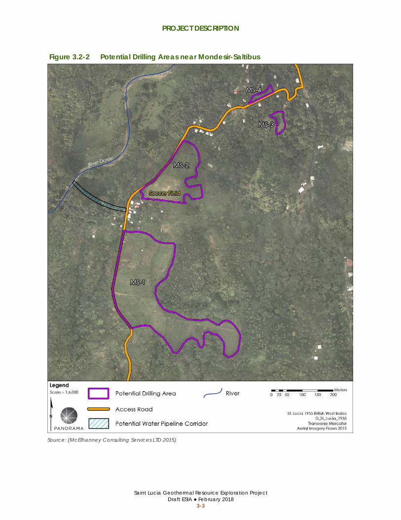
PROJECT DESCRIPTION
Saint Lucia Geothermal Resource Exploration Project Draft ESIA ● February 2018
3-3
Figure 3.2-2 Potential Drilling Areas near Mondesir-Saltibus
Source: (McElhanney Consulting Services LTD 2015)

PROJECT DESCRIPTION
Saint Lucia Geothermal Resource Exploration Project Draft ESIA ● February 2018
3-4
Figure 3.2-3 Potential Drilling Areas Near Fond St. Jacques
Source: (McElhanney Consulting Services LTD 2015)

PROJECT DESCRIPTION
Saint Lucia Geothermal Resource Exploration Project Draft ESIA ● February 2018
3-5
3.2.3 Fond St. Jacques There are limited locations that may be suitable for drilling within the Fond St. Jacques target area due to the density of residential development, steep terrain, and absence of flat and open areas to construct well pads. Two small areas that may be suitable for slim-hole wells within the Fond St. Jacques target area are shown on Figure 3.2-3. The western area is approximately 0.24 hectare (0.6 acre), is surrounded by residences, and is located on an unpaved parking area adjacent to the river. The eastern area is approximately 1.1 hectares (2.7 acres) and is located in an agricultural area near a residential community.
3.3 PROJECT COMPONENTS
3.3.1 Drilling Strategy The drilling strategy for the initial exploration phase will consist of drilling slim-hole wells in the resource target areas to evaluate sub-surface conditions and determine if there are indications of presence or absence of a commercially developable geothermal system.
The well drilling results will be evaluated before determining the next drilling location and well design. If the slim-hole drilling program indicates there may be a commercial resource, full-size geothermal wells could be drilled in Belle Plaine or the MS-1 and MS-2 areas. Full-size wells are not anticipated at Fond St. Jacques or the MS-3 and MS-4 areas due to an absence of flat open areas and the presence of residences in close proximity to the drilling area making access with a large drill-rig economically infeasible during this initial exploration stage. The deep geothermal wells would be used to further test and prove the presence of a commercial geothermal resource.
3.3.2 Site Development, Civil Works, and Supplies
Equipment and Material Sources Equipment and materials will be sourced locally, if available. It is expected that some equipment and materials would have to be shipped to Saint Lucia from nearby countries (most notably Central, South and North American countries). Shipped equipment and materials would be transported out of Port Vieux Fort and Hewanorra International Airport to the south, or Soufrière Bay to the West. Existing infrastructure at Port Vieux Fort and Hewanorra International Airport could accommodate project needs and is the preferred method of obtaining large equipment and materials for the project.
Soufrière Bay does not have a commercial seaport that could accommodate project needs; therefore, a temporary ramp consisting of a docking station with setup for loading and unloading boats and trucks would be constructed on the beach to unload and load equipment

PROJECT DESCRIPTION
Saint Lucia Geothermal Resource Exploration Project Draft ESIA ● February 2018
3-6
from the vessel. The decision whether to build this infrastructure will be based on logistic ease and economic value.
Access Roads The equipment and materials would be transported from the ports to the exploration target areas using a network of existing paved and unpaved roads, as well as new access roads within the drilling target areas. Existing roads may also be improved by increasing the width at certain sections to accommodate the turning radius for vehicles and drilling equipment, and by reinforcing unpaved roads leading to the Fond St. Jacques and Mondesir-Saltibus drilling target areas. Access roads would be improved or constructed as needed by removing trees and vegetation, grading, installing fill dirt, and/or installing gravel. If necessary, retaining walls along access roads would be installed or replaced consistent with engineering requirements. Fill material and gravel used for access roads would be purchased from local suppliers or shipped to the island from other CARICOM Countries. The anticipated volume of fill material and gravel is expected to be minor, given that the well pad locations would be chosen at sites close to existing roads. During the process of selecting well pad locations, the cost of new roads would be evaluated further by GoSL’s Department of Infrastructure. A unit cost estimate (i.e., cost per kilometer of new road) would be used to estimate the expected total cost for accessing well pads.
Access roads would be established with a width of approximately 4 to 6 meters (about 13 to 20 feet). Construction of new access roads would occur immediately before well pad development. A drilling rig capable of completing the slim-hole wells (e.g., a Boart Longyear LF230 diamond coring rig) is approximately 3 meters (about 10 feet) wide.
Existing bridges and culverts would be reinforced or replaced, where necessary. Temporary or permanent drainage crossings would be installed as needed to accommodate equipment access. These crossing could include bridges, culverts, steel plates, and rock. Temporary crossing materials would be removed from drainage crossings following construction. The primary access road network is shown on Figure 3.3-1.
Equipment and Material Storage Equipment and material storage sites would be developed near each drill pad or as close as possible if space is limited. The total space needed at each location would be approximately 0.1 to 0.2 hectare (0.25 to 0.5 acre). If necessary, storage sites would be cleared of vegetation and graded prior to use. Gravel and drainage materials may also be installed to facilitate all weather access. Equipment and materials at the storage sites would be transported to and from well pads and other project sites, as needed.
If necessary, a security fence and lighting would be installed around the storage sites, and security guards may be stationed at the sites.

PROJECT DESCRIPTION
Saint Lucia Geothermal Resource Exploration Project Draft ESIA ● February 2018
3-7
Figure 3.3-1 Primary Access Roads
Source: (ESRI 2017, ACP-EU Natural Disaster Risk Reduction Program 2016)

PROJECT DESCRIPTION
Saint Lucia Geothermal Resource Exploration Project Draft ESIA ● February 2018
3-8
Worker Camp If required, a worker camp would be established in the Belle Plaine/Fond St. Jacques area and another worker camp could be established in the Mondesir/Saltibus area to house the construction workforce during exploration activities in each area. The worker camp would house up to 50 workers and would include separate sleeping and bathing facilities for men and women, safe food and drinking water, air conditioning, first aid and medical facility, water storage, generators for electricity, and access to communication networks. Transportation from the worker camp to the project site will be provided.
If necessary, a security fence and lighting would be installed around the worker camp, and security guards may be stationed at the camp.
Well Pads Well pads would be developed at each drilling location where the drilling equipment and materials would be positioned. A well pad for a slim-hole well is typically much smaller than a full-sized well (approximately 40 by 30 meters or 0.1 hectare [0.25 acre]). Well pads for full-sized (deep) wells are generally 100 by 100 meters or approximately 0.8 to 1.6 hectares (2 to 4 acres) in size. Well pads generally include the equipment and components listed below; however, slim-hole well pads would include fewer and/or smaller components than full-sized wells. The differences between full-sized wells and slim-hole wells are described further in Section 3.3.3
• Drill rig • Well head • Blowout prevention equipment • Power supply engines • Fuel tanks • Accumulator • Pipe racks • Drilling mud tanks
• Drilling mud pumps • Water storage tanks • Water supply pipelines • Mixing tanks • Reserve pit • Office space • Storage space • Fire-fighting equipment • Parking space
Well pad development would include removing vegetation (including trees). The ground surface would be prepared by grading, compacting soil, and installing a layer of gravel. Gravel used for the well pads would be purchased from local suppliers. The typical layouts of a full-sized well and slim-hole well are show on Figure 3.3-2 and Figure 3.3-3, respectively.
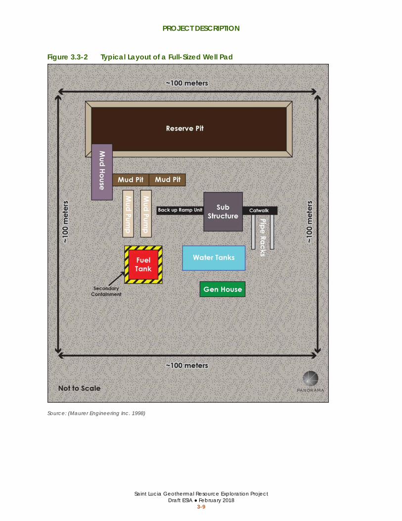
PROJECT DESCRIPTION
Saint Lucia Geothermal Resource Exploration Project Draft ESIA ● February 2018
3-9
Figure 3.3-2 Typical Layout of a Full-Sized Well Pad
Source: (Maurer Engineering Inc. 1998)

PROJECT DESCRIPTION
Saint Lucia Geothermal Resource Exploration Project Draft ESIA ● February 2018
3-10
Figure 3.3-3 Typical Layout of a Slim-Hole Well Pad
Source: (Maurer Engineering Inc. 1998)

PROJECT DESCRIPTION
Saint Lucia Geothermal Resource Exploration Project Draft ESIA ● February 2018
3-11
3.3.3 Well Drilling As described in Section 3.3.1, the proposed project includes drilling exploratory slim-hole wells at the potential drilling areas; however, the option for drilling full-sized wells is also included. For comparison purposes, Table 3.3-1 lists some of the key differences between slim-hole wells and full-sized wells.
Table 3.3-1 Comparison of Potential Drilling Operations Component Slim-hole Wells Full-sized Wells
Well Pad Dimensions 40 x 30 meters (0.12 hectare) (130 x 100 feet; 0.3 acre)
100 x 100 meters (0.2 hectare) (330 x 330 feet; 0.5 acre)
Drill Rig Dimensions 12 x 4 meters (40 to 13 feet) a 20 x 10 meters (66 to 33 feet) b
Minimum Access Road Width 4 to 5 meters (12 to 16 feet) 6 to 7 meters (18 to 24 feet)
Well Diameter at Depth 3.78 inches 7 inches
Target Depth 1,200 to 2,000 meters (4,000 to 6,600) feet)
2,000 to 3,000 meters (6,600 to 9,850 feet)
Estimated Water Demand during Drilling
3 to 5 liters per second (up to 45 days)
20 to 30 liters per second (up to 90 days)
Drilling Materials • Drilling mud/fluid • Casing • Cement
• Drilling mud/fluid • Casing • Cement
Drill Cuttings/Waste Storage • Tanks or lined sumps • Lined sumps
Drilling Period 30 to 45 days (up to 24 hours per day)
30 to 90 days (up to 24 hours per day)
Geothermal Resource Testing • Temperature gradient • Potential for injectivity and
production testing
• Injectivity and production testing
Testing Period 30 days (up to 24 hours per day)
30 to 90 days (up to 24 hours per day)
Notes: a Dimensions for the anticipated drill rig (Boart Longyear LF230 or similar). b Approximate dimensions for a conventional drill rig.
Sources: (GeothermEx and Power Engineers 2017)
The exploration slim-holes are planned to be drilled using a combination of rotary and diamond coring drilling techniques. A diamond coring rig that is equipped to rotary drill is the ideal rig type to complete these wells. The wells are planned to reach a total depth of 1,200 to 1,500 meters (approximately 4,000 to 5,000 feet), with the option to drill to 2,000 meters (in HQ or NQ core diameter). The deepest cemented casing string will be set to approximately 750 meters depth (approximately 2,500 feet). A blowout-preventer (BOP) would be installed above the 7-inch casing, which will be set to a depth of approximately 250 meters (approximately 820 feet). If full-sized exploration wells are drilled, they would be

PROJECT DESCRIPTION
Saint Lucia Geothermal Resource Exploration Project Draft ESIA ● February 2018
3-12
approximately 48 inches in diameter at the top of the well and narrow (telescope) to approximately 7 inches at the bottom of the well.
Examples of drill rigs for a slim-hole well and full-sized well are shown on Figure 3.3-4 and Figure 3.3-5, respectively.
Drilling would require water to cool the drill and wash drill cuttings from the drill bit.2 The final volumes required will be defined after selection of the drilling rig and hydraulics calculations are completed.
Wells would be drilled using water and non-toxic drilling mud. Variable concentrations of non-toxic additives (drilling fluid) would be introduced to the drilling mud as needed to prevent corrosion, increase mud weight, and prevent mud loss. Additional drilling mud would be mixed and added to the mud system as needed to maintain the required mud quantities.
All drill cuttings and drilling fluid would be discharged to a reserve pit or tank. After drill cuttings settle, the drilling fluid would be disposed of in a shallow well or open reserve pits. Drill cuttings would be left in the reserve pit if found to be non-toxic after testing. The volume of cuttings produced from each exploration slim-hole well is estimated to be approximately 21 cubic meters (approximately 70 cubic feet). The final sump dimensions would be designed to handle all cuttings and mud that is not re-circulated.
An exploration well may need to be re-drilled or worked-over if problems occur that prevent completion of the well. Potential problems may include mechanical malfunctions, difficulty setting the casing, or limited permeability, productivity, or injectivity. The well may be re-drilled by re-entering and re-drilling the existing well bore, or moving the drill rig to a different location on the well pad and drilling a new well through a new conductor casing. Each well will be equipped with a well head and operating valve.
3.3.4 Geothermal Resource Testing Testing for the presence or absence of an exploitable geothermal reservoir will be conducted after each well is completed. Depending on the final depth and characteristics of each well, these tests would include downhole temperature measurements, injection testing or production testing. Temperature-gradient measurements will be completed periodically for weeks after completion, after the drilling rig is off the location.
2 Drilling operations for the deeper sections of each well require relatively small amounts of water flow, whereas the larger hole diameters near surface require significantly more water flow for hole cleaning.

PROJECT DESCRIPTION
Saint Lucia Geothermal Resource Exploration Project Draft ESIA ● February 2018
3-13
Figure 3.3-4 Example Well Pad and Drill Rig for a Slim-hole Well
Source: (Boart Longyear 2017)
Figure 3.3-5 Example Well Pad and Drill Rig for a Full-sized Well
Source: (n.d. 2017)

PROJECT DESCRIPTION
Saint Lucia Geothermal Resource Exploration Project Draft ESIA ● February 2018
3-14
Wells that encounter elevated temperature and permeability at depth may be completed with a slotted liner. Short-term production and/or injection tests may be completed to assess sub-surface conditions. This testing will occur immediately upon completion of the well, and will require the drill rig to remain on site.
If deep exploration wells are drilled and successfully encounter the geothermal reservoir, well and reservoir testing would be conducted to analyze characteristics of the resource. One or more initial short-term flow tests would occur at each exploration well, and one or more long-term flow tests will occur after the completion of all wells to assess the productivity of the geothermal reservoir and to sample the geothermal fluid. One or more short-term tests will be conducted to test any shallow reservoir transected by the slim-hole wells.
The well bore would ideally be cleared of all residual drilling mud and drill cuttings prior to conducting a well production test. Air may be injected to facilitate the well to flow. The geothermal fluids would be allowed to flow from the exploration well into an atmospheric separator, where temperature, pressure, flow rate, and chemical composition are monitored. The separated water would be discharged to tanks and steam would be released to the atmosphere through a silencer. The silencer may be a rock muffler or a larger diameter pipe. An injectivity test may also be performed by injecting the extracted geothermal fluid back into the exploration well. A long-term flow test may be performed, if warranted, to measure the flow temperature, pressure, and chemistry over time. The decision to conduct a long-term flow test will depend on wellbore conditions, benefits from the data obtained, and casing integrity.
3.3.5 Well Abandonment and Site Reclamation The commercial potential of each exploration well would be assessed after testing. The well will not be abandoned if it is determined to have long-term use as a production well, monitoring well, or injection well. Equipment would be removed and the site cleared of excess material. The wellhead will remain in place for future testing, monitoring, or production.
If a well is not determined to have commercial potential, monitoring of the well may continue or the well may be abandoned. Well abandonment typically involves plugging the well bore with enough cement to ensure that fluid in the reservoir would not flow into different aquifers; the casing would remain in place. Any wellhead equipment would be removed from the well, and a metal cap would be welded to the casing.
The well pad sites would then be graded as necessary to restore the sites to the approximate original topography.
3.4 WATER DEMAND The project would require fresh water for the workforce and to support well pad compaction and well drilling. Potable water would be obtained from WASCO or a local vendor. Estimated water use during well drilling is provided in Table 3.3-1.

PROJECT DESCRIPTION
Saint Lucia Geothermal Resource Exploration Project Draft ESIA ● February 2018
3-15
Water for drilling at Belle Plaine would either be piped in from the adjacent Migny River or tributaries, piped in from local water tanks, or trucked in from other local sources as approved by WASCO. If necessary, a water well would be developed to provide water for the well drilling.
Water for drilling at Mondesir-Saltibus would be piped in from the River Doree or tributaries downstream of WASCO's main raw water intake. Depending on the specific location of the well pads, either a temporary water pipeline would be installed between the raw water sources and well locations along the road and water access corridor (as shown on Figure 3.2-2), or the water would be transported via a small water truck from the river to the well pad. The final decision will be based on logistics and economics. Water could also be piped in from local water tanks or trucked in from other sources.
Water for drilling at Fond St. Jacques would either be piped in from the Soufrière River or tributaries downstream of WASCO’s three raw water intakes, piped in from water local tanks, or trucked in from other sources.
3.5 EROSION AND SEDIMENT MANAGEMENT Best management practices (BMPs) for erosion and sediment control would be developed during the project design. BMPs would be used to stabilize loose soil and control sediment. Typical BMP materials installed on construction sites include fiber matting, hydroseed, mulch, straw wattles, silt fencing, rock bags, and hay bales. Typical BMP procedures implemented on construction sites include wetting loose, dry soil during ground disturbance; preventing soil track-out onto paved roadways; and covering truck loads when transporting soil.
3.6 HAZARDOUS MATERIAL MANAGEMENT Hazardous materials, such as fuels, oils, and lubricants for construction equipment, would be stored in the designated storage area. Used oil would be gathered and stored in tanks at the storage area until it could be transported off site and disposed of at a facility that can accept hazardous materials. A roof would be installed over a portion of the storage area to protect construction materials from the rain. Wells would be drilled with water and non-toxic drilling mud. Hazardous materials would be transported, handled, and stored in accordance with applicable laws of Saint Lucia, World Bank General EHS Guidelines Section 1.5 (2007a), and World Bank EHS Guidelines for Geothermal Power Generation Section 1.1 (2007b).
3.7 WASTE AND EFFLUENT DISPOSAL All drill cuttings and drilling fluid would be discharged to the reserve pit or tanks. Drill cuttings would be left in the reserve pit. Fluids and solids would be tested to determine the chemical composition and identify any materials that may be hazardous. Any drill cuttings that exceed the toxicity threshold for hazardous waste would be treated as hazardous waste and disposed of off-site.

PROJECT DESCRIPTION
Saint Lucia Geothermal Resource Exploration Project Draft ESIA ● February 2018
3-16
Latrines for workers would be constructed on the project site and would be maintained in a clean condition. A septic tank system would be installed to manage the wastewater from the worker camp.
Trash would be maintained in covered receptacles at the well pads, storage area, and worker camp. Non-hazardous waste would be disposed of at an authorized landfill in either Vieux Fort or Castries.
3.8 SCHEDULE AND WORKFORCE The anticipated project schedule and workforce are summarized in Table 3.8-1. The anticipated work hours for project activities are summarized in Table 3.8-2.
Table 3.8-1 Anticipated Workforce and Schedule Activities Schedule Workforce
Access Establishment and Site Development 0 to 3 months Up to 50
Well Drilling (per well) 1 to 3 months Up to 50
Well Testing (per well) 0 to 3 months Up to 50
Well Abandonment and Pad Reclamation 1 month Up to 50
Grand Total 2 to 10 months Up to 50
Table 3.8-2 Anticipated Workhours per Day Activities Hours
Access Establishment and Site Development 7:00 to 19:00
Well Drilling 24 hours
Well Testing 24 hours
Well Abandonment and Pad Reclamation 7:00 to 19:00
Note: Proposed workhours would be the same on weekdays and weekends for all activities.

BASELINE DATA/EXISTING ENVIRONMENT
Saint Lucia Geothermal Resource Exploration Project Draft ESIA ● February 2018
4-1
4 BASELINE DATA/EXISTING ENVIRONMENT
4.1 OVERVIEW A comprehensive scoping studies report was prepared for the project prior to development of the ESIA to obtain and evaluate information about the existing environmental and social conditions within the project influence area. This section summarizes the baseline/existing conditions that may be at risk or impacted by the project based on the results of the Scoping Studies Report. The complete Scoping Studies Report is provided in Appendix C. The Scoping Studies Report provides additional detail on baseline data and conditions in the project area including the data sources, study methods and data gaps.
4.2 ENVIRONMENTAL CONDITIONS
4.2.1 Water Resources
Water Supply
Surface Water Resources The Belle Plaine drilling site is located within the Choiseul/Trou-Barbet watershed. The Choiseul and Trou Barbet rivers flow through or adjacent to the potential drilling area from south to north. The drilling area drains to the east and north within the valley. Storage tanks that are used to contain runoff water are present in the potential drilling area. Water in Belle Plaine area is primarily managed for agricultural activities. Streams along the western flank of the valley contained minimal flow during field investigation during the rainy season and these streams likely run dry for portions of the year. No springs or ponding of surface water was observed within the valley.
The Mondesir-Saltibus sites are located within the Doree and Balembouche watersheds. The rivers are located to the west and to the east of the potential drilling area. The river located to the west of the potential drilling area maintains perennial flow. There is limited water supply infrastructure other than cemented roadside drainage ditches and pipes that supply water to the population.
The Fond St. Jacques potential drilling areas are located within the Soufrière watershed. The river borders the Fond St. Jacques drilling area. The river supplies water to a local water storage tank that serves as the primary water source for the Fond St. Jacques community. Buried pipelines convey water from the water storage tanks to the community. Two springs are located in the foothills on the southeastern flank of the potential drilling areas. The water that comes

BASELINE DATA/EXISTING ENVIRONMENT
Saint Lucia Geothermal Resource Exploration Project Draft ESIA ● February 2018
4-2
from these springs is stored in tanks (see Figure 4.2-1) and supplies the adjacent communities of Fond St. Jacques and Soufrière with freshwater.
Community members in Fond St. Jacques/Belvedere indicated that the spring water is extremely important to them as a “back-up” water supply, particularly during public water shortages and natural disasters, such as Hurricane Tomas when WASCO’s supplies had been damaged. Some individuals indicated that their spring water supplies are piped alongside WASCO’s pipelines and into their households. One respondent reported that since Hurricane Tomas, spring water, instead of WASCO’s water, was now piped to the household for domestic purposes (except drinking).
A household survey conducted in 2017 indicated that the majority of households in all the affected communities use mainly public pipe-borne water supplied by WASCO as their primary source of water for domestic purposes, which is generally considered good quality and reliable. Rainwater harvesting tanks/containers were also used by most households. Spring water was generally used for other non-drinkable domestic purposes and farming in all the communities. A few households also reported using a combination of public standpipe, spring, and river water.
Figure 4.2-1 Water Storage Infrastructure in Fond St. Jacques
Source: (Appendix E, Scoping Studies Report 2017)

BASELINE DATA/EXISTING ENVIRONMENT
Saint Lucia Geothermal Resource Exploration Project Draft ESIA ● February 2018
4-3
Groundwater No groundwater investigations have been performed in the project area and there is no reported use of groundwater resources for water supply in the area. Rainwater runoff from topographically high areas, including the mountains surrounding Belle Plaine and Fond St. Jacques, recharge groundwater aquifers in the valleys. The groundwater aquifers in the project areas are expected to be limited in size and volume due to the volcanic nature of the geology in the project areas and the small basin and alluvial area that could contribute to the groundwater system. Groundwater aquifers typically occur in areas with underlying sedimentary soils; volcanic bedrock is not conducive to groundwater storage.
Geothermal Resource The geothermal aquifer is naturally separated from the groundwater aquifer by aquitards, which limit infiltration and cross-contamination of geothermal resources with surface water or shallow groundwater resources. Jacobs (Jacobs New Zealand Limited 2016) developed a conceptual hydrogeological model of the area of influence (shown in Figure 4.2-2). The conceptual model shows the presence of a clay layer, which suppresses surface expression of the geothermal system. The cool groundwater aquifer is perched above the clay layer. The hydrothermal alteration appears to occur at relatively shallow depths just at or below sea level. Surface manifestation of the geothermal resource occurs along fractures where there is upflow, such as in the vicinity of Ravine Claire Spike Falls.
Figure 4.2-2 Schematic Conceptual Hydrogeologic Model
Source: (Jacobs 2016)

BASELINE DATA/EXISTING ENVIRONMENT
Saint Lucia Geothermal Resource Exploration Project Draft ESIA ● February 2018
4-4
Water Quality The water quality of Saint Lucia’s rivers has declined considerably in recent years due to an increase in agriculture, especially banana cultivation. Research carried out by the River Surveillance Monitoring Project (Lloyd et al. 1996) concluded that the variable that most affects Saint Lucia’s ecosystems is the intensification of agriculture in combination with deforestation near water sources. Recent water quality studies conducted by the WRMA (Water Resources Management Agency of Saint Lucia 2010-2016) in the Fond St. Jacques and Saltibus areas indicate the presence of coliform in the local drinking water supply; however, water from both sites is within the range of what is allowed by the WHO for inorganic constituents.
4.2.2 Air Quality
Project Area Ambient Air Quality Ambient air quality was measured for a 20-day period in the vicinity of the project. Low ambient concentrations of nitrogen dioxide (NO2), Sulphur dioxide (SO2), and hydrogen sulfide (H2S) were measured near the project areas. The 20-day average concentrations were well below the World Health Organization (WHO) Guidelines. WHO guidelines specify 10-minute maximum concentrations of 500 µg/m3 for SO2, a 1-hour average of 40 µg/m3 for NO2 and a 30-minute average of 7 µg/m3 for H2S.
Naturally Occurring Geothermal Emissions Geothermal systems may contain gases that are potentially hazardous to human health. The most common gases in geothermal systems include: carbon dioxide (CO2) and hydrogen sulphide (H2S). People visiting Sulphur Springs and other areas of fumarolic activity with uncontrolled naturally occurring emissions in Saint Lucia are at the greatest risk for exposure to geothermal gas emissions (Jan Lindsay 2002). There have been reports of people and animals dying from CO2 inhalation associated with geothermal systems in the Caribbean, including Saint Lucia (Jan Lindsay 2002).
Ambient concentrations of SO2 and H2S at Sulphur Springs were substantially higher than concentrations in the project vicinity. H2S concentrations at Sulphur Springs were 29.24 µg/m3, which exceeds WHO guidelines of 7 µg/m3. It should be noted that the WHO guidelines are for annoyance, with potential eye irritation likely caused when concentrations reach 150 µg/m3 or above. A 20-day SO2 average concentration of 292 µg/m3 was measured at the Sulphur Springs site. This average SO2 concentration was below WHO guidelines and in line with concentrations measured during the University of West Indies Study, which showed monthly average concentrations ranging from 177 to 623 µg/m3 between April and December 2014. The higher concentrations measured at this site are representative of emissions at the fumarole where there is venting of the geothermal gases.
4.2.3 Geology and Soils Belle Plaine is located in a wide, flat valley surrounded by steep mountains. Geologically, this area is characterized by pumiceous, pyroclastic flow deposits. The soil is used for agricultural production, including bananas, cocoa, and coconuts.
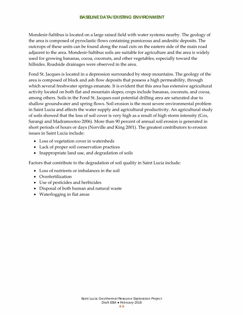
BASELINE DATA/EXISTING ENVIRONMENT
Saint Lucia Geothermal Resource Exploration Project Draft ESIA ● February 2018
4-5
Mondesir-Saltibus is located on a large raised field with water systems nearby. The geology of the area is composed of pyroclastic flows containing pumiceous and andesitic deposits. The outcrops of these units can be found along the road cuts on the eastern side of the main road adjacent to the area. Mondesir-Saltibus soils are suitable for agriculture and the area is widely used for growing bananas, cocoa, coconuts, and other vegetables, especially toward the hillsides. Roadside drainages were observed in the area.
Fond St. Jacques is located in a depression surrounded by steep mountains. The geology of the area is composed of block and ash flow deposits that possess a high permeability, through which several freshwater springs emanate. It is evident that this area has extensive agricultural activity located on both flat and mountain slopes; crops include bananas, coconuts, and cocoa, among others. Soils in the Fond St. Jacques east potential drilling area are saturated due to shallow groundwater and spring flows. Soil erosion is the most severe environmental problem in Saint Lucia and affects the water supply and agricultural productivity. An agricultural study of soils showed that the loss of soil cover is very high as a result of high storm intensity (Cox, Sarangi and Madramootoo 2006). More than 90 percent of annual soil erosion is generated in short periods of hours or days (Norville and King 2001). The greatest contributors to erosion issues in Saint Lucia include:
• Loss of vegetation cover in watersheds • Lack of proper soil conservation practices • Inappropriate land use, and degradation of soils
Factors that contribute to the degradation of soil quality in Saint Lucia include:
• Loss of nutrients or imbalances in the soil • Overfertilization • Use of pesticides and herbicides • Disposal of both human and natural waste • Waterlogging in flat areas

BASELINE DATA/EXISTING ENVIRONMENT
Saint Lucia Geothermal Resource Exploration Project Draft ESIA ● February 2018
4-6
4.2.4 Noise Existing daytime ambient noise levels were measured in the project area of influence. The documented noise levels were consistent with a rural environmental where the noise sources are predominantly natural (e.g., wind, water, wildlife, and farm animals). Other noise sources included mobile (e.g., traffic) and stationary sources encountered along roadways. Table 4.2-1 provides the average and the extreme high and low noise levels measured at representative locations near each potential drilling area during daytime hours. Ambient noise levels at night are typically lower than during the daytime (approximately 10 A-weighted decibels3 [dBA] less).
There are numerous residents living in the vicinity of the potential drilling areas, which are considered noise-sensitive receptors. Residences within 304.8 meters (1,000 feet) of the potential drilling areas are shown on Figure 4.2-3 through Figure 4.2-5.
Table 4.2-1 Existing Daytime Ambient Noise Levels Area of Impact
Average (dBA)
Range (dBA)
Extreme Noise Sources during Measurements
Belle Plaine 45 - 60 30 - 88
The high noise measurement at Belle Plaine was recorded within 20 meters from a running diesel engine flatbed 4 axle truck that was idling throughout the duration of the noise measurement.
Fond St. Jacques
45 - 71 38 - 105 The high noise level was measured in the courtyard of the Fond St. Jacques primary school at the end of the school day at approximately 15:00 when children were present and yelling and interacting with the microphone equipment from a short distance.
Mondesir-Saltibus
43 - 60 30 - 120 A large diesel engine truck on the main N-S road near the noise monitoring station passed by during the recording.
Source: (Dewhurst Group 2017)
3 The A-weighted sound level (dBA) is a noise measurement that deemphasizes the very low- and very high-frequency components of the sound, which reflects how the human ear perceives sound.
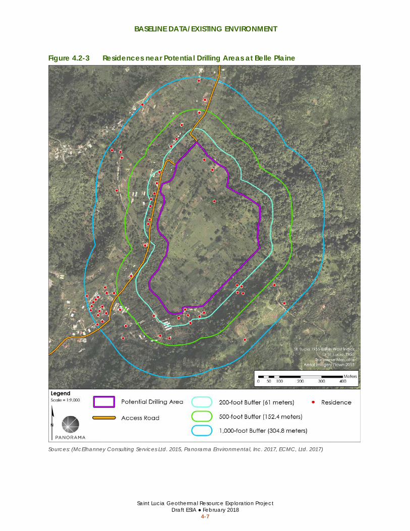
BASELINE DATA/EXISTING ENVIRONMENT
Saint Lucia Geothermal Resource Exploration Project Draft ESIA ● February 2018
4-7
Figure 4.2-3 Residences near Potential Drilling Areas at Belle Plaine
Sources: (McElhanney Consulting Services Ltd. 2015, Panorama Environmental, Inc. 2017, ECMC, Ltd. 2017)

BASELINE DATA/EXISTING ENVIRONMENT
Saint Lucia Geothermal Resource Exploration Project Draft ESIA ● February 2018
4-8
Figure 4.2-4 Residences near Potential Drilling Areas at Mondesir-Saltibus
Sources: (McElhanney Consulting Services Ltd. 2015, Panorama Environmental, Inc. 2017, ECMC, Ltd. 2017)
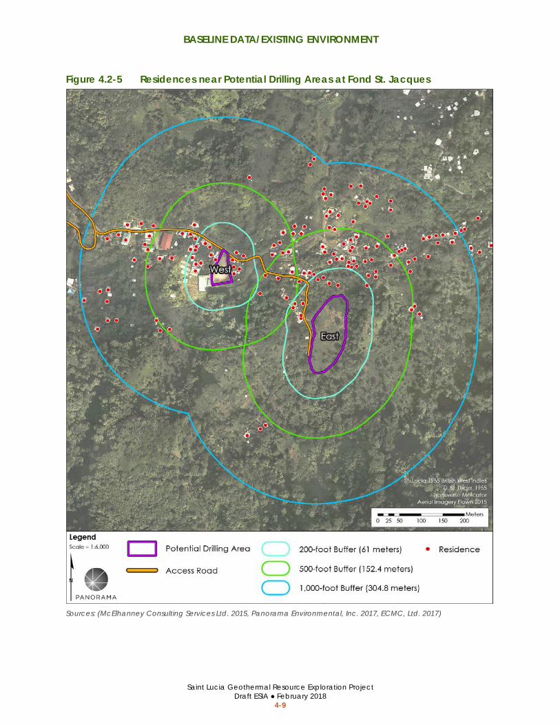
BASELINE DATA/EXISTING ENVIRONMENT
Saint Lucia Geothermal Resource Exploration Project Draft ESIA ● February 2018
4-9
Figure 4.2-5 Residences near Potential Drilling Areas at Fond St. Jacques
Sources: (McElhanney Consulting Services Ltd. 2015, Panorama Environmental, Inc. 2017, ECMC, Ltd. 2017)

BASELINE DATA/EXISTING ENVIRONMENT
Saint Lucia Geothermal Resource Exploration Project Draft ESIA ● February 2018
4-10
4.2.5 Natural Habitats and Biodiversity Flora and fauna species observed within the project area of influence are provided in the Scoping Studies Report (Appendix C). No endangered or priority floristic, mammalian, herpetofauna, or insect species were encountered during surveys of the project areas and adjacent area of influence. Several endangered and priority birds were encountered in the forest habitat adjacent to Belle Plaine and Mondesir-Saltibus (see discussion below).
Vegetation Communities/Habitat Characteristics The dominant land use/vegetation types in each drilling area are shown on Figure 4.2-6 through Figure 4.2-8. The dominant vegetation types and habitat characteristics of each project area are summarized in Table 4.2-2, below. The drilling areas were characterized by a lack of native habitats or vegetation communities. Belle Plaine, Mondesir-Saltibus, and Fond St. Jacques East areas are subject to widespread agricultural production. The Fond St. Jacques West area has been developed/disturbed and generally lacks natural vegetation or habitat. Native forest habitat occurs along the border of the Belle Plaine and Mondesir-Saltibus project areas. Vegetation surveys have not been completed within the MS-3 or MS-4 sites, but the sites appear disturbed from agricultural use or adjacent residential uses.
Fauna Table 4.2-3 provides a summary of the common faunal species documented in each project area and surrounding area of influence (i.e., habitat areas within approximately 300 meters [1,000 feet] of the potential drilling sites). The drilling areas were characterized by a lack of native habitats. Belle Plaine, Fond St. Jacques East and West, and MS-2 were very similar in composition of faunal community with many of the same bird, mammalian, herpetofauna, and insect species due to similar habitat conditions within and surrounding the drilling areas. The drilling areas were characterized by a lack of suitable habitat; however, the surrounding forested edge provides natural habitat for bird species. Fauna surveys were not completed within MS-3 or MS-4, but the areas are expected to have similar fauna species to MS-1 and MS-2 due to the proximity of the areas.
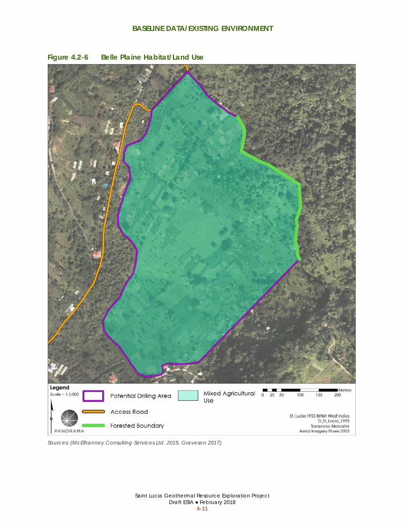
BASELINE DATA/EXISTING ENVIRONMENT
Saint Lucia Geothermal Resource Exploration Project Draft ESIA ● February 2018
4-11
Figure 4.2-6 Belle Plaine Habitat/Land Use
Sources: (McElhanney Consulting Services Ltd. 2015, Graveson 2017)

BASELINE DATA/EXISTING ENVIRONMENT
Saint Lucia Geothermal Resource Exploration Project Draft ESIA ● February 2018
4-12
Figure 4.2-7 Mondesir-Saltibus Habitat/Land Use (MS-1 and MS-2 Only)
Sources: (McElhanney Consulting Services Ltd. 2015, Graveson 2017)

BASELINE DATA/EXISTING ENVIRONMENT
Saint Lucia Geothermal Resource Exploration Project Draft ESIA ● February 2018
4-13
Figure 4.2-8 Fond St. Jacques Habitat/Land Use
Sources: (McElhanney Consulting Services Ltd. 2015, Graveson 2017)

BASELINE DATA/EXISTING ENVIRONMENT
Saint Lucia Geothermal Resource Exploration Project Draft ESIA ● February 2018
4-14
Table 4.2-2 Habitat and Dominant Floristic Species by Area
Area Name Description of Vegetation/Habitat
Conditions Dominant Vegetation
Belle Plaine The Belle Plaine area has been cleared of all natural forest and replaced by agriculture. The area was previously intensively farmed with bananas and is now largely abandoned with open herbaceous areas punctuated by remnant Musa cultivars (bananas and plantains) and mature fruit trees. Small plots with a market gardening type of agriculture are located in small areas. Cows graze on the site and several substantial wall houses are under construction in the area. The area is bordered on the western side by a steep forested hill
The area is covered predominantly by weedy flora of grasses, herbs and shrubs. The majority are native species, but many are naturalized species. Widely spaced throughout the open areas are cultivated fruit trees including Erythrina poeppigiana, Gmelina and pines, and mahogany. There are also many clumps of Musa cultivars (bananas and plantains). A few ornamental trees occur on the site including Ficus bejamina, Bougainvillea, Saman trees and Heliconia wagneriana which have become naturalized.
MS-1 The MS-1 area is a formerly intensive agricultural area that is now limited to sparse cultivation. There are many common weedy herbs and shrubs found on the site.
The area is dominated by herbs and shrubs including Andropogon bicornis, Urena lobata and Ipomoea tiliacea along with grasses such as Andropogon bicornis, Cenchrus purpureus, Chloris ciliata and Eragrostis pilos. Additional cultivated vegetables and fruit trees are present.
MS-2 The MS-2 area is a formerly intensive agricultural area that is now limited to sparse cultivation. There are many common weedy herbs and shrubs found on the site.
The area is dominated by herbs and shrubs including Andropogon bicornis, Urena lobata and Ipomoea tiliacea along with grasses such as Andropogon bicornis, Cenchrus purpureus, Chloris ciliata and Eragrostis pilos. Additional cultivated vegetables and fruit trees are present.
MS-3 The site is located approximately 90 meters (300 feet) southwest of the Saltibus/Parc Estate road junction. The surface is roughly rectangular with dimensions approximately 100 meters (330 feet) by 60 meters (200 feet). The topography is flat with very good surface features and is not under dense vegetation. The existing land use is agricultural and residential (two houses); the immediate surrounding land use is agricultural.
Similar to MS-1 and MS-2 (no biological surveys have been completed in the area).
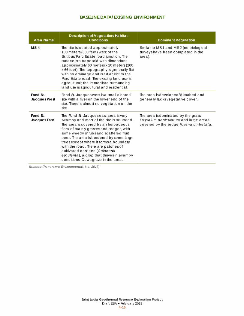
BASELINE DATA/EXISTING ENVIRONMENT
Saint Lucia Geothermal Resource Exploration Project Draft ESIA ● February 2018
4-15
Area Name Description of Vegetation/Habitat
Conditions Dominant Vegetation
MS-4 The site is located approximately 100 meters (330 feet) west of the Saltibus/Parc Estate road junction. The surface is a trapezoid with dimensions approximately 60 meters x 20 meters (200 x 66 feet). The topography is generally flat with no drainage and is adjacent to the Parc Estate road. The existing land use is agricultural; the immediate surrounding land use is agricultural and residential.
Similar to MS-1 and MS-2 (no biological surveys have been completed in the area).
Fond St. Jacques West
Fond St. Jacques west is a small cleared site with a river on the lower end of the site. There is almost no vegetation on the site.
The area is developed/disturbed and generally lacks vegetative cover.
Fond St. Jacques East
The Fond St. Jacques east area is very swampy and most of the site is saturated. The area is covered by an herbaceous flora of mainly grasses and sedges, with some weedy shrubs and scattered fruit trees. The area is bordered by some large trees except where it forms a boundary with the road. There are patches of cultivated dasheen (Colocasia esculenta), a crop that thrives in swampy conditions. Cows graze in the area.
The area is dominated by the grass Paspalum paniculatum and large areas covered by the sedge Fuirena umbellata.
Sources: (Panorama Environmental, Inc. 2017)

BASELINE DATA/EXISTING ENVIRONMENT
Saint Lucia Geothermal Resource Exploration Project Draft ESIA ● February 2018
4-16
This page is intentionally left blank.

BASELINE DATA/EXISTING ENVIRONMENT
Saint Lucia Geothermal Resource Development Project Draft ESIA ● February 2018
4-17
Table 4.2-3 Faunal Species and Conditions in the Area of Influence Area Name Birds Mammals Herpetofauna Insects
Belle Plaine A total of 36 species were detected in the Belle Plaine area and surroundings. The majority of the detected species are resident species, with the exception of two, the Sand spotted sandpiper and the barn swallow. Five endemic birds occurred in the area; two of the Saint Lucian endemics were uncommon for the site. Nine priority species were found occurring in the forested area adjacent to the site, four of which are classified as endangered species of birds. The priority species observed include: • Saint Lucia Parrot (Amazona versicolor) • Saint Lucia Black finch (Melanospiza richardsoni) • Saint Lucia Oriole (Icterus laudabilis) • House Wren (Troglodytes aedon mesoleucus) • Saint Lucia Warbler (Dendroica delicata) • Saint Lucia Pewee (Contopus oberi) • Lesser Antillean Saltator (Saltator albicollis albicollis) • Lesser Antillean Flycatcher (Myiarchus oberi
sanctaeluciae) • Grey trembler (Cinclocerthia gutturalis macrorhyncha)
Mongoose (Herpestes suropuntatus) was recorded in the area. Mongoose was introduced to Saint Lucia and is classified as invasive wildlife. Two species of bats were observed in the study area including: • Fruit bats (Monophyllus plethodon) • Insectivorous bats (Bracyphyllus cavernum)
These species are not considered endangered.
Five reptile species were recorded in the study area, including the endemic Saint Lucia anolis lizard (Anolis luciae). Other reptiles included: • Common house gecko (Hemidactylus
mabouia) • Slipperyback skink, known as Zandoli tarre
(Gymnopthalmus pleei)
Butterflies, dragonflies, and bees were common insects observed in the study area. Common butterfly species included: • Southern great white • White peacock • Common long tail skipper • Tropical chequered skipper • Ocola skipper • Fiery skipper • False barred sulphur • Spreadwing skipper • Caribbean buckeye • Southern broken dash • Hannos blues
MS-1 A total of 20 species of birds were recorded in the MS-1 study area. The bird species encountered were very similar to Belle Plaine and Fond Saint Jacques East, owing to the similar biodiversity and rich ecotone in the forest edge surrounding the potential drilling sites, which provide an ideal habitat. Four of these species are classified as priority species, two of which are Saint Lucia endemic species: Saint Lucia pewee (Contopus oberi) and Saint Lucia warbler. Both Saint Lucian endemics were common for the site, which is consistent at the national level.
None Three reptile species were recorded in the study area, including: • Saint Lucia anolis lizard (Anolis luciae) • Common House Gecko (Hemidactylus
mabouia) • Slipperyback Skink, known as Zandoli tarre
(Gymnopthalmus pleei)
Very few insects were observed and none were identified to a species level.
MS-2 A total of 15 bird species, which include two priority species,the Saint Lucia warbler and Lesser Antillean saltator, were observed in the MS-2 study area. The Saint Lucia warbler (dendroica delicata), is classified as endemic to Saint Lucia, but is considered of Least Concern in accordance with the IUCN Red List Category & Criteria (2016)
None None
Fond St. Jacques West
There were very few faunal species on the Fond St. Jacques West site due to the lack of vegetation to provide habitats for these species. Bird species encountered included: • Carib grackle • Lesser Antillean bull finch • Common ground dove • Zenaida dove
These species are very common on the island and are adapted to open areas.
None None None

BASELINE DATA/EXISTING ENVIRONMENT
Saint Lucia Geothermal Resource Development Project Draft ESIA ● February 2018
4-18
Area Name Birds Mammals Herpetofauna Insects
Fond St. Jacques East
A total of 29 bird species were detected in the Fond St. Jacques east area. The majority of the detected bird species are resident species. Five Saint Lucia endemic species were observed during surveys. Three priority species were observed including: • Saint Lucia parrot (Amazona versicolor) • Saint Lucia black finch (Manospiza richardsoni) • Saint Lucia oriole (Icterus laudabilis)
Seven mammal species were recorded in the study area. These include, the small asian mongoose (Herpestesou ropuntatus) the opossum (Didelphis marsupialis), rats, and mice. All species are introduced to Saint Lucia and are classified as alien invasive wildlife. Two species of bats, a fruit bat (Monophyllus plethodon) and an insectivorous bat (Bracyphyllus cavernum) were found in this study area. These species are not considered endangered.
Three reptile species were recorded in the study area including • Saint Lucia anolis lizard (Anolis luciae) • Common house gecko (Hemidactylus
mabouia) • Slipperyback skink, known as Zandoli tarre
(Gymnopthalmus pleei) One amphibian, the cane toad (Rhinella marina) was encountered in the study area. The habitat is ideal for this species, which is considered an invasive species.
Butterflies, dragonflies, and bees were the most common insects observed in the study area. Dragonfly species were the most common insect group. The presence of a wet surface provides ideal habitat for the majority of dragonfy species.
Sources: (Panorama Environmental, Inc. 2017)

BASELINE DATA/EXISTING ENVIRONMENT
Saint Lucia Geothermal Resource Development Project Draft ESIA ● February 2018
4-19
4.2.6 Archeological and Cultural Resources The areas of Belle Plaine and Mondesir-Saltibus contain significant amounts of both prehistoric and early colonial artifacts. Areas within Belle Plaine and Mondesir-Saltibus that are highly sensitive for historical and prehistoric resources are shown on Figure 4.2-9 and Figure 4.2-10. The potential drilling area at Belle Plaine is located on or near the locations of two early plantations, Rabot Estate and Belle Plaine Estate. There is a strong likelihood that the potential drilling area at Mondesir-Saltibus is within the eighteenth and early nineteenth century slave village at Parc Estate, one of the largest plantations and slaveholdings in Saint Lucia. Both the Belle Plaine and Mondesir-Saltibus potential drilling areas have the potential to shed new light on significant aspects of Saint Lucian cultural heritage, especially issues of slavery and plantation life in early Saint Lucia. The archaeological study of slavery and plantation life in Saint Lucia is lacking, and the evidence from these sites may provide important insights into the daily lives of enslaved peoples who lived and worked on Saint Lucian estates. Belle Plaine may also offer new information about the lives and material conditions of plantation owners and their families in the early colonial era.
The drilling areas at Fond St. Jacques have been heavily developed or located in a historically swampy area where settlement is unlikely. No archeological artifacts were identified at these areas during pedestrian surveys. For these reasons, the drilling sites at Fond St. Jacques are not considered sensitive archeological sites.
A fairly sizeable amount of prehistoric Amerindian materials were observed during pedestrian surveys at Belle Plaine and Mondesir-Saltibus. There is a potential for subsurface Amerindian resources due to the age of these resources. The discovery of Amerindian materials adds to the ever-growing database of Amerindian archaeological sites in Saint Lucia, as well as the broader Caribbean.

BASELINE DATA/EXISTING ENVIRONMENT
Saint Lucia Geothermal Resource Development Project Draft ESIA ● February 2018
4-20
Figure 4.2-9 Belle Plaine Historically Sensitive Areas
Sources: (McElhanney Consulting Services Ltd. 2015, Smith 2017)

BASELINE DATA/EXISTING ENVIRONMENT
Saint Lucia Geothermal Resource Development Project Draft ESIA ● February 2018
4-21
Figure 4.2-10 Mondesir-Saltibus Historically Sensitive Areas (MS-1 and MS-2 Only)
Sources: (McElhanney Consulting Services Ltd. 2015, Smith 2017)

BASELINE DATA/EXISTING ENVIRONMENT
Saint Lucia Geothermal Resource Development Project Draft ESIA ● February 2018
4-22
4.2.7 Landscape and Visual Character The visual resources and landscape within the Belle Plaine, Mondesir-Saltibus, and Fond St. Jacques east sites are typical of agricultural areas in Saint Lucia and provide views of trees, row crops, and fallow agricultural fields as shown on Figure 4.2-11, Figure 4.2-12, and Figure 4.2-15. An open grass soccer field is present within MS-2 and an unpaved recreational area is present in Fond St. Jacques west as shown on Figure 4.2-13 and Figure 4.2-14, respectively. There are no scenic vistas or viewpoints in proximity to the drilling areas. The drilling areas are only visible within the valley surrounding the potential drilling area due to the steep surrounding hillslopes and topography. The drilling areas are not visible from any key viewpoints in the PMA referenced in the Limits of Acceptable Change Report (The Landmark Practice 2013).
Figure 4.2-11 Belle Plaine Active Farmland
Source: (Appendix E, Scoping Studies Report 2017)
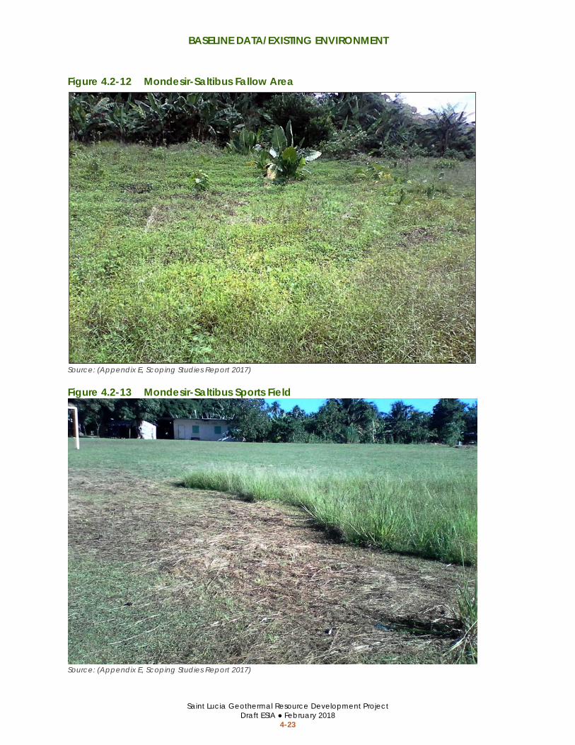
BASELINE DATA/EXISTING ENVIRONMENT
Saint Lucia Geothermal Resource Development Project Draft ESIA ● February 2018
4-23
Figure 4.2-12 Mondesir-Saltibus Fallow Area
Source: (Appendix E, Scoping Studies Report 2017)
Figure 4.2-13 Mondesir-Saltibus Sports Field
Source: (Appendix E, Scoping Studies Report 2017)
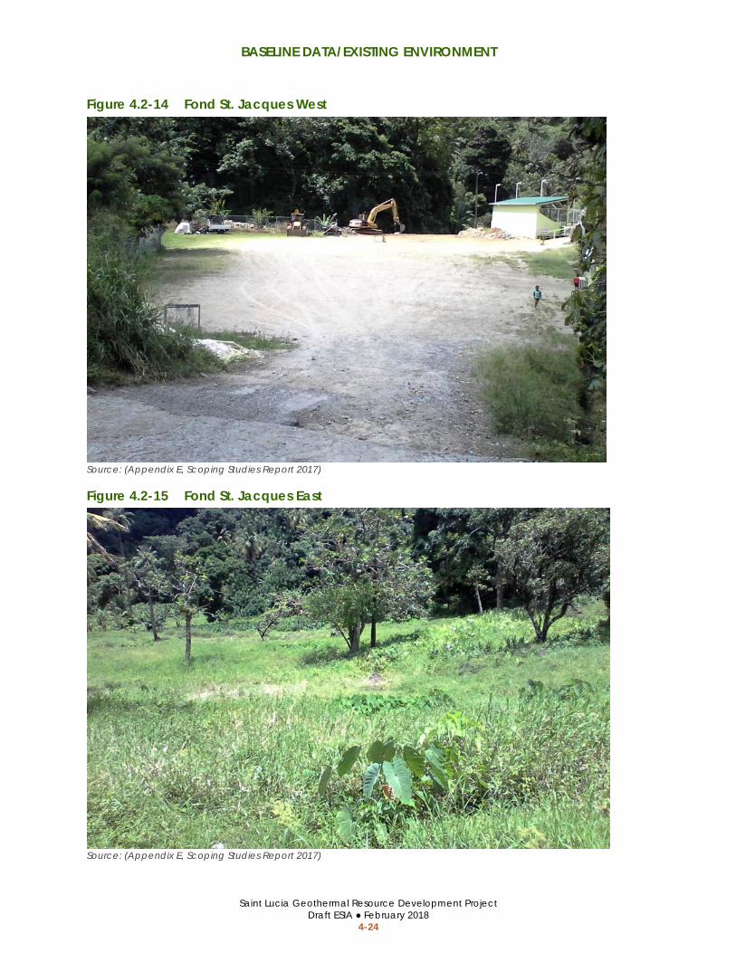
BASELINE DATA/EXISTING ENVIRONMENT
Saint Lucia Geothermal Resource Development Project Draft ESIA ● February 2018
4-24
Figure 4.2-14 Fond St. Jacques West
Source: (Appendix E, Scoping Studies Report 2017)
Figure 4.2-15 Fond St. Jacques East
Source: (Appendix E, Scoping Studies Report 2017)
BASELINE DATA/EXISTING ENVIRONMENT
Saint Lucia Geothermal Resource Development Project Draft ESIA ● February 2018
4-25
4.2.8 Geohazard and Natural Disaster Vulnerability
Hurricanes and Tropical Storms Saint Lucia faces a constant threat from hurricanes and other tropical storms; hurricanes have historically been the most common hazard to impact Saint Lucia (Government of Saint Lucia 2006). Hurricanes are also the primary cause of widespread slope failure (Government of Saint Lucia 2006). Recent climate change predictions indicate a future increase in hurricane activity and extreme rainfall events in the region, including an increase in associated landslide failure (Brian Lovelock 2016). According to the World Bank, Saint Lucia has an average annual loss from hurricanes of US $9.5 million (0.7 percent of the GDP), and a probably maximum loss from hurricanes of US $382 million (27.2 percent of the GDP) over a 250-year return period (2016). Saint Lucia has a high vulnerability to impacts from hurricanes in all categories.
Flooding Hazards Flooding is a risk in Saint Lucia, particularly flooding associated with hurricanes and tropical depressions. The main areas at risk for flooding in Saint Lucia are narrow zones along river valleys and in the Soufrière Valley. The Global Facility for Disaster Reduction and Recovery produces a national flood hazard map for Saint Lucia, as part of the Caribbean Handbook on Risk Information Management project (2017). The only flood hazard area identified within the potential development areas is located along the stream corridor through Fond St. Jacques and within a small portion of the Mondesir-Saltibus drilling area as shown in Figure 4.2-16.
Landslides Numerous damaging landslides have been documented in Saint Lucia; the causes of the most significant landslides have been attributed to events including hurricanes, tropical storms, and poor farming practices (i.e., mass rainforest canopy removal). Research indicates that the majority of landslides in Saint Lucia are shallow failures of the soil mass at depths of 2 meters (7 feet) or less; the most common landslide types are debris flows; and earth flows, rockfalls, rock slides, and slumps also occur, but are less frequent (Brian Lovelock 2016). Most slumps and rotational failures observed are associated with disturbed slopes such as road cuts or unplanned housing developments involving construction, earthworks, and vegetation changes (The University of the West Indies 2017). Roads in Saint Lucia are often susceptible to new slumps and slope failures due to redirected or inadequate drainage, exposed soils, over steepened cut slopes, and/or the removal of support at the toe of slopes (Brian Lovelock 2016).
Seismicity and Earthquakes There are no known active faults within the project drilling areas, and there is a relatively low potential for major earthquakes to cause substantial damage in Saint Lucia. According to the World Bank, Saint Lucia has an annual average loss from earthquakes of US $2.6 million (0.2 percent of the GDP), and a probably maximum loss from earthquakes of US $148 million (10.5 percent of the GDP) over a 250-year return period (2016). These values are less than half of those estimated for loss from hurricanes. Saint Lucia is considered to have a moderate vulnerability to impacts from seismicity and earthquakes in all categories.

BASELINE DATA/EXISTING ENVIRONMENT
Saint Lucia Geothermal Resource Development Project Draft ESIA ● February 2018
4-26
Figure 4.2-16 Flood Hazard Areas
Sources: (McElhanney Consulting Services Ltd. 2015, ACP-EU Natural Disaster Risk Reduction Program 2016)

BASELINE DATA/EXISTING ENVIRONMENT
Saint Lucia Geothermal Resource Development Project Draft ESIA ● February 2018
4-27
Volcanic Eruptions Approximately one third of Saint Lucia is within a moderate, high, or very high volcanic hazard zone identified on volcanic hazard maps used by the GoSL (Jan Lindsay 2002). The drilling areas at Belle Plaine and Fond St. Jacques are in a ‘very high hazard zone.’ The drilling area at Mondesir-Saltibus is in a ‘high hazard zone.’
4.3 SOCIAL CONDITIONS
4.3.1 Population and Affected Communities The project area spans three contiguous districts, Soufrière, Choiseul, and Laborie; however, the communities and people potentially affected by the project are located in Soufrière and Laborie. The project drilling areas would be located within or adjacent two community settlements in Soufrière and two community settlements in Laborie. The communities that could be affected by project activities and population estimates from 2010 are listed in Table 4.3-1.
Table 4.3-1 Population and Unemployment Rates of Affected Communities
Source: (Central Statistics Office 2011, Panorama Environmental, Inc. 2017)
4.3.2 Employment, Livelihoods, and Income Economic activity and employment in Saint Lucia are driven by three main sectors: tourism (hotels), construction, and agriculture. Tourism is the single largest economic activity in the country, and is primarily concentrated in the north (Gros Islet) and south (Soufrière). In 2016, tourism accounted for approximately 8 percent of the gross domestic product (GDP) in Saint Lucia. The contribution of tourism to GDP has generally increased over the past 10 years, whereas the contribution of agriculture has gradually decreased to approximately 2 percent in 2016.
The total unemployment rate in Saint Lucia has remained above 20 percent since 2009, with one report in 2016 that showed signs of improvement. The declining contribution of the agriculture
Population (2010) Unemployment
Rate (2010) Affected Communities Females Males Total
Belvedere a 221 252 473 12.1 %
Belle Plaine a 47 54 101 23.9 %
Parc Estate b 45 54 99 30.6 %
Gayabois b 31 42 73 23.3 %
Total 344 402 746 12.1 % – 23.3 %
Notes: a Belvedere and Belle Plaine are in Soufrière. Belvedere is about 8,000 meters (5 miles) north of the Fond
St. Jacque areas. b Parc Estate and Gayabois are in Laborie. Gayabais is about 1,126 meters (0.7 miles) south of the
Mondesir drilling areas.
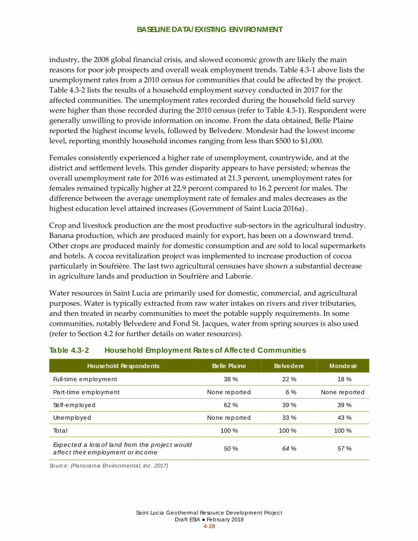
BASELINE DATA/EXISTING ENVIRONMENT
Saint Lucia Geothermal Resource Development Project Draft ESIA ● February 2018
4-28
industry, the 2008 global financial crisis, and slowed economic growth are likely the main reasons for poor job prospects and overall weak employment trends. Table 4.3-1 above lists the unemployment rates from a 2010 census for communities that could be affected by the project. Table 4.3-2 lists the results of a household employment survey conducted in 2017 for the affected communities. The unemployment rates recorded during the household field survey were higher than those recorded during the 2010 census (refer to Table 4.3-1). Respondent were generally unwilling to provide information on income. From the data obtained, Belle Plaine reported the highest income levels, followed by Belvedere. Mondesir had the lowest income level, reporting monthly household incomes ranging from less than $500 to $1,000.
Females consistently experienced a higher rate of unemployment, countrywide, and at the district and settlement levels. This gender disparity appears to have persisted; whereas the overall unemployment rate for 2016 was estimated at 21.3 percent, unemployment rates for females remained typically higher at 22.9 percent compared to 16.2 percent for males. The difference between the average unemployment rate of females and males decreases as the highest education level attained increases (Government of Saint Lucia 2016a) .
Crop and livestock production are the most productive sub-sectors in the agricultural industry. Banana production, which are produced mainly for export, has been on a downward trend. Other crops are produced mainly for domestic consumption and are sold to local supermarkets and hotels. A cocoa revitalization project was implemented to increase production of cocoa particularly in Soufrière. The last two agricultural censuses have shown a substantial decrease in agriculture lands and production in Soufrière and Laborie.
Water resources in Saint Lucia are primarily used for domestic, commercial, and agricultural purposes. Water is typically extracted from raw water intakes on rivers and river tributaries, and then treated in nearby communities to meet the potable supply requirements. In some communities, notably Belvedere and Fond St. Jacques, water from spring sources is also used (refer to Section 4.2 for further details on water resources).
Table 4.3-2 Household Employment Rates of Affected Communities
Source: (Panorama Environmental, Inc. 2017)
Household Respondents Belle Plaine Belvedere Mondesir
Full-time employment 38 % 22 % 18 %
Part-time employment None reported 6 % None reported
Self-employed 62 % 39 % 39 %
Unemployed None reported 33 % 43 %
Total 100 % 100 % 100 %
Expected a loss of land from the project would affect their employment or income 50 % 64 % 57 %

BASELINE DATA/EXISTING ENVIRONMENT
Saint Lucia Geothermal Resource Development Project Draft ESIA ● February 2018
4-29
4.3.3 Education The affected communities fall within two school districts (#7 and #8), which have a total of 17 primary and 3 secondary schools. All 20 of these schools are exceeding their capacity (Ministry of Education 2014). The Saltibus Combined Primary School and the Piaye Secondary Schools serve the Parc Estate and Gayabois communities. They are located approximately 0.8 and 8 kilometers (0.5 and 5 miles) away, respectively. The Fond St. Jacques Primary School and the Soufrière Comprehensive Secondary Schools server the communities of Belvedere and Belle Plaine. These schools are located approximately 0.8 and 5 kilometers (0.5 and 3 miles) from Belvedere, and approximately 3 and 8 kilometers (2 and 5 miles) from Belle Plaine, respectively.
Based on the results of a household field survey, approximately 54 percent of the household populations attained primary level education; 28 percent were educated at the secondary level and 9 percent were educated at the tertiary level (community college).
4.3.4 Health and Disease The affected communities span two health regions (#5 and #6) that contain a total of eight health care facilities. Soufrière Hospital is the main primary care health facility serving the communities of Fond St. Jacques, Belvedere, and Belle Plaine. There are two other health centers in Soufrière that provide general services including visiting specialist and pharmacist services. The Fond St. Jacques health center is less than 5 kilometers (3 miles) from the Belvedere community and the Etangs Health Centre is approximately 5 kilometers (3 miles) from Belle Plaine. The Soufrière Hospital currently functions as a polyclinic or non-hospital referral facility and is not equipped to provide a high level of acute care.
Secondary level medical care for Fond St. Jacques and Belle Plaine communities is available at Victoria and St. Jude Hospital, both of which are about 45 kilometers (28 miles) away. The residents of Mondesir (Parc Estate and Guyabois), have access to the Saltibus health center, which is approximately 5 kilometers (3 miles) away. The St. Jude Hospital is about 30 kilometers (18 miles) from Mondesir and is available for secondary level medical care to the Parc Estate and Gayabois communities.
The Ministry of Health reported that for 2014, the infant mortality rate (annual infant deaths under 1 year old per every 1,000 live births) was down to 17 and the average life expectancy had decreased to 74.4 years. Excluding maternal and reproductive conditions, injuries, road accidents, and non-communicable diseases (e.g., hypertension, heart disease, and cancer) were the most common causes of illnesses and death in Saint Lucia. In 2013 and 2014, mortality due to non-communicable diseases accounted for 58 percent of premature deaths and 73 percent of total preventable deaths. In recent years, there has been a significant increase in the number of suicides in Saint Lucia. The majority of the cases are due to mental health illnesses or substance abuse problems such as alcohol and the use of illicit drugs (Saint Lucia 2015).
The gradual rise in the numbers of persons testing positive for HIV or dying of AIDS is of great concern, although the disease is not yet a significant cause of illness and death in Saint Lucia. The annual HIV/AIDS surveillance report by the Ministry of Health for 2014 reveals that the

BASELINE DATA/EXISTING ENVIRONMENT
Saint Lucia Geothermal Resource Development Project Draft ESIA ● February 2018
4-30
number of cases per 100,000 persons of HIV infection is 35. The number of new cases of HIV infection stabilized between 2005 and 2010, increased again between 2011 and 2013, and fell slightly in 2014 compared to 2013. At the end of 2014, there were 674 persons living with HIV out of the total 1029 cases recorded on the national register; males accounted for 50 percent. The majority of diagnosed cases live in the north (e.g., Castries, Babonneau, and Gros Islet) where roughly 55 percent of the population resides. About 34 percent of persons living with HIV in Saint Lucia are enrolled under the Ministry of Health’s treatment program.
4.3.5 Land Ownership and Housing The primary form of land tenure in the Belle Plaine area is family-owned land followed by leased, and privately-held land based on information obtained from the Land Registry Titling Project (LRTP) maps and Government of Saint Lucia Land Registry. Among the three communities, private ownership of lands was highest in Belle Plaine, whereas family-owned land was the main form of land tenure in Belvedere. Leasing, primarily from Government/Invest Saint Lucia, was the predominant form of land tenure in Mondesir, specifically MS-1 and MS-2.
Belle Plaine’s respondents reported the highest percentage (80 percent) of family-land used for farming. In the Belle Plaine community cluster, members of a family comprising many siblings declared ownership of over 80 hectares (200 acres) of land, which is currently being used to grow a variety of crops for sale. These lands have already been sub-divided and titles are currently being prepared. In Belvedere, family-owned land was the main form of tenure reported for both housing and farming.
The houses in the three communities are all detached/individual structures mostly built from masonry (concrete/block-wall) or a combination of masonry and wood. The Belle Plaine community had the highest proportion of houses constructed out of a combination of masonry and wood materials. A higher percentage of wooden houses was observed in Belevedere and Mondesir. All the houses surveyed in the Belle Plaine community reported having septic tank toilet facilities whereas 18 percent and 36 percent in Belvedere and Mondesir, respectively, had pit latrines.
4.4 CUMULATIVE DEVELOPMENT According to the Saint Lucia Ministry of Physical Planning, no other projects have been proposed in the project area of influence.
4.5 DATA GAPS FOR FUTURE DEVELOPMENT As previously stated, this ESIA focuses on the exploration phase of geothermal development and does not address development of a power plant in the event that a commercially viable geothermal resource is identified. A separate ESIA would be prepared to address potential impacts from power plant development, although much of the information presented in this

BASELINE DATA/EXISTING ENVIRONMENT
Saint Lucia Geothermal Resource Development Project Draft ESIA ● February 2018
4-31
ESIA could serve as a starting place for evaluation of environmental conditions. Potential data gaps for preparing an ESIA that addresses future power plant development are summarized as follows:
• Clear policy guidance from the PMA Development office on levels of acceptable geothermal development within PMA policy areas and green “buffer zone” (refer to Section 2.5)
• Baseline data for specific power plant development areas • An assessment of environmental and social risks and impacts associated with
construction, maintenance, and operation of the power plant • Additional data on ambient air quality conditions and wind speed/direction in the
potential area of drilling to support dispersion modeling of air emissions from a future development phase
• An aquifer test to support a more detailed hydrologic model and assessment of potential use of groundwater resources in the future development area
• Data on surface water discharge rates and water quality; long-term monitoring of surface water resource flow rate and water quality in proximity to the future development area is recommended

BASELINE DATA/EXISTING ENVIRONMENT
Saint Lucia Geothermal Resource Development Project Draft ESIA ● February 2018
4-32
This page is intentionally left blank.

ENVIRONMENTAL AND SOCIAL RISKS AND IMPACTS
Saint Lucia Geothermal Resource Development Project Draft ESIA ● February 2018
5-1
5 ENVIRONMENTAL AND SOCIAL RISKS AND IMPACTS
5.1 APPROACH TO IMPACT ANALYSIS The IFC Performance Standards on Environmental and Social Sustainability states that the environmental and social risks and impacts section should take into account all relevant environmental and social risks and impacts of the project, including the environmental and social risks and impacts specifically identified in PS 2 through PS 8, as well as any other environmental and social risks and impacts arising as a consequence of the specific nature and context of the project.
The primary purpose of an ESIA is to predict the impacts resulting from a project and identify measures to avoid, reduce, or compensate for adverse impacts. Impacts can be direct, indirect, or induced, as defined in Table 5.1-1.
Table 5.1-1 Types of Impacts Type of Impact Definition
Direct Impacts that result from a direct interaction between the project and a resource/receptor (e.g., between disturbance of a plot of land and the habitats on that plot of land that are affected).
Indirect Impacts that follow from the direct interactions between the project and its environment as a result of subsequent interactions within the environment (e.g., impacts on bird population levels as a result of construction noise impacts on bird breeding behavior).
Induced Impacts that result from other activities (which are not part of the project) that happen as a consequence of the project (e.g., increased spending in the local economy due to increased worker employment).
5.1.1 Step 1: Predict Impacts Potential project impacts are predicted and quantified to the extent possible. The magnitude of impacts on resources (e.g., water and air) or receptors (e.g., people, communities, wildlife species, habitats) is defined. Magnitude is a function of the following impact characteristics:
• Type of impact (i.e., direct, indirect, induced) • Size, scale, or intensity of impact • Nature of the change compared to baseline conditions (i.e., what is affected and
how) • Geographical extent and distribution (e.g., local, regional, international) • Duration and/or frequency (e.g., temporary, short-term, long-term, permanent)
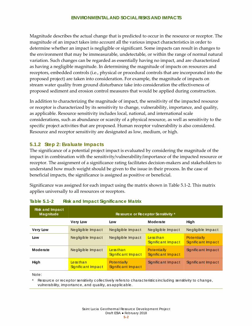
ENVIRONMENTAL AND SOCIAL RISKS AND IMPACTS
Saint Lucia Geothermal Resource Development Project Draft ESIA ● February 2018
5-2
Magnitude describes the actual change that is predicted to occur in the resource or receptor. The magnitude of an impact takes into account all the various impact characteristics in order to determine whether an impact is negligible or significant. Some impacts can result in changes to the environment that may be immeasurable, undetectable, or within the range of normal natural variation. Such changes can be regarded as essentially having no impact, and are characterized as having a negligible magnitude. In determining the magnitude of impacts on resources and receptors, embedded controls (i.e., physical or procedural controls that are incorporated into the proposed project) are taken into consideration. For example, the magnitude of impacts on stream water quality from ground disturbance take into consideration the effectiveness of proposed sediment and erosion control measures that would be applied during construction.
In addition to characterizing the magnitude of impact, the sensitivity of the impacted resource or receptor is characterized by its sensitivity to change, vulnerability, importance, and quality, as applicable. Resource sensitivity includes local, national, and international scale considerations, such as abundance or scarcity of a physical resource, as well as sensitivity to the specific project activities that are proposed. Human receptor vulnerability is also considered. Resource and receptor sensitivity are designated as low, medium, or high.
5.1.2 Step 2: Evaluate Impacts The significance of a potential project impact is evaluated by considering the magnitude of the impact in combination with the sensitivity/vulnerability/importance of the impacted resource or receptor. The assignment of a significance rating facilitates decision-makers and stakeholders to understand how much weight should be given to the issue in their process. In the case of beneficial impacts, the significance is assigned as positive or beneficial.
Significance was assigned for each impact using the matrix shown in Table 5.1-2. This matrix applies universally to all resources or receptors.
Table 5.1-2 Risk and Impact Significance Matrix Risk and Impact
Magnitude Resource or Receptor Sensitivity a
Very Low Low Moderate High
Very Low Negligible Impact Negligible Impact Negligible Impact Negligible Impact
Low Negligible Impact Negligible Impact Less than Significant Impact
Potentially Significant Impact
Moderate Negligible Impact Less than Significant Impact
Potentially Significant Impact
Significant Impact
High Less than Significant Impact
Potentially Significant Impact
Significant Impact Significant Impact
Note: a Resource or receptor sensitivity collectively refers to characteristics including sensitivity to change,
vulnerability, importance, and quality, as applicable.

ENVIRONMENTAL AND SOCIAL RISKS AND IMPACTS
Saint Lucia Geothermal Resource Development Project Draft ESIA ● February 2018
5-3
The levels of impacts are defined using the following terms:
• Negligible Impact. A negligible impact is one where a resource or receptor (including people) would not be affected by a particular activity, or the predicted effect is deemed to be imperceptible or is indistinguishable from natural background variations.
• Less than Significant Impact. A less than significant impact is a minor impact is where a resource or receptor would experience a noticeable effect, but the impact magnitude is sufficiently low (with or without mitigation) and/or the resource or receptor is of low sensitivity. In either case, a less than significant impact must be sufficiently below applicable standard threshold limits.
• Potentially Significant Impact. A potentially significant impact is a moderate impact that meets applicable standards but comes near the threshold limit. The emphasis for such moderate impacts is to demonstrate that the impact has been reduced to a level that is as minor as reasonably practicable so that the impact does not exceed standard threshold limits and become significant.
• Significant Impact. A significant impact is one where an applicable standard threshold limit would or could be exceeded, or if a highly valued or very scarce resource would be substantially affected.
In addition to the risks and adverse effects, the proposed project may include positive effects. Some of the positive effects from the proposed project are described in the impact evaluation, such as the potential for generating temporary jobs during exploration activities; however, the impact evaluation primarily focuses on the adverse impacts.
5.1.3 Step 3: Evaluate Mitigation After predicting and evaluating the impacts, the ESIA process involves evaluating mitigation measures that could be implemented to avoid, reduce, or compensate for the impacts, as necessary and to the extent reasonably feasible. A mitigation hierarchy from the World Bank Environmental and Social Framework was used in which preference is always given to avoid or minimize the impact before considering other types of mitigation (i.e., observe, remedy, compensate, offset). The hierarchy of mitigation measures includes:
1. Anticipate and Avoid Impacts. Remove the source of the impact (i.e., avoid the specific action or resource area).
2. Minimize Impacts. Reduce the magnitude of the impact, where the impact cannot be completely avoided.
3. Compensate or Offset Impacts. Where significant residual impacts would remain after exhausting avoidance and minimization options, provide compensation or offsets for the impact, where technically and financially feasible.

ENVIRONMENTAL AND SOCIAL RISKS AND IMPACTS
Saint Lucia Geothermal Resource Development Project Draft ESIA ● February 2018
5-4
5.1.4 Step 4: Evaluate Residual Impacts Residual impacts are the impacts that are predicted to remain after mitigation has been implemented based on the effective outcomes. The significance of residual impacts are rated in the same way as impacts before mitigation (e.g., less than significant, potentially significant, and significant), but includes assumptions on how mitigation would reduce the impact magnitude or otherwise address sensitivity characteristics, thereby reducing its overall significance.
5.2 ENVIRONMENTAL RISKS AND IMPACTS
5.2.1 Water Resources
Sensitive Resources Two intermittent streams flow through or adjacent to the Belle Plaine drilling area, two rivers flow adjacent to the Mondesir-Saltibus drilling areas, and two rivers flow near the Fond St. Jacques drilling area. The Fond St. Jacques drilling area is also located near water storage infrastructure and springs, which supply drinking and non-drinking water to the local community. The rivers and water resources near the proposed drilling areas are important water supply sources for the communities near the project area and downstream. These resources are very important to the local communities and considered highly sensitive.
Potential Risks/Impacts and Magnitude
Water Quality Civil Works The project would involve construction of new access road segments, expansion of existing access roads, and construction of well pads. Grading and vegetation clearing activities during the civil works phase of the project could destabilize soil and result in erosion or sedimentation during rain events. Erosion and sedimentation that reaches the drainage network has the potential to degrade surface water quality.
Well Drilling and Testing Geothermal fluid could be produced during the geothermal drilling and testing at the Belle Plaine and Modesir-Salitbus wells. Drill cuttings and fluids produced during drilling, and produced geothermal fluids could contain high levels of the following heavy metals, which commonly occur in geothermal resources:
• Arsenic • Boron • Cadmium • Chromium • Nickel
• Mercury • Zinc • Uranium • Radium • Gross alpha and beta

ENVIRONMENTAL AND SOCIAL RISKS AND IMPACTS
Saint Lucia Geothermal Resource Development Project Draft ESIA ● February 2018
5-5
Drilling waste and any geothermal fluids would be collected in tanks or reserve pits at the drilling sites. Fluids would be allowed to evaporate or, or they would be reinjected into the well.
If the reserve pits were improperly constructed or maintained, fluids in the pits could be flow into the drainage network, which could degrade water quality downstream from the drilling areas. Incidental leaks or spills of hazardous materials could also contaminate nearby waterways if the materials are not properly contained.
There is a risk that the geothermal drilling and testing operations could result in a release of geothermal fluids to surface waters. While unlikely, a well blowout could result in an uncontained discharge of geothermal fluids that could flow to surface water. Well blowouts are typically caused by improper well construction or lack of BOP equipment. Well BOP equipment will be installed on all wells.
Civil Works and Well Drilling Earth moving equipment (e.g., graders and dozers) and drill rigs require the use of oil, grease, hydraulic fluids, and other chemicals. Leaking construction equipment, drill rigs, or improperly stored hazardous materials could result in a discharge of hazardous materials to nearby rivers during rain events. The transport of hazardous materials to waterways has the potential to degrade water quality downstream of the work area.
Surface pollution upgradient of springs or well drilling within connected aquifers could impact water quality for the springs at Fond St. Jacques. These springs are likely surface manifestations of ground water collection from upslope area, and the potential drilling areas are located downgradient from the springs; however, the potential for underground connectivity between spring sources and aquifers that may be encountered during drilling cannot be known without further study or monitoring.
Reclamation Reclamation would involve earth moving activities that would have a potential to cause erosion prior to vegetation establishment. The equipment used during reclamation would also require small quantities of hazardous materials (e.g., oil, grease, and hydraulic fluid).
Water Supply Civil Works Construction equipment and grading could directly damage water supply systems (i.e., pipes, intakes, tanks, and ditches) that are both above ground or buried. In particular, the buried pipelines and water supply infrastructure in Fond St. Jacques could be damaged during well pad and access road construction. Effects to the water supply system would have an adverse effect on water supply in the community if not promptly repaired.
Water would be required for dust control during road and well pad construction. The volume of water required for dust control would be minimal and would not noticeably affect the availability of water in the region.

ENVIRONMENTAL AND SOCIAL RISKS AND IMPACTS
Saint Lucia Geothermal Resource Development Project Draft ESIA ● February 2018
5-6
Well Drilling The project would require fresh water for drilling, worker needs (e.g., drinking, washing, and sanitation), and dust control. Drilling water would be extracted from the Doree River and Migny River, including their tributaries, or other WASCO water supply tanks and piped or carried by truck to the well sites. Water extraction would occur downstream from WASCO’s raw water intakes to avoid substantial impacts on the main water supply; however, the downstream water supply could be affected. If feasible, a water well could also be bored in the Belle Plaine area to supply drilling water.
The volume of water required during well drilling would vary depending on the type of well (e.g., slim-hole or full-sized well) and the subsurface conditions and rock/fracture permeability, which are currently unknown. Higher permeability rocks with numerous open fractures would require more water during drilling. The water requirements specified in Section 3.4 reflect the maximum potential water demand assuming highly permeable rock is encountered with high water losses. The volume of water required for well drilling could exceed the volume of water that is available in local streams. Therefore, the project could substantially reduce the water supply for users downstream of river extraction points or those relying on water tanks that may be used by the project.
Installation of a water well in the Belle Plaine area would not affect the water supply in the area because there are no existing uses of groundwater resources in the Belle Plaine area.
Reclamation Water use would be limited during reclamation and would be used primarily for dust control.
Flooding Civil Works and Well Drilling The project area in Belle Plaine is located within a 100-year flood plain. Table 5.2-1 below provides the approximate hydraulic flow rates for each of the project areas using the rational method.
Table 5.2-1 Estimated Hydraulic Flow Rates
Project Area Catchment
Area (ha)
Top Elevation
(m) Slope Runoff
Coefficient
Intensity (mm/hr) Runoff (m3/s)
5-yr 10-yr 5-yr 10-yr
Belle Plaine
L’Ivrogne 910 698 0.065 0.15 62 85 24 32
Sub-L’Ivrogne
251 249 0.036 0.15 82 115 9 12
Mondesir-Saltibus
Doree 1095 570 0.055 0.15 50 70 23 32
Sub-Doree 736 548 0.058 0.15 68 90 21 28
Fond St. Jacques
Soufrière 1556 520 0.071 0.15 62 85 40 55
Sub-Soufrière
226 240 0.14 0.15 108 215 10 20

ENVIRONMENTAL AND SOCIAL RISKS AND IMPACTS
Saint Lucia Geothermal Resource Development Project Draft ESIA ● February 2018
5-7
The minimal surface recontouring to construct a well pad would not measurably effect runoff in any of the effected drainages. The well pads are small in size and would remain largely pervious so that they would not concentrate downstream flow or cause any increase in downstream flooding.
Reclamation The project site would be returned to pre-existing contours and vegetation types during site reclamation. Reclamation of the site would have no impact on flood intensity off site.
Impact Significance and Mitigation The significance of each impact on water resources and mitigation measures that would be applied are summarized Table 5.2-2.
Table 5.2-2 Summary of Potential Water Resource Impacts and Mitigation
Resource/ Receptor Impact Sensitivity Magnitude
Pre-Mitigation
Significance Mitigation Measure
Residual Significance
Water Quality
Sediment Discharge
High Moderate Significant Water-1 Water-2
Negligible to Less than Significant
Drilling Waste High Moderate Significant Water-3 Negligible
Geothermal Fluid Discharge
High High Significant Water-4 Negligible to Less than Significant
Hazardous Material Discharge
High Moderate Significant Hazards-1 Negligible
Underground Spring Contamination
High Moderate Significant Water-2 Negligible
Water Supply
Damage Water Supply Infrastructure
High Moderate Significant Water-5 Negligible
Water Use (Dust Control)
High Very Low Negligible -- --
Water Use (Well Drilling)
High High Significant Water-5 Water-6
Less than Significant
Groundwater Well
Low Low Less than Significant
-- --
Flooding Well Pad Construction
Moderate Low Negligible -- --

ENVIRONMENTAL AND SOCIAL RISKS AND IMPACTS
Saint Lucia Geothermal Resource Development Project Draft ESIA ● February 2018
5-8
5.2.2 Air Quality
Sensitive Receptors Residential dwellings are located in proximity to the drilling areas in Belle Plaine, Mondesir-Saltibus, and Fond St. Jacques; occupied dwellings are considered sensitive receptors. Sensitive receptors within 305 meters (1,000 feet) of the drilling areas are shown on Figure 4.2-3 through Figure 4.2-5. Elderly individuals and people who may be more sensitive to air quality were documented in the communities surrounding the drilling sites. The residences are therefore considered highly sensitive to air quality impacts.
Potential Risks/Impacts and Magnitude
Equipment Emissions and Fugitive Dust Civil Works and Well Drilling Well pad construction for slim wells would require leveling and compaction to create a stable surface for the truck mounted drill rig. The full-size wells could require soil excavation, grading, and vegetation removal, which could create sources of fugitive dust. Travel over unpaved access roads during civil works and well drilling operations could create fugitive dust, which could impact air quality and visibility. Access road improvements may require vegetation removal and grading with heavy equipment which could also produce fugitive dust. Fugitive dust could settle onto adjacent agricultural products or could cause visible dust plumes that would be noticeable to people living or working in the area.
Both the civil works and well drilling construction phases would require the use of heavy diesel-powered equipment. The equipment exhaust would result in emissions that would temporarily degrade air quality in the immediate vicinity of the equipment. The duration of construction in a single area would be limited to approximately 2 to 6 months, depending on the size of the wells. Equipment emissions would dissipate rapidly in the atmosphere and would not result in a substantial increase in any air pollutant at sensitive receptors.
Reclamation The air quality effects of reclamation would be similar to those of civil works but likely short in duration (less than one week) during site recontouring. Reclamation activities would stabilize the site to avoid long-term emissions of fugitive dust.
Geothermal Gas Emissions Well Drilling and Testing Well drilling and flow testing could result in the release of geothermal steam if the resource is encountered. The geothermal emissions may include water vapor, carbon dioxide, and hydrogen sulphide (H2S). Small amounts of boron, arsenic, mercury, and bicarbonate may be entrained in geothermal steam and emitted during drilling and testing. These gases occur naturally at the surface manifestations of the geothermal resource at Sulphur Springs.
Well flow testing would only occur if the geothermal resource was encountered, and would not occur at Fond St. Jacques east site to minimize risks to the population due to proximity to

ENVIRONMENTAL AND SOCIAL RISKS AND IMPACTS
Saint Lucia Geothermal Resource Development Project Draft ESIA ● February 2018
5-9
sensitive receptors. Fond St. Jacques would only include temperature gradient holes. Flow testing would involve venting steam to the atmosphere and could emit H2S, boron, arsenic, mercury, and bicarbonate. The geothermal resource is usually encountered at the latter phase of drilling—the last 10 to 15 days. H2S is the constituent of primary concern in geothermal emissions because it can cause health effects at elevated levels. The H2S concentration measured at Sulphur Springs is characteristic of the anticipated H2S concentrations anticipated during venting of the geothermal resource. H2S concentrations at Sulphur Springs were 29.24 µg/m3 during air quality monitoring in September 2017 (refer to Appendix C). Local receptors within 100 meters (328 feet) may smell a “rotten egg” odor if H2S is present in the steam.
It is not feasible at this stage of the project to conduct air dispersion modeling to predict H2S levels at receptors because (1) the precise location of the well pads and relative distance to receptors is not defined, (2) the chemistry of the geothermal resource in the potential drilling areas is not known, and (3) there is no data on the wind speed and direction in the project areas. The air quality at Sulphur Springs where the geothermal resource naturally vents to the atmosphere indicates that the project could produce H2S concentrations in excess of WHO guidelines for annoyance. Any emissions from the geothermal drilling and testing, including a potential blowout, would disperse quickly in the atmosphere. The air quality risk from geothermal testing would be moderate due to quick dispersion rates, the short duration of drilling and testing activities, and limited volume of fluid that could be produced. The temporary venting of geothermal steam during resource testing would not cause any adverse health effects and is not expected to exceed WHO H2S thresholds for eye irritation.
Impact Significance and Mitigation The significance of each impact on air quality resources and mitigation measures that would be applied are summarized in Table 5.2-3.
Table 5.2-3 Summary of Air Quality Impacts and Mitigation Resource/ Receptor Impact Sensitivity Magnitude
Pre-Mitigation Significance
Mitigation Measure
Residual Significance
Residences and Community Members
Fugitive Dust Moderate Low Less than Significant
Air-1 Negligible
Equipment Emissions
High Low Potentially Significant
Air-2 Negligible
Geothermal Gas Emissions
High Moderate Significant Air-3 Water-4
Negligible to Less than Significant
5.2.3 Geology and Soils
Sensitive Resources The potential drilling areas in Belle Plain, Mondesir-Saltibus, and Fond St. Jacques include active agricultural uses. Productive topsoil is important to agricultural production and topsoil is considered a highly sensitive resource to the community. The project area in Fond St. Jacques
ENVIRONMENTAL AND SOCIAL RISKS AND IMPACTS
Saint Lucia Geothermal Resource Development Project Draft ESIA ● February 2018
5-10
and the access roads to the drilling sites are located within areas that are prone to landslides and slope failure. The risk of landslides is high in areas where access road grading may be required.
Potential Risks/Impacts and Magnitude
Erosion and Topsoil Loss Civil Works Soil erosion is a severe environmental problem in Saint Lucia and affects the water supply and agricultural productivity. Access road and well pad grading and vegetation clearing activities could cause soil erosion and loss of topsoil. Gravel would be installed at work areas and access roads, where necessary, to facilitate all weather access for vehicles and equipment. Substantial erosion could affect slope stability and lead to sediment transport. Substantial topsoil loss could affect agricultural land and crop production.
Well Drilling and Testing Well drilling and testing activities would be conducted within the stabilized well pad. Well drilling and testing activities would not disturb nearby areas or cause loss of topsoil. Geothermal fluid spills from the sump (if used) could cause erosion of topsoil in steep areas. Most well pads would be located on relatively flat areas, reducing the risk of runoff and erosion.
Reclamation Reclamation would involve recontouring of the site to pre-existing conditions. The removal of gravel could temporarily destabilize the soil and cause soil erosion; however, the reclamation activities would provide long-term stabilization of the site and involve replacement of topsoil to minimize or avoid effects from topsoil loss.
Landslides, Mudflows, and Unstable Soil Conditions Civil Works The access roads leading to the potential drilling areas require passage through steep mountainous terrain with tight turns. Access roads may need to be expanded in areas where the turning radius is insufficient to accommodate large construction equipment. Expansion of the access road along steep slopes could cause slope instability if the road expansion is not properly designed to address soil and slope conditions.
The potential drilling area in Fond St. Jacques east is located in an area that is known to contain saturated soils. Construction of the well pad and access road could create an unstable work area if the well pad was not properly engineered and constructed to address saturated soil conditions.
Well Drilling The slopes surrounding the Belle Plaine, Fond St. Jacques and MS-3 and MS-4 areas are prone to landslides and potential mudflows. Landslides could affect the drilling sites depending on the location and extent of slope failure. Due to the short duration of drilling activities, drilling
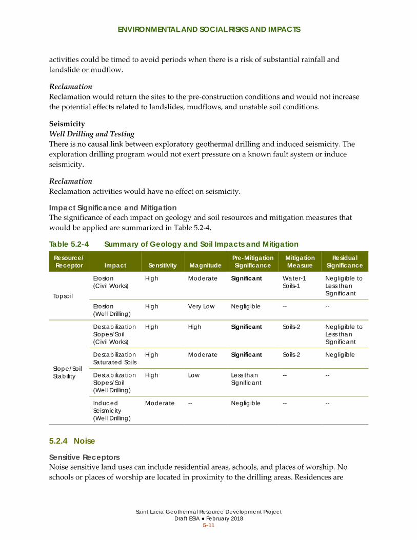
ENVIRONMENTAL AND SOCIAL RISKS AND IMPACTS
Saint Lucia Geothermal Resource Development Project Draft ESIA ● February 2018
5-11
activities could be timed to avoid periods when there is a risk of substantial rainfall and landslide or mudflow.
Reclamation Reclamation would return the sites to the pre-construction conditions and would not increase the potential effects related to landslides, mudflows, and unstable soil conditions.
Seismicity Well Drilling and Testing There is no causal link between exploratory geothermal drilling and induced seismicity. The exploration drilling program would not exert pressure on a known fault system or induce seismicity.
Reclamation Reclamation activities would have no effect on seismicity.
Impact Significance and Mitigation The significance of each impact on geology and soil resources and mitigation measures that would be applied are summarized in Table 5.2-4.
Table 5.2-4 Summary of Geology and Soil Impacts and Mitigation Resource/ Receptor Impact Sensitivity Magnitude
Pre-Mitigation Significance
Mitigation Measure
Residual Significance
Topsoil
Erosion (Civil Works)
High Moderate Significant Water-1 Soils-1
Negligible to Less than Significant
Erosion (Well Drilling)
High Very Low Negligible -- --
Slope/Soil Stability
Destabilization Slopes/Soil (Civil Works)
High High Significant Soils-2 Negligible to Less than Significant
Destabilization Saturated Soils
High Moderate Significant Soils-2 Negligible
Destabilization Slopes/Soil (Well Drilling)
High Low Less than Significant
-- --
Induced Seismicity (Well Drilling)
Moderate -- Negligible -- --
5.2.4 Noise
Sensitive Receptors Noise sensitive land uses can include residential areas, schools, and places of worship. No schools or places of worship are located in proximity to the drilling areas. Residences are

ENVIRONMENTAL AND SOCIAL RISKS AND IMPACTS
Saint Lucia Geothermal Resource Development Project Draft ESIA ● February 2018
5-12
located in the vicinity of all three of the potential drilling areas, the closest of which are near the Fond St. Jacques west and MS-4 site. Residences within 305 meters (1,000 feet) are shown on Figure 4.2-3 through Figure 4.2-5. Residents are typically most sensitive to noise at night, when noise can interfere with sleep. The noise sensitivity for receptors in proximity to the drilling sites is considered high because the project could involve drilling and testing activities at night.
Potential Risks/Impacts and Magnitude
Civil Works The project would temporarily generate noise during construction activities from the operation of motorized vehicles (e.g., trucks and bulldozers) and stationary equipment (e.g., generators, compressors, pumps, etc.). Civil works activities would occur during daytime hours. Typical noise levels from civil works activities are listed in Table 5.2-5.
The noise levels in Table 5.2-5 are based on a reference distance of approximately 15 meters (50 feet), and the noise level would change with distance. Noise levels attenuate (decrease) at an average rate of approximately 6 dBA per doubling of distance from a source. Conversely, noise levels increase by approximately 6 dBA when distance is reduced by half. For example, if noise from a bulldozer is 85 dBA at a distance of 15 meters (50 feet), the adjusted noise level would be 79 dBA at 30 meters (100 feet) and 91 dBA at 7.5 meters (25 feet).
Table 5.2-5 Typical Noise from the Proposed Activities Activity Predicted Noise Levels (dBA) at Distance a
Meters (Feet)
3.8 (13)
7.6 (25)
15.2 (50)
30.5 (100)
61.0 (200)
152.4 (500)
304.8 (1,000)
609.6 (2,000)
1,524.0 (5,000)
Civil Works 96 90 84 78 72 66 60 54 48
Well Drilling (Large Rig) 93 87 81 75 69 63 57 51 45
Well Drilling (Small Rig) 83 77 71 65 59 53 47 41 35
Well Clean-Out 93 87 81 75 69 63 57 51 45
Well Flow-Testing 96 90 84 78 72 66 60 54 48
Note: a Estimated noise levels are given for various distances from the noise-generating sources. These noise
levels do not account for the topographical barriers, trees, vegetation, and manmade structures through the project area that would absorb or deflect sound waves, thereby reducing noise levels.
Sources: (U.S. Department of Interior, Bureau of Land Managment 1995)
Well Drilling The project drilling areas are generally located in areas that are characterized as residential, rural residential, and mixed-use agricultural land. The World Bank’s guidelines for noise in
ENVIRONMENTAL AND SOCIAL RISKS AND IMPACTS
Saint Lucia Geothermal Resource Development Project Draft ESIA ● February 2018
5-13
residential areas (refer to Section 0), when measured at the nearest sensitive receptor, are as follows:
• ≤ 55 dBA during daytime hours (7:00 and 22:00) • ≤ 45 dBA during nighttime hours (22:00 and 7:00) • ≤ 3 dBA increase above existing ambient levels (all periods)
The World Bank’s guidelines are generally suited for permanent noise increases, such as noise from permanent facility or frequent operation activity. Infrequent and temporary construction noise typically exceeds these guidelines; however, the guidelines can indicate a potential noise impact for construction noise that is relatively long-term (more than a few weeks or months). All noise associated with the well drilling and testing phase would be temporary and limited to the 2 to 6 months in any area.
Residences (sensitive receptors) are located in proximity to the boundary of potential drilling areas, especially at Fond St. Jacques west and MS-4, as shown on Figure 4.2-3 through Figure 4.2-5. Construction activities at 15 meters (50 feet) from the project would temporarily exceed the World Bank’s guidelines for permanent noise. Temporarily exceeding the guidelines would not be a significant impact on its own; however, the project could generate substantial temporary noise that could impact adjacent residents and workers, depending on the noise characteristics (i.e., overall level, difference between existing ambient noise, duration, frequency, and timing), receptor location (i.e., separation distance and intervening vegetation, topography, and structures), and receptor sensitivity.
Daytime drilling noise could result in adverse community reaction if a well is drilled adjacent to a home in Belle Plaine or MS-4 areas. Most other drilling areas would allow 50 meters (160 feet) or more buffer from residences.
Nighttime drilling noise could cause adverse community reaction and potentially sleep disturbance. Noise above 45 dBA during nighttime hours is likely to cause sleep disturbance. Noise levels could exceed 45 dBA up to 300 meters (1,000 feet) from the well pad. Indoor noise levels with the windows closed would be attenuated and less than outdoor noise levels. Procedures should be implemented to position well pads as far from receptors as feasible, and to reduce equipment noise levels to the greatest extent possible.
Drilling may also cause periodic vibration that could be felt up to approximately 10 meters (30 feet) from the drill rig depending on ground conditions. Vibration attenuates rapidly over distance, and any vibration would be temporary and short-term. Vibration would not affect any structures due to the rapid attenuation of vibration with distance.
Reclamation Site recontouring and reclamation activities would produce temporary noise from use of large equipment, similar to the equipment that would be used for the civil works phase. Noise during reclamation would be very short in duration (a few days). Reclamation activities would take

ENVIRONMENTAL AND SOCIAL RISKS AND IMPACTS
Saint Lucia Geothermal Resource Development Project Draft ESIA ● February 2018
5-14
place during daytime hours. The noise impact would be similar to large truck noise, which is part of the ambient environment.
Impact Significance and Mitigation The significance of each impact on noise sensitive receptors and mitigation measures that would be applied are summarized in Table 5.2-6.
Table 5.2-6 Summary of Noise Impacts and Mitigation Resource/ Receptor Impact Sensitivity Magnitude
Pre-Mitigation Significance
Mitigation Measure
Residual Significance
Residences
Daytime Noise (Civil Works)
Moderate Moderate to High a
Significant Noise-1 Less than Significant
Daytime Noise (Well Drilling and Testing)
Moderate Moderate to High a
Significant Noise-1 Less than Significant
Nighttime Noise (Well Drilling and Testing)
High Moderate to High a
Significant Noise-1 Less than Significant
Structures Vibration (Well Drilling)
Moderate Low Negligible -- --
Note: a Magnitude would be high at Fond St. Jacques west and moderate at other locations.
5.2.5 Natural Habitats and Biodiversity
Sensitive Resources The project area consists of disturbed and agricultural production areas. No natural habitats are present and no sensitive or critical natural sites occur in the areas that would be directly affected by the project activities. There are no rare, endangered or protected species present, and no areas of high biological diversity or endemism. No endangered or vulnerable plant, mammal, lizard, reptile or insect species are known to occur in the area. The sensitivity of biological resources within the drilling area is low.
Priority bird species occur in the forested areas adjacent to the drilling areas in Belle Plaine and Mondesir-Saltibus. The sensitivity of forested areas adjacent to the project area is moderate.
Potential Risks/Impacts and Magnitude
Direct Impacts on Habitat and Species (Civil Works) Access road grading and well pad construction in agricultural areas or disturbed habitats would not have an adverse impact on natural communities or biodiversity because no natural communities occur in the area. Wildlife would tend to avoid areas of noise and human activity.
Biological surveys of the proposed drilling areas did not identify sensitive biological resources within any drilling site (refer to Appendix C). Well pad construction and access road grading

ENVIRONMENTAL AND SOCIAL RISKS AND IMPACTS
Saint Lucia Geothermal Resource Development Project Draft ESIA ● February 2018
5-15
within the surveyed drilling areas would not directly affect any natural habitats or sensitive species because the potential drilling areas are agricultural or barren areas with no suitable habitat for sensitive biological resources.
Biological surveys have not been completed at MS-3 or MS-4. MS-3 and MS-4 were defined as agricultural and residential disturbed areas during reconnaissance surveys, and the areas have a low potential for sensitive biological resources. While it is unlikely that sensitive biological resources could occur in the MS-3 or MS-4 areas, it is not possible to fully rule out the potential for sensitive species in the MS-3 or MS-4 areas because the areas have not been surveyed. If rare plants or sensitive biological resources occur in the MS-3 or MS-4 area, well pad construction and access road grading would adversely impact these resources.
Indirect Impacts on Habitat and Species (Civil Works and Well Drilling) Invasive Weeds Construction equipment, vehicles, and drill rigs can carry mud and invasive weed fragments or seeds on the vehicle and equipment tires or undercarriage. Invasive weeds could be introduced to the project area and surroundings through imported construction equipment and drill rigs. Invasive weeds can outcompete native vegetation and cause loss of habitat and potentially increased risk of wildfire. The potential drilling areas in Belle Plaine and Fond St. Jacques are located in proximity to the PMA. Introduction of invasive weeds was identified as a threat to the biological diversity of the PMA (The Landmark Practice 2013). The introduction of invasive weeds could adversely impact native habitats surrounding the potential drilling areas.
Noise Heavy equipment used during civil works and well drilling activities will produce noise levels that exceed the ambient noise conditions in the area (refer to Section 5.2.4 for predicted noise levels). Noise from heavy equipment and the drill rig could disturb wildlife and interrupt bird nesting behavior. Several priority bird species were documented in the forested buffer near the drilling areas during planning surveys (refer to Appendix C). An intermittent increase in noise could potentially cause nest abandonment if birds are nesting in the vicinity of the drilling area. Disturbing nesting behavior or causing nest abandonment could adversely impact bird populations. Drilling noise levels would be fairly constant over the drilling period. Drilling noise is not expected to cause nest disturbance because any species nesting in the vicinity of the drilling area would be accustomed to the constant noise level; however, drilling noise could cause birds to avoid habitat in proximity to the drilling areas.
Worker Behavior Workers could attract wildlife to the construction area if they were to feed wildlife or improperly store food waste. Attracting wildlife to the work area could put wildlife in danger or injury or mortality from heavy equipment or vehicles.

ENVIRONMENTAL AND SOCIAL RISKS AND IMPACTS
Saint Lucia Geothermal Resource Development Project Draft ESIA ● February 2018
5-16
Reclamation Reclamation activities would return the well pads to the preconstruction state. Drill pads would be revegetated to match pre-construction conditions. Reclamation activities would not adversely affect biodiversity or natural habitats.
Impact Significance and Mitigation The significance of each impact on natural habitats and biodiversity and the mitigation measures that would be applied are summarized in Table 5.2-7.
Table 5.2-7 Summary of Natural Habitats and Biodiversity Impacts and Mitigation Resource/ Receptor Impact Sensitivity Magnitude
Pre-Mitigation Significance
Mitigation Measure
Residual Significance
Rare Species
Unknown Resources in MS-3 or MS-4
Very Low to High
Moderate Significant Biodiversity-1 Less than Significant
Natural Habitats
Introduction of Invasive Weeds
High Low Potentially Significant
Biodiversity-2 Negligible
Priority Birds
Nesting Disturbance
High Moderate Significant Biodiversity-3 Negligible
Wildlife Attracting Wildlife
Low Moderate Potentially Significant
Waste-1 Negligible
5.2.6 Archeological and Cultural Resources
Sensitive Resources Belle Plaine and Mondesir-Saltibus contain an abundance of historical and Amerindian resources. These drilling areas are considered highly sensitive for archaeological and cultural resources. Fond St. Jacques has low sensitivity for archaeological and cultural resources; no historical uses are known to occur in the area.
The MS-3 and MS-4 sites have not been surveyed for archaeological and cultural resources. These areas could contain sensitive archaeological and cultural resources, similar to the MS-1 and MS-2 areas, which were previously surveyed.
Further study of the areas that would be impacted at these drilling sites is necessary before any grading or ground disturbing activities occur to gather information about the sites and evaluate their significance. A qualified archeological monitor should also be present to collect and evaluate any artifacts that may be encountered during grading at the Belle Plaine and Mondesir-Saltibus drilling areas. Mitigation measures are identified in Section 6 to address sensitive archeological sites that may be present at the Belle Plaine and Mondesir-Saltibus drilling areas.

ENVIRONMENTAL AND SOCIAL RISKS AND IMPACTS
Saint Lucia Geothermal Resource Development Project Draft ESIA ● February 2018
5-17
Potential Risks/Impacts and Magnitude
Civil Works The project would involve grading and ground disturbance in the Belle Plaine and Mondesir-Saltibus areas, which are known to contain archeological resources. Grading, vegetation removal, and excavation activities have the potential to displace or destroy archaeological or cultural resources that may contain important information about Saint Lucia’s history. There is also a potential for workers to take artifacts that may be uncovered, which could result in the loss of important historical resources.
Well Drilling Well drilling activities would occur within the graded and disturbed well pad that would be constructed during the civil works phase. No archaeological or cultural resources would be disturbed by well drilling activities.
Reclamation Reclamation activities would occur in the areas disturbed by civil works activities. Reclamation activities would not cause effects to cultural resources.
Impact Significance and Mitigation The significance of each impact on archaeological and cultural resources and the mitigation measures that would be applied are summarized in Table 5.2-8.
Table 5.2-8 Summary of Archaeological and Cultural Impacts and Mitigation
Resource/ Receptor Impact Sensitivity Magnitude
Pre-Mitigation
Significance Mitigation Measure
Residual Significance
Historical and Amerindian Resources
Damage or Relocate Resources
High Moderate Significant Cultural-1 Cultural-3
Negligible to Less than Significant
Unknown Resources at MS-3 and MS-4
Very Low to High
Moderate Significant Cultural-2 Negligible to Less than Significant
5.2.7 Landscape and Visual Character
Sensitive Resources There are no scenic vistas within the project area. The potential drilling area within Fond St. Jacques and Belle Plaine are located within the buffer area for the PMA. Landscapes and viewsheds in the PMA buffer are considered to have a moderate or high sensitivity to visual effects.

ENVIRONMENTAL AND SOCIAL RISKS AND IMPACTS
Saint Lucia Geothermal Resource Development Project Draft ESIA ● February 2018
5-18
Potential Risks/Impacts and Magnitude
Civil Works The removal of vegetation from access roads and well pads and the grading of well pads will have a temporary impact on the landscape and scenery in areas adjacent to project sites. Substantial vegetation disturbance could have a minor but long-term impact on visual quality if the well pad and access roads with vegetation that contributes to scenic quality were not revegetated following project activities.
Well Drilling The presence of tall drill rigs and construction equipment would contrast with the natural landscape and temporarily degrade the visual quality near drilling areas. The drill rigs would only be in place for up to 6 months during drilling and testing. Trees, dense vegetation, and topography in the area would partially screen the drilling activities from views, such as those from the primary access roads. The project areas are not visible from any of the key viewpoints in the PMA that were considered in the Limits of Acceptable Change report (The Landmark Practice 2013).
Reclamation Reclamation activities would be short-term and not have an adverse effect on the landscape or visual character of the area. Reclamation activities including site recontouring, revegetation, and trash removal would restore the site to pre-construction conditions to avoid any long-term impacts on the landscape.
Impact Significance and Mitigation The significance of each impact on landscape and visual quality and the mitigation measures that would be applied are summarized in Table 5.2-9.
Table 5.2-9 Summary of Landscape and Visual Quality Impacts and Mitigation Resource/ Receptor Impact Sensitivity Magnitude
Pre-Mitigation Significance
Mitigation Measure
Residual Significance
PMA Buffer Zone
Vegetation Removal and Grading
High Moderate Significant Landscape-1 Negligible to Less than Significant
Visible Construction Equipment
Moderate Low Less than Significant
-- --
Views from Adjacent Roads and Residences
Vegetation Removal and Grading
Low to Moderate
Low Less than Significant
-- --
Visible Construction Equipment
Low to Moderate
Low Less than Significant
-- --

ENVIRONMENTAL AND SOCIAL RISKS AND IMPACTS
Saint Lucia Geothermal Resource Development Project Draft ESIA ● February 2018
5-19
5.2.8 Traffic Circulation and Safety
Sensitive Resources The roads that would be used to access the drilling areas are used by community members and potentially tourists; traffic volume on the roads leading to the drilling area is generally low. The existing road network to Belle Plaine and Fond St. Jacques is paved and the road to Mondesir-Saltibus is unpaved. The road that would be used by construction equipment to access the drilling areas is the primary access road to each community.
Potential Risks/Impacts and Magnitude
Road Expansion (Civil Works) The project may require expansion of roadways at sharp turns where the turning radius is inadequate to support large equipment access. Expansion of the roadway could require temporary lane or road closures. Temporary road closures could disrupt the traffic circulation, may cause prolonged wait times during traffic control, and traffic detours to maintain community access. Road work could also create temporary traffic safety hazards during construction, or permanent hazards if improperly designed.
Large Vehicle/Equipment Transport (Civil Works and Well Drilling) The project would involve operating large trucks on public roads to transport construction equipment and materials. Traffic controls, such as pilot vehicles and flaggers, may be necessary to safety maneuver large trucks through narrow roads and sharp turns. Temporary lane and road closures may also be necessary where access roads are constructed for the project. Traffic controls would temporarily impact traffic circulation for infrequent and short periods during construction, which would not be significant. Temporary lane and road closures lasting more than a few hours could significantly disrupt traffic circulation, depending on the location and duration of the closure.
Reclamation Site reclamation would require temporary travel of large construction equipment on area roads during site recontouring and revegetation. Reclamation activities would be very short in duration (a few days) and would be conducted off area roadways within the well pad area. Reclamation would require little or no heavy equipment travel on area roads.
Impact Significance and Mitigation The significance of each impact on traffic circulation and safety and the mitigation measures that would be applied are summarized in Table 5.2-10.
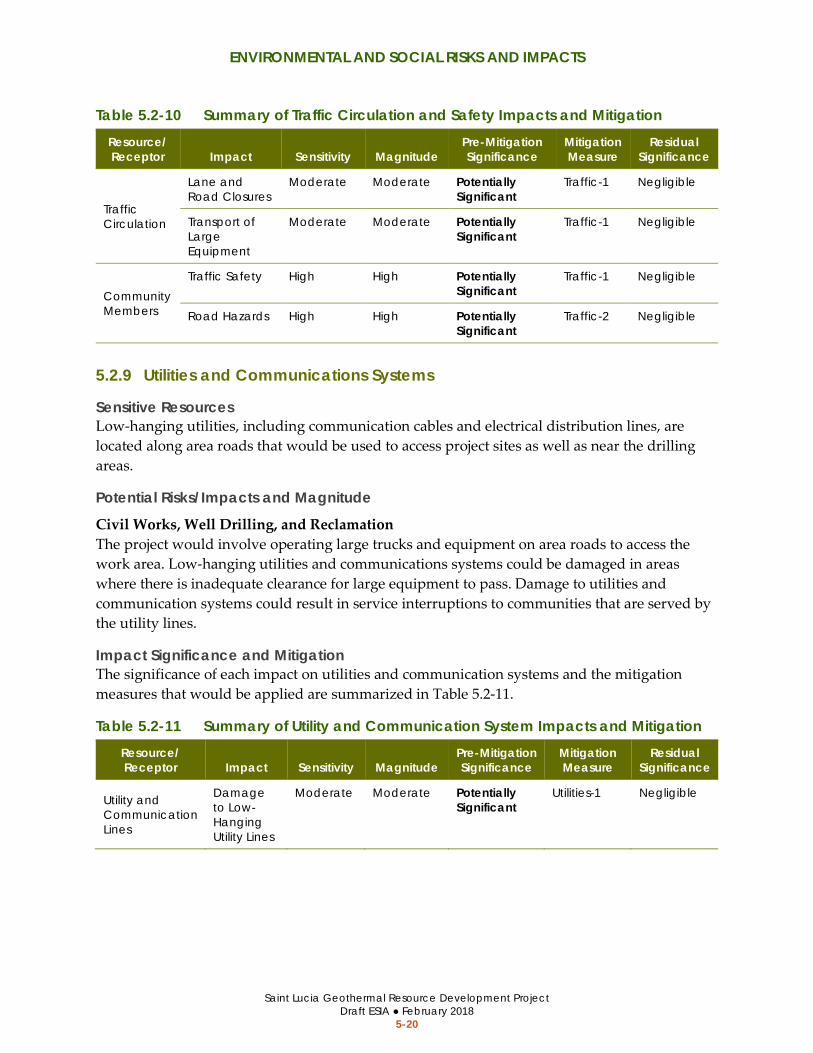
ENVIRONMENTAL AND SOCIAL RISKS AND IMPACTS
Saint Lucia Geothermal Resource Development Project Draft ESIA ● February 2018
5-20
Table 5.2-10 Summary of Traffic Circulation and Safety Impacts and Mitigation Resource/ Receptor Impact Sensitivity Magnitude
Pre-Mitigation Significance
Mitigation Measure
Residual Significance
Traffic Circulation
Lane and Road Closures
Moderate Moderate Potentially Significant
Traffic-1 Negligible
Transport of Large Equipment
Moderate Moderate Potentially Significant
Traffic-1 Negligible
Community Members
Traffic Safety High High Potentially Significant
Traffic-1 Negligible
Road Hazards High High Potentially Significant
Traffic-2 Negligible
5.2.9 Utilities and Communications Systems
Sensitive Resources Low-hanging utilities, including communication cables and electrical distribution lines, are located along area roads that would be used to access project sites as well as near the drilling areas.
Potential Risks/Impacts and Magnitude
Civil Works, Well Drilling, and Reclamation The project would involve operating large trucks and equipment on area roads to access the work area. Low-hanging utilities and communications systems could be damaged in areas where there is inadequate clearance for large equipment to pass. Damage to utilities and communication systems could result in service interruptions to communities that are served by the utility lines.
Impact Significance and Mitigation The significance of each impact on utilities and communication systems and the mitigation measures that would be applied are summarized in Table 5.2-11.
Table 5.2-11 Summary of Utility and Communication System Impacts and Mitigation Resource/ Receptor Impact Sensitivity Magnitude
Pre-Mitigation Significance
Mitigation Measure
Residual Significance
Utility and Communication Lines
Damage to Low-Hanging Utility Lines
Moderate Moderate Potentially Significant
Utilities-1 Negligible

ENVIRONMENTAL AND SOCIAL RISKS AND IMPACTS
Saint Lucia Geothermal Resource Development Project Draft ESIA ● February 2018
5-21
5.2.10 Hazards and Hazardous Materials
Sensitive Receptors The communities living near the drilling areas are at risk of hazards from construction operations. Sensitive receptors include residents near the drilling sites and community members who may use the roads or recreational facilities near the drilling areas. No schools are located in proximity to the drilling areas.
Workers would also be exposed to hazards and hazardous materials (refer also to Section 5.3.6 for worker health and safety and community health and safety).
Potential Risks/Impacts and Magnitude
Hazardous Material Use (Civil Works and Well Drilling) Operation of construction equipment would involve the use of hazardous materials, such as fuels, oils, lubricants, and other chemicals. Wells would be drilled with water and non-toxic drilling mud; however, materials extracted during the well drilling and testing process (e.g., cuttings and geothermal fluid) could be hazardous and contain toxic elements, such as heavy metals.
Hazardous materials, including potentially hazardous waste, would be transported, handled, and stored in accordance with applicable laws. If hazardous material and waste were not managed correctly, or if incidental leaks or spills occurred, the project could contaminate soil and water quality. Contaminating soil and water quality could affect drinking water for local communities, natural habitats, and agricultural production.
Geothermal Fluid Discharge (Well Drilling) Although unlikely, well drilling could result in an unanticipated release of geothermal gasses and fluid if a well blow out occurred. An uncontrolled release of geothermal fluid could expose people near the well to air contaminants as described in Section 5.2.2, water quality contaminants (see Section 5.2.1), and/or very high temperature fluid, which may be hazardous to community members and workers.
Reclamation Reclamation would use equipment similar to that used in construction. Site clean-up and restoration would have minimal use of hazardous materials and the risk would be low.
Impact Significance and Mitigation The significance of each impact on hazards and hazardous materials and the mitigation measures that would be applied are summarized in Table 5.2-12.

ENVIRONMENTAL AND SOCIAL RISKS AND IMPACTS
Saint Lucia Geothermal Resource Development Project Draft ESIA ● February 2018
5-22
Table 5.2-12 Summary of Hazards and Hazardous Materials Impacts and Mitigation Resource/ Receptor Impact Sensitivity Magnitude
Pre-Mitigation Significance
Mitigation Measure
Residual Significance
Community Members and Workers
Hazardous Material Discharge
High Low Potentially Significant
Hazards-1 Negligible
Geothermal Gases and Fluid, and Well Blowout
High Low Potentially Significant
Water-3 Water-4 Air-3
Negligible
5.2.11 Fires
Sensitive Receptors/Resources Uncontrolled wildfires can result in substantial damage to property, as well as injury or death. Wildfires can also result in substantial damage to natural habitats and biodiversity. The drilling areas have a low to moderate risk of wildfires during the dry season or periods of drought.
Potential Risks/Impacts and Magnitude
Civil Works and Well Drilling The project would have a low potential for causing fires during civil works and well drilling operations. The use of heavy construction equipment and welding could create sparks, which could potentially ignite a wildfire in nearby brush. Workers who smoke could also cause a wildfire if their cigarettes were not properly extinguished or smoking occurred in areas with dry vegetation.
The project would involve operating large trucks and equipment near low-hanging utility lines, including power lines. Live power lines could cause electrocution and fires.
Well Testing Geothermal testing would not pose a significant risk of fires because gases that are typically emitted from geothermal systems are not combustible.
Reclamation Reclamations activities would consist of trash removal, site recontouring, and revegetation. Reclamation activities would be conducted within the well pad, which would be free of vegetation. The risk of fire from site reclamation would be very low.
Impact Significance and Mitigation The significance of fire impacts and the mitigation measures that would be applied are summarized in Table 5.2-13.
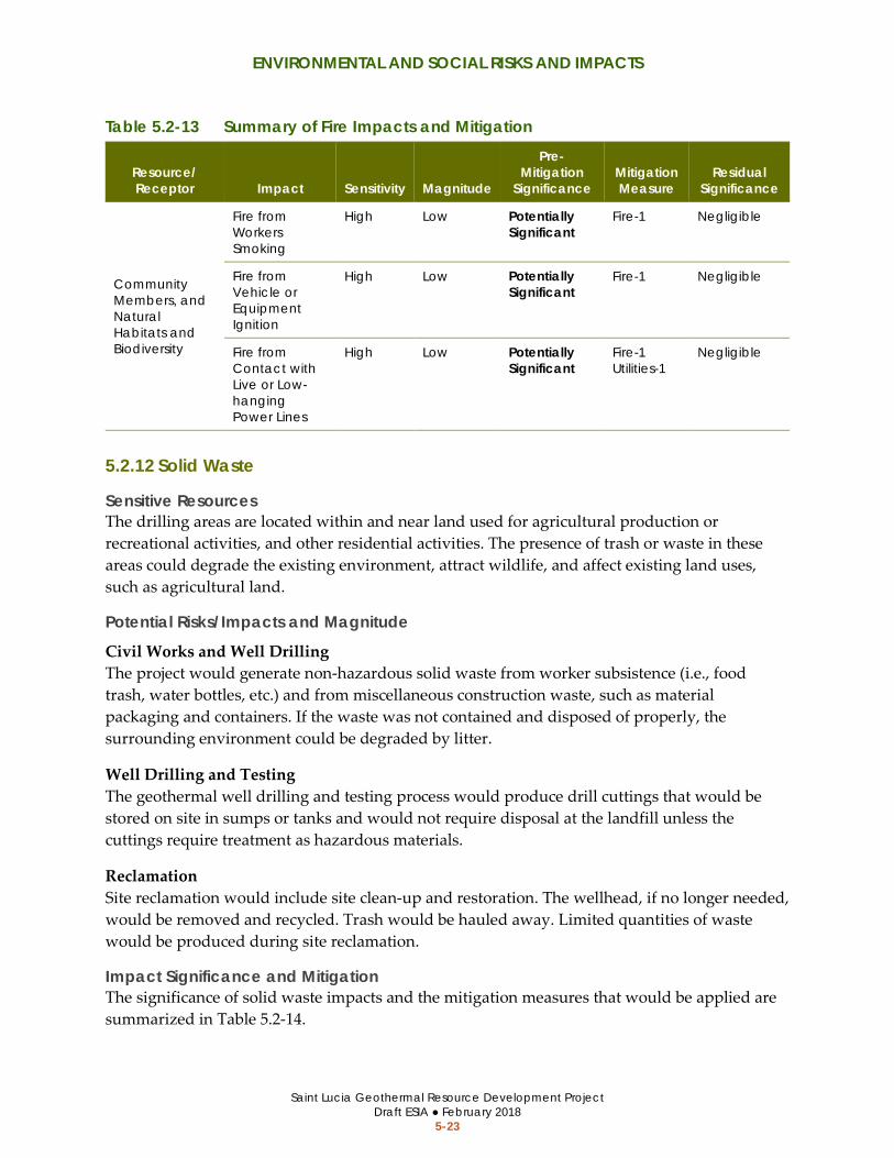
ENVIRONMENTAL AND SOCIAL RISKS AND IMPACTS
Saint Lucia Geothermal Resource Development Project Draft ESIA ● February 2018
5-23
Table 5.2-13 Summary of Fire Impacts and Mitigation
Resource/ Receptor Impact Sensitivity Magnitude
Pre-Mitigation
Significance Mitigation Measure
Residual Significance
Community Members, and Natural Habitats and Biodiversity
Fire from Workers Smoking
High Low Potentially Significant
Fire-1 Negligible
Fire from Vehicle or Equipment Ignition
High Low Potentially Significant
Fire-1 Negligible
Fire from Contact with Live or Low-hanging Power Lines
High Low Potentially Significant
Fire-1 Utilities-1
Negligible
5.2.12 Solid Waste
Sensitive Resources The drilling areas are located within and near land used for agricultural production or recreational activities, and other residential activities. The presence of trash or waste in these areas could degrade the existing environment, attract wildlife, and affect existing land uses, such as agricultural land.
Potential Risks/Impacts and Magnitude
Civil Works and Well Drilling The project would generate non-hazardous solid waste from worker subsistence (i.e., food trash, water bottles, etc.) and from miscellaneous construction waste, such as material packaging and containers. If the waste was not contained and disposed of properly, the surrounding environment could be degraded by litter.
Well Drilling and Testing The geothermal well drilling and testing process would produce drill cuttings that would be stored on site in sumps or tanks and would not require disposal at the landfill unless the cuttings require treatment as hazardous materials.
Reclamation Site reclamation would include site clean-up and restoration. The wellhead, if no longer needed, would be removed and recycled. Trash would be hauled away. Limited quantities of waste would be produced during site reclamation.
Impact Significance and Mitigation The significance of solid waste impacts and the mitigation measures that would be applied are summarized in Table 5.2-14.

ENVIRONMENTAL AND SOCIAL RISKS AND IMPACTS
Saint Lucia Geothermal Resource Development Project Draft ESIA ● February 2018
5-24
Table 5.2-14 Summary of Solid Waste Impacts and Mitigation Resource/ Receptor Impact Sensitivity Magnitude
Pre-Mitigation Significance
Mitigation Measure
Residual Significance
Farmers and Community Members
Construction Waste and Debris
Moderate Low Potentially Significant
Waste-1 Negligible
5.3 SOCIAL RISKS AND IMPACTS
5.3.1 Livelihoods
Sensitive Receptors The potential drilling areas in Belle Plaine, Mondesir-Saltibus, and Fond St. Jacques east are under agricultural production. The livelihoods of farm owners and workers could be impacted, if the project causes a reduction in agriculture production.
Potential Risks/Impacts and Magnitude
Direct Impact on Livelihoods (Civil Works and Well Drilling) The project would temporarily disrupt agricultural production where well pads and access routes would be located on land that is currently used for agricultural production. Depending on the location of the well pads and access roads, the project could impact farms with annual row crops or crop trees that have longer maturing and yield periods (i.e., bananas, coconuts, cocoa, avocados, mangoes, and citrus). Construction of the well pads would remove that area from agricultural production for the life of the well pad. The area would be lost to agriculture for a few months to 1 year if:
• The slim-hole well testing results do not show promising increase in temperature at depth and the well is not suitable for monitoring
• The slim-hole well geology does not indicate the presence of a geothermal resource • The slim-hole well (if it is designed to penetrate the geothermal resource) does not
show adequate temperature, permeability, and fluid and the well is not suitable for monitoring
• The full-size well does not encounter a geothermal resource with adequate temperature, permeability, and fluid flow and the well is not suitable for monitoring
Unsuccessful wells would be plugged, abandoned, and the well pad restored. A well that may be suitable for monitoring or further study may retain the wellhead requiring up to 5 square meters (16 square feet) of permanent impact, with the majority of the well pad revegetated and restored. Monitoring could continue at a restored well pad.
Short-term impacts could occur through well drilling and restoration (approximately 2 to 10 months) where annual row crops are present. Where mature crop trees could not be avoided, the impact would occur for a longer period (up to several years) until the new trees matured

ENVIRONMENTAL AND SOCIAL RISKS AND IMPACTS
Saint Lucia Geothermal Resource Development Project Draft ESIA ● February 2018
5-25
and reached the same production levels. Impacts on agriculture production and compensation are discussed further in the Section 5.3.3, Resettlement.
Wells that are successful, encounter a geothermal resource, and are designated for further drilling or testing may be removed from agricultural production for several years to up to 30 years or more if a power plant is built.
The graded well pad and access road could result in the long-term loss of agricultural productivity if the well pad site was not properly restored to pre-construction conditions with productive topsoil.
The project has the potential to create temporary construction jobs for local community members during the civil works and drilling phase. Although the extent of job opportunities and hiring is unknown at this time, providing local communities with job opportunities would be a positive impact.
Indirect Impacts on Livelihoods Geothermal Emissions (Well Testing) Geothermal emissions may result in some geothermal steam particulates landing on nearby crops. Some crops are sensitive to boron and could be affected if geothermal steam particulate settle on the crops. Leaf injury must be severe to cause reduced crop quality and yields. Long-term use of irrigation water containing more than 0.5 ppm of boron can reduce yields of bean, onion, garlic, and strawberry; 0.7 ppm can reduce yields of broccoli, carrot, potato, and lettuce; and 2 ppm can reduce yields of cabbage and cauliflower. The amount of boron that would be deposited on crops would be low because the droplets settle out close to the emission point and land on the well pad and the testing would be short duration (days). Impacts to agricultural production and required compensation are described in detail in the RAP (Appendix E).
Water Supply and Topsoil Loss The project could also deplete the water supply or degrade water supply systems used for agriculture (refer to Section 5.2.1) and could cause loss of topsoil due to erosion (refer to Section 5.2.3); these project impacts have the potential to adversely affect agricultural production.
Reclamation Reclamation would restore the sites to agricultural production and would avoid long-term impacts from loss of productive use of the land. The reclamation process would likely require local labor, which would also have a positive impact on livelihoods.
Impact Significance and Mitigation The significance of impacts on livelihoods and the mitigation measures that would be applied are summarized in Table 5.3-1. The RAP and RPF also identify measures to reduce or avoid impacts (refer to Section 5.3.3).

ENVIRONMENTAL AND SOCIAL RISKS AND IMPACTS
Saint Lucia Geothermal Resource Development Project Draft ESIA ● February 2018
5-26
Table 5.3-1 Summary of Livelihood Impacts and Mitigation Resource/ Receptor Impact Sensitivity Magnitude
Pre-Mitigation Significance
Mitigation Measure
Residual Significance
Farmers
Short-term Loss of Livelihood
High High Significant Social-1 Soils-1 Landscape-1
Negligible
Long-term Loss of Livelihood
High Low Potentially Significant
Social-1 Soils-1 Landscape-1
Negligible
Community Members
Temporary Construction Jobs
-- -- Positive -- --
5.3.2 Tourism
Sensitive Receptors/Resources Tourism is the primary economic activity in the project region. The protection of the tourist industry and tourist resources is a top priority for the GoSL and community stakeholders.
No tourist destinations, such as hotels or popular places of interest, are located in close proximity to the potential drilling areas. The closest tourist destinations are located approximately 0.6 kilometer (2,000 feet) from the drilling areas as shown on Figure 5.3-1. Intervening topography and dense vegetation would restrict views of the drilling areas and project activities.
Potential Risks/Impacts and Magnitude The large truck traffic could have a minor effect on tourist traffic near Soufrière or other port of entry for heavy equipment (refer to Section 5.2.8).
Temporary construction noise (refer to Section 5.2.4), landscape impacts (refer to Section 5.2.7) could affect tourists in a similar manner as local residents; however, the project would not displace tourism activities or the livelihoods of those working in the tourism industry. The geothermal drilling could be of interest to tourists and could be a positive impact, bringing tourists to the area that may increase spending in the local community.

ENVIRONMENTAL AND SOCIAL RISKS AND IMPACTS
Saint Lucia Geothermal Resource Development Project Draft ESIA ● February 2018
5-27
Figure 5.3-1 Tourist Destinations in the Project Vicinity
Sources: (ESRI 2017, McElhanney Consulting Services LTD 2015)

ENVIRONMENTAL AND SOCIAL RISKS AND IMPACTS
Saint Lucia Geothermal Resource Development Project Draft ESIA ● February 2018
5-28
Impact Significance and Mitigation The significance of impacts on tourism and the mitigation measures that would be applied are summarized in Table 5.3-2.
Table 5.3-2 Summary of Tourism Impacts and Mitigation Resource/ Receptor Impact Sensitivity Magnitude
Pre-Mitigation Significance
Mitigation Measure
Residual Significance
Tourism
Visual High Very Low Negligible -- --
Noise High Very Low Negligible -- --
Traffic High Very Low Negligible -- --
5.3.3 Resettlement
Sensitive Receptors No structures are located within the potential drilling areas where well pads will be sited. Agricultural land uses in the project area could be temporarily displaced during civil works and well drilling activities.
Potential Risks/Impacts and Magnitude
Direct Impacts (Civil Works and Drilling) Resettlement refers to the potential displacement of people or existing land uses. Figure 4.2-3 through Figure 4.2-5 show sensitive receptors in the potential drilling areas. It is not anticipated that the project would require direct resettlement of communities or residences because there are adequate open spaces within the drilling areas to build the well pads. A slim-hole well pad is approximately 40 by 30 meters (0.1 hectare or 0.25 acre). Well pads for full-sized (deep) wells are generally 100 by 100 meters (330 by 330 feet) or approximately 0.8 to 1.6 hectares (2 to 4 acres) in size. The well pad siting goal is to reach the geologic targets, and avoid drilling in close proximity to residences if possible. The actual locations will be sited based on these factors as well as access and surface conditions.
Inadvertent travel off of access roads or outside of designated work areas could expand the area of impact on livelihoods and the area requiring compensation for loss. This impact is addressed in the RAP and RPF.
Indirect Impacts It may be necessary, for safety reasons or to avoid substantial noise disruption (refer to Section 5.2.4), to temporarily vacate residents in close proximity to well pads during construction and/or drilling, such as during potential emergency situations (addressed in Section 5.3.6). Any evacuation of residents would be very short in duration (a few hours) and would not cause resettlement.
The project would temporarily impact agricultural land during construction and restoration as described in Section 5.3.1.. Impacting food supply and the livelihoods of farm owners and

ENVIRONMENTAL AND SOCIAL RISKS AND IMPACTS
Saint Lucia Geothermal Resource Development Project Draft ESIA ● February 2018
5-29
farmworkers could cause indirect resettlement. Resettlement without appropriate compensation would be a significant impact.
A RAP was developed to address anticipated resettlement for the project (displacement of agricultural land uses) (provided in Appendix E). In addition, a RPF was developed to address the potential for unanticipated resettlement issues that may arise (provided in Appendix F).
Impact Significance and Mitigation The significance of impacts on resettlement and the mitigation measures that would be applied to reduce the impact are summarized in Table 5.3-3.
Table 5.3-3 Summary of Resettlement Impacts and Mitigation Resource/ Receptor Impact Sensitivity Magnitude
Pre-Mitigation Significance
Mitigation Measure
Residual Significance
Farmers Displace Agricultural Production
High Moderate Potentially Significant
RAP RPF
Negligible
Community Emergency Evacuation
High Very Low Negligible -- --
Farmers Travel Outside Approved Work Areas
High Moderate Potentially Significant
Social-1 Negligible
5.3.4 Working Conditions and Equality
Sensitive Receptors Women are vulnerable to sexual harassment and abuse and should be afforded special considerations and protection. Religious minorities, ethnic minorities, or economically disadvantaged communities are also vulnerable to discrimination and disproportionate impacts. In the workplace, these groups can also be vulnerable to unequal job opportunities, unequal pay, and workplace harassment. Poor labor and working conditions can result in worker exploitation and abuse.
Potential Risks/Impacts and Magnitude The project would comply with applicable laws and policies governing labor rights and working conditions. The project would also incorporate World Bank EHS Guidelines and policies relevant to working conditions and equality to ensure and safe and equitable environment for all workers.
Impact Significance and Mitigation The significance of impacts on working conditions and equality and the mitigation measures that would be applied are summarized in Table 5.3-4.

ENVIRONMENTAL AND SOCIAL RISKS AND IMPACTS
Saint Lucia Geothermal Resource Development Project Draft ESIA ● February 2018
5-30
Table 5.3-4 Summary of Equality and Working Conditions Impacts and Mitigation Resource/ Receptor Impact Sensitivity Magnitude
Pre-Mitigation Significance
Mitigation Measure
Residual Significance
Community members
Harassment from workers
Moderate Moderate Potentially Significant
Social-2 Negligible
Workers Workplace harassment
Moderate Moderate Potentially Significant
Social-2 Negligible
5.3.5 Recreation
Sensitive Resources There is a soccer field within the potential drilling area identified for Mondesir-Saltibus (refer to Figure 3.2-2) and a recreational area in Fond St. Jacques west. There are few soccer fields in the region and the field is important to the surrounding communities.
Potential Risks/Impacts and Magnitude The recreational areas could be physically impacted by construction activities if access roads and well pads were positioned within the soccer field, and soccer games could be prevented if the field was occupied by project equipment. The soccer field and games could be affected for between 2 to 10 months during construction through restoration, depending on the extent of well drilling and testing. Physically disturbing the soccer field and losing access to the playing field could result in an adverse community effect.
Impact Significance and Mitigation The significance of impacts on recreation and the mitigation measures that would be applied are summarized in Table 5.3-5.
Table 5.3-5 Summary of Recreation Impacts and Mitigation Resource/ Receptor Impact Sensitivity Magnitude
Pre-Mitigation Significance
Mitigation Measure
Residual Significance
Community Members
Temporary Loss of Recreational Areas
High Moderate Significant Social-4 Less than Significant
5.3.6 Labor Influx
Sensitive Resources The potential drilling areas and worker camp are located near communities with limited housing resources.
Potential Risks/Impacts and Magnitude The project could attract locals from surrounding communities seeking possible employment opportunities which could temporarily increase community population and housing demand for the duration of construction (approximately 6 to 9 months). The majority of workers without

ENVIRONMENTAL AND SOCIAL RISKS AND IMPACTS
Saint Lucia Geothermal Resource Development Project Draft ESIA ● February 2018
5-31
available housing would be provided housing at the worker camp, and the project would not involve long-term jobs; therefore, it is unlikely that people seeking work would permanently migrate to communities where project activities would occur.
Impact Significance and Mitigation The significance of impacts on labor influx and the mitigation measures that would be applied are summarized in Table 5.3-6.
Table 5.3-6 Summary of Labor Influx Impacts and Mitigation Resource/ Receptor Impact Sensitivity Magnitude
Pre-Mitigation Significance
Mitigation Measure
Residual Significance
Local communities
Labor Influx High Low Less than Significant
-- --
5.4 HEALTH AND SAFETY
5.4.1 Worker Health and Safety
Sensitive Receptors Workers would have the greatest potential for health and safety risks as a result of the geothermal exploration activities because workers would be directly engaged in the geothermal exploration process.
Potential Risks/Impacts and Magnitude The project would expose the labor workforce to hazards during construction that pose a risk of bodily injury or death. The primary hazards that may be encountered during construction can be generally categorized as either occupational or environmental. Typical occupational hazards associated construction include working with moving machinery and motorized equipment, working at heights or in confined spaces, open holes and trenches, repetitive motions, falling objects, exposure to heat (i.e., hot weather, fluids, or objects), fires, loud noises, and hazardous materials (refer to Section 5.2.10). Less common occupational hazards that may be encountered during geothermal drilling and testing include exposure to potentially harmful geothermal gases, hot geothermal fluids and drilling materials, and hazards associated with a potential well blowout.
Environmental hazards in Saint Lucia that may be encountered during construction include hurricanes and tropical storms, landslides, earthquakes, volcanic eruptions, and flooding. Workers could also be exposed to biological hazards in the environment such as those associated with dangerous or infectious insects, animals, and plants.
If proper safety precautions were not taken, then workers could be exposed to very high levels of noise that could result in hearing damage. Hearing damage can occur from exposure to moderate noise levels (85 to 100 dBA) over a few weeks, or exposure to high noise levels (>100 dBA) for shorter periods (refer to Table 2.6-5). The frequency of exposure plays a large

ENVIRONMENTAL AND SOCIAL RISKS AND IMPACTS
Saint Lucia Geothermal Resource Development Project Draft ESIA ● February 2018
5-32
role in the risk of hearing damage. Workers must wear proper hearing protection when noise levels exceed 85 dBA (refer to Table 2.6-5).
Refer to Section 5.4.2 below for a discussion of potential risks associated with disease.
Impact Significance and Mitigation The significance of impacts on worker health and safety and the mitigation measures that would be applied are summarized in Table 5.4-1.
Table 5.4-1 Summary of Worker Health and Safety Impacts and Mitigation Resource/ Receptor Impact Sensitivity Magnitude
Pre-Mitigation Significance
Mitigation Measure
Residual Significance
Workers
Occupational Hazards
High High Significant Safety-1 Safety-2 Safety-3
Less than Significant
Noise High High Significant Noise-1 Less than Significant
Geothermal Gases
High High Significant Water-4 Air-3
Less than Significant
Disease High Moderate Potentially Significant
Safety-1 Negligible
5.4.2 Community Health and Safety
Sensitive Receptors The project could expose the local community members to the same hazards as workers; however, the risk of such hazards would generally be reduced with distance from project areas. Community members who are living or using property adjacent to the well pads and access roads would be exposed to the greatest risk of hazards.
Potential Risks/Impacts and Magnitude
Community Hazards from Civil Works and Drilling Activities The public would generally be restricted from entering well pads where the hazards are greatest; however, the public could still be exposed to hazards at the periphery of work areas or within access roads. Hazards to the community would include moving vehicles and equipment, hazardous materials, open holes and trenches, fires, potentially harmful geothermal gases, and hazards associated with a potential well blowout.
Disease The project would involve bringing foreign workers to Saint Lucia. Foreign workers could expose people in Saint Lucia to new diseases, and vice versa. The risk of transferring diseases between workers and the local population would not be significantly different that the same risk between tourists and the local population. The project workforce would be limited to approximately 50 people at any given stage of construction, some of whom may be hired from
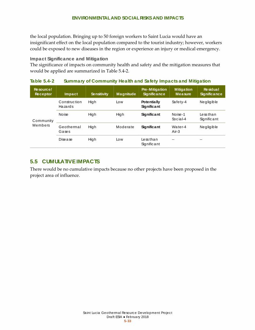
ENVIRONMENTAL AND SOCIAL RISKS AND IMPACTS
Saint Lucia Geothermal Resource Development Project Draft ESIA ● February 2018
5-33
the local population. Bringing up to 50 foreign workers to Saint Lucia would have an insignificant effect on the local population compared to the tourist industry; however, workers could be exposed to new diseases in the region or experience an injury or medical emergency.
Impact Significance and Mitigation The significance of impacts on community health and safety and the mitigation measures that would be applied are summarized in Table 5.4-2.
Table 5.4-2 Summary of Community Health and Safety Impacts and Mitigation Resource/ Receptor Impact Sensitivity Magnitude
Pre-Mitigation Significance
Mitigation Measure
Residual Significance
Community Members
Construction Hazards
High Low Potentially Significant
Safety-4 Negligible
Noise High High Significant Noise-1 Social-4
Less than Significant
Geothermal Gases
High Moderate Significant Water-4 Air-3
Negligible
Disease High Low Less than Significant
-- --
5.5 CUMULATIVE IMPACTS There would be no cumulative impacts because no other projects have been proposed in the project area of influence.

ENVIRONMENTAL AND SOCIAL RISKS AND IMPACTS
Saint Lucia Geothermal Resource Development Project Draft ESIA ● February 2018
5-34
This page is intentionally blank.
MITIGATION MEASURES
Saint Lucia Geothermal Resource Development Project Draft ESIA ● February 2018
6-1
6 MITIGATION MEASURES
6.1 OVERVIEW This section identifies the mitigation measures that would be implemented to address the risks and potential impacts described in Section 5. Mitigation measures for the project are separated into three categories: environmental, social, and health and safety; however, elements of some mitigation measures are applicable to more than one category.
Mitigation measures were designed to avoid or reduce impacts to less than significant levels. In addition to the full text of the mitigation measures, the following elements are provided for each measure:
• The issue or potential impact being mitigated identified in Section 5 • The parties responsible for implementing the described requirements • The general timing when implementation is required
The construction contractors (e.g., civil and drilling) would have the primary responsibilities for implementing the mitigation requirements; however, the GoSL’s Project Coordination Unit (PCU) would also be responsible for implementing some requirements where specified. The PCU would be responsible monitoring, documenting, and reporting implementation of the mitigation measures. These roles and responsibilities are described in detail in the ESMP.

MITIGATION MEASURES
Saint Lucia Geothermal Resource Development Project Draft ESIA ● February 2018
6-2
6.2 ENVIRONMENTAL MITIGATION MEASURES Table 6.2-1 Environmental Mitigation Measures
Issues/Potential Impacts Mitigation Measure
Responsible for Implementing
Timing of Requirements
Water Resources
• Water Quality • Erosion and
Topsoil Loss • Landslides
and Mudflows
Water-1: Stormwater, Erosion, and Sediment Control Stormwater runoff and drainage shall be properly managed at all work areas using best management practices (BMPs) (e.g., procedural actions and/or material installations). BMPs and drainage systems shall be designed to accommodate rapid rainfall events that can be expected in the region. The following procedures shall be implemented to prevent soil loss, erosion, and sediment transport in project areas: • Project activities shall be scheduled to avoid the heaviest rain season, to the
extent possible. • Soil disturbance shall be limited to the minimum amount necessary. • All disturbed areas shall be stabilized as soon as possible (i.e., covered,
compacted, or secured with BMP materials). • Project traffic shall be restricted to designated areas. • Pipelines shall be monitored for leaks and any leaks shall be repaired
immediately. • Sediment shall be controlled and prevented from leaving disturbed project
areas. All BMPs shall be properly inspected and maintained on a frequent basis to ensure they are functioning properly.
• Civil Works Contractor
• Drilling Contractor
• Before Construction
• During Construction
• Water Quality Water-2: Water Quality Monitoring Program The drilling contractor shall implement a water quality monitoring program to ensure the project does not cause or substantially contribute to a condition that exceeds acceptable water quality standards. Water quality sampling shall occur prior to the start of project activities to determine the baseline contaminant levels, and then every few weeks during project activities in the area, in order to determine if the project is reducing water quality. Samples shall be taken upstream and downstream in potentially affected waterways. If it is determined that the project is reducing water quality, the drilling contractor shall make the appropriate adjustments to the construction activities to correct the problem. If the water
• Drilling Contractor
• Before Construction
• During Construction
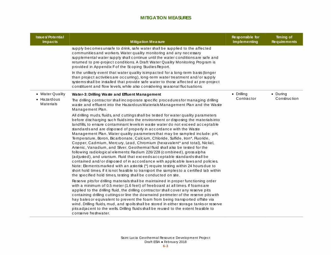
MITIGATION MEASURES
Saint Lucia Geothermal Resource Development Project Draft ESIA ● February 2018
6-3
Issues/Potential Impacts Mitigation Measure
Responsible for Implementing
Timing of Requirements
supply becomes unsafe to drink, safe water shall be supplied to the affected communities and workers. Water quality monitoring and any necessary supplemental water supply shall continue until the water conditions are safe and returned to pre-project conditions. A Draft Water Quality Monitoring Program is provided in Appendix F of the Scoping Studies Report. In the unlikely event that water quality is impacted for a long-term basis (longer than project activities are occurring), long-term water treatment and/or supply systems shall be installed that provide safe water to those affected at pre-project constituent and flow levels, while also considering seasonal fluctuations.
• Water Quality • Hazardous
Materials
Water-3: Drilling Waste and Effluent Management The drilling contractor shall incorporate specific procedures for managing drilling waste and effluent into the Hazardous Materials Management Plan and the Waste Management Plan. All drilling muds, fluids, and cuttings shall be tested for water quality parameters before discharging such fluids into the environment or disposing the materials into landfills, to ensure contaminant levels in waste water do not exceed acceptable standards and are disposed of properly in accordance with the Waste Management Plan. Water quality parameters that may be sampled include: pH, Temperature, Boron, Bicarbonate, Calcium, Chloride, Sulfide, Iron*, Fluoride, Copper, Cadmium, Mercury, Lead, Chromium (hexavalent* and total), Nickel, Arsenic, Vanadium, and Silver. Geothermal fluid shall also be tested for the following radiological elements: Radium 226/228 (combined), gross alpha (adjusted), and uranium. Fluid that exceeds acceptable standards shall be contained and/or disposed of in accordance with applicable laws and policies. Note: Elements marked with an asterisk (*) require testing within 24 hours due to short hold times. If it is not feasible to transport the samples to a certified lab within the specified hold times, testing shall be conducted on site. Reserve pits for drilling materials shall be maintained in proper functioning order with a minimum of 0.5 meter (1.6 feet) of freeboard at all times. If foams are applied to the drilling fluid, the drilling contractor shall cover any reserve pits containing drilling cuttings or line the downwind perimeter of the reserve pits with hay bales or equivalent to prevent the foam from being transported offsite via wind. Drilling fluids, mud, and spoils shall be stored in either storage tanks or reserve pits adjacent to the wells. Drilling fluids shall be reused to the extent feasible to conserve freshwater.
• Drilling Contractor
• During Construction
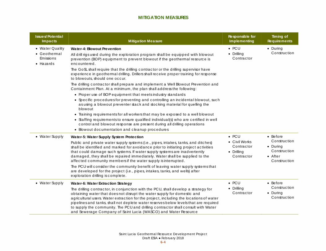
MITIGATION MEASURES
Saint Lucia Geothermal Resource Development Project Draft ESIA ● February 2018
6-4
Issues/Potential Impacts Mitigation Measure
Responsible for Implementing
Timing of Requirements
• Water Quality • Geothermal
Emissions • Hazards
Water-4: Blowout Prevention All drill rigs used during the exploration program shall be equipped with blowout prevention (BOP) equipment to prevent blowout if the geothermal resource is encountered. The GoSL shall require that the drilling contractor or the drilling supervisor have experience in geothermal drilling. Drillers shall receive proper training for response to blowouts, should one occur. The drilling contractor shall prepare and implement a Well Blowout Prevention and Containment Plan. At a minimum, the plan shall address the following: • Proper use of BOP equipment that meets industry standards • Specific procedures for preventing and controlling an incidental blowout, such
as using a blowout preventer stack and stocking material for quelling the blowout
• Training requirements for all workers that may be exposed to a well blowout • Staffing requirements to ensure qualified individual(s) who are certified in well
control and blowout response are present during all drilling operations • Blowout documentation and cleanup procedures
• PCU • Drilling
Contractor
• During Construction
• Water Supply Water-5: Water Supply System Protection Public and private water supply systems (i.e., pipes, intakes, tanks, and ditches) shall be identified and marked for avoidance prior to initiating project activities that could damage such systems. If water supply systems are inadvertently damaged, they shall be repaired immediately. Water shall be supplied to the affected community members if the water supply is interrupted. The PCU will consider the community benefit of leaving water supply systems that are developed for the project (i.e., pipes, intakes, tanks, and wells) after exploration drilling is complete.
• PCU • Civil Works
Contractor • Drilling
Contractor
• Before Construction
• During Construction
• After Construction
• Water Supply Water-6: Water Extraction Strategy The drilling contractor, in conjunction with the PCU, shall develop a strategy for obtaining water that does not disrupt the water supply for domestic and agricultural users. Water extraction for the project, including the locations of water pipelines and tanks, shall not deplete water reserves below levels that are required to supply the community. The PCU and drilling contractor shall consult with Water and Sewerage Company of Saint Lucia (WASCO) and Water Resource
• PCU • Drilling
Contractor
• Before Construction
• During Construction

MITIGATION MEASURES
Saint Lucia Geothermal Resource Development Project Draft ESIA ● February 2018
6-5
Issues/Potential Impacts Mitigation Measure
Responsible for Implementing
Timing of Requirements
Management Agency (WRMA) of Saint Lucia to ensure communities are supplied with adequate water during extraction. Where water is extracted from rivers, the project intake systems shall be designed to limit impacts on sensitive aquatic habitat and wildlife, and screen barriers shall be installed to prevent impingement and entrapment of wildlife. Intake areas and potential hazards where pipelines cross roadways shall be clearly marked with signs and/or flagging.
Air Quality
• Air Quality Air-1: Fugitive Dust Management The following procedures shall be implemented where dry exposed soils are located in project areas: • Water shall be applied to active construction areas to prevent visible dust, to
the extent that water is readily available. Water shall not be over applied so that it creates runoff that leaves the site. As an alternative to water, chemical stabilizers or surfactants may be applied to disturbed areas, being careful to not allow overspray on nearby vegetation.
• Vehicle speeds shall not exceed 25 kilometers (15 miles) per hour on unpaved surfaces.
• Inactive areas shall be covered or otherwise stabilized to reduce the potential for wind transporting dust.
Disturbed areas shall be stabilized and restored once project activities are completed.
• Civil Contractor
• Drilling Contractor
• During Construction
• Air Quality Air-2: Construction Emissions Controls The construction contractors shall be responsible for ensuring all vehicles and equipment are properly operated and maintained according the manufacturer’s specifications, and equipped with appropriate emission control devices (i.e., catalytic converters, etc.). Malfunctioning equipment shall be repaired immediately or removed from the site.
• Civil Contractor
• Drilling Contractor
• During Construction
• Worker Health and Safety
• Community Health and Safety
Air-3: Air Quality Monitoring and Noxious Gas Management The drilling contractor shall be responsible for managing risks to workers and local communities from potentially harmful geothermal gas emissions (e.g., hydrogen sulphide, carbon dioxide, boron, arsenic, mercury, and bicarbonate) during well
• Drilling Contractor
• During Construction

MITIGATION MEASURES
Saint Lucia Geothermal Resource Development Project Draft ESIA ● February 2018
6-6
Issues/Potential Impacts Mitigation Measure
Responsible for Implementing
Timing of Requirements
drilling and testing. At a minimum, the following procedures shall be implemented during drilling and testing activities: • Well drilling or testing that could cause the release of potentially harmful
geothermal gases shall not occur where the public could be put at undue risk. An appropriate geothermal gas hazard zone shall be established around well sites based on the risk of gas release from the drilling and testing activities that would occur. The hazard zone shall be marked with signs and communicated to the local community members. If occupied structures would be located within a hazard zone, the drilling site must be relocated or drilling activities shall be limited to techniques that would not release unsafe levels of geothermal gases, such as surface coring.
• Minimize the potential for gas release by using properly weighted drilling mud to keep the well from flowing or by implementing other well head abatement measures.
• Install gas detection and monitoring devices during well drilling and testing activities, that are equipped with alarms that would be trigged if gas concentrations reach unsafe levels.
• Autonomous respiratory equipment shall be provided in enclosed areas of the drill rig.
• The Health and Safety Plan shall specify safety procedures for potential exposure to geothermal gases and emergency response.
The drilling contractor shall implement an air quality monitoring program to monitor air quality during well drilling and testing for signs of unsafe levels of potentially harmful geothermal gases using automated detection and alarm systems. If unsafe gas levels are detected, the area shall be evacuated and properly trained workers wearing appropriate PPE shall attempt to stop the release by injecting hydrogen peroxide, capping the well, or another suitable method.
Geology and Soils
• Topsoil Loss Soils-1: Topsoil Preservation and Restoration Where grading occurs within farmland, topsoil shall be separated and stockpiled during the construction period. The topsoil stockpile shall be secured with plastic and BMP materials. Following construction, the topsoil shall be applied evenly to the site during the restoration process. The topsoil shall be properly compacted and stabilized to prevent erosion and sediment transport.
• Civil Works Contractor
• Before Construction
• During Construction

MITIGATION MEASURES
Saint Lucia Geothermal Resource Development Project Draft ESIA ● February 2018
6-7
Issues/Potential Impacts Mitigation Measure
Responsible for Implementing
Timing of Requirements
• Unstable Slopes and Saturated Soils
Soils-2: Geotechnical Investigation The civil works contractor shall complete a geotechnical investigation prior to initiating civil works activities for access road expansion or well pad construction in Fond St. Jacques. The contractor shall implement all recommendations contained in the geotechnical investigation.
• Civil Works Contractor
• Before Construction
• During Construction
Noise
• Noise Noise-1: Noise Abatement and Community Coordination Construction noise and the associated effects shall be reduced or minimized, to the extent possible, by implementing the following procedures: • Select quieter equipment and construction activities, whenever feasible; • Ensure motorized vehicles and equipment are equipped with the greatest
possible noise reduction parts, such as mufflers, silencers, insulators, and enclosures;
• Locate access roads and well pads as far from sensitive receptors as feasible; • Limit civil work activities to daytime hours (7:00 to 18:00), to the extent feasible; • Avoid civil works during sensitive morning, evening, and nighttime periods, to
the extent feasible; • Notify and coordinate with residents adjacent to project areas prior to
construction to inform them of the possibility of temporary noise disruption, and how to report noise complaints;
• Install acoustic barriers between stationary equipment and sensitive receptors located within 300 meters (1,000 feet);
• Use a rock muffler or other effective, industry standard silencer during well testing;
• Notify community members at least 24 hours prior to conducting well tests; • Implement a Noise Complaint Program to record and respond to noise
complaints during construction.
• Civil Works Contractor
• Drilling Contractor
• Before Construction
• During Construction
Natural Habitats and Biodiversity
• Biodiversity Biodiversity-1: Pre-Construction Surveys in MS-3 and MS-4 The GoSL shall conduct surveys for rare plants and priority or endemic wildlife species prior to civil work activities in MS-3 and MS-4. If any rare plants or sensitive
• PCU • Before Construction

MITIGATION MEASURES
Saint Lucia Geothermal Resource Development Project Draft ESIA ● February 2018
6-8
Issues/Potential Impacts Mitigation Measure
Responsible for Implementing
Timing of Requirements
wildlife species occur in the drilling area, the sensitive resource shall be fenced and no activities will be allowed within 15 meters (50 feet) of the resource.
• Natural Habitats
Biodiversity-2: Invasive Weed Control All equipment shall arrive at the work site clean and free of caked mud and plant material.
• Civil Works Contractor
• Drilling Contractor
• During Construction
• Nesting Birds Biodiversity-3: Nesting Bird Avoidance and Impact Minimization Well drilling activities shall be scheduled outside of the prime bird nesting season (April to June) to the extent feasible. If well drilling occurs during the prime nesting bird season, well pads shall be positioned at least 75 meters (250 feet) from the forested areas where suitable nesting habitat for priority bird species may be located. Prior to well drilling during the nesting season, a qualified biologist shall survey potentially suitable nesting habitat for priority species birds. If active nests are identified, a qualified biologist shall monitor the nesting birds responses to the loudest level of construction noise for an appropriate duration. If the nesting birds show signs of disturbance that could result in nest failure, all work activities that disturb the birds shall be temporarily halted and visual and acoustic barriers shall be erected between the nesting location and work areas. Installation of any visual and acoustic barriers shall be overseen and approved by the qualified biologist.
• Civil Works Contractor
• Drilling Contractor
• Before Construction
Archaeological and Cultural Resources
• Archeological and Cultural Resources
Cultural-1: Archaeological Testing or Monitoring The contractor shall either conduct subsurface archaeological testing prior to grading and earthwork. If the results of the subsurface testing indicate the presence of subsurface archaeological resources, archaeological monitoring shall be conducted during grading and earthwork in the drilling area. Archaeological Testing. Prior to ground disturbing activities in Belle Plaine and Mondesir-Saltibus, a qualified archeologist shall conduct subsurface archaeological testing, site recording, and artifact recovery in previously undisturbed areas that would be significant impacted by project activities (e.g., grading deeper than 6 inches and drilling). The testing shall include a series of 50 cm shovel test pits at 10-meter (30-foot) intervals within the immediate areas that would be affected.
• Civil Works Contractor
• Before Construction
• During Construction

MITIGATION MEASURES
Saint Lucia Geothermal Resource Development Project Draft ESIA ● February 2018
6-9
Issues/Potential Impacts Mitigation Measure
Responsible for Implementing
Timing of Requirements
Archaeological Monitoring. During grading activities in Belle Plaine and Mondesir-Saltibus that are greater than 6 inches in depth, a qualified archeological monitor shall be present. The archeological monitor shall observe grading activities and collect any artifacts that may be unsurfaced. If the archeological monitor determines that a sensitive archeological site may be present, work shall be redirected until the site can be evaluated for its significance. If the site is determined to be significant or if the site evaluation efforts would be extensive, project areas that pose a risk to the site may be relocated away from the site to avoid potential delays to project activities. Alternatively, special protection measures may be implemented to continue project activities while preserving possible site features, as determined appropriate by the archeological monitor.
• Archeological and Cultural Resources
Cultural-2: Pre-Construction Surveys in MS-3 and MS-4 The GoSL shall conduct surveys for archeological and cultural resources prior to civil work activities in MS-3 and MS-4. If any sensitive resources are identified, the resources shall be evaluated to determine appropriate treatment or avoidance procedures. If the sites contain resources or if inadvertent discoveries are made during construction, the testing and monitoring provisions detailed in Cultural-1 shall be implemented, as determined necessary by the archeologist and GoSL.
• PCU • Before Construction
• Archeological and Cultural Resources
Cultural-3: Worker Cultural Resource Sensitivity Training Workers shall be properly trained on identifying potential archeological and cultural resources that could be uncovered during construction, including procedures for reporting potential discoveries to the archeological monitor. If potential resources are discovered, they must be left in place or turned over to the archeological monitor for proper record keeping and cataloging.
• PCU • Before Construction
• During Construction
Landscape and Visual Character
• Landscape and Visual Character
• Waste
Landscape-1: Site Reclamation and Restoration The following reclamation and restoration activities shall be completed following construction: • Prior to construction the contractor shall take photos of the well pad and
access roads to document pre-construction conditions. • The contractor shall restore grades on site to match pre-construction
conditions.
• Drilling Contractor
• After Construction

MITIGATION MEASURES
Saint Lucia Geothermal Resource Development Project Draft ESIA ● February 2018
6-10
Issues/Potential Impacts Mitigation Measure
Responsible for Implementing
Timing of Requirements
• The proper restoration of the site shall be documented by the contractor in a post-construction report containing pre- and post-construction photos.
• The drilling mud treatment facilities and water intake and/or drilling fluid disposal pipes shall be dismantled upon completion of the exploration phase and removed from the project site.
• Where applicable, the temporary treatment facilities and pipes for disposal of geothermal fluids produced during the well tests shall be dismantled after completion of the tests and the temporary treatment facilities and pipes shall be removed from the project site.
• The drilling fluid and mud reserve pits, and any water supply sumps shall be filled in, and graded to match the surrounding area.
• The worker camp and storage area, including all aggregate and materials and any latrines, shall be dismantled and removed from the site. The worker camp and storage area shall be resurfaced as necessary to match the surrounding area.
• Heavily compacted areas should be appropriately de-compacted to facility quicker vegetation regrowth.
Traffic Circulation and Safety
• Traffic Circulation • Community
Health and Safety
Traffic-1: Traffic Control Informational signs shall be posted where lane and road closures could substantially disrupt traffic circulation at least 7 days prior to the closure. Proper traffic controls shall be in place during closures to minimize impacts on traffic circulation and for traffic safety, such as signs, flaggers, and temporary barriers. Local traffic laws and speed limits shall be followed at all times. Appropriate safety precautions shall be taken when transporting large equipment on public roadways, such as using a pilot car.
• Civil Works Contractor
• Drilling Contractor
• Before Construction
• During Construction
• Community Health and Safety
Traffic-2: Road Hazard Avoidance If road work occurs on public roadways, the civil works contractor shall design the modifications in accordance with applicable road and traffic safety laws. The project shall not degrade road safety or create a new road hazard. The designs for any road modifications shall be submitted to the GoSL for review and approval prior to conducting the work.
• Civil Works Contractor
• Before Construction
• During Construction

MITIGATION MEASURES
Saint Lucia Geothermal Resource Development Project Draft ESIA ● February 2018
6-11
Issues/Potential Impacts Mitigation Measure
Responsible for Implementing
Timing of Requirements
Utilities and Communication Systems
• Utilities and Communication Systems
Utilities-1: Protect Overhead Utility Lines The construction contractors shall identify and mark any overhead utility and communication lines that hang over access roads and work areas to ensure the lines are not inadvertently damaged during construction. A minimum of 5 feet of clearance shall be maintained between construction equipment and low-hanging lines. If the minimum clearance cannot be maintained, the construction contractors shall work with the applicable system providers to temporarily disconnect or reposition the lines for the duration of construction.
• Civil Works Contractor
• Drilling Contractor
• Before Construction
Hazards and Hazardous Materials
• Water Quality • Hazardous
Materials • Worker Health
and Safety • Community
Health and Safety
Hazards-1: Hazardous Materials Management Plan The construction contractors shall prepare and implement a Hazardous Materials Management Plan. The Hazardous Materials Management shall identify proper management procedures for all hazardous materials and wastes that may be encountered during construction, including handling, labeling, transporting, and storing procedures. In addition, the Hazardous Materials Management Plan shall address the following: • Non-toxic and biodegradable produces will be used whenever possible. • Hazardous materials shall be transported and stored in appropriate
containers with clearly visible labels. Hazardous materials shall be stored at least 100 feet from any downgradient drainage or within secondary containment cable of containing its entire volume.
• Stormwater flows shall be directed away from hazardous material storage areas.
• Equipment and work areas shall be regularly inspected for signs of leaks and spills. Spill containment and cleanup kits shall be available wherever hazardous materials are being used or stored. Any incidental spills or leaks shall be contained and cleaned up as soon as it is safe to do so. Any contaminated soil shall be collected and disposed of in an appropriate land fill.
• Equipment refueling and maintenance shall be limited to designated areas at least 30 meters (100 feet) from any downgradient drainage.
• Civil Works Contractor
• Drilling Contractor
• Before Construction
• During Construction

MITIGATION MEASURES
Saint Lucia Geothermal Resource Development Project Draft ESIA ● February 2018
6-12
Issues/Potential Impacts Mitigation Measure
Responsible for Implementing
Timing of Requirements
All workers shall receive training on proper handling and storage of hazardous materials, as well as spill response and cleanup procedures, prior to working on the project site.
Fires
• Wildfire Ignition
Fires-1: Fire Prevention and Response The risk of fires shall be evaluated for each project site based on the activities that would occur, environmental conditions, and presence of ignitable or combustible materials in the area. If the activities pose a risk of igniting a wildfire, appropriate fire prevention and response equipment shall be available at each active site, such as shovels, axes, fire extinguishers, and dedicated water tanks. All workers shall be trained on proper fire prevention and response procedures prior to working on the site. Any smoking on site shall be restricted to barren areas away from ignitable or combustible material. Smoking waste shall be fully extinguished and disposed of appropriately.
• Civil Contractor
• Drilling Contractor
• During Construction
Solid Waste
• Water Quality • Hazardous
Materials • Waste
Waste-1: Waste Management Plan The construction contractors shall prepare and implement a Waste Management Plan. At a minimum, the plan shall address the sources of waste; waste minimization, reuse, and recycling opportunities; and waste collection, storage, and disposal procedures. The Waste Management Plan should distinguish between solid and liquid waste, as applicable, and include procedures for addressing waste that may be hazardous to health and the environment. In addition, the Waste Management Plan shall address the following: • All food waste shall be contained in covered bins and disposed of on a
frequent basis to avoid attracting wildlife. • Trash bins shall be accessible at all locations where waste is generated. • The project area shall be kept clean and free of litter and no litter shall be
allowed to disperse to the surrounding area. • Solid waste shall be removed from the site and transported to a municipal
landfill. • Waste shall not be dumped or buried in unauthorized areas or burned.
• Civil Works Contractor
• Drilling Contractor
• Before Construction
• During Construction

MITIGATION MEASURES
Saint Lucia Geothermal Resource Development Project Draft ESIA ● February 2018
6-13
Issues/Potential Impacts Mitigation Measure
Responsible for Implementing
Timing of Requirements
• Human waste associated with the worker camp and latrines shall be properly contained and disposed of.
The construction contractors shall ensure all workers receive training on proper disposal of all waste prior to working on the project site.
6.3 SOCIAL MITIGATION MEASURES Table 6.3-1 Social Mitigation Measures
Issues/Potential Impacts Mitigation Measure
Responsible for Implementing
Timing of Requirements
• Livelihoods Social-1: Agriculture Production Impacts to active farmland should be avoided to the extent possible. The locations of access roads and well pads should be positioned away from active agricultural areas, as feasible. The limits of all access roads and well pads shall be clearly identified and marked, if necessary, to ensure impacts from ground disturbance are limited to approved properties and work areas. If active farmland cannot be avoided, crops with long maturing periods (i.e., bananas, coconuts, cocoa, avocados, mangoes, and citrus) should be avoided to the greatest extent possible. Where farmland and crops are impacted by the project, farm owners and farmworkers should be compensated for the loss in pay and agriculture production for affected growing seasons in accordance with the Resettlement Action Plan and Resettlement Policy Framework. Male and female farm owners and farmworkers shall be compensated for impacts to agriculture production equally.
• Civil Works Contractor
• Drilling Contractor
• Before Construction
• After Construction
• Working Conditions and Equality
Social-2: Working Conditions and Equality Employment opportunities created by the project shall be equally available to men and women. If locals are hired for construction jobs, job postings and/or notices shall be disseminated that foster participation from women and men. The GoSL shall provide include a preference for hiring from the project region in the civil works contract. The construction contractors shall provide safe and equal working conditions and comply with the World Bank’s social policies regarding age, gender, ethnicity, and religious equality. Workers shall be provided with:
• Civil Works Contractor
• Drilling Contractor
• During Construction

MITIGATION MEASURES
Saint Lucia Geothermal Resource Development Project Draft ESIA ● February 2018
6-14
Issues/Potential Impacts Mitigation Measure
Responsible for Implementing
Timing of Requirements
• Information on their rights regarding safety and payment prior to working on the site
• Gender-specific latrines at each project area that are maintained in a sanitary condition with adequate capacity
• Gender-specific sleeping quarters at the worker camp • Clean drinking water at all times • Adequate training for their position
Violence, sexual harassment, discrimination, and drug abuse shall not be tolerated. Workers engaging in such activities shall be dismissed immediately. Any concerns and complaints regarding workplace or community harassment shall be addressed with respect and due diligence by a grievance and redress committee designated by the GoSL; women shall be appointed to the grievance and redress committee. Workers and community members who issue concerns or complaints shall be protected from retaliation. Prior to working on the project site, all workers shall receive equality and harassment awareness training, for both workplace and community relations, in conjunction with other social trainings for the project.
• Working Conditions and Equality
• Noise • Community
Health and Safety
Social-3: Community Engagement and Sensitivity Pre-construction Meeting. Prior to the start of construction activities, the PCU shall hold a public meeting for the affected communities to explain the project activities, schedule, possible inconveniences that may be experienced during construction, and safety considerations associated with drilling operations (refer to Health and Safety-4). The affected communities shall be informed of how they can submit complaints about the project should they arise. Informational Signs. The PCU shall install an informational sign at the entrance of each project area to inform the public about the project, construction schedule, and important information about health and safety related to project activities, such as evacuation areas in the event of an emergency. The sign shall include procedures and contact information for submitting complaints about the project to the community liaison officer (CLO). Community Complaints. Complaints that relate to the requirements set forth in the ESIA shall be recorded and addressed as set forth in the Stakeholder Engagement Plan, and the underlying issue shall be corrected, to the extent feasible.
• PCU • Civil Works
Contractor • Drilling
Contractor
• Before Construction
• During Construction

MITIGATION MEASURES
Saint Lucia Geothermal Resource Development Project Draft ESIA ● February 2018
6-15
Issues/Potential Impacts Mitigation Measure
Responsible for Implementing
Timing of Requirements
Worker Sensitivity Training. The PCU shall prepare a social and community sensitivity training that would be provided to all workers. The training shall be designed to inform all workers of the local customs, traditions, and community considerations for each area affected by the project. The construction contractors shall be responsible for providing the social and community sensitivity training to all workers prior to initiating work.
• Recreation Social-4: Recreation Avoid project activities (i.e., drilling, staging, or storing material) in recreational areas such as playing fields where feasible to minimize disruption to the communities in the drilling areas.
• Civil Works Contractor
• Drilling Contractor
• During Construction
6.4 HEALTH AND SAFETY MITIGATION MEASURES Table 6.4-1 Health and Safety Mitigation Measures
Issues/Potential Impacts Mitigation Measure
Responsible for Implementing
Timing of Requirements
• Fires • Worker
Health and Safety
• Community Health and Safety
Safety-1: Health and Safety Plan The construction contractors shall prepare and implement a Health and Safety Plan that addresses the applicable risks and prevention procedures applicable to each contractor’s work. At a minimum, the Health and Safety Plan shall address hazards that may be encountered during construction, including prevention and response procedures, for the following topics: • General occupational hazards that may be encountered (e.g., moving
machinery and motorized equipment, working at heights or in confined spaces, repetitive motions, falling objects, exposure to heat, loud noises, and hazardous materials, protective clothing);
• Unique occupational hazards associated with drilling activities (e.g., exposure to potentially harmful geothermal gases, hot geothermal fluids and drilling materials, and hazards associated with a potential well blowout);
• Minimum training requirements for operating vehicles, equipment, and machinery, in accordance with applicable laws and industry standards;
• Fire prevention and response procedures, including compliance with the with relevant policies in the GoSL’s Wildfire Management Plan;
• Civil Works Contractor
• Drilling Contractor
• Before Construction
• During Construction

MITIGATION MEASURES
Saint Lucia Geothermal Resource Development Project Draft ESIA ● February 2018
6-16
Issues/Potential Impacts Mitigation Measure
Responsible for Implementing
Timing of Requirements
• Natural hazards that may be experienced during construction (e.g., hurricanes and tropical storms, landslides, earthquakes, volcanic eruptions, and flooding), including designated response procedures and evacuation areas for each project area that are consistent with the GoSL’s natural hazards and emergency response plans;
• Biological hazards in the environment (e.g., dangerous or infectious insects, animals, and plants);
• Disease risk and prevention (i.e., HIV/AIDs, etc.); • Community safety considerations (e.g., traffic, harmful geothermal gases, and
unsafe areas); • Emergency preparedness and response procedures, including the locations of
hospitals and medical services in the region in the event of an injury or medical emergency.
The construction contractors shall provide all workers with training on the contents of the Health and Safety Plan prior to working on the site. Refresher trainings shall be given on an occasional basis and before beginning work in new project areas.
• Worker Health and Safety
Safety-2: Personal Protective Equipment The construction contractors shall supply all workers with personal protective equipment (PPE), and ensure workers use the proper PPE during all work activities. At a minimum, PPE for workers shall include: • Safety headgear • Steel toed boots • Safety glasses or impact-resistant eye protection • Ear protective devices • Harnesses for workers operating at heights • Respirators • Gloves • High visibility clothing or vests • Other specialized protective equipment for the drilling, welding, etc.
All PPE shall be properly fitted for each worker, including body size and gender, and workers shall be trained in the proper use of PPE, prior to working on the project site.
• Civil Works Contractor
• Drilling Contractor
• Before Construction
• During Construction
• Worker Health and Safety
Safety-3: First Aid and Emergency Response Equipment • Civil Works Contractor
• Before Construction

MITIGATION MEASURES
Saint Lucia Geothermal Resource Development Project Draft ESIA ● February 2018
6-17
Issues/Potential Impacts Mitigation Measure
Responsible for Implementing
Timing of Requirements
The construction contractors shall provide first aid training to all workers prior to working on the project. The construction contractors shall ensure all project sites are equipped with first aid and emergency response equipment. The drilling contractor shall ensure that adequate safety equipment is located at drilling sites and maintained in good working order, such as firefighting equipment, protective suits, respirators, and other breathing apparatuses.
• Drilling Contractor
• During Construction
• Community Health and Safety
Safety-4: Community Safety Communities that may be exposed to hazards from drilling activities (communities within 500 meters of well pads) shall be informed of the risks and provided information regarding emergency preparedness and response. If and where necessary at drilling areas, alarms shall be installed for major emergencies that could require evacuation, such as a well blowout or geothermal gas emission. Evacuation procedures during an alarm shall be communicated to community members during the Pre-construction Information Meeting and on applicable display panels (refer to Social-3). The construction contractors shall install temporary signs and fences around all unsafe areas to prevent members of the public from entering the areas. If installing fences is not feasible, the area shall be clearly identified as unsafe with signs and flagging.
• Civil Works Contractor
• Drilling Contractor
• Before Construction
• During Construction

MITIGATION MEASURES
Saint Lucia Geothermal Resource Development Project Draft ESIA ● February 2018
6-18
This page is intentionally left blank.

ANALYSIS OF ALTERNATIVES
Saint Lucia Geothermal Resource Development Project Draft ESIA ● February 2018
7-1
7 ANALYSIS OF ALTERNATIVES
7.1 OVERVIEW This section describes alternatives that were considered when developing the proposed project. The alternatives include different locations for exploration activities within the geothermal resource area. Each alternative would avoid at least one significant impact, but would include different or greater impacts of their own. Project alternatives, including a “without project” alternative, are described below, including their pros and cons as well as potential differences in mitigation.
7.1.1 Approach to Definition of Potential Geothermal Exploration Areas Jacobs conducted geophysical investigations in the Soufrière and Choiseul regions to assist the GoSL in defining areas for geothermal resource exploration outside of Sulphur Springs (2016). Jacobs identified three target areas for geothermal resource investigation. These target areas spanned a large area to the east of Sulphur Springs.
7.1.2 Refinement of Drilling Areas to Minimize Impacts GeothermEx/POWER Engineers and Panorama Environmental, Inc. conducted reconnaissance surveys of the three target resource areas defined by Jacobs. GeothermEx/POWER and Panorama considered key environmental and social constraints when defining the geothermal resource target drilling areas considered in this ESIA. These constraints included:
• Stable and relatively flat topography within the drilling area • Drill rig transport/access via the existing road network • Access to water supply • Avoidance of existing homes/structures • Avoidance of native habitats • Avoidance of the PMA Policy Areas
7.1.3 Drilling Strategy GeothermEx/POWER Engineers considered potential environmental and social conflicts when developing the drilling strategy. The drilling strategy specifically focuses on small diameter wells in order to minimize the time required to complete the wells and the area needed for the well pads. The strategy also identifies Fond St. Jacques and MS-3 and MS-4 as areas that would only be suitable for slim-hole wells to minimize community disruption and social impacts.

ANALYSIS OF ALTERNATIVES
Saint Lucia Geothermal Resource Development Project Draft ESIA ● February 2018
7-2
7.2 ALTERNATIVES CONSIDERED BUT REJECTED
7.2.1 Alternative 1: Alternate Drilling Areas
Rural and Mountainous Areas The proposed project drilling areas are located in flat and open areas to avoid communities as much as possible, and limit the amount of tree removal and grading that would be required to establish access roads and well pads. Nearly all of the flat and open areas in the areas of geologic interest for drilling (based on the Pre-Feasibility Study (GeothermEx and Power Engineers 2017, Jacobs New Zealand Limited 2016) are used for agriculture production and have greater residential density. Areas north of Mondesir-Saltibus with potentially more attractive geophysical indications are in more rugged terrain that would require extensive road building and substantial cut and fill for well pads.
An alternative to the proposed project would be to move the project drilling areas away from the flat and open areas, where residences and farmland are located, to more rural areas that have steeper slopes and would have much greater road and pad construction costs. The pros and cons of this alternative are summarized as follows:
Pros • Avoids direct impacts to
farmland and livelihoods • Reduces impacts on adjacent
residents (e.g., noise, air quality, livelihoods, and traffic circulation)
• Reduces some public safety concerns (e.g., geothermal gas emissions, hot fluids, heavy equipment, etc.) for nearby residences
Cons • Greater impacts associated with
grading, ground disturbance, and vegetation disturbance
• Greater risk of erosion and sediment transport
• Greater impacts on habitat for wildlife and nesting birds
• Potential for causing landslides and mudslides
• Potentially greater visual impacts
• Longer construction period • Greater construction costs
This alternative would require similar mitigation to the proposed project; however, mitigation to compensate farm owners and farmworkers for a loss in livelihoods would not be needed. Additional mitigation would be needed to address the risks and impacts from working on slopes. The civil works costs would be substantially greater.
Pitons Management Area The proposed project does not include drilling areas within the PMA policy area boundary, which was intentionally avoided to:
• Avoid risks and impacts to the PMA World Heritage Site • Avoid conflicts with tourism

ANALYSIS OF ALTERNATIVES
Saint Lucia Geothermal Resource Development Project Draft ESIA ● February 2018
7-3
• Uphold the GoSL’s preservation commitments An alternative to the proposed project would be locate one or more of the drilling areas within the PMA, which is closer to Sulphur Springs and surface manifestations of the geothermal resource and farther from residential areas. The pros and cons of this alternative are summarized as follows:
Pros • May reduce direct impacts on
farmland • Reduces impacts on adjacent
residents (e.g., noise, air quality, livelihoods, and traffic circulation)
• Reduces some public safety concerns (e.g., geothermal gas emissions, hot fluids, heavy equipment, etc.) for nearby residences if pads are sited farther from residences
Cons • Impacts in the PMA • Could affect the PMA’s
designation as a World Heritage Site
• Greater impacts on tourism • Greater impacts on habitat for
wildlife and nesting birds • Visual impacts in the tourist
area • Closer to known area of high-
acidity geothermal fluids identified during previous drilling investigations
• Possible impacts to surface manifestations of the Soufriere volcanic area
This alternative would require similar mitigation to the proposed project; however, mitigation to compensate farm owners and farmworkers for a loss in livelihoods might not not be necessary. Additional mitigation would be needed to address impacts to visual resources, tourism, the PMA, and to preserve the World Heritage Site designation.
7.2.2 Alternative 2: Reduced Drilling Sites The drilling areas in Fond St. Jacques are in close proximity to residences. An alternative to the proposed project would be to avoid drilling in Fond St. Jacques, which is in very close proximity to residences, and only drill wells in the Belle Plaine and Mondesir-Saltibus areas, except MS-4 which is also close to residences. The pros and cons of this alternative are summarized as follows:
Pros • Reduces direct impacts on
farmland and livelihoods • Reduces impacts on adjacent
residents (e.g., noise, air quality, livelihoods, and traffic circulation)
Cons • Reduces exploration study area • No subsurface data would be
collected for the northern extent of the geothermal interest areas
• Fond St. Jacques is within the area that was defined as the
ANALYSIS OF ALTERNATIVES
Saint Lucia Geothermal Resource Development Project Draft ESIA ● February 2018
7-4
• Reduces some public safety concerns (e.g., geothermal gas emissions, hot fluids, heavy equipment, etc.) for nearby residences
• Reduces construction costs • Reduces mitigation costs
resource target area resulting from geophysical assessment
This alternative would require similar mitigation to the proposed project; however, some mitigation procedures for construction noise and community health and safety may not be needed. Additional mitigation would be needed to address impacts on the PMA and to preserve the World Heritage Site designation. No additional mitigation would be needed.
7.2.3 Alternative 3: “Without Project” Alternative The World Bank Environmental and Social Framework states that a “without project” alternative should be addressed in the analysis of alternatives section. A “without project” alternative considers if the project was not implemented and no exploration drilling occurred at all. The pros and cons of this alternative are summarized as follows:
Pros • Avoids all impacts
Cons • No information would be
obtained about the feasibility of developing the geothermal resource
• Geothermal development would not occur and energy use in the region would continue as it is now
No mitigation would be required under this alternative.

STAKEHOLDER ENGAGEMENT AND COMMUNITY CONSULTATIONS
Saint Lucia Geothermal Resource Development Project Draft ESIA ● February 2018
8-1
8 STAKEHOLDER ENGAGEMENT AND COMMUNITY CONSULTATIONS
8.1 PROJECT STAKEHOLDERS Project stakeholders include individuals, groups, organizations, and institutions interested in and potentially affected by the project as well as those having the ability to influence the project, either positively or negatively. The primary stakeholders are comprised of persons that are directly or indirectly affected by the project impacts and other community individuals and groups. The secondary stakeholders are the institutional (the government agencies, non-profit, community-based) organizations and other people who have an interest in the project including potential beneficiaries (such as consumers for the geothermal energy). Table 8.1-1 presents a brief analysis of the various stakeholders of the project.
Table 8.1-1 Project Stakeholders
Stakeholder Type Individuals/Groups/Organization Level/Influence
Potential receptors – those ultimately affected (directly or indirectly) by the project (positively or negatively) due to the project’s impacts
Interested and affected parties in the project’s area of influence
Primary key stakeholders (individuals and groups) High stake, but low influence
Project Affected Persons Residents, landowners and farmers/ farm workers, agricultural squatters near the exploratory drilling sites in target communities
Primary key stakeholders (individuals and groups) High stake, but low influence
Other Affected Persons
Vulnerable persons (women, children, disabled); local community advisory groups; parliamentary representatives; drive-in, drive-out workers and fly-in, fly-out workers
Primary stakeholders Advocates/supporters Blockers/critics
Other Stakeholders in Soufriere, Laborie & Choiseul districts
Project Affected Communities Local private businesses, schools, hoteliers; tour operators The unemployed (potential workforce seeking employment) Local recreational users including national & foreign tourists
Primary stakeholders Advocates/supporters Blockers/critics
National and local NGOs & CBOs/Regulators/organizations (Legal mandates)/ interest groups
Soufriere Regional Development Foundation; Fond St. Jacques Development Foundation; Laborie Development Foundation; Saint Lucia
Secondary key stakeholders Advocates/supporters Blockers/critics
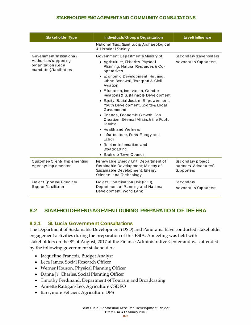
STAKEHOLDER ENGAGEMENT AND COMMUNITY CONSULTATIONS
Saint Lucia Geothermal Resource Development Project Draft ESIA ● February 2018
8-2
Stakeholder Type Individuals/Groups/Organization Level/Influence
National Trust; Saint Lucia Archaeological & Historical Society
Government/Institutional/ Authorities/supporting organization (Legal mandates)/facilitators
Government Departments/Ministry of: • Agriculture, Fisheries, Physical
Planning, Natural Resources & Co-operatives
• Economic Development, Housing, Urban Renewal, Transport & Civil Aviation
• Education, Innovation, Gender Relations & Sustainable Development
• Equity, Social Justice, Empowerment, Youth Development, Sports & Local Government
• Finance, Economic Growth, Job Creation, External Affairs & the Public Service
• Health and Wellness • Infrastructure, Ports, Energy and
Labor • Tourism, Information, and
Broadcasting • Soufriere Town Council
Secondary stakeholders Advocates/Supporters
Customer/Client/ Implementing Agency/Implementer
Renewable Energy Unit, Department of Sustainable Development; Ministry of Sustainable Development, Energy, Science, and Technology
Secondary project partners/ Advocates/ Supporters
Project Sponsor/Fiduciary Support/facilitator
Project Coordination Unit (PCU), Department of Planning and National Development; World Bank
Secondary Advocates/Supporters
8.2 STAKEHOLDER ENGAGEMENT DURING PREPARATION OF THE ESIA
8.2.1 St. Lucia Government Consultations The Department of Sustainable Development (DSD) and Panorama have conducted stakeholder engagement activities during the preparation of this ESIA. A meeting was held with stakeholders on the 8th of August, 2017 at the Finance Administrative Center and was attended by the following government stakeholders:
• Jacqueline Francois, Budget Analyst • Leca James, Social Research Officer • Werner Houson, Physical Planning Officer • Danna Jr. Charles, Social Planning Officer • Timothy Ferdinand, Department of Tourism and Broadcasting • Annette Rattigan-Leo, Agriculture CSDEO • Barrymore Felicien, Agriculture DPS
STAKEHOLDER ENGAGEMENT AND COMMUNITY CONSULTATIONS
Saint Lucia Geothermal Resource Development Project Draft ESIA ● February 2018
8-3
DSD staff, Judith Ephraim and Panorama staff member Susanne Heim conducted follow-on meetings on 11 August 2017 with the Departments of Physical Planning, Land Survey, and Land Registry. These meetings were attended by:
• Mrs. Magdalene Fontenelle, Physical Planning • Mr. David Alphonse, Physical Planning • Ms. Jeanelle Fevrier-Popo, Physical Planning • Werner Houson, Physical Planning • Mr. Phillip Hippolyte, Survey • Mr. Luther Goddard, Deputy Chief Surveyor
8.2.2 Local Agency Consultations The DSD and Panorama conducted a site visit with local stakeholder representatives on 9 August 2017. The site visit included travel to Sulphur Springs where previous geothermal exploration had been completed and the three target areas for geothermal exploration including the Belle Plaine, Fond St. Jacques, and Mondesir-Saltibus area. Panorama presented a PowerPoint presentation on the geothermal exploration and development process and ESIA procedures and scope at the Soufrière Regional Development Foundation Office after completion of the site visit. The site visit and meeting in Soufrière were attended by the following local stakeholder representatives:
• Augustine Dominique, Manager, PMA Office • Michael Bobb, General Manager, SMMA • Craig Henry, Saint Lucia National Trust • Franklin Solomon, Operations Manager-SRDF • Shem Jean, Projects-SRDF • Vicky Romael John Augustin, Road Builder in Choiseul
8.2.3 Community Meetings The DSD and ECMC conducted community meetings and presented the proposed geothermal exploration project in each of the local communities (Belle Plaine, Mondesir-Saltibus, and Fond St. Jacques) in August and September 2017. Community comments were obtained during each meeting and subsequent surveys were conducted with community members. Notes from each of the community meetings are provided in the Scoping Studies Report (Appendix C).
8.3 COMMUNITY CONSULTATION ON DRAFT ESIA Project stakeholders will be given an opportunity to comment on the Draft ESIA. Public meetings will be scheduled to inform project stakeholders about the project and provide commenting opportunities. The meetings will be held in the same locations as the initial community consultations in Belle Plaine, Fond St. Jacques, and Mondesir. An additional public consultation meeting will be held with stakeholders in Castries. Stakeholder consultations on the Draft ESIA have been scheduled for the week of March 5. The Government of Saint Lucia

STAKEHOLDER ENGAGEMENT AND COMMUNITY CONSULTATIONS
Saint Lucia Geothermal Resource Development Project Draft ESIA ● February 2018
8-4
will advertise the stakeholder consultations in affected communities prior to the meeting date. Stakeholder comments pertaining to the ESIA analysis will be addressed in the Final ESIA.
8.4 COMMUNICATIONS AND OUTREACH CAMPAIGN Separate from the ESIA, the GoSL intends to engage a communication consultant to increase public awareness for geothermal exploration and the proposed project.
8.5 STAKEHOLDER ENGAGEMENT PLAN A Stakeholder Engagement Plan has been prepared for the project (refer to Appendix G). The Stakeholder Engagement Plan defines key stakeholders, the timing for interaction with each stakeholder group prior to, during, and after geothermal exploration activities, and the approaches to reach stakeholders. Stakeholder engagement will be ongoing throughout the project life.
8.6 GRIEVANCE REDRESS The GoSL will appoint a community liaison officer (CLO) to conduct stakeholder outreach during project implementation and respond to any grievances or complaints that may arise. The CLO will act as the key point of contact to resolve project grievances from construction workers, local residents, and community members. The CLO will be responsible for addressing project grievances and directing contractors to make any appropriate change to their work. The contractor shall take reasonable action to address grievances as required by local laws and this ESIA.
Saint Lucia Geothermal Resource Development Project Draft ESIA ● February 2018
A-1
APPENDIX A LIST OF ESIA PREPARERS AND CONTRIBUTORS

Saint Lucia Geothermal Resource Development Project Draft ESIA ● February 2018
A-2
APPENDIX A LIST OF ESIA PREPARERS AND CONTRIBUTORS
Topic Area/Role Name
Project Director Laurie Hietter, Panorama
Project Manager Susanne Heim, Panorama
Document Preparation Aaron Lui, Panorama
Document Support Kara Dewhurst, Panorama
Social Assessment Specialist Theresa Alexander-Louis, ECMC
Local Land Use Specialist Egbert Louis, ECMC
Local ESIA Specialist Alison Gail King, ECMC
Botanist Roger Graveson
Wildlife Biologist Adam Toussaint
Archaeologist/Anthropologist Frederick Smith, Panorama
Hydrologist/Hydrogeologist Warren Dewhurst, Dewhurst Group

Saint Lucia Geothermal Resource Development Project Draft ESIA ● February 2018
B-1
APPENDIX B REFERENCES

Saint Lucia Geothermal Resource Development Project Draft ESIA ● February 2018
B-2
APPENDIX B REFERENCES
ACP-EU Natural Disaster Risk Reduction Program. 2016. "Saint Lucia Administrative Units GIS dataset." Caribbean Handbook on Risk Information Management. April 26.
—. 2016. "Saint Lucia Flood Susceptibility GIS dataset."
Barthelmy, Alyosius. 1990. "Overview of Geothermal Exploration in Saint Lucia, West Indies." Geothermal Resource Transactions V. 14, Part I. August.
Behrens and Associates, Inc. 2006. "Gas Well Drilling Noise Impact and Mitigation Study."
Boart Longyear. 2017. LF™230 SURFACE CORING DRILL RIG. October 19. https://www.boartlongyear.com/product/lf230/.
Brian Lovelock, Greg Ussher, Ryan Libbey. 2016. "Soufriere Geothermal Resource - Integrated Exploration Report." VH00001.03-TEC-RPT-005; D. Auckland: Jacobs New Zealand Limited, May 27.
Central Statistics Office. 2011. "2010 Population and Housing Census Preliminary Report." http://192.147.231.244:9090/stats/images/OtherPublications/StLuciaPreliminaryCensusReport2010.pdf.
Cox, C. 2004. "A hydrological assessment and watershed management plan for the Current Watershed/ Water Resources Management Issues, Chapter 2."
Cox, C.A., A. Sarangi, and C.A. Madramootoo. 2006. "Effect of Land Management on Runoof and Soil Losses from Two Small watersheds in St. Lucia. Land Degredation."
Dewhurst Group. 2017. "Estimated flow rates for project area catchments." December 24.
—. 2017. "Noise Monitoring Survey." September.
ECMC, Ltd. 2017. "Future Residence Locations GIS dataset."
ESRI. 2017. "raster, vector, and on-line GIS Data resources."
Federal Highway Administration. 2017. Construction Noise Handbook. October 26. https://www.fhwa.dot.gov/environment/noise/construction_noise/handbook/handbook09.cfm.
GeothermEx and Power Engineers. 2017. "Pre-Feasibility Study of a Proposed Geothermal Project in Saint Lucia." Interim Report. September 29.
Government of Saint Lucia. 2016a. "Economic and Social Review of the Economy."
—. 2006. "Natural Hazard Mitigation Plan."

Saint Lucia Geothermal Resource Development Project Draft ESIA ● February 2018
B-3
Graveson, Roger. 2017. "Habitat Survey for Saint Lucia Geothermal Project."
Hyder Consulting Limited. 2008. "Pitons Management Area and Soufriere Region Integrated Development Plan." February.
IFC and World Bank Group. 2007a. "Environmental, Health and Safety General Guidelines." http://www.ifc.org/wps/wcm/connect/554e8d80488658e4b76af76a6515bb18/Final%2B-%2BGeneral%2BEHS%2BGuidelines.pdf?MOD=AJPERES.
IFC and World Bank Group. 2007b. "Environmental, Health, and Safety Guidelines for Geothermal Power Generation." http://www.ifc.org/wps/wcm/connect/329e1c80488557dabe1cfe6a6515bb18/Final%2B-%2BGeothermal%2BPower%2BGeneration.pdf?MOD=AJPERES&id=1323161975166.
International Finance Corporation. 2012. IFC Performance Standards on Environmental and Social Sustainability. International Finance Corporation World Bank Group.
International Labour Organization. 2009. Saint Lucia. October. Accessed December 24, 2017. http://www.ilo.org/caribbean/countries-covered/saint-lucia/lang--en/index.htm.
Jacobs New Zealand Limited. 2016. "Soufriere Geothermal Resource - Integrated Exploration Report." VH00001.03-TEC-RPT-005; D. Auckland, May 27.
Jan Lindsay, Jerome David, John Shepherd and Judith Ephraim. 2002. "Volcanic Hazard Assessment for Saint Lucia, Lesser Antilles." St. Augustine: The University of the West Indies, Seismic Research Unit, September.
Kiama, Henry Wamalwa and Rose. 2016. "Noise Level Assessment in Geothermal Projects." A Case Study Of Menengai Geothermal Project, Kenya. November.
Lloyd et al. 1996. "Water Resources Management Unit, Ministry of Agriculture, Forestry and Fisheries Government of St. Lucia, 2001. Integrating the Management of Watersheds and Coastal Areas in St. Lucia."
Maurer Engineering Inc. 1998. "Project to Develop and Evaluate Coil-Tubing and Slim-Hole Technology."
McElhanney Consulting Services Ltd. 2015. "St_Lucia_2015_WGS84_Z20_20cm.ecw Aerial Imagery." LiDAR Survey to Advise on Geothermal Exploration - Saint Lucia.
Ministry of Education. 2014. Education and Statistical Digest. Castries: Ministry of Eductation.
n.d. 2017. Pixabay. October 17. https://pixabay.com/p-1928358/?no_redirect.
Norville, P., and S. King. 2001. "Integrating the management of watersheds and coastal areas in Saint Lucia." Water Resources Management Unit, Minsitry of Agriculture, Government of Saint Lucia.

Saint Lucia Geothermal Resource Development Project Draft ESIA ● February 2018
B-4
Panorama Environmental, Inc. 2017. "Government of Saint Lucia Scoping Studies Report Geothermal Resource Development Project Environmental and Social Impact Assessment." November.
—. 2017. "Residence Locations GIS dataset."
Saint Lucia Electric Systems Limited. 2016. "2016 Annual Report."
Saint Lucia. 2015. "Saint Lucia National Report." submitted in accordance with paragraph 5 of the annex to Human Rights Council Resolution 16/21. November.
Smith, Dr. Fredrick H. 2017. "Cultural Resource Area GIS dataset."
The Global Facility for Disaster Reduction. 2017. "Saint Lucia National Flood Hazard Map."
The Landmark Practice. 2013. "Limits of Acceptable Change Study for the Pitons Management Area World Heritage Site."
The University of the West Indies. 2017. Natural Hazards and Disasters. https://www.mona.uwi.edu/uds/Land_St_Lucia.html.
Toussaint et al. 2009. Status and Conservation of Saint Lucia Birds.
n.d. "U.S. Code of Federal Regulation Title 40 §261.24."
U.S. Department of Interior, Bureau of Land Managment. 1995. "Glass Mountain Unit Geothermal Exploration Project." Environmental Assessment/Initial Study. April.
UNESCO. 2017. Pitons Management Area. Accessed December 24, 2017. http://whc.unesco.org/en/list/1161.
Water Resources Management Agency of Saint Lucia. 2010-2016. "Streamflow point measurements."
WHO. 2000. "Air Quality Guidelines for Europe." Second Edition.
—. 2005. "WHO Air quality guidelines for particulate matter, ozone, nitrogen dioxide, and sulpher dioxide." Summary of risk assessment.
World Bank. 2016. "Country Disaster Risk Profile." International Bank for Reconstruction and Development / The World Bank.
World Bank. 1999. "The World Bank Operational Manual Operational Policies: Environmental Assessment."
—. 2017. "World Bank Environmental and Social Framework." Washington, DC.

Saint Lucia Geothermal Resource Development Project Draft ESIA ● February 2018]
C-1
APPENDIX C SCOPING STUDIES REPORT

Saint Lucia Geothermal Resource Development Project Draft ESIA ● February 2018]
C-2

Saint Lucia Geothermal Resource Development Project Draft ESIA ● February 2018]
D-1
APPENDIX D ENVIRONMENTAL AND SOCIAL MANAGEMENT PLAN

Saint Lucia Geothermal Resource Development Project Draft ESIA ● February 2018]
D-2

Saint Lucia Geothermal Resource Development Project Draft ESIA ● February 2018]
E-1
APPENDIX E RESETTLEMENT ACTION PLAN

Saint Lucia Geothermal Resource Development Project Draft ESIA ● February 2018]
E-2

Saint Lucia Geothermal Resource Development Project Draft ESIA ● February 2018]
F-1
APPENDIX F RESETTLEMENT POLICY FRAMEWORK

Saint Lucia Geothermal Resource Development Project Draft ESIA ● February 2018]
F-2

Saint Lucia Geothermal Resource Development Project Draft ESIA ● February 2018]
G-1
APPENDIX G STAKEHOLDER ENGAGEMENT PLAN

Saint Lucia Geothermal Resource Development Project Draft ESIA ● February 2018]
G-2