draft city plan part two - brighton-hove.gov.uk · introduction ... dm41 polluted sites, hazardous...
TRANSCRIPT
July 2018
Draft City Plan Part TwoBrighton & Hove City Council’s Development Plan
Contents
Section 1 ......................................................................................................................... 4
Introduction ..................................................................................................................... 5
Table 1 Timetable for the Preparation of City Plan Part Two ........................................... 9
How to Comment on the draft City Plan Part Two ........................................................... 9
Section 2 ....................................................................................................................... 10
Development Management Policies .............................................................................. 10
Topic – Housing, Accommodation and Community ....................................................... 11
DM1 Housing Quality, Choice and Mix ...................................................................... 11
Table 2 – Minimum gross internal floor areas and storage (sqm ) ........................................ 12
DM2 Retaining Housing and residential accommodation (C3) ................................... 16
DM3 Residential conversions and the retention of smaller dwellings ......................... 18
DM4 Housing and Accommodation for Older Persons ............................................... 20
DM5 Supported Accommodation (Specialist and Vulnerable Needs) ......................... 24
DM6 Build To Rent Housing ...................................................................................... 26
DM7 Houses in Multiple Occupation (HMOs)............................................................. 30
Figure 1 Example of Contiguous Output Areas ...................................................................... 32
DM8 Purpose Built Student Accommodation ............................................................. 34
DM9 Community Facilities ......................................................................................... 37
DM10 Public Houses ................................................................................................. 40
Topic – Employment and Retail .................................................................................... 43
DM11 New Business Floorspace ............................................................................... 43
DM12 Primary, Secondary and Local Centre Shopping Frontages ............................ 46
DM13 Important Local Parades, Neighbourhood Parades and Individual Shop Units 51
DM14 Special Retail Area - Brighton Marina ............................................................. 54
DM15 Special Retail Area - The Seafront .................................................................. 56
DM16 Markets ........................................................................................................... 57
DM17 Opportunity Areas for new Hotels and Safeguarding Conference Facilities ..... 59
Topic – Design & Heritage ............................................................................................ 62
DM18 High quality design and places ........................................................................ 62
DM19 Maximising Development Potential ................................................................. 67
DM20 Protection of Amenity ...................................................................................... 68
DM21 Extensions and alterations .............................................................................. 70
DM22 Landscape Design and Trees ......................................................................... 71
1
DM23 Shop Fronts .................................................................................................... 75
DM24 Advertisements ............................................................................................... 78
DM25 Communications Infrastructure ....................................................................... 80
DM26 Conservation Areas ......................................................................................... 83
DM27 Listed Buildings ............................................................................................... 85
DM28 Locally Listed Heritage Assets ........................................................................ 87
DM29 The Setting of Heritage Assets ........................................................................ 88
DM30 Registered Parks and Gardens ....................................................................... 90
DM31 Archaeological Interest .................................................................................... 91
DM32 The Royal Pavilion Estate ............................................................................... 94
Topic – Transport and Travel ........................................................................................ 96
DM33 Safe, Sustainable and Active Travel ................................................................ 96
DM34 Transport Interchanges ................................................................................. 100
DM35 Travel Plans and Transport Assessments ..................................................... 102
DM36 Parking and Servicing ................................................................................... 105
Topic – Environment and Energy ................................................................................ 108
DM37 Green Infrastructure and Nature Conservation .............................................. 108
DM38 Local Green Spaces ...................................................................................... 114
DM39 Development on the Seafront ........................................................................ 116
DM40 Protection of the Environment and Health – Pollution and Nuisance ............. 119
DM41 Polluted sites, hazardous substances & land stability .................................... 123
DM42 Protecting the Water Environment ................................................................. 126
DM43 Sustainable Urban Drainage ......................................................................... 128
DM44 Energy Efficiency and Renewables ............................................................... 130
DM45 Community Energy........................................................................................ 136
DM46 Heating and cooling network infrastructure ................................................... 138
Table 3 The Heating and Cooling Hierarchy ......................................................................... 140
Table 4 - Indicative space requirements for heat exchange substation equipment within building plant rooms ............................................................................................................ 142
Section 3 ..................................................................................................................... 143
Special Area Policy, Strategic Site Allocations, Housing and Mixed Use Sites and other Site Allocations ........................................................................................................... 143
Special Area SA7 Benfield Valley ............................................................................ 144
Figure 2 Illustrative Diagram ................................................................................................ 144
Strategic Site Allocations ............................................................................................ 148
SSA1 Brighton General Hospital Site, Elm Grove, Freshfield Road ......................... 148
2
SSA2 Combined Engineering Depot, New England Road ....................................... 150
SSA3 Land at Lyon Close, Hove ............................................................................. 152
SSA4 Sackville Trading Estate and Coal Yard ......................................................... 154
SSA5 Madeira Terrace and Madeira Drive .............................................................. 157
SSA6 Former Peter Pan leisure site (adjacent Yellow Wave), Madeira Drive .......... 160
SSA7 Land Adjacent to American Express Community Stadium, Village Way ......... 162
H1 Housing Sites and Mixed Use Sites ................................................................... 164
Table 5 - Residential Site Allocations ................................................................................... 165
Table 6 - Mixed Use Site Allocations .................................................................................... 168
H2 Housing Sites – Urban Fringe ............................................................................ 170
Table 7 Urban Fringe Allocations ......................................................................................... 171
H3 Purpose Built Student Accommodation .............................................................. 177
Table 8 Purpose Built Student Accommodation Sites ......................................................... 177
E1 Opportunity site for business and warehouse uses ............................................ 178
Appendix 1: Glossary of terms .................................................................................... 180
Appendix 2 Parking Standards – Policy DM36 Parking and Servicing (adopted Parking Standards SPD) .......................................................................................................... 191
Appendix 3 - Local Wildlife Sites (Policy DM37 Green Infrastructure and Nature Conservation ............................................................................................................... 205
Appendix 4 - Policy H2 Urban Fringe Housing Site Maps (see also proposed draft Policies Map) .............................................................................................................. 208
Appendix 5 - List of Brighton & Hove Local Plan policies that will be superseded on adoption of the City Plan Part 2: .................................................................................. 215
Appendix 6 Table 1 – Proposed Changes to Policy Map – new additions/ amendments by virtue of policies in Draft City Plan Part 2/ Updates ................................................. 219
Appendix 6 Table 2 Policies Map – Proposed Changes to the City plan Part 1 Policies Map due to retained Brighton & Hove Local Plan Policies being superseded by City Plan Part 2 policies ............................................................................................................. 220
3

Section 1 Introduction
4
Introduction
1.1 The Brighton & Hove City Plan Part One was adopted in March 2016 and sets out the strategic policy framework to guide the new development required across the city to 2030. The City Plan Part One sets the overall amounts of development to be planned for (e.g. housing, employment and retail) and the broad locations and Development Areas where new development will take place. It allocates key strategic sites and also sets out key strategic policies to guide future development including policies for urban design, transport, affordable housing, biodiversity and sustainability. This strategic framework is now part of the statutory Development Plan for Brighton & Hove.
1.2 The role of the City Plan Part Two is to support the implementation and delivery of City Plan Part One; to build on the strategic policy framework; to identify and allocate additional development sites and to set out a detailed development management policy framework to assist in the determination of planning applications.
1.3 The City Plan Part Two is:
• Consistent with the vision, strategy and objectives and strategic policies set out in City Plan Part One; and it will cover the period up to 2030;
• Covers the administrative area of the city council that is not within the South Downs National Park (the South Downs National Park Authority is preparing a Local Plan which will cover the administrative area of Brighton & Hove that falls within the National Park);
• Contains site allocations (e.g. for housing and mixed use sites) so that the City Plan Part One strategy for accommodating development needs can be implemented;
• Contains amended/updated or new shopping centre boundaries and heritage/nature conservation designations;
• Contains a suite of development management policies that will replace some of the saved 2005 Local Plan policies and delete others to ensure there is a more streamlined and straightforward set of development management policies;
• Conforms with the National Planning Policy Framework (NPPF) and respond to government changes to the planning system; and
• Results in one City Development Plan (Parts 1 and 2) which will be simpler to use for development management.
Policies Map
1.4 The Policies Map is updated each time a new plan is adopted to show the changes to the adopted policies map that would result from the proposals in the
5
emerging City Plan. Proposed amendments to the Policies Map (adopted with the City Plan Part One in March 2016) have been published alongside the draft City Plan Part 2 to include the proposed site allocations, new and/or updated policy designations related to City Plan Part Two and to remove those allocations/ designations related to BHLP policies that will be superseded on the adoption of City Part Plan 2 (a schedule of the proposed changes is set out in in Appendix 6).
Superseded BHLP policies
1.5 On adoption, the City Plan Part Two will replace the remaining ‘saved’ policies from the Brighton& Hove Local Plan (BHLP) 2006 (the list of retained BHLP policies that will be replaced are set out in Appendix 5).
Relationship with other DPDs
1.6 The following adopted Plans form part the development plan framework for Brighton & Hove:
City Plan Part 1 (adopted March 2016) sets out the vision and objectives for the development and growth of Brighton & Hove up to 2030; identifies broad locations for development and allocates strategic sites and employment sites and a set a of city wide policies to guide decisions on planning applications.
Waste and Minerals Local Plan (WMLP) – the Waste and Minerals Plan (adopted February 2013) and Waste and Minerals Sites Plan (adopted February 2017) are the statutory plans for waste and minerals developments in Brighton & Hove and East Sussex.
1.7 The following emerging development plan documents, will when adopted, form part of the development plan framework for Brighton & Hove:
Shoreham Harbour Joint Area Action Plan (JAAP)1 – provides a comprehensive, deliverable plan for the future revitalization of Shoreham Harbour. Prepared jointly with Adur District Council and West Sussex County Council.
1 Following the publication of the Proposed Submission Shoreham Harbour Joint Area Action Plan the authorities intend to submit the plan to the Secretary of State for Communities and Local Government for public examination in Spring/Summer 2018.
6
Community Infrastructure Levy (CIL) – once adopted CIL2 allows local authorities to raise funds from development for the provision of infrastructure in and around their areas.
Neighbourhood Plans – once a neighbourhood development plan passes independent examination and referendum it sits alongside other development plans listed above to guide development and to help decide the outcome of planning applications in the area.
Supplementary Planning Documents – will provide guidance on specific areas and topics and adopted and emerging SPDs are listed in the Local Development Scheme.
Duty to Co-operate
1.8 The NPPF requires councils to work together to address strategic priorities across boundaries and development requirements which cannot be wholly met within their own areas. The council will continue to engage constructively, actively and on an ongoing basis with neighbouring authorities and public bodies to address unmet needs as a member of the East Sussex Strategic Planning Members Group and the Coastal West Sussex and Greater Brighton Strategic Planning Board.
Supporting Documents
1.9 The draft City Plan Part 2 is also accompanied by a number of supporting documents:
Sustainability Appraisal (SA) – the role of the SA is to consider all the likely significant effects that the draft City Plan Part 2 may have on various environmental, economic and social factors. The process incorporates the requirements of the Strategic Environmental Assessment (SEA) Directive. Information on the reasonable alternative options that have been considered and discounted in favour of the draft City Plan Part Two policies are set in the SA Report and published as a separate document.
Habitat Regulations Assessment (HRA) – a Habitats Regulations Assessment (HRA) is required for any proposed plan or project which may have a significant effect on one or more European sites and which is not directly related with or necessary to the management of those sites. The purpose of the HRA is to determine whether or not significant effects are likely and to suggest ways in which they could be avoided. An HRA screening has been carried out to establish if the City Plan Part Two might have any Likely Significant Effects
2 Brighton & Hove City Council intends has published a Community Infrastructure Levy Draft Charging schedule for consultation and intends to submit the CIL Draft Charging Schedule for examination in autumn 2018.
7

(LSEs) on any European site. This has screened out all potential impacts on European sites with the exception of air quality impacts on the Ashdown Forest SAC and SPA, where more detailed evidence is needed to satisfy the requirement for ‘appropriate assessment’ in the HRA Regulations. Further traffic and air quality modelling is now underway which will be completed and made available for the start of consultation. Published as a separate document.
Health and Equalities Impact Assessment (HEQIA) – has been undertaken to ensure the draft policies are coordinated to address equalities, health and well-being outcomes throughout the city. The study found where there was potential for impact, this was generally positive and many policies were found to be inclusive for various communities. Some policies have specific positive effects for certain groups, for instance older people and disabled people, particularly policies in relation to housing and those that improve accessibility. Some policies have been refined through recommendations arising from the HEQIA. Published as a separate document.
Consultation Statement – provides full information on how organisations, groups and individuals were consulted at the City Plan Part Two Scoping stage (June - September 2016) and how the consultation responses helped shape the draft City Plan Two. Published as a separate document.
Monitoring and Implementation Targets – sets out the proposed monitoring indicators and targets and identifies how the City Plan Part Two will be implemented. It is proposed that these monitoring indicators targets will be included in an update to Annex 1 of the City Plan Part 1 which will be updated at submission stage. The Authority Monitoring Report (AMR) is the key evaluation tool to monitor performance and will be revised to take into account new policies contained within this plan when it has been adopted. Published as a separate document.
Supporting Evidence
1.10 A number of background studies have also been completed which provide evidence to inform the drafting of policies and site allocations and include Urban Fringe Further Assessment Studies, Brighton & Hove Visitor Accommodation Update Study, Housing and Employment Land Study; Brighton & Hove Local Wildlife Study, Gypsy and Travellers Site Assessments and CPP2 Energy Study. These have been published alongside the draft City Plan Part Two for information. Topic papers have also been prepared to outline the approach to site allocations, housing provision and retail frontages and published for information.
1.11 A Glossary of terms is included in Appendix 1.
8
Table 1 Timetable for the Preparation of City Plan Part Two City Plan Part Two stage of plan preparation Date
Scoping Document (Regulation 18) June 2016
Draft Plan and SA (Regulation 18) Summer 2018
Publication stage (Regulation 19) Autumn 2019
Submission stage Spring 2020
Examination Summer 2020
Adoption of City Plan Part Two Early 2021
How to Comment on the draft City Plan Part Two
1.12 The City Council would like to know what you think about the draft City Plan Part Two. You do not have to comment on everything in the draft City Plan Part Two. We want to hear your views on those aspects that are of most interest to you.
1.13 We recommend you make your comments using the council’s online consultation portal: http://consult.brighton-hove.gov.uk/portal. This will help us handle your comments quickly and efficiently.
1.14 The Draft City Plan Part Two and supporting documents including the proposed changes to the Policies Map and the Sustainability Appraisal (SA) are available on the Council’s website (www.brighton-hove.gov.uk/cityplan-part2) and can also be viewed at the customer service centres at Hove Town Hall and Bartholomew House Brighton and the main city Libraries (Jubilee, Hove and Portslade) during normal opening hours. The draft CPP2 including the policies map and non-technical SA summary can also be viewed at all other libraries during normal opening hours. Word versions of the Response Form are available on request to [email protected]
1.15 Consultation on the Draft City Plan Part Two will run for 10 weeks from 5 July to 13 September 2018.
Council’s Consultation Portal: http://consult.brighton-hove.gov.uk/portal
Email: [email protected] (please respond using the Response Form)
Post: Draft CPP2, Policy Projects and Heritage Team, Brighton & Hove City Council, First Floor Hove Town Hall, Norton Road, BN3 3BQ.
9

Section 2 Development Management
Policies
10
Topic – Housing, Accommodation and Community
DM1 Housing Quality, Choice and Mix
The council will seek the delivery of a wide choice of high quality homes which will contribute to the creation of mixed, balanced, inclusive and sustainable communities. Proposals for new residential development will be required to:
a) incorporate a range of dwelling types, tenures and sizes that reflect and respond to the city’s identified housing needs (see also City Plan Part One policies SA6, CP14, CP19, CP203); and,
b) make provision for a range and mix of housing /accommodation formats subject to the character, location and context of the site , for example, self and custom build housing, build for rent, community led housing, starter homes and other types of provision supported by national and local policy.
In addition, planning applications for new residential development (including residential extensions and residential accommodation falling outside Use Class C3) will be expected to comply with the following requirements:
c) all residential units should meet the nationally described space standards4;
d) all residential units should as a minimum be accessible and adaptable in accordance with Building Regulation M4(2)5;
e) for proposals providing 10 or more dwellings, 10% of the affordable residential units and 5% of all the residential units should be suitable for occupation by a wheelchair user in accordance with Building Regulation M4(3)6. Where this is not practicable on-site an equivalent financial contribution should be provided7; and
3 See also the Objectively Assessed Need Report 2015 (GL Hearn) and subsequent updates. 4 The nationally described space standards as set out in the policy or as amended. Residential extensions and also residential accommodation that does not fall within a C3 use class will be expected to meet the standards. As a minimum such accommodation should meet the standards for bedroom sizes, storage, ceiling heights and provision of level access. 5 Building Regulations M4(2) or as amended. 6 Building Regulations M4(3) or as amended. 7 PartM4(3) - the extra cost per dwelling to provide was assessed in the CIL Viability Study (2017) to be £26,816 for houses and £15,691 for flats. These figures will form the basis for any financial contribution for off-site provision, taking into account inflation.
11
f) all new residential development will be required to provide useable private outdoor amenity space appropriate to the scale and character of the development.
Exceptions to criteria c) – e) will only be permitted where the applicant has provided a robust justification and the council is satisfied that particular circumstances apply.
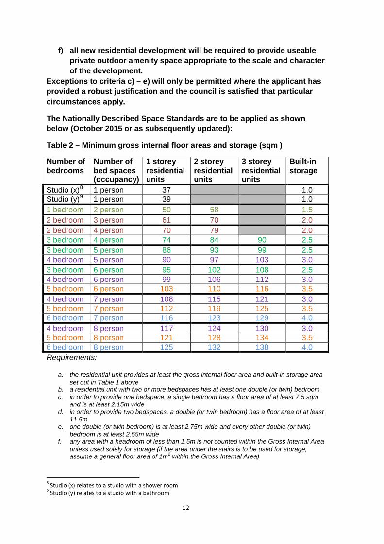
The Nationally Described Space Standards are to be applied as shown below (October 2015 or as subsequently updated):
Table 2 – Minimum gross internal floor areas and storage (sqm ) Number of bedrooms
Number of bed spaces (occupancy)
1 storey residential units
2 storey residential units
3 storey residential units
Built-in storage
Studio (x)8 1 person 37 1.0 Studio (y)9 1 person 39 1.0 1 bedroom 2 person 50 58 1.5 2 bedroom 3 person 61 70 2.0 2 bedroom 4 person 70 79 2.0 3 bedroom 4 person 74 84 90 2.5 3 bedroom 5 person 86 93 99 2.5 4 bedroom 5 person 90 97 103 3.0 3 bedroom 6 person 95 102 108 2.5 4 bedroom 6 person 99 106 112 3.0 5 bedroom 6 person 103 110 116 3.5 4 bedroom 7 person 108 115 121 3.0 5 bedroom 7 person 112 119 125 3.5 6 bedroom 7 person 116 123 129 4.0 4 bedroom 8 person 117 124 130 3.0 5 bedroom 8 person 121 128 134 3.5 6 bedroom 8 person 125 132 138 4.0 Requirements:
a. the residential unit provides at least the gross internal floor area and built-in storage area set out in Table 1 above
b. a residential unit with two or more bedspaces has at least one double (or twin) bedroom c. in order to provide one bedspace, a single bedroom has a floor area of at least 7.5 sqm
and is at least 2.15m wide d. in order to provide two bedspaces, a double (or twin bedroom) has a floor area of at least
11.5m e. one double (or twin bedroom) is at least 2.75m wide and every other double (or twin)
bedroom is at least 2.55m wide f. any area with a headroom of less than 1.5m is not counted within the Gross Internal Area
unless used solely for storage (if the area under the stairs is to be used for storage, assume a general floor area of 1m2 within the Gross Internal Area)
8 Studio (x) relates to a studio with a shower room 9 Studio (y) relates to a studio with a bathroom
12
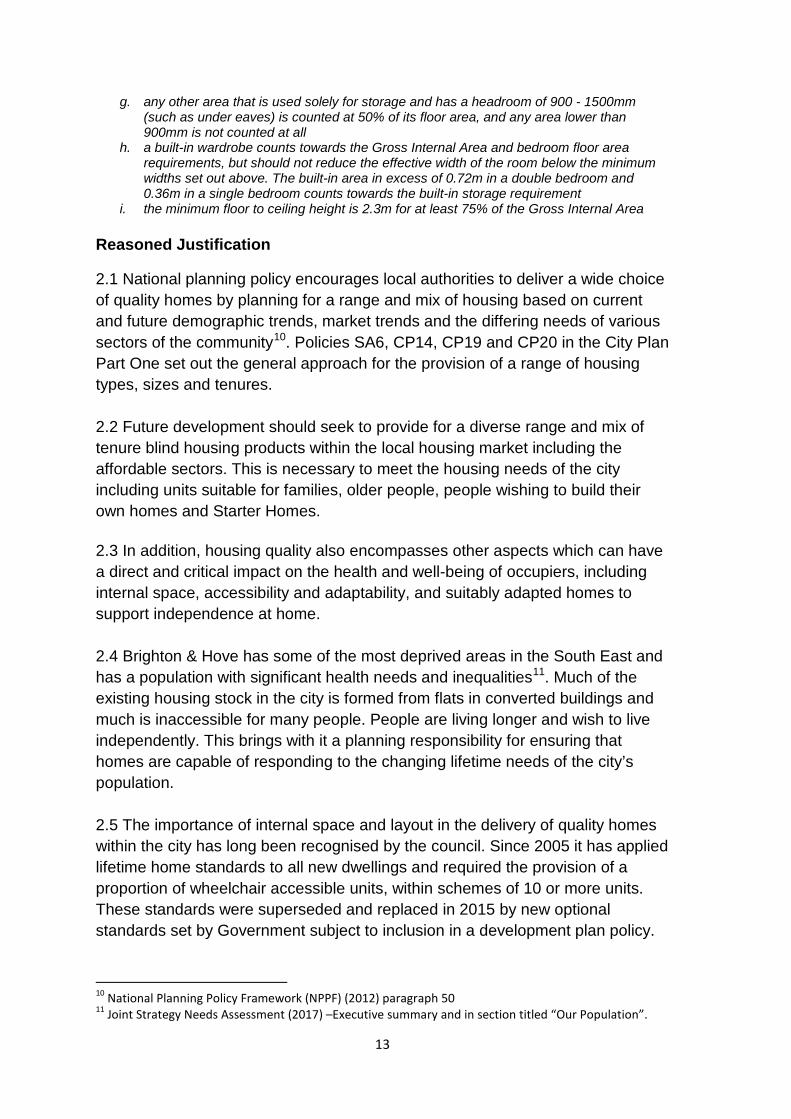
g. any other area that is used solely for storage and has a headroom of 900 - 1500mm (such as under eaves) is counted at 50% of its floor area, and any area lower than 900mm is not counted at all
h. a built-in wardrobe counts towards the Gross Internal Area and bedroom floor area requirements, but should not reduce the effective width of the room below the minimum widths set out above. The built-in area in excess of 0.72m
in a double bedroom and 0.36m
in a single bedroom counts towards the built-in storage requirement i. the minimum floor to ceiling height is 2.3m for at least 75% of the Gross Internal Area
Reasoned Justification
2.1 National planning policy encourages local authorities to deliver a wide choice of quality homes by planning for a range and mix of housing based on current and future demographic trends, market trends and the differing needs of various sectors of the community10. Policies SA6, CP14, CP19 and CP20 in the City Plan Part One set out the general approach for the provision of a range of housing types, sizes and tenures. 2.2 Future development should seek to provide for a diverse range and mix of tenure blind housing products within the local housing market including the affordable sectors. This is necessary to meet the housing needs of the city including units suitable for families, older people, people wishing to build their own homes and Starter Homes. 2.3 In addition, housing quality also encompasses other aspects which can have a direct and critical impact on the health and well-being of occupiers, including internal space, accessibility and adaptability, and suitably adapted homes to support independence at home. 2.4 Brighton & Hove has some of the most deprived areas in the South East and has a population with significant health needs and inequalities11. Much of the existing housing stock in the city is formed from flats in converted buildings and much is inaccessible for many people. People are living longer and wish to live independently. This brings with it a planning responsibility for ensuring that homes are capable of responding to the changing lifetime needs of the city’s population. 2.5 The importance of internal space and layout in the delivery of quality homes within the city has long been recognised by the council. Since 2005 it has applied lifetime home standards to all new dwellings and required the provision of a proportion of wheelchair accessible units, within schemes of 10 or more units. These standards were superseded and replaced in 2015 by new optional standards set by Government subject to inclusion in a development plan policy.
10 National Planning Policy Framework (NPPF) (2012) paragraph 50 11 Joint Strategy Needs Assessment (2017) –Executive summary and in section titled “Our Population”.
13
2.6 The three standards being applied by virtue of this policy include the optional Nationally Described Space Standards, which cover minimum gross internal floor, ceiling heights and storage space requirements. The wider lifetime home and wheelchair user requirements are addressed in optional provisions in the Building Regulations [M4(2) and M4(3)]. These standards are enforced through building regulations with the requirements applied through planning policy by way of condition attached to planning consents. The policy sets out the space standards at the time of writing but the policy will apply in respect of any future revision to the national optional standards or approach. 2.7 The council will expect all forms of residential accommodation to have regard to these standards including those not considered to fall within the C3 use class. Such accommodation can include extra care, assisted living and other such schemes designed for frailer older people or others with disabilities and those in need of care or support. In respect of a property being extended, the new extension will be expected to accord with the respective standards and it must not make the existing accommodation worse. 2.8 It is recognised that there may be some instances when an exception to an element of the requirements might be justified. For example, it may not be viable to provide level access via a lift to all units within small residential schemes. In such instances the accessible and adaptable standard should be met as far as possible applying where practicable an alternative solution to lift provision, such as an accessible stairway capable of providing a stair lift. A flexible approach to the standards might also be justified with regard to a conversion of a listed building. Where it is considered full compliance with the standards would not be possible, applicants must address this at an early stage in the planning process and involve a building control officer when considering alternative solutions. Robust justification for exceptions will be required. 2.9 National planning policy makes clear planning authorities should plan positively to meet a full range of housing needs. Self or custom build housing is housing built or commissioned by individuals (or groups of individuals) for their own occupation12. The council is required to keep a register of individuals and groups of individuals who are seeking to acquire serviced plots of land in their area in order to build homes for those individuals to occupy. This provides information regarding the demand for custom/ self-build plots in Brighton & Hove. The council is keen to support and encourage individuals and communities who want to build their own homes.
12 The Community Infrastructure Levy Regulations include a definition of “self-build housing” as a dwelling built by (or commissioned by) someone to be occupied by them as their sole or main residence for at least three years.
14
2.10 The ability to make provision for serviced plots of land specifically for custom/self-build housing in the city is constrained by a number of factors. A key factor is the nature of development sites in the city and the constrained land supply generally. A large proportion of sites in the city are small scale and are brownfield sites required for flatted development in order to make effective use the land. Sites within the city’s urban fringe may provide an opportunity for custom and self-build and this is encouraged. Proposals involving sites within the urban fringe will be encouraged to make provision for this type of housing. 2.11 The above policy also requires that an element of useable private outdoor amenity space is provided for the occupants of new residential development. Private amenity space can make an important contribution in improving the health, well-being and general quality of life of the city’s residents and has the potential to support and enhance local biodiversity. The provision of space for seating, play, drying and storage space is part of securing good design and a good standard of residential development in the city. 2.12 It is recognised that Brighton & Hove has a variety of townscapes with different densities, dwelling types and sizes. In considering the type and amount of useable private amenity space the council will have regard to the type, scale, location and context of residential development. It is accepted that it may be difficult to provide outdoor amenity space where development involves conversion of existing buildings, particularly with regard to upper floors. Appropriate forms of provision include gardens, balconies, patios, roof terraces and shared amenity spaces in flatted forms of development. Factors such as access to the amenity space, its orientation, scope for privacy, size and usability will be key considerations. It will also be important to ensure, where relevant, that outdoor space is appropriate to the needs of intended occupiers e.g. in the case of housing for older and/or specialist housing for disabled people. 2.13 Outdoor amenity space for dwelling units should provide sufficient space to accommodate a table and chairs suitable for the size of the dwelling and where relevant space for refuse and recycling bins, an area to dry washing and circulation space. Where sites are constrained it may still be possible to achieve innovative and useable solutions to the delivery of outdoor amenity space.
15
DM2 Retaining Housing and residential accommodation (C3)
The council will seek to resist any net loss of existing residential accommodation (Use Class C3) in the city. Planning applications that result in the loss of residential accommodation will not be permitted unless one or more of the following exceptions apply: a) it can be demonstrated that the accommodation cannot be rehabilitated
or redeveloped to achieve satisfactory housing standards required by other policies in the City Plan;
b) the proposal would result in a net gain in units of affordable housing; c) the loss would enable sub-standard residential units to be enlarged to
meet residential space standards (in accordance with Policy DM1 Housing Quality, Choice and Mix);
d) the proposed change of use will provide a local community service/ facility that meets an identified need;
e) it can be demonstrated that a proposed change of use is the only practicable way of preserving the special architectural or historic interest of a listed building or other building of heritage significance; or
f) where the previous use of the building would be a material consideration.
Proposals for the de-conversion / amalgamation of C3 residential units involving a net loss will be considered on their merits and with regard to assessments of local housing need/demand. NB Policies CP21 and DM7 will be applied to proposed change of use from C3 to C4. Reasoned Justification 2.14 The constrained housing land supply in Brighton & Hove together with the need to make the best use of sites and properties that are available mean that it is important to retain existing housing and residential accommodation (Use Class C3) in the city. There is also a need to ensure a range of dwelling types and sizes to meet the city’s identified housing needs, facilitate housing choice and achieve mixed and balanced communities. 2.15 The policy makes provision for a number of exceptions where a net loss of residential accommodation might be justified. These largely address issues regarding the standard of accommodation e.g. where it can be demonstrated that the accommodation cannot realistically be rehabilitated to meet accepted standards or in terms of housing not being able to achieve the required housing space /access standards as set out in Policy DM1 without incurring a net loss.
16
Other exceptions allow for a loss where proposals would result in a net gain of affordable housing or where a loss would be the only way to preserve a building of special architectural or historic interest, including listed buildings. All exceptions will need to be clearly justified and accompanied by suitable supporting information. 2.16 Where development involves the demolition and redevelopment of homes, the council will expect proposals to provide at least a similar or greater number of replacement homes. Where an application involves a small scale net loss of C3 residential units (for example the de-conversion of small flats back to a family sized home) then applications will be considered on their merits taking account of other considerations including, for example, amenity considerations and evidence regarding the city’s identified housing needs. The council’s objectively assessed housing need evidence base13 demonstrates that over the Plan period there will be considerable demand for family sized homes (2 and 3+ bedroom properties) and the de-conversion of small flats back to family sized homes can make a contribution to this element of identified need. The council does not seek to resist schemes combining dwellings that involve the loss of a single home. 2.17 Where it can be demonstrated that there has been a material change of use from a residential use e.g. to a holiday let, then this policy may be used for enforcement purposes. The intensification of such uses on a permanent basis can harm the residential amenity or character of the locality due to levels of activity that cause excessive noise and disturbance to residents. 2.18 A change of use may be permitted where a local need can be demonstrated to provide an essential local community service (see Policy DM9 Community Facilities). The Infrastructure Delivery Plan (Annex 2 to City Plan Part One) provides an evidence base for the provision of suitable facilities. Proposals will be considered on their merits having regard to the impact on the amenity of residents, car parking and traffic etc. 2.19 This policy will help to ensure that measures aimed at delivering additional housing and residential accommodation, including through rehabilitation and repair, are not undermined through losses to the existing housing stock. The policy is consistent with the council’s Housing Strategy objectives to improve housing standards and conditions, boost the supply of affordable housing and bring vacant housing back into use and complements the council’s Empty Property Service Plan.
13 Brighton & Hove objectively assessed housing need, June 2015, GL Hearn.
17
DM3 Residential conversions and the retention of smaller dwellings
Planning permission for the conversion of dwellings into smaller units of self-contained accommodation will be granted where all the following criteria are met;
a. The original floor area¹ is greater than 124sqm or the dwelling has 4 or more bedrooms as originally built;
b. At least one unit of the accommodation provided is suitable for family occupation and has a minimum of two bedrooms, and
c. The proposal provides a high standard of accommodation that complies with requirements set out in Policy DM1 Housing Quality, Choice and Mix.
The requirement within criterion b) for a unit of family accommodation will not apply where it is demonstrated that;
i) A different mix of units is essential to preserve the character of a listed building; or
ii) A different mix of units is necessary to meet the needs of existing occupants who will remain on completion of the conversion; or
iii) The proposal is specifically for people with special housing needs.
¹The original floor area excludes later additions such as extensions, garages (including converted garages) and loft conversions. The calculation of the original floor area must be based on internal dimensions only.
Reasoned Justification
2.20 The aim of this policy is to manage the subdivision of single residential units into smaller self-contained units in order to ensure that conversions provide a high standard of accommodation and promote and retain housing choice in the city.
2.21 The Council gives a high priority to the importance of achieving a good housing mix and choice of housing (in terms of types and sizes of accommodation). Larger family housing (houses with 4 or more bedrooms or a floorspace of 124sq m or more) is seen as a valuable resource to meet the needs of larger families and provide housing choice. At the same time the conversion of larger properties into smaller residential units plays an important role in increasing housing supply, contributes toward the provision of a wider range of housing and helps to meet the needs of a growing number of smaller households. It is also consistent with the objective of making the best use of the land available within the city.
18

2.22 There also remains a high level of demand for smaller dwellings suitable for family accommodation and it will continue to be important to retain the existing stock of these dwellings (i.e. those where the original floor area is less than 124sqm). This is consistent with Brighton & Hove City Plan Part One Policy CP19 Housing Mix.
2.23 Too much conversion activity can have an adverse impact on residential amenity, particularly in those areas where dwelling densities are already high. The conversion of properties below the threshold stated in the policy would result in a poor standard of accommodation and as such the policy is consistent with the aims of the Nationally Described Space Standards.
19
DM4 Housing and Accommodation for Older Persons The council will seek to ensure there is a sufficient supply and range of residential accommodation suitable for older people. Development proposals to meet the specific accommodation needs of older people will be supported where the development meets all of the following criteria:
a) contributes towards meeting a demonstrable need within the city and is targeted towards the needs of local residents;
b) is accessible to public transport, shops, services, community facilities, and social networks appropriate to the needs of the intended occupiers;
c) will be suitable for the intended occupiers in terms of the standard of facilities, the level of independence and the provision of support and/or care;
d) provides appropriate facilities for carers and visitors; e) provides appropriate communal space and suitably landscaped
outdoor space for informal recreation, including space that gives residents the ability to grow plants and food;
f) complies with the standards set out in Policy DM1 Housing Quality, Choice and Mix except where reduced standards are agreed with the council, or comply with Care Quality Commission regulations and standards14 as relevant to the accommodation provided; and,
g) contributes to creating a mixed, inclusive and sustainable community.
In accordance with City Plan Part One Policy CP20 Affordable Housing, the council will seek an element of affordable housing provision for older persons as part of market-led developments for older people. Proposals that will result in the loss of residential accommodation for older people will be resisted unless it can be demonstrated that at least one of the following criteria apply:
a) the existing provision is surplus to needs within the City; b) the existing provision is incapable of meeting contemporary
standards for the support and/or care required and appropriate alternative provision is available and has been secured for the occupants; or
c) the loss is necessary to enable the provision of accommodation for older people which is better able to foster independent living and meet changes in the support and care needs of the occupants.
14 Or respective standards as amended
20
Where the council is satisfied that development involving the loss of accommodation for older persons is justified, the priority will be for an alternative form of supported housing or general housing (Use Class C3) including an appropriate amount of affordable housing. Reasoned Justification 2.24 The population of Brighton & Hove is growing and the profile of the city’s population is also changing. Population growth over the next 20 years is likely to be strong for those aged 60 and over. City-wide plans and strategies15 seek to ensure that the older population ages well, through promoting good physical and mental health, promoting age-friendly living environments and the provision of a range of suitable housing /accommodation options. 2.25 Whilst Brighton & Hove currently has a relatively small proportion of its population falling within the older age groups16, almost one third of those 65 or over are aged over 80. Demographic projections indicate there will be 68,100 people aged 60 and over in 2030, an increase of 41% from 201017. Older people in the City are now also more likely to have multiple long-term conditions18 than in previous decades. It is therefore important there is an appropriate range of accommodation and care provision to meet specific needs. 2.26 Many older people want to retain as much independence as possible and want to remain in their own homes. Community based health and support services enable many people to do so. Accessibility is often a key issue for older people and Policy DM1 Housing Quality, Choice and Mix seeks to ensure that new residential development can appropriately cater for the needs of residents throughout their life. Many needs will be met by providing support for people to live in suitable homes within the general housing stock, but there is still likely to be an ongoing need for development built specifically to meet the needs of older people. 2.27 The availability of a range of suitable accommodation options for older people can help release family accommodation, improve quality of life and reduce the need for residential care. In addition, some older people require levels of care not normally provided at home (e.g as a result of a fall or a hospital admission). More specialist forms of housing for older people, including extra care housing, has the potential to provide the level of support needed to help
15 For example, Brighton & Hove Housing Strategy and the Health and Well Being Strategy. 16 Based on Mid-Year Estimates (ONS) 2016 there are 38,395 people age 65 or over in Brighton & Hove, representing 13.3% of the total population (England Average = 17.9%) 17 Source: GL Hearn Objectively Assessed Needs Report June 2015. Table 9 in the report provides a projected future need for specialist housing 18 Source: Annual Report of the Director of Public Health 2016/17
21
people to remain part of the community and maintain independence for longer through the integration of accommodation and care. The availability of such housing can help reduce hospital admissions and enables discharge of older people from acute hospital beds. 2.28 The City has a higher percentage of pensioners in poverty compared with the national average (20.6% in the City compared to England’s average of 15.8%)19 and evidence indicates that those most deprived are more likely to suffer multiple long-term conditions20. The Brighton & Hove Housing Statistical Bulletins highlight the demand for affordable sheltered homes in the city. It is therefore important to ensure that there is appropriate provision to address the need for affordable accommodation for older people. 2.29 Where market housing is specifically proposed for older people, a proportion of affordable housing provision will be sought in accordance with City Plan Part One Policy CP20. As far as possible an equivalent amount of affordable provision for older people will be sought to meet needs. It is acknowledged that such forms of housing can have distinctive financial viability characteristics, particularly if an element of care is involved. A flexible approach will therefore be taken to the nature of provision and whether the affordable provision can be made on site. 2.30 Development that attracts additional care users into the city is likely to have a significant impact on council resources. The council will therefore support new development for older people provided that it meets a demonstrable need to provide for existing residents and is targeted towards meeting that need. The council will require, as a minimum, that the accommodation is marketed and made available for sale, rent or as appropriate within the city for a period of at least 6 months before it is marketed more widely. 2.31 Examples of the types of housing and accommodation that will be covered by this policy include:
• Age restricted occupancy housing (Use Class C3) – accommodation where an age restriction is placed on occupants who live independently in self-contained homes;
• Warden assisted housing (Use Class C3) – clusters of accommodation where people live independently in self-contained homes where a warden is contactable between specified times to manage communal areas and may check on residents. Sometimes a communal meeting lounge and gardens are provided;
19 Source: Department for Work and Pensions (February 2017) – included in the Local Insight Profile for Brighton and Hove Area (November 2017). 20 Source: Annual Report of the Director of Public Health 2016/17
22
• Sheltered housing - clusters of accommodation where people live independently in self-contained homes where low intensity support is available, sometimes on site (usually within Use Class C3). Often with a communal meeting lounge, guest room and gardens;
• Extra-care/assisted living homes (also known as close care, very sheltered or continuing care housing) – also independent living in self-contained homes, but designed to enable provision of higher intensity care as occupiers’ needs increase, with on-site care facilities usually available. On-site facilities may also provide support for older people in the wider community. Shared lounges and other social and leisure facilities are sometimes provided. Care home accommodation may also be included on site. Extra-care/assisted living homes normally fall either within Use Class C2 or C3, this varies depending on the level of self-containment of the homes, the level of care provided and whether overnight care is available;
• Residential/nursing homes (including end of life/hospice care and dementia care) where higher intensity care is available 24 hours – commonly bedsit rooms with shared lounges and eating – this may involve residential care only, nursing homes staffed by qualified nursing staff, or dual-registered care homes where medical assistance is provided to occupiers that need it (care homes are usually within Use Class C2);
23
DM5 Supported Accommodation (Specialist and Vulnerable Needs)
The council will seek to ensure there is an appropriate range and supply of residential accommodation for people with special needs, including supported housing not covered by Policy DM4 Housing and Accommodation for Older Persons.
Proposals for development aimed to meet the specific accommodation requirements of people with specialist needs will be permitted where the development meets all of the following criteria:
a) contributes towards meeting a demonstrable need within the city and is targeted to meeting the needs of local residents;
b) is accessible, appropriately located and suitable to meet the needs of the intended occupiers in terms of the standard of facilities, the level of independence, and the provision of support and/or care, including appropriate facilities for carers and visitors;
c) complies with the standards set out in Policy DM1 Housing Quality, Choice and Mix except where reduced standards are agreed with the council, or comply with Care Quality Commission regulations and standards21 as relevant to the accommodation provided; and
d) contributes to creating a mixed, inclusive and sustainable community.
The loss of specialist housing (all or certain types) will be resisted.
Reasoned Justification
2.32 The approach set out in the City Plan seeks to provide for an integrated society which cares for the vulnerable and people with specialist accommodation needs. This policy facilitates the delivery of the various different specialist housing types other than those covered by Policy DM4 Housing and Accommodation for Older Persons. These include:
• hostels; • shared housing; • supported housing; • care homes; and • other types of accommodation built or adapted to meet specialist needs.
2.33 Such development may offer accommodation on a temporary or long term/ permanent basis, to meet the needs of people who are:
o homeless
21 Or respective standards as amended
24
o disabled and/or vulnerable, including people with: learning disabilities mental health problems dependency addictions
2.34 The policy does not cover student housing, houses in multiple occupation (HMOs), hospitals, or, hostels offering visitor accommodation such as backpacker or youth hostels. (See policies CP6 Visitor Accommodation, CP21 Student Housing and Housing in Multiple Occupation, and DM7 Houses in Multiple Occupation (HMOs). 2.35 In determining the appropriate use class for self-contained facilities, the council will consider whether the development will be a registered location with the Care Quality Commission22, the degree of care, and the proportion of units for which care is likely to be available. In some cases a development may be deemed to provide units within both the C2 and C3 Use Classes and some may be deemed to be ‘sui generis’. 2.36 Where a proposal for specialist residential accommodation involves the conversion of an existing dwelling, regard should be given to Policy DM3 Residential Conversions and the Retention of Smaller Dwellings. 2.37 Other relevant policies will be taken into account when considering if a proposal is appropriately located, for example impact upon transport and amenity. The council will resist proposals for new specialist housing and accommodation where it would result in an over-concentration of similar uses in the immediate area, if it is considered that the proposals will have a negative effect on the character and function of an area, and/or local amenity.
22 Unlike residential care homes in Use Class C2, the private address of a person who uses care services is not defined as a location by the Care Quality Commission for the purposes of its registration process. However, the delivery of the domiciliary care component to individual residents is registered by the Care Quality Commission. Further information on registration is available on the Care Quality Commission website.
25
DM6 Build To Rent Housing
1. Proposals for the development of Build to Rent housing will be required to meet all of the following criteria: a) the development will improve housing choice and make a positive
contribution to the achievement of mixed and sustainable communities in accordance with City Plan Part One Policy CP19 Housing Mix;
b) the development will not lead to an over-concentration of build to rent within sites designated as Strategic Allocations in the City Plan;
c) all of the dwellings are self-contained and let separately; d) the homes are held as build to rent under a covenant for at least 15
years; e) the build to rent housing is under unified ownership and will be
subject to common management; f) the development will provide professional and on-site management; g) the development will offer tenancies of at least 3 years available to
all tenants with defined in-tenancy rent reviews; h) the development provides a high standard of accommodation that
complies with the requirements in Policy DM1 Housing Quality, Choice and Mix; and
i) the provision of affordable housing complies with the requirements in City Plan Part One Policy CP20 Affordable Housing, subject to the criteria set out in part 2 of this policy.
2. Build to rent developments will be expected to contribute towards
meeting the city’s identified need for affordable housing. The council will negotiate to achieve the following requirements: a) a proportion of affordable housing based on the requirements of
Policy CP20 (40% on sites of 15 or more (net) dwellings), normally in the form of affordable private rent;
b) the affordable homes to be offered at discounted rent levels to be agreed with the council23;
c) eligibility criteria for the occupants of the affordable homes to be agreed with the council and included in the S106 agreement;
d) the size mix of affordable housing units to be agreed with the council in accordance with Policy CP20; and
e) the affordable homes to be secured in perpetuity - the council will seek inclusion within the S106 agreement of a ‘clawback’ arrangement in the event of affordable units being sold or taken out of the build to rent sector.
23 Guidance on the rent levels sought by the council is provided in the Affordable Housing Brief.
26
Reasoned Justification
2.38 ‘Build to rent’ is an emerging sector in the housing market, comprising large purpose-built developments for private rent. This type of housing is associated with long term institutional funding/investment and is a growing sector in major urban areas.
2.39 The Government is promoting build to rent as a means of improving the supply, choice and quality of private rented accommodation. Following initial proposals as part of the Housing White Paper consultation in February 201724, build to rent has been defined as a distinct housing category in draft revisions to the NPPF25 in March 2018. To accompany the draft NPPF, the Government has published draft Planning Practice Guidance26 covering the delivery and management of this type of accommodation. The draft NPPF defines build to rent as:
“Purpose built housing that is typically 100% rented out. It can form part of a wider multi-tenure development scheme comprising either flats or houses, but should be on the same site and/or contiguous with the main development. Schemes will usually offer longer tenancy agreements of three years or more, and will typically be professionally managed stock in single ownership and management control.”
2.40 The draft NPPF and PPG indicate that affordable housing in build to rent schemes should normally be provided in the form of ‘affordable private rent’, with both market and affordable private rent units within a development managed collectively by a single landlord.
2.41 In the context of increasing local development interest in build to rent and emerging national planning guidance, it is considered appropriate to include a policy for build to rent in City Plan Part Two. However, it is accepted that build to rent is a new sector within the city’s housing market and also that national policy and guidance are still at draft stage. Planning policy and practice with regard to build to rent may evolve further.
2.42 The council considers that build to rent can help to boost the supply of housing to rent in the city by providing more choice of good quality rented accommodation and secure longer term tenancies. The policy aims to facilitate the delivery of high quality build to rent schemes that will contribute towards meeting identified housing needs in the city. In accordance with Policy CP19 in City Plan Part One, build to rent proposals should form part of an appropriate mix
24 DCLG Planning and Affordable Housing for Build to Rent: A consultation paper, February 2017 25 MHCLG National Planning Policy Framework: Draft text for consultation, March 2018 26 MHCLG Draft Planning Practice Guidance (draft updates to planning guidance which will form part of the Government’s online Planning Practice Guidance), March 2018
27
of housing in terms of housing type, size and tenure. The council will therefore seek to avoid an over-concentration of build to rent development within sites designated as Strategic Allocations in the City Plan.
2.43 In accordance with the emerging PPG, the policy seeks to ensure that developments provide secure tenancies of at least 3 years to all tenants (whether paying market rent or affordable private rent). The council will use S106 agreements to set out the key details of the lettings agreement, the rent levels and apportionment of the homes across the development, a management and service agreement, and marketing agreement setting out how their availability is to be publicised.
2.44The policy also seeks to ensure that build to rent homes are designed, constructed and managed to a high quality standard, meeting the requirements in Policy DM1 Housing Quality, Choice and Mix, with the affordable homes constructed and managed to the same standards as the private rented homes. Build to rent developments will also be expected to meet open space and sports provision needs in accordance with City Plan Part One Policies CP16 Open Space and CP17 Sports Provision.
2.45 Brighton and Hove has a substantial need for affordable housing and therefore it is important that build to rent schemes provide a proportion of homes at a genuinely affordable rental cost for households in need. In accordance with Policy CP20 in City Plan Part One, the council will seek the provision of 40% affordable housing, with provision made to maintain the affordability in perpetuity. Affordable housing in build to rent schemes normally comprises homes for affordable private rent which are integrated within the overall development and owned/managed together with the market rent units by a single private landlord/management company, rather than separately by a registered social landlord. Subject to an assessment of overall development viability, the council will negotiate to ensure that the affordable housing within build to rent schemes is offered at rents that are genuinely affordable for households in need in the city as set out in the Affordable Housing Brief, with 55% of the affordable element provided at Local Housing Allowance rent levels and the remaining affordable provided at a discount of at least 20% against local market rents. The council will also seek to agree eligibility criteria for the occupants of the affordable homes and will include this in the S106 agreement.
2.46 The council will require build to rent scheme operators to produce an annual statement, confirming the approach to letting the affordable units, their ongoing status, and clearly identifying how the scheme is meeting the overall affordable housing level required in the planning permission.
2.47 It is recognised that the economics of build to rent schemes differ from build for sale in that they are based on a long term income stream and do not generate
28
an early capital sum. As a consequence, viability assessment may require a different approach. The draft NPPG indicates that both the proportion of affordable private rent units, and the discount offered on them can be varied across a development, over time. This can potentially be addressed through provision for viability review mechanisms to be included in the S106 agreement. The Council will expect applications for build to rent to provide justification for their proposed approach to affordable housing provision. Any issues of viability would need to be supported by a transparent viability assessment subject to independent assessment in line with the council’s affordable housing validation requirements. The cost of such assessment will be expected to be met by the applicant.
2.48 In accordance with the draft NPPF and PPG, the council will seek to ensure that affordable housing included within a build to rent scheme is maintained as a community benefit in perpetuity. To cover any circumstances where all or part of a build to rent scheme is sold or converted to another tenure, the council will seek the inclusion within the S106 agreement of specified mechanisms for recouping (“clawing back”) the value of the affordable housing provision. This could be achieved through the alternative provision of other affordable housing or a financial contribution equivalent to the value of the affordable housing lost as a result of the sale/conversion of the build to rent scheme.
2.49 In order to support and inform the draft policy above, the council intends to commission further evidence looking at the viability and deliverability of build to rent in the city, in particular with respect to the provision of affordable housing.
29
DM7 Houses in Multiple Occupation (HMOs) 1. Planning permission will be granted for the conversion of sui generis Houses in Multiple Occupation to self-contained family homes (use class C3). 2. Applications for new build HMOs, and applications for the change of use to a C4 use, a mixed C3/C4 use or to a sui generis HMO use will be permitted where the proposal complies with City Plan Part One Policy CP21 and all of the following criteria are met:
a) fewer than 20% of dwellings in the wider neighbourhood area are already in use as HMOs;
b) the proposal does not result in a non-HMO dwelling being sandwiched between two existing HMOs in a continuous frontage;
c) the proposal does not lead to a continuous frontage of three or more HMOs;
d) The internal and private outdoor space standards provided comply with Policy DM1 Housing Quality, Choice and Mix;
e) communal living space and cooking and bathroom facilities are provided appropriate in size to the expected number of occupants.
Reasoned Justification 2.50 A House in Multiple Occupation, commonly known as a HMO, is defined as a property rented to at least three people who are not from one ‘household’ (e.g. a family) but share facilities such as a bathroom and kitchen. Examples include bedsits, shared houses, lodgings, accommodation for workers/ employees and refuges. Planning use classes distinguish between ‘small’ HMOs of up to six people (C4 use class), and ‘large’ HMOs of seven of more occupants which are sui generis. 2.51 High concentrations of HMOs can cause a number of negative impacts on local communities, for example more frequent noise nuisance, depopulation of neighbourhoods during academic vacations, increased pressure on parking due to higher population densities, and higher levels of population transience leading to a possible longer-term breakdown of community cohesion. 2.52 Larger HMOs are likely to have a proportionately greater impacts on surrounding occupants and neighbourhoods as each additional resident will increase the level of activity, for example through more frequent comings and goings, different patterns of behaviour and consequential noise and disturbance. A property occupied by a group of unconnected adults is likely to have a greater impact than a typical family home with a similar number of occupants as lifestyles and movement patterns will be less connected. It is also considered that
30
individual unconnected occupants are more likely to generate additional refuse and parking pressures than a typical family home. 2.53 Equally, the cumulative effect of incremental intensification in an area caused by numerous changes of use from small HMO to large HMOs can be significant, affecting both immediate neighbours and the wider area. For these reasons applications for such changes will be assessed using the same criteria as conversions from other uses. 2.54 There are approximately 5,000 licensed HMOs in the city. This high number is partly due to housing costs and availability in the city, and partly due to the supply of Purpose Built Student Accommodation (PBSA) not matching the past expansion of student numbers. The city’s housing market has responded to the imbalance in supply and demand through increasing numbers of family dwellings being converted to HMOs. 2.55 Many HMOs do not house students - the cost of housing in the city and overall shortage of new planned housing compared to the assessed need mean that many young professionals and people on low incomes also live in HMOs. A balance must be struck between maintaining this sector of the housing market, and permitting reversion to C3 family homes given the potential negative impacts and demand for additional family housing in the city. 2.56 The above policy responds to this by allowing for further conversion to HMOs where the defined criteria are met, but also supporting reversions to C3 use class family homes27. Policy support is provided for changes in use in both directions, whilst guarding against exacerbating the negative impacts that can occur where there are over-concentrations of HMOs. 2.57 City Plan Part One Policy CP21 has been effective in preventing new HMO development from exacerbating existing concentrations within a short 50m radius of application sites, whilst allowing further conversions in areas of lower proliferation. However, additional HMOs can also impact on residential amenity where they lead to concentrations in the immediate vicinity of an application site, as well as creating other impacts where they proliferate at a broader neighbourhood level wider than the immediate 50m radius. 2.58 This policy therefore extends Policy CP21 by introducing additional criteria to address these issues which will be used in addition to the criteria in CP21 to determine applications. The planning policy framework for determining applications for HMOs is therefore:
27 A change of use from a small HMO (use class C4) to C3 falls under permitted development and does not require planning permission.
31
• Local level. City Plan Part One Policy CP21 states that HMO development will not be permitted where more than 10 per cent of dwellings within a radius of 50 metres of the application site are already in HMO use.
• Immediate vicinity. Additional criteria in Policy DM7 to ensure that a non-HMO is not ’sandwiched’ between two HMOs in a continuous frontage as well as preventing continuous frontages of 3 or more HMOs. In situations where properties are not traditional houses situated along a street frontage, the policy can be applied flexibly depending on the individual circumstances of the proposal.
• Wider neighbourhood level. Policy DM7 introduces an additional criteria that will look at HMO concentrations across a cluster of contiguous (i.e. immediately adjoining) census output areas28. HMOs will be assessed at this wider neighbourhood level to ensure that existing HMOs do not exceed 20% of all properties across the neighbourhood level.
2.59 The 20% level is considered appropriate for assessing wider neighbourhood areas with indirect impacts that affect the character of communities (for example a decreasing demand for local schools and changes in types of retail provision) rather than the specific impacts on individual properties that the existing other criteria in this policy and CP21 are intended to address. 2.60 The number of contiguous output areas may vary depending upon local circumstances but typically clusters will be comprised of between 5 and 7 output areas. Output areas generally comprise around 125 households and it is expected that 5-7 output areas would capture approximately 625 to 875 properties.
Figure 1 Example of Contiguous Output Areas
28 Output areas (OA) were created for Census data, specifically for the output of census estimates. They are the smallest area for which census data is provided and were designed to have similar population sizes.
32
2.61 It is hoped that as the supply of Purpose Built Student Accommodation to meet the need from the city’s educational establishments increases, the demand for HMOs from the student population will decrease. 2.62 It is important that adequate living conditions are provided for occupants of HMOs. The Housing Act 2004 requires landlords of larger HMOs to apply for licences, and the city council has also introduced a city-wide additional HMO licensing for small HMOs. This is a separate regulatory regime to planning and seeks to secure minimum standards of accommodation fit for human habitation such as fire safety standards and access to basic facilities such as a kitchen, bathroom and toilet. The planning system has a wider responsibility for ensuring that the quality of accommodation will provide more than the bare minimum for its occupants by ensuring an adequate standard of living for long term occupants. 2.63 Where additional bedrooms are created in both new build HMOs and conversions of existing buildings, these will be expected to meet the internal space standards set out in Policy DM1 Housing Quality, Choice and Mix. Appropriately sized, proportioned and equipped communal areas and adequate bathroom and cooking facilities should be provided, relative to the expected number of occupants. Communal living space should be provided within the main structure of the building and not within conservatories due to the inferior noise insulation and consequent effect on amenity of neighbours. Insufficient communal areas increase the time occupants must spend in their individual bedrooms and can therefore hinder social cohesion within the property. The size of the bedrooms and the extent of their ability to function as social areas will be taken into account in determining whether communal space provision is sufficient. Large HMOs will be expected to provide at least two bathrooms with showering facilities. 2.64 HMO proposals are also required to provide useable private outdoor amenity space appropriate to the scale and character of the development as required by Policy DM1 Housing Quality, Choice and Mix.
33
DM8 Purpose Built Student Accommodation
Planning permission will be granted for new purpose built student accommodation (PBSA) developments, subject to the criteria set out in City Plan Part One Policy CP21, which provide all of the following:
a) predominantly cluster units; b) bedrooms of a sufficient size for living and studying; c) communal living space, cooking and bathroom facilities
commensurate in size to the number of occupants; d) acceptable daylighting to all habitable rooms; e) measures to promote the use of and provide access to sustainable
transport including management arrangements to ensure occupants do not keep cars in Brighton & Hove;
f) an effective 24 hour on-site security presence; and g) tenancy agreements for occupants that last a full academic year.
Reasoned Justification
2.65 Brighton’s two universities, the University of Brighton and University of Sussex, are major assets that are vital to the city’s economy and make an important contribution to its economic and cultural life and its positive national and international reputation. 2.66 However, the number of permitted PBSA bedspaces, currently assessed to be 12,44529, remains below the number of students in the city requiring accommodation, particularly for students at the University of Brighton. It is therefore expected that applications for new PBSA development will continue to come forward. 2.67 The council welcomes the development of new PBSA on appropriate sites. In addition to setting out criteria to guide the suitable location of PBSA, City Plan Part One Policy CP21 allocated five sites for new development, of which Pelham Street remains undeveloped and without an extant permission. Additionally, the Falmer Released Land is identified in City Plan Part One Policy DA3 Lewes Road Area as being suitable for development of a range of uses, including PBSA. Additional site allocations are set out in Policy H3 Purpose Built Student Accommodation. 2.68 The greatest demand for student accommodation stems from the two universities, and the occupation of new developments by university students is
29 3,146 bedspaces managed by University of Brighton, 8,167 managed by University of Sussex, and 1,132 privately managed.
34
preferred due to the large numbers currently residing in HMOs. Although there are approximately 50 language schools in the city, these are understood to currently house the vast majority of students with host families. To ensure that new PBSA developments cater for students who would otherwise be expected to reside in HMOs, tenancy agreements will be required by condition to cover a full academic year. 2.69 The policy also seeks to ensure that PBSA developments are designed to provide an adequate standard of accommodation. Whilst it is recognised that PBSA is rarely long term accommodation for the occupants, it is important that adequate standards of design are maintained. Poor quality, noisy, cramped and poorly laid out accommodation with inadequate daylighting can be contributory factor to a sense of isolation, loneliness and related health impacts in some occupants, who may struggle to adjust to unfamiliar surroundings in a new city or country. Accommodation should therefore facilitate convenient social interaction by providing communal living space and cooking facilities appropriate in size to the number of occupants in a development or within a cluster flat. Rooms should have sufficient space for a bed, storage space, a desk space with good natural light, and adequate circulation space around these items to ensure they are all usable. Daylight and sunlight levels should meet the recommended standards for living rooms set out in current BRE guidance and any subsequent revisions. 2.70 It is important to deliver a mix of accommodation types. Studio flats can meet a specific demand in the market as they provide a greater degree of independence (e.g. for mature students), however they are in general more expensive for students to rent and are therefore unaffordable for many. Occupants of more expensive studio flats are less likely to otherwise reside in HMOs, and their provision therefore is less likely to contribute positively towards the overarching policy aim of mitigating the impacts of concentrations of HMOs in some neighbourhoods by providing alternative accommodation options. Cluster flats are a more affordable option and also encourage greater social interaction. In order to provide a greater strategic benefit to the city developments should provide a predominance of cluster flats in order to be available to a broad spectrum of students, rather than only the wealthiest. 2.71 The majority of new PBSA developments in recent years have been located along the Lewes Road academic corridor due to the accessibility to the universities. Some of these locations are in areas not covered by Controlled Parking Zones so the council cannot restrict the number of cars brought to the city by occupants through permit-free developments. As the locational criteria for PBSA developments in Policy CP21 include the need for them to be located on sustainable transport corridors easily accessible to the universities, it is considered unlikely that students would need private transport. In order to reduce the impact on neighbouring streets, management arrangements will be expected
35

to ensure that occupants do not keep cars in Brighton & Hove. Exceptions may apply in the case of disabled students. Other measures to support sustainable transport use such as discounted bus tickets and cycle loans should also be provided. 2.72 Developments should also maintain an effective 24 hour staffing/security presence to ensure the safety and security of residents and to enable a rapid response to any incidents of anti-social behaviour. This should not take the form of student volunteers.
36

DM9 Community Facilities
1. Planning permission will be granted for new or improved community facilities where all of the following criteria are met:
a) the proposed use is compatible with adjoining and nearby uses; b) the site is close to the community it serves and is readily accessible
by walking, cycling and public transport; and c) where feasible and appropriate, community facilities have been co-
located to maximise their accessibility to residents and reduce the need for travel (for example at Community Hubs).
2. Development that would lead to the loss of community facilities will only be permitted where it has been demonstrated that at least one of the following circumstances applies:
a) replacement facilities of an appropriate quality and size will be provided as part of new development proposals or in an alternative suitable location that meets the criteria in part 1 of this policy; or
b) the facility is no longer needed and suitable alternative provision with sufficient capacity is available in a location easily accessible to users of the facility; or
c) the building or land is no longer suitable to accommodate the current use or any alternative suitable community use and cannot be reasonably adapted to do so; or
d) it has been demonstrated that there is no current or future need or demand for the space, either in its current use or any alternative community use and evidence of active, flexible and appropriate marketing of the site for community use has been provided.
Partial loss of floorspace through change of use will be supported when the operational need of the community use requires less floorspace or in order to sustain the viability of the existing use by cross-subsidy. Reasoned Justification 2.73 The term ‘community facilities’ encompasses a wide range of facilities and services which are defined in national policy as being social, recreational and cultural in nature30. They can be broadly separated into the following types of use:
30 National Planning Policy Framework – paragraph 70
37
• Non-residential Institutions (Use Class D1) – these are defined by the Use Classes Order and include education uses (non-residential), health clinics/GP surgeries, day nurseries/crèches, law courts, training centres, museums, public libraries, public halls and places of worship.
• Essential community infrastructure to meet the needs of the city. This includes:
o Facilities for the emergency services including the NHS and Fire, Police and Ambulance Services;
o Public toilets; and o Prison and custody facilities.
• Cultural and social facilities which perform an important role in the health and wellbeing and ‘quality of life’ of the city’s residents. These include theatres, cinemas, public houses, social clubs, night-time venues, bingo halls, and sport facilities. These types of venue are already protected by City Plan Part One Policy CP5.
2.74 New development adds to the demand for existing community facilities and can lead to the need for entirely new facilities. City Plan Part One Policy CP7 sets out how the council will work with partners to ensure that the necessary social, environmental and physical infrastructure is appropriately provided in time to serve new development. The Infrastructure Delivery Plan (Annex 2 to the City Plan Part One) is updated periodically and identifies existing infrastructure, current shortfalls, and existing and future infrastructure needs to support the planned new development in the city over the Plan period up to 2030. The council will encourage developers to engage with providers of essential city infrastructure at an early stage where a specific need has been identified as part of the development. 2.75 This policy links to those requirements by setting out the development management considerations that will be taken into account in determining applications for new community facilities or proposals that would involve their loss. The council will seek to retain existing facilities by permitting proposals for alternative uses or redevelopment which would result in their loss to the community only where it can be demonstrated that the facility is not needed or the premises are not suitable for continued community use. 2.76 In order to demonstrate that a facility is not needed or is not suitable for alternative community use evidence of active, flexible and appropriate marketing of the site for community use for a 12 month period should be submitted. 2.77 The policy supports the provision of new community facilities where they are compatible with existing uses and are easily accessible to the community that will use them. Community facilities serve all parts of the community, including more
38

vulnerable people, and it is therefore essential that they are readily accessible by sustainable means of travel, particularly given the relatively low level of car ownership in Brighton & Hove. Consideration will therefore need to be given to the availability of existing public transport services/routes, especially buses, to ensure that levels of accessibility are adequate, in addition to any associated infrastructure requirements. 2.78 The policy includes flexibility by allowing partial loss of floorspace where this would not affect the ability of the existing use to effectively operate, to sustain an otherwise unviable community use through the introduction of a higher value use on part of the site.
39
DM10 Public Houses Public houses will be protected. Planning permission will not be granted for redevelopment and/or change of use except where:
a. it has been demonstrated that use as a public house is not economically viable now and could not be made viable in the future31; and
b. it has been demonstrated that the local community no longer needs
the public house and alternative provision meeting a similar need is available in the locality.
Where an alternative use can be justified, priority will be given to re-use of the premises or site for alternative community facilities. Reasoned Justification 2.79 Public houses are important contributors to the character and vitality of communities, providing opportunities for social interaction, strengthening social cohesion and acting as a focus for the local community. 2.80 A significant number of pubs have been lost to other uses in Brighton & Hove in recent years, and others have been subject to high profile local campaigns when threatened with alternative development proposals. It can be difficult to provide for new public houses due to a lack of suitable sites and concerns regarding amenity where the use is not established, particularly in residential areas of the city. 2.81 Applicants will be expected to submit a full viability assessment which should include trading accounts for the past three years of operation and have regard to the Campaign for Real Ale’s public house viability test and any subsequent guidance32. Details should also be provided of any changes that may have impacted on the business in the period that corresponds with the trading information plus one year beforehand (i.e. 4 years in total), for example, changes/reductions in opening hours; removal of facilities or cancellation of events that could increase patronage. 2.82 Recent lack of success using a purely economic analysis does not necessarily indicate lack of need or demand. Clear evidence will be required to
31 Applicants will be required to provide detailed evidence that the existing use as a public house is unviable and that initiatives to improve viability have been fully explored. 32 https://pubs.camra.org.uk/planning-help-and-guidance
40
demonstrate that the pub is no longer viable and could not be made viable, and that options to increase viability have been fully explored. These could include expanding the choice of food and/or drink to meet current market expectations and trends or gaps in the local market; making genuine attempts to attract new customers through initiatives such as pub quizzes and live music; consideration of using the space for alternative community uses at less popular times; providing guest accommodation where space exists; and sharing the premises with other businesses. The Bevy pub in Bevendean is an example of how a pub can act as a community hub with numerous initiatives involving different age groups undertaken to boost patronage33. 2.83 It should be demonstrated that the pub is actively seeking to attract customers, for example by being kept in a good state of external and internal repair, maintaining an active social media presence, and being reliably open for business. 2.84 Evidence will also be required that the site/premises has been appropriately and prominently marketed for a period of at least 24 months at a fair price for ongoing use as a public house. Both freehold and leasehold options should be made available without a ‘tie’ requiring the purchase of drinks through the vendor and without restrictive covenants that would otherwise prevent re-use as a public house such that other pub operators, breweries, local businesses or community groups wishing to take over the premises and trade as a pub are not excluded. The asking price should be pre-agreed in writing with the local planning authority following independent valuation (funded by the developer) by a professional RICS valuer with expertise in the licensed leisure sector and who is not engaged to market the property. 2.85 Public houses meet a range of needs, and it cannot be assumed that all are directly comparable. For example a traditional wet-led community pub meets a different need and serves a different market to a gastropub. In assessing the range of alternative provision in the locality of a site, consideration should therefore be given to the diverse nature of pubs and the particular elements of the community they serve. Consideration should also be given to possible increases in demand if significant new housing is proposed in the locality of if other pubs in the locality have recently closed. 2.86 If the application site has been registered as an Asset of Community Value (ACV), this will be treated as a material consideration, alongside all viability and marketing evidence, in determining if the site has a future as a viable public house business. Whilst being registered as such does not in itself indicate that a
33 www.thebevy.co.uk/
41
public house use can continue to be viable, it does provide a strong indication that there is local support for its retention. 2.87 The council will seek to retain public house uses in their original buildings, as many of the intangible elements of pubs which are valued by their customers, for example a sense of authenticity, character, history and nostalgia, are extremely difficult to replicate in new premises. However, where it has been demonstrated that retention of the original business is not possible, it may be possible to retain a public house function as part of a full redevelopment of a site. If this is proposed, the townscape, streetscape and heritage significance of the public house will be assessed in determining if this approach is acceptable. 2.88 Where an alternative use can be justified, priority will be given to alternative community facilities, as these may be able to provide an alternative focus and meeting point for the community.
42
Topic – Employment and Retail
DM11 New Business Floorspace
Development proposals involving the provision of new B1a, b and c Use Class business floorspace, either in stand-alone commercial or mixed-use schemes, should provide for well-designed buildings and layouts suitable for incorporating a range of unit sizes and types that are flexible, with good natural light, suitable for sub-division and configuration for new uses and activities; and for B1c light industrial use include adequate floor to ceiling heights; floor loading, power, servicing and loading facilities. Where development proposals involve the redevelopment of existing older/ poor quality and low density industrial and warehousing premises on protected industrial estates the council will require an efficient use of the site/ premises to provide higher density and flexibly designed business premises for B1, B2 and/or B8 uses.
Reasoned Justification
2.89 New business floorspace needs to be designed to respond to changing economic conditions and support economic growth. It is important to ensure that new employment floorspace is ‘future proofed’ as far as possible allowing capacity and flexibility for add-on space to support enterprise growth or demand for move-on accommodation. Unless it is demonstrated that a commercial occupier has been identified to occupy the employment land/floorspace and has particular requirements for the premises or land being developed, proposals should incorporate flexible design features to provide future adaptability for a range of uses and occupants and business size, such as small and medium sized companies and ‘start up’ businesses as well as larger sized accommodation to support growing/ larger businesses. Premises should have good natural lighting (and avoid basement and windowless offices).
2.90 Flexible design features for new B1a office floorspace includes:
• Adequate floor to ceiling heights (at least 3 metres of free space) with few supporting columns, if this can be avoided;
• Strategic lay-out of entrances, entry cores, lift cores, loading facilities and fire escapes, to allow mixing of uses within the building;
• Availability of a range of unit sizes and types suitable for occupation by small, medium and large businesses (where appropriate);
43
• Grouping of services, plumbing, electrics, cabling, communications infrastructure and circulation;
• Flexible ground floor access systems that can easily be adapted for goods delivery (e.g. through adaptable façade panels);
• Good standards of insulation to mitigate any overspill from future alternative uses in the building, and good natural daylight;
• Other details such as digital connections where appropriate (see DM25), meeting room facilities, flexible desk arrangements, service lifts, and flexible space for events.
• Charging points and other infrastructure to support the use of low emission vehicles (see DM36)
2.91 Where new B1b or B1c units are proposed the council will seek flexible design features which will allow the reconfiguration of internal space to suit new occupiers with different space requirements and/or allow the retention of existing businesses occupying the premises to expand in situ. This could also include, for example, at least 3 metres of free space but up to a minimum of 5 metres in industrial buildings to allow for the introduction of mezzanines; full height delivery doors, and being able to site additional delivery doors to enable subdivision of buildings and/or reallocation of space to meet the requirements of new users. Appropriate design features should include adequate floor to ceiling heights; floor loading, power, servicing and loading facilities suitable for light industrial use. 2.92 With speculative proposals, applicants must also demonstrate to the council’s satisfaction that the business floorspace is appropriate to meet the likely needs of a range of potential end users and this may include an indication of the marketing strategy that will be employed to ensure the successful take up of the employment floorspace. New build business premises should be provided with an internal fit out to an appropriate standard to attract new occupiers. In implementing this policy the council, in consultation with the applicant, will give careful consideration to the needs of potential end users for the premises being provided as part of the development, and will take into account all relevant circumstances when assessing the level of fit-out that will need to be provided. 2.93 Proposals that provide mixed-use or differing commercial uses must be designed to demonstrate there is adequate separation of uses, to ensure high standards of amenity. 2.94 Small businesses often seek premises that have flexible, layouts that can adapt as the business grows or changes and networking space to interact with other small business or to meet with clients. Innovative new employment floorspace in developments that provide a range of facilities including: flexible occupancy terms; flexible layouts; a mix of offices, studios; workshop space; as
44

well as networking, socialising and meeting space will be encouraged where it meet the needs of a range of business types and sizes. However the council also considers that co-working, micro space, maker space and creative space will not meet floorspace needs of all occupiers/ growth sectors in the city. Consideration should also be given to the provision of larger flexibly designed space to meet the needs of businesses in the middle stage of growth that need to expand. 2.95 There is a very limited supply of land for Business class uses in the city. This places importance on making best use of existing business sites and premises that are suitably located and commercially attractive to business uses. Policy CP3.4 in the City Plan Part One is supportive of proposals for the upgrade and refurbishment of the identified and protected industrial estates and premises. Where opportunities for redevelopment of older/ poor quality industrial premises come forward on safeguarded industrial estates/ business parks, in accordance with CPP1 Policy CP3 Employment Land, the council will seek a mix of flexibly designed unit sizes suitable for a range of B1, B2 and B8 uses making efficient use of the site or premises. Successful examples include the phased development of Woodingdean Business Park, and the mix of self-contained office and workshop units at Hove Technology Centre, Westergate House and English Close Business Centre.
45
DM12 Primary, Secondary and Local Centre Shopping Frontages
Proposals for a change of use of an existing shop (Class A1) to Class A2, A3, A4 or A5 uses within the designated Regional, Town, District and Local shopping centres as shown on the Policies Map, will be permitted where the proposal would not conflict with the criteria below; A) Regional, Town and District Shopping Centre Frontages
i) Changes of use of a ground floor Class A1 retail unit in the primary shopping frontages will only be permitted where the proportion of Class A1 retail units would not fall below 75% in the Regional Centre, and 50% in Town and District Centres (as a proportion of total units measured across the total Primary Shopping Frontage), taking into account unimplemented planning permissions for changes of use.
ii) Changes of use of a ground floor Class A1 retail unit in the
secondary shopping frontages will only be permitted where the proportion of Class A1 retail units would not fall below 35% in the Regional Centre and below 30% in the Town and District Centres (as a proportion of total units measured across the total Secondary Shopping Frontage), taking into account unimplemented planning permission for changes of use.
In addition to Ai) or Aii) above, proposals for changes of use from class A1 retail units will be permitted where;
iii) The proposal would not result in a group of three or more adjoining shop units being in non-retail uses. Exceptions may be permitted if it would allow an existing business currently occupying an immediately adjacent unit to expand (this excludes the Lanes and North Laines).
iv) The shop unit has been marketed for a minimum of one year, at an appropriate rent (providing three comparable shop rents within the centre) with the marketing information clearly demonstrating that there is no realistic prospect of the unit being used for A1 retail in the foreseeable future; and
v) A shop front has been retained or provided. Community uses such as dentists, doctors and health clinics may be permitted where they are considered complementary to the town centre, would maintain a window display and draw pedestrian activity into the centre.
46
Changes of use at ground floor to residential will not be permitted in Regional, Town and District Shopping Centres.
B) Local Shopping Centres
Proposals for a change of use of a ground floor Class A1 retail unit in a Local Centre (as defined on the Policies Map) will be permitted where;
i) the proportion of Class A1 units in the centre would not fall below
50% (as a proportion of total units in the whole centre) taking into account unimplemented planning permission for changes of use;
ii) The shop unit has been marketed for a minimum of one year, at an appropriate rent (providing three comparable shop rents within the centre) with the marketing information clearly demonstrating that there is no realistic prospect of the unit being used for A1 retail in the foreseeable future; and
iii) A shop front has been retained or provided. Community uses such as dentists, doctors and health clinics may be permitted where they are considered complementary to the town centre, would maintain a window display and draw pedestrian activity into the centre. Changes of use at ground floor to residential will not be permitted in Local Shopping Centres.
As an update to the hierarchy of shopping centres as set out in policy CP4 of the City Plan Part One, the secondary frontage of the Regional Centre has been amended to facilitate a new centre called Brunswick Town Local Centre. This centre is shown on the updated Policies Map. Reasoned Justification Review of and designation of shopping frontages 2.96 In line with the NPPF, the council has sought to define and designate primary and secondary frontages within the Regional, Town and District Centres of the city in order to assist in the safeguarding and managing of retail uses and related facilities and services. 2.97 In 2017 a review was undertaken of the primary and secondary shopping frontages of the current hierarchy of shopping centres in the city. As part of the review some frontage designations have now changed between primary and secondary designation and a new Local Centre in Brunswick Town some newly identified Important Local Parades have been included within the retail hierarchy. New developments adjacent to shopping frontages were also been designated where it was appropriate to do so. The review’s recommendations are now reflected in the updated Policies Map.
47
2.98 The review indicated that it is appropriate to continue the approach of controlling the amount of class A1 retail and non-A1 units in each centre. This has proven to be a practical approach in the past and one that allows some flexibility for change of uses within the frontages and an achievement of a good mix of uses. 2.99 For a shopping centre to operate successfully it is necessary for shops to group together. Interruption of retail frontages by non-retail uses, such as a bank, restaurant, pub or estate agent can be complementary to the centre’s primary shopping function because they can be considered as providing a local service but, the retail function will be adversely affected if the mix of uses is affected by the dilution of too many A1 retail shops. Primary and Secondary Frontages 2.100 In the Primary Frontages of each centre a higher percentage of A1 retail uses is set out in the policy to help to ensure that class A1 retail acts as the dominant use and core function of the centres and to reinforce the overall vitality and viability. The primary frontage sees the highest levels of activity and footfall; therefore it is also appropriate to locate uses to these areas which enhance the character and attractiveness of the centre as a place to visit. 2.101 Within the secondary frontages, a wider mix of uses is supported and consequently a lower minimum threshold for class A1 retail is appropriate. Although these areas do not form part of the primary shopping areas they do still contribute to the overall vitality and viability of the centre offer. Therefore it would not be appropriate for clusters of non-retail uses to form in these locations either. 2.102 The percentage of class A1 retail required in the Regional Centre is the highest, in order to maintain its role as the principle shopping centre in East Sussex, which is of considerable importance to the economic and social life of Brighton and Hove. 2.103 In order to maintain the unique/niche/independent retailers in the Lanes and the North Laine, the amalgamation of small units to create larger units will not be permitted; in order to ensure that there is a range of retail premises and to promote and encourage these types of retailers in these areas of the city centre. 2.104 Community uses (e.g. doctors and dentists) which would draw people to the centre and may generate combined shopping visits will also be considered where they are considered complementary to the town centre, and where they would maintain a window display and draw pedestrian activity into the centre.
48

Local Centres 2.105 Local centres are small groupings, usually comprising a newsagent and a general grocery store and occasionally a sub-post office, pharmacy, a hairdresser and other small shops of a local nature. As local centres tend to be small they do not have primary and secondary frontages. A threshold of 50% A1 retail is stipulated to ensure that these centres remain functional to the communities that they serve in providing top up shopping and local services. Implementation and Monitoring 2.106 Implementation of the policy will be assisted by continuing to monitor numbers of retail units with defined shopping centres. The council will use retail survey data, the lawful use and unimplemented extant permissions to help calculate the proportion of units in A1 retail use. The council’s retail survey data will be updated at least bi-annually. The council will report on this in their Authority Monitoring Report. As part of the development management process, applicants may wish to conduct similar studies themselves to justify that proposals for changes of use would not result in the proportions of A1 units within the primary and secondary frontages falling below the threshold set out in the policy. Evidence of Marketing 2.107 In demonstrating that marketing for at least a year has been carried out, the council will expect the applicant to outline where and how marketing has been undertaken, with details provided to demonstrate that the asking rent has been at a realistic rate, evidence that a prominent advertisement was displayed during the marketing and submitting details of at least three comparable properties for rent. It would be expected that the site has been actively marketed nationally and locally on commercial property websites. Permitted Development Rights 2.108 Several changes to the Permitted Development Rights affecting change of use to and from retail have been introduced in recent years. Where prior approval is needed, the Council will interpret ‘key shopping areas’ referred to in the General Permitted Development Order 2015 as being designated Primary and Secondary Shopping Frontages. 2.109 Ongoing monitoring of the concentration of non-retail uses in shopping centres will be maintained in order to continue to examine the feasibility of implementing Article 4 Directions to remove permitted development rights where shopping areas are showing over- concentrations of particular non A1 uses.
49
New Development in Centres 2.110 The policy will be applied to new units that are constructed within designated frontages or where they form a logical extension to an existing frontage. 2.111 Whilst residential uses can contribute to the overall vitality of a centre, housing on the ground floor contributes less to vitality than most commercial uses. Commercial uses will therefore be expected to located at ground floor level to provide an active frontage. 2.112 Residential development contributes to the overall health of centres and to meeting the city’s housing target. There is scope to increase housing stock in the centres, by increasing densities or by introducing housing in upper floors, provided that this does not lead to an unacceptable loss of commercial space and that the commercial uses on the ground floor remain of a viable size.
50
DM13 Important Local Parades, Neighbourhood Parades and Individual Shop Units
A) Important Local Parades
The following shopping areas are designated as Important Local Parades34 within the retail hierarchy as shown on the Policies Map;
• Cowley Drive, Woodingdean • Goldstone Villas, Hove • Hove Park Villas, Hove • Islingword Road, Brighton • Old Shoreham Road/Sackville Road, Hove • Valley Road, Portslade • Victoria Terrace, Hove • Warren Road, Woodingdean • Woodland Parade, Hove
In Important Local Parades, changes of use involving the loss of A1 retail units, will be permitted where;
a. the proposal would not result in the number of units in A1 retail use falling below 50%; and
b. the shop unit has been marketed for a minimum of one year;
Changes of use at ground floor to residential will not be permitted in Important Local Parades.
B) Neighbourhood Parades and Individual Shop Units
Planning permission will be granted for change of use of shops (classes A1 to A5) outside of designated centres and Important Local Parades provided that;
a. there are alternative shopping facilities within reasonable walking distance (300 metres);
b. the shop unit has been marketed for a minimum of one year; Reasoned Justification 2.113 The term ‘Important Local Parades (ILPs)’ as defined on the Policies Map refers to a group of shops (five or more). ILPS have a key role in contributing to sustainable development, providing access to day-to-day necessities such as a
34 As designated on the Policies Map.
51
newsagent, convenience store off-licence, pharmacies and post offices, within walking distance from home.
2.114 The term ‘Neighbourhood Parade’ refers to a cluster of three or more A1 retail units such as a newsagent, convenience store or off-licence, together with A2 uses, for example estate agents or A3, A4 or A5 uses, that function as a group and are capable of serving the convenience needs of a local residential catchment population particularly for older people, people with disabilities and the very young who cannot easily travel far, it is important that convenience retail needs can be met within an easy walking distance within their neighbourhood. In terms of sustainable development, it is important that people are not dependant on use of the car for their day to day retail needs. In areas not close to larger retail centres, parades and isolated shop units provide convenient access to goods and services which are needed on a day to day basis. To support sustainable communities the loss of retail and services will be resisted in under-served areas. 2.115 The function of parades has gradually changed over time, and in addition to shops that perform a local shopping function, many parades now provide more specialist retailers (for example, bridal wear or musical instruments) together with a range of non-retail uses such as takeaways. Whilst non-retail uses can provide an important local function, there is risk that the presence of too many can undermine the ability of the parade to meet local shopping needs and are still anchored by at least one convenience retailer. It is vital, therefore, that each neighbourhood parade continues to offer a good balance of shops and services to support residents’ day-to-day needs, whilst providing flexibility to allow for other appropriate uses. 2.116 When determining applications for planning permission or prior approval for retail to residential permitted development, the council will not normally permit development resulting in the loss of local retail and service provision unless there is alternative equivalent provision within 300 metres. This is considered a reasonable walking distance (5 minutes for the average person) to access convenience shopping and local services. Provision will be considered equivalent where it provides a similar offer which meets the same need, such as the need for fresh food or a financial service. 2.117 Where applications involve the loss of A1 retail units, the council will require supporting evidence that retail use(s) are no longer economically viable. Applicants will be expected to demonstrate an active marketing campaign for a continuous period of at least a 12 months with evidence submitted showing that a prominent advertisement was displayed during the marketing, whilst the premises was vacant or in ‘meanwhile use’, which has been shown to be unsuccessful. In addition, for neighbourhood parades and individual retail units
52
where there is no equivalent alternative provision within 400 metres, it will also need to be demonstrated that Use Classes A2, A3 and laundrettes are not viable, before any other uses will be permitted However, subject to the policy requirements, change of use to a community facility such as a community centre may be permitted where it can be demonstrated there is a need for such provision. 2.118 In all cases, demonstration of need must include evidence of consultation with service providers and the local community and an audit of existing provision within the local area. 2.119 Brighton and Hove has numerous small local shopping parades and individual shops located in local residential communities. It is important that these shopping facilities remain vibrant, attractive and accessible. Providing local shopping and related facilities within walking distance enables the less mobile, including the elderly and low-income groups, access to food and services close to where they live, and is important in achieving equality of opportunity and sustainable neighbourhoods.
53
DM14 Special Retail Area - Brighton Marina In order to maintain and enhance the special retail offer and range of provision within Brighton Marina, the change of use of existing retail (Use Class A1 ) premises to Use Class A2 (financial and professional services) and A3 (cafes and restaurants) and launderettes (Sui Generis) will be permitted provided that all of the following criteria are met; a. The proposed use would retain and/or complement the existing diversity
and mix of retail uses (especially the convenience and service offer) and support non-retail uses such as leisure, tourism and commercial uses within the Marina;
b. The proposed use would improve the vitality and viability of the Marina, including having a positive effect on the shopping environment by encouraging combined trips and attracting pedestrian activity to the retail areas of the Marina; and
c. The development would not be materially detrimental to the amenities of occupiers of nearby properties or the general character of the Marina.
In addition to the uses set out above, community uses primarily serving local residents in Use Class D1 community uses (e.g. clinics, health centres, crèches, day nurseries doctors, dentists) may be permitted provided that;
a. a window display is maintained, in order to keep the frontage active; b. the proposal would directly serve residents of and visitors to the
Marina; c. the proposed use would draw pedestrian activity into the Marina;,
and d. the proposal would not result in the loss of an occupied A1 retail unit
where reasonable alternative premises for the non-retail use are available elsewhere in the Marina.
Within Brighton Marina a change of use at ground floor level to residential in a retail/commercial/leisure frontage will not be permitted. Reasoned Justification 2.120 Brighton Marina, functions as an independent component of the city’s urban area. The Marina provides a mix of housing, shopping, commercial, leisure and recreational buildings in addition to being a working harbour. This creates a unique retail environment. 2.121 The majority of existing retail activity takes place in the Merchant’s Quay/Marina Square and at the Asda superstore. Whilst Brighton Marina
54
contains a range of bars, restaurants and factory outlet stores related to its wider recreation and leisure role, it currently lacks the full range of shops and services, such as banks and a post office, to support the proposed expansion in residential population (see City Plan Part One Policy DA2 Brighton Marina, Gas Works and Black Rock Area).
2.122 The purpose of this policy is to broaden and strengthen the choice and performance of retail activity in the Marina through the encouragement of mixed retail activity. The policy proposes a flexible approach for the Marina, to ensure that its vitality and viability is maintained and enhanced, including a balanced mix of A1 retail and non-A1 uses. Both retail and non-retail uses should draw additional pedestrian activity to the Marina to strengthen its retail offer and provide other facilities required to support existing residents and visitors, as well the increased population that will be generated by the proposed additional residential developments.
55
DM15 Special Retail Area - The Seafront
Development proposals including change of use for new shop, food and drink and drinking establishments (A1 – A5) and D1 galleries and museums (D2 Use Class) on the lower promenade Madeira Drive and within the seafront arches, will be permitted provided that all of the following criteria are met;
a) The existing diversity and mix of retail, sport, leisure, cultural and recreation uses along the seafront will be retained or enhanced;
b) The proposed development is of appropriate scale and design to complement the historic character and setting of the seafront (See Policies SA1 and CP4);
c) The proposal will support the role of the seafront as recreation and tourist destination helping to extend footfall and reduce seasonality; and
d) The proposed development or uses will not have a harmful impact on the amenity of local residents, visitors and the seafront due to noise, odour, disturbance and light pollution.
The council will encourage temporary uses which help animate and activate vacant buildings or sites before regeneration/ construction commences.
Provision of ancillary small-scale retail outlets will be permitted on identified seafront development sites or to support existing or proposed leisure/ tourism schemes (see SSA5 and SSA6).
Reasoned Justification
2.123 The City’s seafront arches are occupied by a variety of tenants and provide an eclectic offer to visitors and residents alike. The seafront traders occupy the length of the arches loosely by ‘zone’, such as sport, outdoor leisure, artist quarter leisure, restaurants and bars, as well as recreation. Opportunities exist for additional shops and food and drink facilities to cater for visitors from small kiosks to small scale shops, cafes or restaurants in certain areas. There is the potential to enhance the range of uses in order to increase activity in the evening, reduce seasonality and extend footfall along the seafront to the east. Policy CP17 Sports Provision will apply to new sport or leisure proposals.
2.124 Any use extending for more than 28 days (consecutively or in a single year) requires planning permission. Interim or ‘meanwhile’ uses such as pop-up cafés, performance space/ community uses shops and temporary uses of empty property and land can help to animate and activate vacant buildings/ sites before regeneration or development begins. This can have the benefit of providing an interim income stream whilst also enhancing the attractiveness of a site or location for potential future tenants.
56
DM16 Markets Proposals for new or improved markets and market stalls will be permitted within defined shopping centres where they would not cause individual or cumulative harm to the local area in terms of residential amenity, pedestrian and highway safety, parking congestion or the free flow of traffic, especially public transport. Planning permission will be refused for development which would result in the permanent loss of markets or pitches unless appropriate comparable replacement provision is made subject to the impact on existing shopping facilities and markets. The council will ensure the appropriate control of hours of operation and that adequate arrangement is made for storage and disposal of litter and refuse, parking and servicing. Temporary permissions and/or planning conditions may be used to assess or regulate the impact of markets, including proposals for farmers markets, temporary markets or car boot sales.
Reasoned Justification
2.125 It is recognised that street markets make an important contribution to the variety and attraction of shopping in the city and to the character of local areas, particularly where the character of the street markets contributes to enhancing the available retail offer. The city has a variety of markets operating weekly and monthly as well as those that visit on a seasonal basis. 2.126 The Open Market at Marshall’s Row, London Road is the city’s permanent indoor market operating on a daily basis. The council will support improvements to the market’s environment and management where appropriate. The policy sets out that markets should be located within the city’s defined Shopping Centres to complement these centres, and add to their vitality and viability, ensuring a diverse offer of goods to the shopper. Markets located outside the Shopping Centres would detract from their role. The council will resist development proposals that would result in the loss of markets and pitches, unless appropriate comparable re-provision is made. 2.127 Street markets are also important for the establishment of new entrepreneurial business by Brighton & Hove residents. Additional or expanded markets are encouraged and will be supported within defined shopping centres subject to the criteria listed.
57

2.128 The council will use conditions and/or obligations to ensure that the operation of markets do not have harmful impacts, and will require detailed layout plans as part of an application to allow consideration as to whether these matters have been properly addressed. In addition to planning controls, the council manages proposals for new markets through its role in determining applications for street trading licenses.
58
DM17 Opportunity Areas for new Hotels and Safeguarding Conference Facilities
The following City Plan Part 1 Strategic Allocations/ Development Areas are identified as suitable search areas for new hotel development:
1. DA1.B.1 New Brighton Centre and Expansion of Churchill Square 2. DA2.C.1 Brighton Inner Harbour 3. DA2.C.3 Black Rock Site 4. DA4.C.1 New England Street Area 5. DA6 Hove Station Area
Proposals will be assessed against the Development Plan policies, in particular CP6 Visitor Accommodation, and should not compromise the priorities and aspirations set out in the adopted Development Area proposals and the allocated mix of permitted uses set out in the Strategic Allocations.
Safeguarding Conference Facilities
In order to maintain the city’s role as a conference destination existing large capacity conference facilities will be maintained and enhanced.
Proposals for loss of these facilities would need to demonstrate: a) availability of adequate provision elsewhere in the city; and b) that the existing use was no longer viable or could no longer be sustained on a long-term basis; or c) partial loss enables the upgrade of remaining conference and banqueting provision; or d) Accord with a Strategic Allocation set out in CPP1. Reasoned Justification
2.129 Brighton and Hove has one of the strongest hotel markets in the UK. An updated Visitor Accommodation Study35 has identified a greater requirement for additional hotel provision over the Plan period than was projected in the 2006 Brighton & Hove Hotel Future Study, as a result of much stronger than anticipated growth in the city’s hotel market and significantly improved hotel performance since 2006. A range of indicators suggests continuing growth for all forms of visitor accommodation particularly from the leisure tourist market over the next five years36.
35 Visitor Accommodation Study Update April 2018. 36 The Brighton & Hove Visitor Accommodation Study Update 2018 estimated that visitor accommodation demand in the city could grow by 2-4% over the next 5 years.
59
2.130 As a tourist destination, the city cannot grow staying tourism without additional hotel accommodation because currently the city’s hotels are full and are turning business away for much of the time at weekends and during the peak holiday season but also during peak conference months. The city is also under-represented in terms of international hotel brands which can help drive new business to the city and can help it remain competitive as a destination. New contemporary hotel products and brands can also attract new tourist markets to the city as identified in the council’s emerging Visitor Economy Strategy. The Brighton & Hove Visitor Accommodation Study Update 2018 emphasises the need to attract hotel products and brands to Brighton that will help to attract new markets to the city and strengthen its competitive position as a business and leisure tourism destination in terms of:
• International hotel brands that will bring new business to the city through their customer base, national and international marketing, brand strength, loyalty programmes and distribution channels.
• Lifestyle and budget boutique hotels and aparthotels, to attract the pre-family couples, business traveller and leisure guest.
• London-based hotel brands that are looking to expand beyond the capital that can bring their customers to Brighton.
2.131 The Brighton & Hove Visitor Accommodation Study Update 2018 forecast a need for a further two new hotels37 in Brighton by 2022 in addition to the planned pipeline hotels that are set to open in the next 2-3 years38 and longer-term forecasts (2023-2030) indicate a potential for further 4-8 hotels in the city. Given the sensitivity of the longer term forecasts the City Plan will be guided by the low-growth forecast requirement of up to 5 new hotels over the plan period.
2.132 City Plan Part 1 Policy CP6 Visitor Accommodation directs new hotels firstly to the central Brighton area in accordance with the NPPF. Whilst a number of windfall hotel sites have come forward within SA2 Central Brighton and may do so over the Plan period there are limited future site opportunities in central Brighton to accommodate the potential need.
2.133 New hotels could also be delivered through extensions to existing hotels or through the re-positioning and redevelopment of existing hotels. The following sequentially suitable opportunity search areas for new hotels are identified to guide any future planning applications:
• DA1 Brighton Centre and Churchill Square Area - allows for new hotel as part of the redevelopment opportunities for the strategic allocation. This would allow for the re-provision of existing hotels and additional seafront hotels for the leisure market
37 Assuming an average size of hotel of 150 bedrooms 38 Including Hotel Indigo and the Premier Inn West Street.
60
• DA4 New England Quarter and London Road Area – the primary purpose is employment-led redevelopment of sites in the New England Street Area to create a new business quarter for the city. Policy allocations also require a minimum amount of residential development to be delivered. Where masterplanning indicates the capacity for a hotel to be delivered alongside the net additional allocation requirements for new office floorspace and housing this will be considered.
• DA2 Brighton Marina, Gas Works and Black Rock Area – to support the emerging Brighton Waterfront Proposals and the ongoing regeneration of the seafront the capacity for new hotel at the Black Rock site should be considered and the potential for a hotel as part of the mix of permitted uses for the Inner Harbour site at Brighton Marina;
• DA6 Hove Station Area – sustainable transport hub with links to Hove town centre and seafront but not considered a significant hotel location. Potential for a budget hotel alongside other uses if there is sufficient capacity.
2.134 This planned approach and locational strategy to securing hotel development could both create the capacity to underpin the desired growth in the visitor economy and maximise destination benefit. 2.135 The City Plan Part 1 through Policies DA1 and DA2 supports a council priority to position Brighton as one of Europe’s leading conference and meeting destinations through the development of a new state-of-the-art conference centre in a landmark building. The council is progressing with the Waterfront Project proposals for a replacement world class conference and events venue, including an entertainment venue. There are a number of established large-capacity conference facilities in the city. These facilities play an important role in attracting major conferences to the city and facilities within hotels attract large scale residential conferences. In order to maintain the city’s competitive position as a conference destination the policy resists the substantial loss of conference facilities unless the exceptions set out in the policy are met.
61
Topic – Design & Heritage
DM18 High quality design and places
Development proposals must demonstrate a high standard of design and make a positive contribution to a sense of place and the visual quality of the environment. The council will require an integrated approach to the design process from project inception where place making and sustainable development are considered as one. Proposals for development will be expected to consider the following key design aspects:
a. the local context; including responding positively to the urban grain; b. the scale and shape of buildings; c. the building materials and architectural detailing; and d. the spaces between and around buildings taking into account:
(i) purpose and function; (ii) access and linkages; (iii) uses and activities; and (iv) comfort, image and sociability.
Major development proposals will be required to demonstrate how the criteria listed above have been considered and addressed in their plans. In addition to the above, major development proposals on strategic and/or prominent sites should also consider the incorporation of an artistic element. Reasoned Justification 2.136 Where attractive buildings and spaces are created within and around a development, their contribution to the local environment can be far greater than the sum of their parts. The layout of buildings and spaces within a development is critical to the creation of a sense of identity. Place-making focuses on ways to deliver attractive, successful places by improving the city’s buildings and public spaces so that they invite greater interaction between people and promote better connected healthier, more social and more economically viable communities. Local context 2.137 The successful integration of new development into the local context is dependent upon an understanding of and positive response to existing
62

development patterns of the local area – its ‘urban grain’. Appropriate design responses can range from repeating or reinterpreting local building patterns through to deliberate and considered contrast. The urban grain can provide a good starting point when considering the layout of new buildings and spaces. Important elements include local patterns of roads and streets; building lines and set-backs; building types and densities; plot sizes and patterns; open spaces; and orientation. It is often possible to identify a clear and distinctive pattern of buildings and spaces along a street or road frontage. As a rule of thumb, the layout of new development should broadly follow this pattern. However, this should not rule out different forms of layout in particular where different forms can help to provide variety, inject character and ensure that sites are used efficiently. 2.138 A detailed Tall Buildings Statement will be required to support proposals for buildings of 18 meters or taller (approximately 6 storeys) as set out City Plan Part One Policy CP12 Urban Design and local guidance on tall buildings. 2.139 More detailed area- and site-specific design principles will be identified via the Urban Design Framework. Scale and shape of new buildings 2.140 This is a major factor in determining the visual character of an area. The aim should be to create a sense of harmony and visual continuity between new and old. The basic proportions of a building, including its height, width and depth, the shape of its gables and the pitch of the roof, can be varied to suit the local context. What matters is not so much the absolute size of a new building or development, but its size relative to its surroundings, and how apparent the scale of a building or development will be. Elements of any building that are visible from a highway are of particular importance. 2.141 In general, where existing buildings are of consistent height, new buildings should reflect existing levels closely. Where existing building heights are varied it is not essential to match existing levels exactly. Some variation in heights may be desirable for groups of new buildings where the surrounding roofscape is irregular. In some situations, it may be desirable for new buildings to be taller than their neighbours. On corner sites, for instance, such buildings can be used to give a strong sense of enclosure to the surrounding spaces and to provide local landmark. Where this is the case lower wings can be added to step down to adjacent smaller scale buildings. Buildings of 18 meters or taller (approximately 6 storeys) are classified as ‘tall buildings’ and are subject to specific requirements that are set out in Policy CP12 and local guidance.
63
Building materials and architectural detailing 2.142 The selection of external materials and finishes is often a critical factor in determining how well a new development relates visually to its surroundings. By adopting the local palette of materials, and the ways in which these are combined and detailed, new development can reinforce local distinctiveness. Other important aspects of local building design include the pattern and proportions of the windows in nearby buildings, and the ways that elevations are divided horizontally and vertically. These elements can give a street scene a particular visual rhythm that new development should generally maintain. There are a range of architectural tools that can be used to help integrate relatively large buildings with smaller neighbours. For example, by dividing a building into visually distinct elements can have the effect of reducing its apparent scale. Clear visual breaks between the main body of the building and its various subsidiary elements may be achieved by changes in building height, rooflines and pitches and by stepping forward and back elevations. Spaces between buildings 2.143 Too often attention is focused on buildings and their architectural detail at the expense of proper consideration of the design of the spaces between buildings. In many instances it is the quality of these spaces rather than the appearance of the buildings that makes places memorable. By turns, poorly conceived places can sometimes undermine high quality architecture, with street clutter and infrastructure obscuring views. The sensitive application of certain well-proven design principles can help to ensure that a sense of identity is created in new development.
a) Purpose and function 2.144 Buildings within a development should be arranged to create well defined spaces, each with a clear purpose and function. The spaces within a development should not consist simply of the land left over once the footprints of buildings and the positions of roads and accesses have been established. Defining the nature and use of the spaces early in the design process can help inform the siting and design of buildings, hard and soft landscape and, if applicable, distribution of uses that will enclose these spaces. The use of building lines and set-backs, building form, visual enclosure and boundary treatments are some of the design tools that can be used to assist in this task.
b) Access and links 2.145 A successful place is easy to get to, visible and easy to move through. Physical elements can enhance access and links such as a clearly marked
64
street-crossing or a shopping parade leading to the space. These can add interest and help create a safer environment. The ability to see a public space from a distance, parking arrangements and convenient public transport can also contribute to better access.
c) Uses and activities 2.146 The basic building blocks of a place are the reasons why people come to a space and why they return. They can also make a place special or unique. Successful public places typically offer a variety of uses and activities in and/or around it that suits its users. The right mix and spatial clustering of uses can be critical to attracting a range of people and animating a space. 2.147 When there is little or nothing to do in a place, such as in areas where there are empty shops and blank facades and/or those that not benefit from adequate levels of overlooking, a place can easily become, or come to be perceived as, unsafe. Hence, all new development should present an interesting and attractive frontage particularly at street level for pedestrians. Commercial developments in the town centres in particular should include ground floor uses that provide visual interest and which encourage people to visit in the daytime and evening. 2.148 In Brighton & Hove where availability of open public space is limited, opportunities should be taken to optimise the use of open spaces. Streets and spaces should be flexibly designed to accommodate a range of activities. For instance, local streets that are used for parking and vehicle movement could be designed to accommodate at times informal play, a temporary market and community events. Equally, temporary, interim or ‘meanwhile’ uses which help animate and activate vacant retail units, in particular at ground level, would be supported by the council (see Policies CP5 Culture and Tourism, DM14 and 15 Special Retail Areas – DM39 Development on the Seafront and DM12 Primary, Secondary and Local Centre Shopping Frontages).
d) Comfort, image and sociability 2.149 Perceptions about comfort, image and sociability are often foremost in people’s minds when they are deciding whether or not to use a place to enjoy oneself or to meet other people. A successful place can encourage all sorts of people to meet and interact, creating a stronger attachment to their community and to the sense of place that fosters these types of social activities. In general, comfort and sociability relate to people’s sense of safety, cleanliness and overall character of a place. In design terms this can range from the provision of and/or arrangements to enable the use of public toilet facilities to a choice of places to sit along with shade, shelter or other protection from the elements and the
65
introduction of elements that may affect the appearance of a street such as the introduction of external bike and rubbish bin storage/sheds. The presence and quality of hard and soft landscaping and the nature of vehicular traffic will also influence these perceptions. Substantial traffic and associated perceptions about danger, noise and air quality may make movement through spaces difficult and deter people from lingering in them.
e) Artistic element 2.150 The incorporation of art into the design of buildings and spaces can be a useful and effective way of creating and/or enhancing local distinctiveness and developing a desirable sense of place. It can provide important opportunities to involve the local community and offer work opportunities to artists, many of whom will be local, and to promote and strengthen the city’s appeal as a tourist attraction. 2.151 Proposals for major applications on strategic or prominent sites or development that is likely to have an impact on public realm will need to demonstrate how an artistic element has been incorporated into development design and how proposals meet the objectives of relevant art- and public realm-related strategies and guidance. 2.152 Applicants proposing major development and/or development in a sensitive location should engage with the council’s design review service at an early stage in the design process. In addition, such applicants are encouraged to make use of the council’s pre-application service.
66
DM19 Maximising Development Potential
Development proposals should seek to maximise opportunities for the development and use of land to ensure the efficient and effective use of available sites. Planning applications will be expected to demonstrate that development proposals meet all of the following requirements:
a. maximise opportunities for an appropriate mix of uses across the site;
b. residential development should comply with Policy CP14 Housing Density in City Plan Part One;
c. achieve efficient use of the site in terms of building layouts and design; and
d. make efficient use of land to provide for effective open space, amenity space, access and car parking.
Reasoned justification 2.153 Development opportunities in Brighton & Hove are constrained by the South Downs and the sea leaving only a limited supply of land suitable for development within the City Plan area. It is important that new development proposals make efficient use and maximise the potential of available sites, whilst avoiding promoting over-crowding, congestion, excessive densities and negative amenity/infrastructure impacts on surrounding areas. This requires consideration of the efficient and effective use of sites, not only in terms of the design and layout of buildings, but also considering open space, access and car parking etc. 2.154 Policy CP14 Housing Density in the City Plan Part One sets general policy parameters for the density of residential development setting a general expectation for a minimum net density of 50 dwellings per hectare with a minimum of 100 dph within Development Areas DA1-6 and DA8. Policy CP14 also sets out circumstances where a residential density below 50 dph may be appropriate, for example to reflect a neighbourhood’s characteristics, meet the housing needs of a particular group or contribute towards creating a sustainable neighbourhood. However, even where a lower density of development may be appropriate, it is still important to ensure that an efficient use of the site is achieved in terms of mix of uses, layouts and design etc. Proposals that are inconsistent with the density levels in Policy CP14 will need to demonstrate that a satisfactory balance has been achieved between respecting local context and maximising site potential to meet the city’s needs, in particular in relation to housing provision. 2.155 When considering the density and design of development, proposals will also need to take account of other policies in this Plan, in particular the impact on
67

amenities and the design and quality of spaces between buildings (see City Plan Part One Policies CP12 Urban Design and CP13 Public Streets and Spaces, and DM18 High Quality Design and Places and DM20 Protection of Amenity policies).
DM20 Protection of Amenity Planning permission for any development including change of use will be granted where it would not cause a loss of amenity to the proposed, existing and / or adjacent users, residents, occupiers or where it is not liable to be detrimental to human health. Reasoned Justification 2.156 In a dense city like Brighton & Hove proposals for new development need to give full consideration to their impact upon neighbours as well as future users, residents and occupiers. Most potential negative impact can be addressed through design and mitigation measures if these are considered early in the design stage of a development. When designing new development, applicants will be required to consider the effect of their proposal upon: visual privacy and overlooking; outlook and overshadowing; and sunlight and daylight.
2.157 Applicants will be encouraged to engage and consult with neighbours at an early stage in the development of the proposed scheme. In addition, they should seek advice from the Local Planning Authority as early as possible to identify and address sensitive amenity issues for example relating to extensions and alterations (see Policy DM21 Extensions and Alterations) and minimum internal residential space standards (see Policy DM1 Housing Quality, Choice and Mix). Spaces that are overlooked lack visual privacy. 2.158 New buildings, extensions, roof terraces, balconies and the location of new windows should be carefully designed to avoid overlooking. The most sensitive areas are: living rooms; bedrooms; kitchens; and the part of a garden nearest to the house. Public spaces and communal areas will benefit from a degree of overlooking due to the increased level of surveillance it can provide. For information about the impact of material nuisance interfering with the comfort, convenience, or health of new, existing and neighbouring occupants such as foul odours, noxious gases, smoke, dust, loud noises, excessive light or high temperatures please refer to Policy DM40 Protection of the Environment and Health – Pollution and Nuisance.
68
Outlook 2.159 Outlook is the visual amenity enjoyed by occupants when looking out of their windows or from their garden. New development should ensure the proximity, size or cumulative effect of any structures do not have an overbearing and/or dominating effect that is detrimental to the enjoyment of their properties by adjoining residential occupiers. Particular care should be given to development that adjoins properties with a single aspect. However the protection of specific views from a property is not a material planning consideration. Overshadowing 2.160 New development should take reasonable steps to avoid overshadowing windows to habitable rooms or open spaces and gardens. This may be particularly difficult in the denser areas of the city. However, it is important in these areas to prevent overshadowing of amenity space and open spaces given the limited amount of open spaces and the existing amount of overshadowing. Sunlight and daylight 2.161 Sunlight and daylight will be affected by the location of the proposed development and its proximity to, and position in relation to, nearby windows. The council will use existing, well-established guidance on these issues to assess whether acceptable levels of daylight and sunlight are available to habitable spaces. Reports may be required for both minor and major applications depending on whether a proposal has the potential to reduce daylight and sunlight levels.
69
DM21 Extensions and alterations
Planning permission for extensions or alterations to existing buildings, including the formation of rooms in the roof, will be granted if the proposed development:
a. is well designed, sited and detailed in relation to the property to be extended, adjoining properties and to the surrounding area;
b. takes account the existing character of the area; and
c. uses materials sympathetic to the parent building.
Reasoned Justification
2.162 Brighton & Hove is a densely built-up city where development often involves the extension or conversion of existing buildings. High quality design that responds creatively to the site and its context will be expected.
2.163 The main design elements which should be considered include:
the materials, design and detailing used for the original property; and the relationship with adjoining properties and streetscape, including the
building line, roofscape, orientation, and the slope of the site (see Policy DM18 High Quality Design and Places).
2.164 As a general rule, extensions are expected to play a subordinate role that respects the design, scale and proportions of the host building and the streetscape and not lead to unacceptable impacts on amenity of neighbouring properties (see DM20 Protection of Amenity).
2.165 Where possible, development proposals should maximise opportunities to improve the energy performance of existing buildings beyond Building Regulations. Minimum standards may apply to large extensions (see City Plan Part One Policy CP8 Sustainable Buildings and Policy DM44 Energy Efficiency and Renewables).
2.166 For further details please refer to local design guidance on extensions and alterations.
70
DM22 Landscape Design and Trees
Development proposals will be required to retain and provide for appropriate landscape design, trees and planting as part of the development scheme taking into account the need for:
• the inclusion of landscape design from the outset so that it informs the overall design of development and is fit for purpose39 having regard to: suitable microclimates, amenity, sense of place and ecosystem services – including the provision of nature based solutions40, SuDs, green roofs/walls, plants for pollinators, climate control and climate change adaption measures;
• clear, legible landscape plans and material details; • accurate identification of all existing trees, shrubs, hedgerows and
landscape features; • the retention of existing trees and hedgerows with details of
appropriate protection during construction. Where removal is unavoidable, the provision of plans that clearly identify the location and species of all those to be lost and all those to be retained;
• replacement trees along with appropriate associated planting space and works of a type, size and location to the satisfaction of the council for any tree felled; for example, by reason of it being severely diseased or dangerous;
• the planting and maintenance of street trees of appropriate species and intervals should be provided where appropriate by major development proposals with significant street frontage;
• effective use of existing landscape features or levelling to facilitate greater flexible and multi-functional use including, where practicable, informal/formal sports, children’s play and food growing;
• high quality planting and landscape materials appropriate to the site and its proposed use including the planting of native species, new trees41, hedges and the use of permeable hard landscape materials wherever practicable;
39 Fit for purpose includes the need to have regard to minimum required activity areas and relevant standards including British Standards, for example, playgrounds: BS EN 1176, BS EN 1177 40 Nature based solutions are solutions to ‘problems’ using natural measures such as water, vegetation and green roofs/walls to: help cool, help irrigate, reduce noise, provide shade, slow rainwater run-off and provide a visual and/or wind screen. Also appropriate planting can help ameliorate air quality issues. 41 Regard should be given to the provision of native trees and Sussex fruit trees whilst providing a wide diversity of species and range of tree ages fundamental to avoid threats from disease and climatic extremes such as hurricanes
71
• viable long-term maintenance and durable materials, including the submission of a funded maintenance plan to be approved by the council, so as to secure a high quality attractive environment;
• meeting the generated open space requirements (see City Plan Part One Policies CP16 Open Space and CP17 Sports Provision); and
• capitalising on opportunities to facilitate social integration, improve public health and safety, accessibility, connectivity, and enhance biodiversity, Green Infrastructure and/or create green links for wildlife and public access.
Works to a protected tree42 will be permitted only where they do not damage the amenity value and health of the tree and/or are the minimum consistent with good arboricultural practice43.
The felling of a protected tree will only be permitted where it is severely diseased or dangerous, or, it is necessary to accommodate development of national importance which cannot be located elsewhere; and, a replacement tree is provided of a type, size and location to the satisfaction of the council.
On major and public realm schemes a Green Infrastructure plan and details of structural landscaping44, which contribute to the existing overall landscape quality of an area, will need to be agreed with the council prior to the determination of a planning application. It may be a requirement, in appropriate cases, that some landscaping is planted prior to development commencing (See Policy DM37 Green Infrastructure and Nature Conservation).
Reasoned Justification
2.167 The space between and around buildings are just as important as the buildings themselves. It is essential that careful attention is given to these spaces within the overall design of a scheme, including schemes for change of use, in order to achieve good design and multifunctionality. Indeed, good design involves consideration of the landscape as an integral part of the design process helping to optimise its ability to fulfil several functions. Early consideration ensures advantage of the ‘additional’ opportunities landscape provides can be taken, such as, climate change mitigation and resilience, water purification, air
42 Protected trees include those covered by a Tree Preservation Order and/or lies within a conservation area. 43 Regard must be given to British Standard 5837 (Trees in Relation to Design, Demolition and Construction) and any subsequent revisions 44 Structural landscaping includes features such as changes in ground levels, retaining walls, fences, ornamental structures, street furniture and other types of hard landscaping.
72
pollution mitigation45, habitat creation, accessibility and connectivity, sustainable urban drainage, secure drying space as well as visual amenity and recreation. 2.168 An objective of any proposal should be to integrate development into its surroundings with minimal impact on the environment, whilst at the same time creating an attractive setting in the immediate vicinity. All development should incorporate green infrastructure measures that are appropriate to the type and context of the proposal as part of an overall landscape design. Major development schemes should seek to demonstrate how landscape has informed the overall design by the submission of a Green Infrastructure masterplan/strategy (see DM37 Green Infrastructure and Nature Conservation). 2.169 A high standard of design is expected. New developments are encouraged to express individuality and a legible sense of identity whilst retaining the character of the local area. Landscape schemes will be sought which are attractive and distinctive and make a positive contribution to the site, its surroundings and biodiversity. It is important in terms of 'quality of life' for people to have easy access to natural open space. Materials should be carefully selected to suit and work with the function of the space. Native species will be encouraged in particular those of local origin subject to climate change adaptability. Personal and community safety should be carefully considered in all schemes. 2.170 Effective landscaping will also be required where proposals involve changes of use. A change of use to a building may require an alteration to the materials in the landscaped area so that the new function of the building, and consequently its character, is reflected in its surroundings. The landscape and external space can play an important role in determining access into areas, use of spaces and the hierarchy of public / private outdoor spaces with differing levels of privacy and security. Careful consideration should also be given to ensure that the role of the landscaping does not conflict with the requirements of the Building Regulations, for example, landscape schemes should not hinder emergency access points. 2.171 As far as practicable existing trees and hedgerows should be retained and new ones planted where appropriate. They help to add maturity to schemes; provide essential habitat for a wide range of wildlife; integrate developments into the existing environment; contribute to the character of the town; are valuable in softening the appearance of the built-up area; help emphasise highway and pedestrian routes; help to identify site boundaries; provide shelter; and can help to reduce noise and atmospheric pollution.
45 Through appropriate siting, choice of species and pruning regime landscaped features such as trees and vegetation can help mitigate air pollution (see NICE Guidance 70 Air Quality and Health June 2017).
73
2.172 Planning applications for any development that affects trees will be expected to be accompanied by a detailed arboricultural report and plan. The plan should be accurately plotted to scale and should indicate tree species, trunk diameter at breast height and crown spread. Hedgerows should also be plotted with species height and spread indicated. The footprint of the development, underground services, driveways, hardstanding areas and ground level changes should also be indicated. Plans should clearly set out which trees and hedgerows will be retained, removed and where new will be provided. Where development is permitted in the vicinity of trees or hedgerows, details about protective fencing will also be required in accordance with British Standard 5837 (Trees in Relation to Design, Demolition and Construction) and any subsequent revisions. 2.173 Brighton has been an Area of (Elm) Disease Management since the 1970s and has the only significant population of Elms in England making it home to the National Elm collection. Particular regard will therefore be given to the need to maintain and expand the presence of a range of different varieties and ages of Elm trees in different locations within the city. 2.174 Works to a tree covered by a Tree Preservation Order or within a conservation area will be permitted only where the works do not damage the amenity value or health of the tree. Any work carried out will be done using good arboricultural practice, such as that detailed in British Standard 3998 'Recommendations for tree work'. Where trees are removed, replacement trees of an agreed species, size and location will be required. Developers will be expected to protect trees covered by Tree Preservation Orders. It should be noted that it is a criminal offence to do works to a tree in contravention of a Tree Preservation Order. 2.175 Larger trees provide the eco-system services at much greater levels than smaller ones. Consequently, where large trees are felled they will need to be replaced with new younger, trees in numbers that approximately compensate for their size (rather on a one-for-one basis). The number of replacement trees should be sufficient to compensate the lost stem/trunk diameter from all those felled. The compensation provided by each replacement trees shall be as measured at planting out based on the stock size. This will be calculated in accordance with the Capital Asset Value for Amenity Trees (CAVAT) methodology. Reasonable deductions will be permitted based on the value of any replacement planting works. New trees including trees on the highways should be provided with sufficient above and below ground planting space requirements (soil volumes, water supply and drainage) to allow for healthy growth to maturity without creating conflicts with buildings, pavements and utility infrastructure. With major development proposals with a significant street frontage the provision and maintenance of street trees will be expected. Where the provision and
74
maintenance of street trees are not feasible consideration will be given to overhanging planting within development sites at the highway edge. If trees are (or will become) owned or maintained by the council then, alongside maintenance plans, applicants will be expected to provide adequate funding to manage additional maintenance that is foreseeable as a result of development.
DM23 Shop Fronts
Permission will be granted for a new, replacement or altered shop front provided that the shop front:
a. Respects the scale, style, proportions, detailing, materials and finish of the parent building and surrounding buildings;
b. Retains a visible means of support to the building above and does not interrupt or obscure any architectural details;
c. Has a fascia that is proportionate in depth to the scale of the shop front and which retains or reinstates vertical breaks between buildings;
d. Integrates all elements of the shop front, including provision for security measures, blinds and advertisements where required;
e. Incorporates all reasonable measures to make the shop front accessible to all.
In conservation areas and in listed buildings shop front proposals must preserve or enhance the special architectural and historic interest of the area or building. Good quality traditional shop fronts or surviving elements must be retained and where necessary restored. New or replacement shop fronts in traditional buildings should be based upon historic evidence or nearby historic examples wherever possible.
Security measures will be permitted where they are well designed, integrated into the shop front and maintain a window display. Solid shutters will only be permitted where at least one of the following criteria is met:
a. In isolated locations or in special circumstances where supporting evidence demonstrates that security poses a special problem and all other appropriate security measures have been explored; or
b. Where the shop front is of an open type such as a traditional greengrocers and where no alternative solution would be possible; or
c. Where there is no acknowledged need to retain a visible display outside opening hours.
75
Where temporary security measures are necessary, such as when a property is vacant, any boarding up should be decorated to match the shop front or building.
Blinds or awnings will be permitted where they are sensitively designed and located. They should relate to a shop window and cover the full width of the fascia but not obscure any architectural features. On a listed building or a historic building in a conservation area a traditional retractable canvas blind will be permitted where this would not adversely affect the building’s proportions or harm a historic shop front or other important feature. Permission will not be granted for blinds above fascia level.
This policy will apply to all uses that have a ground floor commercial frontage with public access, e.g. A1, A2, A3, A4 and A5 uses.
Reasoned Justification
2.176 There are usually sound reasons why a replacement shop front may be proposed. The existing one may be in poor condition, visually unattractive, unsuitable for the proposed use or may suffer from poor accessibility, for example for people with protected characteristics as defined by the Equalities Act 2010. However, where no such reasons are evident the council will expect the applicant to demonstrate why replacement is proposed, in the interests of sustainability, and will require proposals to represent a clear improvement in design quality over the existing shop front. The loss of a historic shop front is unlikely to be justified.
2.177 A well designed shop front should form an integral part of the building. Each frontage may be separate with its own individual style, but respecting the form of the building above and frontages to each side. This gives the shopping street rhythm and harmony without monotony. In the case of uniform parades or distinct architectural groups, however, the council will seek to ensure that the shop fronts achieve a visual coherence.
2.178 The key to achieving a good shop front design is proportion. It should make full use of the original ground floor height and have a vertical or horizontal emphasis consistent with the building as a whole. A vertical emphasis will normally be the appropriate approach where the building is Regency or Victorian in period. Good proportion will be achieved by careful consideration of the inter-relationship between the five principal elements of a shop front: pilasters; fascia; stall riser; shop window; and entrances(s).
2.179 Many local shop fronts incorporate traditional features such as a recessed doorway, a timber frame and fascia with mouldings, and a rendered or brick stall riser. These features make a valuable contribution and their retention will be
76
sought. Where two or more adjacent units are being combined to form one unit, the shop front should be designed so as to retain the appearance of separate units, especially within a conservation area or on a listed building.
2.180 The prevalence of solid shutters in a street can transform it into a more threatening environment that increases the fear of crime to pedestrians in particular. For the avoidance of doubt, shutters with a ‘pin hole’ design are considered to be 'solid' for the purposes of this policy. In considering whether there is a need to maintain a visible display outside opening hours the council will take into account whether the shop unit falls within a defined retail centre or local parade (see Policies DM12 Primary, Secondary and Local Centre Shopping Frontages and DM13 Important Local Parades, Neighbourhood Parades and Individual Shop Units)
2.181 Blinds and awnings can add interest and vitality to a shopping street and provide protection from sunlight but should be carefully considered as an integral element of a shop front design. Blinds which can retract into a recessed box are usually more appropriate, especially on listed buildings or within conservation areas. Where there is no obvious practical need for a blind, for example on north facing shop fronts, the applicant must demonstrate that a blind would be a positive element in the street scene.
2.182 Further detailed policy guidance is set out in SPD02 on Shop Front Design.
77
DM24 Advertisements
Consent will be granted for advertisements and/or signs where they are sensitively designed and located so that they do not harm the visual amenity of the site or wider area and do not adversely affect public safety. Consideration will be given to:
a. The character of the area b. The siting of advertisements c. Size and proportion d. Design e. Materials f. Lettering and colour g. Means of fixture h. Method and extent of illumination i. Cumulative impacts
Advertisements affecting a heritage asset or its setting must cause no harm to the significance of the asset. Particular regard will be had to the impact on any architectural or historic features of the site and to the chosen materials and finish. Any illumination should be by means of individual halo or internally illuminated letters on an unlit background or by means of discreet external trough lights or spot lights.
Advertisements outside the built up area must be sensitively designed and be in keeping with the rural area and landscape and should not be illuminated.
Applications for advertisement hoardings or scaffold shrouds will be subject to particular scrutiny due to their scale and potential impact on amenity and public safety. Any consent granted will be for a strictly limited period.
Reasoned Justification
2.183 The council has control over outdoor advertising in the interests of ‘amenity’ and ‘public safety’. The term ‘amenity’ covers the effect of advertising on the appearance of a building or group of buildings and on visual or aural amenity in the locality where the advertisement is to be displayed. Relevant considerations are those scenic, historic, architectural or cultural features that contribute to the distinctive character of the locality. The term ‘public safety’ refers to the potential impact of commercial advertising on road-users (including pedestrians) and on crime prevention and protection.
2.184 Advertising is important to the viability of commercial enterprises and to the health of the local economy. It can be informative and, when well designed
78
and sited, can add interest and vitality to the street scene. However, a proliferation of signs can create a cluttered appearance with no visual cohesion which may be damaging to the appearance of buildings, streets or areas. Moreover, because advertising only works where it can be clearly seen, a clutter of signs may simply cause confusion, defeating its object and potentially impacting on public safety.
2.185 The council will seek to ensure that advertisements are kept to a minimum and that they relate well to the function and use of the building or structure on which they are displayed. Any sign should be proportionate to the scale of the building or structure to which it is fixed and should not extend over any window or other feature. The presence in an area of some existing poorly located or designed advertisements will not be considered to set a precedent for others in the area. Brighton & Hove is a historic city with a tight urban grain and predominantly low to medium rise buildings. Therefore, as a general rule, advertisements above first floor window sill level will be considered inappropriate.
2.186 Advertisement hoardings can be particularly intrusive in a locality because of their size and positioning. Permanent advertisement hoardings will be considered inappropriate where they would affect heritage assets or their settings or would be within the seafront area or within the countryside. Temporary advertisement hoardings or shrouds may be acceptable around building sites where their display would enhance a street scene during the course of the works. Hoardings or shrouds will not be considered acceptable in residential streets or areas.
2.187 Where necessary the council will take proactive action to secure the removal of advertisements that are harmful to amenity or public safety, having regard to this policy, particularly to reduce a clutter of signage.
2.188 Further detailed policy guidance is set out in SPD07 on Advertisements.
79
DM25 Communications Infrastructure Planning applications for telecommunications development will be permitted where all of the following criteria have been met:
a. There will be no significant impact on the character or appearance of the building on which, or space within which, the equipment is located, including contributing to an over accumulation of street clutter, in accordance with Policy DM18 High Quality Design and Places;
b. The significance, appearance, character and setting of heritage assets are conserved or enhanced, in accordance with City Plan Part One Policy CP15 Heritage;
c. There is no adverse/ unacceptable effect on important wildlife sites, areas of landscape importance and their setting including the setting of the South Downs National Park;
d. All options have been explored for sharing of existing equipment and/or erecting masts on existing tall buildings or other structures, as demonstrated clearly within the application documents;
e. The proposal is appropriately designed, minimising size and scale, and camouflaging appearance wherever possible;
f. All masts and additions to existing masts are self-certified to meet International Commission on Non-Ionizing Radiation Protection (ICNIRP) standards;
g. It has been demonstrated that the telecommunications infrastructure will not cause significant and irremediable interference with respect to other electrical equipment, air traffic services or instrumentation operated in the national interest.
When planning permission for satellite antenna (dish or aerial) is required, applications will be granted where they are sensitively located so as not to be visible from the street or other public spaces, do not detract from the character and appearance of the surrounding area, are the minimum possible size and of an appropriate colour. Planning permission and/or listed building consent may be refused for satellite antenna equipment that would harm the appearance, character and setting of heritage assets. New development or major renovation works to existing buildings should achieve greater digital connectivity than set out in Part R1 Building Regulations46 networks where possible and ensure that sufficient ducting
46 Part R Physical Infrastructure for high-speed electronic communications network.
80
space for future digital connectivity infrastructure is provided as part of the development. Where possible, the council will encourage the removal of older communication equipment that is no longer required in order to minimise visual impact. Reasoned Justification 2.189 The council supports the provision of efficient and reliable digital/electronic and telecommunication infrastructure across the city (City Plan Part One Policy CP2.4). There are a range of technologies that can provide next generation connectivity, from fixed line broadband, to mobile, wireless, and satellite connections. The council will seek to ensure that acceptable provision continues to be made for this infrastructure, whilst ensuring that the impact on the environment, visual and residential amenity is minimised. 2.190 The provision of new infrastructure, including masts and road side cabinets, has the potential to contribute to street clutter and impact visual amenity. The aim is to keep the numbers of radio and telecommunication masts and the sites for such installations to a minimum consistent with the efficient operation of the network. Any new equipment should only be considered after fully exploring all opportunities for the use of existing infrastructure, provided that the visual impact is less than the installation of a further mast. There may be occasions when two smaller masts are actually considered to be more appropriate than one big mast. Where mast sharing is not possible siting on tall structures and buildings should be prioritised, and all new equipment should be suitably designed minimising size and scale wherever possible and taking opportunities to camouflage equipment. The council will expect applicants to show clear evidence that these options have been fully explored. 2.191 Whilst recognising that there may be potential for the siting of telecommunication apparatus and associated structures in conservation areas and on/around statutory and locally listed buildings, the council is concerned to ensure that the amenity, character and quality of its conservation areas and listed buildings and their settings are protected. Similarly the council is concerned to ensure that there is no adverse/ unacceptable effect on important wildlife sites (see Policy DM37 Green Infrastructure and Nature Conservation), areas of landscape importance and their setting, including the setting of South Downs National Park. Proposals will be required to minimise environmental harm and provide adequate mitigation measures. 2.192 In accordance with Government guidance, applications for new telecommunications masts and additions to existing masts must include a
81
statement that self-certifies the equipment meeting International Commission on Non-Ionizing Radiation Protection (ICNIRP) standards. Subject to this the council may not determine health safeguards when assessing applications for telecommunications equipment. However, all applications should include the outcome of pre-submission consultations with residents and other organisations with an interest in the development, in particular where a mast is to be installed near a school or college. 2.193 This policy applies to satellite equipment for individual buildings at a domestic or business level which require planning permission and or listed building consent. 2.194 New development allows for the opportunity of installing new digital and communications infrastructures. From 1 January 2017 all new developments are required to meet the digital connectivity speed thresholds set out in Building Regulations. Ensuring the city’s digital infrastructure is future ready, by requiring higher grade infrastructure which could deliver greater connectivity speeds, reflects the rapid changes in technology and will allow the city to maintain its role as a leading digital tech hub. Through the policy the council will seek the effective provision of digital connectivity that supports innovation and choice by ensuring that sufficient ducting space is provided throughout the site that is useable by any supplier. It will also be important to ensure that as well as the provision of in-building and site physical infrastructure, that were the opportunity exist (for example through s278 works on the adjacent highways), sufficient connections to the site are also provided. Developers are encouraged to consider how their proposals may contribute to and integrate with active digital hubs within the city. To support the council’s smart city47 aspirations, major developments, streetworks and improvements to the public realm will be encouraged to consider wired and wireless connectivity, open access communication networks and smart technology.
47 Smart city has been defined as the ‘effective integration of physical, digital and human systems in the built environment to deliver a sustainable, prosperous and inclusive future for its citizens’ [SOURCE: PAS 180:2014, 3.1.62 ]
82
DM26 Conservation Areas
Development proposals within conservation areas, including alterations, change of use, demolition and new buildings, will be permitted where they preserve or enhance the distinctive character and appearance of that conservation area, taking full account of the appraisal set out in the relevant character statement. Particular regard will be had to:
a. The urban grain and/or historic development pattern of the area, including plot sizes, topography, open space and landscape.
b. The typical building forms and building lines of the area, including scale, rhythm and proportion.
c. The cohesiveness or diversity of an area.
d. The retention of buildings, structures and architectural features that contribute positively to the identified character and appearance of the area.
e. The preservation or enhancement of key views.
f. The primary importance of street elevations (or other publicly visible elevations) and the roofscape.
g. The importance of hard boundary treatments and the distinction between public and private realm.
h. The retention of trees and gardens where these are integral to the significance of the area.
i. The use of building materials and finishes that respect the area.
j. The retention of historic street furniture.
The council will give particular consideration to the retention of a mix of uses in areas where such a mix contributes positively to the character and appearance of the area, including any cumulative impacts.
New development within a conservation area should be of the highest design quality and should take the opportunity to enhance the special interest of the area wherever possible, having regard to any adopted management plan.
Reasoned Justification
2.195 In cases where there is no up-to-date character statement in place the applicant will be expected to carry out an appraisal of the area and to include this
83
within a submitted Heritage Statement. It should be proportionate to the scope of the proposed development.
2.196 Opportunities for enhancement of a conservation area, including beneficial change, may be set out in a management plan for the area. The council will have regard to management plans when instigating proactive programmes of action to secure the repair and redecoration of buildings, through enforcement where necessary.
2.197 The demolition of a building which makes a positive contribution to a conservation area will only be permitted if it has been satisfactorily demonstrated that the building does not have a viable use, having regard to its significance and condition. It is important that any use is viable for the long term future conservation of the building, as well as for the current owner.
2.198 In addition, to prevent the possibility of vacant gap sites, demolition will only be permitted where there are acceptable plans for the site’s development. Conditions will be imposed to ensure a contract exists for the construction of the replacement building(s) and/or the landscaping of the site prior to the commencement of demolition. Exceptions may be made where the demolition would not result in an unsightly gap in the street frontage.
2.199 The council will support the removal of buildings that have been identified in a character statement as harming a conservation area.
2.200 New development in back gardens or other backland plots will only be acceptable where the size of the plot is sufficient to accommodate development without detriment to the historic development pattern of the area and where a satisfactory means of access exists. In such cases any new building should be clearly subservient in scale and form to the main building(s). Extensions to existing buildings will also be expected to avoid excessive plot coverage so that gardens and courtyards remain of appropriate size for the area.
2.201 Matters of detailed design will be carefully considered to avoid the gradual erosion of historic character. The retention of architectural features and materials that positively contribute to conservation areas is vital. The planning authority will seek the restoration or reinstatement of such features when considering planning applications, subject to clear evidence.
2.202 A more flexible approach will be taken in respect of rear elevations that are not publicly visible, particularly where the rear of a terrace or group has been subject to past incremental alteration that has eroded its significance.
2.203 Further detailed policy guidance on alterations to buildings in conservation areas is set out in Supplementary Planning Documents (SPDs):SPD02 on Shop Front Design and SPD09 on Architectural Features. Information on future
84
conservation area designation and management is set out in the council’s Conservation Strategy (2015).
DM27 Listed Buildings
A listed building should be retained in viable use and good repair. Proposals involving the alteration, extension, or change of use of a listed building will be permitted where they would not harm the special architectural or historic interest of the building, having particular regard to:
a. The exterior of the building, its design, construction, fabric, finishes and architectural features.
b. The interior of the building, its plan form, internal hierarchy, construction, fabric, finishes, features and fixtures.
c. Any curtilage structures or hard surfaces.
d. Any boundary wall, railings, gates or fences etc.
e. Any group value the building possesses.
f. The significance of any past additions to the building or later phases of its development.
g. Any historical associations that the building has.
h. The design quality of any proposed additions.
i. The use of materials which are appropriate historically, functionally and aesthetically.
j. The impact of any excavation works on the building’s structural integrity and archaeological interest.
k. The potential reversibility of any alterations.
Where vacancy is an on-going concern, consent will be granted for a new viable use that is consistent with the conservation of the building’s special interest, provided that this would not unacceptably conflict with other policies or material considerations. In applying other policies the council will have special regard to the benefits of bringing the listed building back into use.
85
Reasoned Justification
2.204 The council will expect applications for works to a listed building to be accompanied by a Heritage Statement that identifies the special architectural interest of the building, assesses the impact of the proposals on that special interest and, where appropriate, identifies any mitigating measures put forward.
2.205 There is a general presumption in favour of the preservation of listed buildings. Where substantial harm is identified the council will expect the applicant to fully meet the requirements set out in the NPPF. Any substantial public benefits put forward must directly relate to the development itself, must benefit the local community in the long term and must not otherwise be achievable.
2.206 In addition, demolition or major alteration will not be considered without acceptable detailed plans for the site's development. Conditions will be imposed in order to ensure that a contract exists for the construction of the new building(s) and / or for the landscaping of the site prior to the commencement of any demolition works.
2.207 The council will give consideration to benefits arising from the reuse of a listed building or associated structure(s) or reducing or removing risks to its long term future. Consideration will also be given to any proposed enhancements or mitigating measures, such as carefully researched restoration or reinstatement works. Speculative or conjectural restoration proposals will not be regarded as beneficial works.
2.208 Where excavations are proposed, the main elements of listed buildings which contribute to their significance and which may be affected include: structural integrity, historic architectural features, plan form, hierarchy of spaces and (in the case of residential buildings) domestic scale.
2.209 Recording of a building may be required where historic fabric or features are to be lost or irreversibly altered. In such cases the council will expect the recording to be proportionate to the scale of the loss and to be carried out in accordance with the appropriate recording level set out in Historic England’s guidance.
2.210 Where necessary, the council will use the powers available to it under the Planning acts to secure the repair of listed buildings, particularly where a building is identified as being ‘at risk’.
2.211 Further detailed policy guidance on alterations to listed buildings will be set out in a Supplementary Planning Document (SPD), which will complement existing SPDs such as SPD09 on Architectural Features. Further information on the council’s approach to buildings at risk is set out in the council’s Conservation Strategy (2015).
86
DM28 Locally Listed Heritage Assets
The council will strongly encourage the retention of locally listed heritage assets and their continued use. Applications for demolition or substantial alteration (including any loss of key components) will be expected to demonstrate that the option of retention and reuse has been fully explored.
Alterations and extensions to a locally listed heritage asset, or new development within its curtilage, should be of a high standard of design that respects the special interest of the asset as set out in the Local List (or, where not included, within a submitted heritage statement).
Other potential non-designated heritage assets may on occasion be identified as part of the pre-application process, particularly where they occupy sites or locations that are not readily visible from a public viewpoint. Where they possess a sufficient degree of significance they will be subject to this policy. In all such cases that significance will be assessed against the selection criteria set out in The Local List of Heritage Assets (PAN07).
Reasoned Justification
2.212 A locally listed heritage asset is defined as a non-designated heritage asset under the terms of the NPPF; it has been identified as having a degree of significance meriting consideration in planning decisions.
2.213 The council has adopted and published a Local List of Heritage Assets (2015), which will be periodically reviewed. The list covers buildings, other structures and parks and gardens, which were selected following public consultation and according to consistent criteria. The special interest of each asset is set out in an individual summary entry. Given the very different heritage values of a building and a park or garden, this policy will be applied appropriately dependent on the nature of the asset.
2.214 A Planning Advice Note on the Local List of Heritage Assets (PAN07) provides further information on what local listing means, the implications of inclusion, the selection criteria and process for review.
2.215 In considering any proposal for the loss of a non-designated heritage asset the council will expect satisfactory evidence to justify the proposal, including whether or not the asset has a viable use, having regard to its significance and condition. It is important that any use is viable for the long term future conservation of the asset, as well as for the current owner.
87
2.216 This policy does not include non-designated heritage assets of archaeological interest. Such assets take the form of Archaeological Notification Areas (ANAs) and are covered by policy DM31 Archaeological Interest.
2.217 Locally listed buildings are covered by the detailed policy guidance set out Supplementary Planning Document SPD09 on Architectural Features.
DM29 The Setting of Heritage Assets
Development within the setting of a heritage asset will be permitted where its impact would not harm the contribution that setting makes to the asset’s significance, by virtue of the development’s siting, footprint, density, scale, massing, design, materials, landscaping or use.
In assessing the contribution that setting makes to significance, and the impact of a development on that setting, the council will have particular regard to the following considerations:
a) The physical surroundings of the asset, including topography and townscape;
b) The asset’s relationship with the Downland landscape, the sea or seafront and with other heritage assets;
c) The asset’s historic or cultural associations with its surroundings, including patterns of development and use;
d) The importance of any sense of enclosure, seclusion, remoteness or tranquillity;
e) The way in which views from, towards, through and across the asset allow its significance to be appreciated;
f) Whether the asset is visually dominant and any role it plays as a focal point or landmark; and
g) Whether the setting was designed or has informally occurred over time, including the degree of change to the setting that has taken place.
Opportunities should be taken to enhance the setting of a heritage asset through new development. Where a major development impacts on the setting of multiple heritage assets, priority should be given to enhancing the setting of the asset(s) of greatest significance.
88
Reasoned Justification
2.218 Setting is defined in the glossary of the NPPF whilst the NPPG explains that all heritage assets have a setting. However, the extent to which the setting makes a contribution to an asset’s significance will vary and therefore the degree to which a setting can accommodate change will also vary.
2.219 Consideration of setting in urban areas, given the potential numbers and proximity of heritage assets, will often overlap with considerations both of townscape/urban design and of the character and appearance of conservation areas.
2.220 For smaller developments that are not likely to be prominent or intrusive, the assessment of effects on setting may often be limited to the immediate surroundings; the degree of physical separation between the development and an asset may be relevant. Proposals affecting very significant assets or multiple assets and/or changes likely to have a major effect on significance will require a detailed approach to analysis and assessment.
2.221Assessment of the contribution of setting to the significance of heritage assets will almost always include the consideration of views, which can be static or dynamic, long or short. Early identification of key views will be essential and in more complex cases a formal views analysis will be required.
2.222 In Brighton & Hove the influence of the Downland topography and landscape on the development of the city, as seen in different ways in both the urban townscape and semi-rural fringes, will often be a contributory element of an asset’s setting, as will any relationship with the sea in general and seafront in particular. The inter-relationship of the major historic set piece developments (such as squares and crescents) and the relationship of the grand terraces with the smaller service streets are other notable contributory elements.
2.223 Where enabling development is proposed within the setting of a heritage asset it must not materially harm the heritage values of the asset or its setting. Further detailed guidance on the setting of heritage assets can be found in the Historic England Good Practice Advice Note 3: Setting and Views and further guidance on enabling development can be found in the Historic England publication ‘Enabling Development and the Conservation of Significant Places’.
89
DM30 Registered Parks and Gardens
Permission will be granted for development proposals that would preserve or enhance the historic layout, character, designed features and principal components of a registered park and garden of special historic interest. In assessing this, the council will have particular regard to the impact of development on any notable view of, within or across the park or garden.
As an exception to the above, and where permission is required, temporary uses or events (including associated structures) may be permitted where any harm caused would be strictly temporary, minor and easily reversible, having regard to the significance of the site within the park and garden, the scale of impact, timing and any public benefits arising from the use or event.
The production of management plans for registered parks and gardens and the implementation of identified enhancement works will be positively encouraged.
Reasoned Justification
2.224 Parks and gardens are key components of the historic environment. Registered parks and gardens are designed landscapes of national importance, including: public parks; communal gardens of historic groups of houses; and cemeteries.
2.225 Historic designed landscapes invariably include buildings and structures. They can be the reason that it was designated or may predate it. These buildings and structures may follow particular architectural styles. The degree of ornamentation and quality of materials usually reflects its intended status within a designed landscape.
2.226 Where feasible the council will seek the removal of structures and uses that detract from the special historic interest of the park and garden. New landscaping and other works within these parks and gardens should be based upon a clear understanding of the significance of the park and garden.
2.227 In assessing temporary uses and events, the council will give particular consideration to: the duration of the use; the numbers of people expected to attend; the time of year when the use is to occur; the scale, form and fixing of any physical structures; and the impacts on public views and access. The cumulative impact of uses or events on a specific park or garden, including recurrent events, will be subject to additional scrutiny in assessing potential harm. The council will expect any application to include details of measures to be carried out on cessation of the use/event in order to restore the park and garden to its prior condition.
90
2.228 Further detailed policy guidance on alterations to historic buildings within registered parks and gardens is set out in Supplementary Planning Document SPD09 on Architectural Features. Information on the future management of registered parks and gardens is set out in the council’s Conservation Strategy (2015) and the Open Spaces Strategy (2017).
DM31 Archaeological Interest
Development proposals affecting heritage assets with archaeological interest will be permitted where it can be demonstrated that development will not be harmful to the archaeological interest of the heritage assets or their settings, having regard to their significance. This will include: direct impacts on designated sites (e.g. developments requiring Scheduled Monument Consent); indirect impacts on the settings of designated sites; and impacts on sites that have the potential to include heritage assets with archaeological interest, (having consulted the Historic Environment Record).
In all such cases the applicant will be expected to consult with the Historic Environment Record (HER) in order to provide for one of three outcomes:
(i) No significant impact considered likely and no further consultation with the HER considered necessary;
(ii) A Historic Environment Consultation Report (iii) A desk-based assessment.
The results of any report or assessment should be included within a Heritage Statement, which must accompany the planning application.
Where the council has reason to believe, either from the archaeological assessment or from other evidence sources, that significant archaeological remains may exist, a suitable field evaluation and/or survey (e.g. for standing buildings and structures) will be required.
In some cases permission may be granted subject to a requirement that no development shall take place until the developer has secured the implementation of a programme of archaeological work (including field work, post excavation analysis, reporting and archiving), in accordance with a Written Scheme of Investigation approved by the council.
Preservation in situ of archaeological sites or remains is the preferred option. Wherever practical, opportunities should be taken for the enhancement and interpretation of remains left in situ.
91
Where the assessment shows that preservation in situ is not justified, developers will be required to:
(a) Record any heritage assets to be lost (wholly or in part) in a manner proportionate to their significance and to make this record publicly accessible; and
(b) Make provision for the conservation and storage of artefacts.
Planning conditions may be imposed, or a planning obligation sought, in order to secure these requirements.
Reasoned Justification
2.229 Archaeological remains are finite and irreplaceable resources which are particularly vulnerable to the effects of new development. Archaeological interest is defined in the NPPF.
2.230 Designated sites of archaeological interest are Scheduled Monuments. The NPPF identifies two categories of non-designated sites of archaeological interest: those that are demonstrably of equivalent significance to Scheduled Monuments and so considered subject to the same policies as those for designated heritage assets; and other non-designated sites.
2.231 The known areas of archaeological interest within Brighton & Hove are included within the Historic Environment Record (HER) as Archaeological Notification Areas (ANAs). The identification of ANAs is a dynamic process that changes over time as new evidence comes to light and it is therefore important to check the HER for the latest areas. Some heritage assets within ANAs, or even outside, might on further detailed investigation merit designation as a Scheduled Monument.
2.232 Archaeology does not relate to below ground remains only. Buildings and other standing structures may also have archaeological interest as they hold evidence of past human activity and are a primary source of evidence about the substance and evolution of places and the people and cultures that made them. Archaeological recording of standing buildings will therefore be required where necessary in order to properly understand significance.
2.233 In applying this policy the council will expect that field evaluation includes trial trenching, topographical surveying and geophysical surveying.
2.234 Where important archaeological features or remains are uncovered during an approved programme of archaeological works, it is essential that these are subject to recording, storage and interpretation. There is currently no museum or archive space available within Brighton & Hove for the storage of archives arising from archaeological investigations. Therefore where an application is subject to a
92

programme of archaeological works the developer will be expected to make a financial contribution towards the costs of the storage facility, as set out in the council’s Infrastructure Delivery Plan, and to ensure that the archive is prepared to accepted standards and made available for deposition.
2.235 Where structures or land uses exist on Scheduled Monuments or other important archaeological sites that are damaging or potentially damaging to their archaeological interest, the council will seek their removal where practicable. Where appropriate, the council will also consider making Article 4 Directions to control developments that are considered to be harmful.
93
DM32 The Royal Pavilion Estate
1. Proposals that seek to re-establish the Royal Pavilion estate as a single historic estate will be encouraged and supported. Such proposals should be informed by a Conservation Plan that seeks to reconnect and unify the numerous heritage assets that comprise the estate. It is expected that a successful scheme should achieve all of the following:
a) Provide a more legible and coherent perimeter treatment; b) Enhance entrances and create a sense of arrival; c) Improve security within the estate and design out anti-social
behaviour; d) Transform the quality and infrastructure of the gardens and enable
the management of activities within it; e) Provide better management of vehicular traffic into and within the
estate; f) Ensure more effective and attractive pedestrian circulation through
the estate; g) Provide better signage and interpretation; h) Enhance key views into and across the estate; and i) Encourage conservation of heritage planning and greater
biodiversity within the gardens.
2. With regard to the Royal Pavilion itself proposals will be supported where they seek to contribute to at least one of the following objectives:
a) Improve the visitor welcome; b) Increase accessibility; c) Restore additional areas of the building and open them up for public
access; or d) Improve catering facilities for functions and events.
3. Temporary uses within the gardens will be assessed against the policy on Registered Parks and Gardens with particular regard to all of the following:
a) The role of the gardens as a setting for the listed buildings; b) The protection of key views; c) Potential impacts on historic fabric and protective measures; and d) The importance of the formal and quieter character of the east lawn.
Reasoned Justification
2.236 The Royal Pavilion estate is a unique collection of multiple heritage assets and cultural facilities, clustered around the historic gardens, which are intrinsically linked by their history as a ‘Royal estate’. The estate forms the heart
94
of the city centre’s ‘cultural quarter’. However these links have been eroded and undermined by past changes and fragmented management and through poor presentation. This has resulted in an unsatisfactory visitor experience and a lack of understanding of, and respect for, the heritage significance of the estate. At its worst this results in anti-social behaviour and damage to historic fabric.
2.237 In order to reunify the Royal Pavilion estate it will be essential to re-awaken the potential of the gardens as the means to mediate and connect the complex relationships between the historic buildings, so restoring the character of a ‘Royal estate’. This should include improving the infrastructure within the gardens, such as protective fencing, better paths and lighting levels, improved irrigation and waste disposal and better facilities for the gardening staff.
2.238 It will be necessary to balance operational and commercial pressures of the major cultural venues with the conservation of the heritage assets. Temporary events and uses within the gardens should be carefully considered to limit the impacts on the fabric and significance of the heritage assets, including their settings. The impact on public views and access will form part of this consideration. The more formal east lawn is particularly sensitive to such events; large structures should be avoided there, particularly during the summer months. The cumulative impact of uses or events, including recurrent events, will be subject to additional scrutiny in assessing potential harm. This will include the impact of large vehicular movements into and through the gardens. The William IV Gate (North Gate) has been identified as especially vulnerable to vehicular traffic impacts.
2.239 The first phase of works to re-establish a single historic estate is already underway, focusing on the Corn Exchange and Studio Theatre. This will modernise the performance spaces and ticket office and provide a new artist creation space, as well as a new café that will connect both visually and physically with the gardens.
2.240 A Conservation Plan should be prepared as a pre-requisite for further phases of work, to inform the proposals and ensure that all phases are considered as part of a wider, integrated scheme.
2.241 Future proposals should also demonstrate co-ordination with public realm works and public facilities on the approaches to the Royal Pavilion estate. This will include the works to rejuvenate the Valley Gardens and the need to improve the operation and appearance of the public toilets at Princes Place and the adjacent commercial refuse storage area, as well as enhancing the approach from Palace Place.
95
Topic – Transport and Travel
DM33 Safe, Sustainable and Active Travel
The council will promote and provide for the use of sustainable transport and active travel by prioritising walking, cycling and public transport in the city. This will support the objectives, projects and programmes set out in the Local Transport Plan and other strategy and policy documents. New developments should be designed in a way that is safe and accessible for all users, and encourages the greatest possible use of sustainable and active forms of travel. 1. Pedestrians (including wheelchair users) In order to encourage walking, new development should:
a) provide for safe, comfortable and convenient access to/from proposed development for all pedestrians, irrespective of their level of personal mobility and cognition; and
b) contribute towards improvements to the wider pedestrian environment, providing for a safe and attractive public realm, including signage, seating, shade/shelter and planting, including consideration of assigning some parts of streets and spaces for shared use by pedestrians and small numbers of vehicles; and
c) maintain, improve and/or provide pedestrian/wheelchair accessible routes that are easy, convenient and safe to use, giving consideration to pedestrian desire lines within and outside site boundaries
2. Cyclists In order to ensure a safe and accessible environment for cyclists, new development should:
a) provide for safe, easy and convenient access for cyclists to/from proposed development; and
b) provide or contribute towards, the city’s network of high quality, convenient and safe cycle routes; and
c) protect existing and proposed cycle routes unless satisfactory mitigation is provided or provision is made for an alternative alignment; and
d) provide for sufficient levels of cycle parking facilities in line with the Parking Standards for New Development (Appendix 2) (and any subsequent revisions) which must, wherever possible, be under cover, secure, convenient to use, well-lit and as close to the main
96
entrance(s) of the premises as is possible. Short stay visitor cycle parking could be uncovered but must be located close to the building entrance(s) and benefit from high levels of natural surveillance; and
e) make provision for high quality facilities that will encourage and enable cycling including communal cycle maintenance facilities, workplace showers, lockers and changing facilities;
3. Public Transport Users In order to promote and provide for greater levels of public transport usage in the city (including bus, coach, taxi and rail travel), new development should:
a) be located and designed to provide good access to public transport services and facilities; and
b) provide or contribute towards improvements to the public transport network/infrastructure including passenger interchanges and facilities; and
c) directly fund or contribute towards improvements and/or extensions to existing bus services and/or the provision of new bus routes; and
d) protect and, where appropriate, enhance existing and proposed public transport routes.
4. Safe and Inclusive Travel Planning permission will be granted for developments that meet all of the following criteria:
a) Do not create road safety problems or dangers for any road user, especially those who are most vulnerable;
b) Provide inclusive access for disabled people, older people, and other vulnerable road users wherever it can be reasonably achieved having been afforded significant priority;
c) Do not prejudice the implementation of proposed road safety improvements set out in the Local Transport Plan (and subsequent revisions/successor documents or programmes) and the council’s Road Safety/Safer Roads Strategy; and
d) Create safe and secure layouts which minimise the risk of collision or potential conflict between road users.
Reasoned Justification
2.242 The council has a strategic aim of increasing walking and cycling, with a long term goal that these should be the first choice for shorter journeys such as
97
those to and from school, college, work or leisure trips. Increasing the proportion of shorter trips made by walking and cycling has the twin benefits of improving the health of the population, and improving traffic flow on local roads and air quality in local neighbourhoods by reducing the number of car journeys.
2.243 Brighton & Hove is already one of the country’s least car-dependent cities outside London, with 38.2% of households not owning a car48. A number of high quality improvements to the public realm have been implemented in recent years. These have taken different forms, for example the award-winning shared space scheme on New Road, and the addition of wayfinding boards and fingerposts throughout the city centre, with further improvements in the pipeline, notably the redesign of Valley Gardens. Brighton & Hove is a compact city, and the distances between key destinations in the city centre are not significant. High quality, legible pedestrian routes and environments, particularly when segregated from traffic, can encourage people to choose to walk more as an alternative to other forms of transport. The policy aims to support further improvements in the public realm to make walking in the city more attractive, including providing measures to assist more vulnerable people, such as those with mobility difficulties.
2.244 Infrastructure for cyclists in the city has been greatly improved in recent years through the implementation of measures such as the award-winning Lewes Road scheme with floating bus-stops to minimise conflict between cyclists and vehicles. It is important that the integrity of these cycle routes is maintained and that new development does not hinder their ability to be used in the manner intended. A cycle hire/Bike Share scheme has been successfully introduced to further encourage the use of cycling for short trips, and the provision of the necessary infrastructure to allow the effective implementation of this scheme is supported.
2.245 To encourage further increases in the level of cycling in the city, better facilities for cyclists need to be provided at destinations. For example, adequate shower and changing facilities should be provided in larger work place developments; as set out within the council’s Parking Standards SPD (incorporated within Appendix 2).
2.246 Cycle routes are more likely to be used if people can leave cycles safely and securely at either end of a journey. Secure, convenient to use, clearly marked and wherever possible, undercover cycle parking, should be provided as an integral part of all new development; as set out within the Parking Standards SPD. “Sheffield” or similar universally-accessible stands should be provided, and hanging racks are not acceptable. When providing cycle parking for facilities that are open after dark, such as restaurants, cinemas and theatres, it is essential
48 2011 Census data
98

that spaces and approaches to them benefit from natural surveillance and are well-lit. Where the need generated by the development cannot be met on site, the planning authority may negotiate with the applicant for the provision of cycle parking facilities nearby on the public highway. Existing public cycle parking provision in the vicinity of the site should be reviewed the need to provide additional visitor stands in excess of the minimum requirement in the Parking Standards SPD to contribute towards meeting apparent unmet demand should be considered.
2.247 In partnership with rail, bus, coach and taxi operators, the council will ensure that new developments that increase demand for public transport provides for any required improvements to services and infrastructure. This will include contributions to the provision of new bus passenger facilities (for example, accessible and sheltered bus stops and improved bus services), where appropriate.
99
DM34 Transport Interchanges
The development of purpose-built interchanges including park and ride facilities, coach stations and parking, lorry parking or freight consolidation centres will be supported where proposals meet all of the following criteria:
a) it can be demonstrated that the development will have a significant positive effect in reducing congestion in the city centre and/or mitigating other issues within designated areas, for example through air quality improvements in AQMAs;
b) minimise the need to travel through residential areas, the central area and Conservation Areas is minimised;
c) appropriate design and landscape measures are incorporated to minimise the visual and amenity impact;
d) there is no unacceptable impact on local and strategic road networks and its capacity to safely and efficiently accommodate the movement generated or attracted by the development;
e) provision is made for the needs of those with mobility difficulties and for the safety and security of all users;
f) the site is located on or close to a major radial route into the city; and
g) for park and ride sites, complementary measures are implemented to ensure the reliability and enhance the attractiveness for users of using such a facility.
Reasoned Justification 2.248 Brighton & Hove currently lacks a large-scale park and ride facility, although a number of sites are used on a short-term temporary basis to support outdoor events at the American Express Community Stadium at Falmer. The development of a purpose- built park and ride scheme could assist in reducing and improving traffic flow in the city’s central areas and the South Downs National Park and help reduce congestion, and when combined with complementary priority measures, could provide other benefits such as speeding up public transport journeys and improving air quality. The potential wider impacts of a scheme on local neighbourhoods and traffic flows and the need for parking provision in the city centre should be considered in order to ensure that the objectives of the scheme can be realised. 2.249 Brighton & Hove also lacks a dedicated lorry or coach park for tour buses and their drivers, as well as a purpose-built, centrally located coach station with passenger facilities for scheduled coach services. At present tour buses park along the seafront on Madeira Drive and at Roedean but there are no facilities for drivers or for cleaning between trips. The provision of proper layover facilities is
100
considered essential to ensure the city maintains its role as a primary visitor destination. These could be located on brownfield sites or shared sites used for parking at other times of the year. The city’s current coach station at Pool Valley is recognised as not being of a suitable standard and quality of arrival or departure point for the volume of residents and visitors that use it. 2.250 The policy seeks to facilitate the provision of purpose-built and strategic transport interchange facilities where they would help to reduce traffic congestion across the city and are suitably located and designed. This issue will be considered further as part of a future Traffic Network Management Strategy and Interchange Strategy. 2.251 The success and commercial viability of park and ride services requires a complementary town centre parking strategy to ensure that park and ride services compare favourably to long stay parking provision and tariffs in the town centre, as well as high frequency services and bus priority over general traffic to make them appealing.
101
DM35 Travel Plans and Transport Assessments
Transport Statements, Transport Assessments, Construction and Environmental Management Plans and Travel Plans should be provided to support planning applications for all developments that are likely to generate significant amounts of movement/travel in line with the NPPF or any subsequent national or locally derived standards and guidance.
1. Larger developments requiring Transport Assessments should also
consider the cumulative transport impacts arising from other committed or planned developments (i.e. development that is permitted or allocated and there is a reasonable degree of certainty delivery will occur). Development will not be permitted where the residual cumulative impact of the development is severe, unless provision is made for appropriate mitigation.
2. A Transport Assessment should be submitted to support any development located within or adjacent to an AQMA.
3. All development proposals should include appropriate measures to ensure that journeys by private car are minimised and to make the greatest possible use of sustainable travel in order to deliver the objectives for sustainable transport set out in Policy CP9 of the City Plan Part One. Where necessary, planning obligations will be sought to facilitate or support such measures.
4. Proposals that could create significant disturbance or intrusion during the demolition and construction processes will be required to submit a Construction & Environmental Management Plan.
Reasoned Justification
2.252 Travel decisions and behaviour can be significantly influenced by a number of factors. These can include awareness of the choices available; the availability and accessibility of associated information about using them and their potential benefits; and the availability of parking at the journey’s origin and destination.
2.253 Travel Plans and Transport Assessments seek to reduce traffic generation and mitigate the effects of development proposals by encouraging the use of walking, cycling, public transport and journey sharing through the provision of specific facilities, opportunities and incentives to employees, which might include reduced-cost rail or bus passes and cycle allowances. They are effective tools in
102
promoting and increasing the use of sustainable transport and help reduce the need for car travel and associated parking. Transport Assessments and Travel Plans or Transport Statements will be requested for development depending on its anticipated scale and impact on the transport network in line with recognised, published best practice guidance or subsequent national or locally derived standards.
2.254 Whilst awaiting further locally defined standards the need for major applications to submit a Transport Assessment, Statement and/or Travel Plan should be agreed with the Council. Where development is being contemplated that would exceed 60% of the lower thresholds in Appendix B of the Department for Transport’s 2007 ‘Guidance on Transport’ then prospective applicants will be expected to submit a scoping appraisal as Appendix A of the same document. Where the Council deems that these assessments and plans are unnecessary, major and minor applications will nonetheless be required to set out the transport impact of their proposals. Matters to be considered, amongst others, will include accordance with SPD14 parking standards, likelihood and impact of potential overspill parking onto nearby streets, trip generation, and arrangements for servicing and deliveries. Whilst development should generally be located in the most accessible locations, some development proposals, for example in urban fringe locations, may give rise to the need for a package of transport measures to support sustainable travel. This might include new or improved public transport services, walking and cycling links and facilities. Where necessary, planning obligations will be sought to ensure these measures are in place to support new residents and businesses but also to avoid adverse impacts of new development on existing occupiers. Where low-car or car-free development is proposed enhanced measures are likely to be necessary to ensure that the private car trips that would otherwise be expected actually transfer to sustainable transport as intended.
2.255 Assessments should primarily be based on normal traffic flow and usage conditions (e.g. non-school holiday periods, typical weather conditions) but it may also be necessary to consider the implications for any regular peak traffic and usage periods (such as rush hours). In considering the cumulative impact of a development, Transport Assessments should include allocations and permitted developments in other local authority areas where appropriate.
2.256 Travel Plans for low-car and car-free development should include substantial additional measures to those typically required for other development to ensure that otherwise expected car trips transfer to sustainable transport.
2.257 The preparation and implementation of Construction & Environmental Management Plans (CEMPs) is widely considered to be best practice (by statutory and non-statutory bodies as well as major companies in many sectors) to manage the construction and environmental effects of development projects
103

and to demonstrate compliance with environmental legislation. In order to minimise the impacts of construction on the city and local neighbourhoods, certain developments will be required to submit a CEMP to the council. Where appropriate these will be expected to include assessments of vehicle movements associated with staff and contractor access to the construction site (i.e travel to work) and associated measures to prevent unreasonable impact on local parking and public transport services.
104
DM36 Parking and Servicing
Provision of parking, including ‘blue badge’ holder and cycle parking, in new developments should follow the standards in SPD14 ‘Parking Standards for New Development’ (and any subsequent revisions) as set out in Appendix 2 . In addition:
1. Where a development is likely to result in overspill car parking on-
street, applicants will be required to submit information, including parking surveys, to demonstrate there is sufficient car parking capacity in the immediate vicinity of the site to support the extra demand created by the new development. Where this cannot be demonstrated the council may require the development to be ‘permit free’.
2. New developments should include infrastructure to support the use of low emission vehicles.
3. Parking spaces for people with a mobility related disability (‘blue badge’ holders) should be located close to the main or most suitable access, to the development. Where these spaces cannot be laid out within the development site, developers may be required to provide dedicated spaces on-street or, where appropriate, support a mobility scheme or specially adapted public transport infrastructure.
4. Provision for large vehicles to service new developments should be provided on-site, including sufficient, safe manoeuvring space. Major developments of flats and apartments should provide appropriately designed external loading facilities to accommodate vehicle movements generated by ride-hailing and online shopping/delivery services.
5. Major development should include transport infrastructure that improves equality of access to travel and supports the efficient use of space, such as cycle hire and car club schemes.
Reasoned Justification
2.258 The availability of parking, especially for cars, can have a major influence on transport and travel choices that people make for their journeys, especially for destination land uses (those other than residential). In October 2016 the council adopted a revised Parking Standards for New Development SPD which builds on
105
and supports City Plan Part One Policy CP9 by providing detailed requirements which should be applied to all new development within the city. The SPD provides clear information and guidance to assist in determining the right level and quality of parking for developments in different locations and with different land uses. The guidance in the SPD on parking levels is now transposed into policy and is set out in full in Appendix 2. This reflects local circumstances and aims to strike the right balance between providing appropriate levels of car parking spaces whilst also promoting sustainable forms of transport in areas of good public transport accessibility. Any future revisions to these standards will replace those currently set out in the Appendix 2.
2.259 On-street car parking is at a premium in many parts of Brighton & Hove, with much of the central areas of the city subject to Controlled Parking Zones. To avoid adding to parking pressure in areas of high demand, developments likely to lead to overspill parking will need to demonstrate that there is sufficient on-street parking capacity in the immediate vicinity of a development site to support the extra demand that the development could create. A parking survey is required as an aspect of this case. Within Controlled Parking Zones consideration will also be required of the possible existence of waiting lists for permits at any time of the year.
2.260 In locations where it cannot be demonstrated that on-street parking capacity would be sufficient to accommodate overspill, the council may add conditions to planning permissions to ensure that developments are ‘permit free’, i.e. that future occupants of a development are not eligible to apply for council-issued on-street parking permits. This will prevent further deterioration in parking availability for existing residents, and assist in reducing the negative effects on air quality, congestion and amenity which can result from motorists spending time circulating whilst searching for a parking space.
2.261 The council will also support the provision of infrastructure to support low and ultra-low emission vehicles (ULEVs - motor vehicles that emit extremely low levels of motor vehicle emissions compared to other vehicles) and plug-in vehicles (motor vehicles that can be recharged from an external source of electricity), for example electric vehicle charging points. ULEVs are expected to make an increasingly important contribution in reducing greenhouse gas emissions and assisting the UK to comply with legal obligations regarding air quality.
2.262 A shift to ULEVs offers the potential to decarbonise road transport locally, thereby making a contribution towards reducing the UK’s greenhouse emissions, whilst still enabling mobility. These benefits will be maximised if the source of the power is also part of a grid-decarbonisation programme, or generated more sustainably. Plug-in and ULEV infrastructure should be considered by both commercial and residential developers, looking at provision as part of the
106
development and forward planning for future demand. Where appropriate, developments should also include passive provision to allow conversion at a later date.
2.263 Where appropriate and feasible, provision should be made on-site for large vehicles necessary to service the development allowing sufficient space for them to load / unload and manoeuvre. The need for sufficient space for proper manoeuvring of waste collection vehicles is covered by adopted Policy WMP3e of the Waste & Minerals Plan. On-site access allows for more efficient servicing with a reduced risk of obstructing the public highway, therefore maintaining its safety and minimising delays to other users.
2.264 With changes in shopping habits and technology, developments of residential flats now attract increasing numbers of ride-hailing and on-line delivery vehicles. it is important that convenient external facilities for such vehicles are provided close to main resident entrances. Where such facilities cannot be laid out within the external parts of the development site then the developer may be required to provide them on the public highway.
2.265 Technologies and systems that provide communal access to personal vehicles, such as bike share and car clubs, have the potential to improve access whilst making more efficient use of land. They may also encourage increases in the use of more sustainable modes of transport by encouraging reductions in car ownership.
107
Topic – Environment and Energy
DM37 Green Infrastructure and Nature Conservation
Development proposals will be required to demonstrate that they safeguard or contribute to the existing multifunctional network of Green Infrastructure; the connections between spaces within and beyond the City; ensure that the ecosystems services49 of the area are retained, and complement UNESCO Biosphere objectives50. Proposals must seek to protect and prevent damaging impacts to the following and, where possible, seek to enhance:
• the Nature Improvement Area 51 • protected and notable species and habitats52 • ancient woodland • aged/veteran trees • protected trees53 • the City’s National Elm Collection • designated sites of importance to nature conservation54
Proposals liable to affect such sites and/or features either directly or indirectly must be supported by an appropriate and detailed site investigation/ assessment and accord with provisions set out in the
49 Ecosystem services are the benefits provided by ecosystems that contribute to making human life both possible and worth living. They are grouped into four broad categories: provisioning, such as the production of food and water; regulating, such as the control of climate and disease; supporting, such as nutrient cycles and crop pollination; and cultural, such as spiritual and recreational benefits. 50 The Brighton and Lewes Downs UNESCO Biosphere aims to pioneer and inspire a positive future by connecting people and nature, as an international demonstration area for sustainability. Its objectives are threefold: conserve and enhance nature; pursue sustainable development of society and economy; and, encourage environmental knowledge, learning and awareness and engagement 51 The South Downs Way Ahead Nature Improvement Area (NIA) - the NPPF defines NIA as: “Inter-connected networks of wildlife habitats intended to re-establish thriving wildlife populations and help species respond to the challenges of climate change. ” 52 Protected species/habitats include species of animal or plant, or its habitat (including feeding, resting and breeding areas) protected under National and European legislation and/or included on a Red List (ie complies with criteria set by the International Union for Conservation of Nature [IUCN] or similar following a process review). Notable species/habitats include those identified as being of principal importance in England, Section 41 of the Natural Environment and Rural Communities Act 2006; priority UK Biodiversity Action Plan (BAP) and Local BAP habitats and species; and, those listed on the Sussex Rare Species Inventory (held by Sussex Biodiversity Record Centre). 53 Protected trees includes those covered by a Tree Preservation Order and/or lie within a conservation area. 54 This includes geodiversity
108
mitigation hierarchy 55. Measures to avoid any harmful impacts and minimise adverse effects will be required. Proposals liable to cause demonstrable harm to such sites and/or features will not be permitted. (See also Policy DM22 Landscape Design and Trees). Designated sites: Proposals within a designated site of importance to nature conservation56 or which could impact upon a designated site must demonstrate that any adverse effects would not undermine the objectives of the designation, features of interest/importance and/or integrity of the area. Proposals within a designated site, as detailed below, will be permitted only where it can be demonstrated that there are no suitable alternative sites, the proposal accords with City Plan Part One policies CP10 Biodiversity and CP16 Open Space, and: • within International/European sites: there are imperative reasons of
overriding public interest • within National sites: there are overriding benefits of national
importance • within a Local Nature Reserve: there are overriding benefits of regional
importance, or, it is sympathetic and ancillary development to the designation
• within a local site: there are overriding benefits of citywide importance, or, it is sympathetic and ancillary development to the designation
Proposals liable to cause direct or indirect harm to a designated site that accord with the requirements and exceptions above must provide: a) details to demonstrate that the objectives of the designation and
integrity of the area will not be undermined; b) measures included to provide biodiversity net gains; c) greater reductions in CO2 emissions than set out in City Plan Part
One Policy CP8 Sustainable Buildings and PolicyDM43 Energy Efficiency and Renewables;
d) improvements to public appreciation of the site; and, e) funded management plans that secure the protection and
enhancement of remaining features57.
55 The “mitigation hierarchy” is set out in the British standard for Biodiversity management (BS42020). In essence it seeks avoidance of harm; then mitigation; then compensation alongside new benefits for wildlife. 56 This includes geodiversity 57 Remaining features includes those retained in situ, translocated and/or provided to compensate for lost features.
109
Reasoned Justification 2.266 The natural environment is critical to all living things. Its conservation and enhancement also brings about social and economic benefits and it can support climate resilience in built up urban areas. A development proposal’s impact upon the natural environment must be considered early in the design process, including cumulative impacts and impacts upon the wider environment. Applicants must properly assess and minimise the impact of their proposals on the natural environment/natural capital58 and give full consideration to biodiversity and the value of incorporating appropriate Green Infrastructure solutions into the design (see also Policies DM22 Landscape Design and Trees, DM1Housing Quality, Choice and Mix, DM43 Sustainable Urban Drainage and City Plan Part One policies, CP8 Sustainable Buildings, CP10 Biodiversity, CP16 Open Space and CP17 Sports Provision). 2.267 The council will continue to work with the Brighton and Lewes Downs UNESCO Biosphere partners, including the South Downs National Park Authority and other surrounding authorities, to secure a landscape scale approach to biodiversity and Green Infrastructure. 2.268 Green Infrastructure is a multi-functional and connected network of predominantly green spaces, water and other environmental features in urban and rural areas that delivers a wide range of environmental, social, economic benefits and quality of life benefits. It can help strengthen climate change resilience, health and well-being of communities, economic vibrancy, and, provide habitats and wildlife corridors as well as urban cooling. 2.269 In Brighton & Hove the key spatial backbone/framework for Green Infrastructure is formed by the South Downs Way Ahead Nature Improvement Area (NIA) which includes the City’s Green Network 59 along with other identified open space, designated nature conservation sites and the seafront (promenade, beach and sea). However the City’s Green Infrastructure encompasses more than this ‘spatial backbone’ and includes; street trees, residential gardens, green roofs/walls and landscaped/flood management areas including sustainable urban drainage systems (SuDS). Cycling/walking routes and manmade features designed to enhance biodiversity/recreation (eg bird/bat boxes) are also important to the overarching concept in the City.
58 Natural Capital is the world’s stocks of natural assets which include geology, soil, air, water and all living things. It is from this Natural Capital that humans derive a wide range of services, often called ecosystem services, which make human life possible. 59 The South Downs Way Ahead Nature Improvement Area (NIA) is one of 12 NIAs that were announced by Government in February 2012. It sets a landscape scale approach to biodiversity and focuses on safeguarding endangered chalk grassland, vital for rare and endangered wildlife and the provision of clean drinking water and green space.
110
2.270 A key element of Green Infrastructure is retaining a rich biodiversity network. The presence of protected species is a material consideration in planning decisions. Many other species are nationally rare or vulnerable although not currently protected by law. In some cases these species have specialised habitat requirements and survive in a few, localised areas. Some habitats are irreplaceable such as ancient woodland and aged/veteran trees whilst the City’s remaining population of elm trees (known as the ‘National Elm collection’) is nationally important. The council considers that species and habitats that are protected, rare or vulnerable should be conserved, with appropriate buffer strips, as part of the development management process. Any invasive non-native species should be removed in accordance with legislation (see also DM40 Protection of the Environment and Health – Pollution and Nuisance). 2.271 Proposals must assess potential impacts on, nature conservation features (which includes geodiversity). This may require an ecological/geodiversity survey and reference to previous surveys, where appropriate. Proposals which may affect protected or rare species, within or outside a designated site, must be fully informed by expert survey and advice60. Appropriate regard should be given to current and historical data, regeneration/repopulation potential, species’ adaptability to climate change, irreplaceability of habitats, the significance of the site for the connectivity of habitats and species, and, where possible an assessment of ‘natural capital’. Proposals will be expected to have taken into account the advice provided in SPD11 ‘Nature Conservation and Development’, SPD06 ‘Trees and Development Sites’ and any subsequent detailed guidance. 2.272 When applying this policy, regard will be given to the achievement of national and local Biodiversity Action Plan (BAP) Targets61. Enhancement opportunities should focus on Brighton & Hove’s local BAP habitats (e.g chalk grassland) and species (e.g. swifts, peregrines, starlings, white-letter hairstreaks, hornet robberfly etc.). Consideration should also be given to the protection of native species, and provision of roosting/nesting boxes for bat/birds (including swifts, house martins and swallows), gaps/holes at ground level in boundaries for hedgehogs, biodiverse roofs and walls, and, appropriate innovative and creative measures. 2.273 Any proposal affecting nature conservation features and/or designated sites should include a nature conservation/ecological report which demonstrates how any losses will be mitigated and identifies opportunities to enhance the nature conservation value of the site. Ecological reports should be produced in line with the British Standard on biodiversity management BS42020:2013 and
60 The Sussex Biodiversity Record Centre (Woods Mill, Henfield) is the principle source of up-to -date biodiversity information. The Booth Museum (Dyke Road, Brighton) also holds data that may be relevant for nature conservation surveys. 61 Brighton & Hove Local Biodiversity Action Plan (2013) or any subsequent updates.
111

CIEEM Technical Guidance (and subsequent revisions). Reports should include evidence that they have followed the mitigation hierarchy set out in BS42020 which seeks as a preference to avoid impacts, then to mitigate unavoidable impacts, and, as a last resort, to compensate for unavoidable residual impacts that remain after avoidance and mitigation measures. Alongside this opportunities should be explored to provide new benefits for wildlife. Opportunities to deliver higher carbon dioxide savings through greater passive design, fabric and energy efficiency measures and low and zero carbon technologies will also be required (see CP8 Sustainable Buildings and DM43 Energy Efficiency and Renewables). Designated Sites: 2.274 International/ European Sites: These include Special Areas of Conservation (SACs), Special Protection Areas (SPAs) and Ramsar Sites. There are currently no sites of International or European importance for nature conservation within the City Plan area. However Castle Hill is designated a Special Area of Conservation (SAC) and lies within the South Downs National Park and the administrative area of the city council. Large scale development within the City Plan area may still detrimentally affect the SAC by reason of additional pressure from visitors and traffic. 2.275 National Sites: These include National Nature Reserves (NNRs) and Sites of Special Scientific Interest (SSSIs), both of which are designated by Natural England. There is one Site of Special Scientific Interest (SSSIs): Brighton to Newhaven Cliffs which lies partly within the City Plan area. There are currently no National Nature Reserves (NNRs) within the City Plan area. However there is both a designated NNR and SSSI at Castle Hill also. Therefore, similar to the SAC, care is needed to ensure they are not affected by detrimental impacts from development within the City Plan area. 2.276 Local Nature Reserves (LNRs): There are currently 6 Local Nature Reserves62 that lie in part or wholly within the City Plan area. These are:
• Bevendean Downland • Ladies Mile • Withdean Woods and Westdene Woodlands • Whitehawk Hill • Wild Park/Hollingbury • Beacon Hill (majority lies within the National Park)
2.277 Local Sites include: Local Wildlife Sites (LWS) – formerly called Sites of Nature Conservation Importance (SNCIs)) and Local Geological Sites (LGeoS –
62 Benfield Hill and Stanmer and Coldean LNR lie wholly within the National Park.
112
formerly called Regionally Important Geological and Geomorphological Sites (RIGGS)). There are 50 LWS and 7 candidate Local Wildlife Sites these are listed in Appendix 3 (as assessed in the 2017 LWS Review Report). 2.278 There are three Local Geological Sites within the City Plan area, these are listed below (nb the first two adjoin one another):
• Black Rock, Brighton - (Sussex RIGS number: TQ30/236) (forms part of Brighton to Newhaven Cliffs SSSI Geological Site)
• Coastal Section, Friar's Bay to Black Rock Marina - (Sussex RIGS number: TQ40/174) (forms part of Brighton to Newhaven Cliffs SSSI Geological Site)
• The Goldstone, Hove Park – (Sussex RIGS number: TQ20/121) (Large sarsen about 2x3m set up on end in concrete and surrounded by 10 smaller stones) Grid ref: TQ286060
113
DM38 Local Green Spaces
The following green areas, as defined on the policies map, are designated and protected as Local Green Spaces:
• Hollingbury Park • Three Cornered Copse • Ladies’ Mile • Benfield Valley
Enhancements consistent with Local Green Space designation will be supported and will be required where proposed development may impact the Local Green Space63. Reasoned Justification 2.279 In 2012 national policy introduced the concept of Local Green Space designation as a way to provide special protection for green areas that are considered of particular importance to local communities. 2.280 The designation rules out development other than in very special circumstances. To qualify the spaces have to be demonstrably special to a local community, hold a particular local significance and capable of enduring beyond the end of the plan period. It is not appropriate to designate sites purely to resist development. 2.281 The purpose of this policy is therefore to designate Local Green Spaces which qualify and warrant special protection. Further Local Green Spaces may be designated in future Neighbourhood Development Plans. 2.282 In Brighton & Hove the open spaces identified on the policies map are already afforded significant protection by policies CP16 Open Space and CP17 Sports Provision in Part One of the City Plan. In general, the designation of an open space as Local Green Space will not therefore provide any greater protection. 2.283 The four sites identified in this policy are designated due to their value to the local community and their local significance in their role as areas for enjoyment of recreation, tranquillity, wildlife, heritage and their linkages to the adjacent urban area. All four also act as important green wedges into the urban area which act as wildlife corridors and important routes for people accessing the
63 Enhancements that may be consistent with Local Green Space designation include access improvements, interpretation boards, management, facilities ancillary to the open space use.
114
South Downs and offer good gateway enhancement opportunities to the South Downs National Park. Their designation is supported by the recommendations of the 2014 and 2015 Urban Fringe Assessment Studies. 2.284 Whilst Ladies’ Mile and Benfield Valley include some provision for housing development, this is on the basis that development will be expected to secure the effective management, protection and enhancement of the retained open space so that it can endure as valuable public open space beyond the plan period. Where essential to the delivery of the Benfield Valley developable areas it may be necessary for highway access routes to encroach upon the Local Green Space. This must however be kept to the minimum. 2.285 Within Hollingbury Park regard will be given to the operational needs of the site such as those associated with the existing telecommunication facilities and Southern Water operational land. However robust justification will be required to support any additional development associated with operational needs. This would need to demonstrate that there are no alternative options, the development is essential to the provision of viable ongoing service delivery, the development is the minimum necessary and appropriately located, designed and, where relevant, screened.
115
DM39 Development on the Seafront
Proposals which generate a need for enhanced coastal defences will be required to meet all of the following criteria
a) accord with the relevant Shoreline Management Plan and Coastal Strategy Study;
b) be of a design and appearance that is in keeping with their surroundings;
c) be maintained as part of the development and not be detrimental to coastal processes64, existing and/or proposed coastal defences/coastal protection works and their maintenance; and
d) where appropriate, include escape routes in the event of tidal flooding, where possible, on north side of buildings, providing windows and access ways that are capable of withstanding storm attack.
Proposals should be designed to take account of the particular conditions experienced in the coastal zone, for example in layout, design, landscaping and materials proposed, and should be resilient to the effects of climate change and designed to avoid adverse impacts from and on the coastal and marine environment in accordance with Policy DM37 Green Infrastructure and Nature Conservation. Proposals should safeguard the importance of the seafront and beach as an open space and maintain and enhance public access to and along the coast and to sea-based activities (see City Plan Part One policies CP16 Open Space and CP17 Sports Provision). There will be a presumption against development extending onto the shingle beach. As an exception the council will support the provision of new small scale public amenities of an appropriate design (such as toilets and facilities for coastal sport uses such as showers, changing rooms and lifeguard facilities) or improvements to existing areas of hardstanding or access to the beach, shoreline and sea-based activities. All developments providing sea-based activities or with a potential impact upon the marine environment should be in accordance with the Marine South Plan. Reasoned Justification
64 A collective term covering the action of natural forces on the shoreline, and nearshore seabed, CIRIA Beach Management Manual 2nd Edition
116
2.286 The City Plan Part 1 sets out a coordinated overarching strategy for the seafront with identified priorities for defined areas. Through Strategic Allocations, major regeneration proposals are made for Brighton Marina, the Black Rock site, Brighton Centre and Churchill Square Redevelopment area and Shoreham Harbour. Policy CP11 set outs the approach to managing flood risk. This policy requires that planning applications must demonstrate that account has been taken of the particular conditions experienced within the coastal zone and where appropriate be accompanied by appropriate coastal defences. Proposals should protect and enhance the beach, shoreline and marine environment as open space and valuable natural habitats. 2.287 The city's beaches are divided in character at Black Rock. To the west are large shingle beaches controlled by a 'field' of concrete and timber groynes which have developed over the decades. To the east of Black Rock and the Marina, a chalk cliff line runs all the way to the River Ouse at Newhaven65. The beaches here have formed as a result of the retreat of the cliffs, leaving a wave cut platform. The foot of the cliffs is now protected by a seawall and the Undercliff Walk. The timber groynes and shingle beaches play a huge role in protecting the city and it is imperative that any improvements or changes to the seafront do not compromise the effectiveness of these defences. The council’s policies for coastal management and coast defence works are set out in Coastal Strategy Studies and the Shoreline Management Plan. 2.288 Climate change is predicted to result in a gradual rise in sea level accompanied by an increase in storm frequency. Allied with increased storminess, this is likely to result in the sea defences being 'overtopped' and damaged more frequently. Consequently, an increasing level of maintenance and repair will be required to ensure the integrity and effectiveness of the defences. The importance of access to the coastal defences is therefore going to increase. Development which generates a need for enhancements to the defences will not be permitted unless developer funding is secured to cover the full costs of such enhancements and future maintenance directly related to the proposed development. 2.289 If development is permitted in the vicinity of coastal and flood defences, the council, following consultation with the, Environment Agency, will require appropriate measures to be incorporated into the scheme in order to ensure that the stability and continuity of the defences is maintained. Developers will be expected to cover the costs of any such measures, including their long term monitoring and management.
65 Forms the western half of the ‘Beachy Head West’ designated Marine Conservation Zone, and the terrestrial part is designated as the Brighton to Newhaven Cliffs SSSI.
117
2.290 The council will seek to ensure that any new or enhanced sea defences integrate sensitively with the local environment. 2.291 The coastal waters of Brighton & Hove contain important marine habitats, chalk cliffs, undersea chalk reefs and areas of internationally rare undisturbed vegetated shingle (including Local Wildlife Sites). These coastal habitats are therefore a key environmental asset as well as valued open space, and opportunities to protect and enhance them will be sought where appropriate as part of any development proposals in the seafront area (see Policy DM37 Green Infrastructure and Nature Conservation). 2.292 Whilst there is a presumption against development on the shingle beach, building hard surfacing on shingle beaches can help improve access for disabled persons, (including wheel chair users) young and elderly beach users and is a positive way to improve the public realm. Hard standing areas can also provide opportunities to improve shelter, shade, signage and lighting and provide small scale public amenities such as toilets and lifeguard facilities small kiosks. However it is important to recognise that coastal processes and climate change are likely to see narrowing of the beach in the medium to long term (Shoreline Management Plan 2006). For this reason, provision of public amenities should be small scale and of appropriate design complementing other structures along the seafront and not impede maintenance of coastal defences including beach management. To help reduce clutter and physical barriers the council will seek the removal of redundant structures on the seafront. 2.293 The city’s coastal location means the council must have regard to the UK Marine Policy Statement and the South Marine Plans (Inshore and Offshore)66. The council is not responsible for planning beyond the coastal mean low water mark however it needs to ensure that policies across the land/sea boundary are integrated. All developments providing sea-based activities (such as jet skiing, surfing or boat facilities) or with a potential impact upon the marine environment (including designated Marine Conservation Zones) should be in accordance with the South Marine Plan. Where appropriate the Marine Management Organisation will be consulted.
66 Draft South Marine Plan was published 16 November 2016
118
DM40 Protection of the Environment and Health – Pollution and Nuisance67
Planning permission will be granted for development proposals that can demonstrate they will not give rise nor be subject to material nuisance and/or pollution that would cause unacceptable harm to health, safety, quality of life, amenity, biodiversity and/or the environment (including air, land, water and built form). Proposals should seek to alleviate existing problems through their design.
Proposals liable to cause or be affected by pollution and/or nuisance will be required to meet all the following criteria:
a) be supported by appropriate detailed evidence that demonstrates: i. the site is suitable for the proposed use and will not
compromise the current or future operation of existing uses; ii. pollution and/or nuisance will be minimised;
iii. appropriate measures can and will be incorporated to attenuate/mitigate existing and/or potential problems in accordance with national and local guidance; and,
iv. appropriate regard has been given to the cumulative impact of all relevant committed developments as well as that of the proposal and/or effect of an existing pollution/nuisance source.
b) support the implementation of local Air Quality Action Plans and help support the local authority meet the Government’s air quality and other sustainability targets;
c) provide, when appropriate, an Air Quality Impact Assessment to consider both the exposure of future and existing occupants to air pollution, and, the effect of the development on air quality. Air quality improvements and/or mitigation must be included wherever possible;
d) have a positive impact, where practicable, on air quality when located within or close to an Air Quality Management Area and not worsen the problem. Particular regard must be given to the impacts of emissions from transport, flues, fixed plant, and, heat and power systems; and,
67 Pollution and nuisance include: noise, vibration, smell/odour, light, heat, dust, dirt, PM10, NO2 fumes, gases, steam, radiation, smoke, invasive non-native species/diseases (including Japanese knotweed, Himalayan Balsam and Dutch Elm Disease), electromagnetism, other polluting and nuisance emissions, and other forms of disturbance.
119
e) ensure outdoor lighting is well designed; low impact; efficient; the minimum necessary with an appropriate balance between intensity, fittings, height and structures; and, not cause unacceptable detriment to public and highway safety, the night sky and the South Downs National Park International Dark Sky Reserve.
When a proposal, including the remediation measures, invokes the need for an Environmental Impact Assessment the findings of the assessment must be appropriately taken into account.
Reasoned Justification
2.294 Pollution and nuisance can have a detrimental impact on amenity as well as serious health impacts on people, the environment and nature conservation. Government policy advises that policies and decisions must ensure that development is appropriate to its location and new use to prevent unacceptable risks from pollution. It highlights the need to take into account health, quality of life, amenity, the natural environment and the potential sensitivity of certain areas or a proposed development when assessing the adverse effects of pollution.
2.295 The issue of air pollution and improving the quality of the air that people breathe is one of the city’s principal challenges and is a strategic objective in City Plan Part One. Two Air Quality Management Areas (AQMAs) are currently designated within the city; one covering the city centre and Portslade, and a second smaller area that includes Rottingdean High Street and its junction with the A259. The main cause of pollution in both areas is emissions from diesel vehicles. A key contributor to poor air quality in the city is emissions from all types of vehicles in confined spaces. The city council has published an Air Quality Action Plan (AQAP) which sets out a series of measures to address and mitigate the causes of pollution in these areas. The AQAP is updated annually in the Air Quality Annual Status Report.
2.296 The AQAP builds on a series of measures that have already been implemented in the city including one of the UK’s first bus Low Emission Zones and the introduction of lower-emission buses. The main aim of the 2015 renewed AQAP is to achieve compliance with the 40 µg/m3 level for nitrogen dioxide in residential areas parallel to transport corridors, which became a legally binding standard in 2010. A targeted approach is intended to tackle the most polluting ground level sources within narrow streets where wind flow and ventilation is restricted.
2.297 Proposals for new development should consider air quality issues68 and, where necessary, undertake detailed assessments of air quality impacts. Such
68 Whether or not air quality is relevant to a planning decision will depend on the proposed development and its location (National Planning Policy Guidance) Paragraph: 005 Reference ID: 32-005-20140306
120
assessments should consider potential impacts resulting from traffic generated by the proposed development, and also consider the impact of any existing traffic/air quality problems on the future occupants of the scheme and adjacent. The council may seek to control the volume and flow of traffic to and from a proposed development to comply with this policy (see also Policy CP9: Sustainable Transport).
2.298 This policy complements the AQAP by ensuring that new development in or near AQMAs assists in achieving its aim of improving air quality. New development proposals should take account of their impact on local air quality, be consistent with the latest AQAP and minimise increased exposure to existing poor air quality within an AQMA. Improvements and/or mitigation will be sought wherever possible. It is important that cumulative impacts are taken into account including impacts from development beyond the boundary of the City Plan area.
2.299 Where a development includes new residential premises in a known area of poor air quality, remedial measures will be required such as: the provision of passive or hybrid ventilation systems; appropriate amendments to uses and design; alternatives to the provision of or a set-back in balconies and living quarters at roadside; provision of charging infrastructure for electric vehicles, or passive provision to allow conversion at a later date; and also travel plans to encourage reduced car use. Alterations to the massing and position of buildings close to confined slow moving roads can avoid enclosure that is liable to inhibit emission dispersion. Subject to other amenity considerations, development should be designed so as to increase the distance between bedrooms/living rooms and road traffic emissions.
2.300 It is important to ensure that sustainable building measures intended to reduce fuel consumption and carbon dioxide are not detrimental to local air quality; namely oxides of nitrogen, dust, smoke and particulate matter. For example, wood fuel combustion and combined heat and power systems using combustion in high density urban areas may not be acceptable due to a need to comply with nitrogen dioxide limits. Developments in or close to an AQMA should prioritise generation of heat and power through means that do not influence air quality and minimise emissions to air from combustion, such as electrification and energy storage. The impact on surrounding occupants from flues on top of buildings also needs to be taken into account especially within areas with existing tall buildings or with potential to deliver taller buildings.
2.301 Noise and vibration, even from a proposed means of ventilation, can potentially have a serious impact on residential amenity, quality of life and biodiversity. Detrimental noise impacts can occur continuously or intermittently and the effects can vary depending on the pitch, tone and frequency. It is not practicable, therefore, to clearly indicate when noise impact studies will be expected. Any noise impact study and noise assessment must be carried out in
121
accordance with current authoritative guidance and British Standards (for example, BS4142, BS8233:2014, Noise Action Plan Brighton Agglomeration, having regard to the Noise Policy Statement for England [NP SE] and any subsequent revisions).
2.302 It is important to achieve sustainable development that promotes good health and quality of life. A number of uses and types of sites can be particularly sensitive to pollution and nuisance. For example, schools, nurseries, hospitals, housing, the South Downs National Park and sites important for nature conservation. Sensitive uses should not be located next to significant pollution and / or nuisance generating uses (for example, immediately adjacent to railways, heavily trafficked roads, nightclubs, music venues, noisy industrial premises or mineral and waste operations) except where measures can be taken to alleviate effectively the existing problems prior to occupation. Similarly appropriate measures will be expected to ensure there are no detrimental impacts upon sensitive sites / development including those sensitive at certain times of the day and week such as offices and churches. The operation of existing uses and businesses should not be prejudiced by the siting of new sensitive development. Developers and future occupants will be expected to acknowledge existing uses. Where appropriate, deeds or similar will be required to remove the occupants right to complain about disturbance in order to protect existing uses and businesses from losing necessary operating licences, the imposition of undue operating restrictions and closure.
2.303 Light pollution and glare can create a range of adverse impacts, for example by causing nuisance to residential occupiers, by creating a hazard for drivers leading to road safety problems, by detrimentally affecting the character and amenity of the surrounding area, or by causing adverse impacts for nature conservation. Development proposals should avoid excessive and unnecessary lighting, whilst at the same time recognising the important role of lighting in optimising the effective use of land outside daylight hours and addressing crime and antisocial behaviour (such as floodlighting for the extension of operating hours/crime deterrent). In May 2016 the South Downs National Park was designated as an International Dark Sky Reserve (IDSR). Lighting within the setting of the National Park should therefore take particular care to avoid unnecessary direct or reflected illumination of the sky at night.
122
DM41 Polluted sites, hazardous substances & land stability
Development proposals must ensure that they do not prejudice health, safety and the quality of the city’s environment and ecosystem services69. Proposals must be supported by a desktop survey and where appropriate a site investigation70 and must demonstrate that all of the following requirements are met:
a) the development is appropriate for the location taking account of ground conditions, land instability and vulnerability of future and surrounding occupants;
b) appropriate measures have been taken, or are provided for, to address hazardous substances, installations and notifiable pipelines;
c) the development provides for the suitable re-use of polluted land and buildings and delivers appropriate remediation to safeguard and protect the end users of the site and prevent leaching; and
d) provision is made for appropriate measures necessary to protect the environment, future users and surrounding occupants.
Reasoned Justification
2.304 Industrial activity, waste disposal, accidental spillages and transportation can cause the potential contamination of land. The presence of even small-scale undertakings can leave land in a contaminated state. Often the causal processes or activities have ceased and are no longer evident. 2.305 The re-use of polluted land and buildings will be encouraged in order to promote the re-use of brownfield sites, reduce the need for the development of greenfield sites, and reduce the threats posed by contamination to health, safety and the environment. It offers a sustainable approach to redevelopment and a means of regenerating specific areas and has the potential for delivering significant environmental benefits. Very few sites are so badly polluted that they cannot be re-used at all, but the contamination and the cost of dealing with it may restrict the choice of new uses. After remediation land should be appropriate for the proposed use and as a minimum should not be capable of being determined as contaminated land under s78(R) Part IIA of the Environmental Protection Act 1990 or as revised by national legislation and policy.
69 Ecosystem Services are defined as the benefits that a healthy natural environment provides for people, either directly or indirectly. These range from the essentials for life, including clean air and water, food and fuel, to things that improve quality of life and wellbeing, such as recreation and beautiful landscapes. They also include natural processes, such as climate and flood regulation. 70 A site investigation must be undertaken where: development is proposed on a site which has historically been built upon; where a desk survey determines additional investigation is needed; and, when a site is known to be polluted.
123
2.306 When there is cause to suspect that a proposed development site is polluted an assessment must be undertaken. Regard should be given to the city council’s Contaminated Land Strategy for Brighton & Hove. Where appropriate, a detailed site investigation will be required to establish the extent of pollution and to ascertain the potential of the proposal to cause harm to the environment (including groundwater), human health and non-human receptors. Where proposals involve the use of a polluted site, remediation prior to development and/or during construction, will be required appropriate to its future use and to prevent leaching of pollutants. The council will apply phased conditions to secure any necessary remediation, and ensure future verification, monitoring and/or maintenance. Any desktop study, site investigation, remediation and verification work should be undertaken by a competent person/company in accordance with the National Quality Mark Scheme for Land Contamination Management (NQMS), Government guidance and any applicable national standards. 2.307 Whilst it is the developer’s / landowner’s responsibility to ensure that land is physically suitable for development, land stability can also be a material planning consideration. It is important that land stability is taken into account at an early stage in the development process in order to prevent risks to occupiers of the development and surrounding area. In appropriate cases the council may require planning applications to be accompanied by supporting information describing and analysing the issues relevant to ground instability and indicating how any foreseeable problems would be overcome including any necessary stabilisation measures. Where a slope stability report is required, it should take account of ancient landslides, geological fault lines, water courses/ditches and natural ground water routes. 2.308 Where the suspected stability or contamination of a site is not considered to be significant or not of a high risk, permission may be granted subject to conditions requiring site investigation, discovery strategy and any remedial measures as deemed necessary once a competent person has carried out an options appraisal. 2.309 The Planning (Hazardous Substances) Act 1990 provides for the control of the presence or use of hazardous substances71. Whilst it is not the role of the planning system to enforce legislation covered by other bodies, it is appropriate to consider the land use issues. For example, the site implications of accommodating the necessary pollution control measures, consideration of the risks notwithstanding the delivery of legally required measures, ‘Sensitivity
71 Storage and use of certain, toxic, highly reactive, inflammable or explosive substances in excess of the controlled quantities set out in the Planning (Hazardous Substances) Regulations 2015 or subsequent revisions.
124
Level’, and, appropriate distances between hazardous establishments and population or environmentally sensitive areas. The Health and Safety Executive (HSE) specifies consultation zones around hazardous installations in order to control development in the vicinity for reasons of public safety. Where applicable, compliance with technical advice from the Health and Safety Executive will be expected. There are currently two HSE consultation zones affecting the City Plan area: the Gas Works near Brighton Marina and also the outer zone from a site in Adur District Council at Shoreham Harbour/Port. 2.310 This policy will be assisted and complemented by the powers and duties exercised under Environmental Health legislation (in accordance with the Environmental Protection Act 1990 and Environment Act 1995), Building Regulations legislation, and by other agencies, for example, the Environment Agency and the Health and Safety Executive.
125
DM42 Protecting the Water Environment
In consultation with the council and relevant statutory bodies, planning applicants should consider the potential impacts on water quality resulting from the design, construction and operation of proposed development. Where necessary, development proposals should include measures to reduce any risk to the water environment and its ecology and aim to protect and improve water quality (of surface water, groundwater and the sea).
Development proposals will not be permitted if they have an unacceptable impact on the quality and potential yield of local water resources used for public water supplies.
Planning permission may be refused if relevant site investigations and risk assessments have not been undertaken and if necessary mitigation measures are not provided.
The council in liaison with Southern Water will take account of the capacity of existing on and off-site water and sewerage infrastructure and the impact of development proposals on this infrastructure.
Applicants will be required to demonstrate that capacity exists on and off-site in the sewerage network to serve the development or that it can be provided at the nearest point of adequate capacity ahead of occupation to avoid sewer flooding.
Where necessary, and as advised by Southern Water, the council will seek improvements to water and/or sewerage infrastructure related and appropriate to the development so that improvements are completed prior to occupation of development.
Reasoned Justification
2.311 All of the drinking water for Brighton & Hove is supplied from groundwater sources in the form of underground chalk aquifers and there are number of groundwater source protection zones (identified by the Environment Agency). There is a need to improve groundwater quality and quantity status in the Brighton Chalk Block Aquifer. Sea water quality is of equal importance in terms of environmental quality and its value as a key recreational asset (See also City Plan Part One Policy SA1 The Seafront and DM39 Development on the Seafront). The city is within a ‘highly water stressed’ region with above regional average per capita water consumption. The European Water Framework Directive provides clear objectives for protecting and enhancing water quality, both surface and ground water. A River Basin Management Plan for the South
126
East has been prepared by the Environment Agency under the European Water Framework Directive. The plan focuses on the protection, improvement and sustainable use of the water environment.
2.312 The City Plan Part One requires that all new development reduces air, land and water pollution and safeguards water supplies if development is within groundwater Source Protection Zones (CP8.l). Policy CP8 Sustainable Buildings also aspires towards water neutrality in all new development by requiring high water efficiency standards and incorporating facilities to recycle, harvest and conserve water resources. 2.313 The council will require development proposals to consider risks to water quality, and where appropriate, to reduce the risks to the water environment and aim to protect and improve the water quality of both surface water and groundwater. In line with the requirements of the Water Framework Directive developments that adversely affect surface and ground water quality will be resisted. Development proposals should be designed to ensure that misconnections between foul and surface water networks are eliminated and not easily created through future building alterations. 2.314 Southern Water is the statutory water and sewerage undertaker for the City Plan area. New and improved water and wastewater infrastructure will be needed to serve the development proposed in the City Plan. New development must be co-ordinated with the provision of new and improved infrastructure. This will help to ensure that a high level of service can be maintained for both new and existing customers, and that unsatisfactory levels of service such as sewer flooding or poor water pressure are prevented. This also helps to ensure that, there is no deterioration to water quality and the environment, as required by the Water Framework Directive.
2.315 City Plan Part One Policy CP7 addresses infrastructure provision, and the phasing of development with necessary infrastructure. Water and wastewater infrastructure is included in the list of infrastructure or service provision where planning obligations/ CIL may potentially be sought. Relevant Development and Special Area policies make specific provision for the protection of water resources related to particular strategic allocations.
2.316 Applicants should liaise with Southern Water in order to demonstrate that there is adequate water supply, surface water, foul drainage and sewerage treatment capacity to serve the development and that it would not lead to problems for existing users. In some circumstances, it may be necessary for applicants to carry out appropriate studies to ascertain whether the proposed development would lead to overloading of existing infrastructure. Where capacity assessments show there is a need, Southern Water will require for development
127
to connect to the sewerage/water network at the nearest point of adequate capacity.
DM43 Sustainable Urban Drainage
The design and layout of all new buildings, and the development of car parking and hard standing, will be required to incorporate appropriate Sustainable Drainage Systems (SUDS) capable of ensuring that there is a reduction in the level of surface water leaving the site unless it can be demonstrated not to be reasonably practicable.
Subterranean development, for example, storage tanks, basements or subterranean car parks, will not be permitted in areas where there has been a history of groundwater emergence.
SUDS should be sensitively located and designed to ensure that the quality of local water is not adversely affected; and should promote improved biodiversity, an enhanced landscape/townscape and good quality spaces that improve public amenities in the area.
Details of the proposed SUDS should be submitted as part of any planning application including provision for arrangements for the whole life management and maintenance of the provided SUDS.
Reasoned Justification
2.317 The precise impacts of climate change on Brighton and Hove in the future are difficult to assess but it anticipated that the UK is likely to see more extreme weather events including increased flooding. The purpose of the policy is to reduce the city’s vulnerability to surface water flooding through appropriate management and ensure there is no net increase in surface water run-off from new development.
2.318 The NPPF indicates that risk of flooding should be avoided by directing development away from the highest risk areas. The Council has produced a Strategic Flood Risk Assessment (SFRA)72 which includes allowances for flood risk from all sources such as surface water, groundwater, coastal flooding and the likely effects of climate change. The draft SFRA update has informed the location of proposed development in the City Plan and will be a consideration in the assessment of planning applications.
72 SFRA (2012) which is currently being updated and due for completion Summer 2018.
128
2.319 The Council is preparing a Supplementary Planning Document on Sustainable Drainage to provide further detailed guidance 73. The SPD will also be relevant in the assessment of planning applications.
2.320 The NPPF states that when determining a planning application, local planning authorities should ensure that flood risk is not increased elsewhere as a result of a proposed development and indicates that priority should be given to the use of Sustainable Drainage Systems (SUDS). The starting position is that surface water drainage should be dealt with within a development site.
2.321 SUDS cover a range of measures, including:
• infiltration devices to allow water to soak into the ground, that can include individual soakaways and communal facilities;
• filter strips and swales, which are vegetated features that hold and drain water downhill mimicking natural drainage patterns;
• filter drains and porous pavements to allow rainwater and run-off to infiltrate into permeable material below ground and provide storage if needed; and
• basins and ponds to hold excess water after rain and allow controlled discharge that avoids flooding.
2.322 The choice of appropriate sustainable drainage measures for a site/development should be informed by specific catchment and ground characteristics, and will require the early consideration of a wide range of issues relating to the management, long term adoption and maintenance of SUDS. When determining the suitability of SUDS, vulnerability and the importance of local ecological resources, such as water quality and biodiversity should be considered. See also policies DM42 Protecting the Water Environment and DM40 Protection of Environment and Health – Pollution and Nuisance and DM37 Green Infrastructure and Nature Conservation. The use of SUDS will be required as part of all development proposals other than in exceptional circumstances where it can be demonstrated that there is no appropriate SUDS solution which is reasonably practicable.
2.323 A particular issue in Brighton and Hove City is the risk of groundwater flooding. For this reason, subterranean development, such as basements, storage tanks and underground car parks, will not be permitted in areas where there has been a history of groundwater emergence to ensure that there is no increased risk of in groundwater flooding to a development or third parties.
73 The Sustainable Drainage SPD is due for adoption in 2019
129
DM44 Energy Efficiency and Renewables
The following standards of energy efficiency and energy performance will be required unless it can be demonstrated that doing so is not technically feasible and/or would make the scheme unviable:
1. All development including conversions and change of use of existing buildings to achieve at least 19% improvement on the carbon emission targets set by Part L74
2. All development to achieve a minimum Energy Performance Certificate (EPC) rating of:
i) EPC ‘C’ for conversions and changes of use of existing buildings to residential and non residential use ii) EPC ‘B’ for new build residential and non residential development.
3. Opportunities for new development to achieve greater reductions in CO2 emissions through the use of passive design, fabric standards, energy efficiency measures and low and zero carbon technologies will be encouraged in the following areas:
a. Development Areas 1- 7 (City Plan Part 1); b. Housing Allocations in the urban fringe (Policy H2); c. Within industrial areas identified and safeguarded in City Plan
Part 1 Policy CP3.3.
Where it can be demonstrated that the minimum CO2 reduction targets cannot be met on-site, mitigation measures may be sought in accordance with City Plan Part 1 Policy CP7 Infrastructure and Developer Contributions.
All development will be expected to submit an energy statement to provide details of the low and zero carbon energy technologies used including the size/capacity of the systems and the estimated CO2 savings that will be achieved.
Reasoned Justification
2.324 The purpose of this policy is to ensure that development delivers secure, affordable, low carbon growth, increases future energy resilience, and delivers the strategic objectives of City Plan Part One and the city to become a zero-
74 This target may be amended if there are changes to national policy, legislation or changes to Part L of the Building Regulations or the approved calculation methodology.
130
carbon city by 205075 . This policy sets out the further steps the council will take to mitigate carbon emissions associated with all new development.
2.235 The Climate Change Act (2008) sets a legally binding target to reduce UK carbon emissions by 80% by 2050, against a 1990 baseline. The Committee on Climate Change advises the Government on the setting of binding 5-year carbon budgets on a pathway to achieving the 2050 target. The first five carbon budgets covering the period up to 2032 have been set in law. The current budget requires a minimum 57% reduction in carbon emissions (compared with 1990 levels) by 2030.
2.236 The UK is committed to supplying 15% of all energy from renewable sources by 2020 as part of an EU target to supply 20% of energy from renewables by 2020. The UK Renewable Energy Strategy (2009) anticipates that renewables will need to contribute around 30% of electricity supply, 12% of heating energy and 10% of transport energy to meet this target.
2.237 New development in Brighton and Hove will also need to support the government’s Clean Growth Strategy objectives and be future-proofed against changes to the national energy system. Brighton & Hove is part of a national energy system and currently sources the majority of its energy from outside the city boundary. The city will need to shift from reliance on natural gas to a more diverse range of low and zero-carbon sources, including renewable energy. Decentralised energy will become an increasingly important element of the energy supply and will help the city become more self-sufficient in relation to its energy needs.
2.238 Developments should maximise opportunities for on-site electricity and heat production from solar technologies (photovoltaic and thermal) and use innovative building materials and smart technologies. This will reduce carbon emissions, reduce energy costs to occupants, improve the city’s energy resilience and support the growth of green jobs.
2.239 Brighton & Hove’s homes and workplaces are responsible for approximately 70% of the city’s carbon emissions 76. For Brighton and Hove to achieve its objective of becoming a zero-carbon city by 205077, improvement needs to be achieved in existing and new development through meeting at least
75 Carbon’ is used as a shorthand term for all greenhouse gases. Carbon accounting is measured nationally in carbon dioxide equivalent, which includes the conversion of other greenhouse gases into their equivalent carbon dioxide emissions. 76 1007.6 KtCO2 as identified in Brighton and Hove City Plan Part 2 Energy Study (AECOM 2018) 77 ‘Carbon’ is used as a shorthand term for all greenhouse gases. Carbon accounting is measured nationally in carbon dioxide equivalent, which includes the conversion of other greenhouse gases into their equivalent carbon dioxide emissions.
131
the minimum standards set out above, and those in City Plan Part1 policy CP8 Sustainable Development78.
2.240 The following energy hierarchy should inform the design, construction and operation of new buildings:
Be lean: use less energy Be clean: supply energy efficiently, Be green: use renewable energy
2.241 The priority is to minimise energy demand, and then address how energy will be supplied and renewable technologies incorporated. Fabric and energy efficiency measures are the most effective way to reduce energy demands, CO2 emissions and costs for occupant of new buildings. These benefits are also more reliable as they are less reliant on the long-term operation and maintenance of equipment.
2.242 The energy sector is going through considerable changes with trends such as decarbonisation of the national electricity grid; increasing use of electric vehicles and increasing uptake of low and zero carbon (LZC) energy technologies. These changes will potentially put stress on existing energy infrastructure, increasing the need for energy efficient development with low energy use, managing and avoiding energy use at peak demand times.
CO2 Reduction
2.243 Currently, the minimum 19% CO2 reduction target required by City Plan Part 1 policy CP8 Sustainable Buildings applies to developments of new residential dwellings only.
2.244 To mitigate carbon emissions associated with all new development and meet local and national policy objectives for CO2 emissions reduction, this minimum requirement now applies to all types of development. In order to meet the national and local carbon reduction targets, greater CO2 emission reductions will need to be delivered in the future and these targets will be kept under review.
2.245 If a developer can demonstrate that there is a technical or financial reason why this target cannot be achieved they would be expected to deliver as close to this target as possible. Where it can be demonstrated that the minimum CO2 reduction targets cannot be met on-site, mitigation measures may be sought in accordance with City Plan Part 1 Policy CP7 Infrastructure and Developer Contributions. The council will consider setting up a carbon offset scheme in the future which could then be applied to the residual CO2 emissions to enable the development to achieve compliance.
78 The Planning and Energy Act 2008 enables local planning authorities to set requirements for energy use and energy efficiency in local plans.
132
Energy Cost efficiency
2.246 Ensuring that new buildings have low energy consumption and CO2 emissions will have benefits for the future residents and business occupants, through reduced energy bills. This will benefit the wider community through reduced CO2 emissions and less pressure on local energy infrastructure.
2.247 The Minimum Energy Efficiency Standards (MEES) Regulations require all applicable properties for sale and rent in the UK to achieve an Energy Performance Certificate (EPC)79 of E or better. The Clean Growth Strategy (2017)80 has set a target for as many buildings as possible to achieve an EPC of C by 2030/35 and commits to keep energy efficiency standards under review.
2.248 The City Plan seeks to reduce inequalities and deliver energy efficient development81. Given the importance of addressing energy consumption from domestic and non-domestic buildings, the council considers opportunities to improve the performance of existing and new developments should be taken in advance of the government target. A higher minimum (EPC) standard of is sought for all new development in the city informed by 2018 Energy Study82 unless it can be demonstrated that this is not feasible due to technical, practical, or viability considerations.
2.249 In Brighton & Hove fuel poverty was estimated to affect 11.9% of households, higher than national and regional averages83. The City Plan Part 2 Energy Study shows there is lower performance in existing buildings than in new buildings. In existing buildings, 57% of non-domestic properties, and 74% of dwellings achieve a ‘D’ rating or above. Of these dwellings, the majority have a ‘potential’ to achieve a ‘C’ or ‘B’ rating with some relatively straightforward cost effective energy efficiency improvements84. Performance levels may be lower in existing buildings due to historic building fabric, and planning constraints associated with heritage designations. To protect tenants from fuel poverty, an EPC ‘C’ rating is expected of all development associated with existing development.
2.250 Developers are required to confirm the predicted EPC ratings for all buildings when submitting a planning application, to submit a copy of the final
79 An EPC gives an estimate of energy use, carbon dioxide (CO2) emissions and fuel costs, providing an energy efficiency rating from A (most efficient) to G (least efficient). 80https://www.gov.uk/government/uploads/system/uploads/attachment_data/file/651916/BEIS_The_Clean_Growth_online_12.10.17.pdf 81 Strategic Objectives: SO20, SO7 and SO8 82 A higher minimum standard for new build reflects the City Plan Part 2 Energy Study82 findings that in the city, the majority of new domestic properties (69%) and new non-domestic properties (78%) achieve an EPC of ‘B’ or above. 83 Annual Fuel Poverty Statistics Report (2015) quoted in Brighton & Hove Fuel Poverty and Affordable Warmth Strategy 2016-2020. 84 Brighton & Hove City Plan Part Two Energy Study (AECOM 2018) Section 3.3
133
EPC to the planning authority on completion. It is assumed no additional work will be required from the developer as it is a legal requirement to produce a draft EPC before work starts on site and a final EPC at completion for submission.
Low Carbon Opportunity Zones
2.251 There are certain locations within the city that offer greater potential for the installation of low and zero carbon technologies (LZCs). In these locations developers are encouraged to assess the potential to deliver higher CO2 savings through greater passive design, fabric and energy efficiency measures and LZC technologies. These areas are identified as ‘Low Carbon Opportunity Zones’:
a) Development Areas 1- 7 (City Plan Part 1)
2.252 Analysis from the Energy Study 2018 shows that there are significant opportunities to install low and zero carbon energy technologies and heat networks within the identified development areas.
b) Housing Allocations in the urban fringe (Policy H2)
2.253 Urban fringe housing sites could also reasonably be expected to deliver more in regards to low carbon and sustainable design and, as greenfield sites, these locations are also likely to offer greater flexibility in master-planning and design of buildings to maximise the use of energy and sustainable design measures.
c) Within industrial areas identified and safeguarded in City Plan Part One Policy CP3.3.
2.254 Development taking place within existing designated industrial areas is also likely to offer the potential for additional energy and sustainability measures, for several reasons. These locations will have fewer issues associated with visual impact and are likely to contain buildings with features, such as greater roof areas, that will support increased installations of solar energy. Additionally, uses on these sites may be more energy-intensive, in which case the use of LZCs could help to relieve pressure on local power networks. Furthermore, they may produce waste heat or materials that could be used to supply energy onsite or nearby.
2.255 It will be the developer’s responsibility to assess the viability of installing more LZCs in specific locations. Community ownership of LZCs, could provide a means to finance LZC schemes and offers additional benefits to the community.
Evidence of compliance
2.256 The move towards zero-carbon development requires comprehensive monitoring of energy demand and carbon emissions to ensure that buildings are well designed, and to ensure planning commitments are being delivered.
134
2.257 The City Plan seeks to maximise the delivery of low and zero carbon (LZC) energy technologies associated with new development in the city. It is anticipated that developers will use LZCs to meet the CO2 reduction and BREEAM targets once Part L targets have been achieved. Understanding what has been proposed will be important to support the Council in recording the types of technologies used and the scale of installations within Brighton and Hove.
2.258 The achievement of the CO2 reduction standard can be demonstrated through an Energy Statement prior to commencement of development. At post construction stage, achievement of the standard can be demonstrated through final ‘as built’ reports produced for Building Regulations compliance e.g. SAP (Standard Assessment Procedure) for dwellings, and or SBEM (Simplified Building Energy Model) or BRUKL (Building Regulations UK Part L) for non-domestic development.
2.259 Detailed information relating to the specific information required, format and presentation of this information will be set out in a technical guidance document to ensure consistency of reporting and evidence requirements.
2.260 This should provide details of the low and zero carbon energy technologies used including the size/capacity of the systems and the estimated CO2 savings that will be achieved. A technical guidance document will be produced to provide support on the specific information required to demonstrate compliance.
135
DM45 Community Energy
Developers of medium scale and major development schemes85 are encouraged to actively seek community energy partners to deliver low and zero carbon energy86 solutions which are ‘led by’; or ‘meet the needs’ of local communities
Reasoned Justification
2.261 The City Plan recognises the importance of enabling communities and residents to take a greater share in the benefits of the UK’s transition to low carbon energy. This policy follows on from City Plan Part One policy CP8 Sustainable Buildings, part 2 (a), (b), (c), and (d).
2.262 The Government’s Community Energy Strategy (2014)87 supports the role that communities can play in helping to meet the UK’s energy and climate change challenges, and asks all authorities to show leadership to help deliver community energy projects.
2.263The local energy economy in Brighton & Hove can deliver significant long term benefits to the community, including reduced energy bills, increased energy sustainability and security, and a shift of ownership to local people.
2.264 Developers of medium scale and major development schemes are encouraged to actively seek community energy partners to deliver low carbon energy solutions which are ‘led by’ or ‘meet the needs’ of communities through full community ownership and control of a low carbon energy solution or project. This policy is particularly relevant where viability issues restrict the applicants’ ability to maximise the potential for low and zero carbon energy as part of their scheme.
2.265 ‘Full community ownership’ is defined as where the community, through an appropriately constituted community energy enterprise, has ownership and control of the revenue, surplus income and energy generated by the development (which could include being used to provide cheaper energy within the community through locally discounted tariffs). This model provides the greatest scope for long term accessible and inclusive benefits for the local
85 Medium scale and major developments are defined as: • non-residential retail developments over 151sqm; • other non-residential development over 236sqm; and • residential development over 3 units. 86 Renewable and low carbon energy: Includes energy for heating and cooling as well as generating electricity. Renewable energy covers those energy flows that occur naturally and repeatedly in the environment – from the wind, the fall of water, the movement of the oceans, from the sun and also from biomass and deep geothermal heat. Low carbon technologies are those that can help reduce emissions (compared to conventional use of fossil fuels). (Definition from NPPF) 87 UK Community Energy Strategy 2014 and update 2015
136
community and will therefore receive the greatest level of support. Other models exist such as split ownership, joint venture, equity shares, and post-construction community buy out.
2.266 Some areas of Brighton & Hove have been identified as ‘low carbon opportunity zones’ where there is greater potential for the installation of renewable or low carbon energy, or which justify greater efforts to reduce environmental impacts. In these locations developers are encouraged to assess the potential to deliver higher CO2 savings. A community energy approach where schemes are led by, and/or meet the needs of local communities and provide a positive local benefit, may assist in delivering higher levels of CO2 savings in a viable way in these zones.
2.267 Neighbourhood Forums are encouraged to consider the potential for community energy when preparing Neighbourhood Plans.
137

DM46 Heating and cooling network infrastructure
The Council will encourage development proposals to consider the inclusion of integrated heat networks and/or communal heating systems in accordance with Policy CP8 in City Plan Part One88 .
Where proposals come forward with combined heat and power (CHP) they should meet CHP Quality Assurance standards (CHPQA)89 and should demonstrate that heating and cooling systems have been selected in accordance with the heating and cooling hierarchy and CIBSE Heat Network Code of Practice90;
All proposals that include heat networks must demonstrate they offer heat service customer protection by adopting a customer protection scheme (such as Heat Trust91 or equivalent); and
All development incorporating heat network infrastructure which is proposed within or adjacent to a heat priority area92 will be expected to meet the minimum standards specified in the CIBSE Heat Network Code of Practice and demonstrate consideration of future connection to a wider heat network, including;
a. control systems and temperatures of operation; b. routing of pipework and location of the energy centre; c. safeguarded access for external pipework into the energy
centre; and d. space within the energy centre for a future heat substation.
Reasoned Justification
2.268 This policy seeks to ensure that heat network infrastructure and communal heating systems are incorporated into new development where appropriate to support wider heat network development within Brighton & Hove. The policy will ensure that heat network infrastructure is constructed to a high quality to provide a reliable, affordable, quality and low carbon source of heat to end users as well
88 City Plan Part 1 Development Areas 1-8 include priorities related to consideration/ incorporation of infrastructure to support low and zero carbon decentralised energy. 89 CHP Quality Assurance programme (CHPQA) is a government initiative www.gov.uk/guidance/combined-heat-power-quality-assurance-programme 90 CIBSE Heat Networks Code of Practice CP1 ‘Heat Networks: Code of Practice for the UK’ www.cibse.org/knowledge/knowledge-items/detail?id=a0q200000090MYHAA2 91 http://heattrust.org/ 92 Fourteen heat priority areas where identified in figure 23 in the B&H Renewable & Sustainable Energy Study and allocated in CPP1. These identify areas in the city with enhanced opportunity for the successful delivery of heat networks. Further heat priority areas may be identified when this study is updated.
138
as consistency and connectivity of decentralised energy systems and protections for heat customers.
2.269 An increasing number of heat networks and communal heating systems93 are being integrated into development schemes across Brighton & Hove and in neighbouring authority areas. Heat and cooling networks along with decentralised energy schemes are expected to extend across the city and region in future years and decades. This policy expands on the existing Policy CP8 in City Plan Part One by providing additional criteria that should be addressed when such schemes come forward.
Heating and cooling hierarchy
2.270 City Plan Part One Policy CP8 at paragraph 4.85 sets out that an assessment of the energy demand and carbon dioxide emissions will be expected from all proposed residential and major developments (see also Policy DM44 Energy Efficiency and Renewable Energy). This should show how carbon emissions have been reduced, energy efficiency integrated, renewable energy installed, and connections facilitated or made to heat networks where they exist.
2.271 In addition to the criteria set out in the City Plan Part One, proposals should demonstrate that the heating and cooling systems have been selected in accordance with the heating and cooling hierarchy as set out below. This will ensure that development in the city contributes to meeting Strategic Objective 07 in the City Plan, to contribute to a reduction in the ecological footprint of Brighton & Hove.
93 Communal heating means the distribution of thermal energy in the form of steam, hot water, or chilled liquids from a central source in a building which is occupied by more than one final customer, for the use of space heating, process heating, cooling or hot water. Heat network means the distribution of thermal energy in the form of steam, hot water or chilled liquids from a central source of production through a network to multiple buildings or sites for the use of space heating or process heating, cooling or hot water.
139
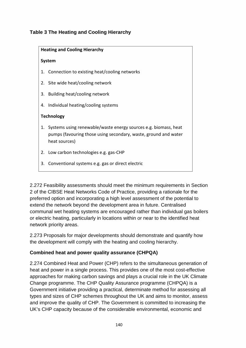
Table 3 The Heating and Cooling Hierarchy
Heating and Cooling Hierarchy
System
1. Connection to existing heat/cooling networks
2. Site wide heat/cooling network
3. Building heat/cooling network
4. Individual heating/cooling systems
Technology
1. Systems using renewable/waste energy sources e.g. biomass, heat pumps (favouring those using secondary, waste, ground and water heat sources)
2. Low carbon technologies e.g. gas-CHP
3. Conventional systems e.g. gas or direct electric
2.272 Feasibility assessments should meet the minimum requirements in Section 2 of the CIBSE Heat Networks Code of Practice, providing a rationale for the preferred option and incorporating a high level assessment of the potential to extend the network beyond the development area in future. Centralised communal wet heating systems are encouraged rather than individual gas boilers or electric heating, particularly in locations within or near to the identified heat network priority areas.
2.273 Proposals for major developments should demonstrate and quantify how the development will comply with the heating and cooling hierarchy.
Combined heat and power quality assurance (CHPQA)
2.274 Combined Heat and Power (CHP) refers to the simultaneous generation of heat and power in a single process. This provides one of the most cost-effective approaches for making carbon savings and plays a crucial role in the UK Climate Change programme. The CHP Quality Assurance programme (CHPQA) is a Government initiative providing a practical, determinate method for assessing all types and sizes of CHP schemes throughout the UK and aims to monitor, assess and improve the quality of CHP. The Government is committed to increasing the UK’s CHP capacity because of the considerable environmental, economic and
140
social benefits it can bring together with its contribution to security of supply. Successful CHPQA certification grants eligibility to a range of benefits94. CHPQA, by assessing CHP schemes on the basis of their energy efficiency and environmental performance, ensures that the associated fiscal benefits are in line with environmental performance.
Customer protection for communal heat service users
2.275 The heating sector, unlike gas and electricity, is an unregulated market. This means that customers can be vulnerable to variable pricing and service standards from their heat provider. To ensure customers receive fair and quality services, proposals for communal heat systems are expected to adopt a nationally recognised customer protection scheme in the delivery and management of their service. An example of a national scheme is the Heat Trust Customer Protection Scheme95.
Heat Network Good Practice standards
a) Technical specifications for connection
2.276 Within City Plan Part One, Policy CP8, the Development Area policies and some of the Strategic Areas policies set out local priorities that proposed energy systems in heat priority areas should be ‘connection ready’ (to have capacity for future connection) or connect where a network is planned or exists.
2.277 Where there is requirement for heat network connection or to be ‘connection ready’, buildings connecting to an existing heat network should adhere to the relevant guidelines set in the CIBSE Heat Networks Code of Practice Chapter 3 ‘Design’.
b) Indicative space requirements
2.278 Buildings should allow adequate plant room space to allow for connection at a later date (indicative requirements are shown in the table below).
94 CHPQA current benefits at April 2017 include Renewable Heat Incentive, Carbon Price Floor (heat) relief, Climate Change Levy exemption (in respect of electricity directly supplied), Enhanced Capital Allowances and preferential Business Rates. 95 Heat Trust Protection Scheme www.heattrust.org. Heat customers that are served by heat networks registered with Heat Trust will benefit from the standards set out within the Scheme. These standards are designed to be comparable to the service standard required by gas and electricity companies and include: support for vulnerable consumers, responding to faults and emergencies, guaranteed service payments for interruptions in supply, metering and billing and complaints handling. Customers will also be able to access the Energy Ombudsman if they remain unhappy with how their heat supplier has managed their complaint.
141
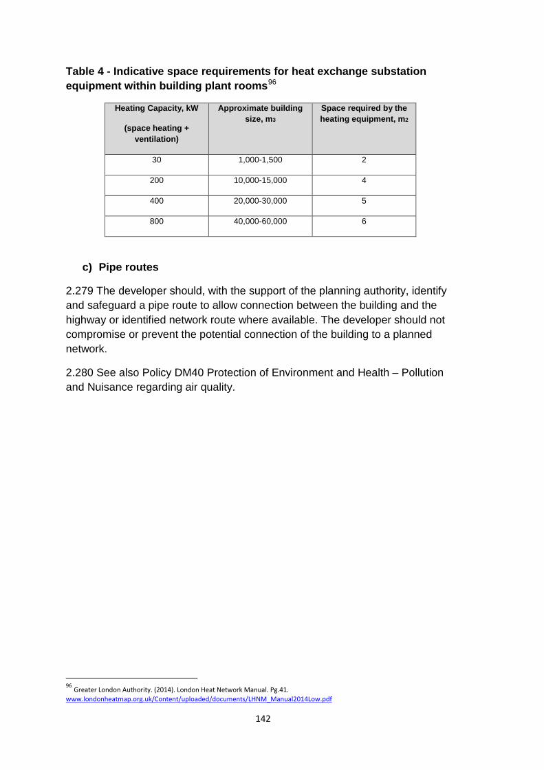
Table 4 - Indicative space requirements for heat exchange substation equipment within building plant rooms96
Heating Capacity, kW
(space heating + ventilation)
Approximate building size, m3
Space required by the heating equipment, m2
30 1,000-1,500 2
200 10,000-15,000 4
400 20,000-30,000 5
800 40,000-60,000 6
c) Pipe routes
2.279 The developer should, with the support of the planning authority, identify and safeguard a pipe route to allow connection between the building and the highway or identified network route where available. The developer should not compromise or prevent the potential connection of the building to a planned network.
2.280 See also Policy DM40 Protection of Environment and Health – Pollution and Nuisance regarding air quality.
96 Greater London Authority. (2014). London Heat Network Manual. Pg.41. www.londonheatmap.org.uk/Content/uploaded/documents/LHNM_Manual2014Low.pdf
142
Section 3 Special Area Policy, Strategic Site Allocations, Housing and Mixed
Use Sites and other Site Allocations
143
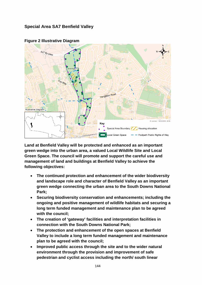
Special Area SA7 Benfield Valley
Figure 2 Illustrative Diagram
Land at Benfield Valley will be protected and enhanced as an important green wedge into the urban area, a valued Local Wildlife Site and Local Green Space. The council will promote and support the careful use and management of land and buildings at Benfield Valley to achieve the following objectives:
• The continued protection and enhancement of the wider biodiversity and landscape role and character of Benfield Valley as an important green wedge connecting the urban area to the South Downs National Park;
• Securing biodiversity conservation and enhancements; including the ongoing and positive management of wildlife habitats and securing a long term funded management and maintenance plan to be agreed with the council;
• The creation of ‘gateway’ facilities and interpretation facilities in connection with the South Downs National Park;
• The protection and enhancement of the open spaces at Benfield Valley to include a long term funded management and maintenance plan to be agreed with the council;
• Improved public access through the site and to the wider natural environment through the provision and improvement of safe pedestrian and cyclist access including the north/ south linear
144

footpath/cycleway on the eastern side of Benfield Valley and existing rights of ways;
• The sympathetic repair and re-use of Benfield Barn and its associated structures and walls in a way that is compatible with and integrates with the landscape character of Benfield Valley, the wider natural environment and the Benfield Barn Conservation Area.
Residential development in accordance with the identified development areas shown to the north and south of Hangleton Lane will be permitted provided that such development addresses the key considerations set out in Policy H2 Urban Fringe Housing Sites. Development proposals will be required to preserve the settings of the Benfield Barn and Hangleton Conservation Areas and contribute towards the achievement of the key objectives as listed above (see also Policy H2 Urban Fringe Housing Sites) and as set out in City Plan Part One Policy SA4 Urban Fringe. Appropriate uses of the Benfield Barn and outbuildings within the conservation area will be non-intensive community and /or recreational facilities appropriate to the area. Proposals for the use of the buildings should include provision for a respective long term funded management and maintenance plan, to be agreed with the council.
Development proposals will also be subject to the criteria set out in City Plan Part One Policy SA4.
Reasoned Justification
3.1 The purpose of this policy is to facilitate the positive and ongoing management and maintenance of Benfield Valley’s open spaces, wildlife habitats and heritage assets and to improve and enhance public access and connectivity with the adjoining urban areas and to the South Downs National Park, a key focus of the UNESCO Biosphere.
3.2 Benfield Valley is an important green wedge extending from the urban area in the south northwards to the National Park. It acts as an important ‘green lung’ with major open spaces at both the north and southern ends and is well used by the public for outdoor recreation. It also contains significant wildlife habitats and protected species and much of the area has been designated a Local Wildlife Site (LWS). It is proposed to maintain a broad linear Local Green Space to maintain the valley’s green wedge landscape role and character. The designation of Benfield Valley as a Local Green Space was a recommendation of the 2014 Urban Fringe Assessment Study and was supported through public consultation at the Scoping Stage of City Plan Part Two (DM37 Green Infrastructure and Nature Conservation).
3.3 Benfield Barn is a listed building and together with the historic outbuildings and flint walls in the vicinity of the Barn constitutes the Benfield Barn
145
Conservation Area. The Barn and the surrounding area is ideally located to be a ‘stepping off’ point for the wider South Downs National Park and the Barn itself offers an ideal opportunity to secure a community / interpretation or gateway facility to forge stronger links between the urban area and the National Park.
3.4 A key aim of this policy is to secure long term and enduring positive management, maintenance and enhancement of Benfield Valley and Benfield Barn and the better connection of the valley both to the surrounding urban areas and to the National Park. To help facilitate this, and in recognition of the city’s wider housing needs, provision has been made for an element of residential development to correspond with the potential development potential areas lying identified to the north and south of Hangleton Lane. Proposals for development will need to fully address the development considerations set out in Policy H2 Urban Fringe Housing Sites and meet the specific development management criteria set out in Policy SA4 Urban Fringe in City Plan Part One.
3.5 The identified areas of development potential to the north and south of Hangleton Lane have potential for approximately 100 dwellings. Given the relatively contained nature of Benfield Valley, it is envisaged that residential densities within the areas of development potential could be higher than those of existing surrounding residential areas. It is considered that development of up to three storeys might be accommodated without harm to key views and the settings of nearby listed buildings. It is expected that any development proposals will need to incorporate appropriate buffers, landscaping and screening.
3.6 Proposals will be required to make provision for and secure long term management plans for the positive and enduring enhancement and management of the valley’s open spaces and wildlife habitats.
3.7 The most northern part of the Valley is important to the wider landscape character where informal public outdoor recreation, which is sympathetic to wildlife and the enhancement of habitat mosaics, would be appropriate. The middle section of the Valley, to the west of Greenleas in the southern part of the Valley, could provide opportunities for public outdoor recreation which could include provision for more formal sports provision provided appropriate regard is given to biodiversity. Any provision for indoor sports provision would need to demonstrate there is an identified sports need and there are no deliverable alternatives in order to justify any exception to the local green space designation.
3.8 Proposals for development will therefore be required to provide detailed assessments to include the following:
146
• A Landscape and Visual Character Assessment97 which will inform landscape led masterplans for development sites and associated management/maintenance plans;
• An Ecological Assessment98 which will inform associated management/maintenance plans;
• An Archaeological Assessment; • A Transport Assessment • A Heritage Statement
3.9 In terms of connectivity to the wider urban area and to the National Park, as part of the UNESCO Biosphere, there are positive opportunities to secure better linkages through the site in terms of improved pedestrian and cycle routes particularly with regard to the existing north-south cycle/footway; the existing desire lines which cross the site at various points and existing rights of way. The need to enhance accessibility, maintain and improve the links to and through the site and deliver an effective and visually attractive Gateway to the National Park will be important considerations in the determination of development proposals and agreed management plans.
97 To be carried out in accordance with Guidelines for Landscape and Visual Impact Assessment 3rd Edition (Landscape Institute and IEAM 2013).
98 To be carried out in accordance with BS42020:2013 and CIEEM guidance.
147
Strategic Site Allocations
SSA1 Brighton General Hospital Site, Elm Grove, Freshfield Road
The Brighton General Hospital site as shown on the Policies Map is allocated for comprehensive mixed use development to include:
• 10,000 – 12,000 sq m health and care facility (D1); • a minimum of 200 residential units (Use class C3); and • community facilities.
Planning permission will be granted for proposals that accord with the Development Plan and meet the following site specific requirements:
a. Achieve a high quality of design which preserves and where possible enhances the setting of the Grade II Listed Building and non-designated heritage assets;
b. Create active frontages along Freshfield Road and Pankhurst Road. c. Maintain and improve the existing amenity greenspace through an
integrated landscape, open space and public realm network to include the provision of children’s playspace and/or a multi use sports facility;
d. Deliver sustainable transport infrastructure improvements that provide and promote public and sustainable transport and improved safe pedestrian and cyclist access to and through the site to support the mixed use development.
e. The developer will enter into a training place agreement to secure training for local people.
Reasoned Justification
3.10 Brighton General Hospital is a prominent and important brownfield site within the city and can meet citywide priorities through the re-provision of new purpose built health and care facilities alongside new housing to help meet citywide needs and community facilities.
3.11 The main Brighton General Hospital Arundel Building and the later built infirmary blocks form a prominent group of landmark buildings on the high ridge on the east side of Brighton. The site occupies an elevated position with extensive viewpoints across the city and requires a high quality architectural response. The Arundel Building is a Grade II listed building and was formerly used as the city’s workhouse. The three 1802 Infirmary and Workhouse Blocks are located within the curtilage of the principal listed building and are therefore also listed.
148
3.12 As part of the Greater Brighton One Public Estate Work Programme the council has been working with Sussex Community NHS FoundationTrust to unlock the potential of surplus public land. Following high level assessment and masterplanning, the Sussex Community NHS Trust have indicated that they have a continuing requirement for health and social care facilities and administrative offices on the site with a desire to create a modern purpose built health and care campus.
3.13 New residential development will be expected to meet the requirements for new housing as set out in City Plan Part One policies e.g. CP14 Housing Density, CP19 Housing Mix and CP20 Affordable Housing together with those set out in DM1 Housing Quality, Choice and Mix. Community facilities will be sought as part of the residential development to serve the wider residential area where limited facilities exist at present.
3.14 Opportunities to promote public and sustainable transport will be sought in particular safe pedestrian and cyclist access to and through the site to support the mixed use development.
3.15 The site contains open space (classified as amenity greenspace) and the sub area will have an open space deficit by 203099. The existing open space should be maintained and improved through an integrated landscape, open space and public realm network to include the provision of children’s playspace and or an informal multi use sports area (see City Plan Part One policies CP16 Open Space and CP17 Sports Provision). Opportunities also exist to incorporate Sustainable Urban Drainage within the open space and landscaping improvements (DM43 Sustainable Urban Drainage and DM22 Landscape Design and Trees).
99 Open Space Study Update 2011
149
SSA2 Combined Engineering Depot, New England Road
The Combined Engineering Depot, New England Road as shown on the Policies Map is allocated for comprehensive mixed use development to include:
• a minimum of 100 residential units (Use class C3); and • the provision/replacement of a minimum of 1,000 sq m B1 workspace
and managed starter office units.
Planning permission will be granted for proposals that accord with the Development Plan and meet the following site specific requirements:
a. Contribute towards the local priorities for the wider Development Area as set out in City Plan Part One Policy DA4;
b. Achieve a high quality of design and amenity which responds to the close proximity of the railway lines;
c. Sustainable transport infrastructure improvements that provide and promote public and sustainable transport and improved safe pedestrian and cyclist access to the site to support the mixed use development;
d. Improvements to the pedestrian environment along New England Road including the introduction of an active and engaging streetscape and improved lighting;
e. Take into account impact on local air quality and improvements and/ or mitigation will be sought;
f. Enhance and strengthen green infrastructure and secure enhancements to biodiversity in the area;
g. Building heights and massing should respect strategic city wide views and the setting of nearby heritage assets; and
h. The developer will enter into a training place agreement to secure training for local people.
Reasoned Justification
3.16 The Combined Engineering Depot, New England Road is located to the north of the Brighton mainline station site. Currently in operational use, owners Network Rail have indicated the potential for the majority of the site to come forward for redevelopment during the plan period following relocation of some of the current operations elsewhere in the rail estate. For Network Rail the priorities are to unlock surplus land for homes, drive economic growth in towns and cities and reinvest money into the rail network to help fund the Railway Upgrade Plan.The redevelopment of this site offers the opportunity to deliver new housing whilst providing employment space for local jobs.
150
3.17 The redevelopment of the site needs to reflect the identified local priorities set out in Policy DA4 New England Quarter and London Road area.
3.18 Careful consideration will need to be given on the siting of the residential element given the ‘island’ nature of the site which is bordered by the existing open railway lines and New England Road (B2122). Proposals will be required to address air quality, noise and vibration issues and create an attractive residential environment. Opportunities to improve links to the wider Brighton Station site should also be explored.
3.19 Brighton mainline station is a grade II* listed building, the Railway Bridge is Grade II listed and the site is situated adjacent to West Hill Conservation Area. Building heights and massing should respect strategic city wide views and the setting of nearby heritage assets.
3.20 The future redevelopment of the site provides an opportunity to improve the frontage of the site onto New England Road and create an attractive and active streetscape. Redevelopment proposals should enhance and strengthen green infrastructure (the Brighton Station Greenway is in close proximity) and secure enhancements to biodiversity in the area. Environmental improvements should address air quality issues and include a better pedestrian environment in front of the site including the under the railway viaduct.
151
SSA3 Land at Lyon Close, Hove
Land at Lyon Close, Hove as shown on the Policies Map is allocated for comprehensive mixed use redevelopment to deliver more effective and coordinated use of the whole site.
Development/ redevelopment across the allocated site will deliver the following:
• the retention/ replacement of a minimum of 5,700 sq m net B1a office floorspace through the mixed use development of the following sites: i) Spitfire House, 141 Davigdor Road - 1,000 sq m (retention) ii) 113-119 Davigdor Road - 700 sq m iii) P&H House 106 - 112 Davigdor Road - 1,000 sq m iv) Preece House 91-103 Davigdor Road – 2,000 sq m v) Peacock Industrial Estate – 1,000 sq m
• a minimum of 300 residential units (Use class C3); • expanded D1 health facilities (GP surgery) and/or community uses
subject to demonstration of need and deliverability; and • ancillary small scale retail uses.
Should the retail warehouse units100 come forward for redevelopment during the Plan period then the council will seek a mix of B1 business and residential uses.
Planning permission will be granted for proposals that accord with the Development Plan and meet the following site specific requirements:
a. Proposals relating to individual buildings and/or sites forming part of the allocation will be required to demonstrate they will not prejudice delivery of the quantum of development and uses identified in this policy.
b. All proposals, including changes in existing business uses (Use Class B1-B8), will be expected to contribute to the provision of a range of office and flexible workspaces including medium floor plate offices and start up business floorspace suitable for small business;
c. Development should be of a high quality of design and amenity which responds to the close proximity of the railway lines; incorporate active uses at lower floor levels providing an active and engaging streetscape to Davigdor Road, Lyon Close and the upper part of Holland Road;
d. Development should contribute to a coherent townscape, improved public realm and provide shared amenity space;
100 Retail Units 1 and 2 Peacock Industrial Estate
152
e. Provision should be made for sustainable transport infrastructure improvements that provide and promote public transport and improved pedestrian and cyclist access to and through the site to support the mixed use development;
f. Development should provide for a mix of dwelling type, tenure and size to cater for a range of housing requirements and to improve housing choice (see Policy CP19); and
g. The developer will enter into a training place agreement to secure training for local people.
Reasoned Justification
3.21 Land at Lyon Close includes a number of offices, retail and industrial units. There are adjacent healthcare uses and the site is close to two schools, a local retail parade, church and the well-used St Anne’s Well Gardens. The site is identified as a strategic allocation reflecting the locality’s diverse mix of uses and recognising that change is happening with a number of residential buildings under construction or approved within the allocated area. The allocation is intended to ensure a coordinated and comprehensive mixed use redevelopment of the wider site which will contribute to the housing supply in Brighton & Hove whilst maintaining an important employment role and ensure more efficient use of the land.
3.22 A coordinated masterplan approach to redevelopment will enable improvements to the permeability of the wider site; and to create active spaces and uses at lower floor levels with providing more vibrant and engaging streetscapes to Davigdor Road, Lyon Close and the upper part of Holland Road. There is also an opportunity to ensure shared/ private amenity space is provided for new residents and workers. There are opportunities to improve the image of the whole area with additional street trees on Davigdor Road, improvements in the public realm and improving pedestrian connectivity within the site and to the wider area in particular Somerhill Road. A coordinated approach will ensure improve vehicle access and connections into and through the site. A set of Design Principles (created with the support of Design South East) has informed the strategic allocation and will be expected to be taken into consideration in design proposals101.
101 Lyon Close, Hove Design Workshop Report January 2018
153
SSA4 Sackville Trading Estate and Coal Yard
Land at Sackville Trading Estate and Coal Yard as shown on the Policies Map is allocated for a comprehensive mixed use development to include:
• A minimum of 500 residential units (Use Class C3); • A minimum of 6000m2 B1 employment floorspace; • Ancillary retail and food and drink outlets; • High quality public realm including a public square; • Children’s playspace and/or an informal multi use sports area; and • Community facilities based on local need.
Planning permission will be granted for proposals that accord with Development Plan policies and meet the following site specific requirements:
a. Contribute towards the local priorities for the wider Development Area as set out in City Plan Part One Policy DA6 and meet the policy requirements of a future Hove Station Neighbourhood Plan;
b. Achieve a high quality of design and amenity which responds to the close proximity of the railway lines;
c. Improve permeability into the site by providing accessible pedestrian linkages to Sackville Road, and from the eastern end of the existing Coal Yard to Hove Station or Fonthill Road or other location south of the railway line;
d. Be designed to facilitate the creation of additional connections to Newtown Road should future redevelopment occur on adjacent sites;
e. Make provision for sustainable transport infrastructure improvements that provide and promote public and sustainable transport in particular safe and improved pedestrian and cyclist access to and through the site to support the mixed use development;
f. Ensure new development proposals take into account impact upon local air quality and that improvements and/or mitigation are sought wherever possible; and
g. The developer will enter into a training place agreement to secure training for local people.
Reasoned Justification
3.23 Sackville Trading Estate is located on the east side of Sackville Road, approximately 50 metres south of the junction with Old Shoreham Road, with the Coal Yard being a wedge shaped piece of land further to the south abutting the railway line, with Hove station situated to the east. The Trading Estate part of
154
allocated site currently contains a number of small scale buildings, which comprise of a mix of employment, trade counter and restricted retail uses. The current floorspace on the site is understood to be 5,080sqm B uses. The Coal Yard comprises of a mix of sui generis employment generating uses, including the coal facility itself and the Council car pound.
3.24 Redevelopment of the site should be guided by local priorities for the Hove Station Development Area as set out in City Plan Part One Policy DA6, which sets a requirement for an attractive and sustainable mixed-use area focussed on employment. The additional land available through incorporation of the Coal Yard site will allow a more ambitious scheme than that previously permitted, and should enable the minimum development specified in Policy DA6 to be exceeded across the Development Area as a whole.
3.25 The site also falls within the Hove Station Neighbourhood Forum area. A Neighbourhood Plan is being produced and a consultation is proposed for summer 2018.
3.26 The policy’s employment floorspace requirement allows for the current level on the Trading Estate part of the site to be increased by a minimum of 20%. This is considered appropriate given the additional employment generating activities that would be lost through the redevelopment of the Coal Yard site. The local priorities include support for flexible employment space, and this should be provided as part of the redevelopment, together with move-on accommodation for growing businesses.
3.27 Ancillary retail and food and drink outlets should be small scale and intended to serve the residents and employees in the new development and local area.
3.28 The Hove Station area is identified in the Tall Buildings SPD102 as having opportunities for tall building development. The inclusion of a well-designed and appropriate located tall building(s) could form part of a redevelopment scheme.
3.29 An Air Quality Management Area extends along Sackville Road to the junction with Old Shoreham Road. The effect of the new development on this AQMA will require careful consideration in order to achieve compliance with the requirements of Policies CP9 Sustainable Transport and DM40 Protection of the Environment -Pollution and Nuisance.
3.30 Connectivity and pedestrian linkages from the southern part of the site are currently poor and redevelopment proposals need to ensure it becomes a successfully integrated part of the wider residential community. The site is located in close proximity to Hove Station, however there is no easy means of
102 www.brighton-hove.gov.uk/sites/brighton-hove.gov.uk/files/downloads/localplan2001/15_SPGBHTall_buildings.pdf
155

accessing the station by vehicle or on foot. Redevelopment proposals should robustly investigate the feasibility of providing improved access, for example through the provision of a footbridge to the existing station car park or by the creation of a new access to Fonthill Road from the east of the Coal Yard which would follow pedestrian desire lines.
3.31 The site is located within a Groundwater Source Protection Zone (zones 1 and 2). Development in this location will need to ensure that groundwater resources are protected from pollution.
156
SSA5 Madeira Terrace and Madeira Drive
Madeira Terrace, as shown on the Policies Map is allocated for a vibrant and balanced mix of uses potentially including:
• Retail uses (Use Classes A1, A3, A4, A5); • Commercial space (Use Class B1); • Hotel (Use Class C1); • Galleries/museum(s) (Use Class D1); and/or • Leisure uses (Use Class D2) appropriate to the character of the
seafront.
Planning permission will be granted for proposals that accord with the Development Plan and meet the following site specific requirements:
a) Seek the wider restoration and repair of the remainder of the Terraces and access points;
b) Seek infrastructure improvements (including internet) along Madeira Drive.
c) Provide improved sustainable transport and pedestrian facilities to address severance along the seafront and to improve access to and along Madeira Drive for visitors and residents linking access improvements to the Black Rock site and the Marina;
d) Provide improved access to the beach for visitors of limited mobility; e) Support and contribute towards a coordinated approach to public
realm improvements including shared surfaces; improved lighting, signage and wayfinding;
f) Allow small scale hardstanding areas on the ‘back of the’ beach parallel to Madeira Drive to provide basic visitor amenities such as toilets, shelter, kiosks and lifeguard facilities (see Policy DM39 Development on the Seafront policy);
g) Conserve and enhance biodiversity in the area; h) Encourage a variety of temporary/ pop up uses consistent with the
area’s role as a centre for cultural, sports and family based activities.
Reasoned Justification
3.32 A council priority is the successful regeneration of Madeira Drive to create a ‘seafront for all’ that features diverse and engaging attractions for residents and visitors. The approach will be based around introducing ‘activity clusters’ at key points along the seafront, themed around different types of daytime and night time uses. These clusters will build upon areas along Madeira Drive that are already activated such as the ‘Leisure Beach’ cluster around the Yellowwave Beach Sports. This will ensure that the seafront continues to be a year-round destination for sustainable tourism, leisure, recreation and culture, which in turn
157
will support the city’s economy and unlock future investment (see also Policy SA1 The Seafront).
3.33 Madeira Terrace is a Grade II listed structure running half a mile along the seafront and includes 151 separate arches, a Victorian promenade with raised walkway, access stairs, associated buildings and lift towers. It is considered to be the longest cast iron structure in Britain, running from the Aquarium Colonnade to the Volk’s Railway maintenance building. Since 2012 Madeira Terrace has been closed to the public as the structure has degraded and become unsafe.
3.34 The renovation of Madeira Terrace will need to be sensitive to the structure’s unique heritage and will need to be commercially viable in order to pay for its long term maintenance. It is likely that a variety of commercial uses will be placed in the arches of Madeira Terrace. This might take the form of single units, or a combination of units with an emphasis on creating a vibrant mix and balance of uses, with active and attractive frontages that do not duplicate activities offered elsewhere along the Seafront (see also Policy DM15 Special Retail Areas – The Seafront).
3.35 Uses should be complementary to the area and the vision for this part of the seafront and could include a wide variety of uses such as cafes, bars, restaurants, boutique retail, an arts centre/ Heritage Interpretation and Learning centre, an outdoor sports activity centre, museum space, a hub for creative industries with incubator/ workspace, boutique hotel or a youth hostel. However, residential use will not be permitted. Careful consideration needs to be given to the relationship and connection between the businesses within the arches and the area’s ongoing role as Brighton and Hove’s premier events space and the beach.
3.36 There is a need to improve connections between Marine Parade and Madeira Drive. This is important as it will help both to tackle severance and also to improve accessibility to Madeira Drive, the seafront and its attractions. Options to improve public transport along Madeira Drive will also need to be developed in the context of the Coastal Transport System (CTS) proposal, as well as the transport /access strategy for the proposed Waterfront East development at Black Rock (see Policy DA1 in the City Plan Part One). Improvements to seafront accessibility will require a comprehensive approach which considers all transport modes, as well as the various demands from different users of the space along the seafront. Improvements to seafront accessibility should support the implementation of the England Coast Path103.
103 Natural England has begun to investigate how to improve coastal access along a 50 km stretch of the Sussex coast between Shoreham-by-Sea and Eastbourne. This new access is expected to be ready in 2019.
158
3.37 The public realm along Madeira Drive needs improvement and a multifunctional/ shared surface approach will be promoted to address access and parking requirements, allowing for the use of the space for events as well as for pedestrians. A masterplan including public realm strategy will be developed to support the implementation of this policy.
3.38 Opportunities to improve the biodiversity of the area and access to areas of ecological importance (The Green Wall and the beach, including rare vegetated shingle habitats) will be required. High quality and sustainable development will be expected in accordance with the priorities set out in policies SA1 The Seafront in the City Plan Part 1; and DM39 Development on the Seafront and other city wide policies.
159
SSA6 Former Peter Pan leisure site (adjacent Yellow Wave), Madeira Drive
The Former Peter Pan Leisure site, Madeira Drive as shown on the Policies Map is allocated for the following range of uses:
• leisure uses (Use Class D2) or art and heritage uses (Use Class D2) appropriate to the character of the seafront; and
• ancillary supporting retail uses (A1, A3) use class as part of a mixed use scheme.
Planning permission will be granted for proposals that accord with the Development Plan and meet the following site specific requirements:
a. Contribute towards the priorities for the Seafront as set out in City Plan Part One Policy SA1, including supporting the role of the seafront as an all year recreation attraction for residents and tourists;
b. Achieve a high quality of design and sustainability which preserves and where possible enhances the setting the Conservation Area, adjacent Listed Buildings/ structures, the character of the seafront and strategic views;
c. Provide for sustainable means of transport to and from the site and demonstrate good linkages for pedestrians and cyclists;
d. Complement the regeneration of Madeira Terraces and Drive (SSA5) and contribute to a coordinated approach to enhance the public realm;
e. Improve accessibility and connectivity between the site and the beach and sea; and
f. Conserve and enhance biodiversity in the area.
Reasoned Justification
3.39 Building on the success of the Seafront Development Initiative between the two piers the council wishes to establish the southern side of Madeira Drive as an all year round leisure destination for residents and visitors alike. Existing businesses on the southern side of Madeira Drive currently provide opportunities for a range of leisure opportunities for a variety of different user groups. Examples include Yellowave and Peter Pan’s playground. This last remaining site provides an opportunity for children and family themed leisure attractions; wet and dry sports attractions or art and heritage related attractions to complement the existing uses, adding to the overall offer on Madeira Drive.
3.40 The allocation comprises a significant part of the Peter Plan Leisure Park area which has significant local heritage having been reclaimed from the sea in 1877. The site has remained vacant for many years. It has potential for a variety
160
of uses and could be operated/ occupied with a mix of open air and indoor facilities. The use should ideally provide an all year round leisure destination for both residents and tourists and provide a different offer to the uses found elsewhere on the Seafront.
3.41 Ancillary retail uses will be permitted that support the new attraction and create footfall to the site. Due to the heritage assets (East Cliff Conservation Area and Grade II listed Madeira Terraces and Shelter Hall) development at beach level should be primarily single storey and should not exceed the height of middle promenade to respect the historic setting and open nature of the area. Buildings and structures should be clustered together in a visually co-ordinated manner. Development will need to respect the open character of this area of seafront and should allow clear gaps through for sea views. The Volk’s Railway SNCI lies adjacent to the site, development will be expected to conserve and enhance biodiversity in accordance with DM37 Green Infrastructure and Nature Conservation.
3.42 High quality and sustainable development will be expected in accordance with the priorities set out in SA1 The Seafront; Policy CP5 in the City Plan Part 1 and DM39 Development on the Seafront Policy.
161
SSA7 Land Adjacent to American Express Community Stadium, Village Way
Land Adjacent to the American Express Community Stadium, Village Way as shown on the Policies Map is allocated for:
• B1a (offices) and/or D1 (health/education) uses associated with the Stadium and/or the Universities.
Planning permission will be granted for proposals that accord with the Development Plan and meet the following site specific requirements:
a. Contribute to towards the local priorities for the wider Development Area as set out in City Plan Part One Policy DA3 Lewes Road;
b. Achieve a high quality of design which respects and enhances the adjoining stadium development and downland character;
c. Development should preserve and where possible enhance the setting of the South Downs National Park and nearby heritage assets;
d. Sustainable transport infrastructure will be required to support proposals and to ensure that there is no adverse air quality impact;
e. Contribute towards Biodiversity Plan objectives, green infrastructure and wider landscaping enhancements through creative landscape solutions (including features such as green walls and green roofs);
f. Development must ensure that groundwater sources are protected, to the satisfaction of the Environment Agency;
g. The developer will enter into a training place agreement to secure training for local people.
Reasoned Justification
3.43 The site is adjacent to the north-east of the American Express Community Stadium located within the boundaries of both the city and the Lewes District Council104. The part of the site within the council’s administrative area is located within the DA3 Lewes Road Development Area (City Plan Part 1). A key priority for this area is to further develop and enhance the role of the Lewes Road area as the city’s academic corridor but also to bring forward new employment floorspace. As a major sporting venue, the Stadium is protected by Policy CP17 Sports Provision in the City Plan Part 1. The site provides an opportunity to enhance the facilities of the Stadium by providing for example B1 a offices or D1 health/ education uses associated with the Stadium or the Universities.
104 The Lewes District Local Plan Part 2 is also proposing to allocate the part of the site within its administrative area for the uses outlined in the Policy.
162
3.44 Proposals for the site should not constrain the operation of the Stadium as a major sporting venue.
3.45 Although the site and the stadium are outside of the South Downs National Park boundaries, the Park is in close proximity and the stadium is visible in a number of key views from within the Park. Any new development should conserve and enhance the locality and overall setting, to avoid damage to the special setting of the National Park and not detract from the character of the locality. Proposals should address road and rail noise quality issues in line with Policy DM40 Protection of Environment and Health – Pollution and Nuisance.
3.46 The stadium with its curved and sloping design forms a prominent architectural element in the area and at the approach/entrance to the city from the east. As such proposals for the site will need to give careful consideration to the relationship of any proposed development with the Stadium to ensure that the new development does not erode or detract from the Stadium’s architectural presence. The stadium itself was carefully designed to nestle within the curves of the surrounding downland and the existing bund on site provides an element of green buffer/screening which helps to lessen the bulk of the stadium and integrate it into the surrounding downland setting.
3.47 The design and massing of any proposed development will need to consider the visual impact of the Grade II registered historic Stanmer Park and Listed Buildings within the University of Sussex campus. Careful consideration should be given to the choice of materials which should be complementary to those of the stadium yet distinct and subservient and designed to fit comfortably within the site’s downland context.
3.48 The loss of the bund is acceptable providing that its loss is sufficiently mitigated against, for example by the use of green walls, green roofs and landscaping. This will also provide opportunities for biodiversity enhancements in line with policies CP10 Biodiversity (City Plan Part One), DM37 Green Infrastructure and Nature Conservation and DM22 Landscape Design and Trees. There are also opportunities to improve the public realm in and around the stadium for users.
163
H1 Housing Sites and Mixed Use Sites
The sites listed in Tables 5 and 6 below (as shown on the Policies Map) are allocated for housing (Use Class C3) or mixed-use development including housing and other specified uses. Planning permission will be granted for proposals that accord with the Development Plan and which provide minimum indicative amounts of development shown in the tables.
Reasoned Justification
3.49 Policy CP1 Housing Delivery in City Plan Part One sets out the city’s housing target of 13,200 new homes over the Plan period to 2030 and states that additional sites will be allocated in Part 2 of the Plan to help ensure housing delivery is maintained over the plan period. The supporting text to City Plan Part One Policy CP3 Employment Land details the city’s employment floorspace provision requirements. The very significant constraints on the capacity of the city to physically accommodate the required amount of development for both land uses mean that it is important to maximise the use of brownfield sites. This policy sets out a schedule of brownfield sites that are allocated for housing or mixed use developments including an element of housing and other uses as specified for each individual site listed. The sites have been identified through an update of the council’s Strategic Housing Land Availability Assessment (SHLAA).
3.50 Table 5 contains sites allocated for residential development, and includes information on other uses which may also be suitable as part of the site’s redevelopment. Table 6 contains sites specifically allocated for mixed use developments, and sets out the minimum requirements for the additional uses which must be provided as part of a development proposal. Both tables include an indicative number of residential units that should be provided on each identified site. The indicated numbers of residential units may be exceeded if this can be justified through detailed examination of site specific considerations.
3.51 Only sites which are expected to bring forward 10 or more residential units are allocated in this policy. It is expected that smaller sites and windfall provision will continue to make a significant contribution towards the city’s planned housing requirements as accounted for in Policy CP1 Housing Delivery.
164
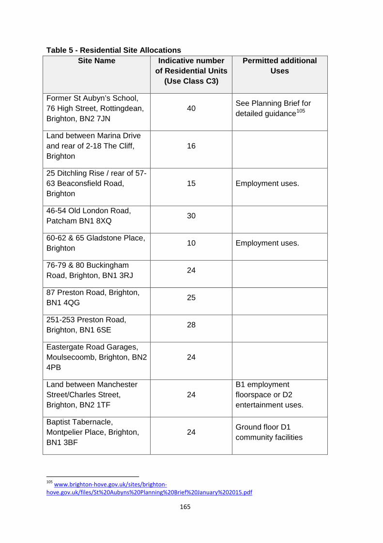
Table 5 - Residential Site Allocations Site Name Indicative number
of Residential Units (Use Class C3)
Permitted additional Uses
Former St Aubyn’s School, 76 High Street, Rottingdean, Brighton, BN2 7JN
40 See Planning Brief for detailed guidance105
Land between Marina Drive and rear of 2-18 The Cliff, Brighton
16
25 Ditchling Rise / rear of 57-63 Beaconsfield Road, Brighton
15 Employment uses.
46-54 Old London Road, Patcham BN1 8XQ 30
60-62 & 65 Gladstone Place, Brighton 10 Employment uses.
76-79 & 80 Buckingham Road, Brighton, BN1 3RJ 24
87 Preston Road, Brighton, BN1 4QG 25
251-253 Preston Road, Brighton, BN1 6SE 28
Eastergate Road Garages, Moulsecoomb, Brighton, BN2 4PB
24
Land between Manchester Street/Charles Street, Brighton, BN2 1TF
24 B1 employment floorspace or D2 entertainment uses.
Baptist Tabernacle, Montpelier Place, Brighton, BN1 3BF
24 Ground floor D1 community facilities
105 www.brighton-hove.gov.uk/sites/brighton-hove.gov.uk/files/St%20Aubyns%20Planning%20Brief%20January%202015.pdf
165
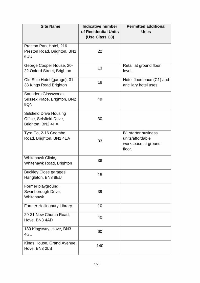
Site Name Indicative number of Residential Units
(Use Class C3)
Permitted additional Uses
Preston Park Hotel, 216 Preston Road, Brighton, BN1 6UU
22
George Cooper House, 20-22 Oxford Street, Brighton 13 Retail at ground floor
level.
Old Ship Hotel (garage), 31-38 Kings Road Brighton 18 Hotel floorspace (C1) and
ancillary hotel uses
Saunders Glassworks, Sussex Place, Brighton, BN2 9QN
49
Selsfield Drive Housing Office, Selsfield Drive, Brighton, BN2 4HA
30
Tyre Co, 2-16 Coombe Road, Brighton, BN2 4EA 33
B1 starter business units/affordable workspace at ground floor.
Whitehawk Clinic, Whitehawk Road, Brighton 38
Buckley Close garages, Hangleton, BN3 8EU 15
Former playground, Swanborough Drive, Whitehawk
39
Former Hollingbury Library 10
29-31 New Church Road, Hove, BN3 4AD
40
189 Kingsway, Hove, BN3 4GU
60
Kings House, Grand Avenue, Hove, BN3 2LS
140
166
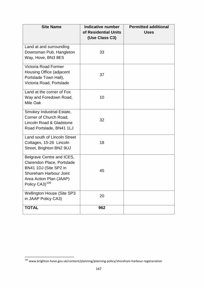
Site Name Indicative number of Residential Units
(Use Class C3)
Permitted additional Uses
Land at and surrounding Downsman Pub, Hangleton Way, Hove, BN3 8ES
33
Victoria Road Former Housing Office (adjacent Portslade Town Hall), Victoria Road, Portslade
37
Land at the corner of Fox Way and Foredown Road, Mile Oak
10
Smokey Industrial Estate, Corner of Church Road, Lincoln Road & Gladstone Road Portslade, BN41 1LJ
32
Land south of Lincoln Street Cottages, 15-26 Lincoln Street, Brighton BN2 9UJ
18
Belgrave Centre and ICES, Clarendon Place, Portslade BN41 1DJ (Site SP2 in Shoreham Harbour Joint Area Action Plan (JAAP) Policy CA3)106
45
Wellington House (Site SP3 in JAAP Policy CA3) 20
TOTAL 962
106 www.brighton-hove.gov.uk/content/planning/planning-policy/shoreham-harbour-regeneration
167

Table 6 - Mixed Use Site Allocations
The follow sites are allocated for mixed use redevelopment:
Site Name Indicative Residential Units (Use Class C3)
Minimum Requirements for Other Uses
City College, Pelham Tower (and car-park), Pelham Street, BN1 4FA
100
Site is allocated for 300 student bedspaces in City Plan Part One Policy CP21. Development should take place as part of a wider redevelopment of the site to improve the existing educational facilities.
71 - 76 Church Street, Brighton
50 B1 Employment floorspace on the ground floor which could include small scale workshop type units.
The Astoria, 10-14 Gloucester Place, Brighton, BN1 4AA
70 310sqm commercial (A1/A2/B1) uses and 70m2 community use D1
Post Office site, 62 North Road, Brighton 110 3000sqm B1 employment
floorspace
Former Brewery site, South Street, Portslade BN41 2LX
48 675sqm employment floorspace
27-31 Church Street (corner with Portland Street) 10
Offices, flexible workspace, housing and ground floor retail frontage to Church Street [630sqm of B1a and 341 sqm GIA A1]
Former Dairy Crest Site, 35-39 The Droveway, Hove, BN3 6LF
14 500sqm B Use Employment uses, ancillary retail
168
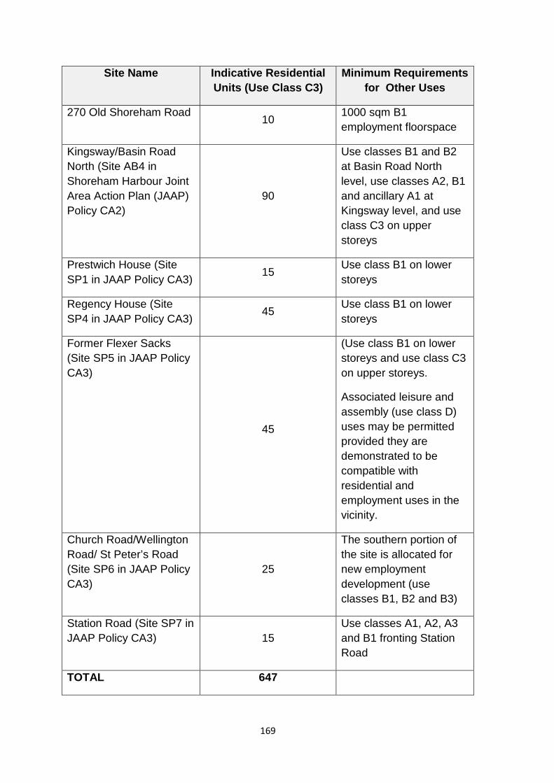
Site Name Indicative Residential Units (Use Class C3)
Minimum Requirements for Other Uses
270 Old Shoreham Road 10 1000 sqm B1 employment floorspace
Kingsway/Basin Road North (Site AB4 in Shoreham Harbour Joint Area Action Plan (JAAP) Policy CA2)
90
Use classes B1 and B2 at Basin Road North level, use classes A2, B1 and ancillary A1 at Kingsway level, and use class C3 on upper storeys
Prestwich House (Site SP1 in JAAP Policy CA3)
15 Use class B1 on lower storeys
Regency House (Site SP4 in JAAP Policy CA3) 45 Use class B1 on lower
storeys
Former Flexer Sacks (Site SP5 in JAAP Policy CA3)
45
(Use class B1 on lower storeys and use class C3 on upper storeys.
Associated leisure and assembly (use class D) uses may be permitted provided they are demonstrated to be compatible with residential and employment uses in the vicinity.
Church Road/Wellington Road/ St Peter’s Road (Site SP6 in JAAP Policy CA3)
25
The southern portion of the site is allocated for new employment development (use classes B1, B2 and B3)
Station Road (Site SP7 in JAAP Policy CA3) 15
Use classes A1, A2, A3 and B1 fronting Station Road
TOTAL 647
169
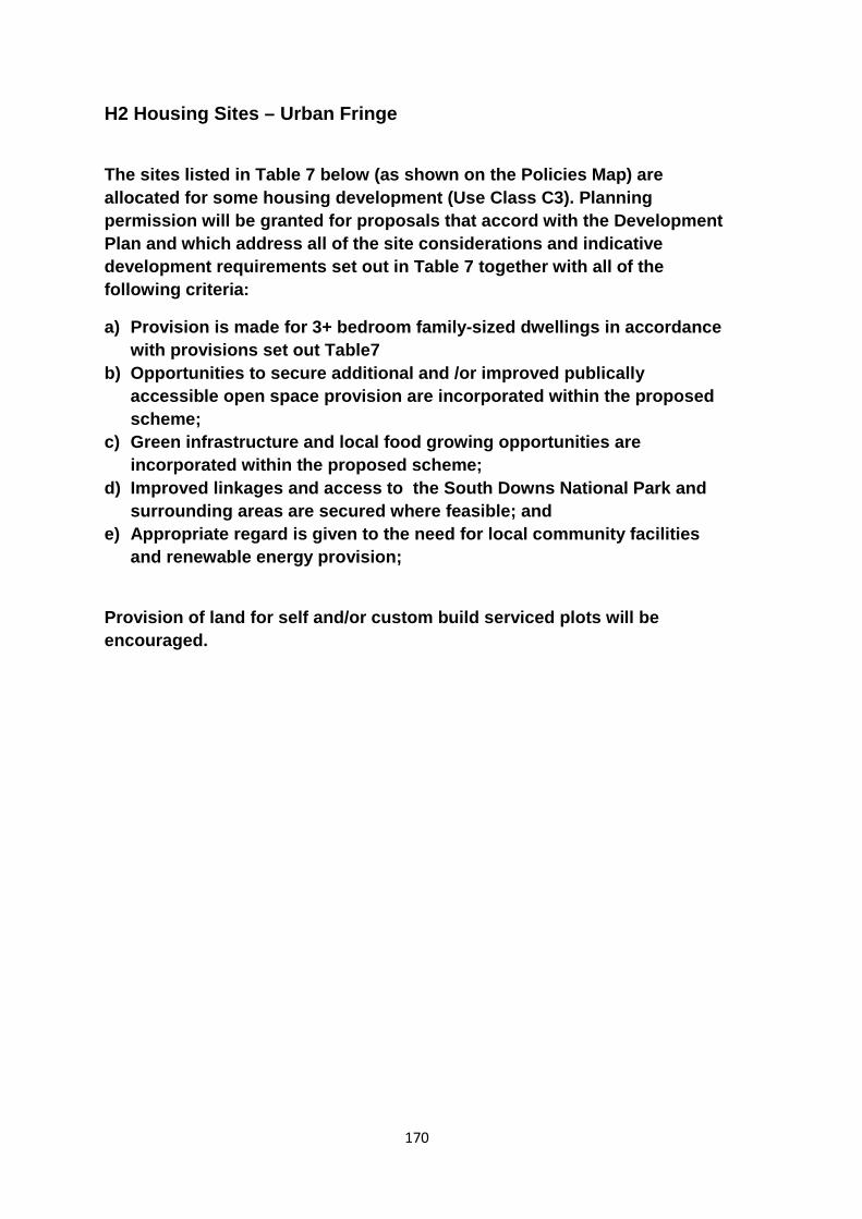
H2 Housing Sites – Urban Fringe
The sites listed in Table 7 below (as shown on the Policies Map) are allocated for some housing development (Use Class C3). Planning permission will be granted for proposals that accord with the Development Plan and which address all of the site considerations and indicative development requirements set out in Table 7 together with all of the following criteria:
a) Provision is made for 3+ bedroom family-sized dwellings in accordance with provisions set out Table7
b) Opportunities to secure additional and /or improved publically accessible open space provision are incorporated within the proposed scheme;
c) Green infrastructure and local food growing opportunities are incorporated within the proposed scheme;
d) Improved linkages and access to the South Downs National Park and surrounding areas are secured where feasible; and
e) Appropriate regard is given to the need for local community facilities and renewable energy provision;
Provision of land for self and/or custom build serviced plots will be encouraged.
170
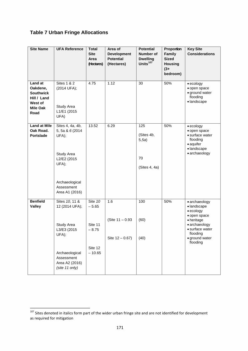
Table 7 Urban Fringe Allocations
Site Name UFA Reference Total Site Area (Hectares)
Area of Development Potential (Hectares)
Potential Number of Dwelling Units107
Proportion Family Sized Housing (3+ bedroom)
Key Site Considerations
Land at Oakdene, Southwick Hill / Land West of Mile Oak Road
Sites 1 & 2 (2014 UFA);
Study Area L1/E1 (2015 UFA)
4.75 1.12
30
50% • ecology • open space • ground water
flooding • landscape
Land at Mile Oak Road. Portslade
Sites 4, 4a, 4b, 5, 5a & 6 (2014 UFA);
Study Area L2/E2 (2015 UFA);
Archaeological Assessment Area A1 (2016)
13.52 6.29 125
(Sites 4b, 5,5a)
70
(Sites 4, 4a)
50% • ecology • open space • surface water
flooding • aquifer • landscape • archaeology
Benfield Valley
Sites 10, 11 & 12 (2014 UFA);
Study Area L3/E3 (2015 UFA);
Archaeological Assessment Area A2 (2016) (site 11 only)
Site 10 – 5.65
Site 11 – 8.75
Site 12 – 10.65
1.6
(Site 11 – 0.93
Site 12 – 0.67)
100
(60)
(40)
50% • archaeology • landscape • ecology • open space • heritage • archaeology • surface water
flooding • ground water
flooding
107 Sites denoted in italics form part of the wider urban fringe site and are not identified for development as required for mitigation
171
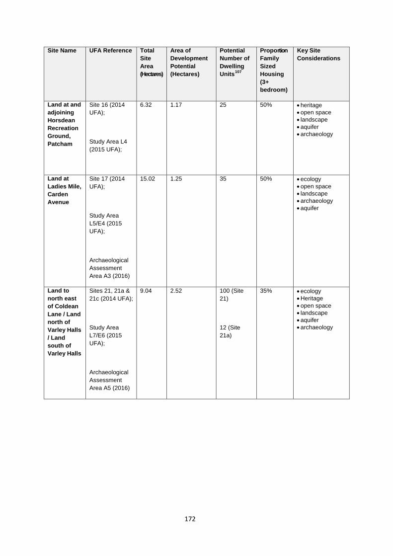
Site Name UFA Reference Total Site Area (Hectares)
Area of Development Potential (Hectares)
Potential Number of Dwelling Units107
Proportion Family Sized Housing (3+ bedroom)
Key Site Considerations
Land at and adjoining Horsdean Recreation Ground, Patcham
Site 16 (2014 UFA);
Study Area L4 (2015 UFA);
6.32 1.17 25
50% • heritage • open space • landscape • aquifer • archaeology
Land at Ladies Mile, Carden Avenue
Site 17 (2014 UFA);
Study Area L5/E4 (2015 UFA);
Archaeological Assessment Area A3 (2016)
15.02 1.25 35
50% • ecology • open space • landscape • archaeology • aquifer
Land to north east of Coldean Lane / Land north of Varley Halls / Land south of Varley Halls
Sites 21, 21a & 21c (2014 UFA);
Study Area L7/E6 (2015 UFA);
Archaeological Assessment Area A5 (2016)
9.04 2.52 100 (Site 21)
12 (Site 21a)
35% • ecology • Heritage • open space • landscape • aquifer • archaeology
172
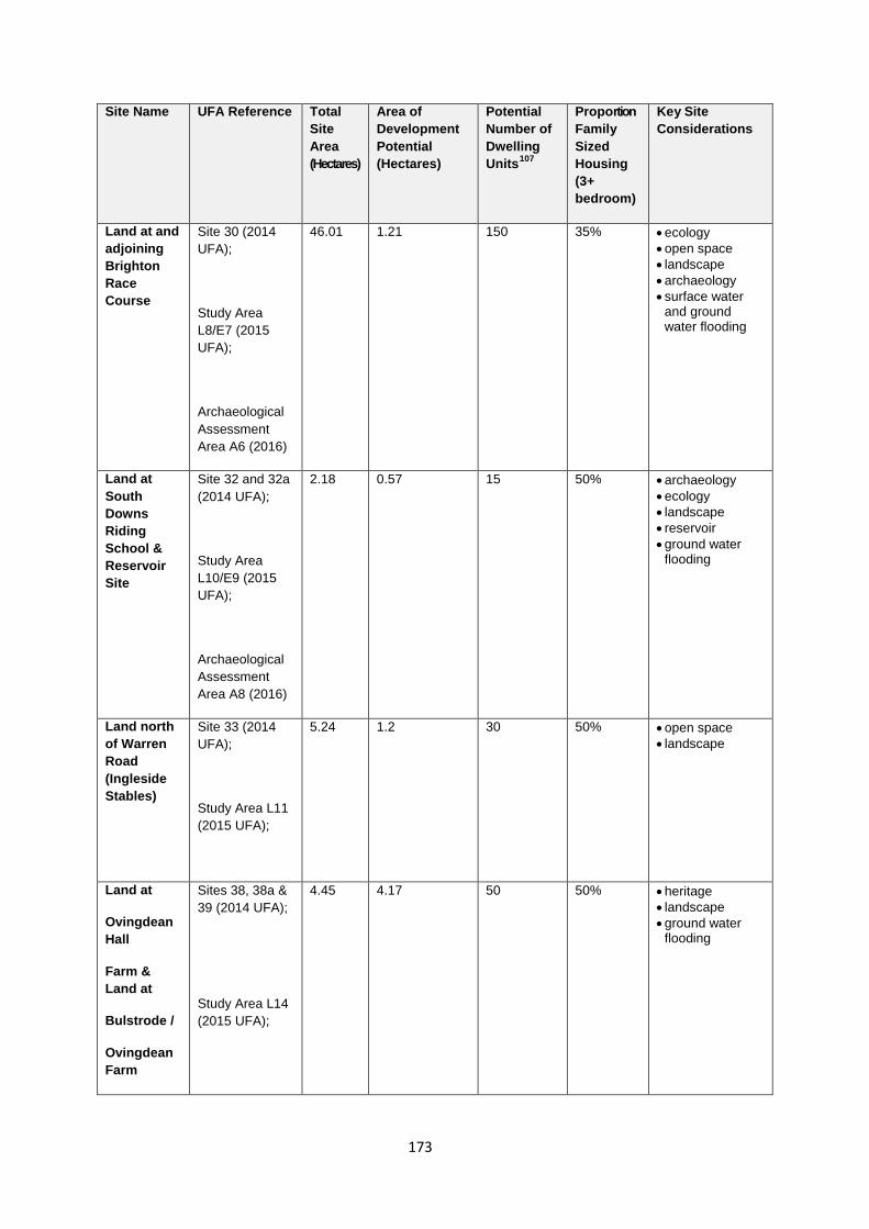
Site Name UFA Reference Total Site Area (Hectares)
Area of Development Potential (Hectares)
Potential Number of Dwelling Units107
Proportion Family Sized Housing (3+ bedroom)
Key Site Considerations
Land at and adjoining Brighton Race Course
Site 30 (2014 UFA);
Study Area L8/E7 (2015 UFA);
Archaeological Assessment Area A6 (2016)
46.01 1.21 150 35% • ecology • open space • landscape • archaeology • surface water
and ground water flooding
Land at South Downs Riding School & Reservoir Site
Site 32 and 32a (2014 UFA);
Study Area L10/E9 (2015 UFA);
Archaeological Assessment Area A8 (2016)
2.18 0.57 15 50% • archaeology • ecology • landscape • reservoir • ground water
flooding
Land north of Warren Road (Ingleside Stables)
Site 33 (2014 UFA);
Study Area L11 (2015 UFA);
5.24 1.2 30 50% • open space • landscape
Land at
Ovingdean Hall
Farm & Land at
Bulstrode /
Ovingdean Farm
Sites 38, 38a & 39 (2014 UFA);
Study Area L14 (2015 UFA);
4.45 4.17 50 50% • heritage • landscape • ground water
flooding
173
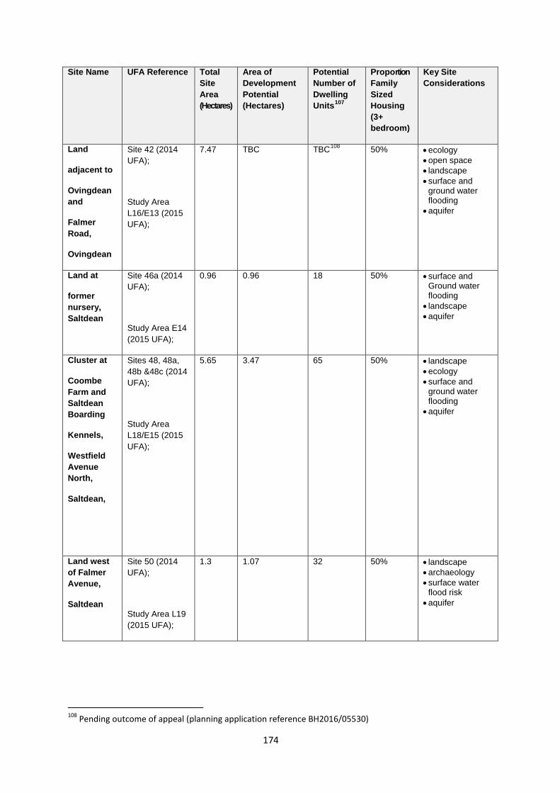
Site Name UFA Reference Total Site Area (Hectares)
Area of Development Potential (Hectares)
Potential Number of Dwelling Units107
Proportion Family Sized Housing (3+ bedroom)
Key Site Considerations
Land
adjacent to
Ovingdean and
Falmer Road,
Ovingdean
Site 42 (2014 UFA);
Study Area L16/E13 (2015 UFA);
7.47 TBC TBC108 50% • ecology • open space • landscape • surface and
ground water flooding
• aquifer
Land at
former nursery, Saltdean
Site 46a (2014 UFA);
Study Area E14 (2015 UFA);
0.96 0.96 18 50% • surface and Ground water flooding
• landscape • aquifer
Cluster at
Coombe Farm and Saltdean Boarding
Kennels,
Westfield Avenue North,
Saltdean,
Sites 48, 48a, 48b &48c (2014 UFA);
Study Area L18/E15 (2015 UFA);
5.65
3.47
65
50% • landscape • ecology • surface and
ground water flooding
• aquifer
Land west of Falmer Avenue,
Saltdean
Site 50 (2014 UFA);
Study Area L19 (2015 UFA);
1.3 1.07 32 50% • landscape • archaeology • surface water
flood risk • aquifer
108 Pending outcome of appeal (planning application reference BH2016/05530)
174
Reasoned Justification
3.52 The city is a tightly constrained urban area with very limited opportunities to physically expand to accommodate new development. City Plan Part One (Policies CP1 Housing Delivery and SA4 Urban Fringe) identified potential for some of the land within the city’s urban fringe (areas of land that lie between the defined built up urban area boundary and the boundary of the South Downs National Park) to contribute towards meeting the city’s housing requirement. The purpose of this policy is to allocate housing development on some of the Urban Fringe sites which were identified through the 2014 Urban Fringe Assessment and further assessment through the 2015 Urban Fringe Assessment Study.
3.53 The number of dwellings proposed in the allocations schedule are indicative, showing what might reasonably be achieved on each site. Of key importance will be the need to adequately address the considerations identified for each site and other matters including design and layout, biodiversity, green infrastructure, open space provision and the relationship with the surrounding areas including, where relevant, the setting of the South Downs National Park (taking account of City Plan Part One Policy SA5) and Conservation Areas.
3.54 City Plan Part One Policy SA4 Urban Fringe clarifies that development within the urban fringe will not be permitted except where a site has been allocated for development or where a countryside location can be justified; and where it can be clearly demonstrated that proposals have had regard to the downland landscape setting of the city, any adverse impacts of development are minimised and appropriately mitigated and/or compensated for and where appropriate, the proposal helps to achieve the 5 policy objectives as set out in Policy SA4 Urban Fringe.
3.55 The site allocations on the urban fringe are suitable locations to deliver a significant amount of family-sized housing and affordable housing. Proposals should accommodate at least 50% family sized housing (unless otherwise indicated in the table above) and the provision of self-build and custom build serviced plots is encouraged (see Policy DM1 Housing Quality, Choice and Mix). They also offer opportunities for community-led housing development.
3.56 City Plan Part One Policy SA4 Urban Fringe promotes the urban fringe as part of the green network and encourages opportunities for multi-functional open space which can include appropriate recreation, cultural experiences, biodiversity and food growing. The site allocations will provide opportunities to enhance and expand the green network (see Policy DM37 Green Infrastructure and Nature Conservation). Proposals should include the provision of public open space where possible and consideration should be given to ensuring long term management and maintenance. Provisions for food growing should also be
175
incorporated into the development and have regard to the forthcoming Food Growing Supplementary Planning Document (SPD).
3.57 Regard should also be given to the need for community facilities and the opportunities offered by these sites for the provision of renewable energy. For example, in some instances the developable area may be able to incorporate a local facility such as a local shop, community meeting space and/or health facility.
3.58 The urban fringe allocations are by their nature sensitive locations for development, comprising greenfield land adjoining open countryside and the South Downs National Park. In order to ensure that all potential development impacts are accurately identified and that appropriate mitigation is secured developers will be required to submit detailed information/assessments at the planning application stage. This may include, for example;
- Landscape Visual Impact Assessment - Ecological Assessment including Protected Species Survey - Arboricultural Report and Plan(s) /Tree Survey(s) - Archaeology Assessments - Heritage Statement - Traffic Assessment, - Flood Risk Assessment - Drainage Strategy and Sustainable Drainage Report - Open Space Assessment - Hydrological/Hydrogeological Survey
3.59 In addition to the above, the following may also be required in order to comply with other City Plan policies:
- Noise Assessment - Highways Assessment / Transport Statement - Lighting Assessment - Air Quality Assessment - Land Contamination Survey - Environmental Impact Assessments - Sustainability Checklist - Foul Sewerage and Utilities Assessment
176
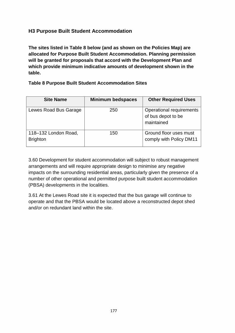
H3 Purpose Built Student Accommodation
The sites listed in Table 8 below (and as shown on the Policies Map) are allocated for Purpose Built Student Accommodation. Planning permission will be granted for proposals that accord with the Development Plan and which provide minimum indicative amounts of development shown in the table.
Table 8 Purpose Built Student Accommodation Sites
Site Name Minimum bedspaces Other Required Uses
Lewes Road Bus Garage 250 Operational requirements of bus depot to be maintained
118–132 London Road, Brighton
150 Ground floor uses must comply with Policy DM11
3.60 Development for student accommodation will subject to robust management arrangements and will require appropriate design to minimise any negative impacts on the surrounding residential areas, particularly given the presence of a number of other operational and permitted purpose built student accommodation (PBSA) developments in the localities.
3.61 At the Lewes Road site it is expected that the bus garage will continue to operate and that the PBSA would be located above a reconstructed depot shed and/or on redundant land within the site.
177
E1 Opportunity site for business and warehouse uses
Land at Hangleton Bottom, Hangleton Link Road, North Portslade as shown on the Policies Map will be granted permission for the following uses only where these would not prevent or prejudice the delivery of a strategic scale waste management facility:
• Business and warehouse premises (Use Classes B1, and B8).
Planning permission will be granted for proposals that accord with the Development Plan in particular Policy SP1 in the Waste and Minerals Sites Plan.
Reasoned Justification
3.62 Demand for employment floorspace in the city remains strong with existing local firms looking to expand and businesses who want to be located closer to the main focus of economic and business activity within Brighton & Hove and its immediate periphery. Modest growth in jobs in this sector is forecast to 2030. The advanced manufacturing and engineering sector is identified as a priority sector109.
3.63 Apart from the refurbishment of some existing industrial estates and new build at Woodingdean Business Park, Brighton and at St Joseph’s Close, Hove there have been no significant new warehouse/ light industrial schemes developed in the last ten years. In particular there is a lack of suitable employment space to support the growth needs of small-to-medium sized businesses that have outgrown small commercial units, but do not require large-scale strategic sites to support their space needs110.
3.64 Policy CP3 Employment Land in the City Plan Part 1 sets out the approach to safeguarding employment land over the Plan period and strategic allocations were identified in Development Areas to bring forward new high quality employment floorspace (DA2- DA8) to meet the forecast requirements over the plan period. Policy CP3 is supportive of opportunities to increase the industrial floorspace capacity in safeguarded industrial estates and on specific sites; however this does not address all the forecast requirements. Part 6 of the policy indicated that Part of the City Plan would seek to allocate additional employment sites and mixed use allocations to help ensure employment land delivery is maintained over the plan period.
3.65 This policy safeguards a potential opportunity for new business and warehouse floorspace to come forward over the plan period.
109 Coast to Capital Strategic Economic Plan March 2014 110 Brighton & Hove Industrial Estates Audit, Stiles Harold Williams December 2017
178
3.66 Hangleton Bottom is a key strategic site for the future delivery of waste management infrastructure needed to support further moves towards sustainable waste management in East Sussex and Brighton & Hove. WMP Policy WMP6 states that “Development proposals which would prevent or prejudice those sites for waste management uses will be resisted.” Use of any part of the site for alternative uses must therefore ensure that the ability of the site to host a strategic scale waste management facility111 is not compromised. Given that the planning for strategic scale waste management facilities is undertaken through a strategic level approach to plan-making (in this case through the East Sussex, Brighton & Hove and South Downs Waste & Minerals Plans), any view as to whether or not an alternative use of the site compromises the ability of the site to host its allocated use through Policy WMP6 will need to be obtained and agreed by all three relevant waste planning authorities.
111 Large strategic scale waste management facility with an indicative waste throughput of 100,000 – 150,000 tonnes per annum as defined in the Waste and Minerals Plan 2013.
179
Appendix 1: Glossary of terms
This glossary provides an explanation of some terms used in this document.
Term Definition
Affordable Housing
Affordable housing includes social rented, affordable rented and intermediate housing provided to eligible households whose needs are not met by the market. Eligibility is determined with regard to local incomes and local house prices. Affordable housing should include provisions to remain at an affordable price for future eligible households or for the subsidy to be recycled for alternative affordable housing provision.
Social rented housing is owned by local authorities and private registered providers (as defined in section 80 of the Housing and Regeneration Act 2008), for which guideline target rents are determined through the national rent regime. It may also be owned by other persons and provided under equivalent rental arrangements to the above, as agreed with the local authority or with the Homes and Communities Agency.
Affordable rented housing is let by local authorities or private registered providers of social housing to households who are eligible for social rented housing.
Affordable Rent is subject to rent controls that require a rent of no more than 80% of the local market rent (including service charges, where applicable).
Intermediate housing is homes for sale and rent provided at a cost above social rent, but below market levels subject to the criteria in the Affordable Housing definition above. These can include shared equity (shared ownership and equity loans), other low cost homes for sale and intermediate rent, but not affordable rented housing.
Homes that do not meet the above definition of affordable housing, such as “low cost market” housing, may not be considered as affordable housing for planning purposes.
180
Archaeological Interest
There will be archaeological interest in a heritage asset if it holds, or potentially may hold, evidence of past human activity worthy of expert investigation at some point. Heritage assets with archaeological interest are the primary source of evidence about the substance and evolution of places, and of the people and cultures that made them.
Archaeological Notification Areas (ANAs)
As part of the Historic Environment Record a series of areas containing recorded archaeological remains have been defined. These areas are called Archaeological Notification Areas and are designed to alert applicants and planning teams to potential impacts on heritage that would need to be addressed in line with the National Planning Policy Framework.
Air Quality Management Area (AQMA)
Areas designated by local authorities because they are not likely to achieve national air quality objectives by the relevant deadlines.
Artistic Element The incorporation of art into the design of buildings and spaces can be a useful and effective way of creating and/or enhancing local distinctiveness and developing a desirable sense of place.
Aquifer
Rock that provides a natural underground store for water. In Brighton & Hove aquifers are used to provide drinking water.
Biodiversity (Biological Diversity)
The range and variety of life (including plants, animals and micro-organisms), ecosystems and ecological processes.
Asset of Community Value (ACV)
A building or land is an asset of community value (ACV) if its main use is, or recently has been, to further the social wellbeing or social interests of the local community and if it could do so in the future
Biosphere Reserve These are designated by the United Nations Educational, Scientific and Cultural Organisation (UNESCO) as centres of excellence to demonstrate conservation and sustainable practice by bringing nature and people together.
BREEAM
Building Research Establishment Environmental Assessment Method - the most widely used means of reviewing and improving the environmental performance of buildings
Brownfield or ‘previously developed land’
Land which is or was occupied by a permanent structure, including the curtilage of the developed land (although it should not be assumed that the whole of the cartilage should
181
be developed) and any associated fixed surface infrastructure.
This excludes:
• Land that is or has been occupied by agricultural or forestry buildings;
• Land that has been developed for minerals extraction or waste disposal by landfill purposes where provision for restoration has been made through development control procedures;
• Land in built-up areas such as private residential gardens, parks, recreation grounds and allotments, which, although it may feature paths, pavilions and other buildings, has not been previously developed, and;
• Land that was previously-developed but where the remains of the permanent structure or fixed surface structure have blended into the landscape in the process of time (to the extent that it can reasonably be considered as part of the natural surroundings).
Change of Use Change in the use of a building or other land for another purpose. In considering a change of use it is normally necessary to establish whether the change is “material” and whether by virtue of the provisions of the Town and Country Planning (Use Classes) Order 1987 (as amended), development requiring planning permission is involved.
Census Output Area Created for the output of census data they are geographical units formed of clusters of postcodes with similar population sizes.
Community Infrastructure Levy (CIL)
A levy allowing local authorities to raise funds from owners or developers of land undertaking new building projects in their area.
Climate Change
Accounts for long-term changes in temperature, precipitation, wind and all other aspects of the Earth's climate. Often regarded as a result of human activity and fossil fuel consumption.
Cluster Flat A sub-unit of accommodation within a larger development under common management. Rooms within a cluster flat will be individually let to tenants by a provider of institutional accommodation, e.g. a university, college, or hospital or specialist accommodation provider, but within each cluster flat tenants usually have exclusive use of communal kitchen/lounge and sometimes bathroom facilities. Most cluster flats will have their own front door within the accommodation block.
Connectivity Connectivity or permeability refers to the visual and physical
182
accessibility into and within an area.
Conservation Area
An area of special architectural or historic interest, the character or appearance of which it is desirable to preserve or enhance. They are designated by the city council, though the Secretary of State also has powers to designate them.
Custom Build Housing Housing built or commissioned by individuals or groups of individuals for their own occupation.
Density (dwellings)
Measure used to describe the numbers of housing units associated with a given area e.g. dwellings per hectare. Net density includes access roads within the site; private garden space; car parking areas; incidental open space and landscaping; and local children's play areas where these are to be provided.
Designated Heritage Asset
A World Heritage Site, Scheduled Monument, Listed Building, Protected Wreck Site, Registered Park and Garden, Registered Battlefield or Conservation Area designated under the relevant legislation
Development The carrying out of building, engineering, mining or other operations in, on, over and under land, or making of a material change of use of any building or land.
Developer Contributions
Contributions made by a developer to mitigate the impact of development, either by paying money for the works to be carried out or by directly providing facilities or works either on or off-site.
Digital Infrastructure Infrastructure, such as small cell antenna and ducts for cables, that supports fixed and mobile connectivity and underpins smart technology.
District Centre Groups of shops often containing at least one supermarket or superstore and a range of non-retail services such as banks and restaurants as well as local public facilities such as a library. Smaller in size than Town and Regional centres.
District Heating Network
This term is generally given to a system where a centralised heat generating plant (using any one of a range of technologies) provides heat to surrounding buildings in the area by means of a network of pipes carrying hot water or steam.
Downland
Usually treeless open land with only a thin covering of soil on the chalk uplands.
183
Ecosystem Services Are the benefits provided by ecosystems that contribute to making human life both possible and worth living. They are grouped into four broad categories: provisioning, such as the production of food and water; regulating, such as the control of climate and disease; supporting, such as nutrient cycles and crop pollination; and cultural, such as spiritual and recreational benefits
Environment
Agency
The leading public body for protecting and improving the environment of air, land and water in England and Wales.
Green Infrastructure Multi-functional and connected network of predominantly green spaces, water and other environmental features in urban and rural areas that delivers a wide range of environmental, social, economic benefits and quality of life benefits. It can help strengthen climate change resilience, health and well-being of communities, economic vibrancy, and, provide habitats and wildlife corridors as well as urban cooling
Green Network (GN)
A series of interlinked natural green spaces and nature conservation features connecting the urban area, urban fringe, the seafront and surrounding downland.
Greenfield Land
Site that has not been previously been built on (includes areas such as playing fields, allotments, countryside and gardens).
Historic England The national public body responsible for the historic environment. Their role includes identify and protecting heritage and providing national expertise at a regional level.
Historic Environment Record (HER)
Information services that seek to provide access to comprehensive and dynamic resources relating to the historic environment of a defined geographic area for public benefit and use.
Historic Parks and Gardens
Gardens, parks and designed landscapes whose character reflects the period (or periods) of their design, and sometimes also the style of a particular designer. Historic England compiles the Register of Parks and Gardens of Special Historic Interest in England.
House in Multiple Occupation (HMO)
An HMO is generally a house or flat that is shared by three or more people who are not related as family members. A small HMO (technically called a Class C4 HMO) includes, in broad terms, small shared houses or flats occupied by between 3 and 6 unrelated individuals who share basic amenities (such as a kitchen and/or bathroom). A large HMO (technically
184
called a Sui Generis HMO) is the same as a small HMO except that it is shared by more than 6 people.
Important Local Parades
A group of shops (five or more). ILPS have a key role in contributing to sustainable development, providing access to day-to-day necessities such as a newsagent, convenience store off-licence, pharmacies and post offices, within walking distance from home
Listed Building
A building of national importance due to its architectural or historic interest. They are buildings which have been included in the Statutory List of Buildings of Special Architectural or Historic Interest. The List is compiled by the Secretary of State (Department for Digital, Culture, Media and Sport), with advice from Historic England, using agreed national criteria.
Local Centre Include a range of small shops of a local nature, serving a small catchment. Typically, local centres might include, amongst other shops, a small supermarket, a newsagent, post office and a pharmacy. Other facilities could include a hot food takeaway and launderette.
Locally Listed Heritage Asset
A non-designated heritage asset that has been identified as having a degree of significance meriting consideration in planning decisions
Local Nature Reserve (LNR)
Local Nature Reserves are for both people and wildlife. They are places with wildlife or geological features that are of special interest locally. They offer people special opportunities to study or learn about nature or simply to enjoy it.
Local Transport Plan (LTP)
(Also called the Full Local Transport Plan when it has been approved by the Government). It is the document prepared by the city council which sets out its transport policy and proposals and is prepared in order to bid for Government funding for all forms of transport.
Local Wildlife Sites Formerly called Sites of Nature Conservation Importance (SNCIs) these are locally valued non-statutory sites
Mixed use developments
A development that contains two or more uses e.g. residential, employment, leisure, community uses.
National Planning Policy Framework
The government’s national planning policy document which was first published in March 2012 and sets out the key principles for sustainable development.
National Planning Policy Guidance
Web-based resource of national planning guidance covering a range of topics and linked to the National Planning Policy
185
Framework
Nationally Described Space Standards
Technical housing standards produced by the government which deal with internal space within new dwellings.
Natural England
A statutory body formed in 2006 with the bringing together of English Nature, the landscape, access and recreation elements of the Countryside Agency and the environmental land management functions of the Rural Development Service.
Nature Improvement Areas
Inter-connected networks of wildlife habitats intended to re-establish thriving wildlife populations and help species respond to the challenges of climate change.
Neighbourhood Parades
A cluster of three or more A1 retail units such as a newsagent, convenience store or off-licence, together with A2 uses, for example estate agents or A3, A4 or A5 uses, that function as a group and are capable of serving the convenience needs of a local residential catchment population
Permeability
The degree of movement possible or permitted between public outside and private inside or between urban areas, buildings, places and spaces.
Place Making Multi-faceted approach to the planning, design and management of buildings and public spaces so that they invite greater interaction between people and promote healthier, more social and more economically viable communities.
Planning Obligations/ Developer contributions
Planning Obligations or Developer Contributions are secured through Section 106 of the Town and Country Planning Act 1990 to mitigate the impacts of a development proposal. They are a legally enforceable obligation entered into under section 106 of the Town and Country Planning Act 1990.
Policies Map
Map which identifies sites/areas to which particular policies apply.
Primary and secondary frontages
Primary frontages are likely to include a high proportion of retail uses which may include food, drinks, clothing and household goods. Secondary frontages provide greater opportunities for a diversity of uses such as restaurants, cinemas and businesses.
Public Realm This is the space between and within buildings that are publicly accessible, including streets, squares, forecourts,
186
open spaces and public and civic buildings.
Purpose Built Student Accommodation
Purpose built accommodation whose main purpose is to house students registered on courses at educational establishments.
Regional Centre The highest level of shopping centre (also known as the city centre) serving a wide catchment area.
Renewable Energy
Includes energy for heating and cooling as well as generating electricity. Renewable energy covers those energy flows that occur naturally and repeatedly in the environment – from the wind, the fall of water, the movement of the oceans, from the sun and also from biomass and deep geothermal heat.
Scheduled Monuments
Designated sites of nationally important archaeological interest. Sites are designated by Historic England
Strategic Environmental Assessment (SEA)
A procedure (set out in the Environmental Assessment of Plans and Programmes Regulations 2004) which requires the formal environmental assessment of certain plans and programmes which are likely to have significant effects on the environment.
Shoreline
Management Plan
(SMP)
Provides a large-scale assessment of the risks associated with coastal processes and present a long term policy framework to reduce these risks to people and the developed, historic and natural environment in a sustainable manner. A SMP is a high level document that forms an important element of the strategy for flood and coastal erosion risk management.
Self-build housing Housing built or commissioned by individuals (or groups of individuals for their own occupation as their sole or main residence for at last three years).
Sense of Place Collection of qualities and characteristics – visual, cultural, social, and environmental – that provide meaning to a location. Sense of place is what makes the physical surroundings of an area or space different from another. and/or appealing to residents, visitors and businesses.
Sites of Special Scientific Interests (SSSIs)
These are designated by Natural England (the government nature conservation agency) under the Wildlife and Countryside Act 1981. Such sites are of special national interest by reason of their flora, fauna, geological features or landforms.
South Downs National Park Authority
The South Downs National Park came into being on 31st March 2010. As a National Park, the SDNPA has statutory purposes and socio-economic responsibilities as
187
(SDNPA) specified in the Environment Act of 1995.
Source Protection Zone
For groundwater sources such as wells, boreholes and springs used for public drinking water supply. These zones show the risk of contamination from any activities that might cause pollution in the area. Defined by the Environment Agency.
Southern Water The statutory water and sewerage undertaker for the City Plan area.
Special Area of Conservation (SAC)
SACs are designated by the European Commission (EC) under the EC Directive on the conservation of habitats and wild flora and fauna (The Habitats and Species Directive 1992). The Habitats Regulations 1994 translate the Directive into UK legislation. SACs are outstanding examples of selected habitat types important for the continuing wellbeing and survival of selected non-bird species (birds are protected under their own European legislation). The Directive states that SACs are to be afforded absolute protection subject to 'imperative reasons of overriding public interest'.
Special Protection
Areas (SPAs)
Areas which have been identified as being of international importance for the breeding, feeding, wintering or the migration of rare and vulnerable species of birds found within European Union countries. They are European designated sites, classified under the Birds Directive.
Strategic Flood Risk Assessment (SFRA)
Created to help appraise, manage and reduce flood risk in relation to the location of potential new development in the city.
Strategic View The line of sight from a particular point to an important landmark or skyline.
Supplementary
Planning
Document (SPD)
Documents which add further detail to the policies in the Local Plan. They can be used to provide further guidance for development on specific sites, or on particular issues, such as design. Supplementary Planning Documents are capable of being a material consideration in planning decisions but are not part of the development plan.
Sustainability Appraisal (SA)
The Planning and Compulsory Purchase Act 2004 requires Local Development Documents to be prepared with a view to contributing to the achievement of sustainable development. A sustainability appraisal is a systematic process, to appraise the social, environmental and economic effects of the strategies and policies in a Local Development Document. It incorporates the requirements of the Environmental Assessment of Plans and Programmes Regulations 2004.
Sustainable Transport Any efficient, safe and accessible means of transport with
188
Modes overall low impact on the environment, including walking and cycling, low and ultra-low emission vehicles, car sharing and public transport.
Sustainable Drainage Systems (SUDS)
Sustainable drainage systems (SuDS) are an approach to surface water management which mimic natural processes by storing and treating rainwater close to where it falls. In addition to reducing the risk and consequences of flooding, SuDS can improve water quality, biodiversity and create spaces for public amenity and recreation.
Tenure Housing tenure describes the legal status under which people have the right to occupy their accommodation. The most common forms of tenure are home-ownership (including homes owned outright and mortgaged) and renting (including social rented housing and private rented housing)
Town Centre
Area defined on the local authority’s proposal map, including the primary shopping area and areas predominantly occupied by main town centre uses within or adjacent to the primary shopping area. References to town centres or centres apply to city centres, town centres, district centres and local centres but exclude small parades of shops of purely neighbourhood significance. Unless they are identified as centres in Local Plans, existing out-of-centre developments, comprising or including main town centre uses, do not constitute town centres.
Townscape General view, appearance and character of an urban scene/landscape.
Transport Assessment
A comprehensive and systematic process of looking at the impact on transport of a proposed development. It identifies what measures will be required to improve accessibility and safety for all modes of travel, particularly for alternatives to the car such as walking, cycling, and public transport and what measures will need to be taken to deal with the anticipated transport impacts of the development.
Transport Statement A simplified version of a transport assessment where it is agreed the transport issues arising out of development proposals are limited and a full transport assessment is not required.
Travel Plan A long-term management strategy for an organisation or site that seeks to deliver sustainable transport objectives through action and is articulated in a document that is regularly reviewed
Tree Preservation An order made by a local planning authority in England to
189
Order protect specific trees, groups of trees or woodlands in the interest in amenity.
Ultra-low emission vehicles
motor vehicles that emit extremely low levels of motor vehicle emissions compared to other vehicles
UNESCO Biosphere Reserve
Biosphere reserves are sites recognised under UNESCO's Man and the Biosphere Programmes, which innovate and demonstrate approaches to conservation and sustainable development. They share their experience and ideas nationally, regionally and internationally within the World Network of Biosphere Reserves.
Urban Fringe
The land between the defined built up area boundary and the South Downs National Park.
Windfall Site
Windfall sites are those which have not been specifically identified as available in the local plan process. They comprise previously-developed sites that have unexpectedly become available.
Zero carbon
‘Zero carbon’ means that there will be no net annual CO2 emissions resulting from energy use in a building
190
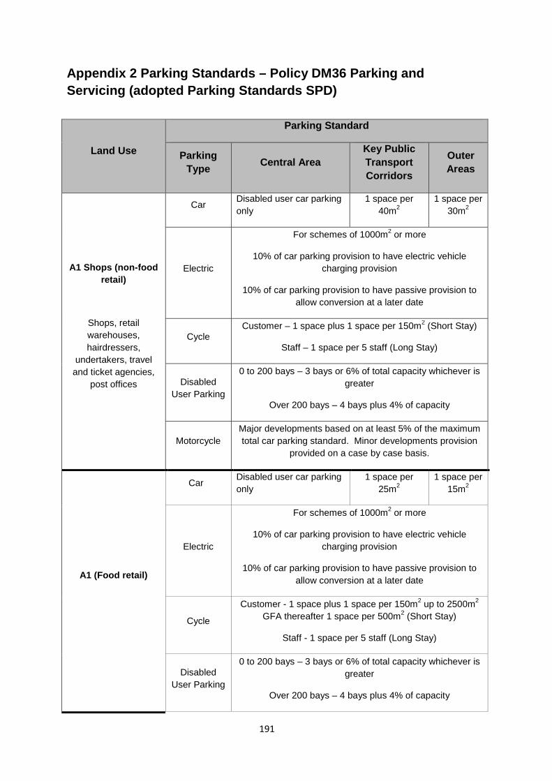
Appendix 2 Parking Standards – Policy DM36 Parking and Servicing (adopted Parking Standards SPD)
Land Use
Parking Standard
Parking Type Central Area
Key Public Transport Corridors
Outer Areas
A1 Shops (non-food retail)
Shops, retail warehouses, hairdressers,
undertakers, travel and ticket agencies,
post offices
Car Disabled user car parking only
1 space per 40m2
1 space per 30m2
Electric
For schemes of 1000m2 or more
10% of car parking provision to have electric vehicle charging provision
10% of car parking provision to have passive provision to allow conversion at a later date
Cycle Customer – 1 space plus 1 space per 150m2 (Short Stay)
Staff – 1 space per 5 staff (Long Stay)
Disabled User Parking
0 to 200 bays – 3 bays or 6% of total capacity whichever is greater
Over 200 bays – 4 bays plus 4% of capacity
Motorcycle Major developments based on at least 5% of the maximum total car parking standard. Minor developments provision
provided on a case by case basis.
A1 (Food retail)
Car Disabled user car parking only
1 space per 25m2
1 space per 15m2
Electric
For schemes of 1000m2 or more
10% of car parking provision to have electric vehicle charging provision
10% of car parking provision to have passive provision to allow conversion at a later date
Cycle
Customer - 1 space plus 1 space per 150m2 up to 2500m2 GFA thereafter 1 space per 500m2 (Short Stay)
Staff - 1 space per 5 staff (Long Stay)
Disabled User Parking
0 to 200 bays – 3 bays or 6% of total capacity whichever is greater
Over 200 bays – 4 bays plus 4% of capacity
191
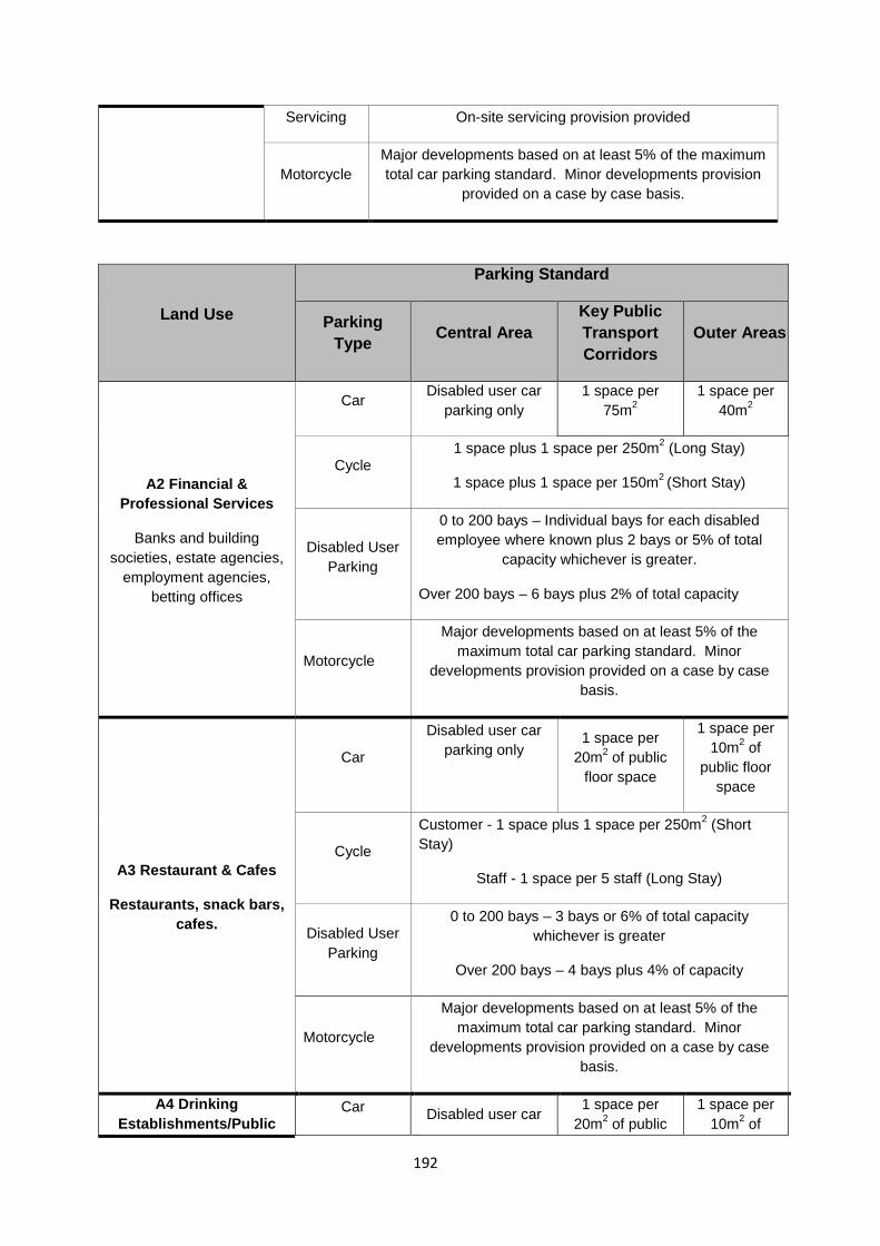
Servicing On-site servicing provision provided
Motorcycle Major developments based on at least 5% of the maximum total car parking standard. Minor developments provision
provided on a case by case basis.
Land Use
Parking Standard
Parking Type Central Area
Key Public Transport Corridors
Outer Areas
A2 Financial & Professional Services
Banks and building societies, estate agencies,
employment agencies, betting offices
Car Disabled user car parking only
1 space per 75m2
1 space per 40m2
Cycle 1 space plus 1 space per 250m2 (Long Stay)
1 space plus 1 space per 150m2 (Short Stay)
Disabled User Parking
0 to 200 bays – Individual bays for each disabled employee where known plus 2 bays or 5% of total
capacity whichever is greater.
Over 200 bays – 6 bays plus 2% of total capacity
Motorcycle
Major developments based on at least 5% of the maximum total car parking standard. Minor
developments provision provided on a case by case basis.
A3 Restaurant & Cafes
Restaurants, snack bars, cafes.
Car
Disabled user car parking only
1 space per 20m2 of public
floor space
1 space per 10m2 of
public floor space
Cycle
Customer - 1 space plus 1 space per 250m2 (Short Stay)
Staff - 1 space per 5 staff (Long Stay)
Disabled User Parking
0 to 200 bays – 3 bays or 6% of total capacity whichever is greater
Over 200 bays – 4 bays plus 4% of capacity
Motorcycle
Major developments based on at least 5% of the maximum total car parking standard. Minor
developments provision provided on a case by case basis.
A4 Drinking Establishments/Public
Car Disabled user car 1 space per
20m2 of public 1 space per
10m2 of
192
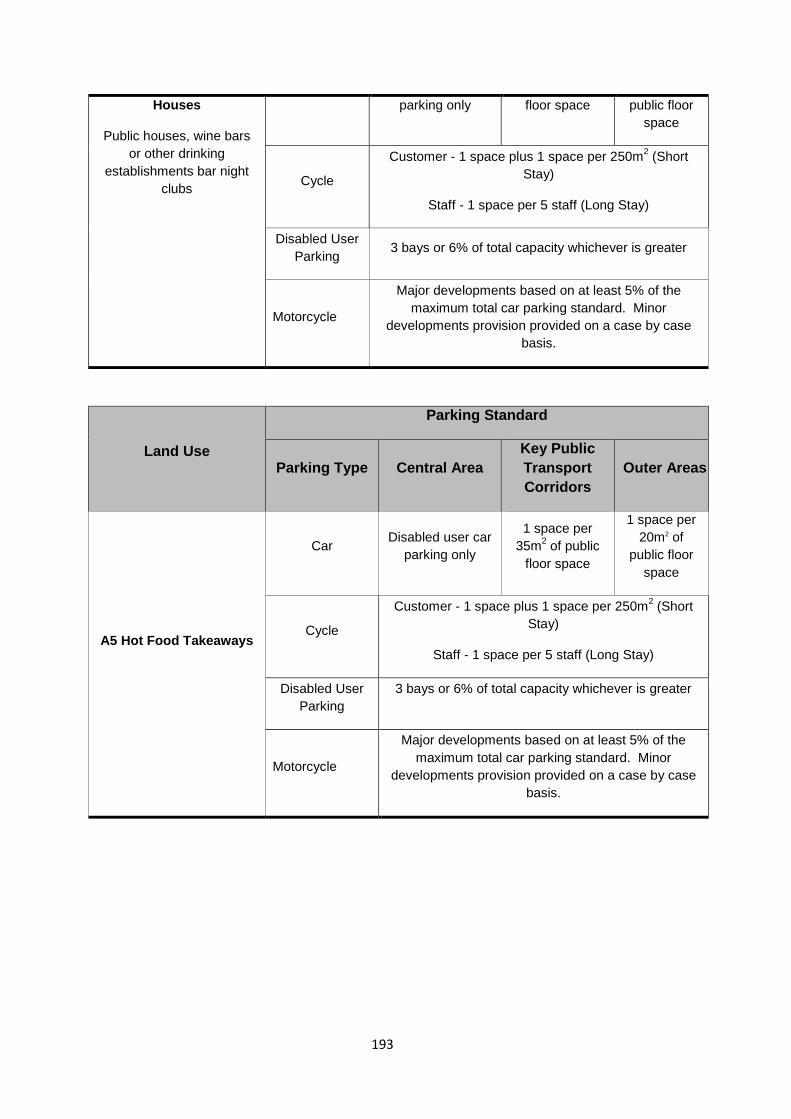
Houses
Public houses, wine bars or other drinking
establishments bar night clubs
parking only floor space public floor space
Cycle
Customer - 1 space plus 1 space per 250m2 (Short Stay)
Staff - 1 space per 5 staff (Long Stay)
Disabled User Parking 3 bays or 6% of total capacity whichever is greater
Motorcycle
Major developments based on at least 5% of the maximum total car parking standard. Minor
developments provision provided on a case by case basis.
Land Use
Parking Standard
Parking Type Central Area Key Public Transport Corridors
Outer Areas
A5 Hot Food Takeaways
Car Disabled user car parking only
1 space per 35m2 of public
floor space
1 space per 20m2 of
public floor space
Cycle
Customer - 1 space plus 1 space per 250m2 (Short Stay)
Staff - 1 space per 5 staff (Long Stay)
Disabled User Parking
3 bays or 6% of total capacity whichever is greater
Motorcycle
Major developments based on at least 5% of the maximum total car parking standard. Minor
developments provision provided on a case by case basis.
193
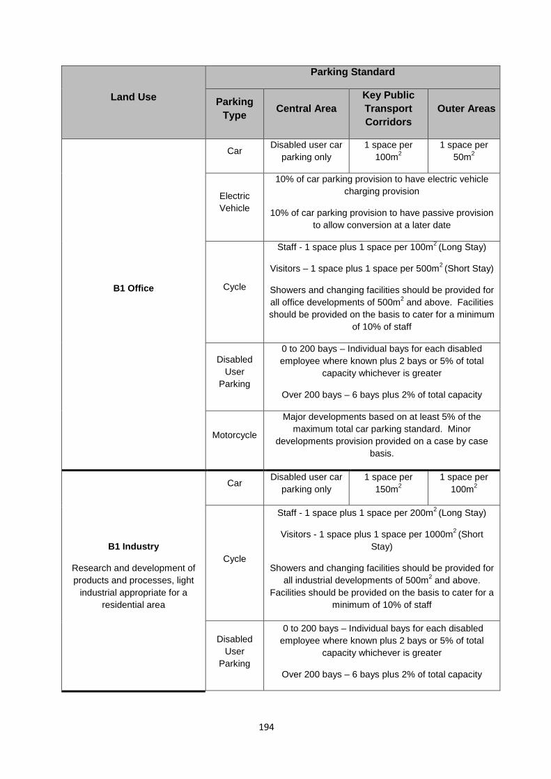
Land Use
Parking Standard
Parking Type Central Area
Key Public Transport Corridors
Outer Areas
B1 Office
Car Disabled user car parking only
1 space per 100m2
1 space per 50m2
Electric Vehicle
10% of car parking provision to have electric vehicle charging provision
10% of car parking provision to have passive provision to allow conversion at a later date
Cycle
Staff - 1 space plus 1 space per 100m2 (Long Stay)
Visitors – 1 space plus 1 space per 500m2 (Short Stay)
Showers and changing facilities should be provided for all office developments of 500m2 and above. Facilities should be provided on the basis to cater for a minimum
of 10% of staff
Disabled User
Parking
0 to 200 bays – Individual bays for each disabled employee where known plus 2 bays or 5% of total
capacity whichever is greater
Over 200 bays – 6 bays plus 2% of total capacity
Motorcycle
Major developments based on at least 5% of the maximum total car parking standard. Minor
developments provision provided on a case by case basis.
B1 Industry
Research and development of products and processes, light
industrial appropriate for a residential area
Car Disabled user car
parking only 1 space per
150m2 1 space per
100m2
Cycle
Staff - 1 space plus 1 space per 200m2 (Long Stay)
Visitors - 1 space plus 1 space per 1000m2 (Short Stay)
Showers and changing facilities should be provided for all industrial developments of 500m2 and above.
Facilities should be provided on the basis to cater for a minimum of 10% of staff
Disabled User
Parking
0 to 200 bays – Individual bays for each disabled employee where known plus 2 bays or 5% of total
capacity whichever is greater
Over 200 bays – 6 bays plus 2% of total capacity
194
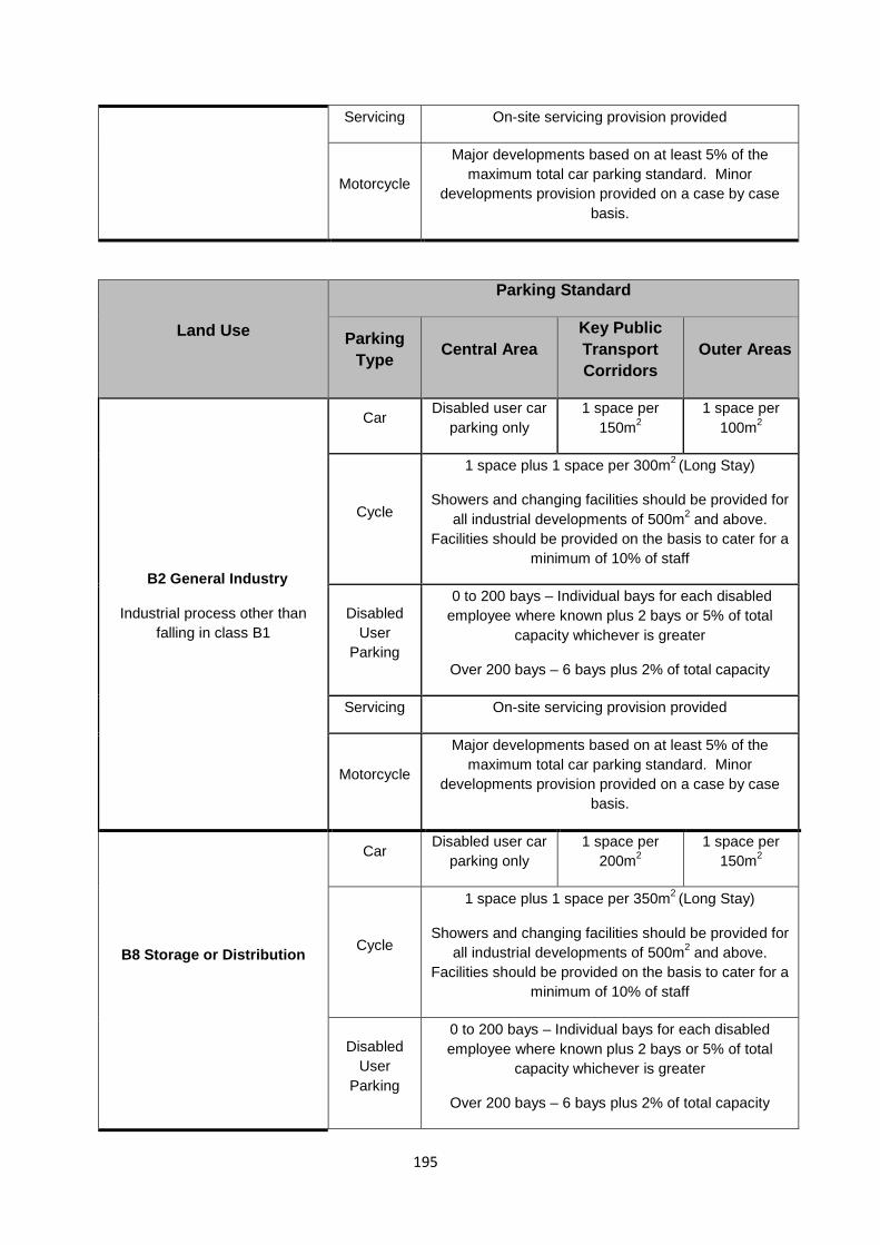
Servicing On-site servicing provision provided
Motorcycle
Major developments based on at least 5% of the maximum total car parking standard. Minor
developments provision provided on a case by case basis.
Land Use
Parking Standard
Parking Type Central Area
Key Public Transport Corridors
Outer Areas
B2 General Industry
Industrial process other than falling in class B1
Car Disabled user car parking only
1 space per 150m2
1 space per 100m2
Cycle
1 space plus 1 space per 300m2 (Long Stay)
Showers and changing facilities should be provided for all industrial developments of 500m2 and above.
Facilities should be provided on the basis to cater for a minimum of 10% of staff
Disabled User
Parking
0 to 200 bays – Individual bays for each disabled employee where known plus 2 bays or 5% of total
capacity whichever is greater
Over 200 bays – 6 bays plus 2% of total capacity
Servicing On-site servicing provision provided
Motorcycle
Major developments based on at least 5% of the maximum total car parking standard. Minor
developments provision provided on a case by case basis.
B8 Storage or Distribution
Car Disabled user car parking only
1 space per 200m2
1 space per 150m2
Cycle
1 space plus 1 space per 350m2 (Long Stay)
Showers and changing facilities should be provided for all industrial developments of 500m2 and above.
Facilities should be provided on the basis to cater for a minimum of 10% of staff
Disabled User
Parking
0 to 200 bays – Individual bays for each disabled employee where known plus 2 bays or 5% of total
capacity whichever is greater
Over 200 bays – 6 bays plus 2% of total capacity
195
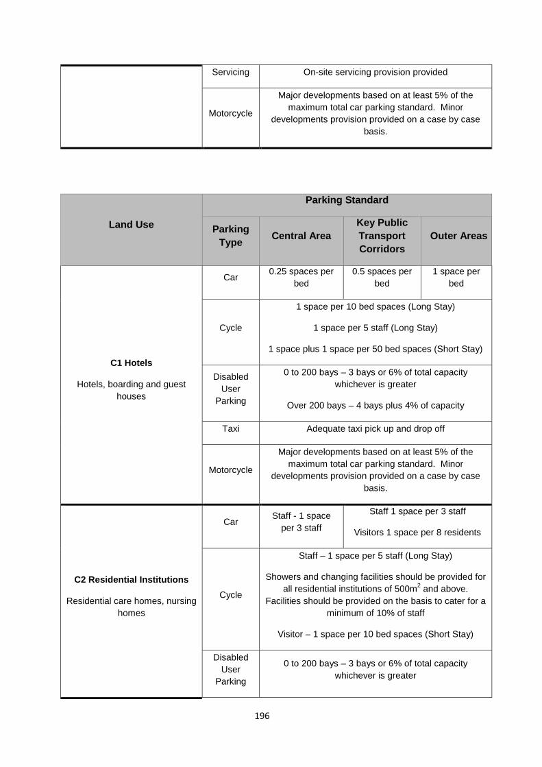
Servicing On-site servicing provision provided
Motorcycle
Major developments based on at least 5% of the maximum total car parking standard. Minor
developments provision provided on a case by case basis.
Land Use
Parking Standard
Parking Type Central Area
Key Public Transport Corridors
Outer Areas
C1 Hotels
Hotels, boarding and guest houses
Car 0.25 spaces per bed
0.5 spaces per bed
1 space per bed
Cycle
1 space per 10 bed spaces (Long Stay)
1 space per 5 staff (Long Stay)
1 space plus 1 space per 50 bed spaces (Short Stay)
Disabled User
Parking
0 to 200 bays – 3 bays or 6% of total capacity whichever is greater
Over 200 bays – 4 bays plus 4% of capacity
Taxi Adequate taxi pick up and drop off
Motorcycle
Major developments based on at least 5% of the maximum total car parking standard. Minor
developments provision provided on a case by case basis.
C2 Residential Institutions
Residential care homes, nursing homes
Car Staff - 1 space
per 3 staff
Staff 1 space per 3 staff
Visitors 1 space per 8 residents
Cycle
Staff – 1 space per 5 staff (Long Stay)
Showers and changing facilities should be provided for all residential institutions of 500m2 and above.
Facilities should be provided on the basis to cater for a minimum of 10% of staff
Visitor – 1 space per 10 bed spaces (Short Stay)
Disabled User
Parking
0 to 200 bays – 3 bays or 6% of total capacity whichever is greater
196
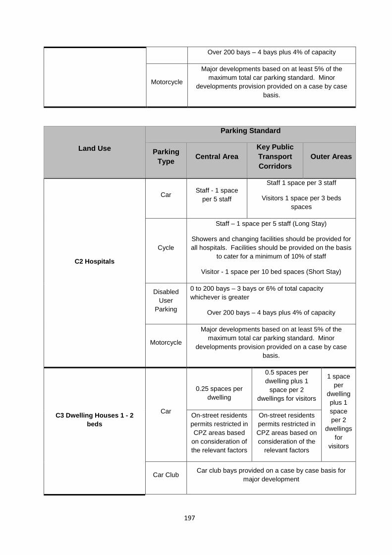
Over 200 bays – 4 bays plus 4% of capacity
Motorcycle
Major developments based on at least 5% of the maximum total car parking standard. Minor
developments provision provided on a case by case basis.
Land Use
Parking Standard
Parking Type Central Area
Key Public Transport Corridors
Outer Areas
C2 Hospitals
Car Staff - 1 space per 5 staff
Staff 1 space per 3 staff
Visitors 1 space per 3 beds spaces
Cycle
Staff – 1 space per 5 staff (Long Stay)
Showers and changing facilities should be provided for all hospitals. Facilities should be provided on the basis
to cater for a minimum of 10% of staff
Visitor - 1 space per 10 bed spaces (Short Stay)
Disabled User
Parking
0 to 200 bays – 3 bays or 6% of total capacity whichever is greater
Over 200 bays – 4 bays plus 4% of capacity
Motorcycle
Major developments based on at least 5% of the maximum total car parking standard. Minor
developments provision provided on a case by case basis.
C3 Dwelling Houses 1 - 2 beds
Car
0.25 spaces per dwelling
0.5 spaces per dwelling plus 1
space per 2 dwellings for visitors
1 space per
dwelling plus 1 space per 2
dwellings for
visitors
On-street residents permits restricted in CPZ areas based
on consideration of the relevant factors
On-street residents permits restricted in CPZ areas based on consideration of the
relevant factors
Car Club Car club bays provided on a case by case basis for major development
197
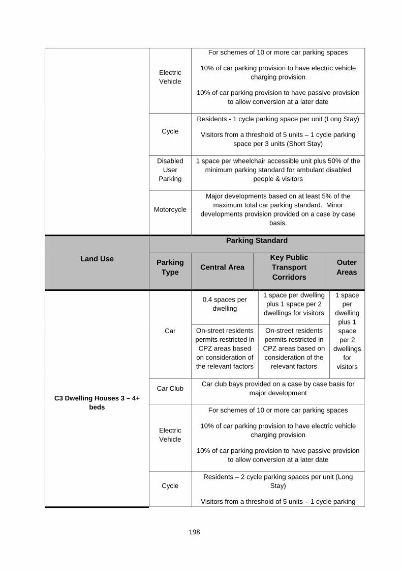
Electric Vehicle
For schemes of 10 or more car parking spaces
10% of car parking provision to have electric vehicle charging provision
10% of car parking provision to have passive provision to allow conversion at a later date
Cycle
Residents - 1 cycle parking space per unit (Long Stay)
Visitors from a threshold of 5 units – 1 cycle parking space per 3 units (Short Stay)
Disabled User
Parking
1 space per wheelchair accessible unit plus 50% of the minimum parking standard for ambulant disabled
people & visitors
Motorcycle
Major developments based on at least 5% of the maximum total car parking standard. Minor
developments provision provided on a case by case basis.
Land Use
Parking Standard
Parking Type Central Area
Key Public Transport Corridors
Outer Areas
C3 Dwelling Houses 3 – 4+ beds
Car
0.4 spaces per dwelling
1 space per dwelling plus 1 space per 2
dwellings for visitors
1 space per
dwelling plus 1 space per 2
dwellings for
visitors
On-street residents permits restricted in CPZ areas based
on consideration of the relevant factors
On-street residents permits restricted in CPZ areas based on consideration of the
relevant factors
Car Club Car club bays provided on a case by case basis for major development
Electric Vehicle
For schemes of 10 or more car parking spaces
10% of car parking provision to have electric vehicle charging provision
10% of car parking provision to have passive provision to allow conversion at a later date
Cycle Residents – 2 cycle parking spaces per unit (Long
Stay)
Visitors from a threshold of 5 units – 1 cycle parking
198
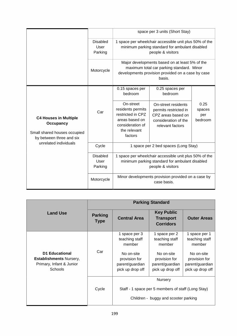
space per 3 units (Short Stay)
Disabled User
Parking
1 space per wheelchair accessible unit plus 50% of the minimum parking standard for ambulant disabled
people & visitors
Motorcycle
Major developments based on at least 5% of the maximum total car parking standard. Minor
developments provision provided on a case by case basis.
C4 Houses in Multiple Occupancy
Small shared houses occupied by between three and six
unrelated individuals
Car
0.15 spaces per bedroom
0.25 spaces per bedroom
0.25 spaces
per bedroom
On-street residents permits restricted in CPZ areas based on consideration of
the relevant factors
On-street residents permits restricted in CPZ areas based on consideration of the
relevant factors
Cycle 1 space per 2 bed spaces (Long Stay)
Disabled User
Parking
1 space per wheelchair accessible unit plus 50% of the minimum parking standard for ambulant disabled
people & visitors
Motorcycle Minor developments provision provided on a case by case basis.
Land Use
Parking Standard
Parking Type Central Area
Key Public Transport Corridors
Outer Areas
D1 Educational Establishments Nursery, Primary, Infant & Junior
Schools
Car
1 space per 3 teaching staff
member
No on-site provision for
parent/guardian pick up drop off
1 space per 2 teaching staff
member
No on-site provision for
parent/guardian pick up drop off
1 space per 1 teaching staff
member
No on-site provision for
parent/guardian pick up drop off
Cycle
Nursery
Staff - 1 space per 5 members of staff (Long Stay)
Children - buggy and scooter parking
199
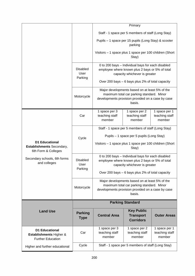
Primary
Staff - 1 space per 5 members of staff (Long Stay)
Pupils – 1 space per 15 pupils (Long Stay) & scooter parking
Visitors – 1 space plus 1 space per 100 children (Short Stay)
Disabled User
Parking
0 to 200 bays – Individual bays for each disabled employee where known plus 2 bays or 5% of total
capacity whichever is greater
Over 200 bays – 6 bays plus 2% of total capacity
Motorcycle
Major developments based on at least 5% of the maximum total car parking standard. Minor
developments provision provided on a case by case basis.
D1 Educational Establishments Secondary,
6th Form & Colleges
Secondary schools, 6th forms and colleges
Car 1 space per 3 teaching staff
member
1 space per 2 teaching staff
member
1 space per 1 teaching staff
member
Cycle
Staff - 1 space per 5 members of staff (Long Stay)
Pupils – 1 space per 5 pupils (Long Stay)
Visitors – 1 space plus 1 space per 100 children (Short Stay)
Disabled User
Parking
0 to 200 bays – Individual bays for each disabled employee where known plus 2 bays or 5% of total
capacity whichever is greater
Over 200 bays – 6 bays plus 2% of total capacity
Motorcycle
Major developments based on at least 5% of the maximum total car parking standard. Minor
developments provision provided on a case by case basis.
Land Use
Parking Standard
Parking Type Central Area
Key Public Transport Corridors
Outer Areas
D1 Educational Establishments Higher &
Further Education
Higher and further educational
Car 1 space per 3 teaching staff
member
1 space per 2 teaching staff
member
1 space per 1 teaching staff
member
Cycle Staff - 1 space per 5 members of staff (Long Stay)
200
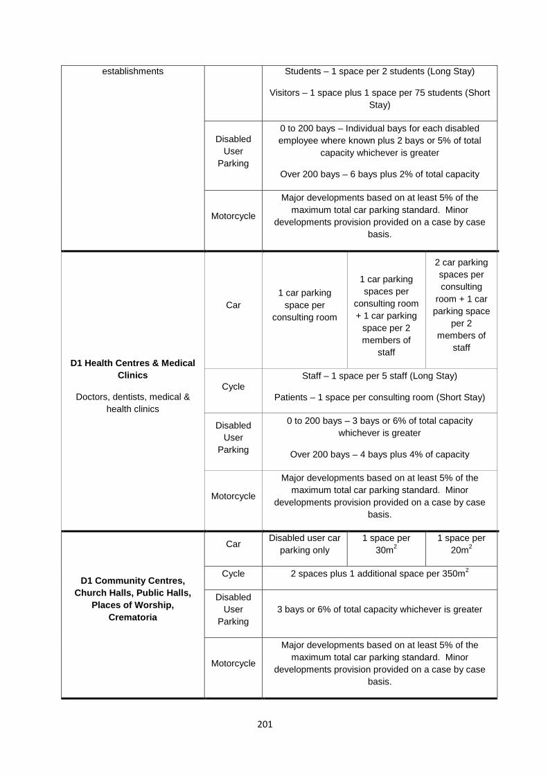
establishments
Students – 1 space per 2 students (Long Stay)
Visitors – 1 space plus 1 space per 75 students (Short Stay)
Disabled User
Parking
0 to 200 bays – Individual bays for each disabled employee where known plus 2 bays or 5% of total
capacity whichever is greater
Over 200 bays – 6 bays plus 2% of total capacity
Motorcycle
Major developments based on at least 5% of the maximum total car parking standard. Minor
developments provision provided on a case by case basis.
D1 Health Centres & Medical Clinics
Doctors, dentists, medical & health clinics
Car 1 car parking
space per consulting room
1 car parking spaces per
consulting room + 1 car parking
space per 2 members of
staff
2 car parking spaces per consulting
room + 1 car parking space
per 2 members of
staff
Cycle Staff – 1 space per 5 staff (Long Stay)
Patients – 1 space per consulting room (Short Stay)
Disabled User
Parking
0 to 200 bays – 3 bays or 6% of total capacity whichever is greater
Over 200 bays – 4 bays plus 4% of capacity
Motorcycle
Major developments based on at least 5% of the maximum total car parking standard. Minor
developments provision provided on a case by case basis.
D1 Community Centres, Church Halls, Public Halls,
Places of Worship, Crematoria
Car Disabled user car parking only
1 space per 30m2
1 space per 20m2
Cycle 2 spaces plus 1 additional space per 350m2
Disabled User
Parking 3 bays or 6% of total capacity whichever is greater
Motorcycle
Major developments based on at least 5% of the maximum total car parking standard. Minor
developments provision provided on a case by case basis.
201
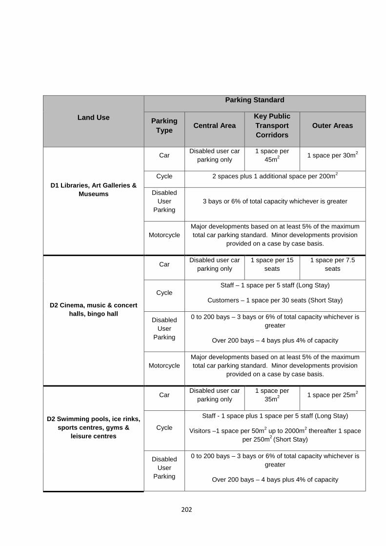
Land Use
Parking Standard
Parking Type Central Area
Key Public Transport Corridors
Outer Areas
D1 Libraries, Art Galleries & Museums
Car Disabled user car parking only
1 space per 45m2 1 space per 30m2
Cycle 2 spaces plus 1 additional space per 200m2
Disabled User
Parking 3 bays or 6% of total capacity whichever is greater
Motorcycle Major developments based on at least 5% of the maximum total car parking standard. Minor developments provision
provided on a case by case basis.
D2 Cinema, music & concert halls, bingo hall
Car Disabled user car parking only
1 space per 15 seats
1 space per 7.5 seats
Cycle Staff – 1 space per 5 staff (Long Stay)
Customers – 1 space per 30 seats (Short Stay)
Disabled User
Parking
0 to 200 bays – 3 bays or 6% of total capacity whichever is greater
Over 200 bays – 4 bays plus 4% of capacity
Motorcycle Major developments based on at least 5% of the maximum total car parking standard. Minor developments provision
provided on a case by case basis.
D2 Swimming pools, ice rinks, sports centres, gyms &
leisure centres
Car Disabled user car parking only
1 space per 35m2 1 space per 25m2
Cycle
Staff - 1 space plus 1 space per 5 staff (Long Stay)
Visitors –1 space per 50m2 up to 2000m2 thereafter 1 space per 250m2 (Short Stay)
Disabled User
Parking
0 to 200 bays – 3 bays or 6% of total capacity whichever is greater
Over 200 bays – 4 bays plus 4% of capacity
202
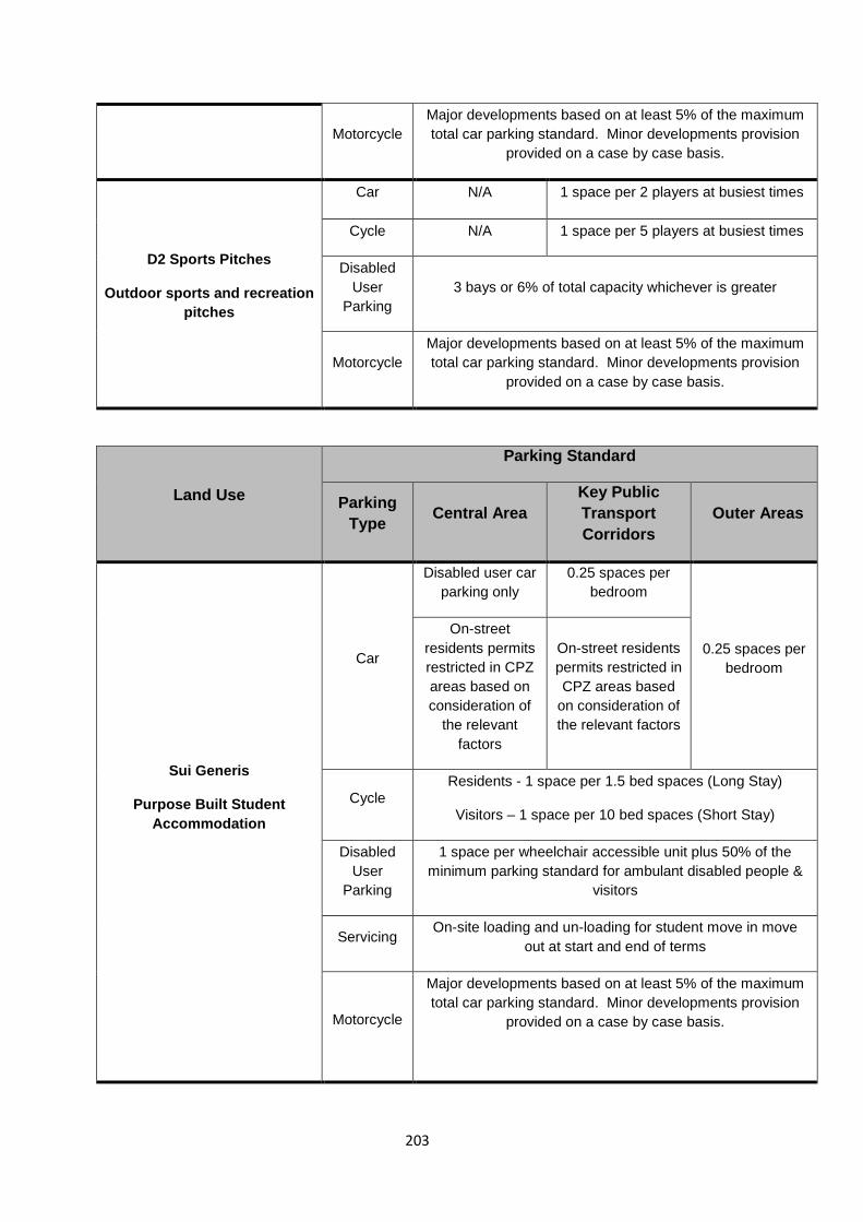
Motorcycle Major developments based on at least 5% of the maximum total car parking standard. Minor developments provision
provided on a case by case basis.
D2 Sports Pitches
Outdoor sports and recreation pitches
Car N/A 1 space per 2 players at busiest times
Cycle N/A 1 space per 5 players at busiest times
Disabled User
Parking 3 bays or 6% of total capacity whichever is greater
Motorcycle Major developments based on at least 5% of the maximum total car parking standard. Minor developments provision
provided on a case by case basis.
Land Use
Parking Standard
Parking Type Central Area
Key Public Transport Corridors
Outer Areas
Sui Generis
Purpose Built Student Accommodation
Car
Disabled user car parking only
0.25 spaces per bedroom
0.25 spaces per bedroom
On-street residents permits restricted in CPZ areas based on consideration of
the relevant factors
On-street residents permits restricted in CPZ areas based
on consideration of the relevant factors
Cycle Residents - 1 space per 1.5 bed spaces (Long Stay)
Visitors – 1 space per 10 bed spaces (Short Stay)
Disabled User
Parking
1 space per wheelchair accessible unit plus 50% of the minimum parking standard for ambulant disabled people &
visitors
Servicing On-site loading and un-loading for student move in move
out at start and end of terms
Motorcycle
Major developments based on at least 5% of the maximum total car parking standard. Minor developments provision
provided on a case by case basis.
203
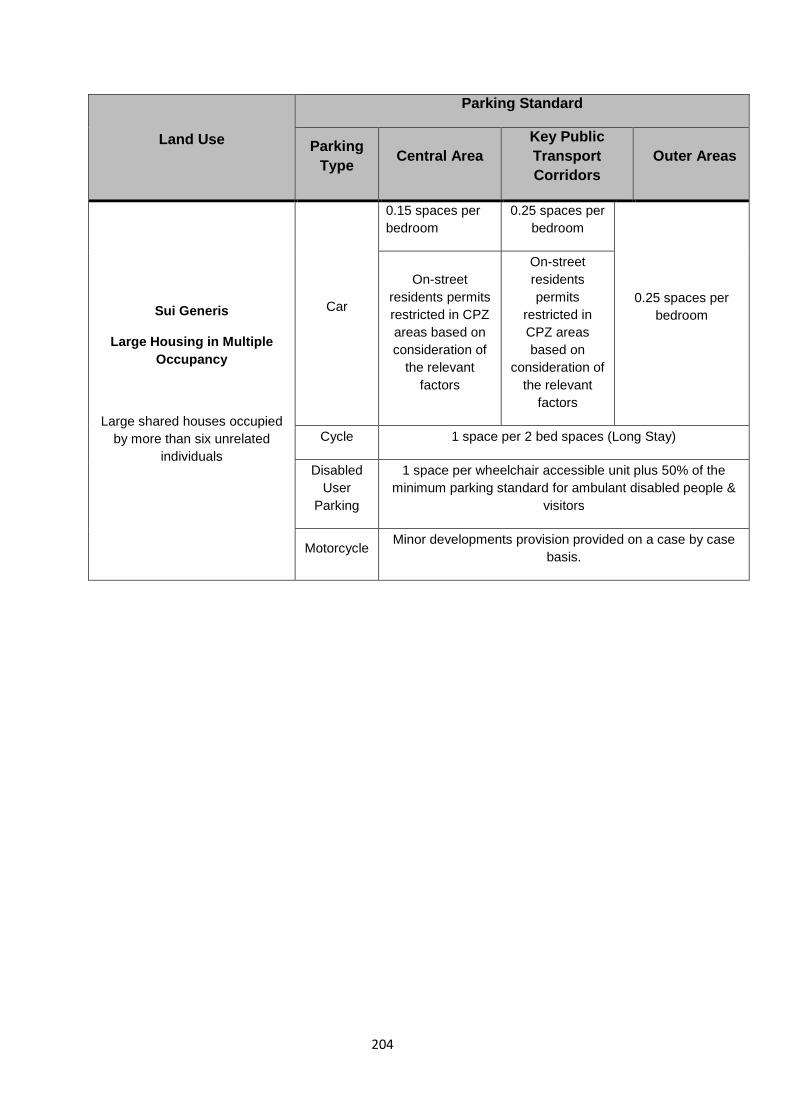
Land Use
Parking Standard
Parking Type Central Area
Key Public Transport Corridors
Outer Areas
Sui Generis
Large Housing in Multiple Occupancy
Large shared houses occupied by more than six unrelated
individuals
Car
0.15 spaces per bedroom
0.25 spaces per bedroom
0.25 spaces per bedroom
On-street residents permits restricted in CPZ areas based on consideration of
the relevant factors
On-street residents permits
restricted in CPZ areas based on
consideration of the relevant
factors
Cycle 1 space per 2 bed spaces (Long Stay)
Disabled User
Parking
1 space per wheelchair accessible unit plus 50% of the minimum parking standard for ambulant disabled people &
visitors
Motorcycle Minor developments provision provided on a case by case basis.
204

Appendix 3 - Local Wildlife Sites (Policy DM37 Green Infrastructure and Nature Conservation
Local Wildlife Sites
BH02 Mile Oak Fields (part National Park)
BH07 Emmaus Gardens & St Nicholas
BH09 Benfield Valley
BH10 Basin Road South
BH12 Toad’s Hole Valley
BH15 Three Cornered Copse
BH17 Bramble Rise Copse
BH20 Tivoli Copse & Railway Woodland
BH21 Foredown Allotments
BH22 Oakdene Southwick Hill
BH25 Brighton Station (Brighton Greenway)
BH26 Hollingbury Industrial Estate
BH27 Crespin Way
BH28 Brighton University
BH29 Volk’s Railway
BH30 Woodvale Extra-mural and Downs Cemeteries
BH31 Black Rock Beach
BH32 Wilson Avenue Whitehawk
BH33 Brighton Marina
BH34 Sheepcote Valley (part National Park)
BH35 Westlain Plantation/Hog Plantation (part National Park)
BH36 Tenant Lain and Moon’s Gate Wood (part National Park)
BH42 Ovingdean School Grounds
BH43 Wanderdown Road Open Space
205
BH60 St Helen’s Churchyard
BH62 Honeysett
BH63 Braeside Avenue Scrub
BH64 Cardinal Newman School
BH65 Cliff Corner
BH66 Cliff Road Paddock
BH67 Dorothy Stringer Wildlife Area
BH69 Highcroft Villas
BH70 Hodshrove Wood
BH71 Hove Park Reservoir
BH72 Land at Westfield Avenue
BH73 London Road Station
BH75 Park Royal & High School
BH76 Rottingdean Pond
BH77 Madeira Drive Green Wall
BH78 Meadowvale
BH79 South Bevendean Down
BH80 St Leonard’s Churchyard
BH81 Stevenson Road Quarry
BH82 Surrenden Crescent & Surrenden Road
BH83 Surrenden Field Copse
BH85 Withdean Park Copse
BH86 Bevendean Horse Paddocks (part National Park)
BH87 Land at Coldean Lane (part National Park)
BH88 Sidehill Scrub
BH89 Dyke Trail South
206
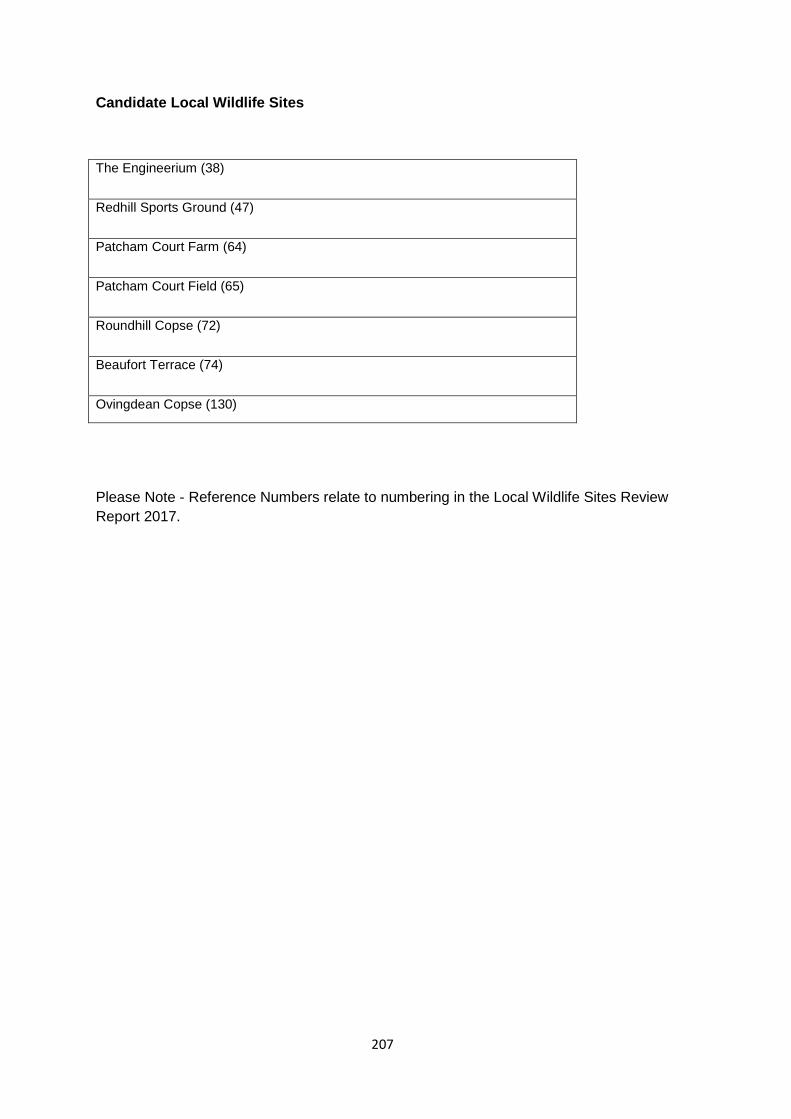
Candidate Local Wildlife Sites
The Engineerium (38) Redhill Sports Ground (47) Patcham Court Farm (64) Patcham Court Field (65) Roundhill Copse (72) Beaufort Terrace (74) Ovingdean Copse (130)
Please Note - Reference Numbers relate to numbering in the Local Wildlife Sites Review Report 2017.
207
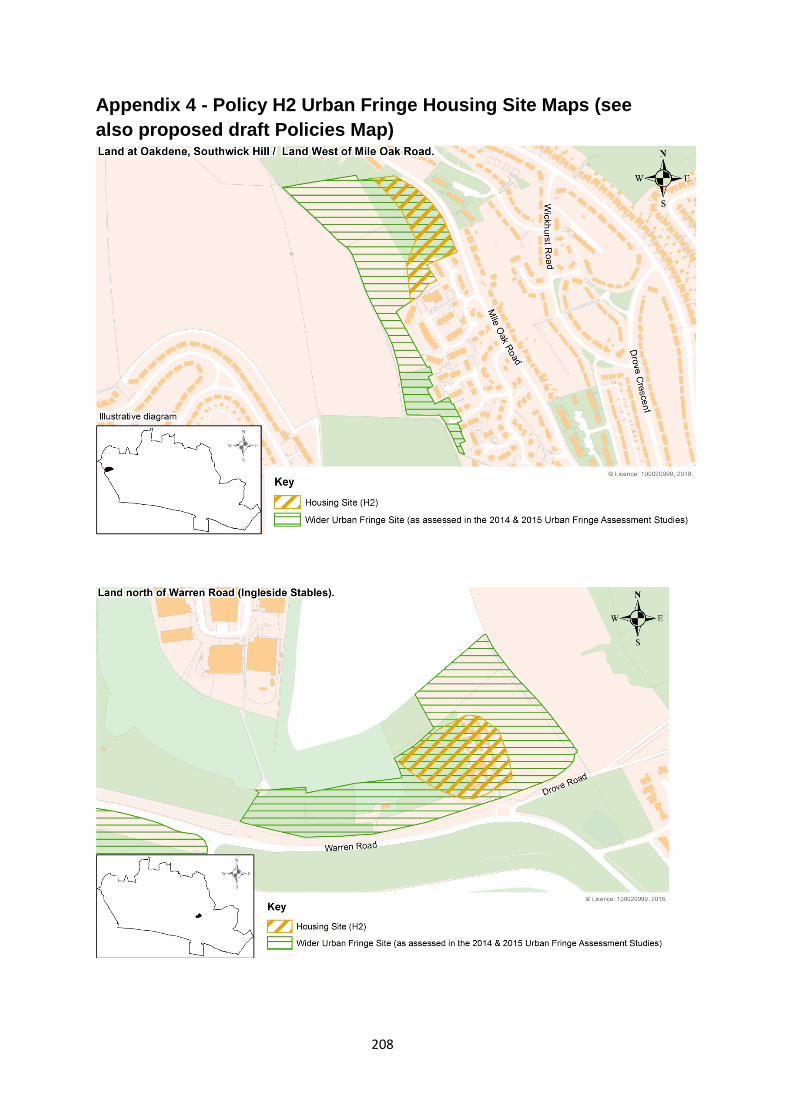
Appendix 4 - Policy H2 Urban Fringe Housing Site Maps (see also proposed draft Policies Map)
208
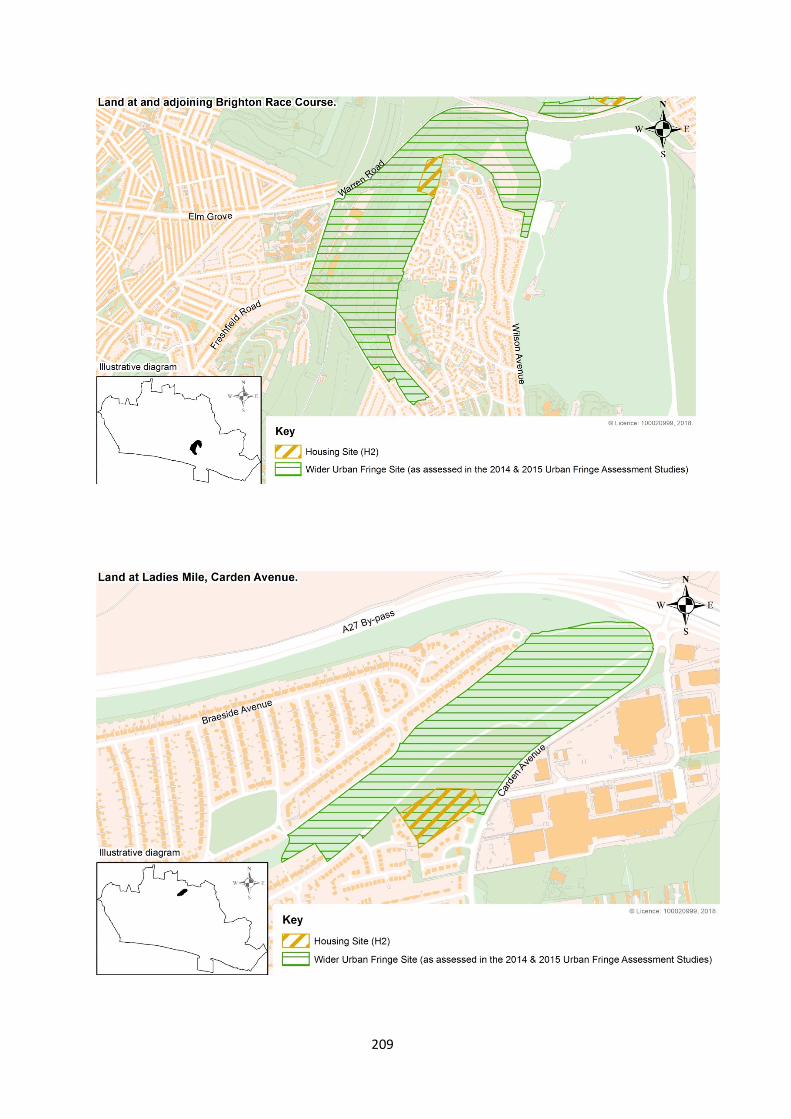
209
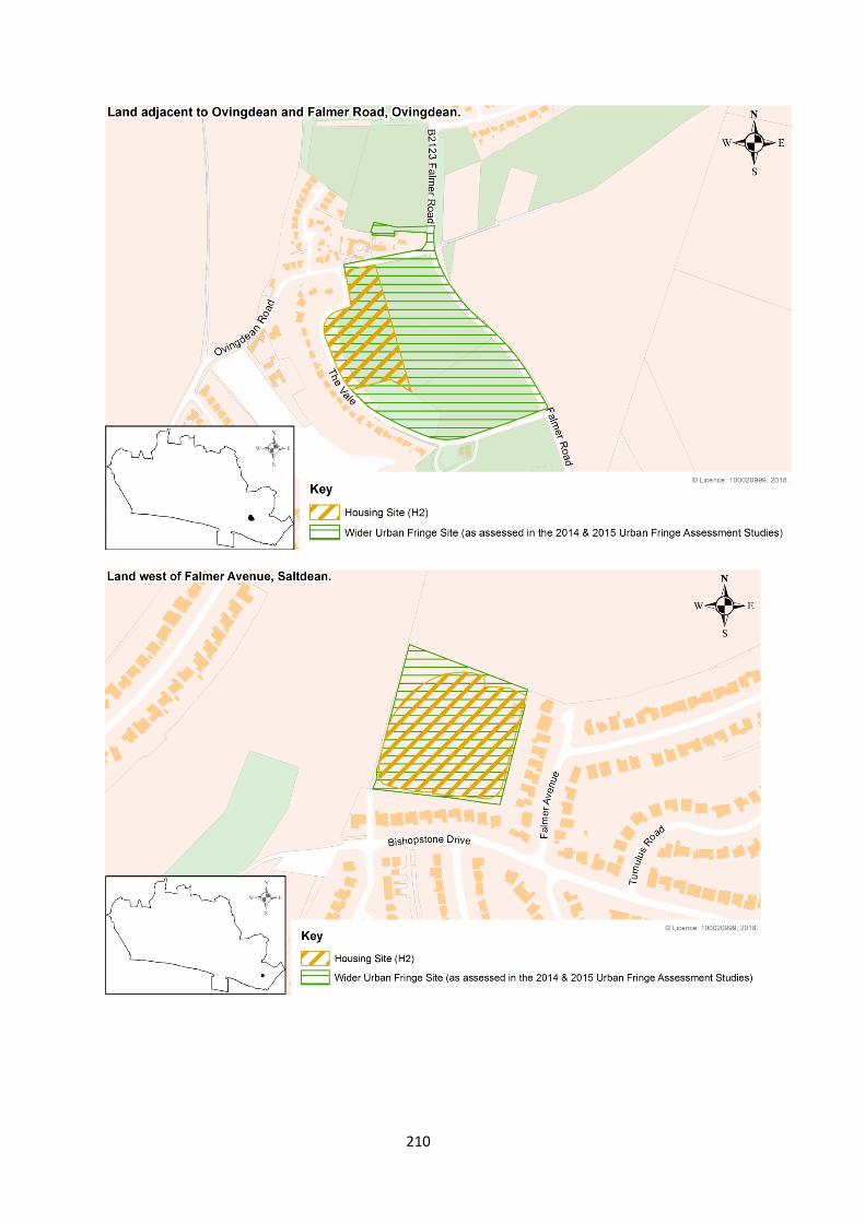
210
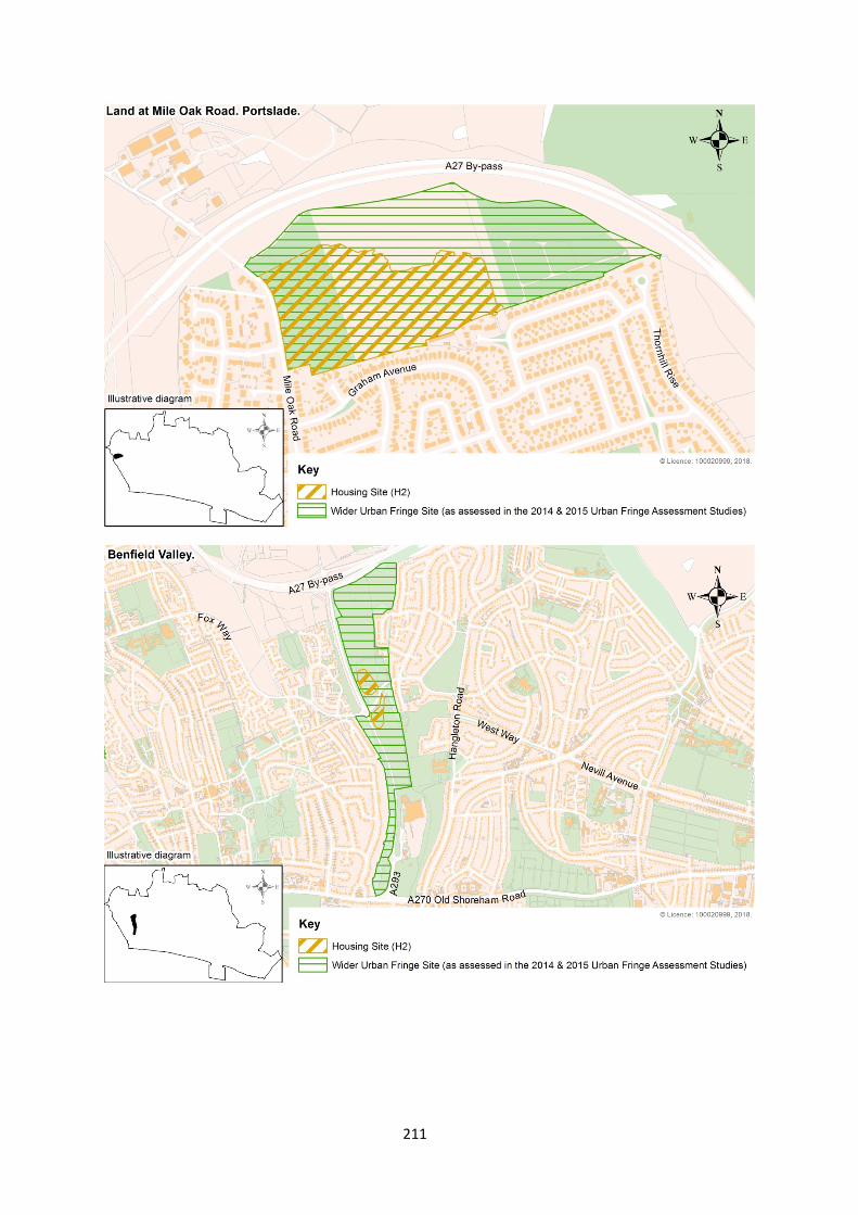
211
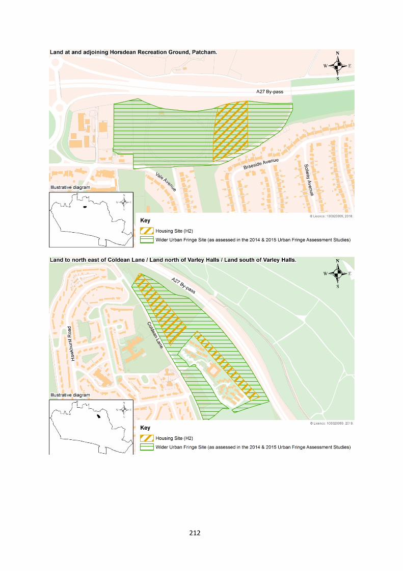
212
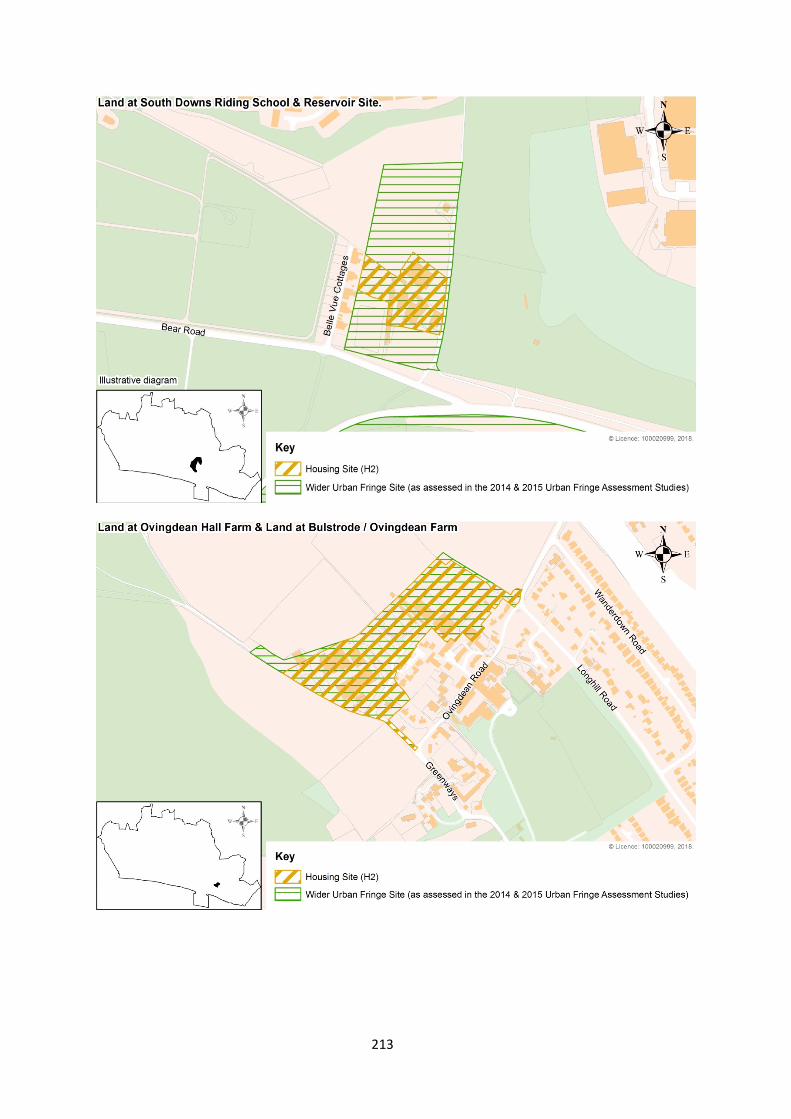
213
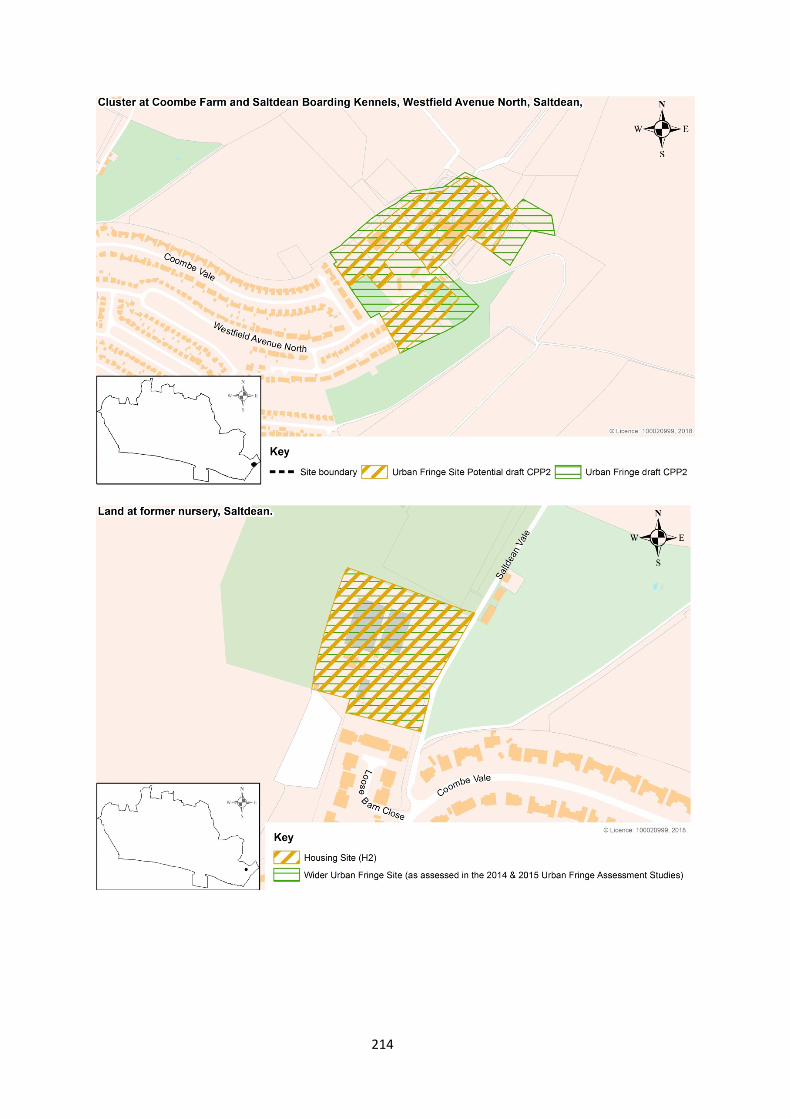
214
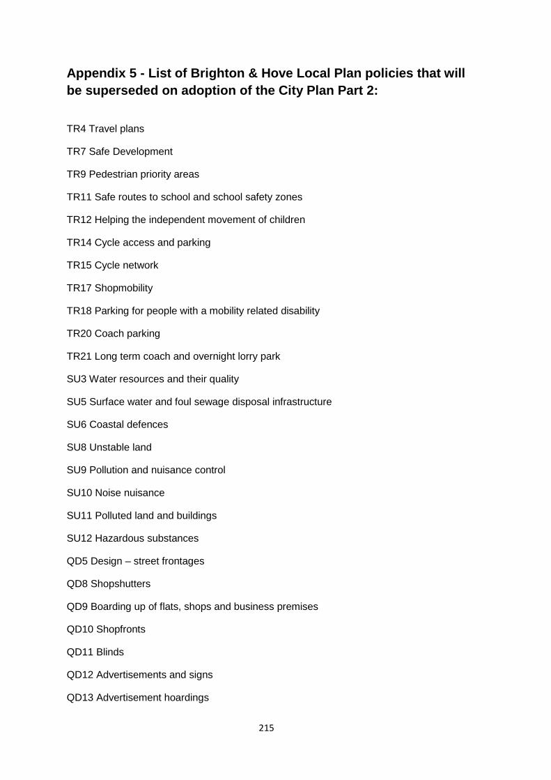
Appendix 5 - List of Brighton & Hove Local Plan policies that will be superseded on adoption of the City Plan Part 2:
TR4 Travel plans
TR7 Safe Development
TR9 Pedestrian priority areas
TR11 Safe routes to school and school safety zones
TR12 Helping the independent movement of children
TR14 Cycle access and parking
TR15 Cycle network
TR17 Shopmobility
TR18 Parking for people with a mobility related disability
TR20 Coach parking
TR21 Long term coach and overnight lorry park
SU3 Water resources and their quality
SU5 Surface water and foul sewage disposal infrastructure
SU6 Coastal defences
SU8 Unstable land
SU9 Pollution and nuisance control
SU10 Noise nuisance
SU11 Polluted land and buildings
SU12 Hazardous substances
QD5 Design – street frontages
QD8 Shopshutters
QD9 Boarding up of flats, shops and business premises
QD10 Shopfronts
QD11 Blinds
QD12 Advertisements and signs
QD13 Advertisement hoardings
215
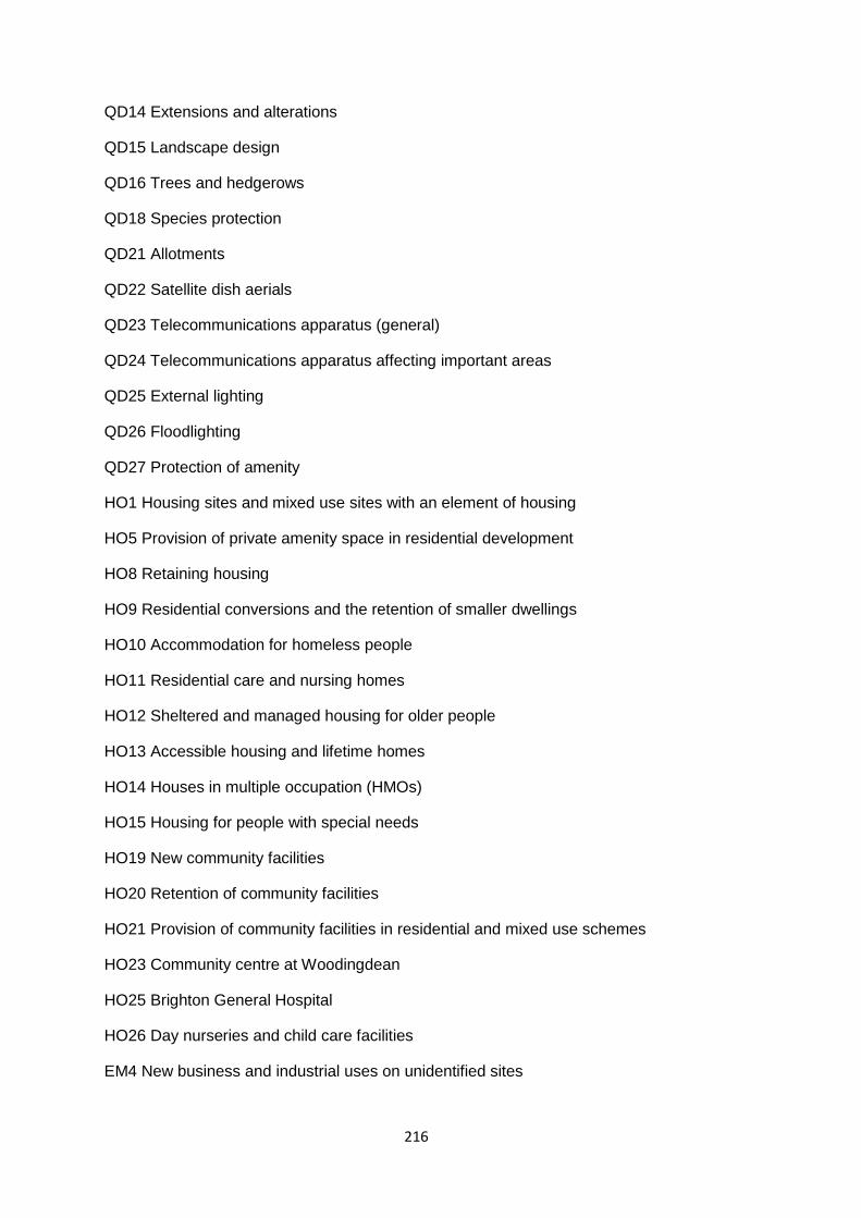
QD14 Extensions and alterations
QD15 Landscape design
QD16 Trees and hedgerows
QD18 Species protection
QD21 Allotments
QD22 Satellite dish aerials
QD23 Telecommunications apparatus (general)
QD24 Telecommunications apparatus affecting important areas
QD25 External lighting
QD26 Floodlighting
QD27 Protection of amenity
HO1 Housing sites and mixed use sites with an element of housing
HO5 Provision of private amenity space in residential development
HO8 Retaining housing
HO9 Residential conversions and the retention of smaller dwellings
HO10 Accommodation for homeless people
HO11 Residential care and nursing homes
HO12 Sheltered and managed housing for older people
HO13 Accessible housing and lifetime homes
HO14 Houses in multiple occupation (HMOs)
HO15 Housing for people with special needs
HO19 New community facilities
HO20 Retention of community facilities
HO21 Provision of community facilities in residential and mixed use schemes
HO23 Community centre at Woodingdean
HO25 Brighton General Hospital
HO26 Day nurseries and child care facilities
EM4 New business and industrial uses on unidentified sites
216
EM7 Warehouses (B8)
EM8 Live-work units on redundant industrial and business and warehouse sites
EM9 Mixed uses and key mixed use sites
EM10 North Laine Area mixed uses
EM11 Mews – mixed uses
SR3 Retail warehouses
SR4 Regional shopping centre
SR5 Town and district shopping centres
SR6 Local centres
SR7 Local parades
SR8 Individual shops
SR9 Brighton Post Office, 51 Ship Street
SR10 Amusement arcades/centres
SR11 Markets and car boot sales
SR12 Large Use Class A3 (food and drink) venues and Use Class A4 (pubs and clubs)
SR13 Nightclubs
SR16 Major sporting and recreation facilities
SR18 Seafront recreation
SR22 Major sporting venues
SR25 Hollingbury Park sports pavilion
SR26 Hangleton Bottom
NC2 Sites of national importance for nature conservation
NC3 Local Nature Reserves (LNRs)
NC4 Sites of Nature Conservation Importance (SNCIs) and Regionally Important Geological Sites (RIGS)
NC9 Benfield Valley
NC10 Benfield Barn
NC11 Land and buildings in the vicinity of Benfield Barn
HE1 Listed buildings
217
HE2 Demolition of a listed building
HE3 Development affecting the setting of a listed building
HE4 Reinstatement of original features on listed buildings
HE6 Development within or affecting the setting of conservation areas
HE8 Demolition in conservation areas
HE9 Advertisements and signs within conservation areas and on, or in the vicinity of a listed building
HE10 Buildings of local interest
HE11 Historic parks and gardens
HE12 Scheduled ancient monuments and other important archaeological sites
218
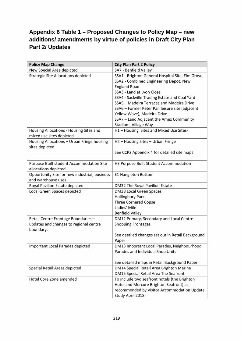
Appendix 6 Table 1 – Proposed Changes to Policy Map – new additions/ amendments by virtue of policies in Draft City Plan Part 2/ Updates
Policy Map Change City Plan Part 2 Policy New Special Area depicted SA7 - Benfield Valley Strategic Site Allocations depicted SSA1 - Brighton General Hospital Site, Elm Grove,
SSA2 - Combined Engineering Depot, New England Road SSA3 - Land at Lyon Close SSA4 - Sackville Trading Estate and Coal Yard SSA5 – Madeira Terraces and Madeira Drive SSA6 – Former Peter Pan leisure site (adjacent Yellow Wave), Madeira Drive SSA7 – Land Adjacent the Amex Community Stadium, Village Way
Housing Allocations - Housing Sites and mixed use sites depicted
H1 – Housing Sites and Mixed Use Sites-
Housing Allocations – Urban Fringe housing sites depicted
H2 – Housing Sites – Urban Fringe See CCP2 Appendix 4 for detailed site maps
Purpose Built student Accommodation Site allocations depicted
H3 Purpose Built Student Accommodation
Opportunity Site for new industrial, business and warehouse uses
E1 Hangleton Bottom
Royal Pavilion Estate depicted DM32 The Royal Pavilion Estate Local Green Spaces depicted DM38 Local Green Spaces
Hollingbury Park Three Cornered Copse Ladies’ Mile Benfield Valley
Retail Centre Frontage Boundaries – updates and changes to regional centre boundary.
DM12 Primary, Secondary and Local Centre Shopping Frontages See detailed changes set out in Retail Background Paper
Important Local Parades depicted DM13 Important Local Parades, Neighbourhood Parades and Individual Shop Units See detailed maps in Retail Background Paper
Special Retail Areas depicted DM14 Special Retail Area Brighton Marina DM15 Special Retail Area The Seafront
Hotel Core Zone amended To include two seafront hotels (the Brighton Hotel and Mercure Brighton Seafront) as recommended by Visitor Accommodation Update Study April 2018.
219
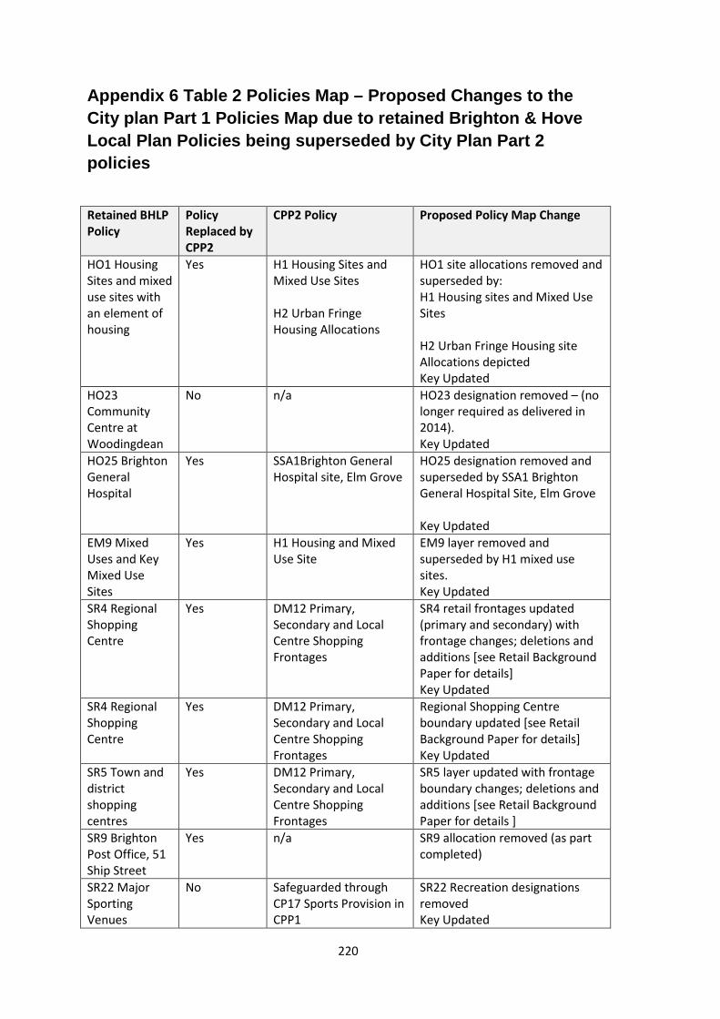
Appendix 6 Table 2 Policies Map – Proposed Changes to the City plan Part 1 Policies Map due to retained Brighton & Hove Local Plan Policies being superseded by City Plan Part 2 policies
Retained BHLP Policy
Policy Replaced by CPP2
CPP2 Policy Proposed Policy Map Change
HO1 Housing Sites and mixed use sites with an element of housing
Yes H1 Housing Sites and Mixed Use Sites H2 Urban Fringe Housing Allocations
HO1 site allocations removed and superseded by: H1 Housing sites and Mixed Use Sites H2 Urban Fringe Housing site Allocations depicted Key Updated
HO23 Community Centre at Woodingdean
No n/a HO23 designation removed – (no longer required as delivered in 2014). Key Updated
HO25 Brighton General Hospital
Yes SSA1Brighton General Hospital site, Elm Grove
HO25 designation removed and superseded by SSA1 Brighton General Hospital Site, Elm Grove Key Updated
EM9 Mixed Uses and Key Mixed Use Sites
Yes H1 Housing and Mixed Use Site
EM9 layer removed and superseded by H1 mixed use sites. Key Updated
SR4 Regional Shopping Centre
Yes DM12 Primary, Secondary and Local Centre Shopping Frontages
SR4 retail frontages updated (primary and secondary) with frontage changes; deletions and additions [see Retail Background Paper for details] Key Updated
SR4 Regional Shopping Centre
Yes DM12 Primary, Secondary and Local Centre Shopping Frontages
Regional Shopping Centre boundary updated [see Retail Background Paper for details] Key Updated
SR5 Town and district shopping centres
Yes DM12 Primary, Secondary and Local Centre Shopping Frontages
SR5 layer updated with frontage boundary changes; deletions and additions [see Retail Background Paper for details ]
SR9 Brighton Post Office, 51 Ship Street
Yes n/a SR9 allocation removed (as part completed)
SR22 Major Sporting Venues
No Safeguarded through CP17 Sports Provision in CPP1
SR22 Recreation designations removed Key Updated
220
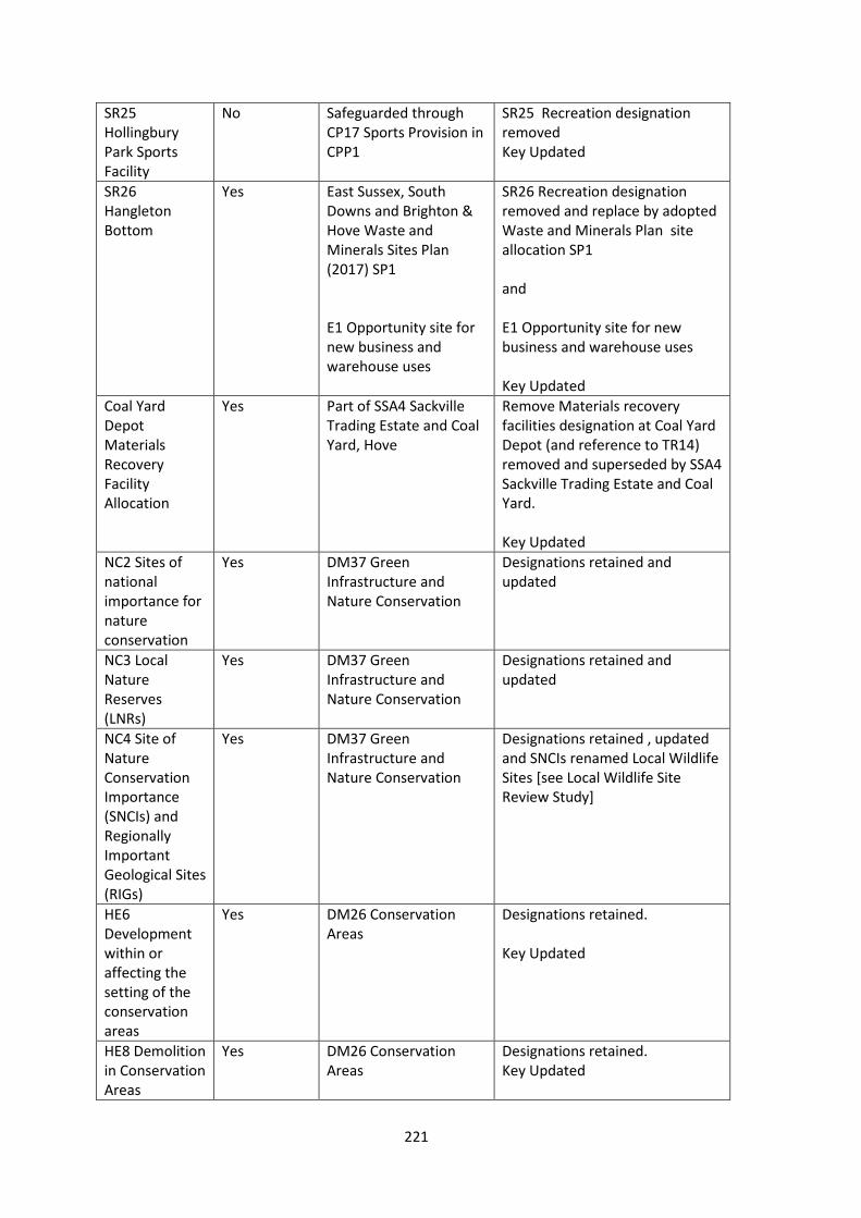
SR25 Hollingbury Park Sports Facility
No Safeguarded through CP17 Sports Provision in CPP1
SR25 Recreation designation removed Key Updated
SR26 Hangleton Bottom
Yes East Sussex, South Downs and Brighton & Hove Waste and Minerals Sites Plan (2017) SP1 E1 Opportunity site for new business and warehouse uses
SR26 Recreation designation removed and replace by adopted Waste and Minerals Plan site allocation SP1 and E1 Opportunity site for new business and warehouse uses Key Updated
Coal Yard Depot Materials Recovery Facility Allocation
Yes Part of SSA4 Sackville Trading Estate and Coal Yard, Hove
Remove Materials recovery facilities designation at Coal Yard Depot (and reference to TR14) removed and superseded by SSA4 Sackville Trading Estate and Coal Yard. Key Updated
NC2 Sites of national importance for nature conservation
Yes DM37 Green Infrastructure and Nature Conservation
Designations retained and updated
NC3 Local Nature Reserves (LNRs)
Yes DM37 Green Infrastructure and Nature Conservation
Designations retained and updated
NC4 Site of Nature Conservation Importance (SNCIs) and Regionally Important Geological Sites (RIGs)
Yes DM37 Green Infrastructure and Nature Conservation
Designations retained , updated and SNCIs renamed Local Wildlife Sites [see Local Wildlife Site Review Study]
HE6 Development within or affecting the setting of the conservation areas
Yes DM26 Conservation Areas
Designations retained. Key Updated
HE8 Demolition in Conservation Areas
Yes DM26 Conservation Areas
Designations retained. Key Updated
221
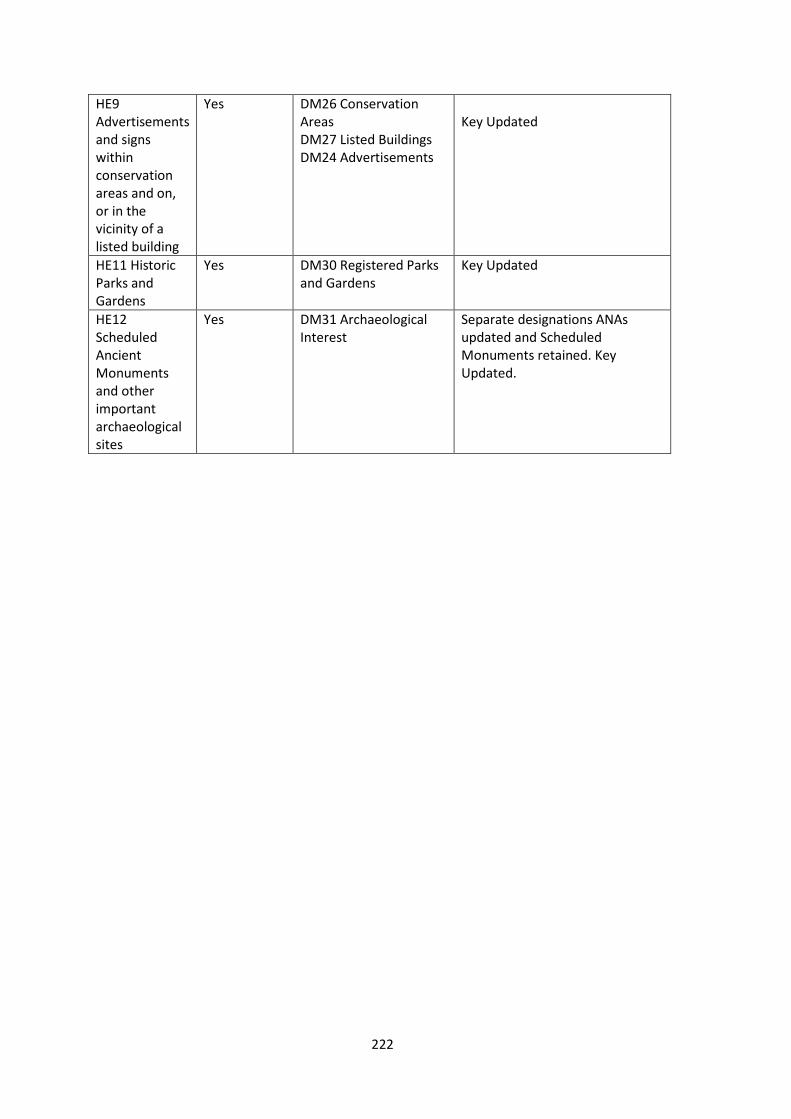
HE9 Advertisements and signs within conservation areas and on, or in the vicinity of a listed building
Yes DM26 Conservation Areas DM27 Listed Buildings DM24 Advertisements
Key Updated
HE11 Historic Parks and Gardens
Yes DM30 Registered Parks and Gardens
Key Updated
HE12 Scheduled Ancient Monuments and other important archaeological sites
Yes DM31 Archaeological Interest
Separate designations ANAs updated and Scheduled Monuments retained. Key Updated.
222