draft cbcs syllabus v2.1 undergraduate courses in … · the model syllabus prepared by the west...
TRANSCRIPT
Draft CBCS Syllabus v2.1 for
Undergraduate Courses in Geography
TO BE EFFECTIVE FROM THE ACADEMIC SESSION 2018-19
University of Calcutta
May, 2018

Note: This page is intentionally kept blank for duplex printing
C U R R I C U L U M S C H E M E
3
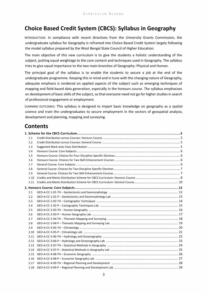
Choice Based Credit System (CBCS): Syllabus in Geography
INTRODUCTION: In compliance with recent directives from the University Grants Commission, the
undergraduate syllabus for Geography is reframed into Choice Based Credit System largely following
the model syllabus prepared by the West Bengal State Council of Higher Education.
The main objective of this new curriculum is to give the students a holistic understanding of the
subject, putting equal weightage to the core content and techniques used in Geography. The syllabus
tries to give equal importance to the two main branches of Geography: Physical and Human.
The principal goal of the syllabus is to enable the students to secure a job at the end of the
undergraduate programme. Keeping this in mind and in tune with the changing nature of Geography,
adequate emphasis is rendered on applied aspects of the subject such as emerging techniques of
mapping and field-based data generation, especially in the honours course. The syllabus emphasises
on development of basic skills of the subject, so that everyone need not go for higher studies in search
of professional engagement or employment.
LEARNING OUTCOMES: This syllabus is designed to impart basic knowledge on geography as a spatial
science and train the undergraduates to secure employment in the sectors of geospatial analysis,
development and planning, mapping and surveying.
Contents 1. Scheme for the CBCS Curriculum ....................................................................................................... 5
1.1 Credit Distribution across Courses: Honours Course ........................................................................................ 5
1.2 Credit Distribution across Courses: General Course ......................................................................................... 5
1.3 Suggested Mark-wise Class Distribution ......................................................................................................... 5
1.4 Honours Course: Core Subjects...................................................................................................................... 6
1.5 Honours Course: Choices for Four Discipline Specific Electives .......................................................................... 6
1.6 Honours Course: Choices for Two Skill Enhancement Courses .......................................................................... 6
1.7 General Course: Core Subjects ...................................................................................................................... 6
1.8 General Course: Choices for Two Discipline Specific Electives ........................................................................... 7
1.9 General Course: Choices for Two Skill Enhancement Courses ........................................................................... 7
1.10 Credits and Marks Distribution Scheme for CBCS Curriculum: Honours Course ................................................... 8
1.11 Credits and Marks Distribution Scheme for CBCS Curriculum: General Course .................................................. 10
2. Honours Course: Core Subjects ....................................................................................................... 12
2.1 GEO-A-CC-1-01-TH – Geotectonics and Geomorphology ............................................................................... 12
2.2 GEO-A-CC-1-01-P – Geotectonics and Geomorphology Lab ............................................................................ 13
2.3 GEO-A-CC-1-02-TH – Cartographic Techniques ............................................................................................. 14
2.4 GEO-A-CC-1-02-P – Cartographic Techniques Lab ......................................................................................... 15
2.5 GEO-A-CC-2-03-TH – Human Geography ...................................................................................................... 16
2.6 GEO-A-CC-2-03-P – Human Geography Lab .................................................................................................. 17
2.7 GEO-A-CC-2-04-TH – Thematic Mapping and Surveying ................................................................................. 18
2.8 GEO-A-CC-2-04-P – Thematic Mapping and Surveying Lab ............................................................................. 19
2.9 GEO-A-CC-3-05-TH – Climatology ................................................................................................................ 20
2.10 GEO-A-CC-3-05-P – Climatology Lab ............................................................................................................ 21
2.11 GEO-A-CC-3-06-TH – Hydrology and Oceanography ...................................................................................... 22
2.12 GEO-A-CC-3-06-P – Hydrology and Oceanography Lab .................................................................................. 23
2.13 GEO-A-CC-3-07-TH – Statistical Methods in Geography ................................................................................. 24
2.14 GEO-A-CC-3-07-P – Statistical Methods in Geography Lab ............................................................................. 25
2.15 GEO-A-CC-4-08-TH – Economic Geography .................................................................................................. 26
2.16 GEO-A-CC-4-08-P – Economic Geography Lab .............................................................................................. 27
2.17 GEO-A-CC-4-09-TH – Regional Planning and Development ............................................................................ 28
2.18 GEO-A-CC-4-09-P – Regional Planning and Development Lab ......................................................................... 29
C U R R I C U L U M S C H E M E
4
2.19 GEO-A-CC-4-10-TH – Soil and Biogeography ................................................................................................. 30
2.20 GEO-A-CC-4-10-P – Soil and Biogeography Lab ............................................................................................. 31
2.21 GEO-A-CC-5-11-TH – Research Methodology and Fieldwork .......................................................................... 32
2.22 GEO-A-CC-5-11-P – Research Methodology and Fieldwork Lab ...................................................................... 33
2.23 GEO-A-CC-5-12-TH – Remote Sensing, GIS and GNSS ..................................................................................... 35
2.24 GEO-A-CC-5-12-P – Remote Sensing, GIS and GNSS Lab ................................................................................. 36
2.25 GEO-A-CC-6-13-TH – Evolution of Geographical Thought ............................................................................... 38
2.26 GEO-A-CC-6-13-P – Evolution of Geographical Thought Lab ........................................................................... 39
2.27 GEO-A-CC-6-14-TH – Hazard Management ................................................................................................... 40
2.28 GEO-A-CC-6-14-P – Hazard Management Lab ............................................................................................... 41
3. Honours Course: Discipline Specific Electives .................................................................................. 42
3.1 GEO-A-DSE-A-6-01-TH – Fluvial Geomorphology ........................................................................................... 42
3.2 GEO-A-DSE-A-6-01-P – Fluvial Geomorphology Lab ....................................................................................... 43
3.3 GEO-A-DSE-A-6-02-TH – Climate Change: Vulnerability and Adaptations ......................................................... 44
3.4 GEO-A-DSE-A-6-02-P – Climate Change: Vulnerability and Adaptations Lab ..................................................... 45
3.5 GEO-A-DSE-A-6-03-TH – Environmental Issues in Geography ......................................................................... 46
3.6 GEO-A-DSE-A-6-03-P – Environmental Issues in Geography Lab ..................................................................... 47
3.7 GEO-A-DSE-A-6-04-TH – Resource Geography .............................................................................................. 48
3.8 GEO-A-DSE-A-6-04-P – Resource Geography Lab .......................................................................................... 49
3.9 GEO-A-DSE-B-6-05-TH – Cultural and Settlement Geography ......................................................................... 50
3.10 GEO-A-DSE-B-6-05-P – Cultural and Settlement Geography Lab ..................................................................... 51
3.11 GEO-A-DSE-B-6-06-TH– Social Geography .................................................................................................... 52
3.12 GEO-A-DSE-B-6-06-P – Social Geography Lab ............................................................................................... 53
3.13 GEO-A-DSE-B-6-07-TH – Urban Geography .................................................................................................. 54
3.14 GEO-A-DSE-B-6-07-P – Urban Geography Lab ............................................................................................... 55
3.15 GEO-A-DSE-B-6-08-TH – Geography of India ................................................................................................. 56
3.16 GEO-A-DSE-B-6-08-P –Geography of India Lab .............................................................................................. 57
4. Honours Course: Skill Enhancement Electives .................................................................................. 58
4.1 GEO-A-SEC-A-3-01-TH – Coastal Management ............................................................................................. 58
4.2 GEO-A-SEC-A-3-02-TH – Tourism Management ............................................................................................ 59
4.3 GEO-A-SEC-B-4-03-TH – Rural Development ................................................................................................ 60
4.4 GEO-A-SEC-B-4-04-TH – Sustainable Development ....................................................................................... 61
5. General Course: Core Subjects ........................................................................................................ 62
5.1 GEO-G-CC-1-01-TH – Physical Geography ..................................................................................................... 62
5.2 GEO-G-CC-1-01-P – Physical Geography Lab ................................................................................................. 63
5.3 GEO-G-CC-2-02-TH – Environmental Geography ........................................................................................... 64
5.4 GEO-G-CC-2-02-P – Environmental Geography Lab ....................................................................................... 65
5.5 GEO-G-CC-3-03-TH – Human Geography ...................................................................................................... 66
5.6 GEO-G-CC-3-03-P– Human Geography Lab ................................................................................................... 67
5.7 GEO-G-CC-4-04-TH – Cartography ............................................................................................................... 68
5.8 GEO-G-CC-4-04-P – Cartography Lab ....................................................................................................................... 69
6. General Course: Discipline Specific Electives ................................................................................... 70 6.1 GEO-G-DSE-A-5-01-TH – Regional Development ...................................................................................................... 70
6.2 GEO-G-DSE-A-5-01-P – Regional Development Lab ................................................................................................. 71
6.3 GEO-G-DSE-A-5-02-TH – Geography of Tourism ...................................................................................................... 72
6.4 GEO-G-DSE-A-5-02-P – Geography of Tourism Lab ....................................................................................................... 73
6.5 GEO-G-DSE-B-6-03-TH – Agricultural Geography ..................................................................................................... 74
6.6 GEO-G-DSE-B-6-03-P – Agricultural Geography Lab ................................................................................................. 75
6.7 GEO-G-DSE-B-6-04-TH – Population Geography ...................................................................................................... 76
6.8 GEO-G-DSE-B-6-04-P – Population Geography Lab .................................................................................................. 77
7. General Course: Skill Enhancement Electives................................................................................... 78 7.1 GEO-G-SKC-A-3/4-01-TH – Coastal Management .................................................................................................... 78
7.2 GEO-G-SKC-B-5/6-02-TH – Rural Development ........................................................................................................ 79
s
C U R R I C U L U M S C H E M E
5
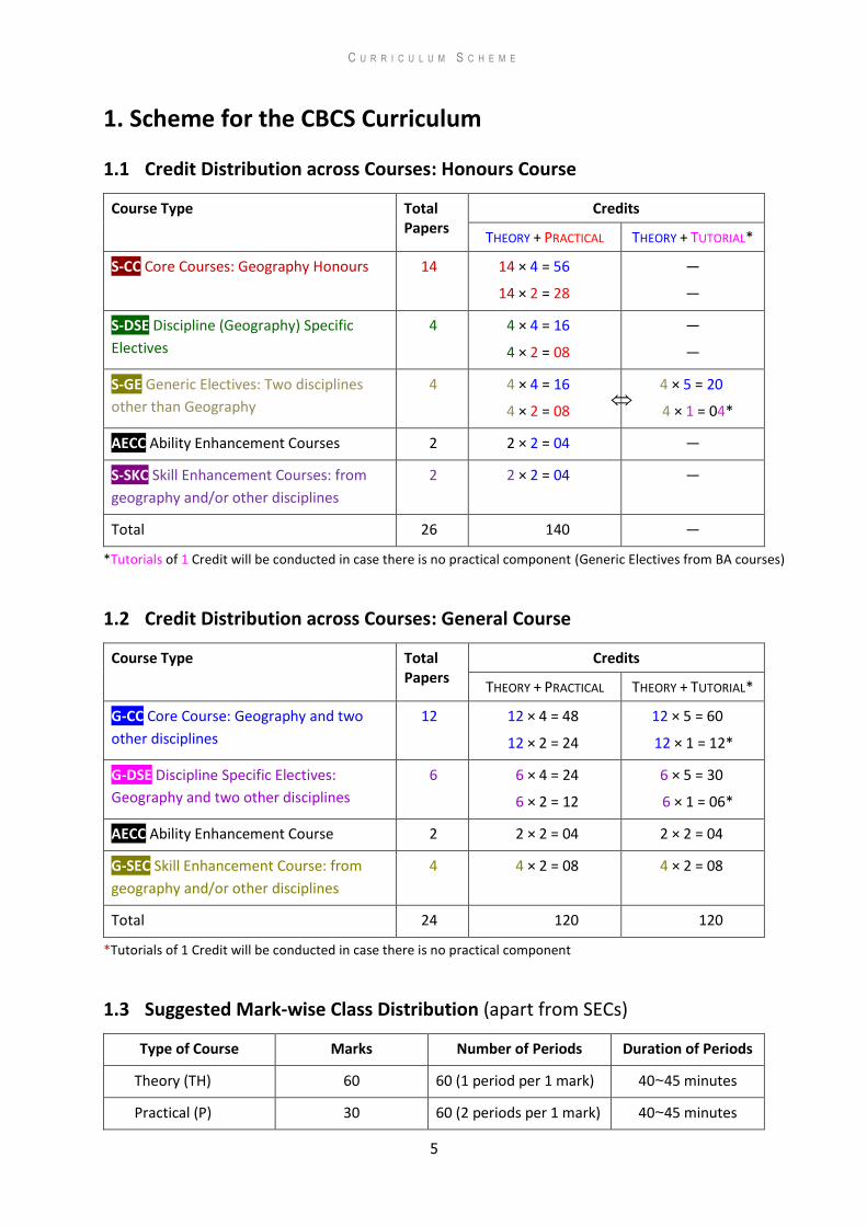
1. Scheme for the CBCS Curriculum
1.1 Credit Distribution across Courses: Honours Course
Course Type Total Papers
Credits
THEORY + PRACTICAL THEORY + TUTORIAL*
S-CC Core Courses: Geography Honours 14 14 × 4 = 56
14 × 2 = 28
—
—
S-DSE Discipline (Geography) Specific
Electives
4 4 × 4 = 16
4 × 2 = 08
—
—
S-GE Generic Electives: Two disciplines
other than Geography
4 4 × 4 = 16
4 × 2 = 08
4 × 5 = 20
4 × 1 = 04*
AECC Ability Enhancement Courses 2 2 × 2 = 04 —
S-SKC Skill Enhancement Courses: from
geography and/or other disciplines
2 2 × 2 = 04 —
Total 26 140 —
*Tutorials of 1 Credit will be conducted in case there is no practical component (Generic Electives from BA courses)
1.2 Credit Distribution across Courses: General Course
Course Type Total Papers
Credits
THEORY + PRACTICAL THEORY + TUTORIAL*
G-CC Core Course: Geography and two
other disciplines
12 12 × 4 = 48
12 × 2 = 24
12 × 5 = 60
12 × 1 = 12*
G-DSE Discipline Specific Electives:
Geography and two other disciplines
6 6 × 4 = 24
6 × 2 = 12
6 × 5 = 30
6 × 1 = 06*
AECC Ability Enhancement Course 2 2 × 2 = 04 2 × 2 = 04
G-SEC Skill Enhancement Course: from
geography and/or other disciplines
4 4 × 2 = 08 4 × 2 = 08
Total 24 120 120
*Tutorials of 1 Credit will be conducted in case there is no practical component
1.3 Suggested Mark-wise Class Distribution (apart from SECs)
Type of Course Marks Number of Periods Duration of Periods
Theory (TH) 60 60 (1 period per 1 mark) 40~45 minutes
Practical (P) 30 60 (2 periods per 1 mark) 40~45 minutes
C U R R I C U L U M S C H E M E
6
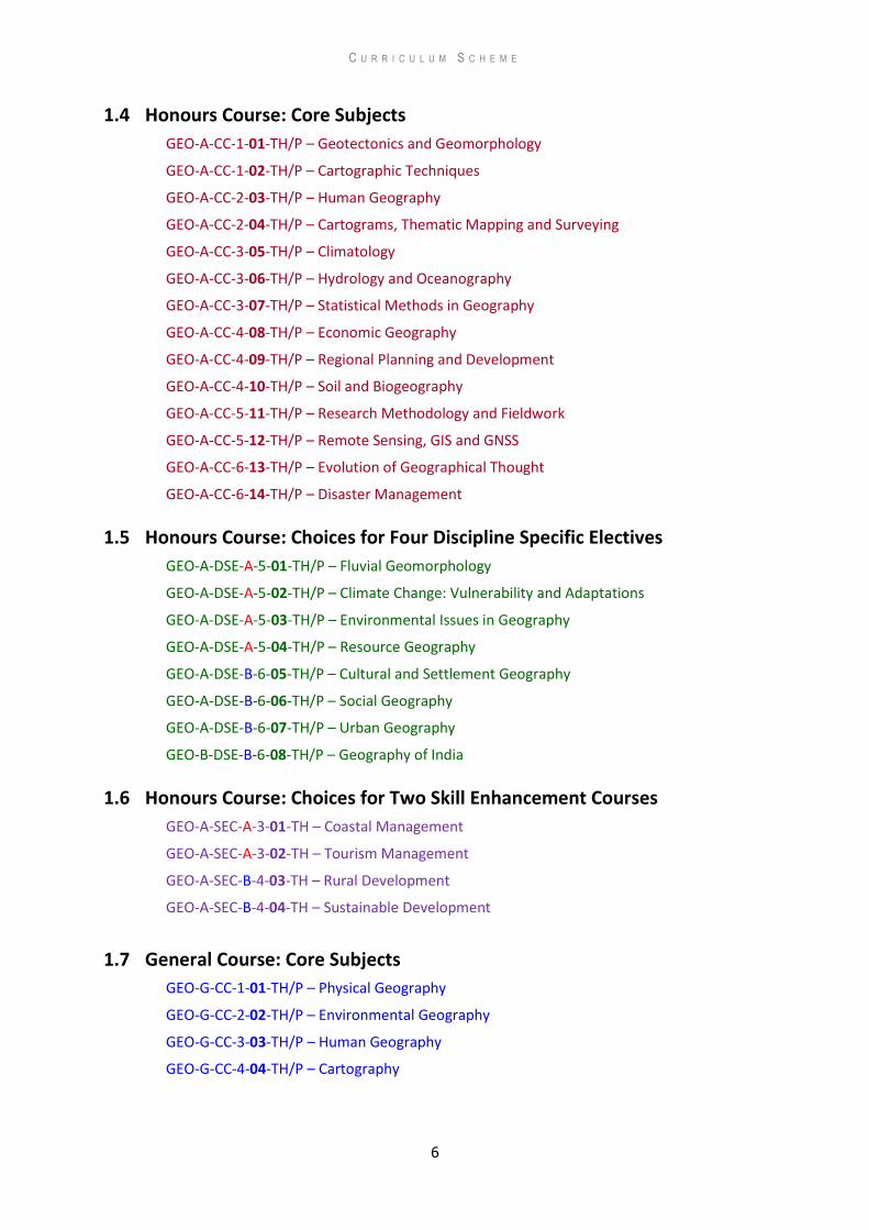
1.4 Honours Course: Core Subjects
GEO-A-CC-1-01-TH/P – Geotectonics and Geomorphology
GEO-A-CC-1-02-TH/P – Cartographic Techniques
GEO-A-CC-2-03-TH/P – Human Geography
GEO-A-CC-2-04-TH/P – Cartograms, Thematic Mapping and Surveying
GEO-A-CC-3-05-TH/P – Climatology
GEO-A-CC-3-06-TH/P – Hydrology and Oceanography
GEO-A-CC-3-07-TH/P – Statistical Methods in Geography
GEO-A-CC-4-08-TH/P – Economic Geography
GEO-A-CC-4-09-TH/P – Regional Planning and Development
GEO-A-CC-4-10-TH/P – Soil and Biogeography
GEO-A-CC-5-11-TH/P – Research Methodology and Fieldwork
GEO-A-CC-5-12-TH/P – Remote Sensing, GIS and GNSS
GEO-A-CC-6-13-TH/P – Evolution of Geographical Thought
GEO-A-CC-6-14-TH/P – Disaster Management
1.5 Honours Course: Choices for Four Discipline Specific Electives
GEO-A-DSE-A-5-01-TH/P – Fluvial Geomorphology
GEO-A-DSE-A-5-02-TH/P – Climate Change: Vulnerability and Adaptations
GEO-A-DSE-A-5-03-TH/P – Environmental Issues in Geography
GEO-A-DSE-A-5-04-TH/P – Resource Geography
GEO-A-DSE-B-6-05-TH/P – Cultural and Settlement Geography
GEO-A-DSE-B-6-06-TH/P – Social Geography
GEO-A-DSE-B-6-07-TH/P – Urban Geography
GEO-B-DSE-B-6-08-TH/P – Geography of India
1.6 Honours Course: Choices for Two Skill Enhancement Courses
GEO-A-SEC-A-3-01-TH – Coastal Management
GEO-A-SEC-A-3-02-TH – Tourism Management
GEO-A-SEC-B-4-03-TH – Rural Development
GEO-A-SEC-B-4-04-TH – Sustainable Development
1.7 General Course: Core Subjects
GEO-G-CC-1-01-TH/P – Physical Geography
GEO-G-CC-2-02-TH/P – Environmental Geography
GEO-G-CC-3-03-TH/P – Human Geography
GEO-G-CC-4-04-TH/P – Cartography

C U R R I C U L U M S C H E M E
7
1.8 General Course: Choices for Two Discipline Specific Electives
GEO-G-DSE-A-5-01-TH/P – Regional Development
GEO-G-DSE-A-5-02-TH/P – Geography of Tourism
GEO-G-DSE-B-6-03-TH/P – Agricultural Geography
GEO-G-DSE-B-6-04-TH/P – Population Geography
1.9 General Course: Choices for Two Skill Enhancement Courses
GEO-G-SEC-A-3/4-01-TH – Coastal Management
GEO-G-SEC-B-5/6-03-TH – Rural Development
C U R R I C U L U M S C H E M E
8
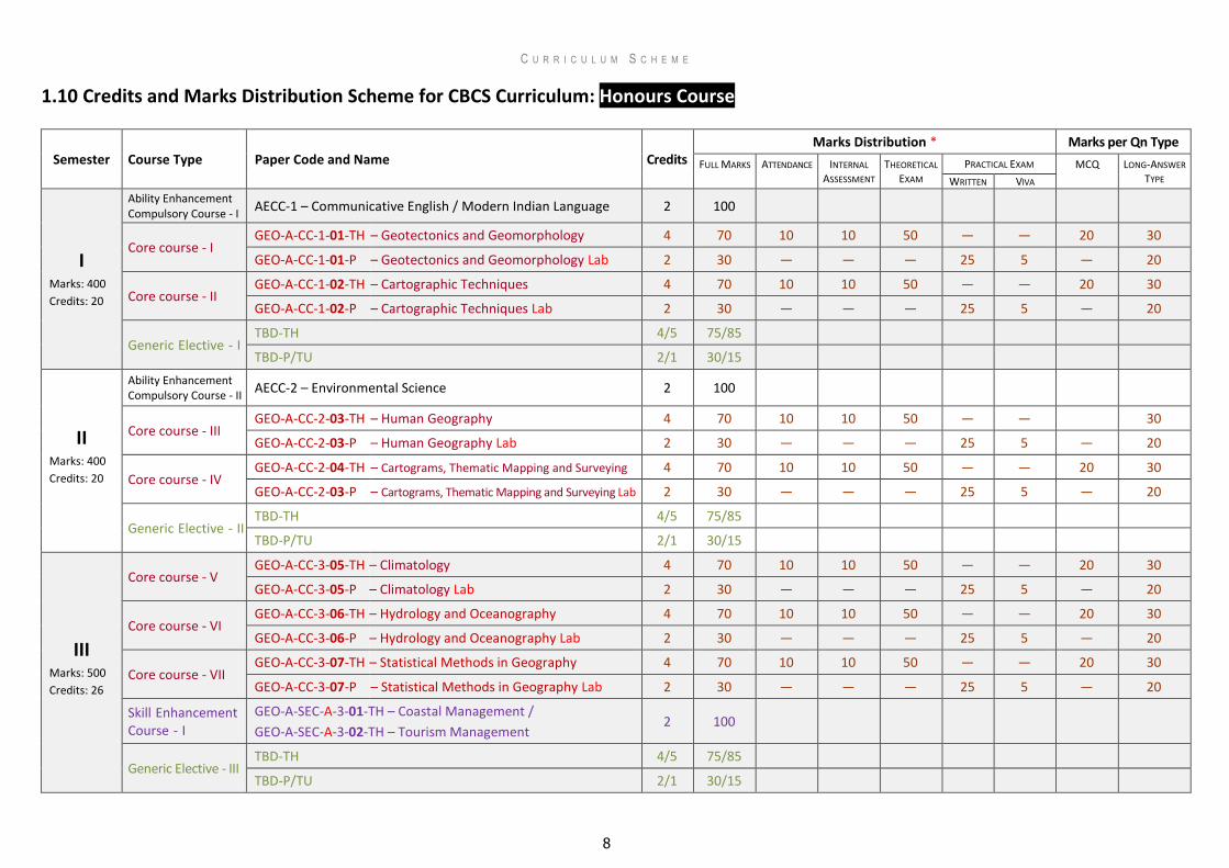
1.10 Credits and Marks Distribution Scheme for CBCS Curriculum: Honours Course
Semester Course Type Paper Code and Name Credits Marks Distribution * Marks per Qn Type
FULL MARKS ATTENDANCE INTERNAL
ASSESSMENT THEORETICAL
EXAM
PRACTICAL EXAM MCQ LONG-ANSWER
TYPE WRITTEN VIVA
I Marks: 400
Credits: 20
Ability Enhancement Compulsory Course - I
AECC-1 – Communicative English / Modern Indian Language 2 100
Core course - I GEO-A-CC-1-01-TH – Geotectonics and Geomorphology 4 70 10 10 50 — — 20 30
GEO-A-CC-1-01-P – Geotectonics and Geomorphology Lab 2 30 — — — 25 5 — 20
Core course - II GEO-A-CC-1-02-TH – Cartographic Techniques 4 70 10 10 50 — — 20 30
GEO-A-CC-1-02-P – Cartographic Techniques Lab 2 30 — — — 25 5 — 20
Generic Elective - I TBD-TH 4/5 75/85
TBD-P/TU 2/1 30/15
II Marks: 400
Credits: 20
Ability Enhancement Compulsory Course - II AECC-2 – Environmental Science 2 100
Core course - III GEO-A-CC-2-03-TH – Human Geography 4 70 10 10 50 — — 30
GEO-A-CC-2-03-P – Human Geography Lab 2 30 — — — 25 5 — 20
Core course - IV GEO-A-CC-2-04-TH – Cartograms, Thematic Mapping and Surveying 4 70 10 10 50 — — 20 30
GEO-A-CC-2-03-P – Cartograms, Thematic Mapping and Surveying Lab 2 30 — — — 25 5 — 20
Generic Elective - II TBD-TH 4/5 75/85
TBD-P/TU 2/1 30/15
III Marks: 500
Credits: 26
Core course - V GEO-A-CC-3-05-TH – Climatology 4 70 10 10 50 — — 20 30
GEO-A-CC-3-05-P – Climatology Lab 2 30 — — — 25 5 — 20
Core course - VI GEO-A-CC-3-06-TH – Hydrology and Oceanography 4 70 10 10 50 — — 20 30
GEO-A-CC-3-06-P – Hydrology and Oceanography Lab 2 30 — — — 25 5 — 20
Core course - VII GEO-A-CC-3-07-TH – Statistical Methods in Geography 4 70 10 10 50 — — 20 30
GEO-A-CC-3-07-P – Statistical Methods in Geography Lab 2 30 — — — 25 5 — 20
Skill Enhancement Course - I
GEO-A-SEC-A-3-01-TH – Coastal Management /
GEO-A-SEC-A-3-02-TH – Tourism Management 2 100
Generic Elective - III TBD-TH 4/5 75/85
TBD-P/TU 2/1 30/15
C U R R I C U L U M S C H E M E
9
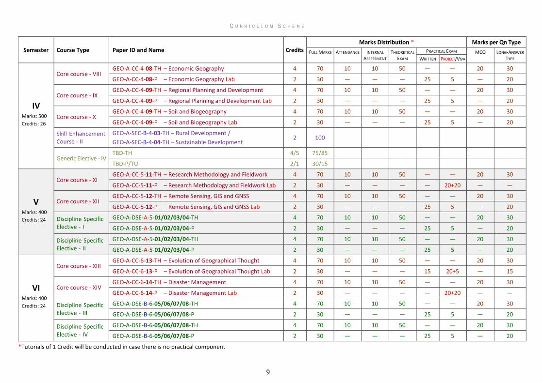
Semester Course Type Paper ID and Name Credits Marks Distribution * Marks per Qn Type
FULL MARKS ATTENDANCE INTERNAL
ASSESSMENT THEORETICAL
EXAM
PRACTICAL EXAM MCQ LONG-ANSWER
TYPE WRITTEN PROJECT/VIVA
IV Marks: 500
Credits: 26
Core course - VIII GEO-A-CC-4-08-TH – Economic Geography 4 70 10 10 50 — — 20 30
GEO-A-CC-4-08-P – Economic Geography Lab 2 30 — — — 25 5 — 20
Core course - IX GEO-A-CC-4-09-TH – Regional Planning and Development 4 70 10 10 50 — — 20 30
GEO-A-CC-4-09-P – Regional Planning and Development Lab 2 30 — — — 25 5 — 20
Core course - X GEO-A-CC-4-09-TH – Soil and Biogeography 4 70 10 10 50 — — 20 30
GEO-A-CC-4-09-P – Soil and Biogeography Lab 2 30 — — — 25 5 — 20
Skill Enhancement Course - II
GEO-A-SEC-B-4-03-TH – Rural Development /
GEO-A-SEC-B-4-04-TH – Sustainable Development 2 100
Generic Elective - IV TBD-TH 4/5 75/85
TBD-P/TU 2/1 30/15
V Marks: 400
Credits: 24
Core course - XI GEO-A-CC-5-11-TH – Research Methodology and Fieldwork 4 70 10 10 50 — — 20 30
GEO-A-CC-5-11-P – Research Methodology and Fieldwork Lab 2 30 — — — — 20+20 — —
Core course - XII GEO-A-CC-5-12-TH – Remote Sensing, GIS and GNSS 4 70 10 10 50 — — 20 30
GEO-A-CC-5-12-P – Remote Sensing, GIS and GNSS Lab 2 30 — — — 25 5 — 20
Discipline Specific Elective - I
GEO-A-DSE-A-5-01/02/03/04-TH 4 70 10 10 50 — — 20 30
GEO-A-DSE-A-5-01/02/03/04-P 2 30 — — — 25 5 — 20
Discipline Specific Elective - II
GEO-A-DSE-A-5-01/02/03/04-TH 4 70 10 10 50 — — 20 30
GEO-A-DSE-A-5-01/02/03/04-P 2 30 — — — 25 5 — 20
VI Marks: 400
Credits: 24
Core course - XIII GEO-A-CC-6-13-TH – Evolution of Geographical Thought 4 70 10 10 50 — — 20 30
GEO-A-CC-6-13-P – Evolution of Geographical Thought Lab 2 30 — — — 15 20+5 — 15
Core course - XIV GEO-A-CC-6-14-TH – Disaster Management 4 70 10 10 50 — — 20 30
GEO-A-CC-6-14-P – Disaster Management Lab 2 30 — — — — 20+20 — —
Discipline Specific Elective - III
GEO-A-DSE-B-6-05/06/07/08-TH 4 70 10 10 50 — — 20 30
GEO-A-DSE-B-6-05/06/07/08-P 2 30 — — — 25 5 — 20
Discipline Specific Elective - IV
GEO-A-DSE-B-6-05/06/07/08-TH 4 70 10 10 50 — — 20 30
GEO-A-DSE-B-6-05/06/07/08-P 2 30 — — — 25 5 — 20
*Tutorials of 1 Credit will be conducted in case there is no practical component
C U R R I C U L U M S C H E M E
10
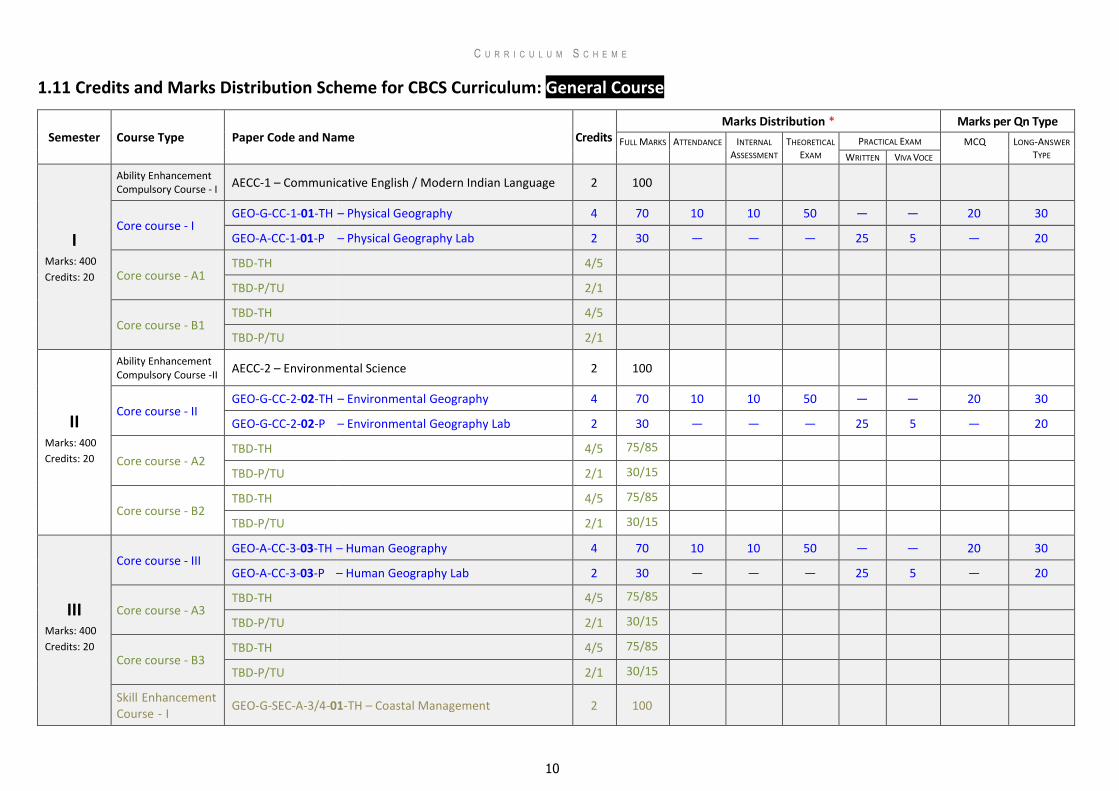
1.11 Credits and Marks Distribution Scheme for CBCS Curriculum: General Course
Semester Course Type Paper Code and Name Credits Marks Distribution * Marks per Qn Type
FULL MARKS ATTENDANCE INTERNAL
ASSESSMENT THEORETICAL
EXAM
PRACTICAL EXAM MCQ LONG-ANSWER
TYPE WRITTEN VIVA VOCE
I Marks: 400
Credits: 20
Ability Enhancement Compulsory Course - I
AECC-1 – Communicative English / Modern Indian Language 2 100
Core course - I GEO-G-CC-1-01-TH – Physical Geography 4 70 10 10 50 — — 20 30
GEO-A-CC-1-01-P – Physical Geography Lab 2 30 — — — 25 5 — 20
Core course - A1 TBD-TH 4/5
TBD-P/TU 2/1
Core course - B1 TBD-TH 4/5
TBD-P/TU 2/1
II Marks: 400
Credits: 20
Ability Enhancement Compulsory Course -II AECC-2 – Environmental Science 2 100
Core course - II GEO-G-CC-2-02-TH – Environmental Geography 4 70 10 10 50 — — 20 30
GEO-G-CC-2-02-P – Environmental Geography Lab 2 30 — — — 25 5 — 20
Core course - A2 TBD-TH 4/5 75/85
TBD-P/TU 2/1 30/15
Core course - B2 TBD-TH 4/5 75/85
TBD-P/TU 2/1 30/15
III Marks: 400
Credits: 20
Core course - III GEO-A-CC-3-03-TH – Human Geography 4 70 10 10 50 — — 20 30
GEO-A-CC-3-03-P – Human Geography Lab 2 30 — — — 25 5 — 20
Core course - A3 TBD-TH 4/5 75/85
TBD-P/TU 2/1 30/15
Core course - B3 TBD-TH 4/5 75/85
TBD-P/TU 2/1 30/15
Skill Enhancement Course - I
GEO-G-SEC-A-3/4-01-TH – Coastal Management 2 100
C U R R I C U L U M S C H E M E
11
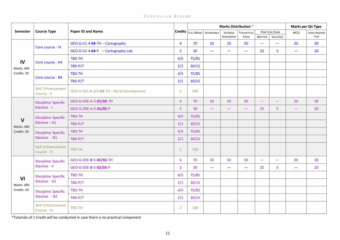
Semester Course Type Paper ID and Name Credits Marks Distribution * Marks per Qn Type
FULL MARKS ATTENDANCE INTERNAL
ASSESSMENT THEORETICAL
EXAM
PRACTICAL EXAM MCQ LONG-ANSWER
TYPE WRITTEN VIVA VOCE
IV Marks: 400
Credits: 20
Core course - IV GEO-G-CC-4-04-TH – Cartography 4 70 10 10 50 — — 20 30
GEO-G-CC-4-04-P – Cartography Lab 2 30 — — — 25 5 — 20
Core course - A4 TBD-TH 4/5 75/85
TBD-P/T 2/1 30/15
Core course - B4 TBD-TH 4/5 75/85
TBD-P/T 2/1 30/15
Skill Enhancement Course - II
GEO-G-SEC-B-3/4-02-TH – Rural Development 2 100
V Marks: 400
Credits: 20
Discipline Specific Elective - I
GEO-G-DSE-A-5-01/02-TH 4 70 10 10 50 — — 20 30
GEO-G-DSE-A-5-01/02-P 2 30 — — — 25 5 — 20
Discipline Specific Elective - A1
TBD-TH 4/5 75/85
TBD-P/T 2/1 30/15
Discipline Specific Elective - B1
TBD-TH 4/5 75/85
TBD-P/T 2/1 30/15
Skill Enhancement Course - III
TBD-TH 2 100
VI Marks: 400
Credits: 20
Discipline Specific Elective - II
GEO-G-DSE-B-5-02/03-TH 4 70 10 10 50 — — 20 30
GEO-G-DSE-B-5-02/03-P 2 30 — — — 25 5 — 20
Discipline Specific Elective - A2
TBD-TH 4/5 75/85
TBD-P/T 2/1 30/15
Discipline Specific Elective - B2
TBD-TH 4/5 75/85
TBD-P/T 2/1 30/15
Skill Enhancement Course - IV
TBD-TH 2 100
*Tutorials of 1 Credit will be conducted in case there is no practical component
12
2 . H O N O U R S C O U R S E : C O R E S U B J E C T S
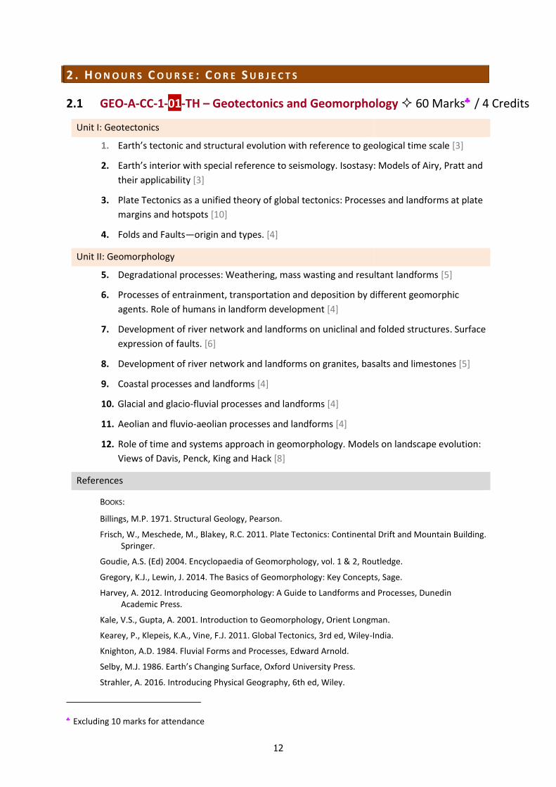
2.1 GEO-A-CC-1-01-TH – Geotectonics and Geomorphology 60 Marks / 4 Credits
Unit I: Geotectonics
1. Earth’s tectonic and structural evolution with reference to geological time scale [3]
2. Earth’s interior with special reference to seismology. Isostasy: Models of Airy, Pratt and
their applicability [3]
3. Plate Tectonics as a unified theory of global tectonics: Processes and landforms at plate
margins and hotspots [10]
4. Folds and Faults—origin and types. [4]
Unit II: Geomorphology
5. Degradational processes: Weathering, mass wasting and resultant landforms [5]
6. Processes of entrainment, transportation and deposition by different geomorphic
agents. Role of humans in landform development [4]
7. Development of river network and landforms on uniclinal and folded structures. Surface
expression of faults. [6]
8. Development of river network and landforms on granites, basalts and limestones [5]
9. Coastal processes and landforms [4]
10. Glacial and glacio-fluvial processes and landforms [4]
11. Aeolian and fluvio-aeolian processes and landforms [4]
12. Role of time and systems approach in geomorphology. Models on landscape evolution:
Views of Davis, Penck, King and Hack [8]
References
BOOKS:
Billings, M.P. 1971. Structural Geology, Pearson.
Frisch, W., Meschede, M., Blakey, R.C. 2011. Plate Tectonics: Continental Drift and Mountain Building. Springer.
Goudie, A.S. (Ed) 2004. Encyclopaedia of Geomorphology, vol. 1 & 2, Routledge.
Gregory, K.J., Lewin, J. 2014. The Basics of Geomorphology: Key Concepts, Sage.
Harvey, A. 2012. Introducing Geomorphology: A Guide to Landforms and Processes, Dunedin Academic Press.
Kale, V.S., Gupta, A. 2001. Introduction to Geomorphology, Orient Longman.
Kearey, P., Klepeis, K.A., Vine, F.J. 2011. Global Tectonics, 3rd ed, Wiley-India.
Knighton, A.D. 1984. Fluvial Forms and Processes, Edward Arnold.
Selby, M.J. 1986. Earth’s Changing Surface, Oxford University Press.
Strahler, A. 2016. Introducing Physical Geography, 6th ed, Wiley.
Excluding 10 marks for attendance
H O N O U R S C O U R S E : C O R E S U B J E C T S
13
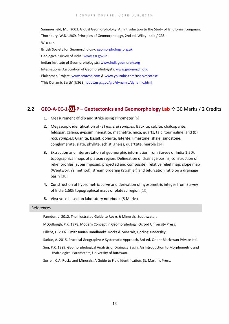
Summerfield, M.J. 2003. Global Geomorphology: An Introduction to the Study of landforms, Longman.
Thornbury, W.D. 1969. Principles of Geomorphology, 2nd ed, Wiley-India / CBS.
WEBSITES:
British Society for Geomorphology: geomorphology.org.uk
Geological Survey of India: www.gsi.gov.in
Indian Institute of Geomorphologists: www.indiageomorph.org
International Association of Geomorphologists: www.geomorph.org
Plaleomap Project: www.scotese.com & www.youtube.com/user/cscotese
'This Dynamic Earth' (USGS): pubs.usgs.gov/gip/dynamic/dynamic.html
2.2 GEO-A-CC-1-01-P – Geotectonics and Geomorphology Lab 30 Marks / 2 Credits
1. Measurement of dip and strike using clinometer [6]
2. Megascopic identification of (a) mineral samples: Bauxite, calcite, chalcopyrite,
feldspar, galena, gypsum, hematite, magnetite, mica, quartz, talc, tourmaline; and (b)
rock samples: Granite, basalt, dolerite, laterite, limestone, shale, sandstone,
conglomerate, slate, phyllite, schist, gneiss, quartzite, marble [14]
3. Extraction and interpretation of geomorphic information from Survey of India 1:50k
topographical maps of plateau region: Delineation of drainage basins, construction of
relief profiles (superimposed, projected and composite), relative relief map, slope map
(Wentworth’s method), stream ordering (Strahler) and bifurcation ratio on a drainage
basin [30]
4. Construction of hypsometric curve and derivation of hypsometric integer from Survey
of India 1:50k topographical maps of plateau region [10]
5. Viva-voce based on laboratory notebook (5 Marks)
References
Farndon, J. 2012. The Illustrated Guide to Rocks & Minerals, Southwater.
McCullough, P.K. 1978. Modern Concept in Geomorphology, Oxford University Press.
Pillent, C. 2002. Smithsonian Handbooks: Rocks & Minerals, Dorling Kindersley.
Sarkar, A. 2015. Practical Geography: A Systematic Approach, 3rd ed, Orient Blackswan Private Ltd.
Sen, P.K. 1989. Geomorphological Analysis of Drainage Basin: An Introduction to Morphometric and
Hydrological Parameters, University of Burdwan.
Sorrell, C.A. Rocks and Minerals: A Guide to Field Identification, St. Martin's Press.
H O N O U R S C O U R S E : C O R E S U B J E C T S
14
2.3 GEO-A-CC-1-02-TH – Cartographic Techniques 60 Marks / 4 Credits
1. Maps: Components and classification [4]
2. Concept and application of scales: Plain, comparative, diagonal and Vernier [8]
3. Coordinate systems: Polar and rectangular [6]
4. Concept of generating globe [2]
5. Grids: Angular and linear systems of measurement [5]
6. Bearing: Magnetic and true, whole-circle and reduced [5]
7. Concept of geoid and spheroid with special reference to Everest and WGS-84 [4]
8. Map projections: Classification, properties and uses [8]
9. Concept and significance of UTM projection [2]
10. Representation of data using dots and proportional circle [5]
11. Representation of data using isopleth and choropleth [5]
12. Survey of India topographical maps: Reference scheme of old and open series.
Information on the margin of maps [6]
References
BOOKS
Kennedy, M., Kopp, S. 2001. Understanding Map Projections, Esri Press.
Kimerling, A.J., Buckley, A.R., Muehrcke, P.C., Muehrcke, J.O. 2011. Map Use: Reading, Analysis,
Interpretation, 7th ed, Esri Press.
Monkhouse, F.J., Wilkinson, H.R. 1971. Maps and Diagrams: Their Compilation and Construction, 3rd
ed (2017 reprint), Alphaneumera-Kolkata.
Pearson II, F. 1990. Map Projections: Theory and Applications 2nd ed, CRC Press.
Robinson, A.H., Morrison, J.L., Phillip, C.M., Kimerling, A.J., Guptill, S.C. 1995. Elements of Cartography,
6th ed, Wiley.
Sarkar, A. 2015. Practical Geography: A Systematic Approach, 3rd ed, Orient Blackswan Private Ltd.
Singh, R.L., Singh, R.P.B. 2008. Elements of Practical Geography, Kalyani Publishers.
Vaidyanadhan, R., Subbarao, K.V. 2014. Landforms of India from Topomaps and Images, Geological
Society of India.
WEBSITES
Geological Survey of India: www.gsi.gov.in
Indian National Cartographic Association: www.incaindia.org
Indian Naval Hydrographic Department: www.hydrobharat.nic.in
National Bureau of Soil Survey and Land Use planning: www.nbsslup.in
Survey of India: www.surveyofindia.gov.in
H O N O U R S C O U R S E : C O R E S U B J E C T S
15
2.4 GEO-A-CC-1-02-P – Cartographic Techniques Lab 30 Marks / 2 Credits
1. Graphical construction of scales: Plain, comparative, diagonal and Vernier [16]
2. Construction of projections: Polar Zenithal Stereographic, Simple Conic with one
standard parallel, Bonne’s, Cylindrical Equal Area, and Mercator’s [20]
3. Thematic maps: Proportional squares, pie diagrams with proportional circles, dots and
spheres [12]
4. Thematic maps: Choropleth, isopleth, and chorochromatic maps [12]
5. Viva-voce based on laboratory notebook (5 Marks)
References
Kennedy, M., Kopp, S. 2001. Understanding Map Projections, Esri Press.
Kimerling, A.J., Buckley, A.R., Muehrcke, P.C., Muehrcke, J.O. 2011. Map Use: Reading, Analysis,
Interpretation, 7th ed, Esri Press.
Monkhouse, F.J., Wilkinson, H.R. 1971. Maps and Diagrams: Their Compilation and Construction, 3rd
ed (2017 reprint), Alphaneumera-Kolkata.
Pearson II, F. 1990. Map Projections: Theory and Applications 2nd ed, CRC Press.
Robinson, A.H., Morrison, J.L., Phillip, C.M., Kimerling, A.J., Guptill, S.C. 1995. Elements of Cartography,
6th ed, Wiley.
Sarkar, A. 2015. Practical Geography: A Systematic Approach, 3rd ed, Orient Blackswan Private Ltd.
Singh, R.L., Singh, R.P.B. 2008. Elements of Practical Geography, Kalyani Publishers.
H O N O U R S C O U R S E : C O R E S U B J E C T S
16
2.5 GEO-A-CC-2-03-TH – Human Geography 60 Marks / 4 Credits
Unit I: Nature and Principles
1. Nature, scope and recent trends. Elements of human geography [4]
2. Approaches to Human Geography: Resource, locational, landscape, environment [6]
3. Concept and classification of race. Ethnicity [5]
4. Space, society and cultural regions (language and religion) [5]
Unit II: Society, Demography and Ekistics
5. Evolution of human societies: Hunting and food gathering, pastoral nomadism,
subsistence farming and industrial society [6]
6. Human adaptation to environment: Case studies of Eskimo, Masai and Maori [4]
7. Population growth and distribution, composition; demographic transition [5]
8. Population–resource regions (Ackerman) [5]
9. Development–environment conflict [5]
10. Types and patterns of rural settlements [5]
11. Rural house types in India [5]
12. Morphology and hierarchy of urban settlements [5]
References
Chandna, R.C. 2016. Geography of Population: Concepts, Determinants and Patterns, Kalyani
Publishers.
Fouberg, E.H., Murphy, A.B., de Blij H.J. 2015. Human Geography: People, Place, and Culture, 11th
ed, Wiley.
Ghosh, S. 1998. Introduction to Settlement Geography, Sangam Books Ltd.
Gould, W.T.S. 2015. Population and Development, Routledge.
Gregory, D., Johnston, R., Pratt, G., Watts., Whatmore, S. (Eds) 2009. The Dictionary of Human
Geography, 5th ed, Wiley.
Knox, P.L., Marston, S.A. 2014. Human Geography: Places and Regions in Global Context, 6th ed,
Pearson Education Limited.
Knox, P.L., McCarthy, L.M. 2011. Urbanization: An Introduction to Urban Geography, 3rd ed, Pearson
Educztuion Ltd.
Mandal, R.B. 2001. Introduction to Rural Settlement, 2nd ed, Concept Publishing Company.
Moseley, W.G., Perramond, E., Hapke, H.M., Laris, P. 2013. An Introduction to Human-Environment
Geography: Local Dynamics and Global Processes, Wiley-Blackwell.
Norton, W. 2014. Human Geography, 8th ed, Oxford University Press.
Pickering K. and Owen A. A. (1997): An Introduction to Global Environmental Issues, 2nd edition
Rutledge, London.
Rubenstein, J.M. 2016. The Cultural Landscape: An Introduction to Human Geography, 12th ed,
Pearson Education Limited.
Short, R.J. 2017. Human Geography: A Short Introduction, 2nd ed, Oxford University Press.
H O N O U R S C O U R S E : C O R E S U B J E C T S
17
2.6 GEO-A-CC-2-03-P – Human Geography Lab 30 Marks / 2 Credits
1. Spatial variation in continent- or country-level religious composition by divided
proportional circles [12]
2. Measuring arithmetic growth rate of population comparing two decadal datasets [15]
3. Types of Age-Sex pyramids (progressive, regressive, intermediate and stationary):
Graphical representation and analysis [20]
4. Nearest neighbour analysis from Survey of India 1:50k topographical maps (5’ x 5’) [13]
5. Viva-voce based on laboratory notebook (5 Marks)
References
Hassan, M.I. 2005. Population Geography, Rawat publications.
Knowles, R and Wareing, J. 1990. Economic and Social Geography, Made Simple Books.
Mahmood, A. 1998. Statistical Methods in Geographical Studies, Rajesh Publication.
Monkhouse, F.J., Wilkinson, H.R. 1971. Maps and Diagrams: Their Compilation and Construction, 3rd
ed (2017 reprint), Alphaneumera-Kolkata.
Sarkar, A. 2015. Practical Geography: A Systematic Approach, 3rd ed, Orient Blackswan Private Ltd.
H O N O U R S C O U R S E : C O R E S U B J E C T S
18
2.7 GEO-A-CC-2-04-TH – Thematic Mapping and Surveying 60 Marks / 4 Credits
1. Concepts of rounding, scientific notation. Logarithm and anti-logarithm. Natural and log
scales [4]
2. Concept of diagrammatic representation of data [2]
3. Preparation and interpretation of geological maps [5]
4. Preparation and interpretation of weather maps [5]
5. Preparation and interpretation land use land cover maps [5]
6. Preparation and interpretation of socio-economic maps [5]
7. Principal national agencies producing thematic maps in India: NATMO, GSI, NBSSLUP,
NHO, NRSC / Bhuvan, etc. [5]
8. Basic concepts of surveying and survey equipment: Prismatic compass [5]
9. Basic concepts of surveying and survey equipment: Dumpy level [7]
10. Basic concepts of surveying and survey equipment: Theodolite [7]
11. Basic concepts of surveying and survey equipment: Abney level [5]
12. Basic concepts of surveying and survey equipment: Laser distance measurer [5]
References
BOOKS:
Basak, N.N. 2017. Surveying and Levelling, 2nd ed, McGraw Hill Education.
Bolton. T. 2009 (reprint). Geological Maps: Their Solution and Interpretation, Cambridge Univ. Press.
Kanetkar, T.P., Kulkatni, S.V. 1988. Surveying and Levelling, Part I, Pune Vidyarthi Griha Prakashan.
Monkhouse, F.J., Wilkinson, H.R. 1971. Maps and Diagrams: Their Compilation and Construction, 3rd
ed (2017 reprint), Alphaneumera-Kolkata.
Robinson, A.H., Morrison, J.L., Phillip, C.M., Kimerling, A.J., Guptill, S.C. 1995. Elements of
Cartography, 6th ed, Wiley.
Sarkar, A. 2015. Practical Geography: A Systematic Approach, 3rd ed, Orient Blackswan Private Ltd.
Singh, R.L., Singh, R.P.B. 2008. Elements of Practical Geography, Kalyani Publishers.
Subramanian, R. 2012. Surveying and Levelling, 2nd ed, Oxford University Press
WEBSITES:
Geological Survey of India: www.gsi.gov.in
Indian Naval Hydrographic Department: www.hydrobharat.nic.in
National Bureau of Soil Survey and Land Use planning: www.nbsslup.in
Survey of India: www.surveyofindia.gov.in
ISRO Bhuvan 2D Platform: bhuvan.nrsc.gov.in/map/bhuvan/bhuvan2d.php
National Remote Sensing Centre: www.nrsc.gov.in
H O N O U R S C O U R S E : C O R E S U B J E C T S
19
2.8 GEO-A-CC-2-04-P – Thematic Mapping and Surveying Lab 30 Marks / 2 Credits
1. Traverse survey using prismatic compass [10]
2. Profile survey using dumpy Level [12]
3. Height determination of base accessible and inaccessible (same vertical plane method)
objects by theodolite [18]
4. Interpretation of geological maps with uniclinal structure, folds, unconformity, and
intrusions [20]
5. Viva-voce based on laboratory notebook (5 Marks)
References
Basak, N.N. 2017. Surveying and Levelling, 2nd ed, McGraw Hill Education.
Bolton. T. 2009 (reprint). Geological Maps: Their Solution and Interpretation, Cambridge University
Press.
Kanetkar, T.P., Kulkatni, S.V. 1988. Surveying and Levelling, Part I, Pune Vidyarthi Griha Prakashan.
Monkhouse, F.J., Wilkinson, H.R. 1971. Maps and Diagrams: Their Compilation and Construction, 3rd
ed (2017 reprint), Alphaneumera-Kolkata.
Robinson, A.H., Morrison, J.L., Phillip, C.M., Kimerling, A.J., Guptill, S.C. 1995. Elements of
Cartography, 6th ed, Wiley.
Sarkar, A. 2015. Practical Geography: A Systematic Approach, 3rd ed, Orient Blackswan Private Ltd.
Singh, R.L., Singh, R.P.B. 2008. Elements of Practical Geography, Kalyani Publishers.
Subramanian, R. 2012. Surveying and Levelling, 2nd ed, Oxford University Press
H O N O U R S C O U R S E : C O R E S U B J E C T S
20
2.9 GEO-A-CC-3-05-TH – Climatology 60 Marks / 4 Credits
Unit I: Elements of the Atmosphere
1. Nature, composition and layering of the atmosphere [4]
2. Insolation: Controlling factors. Heat budget of the atmosphere [6]
3. Temperature: horizontal and vertical distribution. Inversion of temperature: types,
causes and consequences [6]
4. Overview of climate change: Greenhouse effect. Formation, depletion and significance
of the ozone layer [4]
Unit II: Atmospheric Phenomena and Climatic Classification
5. Condensation: Process and forms. Mechanism of precipitation: Bergeron-Findeisen
theory, collision and coalescence. Forms of precipitation [6]
6. Air mass: Typology, origin, characteristics and modification [4]
7. Fronts: Warm and cold, frontogenesis and frontolysis [5]
8. Weather: Stability and instability, barotropic and baroclinic conditions [5]
9. Circulation in the atmosphere: Planetary winds, jet streams, index cycle [5]
10. Atmospheric disturbances: Tropical and mid-latitude cyclones, thunderstorms [5]
11. Monsoon circulation and mechanism with reference to India [5]
12. Climatic classification after Thornthwaite (1955) and Oliver [5]
References
BOOKS:
Ahrens, C.D. 2012. Essentials of Meteorology: An Invitation to the Atmosphere. 9th Ed, Cengage
Learning.
Barry, R.G, Chorley R.J. 2009. Atmosphere Weather and Climate. 9th Ed, Routledge.
Critchfield, H. J. 1983. General Climatology. Prentice Hall India Ltd (2010 Reprint).
Lal, D.S. 2012. Climatology. Sharda Pustak Bhawan.
Lutgens, F.K., Tarbuck, E.J. 1998. The Atmosphere: An Introduction to Meteorology, 9th Ed, Prentice-
Hall Inc.
Oliver, J.E., Hidore J.J. 2002. Climatology: An Atmospheric Science, Pearson Education India
WEBSITES:
India Meteorological Department: www.imd.gov.in
Intergovernmental Panel on Climate Change: www.ipcc.ch
World Bank Climate Change Knowledge Portal: sdwebx.worldbank.org/climateportal/index.cfm
World Meteorological Organization: public.wmo.int/en
H O N O U R S C O U R S E : C O R E S U B J E C T S
21
2.10 GEO-A-CC-3-05-P – Climatology Lab 30 Marks / 2 Credits
1. Measurement of weather elements using analogue instruments: Mean daily
temperature, air pressure, relative humidity, rainfall [15]
2. Interpretation of a daily weather map of India (any two): Pre-Monsoon, Monsoon and
Post-Monsoon [20]
3. Construction and interpretation of hythergraph and climograph (G. Taylor) [15]
4. Construction and interpretation of wind rose [10]
5. Viva-voce based on laboratory notebook (5 Marks)
References
BOOKS:
Monkhouse, F.J., Wilkinson, H.R. 1971. Maps and Diagrams: Their Compilation and Construction, 3rd
ed (2017 reprint), Alphaneumera-Kolkata.
Sarkar, A. 2015. Practical Geography: A Systematic Approach, 3rd ed, Orient Blackswan.
Singh, R.L., Singh, R.P.B. 2008. Elements of Practical Geography, Kalyani Publishers.
WEBSITE:
India Meteorological Department: www.imd.gov.in
H O N O U R S C O U R S E : C O R E S U B J E C T S
22
2.11 GEO-A-CC-3-06-TH – Hydrology and Oceanography 60 Marks / 4 Credits
Unit-I: Hydrology
1. Systems approach in hydrology. Global hydrological cycle: Its physical and biological role
[5]
2. Run off: controlling factors. Infiltration and evapotranspiration. Run off cycle [5]
3. Drainage basin as a hydrological unit. Principles of water harvesting and watershed
management [5]
4. Groundwater: Occurrence and storage. Factors controlling recharge, discharge and
movement [5]
Unit-II: Oceanography
5. Major relief features of the ocean floor: Characteristics and origin according to plate
tectonics [6]
6. Physical and chemical properties of ocean water [4]
7. Water mass, T–S diagram [4]
8. Air-Sea interactions, ocean circulation, wave and tide [8]
9. Ocean temperature and salinity: Distribution and determinants [4]
10. Coral reefs: Formation, classification and threats [5]
11. Marine resources: Classification and sustainable utilisation [4]
12. Sea level change: Types and causes [5]
References
Dingman, S.L. 2015. Physical Hydrology, 3rd ed, Macmillan Publishing Co.
Fitts, C.R. 2002. Groundwater Science, Elsevier.
Garrison, T. 2016. Oceanography: An Invitation to Marine Science, 9th ed, Cengage Learning.
Kearey, P., Klepeis, K.A., Vine, F.J. 2011. Global Tectonics, 3rd ed, Wiley-India.
Karanth, K.R., 1988: Ground Water: Exploration, Assessment and Development, Tata- McGraw Hill.
Pinet, P.R. 2014. Invitation to Oceanography. 7th ed, Jones and Barlett Publishers.
Pinneker, E.V. 2010. General Hydrogeology, Cambridge University Press.
Pugh, D., Woodworth, P. 2014. Sea-Level Science: Understanding Tides, Surges, Tsunamis and Mean Sea-Level Changes, 2nd ed, Cambridge University press.
Raghunath, H.M. 2006. Hydrology: Principles, Analysis, Design, 3rd ed, New Age International Publishers.
Reddy, P.J.R. 2014. A Textbook of Hydrology, University of Science Press.
Subramanya, K. 2013. Engineering Hydrology, McGraw Hill Education.
Sverdrup, K.A., Armrest, E.V. 2010. An Introduction to the World Oceans, 10th ed, McGraw Hill.
Todd, D.K., Larry, W.M. 2004. Groundwater Hydrology, John Wiley & Sons.
Ward, A.D., Trimble, S.W., Burckhard, S.R., Lyon, J.G. 2016. Environmental Hydrology, 3rd ed, CRC Press.
H O N O U R S C O U R S E : C O R E S U B J E C T S
23
2.12 GEO-A-CC-3-06-P – Hydrology and Oceanography Lab 30 Marks / 2 Credits
1. Construction and interpretation of rating curves [10]
2. Construction and interpretation hydrographs and unit hydrographs [15]
3. Monthly rainfall dispersion diagram (Quartile method), Climatic water budget, and
Ergograph [25]
4. Construction of Theissen polygon from precipitation data [10]
5. Viva-voce based on laboratory notebook (5 Marks)
References
BOOKS:
Sen, P.K. 1989. Geomorphological Analysis of Drainage Basin: An Introduction to Morphometric and
Hydrological Parameters, University of Burdwan.
Monkhouse, F.J., Wilkinson, H.R. 1971. Maps and Diagrams: Their Compilation and Construction, 3rd
ed (2017 reprint), Alphaneumera-Kolkata.
Raghunath, H.M. 2006. Hydrology: Principles, Analysis, Design, 3rd ed, New Age International
Publishers.
WEBSITES:
India Meteorological Department: www.imd.gov.in
Central Water Commission: cwc.gov.in
H O N O U R S C O U R S E : C O R E S U B J E C T S
24
2.13 GEO-A-CC-3-07-TH – Statistical Methods in Geography 60 Marks / 4 Credits
Unit I: Frequency Distribution and Sampling
1. Importance and significance of statistics in Geography [4]
2. Discrete and continuous data, population and samples, scales of measurement
(nominal, ordinal, interval and ratio) [5]
3. Sources of geographical data for statistical analysis [4]
4. Collection of data and formation of statistical tables [5]
5. Sampling: Need, types, and significance and methods of random sampling [4]
6. Theoretical distribution: Frequency, cumulative frequency, normal and probability [6]
Unit II: Numerical Data Analysis
7. Central tendency: Mean, median, mode, partition values [6]
8. Measures of dispersion range, mean deviation, standard deviation, coefficient of
variation [6]
9. Association and correlation: Rank correlation, product moment correlation [5]
10. Regression: Linear and non-linear [5]
11. Time series analysis: Moving average [5]
12. Hypothesis testing: Chi-squared test and T-test [5]
References
Acevedo, M.F. 2012. Data Analysis and Statistics for Geography, Environmental Science and Engineering,
CRC Press.
Harris, R., Jarvis, C. 2011. Statistics for Geography and Environmental Science, Prentice Hall.
McGrew Jr., J.C., Lembo Jr., A.J.,Monroe, C.B. 2014. An Introduction to Statistical Problem Solving in Geography, 3rd ed, Waveland Press.
Pal S. K., 1998. Statistics for Geoscientists: Techniques and Applications, Concept Pub Co.
Rogerson, P.A. 2015. Statistical Methods for Geography: A Student’s Guide, 4th ed, Sage.
Sarkar, A. 2015. Practical Geography: A Systematic Approach, 3rd ed, Orient Blackswan.
H O N O U R S C O U R S E : C O R E S U B J E C T S
25
2.14 GEO-A-CC-3-07-P – Statistical Methods in Geography Lab 30 Marks / 2 Credits
1. Construction of data matrix with each row representing an areal unit (districts / blocks /
mouzas / towns) and corresponding columns of relevant attributes [15]
2. Based on the above, a frequency table, measures of central tendency and dispersion
would be computed and interpreted using histogram and frequency curve [15]
3. From the data matrix, a sample set (20%) would be drawn using random, systematic and
stratified methods of sampling and the samples would be located on a map with an
explanation of the methods used [15]
4. Based on of the sample set and using two relevant attributes, a scatter diagram and
linear regression line would be plotted and residual from regression would be mapped
with a short interpretation [15]
5. Viva-voce based on laboratory notebook (5 Marks)
References
Acevedo, M.F. 2012. Data Analysis and Statistics for Geography, Environmental Science and Engineering,
CRC Press.
Harris, R., Jarvis, C. 2011. Statistics for Geography and Environmental Science, Prentice Hall.
McGrew Jr., J.C., Lembo Jr., A.J.,Monroe, C.B. 2014. An Introduction to Statistical Problem Solving in
Geography, 3rd ed, Waveland Press.
Pal, S. K., 1998. Statistics for Geoscientists: Techniques and Applications, Concept Pub Co.
Rogerson, P.A. 2015. Statistical Methods for Geography: A Student’s Guide, 4th ed, Sage.
Sarkar, A. 2015. Practical Geography: A Systematic Approach, 3rd ed, Orient Blackswan.
H O N O U R S C O U R S E : C O R E S U B J E C T S
26
2.15 GEO-A-CC-4-08-TH – Economic Geography 60 Marks / 4 Credits
Unit I: Concepts
1. Meaning and approaches to economic geography [4]
2. Concepts in economic geography: Goods and services, production, exchange and
consumption [6]
3. Concept of economic man, theories of choices [6]
4. Economic distance and transport costs [4]
Unit II: Economic Activities
5. Concept and classification of economic activities [4]
6. Factors affecting location of economic activity with special reference to agriculture (von
Thünen), and industry (Weber) [6]
7. Primary activities: Agriculture, forestry, fishing and mining [6]
8. Secondary activities: Classification of manufacturing, concept of manufacturing regions,
special economic zones and technology parks [6]
9. Tertiary activities: Transport, trade and services [6]
10. Transnational sea-routes, railways and highways with reference to India [4]
11. International trade and economic blocs [4]
12. WTO and BRICS: Evolution, structure and functions [4]
References
BOOKS:
Aoyama, Y., Murphy, J.T., Hanson, S. 2010. Key Concepts in Economic Geography, Sage.
Coe N. M., Kelly P. F. and Yeung H. W., 2007: Economic Geography: A Contemporary Introduction,
Wiley-Blackwell.
Combes P., Mayer T. and Thisse J. F., 2008: Economic Geography: The Integration of Regions and
Nations, Princeton University Press.
Wheeler, J.O., Muller, P.O., Thrall, G.I., Fik, T.J. 1998. Economic Geography, 3rd ed, Wiley.
Willington D. E., 2008: Economic Geography, Husband Press.
Wood, A., Roberts, A. 2010. Economic Geography: Places, Networks and Flows, Routledge.
WEBSITES:
BRICS: www.brics2017.org/English & www.brics2016.gov.in
World Trade Organisation: www.wto.org
H O N O U R S C O U R S E : C O R E S U B J E C T S
27
2.16 GEO-A-CC-4-08-P – Economic Geography Lab 30 Marks / 2 Credits
1. Choropleth mapping of state-wise variation in GDP [10]
2. State-wise variation in occupational structure by proportional divided circles [15]
3. Time series analysis of industrial production (India and West Bengal) [20]
4. Transport network analysis by detour index and shortest path analysis [15]
5. Viva-voce based on laboratory notebook (5 Marks)
References
BOOKS:
Khullar, D.R. 2011. India: A Comprehensive Geography, Kalyani Publishers
Monkhouse, F.J., Wilkinson, H.R. 1971. Maps and Diagrams: Their Compilation and Construction, 3rd ed
(2017 reprint), Alphaneumera-Kolkata
Sharma, T.C. 2012. Economic Geography of India, Rawat Publications.
Saxena, H.M. 2005. Transport Geography, Rawat Publications.
WEBSITES:
Open Government of India Data Platform: data.gov.in
Planning Commission (West Bengal Development Report 2010):
planningcommission.nic.in/plans/stateplan/sdr/sdr_wb1909.pdf
Trending Economics (India’s industrial production):
tradingeconomics.com/india/industrial-production
Wikipedia (Hierarchy of states):
en.wikipedia.org/wiki/List_of_Indian_states_and_union_territories_by_GDP_per_capita
H O N O U R S C O U R S E : C O R E S U B J E C T S
28
2.17 GEO-A-CC-4-09-TH – Regional Planning and Development 60 Marks / 4 Credits
Unit I: Regional Planning
1. Concept of regions: Types of regions and their delineation [4]
2. Regional Planning: Types, principles, objectives, tools and techniques [6]
3. Regional planning and multi-level planning in India [6]
4. Metropolitan concept and urban agglomerations [4]
Unit I: Regional Development
5. Concepts of growth and development, growth versus development [6]
6. Indicators of development: Economic, social and environmental [6]
7. Human development: Concept and measurement [4]
8. Theories and models for regional development: Cumulative causation (Myrdal) [4]
9. Theories and models for regional development: Stages of development (Rostow),
growth pole model (Perroux) [6]
10. Concept and causes of underdevelopment [4]
11. Regional development in India: Disparity and diversity [5]
12. Need and measures for balanced development in India [5]
References
Bhargava, G. 2001. Development of India's Urban, Rural, and Regional Planning in 21st Century: Policy
Perspective, Gyan Publishing House.
Chand, M., Puri, V.K. 2000. Regional Planning In India, Allied Publishers Ltd.
Chandana, R.C. 2016. Regional Planning and Development, 6th ed, Kalyani Publishers.
Glasson, J. 2017. Contemporary Issues in Regional Planning, Routledge.
Gore, C. 2011. Regions in Question: Space, Development Theory, and Regional Policy, Routledge.
Gregory, D., Johnston, R., Pratt, G., Watts., Whatmore, S. (Eds) 2009. The Dictionary of Human
Geography, 5th ed, Wiley.
Hall, P., Tewdwr-Jones, M. 2010. Urban and Regional Planning, Routledge.
Higgins, B., Savoie, D.J. 2017. Regional Development: Theories and Their Application, Routledge.
Kulshetra, S.K. 2012. Urban and Regional Planning in India: A Handbook for Professional Practioners,
Sage Publication.
Kulshetra, S.K. 2012. Urban and Regional Planning in India: A Handbook for Professional Practioners,
Sage Publication.
Kumar, A., Meshram, D.S., Gowda, K. (Eds) 2016. Urban and Regional Planning Education: Learning for
India, Springer.
Kumar, A., Meshram, D.S., Gowda, K. (Eds) 2016. Urban and Regional Planning Education: Learning for
India, Springer.

H O N O U R S C O U R S E : C O R E S U B J E C T S
29
Misra, R.P. 1992. Regional Planning: Concepts, Techniques, Policies and Case Studies, Concept
Publishing.
Ray, J. 2001. Introduction to Development & Regional Planning, Orient Blackswan.
Aoyama, Y., Murphy, J.T., Hanson, S. 2010. Key Concepts in Economic Geography, Sage.
Coe N. M., Kelly P. F. and Yeung H. W., 2007: Economic Geography: A Contemporary Introduction,
Wiley-Blackwell.
Combes P., Mayer T. and Thisse J. F., 2008: Economic Geography: The Integration of Regions and
Nations, Princeton University Press.
Wheeler, J.O., Muller, P.O., Thrall, G.I., Fik, T.J. 1998. Economic Geography, 3rd ed, Wiley.
Willington D. E., 2008: Economic Geography, Husband Press.
Wood, A., Roberts, A. 2010. Economic Geography: Places, Networks and Flows, Routledge.
2.18 GEO-A-CC-4-09-P – Regional Planning and Development Lab 30 Marks / 2 Credits
1. Delineation of formal regions by weighted index method [15]
2. Delineation of functional regions by breaking point analysis [15]
3. Measurement of inequality by location quotient [15]
4. Measuring regional disparity by Sopher index [15]
5. Viva-voce based on laboratory notebook (5 Marks)
References
Glasson, J. 2017. Contemporary Issues in Regional Planning, Routledge.
Knowles, R, Wareing, J. 1990. Economic and Social Geography, Made Simple Books, Rupa.
Mahmood, A. 1998. Statistical Methods in Geographical Studies, Rajesh Publication.
Monkhouse, F.J., Wilkinson, H.R. 1971. Maps and Diagrams: Their Compilation and Construction, 3rd
ed (2017 reprint), Alphaneumera-Kolkata.
H O N O U R S C O U R S E : C O R E S U B J E C T S
30
2.19 GEO-A-CC-4-10-TH – Soil and Biogeography 60 Marks / 4 Credits
Unit I: Soil Geography
1. Factors or soil formation. Man as an active agent of soil transformation [4]
2. Soil profile. Origin and profile characteristics of lateritic, podzol and chernozem soils [6]
3. Definition and significance of soil properties: Texture, structure and moisture [5]
4. Definition and significance of soil properties: pH, organic matter and NPK [5]
5. Soil erosion and degradation: Factors, processes and mitigation measures [4]
6. Principles of soil classification: Genetic and USDA. Concept of land capability and its
classification [6]
Unit II: Biogeography
7. Concepts of biosphere, ecosystem, biome, ecotone, community and ecology [5]
8. Concepts of trophic structure, food chain and food web. Energy flow in ecosystems [5]
9. Classification of world biomes (Whittaker). Geographical extent and characteristics of
tropical rain forest, savanna, hot desert, taiga and coral reef biomes [8]
10. Bio-geochemical cycles with special reference to carbon dioxide and nitrogen [4]
11. Deforestation: Causes, consequences and management [4]
12. Biodiversity: Definition, types, threats and conservation measures [4]
References
Chapman J.L., Reiz, M.J. 1993. Ecology: Principle and Applications, Cambridge University Press.
Chiras, D.D., Reganold, J.P. 2009. Natural Resource Conservation: Management for a Sustainable
Future, 10th ed, Pearson.
Cox, B., Moore, P.D., Ladle, R. 2016. Biogeography: An Ecological and Evolutionary Approach, 9th ed,
Wiley-Blackwell.
Daji, J.A., Kadam, J.R., Patil, N.D. 1996. A Textbook of Soil Science, Media Promoters and Publishers.
Dash, M.C., 2001. Fundamental of Ecology, 2nd edition, Tata McGrawHill, New Delhi
Dey, N. K., Ghosh. P. 1993. India: A Study in Soil Geography, Sribhumi Publishing Company.
Franzmeier, D.P., McFee, W.W., Graveel, J.G., Kohnke, H. 2016. Soil Science Simplified, 5th ed,
Waveland Press.
Huggett, R. 1998. Fundamentals of Biogeography, Routledge, London:
Lomolino, M.V., Riddle, B.R., Whittaker, R.J. 2016. Biogeography, 5th ed, Oxford University Press.
MacDonald, G.2001. Biogeography: Introduction to Space, Time, and Life, Wiley
Morgan, R.P.C. 1995. Soil Erosion and Conservation, 2nd edition, Longman.
Santra. A. 2006. Handbook on Wild and Zoo Animals, International Book Distributing Co.
Sharma, P.D. 2011. Ecology and Environment, Rastogi Publications.
Singer, M., Munns, D.N. 2005. Soils: An Introduction, 6th ed, Pearson.
Weil, R.R. and Brady, N.C. 2016. The Nature and Properties of Soil, 15th edition, Pearson.
White, R. 2006. Principles and Practice of Soil Science: The Soil as a Natural Resource, Blackwell.
Whittaker, R.H. 1975. Communities and Ecosystems, MacMillan.
H O N O U R S C O U R S E : C O R E S U B J E C T S
31
2.20 GEO-A-CC-4-10-P – Soil and Biogeography Lab 30 Marks / 2 Credits
1. Determination of soil reaction (pH) and salinity using field kit [15]
2. Determination of soil type by ternary diagram textural plotting [15]
3. Plant species diversity determination by matrix method [10]
4. Time series analysis of biogeography data [20]
5. Viva-voce based on laboratory notebook (5 Marks)
References
USDA: United States Department of Agriculture. 2014. Soil Survey and Laboratory Methods Manual,
Soil Survey Investigations Report No. 51.
Monkhouse, F.J., Wilkinson, H.R. 1971. Maps and Diagrams: Their Compilation and Construction, 3rd
ed (2017 reprint), Alphaneumera-Kolkata.
Xiao, M. 2009. Soil Testing Laboratory Manual, Bent Tree Press.
H O N O U R S C O U R S E : C O R E S U B J E C T S
32
2.21 GEO-A-CC-5-11-TH – Research Methodology and Fieldwork 60 Marks / 4 Credits
Unit I: Research Methodology
1. Research in Geography: Meaning, types and significance [5]
2. Literature review and formulation of research design [5]
3. Defining research problem, objectives and hypothesis [6]
4. Research materials and methods [4]
5. Techniques of writing scientific reports: Preparing notes, references, bibliography,
abstract and keywords [6]
6. Plagiarism: Classification and prevention [4]
Unit II: Fieldwork
7. Fieldwork in Geographical studies: Role and significance. Selection of study area and
objectives. Pre-field academic preparations. Ethics of fieldwork [6]
8. Field techniques and tools: Observation (participant, non-participant), questionnaires
(open, closed, structured, non-structured). Interview [5]
9. Field techniques and tools: Landscape survey using transects and quadrants,
constructing a sketch, photo and video recording [5]
10. Positioning and collection of samples. Preparation of inventory from field data [4]
11. Post-field tabulation, processing and analysis of quantitative and qualitative data [5]
12. Fieldwork: logistics and handling of emergencies [5]
References
Clifford, N., Cope, M., Gillespie, T.W., French, S. (Eds) 2016. Key Methods in Geography, 3rd ed, Sage.
Gomes, B., Jones III, J.P. (Eds) 2010. Research Methods in Geography: A Critical Introduction, Wiley-
Blackwell.
Lenon, B., Cleves, P. 2015. Geography Fieldwork and Skills, Harper-Collins.
Montello , D.R, Sutton, P. 2012. An Introduction to Scientific Research Methods in Geography and
Environmental Studies, 2nd ed, Sage.
Murthy , K.LN. 2004. Research Methodology in Geography: A Text Book, Concept Publishing Co.
Northey, N., Draper, D., Knight, D.B. 2015. Making Sense in Geography and Environmental Sciences:
A Student's Guide to Research and Writing, 6th ed, Oxford University Press.
Parsons, T., Knight, P.G. 2015. How To Do Your Dissertation in Geography and Related Disciplines,
3rd ed, Routledge.
Riordan, D. 2013. Technical Report Writing Today, 10th ed, Wadsworth Publishing.
Phillips, R., Johns, J. 2012. Fieldwork for Human Geography, Sage.
Thornbush, M.J., Allen, C.D., Fitzpatrick, F.A. (Eds) 2014. Geomorphological Fieldwork, Elsevier.
H O N O U R S C O U R S E : C O R E S U B J E C T S
33
2.22 GEO-A-CC-5-11-P – Research Methodology and Fieldwork Lab 30 Marks / 2 Credits
Every student needs to participate in fieldwork and prepare a field report according to the
following guideline, failing which he/she will not be evaluated for GEO-A-CC-5-11-P.
1. Each student will prepare a report based on primary data collected from field survey and secondary data collected from different sources.
2. Students will select either one rural area (mouza) or an urban area (municipal ward) for the study, with the primary objective of evaluating the relation between physical and cultural landscape.
3. A specific problem or a special feature should be identified based on which, the study area will be selected.
4. The report should be handwritten in English on A4 size paper in candidate’s own words within 5,000 words (Introductory Chapter: 1000 words; Physical Aspects: 1500 words; Socio-economic Aspects: 1500 words; Concluding Chapter: 500 words, approximately) excluding tables, photographs, maps, diagrams, references and appendices.
5. Photographs, maps and diagrams should not exceed 15 pages.
6. A copy of the bound report, duly signed by the concerned teacher, will be submitted during examination.
7. The field work and post-field work will include:
a. Collection of primary data on physical aspects (relief and soil) of the study area. Students should use survey instruments like prismatic compass, dumpy level, Abney level or clinometer wherever necessary.
b. Collection of soil samples from different land cover land use regions of the study area for determining pH and NPK values with help of a soil kit.
c. Collection of socio economic data, at the household level (with the help of a questionnaire) in the selected study area.
d. Plot to plot land use survey for preparation of a land use map, covering whole or part of the selected area.
e. Visit to different organisations and departments for collection of secondary data.
f. Any other survey relevant to the objective of the study.
8. The Field Report should contain the following sections (a–e).
a. Introduction: Study area extent and space relations, reasons for selection of the study area on the basis of a specific problem or special feature, objectives, methods of data collection, analyses and presentation, sources of information, etc.
b. Physical aspects: Lithology and geological structure, relief, slope, drainage, climate, soil, vegetation, environmental issues, proneness to natural hazards, etc.
c. Socio-economic aspects: i. Population attributes: number, sex ratio, literacy, occupational structure, ethnic
and religious composition, language, per capita income, etc. ii. Settlement characteristics: Number of houses, building materials, number and
size of rooms, amenities, etc. iii. Agriculture: General land use, crop-combination, use of fertiliser and irrigational
facilities, production and marketing etc. iv. Other economic activities: Fishing, horticulture, brick-making, household and
other industries, etc.
H O N O U R S C O U R S E : C O R E S U B J E C T S
34
d. Conclusions: Relation between physical and cultural landscape. Evaluation of problems and prospects. General recommendations.
e. Bibliography.
9. The students will prepare (i) a chorochromatic land use land cover map on the basis of plot to plot survey; (ii) a profile of 250–1000 m, surveyed and plotted, with different land use land cover superimposed on it.
10. All sections of the report should contain relevant maps, diagrams and photographs using primary and secondary data, clearly citing sources.
11. All surveys should pertain to the objective of the study. Surveys not relevant for establishing the relation between physical and cultural landscape should be avoided.
12. Marks division: 20 on report + 10 on viva-voce = 30
H O N O U R S C O U R S E : C O R E S U B J E C T S
35
2.23 GEO-A-CC-5-12-TH – Remote Sensing, GIS and GNSS 30 Marks / 2 Credits
Unit I: Remote Sensing
1. Principles of Remote Sensing (RS): Types of RS satellites and sensors [5]
2. Sensor resolutions and their applications with reference to IRS and Landsat missions [5]
3. Image referencing schemes and acquisition procedure of free geospatial data from
NRSC / Bhuvan and USGS [5]
4. Preparation of False Colour Composites from IRS LISS-3 and Landsat TM / OLI data. [5]
5. Principles of image interpretation. Preparation of inventories of landuse land cover
(LULC) features from satellite images [5]
6. Acquisition and utilisation of free Digital Elevation Model data: CartoDEM, SRTM and
ALOS [5]
Unit II: Geographical Information Systems and Global Navigation Satellite System
7. GIS data structures: types: spatial and non-spatial, raster and vector [5]
8. Principles of preparing attribute tables and data manipulation and overlay analysis [6]
9. Principles and significance of buffer preparation [4]
10. Principles and significance overlay analysis [5]
Unit III: Global Navigation Satellite System (GNSS)
11. Principles of GNSS positioning and waypoint collection [5]
12. Principles of transferring of GNSS waypoints to GIS. Area and length calculations from
GNSS data [5]
References
BOOKS:
Bhatta, B. 2011. Global Navigation Satellite Systems: Insights into GPS, GLONASS, Galileo, Compass
and Others, CRC Press.
Bhatta, B. 2011. Remote Sensing and GIS, 2nd ed, Oxford Univ. Press.
Bolstad, P. 2016. GIS Fundamentals: A First Text on Geographic Information Systems, 5th ed, XanEdu
Publishing.
Brewer, C.A. 2015. Designing Better Maps: A Guide for GIS Users, 2nd ed, Esri Press.
Harvey, F. 2015. A Primer of GIS: Fundamental Geographic and Cartographic Concepts, 2nd ed, The
Guilford Press.
Jensen, J.R., 2013. Remote Sensing of the Environment: An Earth Resource Perspective, Pearson
Education India.
Joseph, G. and Jegannathan, C. 2018. Fundamentals of Remote Sensing, 3rd ed, Universities Press.
Lillesand, T.M., Kiefer, R.W. and Chipman, J.W., 2015. Remote Sensing and Image Interpretation, 7th
ed, Wiley.
Sarkar, A. 2015. Practical Geography: A Systematic Approach. 2nd ed, Orient Black Swan Private Ltd.

H O N O U R S C O U R S E : C O R E S U B J E C T S
36
WEBSITES:
ALOS Global Digital Surface Model: www.eorc.jaxa.jp/ALOS/en/aw3d30/index.htm
International Society for Photogrammetry and Remote Sensing: www.isprs.org
ISRO Bhuvan 2D and 3D Platforms: bhuvan.nrsc.gov.in/map/bhuvan/bhuvan2d.php
bhuvan.nrsc.gov.in/globe/3d.php#
NASA Landsat Science: www.landsat.gsfc.nasa.gov
National Remote Sensing Centre: www.nrsc.gov.in
USGS Global Visualization Viewer: www.glovis.usgs.gov
2.24 GEO-A-CC-5-12-P – Remote Sensing, GIS and GNSS Lab 30 Marks / 2 Credits
1. Image georeferencing and enhancement. Preparation of reflectance libraries of LULC
features across different image bands of IRS L3 or Landsat OLI data [15]
2. Supervised image classification, class editing and post-classification analysis [15]
3. Digitisation of features and administrative boundaries. Data attachment, overlay and
preparation of annotated thematic maps [20]
4. Waypoint collection from GNSS receivers and exporting to GIS database [10]
5. Viva-voce based on laboratory notebook (5 Marks)
References
BOOKS:
Bhatta, B. 2011. Global Navigation Satellite Systems: Insights into GPS, GLONASS, Galileo, Compass
and Others, CRC Press.
Bhatta, B. 2011. Remote Sensing and GIS, 2nd ed, Oxford Univ. Press.
Bolstad, P. 2016. GIS Fundamentals: A First Text on Geographic Information Systems, 5th ed, XanEdu
Publishing.
Brewer, C.A. 2015. Designing Better Maps: A Guide for GIS Users, 2nd ed, Esri Press.
Chang, K-t. 2015. Introduction to Geographical Information System, McGraw-Hill Education.
Harvey, F. 2015. A Primer of GIS: Fundamental Geographic and Cartographic Concepts, 2nd ed, The
Guilford Press.
Jensen, J.R., 2013. Remote Sensing of the Environment: An Earth Resource Perspective, Pearson
Education India.
Joseph, G. and Jegannathan, C. 2018. Fundamentals of Remote Sensing, 3rd ed, Universities Press.
Lillesand, T.M., Kiefer, R.W. and Chipman, J.W., 2015. Remote Sensing and Image Interpretation, 7th
ed, Wiley.
Sarkar, A. 2015. Practical Geography: A Systematic Approach. 2nd ed, Orient Black Swan Private Ltd.

H O N O U R S C O U R S E : C O R E S U B J E C T S
37
WEBSITES:
International Society for Photogrammetry and Remote Sensing: www.isprs.org
ISRO Bhuvan 2D and 3D Platforms: bhuvan.nrsc.gov.in/map/bhuvan/bhuvan2d.php
bhuvan.nrsc.gov.in/globe/3d.php#
NASA Landsat Science: www.landsat.gsfc.nasa.gov
National Remote Sensing Centre: www.nrsc.gov.in
USGS Global Visualization Viewer: www.glovis.usgs.gov
H O N O U R S C O U R S E : C O R E S U B J E C T S
38
2.25 GEO-A-CC-6-13-TH – Evolution of Geographical Thought 60 Marks / 4 Credits
Unit I: Nature of Pre Modern Geography
1. Development of pre-modern Geography: Contributions of Greek, Chinese, and Indian
geographers [5]
2. Impact of ‘Dark Age’ in Geography and Arab contributions [5]
3. Geography during the age of ‘Discovery’ and ‘Exploration’ (contributions of Portuguese
voyages, Columbus, Vasco da Gama, Magellan, Thomas Cook) [5]
4. Transition from cosmography to scientific Geography (contributions of Bernard Varenius
and Immanuel Kant). Dualism and Dichotomies (General vs. Particular, Physical vs.
Human, Regional vs. Systematic, Determinism vs. Possibilism, Ideographic vs.
Nomothetic) [7]
Unit II: Foundations of Modern Geography and Recent Trends
5. Evolution of Geographical thoughts in Germany, France, Britain and United States of
America [5]
6. Contributions of Humboldt and Ritter [3]
7. Contributions of Richthofen, Hartshorne–Schaeffer, Ratzel, La Blaché [6]
8. Trends of geography in the post World War-II period: Quantitative revolution, systems
approach [7]
9. Structuralism and historical materialism [3]
10. Changing concept of space with special reference to Harvey [5]
11. Evolution of Critical Geography: Behavioural, humanistic and radical [5]
12. Towards post modernism: Geography in the 21st Century [5]
References
Adhikari, S. 2015. Fundamentals of Geographical Thought, Orient Blackswan.
Clifford, N. Holloway S.L., Rice, S.P., Valentine, G. 2009. Key Concepts in Geography, 2nd ed, Sage.
Couper, P. 2015. A Student′s Introduction to Geographical Thought: Theories, Philosophies,
Methodologies, Sage.
Cresswell, T. 2013. Geographic Thought: A Critical Introduction, Wiley-Blackwell.
Dikshit, R.D. 2004. Geographical Thought: A Contextual History of Ideas, Prentice Hall India.
Holt-Jensen, A. 2011. Geography: History and Concepts: A Student’s Guide, Sage.
Husain, M. 2015. Evolution of Geographical Thought, 6th ed, Rawat Publications.
Gregory, D., Johnston, R., Pratt, G., Watts., Whatmore, S. (Eds) 2009. The Dictionary of Human
Geography, 5th ed, Wiley.
Pete, P. 1998. Modern Geographical Thought, Wiley-Blackwell.
H O N O U R S C O U R S E : C O R E S U B J E C T S
39
2.26 GEO-A-CC-6-13-P – Evolution of Geographical Thought Lab 30 Marks / 2 Credits
1. Changing Perception of maps of the world (Ptolemy, Ibn Batuta, Mercator)
2. Mapping voyages; Columbus, Vasco da Gama, Magellan, Thomas Cook
3. Group Presentation of 5–10 students any selected school of geographical thought (20
marks)
4. Viva-voce based on laboratory notebook on (1) and (2) (10 Marks)
References
Black, J. 2003. Visions of the World: A History of Maps, Mitchell Beazley.
Couper, P. 2015. A Student′s Introduction to Geographical Thought: Theories, Philosophies,
Methodologies, Sage.
Holt-Jensen, A. 2011. Geography: History and Concepts: A Student’s Guide, Sage.
Whitfield, P. 2017. Charting the Oceans, British Library.
H O N O U R S C O U R S E : C O R E S U B J E C T S
40
2.27 GEO-A-CC-6-14-TH – Hazard Management 60 Marks / 4 Credits
Unit I: Concepts
1. Classification of hazards and disasters. Hazard continuum [4]
2. Approaches to hazard study: Risk perception and vulnerability assessment. Hazard
paradigms [6]
3. Responses to hazards: Preparedness, trauma and aftermath. Resilience and capacity
building [5]
4. Hazards mapping: Data and geospatial techniques (for hazards enlisted in Unit II and
GEO-A-CC-6-14-P) [5]
Unit II: Hazard-specific Study with Focus on West Bengal and India
5. Earthquake: Factors, vulnerability, consequences and management [5]
6. Landslide: Factors, vulnerability, consequences and management [5]
7. Land subsidence: Factors, vulnerability, consequences and management [5]
8. Tropical Cyclone: Factors, vulnerability, consequences and management [5]
9. Flood: Factors, vulnerability, consequences and management [5]
10. Riverbank erosion: Factors, vulnerability, consequences and management [5]
11. Fire: Factors, vulnerability, consequences and management [5]
12. Biohazard: Classification, vulnerability, consequences and management [5]
References
BOOKS:
Coenraads, R. (Ed.) 2006. Natural Disasters and How We Cope, Millennium House.
Coch, N.K. 1994. Geohazards: Natural and Human, Pearson College.
Cutter, S.L. 2006. Hazards Vulnerability and Environmental Justice, Routledge
Government of India. 1997. Vulnerability Atlas of India, Revised ed, Building Materials & Technology
Promotion Council, Ministry of Urban Development.
Gupta, H.K. 2013. Disaster Management, University Press.
Hyndman,D., Hyndman, D. 2016. Natural Hazards and Disasters, 5th ed, Brooks Cole.
Kapur, A. 2010. Vulnerable India: A Geographical Study of Disasters, Sage.
Keller. E.A., DeVecchio, D.E. 2014. Natural Hazards: Earth's Processes as Hazards, Disasters, and
Catastrophes, 4th ed, Routledge.
Pine, J.C. 2014. Hazards Analysis: Reducing the Impact of Disasters, 2nd ed, CRC Press.
Robbins, P., Hintz, J., Moore, S.A. 2014. Environment and Society: A Critical Introduction 2nd ed, Wiley.
Smith, K. 2013. Environmental Hazards: Assessing Risk and Reducing Disaster, 6th ed, Routledge.
WEBSITES:
AGU landslide Blog: blogs.agu.org/landslideblog
Dartmouth Flood Observatory: floodobservatory.colorado.edu
Disaster News Network: secure.disasternews.net
India Meteorological Department Cyclone Page: www.rsmcnewdelhi.imd.gov.in/index.php?lang=en
USGS Earthquake Hazards Programme: www.earthquake.usgs.gov
H O N O U R S C O U R S E : C O R E S U B J E C T S
41
2.28 GEO-A-CC-6-14-P – Hazard Management Lab 30 Marks / 2 Credits
A Group Project Report is to be prepared and submitted based on any one case study among the
following hazards from West Bengal, incorporating a preparedness plan, preferably in the vicinity of
the candidates’ institution / district:
1. Earthquake
2. Landslide
3. Land subsidence
4. Thunderstorm
5. Flood
6. Riverbank / coastal erosion
7. Fire
8. Industrial accident
9. Road / Railway accident
10. Structural collapse
11. Environmental Pollution
12. Biohazard
One case study will be done by a group of five to ten students. Different groups may choose different
case studies from any one or different types of disasters. The report should be prepared on secondary
data and handwritten on A4 page in candidates’ own words not exceeding 2,000 words excluding
references. The report should contain a proper title. The report should incorporate relevant tables,
maps, diagrams and references, not exceeding ten pages. Photographs are optional and should not
exceed three. A copy of the stapled / spiral-bound report in a transparent cover, duly signed by the
concerned teacher, will be submitted during examination. Without the report the candidates will not
be evaluated for GEO-A-CC-6-14-P.
Marks division: 20 on report + 10 on viva-voce = 30
42
3 . H O N O U R S C O U R S E : D I S C I P L I N E S P E C I F I C E L E C T I V E S
3.1 GEO-A-DSE-A-6-01-TH – Fluvial Geomorphology 60 Marks / 4 Credits
1. Scope and components of Fluvial Geomorphology. Rivers as hydro-systems. Geographers’
approach to study of rivers [3]
2. Run off: components and controlling factors. Run off cycle [5]
3. Models of channel initiation and network development [5]
4. Drainage basin and its significance as a hydrological unit [5]
5. Linear, areal and altitudinal properties of drainage basin. Horton’s stream laws. [5]
6. Fundamentals of Rosgen stream classification system [5]
7. Fluvial morphodynamics: Adjustment of channel forms to tectonic, climatic, sea level and
land use changes [6]
8. Large rivers of the tropics: Characteristics and significance [5]
9. Fluvial landforms: Terraces, alluvial fans, badlands and accretion topography [5]
10. Human intervention on fluvial systems : Types and consequences [6]
11. Riverbank erosion and river degeneration: Processes, management and impact on land
use [5]
12. Integrated watershed management: Principles and significance [5]
References
Bridges, E. M., 1990. World Geomorphology, Cambridge University Press.
Charlton, R. 2016. Fundamentals of Fluvial Geomorphology, 2nd ed, Routledge.
Chorley, R., Schumm, S. and Sugden, D.E. 1994. Geomorphology, Methuen.
Chorley, R.J. and Kennedy, B.A. 1971. Physical Geography: A Systems Approach, Prentice Hall.
Goudie, A.S. (Ed) 2004. Encyclopaedia of Geomorphology, vol. 1 & 2, Routledge.
Gupta, A. (Ed) 2008. Large Rivers, Wiley.
Gupta, A. 2011. Tropical Geomorphology, Cambridge University Press.
Huggett, R.J. 2011. Fundamentals of Geomorphology, Routledge.
Kale V.S., Gupta A. 2001. Introduction to Geomorphology, Orient Longman.
Knighton, D. 1998. Fluvial Forms and Processes: A New Perspective, Arnold.
Morisawa, M. 1985. Rivers, Longman.
Petts, G.E., Amoros, C (Eds). 1996. Fluvial Hydrosystems, Chapman and Hall.
Rosgen, D.L. 1994. A classification of natural rivers, Catena, 22:169-199.
Selby, M.J. 1985. Earth’s Changing Surface, Oxford University Press.
Sen, P.K. 1989. Geomorphological Analysis of Drainage Basin: An Introduction to Morphometric and
Hydrological Parameters, University of Burdwan.
Summerfield, M.J., 2003. Global Geomorphology: An Introduction to the Study of landforms, Longman.

H O N O U R S C O U R S E : D I S C I P L I N E S P E C I F I C E L E C T I V E S
43
3.2 GEO-A-DSE-A-6-01-P – Fluvial Geomorphology Lab 30 Marks / 2 Credits
1. Computation of channel pattern indices from river planform [10]
2. Riverbank erosion: Quantification of eroded area and vulnerability zonation [20]
3. Flood hazard zonation from flood frequency analysis [15]
4. Analyses of pebbles: Shape indices [15]
5. Viva-voce based on laboratory notebook (5 Marks)
References
BOOKS:
Basu, R., Bhaduri, S. (Eds) 2007. Contemporary Issues and Techniques in Geography, Progressive
Publishers.
Gardiner, V., Dacombe, R.V. 1982. Geomorphological Field Manual, George Allen & Unwin
Lindholm, R. 1987. A Practical Approach to Sedimentology, Allen & Unwin.
Morisawa, M. 1985. Rivers, Longman.
Mukolwe, M.M. 2016. Flood Hazard Mapping: Uncertainty and its Value in the Decision-making
Process, CRC Press.
Sen, P.K. 1989. Geomorphological Analysis of Drainage Basin: An Introduction to Morphometric and
Hydrological Parameters, University of Burdwan.
WEBSITES:
Central Water Commission: cwc.gov.in
Dartmouth Flood Observatory: floodobservatory.colorado.edu
H O N O U R S C O U R S E : D I S C I P L I N E S P E C I F I C E L E C T I V E S
44
3.3 GEO-A-DSE-A-6-02-TH – Climate Change: Vulnerability and Adaptations 60 Marks
1. The science of climate change: Origin, scope and trends [5]
2. Climate change with reference to the geological time scale [6]
3. Evidences and factors of climate change: The nature–man dichotomy [4]
4. Greenhouse gases and global warming [5]
5. Electromagnetic spectrum, atmospheric window, heat balance of the earth [5]
6. Global climatic assessment: IPCC reports [5]
7. Climate change and vulnerability: Physical; economic and social [5]
8. Impact of climate change: Agriculture and water; flora and fauna; human health and
morbidity [5]
9. Global initiatives to climate change mitigation: Kyoto Protocol, carbon trading, clean
development mechanism, COP, climate fund [5]
10. Climate change vulnerability assessment and adaptive strategies with particular
reference to South Asia [5]
11. National Action Plan on climate change [5]
12. Role of urban local bodies, panchayats and educational institutions on climate change
mitigation: Awareness and action programmes [5]
References
BOOKS:
Parry, M., Canziani, O., Palutikof, J., Linden, P., Hanson, C. (Eds) 2007. Climate Change 2007: Impacts,
Adaptation and Vulnerability-Contribution of Working Group II to the Fourth Assessment Report
of the Intergovernmental Panel on Climate Change, Cambridge University Press.
Field, C.B., Barros V.R., Dokken, D.J., Mach, K.J., Mastrandrea, M.D., Bilir, D.E., Chatterjee, M., Ebi, K.L.,
Estrada, Y.O., Genova, R.C., Girma, B., Kissel, E.S., Levy, A.N., MacCracken, S., Mastrandrea, P.R.,
White, L.L. (Eds) 2014. Climate Change 2014: Impacts, Adaptation, and Vulnerability. Part A:
Global and Sectoral Aspects-Contribution of Working Group II to the Fifth Assessment Report of
the Intergovernmental Panel on Climate Change, Cambridge University Press.
Field, C.B., Barros V.R., Dokken, D.J., Mach, K.J., Mastrandrea, M.D., Bilir, D.E., Chatterjee, M., Ebi, K.L.,
Estrada, Y.O., Genova, R.C., Girma, B., Kissel, E.S., Levy, A.N., MacCracken, S., Mastrandrea, P.R.,
White, L.L. (Eds) 2014. Climate Change 2014: Impacts, Adaptation, and Vulnerability. Part B:
Regional Aspects-Contribution of Working Group II to the Fifth Assessment Report of the
Intergovernmental Panel on Climate Change, Cambridge University Press.
Organisation for Economic Co-operation and Development (OECD) 2008. Climate Change Mitigation:
What Do we do? Organisation and Economic Co-operation and Development.
United Nations Environmental Programme (UNEP) 2007. Global Environment Outlook: GEO4:
Environment for Development, United Nations.
Singh, M., Singh, R.B., Hassan, M.I. (Eds) 2014. Climate change and biodiversity: Proceedings of IGU
Rohtak Conference, Vol-1, Springer.
Sen Roy, S., Singh, R.B. 2002. Climate Variability, Extreme Events and Agricultural Productivity in
Mountain Regions, Oxford & IBH.

H O N O U R S C O U R S E : D I S C I P L I N E S P E C I F I C E L E C T I V E S
45
WEBSITES:
Intergovernmental Panel on Climate Change: www.ipcc.ch
Ministry of Environment, Forest and Climate Change: envfor.nic.in
World Bank Climate Change Knowledge Portal: sdwebx.worldbank.org/climateportal/index.cfm
3.4 GEO-A-DSE-A-6-02-P – Climate Change: Vulnerability and Adaptations Lab 30 Marks
1. Analysis of trends of temperatures (maximum and minimum of about three decades) of
any India Meteorological Department (IMD) station [10]
2. Comparative analysis of seasonal variability of rainfall on the basis of monthly data of any
two IMD stations [15]
3. Annual rainfall variability of about three decades for any two representative climatic
regions of India [15]
4. Preparation of an inventory of extreme climatic events and mitigation measure of any
climatic region / country of South Asia for a period of one decade on the basis of
secondary information [20]
5. Viva-voce based on laboratory notebook (5 Marks)
References
BOOKS:
Monkhouse, F.J., Wilkinson, H.R. 1971. Maps and Diagrams: Their Compilation and Construction, 3rd
ed (2017 reprint), Alphaneumera-Kolkata.
Attri, S.D., Tyagi, A. 2010. Climate Profile of India. Met Monograph No. Environment Meteorology
01/ 2010, India Meteorological Department, Govt. of India. Available at:
www.indiaenvironmentportal.org.in/files/climate_profile.pdf
Rathore, L.S., Attri, S.D., Jaswal, A. K. 2013. State Level Climate Change Trends In India.
Meteorological Monograph No. ESSO/IMD/EMRC/02/2013. India Meteorological Department,
Govt. of India. Available at:
http://www.imd.gov.in/section/climate/StateLevelClimateChangeMonoFinal.pdf
Overseas Development Institute and Climate & Development Knowledge Network. 2014. The IPCC’s
Fifth Assessment Report: What’s in it for South Asia? Available at: https://cdkn.org/wp-
content/uploads/2014/04/IPCC_AR5_CDKN_Whats_in_it_for_South_Asia_FULL.pdf
WEBSITES:
India Meteorological Department: www.imd.gov.in/Welcome%20To%20IMD/Welcome.php
World Bank Climate Change Knowledge Portal: sdwebx.worldbank.org/climateportal/index.cfm
H O N O U R S C O U R S E : D I S C I P L I N E S P E C I F I C E L E C T I V E S
46
3.5 GEO-A-DSE-A-6-03-TH – Environmental Issues in Geography 60 Marks / 4
Credits
1. Geographers’ approach to environmental studies [5]
2. Concept of holistic environment and systems approach [5]
3. Ecosystems and their relation with habitats. Habitat loss in West Bengal [5]
4. Wetland ecosystem with special reference to East Kolkata Wetlands [5]
5. Rural environmental issues: Special reference to sanitation and public health [6]
6. Urban environmental issues with special reference to waste management [4]
7. Environmental policies – Club of Rome, earth summits (special reference to Stockholm,
Rio, Johannesburg) [5]
8. Global initiatives for environmental management (special reference to Montreal, Kyoto,
Paris) [5]
9. Environmental Impact Assessment and Environmental Management Planning [5]
10. Overview of principal environment-related regulations of India. Review of their
achievements [5]
11. Principles of wasteland management with special reference to West Bengal [5]
12. Principles of forest management with special reference to West Bengal [5]
References
BOOKS:
Basu, R. and Bhaduri, S. (Eds) 2007. Contemporary Issues and Techniques in Geography, Progressive
Publishers.
Chandna, R.C. 2002. Environmental Geography, Kalyani Press.
Chapman, J.L., Reiz, M.J. 1993. Ecology: Principle and Applications, Cambridge University Press.
Cunninghum, W.P., Cunninghum, M.A. 2004. Principals of Environmental Science: Inquiry and
Applications, Tata Macgraw Hill.
Goudie, A. 2001. 2013. The Human Impact on the Natural Environment: Past, Present, and Future,
7th ed, Wiley-Blackwell.
Gilpin, A., 1994. Environmental Impact Assessment: Cutting Edge for the 21st Century, Cambridge
University Press.
Miller, G.T. 2004. Environmental Science: Working with the Earth, Thomson Brooks.
Odum, E.P., Barrett, G.W. 2005. Fundamentals of Ecology, Ceneage Learning.
Raven, P.H., Hassenzahl, D.M., Hager, M.C., Gift, N.Y., Berg, L.R. 2015. Environment, 9th ed, Wiley.
Sharma, P.D. 2011. Ecology and Environment, Rastogi Publications.
Singh, S. 2013. Environmental Geography, Prayag Pustak Bhawan.
Withgott, J.H., Laposata, M. 2017. Environment: The Science behind the Stories, 6th ed, Pearson.
WEBSITES:
BBC – Science & Environment: www.bbc.com/news/science_and_environment
H O N O U R S C O U R S E : D I S C I P L I N E S P E C I F I C E L E C T I V E S
47
Central Pollution Control Board: www.wbpcb.gov.in
Centre for Science and Environment: www.cseindia.org
Ministry of Environment, Forest and Climate Change: www.envfor.nic.in
The Energy and Resources Institute: www.teriin.org
The World Bank – Environment: www.worldbank.org/en/topic/environment
United Nations Environment Programme: www.unenvironment.org
West Bengal Pollution Control Board: www. cpcb.nic.in
3.6 GEO-A-DSE-A-6-03-P – Environmental Issues in Geography Lab 30 Marks / 2 Credits
1. Preparation of questionnaire for perception survey on environmental problems [15]
2. Preparation of check-list for Environmental Impact Assessment of an urban / industrial
project [15]
3. Quality assessment of soil using field kit: Organic matter and NPK [15]
4. Interpretation of air quality using CPCB / WBPCB data [15]
5. Laboratory notebook and viva voce (10 marks)
References
BOOKS:
Clifford, N., Cope, M., Gillespie, T.W., French, S. (Eds) 2016. Key Methods in Geography, 3rd ed, Sage.
Gilpin, A., 1994. Environmental Impact Assessment: Cutting Edge for the 21st Century, Cambridge
University Press.
Northey, N., Draper, D., Knight, D.B. 2015. Making Sense in Geography and Environmental Sciences:
A Student's Guide to Research and Writing, 6th ed, Oxford University Press.
WEBSITES:
Central Pollution Control Board: www.wbpcb.gov.in
West Bengal Pollution Control Board: www. cpcb.nic.in
H O N O U R S C O U R S E : D I S C I P L I N E S P E C I F I C E L E C T I V E S
48
3.7 GEO-A-DSE-A-6-04-TH – Resource Geography 60 Marks / 4 Credits
Unit I: Resource and Development
1. Natural Resources: Concept and classification [4]
2. Approaches to Resource Utilization: Utilitarian, Conservational, Community based
adaptive [6]
3. Significance of Resources: Backbone of Economic growth and development [5]
4. Pressure on resources. Appraisal and Conservation of Natural Resources [5]
5. Problems of resource depletion—global scenario (forest, water, fossil fuels) [7]
6. Sustainable Resource Development [3]
Unit II: Resource Conflict and Management
7. Distribution, Utilisation, Problems and Management of Metallic Mineral Resources: Iron
ore, Bauxite, copper [6]
8. Distribution, Utilisation, Problems and Management of Non-Metallic Mineral Resources:
Limestone, Mica, Gypsum [6]
9. Distribution, Utilisation, Problems and Management of Energy Resources: Conventional
and Non-Conventional [6]
10. Contemporary Energy Crisis and Future Scenario [4]
11. Politics of Power resources [3]
12. Limits to Growth and Sustainable Use of Resources; Concept of Resource sharing [5]
References
Chiras, D.D., Reganold, J.P. 2009. Natural Resource Conservation: Management for a Sustainable
Future, 10th ed, Pearson.
Cutter, S.N., Renwich, H.L., Renwick, W. 1991. Exploitation, Conservation, and Preservation: A
Geographical Perspective on Natural Resources Use, John Wiley and Sons.
Gadgil, M., Guha, R. 2005. The Use and Abuse of Nature: Incorporating This Fissured Land: An
Ecological History of India and Ecology and Equity, Oxford University Press.
Gregory, D., Johnston, R., Pratt, G., Watts., Whatmore, S. (Eds) 2009. The Dictionary of Human
Geography, 5th ed, Wiley.
Holechek, J.L.C., Richard, A., Fisher, J.T., Valdez, R. 2003. Natural Resources: Ecology, Economics and
Policy, Prentice Hall.
Jones, G., Hollier, G. 1997. Resources, Society and Environmental Management, Paul Chapman.
Klee, G. 1991. Conservation of Natural Resources, Prentice Hall.
Mather, A.S., Chapman, K. 1995. Environmental Resources, John Wiley and Sons.
Mitchell, B. 1997. Resource and Environmental Management, Longman Harlow.
Owen, S., Owen, P.L. 1991. Environment, Resources and Conservation, Cambridge University Press.
Rees, J. 1990. Natural Resources: Allocation, Economics and Policy, Routledge.

H O N O U R S C O U R S E : D I S C I P L I N E S P E C I F I C E L E C T I V E S
49
3.8 GEO-A-DSE-A-6-04-P – Resource Geography Lab 30 Marks / 2 Credits
1. Mapping of forest cover from satellite images [15]
2. Mapping of water bodies from satellite images [15]
3. Decadal changes in state-wise production of coal and iron ore [15]
4. Computing Human Development Index: comparative decadal change of top five Indian
states [15]
5. Viva-voce based on laboratory notebook (5 Marks)
References
Books:
Bhatta, B. 2011. Remote Sensing and GIS, 2nd ed, Oxford Univ. Press.
Datta, R., Sundharam, K.P.M. 2015. Indian Economy, Chand.
Fukuda-Parr, S., Kumar, S.A.K. 2005. Readings in Human Development, Oxford University Press.
Khullar, D.R. 2011. India: A Comprehensive Geography, Kalyani Publishers
Lillesand, T.M., Kiefer, R.W., Chipman, J.W., 2015. Remote Sensing and Image Interpretation, 7th ed,
Wiley.
Monkhouse, F.J., Wilkinson, H.R. 1971. Maps and Diagrams: Their Compilation and Construction, 3rd
ed (2017 reprint), Alphaneumera-Kolkata.
Websites:
Open Government of India Data Platform: data.gov.in
Wikipedia (hierarchy of states):
en.wikipedia.org/wiki/List_of_Indian_states_and_union_territories_by_GDP_per_capita
H O N O U R S C O U R S E : D I S C I P L I N E S P E C I F I C E L E C T I V E S
50
3.9 GEO-A-DSE-B-6-05-TH – Cultural and Settlement Geography 60 Marks / 4 Credits
Unit I: Cultural Geography
1. Definition, scope and content of cultural geography [5]
2. Development of cultural geography in relation to allied disciplines [5]
3. Cultural hearth and realm, cultural diffusion, diffusion of major world religions and
languages [6]
4. Cultural segregation and cultural diversity, culture, technology and development. [5]
5. Races and racial groups of the world [5]
6. Cultural regions of India [4]
Unit II: Settlement Geography
7. Rural Settlement: Definition, nature and characteristics [3]
8. Morphology of rural settlements: site and situation, layout-internal and external [5]
9. Rural house types with reference to India, Social segregation in rural areas; Census
categories of rural settlements [7]
10. Urban Settlements: Census definition (Temporal) and categories in India [3]
11. Urban morphology: Models of Burgess, Hoyt, Harris and Ullman. [7]
12. City-region and conurbation. Functional classification of cities: Schemes of Harris,
Nelson, and McKenzie [5]
References
Banerjee Guha, S. (Ed.) 2004. Space, Society and Geography, Rawat Publication.
Bjelland, M.D., Montello, D.R., Fellmann, J.D., Getis, A., Getis, J. 2000. Human Geography: Landscape of Human Activity, McGraw Hill.
Carter, H. 1995. The Study of Urban Geography, 4th ed, Arnold.
Dhanagare, D.N. 2004. Themes and Perspectives in Indian Sociology, Rawat Publication.
Fern, R.L. 2002. Nature, God and Humanity, Cambridge University Press.
Fouberg, E.H., Murphy, A.B., de Blij H.J. 2015. Human Geography: People, Place, and Culture, 11th ed, Wiley
Ghosh, S. 1998. Introduction to Settlement Geography, Sangam Books Ltd.
Gottdiener, M., Budd, M. Lehtovuori, P. 2016. Key Concepts in Urban Studies, 2nd ed, Sage.
Gregory, D., Johnston, R., Pratt, G., Watts., Whatmore, S. (Eds) 2009. The Dictionary of Human Geography, 5th ed, Wiley.
Hudson, F.S. 1970. Geography of Settlements, Macdonald and Evans Ltd.
Hussain, M. 2007. Models in Geography, Rawat Publication.
Jordan,T., Rowntree, L. 1990. Human Mosaic, Harper Collins Publishers.
Knox, P., Pinch, S. 2000. Urban Social Geography, Pearson Education.
Mandal, R.B. 2001. Introduction to Rural Settlement, 2nd ed, Concept Publishing Company.
Mitchell, D. 2000. Cultural Geography: A Critical Introduction, Blackwell.
Singh, R.Y. 2000. Geography of Settlements, Rawat Publication.
H O N O U R S C O U R S E : D I S C I P L I N E S P E C I F I C E L E C T I V E S
51
3.10 GEO-A-DSE-B-6-05-P – Cultural and Settlement Geography Lab 30 Marks / 2 Credits
1. Mapping language distribution of India [10]
2. CD block-wise housing distribution in any district of West Bengal using proportional
square [20]
3. Identification of rural settlement types from toposheet [15]
4. Social area analysis of a city (Shevky & Bell) [15]
5. Viva-voce based on laboratory notebook (5 Marks)
References
Khullar, D.R. 2011. India: A Comprehensive Geography, Kalyani Publishers
Pacione, M. 2012. Population Geography: Progress and Prospect, Routledge.
Gregory, D., Johnston, R., Pratt, G., Watts., Whatmore, S. (Eds) 2009. The Dictionary of Human
Geography, 5th ed, Wiley.
H O N O U R S C O U R S E : D I S C I P L I N E S P E C I F I C E L E C T I V E S
52
3.11 GEO-A-DSE-B-6-06-TH– Social Geography 60 Marks / 4 Credits
Unit I: Society, Identity and Crisis
1. Social Geography: Concept, origin, nature and scope [4]
2. Concept of Space, Social differentiation and stratification; social processes [5]
3. Social Categories: Caste, class, religion, race and gender and their spatial distribution [6]
4. Basis of social region formation; Evolution of social-cultural regions of India [4]
5. Peopling process of India: Technology and occupational change. Migration [6]
6. Social groups, social behaviour and contemporary social environmental issues with special
reference to India [5]
Unit II: Social Wellbeing and Planning
7. Concepts of social well-being, quality of life. Gender and social well-being [6]
8. Measures of social well-being: Healthcare, education, housing, gender disparity [7]
9. Social geographies of inclusion and exclusion, slums, gated communities, communal conflicts and
crime [6]
10. Social planning during the five-year plans in India [3]
11. Social policies in India: Education and health [4]
12. Social Impact Assessment: Concept and Importance [4]
References
Ahmed A., 1999. Social Geography, Rawat Publications.
Casino, V. J. D., Jr., 2009. Social Geography: A Critical Introduction, Wiley Blackwell.
Cater, J. and Jones T., 2000: Social Geography: An Introduction to Contemporary Issues, Hodder
Arnold.
Gregory, D., Johnston, R., Pratt, G., Watts., Whatmore, S. (Eds) 2009. The Dictionary of Human
Geography, 5th ed, Wiley.
Holt, L., 2011. Geographies of Children, Youth and Families: An International Perspective, Taylor &
Francis.
Majumdar, P.K. 2013. India’s Demography: Changing Demographic Scenario in India, Rawat
Publications.
Mukherji, S. 2013. Migration in India: Links to Urbanization, Regional Disparities and Development
Policies, Rawat Publications
Panelli, R., 2004. Social Geographies: From Difference to Action, Sage.
Rachel, P., Burke, M., Fuller, D., Gough, J., Macfarlane, R. and Mowl, G. 2001. Introducing Social
Geographies, Oxford University Press.
Smith, D. M., 1994. Geography and Social Justice, Blackwell, Oxford.
Smith, S.J., Pain, R., Marston, S. A., Jones, J. P., 2009. The SAGE Handbook of Social Geographies,
Sage Publications.
Valentine, G. 2014. Social Geographies: Space and Society, Routledge.
H O N O U R S C O U R S E : D I S C I P L I N E S P E C I F I C E L E C T I V E S
53
3.12 GEO-A-DSE-B-6-06-P – Social Geography Lab 30 Marks / 2 Credits
1. Preparation of spatial distribution maps of India: Gender, caste, religion [15]
2. Preparation of spatial distribution map of West Bengal: Healthcare indices and
institutions [15]
3. Analysis of migration data: (a) rural to urban and (b) urban to urban migration. [15]
4. Preparation for Social Impact Assessment (checklist of indices only) [15]
5. Viva-voce based on laboratory notebook (5 Marks)
References
BOOKS:
Khullar, D.R. 2011. India: A Comprehensive Geography, Kalyani Publishers
Mishra, D.K. (eds). 2016., Internal Migration in Contemporary India, Sage Publication, New Delhi
Monkhouse, F.J., Wilkinson, H.R. 1971. Maps and Diagrams: Their Compilation and Construction, 3rd
ed (2017 reprint), Alphaneumera-Kolkata.
WEBSITE:
West Bengal Directorate of Health Services (Data on Health):
https://www.wbhealth.gov.in/other_files/Health%20on%20the%20March,%202015-2016.pdf
H O N O U R S C O U R S E : D I S C I P L I N E S P E C I F I C E L E C T I V E S
54
3.13 GEO-A-DSE-B-6-07-TH – Urban Geography 60 Marks / 4 Credits
Unit I: Urban Settlements – Origin and Evolution
1. Urban Geography: nature and scope, different approaches and recent trends in urban
geography [5]
2. Origin of urban places in ancient, medieval, modern and post-modern periods- factors,
stages, and characteristics [7]
3. Theories of urban evolution and growth: Hydraulic theory, economic theory [3]
4. Aspects of urban places: Location, site and situation, Size and spacing of cities: the rank
size rule, the law of the primate city [5]
5. Urban hierarchies: Central place theory; August Lösch’s theory of market centres [5]
6. Patterns of urbanisation in developed and developing countries [5]
Unit II: Urban Places – Changing Scenario
7. Ecological processes of urban growth; urban fringe; city-region [5]
8. Models on city structure: Political economy, bid-rent curve, social area analysis [5]
9. Urban Issues: Problems of housing, slums, civic amenities (water and transport) [7]
10. Patterns and trends of urbanisation in India [3]
11. Policies on urbanisation. Urban change/landscape in post-liberalized period in India [5]
12. Case studies of Delhi, Kolkata, and Chandigarh with reference to land use [5]
References
Carter, H. 1995. The Study of Urban Geography, 4th ed, Arnold.
Giuliano, G., Hanson, S. (Eds) 2017. The Geography of Urban Transportation, 4th ed, Guilford Press.
Gottdiener, M., Budd, M. Lehtovuori, P. 2016. Key Concepts in Urban Studies, 2nd ed, Sage.
Jonas, A.E.G., McCann, E., Thomas, M. 2015. Urban Geography: A Critical Introduction, Wiley-Blackwell.
Kaplan, D., Holloway,S. 2014. Urban Geography, 3rd ed, Wiley.
Knox, P.L., McCarthy, L.M. 2011. Urbanization: An Introduction to Urban Geography, 3rd ed, Pearson.
Latham, A., McCormack, D., McNamara, K. McNeill, D. 2009.Key Concepts in Urban Geography, Sage.
LeGates, R.T., Stout, F. (Eds) 2015 The City Reader, 6th ed, Routledge.
Levy, J.M. 2016. Contemporary Urban Planning, 11th ed, Routledge.
Macionis, J.J.,Parrillo, V.N. 2016. Cities and Urban Life, 7th ed, Pearson.
Mandal, R.B. 2008. Urban Geography: A Text Book, Concept Publishing Company.
Pacione, M. 2009. Urban Geography: A Global Perspective, Routledge.
Potter, R.B., Lloyd-Evans, S. 2014. The City in the Developing World, Routledge.
Ramachandran, R. 1989. Urbanisation and Urban Systems in India, Oxford University Press.
Ramachandran, R., 1992: The Study of Urbanisation, Oxford University Press
Singh, R.B. (Ed.) (2015) Urban development, challenges, risks and resilience in Asian megacities.
Advances in Geographical and Environmental Studies, Springer
H O N O U R S C O U R S E : D I S C I P L I N E S P E C I F I C E L E C T I V E S
55
3.14 GEO-A-DSE-B-6-07-P – Urban Geography Lab 30 Marks / 2 Credits
1. Hierarchy of urban settlements: Rank-size rule [15]
2. State-wise variation and trends of urbanisation [15]
3. Temporal analysis of urban growth using census data [15]
4. Preparation of urban land use map from satellite images [15]
5. Viva-voce based on laboratory notebook (5 Marks)
References
Books:
Kaplan, D., Holloway,S. 2014. Urban Geography, 3rd ed, Wiley.
Latham, A., McCormack, D., McNamara, K. McNeill, D. 2009.Key Concepts in Urban Geography, Sage.
Lillesand, T.M., Kiefer, R.W., Chipman, J.W., 2015. Remote Sensing and Image Interpretation, 7th ed,
Wiley.
Mahmood, A. 1998. Statistical Methods in Geographical Studies, Rajesh Publication
Monkhouse, F.J., Wilkinson, H.R. 1971. Maps and Diagrams: Their Compilation and Construction, 3rd
ed (2017 reprint), Alphaneumera-Kolkata.
WEBSITES:
Census of India: censusindia.gov.in
censusindia.gov.in/2011census/dchb/WBA.html
Planning Commission (West Bengal Development Report 2010):
planningcommission.nic.in/plans/stateplan/sdr/sdr_wb1909.pdf

H O N O U R S C O U R S E : D I S C I P L I N E S P E C I F I C E L E C T I V E S
56
3.15 GEO-A-DSE-B-6-08-TH – Geography of India 60 Marks / 4 Credits
Unit I: Geography of India
1. Physiographic divisions with reference to tectonic provinces [5]
2. Climate, soil and vegetation: Classification and interrelation [6]
3. Population: Distribution, growth, structure and policy [4]
4. Tribes of India with special reference to Gaddi, Toda, Santal and Jarwa [5]
5. Agricultural regions. Green revolution and its consequences [4]
6. Mineral and power resources: Distribution and utilisation of iron ore, coal, petroleum
and natural gas [6]
7. Industrial development: Automobile and information technology [3]
8. Regionalisation of India: Physiographic (R.L. Singh) and economic (P. Sengupta) [7]
Unit II: Geography of West Bengal
9. Physical perspectives: Physiographic divisions, forest and water resources [6]
10. Resources: Agriculture, mining, and industry [6]
11. Population: Growth, distribution and human development [4]
12. Regional Issues: Darjeeling Hills and Sundarban [4]
References
BOOKS
Bandyopadhyay, S., Kar, N.S., Das, S., Sen, J. 2014. River system and water resources of West Bengal: A
Review. In: Vaidyanadhan, R. (Ed) Rejuvenation of Surface Water Resources of India: Potential,
Problems and Prospects, Geological Society of India Special Publication.
Dhara, M.K., Basu, S.K., Bandyopadhyay, R.K., Roy, B., Pal, A.K. (Eds.) 1999. Geology and Mineral
Resources of the States of India, Part-1: West Bengal. Geological Survey of India Miscellaneous
Publication.
Ghurey, G.S. 1963. The Scheduled Tribes of India, 1980 reprint, Transaction Books.
Johnson, B.L.C. (Ed) 2001. Geographical Dictionary of India, Vision Books.
Khullar, D.R. 2011. India: A Comprehensive Geography, Kalyani Publishers
Mandal, H., Mukherjee, S., Datta, A. 2002. India: An Illustrated Atlas of Tribal World, Anthropological
Survey of India.
Pathak, C.R. 2003. Spatial Structure and Processes of Development in India, Regional Science
Association-Kolkata.
Sharma, T.C. 2012. Economic Geography of India, Rawat Publications.
Singh, J. 2003. India-A Comprehensive & Systematic Geography, Gyanodaya Prakashan.
Singh, R.L. 1971. India: A Regional Geography, National Geographical Society of India.
Spate, O.H.K., Learmonth, A.T.A. 1967. India and Pakistan: A General and Regional Geography,
Methuen.
Tiwari, R.C. 2007. Geography of India, Prayag Pustak Bhawan.
Valdiya, K.S. 2010. The Making of India: Geodynamic Evolution, Macmillan Pubishers India Ltd.
H O N O U R S C O U R S E : D I S C I P L I N E S P E C I F I C E L E C T I V E S
57
WEBSITES
Geological Survey of India: gsi.gov.in
National Bureau of Soil Survey and Land Use Planning: nbsslup.in
Indian Council of Agricultural Research: icar.org.in
Census of India: censusindia.gov.in
censusindia.gov.in/2011census/dchb/WBA.html
3.16 GEO-A-DSE-B-6-08-P –Geography of India Lab 30 Marks / 2 Credits
1. Monthly temperature and rainfall graphs of five select stations from different
physiographic regions of India [15]
2. Crop Combination: Comparison of any two contrasting districts in West Bengal [15]
3. Annual trends of production: Mineral resources and manufacturing goods over two
decades [20]
4. Composite Index: Comparison of developed and backward states [10]
5. Viva-voce based on laboratory notebook (5 Marks)
References
BOOKS:
Datt, R. and Sundharam, K.P.M. 2015. Indian Economy, 50th ed, S. Chand.
Khullar, D.R. 2011. India: A Comprehensive Geography, Kalyani Publishers.
Government of West Bengal: District Statistical Handbooks (e.g. bardhaman.nic.in/dshb05.pdf )
WEBSITES:
India Meteorological Department: www.imd.gov.in
ISRO Bhuvan 2D Platforms: bhuvan.nrsc.gov.in/map/bhuvan/bhuvan2d.php
Open Government of India Data Platform: data.gov.in
Planning Commission (West Bengal Development Report 2010):
planningcommission.nic.in/plans/stateplan/sdr/sdr_wb1909.pdf
Trending Economics (India’s industrial production):
tradingeconomics.com/india/industrial-production
UNDP Human Development Report on India (2016):
hdr.undp.org/en/countries/profiles/IND
hdr.undp.org/sites/all/themes/hdr_theme/country-notes/IND.pdf
Wikipedia (hierarchy of states):
en.wikipedia.org/wiki/List_of_Indian_states_and_union_territories_by_GDP_per_capita
58
4 . H O N O U R S C O U R S E : S K I L L E N H A N C E M E N T E L E C T I V E S
4.1 GEO-A-SEC-A-3-01-TH – Coastal Management 90 Marks / 2 Credits
1. Components of a coastal zone. Coastal morphodynamic variables and their role in
evolution of coastal forms [7]
2. Environmental impacts and management of mining, oil exploration, salt manufacturing,
land reclamation and tourism [8]
3. Coastal hazards and their management using structural and non-structural measures:
Erosion, flood, sand encroachment, dune degeneration, estuarine sedimentation and
pollution [8]
4. Principles of Coastal Zone Management. Exclusive Economic Zone and Coastal
Regulation Zones with reference to India. [7]
References
BOOKS:
Beatley, T., Brower, D., Schwab, A.K. 2002. An Introduction to Coastal Zone Management, 2nd ed,
Island Press.
Berkes, F. 2015. Coasts for People: Interdisciplinary Approaches to Coastal and Marine Resource
Management, Routledge.
Carter, R.W.G. 1988. Coastal Environments: An Introduction to the Physical, Ecological and Cultural
Systems of Coastlines, Academic Press.
Clark, J.R. 1996. Coastal Zone Management Handbook, CRC Press / Lewes Publishers.
Clark, J.R. 1998. Coastal Seas: The Conservation Challenge, Blackwell Science.
French, P. 1997. Coastal and Estuarine Management, Routledge.
Kay, R. and Alder, J. 1999. Coastal Planning and Management, E & FN Spon / Routledge.
Pethick, J. 1984. An Introduction to Coastal Geomorphology, Arnold.
Woodrofe, C.D. 2002. Coasts : Form, Process and Evolution. Cambridge University Press.
WEBSITE:
Govt. of India CRZ notification:
www.moef.nic.in/downloads/public-information/CRZ-Notification-2011.pdf
H O N O U R S C O U R S E : S K I L L E N H A N C E M E N T S U B J E C T S
59
4.2 GEO-A-SEC-A-3-02-TH – Tourism Management 90 Marks / 2 Credits
1. Scope and Nature: Concepts and issues, tourism, recreation and leisure inter-relations;
Factors influencing tourism, Types of Tourism: Ecotourism, cultural tourism, adventure
tourism, medical tourism, pilgrimage, international, national [10]
2. Use of information on factors (Historical, natural, socio-cultural and economic;
motivating factors for pilgrimages) to plan destination marketing; tourism products;
niche tourism planning [5]
3. Tourism impact assessment, Sustainable tourism, Information Technology and Tourism,
Tour operations planning and guiding [8]
4. Increasing Global tourism; Tourism in India: Tourism infrastructure, access, planning for
different budgets for case study sites of Western Himalayas, Goa, Chilka/Vembanad,
Jaipur [7]
References
Boniface, B., Cooper, R., Cooper, C. 2016. Worldwide Destinations: The Geography of Travel and
Tourism, vol. 1, 7th ed, Routledge.
Edgell, D.L., Swanson, J. 2013. Tourism Policy and Planning: Yesterday, Today, and Tomorrow,
Routledge.
Fennell, D.A.2014. Ecotourism, 4th ed, Routledge.
Hall, C.M., Lew, A.A. 2009. Understanding and Managing Tourism Impacts: An Integrated Approach,
Routledge.
Hall, C.M., Page, S.J. 2014.The Geography of Tourism and Recreation: Environment, Place and Space
4th ed, Routledge.
Honey, M. 2008. Ecotourism and Sustainable Development, Second Edition: Who Owns Paradise?
2nd ed, Island Press.
Kale, V.S. (Ed) 2017. Geomorphosites of India, Indian Institute of Geomorphologists.
Lew, A., Hall, C.M., Timothy, D.J. 2008. World Geography of Travel and Tourism: A Regional
Approach, Butterworth-Heinemann.
Mason, P. 2017. Geography of Tourism: Image, Impacts and Issues, Goodfellow Publishers.
Mowforth, M., Munt, I. 2015. Tourism and Sustainability: Development, globalisation and new
tourism in the Third World, 4th ed, Routledge.
Var, T., Gunn, C. Tourism Planning: Basics, Concepts, Cases, 4th ed, Routledge.
Velvet, N. 2017. An Introduction to the Geography of Tourism, 2nd ed, Rowman & Littlefield
Publishers.
Williams, S., Lew, A.A. 2014. Tourism Geography: Critical Understandings of Place, Space and
Experience, 3rd ed, Routledge.
Wilson, J. 2017. The Routledge Handbook of Tourism Geographies, Routledge.

H O N O U R S C O U R S E : S K I L L E N H A N C E M E N T S U B J E C T S
60
4.3 GEO-A-SEC-B-4-03-TH – Rural Development 90 Marks / 2 Credits
1. Rural Development: Concept, basic elements, measures of level of rural development [5]
2. Paradigms of rural development: Gandhian approach to rural development Lewis model
of economic development, ‘big push’ theory of development, Myrdal’s model of ‘spread
and backwash effects’ [10]
3. Area based approach to rural development: Drought prone area programmes, PMGSY,
SJSY, MNREGA, Jan Dhan Yojana [10]
4. Rural Governance: Panchayati Raj System and rural development policies and
Programmes in India [5]
References
Gilg, A.W. 1985. An Introduction to Rural Geography, Edwin Arnold.
Krishnamurthy, J. 2000. Rural Development: Problems and Prospects, Rawat Publications.
Lee, D.A., Chaudhri, D.P. (Eds) 1983. Rural Development and State, Methuen Publishing.
Misra, R.P., Sundaram, K.V. (Eds) 1979. Rural Area Development: Perspectives and Approaches,
Sterling Publishers.
Misra, R.P. (Ed.) 1985. Rural Development: Capitalist and Socialist Paths, Vol-1, Concept Publishing.
Ramachandran, H., Guimaraes, J.P.C. 1991. Integrated Rural Development in Asia: Leaning from
Recent Experience, Concept Publishing.
Robb, P. (Ed.) 1983. Rural South Asia: Linkages, Change and Development, Curzon Press.
Singh, K., Shishodia, A. 2016. Rural Development: Principles, Policies, and Management, 4th ed, Sage.
Wanmali, S. 1992. Rural Infrastructure, the Settlement System and Development of the Regional
Economy in Southern India, International Food Policy Research Institute.
Yugandhar, B.N., Mukherjee, N.(Eds) 1991. Studies in Village India: Issues in Rural Development,
Concept Publishing.
H O N O U R S C O U R S E : S K I L L E N H A N C E M E N T S U B J E C T S
61
4.4 GEO-A-SEC-B-4-04-TH – Sustainable Development 90 Marks / 2 Credits
1. Sustainable development: Concept, Historical background, components, limitations [5]
2. Challenges of sustainable development: Determinants, linkage among sustainable
development, environment and poverty [10]
3. Global environmental issues: Population, income and urbanization, health care, forest
and water resources [8]
4. Global goals for sustainable development: Domain, conflict, crisis and compromise [7]
References
BOOKS:
Agyeman, J., Bullard, R.D., Evans, B. (Eds) 2003. Just Sustainabilities: Development in an Unequal
World, the MIT Press.
Baker, S. 2006. Sustainable Development, Routledge.
Blewitt, J. 2017. Understanding Sustainable Development 3rd ed, Routledge.
Browne, S. 2017. Sustainable Development Goals and UN Goal-Setting, Routledge.
Elliott, J. 2012. An Introduction to Sustainable Development, 4th ed, Routledge.
Robbins, P. 2004. Political Ecology: A Critical Introduction, Blackwell Publishing.
Rogers, P., Jalal, K.F., Boyd, J.A. 2007. An Introduction to Sustainable Development, Routledge.
Sachs, J.D. 2015. The Age of Sustainable Development, Columbia University Press.
Williams, O.F. 2014. Sustainable Development, University of Notre Dame Press.
WEBSITE:
UNO Sustainable Development Knowledge Platform: sustainabledevelopment.un.org
62
5 . G E N E R A L C O U R S E : C O R E S U B J E C T S
5.1 GEO-G-CC-1-01-TH – Physical Geography 60 Marks / 4 Credits
Unit I: Geotectonics
1. Earth’s interior with special reference to seismology [3]
2. Plate Tectonics as a unified theory of global tectonics. Formation of major relief
features of the ocean floor and continents according to Plate Tectonics [7]
3. Folds and faults: Classification and surface expression [6]
Unit II: Geomorphology
4. Degradational processes: Weathering, mass wasting and resultant landforms [4]
5. Principal geomorphic agents. Classification and evolution of fluvial, coastal, aeolian and
glacial landforms [12]
6. Ideas of Davis, Penck and King on slope evolution. Systems approach and its significance
in geomorphology [7].
Unit III: Hydrology
7. Global hydrological cycle: Its physical and biological role [2]
8. Run off: controlling factors. Concept of ecological flow [4]
9. Drainage basin as a hydrological unit. Principles of watershed management [3]
Unit IV: Oceanography
10. Physical and chemical properties of ocean water. Distribution and determinants of
temperature and salinity [5]
11. Overview of air-sea interactions. Ocean circulation, wave and tide [7]
12. Marine resources: Classification and sustainable utilisation [3]
References
BOOKS:
Billings, M.P. 1971. Structural Geology, Pearson.
Goudie, A.S. (Ed) 2004. Encyclopaedia of Geomorphology, vol. 1 & 2, Routledge.
Gregory, K.J., Lewin, J. 2014. The Basics of Geomorphology: Key Concepts, Sage.
Harvey, A. 2012. Introducing Geomorphology: A Guide to Landforms and Processes, Dunedin Academic Press.
Kale, V.S., Gupta, A. 2001. Introduction to Geomorphology, Orient Longman.
Kearey, P., Klepeis, K.A., Vine, F.J. 2011. Global Tectonics, 3rd ed, Wiley-India.
Monkhouse, F.J. 1974. Principles of Physical Geography (2009-reprint), Platinum Publishers.
Selby, M.J. 1986. Earth’s Changing Surface, Oxford University Press.
Excluding 10 marks for attendance
G E N E R A L C O U R S E : C O R E S U B J E C T S
63
Strahler, A. 2016. Introducing Physical Geography, 6th ed, Wiley.
Summerfield, M.J. 2003. Global Geomorphology: An Introduction to the Study of landforms, Longman.
WEBSITES:
British Society for Geomorphology: geomorphology.org.uk
Geological Survey of India: www.gsi.gov.in
Indian Institute of Geomorphologists: www.indiageomorph.org
International Association of Geomorphologists: www.geomorph.org
Plaleomap Project: www.scotese.com & www.youtube.com/user/cscotese
'This Dynamic Earth' (USGS): pubs.usgs.gov/gip/dynamic/dynamic.html
5.2 GEO-G-CC-1-01-P – Physical Geography Lab 30 Marks / 2 Credits
1. Megascopic identification of mineral samples: Bauxite, calcite, chalcopyrite, feldspar,
galena, hematite, mica, quartz, talc, tourmaline [8]
2. Megascopic identification of rock samples: Granite, basalt, laterite, limestone, shale,
sandstone, conglomerate, slate, phyllite, schist, gneiss, quartzite [12]
3. Extraction of physiographic information from Survey of India 1:50k topographical maps
of plateau region: Delineation of drainage basins, construction and interpretation of
relief profiles (superimposed, projected and composite), Construction and
interpretation of relative relief map [20]
4. Extraction of drainage information from Survey of India topographical maps:
Construction and interpretation of drainage density maps, extraction and interpretation
of channel features and drainage patterns [20]
5. Viva-voce based on laboratory notebook (5 Marks)
References
Farndon, J. 2012. The Illustrated Guide to Rocks & Minerals, Southwater.
Pillent, C. 2002. Smithsonian Handbooks: Rocks & Minerals, Dorling Kindersley.
Sarkar, A. 2015. Practical Geography: A Systematic Approach, 3rd ed, Orient Blackswan Private Ltd.
Sen, P.K. 1989. Geomorphological Analysis of Drainage Basin: An Introduction to Morphometric and
Hydrological Parameters, University of Burdwan.
Sorrell, C.A. Rocks and Minerals: A Guide to Field Identification, St. Martin's Press.
G E N E R A L C O U R S E : C O R E S U B J E C T S
64
5.3 GEO-G-CC-2-02-TH – Environmental Geography 60 Marks / 4 Credits
Unit I: Climatology
1. Insolation and Heat Budget. Horizontal and vertical distribution of atmospheric
temperature and pressure [5]
2. Overview of planetary wind systems. Indian Monsoons: Mechanisms and controls [6]
3. Atmospheric disturbances: Tropical and temperate cyclones. Thunderstorms [7]
4. Overview of global climatic change: Greenhouse effect. Ozone depletion [5]
5. Scheme of world climatic classification by Köppen [2]
Unit II: Soil Geography
6. Factors of soil formation [4]
7. Soil profile development under different climatic conditions: Laterite, Podsol and
Chernozem [6]
8. Physical and chemical properties of soils: Texture, structure, pH, salinity and NPK status
[6]
9. USDA classification of soils. Soil erosion and its management [4]
Unit III: Biogeography
10. Ecosystem and Biomes. Distribution and characteristics of tropical rainforest; Savannah
and hot desert biomes [6]
11. Plant types, occurrence and ecological adaptations: Halophytes, xerophytes,
hydrophytes and mesophytes [5]
12. Biodiversity: Types, threats and management with special reference to India [4]
References
BOOKS:
Ahrens, C.D. 2012. Essentials of Meteorology: An Invitation to the Atmosphere. 9th Ed, Cengage
Learning.
Barry, R.G, Chorley R.J. 2009. Atmosphere Weather and Climate. 9th Ed, Routledge.
Chapman J.L., Reiz, M.J. 1993. Ecology: Principle and Applications, Cambridge University Press.
Cox, B., Moore, P.D., Ladle, R. 2016. Biogeography: An Ecological and Evolutionary Approach, 9th ed,
Wiley-Blackwell.
Daji, J.A., Kadam, J.R., Patil, N.D. 1996. A Textbook of Soil Science, Media Promoters and Publishers
Pvt Ltd.
Dash, M.C., 2001. Fundamental of Ecology, 2nd edition, Tata McGraw-Hill, New Delhi
Dey, N. K., Ghosh. P. 1993. India: A Study in Soil Geography, Sribhumi Publishing Company.
Lal, D.S. 2012. Climatology. Sharda Pustak Bhawan.
Lutgens, F.K., Tarbuck, E.J., Tasa, D.G. 2015. The Atmosphere: An Introduction to Meteorology, 13th
Ed, Pearson
G E N E R A L C O U R S E : C O R E S U B J E C T S
65
MacDonald, G.2001. Biogeography: Introduction to Space, Time, and Life, Wiley
Morgan, R.P.C. 1995. Soil Erosion and Conservation, 2nd edition, Longman.
Sharma, P.D. 2011. Ecology and Environment, Rastogi Publications.
Singer, M., Munns, D.N. 2005. Soils: An Introduction, 6th ed, Pearson.
Weil, R.R. and Brady, N.C. 2016. The Nature and Properties of Soil, 15th edition, Pearson.
WEBSITES:
India Meteorological Department: www.imd.gov.in
Intergovernmental Panel on Climate Change: www.ipcc.ch
World Bank Climate Change Knowledge Portal: sdwebx.worldbank.org/climateportal/index.cfm
World Meteorological Organization: public.wmo.int/en
United Nations Environment Programmes: www.unep.org
5.4 GEO-G-CC-2-02-P – Environmental Geography Lab 30 Marks / 2 Credits
1. Interpretation of a daily weather map of India (any one): Pre-Monsoon, Monsoon or
Post-Monsoon [20]
2. Construction and interpretation of hythergraph, climograph (G. Taylor) and wind rose
(seasonal) [20]
3. Determination of soil type by ternary diagram textural plotting [10]
4. Preparation of peoples’ biodiversity register [10]
5. Viva-voce based on laboratory notebook (5 Marks)
References
Monkhouse, F.J., Wilkinson, H.R. 1971. Maps and Diagrams: Their Compilation and Construction, 3rd
ed (2017 reprint), Alphaneumera-Kolkata.
Sarkar, A. 2015. Practical Geography: A Systematic Approach, 3rd ed, Orient Blackswan.
Singh, R.L., Singh, R.P.B. 2008. Elements of Practical Geography, Kalyani Publishers.
USDA: United States Department of Agriculture. 2014. Soil Survey and Laboratory Methods Manual,
Soil Survey Investigations Report No. 51.
G E N E R A L C O U R S E : C O R E S U B J E C T S
66
5.5 GEO-G-CC-3-03-TH – Human Geography 60 Marks / 4 Credits
Unit I: Economic Geography
1. Sectors of the economy: Primary, Secondary, Tertiary and Quaternary. Factors affecting
location of economic activities [5]
2. Location of economic activities: Theories of von-Thunen, Lösch and Weber [5]
3. Location of industries with special reference to India: Cotton, Iron and Steel [5]
4. Globalisation and integration of world economies [5]
Unit II: Social Geography
5. Human Society: Structure, functions, social systems. Population and migration:
overview, causes and effects [5]
6. Types and characteristics of social organisations: Primitive, hunting–gathering, agrarian,
industrial [5]
7. Race, Language and Religion: Origin, characteristics and spatial variations [6]
8. Social Issues: Diversity, conflict and transformation [5]
Unit III: Cultural Geography
1. Carl Sauer: cultural landscape and its elements [6]
2. Rural and urban settlements: Differentiation in cultural landscapes [5]
3. Cultural regions and cultural realms [5]
4. Diffusion of culture and innovations [4]
References:
Aoyama, Y., Murphy, J.T., Hanson, S. 2010. Key Concepts in Economic Geography, Sage.
Chandna, R.C. 2016. Geography of Population: Concepts, Determinants and Patterns, Kalyani
Publishers.
Coe N. M., Kelly P. F. and Yeung H. W., 2007: Economic Geography: A Contemporary Introduction,
Wiley-Blackwell.
Fouberg, E.H., Murphy, A.B., de Blij H.J. 2015. Human Geography: People, Place, and Culture, 11th
ed, Wiley.
Ghosh, S. 1998. Introduction to Settlement Geography, Sangam Books Ltd.
Gregory, D., Johnston, R., Pratt, G., Watts., Whatmore, S. (Eds) 2009. The Dictionary of Human
Geography, 5th ed, Wiley.
Knox, P.L., Marston, S.A. 2014. Human Geography: Places and Regions in Global Context, 6th ed,
Pearson Education Limited.
Knox, P.L., McCarthy, L.M. 2011. Urbanization: An Introduction to Urban Geography, 3rd ed, Pearson
Educztuion Ltd.
Moseley, W.G., Perramond, E., Hapke, H.M., Laris, P. 2013. An Introduction to Human-Environment
Geography: Local Dynamics and Global Processes, Wiley-Blackwell.
Norton, W. 2014. Human Geography, 8th ed, Oxford University Press.
G E N E R A L C O U R S E : C O R E S U B J E C T S
67
Rubenstein, J.M. 2016. The Cultural Landscape: An Introduction to Human Geography, 12th ed,
Pearson Education Limited.
Short, R.J. 2017. Human Geography: A Short Introduction, 2nd ed, Oxford University Press.
Wheeler, J.O., Muller, P.O., Thrall, G.I., Fik, T.J. 1998. Economic Geography, 3rd ed, Wiley.
Willington D. E., 2008: Economic Geography, Husband Press.
Wood, A., Roberts, A. 2010. Economic Geography: Places, Networks and Flows, Routledge.
5.6 GEO-G-CC-3-03-P– Human Geography Lab 30 Marks / 2 Credits
1. State-wise variation in occupational structure by proportional divided circles [15]
2. Time series analysis of industrial production using any two manufactured goods from
India [20]
3. Measuring arithmetic growth rate of population comparing two datasets [15]
4. Nearest neighbour analysis: Rural example from Survey of India 1:50k topographical
maps [10]
5. Viva-voce based on laboratory notebook (5 Marks)
References
BOOKS:
Hassan, M.I. 2005. Population Geography, Rawat publications.
Knowles, R. and Wareing, J. 1990. Economic and Social Geography, Made Simple Books.
Mahmood, A. 1998. Statistical Methods in Geographical Studies, Rajesh Publication.
Monkhouse, F.J., Wilkinson, H.R. 1971. Maps and Diagrams: Their Compilation and Construction, 3rd
ed (2017 reprint), Alphaneumera-Kolkata.
Singh, R.L., Singh, R.P.B. 2008. Elements of Practical Geography, Kalyani Publishers.
Sarkar, A. 2015. Practical Geography: A Systematic Approach, 3rd ed, Orient Blackswan Private Ltd.
WEBSITES:
Census of India: censusindia.gov.in
Open Government of India Data Platform: data.gov.in
Trending Economics (India’s industrial production): tradingeconomics.com/india/industrial-production
G E N E R A L C O U R S E : C O R E S U B J E C T S
68
5.7 GEO-G-CC-4-04-TH – Cartography 60 Marks / 4 Credits
Unit I: Scale and Projections
1. Maps: Classification and types. Scales: Types, significance and applications [3]
2. Coordinate systems: Polar and rectangular. Bearing: Magnetic and true, whole-circle
and reduced [3]
3. Map projections: Classification, properties and uses. Concept and significance of UTM
projection [8]
Unit II: Topographic and Thematic Maps
4. Survey of India topographical maps: Reference scheme of old and open series.
Information on the margin of maps [4]
5. Representation of data by dots and proportional circles [4]
6. Representation of data by isopleth and choropleth [4]
7. Principal national agencies producing thematic maps in India: GSI, NATMO, NBSSLUP,
NHO, NRSC etc. Acquaintance with Bhuvan platform [5]
Unit III: Remote Sensing and Geographical Information System
8. Basics of Remote Sensing: Types of satellites, sensors, bands and resolutions with
special reference to the ISRO missions [10]
9. Principles of preparing standard FCCs and classified raster images [5]
10. Principles of Geographical Information System: Concepts of vector types, attribute tables,
buffers and overlay analysis [6]
Unit IV: Surveying
11. Basic concepts of surveying and survey equipment: Prismatic compass [6]
12. Basic concepts of surveying and survey equipment: Dumpy level [6]
References
BOOKS:
Basak, N.N. 2017. Surveying and Levelling, 2nd ed, McGraw Hill Education.
Bhatta, B. 2011. Remote Sensing and GIS, 2nd ed, Oxford Univ. Press.
Joseph, G. and Jegannathan, C. 2018. Fundamentals of Remote Sensing, 3rd ed, Universities Press.
Kanetkar, T.P., Kulkatni, S.V. 1988. Surveying and Levelling, Part I, Pune Vidyarthi Griha Prakashan.
Kimerling, A.J., Buckley, A.R., Muehrcke, P.C., Muehrcke, J.O. 2011. Map Use: Reading, Analysis,
Interpretation, 7th ed, Esri Press.
Monkhouse, F.J., Wilkinson, H.R. 1971. Maps and Diagrams: Their Compilation and Construction, 3rd
ed (2017 reprint), Alphaneumera-Kolkata.
Sarkar, A. 2015. Practical Geography: A Systematic Approach, 3rd ed, Orient Blackswan Private Ltd.
Singh, R.L., Singh, R.P.B. 2008. Elements of Practical Geography, Kalyani Publishers.
G E N E R A L C O U R S E : C O R E S U B J E C T S
69
Vaidyanadhan, R., Subbarao, K.V. 2014. Landforms of India from Topomaps and Images, Geological
Society of India.
WEBSITES:
Geological Survey of India: www.gsi.gov.in
Indian Naval Hydrographic Department: www.hydrobharat.nic.in
National Bureau of Soil Survey and Land Use planning: www.nbsslup.in
Survey of India: www.surveyofindia.gov.in
International Society for Photogrammetry and Remote Sensing: www.isprs.org
ISRO Bhuvan 2D Platform: bhuvan.nrsc.gov.in/map/bhuvan/bhuvan2d.php
NASA Landsat Science: www.landsat.gsfc.nasa.gov
National Remote Sensing Centre: www.nrsc.gov.in
USGS Global Visualization Viewer: www.glovis.usgs.gov
5.8 GEO-G-CC-4-04-P – Cartography Lab 30 Marks / 2 Credits
1. Graphical construction of scales: Plain and comparative [10]
2. Construction of projections: Simple Conic with one standard parallel, Cylindrical Equal
Area, and Polar Zenithal Stereographic [20]
3. Construction of thematic maps: Proportional squares, proportional circles, choropleths
and isopleths [20]
4. Preparation of annotated thematic overlays from satellite standard FCCs of 1:50k [10]
5. Viva-voce based on laboratory notebook (5 Marks)
References
Basak, N.N. 2017. Surveying and Levelling, 2nd ed, McGraw Hill Education.
Kanetkar, T.P., Kulkatni, S.V. 1988. Surveying and Levelling, Part I, Pune Vidyarthi Griha Prakashan.
Monkhouse, F.J., Wilkinson, H.R. 1971. Maps and Diagrams: Their Compilation and Construction, 3rd
ed (2017 reprint), Alphaneumera-Kolkata.
Robinson, A.H., Morrison, J.L., Phillip, C.M., Kimerling, A.J., Guptill, S.C. 1995. Elements of
Cartography, 6th ed, Wiley.
Sarkar, A. 2015. Practical Geography: A Systematic Approach, 3rd ed, Orient Blackswan Private Ltd.
Singh, R.L., Singh, R.P.B. 2008. Elements of Practical Geography, Kalyani Publishers.
Subramanian, R. 2012. Surveying and Levelling, 2nd ed, Oxford University Press
70
6 . G E N E R A L C O U R S E : D I S C I P L I N E S P E C I F I C E L E C T I V E S
6.1 GEO-G-DSE-A-5-01-TH – Regional Development 60 Marks / 4 Credits
1. Definition of region. Types and need of regional planning [3]
2. Choice of a region for planning; characteristics of an ideal planning region; delineation of
planning region [7]
3. Regionalization of India for planning (agro-ecological zones) [5]
4. Strategies/models for regional planning: growth pole model of Perroux [6]
5. Growth centre model in Indian context; concept of village cluster [4]
6. Problem regions and regional planning; backward regions and regional plans: special
area development plans in India. DVC: success and failures [5]
7. Changing concept of development and underdevelopment; Efficiency-equity debate [5]
8. Indicators of development: Economic, social and environmental. Concept of human
development [5]
9. Regional development in India, regional inequality, disparity and diversity [5]
10. Development and regional disparities in India since Independence: Disparities in
agricultural development [5]
11. Development and regional disparities in India since Independence: Disparities in
industrial development [5]
12. Development and regional disparities in India since independence : Disparities in human
resource development in terms of education and health [5]
References
Bhargava, G. 2001. Development of India's Urban, Rural, and Regional Planning in 21st Century: Policy Perspective, Gyan Publishing House.
Chand,M., Puri, V.K. 2000. Regional Planning In India, Allied Publishers Ltd.
Chandana, R.C. 2016. Regional Planning and Development, 6th ed, Kalyani Publishers.
Glasson, J. 2017. Contemporary Issues in Regional Planning, Routledge.
Gore, C. 2011. Regions in Question: Space, Development Theory, and Regional Policy, Routledge.
Gregory, D., Johnston, R., Pratt, G., Watts., Whatmore, S. (Eds) 2009. The Dictionary of Human Geography, 5th ed, Wiley.
Hall, P., Tewdwr-Jones, M. 2010. Urban and Regional Planning, Routledge.
Higgins, B., Savoie, D.J. 2017. Regional Development: Theories and Their Application, Routledge.
Kulshetra, S.K. 2012. Urban and Regional Planning in India: A Handbook for Professional Practioners, Sage Publication.
Kumar, A., Meshram, D.S., Gowda, K. (Eds) 2016. Urban and Regional Planning Education: Learning for India, Springer.
Misra, R.P. 1992. Regional Planning: Concepts, Techniques, Policies and Case Studies, Concept Publishing.
Rapley, J. 2007. Understanding Development: Theory and Practice in the Third World, Lynne Rienner.
Ray, J. 2001. Introduction to Development & Regional Planning, Orient Blackswan.
Raza, M. (Ed.) 1988. Regional Development: Contributions to Indian Geography, Heritage Publishers.
Sen, A. 2000. Development as Freedom, Random House.
G E N E R A L C O U R S E : D I S C I P L I N E S P E C I F I C E L E C T I V E S
71
6.2 GEO-G-DSE-A-5-01-P – Regional Development Lab 30 Marks / 2 Credits
1. Delineation of regions according to given criteria using Weavers method [15]
2. Determination of sphere of influence by gravity model [15]
3. Measurement of inequality by Lorenz curve and location quotient [15]
4. Preparation of Z score and composite Index from suitable data [15]
5. Viva-voce based on laboratory notebook (5 Marks)
References
Glasson, J. 2017. Contemporary Issues in Regional Planning, Routledge.
Mahmood, A. 1998. Statistical Methods in Geographical Studies, Rajesh Publication.
Monkhouse, F.J., Wilkinson, H.R. 1971. Maps and Diagrams: Their Compilation and Construction, 3rd ed (2017 reprint), Alphaneumera-Kolkata.
Pal S. K., 1998. Sstatistics for Geoscientists: Techniques and Applications, Concept Pub Co.
Sarkar, A. 2015. Practical Geography: A Systematic Approach, 3rd ed, Orient Blackswan Private Ltd.
G E N E R A L C O U R S E : D I S C I P L I N E S P E C I F I C E L E C T I V E S
72
6.3 GEO-G-DSE-A-5-02-TH – Geography of Tourism 60 Marks / 4 Credits
1. Scope and Nature: Concepts and issues, tourism, recreation and leisure inter-relations;
geographical parameters of tourism by Robinson [6]
2. Types of Tourism: Ecotourism, cultural tourism, adventure tourism, medical tourism,
pilgrimage, international, national [6]
3. Factors influencing tourism: Historical, natural, socio-cultural and economic; motivating
factors for pilgrimages [5]
4. Spatial pattern of tourism: Spatial affinity; areal and locational dimensions comprising
physical, cultural, historical and economic; International travel destinations- cultural and
historical [4]
5. Impact of tourism: physical, economic and social and perceptive positive and negative
impacts [4]
6. Environmental laws and tourism – current trends, spatial patterns and recent changes
[5]
7. Role of foreign capital and impact of globalization on tourism [4]
8. Recent Trends of Tourism: International and domestic (India) and local, sustainable
tourism, Meeting Incentives Conventions and Exhibitions (MICE) [6]
9. Tourism in India: Tourism infrastructure; regional dimensions of tourist attraction; case
studies of Dal lake, Goa, Garhwal Himalaya, desert and coastal areas [5]
10. Promotion of tourism: National tourism policy. Role of Internet [5]
11. Infrastructure and support system: Accommodation and supplementary
accommodation, other facilities and amenities [5]
12. Tourism circuits-short and longer detraction: Agencies and intermediaries, Indian hotel
industry [5]
References
Boniface, B., Cooper, R., Cooper, C. 2016. Worldwide Destinations: The Geography of Travel and
Tourism, vol. 1, 7th ed, Routledge.
Edgell, D.L., Swanson, J. 2013. Tourism Policy and Planning: Yesterday, Today, and Tomorrow,
Routledge.
Fennell, D.A.2014. Ecotourism, 4th ed, Routledge.
Hall, C.M., Lew, A.A. 2009. Understanding and Managing Tourism Impacts: An Integrated Approach,
Routledge.
Hall, C.M., Page, S.J. 2014.The Geography of Tourism and Recreation: Environment, Place and Space
4th ed, Routledge.
Honey, M. 2008. Ecotourism and Sustainable Development, Second Edition: Who Owns Paradise? 2nd
ed, Island Press.
Kale, V.S. (Ed) 2017. Geomorphosites of India, Indian Institute of Geomorphologists.
Lew, A., Hall, C.M., Timothy, D.J. 2008. World Geography of Travel and Tourism: A Regional Approach,
Butterworth-Heinemann.
G E N E R A L C O U R S E : D I S C I P L I N E S P E C I F I C E L E C T I V E S
73
Mason, P. 2017. Geography of Tourism: Image, Impacts and Issues, Goodfellow Publishers.
Mowforth, M., Munt, I. 2015. Tourism and Sustainability: Development, Globalisation and New
Tourism in the Third World, 4th ed, Routledge.
Var, T., Gunn, C. Tourism Planning: Basics, Concepts, Cases, 4th ed, Routledge.
Velvet, N. 2017. An Introduction to the Geography of Tourism, 2nd ed, Rowman & Littlefield
Publishers.
Williams, S., Lew, A.A. 2014. Tourism Geography: Critical Understandings of Place, Space and
Experience, 3rd ed, Routledge.
Wilson, J. 2017. The Routledge Handbook of Tourism Geographies, Routledge.
6.4 GEO-G-DSE-A-5-02-P – Geography of Tourism Lab 30 Marks / 3 Credits
1. Tourist flow analysis [15]
2. Tourist flow projection from time-series data [15]
3. Isochronic map showing tourist resource and travel time [15]
4. Environmental Impact Assessment of tourism development: Preparation of
questionnaire [15]
5. Viva-voce based on laboratory notebook (5 Marks)
References
BOOKS:
Hall, C.M., Lew, A.A. 2009. Understanding and Managing Tourism Impacts: An Integrated Approach,
Routledge.
Monkhouse, F.J., Wilkinson, H.R. 1971. Maps and Diagrams: Their Compilation and Construction, 3rd
ed (2017 reprint), Alphaneumera-Kolkata.
Sarkar, A. 2015. Practical Geography: A Systematic Approach, 3rd ed, Orient Blackswan Private Ltd.
Velvet, N. 2017. An Introduction to the Geography of Tourism, 2nd ed, Rowman & Littlefield
Publishers.
Wilson, J. 2017. The Routledge Handbook of Tourism Geographies, Routledge.
WEBSITE:
Open Government of India Data Platform: data.gov.in
G E N E R A L C O U R S E : D I S C I P L I N E S P E C I F I C E L E C T I V E S
74
6.5 GEO-G-DSE-B-6-03-TH – Agricultural Geography 60 Marks / 4 Credits
Unit I: Agriculture System
1. Progress of Agricultural Geography with reference to allied disciplines. Approaches
to study of Agricultural Geography [5]
2. Origin and dispersal of agriculture; Role of agriculture on human society [5]
3. Factors affecting agriculture. Classification of world agricultural systems [4]
4. Location and characteristics of major agricultural types: Intensive subsistence,
extensive commercial and plantation agriculture [6]
Unit II: Regionalisation of Agricultural Patterns
5. Concept of cropping pattern, crop combination, gross and net cropped area, crop
rotation [7]
6. A critical review and contemporary perspective of Von Thünen model [3]
7. Definition and factors affecting yield. Measures of agricultural productivity [5]
8. Role of irrigation in Indian agriculture [5]
9. Problems of agriculture with special reference to South Asian countries [5]
10. World patterns of agricultural production and food security [5]
11. Land use survey and land classification (USDA) [5]
12. Globalization and agriculture with special reference to India [5]
References
Basu, D.N., Guha, G.S. 1996. Agro-Climatic Regional Planning in India, Concept Publication.
De, N.K., Jana, N.C. 1997. The Land: Multifaceted Appraisal and Management, Sribhumi Publishing.
Grigg, D. 1995. An Introduction to Agricultural Geography, 2nd ed, Routledge.
Hussain, M. 1978. Agricultural Geography, Rawat Publication.
Ilbery, B.W. 1985. Agricultural Geography: A Social and Economic Analysis, Oxford University Press.
Mohammad, N. 1992. New Dimension in Agriculture Geography, Concept Pub.
Roling, N.G., Wageruters, M.A.E. (Eds.) 1998. Facilitating Sustainable Agriculture, Cambridge
University Press.
Shafi, M. 2005. Agricultural Geography, Pearson.
Singh, J., Dhillon, S.S. 1994. Agricultural Geography, Tata McGraw Hill.
Vaidya, B.C. 1997. Agricultural Land Use in India, Manak Publications.
G E N E R A L C O U R S E : D I S C I P L I N E S P E C I F I C E L E C T I V E S
75
6.6 GEO-G-DSE-B-6-03-P – Agricultural Geography Lab 30 Marks / 2 Credits
1. Preparation and interpretation of crop calendar using Ergograph [15]
2. Preparation of crop-combination regions by Weaver [15]
3. Determination and mapping of cropping intensity [15]
4. Determination and mapping of crop diversity [15]
5. Viva-voce based on laboratory notebook (5 Marks)
References
Hussain, M. 1978. Agricultural Geography, Rawat Publication, Jaipur
Knowles, R and Wareing, J.1990. Economic and Social Geography, Made Simple Books, Rupa
Monkhouse, F.J., Wilkinson, H.R. 1971. Maps and Diagrams: Their Compilation and Construction, 3rd
ed (2017 reprint), Alphaneumera-Kolkata.
Sarkar, A. 2015. Practical Geography: A Systematic Approach, 3rd ed, Orient Blackswan Private Ltd.
Shafi, M. 2005. Agricultural Geography, Pearson
Singh, J., Dhillon, S.S. 1994. Agricultural Geography, Tata McGraw Hill, New Delhi
G E N E R A L C O U R S E : D I S C I P L I N E S P E C I F I C E L E C T I V E S
76
6.7 GEO-G-DSE-B-6-04-TH – Population Geography 60 Marks / 4 Credits
Unit I: Population Dynamics
1. Development of Population Geography as a field of specialization. Relation between
population geography and demography. Sources of population data, their level of
reliability and problems of mapping [6]
2. Population distribution: density and growth. Classical and modern theories in
population distribution and growth, Demographic transition model [6]
3. World patterns determinants of population distribution and growth. Concept of
optimum population [4]
4. Population distribution, density and growth profile in India [4]
Unit II: Population and Development
5. Concepts of age-sex composition; Rural and urban composition; Literacy and education
[5]
6. Measurements of fertility and mortality. Concept of cohort and life table [5]
7. Population composition of India: Urbanisation and occupational structure [7]
8. Migration: Causes and types [3]
9. National and international patterns of migration with reference to India [5]
10. Population and development: Population-resource regions. Concept of human
development index and its components [5]
11. Population policies in developed and less development countries. India's population
policies. Population and environment, implication for the future [5]
12. Contemporary issues: Ageing of population, declining sex ratio, population and
environment dichotomy, impact of HIV/AIDS [5]
References
Books:
Barrett, H.R. 1995. Population Geography, Oliver and Boyd.
Bartram, D. Poros, M. Monforte, P. 2014. Key Concepts in Migration, Sage.
Binde, N., Kanitkar, H. 2000. The Principle of Population Studies, Himalaya Publications.
Chandna, R.C. 2016. Geography of Population: Concepts, Determinants and Patterns, Kalyani
Publishers.
Dyson,T. 2011. Population and Development: The Demographic Transition, Rawat Publications.
Gregory, D., Johnston, R., Pratt, G., Watts., Whatmore, S. (Eds) 2009. The Dictionary of Human
Geography, 5th ed, Wiley.
Hassan, M.I. 2005. Population Geography, Rawat publications.
Hussain, M. 1994. Human Geography, Rawat publications.
Jhingan, M.L., Bhatt, B.K., Desai, J.N. 2014. Demography, Vrinda Publications.
Jones, H. R. 2000. Population Geography, 3rd ed, Chapman.
G E N E R A L C O U R S E : D I S C I P L I N E S P E C I F I C E L E C T I V E S
77
Lutz, W., Warren, C.S., Scherbov, S. 2004. The End of the World Population Growth in the 21st
Century, Earthscan.
Majumdar, P.K. 2013. India’s Demography: Changing Demographic Scenario in India, Rawat
Publications.
Mukherji, S. 2013. Migration in India: Links to Urbanization, Regional Disparities and Development
Policies, Rawat Publications
Newbold, K.B. 2017. Population Geography: Tools & Issues, 3rd ed, Rowman & Littlefield Publishers.
Pacione, M. 2012. Population Geography: Progress and Prospect, Routledge.
WEBSITES:
Census of India: censusindia.gov.in
World Population History: worldpopulationhistory.org
World Population Review: worldpopulationreview.com/continents/world-population
6.8 GEO-G-DSE-B-6-04-P – Population Geography Lab 30 Marks / 2 Credits
1. Population projection by arithmetic method [15]
2. Population density mapping: State-wise for India [15]
3. Analysis of work participation rate: Total and gender-wise for India [15]
4. Analysis occupation structure by dominant and distinctive functions: Districts of West
Bengal [15]
5. Viva-voce based on laboratory notebook (5 Marks)
References
BOOKS:
Hassan, M.I. 2005. Population Geography, Rawat publications.
Khullar, D.R. 2011. India: A Comprehensive Geography, Kalyani Publishers.
Mahmood, A. 1998. Statistical Methods in Geographical Studies, Rajesh Publication, New Delhi.
Majumdar, P.K. 2013. India’s Demography: Changing Demographic Scenario in India, Rawat
Publications.
Monkhouse, F.J., Wilkinson, H.R. 1971. Maps and Diagrams: Their Compilation and Construction, 3rd
ed (2017 reprint), Alphaneumera-Kolkata.
Sarkar, A. 2015. Practical Geography: A Systematic Approach, 3rd ed, Orient Blackswan Private Ltd.
WEBSITE:
Census of India: censusindia.gov.in
censusindia.gov.in/2011census/dchb/WBA.html
78
7 . G E N E R A L C O U R S E : S K I L L E N H A N C E M E N T E L E C T I V E S
7.1 GEO-G-SKC-A-3/4-01-TH – Coastal Management 90 Marks / 2 Credits
5. Components of a coastal zone. Coastal morphodynamic variables and their role in
evolution of coastal forms [7]
6. Environmental impacts and management of mining, oil exploration, salt manufacturing,
land reclamation and tourism [8]
7. Coastal hazards and their management using structural and non-structural measures:
Erosion, flood, sand encroachment, dune degeneration, estuarine sedimentation and
pollution [8]
8. Principles of Coastal Zone Management. Exclusive Economic Zone and Coastal
Regulation Zones with reference to India. [7]
References
Beatley, T., Brower, D., Schwab, A.K. 2002. An Introduction to Coastal Zone Management, 2nd ed,
Island Press.
Berkes, F. 2015. Coasts for People: Interdisciplinary Approaches to Coastal and Marine Resource
Management, Routledge.
Carter, R.W.G. 1988. Coastal Environments: An Introduction to the Physical, Ecological and Cultural
Systems of Coastlines, Academic Press.
Clark, J.R. 1996. Coastal Zone Management Handbook, CRC Press / Lewes Publishers.
Clark, J.R. 1998. Coastal Seas: The Conservation Challenge, Blackwell Science.
French, P. 1997. Coastal and Estuarine Management, Routledge.
Kay, R. and Alder, J. 1999. Coastal Planning and Management, E & FN Spon / Routledge.
Pethick, J. 1984. An Introduction to Coastal Geomorphology, Arnold.
Woodrofe, C.D. 2002. Coasts : Form, Process and Evolution. Cambridge University Press.
C O U R S E S N O T I N S E R T E D I N T H E S Y L L A B U S
79
7.2 GEO-G-SKC-B-5/6-02-TH – Rural Development 90 Marks / 2 Credits
1. Rural Development: Concept, Basic elements, Measuring the level of rural development
[5]
2. Paradigms of rural development: Cumulative causation model, core-periphery model,
Gandhian approach to rural development [10]
3. Area based approach to rural development: Drought prone area programmes, PMGSY,
SJSY, MGNREGA, Jan Dhan Yojana [10]
4. Rural Governance: Panchayati Raj system, rural development policies and programmes
in India – an overview [5]
References
Gilg, A.W. 1985. An Introduction to Rural Geography, Edwin Arnold.
Krishnamurthy, J. 2000. Rural Development: Problems and Prospects, Rawat Publications.
Lee, D.A., Chaudhri, D.P. (Eds) 1983. Rural Development and State, Methuen Publishing.
Misra, R.P., Sundaram, K.V. (Eds) 1979. Rural Area Development: Perspectives and Approaches,
Sterling Publishers.
Misra, R.P. (Ed.) 1985. Rural Development: Capitalist and Socialist Paths, Vol-1, Concept Publishing.
Ramachandran, H., Guimaraes, J.P.C. 1991. Integrated Rural Development in Asia: Leaning from
Recent Experience, Concept Publishing.
Robb, P. (Ed.) 1983. Rural South Asia: Linkages, Change and Development, Curzon Press.
Singh, K., Shishodia, A. 2016. Rural Development: Principles, Policies, and Management, 4th ed, Sage.
Wanmali, S. 1992. Rural Infrastructure, the Settlement System and Development of the Regional
Economy in Southern India, International Food Policy Research Institute.
Yugandhar, B.N., Mukherjee, N.(Eds) 1991. Studies in Village India: Issues in Rural Development,
Concept Publishing.