dr peter mullins - international disaster and risk ... · dr peter mullins m lli c ltimullins...
TRANSCRIPT

Dr Peter MullinsM lli C ltiMullins ConsultingBrisbane, Queensland Australia
Mr John Rossiter & Mr Trevor Leverington Disaster PreparednessDepartment of Public Works, Queenslandp , QAustralia
IDRC Davos 2008

IDRC Davos 2008
Cairns, Queensland, Australia

Authority
Th t i L l G t tThe act requires Local Governments to prepare disaster management plans and to include in the plan matters stated in disaster management guidelinesguidelines.
IDRC Davos 2008

PurposeReduce the impacts ofReduce the impacts oftropical cyclones onQueensland communities.
IDRC Davos 2008

ScopeDefines a process to reduce communityDefines a process to reduce communityvulnerability to cyclones by:• Analysing risks • Quantifying risksy g• Identifying and prioritising strategies to
reduce community riskreduce community risk
IDRC Davos 2008

Risk study
• Communicate and consult• Establish the context• Identify risksy• Analyse risks• Evaluate risks• Evaluate risks• Treat risks – mitigate• Monitor and review
IDRC Davos 2008

Identify risksStudy Goal: Study Goal: Identify risks to the community, in evacuatingprior to, and sheltering during, a tropical cyclone.
The risks examined are:
p , g g, p y
The risks examined are:• Storm tide inundation
Abilit t t• Ability to evacuate• Wind resistance of housing• Ability to shelter
IDRC Davos 2008
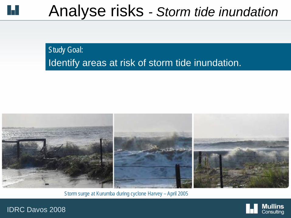
Analyse risks - Storm tide inundation
Study Goal: Identify areas at risk of storm tide inundationIdentify areas at risk of storm tide inundation.
Storm surge at Kurumba during cyclone Harvey – April 2005
IDRC Davos 2008
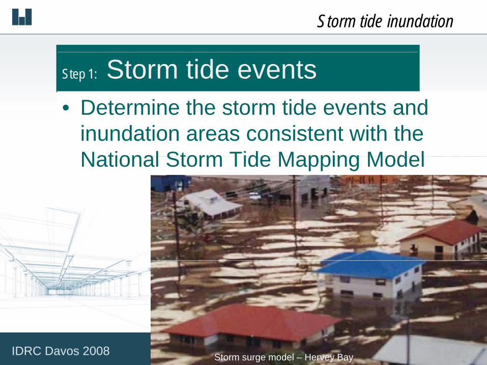
Storm tide inundation
Step 1: Storm tide eventsDetermine the storm tide events and• Determine the storm tide events and inundation areas consistent with the National Storm Tide Mapping ModelNational Storm Tide Mapping Model
Storm surge model – Hervey BayIDRC Davos 2008

Example Storm tide inundation
Storm tide zones for emergency response
Storm tide events
IDRC Davos 2008

Storm tide inundation
Step 2: Likelihood of inundationE ti t th t tid l l f t• Estimate the storm tide level for events which have a chance of occurring or b i d d i fbeing exceeded in any year of: 1/50, 1/100, 1/500, 1/1,000, 1/5 000 d 1/10 0001/5,000 and 1/10,000
Storm surge model – Hervey BayStorm tide damage in Mackay – January 1918

Storm tide inundation
Step 3: Likelihood of evacuation and shelterand shelter
• Estimate the evacuation and shelter probability for each of the storm tide eventsprobability for each of the storm tide events.
Tropical cyclone Ingrid – March 2005IDRC Davos 2008
F t t i t t ti f ti
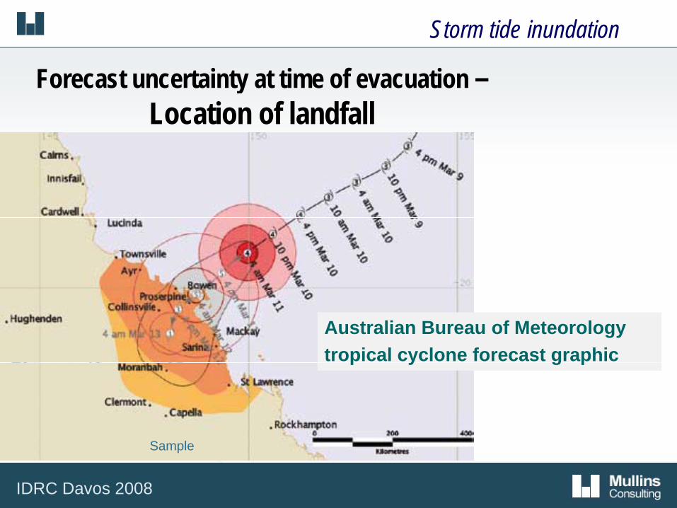
Storm tide inundation
Forecast uncertainty at time of evacuation –Location of landfall
Australian Bureau of Meteorologytropical cyclone forecast graphic p y g p
Sample
IDRC Davos 2008
F t t i t t ti f ti
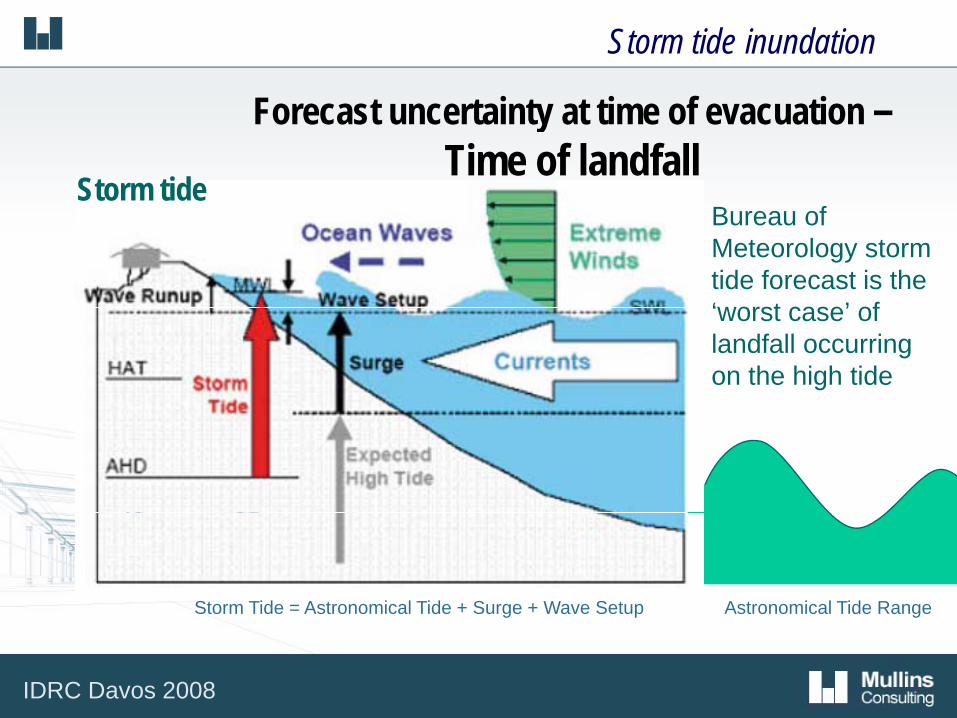
Storm tide inundation
Forecast uncertainty at time of evacuation –Time of landfall
Storm tide • Bureau of
Meteorology storm tide forecast is the ‘worst case’ of‘worst case’ of landfall occurring on the high tide
Astronomical Tide Range Storm Tide = Astronomical Tide + Surge + Wave Setup gg p
IDRC Davos 2008

Example Storm tide inundation
Likelihood of storm tide evacuation and shelter
IDRC Davos 2008
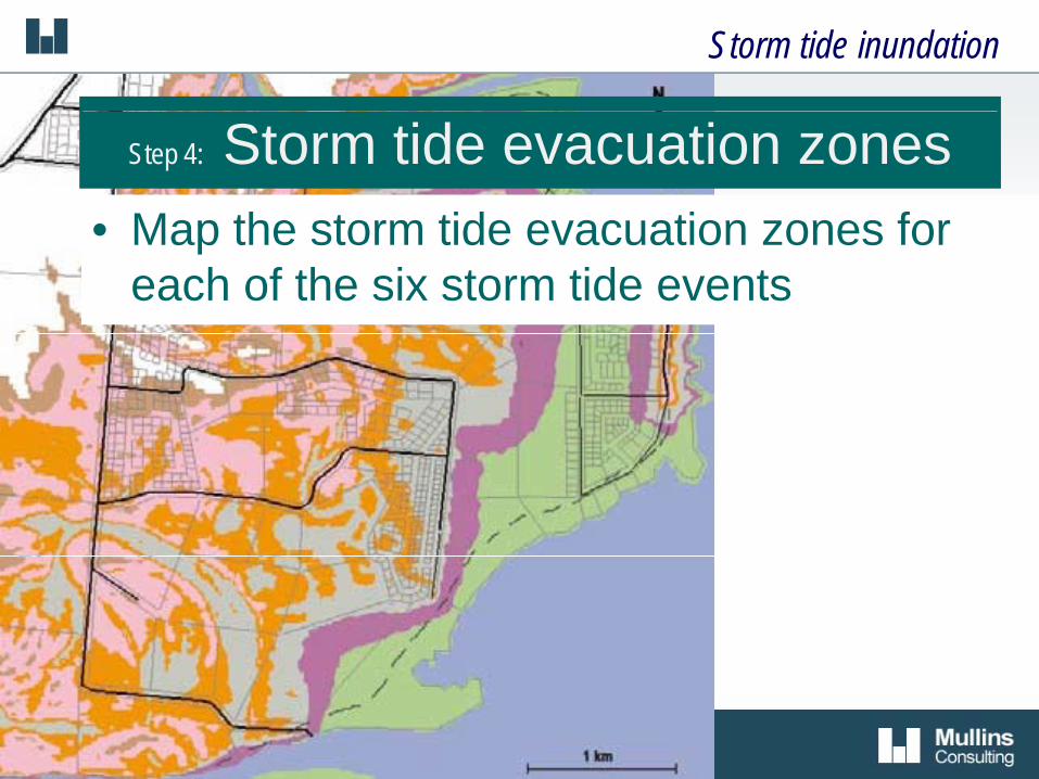
Storm tide inundation
Step 4: Storm tide evacuation zonesMap the storm tide evacuation zones for• Map the storm tide evacuation zones for each of the six storm tide events

Storm tide inundation
Storm tide event inundation areas– Evacuation zones
Frontal area evacuation level is higher to allow for effects of breaking ocean waves
Inland Area Evacuate zones 1 to 4
Frontal Area Evacuate zones 1 to 6
breaking ocean waves
IDRC Davos 2008

Example Storm tide inundation
Event 3 - Evacuation zone
IDRC Davos 2008

Analyse risks - Ability to evacuate Study Goal: Study Goal: Identify the number of people, reliable routes andtime to move from evacuation zones to shelter.
IDRC Davos 2008
Ability to evacuate
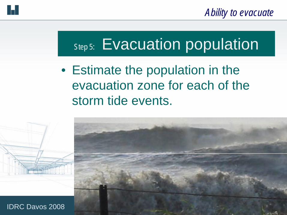
Step 5: Evacuation population• Estimate the population in the
evacuation zone for each of the storm tide events.
IDRC Davos 2008

Ability to evacuate
Step 6: Designated evacuation routes
• Identify evacuation routes and modes of travel for all areas to be evacuated.
• Map the designated evacuation routes.
IDRC Davos 2008

Ability to evacuate
Step 7: Route capacity
• Determine the capacity of, and travel time along, the evacuation routes.g
IDRC Davos 2008

Ability to evacuate
Step 8: Route vulnerabilityQuantify the vulnerability to hazards• Quantify the vulnerability to hazards which may block the evacuation route.
IDRC Davos 2008

Ability to evacuate
Step 9: Evacuation timelines
• Determine the evacuation timelines for each storm tide evacuation event and present the timelines graphically.
IDRC Davos 2008

Example Ability to evacuate
E ac ation timelines E ents 1 & 2Evacuation timelines – Events 1 & 2
IDRC Davos 2008

Analyse risks - Wind resistance
Study Goal: Identify housing complying with cyclone buildingstandards and the population evacuating fromhousing above the storm tide evacuation zone.
IDRC Davos 2008

Wind resistance of housing
Step 10: Map complying housing
• Map suburbs and developments which are built to cyclone building standardsare built to cyclone building standards.
IDRC Davos 2008

Wind resistance of housing
Step 11: Housing vulnerable to wind • Estimate the population in structurally
vulnerable accommodation, such as caravan and temporary buildings, and the population housed in accommodation which does not comply with cyclone building standards.
IDRC Davos 2008

Wind resistance of housing
Step 12: Population evacuating housing
• Estimate the number of people housed above the storm tidehoused above the storm tide evacuation zone who may evacuate.
IDRC Davos 2008

Analyse risks - Ability to shelter
Study Goal: Identify areas to shelter and estimate theypopulation seeking shelter.
IDRC Davos 2008

Sh lt t h tAbility to shelter
Step 13: Shelter catchment • Map the shelter catchment.
Step 14: Shelter zone • Map the shelter zone and suburbs or
developments constructed to cyclone building standards.
P bli l h ltStep 15: Public cyclone shelter zone • Map the public shelter zone and the location of
public cyclone shelters.
IDRC Davos 2008

Example Ability to shelter
Event 3 - Evacuation zone, evacuation routes and shelter zones
IDRC Davos 2008
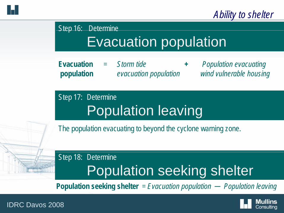
Ability to shelterStep 16: Determine Step 16: Determine
Evacuation population Evacuation = Storm tide + Population evacuating population evacuation population wind vulnerable housing
Step 17: Determine
Population leaving The population evacuating to beyond the cyclone warning zone.
Step 18: Determine
Population seeking shelter Population seeking shelter = Evacuation population ─ Population leaving
IDRC Davos 2008

Ability to shelter
Step 19: Sheltering within the community
• Determine the population sheltering within the community and the capacity of thethe community and the capacity of the community to provide shelter.
IDRC Davos 2008

Ability to shelter
Step 20: Public cyclone shelters
• Determine the population seeking shelter, and the capacity to shelter, in p ypublic cyclone shelters for each storm tide evacuation event.
IDRC Davos 2008

Evaluate risks Study Goal: Study Goal: Evaluate the risk to Queensland communities inevacuation and shelter from severe tropical cyclones.p y
Standarised quantified statement for each risk
IDRC Davos 2008

Evaluate risks
Storm tide inundation risk statement:‘For each storm tide event there is a specific probability that a certain number of people will need to evacuate and seek shelter:’
IDRC Davos 2008

Ability to evacuate risk statement:Evaluate risks
Ability to evacuate risk statement:‘There are events where people will not be able to evacuate to a shelter zone in less than 6 hrs’zone in less than 6 hrs
IDRC Davos 2008

Evaluate risks
Wind resistance of housing risk statement:
Example:
‘700 people live in dwellings which do not comply with cyclone building standards, this represents 70% of the population ‘
Ability to shelter risk statement:‘There are events where:
• more people are seeking shelter than are housed in dwelling complying with cyclone building standards
• people who have evacuated and are seeking shelter will not be able to shelter in complying buildings ‘

Treat risks - mitigation Study Goal:
Preparedness
Study Goal: Identify schemes to reduce community vulnerability.
Preparedness• Plan for the evacuation and shelter of
communities based upon current infrastructure
Infrastructure planning• Identify infrastructure solutions to y
safeguard vulnerable communities
IDRC Davos 2008

Conclusion
P id l l t ith d t il d Provides local governments with detailed guidance on a risk management study which
evaluates community vulnerability– evaluates community vulnerability– informs development planning,
disaster management planning and disaster management planning and emergency response operations
IDRC Davos 2008

IDRC Davos 2008