downstream effects of the lower churchill hydroelectric...
TRANSCRIPT

Downstream Effects of the Lower Churchill Hydroelectric Project: Terrestrial Issues Review and Some Proposed Approaches
Churchill River Delta in Inner lake Melville, Labrador
Image Credit: Google Earth
Prepared for
Submitted to
SA1111
17 January 2011


Downstream Effects of the Lower Churchill Hydroelectric Project: Terrestrial Issues Review and Some Proposed Approaches
Prepared by
Ian Goudie, Ph.D.
For
LGL Limited environmental research associates
P.O. Box 13248, Stn. A St. John's, NL
A1B 4A5 709 754-1992 (phone)
709 754-7718 (fax) [email protected]
www.lgl.com
and
Nalcor Energy Columbus Drive St. John’s, NL
SA1111
24 January 2011

SA1111 Downstream Effects of LCHP LGL Limited 17Jan2011
ii
Suggested citation for this report: Goudie, I. 2011. Downstream Effects of the Lower Churchill Hydroelectric Project: Terrestrial Issues Review and Some Proposed Approaches. LGL Report No. SA1111. Prepared for NALCOR ENERGY. 76 pp + appendices.
SA1111 Downstream Effects of LCHP LGL Limited 17Jan2011
iii
TABLE OF CONTENTS List of Figures ................................................................................................................................ iv List of Tables .................................................................................................................................. v List of Appendices ......................................................................................................................... vi Executive Summary ...................................................................................................................... vii 1.0 Introduction ............................................................................................................................ 1
1.1 Expanded Study Area ....................................................................................................... 2 1.2 Scientific Integrity of Environmental Assessment ........................................................... 3
1.2.1. Science-based Approach ........................................................................................... 3 1.2.2. Importance of Scientific Baseline ............................................................................. 5 1.2.3. Optimal Study Design ............................................................................................... 5
1.3 Ecosystem-based Approach .............................................................................................. 6 1.3.1. Ecological Integrity ................................................................................................... 6 1.3.2. General Principles Important to EBP ........................................................................ 7 1.3.3. Use of Ecological Indicators ..................................................................................... 7
1.4. Impact Prediction, Mitigation and Compensation ........................................................... 8 2.0 Downstream Effects Management ........................................................................................ 9
2.1. Integration of Ecological Approaches ............................................................................. 9 2.1.1. Environmental Flow Regimes (EFRs) .................................................................... 10 2.1.2. Ecosystem Health Indicators ................................................................................... 11 2.1.3. Site Selection Indicators ......................................................................................... 12 2.1.4. Risk Assessment ..................................................................................................... 12
3.0 Prescriptive Approaches to the Lower Churchill Hydroelectric Project ............................. 16 3.1 Ecosystem-based Planning.............................................................................................. 16
3.1.1 Ecosystem Function .................................................................................................. 16 3.1.2. Riparian Habitats ..................................................................................................... 17 3.1.3. Indicator Species ..................................................................................................... 23
4.0 Recommendations .............................................................................................................. 24 5.0 Literature Cited .................................................................................................................... 25 6.0 Appendices ............................................................................................................................ 30
Appendix 1. Information on the Ramsar Convention on Wetlands of International Importance.................................................................................................................................................... 30
7.0 Annex .................................................................................................................................. 32 Overviews of Information Presented in the Lower Churchill Hydroelectric Development EIS................................................................................................................................................... 32 Outline....................................................................................................................................... 32
General Overview of Priority Parameters ............................................................................. 33 Caribou .................................................................................................................................. 38 Riparian/Wetlands................................................................................................................. 44 ASHKUI ................................................................................................................................ 53 Species At Risk, Rare Plants and Habitats............................................................................ 62
SA1111 Downstream Effects of LCHP LGL Limited 17Jan2011
iv
List of Figures Figure 1. General ecological zone of the expanded study area for the Lower Churchill Hydroelectric Project, Labrador. ..................................................................................................... 3 Figure 2. Downstream Assessment Area proposed for the Lower Churchill Hydroelectric Project, Labrador. ......................................................................................................................................... 4 Figure 3 - The theoretical model of a Before-After-Control-Impact (BACI) study design with a significant effect following perturbation. ....................................................................................... 6 Figure 4. Direction of environmental protection planning integrating Environmental Impact Assessment (EIA), Ecological Risk Assessment (ERA) and Environmental Effects Monitoring (EEM). ............................................................................................................................................ 8 Figure 5. Range of natural variability and ecological risk for a hypothetical river. .................... 13 Figure 6. Example of risk thresholds for old growth forests. Source: (CIT 2005) .................... 13 Figure 7. Theoretical application of risk assessment of stream alteration to harvesting of old growth forests in a watershed. ...................................................................................................... 15 Figure 8. A large expansive wetland at the Elizabeth River confluence with the Lower Churchill River, Labrador. ............................................................................................................................ 18 Figure 9. Location of wetland areas in the Lower Churchill River Hydroelectric Project, Labrador.........................................................................................................................................19 Figure 10. Important confluence and coastal wetland habitats in downstream study area of the Lower Churchill Hydroelectric Project, Labrador. ....................................................................... 21 Figure 11. Intertidal wetlands in the Area of Geyts Point in Inner Lake Melville, Labrador ....... 22 Figure 12. Locations of ashkui (areas of early ice-free water) documented in the central Labrador region. ........................................................................................................................................... 59

SA1111 Downstream Effects of LCHP LGL Limited 17Jan2011
v
List of Tables Table 1. Ecological Land Systems with expanses of wetlands connected to the south shore of inner Lake Melville (based on Bajzak 1973) ................................................................................ 21 Annex Table 1. Parameters and strategies for expanding the study area of the Lower Churchill River Hydroelectric Project. ......................................................................................................... 34

SA1111 Downstream Effects of LCHP LGL Limited 17Jan2011
vi
List of Appendices 6.0 Appendices................................. .......................................................................................... 30
Appendix 1. Information on the Ramsar Convention on Wetlands of International Importance................................................ ................................................................................ 30

SA1111 Downstream Effects of LCHP LGL Limited 17Jan2011
vii
Executive Summary The Lower Churchill Hydroelectric Project (LCHP) has been reconfigured to initially focus on the Muskrat Falls development component. As part of its direction from the Joint Review Panel, Nalcor energy (Nalcor) is required to address downstream effects in more depth than in previous Nalcor submissions. During the review of the initial Environmental Impact Statement (EIS), the issue of downstream effects received extensive regulatory agency, First Nations, Environmental Non-Government Organization (ENGO), and public comments. The EIS provided no strong rationale for exclusion of downstream effects, and a number of reviewers pointed out that the World Commission on Dams (WCD) and other scientific sources especially note the importance of downstream effects from impoundments. LGL Limited environmental research associates (LGL) was retained by Nalcor and concluded that the aquatic and the aquatic components of the “terrestrial” Assessment Area should include at least Goose Bay and possibly inner Lake Melville of central Labrador. This report evaluated a suite of terrestrial (terrestrial-aquatic interface in many cases) issues arising from the EIS, and how these relate to a downstream area encompassed under Ecodistrict 452 of the inner Lake Melville area. This study suggests that a science-based focus under an ecosystem-based planning (EBP) approach is more likely to ensure that sustainable development is achieved. In addition to an adjustment of the Assessment Area, the approach proposed in this report presents unique challenges to Nalcor which in many respects will require a progressive environmental orientation to the design, operation and management of the LCHP. Because of the complexity of the processes that occur when a dam impacts an ecosystem, the WCD concludes that it is extremely difficult, and rarely possible, to predict in precise detail the magnitude and nature of impacts arising from the construction of a dam or a series of dams. Therefore, the application of the precautionary principle is considered particularly important for the LCHP because many predictions of potential downstream effects have a high degree of uncertainty. Emerging from the WCD is a science-based approach for new projects guided by the precautionary principle, particularly the integrated concepts of environmental flow releases (or regimes) (EFRs), ecosystem health indicators, site selection indicators, and risk assessment. These applications create an intricate interplay between project design/engineering and environmental sustainability, and require an interdisciplinary, ethical and financial commitment to adaptive management. Adopting the WCD approach would position Nalcor as an innovator in the state-of-the-art of ‘green (hydro) energy’. Within the constraints of available classification data, this report has attempted an EBP approach through the expansion of the ecological classification to encompass Ecodistrict 452 which is the inner Lake Melville area. Inner Lake Melville has extensive intertidal and estuarine wetlands, and the Lower Churchill River downstream of Muskrat Falls has extensive floodplain habitats. These habitats are among the most vulnerable to downstream effects of dams. At the estuary, high silt and nutrients loads mobilized during run-off are deposited under natural flooding leading to extensive shallow intertidal and estuarine habitats sustained wholly or in part by the run-off of Churchill River. The WCD elaborates on the importance of establishment of environmental flow regimes to mitigate and/or reduce negative impacts of downstream effects of dams, and therefore adequate baseline information, including control sites, are critical in the application of adaptive management. It is understood that Nalcor has considered flow regime
SA1111 Downstream Effects of LCHP LGL Limited 17Jan2011
viii
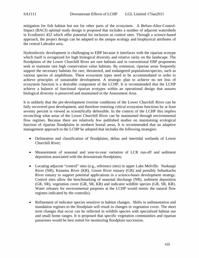
mitigation for fish habitat but not for other parts of the ecosystem. A Before-After-Control-Impact (BACI) optimal study design is proposed that includes a number of adjacent watersheds in Ecodistrict 452 which offer potential for inclusion as control sites. Through a science-based approach, the project design can be adapted to the unique ecology and biophysical attributes of the central Labrador area. Hydroelectric development is challenging to EBP because it interfaces with the riparian ecotype which itself is recognized for high biological diversity and relative rarity on the landscape. The floodplains of the Lower Churchill River are rare habitats and in conventional EBP proponents seek to maintain rare high conservation value habitats. By extension, riparian areas frequently support the necessary habitats for rare, threatened, and endangered populations/species, such as various species of amphibians. These ecosystem types need to be accommodated in order to achieve principles of sustainable development. A strategic plan to achieve no net loss of ecosystem function is a desirable component of the LCHP. It is recommended that the LCHP achieve a balance of functional riparian ecotypes within an operational design that assures biological diversity is preserved and maintained in the Assessment Area. It is unlikely that the pre-development riverine conditions of the Lower Churchill River can be fully recovered post development, and therefore restoring critical ecosystem functions by at least seventy percent is viewed as scientifically defensible. In the context of the LCHP this implies reconciling what areas of the Lower Churchill River can be maintained through environmental flow regimes. Because there are relatively few published studies on maintaining ecological function of riparian floodplains in northern boreal areas, It is recommended that an adaptive management approach to the LCHP be adopted that includes the following strategies:
• Delineation and classification of floodplains, deltas and intertidal wetlands of Lower Churchill River;
• Measurement of seasonal and year-to-year variation of LCR run-off and sediment
deposition associated with the downstream floodplains;
• Locating adjacent “control” sites (e.g., reference sites) in upper Lake Melville. Naskaupi River (NR), Kenamu River (KR), Goose River estuary (GR) and possibly Sebaskachu River estuary to support potential applications in a science-bases development strategy. Control sites allow the benchmarking of seasonal discharge (NR), sediment deposition (GR, SR), vegetation cover (GR, SR, KR) and indicator wildlife species (GR, SR, KR). Water releases for environmental purposes at the LCHP would mimic the natural flow regimes indicated by the control(s).
• Refinement of indicator species sensitive to habitat changes. Shifts in sedimentation and
inundation regimes to the floodplain will result in changes in vegetation cover. The short term changes that occur can be reflected in wildlife species with specialized habitat use and small home ranges. It is proposed that specific vegetation communities and riparian passerines would be best suited for monitoring floodplain succession.

SA1111 Downstream Effects of LCHP LGL Limited 17Jan2011
ix
Several protocols are further recommended to address the longer term environmental management of the Lower Churchill Hydroelectric Project:
1. Facilitate designation of the Lower Churchill River delta and inner Lake Melville as
wetlands of international importance, i.e., the Ramsar Convention. 2. Establish an environmental trust fund that will ensure funding to monitoring and adaptive
management throughout the life of the project. 3. Establishment of an independent scientific advisory body supported by ETF to help guide
scientific research and adaptive management applications. 4. Develop cooperative research arrangements with academic institutions. 5. Establish a system for independent auditing of environmental performance for annual
effects monitoring and adaptive management.

SA1111 Downstream Effects of LCHP LGL Limited 17Jan2011
1
1.0 Introduction In an overview of the Lower Churchill Hydroelectric Generation Project (LCHP) Environmental Impact Statement (EIS) and the responses received from interveners and public, LGL Limited environmental research associates (LGL) concluded that the aquatic and the aquatic components of the “terrestrial” Assessment Area should include at least Goose Bay and possibly inner Lake Melville (draft report by Buchanan and Goudie 2010). The EIS provided no strong rationale for exclusion, and a number of reviewers pointed out that the World Commission on Dams (WCD) (Bergkamp et al. 2000) and other scientific sources (e.g., Nilsson and Dynesius 1994; Thingstad and Reitan 1999) especially note the importance of downstream effects from impoundments may affect ecosystems, and the people that depend on them, for tens to thousands of kilometres downstream. In correspondence of November 2, 2010, the Joint Review Panel (JRP) highlighted that Nalcor’s hydrology studies indicate that the Churchill River exerts a strong influence on the estuarine regime in Goose Bay, and concerns have been expressed by a number of participants regarding the downstream effects of the Project. The JRP further directed the Proponent to elaborate on downstream effects. An adjustment of the Assessment Area boundaries is now necessary, and this report evaluated the suite of issues arising from the EIS and how these relate to the downstream area. In this document, working hypotheses are developed to aid in predicting effects to riparian and terrestrial ecosystems associated with the proposed development. This report represents a science-based approach to help guide ecosystem-based planning (EBM) for the LCHP by developing a strategy for precautionary planning and subsequent adaptive management of ‘downstream effects’ relating to aquatic-terrestrial Valued Ecosystem Components (VECs) and Key Indicators (KIs). The arising issues are linked to critiques expressed by reviewers (regulatory agencies and ENGOs) for other sectors of the proposed LCHP (e.g., ashkui occur in the original and the proposed extended Assessment Area). In preparation for panel hearings, LGL previously assessed the scientific rigor of the EIS and the supporting component studies by evaluating the quality of existing and newly-generated data for impact prediction, the inclusion and interpretation of relevant literature, and evaluating the likelihood of downstream effects. In Annex 1, we more exhaustively evaluate the presentation of a number of VECs and/or KIs. This report is not intended to be an exhaustive treatment of all ecosystem components implicated in the revised Assessment Area and the EIS. In general, the findings for the focal components can be extrapolated to other constituents of the project. The scope of work required a general overview of the EIS in order to assess:
• Approaches to identification and management of downstream effects related to a revised Assessment Area;
• Scientific literature and adaptive management practices relevant to hydroelectric developments;
• Scientific rigor of studies undertaken, and the ability of resulting findings to support impact prediction;
• Scientific validity of concerns/critiques submitted to the federal-provincial review panel to date; and
• Needs for further studies, mitigation, monitoring and/or compensation to bring the issues to a level suitable for acceptance by the public and regulatory agencies.

SA1111 Downstream Effects of LCHP LGL Limited 17Jan2011
2
Based on these assessments, a conceptual approach was developed for sustainable development of the LCHP in relation to the expanded Assessment Area. Concepts for an ecosystem-based approach (EBP), environmental effects monitoring (EEM), environmental flow requirements (EFR), ecological risk, mitigation and compensation are provided. Through such an approach it is expected that the revised project would receive a broad base of support from environmental groups, regulatory agencies and the general public.
1.1 Expanded Study Area Impact evaluation and prediction was expanded downstream of the original Assessment Area to include ecodistict 452 of the Lake Melville Ecoregion, that is, the inner Lake Melville area, including the Goose Bay and Grand Lake basins, adjoining backshores and upstream on Churchill River to Winokapau Lake and lower Minipi River, and encompassing Naskaupi and Red Wine Rivers (Fig. 1). This ecoregion surrounds Lake Melville in southeastern Labrador. It is a narrow extension of the boreal forest into the Taiga Shield ecozone. It is marked by humid, cool summers and cold winters. The mean annual temperature is approximately -2°C. The mean summer temperature is 8.5°C and the mean winter temperature is -13°C. The mean annual precipitation ranges 800-1000 mm. This ecoregion is classified as having a perhumid high-boreal ecoclimate. Its mixed forests are dominated by productive, closed stands of balsam fir, black spruce, white birch, and trembling aspen. This ecoregion comprises all of Melville Plain and portions of river valleys entering the plain from Mecatina and Hamilton plateaus. It is basically an irregular lowland much dissected by river valleys. Elevations are generally close to sea level, to about 300 m asl, although a few hills reach about 500 m asl. This ecoregion includes some of the best timberland in Labrador. It provides habitat for caribou, moose, small mammals, birds, and waterfowl. An ecodistrict is a subdivision of an ecoregion characterized by distinctive assemblages of relief, landforms, geology, soil, vegetation, water bodies and fauna (Lopoukhine et al. 1977; Ecological Stratification Working Group, Environment Canada 1995). This proposed extension to the Assessment Area includes downstream of the LCHP likely to be affected by any changes in hydrology and sedimentation, and is tentatively proposed to include a 2.5 km buffer adjacent to the waterline (Fig. 2). An optimal study design for environmental effects assessment (Green 1979) should include control or reference area (s) separate from the treatment site similarly sampled before and after the development (see Optimal Study Design below), and it is recommended that include the lower reach of the Naskaupi River (NR) and the estuaries of the Kenamu River (KR), Goose River (GR) and possibly Sebaskachu River (SR) for aspects of environmental effects monitoring (EEM) and adaptive management. These sites were selected because (1) they provide estuarine habitats into Lake Melville (KR, GR, SR), (2) they are large watersheds (e.g., NR) originally affected by the Upper Churchill Hydroelectric Project (UCHP), (3) they provide deep valley ecological types similar to the LCR (e.g., NR), and (4) support intertidal wetlands (e.g., KR, GR, SR). Because application of the precautionary principle and subsequent adaptive management are desirable practices for Nalcor, it is important to apply an optimal study design in order to effectively monitor both predicted and unanticipated effects.

SA1111 Downstream Effects of LCHP LGL Limited 17Jan2011
3
Figure 1. General ecological zone of the expanded study area for the Lower Churchill Hydroelectric Project, Labrador.
1.2 Scientific Integrity of Environmental Assessment
1.2.1. Science-based Approach Most environmental assessments (EA) require considerable original research in order to confidently identify and mitigate impacts in detail (Hansen et al. 2009). It is extremely difficult and rarely possible to predict in precise detail the magnitude and nature of impacts arising from the construction of a dam or a series of dams [The World Commission on Dams (WCD); Bergkamp et al. 2000]. Therefore, the application of the precautionary principle is considered particularly important to the LCHP because of the complexity of the processes that occur when a dam impacts an ecosystem.

SA1111 Downstream Effects of LCHP LGL Limited 17Jan2011
4
Figure 2. Downstream Assessment Area proposed for the Lower Churchill Hydroelectric Project, Labrador. An EA that has scientific credibility reduces the potential for professional and societal criticism (e.g., Matthews 1975; Schindler 1976; Rosenberg et al. 1981). Thus, it is important that the LCHP EIS, prepared by a public utility, provide a rigorous scientific approach. A scientific approach is defined as conclusions based on data collected to test a research hypothesis. To truly address potential environmental impacts it is necessary to quantify the natural variation in the ecosystem and contrast this with the variation evident in ‘indicators’ following the development. Monitoring would not be necessary if knowledge was sufficient to make environmental impact predictions with complete confidence. However, for complex developments in complex environments this is never the case. Thus, progress in EA can only be made through comparison of expectations (predictions) with the reality of actual outcomes through measurements and analyses of results (Hansen et al. 2009). The EA itself rarely provides scientific data to establish the presence or lack of an effect because the development or perturbation is generally at the proposal stage. EA should include post-project monitoring when reasonable uncertainty exists that predicted outcomes will be realized (Canadian Environmental Assessment Act 2003).

SA1111 Downstream Effects of LCHP LGL Limited 17Jan2011
5
1.2.2. Importance of Scientific Baseline A scientific framework for data collection and establishment of baseline conditions is essential if conclusions are to be made based on post-project monitoring. Science can contribute to environmental impact assessment at an applied level when testable research hypotheses are formulated that lead to measurements of environmental variables. Descriptive studies are valuable to the extent that they are used to direct and focus the longer-term experimental studies because they provide a basis for the conceptualization and formulation of workable hypotheses (Beanlands and Duinker 1983). It may be difficult to draw conclusions from the follow-up program if there is a poor understanding of the baseline conditions and ecological trends, and the environmental effect predictions were vague and qualitative (Canadian Environmental Assessment Act 2007). Green (1984) noted that any environmental study should be a logical flow of purpose, question, hypotheses, model, sampling design, statistical analyses, tests of hypotheses, interpretation, and presentation of results. Progress in the practice of EA and our understanding of ecosystem response to perturbations can only be made through comparison of expectations (predictions) with the reality of actual outcomes through measurements and analyses of results. Inventories are not, in themselves, support for EA predictions, and proponents undertaking EAs are advised to use inventories of natural resources (based on surveys, existing knowledge, and anecdotal information) to improve scientific predictions. In many cases follow-up studies are necessary to test predictions refined from preliminary field studies and EA preparations (Hansen et al. 2009).
1.2.3. Optimal Study Design Environmental effects studies are designed to assess the environment before and after the human perturbation, and the optimal study design has one or more controls sites separate from the treatment site that is similarly sampled before and after the perturbation (Fig. 3). This sets the stage for the Before-After-Control-Impact (BACI) study design, and the ability for proponents to mitigate impacts is only as functional as the quality of the scientific work undertaken to measure effects in the first place. There is a quantum difference between studies that are merely descriptive and those that are designed to establish ‘baseline conditions’ in the context of a BACI model. Techniques to address study design, assessment of data types, statistical analyses, power tests and determination of effect size are well developed in the scientific literature and by Environment Canada (Hansen et al. 2009).

SA1111 Downstream Effects of LCHP LGL Limited 17Jan2011
6
Impact Occurs In Year2
YEAR
0 1 2 3 4 5 6 7
Mon
itore
d B
iolo
gica
l Var
iabl
e
0
2
4
6
8
10
12
14
Control SiteTreatment Site
Figure 3 -
The theoretical model of a Before-After-Control-Impact (BACI) study design with a significant effect following perturbation.
1.3 Ecosystem-based Approach
1.3.1. Ecological Integrity An ecosystem-based approach is appropriate for environmental planning of the LCHP, and integrates a number of principles assimilated from the scientific literature, notably: Coast Information Team (CIT) 2004, Forest Stewardship Council (FSC); Grumbine 1994, 1997; Hammond (1994, 2002, and 2005). The EIS commits to maintaining ecological integrity that is here defined as protecting, maintaining, or restoring natural ecosystem composition, structure, and function, in other words, the parts, the arrangement of the parts, and the processes of ecosystems (Hammond 2005). Ecosystem-based planning is necessary in order to protect and maintain ecological health and biological diversity at all scales, from small land and water ecosystems to large landscapes. Human cultures and economies depend on healthy ecosystems and biological diversity (our natural capital). Planning human activities that protect, maintain, and restore ecosystem health and biodiversity is the basis for developing sustainable human economies and cultures (Hammond 2002).

SA1111 Downstream Effects of LCHP LGL Limited 17Jan2011
7
1.3.2. General Principles Important to EBP
EBP includes the following principles:
1. Apply the precautionary principle to all plans and activities in order to deal with uncertainties by directing that decisions, interpretations, plans and activities to err on the side of protecting ecosystem functioning, as opposed to erring on the side of protecting resource exploitation.
2. Maintain and restore ecological integrity, which is the full range of composition, structures,
and functioning of enduring features, natural plant communities, and animal habitats/ranges.
3. Within the constraints of the precautionary principle and ecological responsibility, develop
plans which contain testable hypothesis, and explicit strategies for monitoring of adapting management practices to achieve ecological integrity and/or adapt to new and/or unforeseen results.
4. Focus strategies on high conservation habitats (e.g. riparian areas and old growth forests),
sensitive sites and habitat needs for species at risk so that they are protected or restored to a level sufficient to mitigate detrimental effects.
Within the constraints of available classification data, the present report has attempted an EBP approach through the expansion of the ecological classification to encompass Ecodistrict 452 which is the inner Lake Melville area (Fig. 1). Lake Melville has extensive intertidal and estuarine wetlands (Harlequin Enterprises 2004), and these habitats are among the most vulnerable to downstream effects of dams (Bergkamp et al. 2000). The Lower Churchill River downstream of Muskrat Falls has extensive floodplain habitats, and at the estuary, high silt and nutrient loads are mobilized and deposited under natural flooding with run-off regimes leading to extensive shallow intertidal and estuarine habitats in Lake Melville and inner Groswater Bay that are likely sustained mostly by Churchill River run-off. There are a suite of adjacent watersheds in this ecodistrict that offer potential for inclusion as control sites.
1.3.3. Use of Ecological Indicators An important aspect of the refinement of downstream effects is the definition of ecological indicators that are developed to define baseline conditions, and subsequently used to monitor mitigation and sustainable development of the LCHP. The WCD elaborates on the importance of establishment of environmental flow regimes to mitigate and/or reduce negative impacts, and therefore adequate baseline information as well as control sites are critical in the application of adaptive management. Through this, the project design can be adapted to the unique ecology and biophysical attributes of the central Labrador area (see Section 2.1.2. below).

SA1111 Downstream Effects of LCHP LGL Limited 17Jan2011
8
1.4. Impact Prediction, Mitigation and Compensation Emphasis in EA is on anticipation or prediction of impacts, and hence there needs to be a commitment to focus on monitoring of environmental conditions with developments in place (Duinker 1989). Direction for effects monitoring is provided in the Canadian Environmental Assessment Act (CEAA) as “follow-up programs”. Effective protection of the environment relies on the consideration of environmental legislation, EA, ecological risk assessment (ERA) and EEM, all of which feed into an environmental protection plan (EPP) (Curran et al. 2006) (Fig. 4). Mitigation by definition requires ‘measures’ to avoid, reduce or eliminate impacts, and hence can only be reconciled if the impacts themselves have been quantified. Scientific evidence for environmental impact should be based on changes in the impact area that did not occur in the control area (Green 1979). Establishment of suitable ‘control’ sites are an essential component of environmental impact assessment. At the ecosystem level, conservation of ecosystem integrity is especially focused on biological diversity, and EA practitioners are advised to minimize impact on biological diversity by adopting the guiding principle of no net loss of ecosystem function through maintenance of habitat connectivity, species populations and/or genetic diversity (Environment Canada 1996). To achieve this, decisions, interpretations, plans and activities should err on the side of protecting ecosystem functioning with priority focus on species at risk (Environment Canada 2004). Adaptive management is exercised within the constraints of the precautionary principle in that a variety of actions that do subsequently proceed are continuously evaluated (against a ‘control’) and optimized to maintaining or restoring ecological health and biological diversity (Hammond 2002).
Figure 4. Direction of environmental protection planning integrating Environmental Impact Assessment (EIA), Ecological Risk Assessment (ERA) and Environmental Effects Monitoring (EEM).

SA1111 Downstream Effects of LCHP LGL Limited 17Jan2011
9
2.0 Downstream Effects Management
2.1. Integration of Ecological Approaches Riparian habitats are often the focus of landscape conservation because of their high biological diversity; for example, they may support over 85% of songbird species in some geographic areas (Fischer 2000). Project planning can include environmental engineering in order that impacts on various riparian habitats be minimized, avoided or compensated (Bergkamp et al. 2000). Hence, for example, maintenance of a steady reservoir level can improve potential for shoreline re-vegetation. In other cases, spilling of water in spring can mimic seasonal inundation of downstream floodplains. In some situations wetlands in the upper watershed can be spared inundation by reducing reservoir operating levels. All in all, environmental mitigations can have associated costs that are components to achieving environmental sustainability. Tools to foster ecosystem health include:
• Environmental Flow Releases. EFRs are being used in 25 countries and today serve as the single most important tool for managing the riverine ecosystem and associated impacts of dams (Bergkamp et al. 2000). Their use has increased in importance during the last three decades as it has become apparent that flow manipulations are causing serious degradation of river ecosystems. The level of (environmental) costs involved is now sufficiently high for EFRs to be increasingly accepted worldwide as an essential tool for water-resource management, especially where downstream livelihoods may be threatened. The WCD suggests that EFRs need to be developed as part of dam design. However, for existing dams they can be introduced as a means of monitoring or restoring downstream ecosystems. [It is understood that the LCHP will be releasing water for the maintenance of fish habitat but it is unclear if due consideration has been allocated to other parts of the ecosystem.]
• Ecosystem Health Indicators. In order to achieve proactive requirements for maintaining
(or restoring) healthy ecosystems, investments are made in the development of indicators of ecosystem health. These can be used for setting targets for mitigation, compensation and restoration of ecosystems impacted by dams.
• Site Selection Indicators. The World Bank has identified six key indicators of site selection
that help minimize ecosystem impacts, namely: reservoir surface area; water retention time in the reservoir; biomass flooded; length of river impounded; number of inflows to mainstream from undammed down-river tributaries; and access roads through sensitive areas. Use of these Indicators can be promoted and refined on the basis of experience.
• Risk Assessment. Risk assessment consists of five steps: (1) identify indicators for the
elements, processes or functions that are the focus of the assessment, (2) defining the relationship between indicator values and risk, (3) determine acceptable level of risk, (4) calculation of indicator values for different management options, and (5) determining risk associated with indicator values and comparing with acceptable levels.

SA1111 Downstream Effects of LCHP LGL Limited 17Jan2011
10
2.1.1. Environmental Flow Regimes (EFRs) 2.1.1.1. Seasonality and Floodplains Major changes to downstream riverine habitats, first by reduction of river flow and removal of much of its previous seasonal variability causes changes in sediment movement and stabilizes channel morphology. Dam capacity management during major floods can also lead to sudden major releases of water (‘spilling’), creating major floods in downstream areas in river systems that have little or no flood activity within or across years. This affects suitability of the river system below dams for species adapted to colonizing river banks and sandbars between river channels (Bergkamp et al. 2000). Appropriate flow regulation permits flow variation, reflecting the natural hydrograph (Poff et al. 1997; Richter et al. 1997, Richter and Richter 2000), and in the last decade there have been substantial advances in the area of environmental flow regimes (Kauffman et al. 1997, Rood et al. 2005). The Proponent is interested in environmental conservation, and therefore needs to understand the hydrologic needs of floodplain ecosystems (not just fish habitat) of the Lower Churchill River because altering the flow regimes will affect the riparian ecosystems (Nilsson and Berggren 2000). Rivers display seasonal flow variation as a result of meteorological patterns. In north boreal areas in North America, peak flows occur regularly in late spring, as rising temperatures result in snowmelt which combines with spring rains (Mahoney and Rood 1998). Aquatic and riparian biota are adapted to this repetitive pattern, so that their life histories are coordinated with seasonal flows (Johnson 2000; Lytle and Poff 2004). Because there are a number of different adaptive strategies and life cycles associated with river and floodplain organisms, different flow regimes and ecological objectives may be necessary for dry, normal, and wet years (Amlin and Rood 2002; Karrenberg et al. 2002, Richter et al. 1997; Rood and Mahoney 1990). In the Ob River, Yenisey River and other large Siberian rivers that drain into the Arctic Ocean, the timing of the annual ice break-up strongly influences the duration and extent of floodplain inundation, and thus the rate of sediment delivery to the floodplain. Compared with river water entering the floodplain, the water that drains from the floodplain wetlands system has a much lower suspended sediment concentration and elevated organic carbon content, factors that are important for the coastal ecosystems of the Arctic Ocean (Smith and Sidorchuk 1999). Confluences are dynamic because of differences in flood timing, flood magnitude, sediment load and sediment grain size between the main stem and tributary channels. 2.1.1.2. Sediment Trapping Trapping of sediment behind dams has resulted in a global trend toward reduced downstream sediment supply (Bergkamp et al. 2000). For most basins in the northern hemisphere, the range of annual sediment discharges is far wider than the range of annual water discharges (Walling and Fang 1999). This creates uncertainty in any estimate of mean annual sediment flux because variation is likely to be very large, and downstream river channels, floodplains, and resident ecosystems may be adapted as much to the natural variations in sediment supply as to the annual sediment flux as averaged over decadal time scales.

SA1111 Downstream Effects of LCHP LGL Limited 17Jan2011
11
2.1.1.3. Sediment Exchange between Floodplains and River Channels Sediments enter each reach by in-channel suspended load and bedload transport, from local tributaries and by bank erosion (Dunne et al. 1999). Sediment leaves the reaches by deposition on bars, diffuse over-bank flow, by flow into floodplain channels leading to lakes and other off-channel waterbodies, and by in-channel transport. The magnitude of annual sediment exchange between the river and floodplain typically exceeds the magnitude of downstream annual sediment flux, often by a factor of nearly two indicating that sediment supply in the channel can be dominated by interaction with the floodplain. The floodplain is closely coupled to the channel system and thus is vulnerable to even subtle changes in channel sediment transport capacity and supply caused by construction of dams upstream. There is often scouring of river bed below dams due to lower sediment content of released water, and therefore less sediment replacement on the floodplains. Reduction in sediment supply from upstream can lead to channel bed erosion and deepening of the channel cross-section, which in turn reduces the frequency and duration of over-bank flooding hence limiting sediment flux to the floodplain. Floodplain ecosystems then experience a reduction in the supply of vital nutrients carried by fine-grained suspended sediments (Ligon et al. 1995). 2.1.1.4. Environmental Flow versus Plantings A vital area of emerging scientific knowledge is the assessment of EFRs, which deals with the amount, timing, and conditions under which water should be released by dams, to enable downstream river ecosystems to retain their natural integrity and productivity. Blanket minimum flow requirements, such as 10% minimum flow do not address the needs of riverine ecosystems. Taking account of the dynamic nature of rivers requires optimum flows, often including periodic managed floods. It is important to recognise that these are releases specifically for environmental purposes, that is, they do not include flows incidental to electrical generation or necessary for downstream commercial or water supply purposes. Where flows are released for commercial as well as environmental purposes, the term in-stream flows is generally used (Petts 1996, 1984). Dams are built to modify the timing and distribution of water; operational rules are generally based on narrow economic criteria. An environmental flow is a mitigation measure aimed at restoring appropriate flow dynamics and contrasts with artificial measures such as vegetation plantings, which are usually only locally effective and often require periodic replenishment (Alpert et al. 1999; Friedman et al. 1998). Furthermore, these restoration measures will fail if the underlying hydro-geomorphic processes remain uncorrected (Kauffman et al. 1997). In contrast, when in-stream flows are improved, natural restorative processes are effective across a greater area than artificial remediation initiatives (Rood et al. 2003). For example, dams that have pulsing flood releases due to hydropower (demand) can systematically have a downstream re-regulating weir that levels out day to day flow oscillations.
2.1.2. Ecosystem Health Indicators An ecosystem-based approach to the LCHP requires deliberation on what species or species assemblages best provide indices of ecological integrity. Maximum plant and animal species diversity usually occurs near tributary junctions and deltas attributable to more active, and more

SA1111 Downstream Effects of LCHP LGL Limited 17Jan2011
12
temporally variable, sediment exchange between channel and floodplain (Rosales et al. 1999). These ecotypes and their associated riparian assemblages of plants and animals are a priority for preservation of ecosystem function. In-stream flow management can act as a broadly applicable tool for the restoration of floodplain forests (Rood et al. 2005). The approach here would be to identify ‘umbrella species’ or ‘indicator species’ whose viability is indicative of general ecosystem health. Rood et al. (2005) suggested two current priorities for research and application, namely:
1. Performance measures - empirical, quantitative measures of ecosystem response that provide the confirmation and quantification of ecosystem services that may be required to justify the restoration programs , and
2. Resizing rivers where, rather than seeking to restore a river system to its pre-development condition, a more practical objective is to establish a smaller (or larger) river system that displays the same essential ecosystem functions as the original river, but has been scaled to reflect the new hydrologic situation.
2.1.3. Site Selection Indicators
There are many factors in the selection of site for hydroelectric development that can reduce or minimize environmental impacts. The LCHP benefits from being located in a deep valley that will result in a relatively small inundation footprint. Often site selection is more predicated on structural engineering and hydrology. Nevertheless, the re-emphasis of the LCHP on initially building the Muskrat Falls component provides a window to study the implications of inundation levels of the Gull Island component on wetlands upstream of Winokapau Lake.
2.1.4. Risk Assessment
Risk is the probability of an adverse outcome and can be considered as the probability that an ecosystem or ecosystem function or indicator species will be changed or lost following a particular management activity. Risk assessment, sometimes defined by ‘risk curves’ is a way of estimating when thresholds or points are reached that indicate significant ecological changes are occurring. Determining acceptable levels of risk is an approach taken in EBP to inform other decision-makers of the potential implications of alternate decisions. Acceptable levels of risk attempt to maintain ecosystem functions within the range of natural variation (Fig. 5). Risk curves are explicit hypotheses about how management activities influence ecosystems. Explicitly drawn risk curves are useful to summarize current knowledge and to force consideration of uncertainty (Fig. 6). Explicit risk curves with defensible habitat thresholds help separate scientific knowledge from values in multi-stakeholder discussions. Implicit to the successful application of risk assessment is the determination of appropriate indicator variables. Good indicators respond to management, are related clearly to the objective, can be measured or described simply, are relatively insensitive to factors other than the management actions, and are appropriate for the purpose and scale. Risk for each indicator is

SA1111 Downstream Effects of LCHP LGL Limited 17Jan2011
13
classed from very low to high, where low risk begins at the threshold where adverse impacts could begin to be detected, and the transition to high risk corresponds to where significant loss of
Figure 5. Range of natural variability and ecological risk for a hypothetical river. Source: (CIT 2005)
Figure 6. Example of risk thresholds for old growth forests. Source: (CIT 2005)
SA1111 Downstream Effects of LCHP LGL Limited 17Jan2011
14
ecological function is expected to occur. Ideally, precautionary management targets, reflecting a commitment to achieve a high probability of maintaining ecological integrity should be equal to or below the low risk threshold. Management aims to not exceed the high risk threshold because there is a high probability that ecological and conservation values will not be sustained (CIT 2005). Criteria and their associated indicator species are considered key to EBP. The generally accepted approach is to proceed with low risk management and then incrementally toward high risk management if necessary. This is achieved through working at scales that allow risk management to be applied in small (manageable) scales that can be built-up across the landscape so that it is rolled-up into low risk at the bigger scale. Low risk management requires the establishment of absolute thresholds, which for old growth forests is seventy percent retention. At low risk there is a high probability of maintaining the populations of VECs whereas at thirty percent for old growth forests there is degradation into high risk (Price et al. 2007). Ideally, ecological management targets are based on benchmarks derived from knowledge of ecological patterns and processes and their historic variability. The focus in the environmental assessment is on synthesizing traditional, local, and scientific knowledge, expert opinion and risk assessment techniques to develop precautionary targets for key ecological values and objectives, and also to identify high risk thresholds which management should not exceed. Restoration is required when the pattern or process has been disturbed beyond established high risk thresholds (Figure 7).

SA1111 Downstream Effects of LCHP LGL Limited 17Jan2011
15
Figure 7. Theoretical application of risk assessment of stream alteration to harvesting of old growth forests in a watershed.
Source: (CIT 2005)
SA1111 Downstream Effects of LCHP LGL Limited 17Jan2011
16
3.0 Prescriptive Approaches to the Lower Churchill Hydroelectric Project
3.1 Ecosystem-based Planning Adopting an EBP approach to environmental planning of the LCHP raises a series of challenges for Nalcor. Conventional EAs have been largely handled as compartmentalized steps along the way to project construction and operation. With adoption of the precautionary principle and adaptive management, the planning, construction and operation are synergized with environmental design. Hydroelectric development is challenging to EBP because it interfaces with the riparian ecotype which itself is recognized for high biological diversity and relative rarity on the landscape. Rare habitats and species at risk represent the fine filters of EBP (Hammond 2002) meaning that proponents should aim to mitigate, minimize, and/or compensate for anticipated effects. The floodplains of the Lower Churchill River are rare ecotypes for the region and in conventional EBP proponents seek to maintain these habitats (Hammond 2002, 2005). Because the inner Lake Melville Ecodistrict 452 represents a narrow extension of the boreal forest into the Taiga Shield ecozone (ESWG 1995), the supported habitats are rare in this overall landscape of central Labrador. Hammond (2005) noted that within any landscape there are unique ecosystem types that comprise only small portions of the area and/or occur infrequently in dispersed patterns, throughout the geography. Rare or unique ecosystem types require protection, from the patch to the large landscape level, in order to maintain ecological integrity. By extension these ecotypes support the necessary habitats for rare, threatened, and endangered populations/species. These ecosystem types need to be accommodated in order to achieve principles of sustainable development. A strategic plan to achieve no net loss of ecosystem function is a desirable component of the LCHP. Biological diversity can be preserved and maintained in the Assessment Area by achieving a balance of functional riparian ecotypes within an operational design of the LCHP. The approach conceptualized in this report is the antidote to the notion that suitable habitats exist elsewhere and by default it is permissible to favour net habitat loss. No net loss of habitat (function) is premised on the notion that a net loss of habitat (function) is a net loss of the ecosystem to support natural biological diversity.
3.1.1 Ecosystem Function It is unlikely that pre-development riverine conditions can be fully recovered, therefore restoring critical ecosystem functions is viewed as a more feasible objective. In the context of the LCHP this implies that it is important to reconcile what areas or what proportion of floodplain habitats of the Lower Churchill River can be maintained through environmental flow regimes. There are relatively few published studies on maintaining ecological function of riparian floodplains in northern boreal areas. For low risk strategy (after Price et al. 2007), it is recommended that
SA1111 Downstream Effects of LCHP LGL Limited 17Jan2011
17
Nalcor embrace an objective to maintain seventy percent of downstream riparian habitats. For the LCHP, adaptive management should be supported in practice by:
1. Locating adjacent control sites or reference areas in upper Lake Melville, namely: Naskaupi River (NR), Kenamu River (KR), Goose River estuary (GR) and possibly Sebaskachu River estuary. These allow the benchmarking of seasonal discharge (NR), sediment deposition (GR, SR), vegetation cover (GR, SR, KR) and indicator wildlife species (GR, SR, KR). Water releases at LCHP would mimic the natural flow regimes indicated by the controls, and dynamics of vegetation should be convergent.
2. Refinement of indicator species sensitive to habitat changes. Shifts in sedimentation
and inundation regimes to the floodplain result in changes in vegetation cover. The short term changes that occur can be reflected in wildlife species with specialized habitat use and small home ranges. It is proposed that Nalcor refine specific vegetation communities and riparian passerines best suited for monitoring floodplain succession.
3. Development of direct revenue sharing or environmental trust funds (ETF) as tools to
ensure financial support for monitoring and adaptive management of riparian ecosystems throughout the project’s lifetime.
4. Establishment of an independent scientific advisory body supported by ETF to help
guide scientific research and adaptive management applications
3.1.2. Riparian Habitats Riparian habitats are important ecological units because they support high biological diversity, are relatively scarce and act as corridors promoting landscape connectivity. In the LCHP, riparian habitats comprise only 2,360 ha (1.4%) of the Project Area (163,400 ha) ecological land classification (ELC). These are in close association with wetlands that comprise another 3,850 ha (2.4%). Sixty percent (60%) or 3,726 ha of these habitats are predicted to be inundated by the Project, including most wetlands.
In order to meet the objectives of wetland conservation as outlined in the North American Waterfowl Management Plan, Ramsar Convention, and the UN Convention on Biological Diversity, Canada has adopted The Federal Policy on Wetland Conservation. This framework strives for the goal of ‘No Net Loss’ of wetland function. In a general sense, proponents are encouraged to mitigate potential impacts to wetlands and/or develop compensation strategies for those anticipated to be lost (A. Hansen, Environment Canada, pers. comm.). 3.1.2.1 Upstream Considerations An outcome of terrestrial component studies of the EIS was the delineation of extensive productive wetland sites over a 20 km reach of the Lower Churchill River from Fig River confluence at upper Winokapau Lake to 5 km upstream of Metchin River confluence (Fig. 8). In this low gradient area some 600 ha of wetlands (alluvial meadows and marshes) were associated with frequent remnant river oxbows, island channels, contained basins and confluences (Fig. 9,

SA1111 Downstream Effects of LCHP LGL Limited 17Jan2011
18
Source: Goudie et al. 2006). Because an additional 400 ha of associated riparian habitats would be expected there, the general area supports about twenty percent of the riparian-wetland habitats identified in the original Project Area.
Figure 8. A large expansive wetland at the Elizabeth River confluence with the Lower Churchill River, Labrador.

SA1111 Downstream Effects of LCHP LGL Limited 17Jan2011
19
Figure 9. Location of wetland areas in the Lower Churchill River Hydroelectric Project, Labrador. Source: Goudie et al. (2006). Name Site No. Latitude Long Size (ha) Page
Gull Island Component
Upriver Indent LHP_E01 53o 20.4’ 63o 27.7’ 12 7
Crescent Marsh LHP_E02 53o 19.7’ 63o 25.1’ 30 8
Oxbow Channel (N and S) LHP_E03 53o 19.3’ 63o 23.5’ 28, 7 9
Metchin Bowl LHP_E04 53o 18.7’ 63o 21.8’ 24 10
Two Cabin Island LHP_E05 53o 18.2’ 63o 20.7’ 20 11
4-Km Oxbow (W and E) LHP_E06 53o 16.9’ 63o 19.0’ 110, 23 12
Elizabeth Delta LHP_E07 53o 14.4’ 63o 17.6’ 80 13
Wolf Is. Channel LHP_E08 53o 13.6’ 63o 16.8’ 55 14
Wolf Is. Floodplain LHP_E09 53o 12.7’ 63o 13.4’ 115 15
Subtotal 504
Muskrat Falls Component
Gull Lake Lobe 2 LHP_E10 53o 02.4’ 61o 10.5’ 124 16
Grand Total 628

SA1111 Downstream Effects of LCHP LGL Limited 17Jan2011
20
The location presents a unique opportunity to preserve and enhance extensive areas of wetland habitats if inundation levels do not exceed 118 m to 119 m asl. With the revised sequencing of the LCHP (Muskrat Falls first) further considerations of the Gull Island design to maintain wetland function are possible. Environmental Flow Regimes could include a future draw-down channel at Gull Island to reduce inundation levels (save upstream riparian/wetlands), or higher dam/increased reservoir associated with Muskrat Falls to offset any reduction potential power output in the second phase, that is, increase the power potential of phase 1. 3.1.2.2. Downstream Considerations Downstream effects of the LCHP on wetlands are currently constrained by limited information, largely a consequence of not being included in the original Assessment Area. Earlier ecological work in central Labrador (see Beak Consultants Ltd. and Hunter and Associates 1978) did not classify wetlands. In general, there is little to provide an indication of the general expanse of wetland ecotypes in inner Lake Melville and particularly in Ecodistrict 452. Bajzak (1973) undertook a bio-physical classification of the Lake Melville area of Labrador that provided fine-grained interpretation of land forms along the south side of inner Lake Melville from the mouth of the Traverspine River to Eskimo Paps-Long Point area, and classified three land districts adjoining inner Lake Melville, namely: Kenamu River Land District, Carter Basin Land District, and Long Point Land District. Within these, a further thirty-four land systems were delineated, notably identifying some of the rich intertidal and deltaic wetlands, such as the Mud Lake Land System noted for its extensive areas of emerged deltas with numerous abandoned river channels surrounding the mouth of the Churchill (Hamilton) River (Table 1). Within the proposed downstream Assessment Area LGL has estimated 52.3 km2 (5,230 ha) of emerged delta and intertidal wetland habitats (Fig. 10), making it one of the most extensive wetland complexes in Newfoundland and Labrador. The inner Lake Melville area has received little recognition as an important wetland although it is critical to waterfowl, especially in spring staging (Chaulk and Turner 2000). Prior to this work, the Newfoundland and Labrador Habitat Protection Plan identified the wetland-rich area of inner Groswater Bay and this was subsequently designated as an Important Bird Area (IBA). The inner Lake Melville area is also deserving of formal recognition as an IBA given its identified importance to staging waterfowl (Chaulk and Turner 2000, LCHP EIS). Nalcor as proponent of the LCHP could sponsor the designation of these wetlands under the Ramsar Convention for wetlands of international importance. The Convention on Wetlands (Ramsar, Iran, 1971),called the ‘Ramsar Convention’, is an intergovernmental treaty that embodies the commitments of its member countries to maintain the ecological character of their Wetlands of International Importance and to plan for the ‘wise use’, or sustainable use, of all of the wetlands in their territories (Appendix 1). Such an approach aligns with the protocols of adaptive management and sustainable development. Relevant to the LCHP, Ramsar sites may include wetlands affected by hydroelectric development, e.g. Peace-Athabasca delta (321,300 ha).

SA1111 Downstream Effects of LCHP LGL Limited 17Jan2011
21
Table 1. Ecological Land Systems with expanses of wetlands connected to the south shore of inner Lake Melville (based on Bajzak 1973)
Land System Area Relevant Excerpt on Wetland Component Adams Land System (A) Shallow bogs in depressions with open water
bodies … well developed sandy shorelines with some boulders at points.
Epinette Land System (EP) The silty lake shore is inundated and covered by thick Myrica shrub layer.
Derrick Land System (D) Areas of emerged delta with wide and narrow abandoned river channels.
Kenamu Land System (K) Regular flooded shoreline supports thick alder scrub.
Mud Lake Land System (ML) Extensive areas of emerged deltas with numerous abandoned river channels surrounding the mouth of the Churchill (Hamilton) River … the narrow river and lake shorelines are silty.
Epinette Land System (EP) The silty lake shore is inundated and covered by thick Myrica shrub layer.
Figure 10. Important confluence and coastal wetland habitats in downstream study area of the Lower Churchill Hydroelectric Project, Labrador.

SA1111 Downstream Effects of LCHP LGL Limited 17Jan2011
22
The wetlands of the Churchill River delta and associated inner Lake Melville area represent some of the most extensive wetland habitats in Newfoundland and Labrador (Harlequin Enterprises 2004), and saltmarshes are considered rare habitats sensitive to disturbance (Robertson and Roberts 1980). They are poorly described and Bajzak (1973) refers to extensive sweet gale (Myrica gale) fens described as meadow-like vegetation dominated by low sedges on moderately rich and rich wet sites. It is expected that the vegetation communities of these wetlands are more varied and complex than identified in that report (Fig. 11). Important to maintaining ecological function of these wetlands will be enhancement of the predevelopment database. A hydrological database exists that would allow definition of the natural variance of run-off of the Lower Churchill River. Closely associated with these variations are the rates of sedimentation that are driving forces maintaining the Churchill River floodplains and intertidal flats.
Photo Credit C. Jones
Figure 11. Intertidal wetlands in the Area of Geyts Point in Inner Lake Melville, Labrador 3.1.2.3. Prescriptive Strategies for Ecological Flow Regimes below the Tailrace At the watershed scale, an effective baseline and control (s) are necessary in order to develop realistic environmental flow regimes post project. These flows will need adaptive management in order to mimic the natural cycle as indexed by control watersheds (e.g. NR). Dams often have pulsing flood releases due to hydropower demand, and at a local scale of operation at Muskrat Falls, a downstream re-regulating weir could be designed to ‘level-out’ such irregular day to day oscillations, i.e., unnatural water level variations associated with hydroelectric demand-supply. For example, day to day variance of 1 m to 3 m is sufficient to prevent wetland plants from establishing along new shorelines. The inter-mediating weir could help to naturalize water flows in line with natural discharge. The integration of EFR is planned separately from the flow requirements to meet hydro demand. Therefore it may be advantageous to consider adjusting the dam capacity at Muskrat Falls to store this additional supply need. Hydrological considerations of EFR need to provide water for seasonal inundation of the downstream floodplains, and this demand is over and above requirements for electrical generation (Bergkamp et al. 2000).

SA1111 Downstream Effects of LCHP LGL Limited 17Jan2011
23
Because the tailrace of the LCHP is expected to experience much lower levels of sediment loads than natural run-offs (EIS), a strategy is necessary for developing a delta configuration that prevents prevent deep channelization (Friedman et al. 1998). In order to optimize floodplain ecological function some wetland restoration projects have undertaken trenching and channelling to help disperse environmental flows over a broader riparian area below dams (Rood et al. 2005). Seasonal and sustained inundation of floodplain habitats is vital to their maintenance otherwise succession toward invasive shrubs and more terrestrial ecotypes progresses relatively rapidly (Richter and Richter 2000). Nalcor should aim to maintain seventy percent of downstream floodplain habitats. For the LCHP, further channelization below the dam may be mitigated by placement of rip rap or similar coarse material immediately below the tailrace in order to disperse this erosive energy, and enhance the ability to disperse the waters over the flood plain.
3.1.3. Indicator Species Indicator species are viewed equivalently to performance indicators noted by other authors (e.g., Rood et al. 2005). For example, various plants that are suitable indicators of the riparian zone include sweet gale, alder (Alnus crispa) and red-osier dogwood (Cornus stolonifera). Within floodplain habitats, the relative cover of shrubs, such as alder, and conifers can be an indication of succession toward wetter or drier conditions, respectively. A scientific approach to the adaptive management of EFRs includes hypotheses/predictions for the direction of succession of these plant communities. For example, if the floodplain is receiving too little seasonal inundation then the prediction would support an increase in alder shrub habitat (and eventual conifer cover) at the expense of meadow communities. Various species of songbirds closely associate with these habitats, and such songbirds recorded in the LCHP area include Yellow Warbler, Wilson’s Warbler, Northern Waterthrush, Magnolia Warbler, Lincoln’s Sparrow, Swamp Sparrow and White-throated Sparrow. In the Upper Salmon Hydroelectric Development of south-central Newfoundland, passerine birds were demonstrated to be valuable indicators because of specialized habitat use and small home ranges. The engineering of a draw-down canal at Godaleich Pond outlet prevented inundation of the delta, and riparian habitats were conserved. The refinement of vegetation and associated avian studies to a relatively small component (20 ha) of the 1 km2 delta area was interpreted as valuable in detecting a progressive succession toward more terrestrial ecotypes (Goudie 1990). In theory, changes in abundance and distribution of such indicator species (especially when evaluated against controls) can be used for recommending adjustments to EFRs.

SA1111 Downstream Effects of LCHP LGL Limited 17Jan2011
24
4.0 Recommendations In order to achieve recognition as a sustainable state-of-the-art ‘green’ hydroelectric project, ten recommendations are suggested: Principles
1. Embrace the precautionary principle in recognition of the high uncertainty of nature of downstream effects of floodplain and associated wetland habitats;
2. Adopt the objective to achieve no net loss of ecosystem function by determining a post
development river system that displays the same essential ecosystem functions as the original river, but has been scaled to reflect the new hydrologic situation;
Protocols
1. Initiate protocols for designation of the Lower Churchill River delta and inner Lake Melville as wetlands of international importance, i.e., the Ramsar Convention.
2. Establish an environmental trust fund that will ensure funding to monitoring and adaptive
management throughout the life of the project.
3. Establishment of an independent scientific advisory body supported by ETF to help guide scientific research and adaptive management applications.
4. Develop cooperative research arrangements with academic institutions.
5. Establish a system for independent auditing of environmental performance for annual
effects monitoring and adaptive management. Scientific Strategies Enhance the scientific database and analyses on annual and seasonal variation in run-off, and sediment mobilization and deposition of the Lower Churchill River; Complete an ecological classification of the floodplain, deltaic and intertidal wetlands of inner Lake Melville; Establish estuarine controls at adjacent watersheds in the Inner Lake Melville Ecodistrict 452, in order to guide future adaptive management;
Configure the operational design of the Lower Churchill Hydroelectric Project to integrate environmental flow regimes (EFRs); and Determine indicator species/species guilds/communities suitable for assessing the effectiveness of no net loss of ecosystem function and apply adaptive management.

SA1111 Downstream Effects of LCHP LGL Limited 17Jan2011
25
5.0 Literature Cited Alpert P., F. T. Griggs, and D. R. Peterson. 1999. Riparian forest restoration along large rivers:
initial results from the Sacramento River Project. Restor. Ecol. 7: 360-68. Amlin, N. M. and S. B. Rood. 2002. Comparative tolerances of riparian willows and
cottonwoods to water-table decline. Wetlands 22: 338-46. Bajzak, D. 1973. Bio-physical land classification of the lake Melville area, Labrador.
Newfoundland Forest Research Centre Information Report N-X-88. Environment Canada, Forestry Service, St. John’s, NL. 115 pp. plus maps.
Beak Consultants Ltd. and Hunter and Associates. 1978. Lower Churchill River Biophysical
Study, Appendix I: Biophysical Map Series. Beanlands, G. E. and P. N. Duinker. 1983. An ecological framework for environmental impact
assessment in Canada. Institute for Resource and Environmental Studies, Dalhousie University, Halifax, Nova Scotia, and Federal Environmental Assessment Review Office, Hull, Quebec. 132 pp.
Bergkamp, G., M. McCartney, P. Dugan, J. McNeely, and M. Acreman. 2000. Dams, ecosystem
functions and environmental restoration. Prepared for the World Commission on Dams (WCD). Secretariat of the World Commission on Dams, Cape Town, South Africa.155pp. www.dams.org
Buchanan, R. and I. Goudie. 2010. Review of Assessment Boundaries for the Lower Churchill
Development Project EIS – Draft. Prepared for Nalcor energy Energy – Lower Churchill Project, St. John’s, NL. 24 pp.
Chaulk, K and B. Turner. 2000. The timing of waterfowl arrival and dispersion during spring
migration in Labrador. Report prepared for National Defence Headquarters, Ottawa, Canada, 20 pp.
Coast Information Team 2004. The Scientific Basis of Ecosystem-Based Management. Cortex
Consultants Inc. Victoria, BC. 118 pp. Coast Information Team 2005. Ecosystem-Based Management Planning Handbook. Cortex
Consultants Inc. Victoria, BC. 88 pp. Curran, K. J., P. G. Wells, and A. J. Porter. 2006. Proposing a coordinated environmental effects
monitoring (EEM) program structure for the offshore petroleum industry, Nova Scotia, Canada. Marine Policy 30(4): 400-411.
Duinker, P. N. 1989. Ecological effects monitoring in environmental impact assessment: what
can it accomplish? Environmental Management 13: 797-805.

SA1111 Downstream Effects of LCHP LGL Limited 17Jan2011
26
Dunne T., L.A.K. Mertes, R.H. Meade, J.E. Richey, and B. R. Forsberg. 1999. Sediment Transport and Floodplain Storage along the Amazon River Valley in Brazil. Hydrological and Geochemical Processes in Large Scale River Basins Conference, Manaus, Brazil, 15-19 November 1999.
Ecological Stratification Working Group. 1995. A National Ecological Framework for Canada.
Agriculture and Agri-Food Canada, Research Branch, Centre for Land and Biological Resources Research and Environment Canada, State of the Environment Directorate, Ecozone Analysis Branch, Ottawa/Hull.
Environment Canada. 1996. A guide on biodiversity and environmental assessment. Biodiversity
Convention Office, Environment Canada, Ottawa. 15 pp. Environment Canada. 2004. Environmental assessment best practice guide for wildlife at risk in
Canada. Canadian Wildlife Service, Environment Canada, Ottawa. 63 pp. Fischer, R. A. 2000. Width of riparian zones for birds. EMRRP Technical Notes Collection TN
EMRRP-SI-09. U.S. Army Engineer Research and Development Center, Vicksburg, MS, USA.
Friedman J. M., W. R. Osterkamp, M. L. Scott, and G. T. Auble. 1998. Downstream effects of
dams on channel geometry and bottomland vegetation: regional patterns in the Great Plants. Wetlands 18:619-33.
Goudie, R. I. 1990. Case studies of impact of hydro-electrical development on wildlife and their
habitats in Newfoundland and Labrador. In: Delisle, C.E. and M.A. Bouchard, ed. Joules in the water: managing the effects of hydro-electrical development. C.S.E.B. Collection Environment and Ecologie 9: 379-396.
Goudie, I, C. Jones, P. Trimper and M. Gahbauer. 2006. Wetland enhancement in the Lower
Churchill River hydroelectric project: Preliminary Scoping of Sites and Concepts. Environmental Baseline Report for Newfoundland and Labrador Hydro. 17 pp.
Green, R. H. 1979. Sampling design and statistical methods for environmental biologists. John
Wiley and Sons, TO. 257 pp. Green, R. H. 1984. Statistical and nonstatistical considerations for environmental monitoring
studies. Environmental Monitoring and Assessment 4: 293-301. Harlequin Enterprises. 2004. Waterfowl and Wetlands in the Mealy Mountains National Park
Study Area of southern Labrador. Report to Parks Canada, Planning Branch. Contract No. 5115224. 71 pp.
Grumbine, R.E. 1994. What is ecosystem management? Conservation Biology 8:27-38.

SA1111 Downstream Effects of LCHP LGL Limited 17Jan2011
27
Grumbine, R.E. 1997. Reflections on “what is ecosystem management?” Conservation Biology 11: 41- 47.
Hammond, H. 1994. The boreal forest: Options for ecologically responsible human use. Report
to the Yukon Conservation Society. 26 pp. Hammond, H. 2002. Ecosystem-based planning: Principles and process. The Silva Forest
Foundation, Slocan, BC. 12 pp. Hammond, H. 2005. Ecosystem-based conservation planning: Definition, principles and process:
revised boreal version. The Silva Forest Foundation, Slocan, BC. 32 pp. Hanson, A., I. Goudie, A. Lang, C. Gjerdrum, R. Cotter and G. Donaldson. 2009. A framework
for the scientific assessment of potential project impacts on birds. Canadian Wildlife Service Technical Report Series No. 508. Environment Canada, Atlantic Region. 61 pp.
Johnson, W.C. 2000. Tree recruitment and survival in rivers: influence of hydrological
processes. Hydro Processes 14:3051-74. Karrenberg S, P. J. Edwards, and J. Kollman. 2002. The life history of Salicaceae living in the
active zone of floodplains. Freshwm. Biol. 47: 73348. Kauffman J. B., R.L. Beschta, N. Otting, and D. Lytjen. 1997. An ecological perspective of
riparian and stream restoration in the western United States. Fisheries 22: 12-24. Knopf, F. L., R.R. Johnson, T. Rich, F.B. Samson, and R. C. Szaro. 1988. Conservation of
riparian ecosystems in the United States. Wilson Bulletin 100: 272-284. Ligon. F. K., W. E. Dietrich and W. J. Trush. 1995. Downstream ecological effects of dams.
Bioscience 45: 183-192. Lopoukhine, N., N. A. Prout and H. E. Hirvonen. 1977. Ecological land classification of
Labrador: a reconnaissance. Lands Directorate, Environment Canada. Ecological Land Classification Ser. No. 4, 85 pp.
Lytle, D. A. and N. L. Poff. 2004. Adaptation to natural flow regimes. Trends Ecol. Evol. 19:94-
100. Mahoney J. M. and S. B. Rood. 1998. Streamflow requirements for cottonwood seedling
recruitment: an integrative model. Wetlands 18:634-45. Matthews, W. H. 1975. Objective and subjective judgments in environmental impact analysis.
Environmental Conservation 2: 121-131. Nilsson, C. and M. Dynesius. 1994. Ecological effects of river regulation on mammals and birds:
a review. Regul. Riv. 9: 45-53.
SA1111 Downstream Effects of LCHP LGL Limited 17Jan2011
28
Nilsson C, and K. Berggren. 2000. Alterations of Riparian Ecosystems Caused by River
Regulation. BioScience 50 (9): 783-792. Petts, G. E. 1996. Water allocation to protect river ecosystems. In Regulated rivers: research and
management Vol. 121: 353-365. Petts, G. E. 1984. Impounded rivers. John Wiley and Sons Ltd., Chichester, UK. Poff, N. L., I. D. Allan, and M. B. Bain. 1997. The natural flow regime: a paradigm for river
conservation and restoration. BioScience 47: 769-84. Poulin, B. and G. Lefebvre. 1993. Current knowledge of bird species in the region of the
proposed Great Whale Hydroelectric Project. Great Whale Environmental Assessment: Background Paper No.3, National Library of Canada. 87 pp.
Price, K., R. F. Holt and L. Kremsater. 2007. How much is really enough?: Informing old-
growth targets with threshold science. Veridian Ecological. Richter, B. D., J. V. Baumgartner, R. Wigington, and D. P. Braun. 1997. How much water does a
river need? Freshwater Bw. l37: 231-49. Richter, B. D. and H. E. Richter. 2000. Prescribing flood regimes to sustain riparian ecosystems
along meandering rivers. Cmerv. Bwl. 14: 1467-78 Roberts, B. A. and A. W. Robertson. 1980. Palsa bog, sand dunes and saltmarshes:
environmentally sensitive habitats in coastal southeast Labrador. Pp. 245-267 In Research in the Labrador coastal and offshore region, Newfoundland Institute for Cold Ocean Science (NICOS), Memorial University of Newfoundland.
Rood, S. B. and J. M. Mahoney. 1990. Collapse of riparian poplar forests downstream from dams
in western prairies: probable causes and prospects for mitigation. Environ. Manage. 14: 451-64.
Rood, S. B., C. Gourley, and E.M. Ammon. 2003. Flows for floodplain forests: successful
riparian restoration. BioScience 53: 647-56. Rood, S. B., G. M. Samuelson, J. H. Braatne, C. R. Gourley, F. M. R. Hughes, and J. M.
Mahoney. 2005. Managing River Flows to Restore Floodplain Forests. Frontiers in Ecology and the Environment. 3(4): 193-201.
Rosales, J., C. Bradley, G. Petts and D. Gilvear. 1999. A Conceptual Model of
Hydrogeomorphological-Vegetation Interactions within Confluence Zones of Large Tropical Rivers, Orinoco, Venezuela. Hydrological and Geochemical Processes in Large Scale River Basins Conference, Manaus, Brazil, 15-19 November 1999.

SA1111 Downstream Effects of LCHP LGL Limited 17Jan2011
29
Rosenberg, D. M. and V. H. Resh. 1981. Recent trends in environmental impact assessment. Canadian Journal of Fisheries and Aquatic Sciences 38: 591-624.
Schindler, D. W. 1976. The impact statement boondoggle. Science 192: 4239. Smith, L.C. and A. Sidorchuk. 1999. Hydrologic Variability and Floodplain Sedimentation of
Major West Siberian Rivers. Hydrological and Geochemical Processes in Large Scale River Basins Conference, Manaus, Brazil, 15-19 November 1999.
Thingstad, P. G. and O. Reitan. 1999. Responses of birds to damming – a review of the influence
of lakes, dams and reservoirs on bird ecology. Ornis Norvegica 22: 3-37. Walling, D. and D. Fang.1999. Longer-term Variability of Sediment Transport to the Oceans.
Hydrological and Geochemical Processes in Large Scale River Basins Conference, Manaus, Brazil, 15-19 November 1999.

SA1111 Downstream Effects of LCHP LGL Limited 17Jan2011
30
6.0 Appendices
Appendix 1. Information on the Ramsar Convention on Wetlands of International Importance.
The Convention on Wetlands (Ramsar, Iran, 1971) - called the ‘Ramsar Convention’ - is an intergovernmental treaty that embodies the commitments of its member countries to maintain the ecological character of their Wetlands of International Importance and to plan for the ‘wise use’, or sustainable use, of all of the wetlands in their territories. Unlike the other global environmental conventions, Ramsar is not affiliated with the United Nations system of Multilateral Environmental Agreements, but it works very closely with the other MEAs and is a full partner among the "biodiversity-related cluster" of treaties and agreements.
Negotiated through the 1960s by countries and non-governmental organizations that were concerned at the increasing loss and degradation of wetland habitat for migratory waterbirds, the treaty was adopted in the Iranian city of Ramsar in 1971 and came into force in 1975. It is the only global environmental treaty that deals with a particular ecosystem, and the Convention’s member countries cover all geographic regions of the planet.
The Ramsar mission
The Convention’s mission is “the conservation and wise use of all wetlands through local and national actions and international cooperation, as a contribution towards achieving sustainable development throughout the world”.
The Convention uses a broad definition of the types of wetlands covered in its mission, including lakes and rivers, swamps and marshes, wet grasslands and peatlands, oases, estuaries, deltas and tidal flats, near-shore marine areas, mangroves and coral reefs, and human-made sites such as fish ponds, rice paddies, reservoirs, and salt pans.
The Wise Use concept
At the centre of the Ramsar philosophy is the “wise use” concept. The wise use of wetlands is defined as “the maintenance of their ecological character, achieved through the implementation of ecosystem approaches, within the context of sustainable development”. “Wise use” therefore has at its heart the conservation and sustainable use of wetlands and their resources, for the benefit of humankind.
Ramsar commitments
The Ramsar Contracting Parties, or Member States, have committed themselves to implementing the “three pillars” of the Convention: to designate suitable wetlands for the List of Wetlands of International Importance (“Ramsar List”) and ensure their effective management; to work towards the wise use of all their wetlands through national land-use planning, appropriate

SA1111 Downstream Effects of LCHP LGL Limited 17Jan2011
31
policies and legislation, management actions, and public education; and to cooperate internationally concerning transboundary wetlands, shared wetland systems, shared species, and development projects that may affect wetlands.
Currently there are one hundred and sixty contracting parties. Canada became signatory to the Ramsar convention on May 15, 1981 Canada, and currently supports thirty-seven sites recognizing some 13,066,675 ha of wetlands including the Grand Codroy River delta and estuary (925 ha) on the island of Newfoundland.

SA1111 Downstream Effects of LCHP LGL Limited 17Jan2011
32
7.0 Annex
Overviews of Information Presented in the Lower Churchill Hydroelectric Development EIS
Outline LGL Limited environmental research associates (LGL) reviewed a subset of components of the Environmental Impact Statement (EIS) of the proposed Lower Churchill Hydroelectric Project (LCHP), namely the scientific rigor of the EIS and the supporting component studies by (i) evaluating the quality of existing and newly-generated data for impact prediction, (ii) the inclusion and interpretation of relevant literature, and (iii) evaluating the likelihood of effects. The following outline was loosely adhered to for review of select Valued Ecosystem Components/Key Indicators. Relevance to Revised Study Area Boundaries Excerpts and Summary from EIS Regulatory Agency Considerations Proposed Mitigations Identified in EIS and Supporting Documents Other Mitigation Strategies Study Limitations Identified in EIS and Supporting Documents Additional Considerations Biodiversity Relevant EIS Text Needing Further Consideration and Possible Editing Issue Synopsis Recommended Actions Note: LGL focused this review on four VECs/KIs which were well profiled in the public and regulatory reviews, namely: woodland caribou, riparian/wetland habitats, ashkui and species at risk/rare plants. Some of the issues raised in this subset are applicable to other groups and species.

SA1111 Downstream Effects of LCHP LGL Limited 17Jan2011
33
General Overview of Priority Parameters About ten percent of over fourteen hundred comments summarized by NALCOR ENERGY up to 18 October 2010 relate to terrestrial/aquatic wildlife and their habitats. Although this spreadsheet of issues is not exhaustive, it does provide some sense of what issues are priorities (Table 1). A general interpretation of these reviews, the associated joint panel review responses, and continued concerns indicate that a number of general issues may not be fully addressed in the current EIS. The issues could succinctly be summarized as:
(i) The apparent need for the application of the precautionary principle, that is, acknowledgement of scientific uncertainty surrounding project effects and therefore erring on the side of caution.
(ii) A demonstrated commitment to environmental effects monitoring (EEM) that
includes the need to enhance scientific baseline, that is, the potential to develop scientific links between baseline data/information and further studies.
(iii) Demonstration of realistic habitat compensation and monitoring programs, that is,
definitions of regulatory agency policies/guidelines and how proposed programs will achieve the objectives generally stated as ‘no net loss’.
(iv) The need for more complete integration of ecosystem-based approaches and
cumulative effects.

SA1111
Dow
nstream Effects of LC
HP
LGL Lim
ited 17Jan2011
34
Annex Table 1. Parameters and strategies for expanding the study area of the Lower Churchill River Hydroelectric Project. Parameter No. of
Comments Regulatory Agency
General Overview Source Strategy
Caribou 56 Yes Current models for the Resource Selection Function Analysis (RSF) are over-simplified and need to be re-parameterized and augmented with detail of parameters provided in tables. Current distribution and abundance by life stage would be beneficial to the database. Integrate an ecosystem approach (e.g. confounding effects of increased overlap with wolves/moose). Re-evaluate project impact predictions on caribou, including cumulative effects. Identify migration corridors for George River Herd (GRH) in the study area. Integrate winter range of (GRH) in habitat suitability and resource use. Assess potential impacts of project on GRH. Potential negative impacts to include disturbance. Assessment of the project for effects on the Lac Joseph herd (LJH), notably power transmission. Integrate considerations of metapopulation dynamics for these Labrador populations. The conclusions of no significant adverse effect remain unsubstantiated, and lack precaution.
EI, UI, IN, GRK, SC, LMN, PAA
(i) Develop an EEM to undertake ecological habitat inventory in the project area in order to improve analyses of habitat suitability as integrated with disturbance buffers.
(ii) Apply the precautionary principle and define the high scientific uncertainty pertaining to cumulative adverse effects on woodland caribou from the LCHP.
(iii) Re-define cumulative impact by integrating published scientific findings concerning distances to disturbances.
(iv) Apply an ecosystem approach by including interactions of habitat loss in the project area to distribution of wolves and alternative prey (moose).

SA1111
Dow
nstream Effects of LC
HP
LGL Lim
ited 17Jan2011
35
Annex Table 1 (continued). Parameters and strategies for expanding the study area of the Lower Churchill River Hydroelectric Project. Ashkui 21 Yes Attributes of ashkui need better
definition. Develop baseline data acquisition. Reassessment of impact with mitigations and compensation.
EC, IN, SC, DFO, GRK, LMN
(i) Refine definition of ashkui to reflect the associated biological productivity.
(ii) Rescale to identify the high scientific uncertainty of impact.
(iii)Enhance baseline to capture seasonal and annual variability in ashkui formation using Radar Sat imagery.
(iv) Enhance baseline to capture seasonal and annual variability in use of ashkui by wildlife.
(v) Enhance baseline on benthic foods available and used by waterfowl at ashkui.
(vi) Enhance baseline on flow, depth, sediments and substrates at existing ashkui.
(vii) Development of experimental strategies to promote the establishment of ashkui at new inundated project levels (possibly including substrate and benthos transplanting).

SA1111
Dow
nstream Effects of LC
HP
LGL Lim
ited 17Jan2011
36
Annex Table 1 (continued). Parameters and strategies for expanding the study area of the Lower Churchill River Hydroelectric Project. Sedimentation 17 Yes Downstream effects on riparian
ecosystems need to be addressed. TSS needs more effective modelling, presentation and integration in impact predictions and mitigations.
(i) Measures of suspended sediments by time of year
(ii) Rates of deposition in downstream areas, especially estuary and upper Lake Melville
(iii)Selection and inventory of control sites in the Lake Melville ecoregion.
(iv) Link sedimentation and plant biological diversities.
Riparian &Wetlands
11 Yes Impacts of physical changes on aquatic and riparian species need re-evaluation and quantification. Locations for and quantity of anticipated-to-form wetlands to be clarified. Realistic wetland compensation and monitoring programs to be compiled.
EC, GRK, CLEAN, HQ, IN
(i) Ecological inventory of estuarine and deltaic riparian/wetland habitats to be enhanced.
(ii) Selection and inventory of control sites in the Lake Melville ecoregion.
(iii) Identification of specific sites for wetland enhancement.
(iv) Development of wetland impact mitigation strategies through project configuration and environmental flow designs.
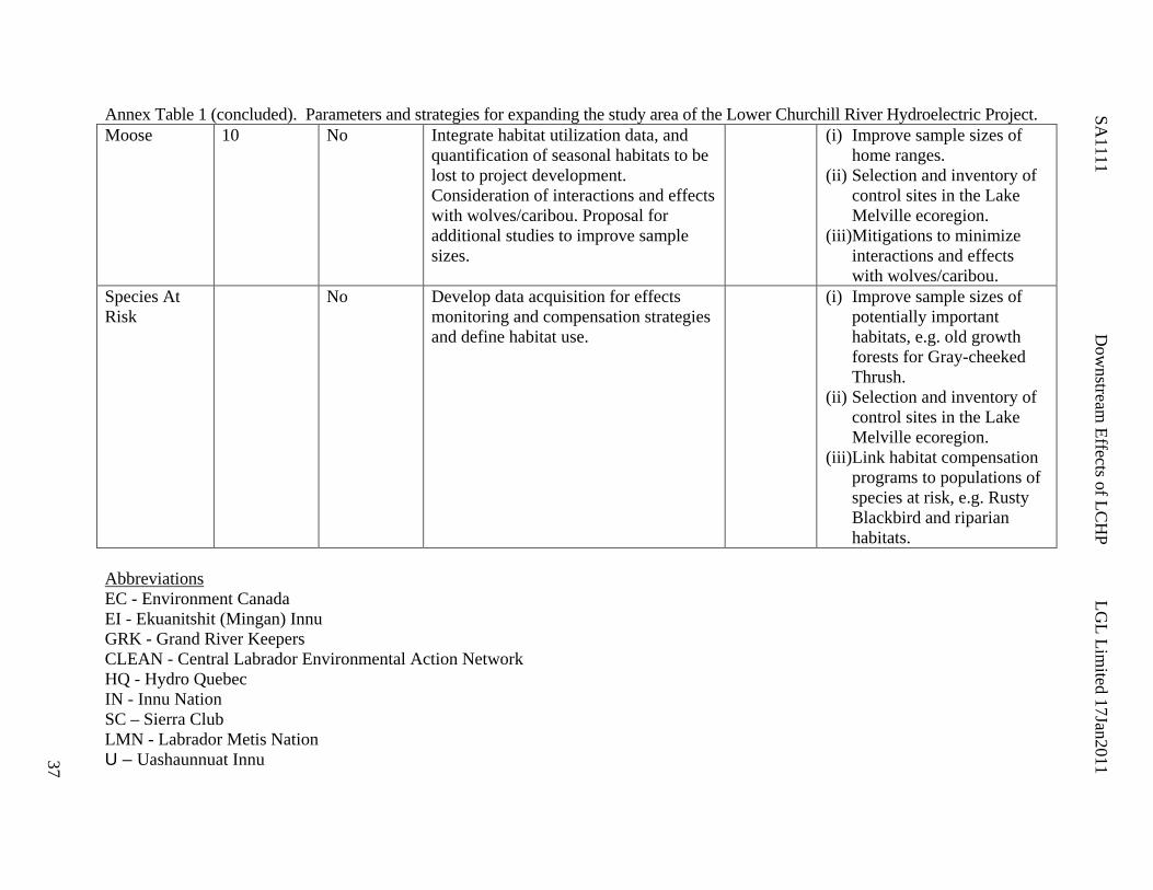
SA1111
Dow
nstream Effects of LC
HP
LGL Lim
ited 17Jan2011
37
Annex Table 1 (concluded). Parameters and strategies for expanding the study area of the Lower Churchill River Hydroelectric Project. Moose 10 No Integrate habitat utilization data, and
quantification of seasonal habitats to be lost to project development. Consideration of interactions and effects with wolves/caribou. Proposal for additional studies to improve sample sizes.
(i) Improve sample sizes of home ranges.
(ii) Selection and inventory of control sites in the Lake Melville ecoregion.
(iii)Mitigations to minimize interactions and effects with wolves/caribou.
Species At Risk
No Develop data acquisition for effects monitoring and compensation strategies and define habitat use.
(i) Improve sample sizes of potentially important habitats, e.g. old growth forests for Gray-cheeked Thrush.
(ii) Selection and inventory of control sites in the Lake Melville ecoregion.
(iii)Link habitat compensation programs to populations of species at risk, e.g. Rusty Blackbird and riparian habitats.
Abbreviations EC - Environment Canada EI - Ekuanitshit (Mingan) Innu GRK - Grand River Keepers CLEAN - Central Labrador Environmental Action Network HQ - Hydro Quebec IN - Innu Nation SC – Sierra Club LMN - Labrador Metis Nation U – Uashaunnuat Innu

SA1111 Downstream Effects of LCHP LGL Limited 17Jan2011
38
Caribou Relevance to Revised Study Area Boundaries The current known range of the Red Wine Caribou Herd (RWM) includes adjacent to the confluence of the LCR with Lake Melville, and notably along backshore of the north shore of Goose Bay and extending eastward to include Grand Lake and its associated watersheds. Excerpts and Summary from EIS “Few studies have specifically examined habitat use by the RWM herd.” (EIS Vol. 2a: p.2-86) “Because data exist for movements of caribou from RWM herd over the last three decades, additional field data were not collected. Instead existing reports and research were used to describe baseline conditions. In addition, several analyses were conducted using available telemetry data to address data gaps, where considered necessary.” (EIS Vol.2a: p.2-85) “Members of the RWM herd are now routinely observed south of the Churchill River” (EIS Vol.2a: p.2-87) “Forest dwelling caribou are lichen specialists” (EIS Vol.2a: p.2-87) “The RSF analysis is dependent on having a habitat map that delineates habitat types that are meaningful for interpreting caribou habitat preferences.” (EIS Vol.2a: p.2-90) “The current outlook for the RWM Herd is not optimistic. Unless intervention can occur related to the primary factors attributed to the decline of this herd (i.e., predation, legal and illegal hunting, and emigration to the GR Herd), its decline will continue. Currently, habitat is not limiting and is of less concern in terms of habitat alteration or limits on movement. (EIS Vol.2a: p.2-107) “When zones of influence are merged to account for overlap in disturbance buffers, sensory disturbance during construction may result in avoidance or reduced occupancy of up to 12.2 percent of the calving range (4.9 percent increase over baseline), 9.1 percent of the post-calving range (4.4 percent increase) and 14.7 percent of the winter range (8.3 percent increase) (Table 5-14).” (EIS Vol.2b: p5.-44) Regulatory Agency Considerations Monitoring programs should include …. caribou monitoring to ensure minimal impacts to movement of George River and Red Wine caribou …. (DEC Review, p.8) Under the heading ‘Habitat Association RWMC’ the Department of Environment and Conservation states that deficiencies in the habitat modeling for woodland caribou should be addressed to ensure that conclusions about habitat associations remain valid. Additional information should be clearly presented on the amount of calving and post-calving habitat that will be lost as a result of flooding in relation to the amount of calving and post-calving habitat within the RWM caribou range. A more complete assessment should be conducted to verify that

SA1111 Downstream Effects of LCHP LGL Limited 17Jan2011
39
flooding will not result in a decrease in the ability of caribou, both Migratory and Sedentary, to cross the Churchill River. (DEC Review, p.9) The Resource Selection Function model chosen is limited to the extent of the Forest Inventory (FI) data, which constitutes only a third of the herd’s range and less than half of available habitats. This lowers the representativeness of the FI as a caribou habitat for the Red Wine Mountain (RWM) population, which in turn seriously constrains the ability to extrapolate effects to the population as a whole, and increases the uncertainty of evaluating project effects. (DEC Review, Oct2010: p.3) An estimation of lichen cover and its relation to FI classes is not detailed or robust enough for a rigorous estimation of the richness of winter habitats. (DEC Review, Oct2010: p.3) Table 5-10. Mitigation measures for Woodland caribou must be more stringent than for other big game species as they are protected under the Endangered Species Act as well as the Wildlife Act. Under the Endangered Species Act, a listed species can not be disturbed. Mitigation for activities must occur even when any woodland caribou enter the vicinity of construction activities. Monitoring programs must clearly outline separate mitigation for Woodland vs. George River caribou. Although the Wildlife Division can accept the conclusion that impacts to the Red Wine Caribou herd will be ‘Not Significant’, the Division does not agree that the level of certainty for this prediction is ‘high’. A monitoring program will be required to verify impact predictions. (DEC, p.9) The analysis does not appear to take into account topographic features. The presence of a cliff would provide a major impediment to caribou crossing through given sections. An assessment of the topography associated with the new shoreline and the likelihood of currently used crossing areas becoming impassable should be included. (DEC, p.13) The Wildlife Division feels that the information provided by the proponent since project registration in December of 2006 is, from a technical point of view and with respect to data collection, acceptable. However, it is our opinion that the interpretation of some of the data leading to statements such as project will cause ‘no significant impact’, is incorrect or insufficient and hence do not provide adequate room for discussions on further appropriate mitigation measures. (DEC Review, Oct2010, p.2). Requirements for Release: Reassessment of caribou habitat impacts and barriers to movement. (DEC, p.13) Proposed Mitigations Identified in EIS and Supporting Documents None identified. Other Mitigation Strategies None identified.
SA1111 Downstream Effects of LCHP LGL Limited 17Jan2011
40
Study Limitations Identified in EIS and Supporting Documents None identified. Additional Considerations Biodiversity Relevant EIS Text Needing Further Consideration and Possible Editing Use of the Foster (1985) reference to infer lichen abundance peaks (and hence caribou habitat) in 40 years (Minaskuat 2009a: p.6-2) is misleading in the context of woodland caribou for a number of reasons. Caribou are demonstrated to select for old forests and they show little use of forests less than 60 years old (e.g. predominantly 150-250 years old in Thomas et al. 1995). A very important component of their winter range is the accessibility of arboreal lichens, and forests that support key arboreal lichen species, notably Usnea longissima, are substantially older, e.g. 80+ years (NCASI 2007a.b.). Some authors have suggested that U. longissima is an indicator of old growth forests, that is, those that have maintained partial or closed canopy cover for perpetuity (Cameron 2002; Thompson et al. 2003). A better discrimination of arboreal versus ground lichens would be relevant for the EIS, and it needs reconfiguring to reflect the critical dependence of woodland caribou on old growth undisturbed boreal forests (Environment Canada 2008). The identification of high value caribou habitat is listed as a knowledge gap in the Woodland Caribou Recovery Strategy, and identifies Winokapau Lake outlet down to Minipi River and to Pinus River in core winter range, and for calving extends 40 km south of Churchill River (Schmelzer et al. 2004). Therefore a logical interpretation is that portion of the LCHP is within the core winter range of the RWM herd. Further consideration is needed on what the potential core range would be for a healthy (viable) herd size. In the EIS, the assessments of potential effects on woodland caribou are strongly focused on habitat, and for its baseline is the use of the Forest Inventory (FI) of the Department of Natural Resources. It appears likely that the FI does not have the resolution necessary to discriminate ‘old forests’ from secondary forests in which case its application to assessing caribou habitat is deficient. Additionally, the FI does not include a large portion of the RWM herd primary range, and therefore has questionable application to extrapolations made in the EIS. The effects assessment for woodland caribou in the EIS are predicated on the development of a resource selection function (RSF) provided in further detail in Minaskuat (2009a). A number of statistical issues are apparent based on the methodology provided. The proponent provides the use of Generalized Linear Models (GLM) to generate Generalized Linear Equations (GEE) as an alternative to standard regression analyses because the telemetry data clearly violate the statistical assumption of independence of observations. Unfortunately, multiple observations of the same animal do not represent independent sampling of habitat selection by RWM caribou. This general problem is termed ‘pseudo-replication’. A GLM can deal with pseudo-replication through the inclusion of an additional term in the model thus allowing variance associated with ‘individual’ to be partialed-out. Based on the LGL assessment of Minaskuat 2009a: Table 6-6, this has not been undertaken, and thus the analyses are flawed. At best, the models should be
SA1111 Downstream Effects of LCHP LGL Limited 17Jan2011
41
rerun to account for pseudo-replication. The net effect would be much reduced sample sizes (for example for winter the n ~ 21 rather than the 358 telemetry locations, Table 6-2). In effect, a properly structured GLM is accounting for the variation associated with individuals, and subsequently allowing the assessment of the independent variable (habitat available) on the response variable (habitat use). See Goudie (2006) for an example of this statistical application in Labrador to account for multiple observations of individual Harlequin Ducks. Disturbance Regimes The scientific literature supports that the effects of landscape-level disturbances on woodland caribou can be quite pronounced with displacements of up to 10 km or more demonstrated for Newfoundland (Chubbs et al. 1993; Schaefer and Mahoney 2007) and other areas of Canada (Kirby et al. 2002). Notwithstanding statistical problems noted above, such ‘larger’ effects would not have been captured in the Minaskuat (2009a) zone of influence (ZOI) because caribou locations and random points were compared within 10 km of various types of disturbance in the FI area (p. 7-1). Selective use of the scientific literature is misleading because authors that demonstrated short term effects (e.g. in Alberta, Kirby et al. 2000 found 1.2 km but also noted apparent larger landscape level effects (11.1 km) for their study areas. Large tracts on intact boreal forest are critical for maintaining viable populations of woodland caribou (Environment Canada 2008). The EIS should be conservatively working with ZOI of 10 km. A very important disturbance type on the landscape is forest access roads, and these were excluded from the ZOI analyses because they are spatially correlated to cutblocks (p.7-1). This is not scientifically defensible, and it is critically important to include these features, if the objective is to assess the current state of disturbance in the home range of the RWM herd. These linear features are thought to play important roles in increasing impacts of predators on caribou (NCASI 2004, 2007a,b). Roads (and transmission corridors) are linear features, and they are demonstrated to be important limiting factors for habitat quality of woodland caribou. A comparison of proportionate area in these disturbance types is therefore not meaningful, and not a basis to make conclusions such as “…existing disturbance levels are well below the threshold that may trigger population declines.” (p. 7-4). A more meaningful assessment would include a conservative buffer zone (e.g. 10 + km radius) around all linear features (and cutblocks) before extrapolating proportions of range that are “undisturbed”. Issue Synopsis 1. The treatment of woodland caribou habitat is insufficiently handled. In the current EIS the
definitions of primary, secondary and tertiary habitats are incorrect because low value habitats, that is, those less than 80 to 100 years old, are included as primary habitat.
2. Information on disturbance is insufficiently integrated from the scientific literature, and landscape level avoidance regimes are not integrated. Methodologies for determining avoidance are constrained to be less than 10 km and of short duration.
3. Considerable uncertainty surrounds the potential effects of the project on RWM caribou, and the estimates of habitat loss (and disturbed) are likely biased low.

SA1111 Downstream Effects of LCHP LGL Limited 17Jan2011
42
Recommended Actions 1. A prudent approach to impact prediction on woodland caribou is recommended that
acknowledges the high scientific uncertainty of effects of loss of old growth forests in the LCHP on RWM caribou.
2. An ecological classification be extended to adequately determine and map old growth and other high conservation value habitats in the project area.
3. The extent of old growth coniferous cover suitable to woodland caribou be adequately assessed for the project area.
4. Disturbance buffers/analyses and mitigation recommendations follow the extensive scientific literature whereby minimum buffers of 10 km are applied.
Additional Literature Cited Cameron R.P. 2002. Habitat associations of epiphytic lichens in managed and unmanaged forest
stands in Nova Scotia. Northeast Naturalist 9:27-46. Environment Canada. 2008. Scientific Review for the Identification of Critical Habitat for
Woodland Caribou (Rangifer tarandus caribou), Boreal Population, in Canada. August 2008. Ottawa: Environment Canada. 72 pp. plus 180 pp Appendices.
Foster, D. R. 1985. Vegetation development following fire in Picea mariana (black spruce) -
Pleurozium forests of south-eastern Labrador, Canada. Journal of Ecology 73: 517-534. Goudie, R. I. 2006. Multivariate response of Harlequin Ducks to aircraft disturbance in Labrador.
Environmental Conservation 33 (1): 28-35. National Council for Air and Stream Improvement, Inc. (NCASI). 2004. Ecological interactions
among caribou, moose, and wolves: Literature review. Technical Bulletin No. 893. Research Triangle Park, N.C.: National Council for Air and Stream Improvement, Inc.
National Council for Air and Stream Improvement, Inc. (NCASI). 2007a. A review of ungulate
nutrition, and the role of top-down and bottom-up forces in woodland caribou population dynamics. Technical Bulletin No. 934. Research Triangle Park, N.C.: National Council for Air and Stream Improvement, Inc.
National Council for Air and Stream Improvement, Inc. (NCASI). 2007b. State of knowledge
and analysis of current research on woodland caribou in Canada. Technical Bulletin No. 939. Research Triangle Park, N.C.: National Council for Air and Stream Improvement, Inc.
Schmelzer, I., J. Brazil, T. Chubbs, S. French, B. Hearn, R. Jeffery, L. LeDrew, H. Martin, A.
McNeill, R. Nuna, R. Otto, F. Phillips, G. Mitchell, G. Pittman, N. Simon, and G. Yetman. 2004. Recovery strategy for three Woodland caribou herds (Rangifer tarandus caribou; Boreal population) in Labrador. Department of Environment and Conservation, Government of Newfoundland and Labrador, Corner Brook. 60 pp.

SA1111 Downstream Effects of LCHP LGL Limited 17Jan2011
43
Thomas, D. C., S. J. Barry and G. Alaire. 1995. Fire-caribou-winter range relationships in northern Canada. Rnagifer 16 (2): 57-67.
Thompson, I., D. J. Larson, and W. A. Montevecchi. 2003. Characterization of old “wet boreal”
forests, with an example from balsam fir forests of western Newfoundland. Environmental Reviews 11: S23-S46.

SA1111 Downstream Effects of LCHP LGL Limited 17Jan2011
44
Riparian/Wetlands Relevance to Revised Study Area Boundaries The lower Churchill estuary is an extensive delta and extends into Goose Bay providing expanses of intertidal wetlands that support thousands of staging waterfowl. The intertidal wetlands of Lake Melville and inner Groswater Bay are predicated on the regular deposition of silt and nutrients from the associated freshwater inputs of which the Churchill River is the single largest source. Excerpts and Summary from EIS “Riparian thickets provide seasonal foraging habitat for mammals such as moose, muskrat and beaver (Minaskuat Inc. 2008f). Several species of birds use this ecotype as breeding habitat, including Alder Flycatcher, Song Sparrow and Yellow-rumped Warbler” (Minaskuat Inc. 2008h).” (EIS, Vol 2a: p. 2-74). “The marsh ecotype provides summer foraging habitat for large game such as moose and black bear, as well as furbearers including beaver, muskrat and river otter (Minaskuat Inc. 2008f). This ecotype also provides year-round habitat for herpetiles such as leopard frogs (Minaskuat Inc. 2008g). Several species of birds use this ecotype as nesting and breeding habitat, including Lincoln’s Sparrow, Northern Waterthrush, Wilson’s Warbler, Swamp Sparrow and Yellow Warbler.” (EIS, Vol 2a: p. 2-75). “Specific areas of regional importance along the Lower Churchill River include the wetland complexes at Upper Brook, adjacent Lower Brook oxbow complex, localized shore of Gull Lake and kettle ponds of the southern backshore (interior), Wolf Island oxbow channel complex, mouth of the Elizabeth River and select marshes upstream of the Metchin River. Eighty-three wetland sites were investigated outside of the transmission corridor, and from Churchill Falls downstream to Gull Island (n = 32) were contiguous with the main stem. Sites between Gull Island and Muskrat Falls (n = 43) were primarily associated with remnant oxbows and backshores of the present riverine channel and consequently were located further from the river’s edge. Downstream of Muskrat Falls, investigated wetland sites (n= 8) were confined to tributary confluences with the main stem” (Minaskuat 2008)”. “While other primary habitat undoubtedly exists elsewhere in the watershed, it is limited in abundance. This limitation suggests that the magnitude of site-specific and local activities is high during construction..... This change in habitat quantity and quality will result in similar effects (i.e., magnitude, geographic extent, duration, reversibility and ecological context) for distribution and abundance of Wetland Sparrows, with both expected to result in a population decline. Changes in health may occur in situations where animals displaced temporarily or permanently occupy new habitats, potentially of lower quality. The resulting changes in territory size and range may also increase the vulnerability of individuals to predation. Residual primary habitat will remain within the Assessment Area, to which Wetland Sparrows may attempt to relocate in the spring following impoundment. Baseline studies indicate that the diversity and productivity of

SA1111 Downstream Effects of LCHP LGL Limited 17Jan2011
45
wetlands outside the existing floodplain are lower than those within and are unlikely to support those displaced individuals. This will result in an overall decline in abundance for the Assessment Area. Displacement may also predispose individuals to greater levels of predation. (EIS, Vol 2b: p. 5-96-97). Regulatory Agency Considerations As part of its commitment to wetlands conservation, the Government of Canada (1991) adopted The Federal Policy on Wetland Conservation (FPWC) with its objective to:
“promote the conservation of Canada’s wetlands to sustain their ecological and socio-economic functions, now and in the future.”
In support of this objective, the Federal Government strives for the goal of No Net Loss of Wetland Function on federal lands or when federal funding is provided. Environment Canada also expects that the goals of the policy be considered in wetland areas, and it is recommended that the hierarchical sequence of mitigation alternatives (avoidance, minimization, and as a last resort, compensation) recommended in FPWC be followed. Environment Canada (EC) states that the maintenance of existing riparian and wetland habitat during construction and the creation of alternative riparian and wetland habitat post construction will help mitigate the effects of flooding on riparian and wetland bird species. Environment Canada has requested an EEM program to determine the success of riparian habitat creation (EC Review, p.9). Under the heading of Wetland Habitat, the Department of Environment and Conservation notes that a large proportion of wetland habitat could not be classified. Additional ground-truthing should be done to assess the unknown component. Wetlands can be very productive habitats and the amount of wetland habitat in each class should be better determined. Mitigation measures should include identification of equal areas of specific wetland area where measures will be employed to facilitate development of those habitat types. (DEC Review, p.8) Proposed Mitigations Identified in EIS and Supporting Documents “Nalcor energy Energy will encourage formation of riparian marsh (wetland) at selected locations adjacent to the reservoirs. This will provide habitat for Wetland Sparrows, Rusty Blackbird, Olive-sided Flycatcher and other wildlife (herpetiles). Riparian vegetation approximately 30 m in width will be left in place during the Muskrat Falls Reservoir preparation, allowing time for replacement areas to become established. Larger trees will be selectively cleared from this buffer” (EIS, Vol.2b:5-36).
• “clear vegetation at FSL to encourage development of a new riparian zone • create conditions for establishing the formation of hardwood forest at selected locations
in the Muskrat Falls Reservoir • encourage formation of riparian marsh wetland at selected locations in the watershed • leave riparian vegetation in place at selected areas during reservoir preparation”

SA1111 Downstream Effects of LCHP LGL Limited 17Jan2011
46
(Excerpts from Table 7-1 Specific Environmental Effects Management Measures for Valued Environmental Components: EIS Vol.2b) Wetland Compensation “To offset the change in wetland habitat, the proponent proposes that the removal of forest vegetation 3 m above the future shoreline will assist development of new riparian zones and provide primary vegetation for Wetland Sparrows in future. Wherever possible, haul roads will occur within the impoundment areas. Nalcor proposes to offset this loss of habitat by developing alternative areas within the Lower Churchill River watershed that contain similar vegetation and structure. This initiative will be investigated and pursued, although it is not certain the mitigation (habitat development) will be successful”. (EIS Vol.2b, p.5-57) “Displacement may also predispose individuals to greater levels of predation. Among the options for mitigation under consideration and evaluation is the creation of comparable wetland habitat along the riparian fringe of the newly created reservoirs or creation of suitable wetland habitat along tributary streams and watercourses adjacent to the reservoir. This may offset lost wetland habitat and further reduce potential adverse effects. Habitat creation would be the subject of follow-up monitoring to confirm the effectiveness of this mitigation.” (EIS Vol.2b, p.5-97) Other Mitigation Strategies One academic reviewer (Dr. Don Steele) noted that a rescaling of the LCHP to involve only one dam at Muskrat Falls, roughly twice the current proposed height, would maintain approximately 100 km of free-flowing river (presumably toward the upper reach and notably above Lake Winokapau. Goudie et al. (2006) provided some conceptual ideas for mitigation of wetland loss in the proposed LCHP, and in total identified 500 to 600 ha (1,236 to 1,483 acres) of wetlands as having potential for enhancement along the LCHP area, and this primarily occurs in the 20 km reach from Fig River confluence at upper Winokapau Lake to 5 km. upstream of Metchin River confluence. This is a relatively large expanse of wetland habitat, and in combination with impoundments may be engineered to compensate for productive wetland habitat losses further downstream, notably at Upper Brook. The Elizabeth-Metchin wetland complexes occur at the upper reach of the currently predicted inundation zone of the Lower Churchill Hydroelectric Project making this site most suitable for manipulation. Consideration of Environmental Flow Regimes (see earlier section; Bergkamp et al. 2000) relate to the challenge of delivering a level of inundation that optimizes and stabilizes water levels on these sites while maximizing the energy output of the project. In its currently predicted footprint of 125 m ASL (Gull Island) and 39 m (Muskrat Falls) all of these wetlands would be lost with limited or no possibility for new wetlands above this zone. Through refinement of the engineering it may be possible to maintain an optimal water level at these wetlands, speculated at 118 – 119 m (Gull Island) / ~35 m (Muskrat Falls) based on GPS-based elevation algorithms. This could involve either (i) engineering a drawdown canal at Gull Island dam, (ii) consideration of one dam at Muskrat Falls, and (iii) some site specific water control structures at narrow openings to the mainstem that could optimize water levels on wetlands (Goudie et al. 2006). It is noteworthy that the regulatory agency (Environment Canada: CEAA#292-p.7; IR#JRP.48) has suggested the consideration of water control structures being engineered for wetlands in the project area.
SA1111 Downstream Effects of LCHP LGL Limited 17Jan2011
47
Study Limitations Identified in EIS and Supporting Documents Under the heading of study limitations, it was clarified that limited sites (n = 8) were investigated downstream of Muskrat Falls during the wetland environmental baseline work (EBR) (Minaskuat 2008). Minaskuat (2008) noted that applying an average ranking of the Lower Churchill River for spring staging waterfowl tends to downplay the importance of localized areas of open water (ashkui) that serve as refugia for migrating waterfowl. The fluvial marshes and alluvial meadows at the confluence of select tributary streams (e.g., Upper Brook and Elizabeth River) as well as more expansive marshes at the estuary with Lake Melville, are ice-free early and provide critical productive staging habitat that are used by high concentrations of waterfowl prior to migrating to breeding areas. The extensive oxbow channels associated with Birch Island near Happy Valley-Goose Bay, the braided systems of the Lower Churchill River confluence at the estuary with Lake Melville and select intertidal communities within inner Lake Melville were not sampled. For staging waterfowl (dabbling ducks and Canada Goose), saltmarsh cordgrass (Spartina alterniflora) dominated wetlands comprise important stretches of the Lake Melville-inner Groswater Bay coastline, and are used by waterfowl aggregations prior to migrating to breeding or wintering areas (Minaskuat 2008). Additional Considerations A definition of riparian Riparian ecosystems include the riparian zone (the wet forest area along creeks, rivers, lakes, wetlands, and all water bodies) and the riparian zone of influence (the upland forest immediately adjacent to the riparian zone). Riparian ecosystems are biological hotspots concentrating water, nutrients, and energy that drain into them, and regulating their dispersal back into the landscape. As well, riparian ecosystems are travel corridors for animals and plants (Hammond 2005). Biological Diversity At the landscape level, high biological diversity is expected in riparian habitats (Knopf et al. 1988). It is flooding and the consequent transfer of material that makes rivers and floodplains among the most fertile, productive and diverse ecosystems in the world. Regular floods keep the successions of vegetation in young, productive stages, creating excellent conditions for abundant wildlife. The diverse vegetation favours animal diversity. Floodplains are rich in species endemic to small geographic areas. Coastal marine wetlands are highly dependent on inputs of freshwater and associated nutrients and sediments from rivers. Coastal wetlands are ecologically and environmentally diverse because of the gradual and often fluctuating dynamic boundaries between salt, brackish and freshwaters (Bergkamp et al. 2000). The International Biological Program (IBP) had identified site #50, a 73 km2 near Gull Island as exemplary of riparian vegetation and regionally-rare plant species.

SA1111 Downstream Effects of LCHP LGL Limited 17Jan2011
48
Relevant EIS Text Needing Further Consideration and Possible Editing Including both the Gull Island and Muskrat Falls hydroelectric components, the project will convert approximately 240 km of riverine habitat on the Lower Churchill River into man-made lake/reservoir. In other words, most riparian/wetland, if not all, habitat along the Lower Churchill River project area will be lost to inundation (a sixty percent loss noted in text is suspect or needs further context). Estimates of habitat loss, particularly as it relates to Species At Risk (see SAR below), need further calculation and definition. In particular, habitat loss needs to be defined in relation to the project area because the LCHP will inundate a high proportion of the riparian habitat in the project area, especially wetlands. Baseline data on SAR numbers, distribution and habitat use in the project area are currently weak, and Environment Canada (EC Review p.13) notes that both the Rusty Blackbird (and the Gray-cheeked Thrush) are regular breeders in central Labrador. Classification and quantification of additional riparian/wetland habitat extending downstream into the inner Lake Melville is warranted “River hydrology resulting from project operation will differ only slightly from existing conditions in terms of vegetation, riverbank stability and ice regimes” (LCHP EIS, Vol. 2b: p.5-61). “The clearing strategy will result in a reservoir with a natural shoreline and riparian zone” (LCHP EIS p. 4-7). Note the contrast to “Although alder-dominated thickets may recolonize along the new high water level, the hydrology, soil and microclimatic conditions do not favour the natural reestablishment of marshes”. (Vol.2b, p.5-57) “Terrestrial wildlife will be displaced from the area that will be occupied by the reservoirs (approximately126 km2) and the associated transmission line. For most species affected, alternative primary habitat exists within the lower Churchill River valley and/or the watershed. The clearing of the forest cover up to 3 m above the proposed shoreline will allow riparian vegetation to establish.” (EIS, Vol.2b: p.7-4) “The relatively stable water level fluctuations on the reservoirs will encourage the establishment of vegetation and, possibly, enhance the effectiveness of riparian and wetland areas as breeding habitat.” (EIS, Vol 2b: p.5-98) “The relatively stable water management and operating regime would facilitate establishment of wetland and riparian habitat. As the shoreline stabilizes over time, it is anticipated that this riparian zone will appear similar to existing areas, likely supporting the re-establishment of Wetland Sparrow populations.” (EIS, Vol 2b: p.5-98) “Among the options for mitigation under consideration and evaluation is the creation of comparable wetland habitat along the riparian fringe of the newly created reservoirs or creation of suitable wetland habitat along tributary streams and watercourses adjacent to the reservoir. This may offset lost wetland habitat and further reduce potential adverse effects. Habitat creation would be the subject of follow-up monitoring to confirm the effectiveness of this mitigation. Change in health due to Wetland Sparrows being displaced permanently, or at least temporarily, may occur because of occupying habitat that is of lower quality and, therefore, more energy demanding; some areas to which they relocate could result in vehicle collisions. The areas of risk to Wetland Sparrows will be limited to those that are adjacent to wetland or riparian areas.

SA1111 Downstream Effects of LCHP LGL Limited 17Jan2011
49
In these cases, the environmental effects will be difficult to measure, but, due to the limited availability of adjacent primary habitat, are expected to have an adverse environmental effect on abundance and distribution related to the loss and alteration of habitat. Although the magnitude of the residual environmental effect is high and a decline is anticipated for these habitat specialists. Wetland Sparrows will continue to breed in the Assessment Area, including in the anticipated new wetland areas. The residual environmental effect of Project activities during construction is therefore considered to be not significant.” (EIS, Vol 2b: p.5-97) Note: These conclusions are incongruent with the text, and Table 5-40 in EIS, Vol 2b provides a certainty of these statements as ‘High’ for both construction and operation. At the very least the proponent needs to acknowledge the high scientific uncertainty of these predictions. As wetland sparrows are an indicator group there is a need to make the obvious cross-link to species at risk, namely Rusty blackbird also dependent on riparian habitats. In general, hydroelectric reservoirs do not create comparable wetland habitats along inundated shorelines because project operations result in fluctuations that are not natural (Bergkamp et al. 2000). This EIS provides a guestimate of weekly fluctuations of 1.0 m for Gull Island reservoir which are probably conservative since the FSL and LSL have a differential of 3m, meaning that greater vertical variation in water levels will occur during operations. Nevertheless, this high variance in water level results in ‘marling’ around reservoirs that are void of vegetation and generally not utilized by wildlife, notably waterfowl. In reservoirs in northern areas in winter, ice rime and scour are severe in winter, and marling leads to a peripheral zone of very low biological productivity (Poulin and Lefervre 1993). Soils are frequently exposed at draw-down and later eroded. For example, shorelines of the Smallwood Reservoir are not used by waterfowl some three decades since its creation. In creation of reservoirs, new shorelines appear at the highest regulated water level (HRW) but they have poorer vegetation and plant composition than natural riparian zones along rivers and lakes developed over a long period. Normally, regular seasonal flooding is an important mechanism for keeping the vegetation in its young productive stages that support high quality foods (Nilsson and Dynesius 1994). In hydroelectric projects, most plants have difficulty in colonizing these frequently inundated and de-watered areas, and when the disturbance includes the inundation of vast areas along a previous river most riparian habitats are lost, and even those downstream are seriously altered (Thingstad and Reitan 1999). This would be the expected scenario along the Lower Churchill River. “Flows through Churchill River will not be altered during operations due to limited storage of Gull Island and Muskrat Falls reservoirs” (LCHP EIS p. 249) Including both hydroelectric components, the project will convert approximately 240 km of riverine habitat on the Lower Churchill River into man-made lake/reservoir. In other words, most riverine habitat along the Lower Churchill River will be lost to inundation. It would be expected that most if not all riparian habitats, such as marshes, alluvial meadows, riparian thickets and fens/bogs will be inundated. More specifically, the construction of the main dam will form a 232 km long reservoir from the Gull Island Generation Facility to the tailrace for the Churchill Falls Power Station. The elevation of the reservoir will be approximately 125 m asl at Full Supply

SA1111 Downstream Effects of LCHP LGL Limited 17Jan2011
50
Level (FSL) and 122 m at Low Supply Level (LSL). In other words, approximately 180 km of predevelopment riverine habitat will be converted to a man-made lake. The remaining 50 km or so represents Winokapau Lake. This is not a “run-of-river” project because there will be no gradient remaining after inundation. With no gradient there can be no flow. Post development the only remaining river flow will be the inflow at the existing tailrace of the upper Churchill Hydroelectric project, and at the tailrace of the subsequent reservoir(s). The water surface level over 232 km will remain within 122 m asl and 125 asl (depending on supply level). This essentially removes all natural river flow. Section 2-19 (LCHP EIS: Volume Part A) provides a brief discussion of run-of-river options for Gull Island and Muskrat Falls areas demonstrating the much lower potential for electricity generation associated with this approach, and these are not viewed as a viable alternatives to impoundment. A misleading description of the LCHP as a ‘run-of-the-river’ project was presented to the Innu Nation by Newfoundland and Labrador Hydro in 1998, and that misconception has continued into current talks to some extent. The LCHP EIS reports the area of inundation of the reservoir will be 85 km², at FSL, resulting in a total surface area of 213 km². Notably, Winokapau Lake is approximately 50 km long by 1.5 km wide with depths > 200 m. This lake exhibits properties typical of large lakes and could be viewed as exemplary of the anticipated properties of the Gull Island reservoir, such as: deep narrow lake, lack of riverine habitats, absence of ashkui and protracted ice cover in spring. It is of sufficient size to effect local weather patters, e.g. ambient temperatures in the surrounding valleys. “A rapid release of water to portions of the river downstream of Gull Island and/or Muskrat Falls, to facilitate early ice breakup and open water formation would conflict with other wildlife and land use, as well as generation plant operations (e.g., Muskrat Falls).” (JPR_154) LGL notes that in a naturally functioning river ecosystem, it is in fact the seasonal flooding, scour, erosion and alluvium deposition that maintains riparian/wetland habitats on deltas such as the Lower Churchill River confluence. Implementation of an environmental flow regime would necessitate mimicking natural flood events. “While Nalcor energy does not advocate deliberate action to enhance the size and number of ashkui directly, Project activities will indirectly enhance the productivity of ashkui. For example, some of the deltas in the reservoirs will be areas of habitat enhancement (e.g., creation of gravel bars and channels) for fish and wildlife resources as a mitigation measure that will also serve to encourage ashkui formation in future” (JPR_154; Volume IIB, Table 7‐1). “Nalcor will undertake to create replacement deciduous hardwood and riparian marsh habitats for Wetland Sparrows, as well as species such as Ruffed Grouse” (EIS, Vol.2b: p.7-4) These statements are vague and unclear if they are to serve the purpose of a mitigation or compensation strategy for riparian/wetland loss. If areas are to be enhanced then specific sites would need to be identified, clear methodologies proposed, and compensatory habitat values provided. Issue Synopsis
1. Wetlands of the Churchill River delta and inner Lake Melville were not quantified.

SA1111 Downstream Effects of LCHP LGL Limited 17Jan2011
51
2. Specific wetlands of the Lower Churchill River need better profiling as to their importance to waterfowl.
3. Importance of ashkui as wetlands identified (see ashkui section below). 4. Mitigations for riparian/wetland habitat are poorly defined. 5. The EIS has not addressed the regulatory agency policy for no net loss of wetland
function. 6. There is no scientific basis to support the statements in the EIS that new wetlands will
form at new project supply water levels. 7. A commitment to an EEM for riparian/wetland to determine success of habitat creation is
not delivered. Recommended Actions
1. Acknowledge scientific uncertainty of effects on riparian/wetland habitat loss.
2. Complete ELC for the expanded study extending downstream to include upper Lake Melville (see Fig. 1).
3. Revise the affected area of footprint to include downstream wetlands.
4. Rate wetlands of the study area for their relative use by waterfowl.
5. Development of a coherent mitigation-compensation plan for wetland loss consistent with the EC policy of no net loss of wetland function.
6. Develop an EEM to determine success of riparian/wetland habitat creation.
7. Identify and establish control sites for other riparian-wetland habitat in the Lake Melville ecoregion.
Additional Literature Cited
Goudie, I, C. Jones, P. Trimper and M. Gahbauer. 2006. Wetland enhancement in the Lower Churchill River hydroelectric project: Preliminary Scoping of Sites and Concepts. Environmental Baseline Report for Newfoundland and Labrador Hydro. 17 pp.
Hammond, H. 2005. Ecosystem-based conservation planning: Definition, principles and process: revised boreal version. The Silva Forest Foundation, Slocan, BC. 32 pp.
Knopf, F. L., R.R. Johnson, T. Rich, F.B. Samson, and R. C. Szaro. 1988. Conservation of riparian ecosystems in the United States. Wilson Bulletin 100: 272-284.
Mahoney, M.L., A.R. Hanson, and S. Gilliland. 2007. An evaluation of a methodology for wetland classification and inventory for Labrador. Technical Report Series No. 480. Canadian Wildlife Service, Atlantic Region. viii. + 40 pp.
Minaskuat Limited Partnership. 2008. Wetland Assessment and Evaluation, Lower Churchill
Hydroelectric Generation Project. Draft Environmental Baseline Report for Newfoundland and Labrador Hydro. Report No. MIN0315.05. 75 pp.

SA1111 Downstream Effects of LCHP LGL Limited 17Jan2011
52
Poulin, B. and Lefebvre, G. 1993. Current knowledge of bird species in the region of the proposed Great Whale Hydroelectric Project. Great Whale Environmental Assessment: Background Paper No.3, National Library of Canada. 87 pp.
Nilsson, C. and Dynesius, M. 1994. Ecological effects of river regulation on mammals and birds: a review. Regul. Riv. 9: 45-53.
Thingstad, P. G. and O. Reitan. 1999. Responses of birds to damming – a review of the influence of lakes, dams and reservoirs on bird ecology. Ornis Norvegica 22: 3-37.
SA1111 Downstream Effects of LCHP LGL Limited 17Jan2011
53
ASHKUI Relevance to Revised Study Area Boundaries Wetland rankings based on abundance of total staging waterfowl placed Snegamook Lake at the top followed closely by Goose Bay (Turner and Chaulk 2000).The central region included Goose Bay, extending from Carter Basin to the Gosling River estuary, North West River, extended from the outlet of Grand Lake to the Sebaskachu River estuary. The major river systems are more attractive as staging habitats because they tend to have larger areas of open water, and may offer better foraging opportunities, particularly in areas where there are deltaic habitats with associated marsh development (Chaulk and Turner 2002). Excerpts and Summary from EIS Proponent Text “The overall numbers using the area throughout the staging period could be much higher than the number observed at any one time. These factors, coupled with the preference of the species for relatively large areas of open water (a feature of the lower Churchill River) underscore the regional importance of this area for staging Surf Scoter. The lower Churchill River is highly suitable for spring staging by Surf Scoter due to the large volume of moving water and low elevation of the Lake Melville ecoregion. This estuary and various locations along the river are some of the first open water areas (ashkui) in central Labrador. Hatch (2007) estimates that approximately 60 km2 of the Churchill River from Happy Valley-Goose Bay to Churchill Falls is ice-free annually. Migrating waterfowl rely on open water areas for staging, while awaiting the thaw of interior wetlands at higher elevations and latitudes. In some years (e.g., 1992, 2007), the interior thaw may be substantially delayed, and during such late years, larger than average numbers of scoters may be observed staging along the lower Churchill River” (EIS, p. 2-153). “The issue of ashkui, their importance to wildlife and Innu people have elevated potential concerns for negative impacts on these important ecosystem components. Little is known of the relative importance of specific ashkui along the main stem of the lower Churchill River for staging waterfowl, how waterfowl species abundance and diversity changes over time within them, and their relative importance in years of delayed spring breakup and these habitats were therefore identified as a study limitation in the EBR” (Minaskuat 2008: Environmental Baseline Report). “Ashkui is primary habitat during the brief spring staging period because it provides access to limited open water at the time and comprises approximately 60 km2 of the Churchill River (Hatch 2008) (EIS p. 2-149). During operation and maintenance, ashkui (such as that which occurs at the confluences of the Metchin River, Elizabeth River, Upper Brook and Lower Brook) will move upstream into the tributary at the interface with the new shoreline (Hatch 2007). Topographic profiles indicate that these confluences will be at least as steep as under existing conditions, and therefore, continue to enhance ashkui formation” (EIS Vol. 2b: p.5-62). “The Innu language contains lexemes that reference landscape features in relation to concentrations of animal and plant species, but these do not translate neatly into western scientific terms such as habitat. The term ashkui is a case in point. It refers to a ‘clearwater area’, an area of open water surrounded by ice in the spring or fall. Some ashkui may be open all year round due to the strong current there (e.g. off Netauakau [Sandy Point] near

SA1111 Downstream Effects of LCHP LGL Limited 17Jan2011
54
Sheshatshiu), while others only form at river junctions (takuatuepan), lake outlets (kupitan), or river and brook estuaries (shatshu) during fall freeze-up and spring break-up. Ashkui can be dangerous places due to the hazards they pose to travel across ice, and so for reasons of safety, people with experience in country living are knowledgeable about the locations of ashkui and how they change shape according to fluctuations in temperature, wind velocity, and precipitation. Moreover, Innu associate ashkui with…shiship (migratory waterfowl), and as a result they established their spring camps near ashkui in order to take advantage of the species abundance there” (EIS, P. 2-145). “Spring staging of Surf Scoter occurs primarily along the lower Churchill River (over 1,000 individuals counted in 2007) including concentrations at the TLH causeway, Muskrat Falls, Beaver Brook outflow, eastern and western ends of Winokapau Lake, Metchin River and approximately 10 km downstream from the Churchill Falls Power Station tailrace (LGL Limited 2008). Compared to the findings of Turner and Chaulk (2000) and Chaulk and Turner (2001, 2002), who surveyed most of the principal waterfowl staging areas in central Labrador, the estimate of 1,000 detected in 2007 represents the single largest concentration of staging scoters observed in the region. This number may be inflated and atypical owing to the lateness of break-up that year. In fact, in most years at the time this survey was undertaken in 2007, many Surf Scoter had already dispersed to breeding areas (S. Gilliland, pers. comm.). Nonetheless, populations at staging areas are not static, being subject to immigration and emigration” (EIS, p. 2-152). “A number of conditions make the lower Churchill River highly suitable for spring staging of Harlequin Duck. Due to the large volume of moving water and low elevation of the Lake Melville region, the estuary and various locations along the river are some of the first open water areas (ashkui)” (EIS, p. 2-171). “Tepiteu-shipu is a good place for nishk (Canada geese) in the spring and fall. There were lots of geese and ducks on the ice here by the ashkui (area of open water). The ice breaks up early at the mouth of the river” (EIS, p. 2-4). “Members of the ITKC noted that the mouths of rivers and brooks along the length of Mishta-shipu are, generally speaking, productive places for various animal and fish species, not just when ashkui form, but at other times of the year as well. Frequent mention was made of large numbers of ducks and geese at the mouths of brooks in the spring. Lots of utshashku (muskrat) were known to frequent marshes near the mouths of these brooks” (EIS, p. 4-27). “The large volume of moving water in the lower Churchill River provides some of the earliest ashkuis in the region, used by Canada Goose and other early-arriving waterfowl while waiting for the thaw of interior wetlands at higher elevations and latitudes” (EIS, p. 2-145). Regulatory Agency Considerations Environment Canada’s submission notes that “the ecological function of the new ashkui may not be the same as those that are lost. Hence, new ashkui may not replace habitat lost when natural ashkui are flooded.” The Proponent is referred to this submission for further rationale. (CEAR # 292, p. 5).

SA1111 Downstream Effects of LCHP LGL Limited 17Jan2011
55
“EC-CWS is not convinced that new ashkui will occur at inflow points as early as the traditional existing ashkui due to the impounded nature of the reservoirs versus the current flow of the watershed. As stated in our comments, we are concerned not only with direct loss of these habitats, but also the alteration of ecological function of these areas. If they are lost, it is not as simple as birds switching to other sites outside the impacted area as these sites may already be fully utilized.” (EC Response to JRP154, p.2). The potential project effects are considered to be of a regional context because the populations involved could number in the thousands in some years.
Proposed Mitigations Proponent In its response to JRP.65, the Proponent states that “If the results of the follow‐up program confirmed the ashkui formation did occur and waterfowl use of the area reached expectations no further action would be taken. If expectations were not met, adaptive management measures could be developed based on the data collected to address changes in the mitigation”.
“To mitigate the potential effect of change in distribution, plans will be implemented to ensure that other suitable sites are free of disturbances. Other mitigation actions could include timing of construction activities to after the primary staging period (mainstem) when there would be few waterfowl remaining on the Lower Churchill mainstem and/or after the post-pair period (transmission corridor). Impounding will destroy riverine habitat and is expected to displace waterfowl from traditionally used areas of the Lower Churchill River. A decision to not develop the Muskrat Falls would reduce the extent of habitat loss although it is difficult to predict the full effects of the water level fluctuations downstream of the Gull Island complex. The proponent has committed to undertaking EEM of known ashkui by an aerial census of waterfowl and undertaking behavioural studies of one site” (JRP#65).
Regulatory Agency Environment Canada recommends that the proponent undertake a carefully planned study of the temporal and spatial use of these sites by early and late nesting waterfowl including behavioural studies to document how these sites are used by the birds. With this information it will be possible to assess the residual effects of the project. If significant residual effects are detected, then mitigation or adaptive management measures may be required.
EC recommends that the proponent investigate methods of ashkui creation other than releases of water. The use of wind or electricity driven pumps may have potential to create open water critical to early nesting waterfowl.
Other Mitigation Strategies Mitigations to reduce extent of staging habitat (ashkui) affected could include engineering of a drawdown canal to reduce the vertical reach of inundation by the proposed reservoir. Many staging diving ducks were located on the LCR occurred in the reach from Gull Island to the tailrace of the Upper Churchill River hydroelectric development. Notable current spring aggregations of staging waterfowl occur adjacent to Lake Winokapau (Fig R. – Elizabeth R. confluences), Metchin River confluence and 10 km downstream of the tailrace (LGL Limited 2007). In its currently predicted footprint of 125 m ASL (Gull Island) all of these wetlands

SA1111 Downstream Effects of LCHP LGL Limited 17Jan2011
56
would be lost with limited or no possibility for new wetlands above this zone. Through refinement of the engineering it may be possible to optimize water levels at these wetlands at about 118 m (Gull Island or Muskrat Falls FSL). Such mitigation while sustaining wetlands above Lake Winokapau would impact the overall potential energy output of the project if both Gull Island and Muskrat Falls in their current configuration are under serious consideration. A reconfiguration for Muskrat Falls only (recent Premier announcement) will have a net benefit for wetland conservation in the study area, and notably, important ashkui above Lake Winokapau would not be affected. While open water may be maintained at confluence with rivers at the 125 m reservoir footprint, such sites will not constitute fully functioning ashkui per se unless suitable substrate and invertebrate populations exist there for exploitation by waterfowl. While these habitats may be expected to improve over the long term (decades), part of the adaptive management to reduce impacts of the proposed LCR hydroelectric development should be the relocation of alluvial deposits from current ashkui to anticipated confluences at inundated levels. This excavation and movement of sediments and their benthos should be designed to take place as close as possible to the timing of reservoir filling in order to promote survival of some of the invertebrates and plants. In its viewing of the Metchin and Elizabeth River profiles, LGL interpreted that post development the profiles are steeper, and therefore less likely to be suitable to forming early open water.. Current ashkui in the LCR are maintained not only by the moving water entering the mainstem but also by the combination of shoals from deposits and flow of the merging LCR. The latter will be lacking in post LCHP development. Because the LCR supports extensive open water from March into May, it may be desirable to maintain open water in as significant numbers of waterfowl currently stage in this area. Strategies to achieve this include the designing and installation of structures that would increase water movement in the reaches of the inundated reservoir area traditionally supporting staging waterfowl thereby creating ashkui-like habitat suitable for waterfowl in reaches that remain relatively shallow ( < 5 – 10 m) in this area. There may be need to add fill to create the necessary shoal habitats in the future reservoir. Study Limitations Additional surveys within years and across several years are required to clearly establish annual variation in waterfowl use of ashkui. Predictions of effects of the project on scoters are affected by technical limitations. A refined definition of how waterfowl may redistribute in the regional context is not presently possible. For example, the link between individuals observed on the LCR and individuals observed on wetlands elsewhere in the study area or the rate of supplanting and turnover of numbers on the LCR in spring is equivocal. These are effectively aspects of emigration and immigration, and there have been no studies (e.g., mark/re-sighting) to estimate these demographics in sea ducks staging here in spring. Use of lower quality habitats or increased densities and competition on remaining wetlands could affect vital demographic rates of waterfowl in the Environmental Assessment Area.

SA1111 Downstream Effects of LCHP LGL Limited 17Jan2011
57
Additional Considerations Cultural Significance Since 1997, the federal department of Environment Canada has collaborated with the Innu Nation (First Nation) of Labrador and social scientists from the Gorsebrook Research Institute (GRI) at Saint Mary’s University in Halifax, Nova Scotia to incorporate social sciences and community involvement into environmental research. The initial goal was to develop comprehensive baseline ecological data of the Labrador landscape from both Innu and Western scientific perspectives. To provide an initial focal point for research, consultations were held with members of the Innu community to identify an aspect of the landscape that was deemed culturally significant and distinct. The landscape feature the Innu chose is ashkui, giving rise to what was referred to as the Ashkui Project in Labrador, Canada (Sable et al. 2006). Ashkui is the Innu-aimun term for areas of open water in early spring productive for a variety of birds, fish and mammals, and are an important feature of their territory as hunting and fishing sites. They view these sites as productive areas, rich with wildlife, and traditionally locate near them in springtime (Fletcher and Breeze 2000). Armitage (1996) mapped a number of staging areas by interviewing Innu elders and harvesters about waterfowl. Because of traditional use over time, ashkui are important in cultural meaning and noted for importance for survival. Although the year-round or seasonal (especially early spring) presence of open water is a component of ashkui, it is the enriched sites and the supported wildlife that distinguish these areas. Fletcher et al. (2000) documented that the Innu indicated that prior to the construction of the dam at the Upper Churchill; there were more Harlequin Duck, goldeneye and fish in the area. It was explained that the dam changed the timing and number of ashkui (there). Baseline and monitoring LGL notes that no specific information on feasible mitigation measures or examples of adaptive management are provided in the EIS. EC has clarified the need to develop an EEM program (see below). In part, this is necessary to define what levels of waterfowl use of ashkui are “expected”, and presumably those anticipated levels will co-vary with spring chronology. Numbers of sea ducks staging on the LCR in spring are likely not static. In fact, the assumption would be that there is continuous supplanting of individuals as breeding pairs disperse to wetlands in the interior, and there are new arrivals from further south. Pairs that breed furthest north or at the highest elevations may be expected to arrive latest and/or stage longer. The baseline data will be improved by conducting aerial surveys every few days over the study area from mid April to late May or early June. Data arising from this design will improve precision of estimates and provide indications of variability in numbers of sea ducks using the LCR. Whether reduction of open water habitat due to the Lower Churchill Hydroelectric Project would result in a population loss or displacement of staging waterfowl to other wetlands is uncertain. The large numbers of birds observed at these ashkui suggest not only a strong affinity to but also a long association with those sites (Turner and Chaulk 2000). Interest in ashkui is relatively recent, partly arising out of the identified deficiencies pertaining to the EIS of low-level military training (DND 1994). The Institute for Environmental Monitoring and Research (IEMR) was established subsequent to that Federal EIS, and had provided some general support to cursory studies of ashkui. Information on the ecology of these sites remains

SA1111 Downstream Effects of LCHP LGL Limited 17Jan2011
58
rudimentary. Fletcher and Breeze (2000) noted that ashkui are sites of open water on lakes, rivers and the ocean when (normally) ice is present elsewhere. Some ashkui never freeze over while others are the first openings in the ice that appear when the weather warms in early spring. Some ashkui begin to appear from mid April to mid May, with the earliest appearing in late March and the latest opening in early June. There are annual variations in the time of openings. They identified basic research needs including identification of fish, invertebrates and vegetation associated with these sites. They noted the need to distinguish differences between freshwater, brackish and marine sites, and to distinguish ashkui sites of greatest importance to wildlife. The fact that the open waters would be more productive as well as more accessible makes sense ecologically as benthic algae bloom earlier which triggers feeding and growth of invertebrates, and subsequently attracts fish, waterfowl and other wildlife. Baillie et al. (2004) noted that waterfowl arriving Labrador from the south in spring must accumulate in greater concentrations when ashkui openings are limited. Numbers of waterfowl varied from 34 to 376 for the 26 April to 27 May 2002 period of their study at Lac Formount in central Labrador and supported interactions with predators, such as otters (Lutra canadensis) and Bald Eagles (Haliaeetus leucocephalus). An overview of known ashkui in the central Labrador area indicates the relative scarcity of this habitat type (Fig. 12).
Relevant EIS text needing Consideration and Possible Editing “As indicated in IR# JRP.48b, additional mitigation measures are not needed as ashkui are likely to occur at tributaries within the reservoirs because conditions such as water temperature and velocity at future deltas and tributaries will be similar to existing conditions (Hatch 2007).” (JPR 154)
“Further, it is likely that ashkui in the lower Churchill River, below Muskrat Falls, will continue to form as they currently do, and remain unaffected by the Project (Hatch 2007)”. (JPR 154)
“In the unlikely event that new ashkui do not form, or do not have the same characteristics, other ashkui that form in the lower Churchill River watershed that would be beyond the reservoirs will be available for use by wildlife and the Innu (Volume IIB, Figure 5‐3)”. (JPR 154)
“While Nalcor energy does not advocate deliberate action to enhance the size and number of ashkui directly, project activities will indirectly enhance the productivity of ashkui. For example, some of the deltas in the reservoirs will be areas of habitat enhancement (e.g., creation of gravel bars and channels) for fish and wildlife resources as a mitigation measure that will also serve to encourage ashkui formation in future (Volume IIB, Table 7‐1).” (JPR 154)
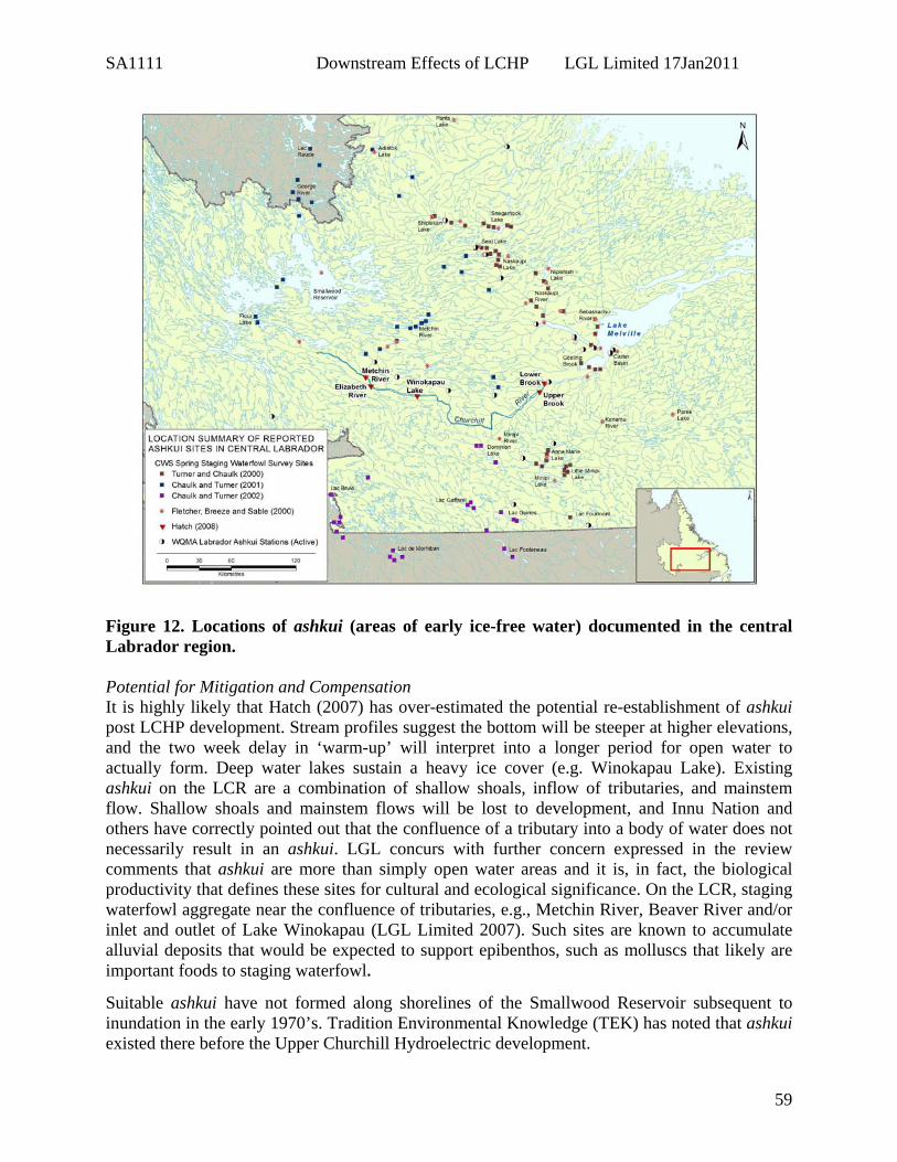
SA1111 Downstream Effects of LCHP LGL Limited 17Jan2011
59
Figure 12. Locations of ashkui (areas of early ice-free water) documented in the central Labrador region. Potential for Mitigation and Compensation It is highly likely that Hatch (2007) has over-estimated the potential re-establishment of ashkui post LCHP development. Stream profiles suggest the bottom will be steeper at higher elevations, and the two week delay in ‘warm-up’ will interpret into a longer period for open water to actually form. Deep water lakes sustain a heavy ice cover (e.g. Winokapau Lake). Existing ashkui on the LCR are a combination of shallow shoals, inflow of tributaries, and mainstem flow. Shallow shoals and mainstem flows will be lost to development, and Innu Nation and others have correctly pointed out that the confluence of a tributary into a body of water does not necessarily result in an ashkui. LGL concurs with further concern expressed in the review comments that ashkui are more than simply open water areas and it is, in fact, the biological productivity that defines these sites for cultural and ecological significance. On the LCR, staging waterfowl aggregate near the confluence of tributaries, e.g., Metchin River, Beaver River and/or inlet and outlet of Lake Winokapau (LGL Limited 2007). Such sites are known to accumulate alluvial deposits that would be expected to support epibenthos, such as molluscs that likely are important foods to staging waterfowl.
Suitable ashkui have not formed along shorelines of the Smallwood Reservoir subsequent to inundation in the early 1970’s. Tradition Environmental Knowledge (TEK) has noted that ashkui existed there before the Upper Churchill Hydroelectric development.

SA1111 Downstream Effects of LCHP LGL Limited 17Jan2011
60
The moving water below the proposed dam(s) at the tailrace(s) will present open water for early arriving waterfowl but the nature of the habitat will be deeper and markedly different that what is currently available, especially because presently there is a wide range of areas along the LCR available in early spring, and these will be lost for the most part. High ice accumulation and therefore delayed thaw and frozen water can be expected for the anticipated reservoir (Reitan and Thingstad 1999). The tailrace itself is also generally subject to considerable human disturbance, and waterfowl generally seek habitats that are free of disturbance. The long-term consequences of the damming may be deteriorating habitat for waterbirds, attributed to fluctuations in water levels that are not natural (Nilsson and Dynesius 1994). As a precautionary step, the proponent should monitoring populations of sea ducks staging along the tributaries of the LCR in order to ensure that populations remain viable before, during and after project construction. Issue Synopsis
1. The project will essentially convert a large riverine system into a deep valley reservoir resulting in 225 km of river reach and 60 km of river reach becoming reservoir habitat for the Gull Island and Muskrat projects, respectively. The net result will be the loss of moving water along the LCR that supports ashkui in spring.
2. The effect on existing ashkui vis-à-vis the potential to (re)form at higher elevations is highly uncertain, and seems unlikely without better consideration of bottom profiles, substrates and associated plants and benthos.
3. There is limited information on the distribution of potential spring staging habitats (ashkui) in relation to spring chronology, and a paucity of data on temporal distribution of waterfowl use of these sites in Labrador
4. The LCR - Goose Bay basin ranked among the top spring staging areas surveyed for waterfowl in central Labrador.
5. The net effect of loss of the Lower Churchill River wetlands could be the geographic displacement of a segment of the regional staging population.
6. Waterfowl displaced from the preferred sites have limited availability of alternative habitats.
Recommended Actions Studies are needed to address the uncertainty surrounding the impact of the LCHP on ashkui in order to ensure that populations remain viable before, during and after project construction:
1. Development of a Before-After-Control-Impact study design to determine the magnitude of effect of inundation of the LCR ashkui, and their use by waterfowl;
2. Radasat images quantified using GIS software for extent of open water ashkui on the LCR and at designated control sites in central Labrador across spring chronology across years;
3. Aerial surveys of treatment and control ashkui to proceed twice weekly from mid April to early June;
4. Stage of spring chronology to be compared across years after controlling for degree day;

SA1111 Downstream Effects of LCHP LGL Limited 17Jan2011
61
5. Assimilation of all available historical data of waterfowl use by survey dates (currently only available in summary form);
6. Benthic surveys of existing ashkui in order to determine the composition and abundance of invertebrates;
7. Food habit studies of scoters using ashkui in order to determine important food items that will be important for colonization of substrates at higher elevations;
8. The designing of an EPP to relocate substrates to future anticipated confluence zones at higher elevations in order to enhance the establishment of new ashkui at anticipated inundation levels; and
9. Exploration of the use of water agitators/pumps or passive structures in order to maintain open water in the upper reaches of the anticipated reservoir where key shallow water areas (< 5 to 10 m) may be conducive to supporting staging waterfowl.
Addition Literature Cited Armitage, Peter. 1996. Results of interviews with selected Innu Nation elders concerning
waterfowl habitats in Labrador. Unpublished report prepared under contract to Environment Canada.
Baillie, S. M., C. D. Wilkerson, and T. L. Newbury. 2004. ‘Ashkui’ venal ice-cover phenomena
and their ecological role in southern Labrador. Canadian Field-Naturalist 118(2): 267-269.
Chaulk, K and B. Turner. 2001. Waterfowl use of spring staging areas in the western and central
portions of the low-level flight training area of Labrador. Report prepared for National Defence Headquarters, Ottawa, Canada, 37 pp.
Chaulk, K and B. Turner. 2002. Waterfowl use of spring staging areas in the south-western
portion of the low-level flight training area of Labrador and Quebec. Report prepared for National Defence Headquarters, Ottawa, Canada, 48 pp.
Sable, T., G. Howell, D. Wilson and P. Penashue. 2006. The Ashkui Project: Linking Western
Science and Innu Environmental Knowledge in Creating a Sustainable Environment. Pp. 109-127 in Paul Sillitoe (ed.). Local science versus global; approaches to indigenous knowledge in international development, Berghahn Books, New York.
Turner, B., and K. Chaulk. 2000. Waterfowl use of spring staging areas in the eastern portion of the low-level flight training area of Labrador. Report prepared for National Defence Headquarters, Ottawa, Canada, 54 pp.
Wilkerson, C. D., C. Jones, A. J. Fontaine, B. Turner, and T. S. Jung. 2002. Waterfowl spring
staging habitat in Labrador: final report. Report to the Institute for Environmental Monitoring and Research. 30 pp.

SA1111 Downstream Effects of LCHP LGL Limited 17Jan2011
62
Species At Risk, Rare Plants and Habitats Relevance to Revised Study Area Boundaries A number of listed species at risk occur in the Assessment Area. Additionally, the project interfaces with extensive riparian habitats that are biologically rich and relatively rare on the landscape. Within these habitats rare plants have been documented or have a high potential to occur. In general, SAR and rare plants should be treated collectively in recognition that rare plants are generally candidates for scientific review of species status. Since SAR and NLESA are relatively new legislative Acts, it will take some time for species listings to be completed. For example, there are currently more than fifteen species awaiting ministerial decision under the NLESA. Wetland/riparian habitats are more extensive downstream of Muskrat Falls, and higher biological and ecological diversity is anticipated in this area. Excerpts and Summary from the EIS The EIS states that two plant species, wood sorrel and Canada yew are regionally uncommon, yet are common elsewhere in Canada (farther south) (EIS, Vol 2a: p.2-79). In contrast, the final report on the rare vascular plants (EBR) highlights twenty-nine potentially rare plant species recorded in fewer than four plots from the two hundred and ninety-nine recorded species in two hundred and thirty-eight survey plots. None of the plant species noted are listed under SARA or NLESA. The EIS makes mention of previous vegetation studies of the Lower Churchill River watershed prior to 2006 include an ELC study (Beak 1978) and a review of two previously identified International Biological Program (IBP) Sites (Northland 1979). The Beak (1978) ELC study collected information on the dominant plant species within a number of vegetation community types within the Lower Churchill River valley, while the Northland (1979) study collected vegetation and other environmental data on two previously identified IBP sites. The EIS does not make clear that these IBP sites are within the proposed project footprint, namely IBP Site #48 representing 30 km2 of sand dune and dune vegetation of the Lower Churchill River valley, and IBP Site #50 representing 73 km2 of riparian vegetation associated with the rare occurrence of wood sorrel (Oxalis acetosella montana) in the Gull Lake area. The Lower Churchill River valley is thought to represent the northern range limit of the wood sorrel, and the rare Canada Yew (Taxus canadensis). In Newfoundland and elsewhere, IBP sites are often the precursors of ecological reserves as they identify representative and/or unique ecological features in various jurisdictions. Regulatory Agency The Department of Environment and Conservation states that rare plants should be included as a key indicator for the terrestrial environment. Given that the botanical surveys identified several species that are currently known to occur only in the Lower Churchill River Valley and that impoundment could potentially extirpate these species from Labrador, a full assessment of the potential magnitude of this loss must be included in the EIS. (DEC Review p.8) DEC noted that the assessment for rare or uncommon plants is inadequate. There is no breakdown or description of how many species are known only from the impoundment area or

SA1111 Downstream Effects of LCHP LGL Limited 17Jan2011
63
an assessment of the likelihood of extirpation of these species from the Labrador landscape with the development. Sampling of additional river systems and improved documentation regarding distribution of rare plants (inside flood zone, outside flood zone (should include tributaries of the Churchill River outside flood zone) area or in adjacent river systems must be conducted. They further added that rare and uncommon plant species should be included as a Key Indicator under the Terrestrial assessment and should receive the same level of assessment as other wildlife species. (DEC Review, p.9). Under a section entitled ‘Species At Risk’ the DEC notes that the proponent was asked to conduct plant surveys to facilitate an assessment of the number of plant species that might be extirpated following impoundment. The report does not summarize how many species were found only in the flood zone and although no species at risk were documented it is possible that some of these rare species occur no where else in Labrador. In order to accurately assess the probability of extirpation of plant species with impoundment, a thorough survey of the area within the flood zone, outside the flood zone and in similar, nearby river valleys was requested. DEC elaborated that the botanical survey of the flood zone and Goose River is adequate, however surveys outside the flood zone and in adjacent river valleys are insufficient. Sampling frequency in other river systems, as well as tributaries to the Churchill River outside the flood zone, should also be increased. Without additional sampling, prediction of impacts on plant species is impossible. In regard to the rare plant issues, the proponent needs to perform a more thorough review of known plant records from Labrador. The proponent must determine the proportion of the known populations of the rare plants (including the ACCDC potentially rare plant list) that occur within the proposed flood zone of the Lower Churchill project. The number of populations known both inside and outside of the flood zone should be documented and presented as well. The Wildlife Division recommends that the proponent determine all of the ecotypes within the study area containing potentially rare plant species (including the ACCDC potentially rare plant list) and then proceed to survey a number of other river systems and tributaries for the same or similar ecotypes. Assessment of the potential impacts to rare and uncommon plants must be included prior to release of the EIS. (DEC, p.13-14). Proposed Mitigation Nalcor energy proposes to “encourage” formation of riparian marsh (wetland) at selected locations adjacent to the reservoirs. This is proposed to provide habitat for Wetland Sparrows, Rusty Blackbird, Olive-sided Flycatcher and other wildlife (herpetiles). Riparian vegetation approximately 30 m in width will be left in place during the Muskrat Falls Reservoir preparation, allowing time for replacement areas to become established. Larger trees will be selectively cleared from this buffer (EIS, Vol2b:5-36). Study Limitations Based on habitat description it seems possible that both the wood sorrel and Canada Yew “rare plant” species may co-occur or occur within the IBP Site #50 but this is not made clear in the EIS. No mention of implications of the project to rare plant ecotypes is provided. There was relatively little field effort implemented to document the presence of Grey-cheeked Thrush, Olive-sided Flycatcher, Rusty Blackbird and Common Nighthawk inside the project

SA1111 Downstream Effects of LCHP LGL Limited 17Jan2011
64
area. The accounts provided rely heavily on other recorded data particularly breed bird counts which are orientated by road routes and hence not overly relevant. The best that these published accounts provide is the knowledge that these SAR occur in the regional area. The information gathered from the small samples of passerine bird habitats could not and did not lead to quantification of habitat use in the project and regional area yet there is an extrapolation to estimate habitat availability within the ELC. Additional Considerations Cultural Considerations Canada yew is considered a powerful medicine by the Innu. Of all the medicines mentioned during interviews of traditional environmental knowledge (TEK), one was considered “rare” - assiuashiku (Canadian yew, Taxus canadensis), found on a small island on Mishta-shipu just above Tshiashku-nipi (Gull Island). Two ITKC members said that this island is called Assiuashiku-minishtiku (Canadian Yew Island), and this is where botanists found the plant in question while surveying the Mista-shipu valley as part of the environmental assessment (EIS, Vol. 2a: p. 2-80). Biodiversity and Ecosystem-based Planning EBP seeks to identify high conservation value ecological units that maybe relatively enriched, such as riparian habitats, and/or rare on the landscape. A fine filter approach to EBP considers rare plants as important indicators of HCV units. Relevant EIS Text Needing Further Consideration and Possible Editing Because many species of rare plants documented in the Project Area are strongly correlated with the riparian habitats also important to SAR, a collective treatment of these habitats as high conservation value units is desirable. Further consideration of the extent and ecological value of old-growth forests would be beneficial. It Is noted that Table 5-3 should include a column for Rare and Uncommon Plants. Primary habitat for Olive-sided Flycatcher and particularly Rusty Blackbird is focused on the riparian zone. Most, if not all, of this habitat will be inundated in the project area. Some reviewers have pointed out that calculations in the EIS provided on quantities of habitat available and subsequently lost are suspect. For example, because Olive-sided Flycatcher utilize edge habitats often associated with riparian areas, we would expect that identified habitat in the project area would be as much as that for Rusty Blackbird or even greater but this is not the case (23.6 km2 versus 61.8 km2, respectively; EIS, Vol.2b p.5-60). By using the Assessment Area (25, 214 km2) the presentation of proportion loss of habitat trivializes the effects of habitat loss. This translates to 0.4% for habitat of Olive-sided Flycatcher and 1.8% for habitat for each of Rusty Blackbird and Gray-cheeked Thrush. From an ecosystem point of view, i.e., within relevant ecodistricts of the Lake Melville Ecoregion, the habitat loss can be more meaningfully interpreted within the project area (the LCR plus 2 km inland). Those figures presented as 76.4 km2 of 832.9 km2 (9.2%) for Gray-cheeked Thrush, 16.6 km2 of 61.8 km2 (26.9%) for Rusty Blackbird, and 14.4 km2of 23.6 km2 (60.6%) for Olive-sided Flycatcher must be incorrect because of (i) large proportional amount of primary forest in the project area, that is, valued habitat for Gray-cheeked Thrush, (ii) the fact that most, if not all, riparian habitat

SA1111 Downstream Effects of LCHP LGL Limited 17Jan2011
65
will be lost in the project area, and (iii) Primary habitat for Olive-sided Flycatcher inside the inundation zone should be even greater than that of Rusty Blackbird. (EIS, p.2-183). Recommended Actions 1. Further baseline on distribution and habitat use of SAR (passerines) in the project area. 2. Integration of SAR and rare plants as high conservation value units. 3. Establishment of control sites for cross referencing rare finds in the LCHP, and monitoring
effects. 4. Integration of baseline into predictive habitat loss using the ELC. 5. Habitat mitigation and compensation plan to be developed. Additional Literature Cited Northland Associates Ltd. 1979. Lower Churchill Hydroelectric Development Reservoir and
Transmission Line - Wildlife Reconnaissance. Prepared for the Lower Churchill Development Corporation, St. John’s, NL.