downscaling extreme month-long anomalies in southern … · downscaling extreme month-long...
TRANSCRIPT

Climatic Change (2010) 98:379–403DOI 10.1007/s10584-009-9739-3
Downscaling extreme month-long anomaliesin southern South America
C. G. Menéndez · M. de Castro · J.-P. Boulanger · A. D’Onofrio · E. Sanchez ·A. A. Sörensson · J. Blazquez · A. Elizalde · D. Jacob · H. Le Treut · Z. X. Li ·M. N. Núñez · N. Pessacg · S. Pfeiffer · M. Rojas · A. Rolla · P. Samuelsson ·S. A. Solman · C. Teichmann
Received: 23 June 2008 / Accepted: 3 August 2009 / Published online: 17 October 2009© The Author(s) 2009. This article is published with open access at Springerlink.com
Abstract We investigate the performance of one stretched-grid atmospheric globalmodel, five different regional climate models and a statistical downscaling techniquein simulating 3 months (January 1971, November 1986, July 1996) characterizedby anomalous climate conditions in the southern La Plata Basin. Models weredriven by reanalysis (ERA-40). The analysis has emphasized on the simulation ofthe precipitation over land and has provided a quantification of the biases of and
C. G. Menéndez (B) · A. A. Sörensson · J. Blazquez · M. N. Núñez · N. Pessacg ·A. Rolla · S. A. SolmanCentro de Investigaciones del Mar y la Atmósfera, CONICET-UBA, Pabellón 2, Piso 2,Ciudad Universitaria, 1428 Buenos Aires, Argentinae-mail: [email protected]
M. de Castro · E. Sanchez · A. ElizaldeFacultad de Ciencias del Medio Ambiente, Universidad de Castilla-La Mancha, Toledo, Spain
J.-P. BoulangerLaboratoire d’Océanographie et du Climat, UMR CNRS/IRD/UPMC, Paris, France
A. D’OnofrioDC, FCEN, Universidad de Buenos Aires, Buenos Aires, Argentina
C. G. Menéndez · S. A. SolmanDCAO, FCEN, Universidad de Buenos Aires, Buenos Aires, Argentina
A. Elizalde · D. Jacob · S. Pfeiffer · C. TeichmannMax Planck Institute for Meteorology, Hamburg, Germany
H. Le Treut · Z. X. LiLaboratoire de Météorologie Dynamique, CNRS, Paris, France
M. RojasDepartamento de Geofísica, Universidad de Chile, Santiago, Chile
P. SamuelssonRossby Centre, SMHI, Norrköping, Sweden

380 Climatic Change (2010) 98:379–403
scatter between the different regional simulations. Most but not all dynamical modelsunderpredict precipitation amounts in south eastern South America during the threeperiods. Results suggest that models have regime dependence, performing better forsome conditions than others. The models’ ensemble and the statistical techniquesucceed in reproducing the overall observed frequency of daily precipitation forall periods. But most models tend to underestimate the frequency of dry days andoverestimate the amount of light rainfall days. The number of events with strong orheavy precipitation tends to be under simulated by the models.
1 Introduction
Global climate models (GCMs) cannot provide information at scales finer thantheir grid (nowadays typically in the range from 125 to 400 km). However, as theneeds of the impact community are a local- and regional-scale problem and, at thesame time, the physical processes at the scales unresolved by GCMs are important,there is a growing motivation for downscaling the simulations provided by globalmodels. Downscaling can be carried out through different techniques. Refining partof the grid of a GCM (variable-resolution global models) or using high resolutionRegional Climate Models (RCMs) nested in GCMs improves the spatial details ofthe simulated climate. Similarly, statistical downscaling of GCM simulations providesenhanced performance for many applications.
CLARIS has promoted the coordinated participation of European and SouthAmerican research teams in the use, development and application of downscaling(dynamical and statistical) methods. Different kinds of activities were executedincluding coordinated experiments for dynamical downscaling and complementaryresearch activities performed by individual partners (e.g. statistical downscalingstudies). Dynamical downscaling can generate realistic regional climate informationthat is consistent with the driving large-scale atmospheric circulation. Nevertheless,there are uncertainties, such as systematic biases in the RCMs and the propagationof errors from the driving data to the inner regional domain.
At the starting point of the project (year 2005) there was little experiencein the use and development of RCMs and downscaling techniques for most ofthe South American regions. Even at present much of the work on this issue inSouth America remains at the level of methodological development and prelimi-nary testing. Nevertheless, downscaled multi-year simulations and climate changeprojections are starting to become available for this region and a great part of theeffort is being channelled within the CLARIS framework. Multi-year simulationswere recently accomplished and first results are being independently analysed bythe different groups within the project (e.g. Solman et al. 2007; Menéndez et al.2007). A collaborative research for studying the regional climate as simulated by theensemble of CLARIS models is in progress. Concurrently, RCMs are being appliedto study regional effects of global climate change in South America (Núñez et al.2006; Marengo 2007; Fuenzalida 2007; Sörensson et al. 2007) and other regions.A comprehensive recent review on regional climate modelling and downscalingtechniques can be found in the Fourth Assessment Report of the InternationalPanel on Climate Change (Christensen et al. 2007). Other recent articles on South

Climatic Change (2010) 98:379–403 381
American regional simulation include Rauscher et al. (2006, 2007) and Seth et al.(2007).
Many impacts of climate change are related to changes in frequency or intensityof extremes. The understanding of downscaling skill for extreme periods is currentlyuncertain, yet presumably of greater importance than downscaling small changes inthe mean. In particular, downscaling extreme episodes in the monthly to seasonalscale is a challenging issue. Nonetheless, relatively little has been done for downscal-ing the intraseasonal scale in South America (e.g. Misra et al. 2003).
The aim of this paper is to provide preliminary insight on some of the downscalingissues relevant to CLARIS scientific objectives. We describe the results of the firstcoordinated exercise performed in the CLARIS framework: a series of regional sim-ulations performed with six models driven by reanalysis (ERA-40) as an endeavourto assess models’ behaviour in particular month-long extreme cases. The analysisconcentrates mainly on precipitation in the southern La Plata Basin. A statisticaldownscaling system (SDS; D’Onofrio et al. 2009) is also tested for downscalingprecipitation over eastern Argentina from ERA40. Descriptions of the experimentaldesign and of the three anomalous selected periods are given in Sections 2 and 3,while the analysis of ensemble performances and statistical downscaling is presentedin Section 4 and final remarks are presented in Section 5.
2 Models and techniques
We carried out three multi-model ensembles of simulations of particularly anom-alous months in terms of precipitation in the southern La Plata Basin (January 1971,November 1986 and July 1996). RCMs participating in this coordinated dynamicaldownscaling experiment include the following: MM5 (CIMA and UCH), RCA3(CIMA and Rossby Centre/SMHI), REMO (MPI-M), PROMES (UCLM) and WRF(CIMA). LMDZ (LMD), an atmospheric GCM with stretched grid, also partici-pates in these experiments. A short description of participating models is given inTable 1. In order to reduce the spread in the multi-model ensemble, a coordinatedapproach in terms of model domain and resolution, time periods and models’ forcingfor all simulations was established. This experiment design allows the identificationof features that are common or vary across the ensemble of models. The selection ofthe periods is based on in situ observational data studies for central and north-easternArgentina (Bettolli et al. 2005; Barrucand and Rusticucci 2001).
The SDS method used in the present study was based on the classification ofweather patterns (see D’Onofrio et al. 2009 for a detailed description of the method).Briefly, daily weather patterns (based on 17 variables) are classified to a reducedspace of 196 clusters. Ensembles of 100 stochastic simulations are then realized toevaluate the statistical model skills. This method has been tested and applied tostations covering a variety of Argentinean climates. In the present paper it is focusedon the regions of major amplitude of the observed extreme events.
All dynamical regional simulations were initialized and forced every 6 h by large-scale atmospheric boundary conditions from the European Centre for Medium-Range Weather Forecasts (ECMWF) 40-year Reanalysis (ERA-40, Uppala et al.2005). The stretched-grid global model LMDZ was used in a nudged mode, whereforcing variables are relaxed towards the driving data (ERA-40) in the global grid

382 Climatic Change (2010) 98:379–403
Tab
le1
Sum
mar
yof
grid
confi
gura
tion
san
dpa
ram
eter
izat
ions
for
the
dyna
mic
alm
odel
sus
edin
the
pres
ents
tudy
LM
DZ
MM
5R
CA
3R
EM
OP
RO
ME
SW
RF
Ref
eren
ceH
ourd
inet
al.
Solm
anet
al.
Kje
llstr
ömet
al.
Jaco
b(2
001)
Cas
tro
etal
.ht
tp://
ww
w.m
mm
.uca
r.ed
u/(2
006)
(200
7)(2
005)
(199
3)w
rf/u
sers
/doc
s/ar
w_v
2.pd
fG
rid
reso
luti
on0.
5◦to
0.7◦
50km
50km
0.5◦
50km
50km
Gri
d(l
at×
lon)
100
×97
110
×13
015
5×
134
121
×14
513
9×
145
101
×15
0V
erti
call
evel
s19
2324
3128
31C
onve
ctio
nE
man
uel(
1993
)K
ain
and
Fri
tsch
Kai
nan
dF
rits
ch(1
993)
,T
iedt
ke(1
989)
,K
ain
and
Fri
tsch
Gre
llan
dD
évén
yi(1
993)
Jone
san
dSa
nche
zm
odifi
cati
ons
afte
r(1
993)
(200
2)(2
002)
Nor
deng
(199
4)M
icro
phys
ics
Bon
yan
dE
man
uel
Exp
licit
Ras
chan
dK
rist
jáns
son
Sund
quis
t(19
78)
Hsi
eet
al.(
1984
)E
TA
Fer
rier
(new
(200
1)m
oist
ure
sche
me
(199
8)E
TA
mic
roph
ysic
s)(H
sie
etal
.198
4)sc
hem
eR
adia
tion
Mor
cret
te(1
991)
Step
hens
(197
8),
Savi
järv
i(19
90),
Mor
cret
teet
al.(
1986
),St
ephe
ns(1
978)
,M
law
eret
al.(
1997
),G
aran
d(1
983)
Sass
etal
.(19
94),
Gio
rget
taan
dW
ildG
aran
d(1
983)
Dud
hia
(198
9)R
äisä
nen
etal
.(20
00)
(199
5)L
and
surf
ace
Kri
nner
etal
.N
oah
land
Sam
uels
son
etal
.(20
06),
Düm
enil
and
Tod
ini
Duc
oudr
eet
al.
Noa
hla
nd-s
urfa
ce(2
005)
mod
el(C
hen
and
Cha
mpe
aux
etal
.(20
05)
(199
2)(1
993)
surf
ace
mod
el(C
hen
and
Dud
hia
2001
)D
udhi
a20
01)
Soil
ther
mal
113
55
74
laye
rsSo
ilm
oist
ure
23
21
24
laye
rs

Climatic Change (2010) 98:379–403 383
outside South America. All models were run with horizontal resolution of about50 km over South America but varying vertical resolution. The five regional models’domains are somewhat different from model to model but share southern SouthAmerica and surrounding oceans.
Each simulation considers a spin up period of about 30 days, i.e. length of sim-ulations is 2 months, but only the last simulated months—January 1971, November1986 and July 1996—were analyzed. A spin up period of 1 month may be sufficientfor the atmospheric and upper soil layer, but it is not enough for deep soil layervariables (Christensen 1999). Therefore, a word of caution should be given regardingour results as the simulations may be influenced by this lack of equilibrium (however,the shortness of our simulations may substantially reduce the influence of the slowlyevolving deeper soil layers). Several studies have investigated the time it takes amodel to achieve thermal and hydrologic equilibrium with the atmospheric forcing.According to Giorgi and Mearns (1999) the top soil layer (∼10 cm depth) equilibrateswith the overlying climate relatively quickly (order of a few weeks), while for a rootzone of 1 m depth the equilibration time may be of several seasons and for a deepersoil, it may be of several years. A great disparity in spin up time between models,variables and regions is often reported. Important reductions in spin up time areexpected in humid regions (Rodell et al. 2005) and, in particular, subtropical SouthAmerica is a region where a quick equilibrium is expected (Silva and Berbery 2006).In addition, the soil moisture initialization from reanalysis data is more effective than
Fig. 1 Regional domain showing the topographic field, the three subregions used to computestatistical measures, and the location of meteorological stations used for comparison with modelsresults

384 Climatic Change (2010) 98:379–403
a dry or wet initialization, significantly reducing the spin up period (Cosgrove et al.2003).
Simulations were evaluated against both station data and high-resolution (0.5◦)precipitation data compiled, respectively, by the CLARIS Work Package 3.2 and theClimatic Research Unit (CRU) of the University of East Anglia (New et al. 1999,2000). The station dataset consists of daily values of precipitation and mean surfacetemperature for 38 Argentine weather stations north of 39◦S.
The results are presented for southern South America (50◦ S, 20◦ S, 85◦ W, 35◦W) and for three smaller regions of particular interest for this project in central andnorth-eastern Argentina that we refer to as North-Eastern Argentina (NEA, 24◦ S,29◦ S, 55.5◦ W, 61◦ W), Southern Mesopotamia (SME, 29◦ S, 34◦ S, 56◦ W, 62◦ W)and Central-Eastern Argentina (CEA, 34◦ S, 38.5◦ S, 56◦ W, 62.5◦ W). These regionsand the observational stations that are used for comparison with model results arepresented in Fig. 1. Note that all considered stations are located over relatively flatand low terrain.
3 Periods description
Composites of observed circulation anomalies during the 3 months are presentedin Figs. 2, 3 and 4, including patterns of geopotential height at 500 hPa, windat 850 hPa, surface air temperature and precipitation. The pattern of circulationanomalies during January 1971 (Fig. 2) is very similar to that discussed by Diaz andAceituno (2003) during episodes of enhanced convection over Uruguay in summer.In particular, the dipolar structure in the precipitation anomaly pattern, with above-average precipitation over southern and central La Plata Basin and a weakenedSouth Atlantic Convergence Zone (SACZ, Kodama 1993) is connected with a largewarm-core anticyclonic circulation anomaly centred between both regions. Thisanticyclonic circulation anomaly favours an intensified advection of warm and humidair toward south-eastern South America from the Amazon basin. Consistently, thelow-level jet (LLJ, a regional intensification of a continental-scale gyre channelledalong the eastern foothills of the Andes into northern Argentina and Paraguay, e.g.Marengo et al. 2004) was particularly strong during this month. At midlatitudes, anegative height anomaly centred eastward of Patagonia is coherent with the wavelikequasi-barotropic structure described by Diaz and Aceituno (2003). The temperatureanomaly field with large cold anomalies southward of 30◦ S suggests an enhancedsubtropical–extratropical baroclinicity over the continent. This negative anomaly oftemperature in southern South America is associated with anomalously strong south-westerlies over Patagonia and southerlies in central Argentina.
November 1986 was another month of enhanced precipitation in the Rio dela Plata area (Fig. 3). The low-level flow is a key feature in the development ofprecipitation in this region (Silva and Berbery 2006). In this respect, the anomalouscirculation patterns relative to January 1971 and November 1986 roughly show somesimilar features. A positive quasi-barotropic geopotential height anomaly eastwardfrom Uruguay goes along with an anticyclonic circulation anomaly over the easternportion of subtropical South America throughout the troposphere. In contrast,

Climatic Change (2010) 98:379–403 385
a b
c d
Fig. 2 CRU-anomalies of a 2-m temperature, in degree Celsius, and b precipitation, in millimeterper day; and ERA-40 anomalies of c 500 hPa geopotential, in meter, and d 850 hPa wind, in meterper second, for January 1971. Reference period for the anomalies: 1961–2000
negative height anomalies centred near 50◦ S sustain a cyclonic vortex in the anomalywind field around this region. This pattern of circulation anomalies also resemblesthe wavelike quasi-barotropic structure discussed by Diaz and Aceituno (2003) forepisodes of enhanced convection in the Rio de la Plata region during spring, butthe wave-train depicted in that paper is located about 5◦ to 10◦ further to the north.Near the surface, the relatively warm conditions over southern Brazil favoured bythe intensified north easterly flow, and the cold anomalies over a large portion ofcentral Argentina and northern Patagonia, suggest an enhanced baroclinicity overthe region. Notice that the anomalous winds toward north-eastern Argentina andUruguay are not limited to the LLJ, but rather inflow is also apparent directly fromsouthern Brazil.

386 Climatic Change (2010) 98:379–403
a b
c d
Fig. 3 a–d As Fig. 2, but for November 1986
July 1996 was anomalously dry and cold in the southern La Plata Basin (Fig. 4).According to Hoskins and Hodges (2005), who discuss SH storm-tracks diagnosticsderived from the whole ERA-40 period, the middle- and upper-tropospheric cyclonicfeatures on the subtropical jet impinging on the Andes lead to the generationof lower-tropospheric cyclones in its lee near central and northern Argentina.A contributing factor to the genesis and growth of storms in this region is themoisture convergence associated with the northerly transport by the LLJ. However,during July 1996 anticyclone conditions prevail in the mid-latitudes and anomaloussoutherlies in the region of the LLJ and southern Brazil characterized the subtropicalarea. Consistently, this period was drier than usual over both south eastern SouthAmerica and southern Andes. Positive height anomalies suggesting ridging andblocking centred in southern Patagonia and a cyclonic circulation anomaly over theAtlantic centred at 33◦ S induce strong southerlies over south eastern South America

Climatic Change (2010) 98:379–403 387
a b
c d
Fig. 4 a–d As Fig. 2, but for July 1996
and consequently relatively severe cold conditions. On the contrary, over Patagoniatemperature anomalies are positive since the westerlies are relatively weak.
4 Results
4.1 Monthly mean temperature
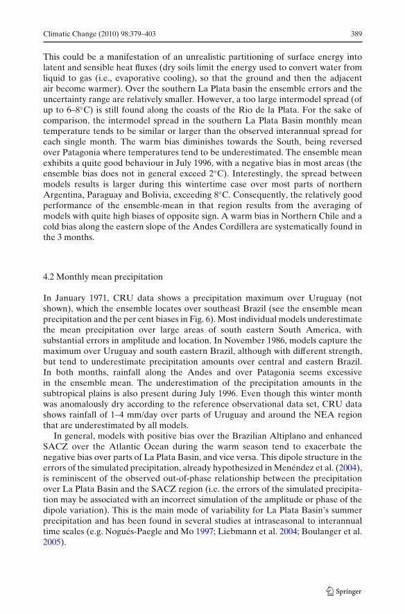
Spatial patterns of the biases of surface air temperature for each of the 3 months assimulated by the models’ ensemble with respect to the reference dataset (CRU) areshown in Fig. 5. Additionally, uncertainty ranges were derived based on the founddifferences between the highest value of the ensemble minus the lowest value at eachgrid point (intermodel range of monthly mean 2 m temperature). January 1971 andNovember 1986 show a quite similar behaviour. During both periods, the ensemble

388 Climatic Change (2010) 98:379–403
JAN 71
BIAS (ENSEMBLE - CRU) INTERMODEL SPREAD
NOV 86
JUL 96
Fig. 5 Biases in monthly mean surface air temperature for the models ensemble for January 1971,November 1986 and July 1996. The simulated temperatures are compared with the CRU data set(left panels). Intermodel range of monthly mean air temperature (right panels). Units: degree Celsius
mean overestimates temperature over large areas in the central and northern part ofthe domain with a maximum bias of about +3◦C. The span between models’ resultsis largest over some areas of Brazil (approx. 8◦C). The large intermodel spread ismainly caused by too high simulated temperatures in some models during the warmseason which are likely connected to a pronounced drying phenomenon (see below).
Climatic Change (2010) 98:379–403 389
This could be a manifestation of an unrealistic partitioning of surface energy intolatent and sensible heat fluxes (dry soils limit the energy used to convert water fromliquid to gas (i.e., evaporative cooling), so that the ground and then the adjacentair become warmer). Over the southern La Plata basin the ensemble errors and theuncertainty range are relatively smaller. However, a too large intermodel spread (ofup to 6–8◦C) is still found along the coasts of the Rio de la Plata. For the sake ofcomparison, the intermodel spread in the southern La Plata Basin monthly meantemperature tends to be similar or larger than the observed interannual spread foreach single month. The warm bias diminishes towards the South, being reversedover Patagonia where temperatures tend to be underestimated. The ensemble meanexhibits a quite good behaviour in July 1996, with a negative bias in most areas (theensemble bias does not in general exceed 2◦C). Interestingly, the spread betweenmodels results is larger during this wintertime case over most parts of northernArgentina, Paraguay and Bolivia, exceeding 8◦C. Consequently, the relatively goodperformance of the ensemble-mean in that region results from the averaging ofmodels with quite high biases of opposite sign. A warm bias in Northern Chile and acold bias along the eastern slope of the Andes Cordillera are systematically found inthe 3 months.
4.2 Monthly mean precipitation
In January 1971, CRU data shows a precipitation maximum over Uruguay (notshown), which the ensemble locates over southeast Brazil (see the ensemble meanprecipitation and the per cent biases in Fig. 6). Most individual models underestimatethe mean precipitation over large areas of south eastern South America, withsubstantial errors in amplitude and location. In November 1986, models capture themaximum over Uruguay and south eastern Brazil, although with different strength,but tend to underestimate precipitation amounts over central and eastern Brazil.In both months, rainfall along the Andes and over Patagonia seems excessivein the ensemble mean. The underestimation of the precipitation amounts in thesubtropical plains is also present during July 1996. Even though this winter monthwas anomalously dry according to the reference observational data set, CRU datashows rainfall of 1–4 mm/day over parts of Uruguay and around the NEA regionthat are underestimated by all models.
In general, models with positive bias over the Brazilian Altiplano and enhancedSACZ over the Atlantic Ocean during the warm season tend to exacerbate thenegative bias over parts of La Plata Basin, and vice versa. This dipole structure in theerrors of the simulated precipitation, already hypothesized in Menéndez et al. (2004),is reminiscent of the observed out-of-phase relationship between the precipitationover La Plata Basin and the SACZ region (i.e. the errors of the simulated precipita-tion may be associated with an incorrect simulation of the amplitude or phase of thedipole variation). This is the main mode of variability for La Plata Basin’s summerprecipitation and has been found in several studies at intraseasonal to interannualtime scales (e.g. Nogués-Paegle and Mo 1997; Liebmann et al. 2004; Boulanger et al.2005).

390 Climatic Change (2010) 98:379–403
JAN 71
ENSEMBLE (MONTHLY MEAN) BIAS (ENSEMBLE - CRU) (%)
NOV 86
JUL 96
Fig. 6 Monthly mean precipitation for the models ensemble and per cent biases for January 1971,November 1986 and July 1996. Units: millimeter per day
By experimental design, models use comparable resolution as well as the sameforcing lateral boundary conditions. Thus the models’ spread is influenced by factorsspecific to the internal model physics and dynamics (i.e. intermodel differences maycome from different model formulation and internal variability). In order to assessthe uncertainty in simulating precipitation, we calculated the intermodel spreadof monthly mean precipitation (Fig. 7, similarly than for temperature results, foreach grid point we evaluate the highest value of the ensemble minus the lowest

Climatic Change (2010) 98:379–403 391
Fig. 7 Monthly intermodelspread for precipitation (seetext) for January 1971,November 1986 and July 1996.Units: millimeter per day
JAN 71
NOV 86
JUL 96
value). For January 1971 and November 1986 the intermodel range of monthly meanprecipitation is very large over large areas of south-eastern South America. The areawith large intermodel spread is more extended in January 1971 than in November

392 Climatic Change (2010) 98:379–403
1986. The location of the intermodel range maxima coincides approximately with theensemble monthly mean maxima. Not surprisingly, the agreement between modelsis better in July 1996 than in the spring and summer months (wintertime weatheris dominated by resolved circulation). For comparison, the intermodel spread ofmonthly precipitation tends to be smaller than the observed interannual spread foreach single month in the southern La Plata Basin. In regions of large precipitation(e.g. NEA) both measures are similar.
4.3 Frequency distribution of the daily rainfall rates
Despite the biases in precipitation and the large inter model spread in the monthlytime-scale, the day-to-day variability tends to be relatively well represented. Ingeneral, the models approximately coincide in the timing of dry days and mainprecipitation events, but they do not coincide in magnitude. The intermodel agree-ment in the daily variation of wet and dry days is more evident during periodswhen precipitation is mainly controlled by the large-scale tropospheric forcing (e.g.during winter, see Fig. 8). This suggests that the models are producing the correctsimulation of precipitation-generating circulation, but not the correct conversion ofwater vapour into rain reaching the ground.
A remaining question is the comparison of models’ results with daily station dataand with the statistical downscaling technique. The targets are twofold: to explore theextent to which using a statistical downscaling technique improves the downscalingof the distribution of precipitation in intensity classes, and to explore how bothtechniques (dynamical and statistical downscaling) capture the heaviest rainfall days.In order to answer the first issue, we made frequency diagrams of daily precipitationfor each model, for the SDS and for the available observational data. For eachindividual model we count for each grid point in each sub-region (NEA, SME,CEA), the total number of days within each precipitation interval representing drydays or “drizzle” precipitation (0–1 mm/day) and light (1–5 mm/day), moderate (5–
Fig. 8 Time series of areamean daily precipitation for alldynamical models for theregion CEA. Units: millimeterper day

Climatic Change (2010) 98:379–403 393
15 mm/day), strong (15–30 mm/day) and heavy (>30 mm/day) precipitation days.Then we evaluate the mean frequency (in percentage) for the considered regionduring each analyzed period. The results are shown in Figs. 9, 10 and 11, afteraveraging over models. The frequency distributions for the models are described bythe median, the 25% and 75%, or quartile, values (half of the models lie betweenthese two values) and the maximum and minimum values in the model ensemble.For the SDS and for the in situ data, the methodology is similar but we count foreach station the number of days in each precipitation regime (we show the meanfrequency for the considered region during each analyzed period).
In general, the frequency distribution of daily rainfall rates according to the SDSfollows the overall features of those observed over the three regions and during thethree periods (Figs. 9–11). The dynamical models’ ensemble also seems to succeedin reproducing the overall observed frequency of daily precipitation for all regionsand periods. At least, the observed frequency is often found within the min–maxrange of the ensemble and is at times found within the inter-quartile range. But wenotice that most dynamical models tend to underestimate the frequency of dry daysover NEA and overestimate the amount of light rainfall days in the three regions.As expected, the number of events in the higher intensity regimes tends to be undersimulated by the models. During the first period (Fig. 9), the SDS always gives abetter estimate of the frequency of rainfall in each range of amounts than the modelsor the mean of the models. However, the differences between observations and SDSestimates in the frequency of heavy precipitation days are quite noticeable. Duringthe second period (Fig. 10), it is striking in NEA that the SDS simulates much betterthe observation probability of dry days. During the third period (Fig. 11), whichwas not characterized by heavy rainfalls, the differences between the dynamical andstatistical results are low. Overall, and especially during the first and second periods,the statistical model overcomes the dynamical ensemble in representing all ranges ofprecipitation amounts.
0 - 1 1 - 5 5 - 15 15 - 30 30 - 5000
0.1
0.2
0.3
0.4
0.5
0.6
0.7
0.8
0.9NEA
Precipitation Range
Fre
cuen
cy
ObservedSDS
0 - 1 1 - 5 5 - 15 15 - 30 30 - 5000
0.1
0.2
0.3
0.4
0.5
0.6
0.7
0.8
0.9SMA
Precipitation Range
Fre
cuen
cy
ObservedSDS
0 - 1 1 - 5 5 - 15 15 - 30 30 - 5000
0.1
0.2
0.3
0.4
0.5
0.6
0.7
0.8
0.9CEA
Precipitation Range
Fre
cuen
cy
ObservedSDS
Fig. 9 Intermodel range of frequency of daily precipitation for the regions NEA, SME and CEAfor January 1971. For each grid point and each model, we count the total number of days withineach precipitation interval. For each interval, the figure shows the minimum, maximum, medianand 25% and 75% quartile values among the six models. Blue lines represent observations frommeteorological stations and the red lines represent the statistical downscaling results

394 Climatic Change (2010) 98:379–403
0 - 1 1 - 5 5 - 15 15 - 30 30 - 5000
0.1
0.2
0.3
0.4
0.5
0.6
0.7
0.8
0.9
NEA
Precipitation Range
Fre
cuen
cy
ObservedSDS
0 - 1 1 - 5 5 - 15 15 - 30 30 - 5000
0.1
0.2
0.3
0.4
0.5
0.6
0.7
0.8
0.9
SMA
Precipitation Range
Fre
cuen
cy
ObservedSDS
0 - 1 1 - 5 5 - 15 15 - 30 30 - 5000
0.1
0.2
0.3
0.4
0.5
0.6
0.7
0.8
0.9
CEA
Precipitation Range
Fre
cuen
cy
ObservedSDS
Fig. 10 As Fig. 8, but for November 1986
4.4 Heavy rainfall
The rainfall in La Plata Basin has been related in large part to mesoscale convectivesystems (Velasco and Fritsch 1987; Nesbitt and Zipser 2003). In order to addressthe simulation of high rainfall extremes associated with intense storms, Fig. 12shows the 1-day maximum precipitation of the models ensemble at each grid-pointfor January 1971 and November 1986. This figure helps visualizing how intense ashort storm could be in this ensemble. Areas registering intense precipitation in themodels ensemble differ between both periods. Peaks of simulated intense rainfall aredistributed throughout the SACZ area, southern Brazil and northern Argentina inJanuary 1971, but are more confined in the southern La Plata Basin in November1986. Heaviest rainfall intensities and locations of maxima also vary substantiallybetween models (not shown). In January 1971, LMDZ, MM5, REMO and PROMESproduce peak rainfall exceeding 100 mm in 24 hours, but only LMDZ and PROMESlocate any of such peaks over the southern La Plata Basin, the region of enhancedmonthly mean precipitation according to the observed climatology. In November1986, only REMO produces heavy precipitation with maxima exceeding 100 mm/day
0 - 1 1 - 5 5 - 15 15 - 30 30 - 5000
0.1
0.2
0.3
0.4
0.5
0.6
0.7
0.8
0.9
1
NEA
Precipitation Range
Fre
cuen
cy
ObservedSDS
0 - 1 1 - 5 5 - 15 15 - 30 30 - 5000
0.1
0.2
0.3
0.4
0.5
0.6
0.7
0.8
0.9
1
SMA
Precipitation Range
Fre
cuen
cy
ObservedSDS
0 - 1 1 - 5 5 - 15 15 - 30 30 - 5000
0.1
0.2
0.3
0.4
0.5
0.6
0.7
0.8
0.9
1
CEA
Precipitation Range
Fre
cuen
cy
ObservedSDS
Fig. 11 As Fig. 8, but for July 1996

Climatic Change (2010) 98:379–403 395
a b
Fig. 12 Heaviest rainfall day (at each grid point we find the heaviest rainfall day in every model, andthen we plot the heaviest value of the six models). Units: millimeter per day
over large areas of northern Argentina, Paraguay, southern Brazil and Uruguay. Thelargest 1-day precipitation amounts produced by the other five models are often inthe range 25–100 mm/day, with larger values in very sparse grid-points. In general,the location of maxima is approximately coincident with the region of anomalouslypositive mean precipitation for this month (including maxima in central Chile andnorth western Argentina).
In order to provide a better quantification, Tables 2, 3 and 4. compares thesimulated heavy rainfall, as defined by the 1-day monthly maximum precipitation,with corresponding values from the statistical downscaling technique and with stationobservations. For each sub-region (NEA, CME, CEA), we consider the 1-daymonthly maximum precipitation at each station, and then we found the minimum
Table 2 First period (January 1971)
Jan 1971 NEA SME CEAMin Max Min Max Min Max
Observations 43.6 67.4 59.9 151.6 11.3 128.1LMDZ 11.3 27.1 9.0 66.5 11.1 53.4MM5 14.8 55.2 3.9 28.2 4.2 32.6REMO 27.7 36.6 5.9 51.8 10.1 48.6RCA 21.1 44.5 16.4 46.8 12.0 29.3PROMES 36.0 49.7 34.0 84.9 6.25 48.1WRF 22.8 37.9 10.0 29.5 5.6 26.3SDS1 16.0 209.0 16.0 302.7 0.3 138.0SDS2 34.5 133.6 25.7 144.0 5.7 99.0
Range of 1-day monthly maximum precipitation for each sub-region (NEA, SME, CEA) as simulatedby each model and from the statistical downscaling method (SDS) and station observations. SDS1represents the results of the statistical model when computing first the maximum of each simulationof the ensemble at each station, second, the maximum and minimum of these maxima at eachstation and finally the minimum and maximum among all the stations. SDS2 represents the resultsof the statistical model when computing first the maximum of each simulation of the ensemble ateach station, second, the 90% and 10% percentiles of these maxima at each station and finally theminimum and maximum among all the stations. Units: millimeter per day

396 Climatic Change (2010) 98:379–403
Table 3 Same as Table 2 butfor the second period(November 1986)
Nov 1986 NEA SME CEA
Min Max Min Max Min Max
Observations 36.4 119.8 39.6 105.2 7.5 78.0LMDZ 6.3 78.6 19.1 72.3 8.6 50.0MM5 63.8 127.7 9.7 82.8 3.9 32.0REMO 33.5 94.2 49.4 199.0 4.9 87.7RCA 17.1 37.2 16.9 66.6 6.9 42.2PROMES 34.9 53.9 10.1 52.1 9.8 30.7WRF 1.1 7.2 22.5 75.8 5.2 26.1SDS1 18.8 209.0 12.5 315.0 4.0 225.3SDS2 36.0 183.8 22.0 165.8 8.0 92.0
and maximum of these quantities. Each min–max interval represents the range ofrainfall amounts corresponding to the heaviest rainfall day in the stations of eachsub-region for the observations, the models and the statistical downscaling.
Given that the SDS simulation is actually an ensemble of 100 simulations, themethodology to compare SDS and individual dynamical models require some adjust-ments. Thus, the SDS results are computed in two different ways. For both ways, firstthe maximum value of each simulation of the ensemble at each station is computed.Second, in the first case, we compute the maximum and minimum values of thesemaxima at each station, while, in the second case, we compute the 90% and 10%percentiles of these maxima at each station. Finally, the minimum and maximumvalues among all stations are computed and displayed in Tables 2–4. The second case(selection of 90% and 10% percentiles) is considered as the stochastic nature of theSDS ensemble implying that for a large number of simulations, the SDS will simulateall values of the precipitation distribution, although with a probability influencedby the weather patterns observed during the simulated period. Thus, as noted inTables 2–4, the range of values computed in the first case always include the observa-tions although these extreme values may have a very low probability of occurrence.When computing the 90% and 10% percentiles, the range of values is much similarto the observations although the maximum values are systematically larger thanobservations. As described in D’Onofrio et al. (2009, this issue), the stochastic natureof the SDS ensembles may require other types of statistical tests in order to evaluatethe skill of the SDS to simulate/predict heavy rainfalls. Anyway, given the objective
Table 4 Same as Table 2, butfor the third period (July 1996)
Jul 1996 NEA SME CEA
Min Max Min Max Min Max
Observations 2.0 34.0 0.0 20.0 3.0 39.0LMDZ 1.4 6.4 2.0 23.8 3.7 25.7MM5 4.4 9.8 6.7 20.6 6.3 25.7REMO 1.3 4.2 3.7 67.5 2.7 61.6RCA 1.0 5.0 1.7 9.9 2.6 18.7PROMES 3.7 9.7 9.0 31.3 8.1 29.6WRF 1.3 6.0 8.3 28.1 3.9 19.1SDS1 0 89.5 0.0 66.4 0 95.1SDS2 0.5 73.0 0.0 31.0 0.0 74.0

Climatic Change (2010) 98:379–403 397
of comparison between individual dynamical models, SDS and observations, it canbe concluded that the SDS reproduces fairly well the observations.
It is worth noting important remaining methodological issues related to comparingprecipitation extremes from station observations with model grid-point values. Inparticular, care will have to be taken to assess the simulated precipitation extremesagainst station data because the level of variability in spatially averaged rainfall isnot comparable to that of point rain-gauge observations. For example, a model thatproduces 24-h precipitation events that are as large as found in station data would besomewhat suspect since local intensities measured by rain gauges should be greaterthan grid box mean intensities simulated by models (even in RCMs running at 50 kmresolution).
4.5 Moisture transport
The reasons for the mean biases and errors in the simulation of spatial and tem-poral variability and extremes in south eastern South America in these particularanomalous months are difficult to assess. To address this problem requires one tounderstand the consequences of different model formulations at a detailed level.In general, main sources of errors are related to model representation of cloudsand cloud feedback, feedbacks between model components, and three-dimensionalresponse to the distribution of atmospheric moisture (Leung et al. 2003). Relatedpossible error sources include a likely excessive decline in soil moisture (and anassociated positive feedback of soil moisture drying) and a defective simulation ofthe regional circulation (particularly the humidity advection from the north).
January 1971 and November 1986 are particularly interesting since these aretwo cases of monthly extreme precipitation in the region focused by CLARIS. Theensemble and most individual models reproduce the location of the maximum inprecipitation near the Rio de la Plata in November 1986 (although with differentstrength) but not in January 1971. Models tend to be more skilful in that region atsimulating November 1986 precipitation likely because the January 1971 climate ismore controlled by mesoscale vortices and mesoscale convective complexes, whichare harder to simulate. This suggests that models skill is dependent on the strengthof the large- and synoptic-scale signature of each period.
Accompanying this anomalous precipitation, an enhanced LLJ transports warm,moist air from the north toward the region, contributing to an increase in the thermalcontrast over south eastern South America. The observed and simulated meridionalthermal contrast is particularly strong in November 1986. According to Silva andBerbery (2006) this combined patterns of thermal and dynamical variables suggestthat large-scale systems, like frontal systems, are important in producing intenserainfall events.
Anomalous high precipitation in south eastern South America is linked with astronger-than-normal influx of moisture carried by the low level winds. Many recentarticles agree on the importance of the low-level flow on the regional precipitationregime (see a recent review in Silva and Berbery 2006). There are two main sources ofmoisture for the Argentinean plains and La Plata Basin. One of them is related withthe LLJ (particularly enhanced during January 1971) while the other is associatedwith the western branch of the Atlantic anticyclone (predominant during November1986). This meridional transport of moisture and heat was crucial for the occurrence

398 Climatic Change (2010) 98:379–403
of anomalously high precipitation in southern La Plata Basin during these bothperiods.
The 850 hPa meridional moisture fluxes at 20◦ S (Fig. 13), is systematicallyunderestimated by all models in January 1971 as compared with the reanalysis, beingthe spread between models considerably smaller than the difference between theERA-40 estimate and the ensemble mean around the longitude of the maximumsouthward flux (around 62◦ W). In the eastern part of the continent, the scattergrows but the ERA-40 values tend to be within or near the simulated range (i.e.inside the envelope). In November 1986, as expected, the meridional moisture fluxesare better captured by the models. The ensemble mean still underestimates themeridional fluxes of moisture, but the observational estimate is contained by theband of simulated values over a large part of the continent (including the region of
Fig. 13 Eight hundred fiftyhectopascals meridionalmoisture fluxes at 20◦ S fromERA-40 reanalysis and assimulated by the CLARISmodels. Shading indicates therange between the largest andsmallest of the individualvalues
–200
–150
–100
–50
0
50
40 45 50 55 60 65 70 75 80 85
Jan 1971
–150
–100
–50
0
50
40 45 50 55 60 65 70 75 80 85
Nov 1986
–100
–75
–50
–25
0
25
50
40 45 50 55 60 65 70 75 80 85
850
hPa
Hum
idity
flu
x (m
s–1
g k
g–1)
Longitude (W)
Jul 1996
RCM max/minERA
RCM avg

Climatic Change (2010) 98:379–403 399
the maximum flux). However, the scatter among the individual models is larger thanin January 1971 in the LLJ region. It is worth noting that the LLJ extends over someof the largest data voids in South America and reanalyzes are perhaps not adequateto describe its structure.
5 Final remarks
The need for the development of downscaling techniques for South America isincreasing in the context of regional integrated assessments and socio-economicapplications. This fact motivates a regional modelling intercomparison exerciseperformed by most of the research centres involved in CLARIS Work Package3.1. The goal was to assess the capabilities of various RCMs and one stretched-grid GCM driven by reanalyzes (ERA-40) to simulate particular month-long casescharacterized by extreme precipitation conditions in the southern La Plata Basin(January 1971, November 1986 and July 1996). A statistical downscaling methodbased on weather pattern classification was also tested for downscaling precipitationover that region from ERA-40 (D’Onofrio et al. 2009, this issue) in order to evaluateits performance for specific extreme month-long cases. Overall, and especially duringthe first and second periods, the statistical model is closer to observations than thedynamical models in representing all ranges of precipitation amounts.
The analysis has emphasized on the simulation of the precipitation over landand has provided a quantification of the biases of and scatter between the differentregional simulations. Relatively large biases and intermodel spread are noticed inthe simulated rainfall. Most but not all models underpredict precipitation amounts insouth eastern South America during the three periods. Results suggest that modelshave regime dependence, performing better for some conditions than others. Ineffect, they tend to be more skilful at simulating November 1986 precipitation be-cause the January 1971 climate is more controlled by mesoscale and convective-scaleprecipitation events. Thermal instability, moist convective activity and the strength oflocal processes are maximum during summer. These factors add a strong element ofrandomness and nonlinearity to the models, thereby maximizing the internal modelvariability and errors, affecting the January 1971 simulation. Wintertime weatheris dominated by synoptic scale systems and during the transitional months fromwinter to summer regimes, precipitation is still relatively controlled by the large-scaletropospheric forcing (i.e. accordingly the models ensemble performs relatively betterduring November 1986).
CLARIS models tend to underestimate the moisture transport and to misrepre-sent precipitation, especially in January 1971. These failures in the low-level circula-tion and in the associated precipitation processes in the LLJ exit region have beenpreviously found in some studies performed with regional models (Vernekar et al.2003; Paegle et al. 2004). Given the complexity of precipitation processes associatedwith the LLJ and its interactions with the Chaco low (a thermal continental low overnorthern Argentina affecting the northerly winds, Seluchi and Marengo 2000) andwith transient cyclonic perturbations, perhaps is not surprising that models oftenfail to capture these features. Simulating the fine-scale precipitation features insouth eastern South America remains a troublesome challenge for future research.

400 Climatic Change (2010) 98:379–403
However, we caution that reanalysis does not incorporate satellite observations priorto 1979 and this could negatively influence the lateral boundary conditions over theocean for the January 1971 case.
A note of caution must be made given the paucity of available in situ data fromsites within southern South America. It is necessary to have a better observationalnetwork over the region to accurately represent the space–time variability of theregional climate for validating models and developing statistical downscaling tech-niques. Additionally, our results are based on a small sample (three case studies of1 month). It is necessary to validate these results from a much larger sample (workin progress).
Simulations were achieved by five regional models and one stretched-grid globalmodel. In addition, a statistical downscaling technique was employed as a comple-mentary method. This first CLARIS downscaling exercise should thus be thought ofas typical but not fully comprehensive of the range of possible solutions that state-of-the-art models and downscaling techniques might provide for southern SouthAmerica. The employed tools are as good as appears possible with the currentgeneration of atmospheric models and statistical techniques, but the uncertaintiesconcerning downscaled precipitation in the region are still significant. Models tendto simulate too dry and warm (cold) conditions during the spring and summer(winter) months. The reasons for the errors in the simulation of precipitation inthese particular anomalous periods are difficult to assess, but it seems likely thatsome physical processes occurring in this region are not efficiently represented inthe models. Deficient simulations of the local thermodynamic factors are potentiallyimportant for the biases in the present climate and for future changes in the regionalclimate. For example, feedbacks associated with the drying of the soil in summerwould be important and need to be better captured by the models.
This paper represents only a first step in the development of downscaling tech-niques in the framework of CLARIS and much work still needs to be done to fullytest and evaluate models and regionalization tools. More research is also needed tounderstand the models’ capabilities and the variety of simulated feedbacks in theregion, and how to combine information from different regional simulations withinformation from other sources such as statistical downscaling.
Acknowledgements We wish to thank the European Commission 6th Framework programme forfunding the CLARIS Project (Project 001454). The three periods were selected by Olga Penalba andMatilde Rusticucci (DCAO, FCEN, Universidad de Buenos Aires) in the framework of CLARISWP3.2. This work was begun while C.G. Menéndez visited the Facultad de Ciencias del MedioAmbiente in Toledo (Spain), invited by the Universidad de Castilla-La Mancha. The ECOS A04U02and PIP/CONICET 5416 projects also supported this work. Constructive comments from twoanonymous reviewers are greatly appreciated.
Open Access This article is distributed under the terms of the Creative Commons AttributionNoncommercial License which permits any noncommercial use, distribution, and reproduction inany medium, provided the original author(s) and source are credited.

Climatic Change (2010) 98:379–403 401
References
Barrucand M, Rusticucci M (2001) Climatología de temperaturas extremas en la Argentina. Vari-abilidad temporal y regional. Meteorológica 26:85–102
Bettolli M, Penalba O, Vargas W (2005) Características de la precipitación diaria en la región sojeraArgentina. In: Proceedings of the IX congreso Argentino de meteorología, Buenos Aires
Bony S, Emanuel KA (2001) A parameterization of the cloudiness associated with cumulus convec-tion; evaluation using TOGA-COARE data. J Atmos Sci 58(21):3158–3183
Boulanger J-P, Lafon F, Penalba O, Rusticucci M, Vargas W (2005) Low-frequency modes ofobserved precipitation variability over the La Plata basin. Clim Dyn 24:393–413. doi:10.1007/s00382-004-0514-x
Castro M, Fernandez C, Gaertner MA (1993) Description of a meso-scale atmospheric numericalmodel. In: Diaz JI, Lions JL (eds) Mathematics, climate and environment, Masson (ISBN: 2-225-84297-3), p 273
Champeaux JL, Masson V, Chauvin F (2005) ECOCLIMAP: a global database of land surfaceparameters at 1 km resolution. Meteorol Appl 12:29–32
Chen F, Dudhia J (2001) Coupling and advanced land surface-hydrology model with the Penn State-NCAR MM5 modeling system. Part I: model implementation and sensitivity. Mon Weather Rev129:569–585
Christensen OB (1999) Relaxation of soil variables in a regional climate model. Tellus A 51:674–685
Christensen JH, Hewitson B, Busuioc A, Chen A, Gao X, Held I, Jones R, Kolli RK, Kwon W-T,Laprise R, Rueda VM, Mearns L, Menéndez CG, Räisänen J, Rinke A, Sarr A, Whetton P (2007)Regional climate projections. In: Solomon S, Qin D, Manning M, Chen Z, Marquis M, AverytKB, Tignor M, Miller HL (eds) Climate change 2007: the physical science basis. Contributionof working group I to the fourth assessment report of the intergovernmental panel on climatechange. Cambridge University Press, Cambridge
Cosgrove BA et al (2003) Land surface model spin up behavior in the North American land dataassimilation system (NLDAS). J Geophys Res 108:8845. doi:10.1029/2002JD003316
Diaz A, Aceituno P (2003) Atmospheric circulation anomalies during episodes of enhanced andreduced convective cloudiness over Uruguay. J Clim 16:3171–3185
D’Onofrio A, Boulanger J-P, Segura EC (2009) A weather pattern classification systemfor regional climate downscaling of daily precipitation and temperature. Clim Change.doi:10.1007/s10584-009-9738-4
Ducoudre N, Laval K, Perrier A (1993) SECHIBA, a new set of parameterizations of the hydrologicexchanges at the land-atmosphere interface within the LMD atmospheric general circulationmodel. J Clim 6:248–273
Dudhia J (1989) Numerical study of convection observed during the winter monsoon experimentusing a mesoscale two-dimensional model. J Atmos Sci 46:3077–3107
Dümenil L, Todini E (1992) A rainfall–runoff scheme for use in the Hamburg climate model.In: O’Kane JP (ed) Advances in theoretical hydrology, EGS series of hydrological sciences 1.Elsevier, Amsterdam, pp 129–157
Emanuel KA (1993) A scheme for representing cumulus convection in large-scale models. J AtmosSci 48:2313–2335
Fuenzalida H (2007) Climate change simulations with PRECIS over Chile. Presentation at theCLARIS final meeting, La Plata, Argentina, June 2007
Garand L (1983) Some improvements and complements to the infrared emissivity algorithm includ-ing a parameterization of the absorption in the continuum region. J Atmos Sci 40:230–244
Giorgetta M, Wild M (1995) The water vapour continuum and its representation in ECHAM4, MaxPlanck institut fuer meteorologie report, vol 162, p 38
Giorgi F, Mearns LO (1999) Introduction to special section: regional climate modeling revisited. JGeophys Res 104:6335–6352
Grell GA, Dévényi D (2002) A generalized approach to parameterizing convection combiningensemble and data assimilation techniques. Geophys Res Lett 29:1693. doi:10.1029/2002GL01531
Hoskins BJ, Hodges KI (2005) New perspectives on the Southern Hemisphere winter storm tracks.J Clim 18:4108–4129

402 Climatic Change (2010) 98:379–403
Hourdin F, Musat I, Bony S, Braconnot P, Codron F, Dufresne J-L, Fairhead L, Filiberti M-A,Friedlingstein P, Grandpeix J-Y, Krinner G, LeVan P, Li Z-X, Lott F (2006) The LMDZ4general circulation model: climate performance and sensitivity to parametrized physics withemphasis on tropical convection. Clim Dyn 27:787–813
Hsie EY, Anthes RA, Keyser D (1984) Numerical simulation of frontogenesis in a moist atmosphere.J Atmos Sci 41:2581–2594
Jacob D (2001) A note on the simulation of the annual and inter-annual variability of the waterbudget over the Baltic Sea drainage basin. Met Atmos Phys 77:61–73
Jones CG, Sanchez E (2002) The representation of shallow cumulus convection and associated cloudfields in the Rossby Centre Atmospheric Model. HIRLAM newsletter 41, SMHI, SE-60176Norrköping, Sweden, pp 91–106
Kain J, Fritsch J (1993) Convective parameterization for mesoscale models: the Kain-Fritsch scheme.In: Emanuell KA, Raymond DJ (eds) The representation of cumulus convection in numericalmodels. American Meteorological Society, Boston, pp 165–170
Kjellström E, Bärring L, Gollvik S, Hansson U, Jones C, Samuelsson P, Rummukainen M, UllerstigA, Willén U, Wyser K (2005) A 140-year simulation of European climate with the new versionof the Rossby Centre regional atmospheric climate model (RCA3). Reports Meteorology andClimatology No 108, SMHI, SE-60176 Norrköping, Sweden, 54 pp
Kodama YM (1993) Large-scale common features of the subtropical convergence zones (the Baiufrontal zone, the SPZ, and the SACZ). Part II: conditions of the circulations for generating theSTCZs. J Meteorol Soc Japan 71:581–610
Krinner G, Viovy N, de-Noblet-Ducoudré N, Ogée J, Polcher J, Friedlingstein P, Ciais P, Sitch S,Prentice C (2005) A dynamic global vegetation model for studies of the coupled atmosphere–biosphere system. Glob Chang Biol 19:1015–1048
Leung LR, Mearns LO, Giorgi F, Wilby RL (2003) Regional climate research needs and opportuni-ties. Bull Am Meteorol Soc 84:89–95
Liebmann B, Kiladis GN, Vera CS, Saulo AC, Carvalho LMV (2004) Subseasonal variations ofrainfall in South America in the vicinity of the low-level jet east of the Andes and comparison tothose in the South Atlantic convergence zone. J Clim 17:3829–3842
Marengo JA (2007) Integrating across spatial and temporal scales in climate projections: challengesfor using RCM projections to develop plausible scenarios for future extreme events in SouthAmerica for vulnerability and impact studies. In: Meeting report (papers) of the IPCC TGICAregional expert meeting, Nadi, Fiji, 20–22 June 2007
Marengo JA, Soares WR, Saulo C, Nicolini M (2004) Climatology of the low-level jet east of theAndes as derived from the NCEP–NCAR reanalyses: characteristics and temporal variability. JClim 17:2261–2280
Menéndez CG, Cabré MF, Nuñez MN (2004) Interannual and diurnal variability of January pre-cipitation over subtropical South America simulated by a regional climate model. CLIVARExchanges 29:1–3
Menéndez CG, Sörensson AA, Samuelsson P, Willén U, Hansson U (2007) Simulating soil-precipitation feedbacks in South America. In: Meeting report (papers) of the IPCC TGICAregional expert meeting, Nadi, Fiji, 20–22 June 2007
Misra V, Dirmeyer PA, Kirtman BP (2003) Dynamic downscaling of seasonal simulations over SouthAmerica. J Clim 16:103–117
Mlawer EJ, Taubman SJ, Brown PD, Iacono MJ, Clough SJ (1997) Radiative transfer for inhomo-geneous atmospheres: RRTM, a validated correlated-k model for the longwave. J Geophys Res102D:16663–16682
Morcrette J-J (1991) Radiation and cloud radiative properties in the ECMWF operational weatherforecast model. J Geophys Res 96D:9121–9132
Morcrette J-J, Smith L, Fourquart Y (1986) Pressure and temperature dependance of the absorptionin longwave radiation parameterizations. Beitr Phys Atmos 59:455–469
Nesbitt SW, Zipser EJ (2003) The diurnal cycle of rainfall and convective intensity to three years ofTRMM measurements. J Clim 16:1456–1475
New M, Hulme M, Jones P (1999) Representing twentieth-century space time climate variability.Part I. development of a 1961–1990 mean monthly terrestrial climatology. J Clim 12:829–856
New M, Hulme M, Jones P (2000) Representing twentieth-century space time climate variability.Part II: development of 1901–1996 monthly grids of terrestrial surface climate. J Clim 13:2217–2238
Nogués-Paegle J, Mo KC (1997) Alternating wet and dry conditions over South America duringsummer. Mon Weather Rev 125:279–291

Climatic Change (2010) 98:379–403 403
Nordeng TE (1994) Extended versions of the convective parametrization scheme at ECMWF andtheir impact on the mean and transient activity of the model in the tropics. ECMWF ResearchDepartment, Technical memorandum no 206, October 1994. European Centre for MediumRange Weather Forecasts, Reading, UK, pp 41
Núñez M, Solman S, Cabré M (2006) Mean climate and annual cycle in a regional climate changeexperiment over Southern South America. II: climate change scenarios (2081–2090). In: Pro-ceedings of 8 ICSHMO, 24–28 April 2006. Foz do Iguacu, Brazil, pp 325–331
Paegle J, Ambrizzi T, Berbery H, Campetella C, Garreaud R, Herdies D, Marengo J, Menéndez CG,Nicolini M, Porfirio da Rocha R, Ruiz J, Saulo CS, Seluchi M, Silva Dias PL (2004) Modelingstudies related to SALLJEX. CLIVAR Exchanges 29:9–11
Räisänen P, Rummukainen M, Räisänen J (2000) Modification of the HIRLAM radiation schemefor use in the Rossby Centre regional atmospheric climate model. Department of Meteorology,Report No 49, University of Helsinki, pp 71
Rasch PJ, Kristjánsson JE (1998) A comparison of the CCM3 model climate using diagnosed andpredicted condensate parameterizations. J Clim 11:1587–1614
Rauscher SA, Seth A, Qian J-H, Camargo SJ (2006) Domain choice in an experimentalnested modeling prediction system for South America. Theor Appl Climatol 86:229–246.doi:10.1007/s00704-006-0206-z
Rauscher SA, Seth A, Liebmann B, Qian J-H, Camargo SJ (2007) Regional climate model—simulated timing and character of seasonal rains in South America. Mon Weather Rev 135:2642–2657
Rodell M, Houser PR, Berg AA, Famiglietti JS (2005) Evaluation of 10 methods for initializing aland surface model. J Hydrometeorol 6:146–155
Samuelsson P, Gollvik S, Ullerstig A (2006) The land-surface scheme of the Rossby Centre regionalatmospheric climate model (RCA3). Report in meteorology 122, SMHI SE-601 76. Norrköping,Sweden
Sass BH, Rontu L, Savijärvi H, Räisänen P (1994) HIRLAM-2 Radiation scheme: documentationand tests. Hirlam technical report no 16, SMHI. SE-601 76 Norrköping, Sweden, 43 pp
Savijärvi H (1990) A fast radiation scheme for mesoscale model and short-range forecast models. JAppl Met 29:437–447
Seluchi ME, Marengo JA (2000) Tropical-midlatitude exchange of air masses during summer andwinter in South America: climatic aspects and examples of intense events. Int J Climatol 20:1167–1190
Seth A, Rauscher SA, Camargo SJ, Qian J-H, Pal JS (2007) RegCM3 regional climatologies forSouth America using reanalysis and ECHAM global model driving fields. Clim Dyn 28:461–480.doi:10.1007/s00382-006-0191-z
Silva VBS, Berbery EH (2006) Intense rainfall events affecting the La Plata basin. J Hydrometeorol7:769–787
Solman S, Nuñez M, Cabré MF (2007) Regional climate change experiments over southern SouthAmerica. I: present climate. Clim Dyn 30:533–552. doi:10.1007/s00382-007-0304-3
Sörensson AA, Menéndez CG, Hansson U, Samuelsson P, Willén U (2007) Present and future cli-mate as simulated by Rossby Centre regional atmosphere model (RCA3) forced by ECHAM5-OM over South America. Presentation at the CLARIS final meeting, La Plata, Argentina, June2007
Stephens GL (1978) Radiation profiles in extended water clouds: II. Parameterization schemes. JAtmos Sci 35:2123–2132
Sundquist H (1978) A parameterization scheme for non-convective condensation including precipi-tation including prediction of cloud water content. Quart J R Met Soc 104:677–690
Tiedtke M (1989) A comprehensive mass flux scheme for cumulus parameterization in large scalemodels. Mon Weather Rev 117:1779–1800
Uppala SM et al (2005) The ERA-40 re-analysis. Quart J R Meteorol Soc 131:2961–3012.doi:10.1256/qj.04.176
Velasco I, Fritsch JM (1987) Mesoscale convective complexes in the Americas. J Geophys Res92(D8):9591–9613
Vernekar AD, Kirtman BP, Fennessy MJ (2003) Low-level jets and their effects on the SouthAmerican summer climate as simulated by the NCEP ETA model. J Clim 16:297–311