
Weather Hazard Modeling Research and development:Recent Advances and Plans
Friends and Partners of Aviation WeatherNBAA Convention, Nov 2-3, 2016
Stephen S. Weygandt Curtis Alexander, Stan Benjamin,
Geoff Manikin*, Tanya Smirnova, Ming HuNOAA Earth System Research Laboratory
*NOAA National Centers for Environmental Prediction

Valid
Loop of radar reflectivity Observations
High-resolution models of hazardous weathernow making very realistic forecasts
Missing radar observations
Given forecasts are not always exactly right
How to improve decision making with inexactforecasts? How can we continue to make forecastsbetter?
Veryrealistic forecasts
15 hour HRRR forecast
Storm details can be wrong
NGM model guidance…around 1990

V2
V1
Continued forecast improvement for Rapidly updated, High-resolution models
Critical Success Index
HRRRReflectivityVerification
Improvement each year…V1
HRRR HRRRV2
NCEP version
22z + 5hr forecasts
RadarObserved
03z

Continued forecast improvement for Rapidly updated, High-resolution models
RAP - upper-airverification
Ongoing study to evaluate how forecast improvements map to aviation decision-making improvements (GSD, AvMet)
Improvement to moisture / microphysics / precipitation,boundary layer / surface energy balance, ensemble assimilation

Higher resolution
models with better physics
Rawins SatelliteAircraft RadarSurface Profiler
Accurate prediction of hazardous weatherWhat are the key requirements?
Rapid updating
Best use of observations (Ensemble data
assimilation)
13-kmReality
ORD
LAX
ORD
3-hr forecast
LAX
6-hr forecastWind
Errors
3-km
-- Fresher forecasts-- Time-lagged ensembles

The benefits of rapid updating:June 16, 2014 NE twin tornadoes
21z 16 June radar obs17z + 4hr
15z + 6hr 14z + 7hr
16z + 5hr
~21z 16 June
Successive HRRR runs converging to solution

HRRR example of consistent solutions:May 11, 2014 NE squall-line
15z+7h 16z+6h 17z+5h
HRRR Updraft HelicityTime-Lagged Ensemble
Successive HRRR runs have consistent solution22z 11 May
Storm Reports
(obs)

Arkansas tornadoes – Sunday 27 April 2014
✖
✖
3 fatalities
HRRR (and RAP) Future MilestonesHRRR MilestonesArkansas Tornadoes April 27 2014
8 fatalities
Tornado Track

15z+10h
19z+6h18z+7h
17z+8h16z+9h
Arkansas tornadoes: very challenging case
Time-lagged ensemble of specific hazard indicator
HRRR Updraft Helicity

00 UTC
Deterministic
Model ensembles: Key to assessing likelihood
Member 3
Observations
Member 2
Member 1
Supercellprobabilitypast hour
19 UTC
00 UTC
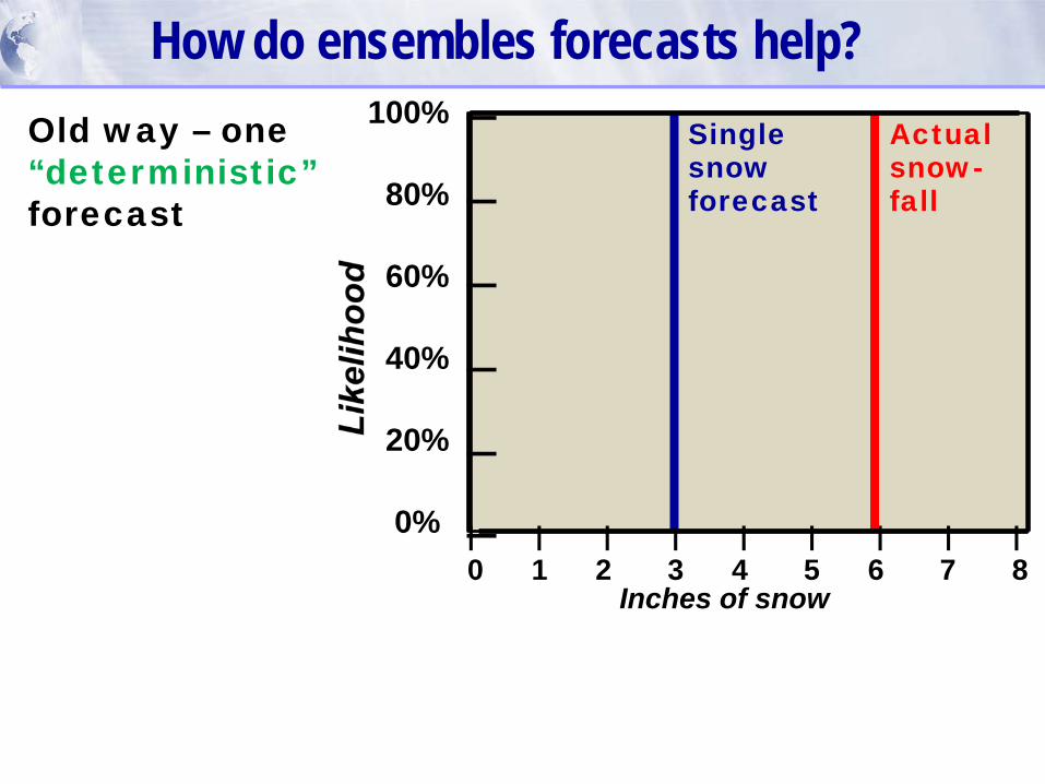
How do ensembles forecasts help?
Inches of snow
| | | | | | | | |0 1 2 3 4 5 6 7 8
100%
80%
60%
40%
20%
0%
Singlesnowforecast
Actualsnow-fall
Old way – one“deterministic”forecast
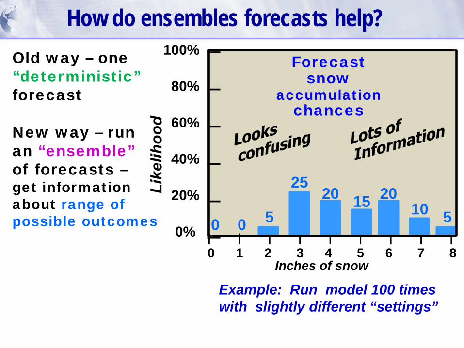
How do ensembles forecasts help?
Inches of snow
| | | | | | | | |0 1 2 3 4 5 6 7 8
100%
80%
60%
40%
20%
0% 0 50
2520 15 20
10 5
Forecastsnow
accumulationchances
Old way – one“deterministic”forecast
New way – runan “ensemble”of forecasts –get informationabout range ofpossible outcomes
Example: Run model 100 times with slightly different “settings”

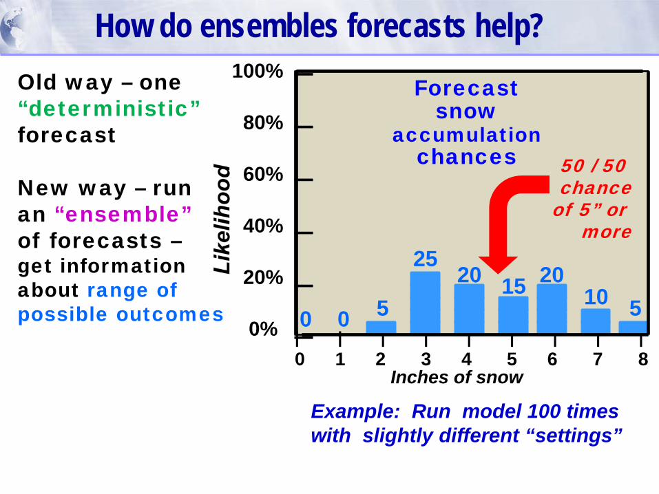
How do ensembles forecasts help?
Inches of snow
| | | | | | | | |0 1 2 3 4 5 6 7 8
100%
80%
60%
40%
20%
0% 0 50
2520 15 20
10 5
Almost NO chanceOf less than 2”
Forecastsnow
accumulationchances
Old way – one“deterministic”forecast
New way – runan “ensemble”of forecasts –get informationabout range ofpossible outcomes
Example: Run model 100 times with slightly different “settings”
How do ensembles forecasts help?
Inches of snow
| | | | | | | | |0 1 2 3 4 5 6 7 8
100%
80%
60%
40%
20%
0% 0 50
2520 15 20
10 5
50 / 50 chance
of 5” or more
Forecastsnow
accumulationchances
Old way – one“deterministic”forecast
New way – runan “ensemble”of forecasts –get informationabout range ofpossible outcomes
Example: Run model 100 times with slightly different “settings”
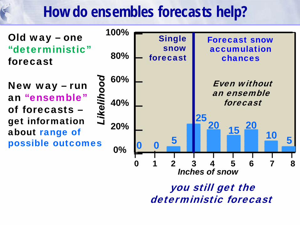
How do ensembles forecasts help?
Inches of snow
| | | | | | | | |0 1 2 3 4 5 6 7 8
100%
80%
60%
40%
20%
0% 0 50
2520 15 20
10 5
Forecast snowaccumulation
chances
Singlesnow
forecast
Old way – one“deterministic”forecast
New way – runan “ensemble”of forecasts –get informationabout range ofpossible outcomes
you still get the deterministic forecast
Even withoutan ensemble
forecast
21z 16 June radar obs
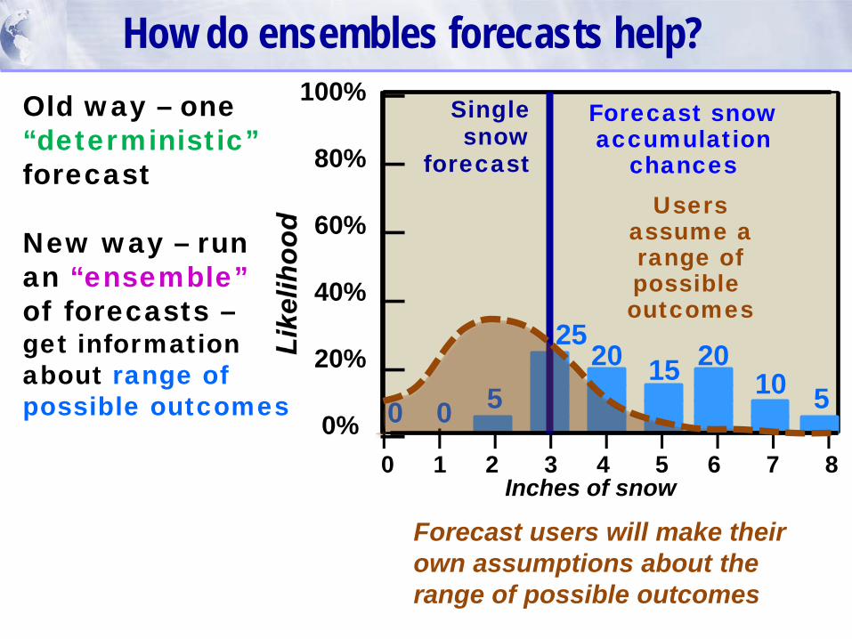
How do ensembles forecasts help?
Inches of snow
| | | | | | | | |0 1 2 3 4 5 6 7 8
100%
80%
60%
40%
20%
0% 0 50
2520 15 20
10 5
Forecast snowaccumulation
chances
Singlesnow
forecast
Old way – one“deterministic”forecast
New way – runan “ensemble”of forecasts –get informationabout range ofpossible outcomes
Forecast users will make theirown assumptions about therange of possible outcomes
Usersassume arange ofpossible outcomes

How do ensembles forecasts help?
Inches of snow
| | | | | | | | |0 1 2 3 4 5 6 7 8
100%
80%
60%
40%
20%
0% 0 50
2520 15 20
10 5
Oldsinglesnow
forecast
Actualsnow-fall
Forecast snow
accum-ulation
chances
Old way – one“deterministic”forecast
New way – runan “ensemble”of forecasts –get informationabout range ofpossible outcomes
One more key benefitfrom ensembles:

How do ensembles forecasts help?
Inches of snow
| | | | | | | | |0 1 2 3 4 5 6 7 8
100%
80%
60%
40%
20%
0% 0 50
252015 20
10 5
Actualsnow-fall
Bettersinglesnow
forecast
Forecast snow
accum-ulation
chances
Old way – one“deterministic”forecast
New way – runan “ensemble”of forecasts –get informationabout range ofpossible outcomes
One more key benefitfrom ensembles:“ensemble data assimilation” improves the deterministic forecast
Need ensembles the mostfor the most challenging
forecast situations

Types of ensembles:
1) Ensembles of opportunity-- Time-lagged ensemble (HRRR-TLE)-- Multi-model ensembles (SSEO)ADS: computationally inexpensiveDISADS: model clustering, members not independent
2) “Designed” ensembles-- Perturbed members of single ensemble system(Global Ensemble Forecast System, HRRR-Ensemble)ADS: More useful spread, ensemble assimilation DISADS: computationally expensive
More information on ensembles
Model BModel A
Example ofmodel clustering
Actual

HRRR-TLE example: 18 April 2016
HRRR-TLE forecastprobability of 6hr QPF exceeding 100 year average return interval (ARI)
23z+13h
accum. precip.
00z+12h 01z+11h
Obs.12-hrprecip.

HRRR Time-Lagged Ensemble (HRRR-TLE):GSD real-time product generation
Real-Time Web Graphics (and grids via LDM/FTP)
Echo-Top> 25 kft
Echo-Top> 30 kft
Probability of condition)
Echo-Top> 35 kft
MVFR IFR
http://rapidrefresh.noaa.gov/hrrrtle

HRRR Ensemble (HRRRE)
Proof-of-conceptReal-time
demonstration
• Single core (ARW)• Ensemble DA (GSI-EnKF) • RAP mean + perturbations
Assimilation Forecast20 members 00z - Three mem to 30 hr1 hr cycling 03z - Three mem to 27 hr21 fcsts / day 12z - Six mem to 18 hrStart 21z day zero 15z - Eighteen mem to 15 hrEnd 18z day one 18z - Eighteen mem to 12 hr
Web Graphics (real-time HRRRE to resume Nov. 2016)
http://rapidrefresh.noaa.gov/HRRRE
Planned Fall 2016 Refinements • Add radar reflectivity data assimilation• Stochastic physics • Apply HRRR-TLE statistical processing• Include lagged members?

Comparison: HRRR-TLE and HRRRE
HRRR-Ensemble15z + 7 hr forecast
Time-Lagged Ensemble15z-17z initializations
Updraft Helicity
> 25 m2/s2
fromDifferent
members

A challenge of ensembles: Displaying output / conveying information
Postage stamp plots
Who is the user?
Feed ensemble informationinto decision support systems?
Spaghetti plots
Need more creativedisplay methodsExtract hazard specific informationSimplify display,only most critical information
Snow accumulationwith time
Plumediagrams
Probabilityregions
Paintball plots
Mean andspread

Rapid Refresh and HRRRNOAA hourly updated models
13km Rapid Refresh (RAP)
3km High Resolution Rapid Refresh (HRRR)
Version 3 -- NCEP implement 23 Aug 2016Version 4 – GSDPlanned NCEP – Early 2018
RAP(13-km)
HRRR (3-km)Version 2 – NCEP implement 23 Aug 2016Version 3 – GSD Planned NCEP – Early 2018
HRRR v3 plan HRRR-E (Ensemble)


