Download - Water in northern Australia Summary Report
Water in northern AustraliaSummary of reports to the Australian Government from the CSIRO Northern Australia Sustainable Yields Project
August 2009
2 Water in nor thern Austral ia
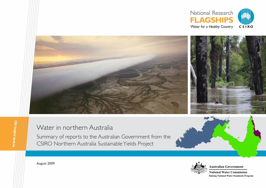
Cover photograph: (left) Morning glory roll >cloud, Gulf of Carpentaria, from 8000 feet, Northern Territory. Courtesy of Russell White, Sydney NSW © 2000. (right) Palms in the waters of Magnificent Creek, Kowanyama, at the mouth of the Mitchell River. Courtesy of TRaCK.
Disclaimers
Derived from or contains data and/or software provided by the Organisations. The Organisations give no warranty in relation to the data and/or software they provided (including accuracy, reliability, completeness, currency or suitability) and accept no liability (including without limitation, liability in negligence) for any loss, damage or costs (including consequential damage) relating to any use or reliance on the data or software including any material derived from that data or software. Data must not be used for direct marketing or be used in breach of the privacy laws. Organisations include: the Western Australia Department of Water; the Northern Territory Department of Natural Resources,
Environment, The Arts and Sport; the Queensland Department of Environment and Resource Management; and the New South Wales Department of Water and Energy.
CSIRO advises that the information contained in this publication comprises general statements based on scientif ic research. The reader is advised and needs to be aware that such information may be incomplete or unable to be used in any specif ic situation. No reliance or actions must therefore be made on that information without seeking prior expert professional, scientif ic and technical advice. To the extent permitted by law, CSIRO (including its
employees and consultants) excludes all liability to any person for any consequences, including but not limited to all losses, damages, costs, expenses and any other compensation, arising directly or indirectly from using this publication (in part or in whole) and any information or material contained in it. Data are assumed to be correct as received from the organisations.
Acknowledgments
Prepared by CSIRO for the Australian Government under the Raising National Water Standards Program of the National Water Commission (NWC). Important aspects of the work were undertaken by the Western Australia Department of Water (DoW); the Northern Territory Department of Natural Resources, Environment, The Arts and Sport (NRETAS); the Queensland Department of Environment and Resource Management (QDERM); the New South Wales Department of Water and Energy; Sinclair Knight Merz; Environmental Hydrology Associates and Jolly Consulting.
The Project was guided and reviewed by a Steering Committee (Kerry Olsson, NWC – co-chair; Chris Schweizer, Department of the Environment, Water, Heritage and the Arts (DEWHA) – co-chair; Tom Hatton, CSIRO; Louise Minty, Bureau of Meteorology (BoM); Lucy, Vincent, Bureau of Rural Sciences (BRS); Tom Crothers, QDERM; Lyall Hinrichsen, QDERM; Ian Lancaster, NRETAS; Mark Pearcey, DoW; Michael Douglas, Tropical Rivers and Coastal Knowledge (TRaCK); Dene Moliere, Environmental Research Institute of the Supervising Scientist (eriss); secretariat support by Angus MacGregor, DEWHA) and benefited from additional reviews by a Technical Reference Panel and other experts, both inside and outside CSIRO.
Citation
CSIRO (2009). Water in northern Australia. Summary of reports to the Australian Government from the CSIRO Northern Australia Sustainable Yields Project. CSIRO, Australia. 12pp
Publication Details
Published by CSIRO © 2009 all rights reserved. This work is copyright. Apart from any use as permitted under the Copyright Act 1968, no part may be reproduced by any process without prior written permission from CSIRO.
ISSN 1835-095X

August 2009 3
!
!
!
!
!!
!
±
Arafura Sea
G u l fCoral Sea
0 200 400
Kilometres
Karumba
Mount Isa
Cairns
Weipao f
C a r p e n t a r i a
Kununurra
Darwin
Broome
I n d i a n
O c e a n
Timor Sea
1377
0
mAHDDrainage division boundaryCatchment boundary
Northern Australia
Australia’s north-draining rivers extend from Broome in the west to Cairns in the east and cover an area of 1,247,000 km2. The west is a landscape of harsh, dry escarpments and tablelands, and low-lying river flats draining to the Timor Sea. East of Darwin, Arnhem Land forms the western boundary of the Gulf of Carpentaria, a large, shallow sea enclosed on three sides and bounded on the north by the Arafura Sea. The land bordering the Gulf is generally flat and low-lying. Tidal inundation is significant across the north. To the east, the Great Dividing Range forms a spine separating the Gulf catchments of Cape York Peninsula from those draining to the Great Barrier Reef. To the south, there are no mountains to mark the boundary of the project area and the transition from the profuse tropical growth of the coastal areas to the arid scrubs of central Australia is gradual.
For this project, river basins were grouped into 13 regions across the three drainage divisions. From west to east, these are:
all rain falls during the wet season, from November to April, and during this period, many low-lying areas are flooded. To the south, the climate becomes hotter and more arid.
The equatorial savannah climate of the far north gradually changes southwards into tropical savannah, then grasslands, with small areas of rainforest and subtropical climate along the Great Dividing Range in the east. The far south gradually changes to desert.
Northern rivers, though mostly fairly short, tend to be very large volumetrically by Australian standards and carry half (about 200,000 gigalitres) of the continent’s total yearly streamflow. Most rivers, however, flow only during the short wet season.
Pastoralism is the dominant land use. There are significant areas of nature conservation, Indigenous land use and forestry. Most income is generated by mining; large mines in the area include the Mount Isa Copper Mine, the McArthur River and Century lead-zinc mines and Weipa bauxite mines. The fishing industry is also a major employer, with prawn and finfish industries supported by the extensive coastal wetlands and shallow coastal waters.
Only small areas of the divisions have been cleared (<1 percent) or used intensively. Grazing pressure and fire regime strongly affect native vegetation cover and weeds significantly influence native vegetation condition. The vegetation has
adapted to cyclical conditions resulting from the strong seasonality of highly intense rainfall and the corresponding strong seasonality of streamflow. An increased incidence of introduced grass species and an increasing intensity and frequency of fires is observed in some areas. Buffel grass, an introduced pasture species, is changing the composition of native grasslands and increasing fire intensity. There are large areas of intact native vegetation.
The population is reasonably sparse with most people living in Darwin, Broome or Mt Isa. The Indigenous population is a significant component (>25 percent) of the population.
Key environmental issues include: sustainable management of grazing and fishing, lack of a sustainable fire-management policy and locally, management of mining water, land clearing and rapid population growth.
Northern Australia supports a diverse array of wildlife, and many are endemic to the north. There are over a hundred different fish species and bird life is prolific, with a large migratory population.
Wetland assets include lakes, mangroves, areas subject to inundation, saline coastal flats, watercourses and swamps. There are significant Ramsar Convention sites, including Kakadu National Park. All of the area’s wetlands are important for ecological reasons, or because they have historical significance or high cultural value, particularly to Indigenous people.
During the dry season, most rivers dry up. Hence, all perennial rivers and perennial springs are important sources of water, and most are also sacred sites.
Figure 1. Topography of the Northern Australia Sustainable Yields project area >
Timor Sea • Fitzroy(WA)• Kimberley• Ord-Bonaparte• Daly• VanDiemen• Arafura
Gulf of Carpentaria • Roper• South-WestGulf• Flinders-Leichhardt• South-EastGulf• Mitchell• WesternCape
Northern North-East Coast• NorthernCoral
The climate is predominantly tropical, with high temperatures year-round (averaging 28°C) and high, yet very seasonal, rainfall. Rainfall decreases away from the coast, ranging from 1800 mm/year in the north to 300 mm/year in the south. Almost
Elevation (m)
Region boundary

4 Water in nor thern Austral ia
The Northern Australia Sustainable Yields Project
considered. Surface–groundwater interactions were investigated. Current water storages and storage options were assessed, including groundwater storage, under the different scenarios. New storage sites and storage-yield reliabilities, however, were not assessed.
This project marks the first time a consistent, robust and transparent assessment has been carried out across the three jurisdictions of northern Australia, and the first time that
The National Water Commission – on behalf of the Council of Australian Governments and in consultation with the Australian Government Department of the Environment, Water, Heritage and the Arts – commissioned CSIRO to assess the water resources of northern Australia, covering the Timor Sea and Gulf of Carpentaria drainage divisions and that part of the North-East Coast Drainage Division that lies north of Cairns.
Building on the success of the Murray-Darling Basin Sustainable Yields Project (completed in 2008), the Northern Australia Sustainable Yields Project has developed methods to assess water resources – surface water and groundwater – under four scenarios:
historical climate (1930 to 2007) and A. current development
recent climate (1996 to 2007) and B. current development
future climate (~2030) and current C. development
future climate (~2030) and future D. development.
The term ‘development’ refers to the use of surface water and groundwater supplies. This assessment assumes that all current entitlements are being fully used and, where possible, actual use is also assessed.
Potential changes in flow regime at sites of important environmental assets were identified; these sites are often also important social and cultural sites. The strongly seasonal climate characteristics of northern Australia were
models have included an assessment of possible future climate implications. It constitutes the first activity under the Australian Government’s Northern Australia Water Futures Assessment and provides critical information for the Northern Australia Land and Water Taskforce.
This project was a desktop study. While no new data were collected, new data were generated through numerical modelling using existing data as a base, and new interpretations of existing data were undertaken.
Assessments and reporting have been made at the region scale, with regions ranging from 45,000 km2 to 165,000 km2, and comprising one or more river basins. Thirteen regions are defined for this purpose (Figure 2). This report summarises the results of investigations across the 13 regions (64 river basins) of the Northern Australia Sustainable Yields project area. Separate summary reports are available for each drainage division. Detailed assessments for each region are included within full Division reports.
Figure 2. Reporting >regions for the Northern Australia Sustainable Yields Project. White lines delimit the river basins
August 2009 5
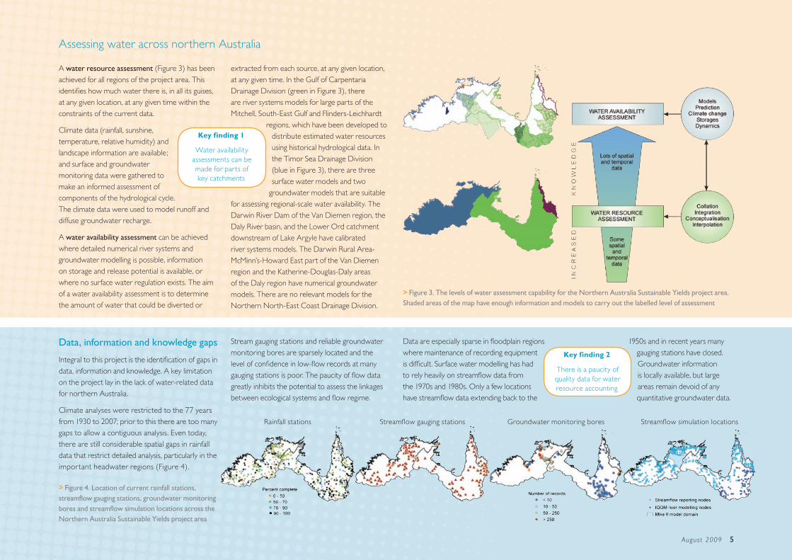
Assessing water across northern Australia
A water resource assessment (Figure 3) has been achieved for all regions of the project area. This identifies how much water there is, in all its guises, at any given location, at any given time within the constraints of the current data.
Climate data (rainfall, sunshine, temperature, relative humidity) and landscape information are available; and surface and groundwater monitoring data were gathered to make an informed assessment of components of the hydrological cycle. The climate data were used to model runoff and diffuse groundwater recharge.
A water availability assessment can be achieved where detailed numerical river systems and groundwater modelling is possible, information on storage and release potential is available, or where no surface water regulation exists. The aim of a water availability assessment is to determine the amount of water that could be diverted or
Data, information and knowledge gaps
Integral to this project is the identification of gaps in data, information and knowledge. A key limitation on the project lay in the lack of water-related data for northern Australia.
Climate analyses were restricted to the 77 years from 1930 to 2007; prior to this there are too many gaps to allow a contiguous analysis. Even today, there are still considerable spatial gaps in rainfall data that restrict detailed analysis, particularly in the important headwater regions (Figure 4).
Figure 3. The levels of water assessment capability for the Northern Australia Sustainable Yields project area. >Shaded areas of the map have enough information and models to carry out the labelled level of assessment
1950s and in recent years many gauging stations have closed. Groundwater information is locally available, but large areas remain devoid of any quantitative groundwater data.
extracted from each source, at any given location, at any given time. In the Gulf of Carpentaria Drainage Division (green in Figure 3), there are river systems models for large parts of the Mitchell, South-East Gulf and Flinders-Leichhardt
regions, which have been developed to distribute estimated water resources using historical hydrological data. In the Timor Sea Drainage Division (blue in Figure 3), there are three surface water models and two
groundwater models that are suitable for assessing regional-scale water availability. The Darwin River Dam of the Van Diemen region, the Daly River basin, and the Lower Ord catchment downstream of Lake Argyle have calibrated river systems models. The Darwin Rural Area-McMinn’s-Howard East part of the Van Diemen region and the Katherine-Douglas-Daly areas of the Daly region have numerical groundwater models. There are no relevant models for the Northern North-East Coast Drainage Division.
Key finding 1
Water availability assessments can be made for parts of key catchments
Stream gauging stations and reliable groundwater monitoring bores are sparsely located and the level of confidence in low-flow records at many gauging stations is poor. The paucity of flow data greatly inhibits the potential to assess the linkages between ecological systems and flow regime.
Data are especially sparse in floodplain regions where maintenance of recording equipment is difficult. Surface water modelling has had to rely heavily on streamflow data from the 1970s and 1980s. Only a few locations have streamflow data extending back to the
Key finding 2
There is a paucity of quality data for water resource accounting
Figure 4. Location of current rainfall stations, >streamflow gauging stations, groundwater monitoring bores and streamflow simulation locations across the Northern Australia Sustainable Yields project area
Rainfall stations Streamflow gauging stations Groundwater monitoring bores Streamflow simulation locations

6 Water in nor thern Austral ia
The Northern Australia Sustainable Yields project area receives substantial rainfall each year. An average of more than 1,077,000 GL (equivalent to 100 times the capacity of Lake Argyle, or 2000 Sydney Harbours) of rain fell across the project area each year between 1930 and 2007. From year to year, however, there is great variability in this amount (Figure 5). The driest year, 1952, received half (546,000 GL) the mean amount; the wettest year, 1974, received nearly twice as much (1,950,000 GL). Averages belie this variability and a single extremely wet year (e.g. 1974) can dramatically increase the long-term mean. This variability increases away from the coast and towards the south: year-to-year variability of rainfall in the Flinders-Leichhardt region in the south is twice that of the Western Cape region in the north.
An extreme climate
More than 94 percent of annual rainfall falls between November and April,
with three to six months receiving little or no rain at all. The potential for evaporation and for plant transpiration (‘potential
evapotranspiration’) is high throughout the year. On average, for ten months of the year potential evapotranspiration is greater than the amount of rainfall received. During a few months in the wet season, daily rainfall can exceed potential evapotranspiration and this drives the seasonal streamflow. On an annual basis, however, rainfall is insufficient to meet evaporative demand and the landscape may be described as water-limited (Figure 6).
Figure 6. Spatial distribution of historical mean annual, wet season and dry season rainfall and potential >evaportransporation and their difference (rainfall less potential evaporation) across the Northern Australia Sustainable Yields Project area water year: 1 September to 31 August; wet season: 1 November to 30 April; dry season: 1 May to 31 October
Figure 5. Annual historical rainfall divergence >(mm) from the historical mean, averaged over the Northern Australia Sustainable Yields project area
-450
-300
-150
0
150
300
450
30/31 50/51 70/71 90/91 06/07
mm
830 mm
Key finding 4
The climate is extremely seasonal and the landscape may be
described as annually water-limited
Key finding 3
There is high inter-annual climate
variability
Water year Wet season Dry season
Diff
eren
ceR
ainf
all
Pote
ntia
l eev
apot
rans
pira
tion
August 2009 7
Historical and current water resources
Surface water
Most rain falls near the coast, on the estuaries, not in the rivers’ headwaters (unlike, for example, the Murray-Darling Basin). Both rainfall and runoff decrease away from the northern coast. Runoff varies from 60 percent to less than 3 percent of rainfall from north to south (Figure 7) and generates on average about 200,000 GL of streamflow across the project area each year.
This pattern of runoff combines with the generally low relief of much of the coastal area to provide little opportunity to increase surface water storages. Opportunities occur mainly in the upper reaches of catchments. In these areas,
however, rainfall is lower and more sporadic, and potential evapotranspiration is higher. Large
storages are needed to compensate for evaporative losses and storage volumes need to be much larger than they would need to be in southern Australia, all things being equal. There are few opportunities
to increase surface water storage that satisfy all these requirements. Possible locations have already been identified by jurisdictions.
Parts of the headwaters of the river basins in the north and east of the Northern Australia Sustainable
Diversions
The majority of rivers across northern Australia have largely unimpeded flow. This is reflected in the large number of wetlands registered in the Directory of Important Wetlands, the proposed Heritage listing of Cape York Peninsula and the Kimberley and the Wild Rivers legislation adopted across many rivers of the Gulf of Carpentaria Drainage Division. A wild river declaration preserves a wild river’s natural values by regulating development within the wild river and its catchment area, and by regulating the taking of natural resources from the area. The few regulated rivers generally have a high degree of regulation and these have had local consequences to flow regimes downstream and around regulation structures.
The greatest diversion occurs in the Lower Ord system around Kununurra to provide water for irrigation, hydropower and environmental flow. The level of use of water diverted for irrigation is low, but hydropower demand can require release of more than half of all inflows to Lake Argyle. Of note, the creation of Lake Argyle and Lake Kununurra through regulation of the Ord River led to their listing as Wetlands of International Importance under the Ramsar Convention.
Key finding 5
Most rain, and runoff, occurs near the coast,
not in the rivers’ headwaters
Key finding 7
Most catchments have largely unimpeded flow
Yields project area receive sufficient rainfall to generate flows in the Mitchell, Western Cape and Northern Coral regions (Figure 7) yet these areas also have low relative relief, or small catchments. The Van Diemen region – the catchments surrounding Darwin – has a combination of high rainfall and adequate relief and additional
potential storages have been identified. Their likely development, however, is beyond the time frame of this study (i.e. beyond 2030).
Figure 7. Spatial distribution of historical mean annual rainfall and modelled runoff across the Northern Australia Sustainable Yields >project area, overlaid on a relative relief surface
Key finding 6
There are significant constraints on the viability of surface
water storages
Rainfall Runoff

8 Water in nor thern Austral ia
Critically, the inland rivers that flow through
the dry season are sustained by localised
groundwater discharge—discharge
occurs where streams cross
outcrops of shallow aquifers, or
where deeper artesian waters
puncture the landscape, generating
springs (Figure 8). These localised
points of discharge are few and the
risk of impact from development is
high. In these environments, ecosystems have
adapted to streamflow conditions that are
The high evaporation rates and long dry seasons
mean that very few rivers—indeed, very few
river reaches—flow year-round.
Those that do are highly valued.
Values are often environmental,
cultural, social and developmental,
and are intertwined. These
perennial river reaches support
endemic ecosystems, provide
tourism and fishing opportunities
and have high spiritual significance for Indigenous
and non-Indigenous people alike.
Surface water – groundwater interaction
Key finding 8
There are very few perennial river reaches
and these have high cultural, social and ecological value
Groundwater
Figure 8. Surface– >groundwater connectivity across the Northern Australia Sustainable Yields Project area. The few rivers that flow through the dry season are related to discharge either from Great Artesian Basin aquifers in the east, or carbonate aquifers in the centre and west
rainfall-dependent in the wet
season and groundwater-
dependent in the dry season.
Key finding 9
Inland perennial rivers are sustained by point discharge of
groundwater
Water tables in shallow aquifers respond dramatically to the seasonal rains, often rising several metres each year. Many shallow aquifers fill to capacity, and drain slowly during the dry season.
Shallow groundwaters generally have good quality water, reflecting the annual fill-and-spill cycle, and can be good supplies of potable water. Extractable yields are determined by the extent to which these dynamic systems can recover each year. The annual natural rise and fall of water levels, however, means these systems have lower extractable yields than deeper, regional systems or the confined aquifers of the Great Artesian Basin, and there is a risk of extraction reducing any streamflow of local rivers reliant on groundwater input.
The extensive aquifers of the Tindall Limestone and Oolloo Dolostone, within the Daly River river basin, for example, may support use of over 100 GL/year. These aquifers, however, are also commonly the primary sources of water that keep local streams flowing year-round; so groundwater extractions adjacent to streams may need regulation to ensure groundwater input to streamflow does not fall below critical limits. Monitoring and models are vital to help constrain levels of extraction. Notably, where water allocation plans are being implemented or developed in the Northern Territory – such as for the Tindall Limestone around Katherine, the Oolloo Dolostone around Daly Rivers and the Darwin-Howard East area – all are resulting in caps to groundwater extraction.
Deep groundwater supplies of the Great Artesian Basin are a potential additional source of water in the east of the project area.
Key finding 10
Shallow groundwater provides opportunities for development, but its dynamic behaviour poses risks of impacting local
streamflow
August 2009 9
There is already significant extraction for stock and domestic purposes. While the resource may support further use, more monitoring of groundwater dynamics is needed to determine safe extraction levels.
The Great Artesian Basin aquifers likely discharge beneath the Gulf of Carpentaria; the consequences of this discharge to the marine environment have not been investigated. Further inland, groundwater from the Great Artesian Basin is the most important source of dry season flow in rivers, and supports numerous artesian springs (Figure 8).
Groundwater recharge rates are variable across the landscape, and depend on soil type, vegetation and topography as well as rainfall amount and other climate variables. The complex interplay between these parameters means there is not always a direct correlation between rainfall and groundwater recharge rates. Modelling indicates that rainfall regime (rain per rain day, number of rain days) is critical, and lower total rainfall might still result in higher recharge. Pathways for water infiltration to water tables can be complex and may change in importance through the year. So, rivers may recharge aquifers during the wet months, while discharging groundwater may keep rivers flowing during the dry months.
Groundwater data are very sparse for most aquifers across the project area and there are large
Floods, flows and ecology
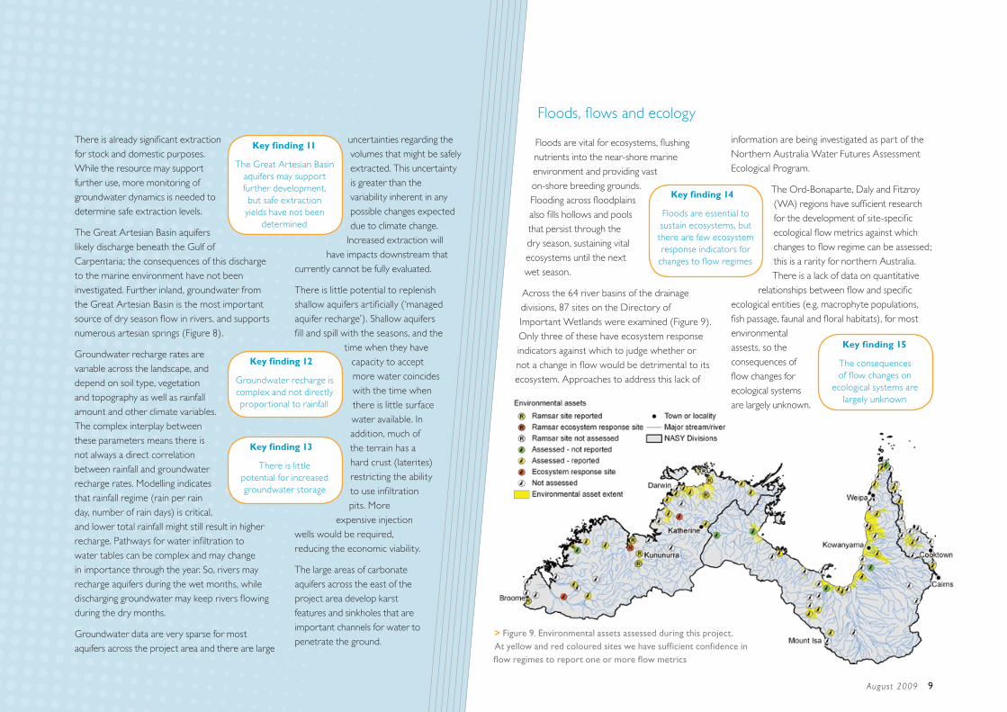
Floods are vital for ecosystems, flushing nutrients into the near-shore marine environment and providing vast on-shore breeding grounds. Flooding across floodplains also fills hollows and pools that persist through the dry season, sustaining vital ecosystems until the next wet season.
Across the 64 river basins of the drainage divisions, 87 sites on the Directory of Important Wetlands were examined (Figure 9). Only three of these have ecosystem response indicators against which to judge whether or not a change in flow would be detrimental to its ecosystem. Approaches to address this lack of
uncertainties regarding the volumes that might be safely extracted. This uncertainty is greater than the variability inherent in any possible changes expected due to climate change.
Increased extraction will have impacts downstream that
currently cannot be fully evaluated.
There is little potential to replenish shallow aquifers artificially (‘managed aquifer recharge’). Shallow aquifers fill and spill with the seasons, and the
time when they have capacity to accept more water coincides with the time when there is little surface water available. In addition, much of the terrain has a hard crust (laterites) restricting the ability to use infiltration pits. More
expensive injection wells would be required, reducing the economic viability.
The large areas of carbonate aquifers across the east of the project area develop karst features and sinkholes that are important channels for water to penetrate the ground.
Key finding 13
There is little potential for increased groundwater storage
Figure 9. Environmental assets assessed during this project. >At yellow and red coloured sites we have sufficient confidence in flow regimes to report one or more flow metrics
information are being investigated as part of the Northern Australia Water Futures Assessment Ecological Program.
The Ord-Bonaparte, Daly and Fitzroy (WA) regions have sufficient research for the development of site-specific ecological flow metrics against which changes to flow regime can be assessed; this is a rarity for northern Australia. There is a lack of data on quantitative
relationships between flow and specific ecological entities (e.g. macrophyte populations, fish passage, faunal and floral habitats), for most environmental assests, so the consequences of flow changes for ecological systems are largely unknown.
Key finding 15
The consequences of flow changes on
ecological systems are largely unknown
Key finding 11
The Great Artesian Basin aquifers may support further development, but safe extraction
yields have not been determined
Key finding 12
Groundwater recharge is complex and not directly proportional to rainfall
Key finding 14
Floods are essential to sustain ecosystems, but there are few ecosystem response indicators for
changes to flow regimes
10 Water in nor thern Austral ia
Historical and recent climate trends
Historical (1930 to 2007) climate records indicate a slight increase in rainfall intensity (rain per rain day) in the drainage divisions and that the recent past (1996 to 2007) has been 24 percent wetter than the previous 66 years (Figure 10). The recent past does not, however, have the full range of climatic variability seen in the historical record; neither does it have the extremes of possible future conditions. So there is considerable risk in using recent past conditions to guide future water planning. A single very wet year can significantly bias the long-term mean.
What the future holds
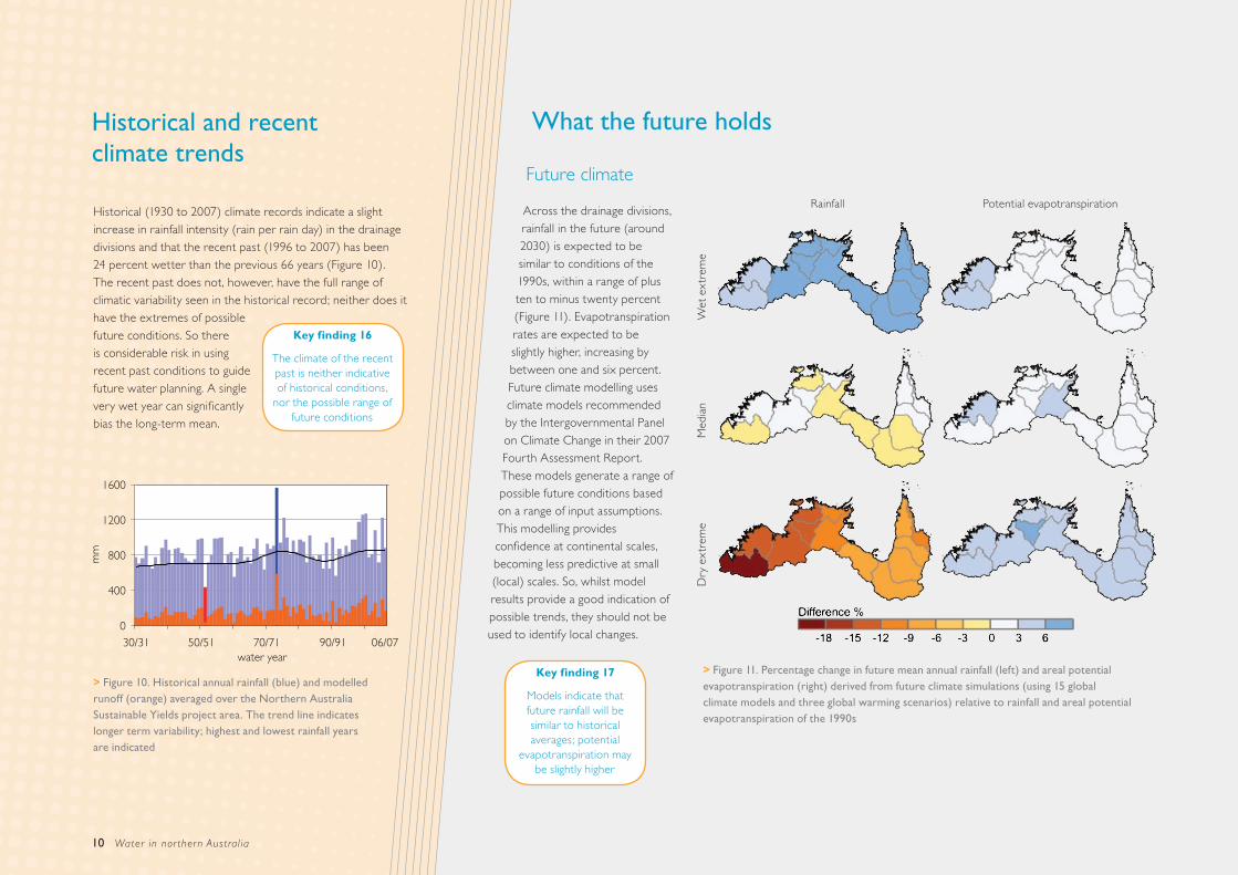
Future climate
Across the drainage divisions, rainfall in the future (around 2030) is expected to be similar to conditions of the 1990s, within a range of plus ten to minus twenty percent (Figure 11). Evapotranspiration rates are expected to be slightly higher, increasing by between one and six percent. Future climate modelling uses climate models recommended by the Intergovernmental Panel on Climate Change in their 2007 Fourth Assessment Report. These models generate a range of possible future conditions based on a range of input assumptions. This modelling provides confidence at continental scales, becoming less predictive at small (local) scales. So, whilst model results provide a good indication of possible trends, they should not be used to identify local changes.
Key finding 16
The climate of the recent past is neither indicative of historical conditions,
nor the possible range of future conditions
Figure 10. Historical annual rainfall (blue) and modelled >runoff (orange) averaged over the Northern Australia Sustainable Yields project area. The trend line indicates longer term variability; highest and lowest rainfall years are indicated
Figure 11. Percentage change in future mean annual rainfall (left) and areal potential >evapotranspiration (right) derived from future climate simulations (using 15 global climate models and three global warming scenarios) relative to rainfall and areal potential evapotranspiration of the 1990s
Key finding 17
Models indicate that future rainfall will be similar to historical averages; potential
evapotranspiration may be slightly higher
0
400
800
1200
1600
30/31 50/51 70/71 90/91 06/07water year
mm
Rainfall Potential evapotranspiration
Wet
ext
rem
eM
edia
nD
ry e
xtre
me

August 2009 11
Development opportunities and constraints
Existing plans by jurisdictions to increase water use will have little impact on water resources at the region scale in the short term (to around 2030). Longer-term impacts may have consequences, however, particularly where groundwater is being extracted. Local consequences may be significant, particularly where groundwater extraction and surface-groundwater interaction is prevalent.
Importantly, groundwater takes considerably longer than surface water to move through the landscape. The slower flow times of groundwater compared to surface water mean that groundwater-fed rivers can continue to flow during the dry, but also that any downstream consequences of groundwater extraction may not be realised for many years.
In the Lower Ord system, reliability of surface water supply is expected to be good into the future, unless a dry extreme climate develops. Seasonality of flow has been significantly affected since the Ord River Dam was built and these changes have resulted in a far greater change to downstream flow than is projected from climate change.
In the Daly region, two aquifer systems are under development: the Tindall Limestone around the Katherine area and the Oolloo Dolostone around the Douglas-Daly confluence area to the north-west of the region. Current
groundwater extraction is very low, though it is expected to increase.
Modelling groundwater extraction at full current entitlements suggests the groundwater levels should reach a new, and lower, dynamic equilibrium within ten to 15 years. Groundwater levels will be generally comparable to historical levels, which were lower than the last decade. Increasing levels of extraction to reflect potential
use in 2030, however, results in generally lower groundwater levels, most notably in the Oolloo Dolostone. This has potential to reduce the flow of the lower Daly River and therefore impact associated environmental regimes.
Smaller groundwater developments (10 to 100 GL/year) in
the carbonate aquifers in the Darwin Rural Area have reached their extraction limit. Additional smaller developments might be feasible within the aquifers of the Canning Basin in the south-west of the Timor Sea Drainage Division but more data are required to confirm this.
Even smaller extractions (i.e. less than 10 GL/year) are feasible across most of the project area, including areas of sandstone aquifers. Many of the shallow groundwater resources, including alluvial aquifers bordering major rivers, however, are highly dynamic, responding rapidly to seasonal rainfall and river flows.
Key finding 18
Planned development will have minimal
regional water resource consequences, but will
have local impact
Key finding 19
Groundwater travels much slower than surface
water, so responses to any change will be
measured in years, not months
Low streamflow conditions may be the most sensitive to modelled climate change. However, the paucity of calibration data provides low confidence in the quantitative assessments of flow regime change, especially for low flow streamflow conditions.
A fresh water crocodile. Windjana Gorge National Park, Kimberley Region Western Australia. >Courtesy of Rosemary McArthur, NatSnap

Web: www.csiro.au/flagships
Australia is founding its future on science and innovation.
Its national science agency, CSIRO is a powerhouse of ideas,
technologies and skills. CSIRO initiated the National Research
Flagships to address Australia’s major research challenges and
opportunities. They apply large scale, long term, multidisciplinary
science and aim for widespread adoption of solutions.
Water in northern Australia: A Summary of reports to the Australian Government from the CSIRO Northern Australia Sustainable Yields Project
This report summarises information from the following reports:
Water in the Timor Sea Drainage Division; Water in the Gulf of Carpentaria Drainage Division and Water in the Northern North-East Coast Drainage Division. CSIRO, Australia ISSN 1835-095X
For further information:
Water for a Healthy Country Flagship Project LeaderDr Richard CresswellPhone: 07 3214 2767Email: [email protected]: www.csiro.au/partnerships/NASY
Northern Australia Water Futures Assessment Department of the Environment, Water, Heritage and the Arts Phone: 02 6274 1111 Email: [email protected] Web: http://www.environment.gov.au/nawfa
VR
U 2
009
• W
fHC
_NA
SYSu
mm
aryR
epor
t_A
LL.in
dd
This document is printed on recycled paper
About the project
The Northern Australia Sustainable Yields (NASY) Project has assessed the water resources of northern Australia. The project modelled and quantified, within the limits of available data, the changes to water resources under four scenarios: historical climate; recent climate; future climate considering current water use and future climate with potential future water demand. The project identified regions that may come under increased, or decreased, stress due to climate change and increased water use.
The assessments made in this project provide key information for further investigations carried out through the Australian Government’s Northern Australia Water Futures Assessment. This initiative aims to develop a knowledge base to inform the development and protection of northern Australia’s water resources, so that any development proceeds in an ecologically, culturally and economically sustainable way.
The NASY project was commissioned by the National Water Commission in consultation with the Australian Government Department of the Environment, Water, Heritage and the Arts. This followed a March 2008 agreement by the Council of Australian Governments to undertake comprehensive scientific assessments of water yield in all major water systems across the country and provide a consistent analytical framework for water policy decisions across the nation. CSIRO is also undertaking assessments in south-west Western Australia and Tasmania.
The NASY project was reviewed by a Steering Committee and a Technical Reference Panel. Both include representation from federal and state governments, as well as independent experts.


