VERMONT LAKE CHAMPLAIN
PHOSPHORUS TMDL PHASE 1
IMPLEMENTATION PLAN
DRAFT AUGUST 2015
PREPARED BY THE STATE OF VERMONT
FOR THE U.S. ENVIRONMENTAL PROTECTION AGENCY
ii
TABLE OF CONTENTS Executive Summary ...................................................................................................................................... 1 Chapter 1- Introduction ............................................................................................................................... 14
A. Phosphorus Impairment of Lake Champlain ...................................................................................... 14 B. TMDL Development and Implementation Planning .......................................................................... 18 C. Vermont’s TMDL Implementation Efforts to Date ............................................................................ 19
Chapter 2 - Status of EPA’s Development of Phosphorus Allocations ...................................................... 29 Chapter 3 - Strategy to Address Point Source Pollution ............................................................................. 31
A. Introduction ........................................................................................................................................ 31 B. Wastewater Treatment Facilities (WWTFS) ...................................................................................... 32 C. Urban Stormwater - MS4s .................................................................................................................. 33 D. NPDES Construction Stormwater Discharges ................................................................................... 34 E. Stormwater Discharges Associated with Industrial Activities ........................................................... 34 F. Residual Designation Authority Discharges ....................................................................................... 34 G. Concentrated Animal Feeding Operation Discharges ........................................................................ 35
Chapter 4 - Current Program Capacity to Address Nonpoint Sources ........................................................ 36 A. Introduction ........................................................................................................................................ 36 B. Developed Lands - Stormwater .......................................................................................................... 37 C. Developed Lands - Transportation ..................................................................................................... 41 D. Agriculture ......................................................................................................................................... 44 E. Forestry ............................................................................................................................................... 51 F. River and Floodplain Management ..................................................................................................... 52 G. Wetlands Protection ........................................................................................................................... 59 H. Shoreland Management ...................................................................................................................... 60 I. Integrated Basin Planning and Funding - A Framework for TMDL Implementation ......................... 61
Chapter 5 - Vermont Commitment to Further Reduce NonPoint Sources .................................................. 68 A. Agricultural Programs ........................................................................................................................ 69 B. Stormwater Management ................................................................................................................... 84 C. Non-Regulatory Stormwater Management for Non-MS4 Municipalities .......................................... 88 D. River Channel Stability ...................................................................................................................... 92 E. Forest Management ............................................................................................................................ 97 F. Watershed Protection and Restoration Programs ............................................................................. 105 G. Wetland Protection and Restoration ................................................................................................. 118 H. Shoreland Management .................................................................................................................... 121 I. Internal Phosphorus Loading in St. Albans Bay ................................................................................ 122 J. Missisquoi Bay --- Enhanced Implementation .................................................................................. 123 K. Funding and Capacity ...................................................................................................................... 126
iii
Chapter 6 - Climate Change and Resilience ............................................................................................. 128 A. Introduction ...................................................................................................................................... 128 B. Summary and Perspective on the Tetra Tech Climate Response Modeling Report ......................... 131 C. Actions to Minimize the Current and Future Water Quality Impacts of Climate Change ............... 133 D. Conclusion ....................................................................................................................................... 145
Chapter 7 - Implementation Schedule and accountability Framework ..................................................... 146 References ................................................................................................................................................. 147
iv
EXECUTIVE SUMMARY Vermonters value a clean Lake Champlain. We swim and fish in the lake, we boat on it, we drink its water, and we deeply appreciate its beauty. A clean lake attracts businesses and tourists to the region and is a major driver of the State’s economy. Phosphorus pollution is the greatest threat to clean water in Lake Champlain. Phosphorus is a nutrient that stimulates excessive growth of algae in the lake, turning the water green. In excessive amounts, algae can impair recreational uses, aesthetic enjoyment, the taste of drinking water, and the biological community. In some cases, algal blooms - particularly cyanobacteria (blue-green algae) - can produce toxins that harm animals and people. Phosphorus is found in eroded soil and runoff from farm fields, barnyards, roads, parking lots, and streambanks, and in wastewater discharges. Efforts to reduce all these sources of phosphorus have accelerated over the past ten years but the lake has been slow to improve. In 2002, the U.S. Environmental Protection Agency (EPA) approved a Lake Champlain Phosphorus Total Maximum Daily Load (TMDL) prepared by the states of Vermont and New York. The TMDL placed caps on the amount of phosphorus allowed to enter each segment of Lake Champlain, and allocated those maximum amounts among the various sources within each major watershed draining to the lake. In 2011, the EPA revoked its approval of the Vermont portion of the Lake Champlain TMDL and is in the process of developing a new TMDL. Phosphorus loading to Lake Champlain is dominated by “nonpoint sources,” which are generated by runoff and erosion across the landscape, as opposed to “point sources” such as wastewater and certain stormwater discharges that are conveyed by a pipe or other discrete conveyance and are more closely regulated. For a TMDL to be approved in a situation where reductions in nonpoint source loading are relied upon to achieve the TMDL, the EPA must find “reasonable assurances” that the necessary nonpoint source reductions will actually occur. Insufficient reasonable assurance was the primary reason given by the EPA for reversing its approval of the 2002 TMDL. EPA’s expectations of Vermont for the new Lake Champlain TMDL are divided into two distinct planning phases. For the first phase, EPA expects Vermont to provide policy commitments relating to nonpoint source phosphorus reductions in a basin-wide scale implementation plan (Phase 1 Plan). After EPA finalizes the TMDL in 2015, it expects the State to develop a sub-basin tactical implementation plan (Phase 2 Plan) for each lake segment. Each tactical sub-basin plan will identify in more detail the specific point source and nonpoint source measures and practices to be implemented by identified dates. This Vermont Lake Champlain TMDL Phase 1 Implementation Plan was developed by the Vermont Agency of Natural Resources (ANR) and the Vermont Agency of Agriculture, Food, and Markets (AAFM). These agencies have been working diligently to develop the types of policy commitments requested by EPA to provide, or reduce the need for, reasonable assurances in the new TMDL. A proposed set of commitments, the Draft State of Vermont Proposal for a Clean Lake Champlain, was issued for public comment in November, 2013. As part of that
1
effort, ANR met frequently with other state agencies, including the Vermont Agency of Transportation (VTrans) to refine the proposed commitments. ANR and AAFM, in conjunction with EPA, held six public meetings in December 2013 and took public comments on the draft proposal. Over 500 people attended those meetings. ANR, in partnership with VTrans and the regional planning and development agencies, held 12 additional meetings with municipalities across the State to discuss the draft proposal. The State received over 100 comments on the November 2013 Proposal for a Clean Lake Champlain as well as a January 17, 2014 letter from the EPA, and used those comments to inform the development of a second and more detailed March 31, 2014 Draft TMDL Phase 1 Implementation Plan. A summary of the public comments and a list of Frequently Asked Questions with responses are available online. A May 8, 2014 letter from EPA provided further review and comment on the March 31 draft plan, which guided revisions incorporated into the present document. This newest July 2015 Plan has been updated to conform to Act 64, Vermont’s Clean Water Act, which was recently passed by the Vermont Legislature. A copy of Act 64 is included as Appendix F to this Plan. Act 64 also requires that this Plan be updated again no later than three months after EPA’s issuance of the final Lake TMDL. The policy commitments described in Chapter 5 of this Phase 1 Plan are summarized in Table 1 and Figure 1, and address all major nonpoint sources of phosphorus to the lake, including the following:
• Untreated/unmanaged runoff from existing developed lands • Discharges from farmsteads and agricultural production areas • Poorly managed cropland • Unmanaged or poorly managed pasture • River and stream channel modifications • Floodplain, river corridor and lakeshore encroachments • Stormwater runoff from developed lands and construction sites • Road construction and maintenance • Forest management practices • Wetland alteration and loss • Legacy effects of historic phosphorus loading • Additional phosphorus contributions anticipated due to climate change
The commitments presented in this Phase 1 Plan include new and enhanced regulation, funding and financial incentives, and technical assistance, and build on work already done by the State over the past 10 years to reduce phosphorus contributions to the lake. They will require new and increased efforts from nearly every sector of society, including state government, municipalities, farmers, developers, businesses and homeowners. The Vermont Department of Environmental Conservation (DEC) is requesting a twenty year implementation schedule to allow for communities to plan and stage the necessary improvements to roads and stormwater infrastructure into long-term capital funding plans as a means of keeping costs and funding burdens down.
2
The EPA is engaged in modeling to determine the total loading capacities for each lake segment watershed and the wasteload and load allocation numbers for point and nonpoint sources, respectively. Once these numbers are finalized, they will be used to more fully define the level of phosphorus reductions needed by point and nonpoint sources in each of the 12 individual Vermont lake segment watersheds. Therefore, many of the commitments described in this plan are expressed as statewide commitments but will be tailored as to scope, intensity and timing based on individual lake segment assessments during the second phase of implementation planning. DEC will use the models and load allocations still being developed by EPA to further refine these commitments. Based on EPA modeling results, some uncertainty exists about whether the tasks and commitments presented in this plan will be sufficient to fully achieve the required phosphorus load reductions in the Missisquoi Bay watershed. Additional and enhanced implementation efforts for Missisquoi Bay are described in Chapter 5, Section J and elsewhere in this plan. Vermont is committed to learning as it implements this plan and to adapting management to incorporate lessons learned along the way as a means to address the special challenges presented in the Missisquoi Bay. In order to implement the programs described in this plan, the State will require additional staff resources and funding. Categories of State funding needs include: (a) staff support in the implementing state agencies, and (b) funding that the State will pass through to communities, businesses, farms and partner organizations. Act 64, recently passed by the Vermont Legislature, includes both increased fees and revenue generating mechanisms for the funding and implementation of this Plan. In sum, the Act provides: (1) Clean Water Fund: The Vermont Clean Water Act imposes a 0.2% increase in Vermont’s
property transfer tax, which will raise approximately $5.3 million annually for the purpose of making additional strategic investments in water pollution control. The Act creates a Clean Water Fund and Board to receive and manage the funds and requires an annual Clean Water Investment Report summarizing public investments and results of those investments.
(2) Ecosystem Restoration Grants: The Vermont Capital Bill increased the amount of funding dedicated to grants under this program dedicated to funding implementation of polluted stormwater runoff control projects to $3.75 million per year (from a current level of approximately $2.5 million) for the next two years.
(3) Increased Agency Capacity: The State of Vermont Fiscal Year 2016 budget includes funding
to support eight new positions within AAFM and thirteen new positions within DEC all dedicated to implementation of the Vermont Clean Water Initiative and Lake Champlain TMDL.
3
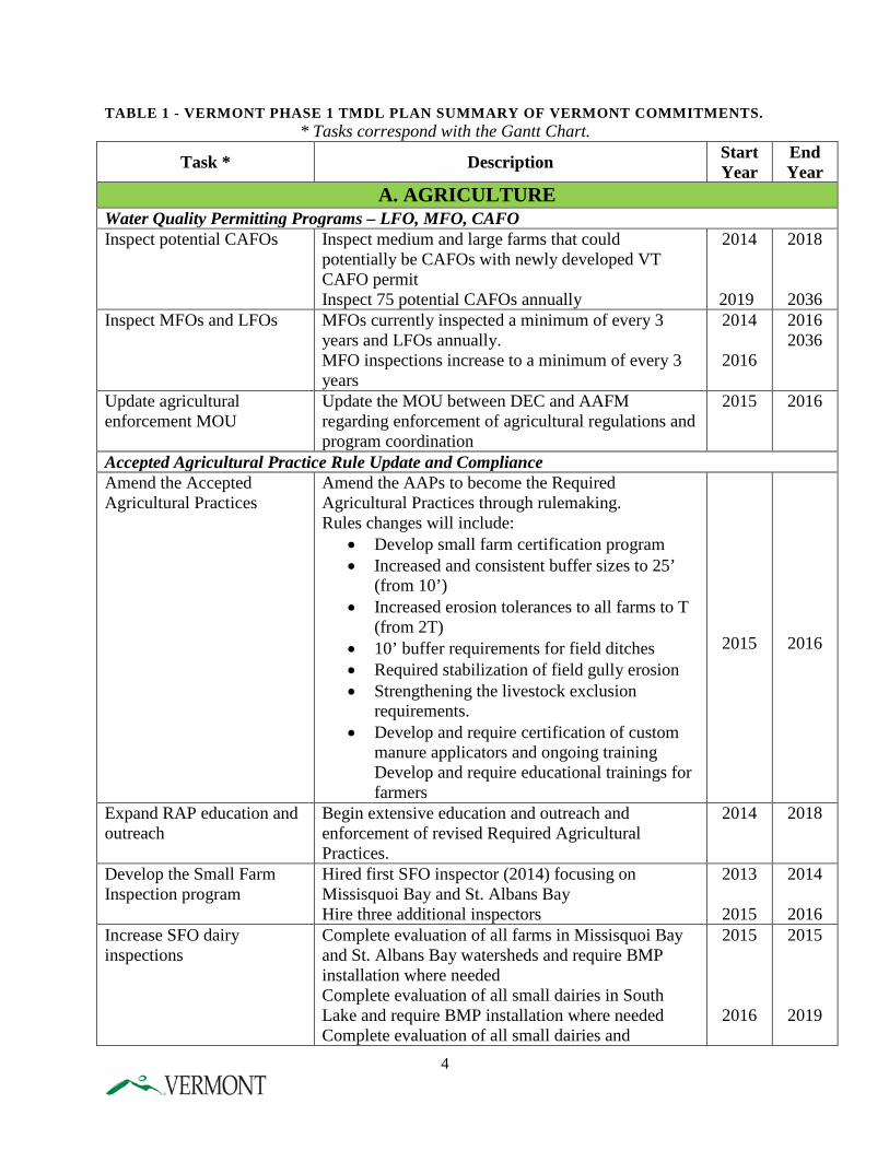
TABLE 1 - VERMONT PHASE 1 TMDL PLAN SUMMARY OF VERMONT COMMITMENTS. * Tasks correspond with the Gantt Chart.
Task * Description Start Year
End Year
A. AGRICULTURE Water Quality Permitting Programs – LFO, MFO, CAFO Inspect potential CAFOs Inspect medium and large farms that could
potentially be CAFOs with newly developed VT CAFO permit Inspect 75 potential CAFOs annually
2014
2019
2018
2036 Inspect MFOs and LFOs MFOs currently inspected a minimum of every 3
years and LFOs annually. MFO inspections increase to a minimum of every 3 years
2014
2016
2016 2036
Update agricultural enforcement MOU
Update the MOU between DEC and AAFM regarding enforcement of agricultural regulations and program coordination
2015 2016
Accepted Agricultural Practice Rule Update and Compliance Amend the Accepted Agricultural Practices
Amend the AAPs to become the Required Agricultural Practices through rulemaking. Rules changes will include:
• Develop small farm certification program • Increased and consistent buffer sizes to 25’
(from 10’) • Increased erosion tolerances to all farms to T
(from 2T) • 10’ buffer requirements for field ditches • Required stabilization of field gully erosion • Strengthening the livestock exclusion
requirements. • Develop and require certification of custom
manure applicators and ongoing training Develop and require educational trainings for farmers
2015
2016
Expand RAP education and outreach
Begin extensive education and outreach and enforcement of revised Required Agricultural Practices.
2014 2018
Develop the Small Farm Inspection program
Hired first SFO inspector (2014) focusing on Missisquoi Bay and St. Albans Bay Hire three additional inspectors
2013
2015
2014
2016 Increase SFO dairy inspections
Complete evaluation of all farms in Missisquoi Bay and St. Albans Bay watersheds and require BMP installation where needed Complete evaluation of all small dairies in South Lake and require BMP installation where needed Complete evaluation of all small dairies and
2015
2016
2015
2019
4
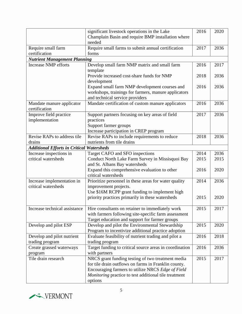
significant livestock operations in the Lake Champlain Basin and require BMP installation where needed
2016 2020
Require small farm certification
Require small farms to submit annual certification forms
2017 2036
Nutrient Management Planning Increase NMP efforts Develop small farm NMP matrix and small farm
template Provide increased cost-share funds for NMP development Expand small farm NMP development courses and workshops, trainings for farmers, manure applicators and technical service providers
2016
2018
2016
2017
2036
2036
Mandate manure applicator certification
Mandate certification of custom manure applicators 2016 2036
Improve field practice implementation
Support partners focusing on key areas of field practices Support farmer groups Increase participation in CREP program
2017 2036
Revise RAPs to address tile drains
Revise RAPs to include requirements to reduce nutrients from tile drains
2018 2036
Additional Efforts in Critical Watersheds Increase inspections in critical watersheds
Target CAFO and SFO inspections Conduct North Lake Farm Survey in Missisquoi Bay and St. Albans Bay watersheds Expand this comprehensive evaluation to other critical watersheds
2014 2015
2016
2036 2015
2020
Increase implementation in critical watersheds
Prioritize personnel in these areas for water quality improvement projects. Use $16M RCPP grant funding to implement high priority practices primarily in these watersheds
2014
2015
2036
2020
Increase technical assistance Hire consultants on retainer to immediately work with farmers following site-specific farm assessment Target education and support for farmer groups
2015 2017
Develop and pilot ESP Develop and pilot the Environmental Stewardship Program to incentivize additional practice adoption
2015 2020
Develop and pilot nutrient trading program
Evaluate feasibility of nutrient trading and pilot a trading program
2016 2018
Create grassed waterways program
Target funding to critical source areas in coordination with partners
2016 2036
Tile drain research NRCS grant funding testing of two treatment media for tile drain outflows on farms in Franklin county. Encouraging farmers to utilize NRCS Edge of Field Monitoring practice to test additional tile treatment options
2015 2017
5
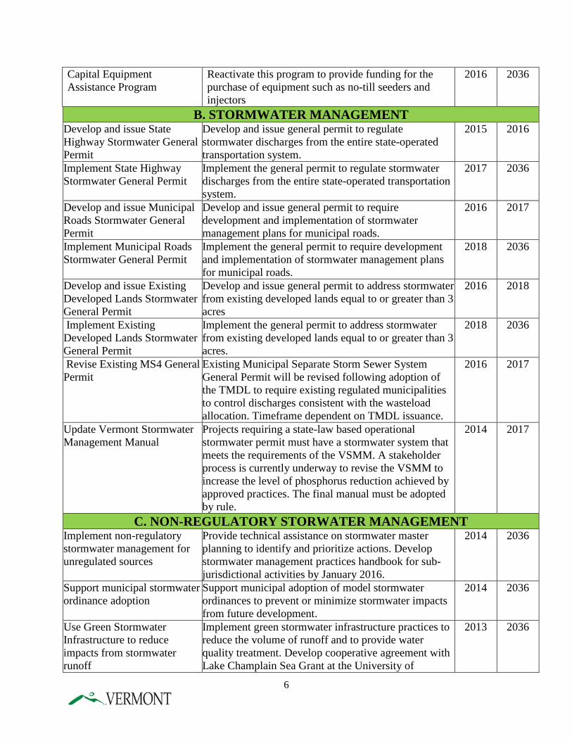
Capital Equipment Assistance Program
Reactivate this program to provide funding for the purchase of equipment such as no-till seeders and injectors
2016 2036
B. STORMWATER MANAGEMENT Develop and issue State Highway Stormwater General Permit
Develop and issue general permit to regulate stormwater discharges from the entire state-operated transportation system.
2015 2016
Implement State Highway Stormwater General Permit
Implement the general permit to regulate stormwater discharges from the entire state-operated transportation system.
2017 2036
Develop and issue Municipal Roads Stormwater General Permit
Develop and issue general permit to require development and implementation of stormwater management plans for municipal roads.
2016 2017
Implement Municipal Roads Stormwater General Permit
Implement the general permit to require development and implementation of stormwater management plans for municipal roads.
2018 2036
Develop and issue Existing Developed Lands Stormwater General Permit
Develop and issue general permit to address stormwater from existing developed lands equal to or greater than 3 acres
2016 2018
Implement Existing Developed Lands Stormwater General Permit
Implement the general permit to address stormwater from existing developed lands equal to or greater than 3 acres.
2018 2036
Revise Existing MS4 General Permit
Existing Municipal Separate Storm Sewer System General Permit will be revised following adoption of the TMDL to require existing regulated municipalities to control discharges consistent with the wasteload allocation. Timeframe dependent on TMDL issuance.
2016 2017
Update Vermont Stormwater Management Manual
Projects requiring a state-law based operational stormwater permit must have a stormwater system that meets the requirements of the VSMM. A stakeholder process is currently underway to revise the VSMM to increase the level of phosphorus reduction achieved by approved practices. The final manual must be adopted by rule.
2014 2017
C. NON-REGULATORY STORWATER MANAGEMENT Implement non-regulatory stormwater management for unregulated sources
Provide technical assistance on stormwater master planning to identify and prioritize actions. Develop stormwater management practices handbook for sub-jurisdictional activities by January 2016.
2014 2036
Support municipal stormwater ordinance adoption
Support municipal adoption of model stormwater ordinances to prevent or minimize stormwater impacts from future development.
2014 2036
Use Green Stormwater Infrastructure to reduce impacts from stormwater runoff
Implement green stormwater infrastructure practices to reduce the volume of runoff and to provide water quality treatment. Develop cooperative agreement with Lake Champlain Sea Grant at the University of
2013 2036
6
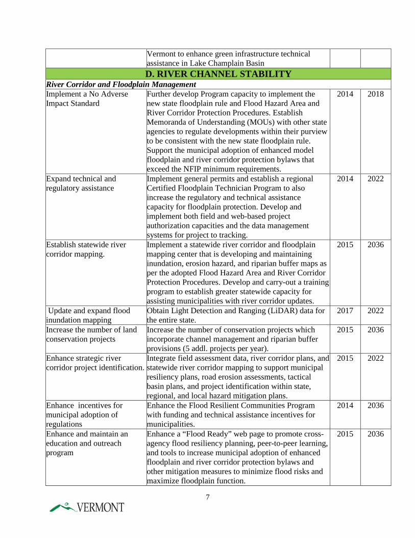
Vermont to enhance green infrastructure technical assistance in Lake Champlain Basin D. RIVER CHANNEL STABILITY
River Corridor and Floodplain Management Implement a No Adverse Impact Standard
Further develop Program capacity to implement the new state floodplain rule and Flood Hazard Area and River Corridor Protection Procedures. Establish Memoranda of Understanding (MOUs) with other state agencies to regulate developments within their purview to be consistent with the new state floodplain rule. Support the municipal adoption of enhanced model floodplain and river corridor protection bylaws that exceed the NFIP minimum requirements.
2014 2018
Expand technical and regulatory assistance
Implement general permits and establish a regional Certified Floodplain Technician Program to also increase the regulatory and technical assistance capacity for floodplain protection. Develop and implement both field and web-based project authorization capacities and the data management systems for project to tracking.
2014 2022
Establish statewide river corridor mapping.
Implement a statewide river corridor and floodplain mapping center that is developing and maintaining inundation, erosion hazard, and riparian buffer maps as per the adopted Flood Hazard Area and River Corridor Protection Procedures. Develop and carry-out a training program to establish greater statewide capacity for assisting municipalities with river corridor updates.
2015 2036
Update and expand flood inundation mapping
Obtain Light Detection and Ranging (LiDAR) data for the entire state.
2017 2022
Increase the number of land conservation projects
Increase the number of conservation projects which incorporate channel management and riparian buffer provisions (5 addl. projects per year).
2015 2036
Enhance strategic river corridor project identification.
Integrate field assessment data, river corridor plans, and statewide river corridor mapping to support municipal resiliency plans, road erosion assessments, tactical basin plans, and project identification within state, regional, and local hazard mitigation plans.
2015 2022
Enhance incentives for municipal adoption of regulations
Enhance the Flood Resilient Communities Program with funding and technical assistance incentives for municipalities.
2014 2036
Enhance and maintain an education and outreach program
Enhance a “Flood Ready” web page to promote cross-agency flood resiliency planning, peer-to-peer learning, and tools to increase municipal adoption of enhanced floodplain and river corridor protection bylaws and other mitigation measures to minimize flood risks and maximize floodplain function.
2015 2036
7
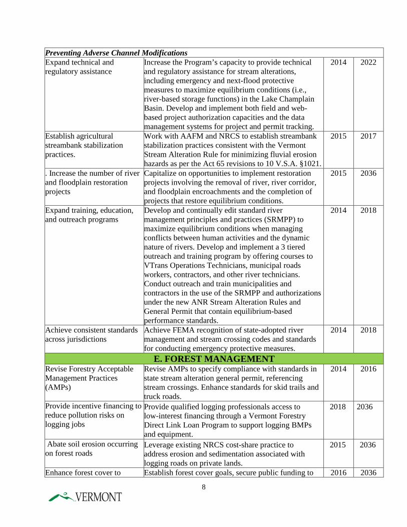
Preventing Adverse Channel Modifications Expand technical and regulatory assistance
Increase the Program’s capacity to provide technical and regulatory assistance for stream alterations, including emergency and next-flood protective measures to maximize equilibrium conditions (i.e., river-based storage functions) in the Lake Champlain Basin. Develop and implement both field and web-based project authorization capacities and the data management systems for project and permit tracking.
2014 2022
Establish agricultural streambank stabilization practices.
Work with AAFM and NRCS to establish streambank stabilization practices consistent with the Vermont Stream Alteration Rule for minimizing fluvial erosion hazards as per the Act 65 revisions to 10 V.S.A. §1021.
2015 2017
. Increase the number of river and floodplain restoration projects
Capitalize on opportunities to implement restoration projects involving the removal of river, river corridor, and floodplain encroachments and the completion of projects that restore equilibrium conditions.
2015 2036
Expand training, education, and outreach programs
Develop and continually edit standard river management principles and practices (SRMPP) to maximize equilibrium conditions when managing conflicts between human activities and the dynamic nature of rivers. Develop and implement a 3 tiered outreach and training program by offering courses to VTrans Operations Technicians, municipal roads workers, contractors, and other river technicians. Conduct outreach and train municipalities and contractors in the use of the SRMPP and authorizations under the new ANR Stream Alteration Rules and General Permit that contain equilibrium-based performance standards.
2014 2018
Achieve consistent standards across jurisdictions
Achieve FEMA recognition of state-adopted river management and stream crossing codes and standards for conducting emergency protective measures.
2014 2018
E. FOREST MANAGEMENT Revise Forestry Acceptable Management Practices (AMPs)
Revise AMPs to specify compliance with standards in state stream alteration general permit, referencing stream crossings. Enhance standards for skid trails and truck roads.
2014 2016
Provide incentive financing to reduce pollution risks on logging jobs
Provide qualified logging professionals access to low-interest financing through a Vermont Forestry Direct Link Loan Program to support logging BMPs and equipment.
2018 2036
Abate soil erosion occurring on forest roads
Leverage existing NRCS cost-share practice to address erosion and sedimentation associated with logging roads on private lands.
2015 2036
Enhance forest cover to Establish forest cover goals, secure public funding to 2016 2036
8
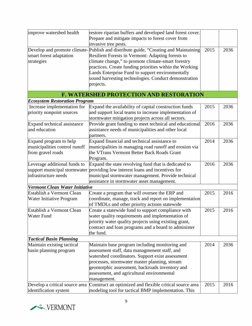
improve watershed health restore riparian buffers and developed land forest cover. Prepare and mitigate impacts to forest cover from invasive tree pests.
Develop and promote climate-smart forest adaptation strategies
Publish and distribute guide, “Creating and Maintaining Resilient Forests in Vermont: Adapting forests to climate change,” to promote climate-smart forestry practices. Create funding priorities within the Working Lands Enterprise Fund to support environmentally sound harvesting technologies. Conduct demonstration projects.
2015 2036
F. WATERSHED PROTECTION AND RESTORATION Ecosystem Restoration Program Increase implementation for priority nonpoint sources
Expand the availability of capital construction funds and support local teams to increase implementation of stormwater mitigation projects across all sectors.
2015 2036
Expand technical assistance and education
Provide grant funding to meet technical and educational assistance needs of municipalities and other local partners.
2016 2036
Expand program to help municipalities control runoff from gravel roads
Expand financial and technical assistance to municipalities in managing road runoff and erosion via the VTrans Vermont Better Back Roads Grant Program.
2014 2036
Leverage additional funds to support municipal stormwater infrastructure needs
Expand the state revolving fund that is dedicated to providing low interest loans and incentives for municipal stormwater management. Provide technical assistance in stormwater asset management.
2016 2036
Vermont Clean Water Initiative Establish a Vermont Clean Water Initiative Program
Create a program that will oversee the ERP and coordinate, manage, track and report on implementation of TMDLs and other priority actions statewide
2015 2016
Establish a Vermont Clean Water Fund
Create a statewide fund to support compliance with water quality requirements and implementation of priority water quality projects using existing grant, contract and loan programs and a board to administer the fund.
2015 2016
Tactical Basin Planning Maintain existing tactical basin planning program
Maintain base program including monitoring and assessment staff, data managmenent staff, and watershed coordinators. Support exist assessment processes, stormwater master planning, stream geomorphic assessment, backroads inventory and assessment, and agricultural environmental management.
2014 2036
Develop a critical source area identification system
Construct an optimized and flexible critical source area modeling tool for tactical BMP implementation. This
2015 2016
9
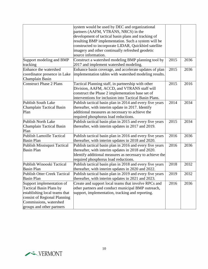
system would be used by DEC and organizational partners (AAFM, VTRANS, NRCS) in the development of tactical basin plans and tracking of resulting BMP implementation. Such a system will be constructed to incorporate LIDAR, Quickbird satellite imagery and other continually refreshed geodetic source information.
Support modeling and BMP tracking
Construct a watershed modeling BMP planning tool by 2017 and implement watershed modeling.
2015 2036
Enhance the watershed coordinator presence in Lake Champlain Basin
Enhance basin coverage, and accelerate updates of plan implementation tables with watershed modeling results.
2015 2036
Construct Phase 2 Plans Tactical Planning staff, in partnership with other Division, AAFM, ACCD, and VTRANS staff will construct the Phase 2 implementation base set of interventions for inclusion into Tactical Basin Plans.
2015 2016
Publish South Lake Champlain Tactical Basin Plan
Publish tactical basin plan in 2014 and every five years thereafter, with interim update in 2017. Identify additional measures as necessary to achieve the required phosphorus load reductions.
2014 2034
Publish North Lake Champlain Tactical Basin Plan
Publish tactical basin plan in 2015 and every five years thereafter, with interim updates in 2017 and 2019.
2015 2034
Publish Lamoille Tactical Basin Plan
Publish tactical basin plan in 2016 and every five years thereafter, with interim updates in 2018 and 2020.
2016 2036
Publish Missisquoi Tactical Basin Plan
Publish tactical basin plan in 2016 and every five years thereafter, with interim updates in 2018 and 2020. Identify additional measures as necessary to achieve the required phosphorus load reductions.
2016 2036
Publish Winooski Tactical Basin Plan
Publish tactical basin plan in 2018 and every five years thereafter, with interim updates in 2020 and 2022.
2018 2032
Publish Otter Creek Tactical Basin Plan
Publish tactical basin plan in 2019 and every five years thereafter, with interim updates in 2021 and 2023.
2019 2032
Support implementation of Tactical Basin Plans by establishing local teams that consist of Regional Planning Commissions, watershed groups and other partners
Create and support local teams that involve RPCs and other partners and conduct municipal BMP outreach, support, implementation, tracking and reporting.
2016 2036
10
G. WETLAND PROTECTION AND RESTORATION Designate several wetlands within the basin as Class I
Enhance state protection for several wetlands within the basin which provide sediment and phosphorus retention or provide erosion control of waterways.
2015 2016
Increase permit compliance Conduct permit compliance checks on 80% of construction projects within the Lake Champlain Basin.
2016 2036
Coordinate wetland restoration projects
Coordinate with federal, state and local partners to identify and implement restoration opportunities.
2014 2025
Expand technical, educational and regulatory assistance
Enhance ability of program to focus significant time on restoration efforts.
2013 2017
H. SHORELAND MANAGEMENT Expand technical and educational assistance
Implement the Lake Wise Program. Enhance ability of program to focus significant time on restoration efforts.
2034 2024
Created new permitting program for activities in shorelands.
Developed permit program procedures and standards that implemented the provisions in the Shoreland Act.
2014 2014
Implement the new Shoreland Protection Act.
Permit activities in lake shorelands. Establish a contractor training program for work in shorelands. Conduct outreach and technical assistance.
2015 2036
Conduct rulemaking under the Shoreland Protection Act.
As dictated by experience implementing the program, enter rulemaking to clarify or strengthen the requirements of the Shoreland Permit Program.
2017 2018
I. INTERNAL PHOSPHORUS LOADING IN ST. ALBANS BAY Control internal phosphorus loading in St. Albans Bay
Conduct treatment design study, secure permits and funding, and implement in-lake treatment.
2032 2036
J. MISSISQUOI BAY – ENHANCED IMPLEMENTATION AAFM North Lake Survey
Visits to all lifestock operations to assess water quality 2015 2015
Address RAP violations; install BMPS
Farms to install site specific BMPs as required and address RAP violations
2015 ongoing
Regional Conservation Partnership Program
Target forest landowners to accelerate implementation of NRCS cost-share practices to improve water quality
2015 2019
Increase portable skidder bridge program
Provide portable skidder bridges watershed wide in Missisquoi Bay
2015 2019
Reduce erosion from inactive forest roads, trails and logging landings
Use LiDAR mapping to map eroding, abandoned and retired forest roads, skid trails and log landings to identify restoration projects for funding.
2015 2017
Re-establish connections to floodplains
Enhance effort to identify opportunities for re-establishing connections to floodplains and working with landowners
2015 2036
Identify opportunities for Enhance effort into identification of opportunities to 2015 2036
11
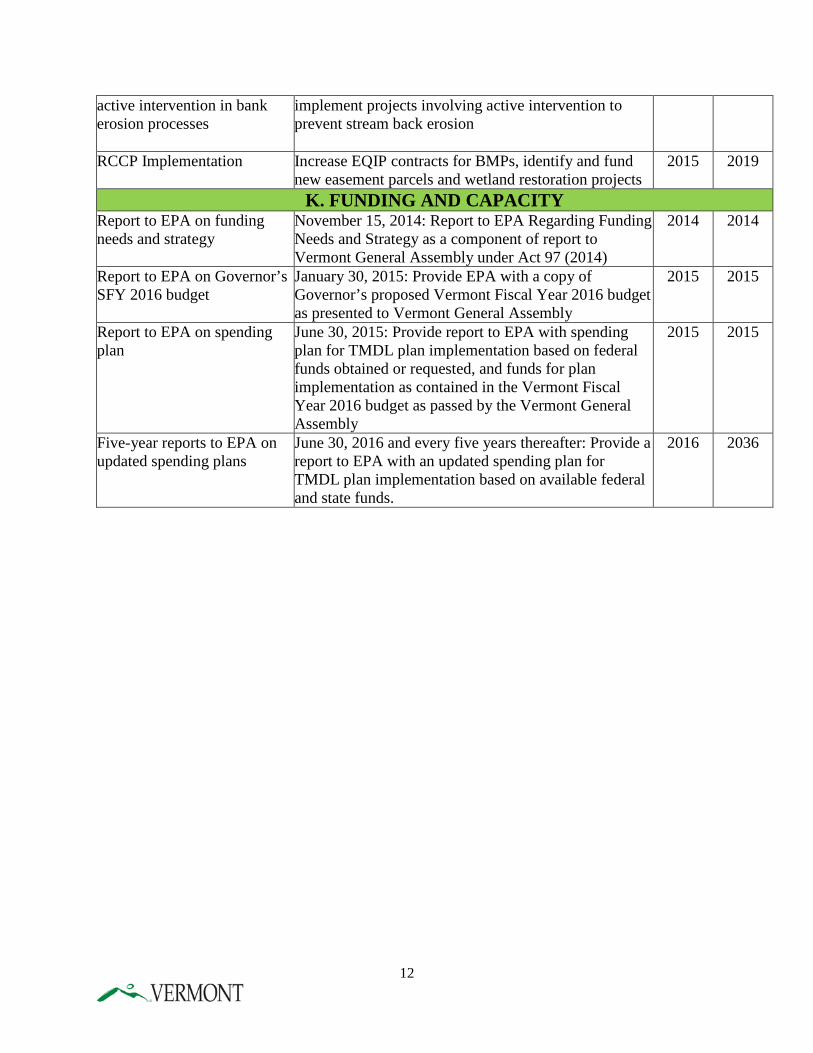
active intervention in bank erosion processes
implement projects involving active intervention to prevent stream back erosion
RCCP Implementation Increase EQIP contracts for BMPs, identify and fund new easement parcels and wetland restoration projects
2015 2019
K. FUNDING AND CAPACITY Report to EPA on funding needs and strategy
November 15, 2014: Report to EPA Regarding Funding Needs and Strategy as a component of report to Vermont General Assembly under Act 97 (2014)
2014 2014
Report to EPA on Governor’s SFY 2016 budget
January 30, 2015: Provide EPA with a copy of Governor’s proposed Vermont Fiscal Year 2016 budget as presented to Vermont General Assembly
2015 2015
Report to EPA on spending plan
June 30, 2015: Provide report to EPA with spending plan for TMDL plan implementation based on federal funds obtained or requested, and funds for plan implementation as contained in the Vermont Fiscal Year 2016 budget as passed by the Vermont General Assembly
2015 2015
Five-year reports to EPA on updated spending plans
June 30, 2016 and every five years thereafter: Provide a report to EPA with an updated spending plan for TMDL plan implementation based on available federal and state funds.
2016
2036
12
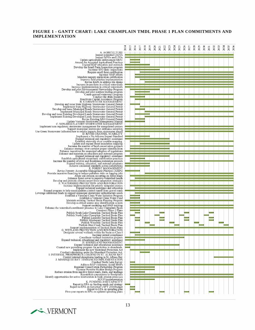
FIGURE 1 - GANTT CHART: LAKE CHAMPLAIN TMDL PHASE 1 PLAN COMMITMENTS AND IMPLEMENTATION
13
CHAPTER 1- INTRODUCTION
A. PHOSPHORUS IMPAIRMENT OF LAKE CHAMPLAIN Phosphorus pollution is the greatest threat to clean water in Lake Champlain. Phosphorus is a nutrient that stimulates excessive growth of algae in the lake, turning the water green. In excessive amounts, phosphorus and the associated algal growth can impair recreational uses and aesthetic enjoyment, reduce the quality of drinking water, and alter the biological community. In some cases, algal blooms – particularly cyanobacteria (or blue-green algae) can produce toxins that harm animals and people. Vermont’s Water Quality Standards include total phosphorus concentration criteria for each of Vermont’s twelve lake segments. These criteria vary among the different lake segments, and are expressed as the annual average phosphorus levels that must be achieved in order to support the many values and uses of the lake. Long-term monitoring of phosphorus levels throughout Lake Champlain by Vermont and New York with the Lake Champlain basin Program has documented phosphorus concentrations in excess of the water quality standards in most areas of the lake (Figure 2). Despite significant efforts to reduce phosphorus loading to the Lake in recent years, the trend lines are still moving upward.
14
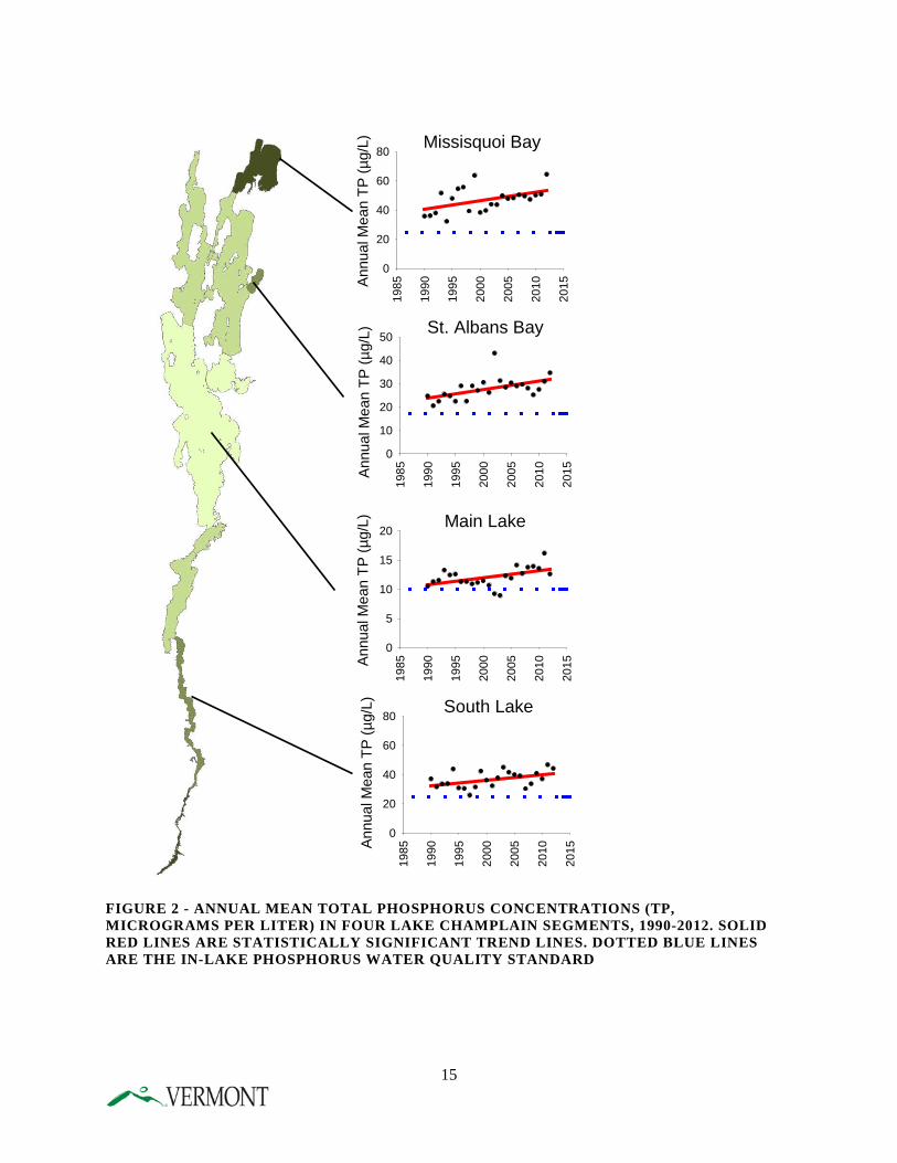
FIGURE 2 - ANNUAL MEAN TOTAL PHOSPHORUS CONCENTRATIONS (TP, MICROGRAMS PER LITER) IN FOUR LAKE CHAMPLAIN SEGMENTS, 1990-2012. SOLID RED LINES ARE STATISTICALLY SIGNIFICANT TREND LINES. DOTTED BLUE LINES ARE THE IN-LAKE PHOSPHORUS WATER QUALITY STANDARD
Annu
al M
ean
TP (µ
g/L) Missisquoi Bay
1985
1990
1995
2000
2005
2010
2015
0
20
40
60
80
Annu
al M
ean
TP (µ
g/L) St. Albans Bay
1985
1990
1995
2000
2005
2010
2015
0
10
20
30
40
50
Annu
al M
ean
TP (µ
g/L) Main Lake
1985
1990
1995
2000
2005
2010
2015
0
5
10
15
20
Annu
al M
ean
TP (µ
g/L) South Lake
1985
1990
1995
2000
2005
2010
2015
0
20
40
60
80
15
Excessive phosphorus is delivered to Lake Champlain as a result of the collective activities of all residents of the Lake Champlain basin, past and present. Stormwater runoff from the roofs of homes and driveways and other developed land contributes phosphorus that is washed into streams when it rains or as snow melts. Similarly in an agricultural setting, rain washes soil and manure off of crop lands, pastures, hay lands, and barnyards into nearby streams. Erosion of roadside banks, ditches, and around unstable culverts delivers sediment and phosphorus to the road drainage network and then to nearby streams. Channelization of streams undertaken to protect development, and encroachment of buildings and roads on floodplains and river corridors, prevents floodwater storage and the attainment of the least erosive, stream equilibrium conditions. Loss of floodplain function increases river bank erosion and the loading of sediments and nutrients such as phosphorus. River bank and bed erosion is also the result of traditional drainage methods that increase runoff directly to streams, thereby increasing volume and velocity of stream flows during storms. Phosphorus is naturally present in small amounts even in runoff from pristine forest land, but logging activities such as construction of roads and stream crossings can cause erosion of sediment and phosphorus into streams. Finally, inadequately treated wastewater, whether from a septic system or a wastewater treatment facility, also contributes phosphorus to the lake. As part of the development of the new Lake Champlain Phosphorus TMDL, EPA supported a watershed modeling analysis that produced estimates of the phosphorus contribution from each major source category. As shown in Figure 3, the relative magnitude of each source varies by watershed, but agricultural land, developed land, and streambank erosion are major sources across all watersheds. Forest land appears as a large source in Figure 3 primarily because forests occupy over 70% of the landscape in the basin. Phosphorus runoff rates per acre from forest land are typically very low. On the other hand, some sources such as farmsteads and back roads that appear small in Figure 3 can contribute some of the highest rates of phosphorus loading per acre. Both the total amount of the phosphorus load and the loading rate per unit of land area should be considered in setting phosphorus reduction priorities.
16
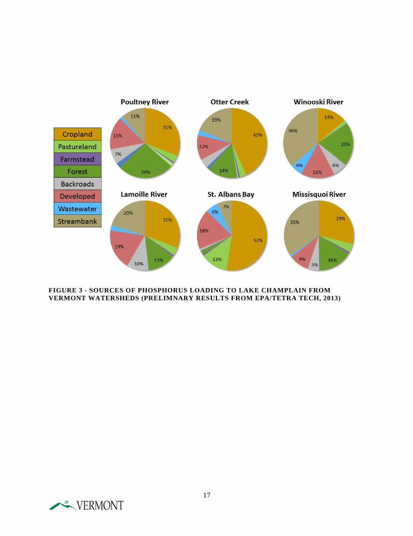
FIGURE 3 - SOURCES OF PHOSPHORUS LOADING TO LAKE CHAMPLAIN FROM VERMONT WATERSHEDS (PRELIMNARY RESULTS FROM EPA/TETRA TECH, 2013)
17
B. TMDL DEVELOPMENT AND IMPLEMENTATION PLANNING Section 303(d) of the federal Clean Water Act requires states to develop a total maximum daily load (TMDL) for water bodies that do not currently meet water quality standards. A TMDL is a “pollution budget” that calculates the amount of pollution the water body can tolerate and still maintain water quality standards. This “budget” is comprised of two components – the “wasteload allocation” which describes the amount of phosphorus reductions required from point source discharges, and the “load allocation” which describes the amount of phosphorus reduction required from nonpoint sources. Point sources include discharges from pipes or other discrete conveyances, for example discharges from wastewater treatment facilities or channelized municipal stormwater runoff. Non-point sources include more diffuse overland discharges to waters, such as runoff from agricultural fields, developed lands and back roads, and from stream erosion due to channelization and increased runoff from developed lands. The 2002 Lake Champlain Phosphorus TMDL was developed and submitted jointly by the States of Vermont and New York to the U.S. Environmental Protection Agency in 2002, following an extensive public participation process in each state. The TMDL built upon a sequence of studies, plans, and agreements completed during the preceding twelve years. A subsequent water quality agreement between Vermont and Quebec was signed in 2002 to define phosphorus load reduction targets and responsibilities for the shared Missisquoi Bay portion of the lake. The 2002 TMDL included a Vermont-specific implementation plan describing a suite of action items and attendant funding needs to reduce the phosphorus load delivered annually to Lake Champlain. The 2002 implementation plan, as amended in 2010, served as a basis for the efforts of ANR and AAFM by guiding annual funding requests, staffing levels, and program priorities for the past twelve years. Despite these numerous efforts, and in response to a lawsuit filed in federal court by Conservation Law Foundation, EPA reconsidered its previous approval of the 2002 TMDL, and disapproved the Vermont portion of the TMDL in January 2011. One of the bases for this disapproval was EPA’s finding that Vermont had not provided sufficient “reasonable assurances” that reductions in nonpoint sources of phosphorus would be attained. Under federal law, upon such disapproval, EPA is required to establish a new TMDL to meet water quality standards. EPA initiated the process for developing a new TMDL in 2011 in cooperation with the State of Vermont. The New York portion of the 2002 TMDL remains in effect. In order to ensure efficient and cost-effective implementation of a TMDL, responsible agencies develop an implementation plan. A TMDL implementation plan identifies a suite of measures that will be taken to reduce pollution levels in order to reach the “pollution budget” for both point and non-point sources specified in the TMDL. Conceptually, the TMDL process of establishing a pollution budget is straightforward – uncertainty, however, makes writing a single, detailed, long-term plan that charts a specific course to water quality extremely challenging. Relevant processes and stressors within a watershed are not always fully understood, and the effectiveness of recommended control measures is often highly variable. In order to continue to make progress in reducing pollution and improving water quality, while at the same time minimizing the potential for costly errors, adaptive implementation is essential. The ability to revisit, reevaluate, and modify the implementation plan is fundamental, applying what has been
18
learned from past watershed-based actions and producing improvements in the landscape and water quality in as efficient and effective a manner as possible. The benefits of this approach include:
• Providing a measure of quality control, given the uncertainty that exists; • Helping to ensure the most cost effective practices are implemented as soon as possible;
and • Allowing for the routine reevaluation of the adequacy of implementation efforts in
achieving the necessary TMDL reductions and water quality standards. The Lake’s 2002 TMDL implementation plan, as amended in 2010, has guided program priorities and annual funding requests and served as the framework for both ANR and AAFM in controlling phosphorus. As a result, numerous water quality programs in ANR and AAFM that existed prior to the TMDL have been substantially expanded and enhanced, and a number of new efforts have begun. These programs work to reduce the phosphorus load delivered to the state’s waters from sources such as wastewater discharges, barnyards, agricultural fields, unstable river channels, urban centers, residential areas, construction sites, back roads, and other areas. The Phase 1 Plan and Phase 2 implementation plans (i.e. tactical basin plans) requested by EPA in its January 17, 2014 letter will build upon the 2002 and 2010 Lake implementation plans and help to further refine and direct efforts and monies spent to reduce phosphorus contributions to Lake Champlain. As described in more detail in Chapters 4 and 5, the Phase 2 basin-specific implementation plans will reflect a tactical basin planning process, which will identify the highest priority projects for each basin and ensure that available funding is prioritized and targeted toward those projects.
C. VERMONT’S TMDL IMPLEMENTATION EFFORTS TO DATE Since 2002, ANR, AAFM and VTrans, in cooperation with federal, state, and local partners, have made significant progress in implementing practices and programs to reduce phosphorus inputs to the Lake. Examples of Vermont water resource protection programs that have been developed or greatly enhanced over the past decade include:
• Stormwater Management Program (ANR); • Green Infrastructure/Low Impact Development Program (ANR); • Vermont Better Back Roads Program (VTrans/ANR); • River Management Program (ANR); • Lake Shoreland Program (ANR); • Wetlands Program (ANR); and • Agricultural Resource Management Division (AAFM).
Examples of water quality implementation projects that have received federal/state funding to reduce phosphorus pollution in the Lake include:
• Stormwater runoff mitigation projects; • River channel, lake shoreland stability projects; • Road infrastructure stability/runoff mitigation projects;
19
• Agricultural runoff mitigation projects; and, • River corridor and wetland easement acquisition.
The original Center for Clean and Clear was established in 2007 to enhance Vermont’s commitment to improve water quality in Lake Champlain. That Program brought together resources dedicated to improving water quality that were previously spread among many state programs. In 2011, the former Center was restructured to become the Vermont Department of Environmental Conservation (DEC) Watershed Management Division (WSMD) Ecosystem Restoration Program (ERP). This Program guides the award of state and federal water quality grants and contracts to address high priority water quality needs. Grant and contract recipients include municipalities, watershed organizations, lake associations, conservation districts, and regional planning commissions − important partners in the effort to safeguard the rivers, lakes, ponds, and wetlands of the State. ERP CAPITAL GRANTS
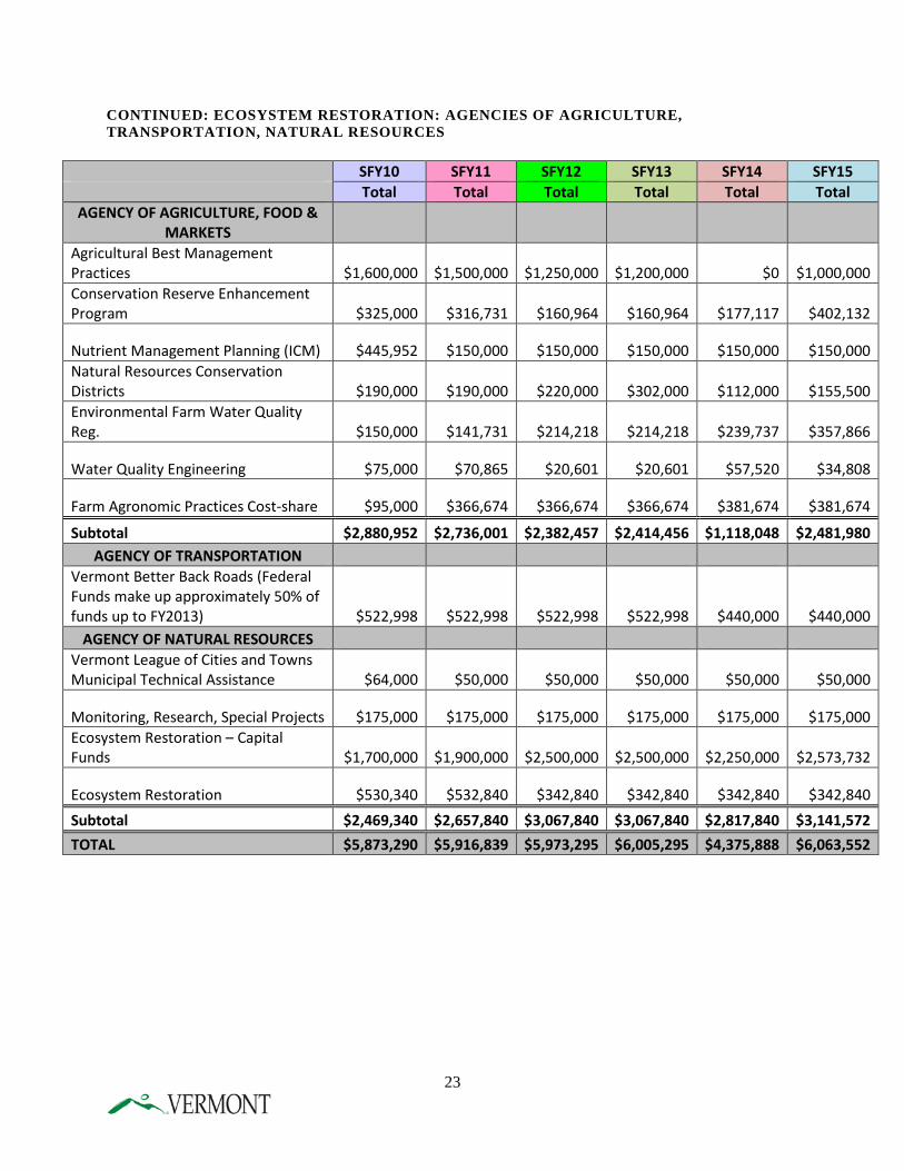
Since 2002, ERP and its predecessor Clean and Clear have provided capital funds to support construction grants for projects that accelerate the reduction of sediment and nutrient pollution, including phosphorus, from uncontrolled runoff into the State’s surface waters. Typical project budgets range from $5,000 to $75,000. ERP directs capital funds toward implementation of priority projects identified in the WSMD Monitoring, Assessment and Planning Program’s (MAPP) tactical basin planning process. That process involves the development of plans that assess water quality throughout a basin and identify and prioritize actions to improve water quality. Throughout the process of tactical basin plan development, partner organizations are encouraged to participate in identifying the highest priority projects for state funded support. As a component of the tactical planning process, watershed coordinators serve as facilitators in the development of ERP grant applications. Projects that are specifically identified in Tactical Plans, and associated river corridor, stormwater master plans and other relevant assessment plans, receive higher scoring in the grant application review process. ERP recently submitted its Annual Report 2013 to the Vermont Legislature. (http://www.watershedmanagement.vt.gov/erp/docs/erp_2013annualreport.pdf). Table 2 and Figure 4 shown below from the Report, illustrates the types of projects that are funded annually by ERP, which include projects in the Lake Champlain basin that result in reductions in phosphorus pollution. In total, 54 grants and contracts, totaling $2.3 million of State Fiscal Year (SFY) 2013 funds were awarded to municipalities, watershed organizations, natural resources conversation districts, regional planning commissions, and university programs to improve water quality. These SFY 2013 dollars and projects represent a small fraction of the projects and dollars spent over the past twelve years in reducing phosphorus contributions to the Lake and improving water quality statewide. Table 3 shows both program administration costs and implementation project costs funded by the ERP Program and former Clean and Clear Program. Figure 6 and Table 4 show the percent of ERP funds spent in the Lake Champlain basin from SFY 2006-2013.
20
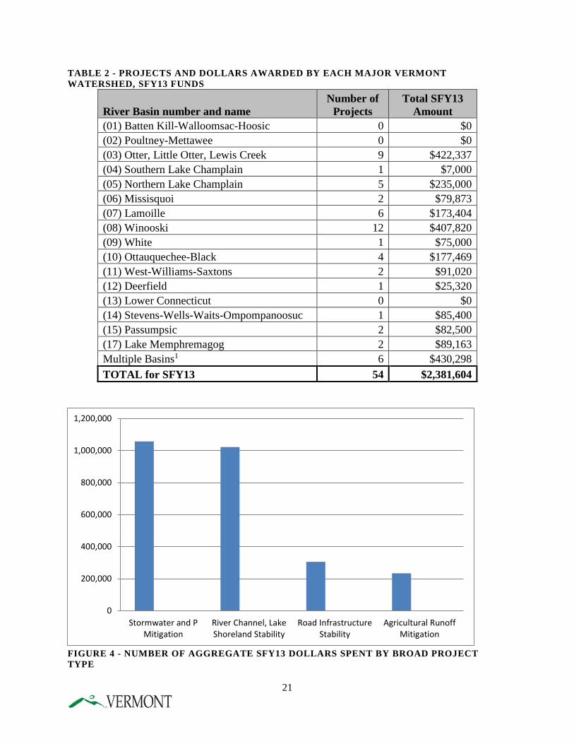
TABLE 2 - PROJECTS AND DOLLARS AWARDED BY EACH MAJOR VERMONT WATERSHED, SFY13 FUNDS
River Basin number and name Number of
Projects Total SFY13
Amount (01) Batten Kill-Walloomsac-Hoosic 0 $0 (02) Poultney-Mettawee 0 $0 (03) Otter, Little Otter, Lewis Creek 9 $422,337 (04) Southern Lake Champlain 1 $7,000 (05) Northern Lake Champlain 5 $235,000 (06) Missisquoi 2 $79,873 (07) Lamoille 6 $173,404 (08) Winooski 12 $407,820 (09) White 1 $75,000 (10) Ottauquechee-Black 4 $177,469 (11) West-Williams-Saxtons 2 $91,020 (12) Deerfield 1 $25,320 (13) Lower Connecticut 0 $0 (14) Stevens-Wells-Waits-Ompompanoosuc 1 $85,400 (15) Passumpsic 2 $82,500 (17) Lake Memphremagog 2 $89,163 Multiple Basins1 6 $430,298 TOTAL for SFY13 54 $2,381,604
FIGURE 4 - NUMBER OF AGGREGATE SFY13 DOLLARS SPENT BY BROAD PROJECT TYPE
0
200,000
400,000
600,000
800,000
1,000,000
1,200,000
Stormwater and PMitigation
River Channel, LakeShoreland Stability
Road InfrastructureStability
Agricultural RunoffMitigation
21
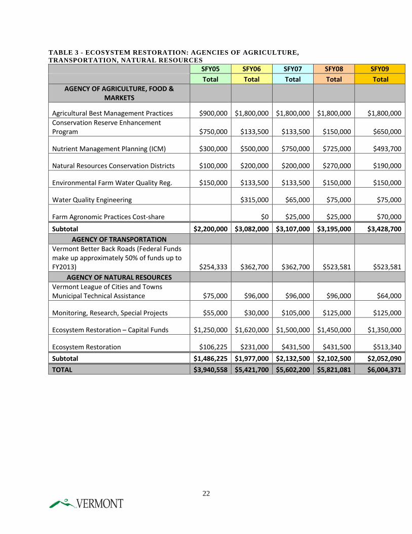
TABLE 3 - ECOSYSTEM RESTORATION: AGENCIES OF AGRICULTURE, TRANSPORTATION, NATURAL RESOURCES
SFY05 SFY06 SFY07 SFY08 SFY09 Total Total Total Total Total
AGENCY OF AGRICULTURE, FOOD & MARKETS
Agricultural Best Management Practices $900,000 $1,800,000 $1,800,000 $1,800,000 $1,800,000 Conservation Reserve Enhancement Program $750,000 $133,500 $133,500 $150,000 $650,000
Nutrient Management Planning (ICM) $300,000 $500,000 $750,000 $725,000 $493,700
Natural Resources Conservation Districts $100,000 $200,000 $200,000 $270,000 $190,000
Environmental Farm Water Quality Reg. $150,000 $133,500 $133,500 $150,000 $150,000
Water Quality Engineering $315,000 $65,000 $75,000 $75,000
Farm Agronomic Practices Cost-share $0 $25,000 $25,000 $70,000
Subtotal $2,200,000 $3,082,000 $3,107,000 $3,195,000 $3,428,700 AGENCY OF TRANSPORTATION
Vermont Better Back Roads (Federal Funds make up approximately 50% of funds up to FY2013) $254,333 $362,700 $362,700 $523,581 $523,581
AGENCY OF NATURAL RESOURCES Vermont League of Cities and Towns Municipal Technical Assistance $75,000 $96,000 $96,000 $96,000 $64,000
Monitoring, Research, Special Projects $55,000 $30,000 $105,000 $125,000 $125,000
Ecosystem Restoration – Capital Funds $1,250,000 $1,620,000 $1,500,000 $1,450,000 $1,350,000
Ecosystem Restoration $106,225 $231,000 $431,500 $431,500 $513,340 Subtotal $1,486,225 $1,977,000 $2,132,500 $2,102,500 $2,052,090 TOTAL $3,940,558 $5,421,700 $5,602,200 $5,821,081 $6,004,371
22
CONTINUED: ECOSYSTEM RESTORATION: AGENCIES OF AGRICULTURE, TRANSPORTATION, NATURAL RESOURCES
SFY10 SFY11 SFY12 SFY13 SFY14 SFY15 Total Total Total Total Total Total
AGENCY OF AGRICULTURE, FOOD & MARKETS
Agricultural Best Management Practices $1,600,000 $1,500,000 $1,250,000 $1,200,000 $0 $1,000,000 Conservation Reserve Enhancement Program $325,000 $316,731 $160,964 $160,964 $177,117 $402,132
Nutrient Management Planning (ICM) $445,952 $150,000 $150,000 $150,000 $150,000 $150,000 Natural Resources Conservation Districts $190,000 $190,000 $220,000 $302,000 $112,000 $155,500 Environmental Farm Water Quality Reg. $150,000 $141,731 $214,218 $214,218 $239,737 $357,866
Water Quality Engineering $75,000 $70,865 $20,601 $20,601 $57,520 $34,808
Farm Agronomic Practices Cost-share $95,000 $366,674 $366,674 $366,674 $381,674 $381,674
Subtotal $2,880,952 $2,736,001 $2,382,457 $2,414,456 $1,118,048 $2,481,980 AGENCY OF TRANSPORTATION
Vermont Better Back Roads (Federal Funds make up approximately 50% of funds up to FY2013) $522,998 $522,998 $522,998 $522,998 $440,000 $440,000
AGENCY OF NATURAL RESOURCES Vermont League of Cities and Towns Municipal Technical Assistance $64,000 $50,000 $50,000 $50,000 $50,000 $50,000
Monitoring, Research, Special Projects $175,000 $175,000 $175,000 $175,000 $175,000 $175,000 Ecosystem Restoration – Capital Funds $1,700,000 $1,900,000 $2,500,000 $2,500,000 $2,250,000 $2,573,732
Ecosystem Restoration $530,340 $532,840 $342,840 $342,840 $342,840 $342,840 Subtotal $2,469,340 $2,657,840 $3,067,840 $3,067,840 $2,817,840 $3,141,572 TOTAL $5,873,290 $5,916,839 $5,973,295 $6,005,295 $4,375,888 $6,063,552
23
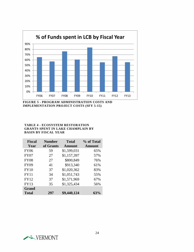
TABLE 4 - ECOSYSTEM RESTORATION GRANTS SPENT IN LAKE CHAMPLAIN BY BASIN BY FISCAL YEAR
Fiscal Year
Number of Grants
Total Amount
% of Total Amount
FY06 59 $1,599,031 65% FY07 27 $1,157,397 57% FY08 27 $800,849 76% FY09 41 $913,340 61% FY10 37 $1,020,362 83% FY11 34 $1,051,743 55% FY12 37 $1,571,969 67% FY13 35 $1,325,434 56% Grand Total 297 $9,440,124 63%
FIGURE 5 - PROGRAM ADMINISTRATION COSTS AND IMPLEMENTATION PROJECT COSTS (SFY 5-15)
24
0%
10%
20%
30%
40%
50%
60%
70%
80%
90%
FY06 FY07 FY08 FY09 FY10 FY11 FY12 FY13
% of Funds spent in LCB by Fiscal Year
SECTION 319 FUNDING
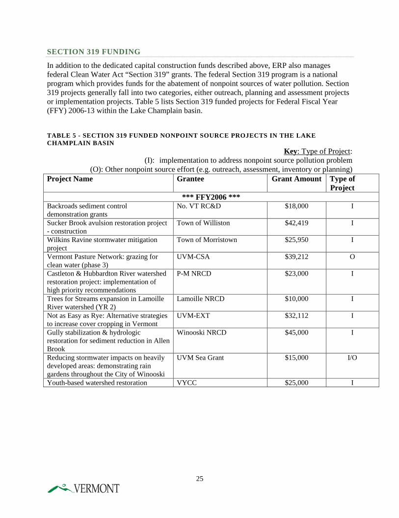
In addition to the dedicated capital construction funds described above, ERP also manages federal Clean Water Act “Section 319” grants. The federal Section 319 program is a national program which provides funds for the abatement of nonpoint sources of water pollution. Section 319 projects generally fall into two categories, either outreach, planning and assessment projects or implementation projects. Table 5 lists Section 319 funded projects for Federal Fiscal Year (FFY) 2006-13 within the Lake Champlain basin. TABLE 5 - SECTION 319 FUNDED NONPOINT SOURCE PROJECTS IN THE LAKE CHAMPLAIN BASIN
Key: Type of Project: (I): implementation to address nonpoint source pollution problem
(O): Other nonpoint source effort (e.g. outreach, assessment, inventory or planning) Project Name Grantee Grant Amount Type of
Project *** FFY2006 ***
Backroads sediment control demonstration grants
No. VT RC&D $18,000 I
Sucker Brook avulsion restoration project - construction
Town of Williston $42,419 I
Wilkins Ravine stormwater mitigation project
Town of Morristown $25,950 I
Vermont Pasture Network: grazing for clean water (phase 3)
UVM-CSA $39,212 O
Castleton & Hubbardton River watershed restoration project: implementation of high priority recommendations
P-M NRCD $23,000 I
Trees for Streams expansion in Lamoille River watershed (YR 2)
Lamoille NRCD $10,000 I
Not as Easy as Rye: Alternative strategies to increase cover cropping in Vermont
UVM-EXT $32,112 I
Gully stabilization & hydrologic restoration for sediment reduction in Allen Brook
Winooski NRCD $45,000 I
Reducing stormwater impacts on heavily developed areas: demonstrating rain gardens throughout the City of Winooski
UVM Sea Grant $15,000 I/O
Youth-based watershed restoration VYCC $25,000 I
25
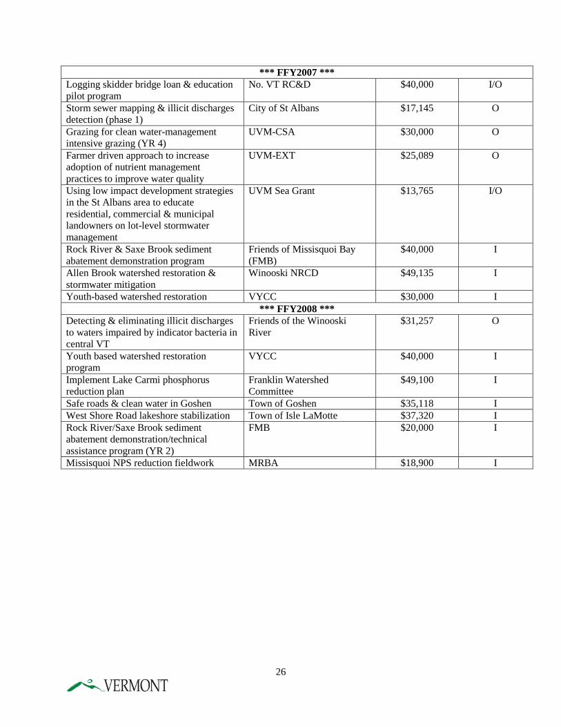
*** FFY2007 *** Logging skidder bridge loan & education pilot program
No. VT RC&D $40,000 I/O
Storm sewer mapping & illicit discharges detection (phase 1)
City of St Albans $17,145 O
Grazing for clean water-management intensive grazing (YR 4)
UVM-CSA $30,000 O
Farmer driven approach to increase adoption of nutrient management practices to improve water quality
UVM-EXT $25,089 O
Using low impact development strategies in the St Albans area to educate residential, commercial & municipal landowners on lot-level stormwater management
UVM Sea Grant $13,765 I/O
Rock River & Saxe Brook sediment abatement demonstration program
Friends of Missisquoi Bay (FMB)
$40,000 I
Allen Brook watershed restoration & stormwater mitigation
Winooski NRCD $49,135 I
Youth-based watershed restoration VYCC $30,000 I *** FFY2008 ***
Detecting & eliminating illicit discharges to waters impaired by indicator bacteria in central VT
Friends of the Winooski River
$31,257 O
Youth based watershed restoration program
VYCC $40,000 I
Implement Lake Carmi phosphorus reduction plan
Franklin Watershed Committee
$49,100 I
Safe roads & clean water in Goshen Town of Goshen $35,118 I West Shore Road lakeshore stabilization Town of Isle LaMotte $37,320 I Rock River/Saxe Brook sediment abatement demonstration/technical assistance program (YR 2)
FMB $20,000 I
Missisquoi NPS reduction fieldwork MRBA $18,900 I
26
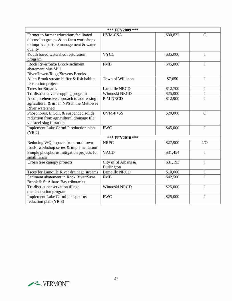
*** FFY2009 *** Farmer to farmer education: facilitated discussion groups & on-farm workshops to improve pasture management & water quality
UVM-CSA $30,832 O
Youth based watershed restoration program
VYCC $35,000 I
Rock River/Saxe Brook sediment abatement plus Mill River/Jewett/Rugg/Stevens Brooks
FMB $45,000 I
Allen Brook stream buffer & fish habitat restoration project
Town of Williston $7,650 I
Trees for Streams Lamoille NRCD $12,700 I Tri-district cover cropping program Winooski NRCD $25,000 I A comprehensive approach to addressing agricultural & urban NPS in the Mettowee River watershed
P-M NRCD $12,900 I
Phosphorus, E.Coli, & suspended solids reduction from agricultural drainage tile via steel slag filtration
UVM-P+SS $20,000 O
Implement Lake Carmi P reduction plan (YR 2)
FWC $45,000 I
*** FFY2010 *** Reducing WQ impacts from rural town roads: workshop series & implementation
NRPC $27,900 I/O
Simple phosphorus mitigation projects for small farms
VACD $31,454 I
Urban tree canopy projects City of St Albans & Burlington
$31,193 I
Trees for Lamoille River drainage streams Lamoille NRCD $10,000 I Sediment abatement in Rock River/Saxe Brook & St Albans Bay tributaries
FMB $42,500 I
Tri-district conservation tillage demonstration program
Winooski NRCD $25,000 I
Implement Lake Carmi phosphorus reduction plan (YR 3)
FWC $25,000 I
27
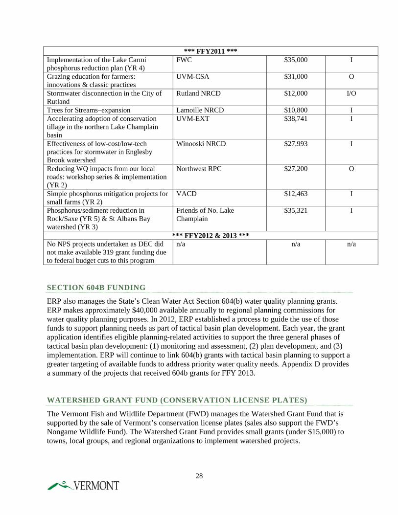
*** FFY2011 *** Implementation of the Lake Carmi phosphorus reduction plan (YR 4)
FWC $35,000 I
Grazing education for farmers: innovations & classic practices
UVM-CSA $31,000 O
Stormwater disconnection in the City of Rutland
Rutland NRCD $12,000 I/O
Trees for Streams–expansion Lamoille NRCD $10,800 I Accelerating adoption of conservation tillage in the northern Lake Champlain basin
UVM-EXT $38,741 I
Effectiveness of low-cost/low-tech practices for stormwater in Englesby Brook watershed
Winooski NRCD $27,993 I
Reducing WQ impacts from our local roads: workshop series & implementation (YR 2)
Northwest RPC $27,200 O
Simple phosphorus mitigation projects for small farms (YR 2)
VACD $12,463 I
Phosphorus/sediment reduction in Rock/Saxe (YR 5) & St Albans Bay watershed (YR 3)
Friends of No. Lake Champlain
$35,321 I
*** FFY2012 & 2013 *** No NPS projects undertaken as DEC did not make available 319 grant funding due to federal budget cuts to this program
n/a n/a n/a
SECTION 604B FUNDING
ERP also manages the State’s Clean Water Act Section 604(b) water quality planning grants. ERP makes approximately $40,000 available annually to regional planning commissions for water quality planning purposes. In 2012, ERP established a process to guide the use of those funds to support planning needs as part of tactical basin plan development. Each year, the grant application identifies eligible planning-related activities to support the three general phases of tactical basin plan development: (1) monitoring and assessment, (2) plan development, and (3) implementation. ERP will continue to link 604(b) grants with tactical basin planning to support a greater targeting of available funds to address priority water quality needs. Appendix D provides a summary of the projects that received 604b grants for FFY 2013. WATERSHED GRANT FUND (CONSERVATION LICENSE PLATES)
The Vermont Fish and Wildlife Department (FWD) manages the Watershed Grant Fund that is supported by the sale of Vermont’s conservation license plates (sales also support the FWD’s Nongame Wildlife Fund). The Watershed Grant Fund provides small grants (under $15,000) to towns, local groups, and regional organizations to implement watershed projects.
28
CHAPTER 2 - STATUS OF EPA’S DEVELOPMENT OF PHOSPHORUS ALLOCATIONS The process of developing a new Lake Champlain Phosphorus TMDL for Vermont began when EPA issued its January 24, 2011 disapproval letter for the Vermont portion of the 2002 TMDL in response to a lawsuit filed by Conservation Law Foundation. In reaching its decision, EPA concluded that two legally contested elements of the TMDL were not consistent with federal regulation and guidance. The two reasons cited by EPA for its disapproval were that the TMDL did not provide an: (1) adequate margin of safety and (2) sufficient reasonable assurances that the necessary nonpoint source load reductions would be achieved. In addition to addressing these legal inadequacies in the TMDL, EPA determined that, once reopened, all aspects of the Vermont TMDL should be reviewed and updated in light of new data, research, and policy considerations. Consequently, EPA has invested significant time and resources in developing new lake and watershed models for Lake Champlain for use in setting new total loading capacities, developing new wasteload and load allocations, evaluating phosphorus load reductions possible from watershed management practices, and considering climate change impacts. Lake and tributary monitoring data used for the lake model indicated that the current (2001-2010 average) phosphorus load to Lake Champlain from Vermont is 631 metric tons per year (mt/yr). Application of the lake model suggests that the total loading capacity from Vermont is about 418 mt/yr. A net lakewide load reduction of 213 mt/yr is needed from Vermont sources, representing an overall 34% reduction when a 5% margin of safety is provided. However, in order to achieve water quality standards throughout the entire lake, the individual Vermont lake segment total loading capacities must be achieved in each case. The twelve Vermont lake segment watershed phosphorus load reduction targets shown in Table 6 are preliminary results that may still revised by EPA in the final TMDL. The percent load reductions required range between 12-64% among the lake segment watersheds (Table 6). In order to assess the potential load reductions obtainable from an enhanced set of watershed management practices, EPA applied a Lake Champlain Scenario Tool (Scenario Tool). The results of this analysis indicated that the percent load reductions achievable from the practices simulated were sufficient to achieve the example TMDL targets in Table 6 in all lake segments except Missisquoi Bay. Enhanced efforts will be required in the Missisquoi Bay watershed. The preliminary results illustrated in Table 6 demonstrate that achieving the necessary load reductions will present an enormous management challenge. This Phase 1 Plan has been developed with an understanding of the magnitude of the effort needed. Once the basin-specific wasteload and load allocations are finalized by EPA, Vermont will issue Phase 2 basin-specific plans that will further refine Vermont’s policy commitments and implementation strategy for all contributing sectors in each lake segment.
29
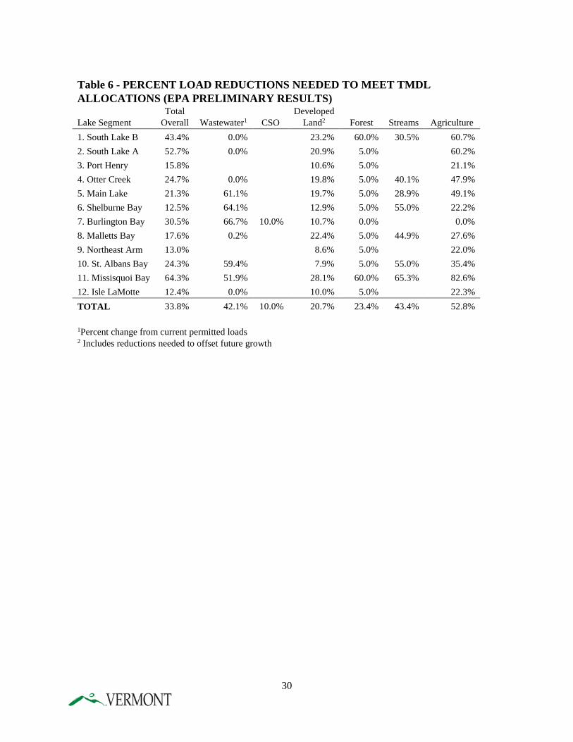
Table 6 - PERCENT LOAD REDUCTIONS NEEDED TO MEET TMDL ALLOCATIONS (EPA PRELIMINARY RESULTS)
Lake Segment Total
Overall Wastewater1 CSO Developed
Land2 Forest Streams Agriculture 1. South Lake B 43.4% 0.0%
23.2% 60.0% 30.5% 60.7%
2. South Lake A 52.7% 0.0%
20.9% 5.0%
60.2% 3. Port Henry 15.8%
10.6% 5.0%
21.1%
4. Otter Creek 24.7% 0.0%
19.8% 5.0% 40.1% 47.9% 5. Main Lake 21.3% 61.1%
19.7% 5.0% 28.9% 49.1%
6. Shelburne Bay 12.5% 64.1%
12.9% 5.0% 55.0% 22.2% 7. Burlington Bay 30.5% 66.7% 10.0% 10.7% 0.0%
0.0%
8. Malletts Bay 17.6% 0.2%
22.4% 5.0% 44.9% 27.6% 9. Northeast Arm 13.0%
8.6% 5.0%
22.0%
10. St. Albans Bay 24.3% 59.4%
7.9% 5.0% 55.0% 35.4% 11. Missisquoi Bay 64.3% 51.9%
28.1% 60.0% 65.3% 82.6%
12. Isle LaMotte 12.4% 0.0% 10.0% 5.0% 22.3% TOTAL 33.8% 42.1% 10.0% 20.7% 23.4% 43.4% 52.8%
1Percent change from current permitted loads 2 Includes reductions needed to offset future growth
30
CHAPTER 3 - STRATEGY TO ADDRESS POINT SOURCE POLLUTION
A. INTRODUCTION As provided by the federal Clean Water Act, a TMDL is a “pollution budget” that describes the amount of pollution a water body can tolerate and still maintain water quality standards. In order to provide reasonable assurances that nonpoint sources will be adequately controlled during TMDL implementation, one must know which phosphorus sources are considered nonpoint sources and which are not. This issue is not always straightforward during TMDL development. For purposes of this Plan, Vermont has made certain assumptions as to which sources are point sources and which are nonpoint sources. The nonpoint sources are subject to reasonable assurances and are addressed in Vermont’s policy commitments in Chapter 5. The point source assumptions are discussed below. In most TMDLs, EPA considers point source discharges to include all discharges that require permits under the National Pollutant Discharge and Elimination System (NPDES). All other discharges are considered nonpoint sources subject to the reasonable assurances requirement. Vermont is assuming that the following NPDES permitted discharges will be subject to the wasteload allocation in the new TMDL:
• Wastewater treatment discharges subject to NDPES permits; • Urban stormwater runoff discharges subject to the MS4 NPDES permit; • Construction site discharges subject to NPDES stormwater permits; • Industrial stormwater discharges subject to the NPDES “multi-sector” permit; • Discharges subject to NPDES permits issued pursuant to the federal Clean Water Act’s
“residual designation authority” provision; and • Stormwater discharges from farms covered by a NPDES CAFO permit.
Since the regulatory programs that cover these sources are part of TMDL implementation planning, this Chapter includes a brief discussion of each program.
31
B. WASTEWATER TREATMENT FACILITIES (WWTFS) This Plan does not allocate any additional phosphorus reductions to wastewater treatment plants in the Lake Champlain basin. The load associated with these plants is small, approximately three percent of the total load from Vermont. Further, Vermont’s communities and businesses have made substantial progress in reducing phosphorus from these plants over the past four decades and it is increasingly difficult to justify further investments in reducing phosphorus from these sources given the relatively high cost of installing additional phosphorus removal. With optimization of operations to maximize phosphorus removal, these plants should remain a minor source of phosphorus pollution for many years to come without any major new capital investments. We recognize that for EPA to justify approving a TMDL that does not allocate any additional load reduction to wastewater treatment plants, the State must demonstrate that it will reduce phosphorus loads from other sources sufficient for Lake Champlain to meet water quality standards. This Plan includes a broad array of actions sufficient to meet the “reasonable assurances” standard that EPA must apply under the Clean Water Act. The EPA indicated in a May 8, 2014 letter that it is highly unlikely that the final TMDL would allocate no reductions to wastewater treatment plants in any of the lake segments. If the EPA determines that additional reductions in permitted wastewater loads are required for the TMDL, then the following considerations should apply.
• Any further reductions in wastewater allocations should be targeted only to facilities in those lake segment watersheds where the currently permitted wastewater load represents a higher proportion of the total phosphorus load from all Vermont sources, and where wastewater upgrades would meaningfully reduce the phosphorus reduction burden placed on non-wastewater sources.
• TMDL-based discharge permit limits should be defined as annual average phosphorus loading rates, rather than as concentration limits, in order to allow operational flexibility in attaining the limits.
• New permit requirements should be implemented through compliance schedules that allow sufficient time for planning, budgeting, and engineering, and that take advantage of cost-efficient opportunities to couple phosphorus upgrades with other planned facility construction projects.
• Other forms of flexibility should be available to achieve the wasteload allocations in an optimally cost-effective manner. For example, trades between wastewater treatment facilities within the same lake segment watershed should be allowed, subject to approval by DEC in the discharge permits for those facilities, provided that the aggregate wasteload allocation for that lake segment is not exceeded. Integrated watershed plans and permits that optimally balance phosphorus reduction requirements for wastewater and stormwater discharges in order to achieve the overall wasteload allocation for the watershed should also be possible for urbanized areas, consistent with EPA guidance.
Upon approval of the TMDL, the DEC Wastewater Management Program will begin reissuing National Pollutant Discharge Elimination System (NPDES) permits for the 59 direct discharge facilities in the Lake Champlain watershed on a five year rotation. Each permit will be developed
32
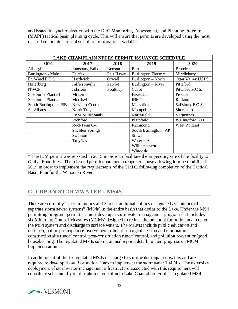
and issued in synchronization with the DEC Monitoring, Assessment, and Planning Program (MAPP) tactical basin planning cycle. This will ensure that permits are developed using the most up-to-date monitoring and scientific information available.
LAKE CHAMPLAIN NPDES PERMIT ISSUANCE SCHEDULE 2016 2017 2018 2019 2020
Alburgh Enosburg Falls Benson Barre Brandon Burlington - Main Fairfax Fair Haven Burlington Electric Middlebury Ed Weed F.C.S. Hardwick Orwell Burlington – North Otter Valley U.H.S. Hinesburg Jeffersonville Pawlet Burlington – River Pittsford NWCF Johnson Poultney Cabot Pittsford F.C.S. Shelburne Plant #1 Milton Essex Jct. Proctor Shelburne Plant #2 Morrisville IBM* Rutland South Burlington - BB Newport Center Marshfield Salisbury F.C.S. St. Albans North Troy Montpelier Shoreham PBM Nutritionals Northfield Vergennes Richford Plainfield Wallingford F.D. RockTenn Co. Richmond West Rutland Sheldon Springs South Burlington –AP Swanton Stowe Troy/Jay Waterbury Williamstown Winooski * The IBM permit was reissued in 2015 in order to facilitate the impending sale of the facility to Global Foundries. The reissued permit contained a reopener clause allowing it to be modified in 2019 in order to implement the requirements of the TMDL following completion of the Tactical Basin Plan for the Winooski River.
C. URBAN STORMWATER - MS4S There are currently 12 communities and 3 non-traditional entities designated as “municipal separate storm sewer systems” (MS4s) in the entire basin that drains to the Lake. Under the MS4 permitting program, permittees must develop a stormwater management program that includes six Minimum Control Measures (MCMs) designed to reduce the potential for pollutants to enter the MS4 system and discharge to surface waters. The MCMs include public education and outreach, public participation/involvement, illicit discharge detection and elimination, construction site runoff control, post-construction runoff control, and pollution prevention/good housekeeping. The regulated MS4s submit annual reports detailing their progress on MCM implementation. In addition, 14 of the 15 regulated MS4s discharge to stormwater impaired waters and are required to develop Flow Restoration Plans to implement the stormwater TMDLs. The extensive deployment of stormwater-management infrastructure associated with this requirement will contribute substantially to phosphorus reduction in Lake Champlain. Further, regulated MS4
33
municipalities are required to track phosphorus reductions associated with the deployment of BMPs.
D. NPDES CONSTRUCTION STORMWATER DISCHARGES The construction stormwater permit program addresses stormwater runoff from earth disturbance activity of one or more acres of land, and is a requirement of the federal Clean Water Act. In general, compliance with the construction stormwater permit requires the development of an erosion prevention and sediment control plan. The goal of the plan is to minimize the erosion of disturbed land and to minimize or eliminate the discharge of sediment (which carries phosphorus) to waters of the State through the implementation of appropriate erosion prevention and sediment control measures. There are currently approximately 800 active state construction stormwater permits.
E. STORMWATER DISCHARGES ASSOCIATED WITH INDUSTRIAL ACTIVITIES The Multi‐Sector General Permit (MSGP) 3‐9003 addresses stormwater runoff associated with industrial facilities. A facility must obtain coverage under the MSGP if it falls within a Standard Industrial Classification (SIC) code listed in Table D‐1 of the permit. All regulated activities are required to implement BMPs such as good housekeeping, erosion prevention, and minimizing exposure; all of which serve to reduce potential pollutant discharges. Facilities manufacturing agricultural chemicals are required to monitor specifically for phosphorus in their stormwater discharges. If monitoring results are above the level set in the permit, the facilities must modify their plans to reduce the phosphorus discharge.
F. RESIDUAL DESIGNATION AUTHORITY DISCHARGES In 2009, the Department issued a NPDES general permit for stormwater “residually designated discharges” (RDA) pursuant to the authority of the federal Clean Water Act. The RDA General Permit 3-9030 covered certain designated discharges not covered by the MS4 permit in five of the urban stormwater-impaired streams in Chittenden County. Properties were designated if their impervious surface discharged directly to a stormwater impaired stream. Designated properties were divided into three categories. Fifty-three properties without a previously issued state stormwater permit and less than one acre of impervious surface were directed to implement the Small Sites Guide which includes good housekeeping and low impact design practices. Five properties without a previously issued state stormwater permit and more than one acre of impervious had to complete a site assessment, gathering information on current site conditions to be used in the development of the flow restoration plans (FRPs). Twenty sites with previously issued state stormwater permits were required to conduct an Engineering Feasibility Analysis (EFA) to upgrade their existing stormwater treatment practices. The EFA directs property
34
owners to infiltrate or detain the 1-year design storm, which will provide phosphorus reductions as well as benefiting flows. DEC plans on expanding the RDA permit to the remaining urban stormwater impaired waters in the near future in order to assist in the implementation of the TMDL for Lake Champlain.
G. CONCENTRATED ANIMAL FEEDING OPERATION DISCHARGES The Vermont statewide concentrated animal feeding operation (CAFO) general permit was issued in June 2013. While the permit is not phosphorus-specific, any farm that discharges pollutants to a surface water body can be required to obtain a permit. The CAFO general permit is for medium farms, but an individual permit can be required for a small or large farm. The CAFO permit requires farms to properly design, construct, operate, and maintain production areas to control waste and to develop and implement a nutrient management plan, which is available to the public. The permit prohibits a discharge of manure, litter, or wastewater, except when direct precipitation equivalent to or greater than a 25-year, 24-hour storm event causes a discharge.
35
CHAPTER 4 - CURRENT PROGRAM CAPACITY TO ADDRESS NONPOINT SOURCES
A. INTRODUCTION Controlling nonpoint source pollution is the key element in reducing phosphorus loads to the Lake and meeting water quality standards. The control of nonpoint source pollution presents a major challenge both in the Lake Champlain basin and nationwide. This is due to the diffuse nature of nonpoint source contributions, which originate from runoff from buildings and parking lots, farm fields, forests, back roads, and stream erosion. These sources can be difficult to identify, quantify and control. In working to control phosphorus pollution, Vermont has invested heavily in programs to enhance the natural stability of streams and rivers, improve management of Vermont’s network of parking lots and roads, protect and restore wetlands, limit polluted runoff from construction sites, implement soil-based conservation practices such as cover cropping, and provide technical and financial assistance to farmers to prevent discharges from barnyards and fields. Despite the magnitude of these efforts, further pollution reductions are needed. In response to EPA’s request for further action, ANR, AAFM, and other state and local partners have spent considerable time evaluating existing state and local “program capacity” to control phosphorus. “Program capacity” is the current legal, regulatory, programmatic, financial, staffing and technical capacity available to meet the TMDL target goals. This evaluation, which included significant stakeholder and public input, was necessary to ensure that future efforts are focused on the highest priority sources in the most cost-effective manner possible. This evaluation also served to identify enhancements needed in existing programs and new programs needed to protect the Lake. The major categories of policy tools used to implement the TMDL include:
• Regulatory requirements: providing specific legally required steps that must be taken to control pollution and reduce impacts, including permitting programs;
• Financial incentives: linking funding eligibility to specific actions or using subsidies to control pollution and reduce impacts;
• Technical assistance: sharing technical information with state, local and private partners regarding the water quality impacts of their current or planned actions, and suggesting techniques to reduce impacts;
• Monitoring, Assessment and Planning: monitoring and assessing the status of surface waters to ensure that implementation efforts are planned, targeted and funded to ensure the best use of available monies with the highest rate of success.
• Funding: targeting funding efforts geographically, and setting priorities for which practices should be implemented first in order to achieve the greatest benefit at the lowest cost.
36
• Education and outreach: sharing information with stakeholders and the general public in order to create a broad-based understanding of nonpoint source pollution and to foster needed behavior changes.
ANR currently administers a combination of these tools as the foundation upon which TMDL implementation is built. In addition, ANR coordinates with AAFM to ensure regulatory, and technical and financial assistance programs are available to the agricultural community, and with VTrans to ensure water quality controls are provided in road construction and maintenance activities. ANR, AAFM and VTrans also work closely with federal, state and local partners to promote regulatory and voluntary programs to ensure implementation, and to seek necessary funding. This Chapter describes the most significant existing policy tools to reduce the major sectors of nonpoint pollution -- developed lands and roadways; agriculture, forests, wetland alterations, and stream erosion. The WSMD’s Vermont Surface Water Management Strategy describes in much greater detail the full range of current programs for reducing both point and nonpoint sources of surface water pollution in Vermont. The Strategy is available on-line at http://www.watershedmanagement.vt.gov/swms.html.
B. DEVELOPED LANDS - STORMWATER Developed land involves the construction of buildings, roads, parking areas and other impervious surfaces that reduce the infiltration of stormwater and speed the delivery and quantity of runoff into surface waters. The vast majority of existing developed land is not regulated under federal/state stormwater permits, does not manage or treat stormwater, and yet is responsible for significant water quality impacts. Based on the modeling efforts to date, phosphorus loading from developed areas comprises approximately 13.8% of the total phosphorus contribution to the Lake. When compared to the agricultural sector land use, developed lands contribute a relatively minor portion of phosphorus loading. However, on an acre-for-acre basis, develop land areas generate a disproportionate share of the phosphorus load to the Lake. Hence, numerous statewide and targeted management programs are in place for nonpoint source runoff from developed lands as described below. OPERATIONAL STORMWATER PERMITS
DEC’s Stormwater Program issues separate permits for runoff from impervious surfaces, construction sites and industrial facilities. All new projects, redevelopment projects and expansion projects are evaluated to determine whether coverage under a state stormwater permit and/or a construction permit is needed in order to comply with state law and the federal Clean Water Act. Also, if a new project is industrial in nature or is an existing industrial facility, then it may also need to seek coverage under a Multi‐Sector General Permit. Many projects require both a state stormwater permit and a construction permit; some projects may require all three permits.
37
DEC has issued operational permits under state authority since the late 1970s, with the scope of the permit program expanding substantially over time. Program technical standards were updated in 1980, 1987, 1997, and 2002. The jurisdictional threshold has also been revised over time, and since 2005 it has been set at one acre of impervious cover. Projects requiring permit coverage must design a management system in compliance with the Vermont Stormwater Management Manual (VSMM) standards developed by the Center for Watershed Protection. DEC is currently in a stakeholder process to update the VSMM with a goal of increasing the application of Low Impact Development (LID) practices. The construction stormwater permit was originally issued in 1997 and was applied to sites with a minimum of five acres of disturbance. In 2006, the permit was reissued to be applied to sites with one acre of disturbance. The Multi-Sector General Permit was originally issued in 2006. State Stormwater Permit Program (a.k.a. operational or post‐construction) This DEC permit program regulates discharges (runoff) from impervious surfaces (i.e. rooftops, paved/gravel roads, etc.). The Stormwater Permit Program has specific jurisdictional thresholds based on the amount of impervious surface, per the Stormwater Management Rules (Stormwater Management Rule for Non‐Stormwater Impaired Waters and Stormwater Management Rule for Stormwater Impaired Waters). In general, projects creating more than one acre of new impervious surface, or projects that expand existing impervious surfaces where the total resulting impervious surface is greater than one acre require permit coverage. Projects requiring permit coverage must apply for coverage under General Permit 3‐9015, unless the project is located within a watershed impaired for stormwater, in which case individual permit coverage is required. Projects that require permit coverage must implement a stormwater management system designed in compliance with the Vermont Stormwater Management Manual (VSMM). The VSMM was developed by the Center for Watershed Protection, and includes sizing criteria to meet water quality, groundwater recharge, channel protection, overbank flood protection and extreme flood control. Table 7 is taken from the VSMM which gives reasonable estimates of phosphorus and other removal efficiencies for the general groups of accepted practices allowed under the permit.
38
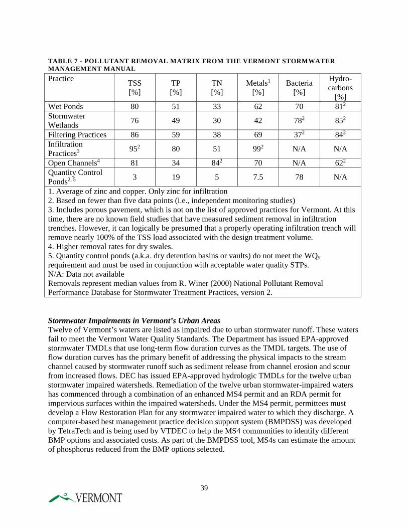
TABLE 7 - POLLUTANT REMOVAL MATRIX FROM THE VERMONT STORMWATER MANAGEMENT MANUAL
Stormwater Impairments in Vermont’s Urban Areas Twelve of Vermont’s waters are listed as impaired due to urban stormwater runoff. These waters fail to meet the Vermont Water Quality Standards. The Department has issued EPA-approved stormwater TMDLs that use long-term flow duration curves as the TMDL targets. The use of flow duration curves has the primary benefit of addressing the physical impacts to the stream channel caused by stormwater runoff such as sediment release from channel erosion and scour from increased flows. DEC has issued EPA-approved hydrologic TMDLs for the twelve urban stormwater impaired watersheds. Remediation of the twelve urban stormwater-impaired waters has commenced through a combination of an enhanced MS4 permit and an RDA permit for impervious surfaces within the impaired watersheds. Under the MS4 permit, permittees must develop a Flow Restoration Plan for any stormwater impaired water to which they discharge. A computer-based best management practice decision support system (BMPDSS) was developed by TetraTech and is being used by VTDEC to help the MS4 communities to identify different BMP options and associated costs. As part of the BMPDSS tool, MS4s can estimate the amount of phosphorus reduced from the BMP options selected.
Practice TSS [%]
TP [%]
TN [%]
Metals1 [%]
Bacteria [%]
Hydro- carbons
[%] Wet Ponds 80 51 33 62 70 812 Stormwater Wetlands 76 49 30 42 782 852
Filtering Practices 86 59 38 69 372 842 Infiltration Practices3 952 80 51 992 N/A N/A
Open Channels4 81 34 842 70 N/A 622 Quantity Control Ponds2, 5 3 19 5 7.5 78 N/A
1. Average of zinc and copper. Only zinc for infiltration 2. Based on fewer than five data points (i.e., independent monitoring studies) 3. Includes porous pavement, which is not on the list of approved practices for Vermont. At this time, there are no known field studies that have measured sediment removal in infiltration trenches. However, it can logically be presumed that a properly operating infiltration trench will remove nearly 100% of the TSS load associated with the design treatment volume. 4. Higher removal rates for dry swales. 5. Quantity control ponds (a.k.a. dry detention basins or vaults) do not meet the WQv requirement and must be used in conjunction with acceptable water quality STPs. N/A: Data not available Removals represent median values from R. Winer (2000) National Pollutant Removal Performance Database for Stormwater Treatment Practices, version 2.
39
Stormwater Impairments and Water Quality Remediation Plans Five mountain watersheds associated with ski area development are listed on the 2012 303(d) List as impaired primarily due to stormwater runoff. One of these watersheds is within the Lake Champlain basin. These mountain watersheds differ substantially from other stormwater impaired areas which are more urbanized “lowland” watersheds in terms of density of development, geographic position, hydrology, impairment source, and land ownership. Based on these factors, DEC is using a non-TMDL approach to remediation, whereby it is working with responsible parties in developing watershed-specific Water Quality Remediation Plans (WQRPs). The watersheds in the Lake Champlain basin cover approximately 1117 acres and will ultimately receive extensive stormwater retrofits in order to alleviate local stream impairments. Implementation of these retrofits to existing impervious areas as well as high erosion areas should result in significant phosphorus reductions. ILLICIT DISCHARGE DETECTION AND ELIMINATION
In 2000, the Vermont Legislature required DEC to implement a statewide program to promote detection and elimination of improper or illegal connections and discharges. (Sec. 3. 10 V.S.A. § 1264 (b)(9)). Illicit discharges are discharges of wastewater or industrial process water into a stormwater-only drainage system. The Legislature's intent was to expand illicit discharge detection and elimination (IDDE) efforts from the communities—all in the greater Burlington area—required to perform IDDE in compliance with the EPA’s Phase 2 Stormwater Rule to encompass all developed areas of the Vermont. Following the Legislature's mandate, DEC has assisted municipalities not subject to the Phase 2 Stormwater Rule by mapping drainage systems and performing IDDE. This work, funded through ERP water quality grants, federal Section 319 and Lake Champlain Basin Program grants, has been completed for all major municipalities in the Missisquoi, Lamoille and Winooski River Basins (outside the greater Burlington area), the three largest Connecticut River Basin towns and is ongoing in the Otter Creek River Basin. About twenty-five communities have had GIS drainage maps completed. Stone Environmental, Inc. in conjunction with several watershed associations (Friends of the Winooski River, Friends of the Mad River) has conducted IDDE surveys in thirteen non-designated MS4 communities, ten of which overlap the state mapping effort. Stone identified 497 discharge points, 237 of which were flowing when inspected. A wastewater source was indicated at 28 discharge points. Other types of contamination included petroleum (11 locations), treated drinking water (13 locations), heated water, and road salt. By combining drainage mapping, environmental investigative work, and municipal cooperation, DEC and Stone eliminated seven wastewater discharges, decreasing phosphorus by an estimated 154 kg per year to Lake Champlain and reducing the risk of pathogen exposure.
40
GREEN STORMWATER INFRASTRUCTURE
Since 2009, DEC has played a critical role in coordination of Vermont’s Green Infrastructure Initiative, a statewide effort that seeks to increase the adoption of low impact development (LID) principles and implementation of green stormwater infrastructure (GSI) practices. The Initiative works to implement strategies identified within the GI Strategic Plan, which was developed by the Green Infrastructure Roundtable, an ad hoc group of individuals from the public and private sector who come together on a quarterly basis. The Plan targets four key audiences: design professionals, municipalities, property owners and state agencies. The Strategic Plan was followed by the signing of Executive Order 06-12 (EO) in March of 2012. The EO further defines the role of State Agencies and calls for the creation of an Interagency Green Infrastructure Council which includes the secretaries of the agencies of Natural Resources, Transportation, Commerce and Community Development, and the Commissioner of Buildings and General Services or their designees. The Council is tasked with identifying opportunities for integration of GSI practices in existing programs, initiating a process for developing GSI technical guidance, establishing a plan for implementing GSI on state properties and projects, identifying agency liaisons, identifying and undertaking GSI research and monitoring, and identifying sustainable funding sources. Members of the Council are also tasked with developing a GSI Implementation Work Plan for their respective Agency/Department. Work plans were completed on July 1, 2013 and lay out opportunities and strategies for moving the GSI initiative forward over the course of the next year. The EO is in effect for five years.
C. DEVELOPED LANDS - TRANSPORTATION A major sub-sector of the Developed Lands sector consists of state and local highways and roads which contribute significant amounts of phosphorus laden runoff to the Lake. There are over 14,000 miles of public roads in Vermont, nearly all of which require ditches and culverts for drainage. Approximately 80% of these road miles are maintained by Vermont municipalities; three quarters of these municipal roads need erosion control improvements. Two thirds of these roads are unpaved gravel or unimproved roads, and nearly all require ditches and culverts for water drainage. If these structures are not properly constructed and maintained, there is significant potential for erosion of sediment carrying phosphorus into the drainage network and adjoining streams and eventually into the Lake. Water quality improvement and protection has become a major focus in recent years as it relates to the roads network generally and to BMP implementation and project development specifically. Programs of note include: TITLE 19
VTrans regulates “drain on” activities into the State right-of-way, within its authority under Title 19, and requires proposed dischargers to the right-of-way treat stormwater prior to discharging into the right-of-way. Furthermore, VTrans prohibits the illegal connection or illicit (non-stormwater) discharge to its right-of-way statewide.
41
VERMONT TRANSPORTATION ROAD AND BRIDGE STANDARDS
The Federal Emergency Management Agency (FEMA) adopted a policy in 1999 that describes municipalities’ eligibility for FEMA benefits following federally declared natural disasters. Prior to federally declared disaster declarations (which make available Public Assistance funds for public infrastructure repairs), municipalities are to adopt road infrastructure “codes and standards” (referred to as “Road and Bridge Standards” or “Codes and Standards”). These municipal codes and standards apply to road and stream crossing upgrades and other infrastructure that are not governed by state or federal standards. FEMA provides Public Assistance funding to support rebuilding to those standards. In 2010, the Vermont Legislature passed Act 110 which modified 19 V.S.A. §309b to establish an incentive program to encourage municipal adoption of codes and standards. That incentive involves increasing state cost share of two grant programs – the Town Highway Class 2 Roadway and Town Highway Structures grant programs. FEMA also required a change to the VTrans’ codes and standards template, prohibiting municipalities from modifying its codes and standards for fiscal reasons. Following a series of federally declared flood disasters in 2008, a number of towns pursuing FEMA Public Assistance reimbursements could not produce copies of their adopted codes and standards. Thus the Act also required municipalities to file an annual certificate of compliance with their codes and standards. Act 110 also required VTrans to revise its Road and Bridge Standards template to include a suite of practical and cost-effective best management practices (BMPs) to better control road-related stormwater runoff. Those practices address construction, maintenance, and repair of municipal road network. VTrans is to review and revise the standards, as appropriate, every four years to ensure that they are protective of water quality, and the Secretary of the Agency of Natural Resources is to approve all revisions. Following the recovery from Tropical Storm Irene, the State of Vermont added another incentive to encourage municipalities to adopt the VTrans Road and Bridge Standards. The State modified its policy for managing the State’s Emergency Relief and Assistance Fund (ERAF). The new standard, effective for any disaster after October 23, 2014, is structured to encourage municipalities to take four basic steps to prepare their communities before the next disaster; one of those steps involves adopting the most recent VTrans Road and Bridge Standards. Following a federally declared flood disaster, FEMA requires a 25% local match for public assistance funding. Municipalities that do not adopt the four basic steps including adoption of Road and Bridge Standards receive a reduced amount of state aid to cover the local match (7.5% of the repair costs). Municipalities that adopt the steps receive state aid to cover half of the local match (12.5% of the repair costs). Municipalities that adopt the basic steps and the state model floodplain and river corridor protection bylaws receive a large share of state aid (17.5% of the repair costs).
42
VERMONT BETTER BACK ROADS PROGRAM
Established in 1997, the Vermont Better Back Roads Program provides grants and technical assistance to towns to correct erosion problems and adopt road maintenance practices that protect water quality while reducing long-term highway maintenance costs. Better Backroads financial and technical assistance demonstrates to towns that the proper fixes and maintenance practices are cost-effective. A long-term goal for the Better Backroads Program is to enable and encourage towns to practice best management practices in road maintenance and repairs and institutionalize these practices into town capital budget priorities. The Vermont Better Back Roads Program is a partnership with the Vermont Local Roads Program, VTrans and ANR. The program is administered by VTrans. After receiving a grant, most towns adopt the recommended practices for future road maintenance work, therefore, the grants leverage improved maintenance practices that both reduce pollution and save towns money. The Better Backroads Program offers improved infrastructure and maintenance practices for eroding ditches, unstable culvert inlets or outlets and eroding roadside banks which can also help prevent flash flood damage during heavy rain events. Grants are provided for two general categories of projects: developing a town-wide inventory of erosion control needs and a capital budget plan to address these needs; and correcting existing erosion control problems. VTRANS FINANCIAL ASSISTANCE
Over the past decade, VTrans has made significant financial investments to ensure that state highways comply with water quality regulations and to assist municipalities in doing the same for local roads. Examples include: Municipal Town Highway (TH) Grants VTrans administers and provides grants to municipalities under the TH Structures, Class 2 Roadway, and TH Emergency Fund appropriations. A significant amount of this funding is tied either directly or indirectly to stormwater related activities. By adopting TH Road and Bridge Standards, municipalities will receive an additional 10% match in funding for the Structures and Class 2 Roadway grants. These Standards include stormwater best management practices directly tied to improving water quality Town Highway Aid VTrans administers and provides annual appropriation for State aid to municipalities based on their number of miles of Class 1, 2, and 3 town highways. These funds must be used solely for town highway construction, improvement, and maintenance purposes, following their adopted Town Road and Bridge Standards. A portion of these funds are directly tied to stormwater treatment. Transportation Alternatives Program VTrans administers this federally funded program for non-traditional transportation-related projects. One eligible activity under this program involves environmental mitigation of stormwater runoff.
43
FEMA Public Assistance Program VTrans administers and provides grants to eligible applicants/owners of publicly-owned facilities who suffered damage during a federally declared disaster (primarily municipal roads/bridges not on federal-aid highways). The vast majority of these grants involve repairs, improvements, and mitigation activities associated with stormwater. FEMA funds 75% and the State & applicant split 25%. FHWA SAFETEA-LU VTrans administered the federal Municipal Highway Stormwater Mitigation Grant Program directing funds to municipalities over the past 5 years allowing the implementation of $5.4 million worth of highway stormwater mitigation, with roughly 50% spent in Chittenden County and 50% spent elsewhere.
D. AGRICULTURE As estimated by the previously discussed modelling efforts, agricultural nonpoint sources of phosphorus account for approximately 40% of the overall phosphorus load delivered to the Lake from Vermont. Therefore, management efforts in this sector have the potential to contribute to significant reductions. In Vermont, a strong agriculture conservation partnership exists between state and federal agencies, as well as the non-profit sector that provides non-regulatory outreach and education to the farming community. These partners include USDA/Natural Resources Conservation Service, the University of Vermont Extension System, the VT Association of Conservation Districts, and other non-governmental groups and watershed organizations. An advisory group was added to this statewide conservation partnership in 2013, with the creation of the Ag Workgroup. The Ag Workgroup members were mostly farmers, with the balance being technical service providers who work directly with farmers. This group provided extensive assistance to the Agency of Agriculture, Food and Markets (AAFM) and DEC in the development of the proposed revisions in the TMDL and stands as an ongoing advisory group to the Agencies. The major agricultural programs described below include regulatory, technical assistance and funding measures to assist in phosphorus reduction efforts. REGULATORY PROGRAMS
The Agency of Agriculture, Food and Markets (AAFM) administers a combination of regulatory and voluntary programs, with the goal of protecting water resources and helping Vermont’s farming community maintain financial viability. This includes ensuring that farms meet or exceed the standards established by the federal water quality regulations (Clean Water Act) while providing the financial and technical tools in order to do so. The AAFM regulatory programs are set up in a three-tiered structure that is designed to provide a logical progression in regulatory oversight as a farm may increase in size.
44
Accepted Agricultural Practices Act 64 requires significant changes to Vermont’s Accepted Agricultural Practices, including a name change to “Required Agricultural Practices” or “RAPs,” thereby reflecting the fact that these practices are not and never have been optional. The Vermont Accepted Agricultural Practice Rule (AAPs) requires that all farms in the state, regardless of size and type of operation, adopt and implement a set of minimum conservation practices to protect water quality. These rules were developed in 1995 and updated in 2006. The AAPs were designed to reduce non-point pollutant discharges through implementation of improved farming techniques rather than investments in structures and equipment, however the AAPs do not allow for any discharge from the farm and remediations may be of a high cost. State law requires that these improvements must be practical as well as cost effective for farmers to implement, as determined by the Secretary of Agriculture, and shall be designed to achieve state standards. Prior to 2013, the AAP program was overseen on a complaint-driven basis due to limited resources and AAFM had never received funding specific to enforcing the AAPs. In recent years, AAFM has investigated between 160 and 215 complaints on small, medium and large farms. The investigations targeted specific complaints or obvious violations and did not include a full AAP compliance assessment. In 2013, AAFM hired the first inspector specifically charged with AAP education and enforcement. This position is prioritizing outreach and evaluation efforts in the agriculturally impaired watershed of Franklin County. AAFM still continues to respond to complaints as in previous years and intends to hire three additional inspectors in 2015-2016 to further expand this. Medium Farm Operations The Medium Farm Operations (MFO) program provides coverage under a single state general permit and is managed by the AAFM. All dairy farms with 200-699 mature animals, whether milking or dry, qualify as a MFO. Other common MFOs include beef operations (300-999 cattle or cow/calf pairs), horse operations (150-499 horses), turkey operations (16,500-54,999 turkeys), and egg facilities (25,000-81,999 laying hens without liquid manure handling system). The general permit prohibits discharges of wastes from a farm's production area to waters of the state and requires manure, compost, and other wastes to be land applied according to a nutrient management plan. AAFM is required to inspect all farms permitted under these rules at least once every five years (increasing to every three years through Act 64) however most are inspected more often and many receive additional technical assistance as practices are implemented. The MFO general permit has been in existence since 2007 and was revised in 2012. Large Farm Operations Program Farms with more than 700 mature dairy cows, 1,000 beef cattle or cow/calf pairs, 1,000 youngstock or heifers, 500 horses, 55,000 turkeys, or 82,000 laying hens must obtain a Large Farm Operations (LFO) permit from the AAFM. A LFO permit prohibits the discharge of wastes from a farm's production area to waters of the state and requires the farm to land apply manure,
45
compost, and other wastes according to a nutrient management plan. Unlike the MFO Program, LFO permits are individual to each farm and also regulate odor, noise, traffic, insects, flies, and other pests, construction siting and setbacks. All LFOs are inspected annually by AAFM. Concentrated Animal Feeding Operation Permits The Vermont statewide Concentrated Animal Feeding Operation (CAFO) general permit is administered by the VT Department of Environmental Conservation and is a federal National Pollutant Discharge Elimination System (NPDES) permit. The CAFO permit was issued in June, 2013. Any farm that discharges to a surface waterbody can be required to obtain a permit. The CAFO general permit is for medium farms, and an individual permit can be required for a small or large farm. The CAFO permit requires farms to properly design, construct, operate, and maintain production areas to control waste and to develop and implement a nutrient management plan, which is available to the public. The permit prohibits a discharge of manure, litter, or wastewater, except when direct precipitation equivalent to or greater than a 25-year, 24-hour storm event causes a discharge. This exception is only allowable when all permit requirements are met. VERMONT AGENCY OF AGRICULTURE, FOOD AND MARKETS
Best Management Practices Program The agricultural Best Management Practices (BMP) Program is both a regulatory and funding program for farmers relating to the construction of farm improvements designed to abate non-point source agricultural waste discharges to waters of the state of Vermont. The BMP program identifies farms that present a risk to water quality and where the AAFM has determined that current infrastructure and practices are not sufficient to address the potential risk to water quality. BMPs must be constructed in a manner that meets the federal Water Pollution Control Act and state water quality standards. Prior to 2015, Vermont statute required the Secretary to determine that sufficient funding was available before requiring a BMP. Act 64 now requires that when BMPs are mandated, the farmer will be made aware of all available resources and it continues to be a goal of AAFM to prioritize available funding where a water quality impact has been identified. Commonly funded production area practices include waste storage facilities, silage leachate systems, milkhouse waste systems, and barnyard runoff collection, most of which are expensive and unaffordable without financial support. Conservation Reserve Enhancement Program In partnership with the USDA, the Conservation Reserve Enhancement Program (CREP) is an enhanced version of the federal USDA Conservation Reserve Program and provides supplemental payments with state funding. CREP encourages the installation of conservation buffers along waterways by providing land owners with a yearly rental payment and by covering the cost of planting the buffer. Additionally, CREP covers the cost of installing fencing and livestock watering systems where animals on pasture are excluded from waterways. In 2013, the rental payment rates from the federal government were drastically cut, and this, along with limited support staff, is a contributing factor to the decreased signups for CREP. Since then, soil
46
rental rates have increased, but support staff for outreach and planning has not increased; currently only part of one person with AAFM works in this program. An evaluation of this program to allow for its continuation and increase is needed and planned for 2016. The federal government provides a 4:1 match for this program, and its value on the Vermont landscape is very high. Farm Agronomic Practices Program The Farm Agronomic Practices (FAP) program provides farmers with state financial assistance of up to $5,000 per farm per year for implementation of soil-based practices that improve soil quality, increase crop production, and reduce erosion and agricultural waste discharges. Eligible practices are nurse crops, strip cropping, conservation crop rotation, alternative manure incorporation, cross-slope tillage, conservation tillage and educational activities. Interest in the FAP program has grown in the past few years and requests for funding far exceed available funds. For this reason, FAP no longer provides funding for cover crops and defers a consistently high number of requests to NRCS funds. Vermont Agricultural Buffer Program The Vermont Agricultural Buffer Program (VABP) offers a 5-year maximum rental contract for the installation of conservation grassed buffers on cropland. Unlike the CREP program, VABP allows planting harvestable grassed buffers. Areas in crop fields that are prone to erosion caused by flood events, which can be classified as flood chutes, are also eligible under this program to be planted into grass and harvested. Nutrient Management Plan Incentive Grants The Nutrient Management Plan Incentive Grants (NMPIG) previously provided funds for the development of a nutrient management plan (NMP) for a farm and three additional years of updates. Due to increased NRCS funding, AAFM now defers farmers to federal funding for the development and updates of NMPs. However, substantial state funding was allocated to this effort in the past and NMP development and implementation is still considered a high priority for AAFM. US DEPARTMENT OF AGRICULTURAL FEDERAL PROGRAMS
Federal programs, funded through the US Agriculture Act of 2014 (commonly known as the Farm Bill), assists Vermont farmers in water quality improvements, including reductions in phosphorus loading to Vermont’s surface waters. The USDA Natural Resources Conservation Service (NRCS) and the Farm Service Agency (FSA) provide technical and financial support for conservation practices and program implementation, as well as funding through the national Conservation Innovation Grant program. In 2014, the newly passed Farm Bill reorganized many of the historic conservation programs. Over the next five years, $18.7 billion has been authorized nationally and due to “regional equity” provisions, Vermont has received substantial water quality improvement funding in recent years. In 2015 NRCS plans on obligating up to $9.2 million Statewide (estimated at $6.6 million within the Lake Champlain Basin) for the Environmental Quality Incentives Program (EQIP). This program provides financial assistance to agricultural producers for the funding of
47
barnyard improvements, manure pit installation, and silage leachate collection systems. In addition, the program will fund the development of Conservation Activity Plans, such Nutrient Management Plans (NMPs) and Comprehensive Nutrient Management Plans (CNMPs). NRCS also has allocated $2.47 million dollars toward the acquisition of Agricultural Conservation Easements through the newly authorized Agricultural Land Easement program. It is expected that this money will be used to conserve 17 farms across the state. Finally, through the newly authorized Wetland Reserve Easement Program, NRCS anticipates funding the acquisition and restoration of around 140 acres of previously converted wetlands. The 2014 Farm Bill also authorized a new funding program, the Regional Conservation Partnership Program (RCPP). RCPP is designed to promote coordination between NRCS and its partners to deliver conservation assistance to landowners. A key goal of RCPP is to increase the number and diversity of partners involved in conservation activities. In 2014, DEC and AAFM submitted a successful application to the highly competitive RCPP program, and in May 2015, was awarded the second largest grant in the country, $16 million to fund efforts over 5 years. This was a bi-state application with the State of New York, and funds are being shared with partners in NY who will focus on Lake Champlain drainage water quality improvement. The grant provides over $20 million as match to the federal funds from 26 partners, many of whom are new to conservation efforts, and bring new opportunities for outreach, education and assistance. The program is being coordinated by DEC, and the State has provided a position to assist with this effort. RCPP funding will result in over 100 new EQIP contracts for farm and forest management practices, 30 new easements, and over 200 acres of wetlands restored and protected. Each project will directly address water quality, with priority given to projects in the Missisquoi, St. Albans Bay and South Lake watersheds of Lake Champlain. Funds are targeted to conserved lands, which as of the 2014 Farm Bill, are now required to develop and implement a water quality focused conservation plan. Additional technical and financial assistance will be provide to help develop and implement these plans on newly conserved farms as required, but also to incentivize prior conserved farms to address critical water quality concerns. USDA’s RCPP program also provided funds to individual states, and the Vermont Association of Conservation Districts received an $800,000 award to increase development and implementation of nutrient management plans. Both programs are coordinating their efforts, and also working closely with a third RCPP effort in the Connecticut River Watershed. USDA allocations have also funded several individual projects in Vermont that directly impact agricultural water quality.
• National Water Quality Initiative ($80,000). Both projects target funds to eligible farmers in the impaired Rock River and Missisquoi Bay watersheds.
• Edge-of-Field monitoring (approx. $220,000). Paired watershed research projects that are assessing the water quality improvement value of key farm BMPs such as cover crops, manure aeration, reduced tillage and water and sediment control basins. Funding in 2016 will include evaluation of tile drains.
48
• Conservation Innovation Grants ($225,000). These competitive grants are funding a web-based tool for BMP tracking, two grants focusing on soil health, one on the viability of reduced tillage systems on heavy clay soils, and one evaluating cover crops on clay soils as an alternative to fall plowing. An additional grant in 2015 is evaluating media for reducing phosphorus in tile drain outflows.
Each of these programs provides extensive water quality technical assistance as well as critical research and education opportunities. PARTNER PROGRAMS
In addition to the state and federal-level programs discussed above, there are a number of local programs through Vermont’s non-profit partners that are geared toward phosphorus reduction from Vermont farms. In addition to these organizations, numerous nonprofit watershed groups provide extensive outreach, education and implementation assistance. Vermont Association of Conservation Districts VACD and its 14 member districts provide education and technical assistance in all natural resource areas, including agriculture, forestry, river management, invasives, stormwater and low-impact development. Districts help agricultural producers by providing non-regulatory assessment and technical assistance, and by leveraging additional funding through grants or other programs. Conservation District programs include:
• Agricultural Resource Specialists: VACD oversees the Agricultural Resource Specialist (ARS) program, a federal and state funded effort which provides free technical assistance and information to help farmers meet the requirements of the state Accepted Agricultural Practices. ARS works with farmers on developing strategies specific to the farm. If these strategies involve implementation costs, ARS provides information and referrals for State and Federal cost-share programs. VACD has also secured grant funding for small on-farm water quality improvement projects, such as livestock exclusion fencing and animal walkways The ARS staff conducts the Agricultural Environmental Management Program. This is a statewide, voluntary program that helps farmers assess their risk of water quality impact and identify areas for improvement. Tiered assessments are conducted that cover farmstead water supplies, nutrient management, pesticide use, and many other farm practices. Suggested actions are linked with technical resources for design and implementation and financial resources for cost-share opportunities.
• Land Treatment Planners: Land Treatment Planners (LTPs) assist farmers in developing land treatment plans (LTPs), the foundation of a full nutrient management plan (NMP). LTPs include field inventories and assessments, documentation of soil erosion loss on individual fields (“T”), practices that are or need to be installed to minimize erosion, and field maps. This free program is provided to farmers through a partnership between the USDA NRCS, Conservation Districts, and AAFM. Land treatment planners coordinate
49
with NRCS or private consultants to complete a NMP, or provide this service to farmers who are taking the UVM Extension NMP development class.
• VACD Implementation Programs: VACD, through grants and pass-through funds,
administers many programs that directly benefit agricultural water quality improvement. Examples include:
o Trees for Streams – a state funded effort that installs riparian buffers; o BMP implementation – small farm projects; o Livestock exclusion – direct funding to farmers for fencing and water systems; o Soil, manure and water testing programs; o Cover crop incentive programs; and o Equipment rental programs.
Each District works to assess needs and provide services and assistance most appropriate and critical to that region.
• Agronomy and Conservation Assistance Program: The Poultney Mettowee Conservation District supports one of the three Lake Champlain basin agronomists who work one-on-one with agricultural producers on BMP and field practice implementation.
University of Vermont Extension Program UVM Extension has multiple programs and staff located throughout the Lake Champlain basin. Staff agronomists advise farmers on topics such as crop production to reduce erosion and nutrient loss from fields, farmstead best management practices for improved manure and water management, animal exclusion fencing, field practices such as soil aeration and alternative manure applicator systems, whole-farm nutrient balances and other identified BMPs. Implementation programs include:
• Agronomy and Conservation Assistance Program: UVM Extension supports two of the three Lake Champlain basin agronomists;
• Champlain Valley Crops, Soil and Pasture Team: provides technical assistance in the southern Lake Champlain watershed with research and practical applications;
• Northwest Crops and Soils Team: provides the best and most relevant crop information, both research based and experiential;
• Research: extensive research on corn trials and short season corn, alternative crops, cover crops, nutrient management and new equipment technologies;
• goCrop: mobile application for nutrient management; • Equipment: equipment rental and education programs; • Workshops: workshops, seminars and symposiums of research and program results.
Vermont Housing and Conservation Board/Vermont Land Trust The Vermont Housing and Conservation Board (VHCB) farmland conservation program has conserved more than 600 farms comprising 144,000 acres since 1987. Landowners work with the Vermont Land Trust (VLT), a private non-profit land conservation organization that raises funds to permanently land, to apply for the purchase of development rights, and an agricultural advisory committee reviews applications and prioritizes purchases. VHCB receives funding from USDA/NRCS, as well as the State of Vermont to assist with land conservation and recent
50
legislation required that water quality be considered as a priority in agricultural land conservation. In addition, as part of the 2014 Farm Bill, lands conserved with USDA funds must have a conservation plan in place for addressing water quality and natural resource concerns. VHCB and VLT are working closely with DEC and AAFM to coordinate efforts with the RCPP funding project to increase land conservation and implementation of conservation plans on current and prior conserved farms. Coordination In addition to the partners above, there are many strong essential watershed groups and non-profit organizations assisting in the education, outreach and implementation of critical water quality improvement on agricultural land. DEC and AAFM provide resources to assist these efforts and work closely with all partners to ensure coordination of efforts. Both agencies work to ensure consistent communication of programs, resources and regulations, and to maximize the value of each partner in water quality improvement efforts.
E. FORESTRY Sediment, which carries phosphorus, is the most common pollutant associated with timber harvesting. Soil is carried by rainwater after timber harvesting equipment and trees dragged or carried over the ground loosen and expose the soil. Bare ground exposed during harvesting operations can be eroded by rainwater and enter nearby streams. Stream crossing used during harvesting are a particular area of concern. An estimated 16% of the total phosphorus load delivered to Lake Champlain comes from forestland. With forest covering more than 4.6 million acres state-wide and representing 78% of Vermont’s total land base, forestry is an important area of focus for reducing phosphorus loading to state waters. The most significant programs that address forestry practices and phosphorus loading are described below. VERMONT ACCEPTABLE MANAGEMENT PRACTICES (AMP)
In 1987, Vermont adopted the Acceptable Management Practices (AMPs) for Maintaining Water Quality on Logging Jobs in Vermont. The AMPS are intended to prevent any mud, petroleum procedures and woody debris (logging slash) from entering State waters and to otherwise maintain water quality and minimize erosion. Since adoption of the AMPs, the Vermont Department of Forests, Parks and Recreation (FPR) has worked with the Vermont forest industry to support DEC’s Compliance and Enforcement Division in an effort to eliminate discharges resulting from logging operations. In 1990, a Memorandum of Understanding (MOU) between the Enforcement Division and FPR was developed to establish a process that FPR and the forest industry may use to assist loggers or landowners when there is a discharge. Under the MOU, five AMP Technical Advisory Teams were created to directly assist any logger or landowner when there is a potential discharge, complaint or request for assistance. Enforcement would be pursued in instances where:
51
• There is substantial failure to comply with the AMPs which has resulted or is likely to result in substantial environmental degradation;
• Efforts to obtain voluntary compliance have been unsuccessful; and • There is a history of non-compliance with the AMPs coupled with discharges to State
waters.
The MOU and this process have been successful in reducing water quality impacts, including erosion, in connection with logging operations in Vermont.
PORTABLE SKIDDER BRIDGE INITIATIVE
The goals of this initiative are three-fold; • Inform loggers, landowners and foresters about the benefits of using portable
skidder bridges through workshops and presentations, field demonstrations, informational brochures, static displays, video and web production, and news articles;
• Provide portable skidder bridges to loggers for purchase, loan and rental using a variety of means and partners; and
• Provide assistance and support for existing and start-up businesses that would fabricate and sell portable skidder bridges.
Portable skidder bridges are designed and intended for use as temporary structures for crossing streams during logging. They are becoming widely viewed as a Best Management Practice for controlling nonpoint source pollution associated with timber harvesting operations. They create less stream bank and stream bed disturbance as compared to other alternatives such as culverts or poled fords. Portable skidder bridges will reduce the potential for sedimentation, channeling, and degradation of aquatic habitat to occur.
F. RIVER AND FLOODPLAIN MANAGEMENT An estimated 22.3% of the total nonpoint phosphorus load delivered to the Lake comes from stream erosion and the loss of floodplain function. While fluvial systems are dynamic by nature, the DEC has documented stressors including channel confinement, straightening, berming, dredging and armoring that have precipitated channel evolution to an extent and rate beyond the natural deposition and erosion processes expected in a post-glacial environment like Vermont. The evolution of stream channels, driven largely by flood events, may take decades to occur. Therefore, erosive stages of the evolution process will result in increases in phosphorous loads from some stream segments before equilibrium or least erosive conditions occur. Managing rivers toward equilibrium conditions and allowing access to floodplains, by avoiding the development of buildings, roads, and other investments in the floodplain or river corridor, provides for climate adaptation and reduces sediment transport and phosphorus pollution. Reducing the need to channelize rivers in attempts to protect encroachments, allows rivers to evolve back and remain in their least erosive, equilibrium condition. Rivers have the energy to perform the work of restoration, with or without human intervention, and therefore, the nutrient
52
load reduction sought through restoration is also achieved through corridor and floodplain protection. The goal of DEC’s Rivers Program is to resolve conflicts between human investments and the dynamics of rivers in an environmentally and economically sustainable manner. The Program supports and implements channel assessment and management practices that recognize the functions and value of floodplains, conservation flows, and streams in their equilibrium condition. The Program provides regulatory review and technical assistance for protection, management, and restoration projects that affect the flow and physical nature of streams and rivers. The objective is to guide and encourage projects that provide increased property and infrastructure protection and maintain or restore the ecological functions, economic values, and restorative processes of river and floodplain systems. Act 64 passed with only minor policy and program development in the areas of river and floodplain management. This is due to the fact that, since 2010, four separate legislative acts focused on stream stability and floodplain function with the goals of reducing Vermont’s vulnerability to flood and fluvial erosion hazards and improving water quality. Vermont laws establish stream equilibrium and river corridor protection as explicit management objectives. These new public policies have put the DEC Rivers Program in the vanguard of implementing an avoidance-centric approach to watershed restoration by protecting floodplain and riparian features where natural fluvial process enhances and sustains water, sediment, and nutrient storage. The aftermath and recovery from Tropical Storm Irene in 2011 and 2012 reminded everyone that unregulated, post-flood channel management can erase decades of progress in restoring stream equilibrium. Consequently, Act 138 (2012) gave municipalities the authority to conduct instream emergency protective measures as long as they were consistent with rules established by the ANR. State policies focused on flood hazard mitigation now address stream erosion. The major sub-programs within DEC’s Rivers Program that manage rivers, river corridors and floodplains, thereby reducing phosphorus loading to the Lake, are described below. RIVER CORRIDOR AND FLOODPLAIN PROTECTION PROGRAM
Regulatory Programs The Program has established state floodplain rules that set a high standard of “no adverse impact” (NAI) in floodplains and river corridors and address all developments exempt from municipal regulation, including state buildings and transportation facilities, utility projects, and agricultural structures. Flood Hazard Area and River Corridor Protection Procedures have also been adopted by the Department to guide the regulation of Act 250 and Section 248 developments; establish map amendment and revision procedures; and river corridor best management practices (e.g., establishment and maintenance of riparian buffers). In summary, to meet the No Adverse Impact Standard, a proposed project shall not:
(A) Be located within a river corridor; (B) Decrease storage capacity within the FEMA-designated Flood Hazard Area without providing compensatory storage to offset the impacts of the proposal.
53
(C) Increase flood elevations or velocities for adjacent landowners. With the primary objective being the protection of undeveloped floodplain and river corridors, the Rules and Protection procedures spell out exceptions to the NAI standard that acknowledge and encourage infill and redevelopment. The Program has established a general permit to expedite authorization of low risk activities under the new Rule. The Program is currently staffed with Floodplain Managers and River Scientists that each cover approximately one third of the state reviewing projects subject to municipal floodplain and river corridor bylaws (in accordance 24 VSA Chap.117, Section 4424); regulating activities under the new Rule; providing floodway determinations; and making NAI regulatory recommendations for Act 250 projects. At present only 30% of Vermont towns actively seek floodplain manager regulatory assistance, which results in approximately 50 municipal floodplain projects per manager per year. Larger municipal and Act 250 projects often require extensive interaction with project proponents and consultants including pre-application design consultation, site visits, formal project review, and attending District Commission and Development Review Board Hearings. Technical Assistance Programs Technical assistance is available to communities wishing to better protect floodplains and river corridors from potential encroachments that will cause conflicts with stable channel functions and potentially increase future flood and erosion damages. In addition, the Program provides support to the state agencies, communities, watershed associations, Regional Planning Commissions (RPCs) and individuals to help plan for, design and implement floodplain restorations, as well as flood hazard avoidance, reduction, mitigation and recovery planning and projects. Under an annual cooperative agreement with the Federal Emergency Management Agency (FEMA), DEC provides technical support to 248 communities enrolled in the National Flood Insurance Program (NFIP). The River Corridor and Floodplain Protection Program provides technical assistance on floodplain management, flood hazard and river corridor mapping, and flood insurance. In addition, the Program is required to conduct community compliance reviews and serve in a liaison capacity on FEMA enforcement actions. Floodplain Managers and River Scientists work with multiple municipal planning commissions toward the adoption of enhanced river corridor and floodplain bylaws. Technical assistance is also provided through a “Flood Ready” web page which provides all manner of planning and implementation tools to increase Vermont municipal adoption of enhanced floodplain, river corridor, and riparian buffer protection bylaws and other mitigation measures to minimize flood and erosion risks and maximize floodplain function. Financial Incentives As required by Act 138, a Flood Resilient Communities Program has been established to create funding and technical assistance incentives for municipalities to adopt regulations for floodplains, river corridors, and riparian buffers. For example, the Emergency Relief and
54
Assistance Fund (ERAF) increases the state cost share recovery in municipalities where enhanced bylaws have been adopted. Program engineers, floodplain managers and scientists provide technical assistance and state funding, and use FEMA flood hazard and pre-disaster mitigation grants to assist non-government entities and municipalities with the planning and implementation of flood and erosion hazard mitigation projects. Mitigation projects and the Program’s assistance are increasingly used as leverage to get landowners and communities involved in greater river corridor and floodplain protection. Assessment, Planning, and Funding The River Scientists each cover 5 or 6 major watersheds in Vermont and work with the Program’s partners to conduct stream geomorphic assessments and develop river corridor plans. This science informs a host of activities across the Program and Division including tactical basin planning, regulatory work, and technical assistance in the development and prioritization of river protection and restoration projects, i.e., for ERP and other funding. They also support a robust planning program with any community willing to seek the hazard mitigation and water quality benefits of dynamic equilibrium streams and floodplains. The scientists are responsible for development, quality assurance and upkeep of river corridor maps in their respective watersheds. The Program leverages state and federal funding to develop Phase 2 stream geomorphic assessment data and river corridor plans that identify river corridor protection and restoration projects consistent with the achievement of equilibrium conditions. A statewide river corridor map layer has been completed as of January 2015 providing a delineated corridor for every stream over 2 square miles in drainage. The publication of a statewide layer has created a level playing field with respect to implementing regulations and promoting incentive programs. As yet, the Program’s extensive stream geomorphic data and river corridor planning outputs have not been attributed to the statewide layer, limiting the identification of strategic protection and restoration projects at the basin or statewide level. The Program has recently developed a mapping program with two staff who works on the FEMA RiskMAP program, updating NFIP maps, and assisting municipal bylaws revisions coincident with the map updates. With FEMA mapping money becoming scarce, the mapping program has focused on the development of river corridor maps to support the municipal adoption of enhanced model floodplain and river corridor protection bylaws that exceed the NFIP minimum requirements. A River Corridor Easement Program has been established by the Rivers Program to conserve river reaches identified as high priority sediment and nutrient attenuation areas. The opportunity to purchase river corridor easements was created to augment the state and municipal fluvial erosion hazard zoning, which, if adopted, avoids future encroachment and flood damage, but does not re-strict channelization practices. The key provisions of a river corridor easement are the purchase of channel management rights and the maintenance of an undisturbed riparian buffer. The Program works closely with state and federal farm service agencies, the Vermont Housing and Conservation Board, and land trust organizations to combine corridor easements with other land conservation programs. The purpose of the river corridor easement is to allow the
55
river to re-establish a natural slope, meander pattern, boundary conditions, and access to floodplains in order to provide flood inundation and fluvial erosion hazard mitigation benefits, improve water quality through hydrologic, sediment and nutrient attenuation, and protect riparian habitats and the natural processes which form them. FEMA pre-disaster and hazard mitigation planning funds in Vermont are being used to help communities develop strategic hazard mitigation plans to restore, remove, or retrofit infrastructure likely to become damaged during or after floods. Recent Stafford Act amendments (44 CFR Part 201.6) required local governments to adopt Hazard Mitigation Plans in order to retain eligibility for certain FEMA grant programs. The State Hazard Mitigation Plan and 12 Regional (multi-jurisdictional) Hazard Mitigation Plans all set high priority on mitigation and avoidance of fluvial erosion hazards through river corridor protection. In this way, Vermont hazard mitigation planning is complementary to water quality objectives and can be a powerful local planning tool. Education and Outreach The Program, in cooperation with a host of planning organizations and the Vermont League of Cities and Towns, conducts outreach and education and annually reports on the status and impact of river corridor zoning and easements, including development of river corridor mapping. The regional scientists, working with DEC Watershed Coordinators, educate communities about stream instability and fluvial erosion hazards, and provide incentives for their adoption and implementation of river corridor plans and bylaws. The Program has provided the RPCs and municipalities with a suite of Enhanced Model Flood Hazard Area Regulations including river corridor protection. These Program activities are conducted pursuant to 10 V.S.A. Chapters 32 and 49, and 24 V.S.A Chapter 117 as amended by Acts 110 and 138 (passed in 2010 and 2012). The establishment of a “Flood Ready” web page has promoted cross-agency, flood resiliency planning (Act 16) by offering peer-to-peer learning and community progress barometers in the Flood Resilient Communities Program. The program uses three river flumes at public meetings, fairs, workshops, and trainings. These live demonstrations have transformed the education and outreach around river dynamics and the impacts of human activities with respect to erosion and sedimentation. Conservation Districts are now purchasing flumes and developing curricula to educate both adults and school children in their communities. RIVER MANAGEMENT PROGRAM
Regulatory Programs Regulation and permitting is conducted pursuant to 10 V.S.A., Chapters 41 and 32 and Section 401 of the Clean Water Act. State Stream Alteration Rules and a General Permit have been adopted that establish first-in-the-nation equilibrium and connectivity standards and regulate next-flood and emergency protective measures. This new regulatory program is supported by the publication and continual refinement of standard river management principles and practices (SRMPP) to maximize equilibrium conditions when managing conflicts between human activities and the dynamic nature of rivers.
56
In summary, to meet the equilibrium and connectivity standards, a proposed project shall not: (A) Result in conditions that cause or perpetuate the unnatural aggrading (raising) or degrading (lowering) of the channel bed elevation. (B) Create a significant disconnect in the stream bed, banks, or floodplain that will cause damage related to erosion or deposition in the stream; or create a barrier to the movement of aquatic life.
Technical Assistance Programs River Management Engineers are experienced in river dynamics, conflict resolution, and the environmental damage and human suffering that occur when projects fail during floods. It is their day-to-day field exposure to Vermont river systems and the people and communities that live along them that has created accountability back and forth between the service provider and the communities they serve and toward sustainable relationships at larger natural and economic scales. The number of stream alteration permits issued in a year is a small fraction of the field visits and face to face technical assistance provided to help project proponents understand the eventual river response and the risks they create to the environment, themselves, and their neighbors. On average, Vermont has experienced a flood disaster every year for the past twenty years and a major regional-scale (>100 year) flood every 15 years. The River Management Engineers work with local officials in putting things back together after a disaster. The River Management Program provides technical assistance to landowners, municipalities, non-governmental organizations and other agencies to help determine the appropriate stream channel management practices necessary to resolve and avoid conflicts with river systems. The practices selected are designed to recognize and accommodate, to the extent feasible, the stream’s natural stable tendencies (equilibrium conditions). The conflicts are resolved with the recognition of a stream’s long-term physical response to past and proposed management practices. The resulting work is intended to provide increased property and infrastructure protection and maintain or enhance the ecological functions, economic values, and restorative processes of the river system. Financial Incentives The State has yet to achieve FEMA recognition of the state-adopted river management and stream crossing codes and standards for conducting emergency protective measures. This is an important goal because to date FEMA Public Assistance funding, rather than serving as an incentive for post-flood restorative practices and right-sized structures, is perpetuating activities and structures that exacerbate stream instability and erosion hazards. Assessment, Planning, and Funding The River management Engineers, working with the river scientists, capitalize on opportunities to implement projects involving the removal of river, river corridor, and floodplain encroachments (e.g., floodplain fills, undersized stream crossings, flood-damaged structures, or dams) and the restoration of floodplain functions. Elevating stream beds and reconnecting floodplains is increasingly recommended by the Engineers as a restoration alternative when working to stabilize road embankments.
57
Education and Outreach The fluvial geomorphic-based river management principles and practices necessary to mitigate flood hazards and maximize equilibrium conditions are not well understood outside of the Program. This creates inefficiencies and compliance issues particularly in post-flood situations. The Program is working to develop training and outreach programs for VTrans, municipalities and contractors in the use of practices that will meet the DEC’s equilibrium-based performance standards. A River and Roads Training Program has been developed through the Tier 2 level. Tier 1 is an online course that introduces the science and management principles and practices. Tier 2 training is a 2-3 day session with classroom and field exercises. Thus far all VTrans operations staff, many municipal road workers, contractors, and other professionals have attended. Detailed Tier 3 project design trainings have not yet been developed. The Program has also begun outreach and training of municipal officials on the web-based authorization process for emergency protective measures under the new ANR Stream Alteration Rules and General Permit designed to maximize technical assistance during post-flood recovery. STREAMFLOW PROTECTION PROGRAM
Regulatory Programs The Streamflow Protection Program issues Section 401 water quality certifications to moderate or cease streamflow and reservoir level fluctuations, including those associated with hydroelectric projects and other dams. In their extremes, peaking operations at hydropower stations result in rapid increases in downstream discharges in river reaches which are vulnerable to erosion under higher velocity flows. Large daily to seasonal decreases in reservoir water levels may result in the erosion of saturated shoreline soils. The Streamflow Protection Program considers these impacts and seeks flow regimes that maximize the stability of steam banks and shorelines. The goal of the Streamflow Protection Program is to maintain conservation flows necessary to protect aquatic habitat and stream ecology. In addition to conservation flows, the Program aims to protect components of the natural flow regime, including the timing, frequency, duration and magnitude of both high and low flow events and their influence on the physical and biological attributes of a stream or river. Technical Assistance Programs Program staff partner with the Public Service Department and have developed guidance for small hydro power developers. Providing this guidance is important at a time when there a numerous drivers or incentives for small-scale, independent, non-carbon burning power production. Small power developers often do not have access to the professional environmental and engineering consultants that the large power producers or utilities may have. These projects may result in the same type of bed and bank erosion as larger dams and diversions. The Program, also works with the Lakes Program, providing technical assistance to lake shore owners concerned about water level fluctuations as the source of erosion along their shoreline and effects on the near shore habitat. Additionally, the Program has partnered with NGO partners to develop guidance for project managers of dam removal projects.
58
Assessment, Planning, and Funding Dam inventory data, maintained by the Program, is provided to support the DEC tactical basin planning process. The Program has supported efforts to assess, design, and find the funding for numerous restoration projects identified in tactical planning, and from the work of the state Dam Task Force, comprised of NGOs and state and federal agencies. Each year, the Program identifies priority stream sections where flow studies are completed to determine compliance with flow criteria in the Vermont Water Quality Standards. These studies are primarily done below unlicensed hydropower projects and for the basis to determine the remedial actions necessary. Over time, the Program has also sponsored statewide studies of production capacity and environmental impacts of both existing and potential hydropower sites.
G. WETLANDS PROTECTION The Vermont Wetlands Program in DEC is responsible for identifying and protecting wetlands which provide significant functions and values for the people of Vermont. Wetlands function as water quality protection, flood storage, wildlife habitat, erosion control, and have recreational value. The goal of the Wetlands Program is to achieve no net loss of significant wetlands or wetland function through regulatory and nonregulatory means. This goal is mainly achieved by assisting the Vermont public and professional community in avoiding impacts to wetlands and wetland buffers through personal contact with District Wetland Ecologists. The number of wetland permits issued in a year is a small fraction of the field visits and face to face technical assistance provided to help effectively avoid and minimize wetland impacts. Wetlands are natural flood regulators which temporarily store floodwaters and then slowly release waters downstream. While floodwaters are being stored in wetlands, sediments and nutrients, including phosphorus settle and are retained. As much as 80-90% of sediments in water may be removed while moving through natural wetlands, resulting in cleaner water. A recent study (Wang et. al., 2010) using the Soil and Water Assessment Tool (SWAT) coupled with the hydraulic equivalent wetland concept (HEW) concluded that the loss of 10-20% of the wetlands in their study watershed would lead to an increase in sediment discharge by 40% and total phosphorus load by 18%. Indeed, wetlands are one of the most important microtopographic features abating non-point source nutrients across a watershed. Between 1780 and 1980 Vermont lost over 35% of its natural wetlands, subsequently losing phosphorus sinks throughout the Champlain Basin. The potential increase in phosphorus retention from restoring the natural hydrology of these lost wetlands would be substantial for the health of Lake Champlain. In 2006, the Agency of Natural Resources commissioned a study to identify and prioritize wetland restoration opportunities in the basin, and this plan was finalized on December 31, 2007. Since that time, data from the plan have been widely distributed to federal, state, and local governmental and non-profit organizations with an expressed interest in wetland restoration and protection. Program staff visited with numerous communities and groups to give locally-focused presentations on the plan results, and to highlight funding mechanisms for landowners interested in restoration. Opportunities for wetland gains and restoration occasionally occur as a result of repairing a violation, through mitigation to offset permitted impacts, or as a result of voluntary
59
measures. VANR currently works with federal, state, and local partners to offer technical assistance and financial incentives to encourage landowner implementation of wetland conservation and restoration opportunities, retain forested buffers, and discourage land conversion. These partners include but are not limited to NRCS, the Army Corps of Engineers, Ducks Unlimited, and VFWS. In May, 2009, Vermont passed legislation (Act 31) to strengthen the State’s wetlands protection statute. A key change to the statute transferred authority from the former Water Resources Panel of the Natural Resources Board to VANR to make administrative determinations to re-classify wetlands for protection. Before the authority transfer, VANR was only able to protect mapped wetlands which included an estimated 61% of wetlands across the state. Now VANR is able to protect thousands of additional wetland acres. Act 31 also allows VANR to update wetland mapping and interpret jurisdictional buffer zone widths to accommodate individual wetland needs. The updated Vermont Wetland Rules which reflect the change in statute began September of 2010. Since the rule changes, VANR has been working to increase the wetlands program capacity to fully realize the new jurisdictional ability. Vermont also recognizes the importance of maintaining native plant vegetated buffers along streams, lakes, and wetlands to maintain water quality. Buffers filter and absorb nutrients in runoff and support the integrity of stream banks to help guard against erosion. Healthy vegetated buffers offer additional benefits such as support fish habitat function, provide habitat and movement corridors for wildlife. The Vermont Wetlands Program often recommends the inclusion of buffers during project review under other authorities, such as Act 250 and Section 248 reviews and water quality certifications under Section 401 of the federal Clean Water Act.
H. SHORELAND MANAGEMENT Development on lake shorelands, including Lake Champlain, is the densest residential development in the state. Studies in Vermont have shown that the majority of shoreland development includes the removal of most of the natural vegetation on the shore. The 2013-2014 session of the Vermont Legislature passed a Shoreland Protection Act that requires DEC to establish a permit program for development within 250 feet of the water’s edge on lakes greater than 10 acres or in size. The Act establishes a 100 foot wide protected naturally vegetated area, the regulation of the creation of cleared or impervious areas, and the use of low-impact development best management practices when needed. The Act will ensure that new shoreland development will have minimal impact on the lake in terms of phosphorus and sediment runoff and degradation of aquatic habitat. In addition, areas proposed for redevelopment will not increase their impact on lake and water quality.
LAKE WISE PROGRAM
Lake Wise is a new addition to the Lakes and Ponds Program that provides outreach and technical assistance around shoreland management. Launched in the summer of 2013, the Program provides on-site review of shoreland conditions and recommendations for lessening the impact of existing shoreland development on a lake. Previously, handouts, workshops and
60
technical assistance were available to the public, and the Lake Wise Program improves on these efforts by updating and consolidating web-based and written information. More importantly, the program is designed to recognize and reward good shoreland management by providing landowners with an attractive sign to post on their property that indicates they are “Lake Wise.” Landowners wishing to retrofit their property into one that meets the Lake Wise standards are given a list of BMPs that can be easily implemented. Participation will be tracked and a cumulative benefit of the program in terms of improved property management will be calculated. MUNICIPAL REGULATION
The WSMD has a long history of providing technical assistance to towns wishing to improve lake protection through effective shoreland management through the town zoning process. For many years DEC staff provided model bylaws, information, technical review, workshops and meetings with planning commissions, select boards and regional planning commissions to inform and encourage towns to adopt effective shoreland management measures. In 2004, DEC began funding a position at the Vermont League of Cities and Towns to provide assistance to towns on a variety of municipal measures that reduce flood damage and nutrient and sediment pollution, and including shoreland ordinance review and assistance. The Lakes and Ponds Program works closely with VLCT to review and develop model standards for shoreland management and assist with review and outreach as needed. SHORELAND STABILIZATION
As part of promoting good shoreland management, and in particular to promote the value of a well vegetated shore in flood resilience and protection of aquatic habitat, the WSMD supports the use of vegetated stabilization means over those that are primarily structural where technically feasible. WSMD staff participated in the development of “The Shoreline Stabilization Handbook” (Northwest Regional Planning Commission, St Albans VT) and subsequently funded workshops and outreach about the handbook’s stabilization designs. Since the Lake Champlain basin floods of 2011, DEC has funded a grants program managed by the Regional Planning Commissions to promote and demonstrate the use of vegetated stabilization measures.
I. INTEGRATED BASIN PLANNING AND FUNDING - A FRAMEWORK FOR TMDL IMPLEMENTATION INTRODUCTION
As described above, multiple programs are in place to both prevent and reduce excess phosphorus runoff to Lake Champlain. However, without an overall plan to identify, prioritize, fund and implement the necessary phosphorus control measures, time and money are likely to be wasted. In order to promote the most efficient and cost-effective implementation of phosphorus controls, DEC’s Watershed Management Division (WSMD) has developed a coordinated watershed assessment, planning, project identification and funding effort. The development of “tactical basin plans” by the WSMD’s Monitoring, Assessment and Planning Program, supported by targeted funding efforts provided by the WSMD’s Ecosystem Restoration Program, provides the required synergy between identified priority projects and available funding.
61
This integration between planning and funding began in 2010, when the WSMD reorganized itself to promote the implementation of integrated water resources management. This reorganization provides a coordinated, efficient means of managing water resource issues through entire watersheds, with the primary objective of maximizing environmental benefit and water resource protection. This reorganization effort included four primary components:
• As a first step, the WSMD integrated its monitoring, assessment and planning sections into a new Monitoring, Assessment and Planning Program (MAPP). Effective watershed management begins with effective planning, which must have a solid, scientific foundation for decision-making. The water resource planning process is closely linked to and dependent upon monitoring and assessment activities. The creation of MAPP enhanced integration of monitoring, assessment and planning.
• The second step in promoting integrated watershed management was the WSMD’s development of the Vermont Surface Water Management Strategy. The Strategy serves as an overall guide during the development of basin plans by focusing management, planning, regulatory and funding efforts on basin-specific stressors, thereby allowing for prioritization of efforts to maximize environmental gain. The Strategy is used by basin planners, stakeholders and the public to identify and collectively prioritize the stressors impacting each basin and sub-basin. This strategy and its periodic updates satisfy provisions of Act 64 which call for development of a comprehensive water quality management strategy
• The third step, described in detail below, is the tactical basin planning process, which is WSMD’s revised approach to watershed-specific management planning. This new process was created based on years of planning and resource management experience by the WSMD. The WSMD recognizes that the tactical basin planning process needs “buy in” from a large constituency, including federal, state, local agencies, the Legislature, watershed councils, planning groups, and the public. Over the past several years, the WSMD has engaged all of these constituencies in discussions regarding the benefits of the tactical planning process. The implementation of the tactical planning process described herein, as augmented by Chapter 5F, satisfies provisions of Act 64 regarding basin plan development.
• The fourth step, described more fully below, was the transformation of the former Clean
and Clear Program into the WSMD’s Ecosystem Restoration Program (ERP) which now works closely with MAPP to identify priority projects in each basin and link available funding to ensure cost-effective and timely implementation.
62
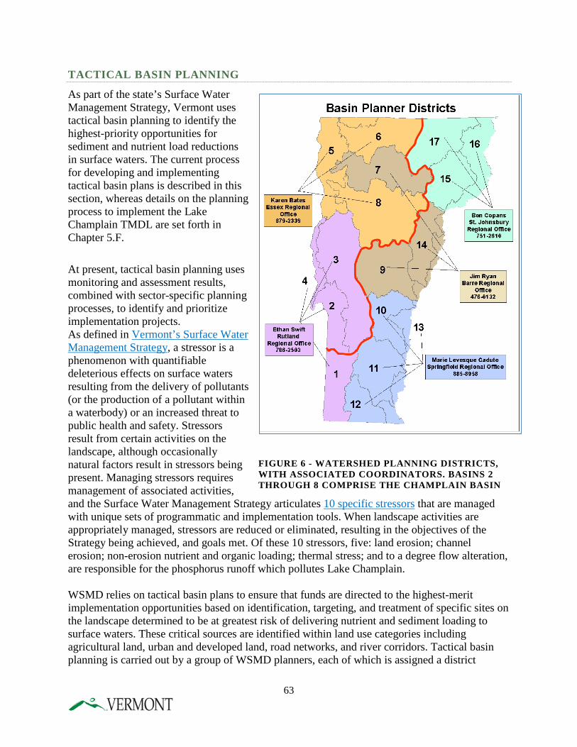
TACTICAL BASIN PLANNING
As part of the state’s Surface Water Management Strategy, Vermont uses tactical basin planning to identify the highest-priority opportunities for sediment and nutrient load reductions in surface waters. The current process for developing and implementing tactical basin plans is described in this section, whereas details on the planning process to implement the Lake Champlain TMDL are set forth in Chapter 5.F.
At present, tactical basin planning uses monitoring and assessment results, combined with sector-specific planning processes, to identify and prioritize implementation projects. As defined in Vermont’s Surface Water Management Strategy, a stressor is a phenomenon with quantifiable deleterious effects on surface waters resulting from the delivery of pollutants (or the production of a pollutant within a waterbody) or an increased threat to public health and safety. Stressors result from certain activities on the landscape, although occasionally natural factors result in stressors being present. Managing stressors requires management of associated activities, and the Surface Water Management Strategy articulates 10 specific stressors that are managed with unique sets of programmatic and implementation tools. When landscape activities are appropriately managed, stressors are reduced or eliminated, resulting in the objectives of the Strategy being achieved, and goals met. Of these 10 stressors, five: land erosion; channel erosion; non-erosion nutrient and organic loading; thermal stress; and to a degree flow alteration, are responsible for the phosphorus runoff which pollutes Lake Champlain. WSMD relies on tactical basin plans to ensure that funds are directed to the highest-merit implementation opportunities based on identification, targeting, and treatment of specific sites on the landscape determined to be at greatest risk of delivering nutrient and sediment loading to surface waters. These critical sources are identified within land use categories including agricultural land, urban and developed land, road networks, and river corridors. Tactical basin planning is carried out by a group of WSMD planners, each of which is assigned a district
FIGURE 6 - WATERSHED PLANNING DISTRICTS, WITH ASSOCIATED COORDINATORS. BASINS 2 THROUGH 8 COMPRISE THE CHAMPLAIN BASIN
63
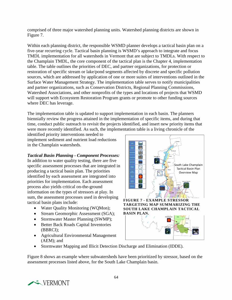
comprised of three major watershed planning units. Watershed planning districts are shown in Figure 7. Within each planning district, the responsible WSMD planner develops a tactical basin plan on a five-year recurring cycle. Tactical basin planning is WSMD’s approach to integrate and focus TMDL implementation for all watersheds in Vermont that are subject to TMDLs. With respect to the Champlain TMDL, the core component of the tactical plan is the Chapter 4, implementation table. The table outlines the priorities of DEC, and partner organizations, for protection or restoration of specific stream or lake/pond segments affected by discrete and specific pollution sources, which are addressed by application of one or more suites of interventions outlined in the Surface Water Management Strategy. The implementation table serves to notify municipalities and partner organizations, such as Conservation Districts, Regional Planning Commissions, Watershed Associations, and other nonprofits of the types and locations of projects that WSMD will support with Ecosystem Restoration Program grants or promote to other funding sources where DEC has leverage. The implementation table is updated to support implementation in each basin. The planners biennially review the progress attained in the implementation of specific items, and during that time, conduct public outreach to revisit the projects identified, and insert new priority items that were more recently identified. As such, the implementation table is a living chronicle of the identified priority interventions needed to implement sediment and nutrient load reductions in the Champlain watersheds. Tactical Basin Planning - Component Processes: In addition to water quality testing, there are five specific assessment processes that are integrated in producing a tactical basin plan. The priorities identified by each assessment are integrated into priorities for implementation. Each assessment process also yields critical on-the-ground information on the types of stressors at play. In sum, the assessment processes used in developing tactical basin plans include:
• Water Quality Monitoring (WQMon); • Stream Geomorphic Assessment (SGA); • Stormwater Master Planning (SWMP); • Better Back Roads Capital Inventories
(BBRCI); • Agricultural Environmental Management
(AEM); and • Stormwater Mapping and Illicit Detection Discharge and Elimination (IDDE).
Figure 8 shows an example where subwatersheds have been prioritized by stressor, based on the assessment processes listed above, for the South Lake Champlain basin.
FIGURE 7 - EXAMPLE STRESSOR TARGETING MAP SUMMARIZING THE SOUTH LAKE CHAMPLAIN TACTICAL BASIN PLAN.
64
Current Implementation Mechanisms Thus far, the mechanisms by which tactical basin plans are developed and implemented are described in detail in the Vermont Surface Water Management Strategy, Chapter Four, at: http://www.watershedmanagement.vt.gov/wqd_mgtplan/swms_ch4.htm. The process of implementing the actions identified in the tactical plans relies on a business process developed in 2011 in DEC, which ties the disbursement of Ecosystem Restoration Program funds to the specific priorities outlined in the implementation tables of tactical plans. DEC envisions that the Vermont Clean Water Fund will bolster implementation by enhancing the Ecosystem Restoration Program and other state clean water funding programs. Tactical Basin Planning Schedule The schedule for issuance of tactical basin plans is found in the Vermont Surface Water Management Strategy, Chapter Four, at: http://www.watershedmanagement.vt.gov/wqd_mgtplan/swms_ch4.htm.
This schedule as revised for this Phase I Plan is summarized as follows:
Completion Date 1. Complete South Lake Champlain Tactical Plan March, 2014 2. Complete North Lake Direct Tactical Plan June, 2015 3. Complete Lamoille Tactical Plan September, 2016 4. Update 2013 Missisquoi Tactical Plan December, 2016 5. Update 2014 South Lake Champlain Tactical Plan December, 2017 6. Update 2012 Winooski Tactical Plan December, 2018 7. Update 2012 Otter Creek Tactical Plan December, 2019
Current Capability of Tactical Basin Plans to address the Lake Champlain TMDL The robustness of the implementation table in a tactical basin plan is predicated upon the availability of up to date surface water monitoring and watershed assessment results. As each tactical basin plan is brought forward for revision, either biennially for implementation table review or as a full five-year revision, the revision benefits from the availability of new monitoring data and assessment information. The watershed assessments are scheduled therefore so that they precede each iteration of a tactical basin plan. Table 8 describes the current priority status of assessments for each major Lake Champlain watershed in Vermont.
65
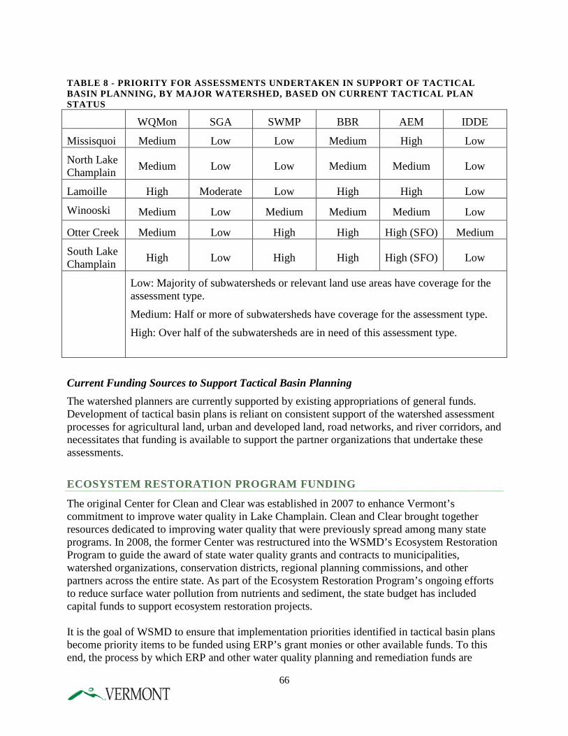
TABLE 8 - PRIORITY FOR ASSESSMENTS UNDERTAKEN IN SUPPORT OF TACTICAL BASIN PLANNING, BY MAJOR WATERSHED, BASED ON CURRENT TACTICAL PLAN STATUS
WQMon SGA SWMP BBR AEM IDDE
Missisquoi Medium Low Low Medium High Low
North Lake Champlain Medium Low Low Medium Medium Low
Lamoille High Moderate Low High High Low
Winooski Medium Low Medium Medium Medium Low
Otter Creek Medium Low High High High (SFO) Medium
South Lake Champlain High Low High High High (SFO) Low
Low: Majority of subwatersheds or relevant land use areas have coverage for the assessment type.
Medium: Half or more of subwatersheds have coverage for the assessment type.
High: Over half of the subwatersheds are in need of this assessment type.
Current Funding Sources to Support Tactical Basin Planning The watershed planners are currently supported by existing appropriations of general funds. Development of tactical basin plans is reliant on consistent support of the watershed assessment processes for agricultural land, urban and developed land, road networks, and river corridors, and necessitates that funding is available to support the partner organizations that undertake these assessments.
ECOSYSTEM RESTORATION PROGRAM FUNDING
The original Center for Clean and Clear was established in 2007 to enhance Vermont’s commitment to improve water quality in Lake Champlain. Clean and Clear brought together resources dedicated to improving water quality that were previously spread among many state programs. In 2008, the former Center was restructured into the WSMD’s Ecosystem Restoration Program to guide the award of state water quality grants and contracts to municipalities, watershed organizations, conservation districts, regional planning commissions, and other partners across the entire state. As part of the Ecosystem Restoration Program’s ongoing efforts to reduce surface water pollution from nutrients and sediment, the state budget has included capital funds to support ecosystem restoration projects. It is the goal of WSMD to ensure that implementation priorities identified in tactical basin plans become priority items to be funded using ERP’s grant monies or other available funds. To this end, the process by which ERP and other water quality planning and remediation funds are
66
distributed are aligned with the tactical planning process. Throughout the process of plan development, partner organizations are encouraged to participate in a meaningful prioritization exercise to identify the highest priority items for funding support. DEC Watershed coordinators also serve as facilitators in the development of ERP grant applications. Projects that are specifically identified in tactical plans and associated watershed assessments receive higher scoring in DEC’s grant allocation rubric. In addition to dedicated ERP funds, ERP also manages “Section 319” grants. In 1987, Congress enacted Section 319 of the Clean Water Act which established a national program to abate nonpoint sources of water pollution. These grants are made possible by the federal funds provided to DEC by EPA, and are available to assist in the implementation of projects to promote restoration of water quality by reducing and managing non-point source pollution in Vermont waters. Projects generally fall into two categories, either outreach, planning and assessment projects or implementation projects. For the most part, Section 319 grants are awarded for the control of sediment and nutrients for the improvement of localized water quality, either through direct implementation or through planning efforts that set the stage for project identification and implementation. Overall, these types of management efforts can have significant benefits in the control of phosphorus loading to the Lake. Finally, ERP administers a small planning grant program, which consists of federal pass through dollars (about $40,000 annually) provided by EPA under Section 604b of the federal Clean Water Act. These funds are granted to regional planning commissions for water quality planning purposes. For the last few years, in an effort to coordinate implementation and funding through tactical basin planning, ERP has announced that 604b grants are only available for a specific set of identified monitoring, assessment, planning and implementation related projects. ERP will continue to support the regional planning commissions by linking 604b grants with these types of projects. Beginning in state FY2017, ERP and will augment the 604b funding with new state funds, as directed by Act 64, the Vermont Clean Water Act, to expand the regional planning commissions’ capacity to provide planning assistance during the tactical basin planning process.
67
CHAPTER 5 - VERMONT COMMITMENT TO FURTHER REDUCE NONPOINT SOURCES Over the past twelve years, Vermont has spent millions of dollars to reduce nonpoint sources of phosphorus to Vermont’s surface waters, including Lake Champlain, and has developed comprehensive stormwater, rivers, wetlands, and agricultural programs to tackle this issue. Despite significant reductions in nonpoint sources, additional work is needed to restore the Lake and meet water quality standards. As described in Chapter 1 of this Plan and shown in Figure 3, the most significant remaining nonpoint sectors of phosphorus include agricultural lands, developed lands, backroads, forests and streambank erosion. Before EPA will approve its new Lake TMDL, it has requested that Vermont provide additional policy commitments to further reduce nonpoint sources of phosphorus to the Lake. These commitments will allow EPA to find that there are “reasonable assurances” that nonpoint sources will be reduced so as to meet the TMDL load allocation target and water quality standards. The State recognizes that periodic revisions are an integral element of the Lake Champlain phosphorus cleanup. Armed with experiences gained through more than twelve years of implementation efforts, ANR and AAFM, with assistance from VTrans, were well positioned to respond to EPA’s request by:
• Reviewing the effectiveness of programs and strategies currently employed to improve Lake Champlain water quality;
• Identifying targeted program enhancements and new actions to further reduce phosphorus loading to the Lake; and
• Developing a prioritized schedule for implementation to most cost effectively and efficiently implement additional phosphorus reduction efforts.
In November 2013, ANR and AAFM distributed for public comment a draft “State of Vermont Proposal for a Clean Lake Champlain” (http://www.watershedmanagement.vt.gov/erp/champlain/docs/2013-11-20_DRAFT_Proposal_for_a_Clean_Lake_Champlain.pdf). The Proposal included suggestions for enhancing existing programs and developing new programs to continue to reduce nonpoint sources. In developing this proposal, ANR met frequently with other state agencies, including VTrans, to refine these commitments. ANR and AAFM, in conjunction with EPA, held six public meetings and took public comments on the draft Proposal; over 500 people attended those meetings. ANR, in partnership with VTrans and the regional planning and development agencies, held 12 additional meetings with municipalities across the State to discuss the draft proposal. The State received over 100 comments, most of which were in support of increasing protection for the Lake and the proposed policy options in the Proposal. These comments were taken into consideration in developing this Phase 1 Plan. A summary of these public comments is available online at: http://www.watershedmanagement.vt.gov/erp/champlain/docs/2014-04-01Final_Summary_of_Public_Comment_Champlain_TMDL.pdf. In addition, a list of Frequently Asked Questions is available online at: http://www.watershedmanagement.vt.gov/erp/champlain/docs/RestoringLakeChamplain-FrequentlyAskedQuestions.pdf.
68
The commitments described below are designed to address the major sectors of phosphorus loading to the Lake in an efficient and cost effective manner. As shown in Figure 3, the relative magnitude of each sector varies by watershed, but agricultural land, developed land, and streambank erosion are major sources across all watersheds. Forest land appears as a large source in Figure 3 primarily because forests occupy over 70% of the landscape in the basin, although phosphorus runoff rates per acre from forest land are typically very low. On the other hand, some sources such as farmsteads and back roads that appear small in Figure 3 can contribute some of the highest rates of phosphorus loading per acre. Both the total amount of the phosphorus load and the loading rate per unit of land area were considered in developing Vermont’s policy commitments, which will determine phosphorus reduction priorities over the next twenty years. Vermont believes that twenty years is a reasonable goal for implementation of these commitments given the enormity of this task and realities of existing funding. Each commitment includes a description of the new program or enhancement to an existing program, the implementation mechanism, and the implementation steps and timeframe. The Gantt Chart in the Executive Summary summarizes the proposed implementation milestones and timeframes. It is important to understand that EPA’s TMDL development is ongoing. Once EPA’s wasteload and load allocation numbers for point and nonpoint sources are finalized, they will be used to more fully define the level of phosphorus reductions needed by sources in each of the thirteen individual lake segments. Therefore, many of the commitments described in this Plan are expressed as statewide commitments but will be tailored as to scope, intensity and timing based on individual lake segment assessments during the second phase of implementation plans. DEC will use the models and load allocations still being developed by EPA to further refine these commitments.
A. AGRICULTURAL PROGRAMS The Vermont Agency of Agriculture, Food & Markets (AAFM) is the lead Agency in Vermont in addressing agricultural nonpoint source pollution. The Agency has several regulatory programs in place to manage nonpoint source pollution and is proposing revisions to these programs in order to more comprehensively address agricultural pollution concerns in Vermont, including Lake Champlain. These proposed revisions embody the vision of the Agency to meet water quality goals and will be applied, as informed by tactical basin planning and adaptive management, to achieve the required reductions in phosphorus. Substantial improvements have been made in recent years as AAFM has increased permit and inspection programs along with enforcement efforts. AAFM recognizes that a lag time exists between installation of BMPs and resulting phosphorus reductions. For example; development of the Medium Farm Operations (MFO) general permit in 2007, generated a significant amount of technical and financial assistance that resulted in extensive practice implementation but due to the nature of the practices, there may be a lag time before reductions of phosphorus are seen. Implementation of the full suite of practices in nutrient management plans, such as crop rotations, erosion improvement and cover crops requires time to gain the full practice benefits.
69
AAFM is committed to continued and strengthened efforts focused on ensuring that medium and large farms meet permit standards and to bring the small farm operations under similar inspection and compliance efforts. Further details are described below. The proposed revisions to agricultural compliance and implementation programs are the result of over two years of outreach efforts. AAFM and DEC worked with the agricultural community in 2012 conducting meetings, focus groups, and discussions to recruit feedback on agricultural water quality improvement. Over 100 recommendations were submitted, and the Ag Workgroup was developed in January 2013 to review these recommendations and provide feedback to AAFM and DEC in development of the agricultural section of the TMDL. The Ag Workgroup consisted of 25 members; mostly farmers as well as technical service providers who work with farmers. The members were a broad representation of Vermont agriculture; small, medium, and large farms, dairy and non-dairy, crop, and organic. AAFM and DEC profoundly thank these members for their extensive and valuable input and has continued to ask for their assistance as an ongoing advisory group. WATER QUALITY PERMITTING PROGRAMS – LFO, MFO, CAFO
DESCRIPTION Vermont has three permitting programs regulating the management of agricultural wastes to prevent contamination of surface waters – the Medium and Small Farm Operation Rules and supporting Medium Farm Operations (MFO) General Permit and the Small or Medium Farm Individual Permits, the Large Farm Operations (LFO) Rules and Individual Permits, and a Concentrated Animal Feeding Operations (CAFO) Permit. Medium and small farm operations permits The Medium and Small Farm Operational Rule, managed by the Vermont Agency of Agriculture, Food and Markets (AAFM), applies a Vermont state general permit to farms with animal numbers that meet the minimum thresholds, such as dairy farms with 200-699 mature animals, 300-999 cattle or cow/calf pairs, 150-499 horses, 16,500-54,999 turkeys, and 25,000-81,999 laying hens without liquid manure handling system. The rule also provides for an individual permit for small or medium farms that meet specific criteria, such as utilizing new or innovative technologies or a history of non-compliance. The Medium and Small Farm Operation Rule prohibits and prevents discharges of wastes from a farm's production area to waters of the state and requires manure, compost, and other wastes to be land applied according to a nutrient management plan. Prior to Act 64, AAFM was required by law to inspect all farms permitted under these rules at least once every five years (20% annually) and many farms are visited more often, due to permit compliance needs, project management assistance, and practice implementation. Due to the passage of Act 64, MFOs will now be inspected a minimum of once every three years. The MFO general permit has been in existence since February, 2007 and was revised in 2012. Currently, there are 142 farms under the MFO general permit throughout Vermont, and approximately 104 of these farms are in the Vermont portion of the Lake Champlain basin.
70
Large farm operations permit The LFO program, also managed by the AAFM, applies an individual permit to farms with animal numbers that meet the minimum thresholds, such as having more than 700 mature dairy cows, 1,000 beef cattle or cow/calf pairs, 1,000 young-stock or heifers, 500 horses, 55,000 turkeys, or 82,000 laying hens without a liquid manure handling system. An LFO permit prohibits and prevents the discharge of wastes from a farm's production area to waters of the state and requires the farm to land apply manure, compost, and other wastes according to a nutrient management plan. An LFO permit also regulates odor, noise, traffic, insects, flies, and other pests, construction siting, and setbacks. AAFM inspects all LFOs throughout Vermont and the Lake Champlain basin annually. The LFO Rules have been in effect since 1999, and were updated in 2007. There are 27 permitted LFOs in Vermont, 17 of which are in the Lake Champlain basin. Inspections of MFO and LFO AAFM currently has three inspectors and a supervisor who also assists with inspections of the MFO and LFO permitted farms. In 2012, AAFM changed the inspection protocol for MFO/LFO inspections to include increased spot checks of field practices. Through this requirement, inspectors visit a minimum of three fields at each inspection, confirming compliance with the farm’s mandatory nutrient management plan. This increases the length of time to complete each inspection but ensures better compliance with the mandatory nutrient management plans on these farms. In 2015, the Agency has focused on assessing the quality of nutrient management plans being provided to farmers by certified planners in addition to how well farmers comply with plans in practice. This information is the foundation for establishing a sound program of certified nutrient management planners and re-establishing the expectations on record keeping and notification when farms alter their plans. AAFM will increase the number of inspections, increase time on farms with field checks and accommodate for future size and technology growth of permitted farms. AAFM will coordinate enforcement information to ensure consistent progress, and maintain a database to ensure ranking of high priority farms. Small farm inspections and compliance 2014 was the first year that AAFM had a staff person solely dedicated to small farm inspections. The number of inspectors at the Agency will increase to seven from four in 2015-2016 which will allow for increased inspection of small farms. Small farms have not been inspected regularly in the past, and Act 64 requires development and implementation of an inspection and certification process for small farms. Enforcement The passage of Act 64 increased the ability of AAFM to enforce on water quality regulations. This new authority allowed for emergency assistance orders to protect water quality, mandatory corrective actions and the authority of AAFM to require the reduction of livestock where livestock waste exceeds farm capacity and no remediation is possible. This legislation also provides AAFM with civil enforcement authority to enjoin activities, order corrective actions and levy civil penalties of up to $85,000 for violations.
71
Also under this new legislation, the Vermont Property Valuation and Review can remove agricultural land or a farm building from the Vermont Use Value Appraisal program if the owner/operator has been identified by AAFM as out of compliance with water quality requirements or not in compliance with an enforcement order for an agricultural water quality violation. CAFO permit The CAFO general permit is a federal Clean Water Act permit for MFOs managed by the Vermont Department of Environmental Conservation (DEC) since June 2013. It requires farms to properly design, construct, operate, and maintain production areas to control waste. The permit prohibits a discharge of manure, litter, or wastewater, except when direct precipitation equivalent to or greater than a 25-year, 24-hour storm event causes a discharge. Any farm, regardless of size, that directly discharges to a surface water body could be required to obtain a CAFO individual permit. There are currently no CAFO permitted farms in Vermont. The CAFO program manager inspects a minimum of 12 farms each year per agreements with EPA, but consistently achieves a higher rate. The farms are chosen based on discussion with AAFM and review of past water quality concerns and are of all sizes. Priority is given to farms with previous violations and those in priority watersheds. DEC will increase this level of inspection with a focus on farms in critical watersheds in the Lake Champlain Basin.
IMPLEMENTATION MECHANISM AAFM and DEC will continue to prepare annual compliance reports as required to meet the goals outlined below in the implementation steps. The compliance reports will contain state-verified information, including but not limited to compliance with nutrient management plan requirements, and the nature of any documented discharges. DEC, AAFM and the Attorney General’s office have also increased regular coordination, resulting in substantial enforcement and penalty actions in 2014.
IMPLEMENTATION STEPS AND TIMEFRAME
1. DEC, in cooperation with AAFM, will conduct inspections of potential CAFOs. A. Minimum of 12 inspections annually in Lake basin 2014-18 B. Minimum of 75 inspections annually after 2019
2. AAFM will inspect all LFOs and MFOs within the Lake
Champlain basin A. All LFOs Annually B. All MFOs Every three years C. Enhance MFO inspection protocols 2014 D. Enhanced NMP compliance (3 field checks) 2014
3. DEC and AAFM will continue to conduct on-farm multi-agency inspections to ensure
consistency in the inspection process A. Agencies will conduct a minimum of 10 joint inspections Annually B. DEC and AAFM will hold trainings for inspection staff Bi-annually
72
4. AAFM and DEC will continue to produce compliance reports that will be shared between agencies Annually
5. DEC and AAFM will continue to coordinate inspection and enforcement actions per the 2007 MOU and has begun quarterly compliance meetings to increase coordination. A. DEC and AAFM representatives will meet to share current activity Monthly B. DEC, AAFM, Attorney General and DEC Compliance &
Enforcement Division (CED) will meet to share current activity Quarterly C. DEC and AAFM will update the 2007 MOU 2016
ACCEPTED AGRICULTURAL PRACTICE RULE UPDATE AND COMPLIANCE
DESCRIPTION Act 64 requires significant changes to Vermont’s Accepted Agricultural Practices, including a name change to the “Required Agricultural Practices” or “RAPs”, reflecting the fact that these practices are not and never have been optional. The Vermont Accepted Agricultural Practice Rule (AAPs), require that all farms in the state, regardless of size and type of operation, adopt and implement a set of minimum conservation practices to protect water quality. Examples include the winter spreading ban which forbids spreading between December 15 and April 1, no allowance for any direct discharges, minimum 10’ buffers along surface waters, no stacking or storage of manure on lands subject to annual overflow, and mortality management requirements. The AAPs do not currently require a written nutrient management plan (NMP), however the rules require compliance with many aspects of nutrient management planning, including required soil tests every five years, applying nutrient applications consistent with soil tests, and meeting 2T (soil erosion tolerance). Education and enforcement of these provisions of the AAPs has been limited due to lack of resources. The AAPs will be revised and strengthened in 2016 and renamed to RAPs. To date the AAP program has not been inspection-based like the MFO and LFO programs due to limited resources. AAFM has never received funding specific to enforcing the AAPs, rather this program is essentially driven by internal or external reports of possible violations and was previously dependent on investigative staff whose primary focus was pesticide, feed, and fertilizer work per their funding sources. State-initiated and public complaints about suspected rule violations result in site investigations to determine compliance with the rule. With the current staffing level, AAFM performs approximately 120 investigations annually. The investigations target specific complaints or obvious violations and do not involve evaluating the entire farm operation to determine the extent of AAP compliance. Understanding this staff resource limitation and the water quality need to ensure compliance with the AAPs, AAFM committed to a targeted small farm inspection program, and has already taken steps to start this process. Additional budget funding in 2014 allowed for AAFM to hire a small farm inspector who is focusing outreach and evaluation efforts in the priority watersheds of St. Albans and Missisquoi Bay. Since hiring, this inspector has visited more than 200 farms, providing education about the AAPs and assessing water quality needs for following assistance, and where appropriate, enforcement
73
Act 64 also provides funding for an additional three inspectors who will be hired in 2015-16. AAFM will expand its small farm inspection program; initially prioritizing dairy farms, but will also address any significant livestock farms that are in priority watersheds. Significant livestock farms will be determined based on size, location, proximity to water, and any potential or actual water quality concerns. In June, 2015, AAFM initiated the North Lake Farm Survey. Through this process, AAFM staff were redirected from their statewide territories to focus on all known agricultural operations in the priority Missisquoi Bay and St. Albans Bay watersheds in Franklin and Orleans Counties. Each farm is being visited for an assessment of water quality concerns and needs. Farms are being informed of water quality concerns and resources available for assistance. Farms with direct discharges are being referred to DEC as required by state statute. Approximately 350 livestock operations are being visited. This same process will be duplicated in additional watersheds. All small dairies in South Lake will be evaluated by the end of 2019. All small dairies and significant livestock operations in the Lake Champlain basin will be evaluated by the end of 2020. AAFM intends on training staff to conduct whole farm inspections as part of the investigation process. AAFM believes that each inspector can address 75 farms per year (including inspection and enforcement). Vermont recognizes that further reductions of agricultural nonpoint source pollution will necessitate taking additional, aggressive actions pertaining to the AAPs to reduce water pollution and achieve a more consistent and equitable regulatory environment for all farms. AAFM also recognizes the enormous need for education about the current regulations as well as any proposed additional requirements, and are working closely with non-regulatory partners who can, and have already taken steps to help with that outreach. Act 64 requires specific changes to the AAPs. These changes, as described below, will go through public comment and rulemaking with implementation required by the Legislature by July 2016. Each action will require extensive outreach and education towards implementation of the rules and remediation of water quality problems. Upon completion, AAFM has the immediate authority to enforce any violations, and does not need additional statutory changes to proceed with compliance. Update AAPS to require changes in buffers, gullies, and erosion Currently MFOs and LFOs are required to have 25 foot buffers and meet an erosion standard of “T”, while small farms are allowed to have 10 foot buffers, with 25 feet at points of runoff, and meet “2T”. Research has proven the value of larger buffers for water quality, and reducing the erosive loss from fields and gullies has been well documented and provides a great potential for decreasing sedimentation to surface water. The RAPs will require consistent buffers across farm sizes, manure setbacks of 25 feet on all perennial streams, 10 foot buffers on field ditches, stabilization of field borne gully erosion, and reducing the field tolerable soil loss for fields in annual crop production to “T”.
74
All MFO and LFO farms, and SFOs that have nutrient management plans (NMPs) through state and/or federal cost-share programs must meet the federal NRCS 590 standard which includes the requirement that any watercourse, regardless of flow, that can be determined to be significantly transporting nutrients or sediments must be buffered 25’ from annual crop production and manure application. There is currently no buffer requirement specific to intermittent streams in the AAPs, however the AAPs state that a farm cannot apply wastes directly into surface water or have over- applications of nutrients that cause runoff of wastes into surface waters. The proposed changes to the AAPS are intended to level these requirements and limit confusion. The enforcement of this new standard will be accomplished with field spot checks on farms in the NMP cost-share programs and inspections on the permitted farms to ensure compliance with the NMP. These changes are important for water quality improvement but also for the agricultural community. The Ag Workgroup which provided extensive input to the process for amending the AAPs recommended consistency among farms in regulations where possible. These rule changes will require extensive outreach and education to farmers, especially changes in regards to erosion tolerance Many small farms are not aware of their current erosion rates, and lack the technical knowledge and software to determine this and the appropriate practices changes without assistance. Management changes will be necessary on many farms to meet the required “T” level. Update AAPs to require changes in livestock exclusion regulations The AAPs currently require that adequate vegetation be maintained on streambanks by limiting animal access and trampling. The proposed change to the RAPs will explicitly exclude livestock from perennial streams where erosion is prevalent and in all production areas. This change will clarify the requirement for livestock exclusion in critical source areas.
The Agency believes that targeting the highest priority locations for livestock exclusion will yield the greatest cost-benefit for water quality. With limited resources to implement a wide variety of non-point source agricultural pollution strategies, targeting resources to the highest priorities is the best strategy for the near term phosphorus reduction benefits. EPA estimated that pasture accounts for 3.8% of the total phosphorus loading to Lake Champlain and AAFM believes this RAP change will significantly reduce a major portion of this. Extensive research has clearly demonstrated that eroding land is a substantial contributor to nutrient loading, and this approach of targeting eroding banks will provide focused attention to the higher benefit opportunities. Prioritizing these targeted areas will also provide the opportunity to focus remaining resources on addressing the cropland loadings which are estimated to be 35.2% of the total Lake loading.
Under this proposed change in the RAPs, erosion at any section of a stream where animals have access, except at defined stream crossings, would trigger the requirement for mandatory exclusion. Exclusion would be required for the length of the stream and will address any areas where erosion is of high potential, and will not be limited only to the eroding section. The Secretary will evaluate any questionable sites on a case-by-case basis and maintain the option of requiring exclusion where any water quality impacts exist.
75
Initiate a RAP compliance certification process for all small farms Currently, small farmers are not required to submit any type of certification of compliance (COC) with the AAPs (unlike MFOs and LFOs which must obtain permits and submit annual reports). Following rulemaking changes to the AAPs, AAFM will require all small farms that meet certain criteria to submit an annual certification form that indicates compliance with the RAPs. Criteria for a mandatory COC will be determined through discussion with the Ag Workgroup, other agricultural partners, and the public rule making process in 2015. Currently the AAPs must be met by all farmers, regardless of size or farm type, however, the cost-benefit of water quality improvement decreases substantially with smaller farm size and animal numbers. It is expected that the COC requirement would be based on either animal numbers or density and will include all crop farmers with greater than 10 acres of crop production. The COC process will initially start with printed reports completed by the farmer, similar to the MFO and LFO annual reports. AAFM will begin the process of developing a web-based online submission option for COC compliance for farmers with internet accessibility, to be released by 2018. AAFM is currently in the process of developing a water quality database which may expand the ability for online submission of MFO and LFO reports. Ideally, technical staff will have the ability to assist landowners with submission during field visits. SFOs will be required to submit COC by 2017. The revisions to the AAPs also include changes in nutrient management planning on small farms, training for farmers and certification of custom manure applicators. This is discussed in following sections.
IMPLEMENTATION MECHANISM The rulemaking process will be conducted to enable the proposed changes to the state regulatory Accepted Agricultural Practices. The proposed rule changes include the following practices:
A. A minimum 25 foot perennial vegetated buffers along all perennial streams B. 10-foot perennial vegetated buffers along field ditches C. Stabilization of field borne gully erosion D. All farms meet “T” for tolerable soil loss, as defined by the U.S. Department of
Agriculture Natural Resources Conservation Service (NRCS), for the prevalent soil type and applied to all farm fields in annual crop production
E. Increased livestock exclusion requirements F. Development and implementation of a small farm certification process
IMPLEMENTATION STEPS AND TIMEFRAME Note: All efforts will begin in prioritized critical source areas and targeted priority watersheds. Priority watersheds are those most impacted by agricultural activities.
1. Update the RAP rule with additional practices and begin implementation by all small farms in the Lake Champlain basin A. Initiate rulemaking 2015 B. Complete rulemaking 2016
76
C. Begin education of potential new regulations 2014 D. Begin enforcement of new regulations 2016
2. Begin small farm evaluation process in priority watersheds A. Evaluate/inspect all small dairies in Missisquoi and St. Albans Bay 2015 B. Evaluate all small dairies in South Lake 2019 C. Evaluate/inspect all small dairies and significant livestock
operations in Lake Champlain basin 2014-20 3. Develop small farm certification of compliance (COC) process
A. Determine threshold level for COC requirement 2016 B. Adopt rules for COC 2016 C. Develop COC program and certification forms 2017 D. Develop online COC process 2018 E. Conduct an extensive education and outreach process for COC 2016-19 F. Require SFO to submit certification 2017
4. Require livestock exclusion in production areas and where erosion exists A. Develop a livestock exclusion incentive program that will include a declining scale cost-share with a time provision to encourage early adoption 2016
NUTRIENT MANAGEMENT PLANNING
DESCRIPTION Nutrient Management Plans Currently MFOs and LFOs are required through the state permits to develop, update, and implement a nutrient management plan (NMP) that meets the USDA/NRCS “590” standard. Small farms that have received USDA cost-share funding for a waste management system are also required to have a 590 NMP. Both AAFM and NRCS provide funding to help develop and update these plans.
A 590 plan includes a nutrient application plan, with additional requirements to minimize nutrient runoff into surface waters. The full document includes maps, soil and manure test results, current and planned crop yields, location of sensitive areas, each field’s tolerable soil loss (“T”), field phosphorus indices (to calculate potential for phosphorus runoff and nitrogen losses), and other possible requirements and goals. The plan indicates all structural practices that are related to nutrient storage and application and ensures that they are installed and maintained to NRCS standards. The NRCS standards are designed based on rainfall data and the current standard is to collect the 25 year, 24 hour storm event. As climate changes, this value will be updated by NRCS. This is also the structural standard required by the new VT CAFO permit and in the AAPs for any new waste storage structure built after July 1, 2006. The MFO and LFO permits also reference the federal NRCS standard. The nutrient management plan can be quite large depending on farm size, requires a level of knowledge and equipment for certain calculations, and can be expensive to develop despite cost-share funding. Few small farms voluntarily choose to develop a 590 plan, however under the current AAPs, all small farms are required to have much of the information that would be in a
77
plan available upon inspection (such as soil testing, tolerable erosion calculations (T) and nutrient application rates). AAFM inspectors review NMPs at the time of inspection on MFOs and LFOs, and increased field inspection protocols in 2013. However, further enforcement, especially of small farm compliance with the AAPs, has been limited.
Act 64 requires the RAPs to include nutrient management standards for farms. The Ag Workgroup recommended that a matrix be developed that would look at not only farm size and number of animals but also animal density, proximity to water and other factors related to potential nutrient runoff. Farms above these criteria could be required to create a 590 standard plan. Farms below could either be required to either use a small farm NMP template (to be developed) or meet current RAPs (for very small operations that do not require an NMP). The threshold for NMPs will ideally coordinate with guidelines for small farm certification of compliance. The Agency will review standards from other States and identify a NMP requirement that best addresses Vermont’s water quality needs. AAFM will work with the Ag Workgroup, the three farmer coalitions in the Lake Champlain Basin and the public as part of the RAP rulemaking process. Field Practices and nutrient management. Nutrient management planning involves careful application of nutrients to cropland and pastures to ensure that nutrients do not exceed the needs of the crop and contribute to water quality impairments, as well as evaluation of field soil loss. An NMP then outlines the best field practices to reach these goals. Substantial work has been done in the Lake Champlain basin in the past five years with the assistance of agronomists and partners, to educate farmers about current practices that may be new to particular areas and soil types, as well as new or different land practices. Funding for equipment to demonstrate and implement these practices has also increased. Many of these practices and equipment require extensive education to minimize risk (e.g. transitioning from traditional plowing to reduced tillage) or ensure successful implementation (e.g. timing and seeding of cover crops, or manure injection around tile drainage). It is essential that the current staff working directly with farmers continue in that capacity and that outreach opportunities increase. Examples of field practices determined by AAFM and DEC to be of greatest value to water quality and in need of continued resources are listed below. This list is not meant to be exclusive of new and adaptive management opportunities. The current NRCS-funded “edge-of-field monitoring” research, being conducted on 6 farms in the Lake Champlain Basin includes many of the below conservation practices to help determine the local value of implementation. As additional research documenting the reduction values of these specific practices becomes available, an adaptive management approach will be taken to further commitments to increase implementation and implementation.
• Cover Crops: Cover cropping is a challenge on heavy clay soils that require tillage and even on lighter soils when weather does not allow for seeding in a timely manner for adequate fall cover. A new program to introduce aerial seeding by helicopter is
78
showing promise and other alternatives such as shorter day corn options and new seeding equipment need continued funding, education and research.
• Reduced tillage: The AAFM Capital Equipment Assistance Program (CEAP) has previously provided funding for on-farm purchase of tools such as no-till planters that are increasing the acreage dedicated to reduced tillage practices that decrease soil erosion and provide cover to bare fields. Education about this practice is crucial to adoption by traditional farmers.
• Manure injection or aeration: CEAP has also provided funding for the purchase of manure injection equipment. Increased use of this equipment is valuable especially in areas with high slopes and proximity to surface water. Manure injectors are able to apply nutrients into hay ground versus the typical surface application which can be prone to runoff. This equipment is extremely expensive and the CEAP funds will be used to incentivize equipment purchase where most appropriate.
• Improving soil health and quality through reduced compaction: Improving soil health and quality by decreasing compaction increases the infiltration of water, reducing erosion and nutrient runoff, and further education about these impacts as well as the economic benefits of good soil health needs to be conducted. Lower compaction rates can be attained through changes in land practices such as reduced tillage and precision nutrient management that decreases use of heavy equipment.
• Precision nutrient application: In addition to improving soil quality, precision nutrient application also allows for site-specific (in-field) detailed application of nutrients using GPS technology on farm equipment. This is initially expensive to install but can more specifically allocate nutrients to decrease any potential for excess runoff.
• Management of farm roads: Many farm roads, including roads that access sugaring operations, are highly compacted areas and can act as conduits for nutrient runoff. Additional resources should be allocated for road management similar to forest road practices.
• Controlled tile drainage: Tile drains are currently being installed in VT by farmers to increase productivity. While well drained fields are less likely to have gully erosion and soil loss, research has shown that drainage from tile can contain high nutrient levels, especially dissolved phosphorus. Education about control structures as well as appropriate installation and management of tile drains is necessary. AAFM is currently coordinating with partners on a study to evaluate media for tile drain outlets and will be providing a report with ANR on tile drainage to the VT Legislature by January 15, 2017 which will include their recommendations for tile drain policies and regulations. The RAPs will be revised to include requirements for tile drainage by January, 2018
• CREP program: The federal Conservation Reserve Enhancement Program provides an annual compensation rate for removing environmentally sensitive land from
79
production and adding practices such as extended buffers. Vermont is able to leverage a 4:1 return on state investment in this program; however producer enrollment has dramatically decreased in recent years due to earlier cuts in the rental rate payments, and limited resources for outreach and education to producers. AAFM intends to revise their BMP rules to include rules on the CREP program by 2017.
Implementation of all BMPs must increase but with limited resources, AAFM will need to prioritize efforts by focusing on potential critical source areas that have a high risk of causing or contributing to phosphorus loading. Critical source area mapping has been conducted in some parts of the Lake Champlain watershed, and with the increased use of LIDAR, mapping will continue for the remainder of the area. NMPs also identify farm specific critical source areas. Agency personnel and partners will all focus on critical source areas in their inspections and implementation.
Trainings AAFM will be working with partners to develop training programs for farmers and manure custom applicators which will provide overviews of state and federal regulations as well as sound water quality practices, and will include an online component when and where possible. AAFM will adopt a rule for certification of custom applicators and requirements for training owners or operators of small, medium and large farms by July 2016 as part of the revisions to the RAPs. Individuals providing custom application of manure will need to be certified after adoption of this Rule. Research Implementation of current practices will be encouraged, funded and incentivized, but additional research is also needed to continue improvements in nutrient management and increase adaptive management in agricultural water quality. AAFM and DEC will continue to encourage and support initiatives that show promise through funding and collaboration. Some current examples of areas of interest to the agencies for continued research include but are not limited to:
• On-farm digesters that increase the use of manure as bedding and the transport of P off-farm
• An evaluation of the P-index to increase its value as a nutrient management tool, and standardization between states
• An evaluation of tools other than RUSLE that will be more applicable as a water quality measurement
• Precision nutrient application (indicated above) • Alternative buffers and cover crops that will provide necessary water quality
needs but have other potential value
80
Partner Assistance AAFM and DEC acknowledge the value of other governmental partners (USDA/NRCS, US Fish and Wildlife), educational partners (UVM Extension System) and non-profit partners (VT Association of Conservation Districts, watershed groups, farmer coalitions), and private for-profit consulting firms, all of whom are non-regulatory and have valuable connections in the agricultural community. Collaborating with these partners and assisting in their support are critical to the success of our water quality improvement efforts. AAFM assumes the operational capacity of key federal partners such as the US Department of Agriculture Natural Resource Conservation Service (NRCS) remains constant at current levels in development of this implementation plan. AAFM and DEC also support increased funding to partners for the critical educational needs as new regulations are required of agricultural producers.
IMPLEMENTATION MECHANISM As part of the RAP revisions, AAFM will standardize nutrient management planning across all agricultural operations, work to increase trainings and educational and outreach opportunities with partners, and provide technical assistance to increase the implementation of NMPs and critical field practices that lead to improvements in water quality.
IMPLEMENTATION STEPS AND TIMEFRAME 1. Increase development and implementation of Nutrient Management Plans
A. Develop NMP matrix and SFO template 2016 B. Provide increased education, outreach and cost-share funds for
NMP development and implementation 2018 C. Expand small farm NMP development courses/workshops
through partners such as UVM Extension and VACD 2017 D. Support farmer groups - Farmers Watershed Alliance,
Champlain Valley Farmers Coalition and support a third startup in South Lake. Provide farmer groups with BMP funds for outreach and small project implementation 2017
2. Improve field practice implementation
A. Support RAP and BMP implementation on small farms by key partners and staff who will focus on the key areas of field practices indicated above Ongoing
B. Address tile drainage i. Develop final report for legislature with recommendations 2017 ii. Revise AAPs to include requirements to reduce nutrients from tile drainage 2018
C. Increase targeted outreach in the key watershed areas of St. Albans Bay, Missisquoi Bay and South Lake 2015-2019
3. Increase training and certification programs A. Develop and coordinate water quality trainings for farmers
i. Adopt requirements for trainings (in RAPs) 2016 ii. Adopt a schedule for water quality trainings for farmers 2017
iii. Develop educational courses for farmers with partners 2016-18
81
iv. Develop online courses for farmer educational credits 2017-20 B. Work with partners to develop and offer a NMP training program
for TSPs 2017 C. Work with partners to develop and offer a training program
for manure applicators 2017 D. Certification of manure applicators
i. Obtain statutory authority for certification process 2015 ii. Provide outreach and education 2015-2018
iii. Mandate certification 2016 ADDITIONAL EFFORTS IN CRITICAL WATERSHEDS (MISSISQUOI BAY, ST. ALBANS BAY, SOUTH LAKE)
DESCRIPTION Higher nutrient loading from agricultural runoff in the two subwatersheds of Missisquoi Bay and South Lake will require that additional measures be implemented in these areas to achieve the Lake Champlain TMDL requirements. Priority will be given to these areas through increased education, outreach and funding opportunities, targeted funding, and higher cost-share opportunities. Specific practices are described above.
IMPLEMENTATION MECHANISM In addition to prioritizations mentioned in previous sections, additional funding and outreach will be targeted to critical source areas in these priority watersheds. Critical source areas will be the focus of this education, new initiatives and enforcement since recent research by Stone Environmental, Inc. has demonstrated that approximately 80% of the nutrient reduction goals can be achieved by focusing on 20% of the area. Addressing these areas will provide the higher benefits requested by EPA, though detailed nutrient loads provided by the EPA are essential to further prioritization. Focusing on higher benefit areas in no way indicates that other areas of concern, especially those with water quality violations or lack of state required conservation practices will be ignored. The following additional implementation steps are seen as initiatives above and beyond current programs and practices in recognition of the greater nutrient reduction needs of these watersheds, and AAFM and DEC remain committed to addressing all water quality concerns, violations and needs through ongoing programs and creative, innovative new efforts to the greatest extent possible. Additional efforts are also being conducted that will be piloted in these critical watersheds. One example is the “certainty” program development that the State has been facilitating with partners and the agricultural community. In 2012, grants from multiple sources, including the EPA and USDA/NRCS as well as private local foundations, provided funding for a concentrated outreach program with the agricultural community. The previously mentioned Ag Workgroup was a result of this effort.
82
A key deliverable of the funding was to evaluate the feasibility of a certainty program for the State of Vermont. Hundreds of farmers, through meetings, focus groups and surveys, participated in this discussion, as well as many member of the environmental community. In many states, “certainty” is a protection against regulation or enforcement by demonstrating a higher level of management and attention to environmental protection. However, in Vermont, we are developing an incentive-based certainty program, that will reward farmers who install or employ additional BMPs above regulatory requirements. This approach was approved by the Ag Workgroup and a draft set of levels of incentives is in development. After further refinement, a pilot of this, the Environmental Stewardship Program, will be implemented in 2016 as part of the RCPP grant effort. The State is also evaluating the feasibility of a nutrient trading program through an NRCS Conservation Innovation Grant. This joint effort between AAFM and DEC will evaluate the opportunities for nutrient trading in the gap watershed area, and guidance for the development of such a program. An additional grant has been submitted by DEC in May, 2015 to pilot this program in Vermont. This additional focus on prioritized planning and implementation has been supported by partner efforts. After an extensive evaluation process with DEC, AAFM and partners, NRCS in Vermont has committed to focusing funding in four priority subwatersheds of Missisquoi Bay, St. Albans Bay and South Lake. During the summer of 2015, NRCS is conducting an extensive strategic planning process to assess the exact needs and opportunities in each of these watersheds. These plans, which will be finalized in August, 2015, will be the foundation for targeted outreach, funding and assistance by NRCS, the State, and partners for the next 3-5 years. Based on an evaluation of this process, NRCS hopes to continue this methodology in close coordination with the DEC Tactical Basin Planning process.
IMPLEMENTATION STEPS AND TIMEFRAME 1. Target CAFO inspections in these watersheds 2014 2. Prioritize inspections of SFOs in these areas 2014 3. Conduct a comprehensive North Lake Farm survey to assess all known livestock
operations in St. Albans Bay and Missisquoi Bay watersheds 2015 4. Extend this comprehensive evaluation to other critical watersheds 2016-2020 5. Provide targeted and prioritized funding for BMP and NMP implementation in
these watersheds 2015-2020 A. Provide $16M of RCPP funding to conserved farms, and increase wetland
restoration and forestry practices B. Prioritize NRCS funding to four subwatersheds C. Continue NRCS National Water Quality Initiative (NWQI) funding in the
Rock River (part of Missisquoi Bay watershed). D. Increase state cost-share rates to support regional efforts E. Evaluate higher rental payment rates for CREP projects in these
watersheds F. Revise state BMP rules to include cost-share prioritization
83
6. Provide targeted education in these watersheds 2015-2019 a. Provide support for the 2 current farmer groups (Farmers
Watershed Alliance and Champlain Valley Farmers Coalition) b. Provide support for a farmer group in the South Lake Region c. Increase CREP outreach for Missisquoi Bay and South Lake d. Contract with partners to implement SFO BMPs including livestock
exclusion and NMPs following inspection 7. Develop the Environmental Stewardship Program (“certainty”) for these
watersheds that provides increased compensation and incentive opportunities for producers who go above and beyond state and federal regulations. 2016
8. Evaluate feasibility of nutrient trading in critical watersheds 2015 Pilot a trading program (grant request submitted) 2016-2018
8. Target funding for a grassed waterways program to critical source areas in priority watersheds. 2016
9. Conduct research of media for tile drain outlet phosphorus reduction 2015-2017 10. Reactive the AAFM Capital Equipment Assistance Program to provide funding
for the purchase of equipment by farmers 2016-2017
B. STORMWATER MANAGEMENT Stormwater runoff from roads and existing developed lands will be addressed in a staged and prioritized manner through a system of watershed-based stormwater permitting using a combination of state law and NPDES-based regulatory authority. The enhanced programs will be applied in combination, as informed by tactical basin planning, to achieve the required reductions in phosphorus. The Department has authority under 10 VSA 1264, and 18-302(a)(5) of the Vermont Stormwater Management Rule to require permits from any impervious surface where we determine treatment is necessary to reduce the adverse impacts resulting from the discharge of stormwater from the impervious surface. The Department may also use its Residual Designation Authority to require permits where it is determined the discharge is a significant contributor of pollutants, or where we determine that stormwater controls are necessary based on a WLA. Finally, the Department may amend its existing MS4 designation criteria to designate additional municipalities as requiring MS4 coverage in order to implement necessary pollutant controls. The Department anticipates implementing the programs addressing stormwater from existing developed lands, state highways, and municipal roads through the most appropriate authority, or combination of authorities, as described above. In all cases, implementation of the authority to regulate stormwater, be it under State law, RDA, or MS4, requires a demonstration of facts linking the discharge to its impacts on receiving waters. The Department anticipates implementing Tactical Basin Planning to develop the required facts, on a basin basis, such that the implementing regulation will be issued both concurrent with, and informed by, the completion of basin-specific plans. These plans will inform the relative extent to which these programs are implemented (e.g. the extent to which road runoff is managed versus addressing
84
runoff from a downtown area), the timing of implementation, and the standards applied. The particularized fact-specific analysis necessary to identify affected municipalities, treatment standards, schedules, and to exercise our existing authorities, is necessarily acquired as part of Phase II implementation. STORMWATER RUNOFF FROM STATE ROADS
DESCRIPTION The first stage of implementation will include permitting all state roads to achieve the necessary level of pollutant reduction to meet TMDL targets. Permitting will generally involve requirements to develop management plans, followed by an implementation scheduled informed by the relative significance of the source, on a watershed basis. A proposed implementation schedule is attached. The State highway system will be addressed via a TS4 Stormwater General Permit. The TS4 is a NPDES-based Transportation Separate Storm Sewer System (TS4 GP) General Permit designed to regulate stormwater discharges from the entire state-operated transportation system. The program would be implemented as an MS4 program, pursuant to 40 CFR 123.35(b). The TS4 would regulate all stormwater discharges from the transportation network and associated transportation facilities by consolidating the permit requirements from the existing Municipal Separate Storm Sewer System (MS4), Multi-sector General Permit (MSGP) and post-construction stormwater permits. Implementation of a comprehensive TS4 GP approach could allow for the prioritization of maintenance, upgrade of stormwater infrastructure, and implementation of remediation activities based on environmental benefit. Stormwater management practices will be consistent with the Vermont Stormwater Management Manual, with an emphasis on surface infiltration where feasible to maximize phosphorus reduction.
IMPLEMENTATION MECHANISM The State will establish a TS4 Stormwater General Permit.
IMPLEMENTATION STEPS AND TIMEFRAME 1. Revise MS4 Procedure for Designation of Regulated Small MS4s 2. Issue Draft TS4 General Permit 2015 3. Issue Final TS4 General Permit 4/2016 4. VTrans to implement program 2017-2036
STORMWATER RUNOFF FROM MUNICIPAL ROADS
DESCRIPTION The first stage of implementation will include permitting all municipal roads to achieve the necessary level of pollutant reduction to meet TMDL targets. Permitting will generally involve requirements to develop management plans, followed by an implementation schedule informed by the relative significance of the source on a watershed basis.
85
Vermont municipalities maintain approximately 11,000 miles of road; three-quarters of these municipal roads need erosion control improvements. Two-thirds of these roads are unpaved gravel or unimproved roads, and nearly all require ditches and culverts for water drainage. Road structures, particularly along gravel roads, can cause erosion and sedimentation into adjoining streams. Stormwater runoff from paved roads can accumulate and deliver debris, oils, salts, and other chemicals, sediment, nutrients, and other pollutants to surface waters. Paved roads can also affect the volume of stormwater runoff being generated, which in turn, can alter the hydrology and ecological health of receiving waters. DEC will issue a stormwater general permit covering municipal roads. The permit will require development of management plans based on local road conditions including road slope, connectivity to receiving waters, and other factors, that identify the type and scope of BMPs necessary for the municipality. The management plan will include an implementation schedule informed by sub-watershed phosphorus reduction priorities. At a minimum, BMPs shall be as protective as those identified in the 2011 Town Road and Bridge Standards and focused on the prevention of erosion and the transport of sediment containing phosphorus. The precise level of BMPs, and associated phosphorus reduction, will be determined during development of Tactical Basin Plans and the general permit. The general permit will adopt these specific BMPs directly, rather than reference the Town Road and Bridge Standards or other standards.
IMPLEMENTATION MECHANISM DEC will use existing authorities to develop a permit program for issuing a municipal road stormwater permit and reporting requirements. The program will emphasize the use of road-related best management practices. The State will first issue a letter of intent prior to the issuance of the new permit. The adoption of a municipal roads general permit by 2017 is required under Act 64.
IMPLEMENTATION STEPS AND TIMEFRAME 1. Issue Draft Municipal Road general permit 2016 2. Issue Final Municipal Road General Permit 2017 3. DEC to administer permit program with VTrans to provide technical assistance, training
and funding support 2017-2036
STORMWATER RUNOFF FROM EXISTING DEVELOPED LANDS
DESCRIPTION Stormwater runoff from existing developed land, exclusive of surfaces regulated under the State or municipal roads stormwater programs, will be addressed in a staged and prioritized manner through a system of watershed-based stormwater permitting using a combination of state law and NPDES-based regulatory authority. The first stage of implementation will require permit coverage for all stormwater discharges on sites where impervious surfaces exceed 3 acres. Additionally, impervious surfaces discharging to
86

municipal stormwater systems where such impervious surfaces exceed 15 acres, in aggregate, and the density of impervious surface is greater than 7%, shall be addressed by a stormwater permit, issued to the municipality and requiring implementation of a stormwater management and phosphorus control plan. These are preliminary criteria that may require refinement during future implementation plans to ensure targets are met. Existing facilities with greater than 3 acres of impervious surface permitted prior to the adoption of the 2002 Stormwater Manual will be subjected to feasibility-based upgrade requirements during their next permit renewal cycle which ranges from 0-10 years. Stormwater management practices will be consistent with the Vermont Stormwater Management Manual, with an emphasis on surface infiltration where feasible to maximize phosphorus reduction. Act 64 requires facilities in the Lake Champlain basin with greater than 3 acres of impervious surface that are unpermitted, or permitted under standards prior to the 2002 Stormwater Manual, to obtain permit coverage under a general permit to retrofit these facilities by 2023. Existing facilities discharging within a regulated Municipal Separate Storm Sewer System (MS4) are required to develop Flow Restoration Plans for stormwater-impaired waters in accordance with the MS4 General Permit. The extensive deployment of stormwater-management infrastructure associated with this requirement will contribute substantially to phosphorus reduction in Lake Champlain. Further, regulated MS4 municipalities are required to track phosphorus reductions associated with the deployment of BMPs. Finally, following issuance of a completed TMDL, the Department will re-issue the MS4 General Permit such that the TMDL is considered an “approved TMDL” under section IV.C.1. of the MS4 General Permit. This will require the MS4 permittees to develop and implement a plan to control discharges consistent with the assumptions and requirements of the wasteload allocation.
IMPLEMENTATION MECHANISM The State will establish a general permit program to address stormwater from existing developed land.
IMPLEMENTATION STEPS AND TIMEFRAME 1. Issue Draft Developed Lands General Permit 2016 2. Issue Final Developed Lands General Permit 2018 3. Re-issue MS4 General Permit 6-months after final TMDL 4. DEC to administer existing developed lands program 2017-2036
STORMWATER RUNOFF FROM NEW DEVELOPMENT
DESCRIPTION DEC’s Stormwater Program administers a post-construction stormwater permit program pursuant to state statute. Regulated projects are required to implement BMPs in accordance with the Vermont Stormwater Management Manual (VSMM). The VSMM was initially developed by the Center for Watershed Protection, and is currently undergoing revision to increase the use of green-stormwater infrastructure practices, and to increase the required levels of phosphorus removal in approved practices. DEC is currently engaged in a contractor-assisted stakeholder
87
process to develop revisions to the VSMM. The process is primarily focused on revising Water Quality Volume, Groundwater Recharge, and Channel Protection criteria, to increase the use of distributed highly-effective treatment (i.e. pollutant removal) practices. Criteria associated with preventing increases in peak flows associate with larger storms (i.e. the Qp10 and Qp100 standards) are likely to be retained. Precipitation volumes used for the various criteria will be revised based on best-available local data, including the past 10-years of record to account for changes in precipitation volumes, and regional variability. The final revised VSMM will then be adopted via state rulemaking process. The final adopted Manual will employ state-of-the-art stormwater BMPs designed to maximize phosphorus removal. These practices combined with Vermont’s regulatory program that requires permits for all new and redevelopment projects with over one acre of impervious surface, as well as expansions greater than 5,000 square feet, will prevent substantial phosphorus loading.
IMPLEMENTATION MECHANISM This strategy is implemented via DEC’s post-construction stormwater permit program.
IMPLEMENTATION STEPS AND TIMEFRAME 1. Complete VSMM stakeholder process 2014-2015 2. Develop Draft Revised VSMM 2015-2016 3. Public Comment on VSMM 2016 4. Final VSMM commence rule making 2016 5. Adopt Final VSMM with enhance phosphorus removal 2017
C. NON-REGULATORY STORMWATER MANAGEMENT FOR NON-MS4 MUNICIPALITIES NON-REGULATORY STORMWATER MANAGEMENT
DESCRIPTION About three percent of the land area in the Lake Champlain basin is impervious surface (such as driveways, sidewalks, streets, and parking lots), but these areas generate a disproportionate amount of the phosphorus loading to Lake Champlain. Only six percent of this impervious surface area in the Lake Champlain basin is currently subject to regulation under a state operational stormwater permit, and only 12 percent of the impervious area is covered by the Municipal Separate Storm Sewer System (MS4) permit. Stormwater Master Planning (SWMP) is an analytical process designed to prevent and reduce stormwater runoff from the impervious areas that are currently not regulated by the DEC. The process serves as the basis for targeting management actions in areas of the developed landscape thought to be critical sources of phosphorus. The process directs a variety of mitigation actions, including Green Stormwater Infrastructure and Low Impact Development approaches, and promotes municipal adoption of the Vermont League of Cities and Town’s model stormwater ordinance to protect water quality and save municipalities money by avoiding the increasing
88
costs of collecting and treating stormwater runoff. Recommended actions identified by a stormwater master planning process are then integrated into tactical basin plans. Class 3 and 4 roads represent a subset of municipally managed impervious surfaces that can be a significant source of pollution. DEC developed remote sensing information for municipalities to initially identify those sections of road that have the potential to be at risk of erosion and may be a source of sediment and phosphorus pollution to surface waters. DEC is also developing a road erosion inventory methodology for identify priority projects for remediation. This methodology will aid municipalities in identifying sections of local roads in need of sediment and erosion control, assess and prioritize the sites, and estimate costs to remediate sites using road best management practices.
IMPLEMENTATION MECHANISM DEC is using existing authorities to manage the program. DEC will develop, employ, and offer trainings for municipalities and other partners on the stormwater master planning protocol as a tool to identify and prioritize stormwater remediation actions.
IMPLEMENTATION STEPS AND TIMEFRAME DEC will continue to support stormwater management of unregulated stormwater sources according to the following schedule:
1. Provide technical assistance to municipalities on stormwater master planning as a tool to identify priority actions and integrate project priorities into tactical basin planning process Ongoing
2. Provide technical and financial assistance to municipalities on stormwater project implementation Ongoing
3. Enhance outreach and technical assistance to support municipal adoption of model stormwater ordinances to prevent or minimize stormwater impacts from future development Ongoing
4. Provide technical assistance to municipalities on conducting road erosion inventories to identify priority actions and integrate them into the Tactical Basin Planning process and support municipalities’ efforts to seek grant funding to implement road BMPs Ongoing
MILESTONES FOR PARTIAL IMPLEMENTATION Create a cooperative agreement with the Lake Champlain Sea Grant Program to continue to provide technical assistance to municipalities in Green Infrastructure and stormwater master planning 2015
1. Develop and finalize a standardized Stormwater Master Planning protocol 2015
5. Provide technical assistance to municipalities on stormwater master planning Ongoing
6. Provide technical and financial assistance to municipalities on stormwater project implementation Ongoing
2. Integrate priority actions identified in stormwater master planning
89
into tactical basin planning for project implementation Ongoing 3. Develop and conduct a statewide GIS analysis of Class 3 and 4 roads 2014 4. Develop a road erosion inventory methodology. 2015 5. Pilot road erosion inventory methodology, in partnership with VTrans 2015-2016 6. Complete stormwater master planning for 10 percent of
Non-MS4 municipalities in the Lake Champlain basin, integrate into tactical basin plans priority-ranked lists of problem sites and proposed corrective actions, and present plans to municipalities 2020
7. Complete stormwater master planning for 20 percent of non-MS4 municipalities in the Lake Champlain basin, integrate into tactical basin plans priority-ranked lists of problem sites and proposed corrective actions, and present plans to municipalities 2025
8. Complete stormwater master planning for 30 percent of non-MS4 municipalities in the Lake Champlain basin, integrate into tactical basin plans priority-ranked lists of problem sites and proposed corrective actions, and present plans to municipalities 2036
9. Provide technical and financial assistance to municipalities on stormwater project implementation Ongoing
10. Conduct outreach and technical assistance to support municipal adoption of model stormwater ordinances to prevent or minimize stormwater impacts from future development Ongoing
GREEN INFRASTRUCTURE INITIATIVE
DESCRIPTION Since 2009, ANR has played a critical role in coordination of Vermont’s Green Infrastructure Initiative, a statewide effort that seeks to increase the adoption of low impact development (LID) principles and implementation of green stormwater infrastructure (GSI) practices. In an effort to advance the merits and provide municipalities greater support in the use of green stormwater infrastructure, DEC is entering into a cooperative agreement with the Lake Champlain Sea Grant Program to pool resources and work collaboratively. The Green Infrastructure Initiative works to implement strategies identified within the GSI Strategic Plan, which was developed by the Green Infrastructure Roundtable, an ad hoc group of individuals from the public and private sector who come together on a quarterly basis. The Plan targets four key audiences and lists major objectives for each:
• Design Professionals: Design professionals (Engineers, Landscape Architects, Architects, Design/Build Contractors) statewide are trained in promoting and utilizing LID principles and GSI practices;
• Municipalities: Help municipalities recognize the impacts from stormwater runoff and work to mitigate the effects;
• Property Owners: Property owners voluntarily implement GSI practices on their property(s); and,
90
• State Agencies: State Agencies secure and commit funding to develop policies and programs to support GSI.
The Strategic Plan was followed by the signing of Executive Order 06-12 (EO) in March of 2012. The EO further defines the role of State agencies and calls for the creation of an Interagency Green Infrastructure Council which includes the secretaries of the agencies of Natural Resources, Transportation, Commerce and Community Development, and the Commissioner of Buildings and General Services or their designees. The Council is tasked with identifying opportunities for integration of GSI practices in existing programs, initiating a process for developing GSI technical guidance, establishing a plan for implementing GSI on state properties and projects, identifying agency liaisons, identifying and undertaking GSI research and monitoring, and identifying sustainable funding sources. Members of the Council are also tasked with developing a GSI Implementation Work Plan for their respective Agency/Department. Work plans were completed on July 1, 2013 and lay out opportunities and strategies for moving the GSI initiative forward over the course of the next year. The EO is in effect for five years. Incorporating LID and GSI into the framework of the Vermont Stormwater Management Manual (VSMM) is an identified task in ANR’s Implementation Work Plan. The existing manual has been seen as a barrier to GSI implementation for some time. In response to this, the Stormwater Program is currently undergoing a process to revise the manual. The purpose of this is two-fold: to incorporate and incentivize LID and GSI concepts and to enhance nutrient removal rates. The revised Stormwater Manual will be adopted via rulemaking as described above.
IMPLEMENTATION MECHANISM ANR will continue to support the Green Infrastructure Initiative to implement the GSI Strategic Plan and the ANR Implementation Work Plan.
IMPLEMENTATION STEPS AND TIMEFRAME 1. ANR will implement and continue to revise the Strategic Plan and
Agency work plans Annually 2. Establish a DEC Green Stormwater Infrastructure program to
provide technical assistance to municipalities; 2013 Enter into a cooperative agreement with Lake Champlain Sea Grant to enhance visibility and support for green stormwater infrastructure 2015
3. Research the use of GSI in other states to meet regulatory requirements 2015
4. Provide training opportunities to ANR staff and external partners to increase knowledge of GSI Annually
5. Provide technical assistance and financial support for GSI projects; Ongoing 6. Develop process for auditing GSI on state properties and
explore opportunities to enhance or utilize additional practices 2016 7. Work with partners to enhance and disseminate model LID
Bylaws Annually
91
8. Revise and redistribute Vermont Low Impact Development 2016 Guide for Residential and Small Sites 2016
9. Develop GSI design standards for downtowns, subdivisions, and state owned properties 2018
10. Convene GI Roundtable Quarterly 11. Convene GI Council Quarterly 12. Revise Strategic Plan and Agency Implementation Work Plans Annual/Semi-Annual
D. RIVER CHANNEL STABILITY MINIMIZING RIVER CORRIDOR AND FLOOD PLAIN ENCROACHMENTS AND RESTORING RIPARIAN FLOOD PLAIN FUNCTIONS AND VALUES
DESCRIPTION Managing rivers and floodplains to attain and maintain dynamic equilibrium conditions (i.e., the vertically stable and least erosive conditions achieved when there is a balance between erosion and deposition processes) provides for greater climate adaptation and public safety while reducing sediment and nutrient pollution. Avoiding new buildings, utilities, or public infrastructure in river corridors and floodplains and maintaining floodplain connectivity as well as native plant-vegetated buffers are essential to attaining and maintaining equilibrium conditions. Avoiding new encroachments decreases adverse river channel modifications and increases the capacity of valley landforms to store floodwaters, sediments, and phosphorus. Floodplains, wetlands, and meanders with vegetated buffers: (a) dampen flood energy and soil erosion by moderating stream flow velocities when floodwaters spill onto them; (b) allow for sediment deposition on floodplains during floods, which account for the greatest volumes of sediment over time; and (c) moderate streambank failures due to the root strength, root depth, and root density of the vegetated buffer. With respect to implementing the Lake Champlain TMDL, the current River Corridor and Floodplain Management Program is limited in the following areas:
• Many developments in floodplains and river corridors, falling outside state jurisdiction are not currently regulated. In addition, ANR has not completed MOUs with other state agencies to regulate developments within their purview to be consistent with the State Flood Hazard Area and River Corridor Rule.
• It would be helpful to train and certify floodplain technicians to assist municipalities
and landowners in floodplain and river corridor protection and to promote enhanced model bylaws that exceed the NFIP minimum requirements and ideally mirror the State No Adverse Impact Standard.
• Floodplain mapping is very limited and very antiquated in eight counties. Light
Detection and Ranging (LiDAR) data would help modernize inundation and river corridor mapping for streams and lakeshores.
92
• The Program would benefit from an outreach program to promote cross-agency, flood resiliency planning, peer-to-peer learning, and community progress barometers to increase Vermont municipal adoption of enhanced floodplain, river corridor, and riparian buffer protection bylaws and other mitigation measures to minimize flood risks and maximize floodplain and riparian function.
Minimizing river corridor and floodplain encroachments will not only serve as a back-stop to limit future increases in phosphorus loading, but, overall, is the most effective form of stream and riparian restoration and the reduction of the existing load. River dynamics ensures that, given the space, rivers will evolve, under their own power, to a least erosive form (i.e. equilibrium conditions).
IMPLEMENTATION MECHANISM DEC will use existing statutory authority to manage the program, including the Flood Hazard Area and River Corridor Rules, Protection Procedures, and General Permits, and Inter-Agency Floodplain and River Corridor Management MOUs.
IMPLEMENTATION STEPS AND TIMEFRAME 1. Further develop the Program implementing the new state floodplain rule that sets a standard of no adverse impact (NAI) in floodplains and river corridors and addresses all developments exempt from municipal regulation. Establish Memoranda of Understanding (MOUs) with other state agencies to regulate developments within their purview to be consistent with the new state floodplain rule. Refine the new Flood Hazard Area and River Corridor Protection Procedures to regulate Act 250 developments and establish map amendment and revision procedures and river corridor best management practices (e.g., establishment and maintenance of riparian buffers).
2014-18 2. Increase the Program’s capacity to regulate municipally exempt activities and Act 250 developments to the higher standards established in Step 1, and review all development proposals (under state and municipal jurisdiction) on floodplains in the Lake Champlain basin. Implement general permits and establish a regional Certified Floodplain Technician Program to also increase the regulatory and technical assistance capacity for floodplain protection. Develop and implement both field and web-based project authorization capacities and the data management systems to track results for protecting, restoring, enhancing and maintaining river corridor and floodplain functions.
2014-22 3. An enhanced river corridor and floodplain management program would also provide technical assistance to a greater number of communities and landowners each year to actively restore floodplains and riparian areas (where opportunities arise) and secure the municipal adoption of enhanced model floodplain and river corridor protection bylaws that exceed the NFIP minimum requirements.
2014-36
93
4. Secure funding to obtain Light Detection and Ranging (LiDAR) data to modernize inundation and river corridor mapping statewide for streams and lakeshores.
2017-22
5. Implement a statewide river corridor and floodplain mapping center that is developing and maintaining inundation, erosion hazard, and riparian buffer maps as per the adopted Flood Hazard Area and River Corridor Protection Procedures. Develop and carry-out a training program for RPC staff and other planners to establish greater statewide capacity for assisting municipalities with river corridor map updates and administrative revisions.
2015-36
6. Integrate field assessment data, river corridor plans, and statewide river corridor mapping to support municipal resiliency plans, road erosion assessments, tactical basin plans, and project identification within state, regional, and local hazard mitigation plans. This work is critically important for the strategic application of technical assistance programs and project funding through Ecosystem Restoration and FEMA Hazard Mitigation Fund programs.
2015-2022 7. Increase the role of land conservation in river corridor and floodplain protection and restoration (i.e., securing river corridor, channel management, and riparian buffer provisions in land conservation projects).
2015-36 8. Enhance the Flood Resilient Communities Program with funding and technical assistance incentives for municipalities to adopt regulations for floodplains, river corridors, and riparian buffers (e.g., the Emergency Relief and Assistance Fund (ERAF), effective 10/2014, increases the state cost share recovery in municipalities where enhanced bylaws have been adopted).
2014-36
9. Enhance and maintain a “Flood Ready” web page to promote cross-agency, flood resiliency planning by offering peer-to-peer learning, community progress barometers in the Flood Resilient Communities Program, and all manner of planning and implementation tools to increase Vermont municipal adoption of enhanced floodplain, river corridor, and riparian buffer protection bylaws and other mitigation measures to minimize flood risks and maximize floodplain function.
2015-36 PREVENTING ADVERSE RIVER CHANNEL MODIFICATIONS
DESCRIPTION Widespread and historic stream channelization (i.e., entrenchment with dredging, berming, straightening, and armoring practices) has resulted in increased erosion and therefore increased sediment and nutrient loading. Land drainage activities and structural controls such as riprap may prevent flooding and erosion at one site, but increase erosion downstream and contribute to destabilizing the stream system. These activities increase the power of floods thereby increasing stream bed and bank erosion, property damages, and risks to public safety. Valley streams and
94
rivers in the Champlain drainage were, by nature, evolving to a least erosive, equilibrium condition where sediment erosion and deposition (storage) are in balance. Now, due to channelization, they function primarily as transport (or non-storage) streams. The floodplain deposition of fine sediment, so critical to nutrient retention, has been drastically reduced (>50%) throughout the Lake Champlain basin. Stream alteration activities that result in conditions that depart from, further depart from, or impede the attainment of an equilibrium condition should be limited. With respect to implementing the Lake Champlain TMDL, the current River Management Program is limited in the following areas:
• The fluvial geomorphic-based river management principles and practices necessary to mitigate flood hazards and maximize equilibrium conditions are not well understood outside of the Program. This creates inefficiencies and compliance issues particularly in post-flood situations. The Program needs to enhance its training and outreach programs for municipalities and contractors in the use of the practices that will meet the DEC’s equilibrium-based performance standards.
• Agencies that fund stream structures and practices may not currently recognize state-
adopted river management and stream crossing codes and standards for conducting emergency and next flood protective measures.
• A fully-functional and seasoned Incident Command System is needed to manage and
authorize emergency measures in large scale flood disasters (i.e., when most modern-day channelization occurs). A network of river scientists, engineers, and habitat restoration specialists are needed to assist VTrans and municipalities as resident experts on larger disaster recovery sites.
IMPLEMENTATION MECHANISM DEC will use existing statutory authority to manage the program, including the implementation of Stream Alteration Rules and General Permits, River Management Training Programs and MOUs regarding inter-agency coordination during flood response periods.
IMPLEMENTATION STEPS AND TIMEFRAME 1. Further develop the River Management Program to implement the State Stream Alteration
Rules and General Permit that establish equilibrium and connectivity standards as well as standard practices for next-flood and emergency protective measures. Continually update the standard river management principles and practices (SRMPP) to maximize equilibrium conditions when managing conflicts between human activities and the dynamic nature of rivers. Achieve federal agency recognition of state-adopted river management and stream crossing codes and standards for conducting emergency protective measures, and promote the municipal adoption of these codes and standards (e.g., with the Vermont Transportation Agency’s Road and Bridge Standards).
2014-2018
95
2. Increase the Program’s capacity to provide technical and regulatory assistance for stream alterations, including emergency and next-flood protective measures to maximize equilibrium conditions (i.e., river-based storage functions) in the Lake Champlain Basin. Develop and implement both field and web-based project authorization capacities and the data management systems to track results for protecting, restoring, enhancing and maintaining fluvial processes and least erosive river forms.
2014-22 3. Establish and maintain a River Operations Center within an ANR Incident Command System
prepared to manage and authorize emergency measures in large scale flood disasters (i.e., when most modern-day channelization occurs). This Center would include a network of river scientists, engineers, and habitat restoration specialists, to assist VTrans and municipalities as resident experts on larger disaster recovery sites.
2015-36
4. Work with AAFM and NRCS to establish streambank stabilization practices consistent with the Vermont Stream Alteration Rule for minimizing fluvial erosion hazards as per the Act 65 revisions to 10 V.S.A. §1021.
2015-2017
5. Working with the river scientists, capitalize on opportunities to implement projects involving the removal of river, river corridor, and floodplain encroachments (e.g., floodplain fills, undersized stream crossings, flood-damaged structures, or dams). Target restoration and protection funds to high priority critical source areas identified in tactical basin plans or river corridor plans, recognizing that restoration measures will vary from avoidance-based to active interventions to restore stream equilibrium conditions, including floodplain restoration and establishing riparian buffers, depending on site characteristics, plan recommendations, and willing landowners.
2015-36
Conduct outreach and train municipalities and contractors in the use of the SRMPP and authorizations under the new ANR Stream Alteration Rules and General Permit. Further develop and implement a 3 tiered outreach and training program by offering courses to VTrans Operations Technicians, municipal roads workers, contractors, and other river technicians.
2014-36
96
E. FOREST MANAGEMENT ACCEPTABLE MANAGEMENT PRACTICES
DESCRIPTION Vermont adopted rules in 1987 for Acceptable Management Practices (AMPs) for Maintaining Water Quality on Logging Jobs in Vermont. The AMPs are intended and designed to prevent any mud, petroleum products and woody debris (logging slash) from entering the waters of the State and to otherwise minimize the risks to water quality. The AMPs are scientifically proven methods for loggers and landowners to follow for maintaining water quality and minimizing erosion. Vermont Department of Forests, Parks, and Recreation (FPR) has begun the process of updating the AMPs. Key modifications include: • Require compliance with standards set forth in the DEC Rivers Program’s stream
alteration general permit • Strengthen standards pertaining to stream crossing practices. The proposed standards
include: o Better management of ditch water on approaches to stream crossings. The
proposal is to prohibit drainage ditches along truck roads from terminating directly into streams and to specify a minimum distance for installing turn-outs. Drainage ditches approaching stream crossings must be turned out into the buffer strip a minimum of 25 feet away from the stream channel, as measured from the top of the bank.
o Better management of surface water runoff from skid trails and truck roads on downhill approaches to stream crossings. The proposal is to prevent surface runoff from entering the stream at stream crossings from skid trails and truck roads and to specify a minimum distance for installing surface water diversion practices, such as drainage dips. Surface runoff is to be diverted into the buffer strip at a minimum distance of 25 feet from the stream channel, as measured from the top of the bank.
o Better management of stream crossings after logging. The proposal is to prevent erosion and to specify a minimum distance from the stream for diverting runoff. Upon removal of the temporary stream crossing structures, the site is to contain water bars 25 feet from the stream channel on downhill approaches to the stream crossing to divert runoff into the buffer to capture sediment before entering the stream. Additionally, all exposed soil, at a minimum of 50 feet on each side of the crossing, must be stabilized with seed and mulch according to existing application rates.
97
• Include a new AMP to address the management of petroleum products and other hazardous materials on logging operations. Such materials must be stored in leak-proof containers, place outside of buffer strips, and must be removed when logging is completed.
• Enhanced stream buffer guidance in the AMPs. Metrics have been included for desirable residual stand density, stand structure and crown cover.
• Enhanced options and guidance with metrics provided for soil stabilization to establish temporary and permanent ground cover.
• Better clarification provided for selection and spacing of water diversions on skid trails and truck roads both during and immediately after logging.
• Increased seeding/mulching of exposed soil adjacent to streams and other bodies of water from 25 feet to 50 feet.
Sediment and other pollution discharges on logging jobs are subject to enforcement under the State’s water pollution control statute (10 V.S.A. 1259(a)). The DEC Compliance and Enforcement Division conducts necessary enforcement actions under a Memorandum of Understanding with FPR. The circumstances and outcomes of field inspections are documented and summarized in annual reports.
Vermont’s Use Value Appraisal Program, also known as the “Current Use Program,” provides property tax benefits to forest land owners enrolled in the program. To maintain eligibility in the Use Value Appraisal program, all timber harvesting operations on enrolled land must comply with the AMPs. Harvesting operations on forest land owned or controlled by the ANR and land enrolled in the Forest Legacy Program must also adhere to the AMPs. Similar water quality protection requirements apply to logging operations on the Green Mountain National Forest.
As shown in Table 9, AMPs or equivalent requirements are mandatory on nearly 60 percent of the 4.6 million acres of forest land in the state, and a similar percentage applies to forest land within the Lake Champlain basin in Vermont. This percentage is expected to increase over time as: (a) the U.S. Forest Service conducts new land acquisitions within the Green Mountain National Forest proclamation boundary; (b) land acquisitions by VANR; (c) enrollment of forest land into the Forest Legacy Program and the Current Use Program. Between 2007 and 2012, acreage enrolled in the Current Use Program within the Lake Champlain basin increased from 600,207 acres to 679,207 acres, showing an approximate 12 percent increase.
98
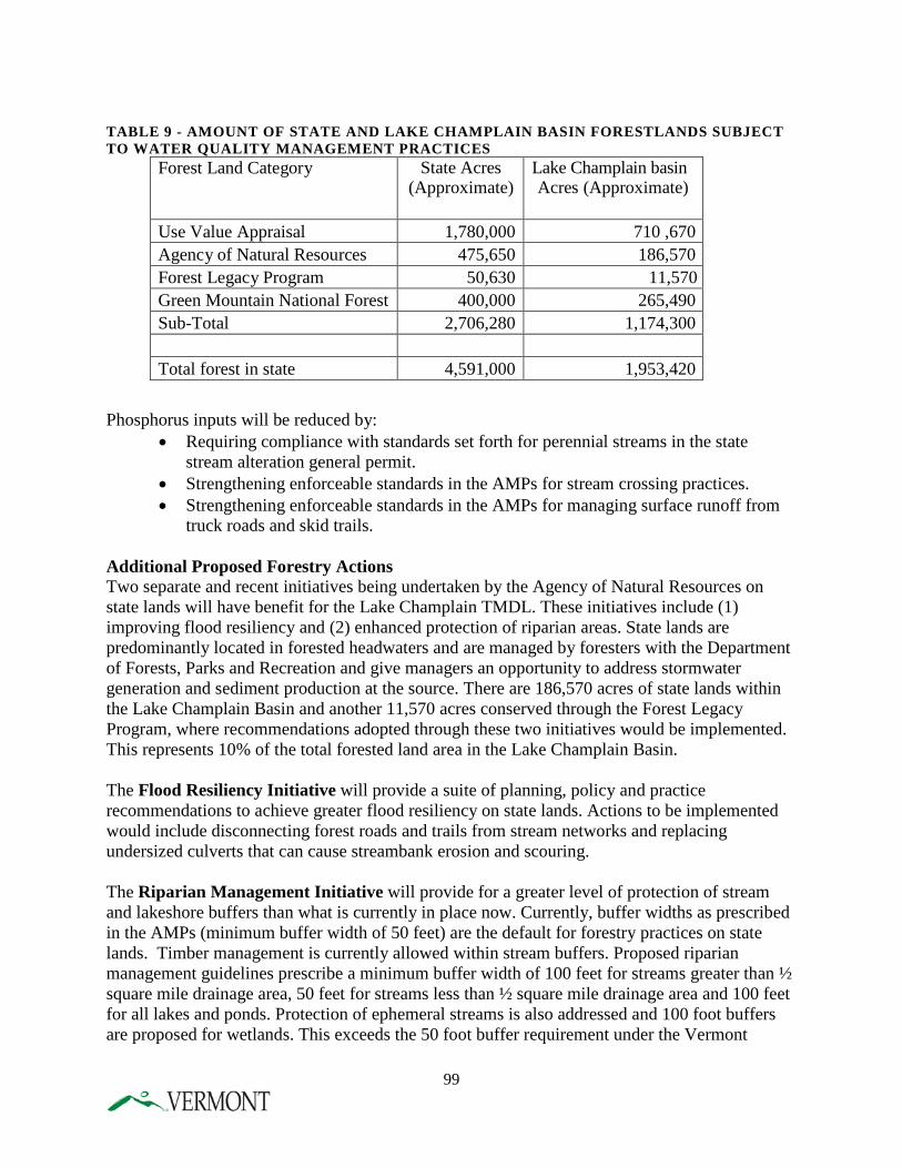
TABLE 9 - AMOUNT OF STATE AND LAKE CHAMPLAIN BASIN FORESTLANDS SUBJECT TO WATER QUALITY MANAGEMENT PRACTICES
Forest Land Category State Acres (Approximate)
Lake Champlain basin Acres (Approximate)
Use Value Appraisal 1,780,000 710 ,670 Agency of Natural Resources 475,650 186,570 Forest Legacy Program 50,630 11,570 Green Mountain National Forest 400,000 265,490 Sub-Total 2,706,280 1,174,300
Total forest in state 4,591,000 1,953,420
Phosphorus inputs will be reduced by:
• Requiring compliance with standards set forth for perennial streams in the state stream alteration general permit.
• Strengthening enforceable standards in the AMPs for stream crossing practices. • Strengthening enforceable standards in the AMPs for managing surface runoff from
truck roads and skid trails. Additional Proposed Forestry Actions Two separate and recent initiatives being undertaken by the Agency of Natural Resources on state lands will have benefit for the Lake Champlain TMDL. These initiatives include (1) improving flood resiliency and (2) enhanced protection of riparian areas. State lands are predominantly located in forested headwaters and are managed by foresters with the Department of Forests, Parks and Recreation and give managers an opportunity to address stormwater generation and sediment production at the source. There are 186,570 acres of state lands within the Lake Champlain Basin and another 11,570 acres conserved through the Forest Legacy Program, where recommendations adopted through these two initiatives would be implemented. This represents 10% of the total forested land area in the Lake Champlain Basin. The Flood Resiliency Initiative will provide a suite of planning, policy and practice recommendations to achieve greater flood resiliency on state lands. Actions to be implemented would include disconnecting forest roads and trails from stream networks and replacing undersized culverts that can cause streambank erosion and scouring. The Riparian Management Initiative will provide for a greater level of protection of stream and lakeshore buffers than what is currently in place now. Currently, buffer widths as prescribed in the AMPs (minimum buffer width of 50 feet) are the default for forestry practices on state lands. Timber management is currently allowed within stream buffers. Proposed riparian management guidelines prescribe a minimum buffer width of 100 feet for streams greater than ½ square mile drainage area, 50 feet for streams less than ½ square mile drainage area and 100 feet for all lakes and ponds. Protection of ephemeral streams is also addressed and 100 foot buffers are proposed for wetlands. This exceeds the 50 foot buffer requirement under the Vermont
99
Wetland Rules. Proposed management strategies for buffers will enhance and restore riparian values and functions. Both initiatives have yet to be reviewed and agreed to by agency stewardship staff or leadership; however, while specific details are subject to change prior to final adoption, it is assumed that these proposed actions will provide for increased sediment control and nutrient retention thus benefitting phosphorus reduction in the Lake Champlain Basin.
IMPLEMENTATION MECHANISM FPR is undertaking a rulemaking process to update the AMPs and revise the AMP manual.
IMPLEMENTATION STEPS AND TIMEFRAME 1. Update AMP Rule and AMP manual 2016
INTERIM MILESTONES 1. Technical Steering Committee (TSC) formed 2012 2. Initial draft revision completed 2012 3. ANR comments solicited 2012 4. Public Stakeholder Meetings held 2013 5. Final recommendations submitted by TSC to Director of Forests 2013 6. Additional round of comments received from ANR 2013 7. ANR legal review 2014 8. Initiate State Rulemaking 2014 9. Release revised AMP manual 2016 10. Conduct workshops 2016
CREATE A VERMONT FORESTRY DIRECT LINK LOAN PROGRAM – INCENTIVE FINANCING TO REDUCE NON-POINT SOURCE POLLUTION RISKS ON TIMBER HARVESTING OPERATIONS.
DESCRIPTION Qualified Logging Professionals would be eligible to obtain low-interest financing from participating banks through a Vermont Forestry Direct Link Loan Program. The purpose of providing this financial incentive is to increase the use of BMPs and environmentally friendly logging equipment in the logging industry. This, in turn, will help to protect and improve water quality in and around logging operations.
FPR will: 1) determine the items that are eligible for financing, 2) ensure that the logger meets qualification requirements 3) ensure that the logger retains, on file, a BMP check list for each operation, and 4) monitor the improvements and practices of the logger.
DEC and the Vermont Municipal Bond Bank (VMBB) will: 1) enter into a memorandum of understanding with FPR to implement the program, 2) work with local banks to participate in the
100
program, and 3) provide oversight within the context of managing the Vermont Forestry Direct Link Loan Program.
Phosphorus inputs will be reduced through increased use of low-impact harvesting systems and other technologies to protect forest water resources.
IMPLEMENTATION MECHANISM FPR and DEC will coordinate this initiative.
IMPLEMENTATION STEPS AND TIMEFRAME 1. EPA augments VT State Clean Water Revolving Fund 2017 and requests DEC to allocate funds to this program 2. DEC and VMBB will enter into a memorandum of understanding 2017 with FPR to implement the program 3. DEC and VMBB will work with local banks to participate 2017
in the program 4. FPR will determine the items that are eligible for financing and 2018
develop the BMP checklist for loggers 5. Launch program 2018
ADDITIONAL ACTIONS TO REDUCE PHOSPHORUS LOADINGS IN THE MISSISQUOI BAY AND SOUTH LAKE SUB-WATERSHEDS
Regional Conservation Partnership Program The Department of Forests, Parks and Recreation is targeting outreach efforts to forest landowners within the Lake Champlain Basin with a focused effort aimed at the Missisquoi Basin to accelerate implementation of NRCS cost-share practices funded through the Regional Conservation Partnership Program (RCPP) to improve water quality and reduce phosphorus. These practices include erosion control on active forest trails and landings; installation of bridges, fords, and culverts at stream crossings; maintaining riparian zones in forests; and mulching. In addition to these outreach efforts, FPR will provide two foresters who will prioritize technical outreach and assistance to the forest landowner community on the effective implementation of these practices. This effort will take place over a five year period starting in 2015.
IMPLEMENTATION MECHANISM FP&R in coordination with DEC and NRCS
IMPLEMENTATION STEPS AND TIMEFRAME 1. Grant proposal submitted 2014 2. Grant awarded 2015 3. Outreach 2015-2019 4. Practice implementation 2015-2019
101
Increasing Access to Portable Skidder Bridges The State’s Portable Skidder Bridge Program, an existing program, supported by FPR and administered by the Natural Resource Conservation Districts provides loggers and private forest landowners access to portable skidder bridges. Portable skidder bridges are used as temporary stream crossing structures when conducting logging operations. The utilization of these bridges provides for streambank stability and reduces sediment and nutrient runoff into waters. The recent expansion of this program in 2015 now provides complete coverage for the entire Missisquoi Bay.
IMPLEMENTATION MECHANISM Natural Resource Conservation Districts and FP&R
IMPLEMENTATION STEPS AND TIMEFRAME 1. Enhanced coverage attained for Missisquoi Basin 2015 2. Enhance portable skidder bridge capacity throughout the LCB by 25% 2019 REDUCING EROSION FROM INACTIVE FOREST ROADS, TRAILS, AND LOG LANDINGS IN PRIVATE FORESTS
The State will use select LiDAR (Light Detection and Ranging) mapping in the Missisquoi Basin to demonstrate the effectiveness of LiDAR to map eroding, abandoned, and retired forest roads, skid trails, and log landings. This type of inactive infrastructure is considered a significant source of sediment and nutrient loss from forest land, and ANR has little information about the extent of these networks and their connectivity to streams. This mapping will be used as a demonstration project to expand this effort throughout the Missisquoi Basin. ANR will use this information to identify and fund restoration projects.
IMPLEMENTATION MECHANISM FPR will facilitate and support this effort.
IMPLEMENTATION STEPS AND TIMEFRAME 1. FPR collaborates with NRCS to develop this as a topic for funding through the NRCS Conservation Innovation Grant Program 2015 2. Grant proposal submitted and grant awarded 2015 3. Contract signed 2015 4. Pilot study area selected 2016 5. LiDAR mapping and ground checks conducted 2016 6. Final report submitted 2017
102
HEALTHY FOREST COVER STRATEGY
DESCRIPTION Forests produce the cleanest water of any land use. Research indicates that on a watershed scale and for riparian forest buffers water quality impacts can be seen when forest cover goes below 65% and 70% respectively. Vermont is approximately 75% forested with fluctuations from watershed to watershed, and site to site. A forest cover strategy of no net forest cover loss supports the creation of a system to promote forest cover goals in priority zones, including riparian and developed areas, coupled with mechanisms to ensure the health, maintenance and conservation of existing cover. Healthy forests translate into functional ecosystems that bind phosphorus and water, preventing additional runoff. Given that 86% of Vermont forests are privately owned and managed, successfully achieving our no net loss of forest cover relies on landowners reaping some financial benefits from their forestlands. Economic incentives for forest products, therefore, become an integral part of keeping healthy forestland. Climate change poses a significant amount of uncertainty with respect to understanding forest response to disturbance, and effectiveness in meeting forest management goals. Increased temperatures, heavy precipitation events, mild winters, and extreme wind and ice storms are all predicted to increase. The best risk management at this point in time is to manage forests to be more resilient to a variety of weather conditions, and to build forest harvest plans that account for extreme weather influences. Estimating Phosphorus Reductions and Other Benefits
• Healthy forest cover in the Lake Champlain watershed will improve watershed health through water interception, filtration and evapotranspiration, and nutrient attenuation.
• Trees and forests reduce stormwater runoff by capturing and storing rainfall in the canopy, thereby reducing runoff volumes and delaying the onset of peak flows. Research studies suggest forest canopy interception measured for conifer stands ranges from 15% to 51% of annual precipitation, and interception in hardwood stands ranges from 8% to 20%.
• The growth of tree roots, as well as the decomposition of roots and leaf litter, increase soil infiltration rates and overall infiltration capacity.
• Through evapotranspiration trees draw moisture from the soil surface, providing an increased soil water capacity. Conifers transpire 10-12% of precipitation, while deciduous trees during leaf-on transpire up to 25% of precipitation.
• Trees and forests directly reduce soil and water phosphorus through root uptake; 1 acre of riparian forest buffer will remove 2 lbs of phosphorus and 2,500 lbs of sediment annually.
• Forest cover reduces soil erosion by buffering the impact of raindrops on barren surfaces. • In addition to these water quality benefits, trees and forests provide a host of ecological,
social and economic benefits including wildlife habitat, forest based industry, improved health and well-being, and recreation and aesthetic values.
103
IMPLEMENTATION MECHANISM FPR will implement the following general strategies for no net loss of forest cover in the watershed.
1. Watershed Forest Cover Goals 2. Restore Riparian Forest Buffers 3. Restore Developed Land Forest Cover 4. Prepare and Mitigate Impacts to Forest Cover from Invasive Tree Pests 5. Publish and distribute the draft forest adaptation strategy document: “Creating and
Maintaining Resilient Forests in Vermont: Adapting forests to climate change.”
IMPLEMENTATION STEPS AND TIMEFRAME 1. Assess current forest cover and prioritize forest cover conservation for
surface water protection and no net forest loss. 2016 2. Assist regional and municipal planning groups to conduct high priority
forest land conservation for surface water protection. Ongoing 3. Consider legislation that would include maintaining forest cover as part of
town plans for surface water protection. Ongoing 4. Increase funding specifically for forest land conservation and target high
Priority forests for surface water protection. Ongoing 5. Promote and support the state’s smart growth initiatives, and seek
innovative incentive strategies to conserve forest cover. 2015 6. Promote landowner incentives through programs such as the Working
Lands Initiative. Ongoing 7. Identify, prioritize, and offer incentives to plant or regenerate 35-foot or
greater buffers (targeting70% forest canopy cover within riparian forest buffers and 50% of the riparian buffer miles). 2016
8. Work with local NGOs to target education and outreach efforts, focusing initially in South Lake and Missisquoi watersheds. Ongoing
9. Target 40% forest cover in Vermont’s urban landscape zones (ULZ) on 50% of developed lands (or 22,066 acres) in the Lake Champlain basin. Ongoing
10. Complete developed land forest cover assessments for Basin ULZ. 2016 11. Work with communities with ULZs on strategies to increase and maintain
developed land forest cover. 2016 12. Implement detection surveys, policies and management practices to slow
the impact of the emerald ash borer. Ongoing 13. Identify and prioritize areas where ash plays a vital role in canopy cover
and water quality protection. 2015 14. Assist high-priority communities to develop invasive tree pest
preparedness plans. 2016 15. Develop criteria and tree management fund for site restoration that involve
tree replacement. 2016 16. Work with partners to develop and implement tree replacement strategies
at high priority sites. 2016 17. Promote recommended forest adaptation strategies to foresters
and landowners to implement climate-smart practices that
104
maintain healthy forest cover, sustain ecological functions such as water holding capacity of forests, and promote water quality 2015
18. Develop and implement a policy to use climate-smart forestry practices on state lands 2015
19. Create funding priorities through the Working Lands Initiative (Working Lands Enterprise Fund (WLEF)) for new forest harvesting technologies that improve protection of soil and water 2016
20. Establish 3 demonstration areas on state land to train foresters and landowners on climate-smart forest management techniques that can then be implemented on the 86% of Vermont’s forestlands that are privately owned 2017
21. Identify vulnerable forest stands within the Lake Champlain basin, develop forest health strategies to maintain forest cover and water holding capacity, and identify funding to implement strategies on priority forests 2018-2036
F. WATERSHED PROTECTION AND RESTORATION PROGRAMS ECOSYSTEM RESTORATION PROGRAM
DESCRIPTION DEC’s Ecosystem Restoration Program (ERP), first established in 2005, manages a competitive grant program to reduce nutrient and sediment pollution into the Lake Champlain basin and other surface waters of the state from nonpoint sources. The grant program has received sustained funding over time. The program awards approximately 50-60 grants each year, totaling roughly $2-4 million of state capital construction funds. Grant recipients include municipalities, watershed and lake organizations, regional planning commissions, and other local and regional partners. Two-thirds of the grants typically are for projects within the Lake Champlain basin. The objectives of the ERP grant program are to:
• Reduce stormwater runoff from developed areas; • Reduce runoff from farms and timberlands; • Upgrade road networks with best road-related stormwater management practices; and, • Restore and protect floodplains, river corridors, wetlands, and riparian areas along rivers,
streams, lakes, ponds, and wetlands. The new Lake Champlain phosphorus TMDL, will require a heightened level of implementation necessary to restore Lake Champlain. Success in accomplish the State’s clean water goals calls for greater collaboration among all parties -- local, state and federal government, partners and other stakeholders -- in implementing, tracking and reporting of progress, Therefore, the ERP will soon transition into WSMD’s Vermont Clean Water Initiative Program (CWIP). The new program will work collaboratively with state, federal and local governments and other partners to coordinate, manage, track, communicate and report on implementation of the Lake Champlain TMDL, other EPA-approved TMDLs and priority clean water restoration
105
activities throughout the State. This program will also provide management support to the Vermont Clean Water Fund Board, the governing body of the new Vermont Clean Water Fund (established in Act 64). This program will continue ERP grants and contracts, and continue to rely on the implementation tables of tactical basin plans for identifying priority projects for implementation. The Program will target existing and any additional funds made available through a Clean Water Fund, using existing water quality grant, contract, and loan programs. What is new is a framework to support implementation by organizing and supporting local teams – locally lead collaborative efforts of municipalities, regional planning commissions, watershed and river groups, conservation districts, and other stakeholders to implement priority projects identified in tactical basin plans.
IMPLEMENTATION MECHANISM The Program continues to manage annual state capital bill and Vermont Clean Water Fund appropriations to implement priority actions, as described in tactical basin plans. The Program will also support delivery of technical and educational assistance, and implementation via the use of local teams.
IMPLEMENTATION STEPS AND TIMEFRAME DEC will undertake the following actions:
1. Develop an annual capital and Vermont Clean Water Fund budget that addresses clean water needs Annually
2. Provide management support to the Vermont Clean Water Fund Board 2015-2036 3. Support interagency coordination regarding TMDL implementation 2015 4. Dispense funds for implementation of priority actions Annually 5. Enhance grant, contract and loan management 2015 6. Support expansion of a state revolving fund for stormwater management 2015-2036 7. Establish indicators and tracking system to measure and track progress 2015 8. Continue to manage the process for the coordinate, manage, track,
communicate and report on TMDL implementation Annually 9. Conduct technical assistance on nonpoint source controls Ongoing
CLEAN WATER FUND
DESCRIPTION The Vermont Clean Water Fund, created in Act 64, will be a dedicated source of funding that strategically targets priority water quality improvement programs to help the State meet its’ anticipated obligations under the Lake Champlain TMDL as well as other water quality priorities of the State. The Fund will consist of appropriations from the Vermont General Assembly, gifts, donations and impact fees. In sum, Act 64 provides: Clean Water Fund: The Vermont Clean Water Act imposes a 0.2% increase in Vermont’s property transfer tax, which will raise approximately $5.3 million annually for the purpose of making additional strategic investments in water pollution control. The Act creates a Clean
106
Water Fund and Board to receive and manage the funds and requires a Clean Water Investment Report summarizing public investments and results of those investments.
Ecosystem Restoration Grants: The Vermont Capital Bill increased the amount of funding dedicated to grants under this program dedicated to funding implementation of polluted stormwater runoff control projects to $3.75 million per year (from a current level of approximately $2.5 million) for the next two years. Regional Conservation Partnership Program: The U.S. Department of Agriculture raised funding for the Vermont Natural Resource Conservation Service (NRCS) to a level of $45 million over five years dedicated to soil and water conservation programs in the Lake Champlain basin, a significant increase over prior year investments. The State of Vermont also applied for and received an additional grant of $16 million from NRCS and committed $20 million in matching funds with partners, dedicated to addressing polluted runoff from farms and forests. Increased Agency Capacity: The State of Vermont Fiscal Year 2016 budget includes funding to support eight new positions within AAFM and thirteen new positions within DEC all dedicated to implementation of the Vermont Clean Water Initiative and Lake Champlain TMDL. The Vermont Clean Water Fund is envisioned to support the following existing programs:
• Loans and grants under the State Revolving Loan Fund (SRF), the fund supported by an annual EPA capitalization grant, state matching funds, and principal and interest repayments on past SRF loans. In addition to continuing to fund repair, replacement and operation of existing wastewater treatment systems, the Fund could provide low interest loans, forgivable principal loans, or grant funding for:
o Stormwater runoff pollution control projects, including green infrastructure projects
o Match for state grant-funded stormwater control projects o Projects required by for stormwater permit or TMDL compliance o Decentralized sewage treatment systems or onsite septic repair and replacement o Agricultural runoff control projects, such as equipment purchase for direct
seed/no till conservation practices o Capital projects to improve municipal road networks, and o Infrastructure planning and asset management for all water system infrastructure
• DEC’s ERP grants and contracts to aid municipalities, landowners, and other partners in project implementation
• VTrans’ grants programs, such as its Vermont Better Back Roads Program, a grant program to help municipalities implement best management practices pertaining to runoff from roads.
• ERP’s grants to support technical and educational assistance to municipalities, farmers, loggers and foresters, developers, businesses, and landowners in practices to reduce nonpoint source pollution runoff and improve flood resilience. The objective is to support:
o Priority technical assistance initiatives, such as ANR’s Green Infrastructure Initiative
107
o Priority agricultural programs, such as an emerging small farm assistance program at AAFM, the University of Vermont (UVM) Extension/Poultney-Mettowee Conservation District’s Agronomy and Conservation Assistance Program (ACAP), and ongoing technical assistance from the state Conservation Districts that make up the Vermont Association of Conservation Districts
o Watershed protection work of key partners including the Regional Planning Commissions, the water resources coordinator at the Vermont League of Cities and Towns Municipal Assistance Program, the natural resources conservation districts, watershed-based groups, and lake associations
o Technical assistance to loggers, landowners, and foresters about best management practices, such as the use of portable skidder bridges, for controlling runoff from timber harvesting operations,
o Leverage federal USDA Natural Resources Conservation Service’s Forest Trails and Landings Cost-share Practice to encourage landowners to address soil erosion and sedimentation associated with logging roads and landings, and,
o Educational assistance from organizations such as the Vermont Youth Conservation Corps, the Student Conservation Association, and the North Woods Stewardship Center.
IMPLEMENTATION MECHANISM WSMD’s Clean Water Initiative Program, formerly the Ecosystem Restoration Program described above, will continue to work with the Administration and the Vermont General Assembly to support the establishment of a Clean Water Fund.
IMPLEMENTATION STEPS AND TIMEFRAME DEC will undertake the following actions:
1. Secure legislation to support the creation of the Clean Water Fund 2015
MILESTONES FOR PARTIAL IMPLEMENTATION 1. Work with state partners to develop an administrative framework
for managing the Fund 2015-2016 2. Establish an initial and permanent funding mechanism to support the Vermont Clean
Water Fund 2015-2019 3. Create a Clean Water Fund Board 2015-2016 4. Establish administrative controls to manage billing, tracking,
progress, communicating, reporting and enforcement 2015-2018
108
TACTICAL BASIN PLANNING AND CRITICAL SOURCE AREA IDENTIFICATION – NEXT-GENERATION STRATEGY FOR TARGETED IMPLEMENTATION AND PHASE II WATERSHED-LEVEL PLANNING
DESCRIPTION As discussed above, there are multiple programs in place to both prevent and reduce excess phosphorus runoff to Lake Champlain. However, without an overall plan to identify, prioritize, fund and implement the necessary phosphorus control measures, time and money may be wasted. In order to promote the most efficient and cost-effective implementation of phosphorus controls, DEC’s Watershed Management Division (WSMD) developed a tactical basin planning process to coordinate watershed assessment, planning, project identification and funding. The identification of priority implementation projects in tactical basin plans is directly linked to targeted funding efforts, currently provided by WSMD’s Ecosystem Restoration Program (ERP). This linkage provides synergy between identified priority projects and available funding. Relationship of Tactical Basin Planning and Phase II Watershed Plans With respect to implementing the Lake Champlain TMDL, VTDEC is committed to further improving the tactical planning process in several ways, such that each associated Lake subwatershed tactical basin plan serves as the Phase 2 Implementation Plan for the execution of the Champlain TMDL. In addition to the expected chapters featured in present tactical plans, VTDEC is committed to significantly expanding the implementation table for each tactical plan. This implementation table will outline the priorities of DEC, and partner organizations for protection or restoration of specific stream/river or lake segments affected by specific pollution sources, and present a specific focus on BMP or programmatic implementation necessary to reduce phosphorus loading to the Lake. The table will describe the types of BMP or other implementation strategies that are needed, by sub-watershed and source sector, and present best-available estimates of likely phosphorus reductions by practice, aggregated at appropriate geographic scale. The table will also serve to notify partner organizations of the types and locations of projects that DEC will support with ERP grants, the Clean Water Fund, or other Federal, State or public-private funding sources available to DEC.
Tactical basin plans will facilitate implementation by translating the results of integrated basin assessments into specific geographically defined areas for project-level intervention. While tactical plan implementation tables will be frequently updated to reflect the implementation of practices that are required as a result of regulatory program requirements, the tactical plans themselves are not standalone regulations or permits. Tactical basin plan implementation tables may identify the appropriate restoration strategies based on monitoring and assessment data, but implementation authority lies with the regulatory programs. Agricultural interventions will be identified in the implementation table at a geographic scale sufficiently fine so as to transparently present areas of planned intervention for each tactical planning cycle, but also at a level sufficiently coarse so as not to trigger confidentiality provisions section 1619 pertaining to agricultural practice installation.
As part of the Phase I Plan for Lake Champlain, WSMD intends to capitalize on partnerships with Regional Planning Commissions and Vermont’s Natural Resources Conservation Districts to assist in the final prioritization of tactical plan implementation actions. Conservation Districts
109
provide capacity for implementation of conservation BMP’s, while Regional Planning Commissions possess unique locally-relevant planning capabilities that complement the Division’s efforts. As provided in Act 64, Regional Planning Commissions may conduct one or more functions in the development of a tactical basin plan:
• Identify projects or activities within a basin that will result in the protection and enhancement of water quality by assisting the Secretary in implementing a project evaluation process to prioritize water quality improvement projects within the region to assure cost effective use of State and federal funds;
• Assure that municipal officials, citizens, watershed groups, and other interested groups and individuals are involved in the basin planning process;
• Provide technical assistance and data collection activities to inform municipal officials and the State in making water quality investment decisions;
• Assure regional and local input in State water quality policy development and planning processes;
• Provide education to municipal officials and citizens regarding the basin planning process;
• Develop, in consultation with the applicable regional planning commission, an analysis and formal recommendation on conformance with the goals and objectives of applicable regional plans;
• Provide for public notice of a draft basin plan; and for the opportunity of public comment on a draft basin;
• Coordinate municipal planning and adoption or implementation of municipal development regulations to better meet State water quality policies and investment priorities.
While tactical plans are redrafted every five years, DEC is also committing to periodic review of the progress of implementation programs and efforts. During that time, DEC will conduct public outreach to highlight implementation efforts, and insert new priority items that are more recently identified through on-going assessment. As such, the tactical basin plan’s implementation table is a living chronicle of the identified priority interventions needed to implement sediment and nutrient load reductions in the Lake Champlain watersheds. Insofar as the implementation tables outline opportunities for phosphorus reduction through improved flood resilience, climate adaptation strategies are also promoted through the tactical plans. Expanding Capacity for Watershed Modeling and Integration The five sector-specific assessment processes (see Chapter 4.I) that are integrated to produce current tactical basin plans yield prioritized prospective projects to address multiple stressors. At present, these assessments are targeted using non-empirical approaches, based to a degree on the organizational interest and availability of partners who would conduct the assessment. The tactical planning process is presently conducted at the scale of individual waters and subwatersheds. For comprehensive management to occur at the scale of the Lake Champlain TMDL, there is a need for additional geographically-based prioritization approaches to target assessments where they are not yet in-place, and where general water quality monitoring data are not available. For example, it is easy to target a Better Back Roads project in a municipality in which impaired waters have been identified using biological monitoring, and available SGA implicates road runoff. Absent this information, where should implementation be targeted first,
110
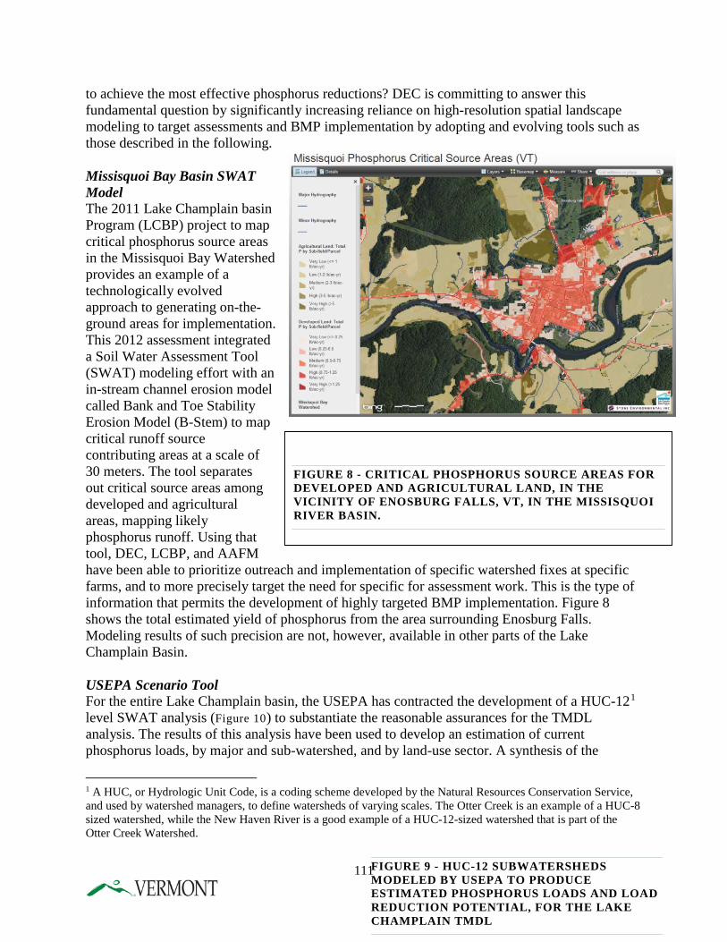
FIGURE 8 - CRITICAL PHOSPHORUS SOURCE AREAS FOR DEVELOPED AND AGRICULTURAL LAND, IN THE VICINITY OF ENOSBURG FALLS, VT, IN THE MISSISQUOI RIVER BASIN.
to achieve the most effective phosphorus reductions? DEC is committing to answer this fundamental question by significantly increasing reliance on high-resolution spatial landscape modeling to target assessments and BMP implementation by adopting and evolving tools such as those described in the following. Missisquoi Bay Basin SWAT Model The 2011 Lake Champlain basin Program (LCBP) project to map critical phosphorus source areas in the Missisquoi Bay Watershed provides an example of a technologically evolved approach to generating on-the-ground areas for implementation. This 2012 assessment integrated a Soil Water Assessment Tool (SWAT) modeling effort with an in-stream channel erosion model called Bank and Toe Stability Erosion Model (B-Stem) to map critical runoff source contributing areas at a scale of 30 meters. The tool separates out critical source areas among developed and agricultural areas, mapping likely phosphorus runoff. Using that tool, DEC, LCBP, and AAFM have been able to prioritize outreach and implementation of specific watershed fixes at specific farms, and to more precisely target the need for specific for assessment work. This is the type of information that permits the development of highly targeted BMP implementation. Figure 8 shows the total estimated yield of phosphorus from the area surrounding Enosburg Falls. Modeling results of such precision are not, however, available in other parts of the Lake Champlain Basin. USEPA Scenario Tool For the entire Lake Champlain basin, the USEPA has contracted the development of a HUC-121 level SWAT analysis (Figure 10) to substantiate the reasonable assurances for the TMDL analysis. The results of this analysis have been used to develop an estimation of current phosphorus loads, by major and sub-watershed, and by land-use sector. A synthesis of the
1 A HUC, or Hydrologic Unit Code, is a coding scheme developed by the Natural Resources Conservation Service, and used by watershed managers, to define watersheds of varying scales. The Otter Creek is an example of a HUC-8 sized watershed, while the New Haven River is a good example of a HUC-12-sized watershed that is part of the Otter Creek Watershed.
FIGURE 9 - HUC-12 SUBWATERSHEDS MODELED BY USEPA TO PRODUCE ESTIMATED PHOSPHORUS LOADS AND LOAD REDUCTION POTENTIAL, FOR THE LAKE CHAMPLAIN TMDL
111
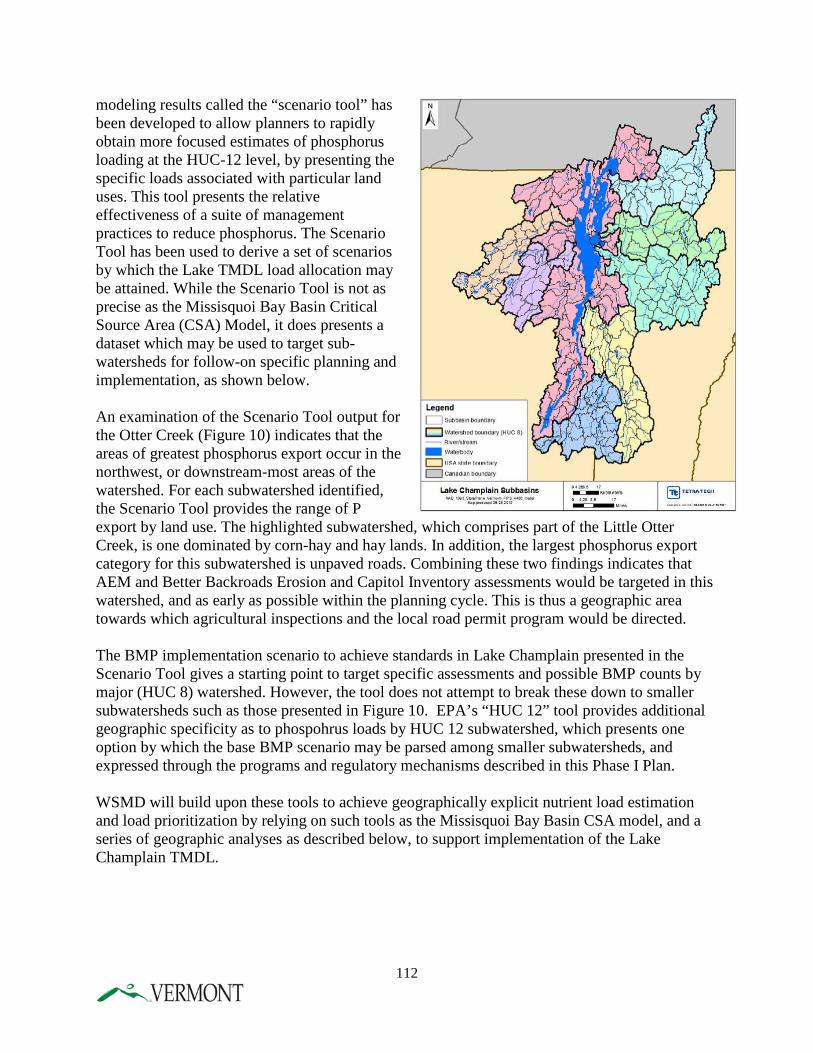
modeling results called the “scenario tool” has been developed to allow planners to rapidly obtain more focused estimates of phosphorus loading at the HUC-12 level, by presenting the specific loads associated with particular land uses. This tool presents the relative effectiveness of a suite of management practices to reduce phosphorus. The Scenario Tool has been used to derive a set of scenarios by which the Lake TMDL load allocation may be attained. While the Scenario Tool is not as precise as the Missisquoi Bay Basin Critical Source Area (CSA) Model, it does presents a dataset which may be used to target sub-watersheds for follow-on specific planning and implementation, as shown below. An examination of the Scenario Tool output for the Otter Creek (Figure 10) indicates that the areas of greatest phosphorus export occur in the northwest, or downstream-most areas of the watershed. For each subwatershed identified, the Scenario Tool provides the range of P export by land use. The highlighted subwatershed, which comprises part of the Little Otter Creek, is one dominated by corn-hay and hay lands. In addition, the largest phosphorus export category for this subwatershed is unpaved roads. Combining these two findings indicates that AEM and Better Backroads Erosion and Capitol Inventory assessments would be targeted in this watershed, and as early as possible within the planning cycle. This is thus a geographic area towards which agricultural inspections and the local road permit program would be directed. The BMP implementation scenario to achieve standards in Lake Champlain presented in the Scenario Tool gives a starting point to target specific assessments and possible BMP counts by major (HUC 8) watershed. However, the tool does not attempt to break these down to smaller subwatersheds such as those presented in Figure 10. EPA’s “HUC 12” tool provides additional geographic specificity as to phospohrus loads by HUC 12 subwatershed, which presents one option by which the base BMP scenario may be parsed among smaller subwatersheds, and expressed through the programs and regulatory mechanisms described in this Phase I Plan. WSMD will build upon these tools to achieve geographically explicit nutrient load estimation and load prioritization by relying on such tools as the Missisquoi Bay Basin CSA model, and a series of geographic analyses as described below, to support implementation of the Lake Champlain TMDL.
112
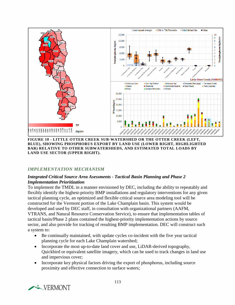
FIGURE 10 - LITTLE OTTER CREEK SUB-WATERSHED OR THE OTTER CREEK (LEFT, BLUE), SHOWING PHOSPHORUS EXPORT BY LAND USE (LOWER RIGHT, HIGHLIGHTED BAR) RELATIVE TO OTHER SUBWATERSHEDS, AND ESTIMATED TOTAL LOADS BY LAND USE SECTOR (UPPER RIGHT).
IMPLEMENTATION MECHANISM Integrated Critical Source Area Asessments - Tactical Basin Planning and Phase 2 Implementation Prioritization To implement the TMDL in a manner envisioned by DEC, including the ability to repeatably and flexibly identify the highest-priority BMP installations and regulatory interventions for any given tactical planning cycle, an optimized and flexible critical source area modeling tool will be constructed for the Vermont portion of the Lake Champlain basin. This system would be developed and used by DEC staff, in consultation with organizational partners (AAFM, VTRANS, and Natural Resource Conservation Service), to ensure that implementation tables of tactical basin/Phase 2 plans contained the highest-priority implementation actions by source sector, and also provide for tracking of resulting BMP implementation. DEC will construct such a system to:
• Be continually maintained, with update cycles co-incident with the five year tactical planning cycle for each Lake Champlain watershed;
• Incorporate the most up-to-date land cover and use, LiDAR-derived topography, Quickbird or equivalent satellite imagery, which can be used to track changes in land use and impervious cover;
• Incorporate key physical factors driving the export of phosphorus, including source proximity and effective connection to surface waters;
113
• Overlay available stream geomorphic assessment information to determine the likelihood for controllable phosphorus by addressing stream disequilibrium;
• Conduct a series of geographically-based analyses aimed at identifying the highest priority stressors.
• Geographically target BMP-level implementation options derived from the Scenario tool and other assessment types identified in Chapter 4; and
• Cross-reference prospective critical source areas that are specific to land-use sectors with these projects or BMPs to produce the next five-year iteration of implementation steps.
The full roster of assessments to be analyzed in the construction of a tactical basin plan may include, but may not be limited to: AGRICULTURE
A. Farmstead mapping B. Annual crop and hayland maps C. Cropland and steep slope adjacency D. Wetland restoration potential (from Lake Champlain Restoration Plan) E. No-till practice application analysis (analysis to identify suitable fields) F. Cover crop practice analysis (analysis to identify high priority fields) G. Manure injection analysis (procedure to identify suitable fields needs to be developed) H. Critical source area maps (could be overlaid with Annual Crop and Hayland Map) I. Tile drainage location maps (procedure yet to be developed) J. Farm ditch maps (when Lidar becomes available) K. Animal access to streams maps (procedure yet to be developed) L. Assessment of practice efficiencies and potential phosphorus load reductions
• Would include single practices and systems • Would include phosphorus reductions and costs per pound • Could be based on previous SWAT information or APEX
GEOMORPHIC ASSESSMENT
• Hyperlinked list of SGA/Corridor Plans • Subwatershed map coded by sediment departure regime • Riparian buffer gaps
STORMWATER MAPPING AND MASTER PLANNING
• Hyperlinked list of SWMP’s, and elevate high priority projects into implementation tables.
ROAD EROSION INVENTORY • Remotely sensed critical erosion sites • Inventoried project locations from municipal BBR assessments
INTEGRATION
A. Table of impaired, stressed, and altered waters, with reference to specific stressors, and linked to stressor chapters.
114
B. Table of individual surface water Total Maximum Daily Loads including TMDL summary information such as loading capacity, margin of safety, load allocation, and wasteload allocation.
C. Identified priority subwatersheds for focused monitoring and assessment. D. Identified of priority subwatersheds for targeted implementation.
The resulting implementation table will translate the results of the integrated assessments into specific geographically explicit areas for project-level intervention, and to support programmatic and partner installation of BMP’s in order to reduce phosphorus loads by a projected amount for each tactical plan cycle. These science-based assessments also serve to identify where additional regulatory program requirements may be brought to bear by the relevant programs. While tactical plan implementation tables will be frequently updated to reflect the implementation of practices that are required as a result of regulatory program requirements, the tactical plans themselves are not considered standalone regulations or permits. Public Availability of Data and Assessments In addition to the mapped and tabular information above, as required by Act 64, the Division will also present a coordinated assessment of all available data and science regarding the quality of the waters of the State, including:
• Light detection and ranging information data (LIDAR); • Stream gauge data; • Stream mapping, including fluvial erosion hazard maps; • Water quality monitoring or sampling data; • Cumulative stressors on a watershed, such as the frequency an activity is conducted
within a watershed or the number of stormwater or other permits issued in a watershed. Tracking BMP implementation and Estimating phosphorus reduction The purpose of BMP tracking is twofold: 1) Create an ongoing geographic portrayal of project and BMP-level implementation; and 2) maintain an accounting of nutrient reductions likely achieved by these installations. DEC envisions two tracking systems that will be integrated to achieve these aims. The tracking systems will serve to display and keep track of individual practices that are implemented, in fulfillment of specifically-identified interventions in a tactical plan implementation table. Agricultural BMP Tracking At present, AAFM is building a multi-organizational geospatial practice implementation database. The purpose of this database is to track and plan agricultural BMP planning and implementation efforts in Vermont among nine partner organizations working to improve water quality by reducing agricultural non-point source pollution. This is the first database that will house NRCS BMP implementation data next to State agency and other partner data. Since NRCS is the largest supplier of financial and technical assistance for agricultural BMP implementation, it is crucial to include their activity when reporting on BMP implementation progress. Further, each partner is currently reporting separately, which can lead to the double counting of implementation activity for projects that are funded or supported by more than one partner.
115
This database would allow Vermont to accurately track progress made, plan future progress, coordinate implementation activities among partners, and allow for enhanced success in meeting agricultural BMP implementation and water quality goals. Current funding for the project allows for the development and implementation of the database, which will occur over the next two years (implemented by end of 2015). Long-term term maintenance for the database will also be needed. Confidentiality provisions pursuant to Section 1619 of the Food, Conservation, and Energy Act of 2008 necessarily limit the public presentation of BMP’s implemented; thus it is necessary for Agricultural agencies to maintain this database. Nutrient reductions achieved will be presented at relevant geographic scales sufficiently large to mask proprietary information.
Non-Agricultural BMP Tracking DEC intends to develop co-incident capability to track BMP implementation for non-agricultural BMPs. DEC will develop a primary system that will document the location and value of all BMP for projects supported by DEC and Clean Water Fund dollars or implemented as part of compliance with regulatory programs, which will be tied to the critical source area assessment system. Using data exchange capabilities, projects and BMP implementation tracked by the agricultural BMP database can be married to DEC’s system, at the appropriate summary level. In addition, for road networks, DEC will incorporate BMP tracking either directly, or through data exchange approaches, in partnership with VTRANS. The phosphorus reduction potential attributable to tactical basin planning is a function of the specific BMPs implemented either as a specific project, or in response to the regulatory requirements promulgated under the many new regulatory programs described in this Phase I Plan.. EPA’s Scenario Tool provides an initial set of nutrient reduction values associated with specific BMPs. DEC will continue to work with EPA and other partners to develop appropriate measures of P reduction associated with BMPs. For those practices contained within the Scenario Tool, the phosphorus removal efficiencies, with some adjustment, will serve as a starting point for projected aggregate phosphorus reductions. Aggregated phosphorus reduction achievements can be reflected by tactical basin plans as they are updated. Capacity for Implementation The WSMD staff that are part of the MAPP and ERP, who are responsible for development and implementation of tactical basin plans, face a formidable workload associated with the implementation of the Champlain TMDL. The roles of the watershed coordinators are to develop the plans on a five-year recurring basis; and update the implementation table on a frequently recurring basis. ERP will: transition to the Clean Water Initiative Program to focus support for implementation of projects or BMPs on the ground. Regional Planning Commissions and watershed organizations are core partners in the implementation of tactical basin plans, and therefore the Lake Champlain TMDL.
IMPLEMENTATION STEPS, TIMEFRAME, MILESTONES The following tabular description of tasks and timelines presents the milestones towards the transition to the augmented tactical planning process as described above. According to this schedule, DEC is committing to a first-iteration basin-wide Phase II roster of implementation steps by spring, 2016. In addition, DEC is committing to updating all tactical basin plans in the
116
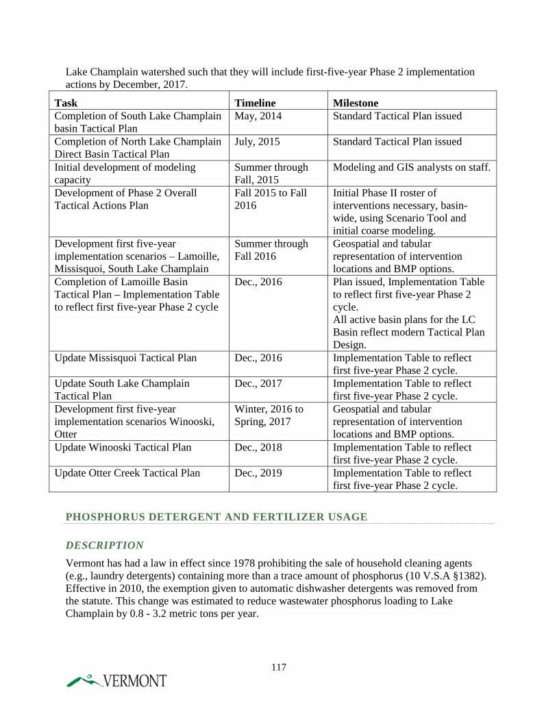
Lake Champlain watershed such that they will include first-five-year Phase 2 implementation actions by December, 2017.
Task Timeline Milestone Completion of South Lake Champlain basin Tactical Plan
May, 2014 Standard Tactical Plan issued
Completion of North Lake Champlain Direct Basin Tactical Plan
July, 2015 Standard Tactical Plan issued
Initial development of modeling capacity
Summer through Fall, 2015
Modeling and GIS analysts on staff.
Development of Phase 2 Overall Tactical Actions Plan
Fall 2015 to Fall 2016
Initial Phase II roster of interventions necessary, basin-wide, using Scenario Tool and initial coarse modeling.
Development first five-year implementation scenarios – Lamoille, Missisquoi, South Lake Champlain
Summer through Fall 2016
Geospatial and tabular representation of intervention locations and BMP options.
Completion of Lamoille Basin Tactical Plan – Implementation Table to reflect first five-year Phase 2 cycle
Dec., 2016 Plan issued, Implementation Table to reflect first five-year Phase 2 cycle. All active basin plans for the LC Basin reflect modern Tactical Plan Design.
Update Missisquoi Tactical Plan Dec., 2016 Implementation Table to reflect first five-year Phase 2 cycle.
Update South Lake Champlain Tactical Plan
Dec., 2017 Implementation Table to reflect first five-year Phase 2 cycle.
Development first five-year implementation scenarios Winooski, Otter
Winter, 2016 to Spring, 2017
Geospatial and tabular representation of intervention locations and BMP options.
Update Winooski Tactical Plan Dec., 2018 Implementation Table to reflect first five-year Phase 2 cycle.
Update Otter Creek Tactical Plan Dec., 2019 Implementation Table to reflect first five-year Phase 2 cycle.
PHOSPHORUS DETERGENT AND FERTILIZER USAGE
DESCRIPTION Vermont has had a law in effect since 1978 prohibiting the sale of household cleaning agents (e.g., laundry detergents) containing more than a trace amount of phosphorus (10 V.S.A §1382). Effective in 2010, the exemption given to automatic dishwasher detergents was removed from the statute. This change was estimated to reduce wastewater phosphorus loading to Lake Champlain by 0.8 - 3.2 metric tons per year.
117
Vermont adopted legislation effective in 2012 (10 V.S.A §1266b) that prohibits the application of phosphorus fertilizer to turf unless the grass is being established during the first growing season, or a soil test indicates the need for phosphorus. Fertilizer applications to impervious surfaces or within 25 feet of surface waters are prohibited.
IMPLEMENTATION MECHANISM Vermont has already passed legislation. No additional action is necessary.
G. WETLAND PROTECTION AND RESTORATION
DESCRIPTION One of the most commonly cited functions of wetlands is the ability to maintain and improve water quality and flood storage of adjacent streams, rivers, and lakes. Wetlands are natural flood regulators which temporarily store floodwaters and then slowly release waters downstream. While floodwaters are being stored in wetlands, sediments and nutrients settle and are retained. As much as 80-90% of sediments in water may be removed while moving through natural wetlands, resulting in cleaner water. A recent study (Wang et. al., 2010) using the Soil and Water Assessment Tool (SWAT) coupled with the hydraulic equivalent wetland concept (HEW) concluded that the loss of 10-20% of the wetlands in their study watershed would lead to an increase in sediment discharge by 40% and total phosphorus load by 18%. Indeed, wetlands are one of the most important microtopographic features abating non-point source nutrients across a watershed. The economic benefits from the ecosystem services that natural wetlands offer can be significant to Vermont communities. For example, the town of Middlebury experienced approximately $3 million in damages from Tropical Storm Irene. The Gund Institute at the University of Vermont estimated that the Otter Creek wetlands complex upstream of Middlebury helped the town avoid an additional $5 million in flood damages. Between 1780 and 1980 Vermont has lost over 35% of its natural wetlands, subsequently loosing phosphorus sinks throughout the Lake Champlain basin. The potential increase in phosphorus retention from restoring the natural hydrology of these lost wetlands would be substantial for the health of Lake Champlain. It is imperative that ANR include protection for natural wetland services and encourage wetland restoration to increase wetland water quality protection in this Phase 1 Plan. The Vermont Wetlands Program is responsible for identifying and protecting wetlands which provide significant functions and values for the people of Vermont. Wetlands often function as water quality protection, flood storage, wildlife habitat, erosion control, and have recreational value. The goal of the Wetlands Program is to achieve no net loss of significant wetlands or wetland function through regulatory and nonregulatory means. This goal is mainly achieved by assisting the Vermont public and professional community in avoiding impacts to wetlands and
118
wetland buffers through personal contact with District Wetland Ecologists. The number of wetland permits issued in a year is a small fraction of the field visits and face to face technical assistance provided to help effectively avoid and minimize wetland impacts. In 2006 the Agency of Natural Resources commissioned a study to identify and prioritize wetland restoration opportunities in the basin, and this plan was finalized on December 31, 2007. Since that time, data from the plan have been widely distributed to federal, state, and local governmental and non-profit organizations with an expressed interest in wetland restoration and protection. Program staff visited with numerous communities and groups to give locally-focused presentations on the plan results, and to highlight funding mechanisms for landowners interested in restoration. Opportunities for wetland gains and restoration occasionally occur as a result of repairing a violation, through mitigation to offset permitted impacts, or as a result of voluntary measures. In May, 2009, the State of Vermont passed legislation (Act 31) to strengthen the State’s wetlands protection statute. A key change to the statute transferred authority from the former Water Resources Panel of the Natural Resources Board to VANR to make administrative determinations to re-classify wetlands for protection. Before the authority transfer, VANR was only able to protect mapped wetlands which included an estimated 61% of wetlands across the state. Now VANR is able to protect thousands of additional wetland acres. Act 31 also allows VANR to update wetland mapping and interpret jurisdictional buffer zone widths to accommodate individual wetland needs. The updated Vermont Wetland Rules which reflect the change in statute began August of 2010. Vermont also recognizes the importance of maintaining native plant vegetated buffers along streams, lakes, and wetlands to maintain water quality. Buffers filter and absorb nutrients in runoff and support the integrity of stream banks to help guard against erosion. Healthy vegetated buffers offer additional benefits such as support fish habitat function, provide habitat and movement corridors for wildlife.
IMPLEMENTATION MECHANISM Because opportunities for wetland restoration occasionally arise as a result of supportive field visits, it is important all District Wetland Ecologists have the capacity to handle such requests. DEC’s goal is to have sufficient staffing such that all Ecologists may provide technical assistance to landowners and municipalities in restoring and protecting wetlands. The Program will station one District Ecologist in the Lake Champlain basin, to dedicate a significant amount of his/her time towards restoration coordination with federal, state and local partners. The State of Vermont categorizes wetlands into three classes: Class I, Class II, and Class III. Class I wetlands are exceptional or irreplaceable in their contribution to Vermont's natural heritage and, therefore, merit the highest level of protection. This protection includes larger protected buffer zones and more rigorous standards for permitting impacts. As of February of 2014, there were only three wetlands with this rigorous protection status, all within the Lake Champlain Basin. The Wetlands Program has identified several exceptional or irreplaceable wetlands within the Lake Champlain basin which function as erosion and flood control of
119
streams and improve water quality. These wetlands will advance through the rulemaking process to designate as Class I so that their core is preserved and the impaired fringes have the opportunity to restore. The area of potential Class I protection within the Lake Champlain Basin is estimated at 28,135 acres. ANR will work with federal, state, and local partners to offer technical assistance and financial incentives to encourage landowner implementation of wetland conservation and restoration opportunities, retain forested buffers, and discourage land conversion. These partners include but are not limited to NRCS, the Army Corps of Engineers, Ducks Unlimited, and VFWS.
IMPLEMENTATION STEPS AND TIMEFRAME DEC will enhance wetland conservation and restoration using the following schedule:
1. DEC continues to implement wetlands rules Ongoing 2. DEC will work with federal, state, and local partners to offer
technical assistance and financial incentives to encourage landowner implementation of wetland conservation and restoration opportunities, retain forested buffers, and discourage land conversion Ongoing
MILESTONES FOR IMPLEMENTATION 1. Establish new Wetland Rules 2010 2. Initiate rules for Class I designation of several wetlands 2015-2016
in the Lake Champlain basin. 3. DEC to conduct site visits for wetland protection,
conduct permitting, and track enforcement actions and outcomes throughout the State Ongoing
4. Conduct permit compliance checks on 80% of construction projects within the Lake Champlain basin 2016
5. DEC will work with federal and state agencies and local partners to identify and implement wetland conservation and restoration opportunities, targeting Missisquoi and South Lake basins 2017
6. DEC will work with federal and state agencies and local partners to identify and implement wetland conservation and restoration opportunities, targeting other priority watersheds subject to increases in runoff from land uses 2019
7. DEC will work with federal and state agencies and local partners to identify and implement wetland conservation and restoration opportunities, targeting watersheds in Lake Champlain basin that are at risk of land conversion 2020
8. Create technical assistance/public education program to work with landowners, municipalities, regional planning commissions, Conservation districts, businesses, and environmental groups to
120
support protection and restoration of vegetated buffers and aquatic habitat function, targeting Lake Champlain basin 2017
9. Expand technical assistance/public education program to work with landowners and other partners to support protection and restoration of vegetated buffers and aquatic habitat function, targeting the rest of the State and aligned with tactical basin planning 2019
H. SHORELAND MANAGEMENT
DESCRIPTION The Shoreland Protection Act will ensure that new shoreland development will have minimal impact on the lake in terms of phosphorus and sediment runoff and degradation of aquatic habitat. In addition, areas proposed for redevelopment will not increase their impact on lake and water quality.
IMPLEMENTATION MECHANISM The Act established a permit program to be administered by DEC’s Lakes and Ponds Program. It includes development review standards in the statute and the program was required to be implemented beginning July 1, 2014.
IMPLEMENTATION STEPS AND TIMEFRAME 1. Created a permit program that meets the statutory requirements 2014 2. Provided information to the public on permit requirements in advance
of the permit program effective date 2014 3. Began permit program implementation July 1, 2014 2014 4. Ensure coordination with the Lake Wise program such that
the Lake Wise BMPs are used as mitigation measures in project review and that Lake Wise is used effectively to promote property management improvements where projects do not falling under jurisdiction of the statute Ongoing
121
I. INTERNAL PHOSPHORUS LOADING IN ST. ALBANS BAY
DESCRIPTION The 2002 Lake Champlain Phosphorus TMDL included a discussion of the internal phosphorus loading problem in St. Albans Bay. The Bay has been subject to excessive phosphorus loading over a period of many decades, resulting in severe algae blooms during the summer. A major phosphorus removal upgrade of the St. Albans City Wastewater Treatment Facility in 1987 significantly reduced phosphorus loading to the Bay. However, phosphorus concentrations in the Bay did not decline as expected after the treatment plant upgrade. Internal phosphorus loading from phosphorus stored in the Bay’s sediments, along with ongoing, excessive phosphorus loading from the Bay’s watershed, were found to be responsible for the continued high phosphorus concentrations in St. Albans Bay. The phosphorus modeling analysis used to derive the total loading capacity for St. Albans Bay in the 2002 Lake Champlain TMDL assumed that net internal loading to the Bay would decline to zero over time once external watershed loads were reduced. The same calculation has been used in EPA’s lake modeling analysis for the new Lake Champlain TMDL. This assumption was considered to be conservative since most other Lake Champlain segments have negative net internal loading rates (i.e., there is net sedimentation of phosphorus). To test the assumption that internal loading would decline within a reasonable time period without in-lake intervention, DEC sponsored research on the phosphorus content of St. Albans Bay sediments and the chemical mechanisms that lead to its release into the water column. The study by Druschel et al. (2005) concluded that there remains a substantial reservoir of phosphorus in the sediments of St. Albans Bay which has the potential to contribute phosphorus to the water in the Bay for a long period of time into the future. In light of these findings, DEC initiated a Phase 1 Feasibility Study for the Control of Internal Phosphorus Loading in St. Albans Bay which was completed by ENSR Corp. (2007). The study evaluated several alternative methods for controlling internal loading in the Bay as to technical feasibility, cost, and environmental impacts. Methods evaluated included circulation, dredging, chemical phosphorus inactivation in the sediments, and tributary dosing. After considering the results of the Phase 1 Feasibility Study along with other research information on St. Albans Bay, DEC began to pursue a Phase 2 Project Design Study with the U.S. Army Corps of Engineers. The purpose of the Phase 2 Study was to develop a detailed design for an in-lake treatment project including refined cost estimates, and to prepare a full environmental evaluation with all information needed for state and federal permitting. The specific treatment methods to be evaluated by the Phase 2 study were sediment phosphorus inactivation with aluminum compounds within the Black Creek Wetland and inner St. Albans Bay (approximately 700 acres), and hydraulic dredging of an area limited to the open-water portion of the Black Creek Wetland. However, the Phase 2 study was never conducted because of difficulties in gaining Corps of Engineers funding for the work. Phosphorus concentrations in the tributary streams draining to St. Albans Bay are among the highest in the Lake Champlain basin because of uncontrolled nonpoint sources in the Bay’s
122
watershed. If these external phosphorus sources are not adequately reduced before an in-lake treatment takes place, the longevity and effectiveness of an internal treatment would be seriously compromised. The 2002 Lake Champlain TMDL stated that progress in reducing nonpoint source phosphorus loading to St. Albans Bay should be a prerequisite before any in-lake treatment is attempted to control internal phosphorus loading. The Phase 1 Feasibility Study consultant’s report reiterated this strong recommendation. Based on the extensive research and modeling done on internal phosphorus dynamics in St. Albans Bay, it is unlikely that control of external watershed phosphorus loading sources alone will result in the full attainment of water quality standards in the Bay. An in-lake treatment to control internal phosphorus loading will likely be necessary as a final step in the restoration of the Bay. The Phase 2 Project Design Study should be conducted when all watershed phosphorus reduction steps applicable to St. Albans Bay are nearing substantial completion. The treatment could be conducted on an earlier date than indicated by the schedule below if the necessary watershed implementation actions in the St. Albans Bay watershed are accelerated.
IMPLEMENTATION MECHANISM Design and implementation of an in-lake treatment project for St. Albans Bay.
IMPLEMENTATION STEPS AND TIMEFRAME 1. Complete Phase 2 Project Design Study, including detailed in-lake treatment design and full environmental permitting information needs 2034 2. Secure treatment project funding 2035 3. Secure environmental permits 2035 4. Conduct in-lake treatment 2036
J. MISSISQUOI BAY --- ENHANCED IMPLEMENTATION Lake modeling conducted by LimnoTech Inc. (2012) and the EPA for the Lake Champlain TMDL indicates that a net overall phosphorus load reduction of about 64% from Vermont sources in the Missisquoi Bay watershed will be needed to achieve the 25 µg/L water quality criterion in the bay. Such extensive reductions are needed because of the high rates of present-day phosphorus loading from the bay’s watershed, and because of the historical legacy of phosphorus stored in the bay’s sediments that is being recycled back into the water during the summer. Watershed modeling and scenario analyses conducted by EPA indicate that a phosphorus load reduction of 64% in the Missisquoi Bay watershed cannot be fully accomplished using the practices and policies simulated for other Vermont lake segment watersheds. Enhanced
123
phosphorus reduction efforts will therefore be directed at the Missisquoi Bay watershed in a phased manner involving agricultural and forestry sources of phosphorus, as described below. As described above in earlier sections of this Plan, there are additional Forestry and Agricultural implementation activities that will focus on the critical watersheds, including Missisquoi Bay. In addition, this section describes additional enhanced implementation activities for Missisquoi Bay. Agricultural Sources The State has managed water quality through the use of management practices, known RAPs, since the 1990’s.2 The RAPs apply to all agricultural operations regardless of size and address both agronomic and water quality practices on farms, however, resources to educate farmers about these practices and enforce them has been limited. AAFM has developed a program to require site specific practices on farms in the Basin to address agricultural phosphorous contributions. The program began in June 2015 with the North Lake Survey where AAFM is visiting all known livestock operations in Franklin County and assessing them for water quality violations and concerns. The program will expand to additional watersheds in the future and includes an evaluation of site-specific practices by assessing farm infrastructure, nutrient management planning, and management practices. Farms will then be required to address any RAP violations as well as install site-specific BMPs where necessary to comply with state water quality standards. These site specific practices may include: expanded perennial vegetated buffers, increased stabilization of field borne gully erosion, achievement of “T” or better soil loss, increased livestock exclusion requirements, manure injection, manure incorporation, cover cropping, and improvements to farm infrastructure and practices for managing or reducing nutrients and waste, amongst other practices. Forestry Sources Three additional efforts will be undertaken by the State in order to enhance phosphorus reductions in Missisquoi Bay watershed. These include a Regional Conservation Partnership Program, increasing access to portable skidder bridges and reducing erosion from inactive forest roads, trails and logging landings in private forests in the Missisquoi Bay watershed. Regional Conservation Partnership Program FPR is engaged in a focused outreach effort to target forest landowners within the Missisquoi Basin to accelerate implementation of NRCS cost-share practices funded through the Regional Conservation Partnership Program (RCPP) to improve water quality and reduce phosphorus.. These practices include erosion control on active forest trails and landings; installation of bridges, fords, and culverts at stream crossings; restoring forest riparian areas; and mulching. In addition to these outreach efforts, FPR will provide two foresters who will prioritize technical outreach and assistance to the forest landowner community on the effective implementation of these practices in these key watersheds. This effort will take place over a five year period. Increasing Access to Portable Skidder Bridges
2 Note, prior to Act 64, the RAPs were referred to as the “Accepted Agricultural Practices” or “AAPs.”
124
The State’s Portable Skidder Bridge Program, an existing program, supported by FPR and administered by the Natural Resource Conservation Districts provides loggers and private forest landowners access to portable skidder bridges. Portable skidder bridges are used as temporary stream crossing structures when conducting logging operations. The utilization of these bridges provides for streambank stability and reduces sediment and nutrient runoff into waters. The recent expansion of this program in 2015 now provides complete coverage for the entire Missisquoi Bay. Reducing Erosion from Inactive Forest Roads, Trails, and Log Landings in Private Forests The State will use select LiDAR (Light Detection and Ranging) mapping in the Missisquoi Basin to demonstrate the effectiveness of LiDAR to map eroding, abandoned, and retired forest roads, skid trails, and log landings. This type of inactive infrastructure is considered a significant source of sediment and nutrient loss from forest land, and ANR has little information about the extent of these networks and their connectivity to streams. This mapping will be used as a demonstration project to expand this effort throughout the Missisquoi Basin. ANR will use this information to identify and fund restoration projects. Stream Bank Sources DEC has committed to the following enhanced implantation for Missisquoi Bay:
1) The State will put extra resources/effort into identification of opportunities for re-establishing connections to floodplains, and working with landowners to make these reconnections happen; and
2) The State will invest extra resources/effort into identification of opportunities where active intervention in bank erosion processes could be most effective, and then implementing projects to:
a. Slope back and re-vegetate stream banks when a stream reach is not at or near equilibrium condition; and
b. Apply bioengineering or other revetments for the purpose of arresting lateral bank migration: i. On stream reaches that are at or near equilibrium conditions;
ii. Where the eroding bank is at the edge of a meander belt within a ANR delineated corridor that is either conserved or protected through land use regulations; or
iii. At mass wasting sites where the stream is eroding a high glacial lake terrace. Both of these measures have been shown to be effective at reducing phosphorus loading from streambanks, and the extra effort DEC is committing to these actions provides assurance that the additional phosphorus reductions assumed (in EPA’s modeling analysis) from streambank erosion in the Missisquoi Bay watershed will eventually be achieved. RCCP Funding and Implementation In October, 2014, DEC and AAFM jointly submitted an application to the new USDA/Regional Conservation Partnership Program (RCPP) for funding to increase implementation of BMPs in key areas of the Lake Champlain Basin. In January of 2015, the State was awarded $16 million of funding over 5 years, to address agricultural and forestry BMP implementation, increased land
125
conservation easements and wetland restoration and easements. The program will be coordinated out of DEC and the state is providing a position to assist. This funding will result in over 100 new EQIP contracts for BMPs, 30 new easement parcels, and over 200 acres of wetlands restored and protected. The priority areas for this effort are the challenged watersheds of Missisquoi Bay, St. Albans Bay, and the South Lake, with a focus on conserved lands, which as of the 2014 Farm Bill, are now required to develop and implement a water quality focused conservation plan.
IMPLEMENTATION STEPS AND TIMEFRAME 1. AAFM North Lake Study 2015-15 2. Address RAP violations;install BMPs 2015-36 3. Regional Conservation Partnership 2015-19 4. Increase portable skidder bridge program 2015-36 5. Reduce erosion from inactive road forests 2015-17 6. Re-establish floodplain connections 2015-36 7. Identify opportunities for bank stabilization 2015-36 8. RCCP Implementation 2015-20
Reference LimnoTech, Inc. 2012. Development of a phosphorus mass balance model for Missisquoi Bay. Lake Champlain Basin Program Tech. Rep. No. 65. Grand Isle, VT. http://www.lcbp.org/wp-content/uploads/2013/03/65_PhosphorusMassBalanceModel_MissisquoiBay_2012.pdf
K. FUNDING AND CAPACITY In order to implement the programs described in this chapter, the State will require additional staff resources and funding. Categories of the state’s funding needs include (a) staff support in the implementing state agencies, and (b) funding that the state will pass through to communities, businesses, farms and partner organizations. Some of the work associated with the programmatic changes contained in the plan can be done by shifting existing staff resources and funding priorities. Some of the work will require building new capacity and funding. An important component of the plan is the formation of a “Vermont Clean Water Fund” which will serve as a means of providing coordinated financial and technical support to communities, businesses, farmers, foresters, developers, state agencies and watershed protection partners. For this fund and other new or expanded programs in the plan, the plan will require some level of state funding to complement federal, private and local funding sources as well as some statutory changes to provide the authority and structure for new or expanded programs. In order to meet this need for additional capacity and funding, the State l developed a detailed description of funding needs required to implement the plan and recommendations related to funding and programmatic changes requiring legislative action for consideration by the Vermont General Assembly. We presented this information as part of a report on statewide water quality improvement programs that the General Assembly required in a statute with a deadline of
126
November 15, 2014. (2014 Acts and Resolves No. 97, Sec. 1(c) as amended by H.650). (Appendix E).
IMPLEMENTATION MECHANISM Act 64, as recently passed by the Vermont General Assembly, includes both increased fees and revenue generating mechanisms for the funding and implementation of this Plan. Act 64 also creates a Vermont Clean Water Fund to: 1) assist the State in complying with water quality requirements and construction or implementation of water quality projects or programs; 2) fund state positions at ANR, AAFM or VTrans when the positions are necessary to achieve or maintain compliance with water quality requirements and existing revenue sources are inadequate to fund the necessary positions; and 3) provide funding to nonprofit organizations, regional associations, and other entities for implementation and administration of community-based water quality program or projects. The Fund will be administered by the Secretary of Administration and a Clean Water Board will be established and comprised of the Secretaries of Administration, ANR, AAFM, ACCD and VTrans, or their designees. The State will be continue to work with EPA, the U.S. Department of Agriculture, and other federal agencies, in cooperation with our federal Congressional delegation, to seek additional federal funding commitments to address phosphorus pollution into Lake Champlain. The State of Vermont, in partnership with 25 organizations, agencies, businesses and non-profits, recently received funding from the USDA Natural Resources Conservation Service through the new Regional Conservation Partnership Program (RCCP). The $16 million grant will provide financial and technical assistance to agricultural and forest landowners over the next five years to help with development and implementation of site-specific farm and forest projects that will directly improve water quality in streams and rivers that flow to Lake Champlain. RCCP funds will also help conserve important and environmentally critical agricultural lands, and restore and protect wetlands that are crucial to absorbing runoff and slowing floodwaters.
IMPLEMENTATION STEPS AND TIMEFRAME 1. Report to EPA regarding funding needs and strategy as a component of a report to the
Vermont General Assembly. November 15, 2014 2. Provide EPA with a copy of Governor’s proposed Vermont Fiscal Year 2016 budget as
presented to the Vermont General Assembly. January 30, 2015 3. Provide a report to EPA with a spending plan for TMDL plan implementation based on
federal funds obtained or requested, and funds for plan implementation as contained in the Vermont Fiscal Year 2016 budget as passed by the Vermont General Assembly. June 30, 2015
4. Provide a report to EPA with an updated spending plan for TMDL plan implementation based on available federal and state funds. June 30, 2016 and every five years thereafter
127
CHAPTER 6 - CLIMATE CHANGE AND RESILIENCE
A. INTRODUCTION Climate trend data for Vermont and regionally serve as a helpful guide in understanding risks associated with climate change impacts we face today and in the future, and actions we need to take to minimize those risks. Scientists have documented changes in Vermont’s climate over the past 50 years. Trends indicate warmer surface temperatures and precipitation patterns. Referencing “Vermont Climate Change Indicators,” (Betts, A., 2001a) in the 2013 VANR report, Climate Change Adaptation Framework, average air temperatures over the past 50 years have increased approximately 4.5 degrees Fahrenheit -- a rate of 0.4 degrees Fahrenheit per decade. These trends are projected to continue. Warmer surface temperatures are changing precipitation patterns and snowpack. More precipitation is falling as rain during the winter months, reducing snowpack. Trend data show earlier snow melt and peak flow of spring runoff. (Karl et al, 2009; Hayhoe et al. 2007). Trends towards more frequent high intensity precipitation events are a particular concern for the northeast region. Precipitation in Vermont has increased by 15-20 percent over the past 50 years, and increases in more frequent and intensive severe weather are projected to continue. (Betts 2011a, UCS 2006, Hayhoe et al. 2007, Karl et al. 2009). The VANR 2011 report entitled, Resilience: A Report on the Health of Vermont’s Environment, released in the aftermath of Tropical Storm Irene, reported that storms “release 67 percent more rain than they did 50 years ago.” Lake Champlain’s phosphorus loading problems are largely associated with stormwater runoff and erosion across all sectors – developed areas, roads, agricultural and forest lands. Climate change impacts on precipitation appear to magnify the effects of our land uses on water quality, placing a greater burden on already stressed ecological systems. The greater frequency of severe precipitation events, brought on by climate change, couple with increases in impervious surfaces will generate more stormwater runoff and erosion, and more water quality degradation. Therefore, the climate change strategy included in this Phase 1 Plan is a “no regrets” strategy built on known actions designed to secure multiple objectives and benefits. The actions described below will:
• Benefit the public; • Focus on reducing impacts from stormwater runoff, erosion, and flooding; and • Include policies that restore and safeguard the hydrology of watersheds and the natural
and beneficial functions of floodplains, river corridors, wetlands, riparian buffer areas, and lake shorelands.
128
Vermont knows all too well, following the aftermath of Tropical Storm Irene, about the potential devastating impacts caused by severe flooding. Flooding can disrupt the local and state economies, displace businesses, raise public health concerns, degrade water quality, threaten infrastructure (such as transportation networks, wastewater treatment facilities, and water supplies), damage agricultural production and private property, and hurt recreation. Thus, Vermont’s “no regrets” or “best bet” climate adaptation actions described here are pragmatic programs and activities that are designed to enhance flood resilience, minimize impacts from stormwater runoff, and improve water quality. While much uncertainty remains about climate change and how, where, magnitude and extent of climate change impacts on precipitation, temperature, and other variables, such as soil moisture (especially important for vegetation generally as well as agricultural productions, and forest management), uncertainty should not be an excuse for inaction. Uncertainty requires a process of reevaluation of progress, incorporation of monitoring and assessment data, and adjustment of actions. This Phase 1 Plan, specifying actions and milestones, allows for an adaptive management approach. This approach accommodates new information and provides a means to minimize negative consequences of climate change. Additionally, the cost of inaction may be far higher than the costs associated with minimizing the negative consequences of climate change. Vermont has experienced, on average one federally declared flood disaster each year for the past twenty years, and the costs of recovery are significant. The year 2011 will forever be remembered by the spring flooding in Lake Champlain and the devastation caused by Tropical Storm Irene. Irene took the lives of six people, destroyed more than 500 miles of state roads, damaged 200 bridges, and destroyed 1,000 homes. The State and federal governments spent more than $565 million in flood recovery, which does not capture the recovery costs borne by local communities and private landowners. (Irene: Reflections on Weathering the Storm, and Irene By The Numbers, and an article by the Huffington Post and the Associated Press). Such severe storm events can also cause significant increases in phosphorus loading to Lake Champlain. In fact, the majority of the annual phosphorus load to Lake Champlain comes during a relatively few major runoff events each year. The spring floods during 2011 carried 62 percent of the annual phosphorus load from the Winooski River (Figure 11). Tropical Storm Irene brought another 13 percent of the annual load during just a few days in late summer.
129
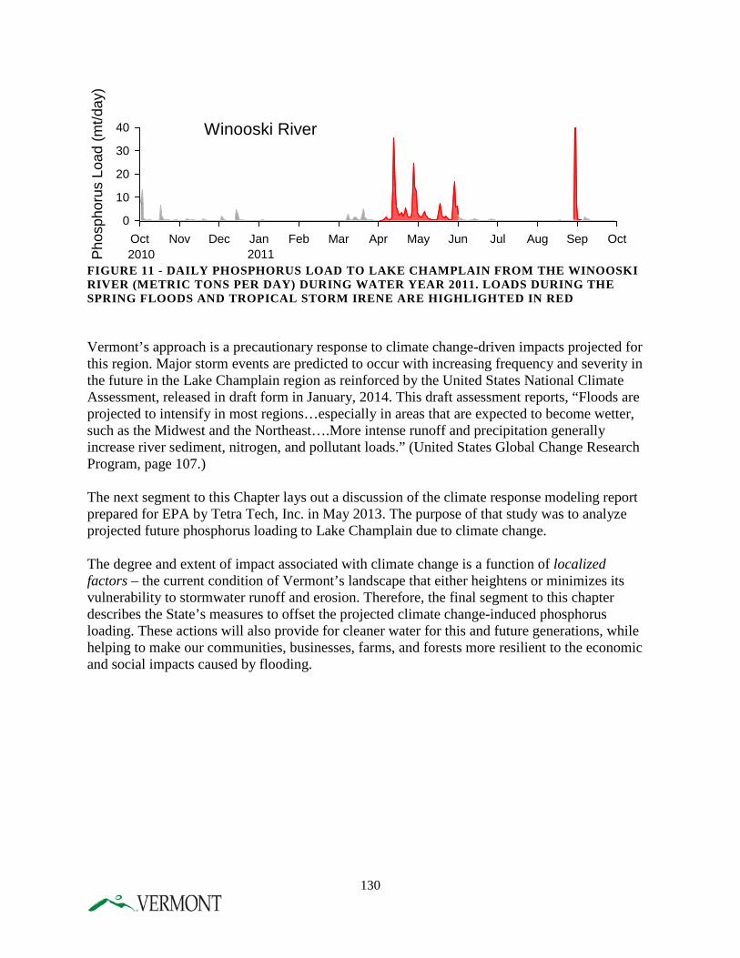
FIGURE 11 - DAILY PHOSPHORUS LOAD TO LAKE CHAMPLAIN FROM THE WINOOSKI RIVER (METRIC TONS PER DAY) DURING WATER YEAR 2011. LOADS DURING THE SPRING FLOODS AND TROPICAL STORM IRENE ARE HIGHLIGHTED IN RED Vermont’s approach is a precautionary response to climate change-driven impacts projected for this region. Major storm events are predicted to occur with increasing frequency and severity in the future in the Lake Champlain region as reinforced by the United States National Climate Assessment, released in draft form in January, 2014. This draft assessment reports, “Floods are projected to intensify in most regions…especially in areas that are expected to become wetter, such as the Midwest and the Northeast….More intense runoff and precipitation generally increase river sediment, nitrogen, and pollutant loads.” (United States Global Change Research Program, page 107.) The next segment to this Chapter lays out a discussion of the climate response modeling report prepared for EPA by Tetra Tech, Inc. in May 2013. The purpose of that study was to analyze projected future phosphorus loading to Lake Champlain due to climate change. The degree and extent of impact associated with climate change is a function of localized factors – the current condition of Vermont’s landscape that either heightens or minimizes its vulnerability to stormwater runoff and erosion. Therefore, the final segment to this chapter describes the State’s measures to offset the projected climate change-induced phosphorus loading. These actions will also provide for cleaner water for this and future generations, while helping to make our communities, businesses, farms, and forests more resilient to the economic and social impacts caused by flooding.
Winooski River
Oct Nov Dec Jan Feb Mar Apr May Jun Jul Aug Sep Oct
Pho
spho
rus
Load
(mt/d
ay)
0
10
20
30
40
2010 2011
130
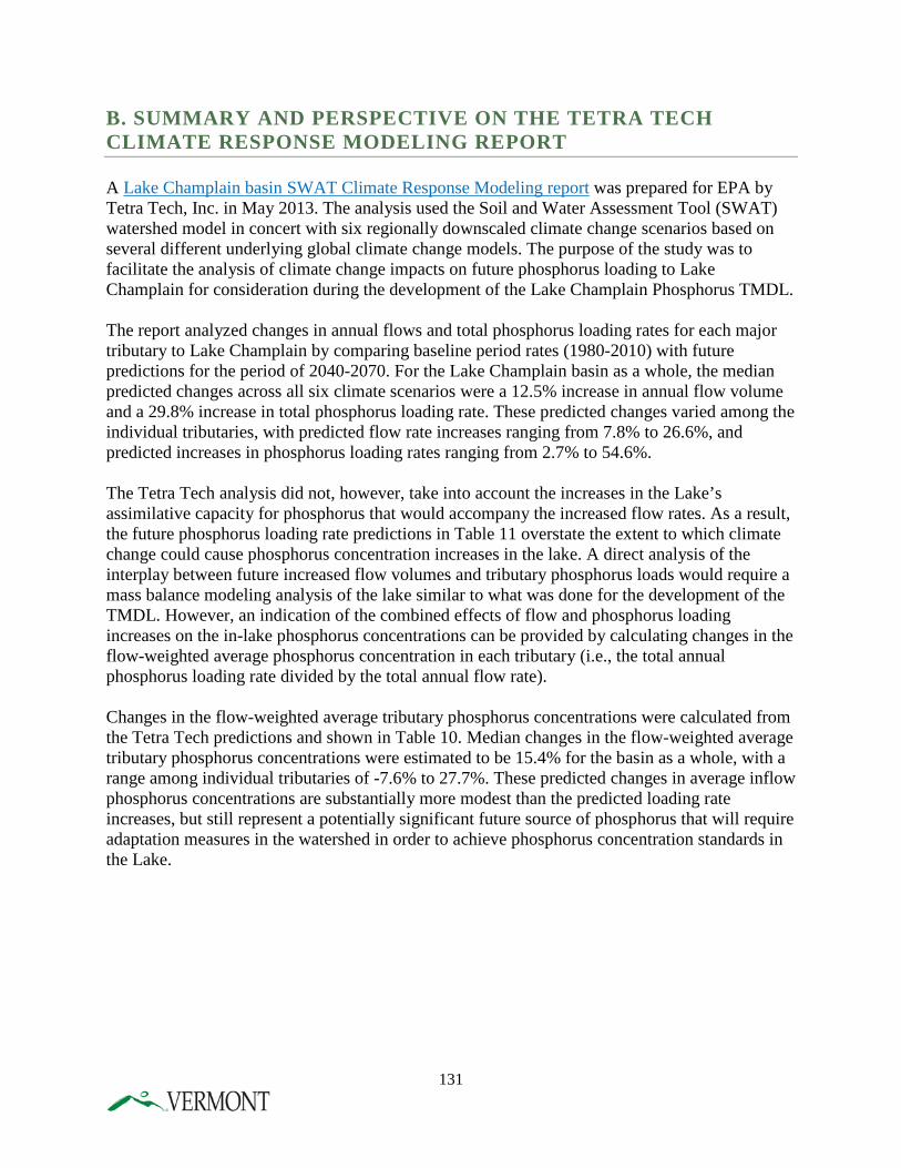
B. SUMMARY AND PERSPECTIVE ON THE TETRA TECH CLIMATE RESPONSE MODELING REPORT A Lake Champlain basin SWAT Climate Response Modeling report was prepared for EPA by Tetra Tech, Inc. in May 2013. The analysis used the Soil and Water Assessment Tool (SWAT) watershed model in concert with six regionally downscaled climate change scenarios based on several different underlying global climate change models. The purpose of the study was to facilitate the analysis of climate change impacts on future phosphorus loading to Lake Champlain for consideration during the development of the Lake Champlain Phosphorus TMDL. The report analyzed changes in annual flows and total phosphorus loading rates for each major tributary to Lake Champlain by comparing baseline period rates (1980-2010) with future predictions for the period of 2040-2070. For the Lake Champlain basin as a whole, the median predicted changes across all six climate scenarios were a 12.5% increase in annual flow volume and a 29.8% increase in total phosphorus loading rate. These predicted changes varied among the individual tributaries, with predicted flow rate increases ranging from 7.8% to 26.6%, and predicted increases in phosphorus loading rates ranging from 2.7% to 54.6%. The Tetra Tech analysis did not, however, take into account the increases in the Lake’s assimilative capacity for phosphorus that would accompany the increased flow rates. As a result, the future phosphorus loading rate predictions in Table 11 overstate the extent to which climate change could cause phosphorus concentration increases in the lake. A direct analysis of the interplay between future increased flow volumes and tributary phosphorus loads would require a mass balance modeling analysis of the lake similar to what was done for the development of the TMDL. However, an indication of the combined effects of flow and phosphorus loading increases on the in-lake phosphorus concentrations can be provided by calculating changes in the flow-weighted average phosphorus concentration in each tributary (i.e., the total annual phosphorus loading rate divided by the total annual flow rate). Changes in the flow-weighted average tributary phosphorus concentrations were calculated from the Tetra Tech predictions and shown in Table 10. Median changes in the flow-weighted average tributary phosphorus concentrations were estimated to be 15.4% for the basin as a whole, with a range among individual tributaries of -7.6% to 27.7%. These predicted changes in average inflow phosphorus concentrations are substantially more modest than the predicted loading rate increases, but still represent a potentially significant future source of phosphorus that will require adaptation measures in the watershed in order to achieve phosphorus concentration standards in the Lake.
131
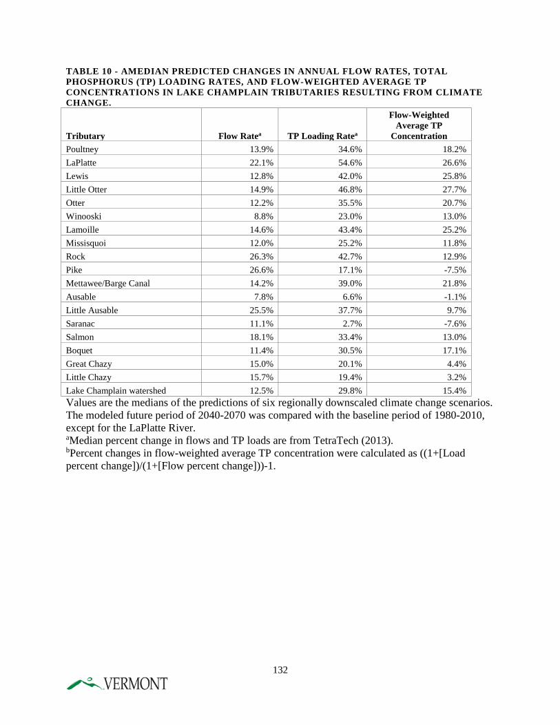
TABLE 10 - AMEDIAN PREDICTED CHANGES IN ANNUAL FLOW RATES, TOTAL PHOSPHORUS (TP) LOADING RATES, AND FLOW-WEIGHTED AVERAGE TP CONCENTRATIONS IN LAKE CHAMPLAIN TRIBUTARIES RESULTING FROM CLIMATE CHANGE.
Tributary Flow Ratea TP Loading Ratea
Flow-Weighted Average TP
Concentration Poultney 13.9% 34.6% 18.2% LaPlatte 22.1% 54.6% 26.6% Lewis 12.8% 42.0% 25.8% Little Otter 14.9% 46.8% 27.7% Otter 12.2% 35.5% 20.7% Winooski 8.8% 23.0% 13.0% Lamoille 14.6% 43.4% 25.2% Missisquoi 12.0% 25.2% 11.8% Rock 26.3% 42.7% 12.9% Pike 26.6% 17.1% -7.5% Mettawee/Barge Canal 14.2% 39.0% 21.8% Ausable 7.8% 6.6% -1.1% Little Ausable 25.5% 37.7% 9.7% Saranac 11.1% 2.7% -7.6% Salmon 18.1% 33.4% 13.0% Boquet 11.4% 30.5% 17.1% Great Chazy 15.0% 20.1% 4.4% Little Chazy 15.7% 19.4% 3.2% Lake Champlain watershed 12.5% 29.8% 15.4% Values are the medians of the predictions of six regionally downscaled climate change scenarios. The modeled future period of 2040-2070 was compared with the baseline period of 1980-2010, except for the LaPlatte River. aMedian percent change in flows and TP loads are from TetraTech (2013). bPercent changes in flow-weighted average TP concentration were calculated as ((1+[Load percent change])/(1+[Flow percent change]))-1.
132
C. ACTIONS TO MINIMIZE THE CURRENT AND FUTURE WATER QUALITY IMPACTS OF CLIMATE CHANGE The final segment to this Chapter discusses specific actions the State of Vermont will take to minimize current and future climate change-induced phosphorus load impacts. Most of these actions are already included as part of this Phase 1 Plan, since climate change is expected to exacerbate the contribution of nutrient loading from land-based, nonpoint sources. Along the theme of a “no-regrets” strategy, actions to minimize the water quality impacts of climate change in Vermont are comparable to actions that minimize impacts from stormwater runoff and erosion. AGRICULTURAL PROGRAMS
Background A robust agricultural-based economy is important to Vermonters. Agriculture in this State supports a working landscape that offers important aesthetic, cultural, environmental, and recreational benefits. Yet climate change poses a number of threats to the State’s agricultural economy. (The Potential Impacts of Climate Change on Agriculture in Vermont). The seasonal shift in temperature and precipitation patterns will affect not only water quality but also crop production, milk productivity and the spread of pests and pathogens. Increased erosion due to increases in precipitation amounts, frequency and intensity, and the resultant runoff is arguably the greatest concern to water quality impacts due to the soil and nutrient loss. However, as crop production is affected by increased temperatures and rainfall, producers may make crop management decisions, such as conversion of forested land to cropland. This could potentially increase the acreage to annual crops but may increase stormflows by as much as 10% (Hewlett, 1982). Producers may change to different crops that may have a greater or lesser ability to retain soil on fields (hayland versus annual crops). As increased crop production is needed, producers are increasing the acreage in tile drainage, which may decrease the nutrient runoff that occurs from field and gully erosion but can add dissolved phosphorus and hydrology concerns through high volume outflows. Actions Many of the current recommendations in Vermont’s policy commitments in this Plan will have a positive impact on water quality as climate change becomes a greater challenge in the future.
• The proposed changes to the AAPs will increase buffer widths, require buffers on field ditches, and require stabilization of field gullies. Increased precipitation will have a dramatic effect on field runoff and these requirements will substantially decrease the water quality impacts.
• Licensing of manure application operators will increase the knowledge of these companies, and require training and oversight that will decrease the over-application of manure in sensitive areas, and prior to heavy rainfall events.
• Additional agency inspectors will increase compliance of nutrient management and field practices
133

• An increase in the technical staff in the field to help implement good land practices such as reduced tillage, cover crops, and alternative manure management has already proven to be an asset to implementation of BMPs already proven to have value in water quality.
• Nutrient management planning will increase and be required on all farms. As a result all farms of a substantial size and/or animal density will be required to document their nutrient applications, soil tests, and other field practices that will decrease any potential for nutrient runoff.
• Focused outreach and BMP funds will be directed to critical source areas in watersheds of Missisquoi Bay, St. Albans Bay and South Lake. Upcoming maps developed with LiDAR technology allow for mapping of high potential runoff areas, down to partial field levels, and prior targeted outreach to these producers resulted in increased site-specific BMP implementation in Franklin County.
• Specific funding for Vermont, site-specific research into new technologies and methodologies will provide local information to producers to help with cost-effective management decision-making.
While these proposed commitments will all address increased precipitation and land use changes due to climate change, additional work is needed to ensure that farmers have the necessary education, tools and resources to address climate change impacts in a way that will improve water quality and protect their investments and livelihoods. It is also important that this work is done in a way that will address the individual needs of each farm, and recognize the human behavior impacts of implementing change. The Agricultural Work Group that was formed by DEC and AAFM to help develop the proposed changes in the TMDL, listed as one of their three priorities, strategies that allow farmers the option to develop “smart” tailored plans. They recognized that flexibility in programs and requirements is necessary to appropriately address the uniquely individual needs and concerns on Vermont farms. A timely recent survey conducted by the UVM RACC effort (Research on Adaptation to Climate Change), showed that the ability to have control over decisions was the most statistically significant driver in creating change, above the impact of regulatory control. In developing programs that will address future issues, providing options as well as resources will be critical to successfully protecting our water quality. Recommendations In determining how to efficiently move forward in addressing the temperature and rainfall effects of future climate change, three key areas stand out as having the greatest potential to help mitigate the potential negative impacts of climate change on water quality; soil health, tile drain issues, and increased implementation of key BMPs. Soil Health Improving soil health is a long-term process that provides extensive and multiple benefits in addressing climate change issues. Good soil health results in increased organic matter, increased soil pore space for water infiltration, increased soil water holding capacity, and decreased flow speed and volume to surface waters. Increased organic matter also helps address drought adaptation that also may result from climate change. For every percent increase in organic matter, another inch of water is available to plants, increasing production and decreasing the
134
need for additional land converted to crops (Emerson, 1995). Soil resiliency hinges on infiltration – rainfall that infiltrates does not run off, cannot cause erosion, and can potentially be stored for plant use. The major problem is not runoff but infiltration. Proposed actions
• Provide specific soil health training to outreach staff for their work with individual farmers.
• Increase demonstration projects and events to educate about biological approaches to compaction that can improve infiltration, specific soil quality BMPs and resources available to help with practice changes.
• Coordinate with UVM Extension Ag/Climate Change specialist on specific education programs for producers to increase knowledge of soil health.
• Coordinate with USDA/NRCS and their new healthy soils initiative “Unlock the Secrets of Soil”, which has extensive new educational materials and tools for helping farmers recognize the value of soil health.
• Use CSA mapping to evaluate priority areas for landscape infrastructure such as storage ponds that can increase water holding capacity that will address drought and prevents runoff of nutrients and sediment and related erosion. Use new personnel to work with landowners in key areas (potentially headwaters)
• Develop an incentive program that provides additional resources to producers who implement management changes that improve soil health. (This will be part of a larger incentive effort).
Tile Drains As farms increase in size, a need for increased production per acre is a factor in the dramatic increase in the installation of tile drains in many sections of the Lake Champlain basin. While there is no method for accurately tracking this practice, NRCS estimates as much as 50% of agricultural fields in some watersheds may contain tile drains (Potter, 2012). When installed and managed appropriately, tile drainage can be an important part of environmental farm management and can dramatically reduce soil erosion and phosphorus losses from fields by decreasing surface runoff and increasing infiltration (Fraser and Fleming, 2001). However, timing and quantity of field nutrient applications, as well as soil quality and installation methods all affect the impacts of tile drains. Many studies have shown that tile drain outflows can contain high levels of dissolved phosphorus as well as nitrogen. These levels can be affected by timing of manure application around rainfall events, and the macropores in the soil that affect nutrient passage through soil to the drains. Tile outflows can also negatively impact stream channels by increasing the velocity of outflow to the receiving water, and resulting soil erosion. Miner Institute in Chazy, NY is currently conducting an extensive research project on the impacts of tile drains and possible BMPs that may be implemented to address these. The Lake Champlain basin Program has recently allocated funds for a literature review of the subject to help inform policy makers, educators and producers about management of tile drains. USDA/NRCS recently added a practice standard (782) that will provide cost-share for systems that intercept tile flow and reduce the concentration of phosphorus to receiving waters. The State of Vermont is participating with the Franklin County watershed group, Friends of Northern Lake Champlain (FNLC) to conduct on-farm research evaluating different media as a treatment for tile
135
drain discharges. Each of these efforts has potential to improve the management of tile drains in Vermont and will be included in outreach and coordination.
Proposed actions • Conduct demonstration projects on Vermont farms in priority watershed to demonstrate
well-installed and managed tile drain systems, and compare water quality impacts. • Work with partners to develop an extensive education program on the impacts and
potential improvements to tile drain installation and management that would include an educational conference, factsheets, website additions and mailings.
• Provide training to outreach staff to assist them in providing education to producers and increase implementation of NRCS tile drain practice.
• Coordinate with partners to share results of tile drain research. INCREASE IMPLEMENTATION OF KEY BEST MANAGEMENT PRACTICES
Many traditional BMPs that improve water quality will also help in mitigating the effects of climate change. As rainfall amounts and intensity increase, these BMPs will become even more necessary and more valuable. Specific BMPs such as conservation tillage, buffers, cover crops and alternative manure management will help address these climate concerns. In one Vermont study, conservation tillage decreased agricultural stormwater runoff by between 50-63% (Claussen and Potter, 1990). A Canadian study showed that soil loss can decrease from 8 tons/acre/year on some fields with conventional tillage to less than 1 ton with no-till practices (Herbek, www2.ca.uky.edu). No-till practices can also increase organic matter in fields from 2.5 to 4.1% (Quarles, 1994). These particular BMPs help by decreasing field erosion, improving soil health and infiltration, and decreasing nutrient runoff. However, some of these practices require very site-specific adaption, resources and education. Transitioning from conventional to reduced or no-till requires individual technical assistance and an understanding of the long-term benefits. Alternative manure management technologies such as manure injection are extremely expensive and require financial assistance to producers. Larger buffers take valuable land out of production and compensation through programs such as CREP must be commensurate with the lost crop value. Cover crops in heavy clay soils can be challenging to implement in the time frame necessary for successful growth. Proposed actions
• Continue to secure necessary BMP, FAP and CEAP (equipment cost-share) implementation funds for specific practices.
• Incentivize practice implementation by providing additional funding and benefit opportunities for BMPs that are implemented in priority watersheds, sensitive riparian areas and other critical source areas. Development of a comprehensive incentive program (Environmental Stewardship Program) that will address priority areas will be done by 2016.
136
• Provide extensive outreach and education about the results of the “edge of field monitoring” research currently funded in Vermont that is evaluating critical BMPs in side-by-side watershed studies.
• Provide adequate ongoing training for technical staff about BMP information, available resources and site-specific implementation opportunities.
Summary Vermont is fortunate to have current support from partners and other agencies that will provide assistance in our ability to share timely and appropriate new technologies and practices to address climate change in the future. The “edge of field monitoring” project that was funded with USDA/NRCS funds is an example of this. UVM Extension hired an agricultural climate change expert in 2013 who has brought educational and research knowledge and opportunities from the Chesapeake Bay area. USDA Secretary Vilsack recently announced that one of the national “climate hubs” will be located in Durham, NH, and will build capacity to provide information and guidance on technologies and risk management practices at the regional and local scale to partners and producers. DEC and AAFM also intend to continue to recruit funds for additional outreach methods such as online training programs for producers, demonstration sites and educational workshops and materials to provide a diverse and flexible way for all producers to receive knowledge and technical assistance. STORMWATER MANAGEMENT
Background Climate change, stormwater runoff and phosphorus loading are inextricably linked. The intensity of precipitation events has a direct impact on the amount of stormwater runoff generated from impervious and semi-impervious surfaces. This in turn has a direct impact on erosion and sedimentation rates, the pollutant removal and detention capacity of existing BMP’s, and the integrity of critical infrastructure such as bridges and culverts. This relationship has significant implications for stormwater management in Vermont. Currently, any project that exceeds the jurisdictional threshold for stormwater in Vermont is required to adhere to the standards set forth in the Vermont Stormwater Management Manual (VSMM). The current version of the VSMM was adopted in 2002 and presents a unified approach for designing and sizing stormwater treatment practices to meet specified treatment standards for water quality, channel protection, groundwater recharge, overbank flood protection, and extreme flood control. The unified sizing approach is intended to manage the entire frequency of storms anticipated over the life of the stormwater management system and the associated development. From a climate change/flood resilience perspective, there are two issues associated with the current version of the VSMM:
• Under the unified sizing approach, stormwater treatment practices are designed according to a targeted design storm. The magnitude of the design storm is based on a probability distribution of observed precipitation events over a period of many decades. These
137
precipitation values may not reflect the trend of greater frequency of severe storm events throughout the Northeast. The Vermont Stormwater Management Manual incorporated most recent available data at the time of adoption. Since this time, more recent data including data published by the Northeast Regional Climate Center at Cornell (“Extreme Precipitation in New York and New England.”)
The Vermont Stormwater Management Manual was adopted prior to the common use of terms like “LID” and “GSI.” However, the Manual includes a range of practices intended to minimize the creation of impervious surfaces, and to allow for the management of runoff through disconnection and infiltration. These practices were state of the art at the time of adoption, but do not represent all the advances that have been made in stormwater management since 2002.
• Reducing water quality impacts from road runoff is another strategy described in this plan with climate resilience benefits. Prior to federally declared disaster declarations (which make available public assistance funds for public infrastructure repairs), municipalities are to adopt road infrastructure “codes and standards” (referred to as “Road and Bridge Standards” or “Codes and Standards”). These municipal codes and standards apply to road and stream crossing upgrades and other infrastructure that are not governed by state or federal standards.
Actions DEC’s Stormwater Program has identified six major actions – five are associated with managing stormwater infrastructure development and the sixth action addresses runoff from road networks. The first five actions that address permitted stormwater infrastructure ensure that such projects are appropriately designed and adequately sized to effectively manage predicted increases in stormwater runoff. Stormwater systems designed and managed per standards that incorporate current precipitation data as well as LID and GSI, ensure resilience against increases in higher intensity precipitation, higher precipitation volumes, and snowmelt events. The sixth action includes incentivization of adoption and compliance with VTrans Road and Bridge Standards. (Act 110, passed in 2010, required that VTrans undergo rulemaking to include in the model Road and Bridge Standards practical and cost-effective best management practices to better control road-related stormwater runoff), as well as the newly-passed requirement for DEC to develop a stormwater general permit for all municipal roads:
• Require recent and localized rainfall data, where possible, to size stormwater practices. An important step toward greater climate adaptation and flood resilience is to ensure that any permitted stormwater system is designed and sized using data that accurately reflects precipitation trends in the Northeast. This data should include: (a) current data and the past 10 years of record; (b) local and regional precipitation data, including the Northeast Regional Climate Center Extreme Precipitation data; and (c) where appropriate, location-specific data to account for regional variation in precipitation patterns.
• Promote greater use of LID principles and GSI practices in the VSMM. LID is focused on avoiding and minimizing impacts to natural features and functions to reduce the amount of stormwater runoff generated both during and after construction. LID places a
138
high value on hydrologic and ecological function, recognizing that those functions are difficult, if not impossible, to replace if lost through development. Requiring LID ensures that stormwater runoff resulting from new development is minimized. This helps to reduce flashy streamflow regimes, caused by stormwater runoff, that can increase stream instability and pollutant loading from streambank bed and bank scouring.
• Promote GSI practices where minimization is not possible. GSI can be used in new development and redevelopment situations. GSI takes advantage of natural processes to treat and manage stormwater. Where soils are adequate, stormwater runoff from small and even large storms can be fully infiltrated into the ground by GSI, thus reducing the volume of water traveling as surface flow. In marginal soils, engineered soil media and soil restoration techniques (aeration, organic amendments, etc.) can be used to increase infiltration rates and improve soil water retention, thus decreasing excessive flows. Those GSI practices that include robust vegetation provide additional resilience to climate change through interception and evapotranspiration, which can collectively amount to a large export of water from the land surface. Where vegetation remains healthy and conditions are suitable, evapotranspiration rates in particular can be significant, sometimes even exceeding precipitation rates, especially during the growing season. This results in a soil column with greater capacity to infiltrate and absorb stormwater runoff during subsequent storms.
• The Stormwater Program is currently updating the VSMM to incorporate and incentivize LID and GSI concepts. As described in a University of New Hampshire study entitled, “Economic and Adaptation Benefits of Low Impact Development,” successful application of GSI has the potential to reduce stormwater runoff enough to reduce the need for conventional and costly drainage and treatment infrastructure, reduce the number of culverts deemed undersized that otherwise would need to be replaced, improve onsite storage of rainwater and snowmelt that can reduce and delay the runoff peak discharge, and minimize hydrologic impacts to the stream channel from stormwater runoff.
• Promote adoption of state stormwater standards at the local level and work to develop and disseminate model stormwater ordinances. These actions will help to address stormwater runoff associated with new developments that fall below state stormwater management jurisdiction.
• All municipalities in the Champlain basin are required to have coverage under the
municipal roads general permit by 2021. This permit program will build on the existing incentivization program managed by VTrans by requiring development and implementation of road management plans that address road and drainage erosion, and that promote substantially-enhanced resilience to precipitation events that cause road infrastructure failure as well as pollutant discharges. Technical assistance will be provided by a coalition of partners providing expertise on planning, transportation, water quality, and river science. :
RIVER CHANNEL STABILITY
139
Background With the increased risk of severe weather events causing water quality degradation as well as economic and public safety impacts, it becomes increasingly important to manage rivers to meet and maintain dynamic equilibrium conditions. Equilibrium refers to the condition in which a stream channel achieves a naturally stable slope, meander pattern, channel dimensions (width and depth), and access to its floodplain. This condition is the least erosive, even at flood stage. This policy requires that floodplains and river corridors are protected and reserved for flooding, and that stream channels themselves are managed in ways that are consistent with the objective of achieving equilibrium conditions over time. Well-functioning floodplains under an equilibrium condition keep people and infrastructure out of harm’s way, reduce property damages and flood recovery costs, reduce the need to channelize rivers in order to protect encroachments and, specific to the Lake Champlain TMDL’s goals, reduce nutrient and sediment loading by minimizing erosion. Actions The following commitments described in this Phase 1 Plan support the State policy to manage rivers towards long-term establishment and maintenance of dynamic equilibrium:
• Reserve, restore, and maintain floodplains and river corridors for flood storage and pollutant attenuation by minimizing floodplain encroachment:
o Established a river corridor easement program to conserve river reaches identified as high priority nutrient and sediment attenuation areas. The key provision of a river corridor easement is the purchase of channel management right;
o Act 110 (enacted in 2010, effective 2011) established, as State policy, the management of rivers and streams to achieve and maintain dynamic equilibrium, the least erosive and naturally stable stream condition. The Act established a river corridor and floodplain management program, integrating floodplain management under the FEMA National Flood Insurance Program with fluvial erosion hazard avoidance, river corridor, buffer protection, and river science;
o Act 138 (effective 2012), directs ANR to create new state floodplain rules for activities exempt from municipal regulation, increase regulatory oversight and technical assistance in floodplain protection, and improve floodplain mapping;
o Act 138 also directs the creation of a Flood Resilient Communities Program to create financial incentives to encourage municipal adoption of bylaws that protect river corridors, floodplains, shorelands, and buffers;
o The State policy for managing the State’s Emergency Relief and Assistance Fund (ERAF), described above, added an incentive to encourage municipal adoption of the state model floodplain and river corridor protection bylaws; Effective in October, 2014, those municipalities that adopt such measures will receive a large share of state aid (from 12.5% to 17.5% of the repair costs) following federally declared flood disasters; and
o Act 16, enacted in 2013 and effective in 2014, requires that municipal and regional land use plans include protection and restoration of floodplains and upland forested area in order to moderate impacts from flooding.
140
• Ensure that stream alteration activities are aligned with and do not depart from attainment of stream equilibrium condition:
o Act 110 also modified stream alteration statutes expanding state jurisdiction to all perennial streams (i.e., those with year-round flows). Prior to Act 110, the regulations only applied to streams with a watershed greater than 10 square miles;
o Act 138 required the adoption of rules and a stream alteration general permit to regulate Emergency Protective Measures (effective in 2014);
o Effective in 2014, the VTrans Road and Bridge Standards, clarify that the VTrans Hydraulics Manual (which provide the VTrans technical analysis for sizing of stream crossings), and the Stream Alterations General Permit, are aligned to support the management of streams, including stream crossings, to achieve equilibrium conditions. Sizing stream crossings based on equilibrium conditions minimize erosion, scour, and structure failure. It also improves connectivity that supports aquatic organism passage;
o Act 138 required that DEC develop a comprehensive “rivers and roads” training program. The targeted audience includes municipal, state and federal transportation network professionals, municipal employees, regional planning commissions and contractors. The goal of the training program is to explain how to design, construct and maintain roads and bridges to create greater river stability and more flood resistant transportation infrastructure. DEC, in partnership with VTrans and FWD, is developing a three-tiered training course. Tier 1 (introductory level) and Tier 2 (intermediate level) are currently available; Tier 3 (advanced level) training, focused on design and construction, will be available in early 2015. DEC will release in 2014 a document entitled, “Standard River Management Principles and Practices: Guidance for Managing Vermont’s Rivers Based on Channel and Floodplain Function.” This document will serve as the technical foundation and reference document for the Tier 3 training.
• Restoring and protecting native woody vegetation in riparian buffers; o Increases in nutrient and sediment pollution loading, unstable streambanks, and
loss of ecological function result when woody riparian vegetation if removed from the riparian or near stream area. Best management practices entail restoring and maintaining an undisturbed area that consists of trees, shrubs, groundcover plants, and the duff layer. ANR adopted Riparian Buffer Guidance in December, 2005, which articulates a framework for Agency recommendations in the Act 250 process. The Agency is currently updating the Buffer Guidance in tandem with adopting River Corridor Procedures and revising the Agency Floodway Procedures used in Act 250.
141
CLIMATE-SMART FOREST ADAPTATION STRATEGIES
Background Forest management has been based on an historical understanding of forest response to given treatments. Under climate change, meeting forest management goals is less certain than it has been in the past. Increased temperatures, heavy precipitation events, mild winters, and extreme wind and ice storms are all predicted to increase. The best risk management at this point in time is to manage forests to be more resilient to a variety of weather conditions, and to build forest harvest plans that account for extreme weather influences. Actions Publish and distribute the draft forest adaptation strategy document: “Creating and Maintaining Resilient Forests in Vermont: Adapting forests to climate change.”
1. Promote recommended forest adaptation strategies to foresters and landowners to implement climate-smart practices that maintain healthy forest cover, sustain ecological functions such as water holding capacity of forests, and promote water quality.
2. Develop and implement a policy to use climate-smart forestry practices on state lands. 3. Create funding priorities through the Working Lands Initiative (Working Lands
Enterprise Fund (WLEF)) for new forest harvesting technologies that improve protection of soil and water.
4. Establish 3 demonstration areas on state land to train foresters and landowners on climate-smart forest management techniques that can then be implemented on the 86% of Vermont’s forestlands that are privately owned.
5. Identify vulnerable forest stands within the Lake Champlain basin, develop forest health strategies to maintain forest cover and water holding capacity, and identify funding to implement strategies on priority forests.
WETLAND PROTECTION AND RESTORATION
Background Global wetlands store carbon at an amount similar to total atmospheric carbon. Wetlands are able to accumulate carbon from agriculture, forestry, and other land uses by storing sediment and organic materials. The emission of carbon dioxide is slowed by vegetation intake of carbon and by the anaerobic conditions which slow organic decomposition by hundreds or thousands of years. Studies have estimated that 6% of global carbon emissions can be attributed to the destruction of artic and tropical peatlands alone. The protection and restoration of wetlands is a crucial component in offsetting climate change impacts in Vermont. Wetlands are more sensitive to climate change than other landscape and deep water features in Vermont. A change in inches in water table depth can cause the presence or absence of a wetland in marginally wet sites. Wetland fragmentation and low biodiversity make many wetland plant communities less robust and adaptable to changes in climate. Vermont wetlands which are especially sensitive to climate change include: peatlands, seasonal wetlands (including vernal pools), spruce/fir swamps, wetlands with small watersheds, and wetlands surrounded by high nutrient and sediment load.
142
Climate impacts on wetland functions are expected to be significant, including hydrologic stresses from earlier spring runoff and hotter and drier summer months. Less consistent precipitation will expose peatlands and cause an increase in carbon dioxide release due to faster decomposition. More intense storm events will increase sediment and pollutants which may overwhelm the water quality protection function of the wetland. Stressors to wetland plant communities will make wetlands more susceptible to invasive species adapted to warmer climates. Loss or degradation of wetland function could, in turn, degrade water quality of the streams and lakes that benefit from the wetlands’ natural filtering capacity. The expected increased groundwater withdrawal to support future irrigation needs, brought about from climate change-induced drier summer months may also lead to further wetland loss. Wetland management, conservation, and restoration are effective and cost-effective climate adaptation strategies that:
• Enhance wetlands’ filtering capacity of pollutants; • Reduce carbon dioxide emissions; • Minimize flood hazards by absorbing and attenuating floodwaters; • Protect populations of species at their range extent; • Promote groundwater recharge, which, in turn supports base flow in streams, which is
particularly important during hotter and drier summer months; and, • Sustain fish and wildlife habitat and support recreational activities that depend on them.
Programs to support the restoration and maintenance of vegetated buffers along waterways are also important strategies that:
• Reduce sediment load in waterways by slowing water velocities and stabilizing banks; • Support cold-water aquatic organisms through shading; • Increase resilience of native plant communities by preventing invasive plant
establishment; • Protect adult habitat of sensitive vernal pool dependent species; and, • Increase and maintain carbon sequestration by vegetation.
Actions Promote wetland conservation and restoration:
• Promote adequate buffers and protection to maximize their capacity to attenuate floodwaters, sediment and pollutants. DEC is able to change size of wetland buffers to accommodate this need;
• Focus protection and restoration efforts on wetlands which effectively sequester carbon, such as bogs. DEC has identified several peatlands throughout the State and will increase their protection standards. In 2012, the Wetlands Program established centennial sites to monitor and study climate change impacts to wetlands;
• Establish a wetlands technical assistance program to implement wetlands conservation and restoration projects with local and federal partners; and
• Strengthen wetland protection statute o Act 31 (enacted in May, 2009) strengthened the State’s wetlands protection
statute, to give DEC the authority to conduct: (a) administrative determinations to
143
re-classify wetlands; (b) update wetland mapping, and, (c) interpret jurisdictional buffer zone widths to accommodate wetland function needs.
SHORELAND MANAGEMENT
Background Shoreland management plays an important role in providing climate change resiliency along lakeshores. Naturally vegetated shoreland are known to be more resistant to erosion during flooding events. Eroding shorelands are a source of sediment and phosphorus to the lake, although the exact quantity of these pollutants due to shoreland erosion has not been studied or estimated. During the spring of 2011 floods in Lake Champlain, shoreland erosion was much more common in areas where the woodland had been removed and replaced with lawn, than in areas where natural vegetation had been left in place. Structural stabilizations can deflect wave energy to adjacent shore areas, thus increasing erosion potential on neighboring properties. In addition, structural stabilization measures were in some cases overtopped by the flood waters and eroded from behind. Well vegetated shorelands provide sustainable stability by making use of the “ecosystem services” of a variety of species and root types which resist erosion due to high water level and wave action. Numerous trunks and stems absorb and break up wave energy, minimizing its impact on the soil layer itself. Shoreland which are yet undeveloped generally has reached an equilibrium where erosion is minimal or non-existent. Where development or other land uses have removed the woodlands, stabilization measures may need to be implemented. Bio-technical and bio-engineering designs can be used to implement stabilization projects. Such projects are ideally designed to mimic the natural shore and be self-sustaining over time. Actions Promote well vegetated shorelands as sustainable erosion prevention along Lake Champlain:
• Require the use of stabilization methods that incorporate vegetation through the Lake Encroachment Program or the Shoreland Permit Program ;
• Provide technical and grant support to project demonstrating and implementing vegetative shoreland stabilization measures;
• Incorporate BMPs for vegetative shoreland stabilization measures into the Lake Wise Program to provide technical assistance to landowners; and
• Continue to coordinate with the River Management Program on the development of model municipal shoreland ordinances that meet federal flood protection standards and provide good shoreland management to benefit both flood resiliency and pollution abatement.
144
D. CONCLUSION Vermont faces important decisions about how to effectively minimize or avoid impacts from climate change. In 2010, The Nature Conservancy published a report entitled, “Climate Change in the Champlain Basin: What natural resource managers can expect and do.” (Stager, J.C, M. Thill, 2010). That report’s conclusions underscore an important message that the best strategies to minimize undesirable impacts from climate change are already known; such strategies do not require a new set of conservation tools. That report provides a comprehensive list of climate-ready strategies, among which are the following that address the anticipated water quality impacts from climate change:
• Acceleration of best management practices across land uses to reduce runoff and erosion; • Stormwater control structures that reduce erosion and nutrient transport; • Stormwater control regulations that use the current precipitation period of record; • River corridor and floodplain protection; • Policy that supports establishment and maintenance of stream equilibrium conditions; • Re-establishment and maintenance of vegetated buffer zones along rivers, wetlands, and
lakes to support streambank integrity, minimize erosion and runoff, and provide shade; • More accurate flood hazard mapping; • Wetland conservation; • Ecologically sound and sustainable shoreland erosion mitigation strategies, • Forestland conservation; and, • Public education.
The climate change policy recommendations described in this Chapter incorporates all of these recommendations. Climate change is projected to increase intensity and frequency of storm events, thereby exacerbating the delivery of phosphorus loading to Lake Champlain from existing, traditional sources or stressors. The three major stressors that comprise most of the nutrient loading to Lake Champlain, described in the Vermont Surface Water Management Strategy include: (a) land erosion from developed lands, agricultural lands, construction, and logging operations; (b) non-erosion-related nutrient loading from sources such as over-fertilization of cropland or poor manure management practices; and (c) stream channel erosion. Promoting greater resilience in the Lake Champlain basin to the water quality impacts of climate change requires actions that reduce loadings from these traditional stressors. Actions described in this Chapter are designed to accomplish that objective. These actions also enhance flood resilience locally and statewide – a top priority of the State and an important “co-benefit” of the implementation of the Lake Champlain TMDL. Thus, investments in the implementation of this Plan to achieve clean water will also pay dividends in contributing toward reduction in the State’s vulnerabilities to climate change.
145
CHAPTER 7 - IMPLEMENTATION SCHEDULE AND ACCOUNTABILITY FRAMEWORK DEC is requesting a twenty year implementation schedule to allow for communities to plan and stage the necessary improvements to roads and stormwater infrastructure into long-term capital fund plans as a means of keeping costs and funding burdens down. DEC is proposing the following general schedule for implementation of the TMDL:
1. Department seeks authority and funding for implementation of the Phase 1 Plan 2014-2015
2. Department develops and implements Phase 2 Plans for each basin (tactical basin plans) 2016-2036
Detailed implementation schedules for Vermont’s policy commitments are included in the Gantt Chart in the Executive Summary. EPA views the Phase 1 and Phase 2 Plans as the core of a broader, ongoing accountability framework by which EPA will assess Vermont’s progress toward fulfilling the pollution reduction targets identified in the final TMDL. In its January 17, 2014 letter, EPA asked that Vermont discuss the State’s commitment to track implementation progress and to enter both BMP installations and programmatic progress into a tracking tool that EPA is helping to develop. DEC is proposing a schedule including five year milestones for reporting and evaluating progress towards goals in the implementation plans. EPA indicated in its January 17, 2014 letter that consequences for failing to make adequate progress could involve (a) requiring wastewater treatment plants to meet phosphorus effluent limits based on limits of technology and to obtain offsets for the remaining phosphorus loads, and (b) expansion of federal Clean Water Act permit coverage to cover a larger scope of activities (separate storm sewer systems, developed areas subject to residual designation authority, and animal feedlot operations).
As discussed previously in Chapter 5, DEC intends to develop the capability to track BMP implementation for non-agricultural BMPs, to complement ongoing efforts by the agricultural resource agencies to develop an agricultural BMP tracking system. DEC will develop a system to document the location and value of all BMP projects supported by federal or state dollars, which will be tied to the Critical Source Area Assessment System. Using data exchange capabilities, implementation projects tracked by the agricultural BMP database will also eventually be married to DEC’s system. In addition, for road network projects, DEC will incorporate BMP tracking either directly, or through data exchange approaches, in partnership with VTRANS.
In order to track numeric estimates of phosphorus reductions achieved, VT will partner with EPA, by leveraging the EPA Scenario Tool discussed in Chapter 5, and the proposed EPA spreadsheet-based tracking tool. The Scenario Tool presents a range of BMP effectiveness values and anticipated load reductions for a suite of BMPs. The spreadsheet tool is intended to translate these into phosphorus reduction estimates. Vermont is committed to developing and maintaining robust data systems to track implementation of projects and program commitments, and will work with EPA to translate these to phosphorus load reductions.
146
REFERENCES Betts, A. K. 2001a. Vermont Climate Change Indicators. Weather, Climate and Society 3:106-115. Dupigny-Giroux, Lesley-Ann. Personal Communication, March 30, 2014. Vermont State Climatologist, Department of Geology, University of Vermont. Hayhoe, K., C.P. Wake, T.G. Huntington, L. Luo, M. Schwartz, J. Sheffield, E. Wood, B. Anderson, J. Bradbury, A. DeGaetano, T. Troy, and D. Wolfe. 2007. Past and future changes in climate and hydrological indicators in the U.S. Northeast. Climate Dynamics 28:381-407. Karl, T.R., J.M. Melillo, and T.C. Peterson, (eds). 2009. Global Climate Change Impacts in the United States. Cambridge University Press, 189 pp. Available online: http://www.globalchange.gov/publications/reports/scientific-assessments/us-impacts Stager, J.C. and Thill, M. 2010. Climate Change in the Champlain Basin: What natural resource managers can expect and do. The Nature Conservancy. TNC/NEAFWA. 2011. Northeast Terrestrial Habitat Mapping Project. Union of Concerned Scientists (UCS). 2006a. Climate Change in the U.S. Northeast – A Report of the Northeast Climate Impacts Assessment. Available on line: http:www.climatechoices.org/assets/documents/climatechoices/NECIA_climate_report_final.pdf Union of Concerned Scientists (UCS). 2006b. Vermont – Confronting Climate Change in the U.S. Northeast. Available online: http:www.climatechoices.org/assets/documents/climatechoices/Vermont_necia.pdf United States Environmental Protection Agency, “Lake Champlain basin SWAT Climate Response Modeling,” May 2013. Available online: http://www.epa.gov/region1/eco/tmdl/pdfs/vt/SWATModelClimateResponseReport.pdf United States Global Change Research Program, United States National Climate Assessment, draft January 2014. Available on-line: http://ncadac.globalchange.gov/ Vermont Agency of Natural Resources, “Climate Change Adaptation Framework,” Prepared by Tetra Tech. May, 2013. Available online: http://www.anr.state.vt.us/anr/climatechange/Pubs/2013.0610.vtanr.NR_CC_Adaptation_Framework_Report.pdf Vermont Agency of Natural Resources, “Resilience: A Report on the Health of Vermont’s Environment,” 2011. Available online: http://www.anr.state.vt.us/anr/envrptsb/ANREnvReport2011.pdf
147
Vermont Agency of Natural Resources, Department of Environmental Conservation, “Statewide Surface Water Management Strategy, May, 2011. Available online: http://www.watershedmanagement.vt.gov/swms.html Vermont Division of Emergency Management & Homeland Security, “Irene: Reflections on Weathering the Storm.” Available online: http://vtstrong.vermont.gov/Portals/0/Documents/2013-IRO-final-report.pdf
Vermont Agency of Natural Resources, “Tropical Storm Irene: By the Numbers.” Available on line: http://www.anr.state.vt.us/anr/climatechange/IreneByTheNumbers.html
148


