
sartori environmental services 106‐185 forester street, north vancouver, bc v7h 2m9 tel 987.5588 fax 987.7740 email [email protected]
UpperLillooetHydroProjectWeeklyEnvironmentalMonitoringReport#34
Reporting Period: August 10th – August 16th, 2014
UpperLillooetRiverHydroelectricFacility(WaterFileNo.2002561,WaterlicenceNo.C130613),BoulderCreekHydroelectricFacility(WaterFileNo.2003049,WaterlicenceNo.
C129969)&TransmissionLine(TXLine)
Distribution List Prepared By
Name Organization
Trevor Andrews
James Davies
Danielle Cunningham
Frank DeGagne
Nathan Braun
George Steeves
Jennifer McCash
Thomas Hicks
Peter Ramsden
Oliver Robson
Greg Davis
Julia Mancinelli
Jackie Boruch
Liz Scroggins
Bas Brusche
Matt Kennedy
Renaud DeBatz
Richard Blanchet
Claude Denault
Jonathan Drapeau
Éric Ayotte
Jordan Gagne
Ian McKeachie
D’Arcy Soutar
Pontus Lindgren
Harriet VanWart
Fisheries and Oceans Canada
MFLNRO – Water Allocation
MFLNRO – Land and Resources
MFLNRO – Land and Resources
BC Environmental Assessment Office
True North Energy – Independent Engineer
True North Energy – Independent Engineer
Sartori Environmental Services
Innergex Renewable Energy Inc.
Innergex Renewable Energy Inc.
Innergex Renewable Energy Inc.
Innergex Renewable Energy Inc.
Innergex Renewable Energy Inc.
Innergex Renewable Energy Inc.
Innergex Renewable Energy Inc.
Innergex Renewable Energy Inc.
Innergex Renewable Energy Inc.
Innergex Renewable Energy Inc.
CRT-ebc Construction Inc.
CRT-ebc Construction Inc.
CRT-ebc Construction Inc.
CRT-ebc Construction Inc.
CRT-ebc Construction Inc.
Westpark Electric Ltd.
Westpark Electric Ltd.
Lil’wat Nation
J. Alex Sartori, RPBio Independent Environmental Monitor (IEM)
J. Stephen Sims, RPBio Delegated IEM
Date Prepared: August 27, 2014
Date Submitted: August 29, 2014

Upper Lillooet Hydro ProjectWeekly Environmental Monitoring Report
sartori environmental services 106‐185 forester street, north vancouver, bc v7h 2m9 tel 987.5588 fax 987.7740 email [email protected]
Owner Construction Permits and Approvals
Environmental Assessment Certificate No.E13-01 (Amendment 1, 2, 3 & 4) Fisheries Act Subsection 35(2)(b) Authorization No. 09-HPAC-PA2-000303 (Amendment 1)
Letter of Advice for the Transmission Line No. 09-HPAC0-PA2-000303 Leave To Commence Construction (ULRHEF) File No. 2002561 Leave To Commence Construction (BDRHEF) File No. 2002453
Leave To Commence Construction (TX Line) File No. 2002561/2002453 Conditional Water Licence (ULRHEF C130613) File No. 2002561 Conditional Water Licence (BDRHEF C129969) File No. 2002453 Conditional Water Licence (BDRHEF C131153) File No. 2003601
Licence of Occupation (ULRHEF #232384) File No. 2409871 Licence of Occupation (BDRHEF #232386) File No. 2409998 Licence of Occupation (TX Line #2423386) File No. 2410654
Occupant Licence to Cut (ULRHEF Amendments 1, 2, 3, 4) No. L49717 Occupant Licence to Cut (BDRHEF – km 38 laydown) No. L49698 Occupant Licence to Cut (BDRHEF Amendments 1, 2) No. L49816 Occupant Licence to Cut (TX Line Amendment 1, 2, 3) No. L49697
General Wildlife Measure Exemption Approval Letter (TX Line & BDRHEF) File No. 78700-35/06 UWR and 39585-20 WHA
Heritage Conservation Act – Alteration Permit (ULRHEF) File No. 11200-03/2014-0033 Road Use Permit No. 6123-13-02 (Lillooet River FSR); 5673-13-01 (Rutherford Creek FSR); 7977-13-01 (Lillooet South FSR); 8015-13-01 (Ryan River); 8188-13-01 (Pemberton Creek FSR); and 9717-13-01 (Miller Bench FSR)
Junction Permit (ULRHEF & BDRHEF) File No. 11250-32/6123 (Amendment 1) Aeronautical Obstruction Approval (Tx Line - Lillooet River Crossing) File No. 2013-004
Aeronautical Obstruction Approval (Tx Line - Ryan River) File No. 2013-005 Aeronautical Obstruction Approval (Tx Line - North Miller) File No. 2013-006 Aeronautical Obstruction Approval (Tx Line - South Miller) File No. 2013-007
Aeronautical Obstruction Approval (Tx Line - Pemberton Creek) File No. 2013-008 Aeronautical Obstruction Approval (Tx Line - Lillooet River near Pemberton) File No. 2013-009
Aeronautical Obstruction Approval (Tx Line - Lillooet River near Meager Creek) File No. 2013-010 Navigable Water Protection Act (ULRHEF) File No. 8200-2009-500434-001 Navigable Water Protection Act (BDRHEF) File No. 8200-2012-501-032-001
Navigable Water Protection Act (Tx Line – North Creek) File No. 8200-2013-500103-001 Navigable Water Protection Act (Tx Line – Lillooet River) File No. 8200-2013-500101-001 Navigable Water Protection Act (Tx Line – Lillooet River) File No. 8200-2013-500102-01 Navigable Water Protection Act (Tx Line – Ryan River) File No. 8200-2013-500104-001
Navigable Water Protection Act (Tx Line – South Miller River) File No. 8200-2013-500100-001 Navigable Water Protection Act (Tx Line – Boulder Creek) File No. 8200-2013-500099-001
Navigable Water Protection Act – Extension Approval (ULRHEF, BDRHEF, Tx Line) Navigable Water Protection Act (Bridge – Ryan River) File No. 8200-2013-500381
Navigable Water Protection Act (Bridge – Upper Lillooet Side Channel; Extension Approval) File No. 8200-2013-500383
Section 57 Authorization (ULRHEF) File No. 16660-20/REC202717 SLRD Temporary Use Permit No. 34 – Boulder Creek HEF
SLRD Temporary Use Permit No. 35 – Upper Lillooet River HEF Works Permit for Construction within FSR Right-of-Way No. 6123-14-01
Section 52(1)(b) FRPA Authorization for Ryan River Wet Crossing File No. FOR-19400-01/2014
Upper Lillooet Hydro ProjectWeekly Environmental Monitoring Report
sartori environmental services 106‐185 forester street, north vancouver, bc v7h 2m9 tel 987.5588 fax 987.7740 email [email protected]
Contractor Construction Permits and Approvals
Magazine Licence File No. UL76018 Section 8 Approval – Short Term Use of Water File (Lillooet River and Tributaries) No.A2006123 (Amendment 1)
Waste Discharge under the Code of Practice for the Concrete and Concrete Products Industry under the Environmental Management Act (Authorization No. 107204) Tracking No. 326969
Wildlife Act Permits – Pacific Tailed Frog Salvage Permit # SU14-95304 &SU13-90538, Fish Salvage Permit # SU14-95329
Section 52 of the Fisheries (General) Regulations – Fish Salvage Licence #XR 139 2014 BC Safety Authority – Temporary Construction Electrical Service Permit EL-140698-2014
Municipal Wastewater Regulation - Authorization # 107032 Water Supply System Construction Permits –VCH-14-613 for Main Camp
Water Supply System Permit to Operate Issued July 30th, 2014 for Main Camp Section 6(3) and Schedule 3 Wildfire Regulations Fire Exemption for Ryan River Bridge File No. 14350-07 SLRD Building Inspection Report dated August 13, 2014 - Construction Camp Building Permit No. 10830
ACRONYMS:
AMBNS Active Migratory Bird Nesting Survey
ASMP Archaeological Sites Management Plan
ARD/ML Acid Rock Drainage and Metal Leaching
BCEAO British Columbia Environmental Assessment Office
BCWQG British Columbia Water Quality Guidelines
BDRHEF Boulder Creek Hydroelectric Facility
BG Background
BKL BKL Consultants Ltd.
CRT-ebc CRT-ebc Construction Inc.
DFO Fisheries and Oceans Canada
DS Downstream
Ecofish Ecofish Research Ltd.
Ecologic Ecologic Consulting
EDI Environmental Dynamics Inc.
EIR Environmental Incident Report
ESC Erosion and Sediment Control
FAM Field Advice Memorandum
FSR Forest Service Road
GWR Mountain Goat Winter Range
Hedberg Hedberg and Associates Ltd.
IE Independent Engineer (True North Energy)
IEM Independent Environmental Monitor
Innergex Innergex Renewable Energy Inc.
ITM Environmental Issue Tracking Matrix
JEM JEM Energy Ltd. (Delegate Independent Engineer)
LTC Leave to Construct
MFLNRO Ministry of Forests, Lands and Natural Resource Operations
MOE Ministry of Environment
NCD Non Classified Drainage
OLTC Occupational License to Cut
PAG Potentially Acid Generating
RVMA Riparian Vegetation Management Area
SES Sartori Environmental Services
TX Line Transmission Line
ULRHEF Upper Lillooet River Hydroelectric Facility
UWR Ungulate Winter Range
VC Valued Component
WQ Water Quality
WEL Westpark Electric Ltd.
WEMR Weekly Environmental Monitoring Report

Upper Lillooet Hydro ProjectWeekly Environmental Monitoring Report
WEMR #34 August 10 – 16, 2014 Page 4 of 20
1.0 Summary of Site Inspections for Reporting Period The table presented below summarizes the IEM team site presence, weather and monitoring locations by component:
Date IEM Team Personnel
Weather Conditions
Monitoring Locations & Key On-site Environmental Information
Sunday August 10
MS Sun and
Cloud
BDRHEF Tunnel Portal Drilling, blasting and stabilization of the tunnel Seepage from tunnel pumped from sump at portal entrance into
sediment ponds BDRHEF Powerhouse Powerhouse excavation BDRHEF Intake Access Road New road – remained closed due to IE issued Stop Work order, no
construction activities (Stop Work Order rescinded) ULRHEF Downstream Tunnel Portal No construction activities ULRHEF Powerhouse Dewatering – No construction activities ULRHEF Intake Diversion Channel Closed due to landslide risk – No construction activities FSR Clearing for 8.5km snowmobile parking lot TX-Line Segment 5 – Ground works from structures 114-121 Segment 10 – Formula installing Ryan River bridge
Monday August 11
MS,TH Sun and
Cloud
BDRHEF Tunnel Portal Drilling, blasting and stabilization of the tunnel Seepage from tunnel pumped from sump at portal entrance into
sediment ponds BDRHEF Powerhouse Powerhouse excavation BDRHEF Intake Access Road No construction activities, pre-activity meeting following rescission
of Stop Work Order) ULRHEF Downstream Tunnel Portal Excavation of sedimentation ponds Tunnel portal construction works ULRHEF Powerhouse Dewatering – No construction activities ULRHEF Intake Diversion Channel Closed due to landslide risk – No construction activities FSR Clearing for 8.5km snowmobile parking lot TX-Line Segment 5 – O’Brien Bros conducting ground works at structures
116 and 117 Segment 10 – Formula installing Ryan River bridge
Upper Lillooet Hydro ProjectWeekly Environmental Monitoring Report
WEMR #34 August 10 – 16, 2014 Page 5 of 20
Date IEM Team Personnel
Weather Conditions
Monitoring Locations & Key On-site Environmental Information
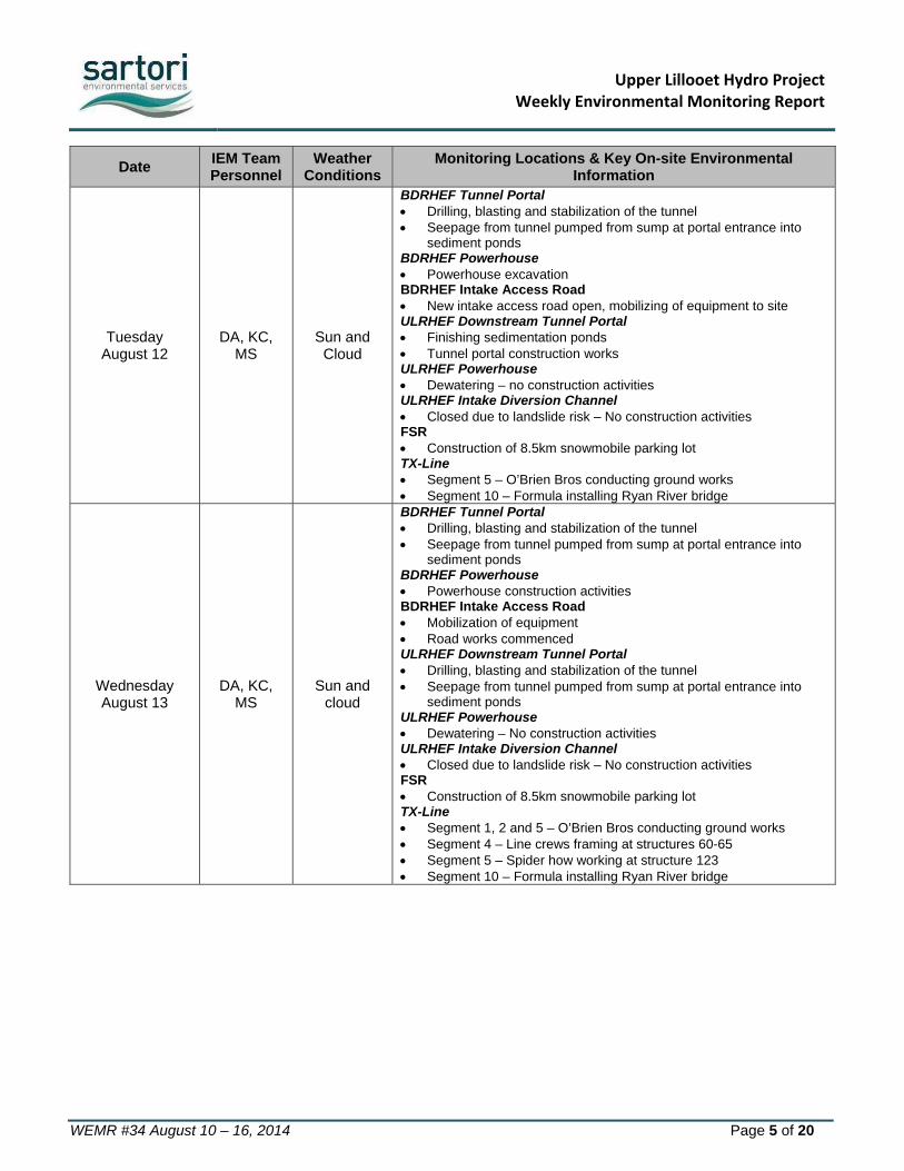
Tuesday August 12
DA, KC, MS
Sun and Cloud
BDRHEF Tunnel Portal Drilling, blasting and stabilization of the tunnel Seepage from tunnel pumped from sump at portal entrance into
sediment ponds BDRHEF Powerhouse Powerhouse excavation BDRHEF Intake Access Road New intake access road open, mobilizing of equipment to site ULRHEF Downstream Tunnel Portal Finishing sedimentation ponds Tunnel portal construction works ULRHEF Powerhouse Dewatering – no construction activities ULRHEF Intake Diversion Channel Closed due to landslide risk – No construction activities FSR Construction of 8.5km snowmobile parking lot TX-Line Segment 5 – O’Brien Bros conducting ground works Segment 10 – Formula installing Ryan River bridge
Wednesday August 13
DA, KC, MS
Sun and cloud
BDRHEF Tunnel Portal Drilling, blasting and stabilization of the tunnel Seepage from tunnel pumped from sump at portal entrance into
sediment ponds BDRHEF Powerhouse Powerhouse construction activities BDRHEF Intake Access Road Mobilization of equipment Road works commenced ULRHEF Downstream Tunnel Portal Drilling, blasting and stabilization of the tunnel Seepage from tunnel pumped from sump at portal entrance into
sediment ponds ULRHEF Powerhouse Dewatering – No construction activities ULRHEF Intake Diversion Channel Closed due to landslide risk – No construction activities FSR Construction of 8.5km snowmobile parking lot TX-Line Segment 1, 2 and 5 – O’Brien Bros conducting ground works Segment 4 – Line crews framing at structures 60-65 Segment 5 – Spider how working at structure 123 Segment 10 – Formula installing Ryan River bridge

Upper Lillooet Hydro ProjectWeekly Environmental Monitoring Report
WEMR #34 August 10 – 16, 2014 Page 6 of 20
Date IEM Team Personnel
Weather Conditions
Monitoring Locations & Key On-site Environmental Information
Thursday August 14
DA, VD Sun and
cloud
BDRHEF Tunnel Portal Drilling, blasting and stabilization of the tunnel Seepage from tunnel pumped from sump at portal entrance into
sediment ponds BDRHEF Powerhouse Powerhouse excavation works BDRHEF Intake Access Road Road construction Lizzie Bay fallers clearing the crane pad ULRHEF Downstream Tunnel Portal Drilling, blasting and stabilization of the tunnel Seepage from tunnel pumped from sump at portal entrance into
sediment ponds ULRHEF Powerhouse Dewatering – No construction activities ULRHEF Intake Diversion Channel Closed due to landslide risk – no construction activities TX-Line Segment 2 – O’Brien Bros conducting ground works at structure 36 Segment 3 – GMS clearing a trail from structure 41-43 Segment 4 – Line crews conducting ground works at structures 57,
58, and 59 Segment 5 – Line crews framing at structure 123, spider hoe
working at structure 115 Segment 10 – Formula installing Ryan River bridge
Friday August 15
DA,SS,VD Sunshine
BDRHEF Tunnel Portal Drilling, blasting and stabilization of the tunnel Seepage from tunnel pumped from sump at portal entrance into
sediment ponds BDRHEF Powerhouse Powerhouse excavation works BDRHEF Intake Access Road Road construction works ULRHEF Downstream Portal Drilling, blasting and stabilization of the tunnel Seepage from tunnel pumped from sump at portal entrance into
sediment ponds ULRHEF Powerhouse Dewatering – No construction activities ULRHEF Intake Diversion Channel Re-opened – Mobilizing equipment to site Drilling, blasting and excavating diversion channel TX-Line Segment 2 – O’Brien Bros conducting ground works Segment 4 – Line crews conducting ground works Segment 5 – Line crews framing at structure 123, spider hoe
working Segment 10 – Formula installing Ryan River bridge

Upper Lillooet Hydro ProjectWeekly Environmental Monitoring Report
WEMR #34 August 10 – 16, 2014 Page 7 of 20
Date IEM Team Personnel
Weather Conditions
Monitoring Locations & Key On-site Environmental Information
Saturday August 16
DA,TH,VD Sun and
cloud
BDRHEF Tunnel Portal Drilling, blasting and stabilization of the tunnel Seepage from tunnel pumped from sump at portal entrance into
sediment ponds BDRHEF Powerhouse Powerhouse construction works BDRHEF Intake Access Road Road construction ULRHEF Downstream Portal Drilling, blasting and stabilization of the tunnel Seepage from tunnel pumped from sump at portal entrance into
sediment ponds ULRHEF Powerhouse Dewatering – No construction activities ULRHEF Intake Diversion Channel Drilling, blasting and excavating of diversion channel TX-Line Segment 2 – O’Brien Bros conducting ground works Segment 4 – Line crews conducting ground works Segment 5 – Line crews framing and spider hoe working Segment 10 – Formula installing Ryan River bridge
IEM Team Personnel: DA – Danita Abraham; KC – Kirsten Cornwall; MS – Mandala Smulders; TH – Tom Hicks; SS – Stephen Sims; VD – Vanessa Dan
2.0 Administrative Summary Key communications and meetings the IEM team had with the licensees, contractors and/or environmental authorities:
Date Communication
Type Participants Issues Discussed
ITM ID No.
August 10 Email SES, JEM, CRT-ebc, Innergex,
The IE submitted a letter rescinding the Stop Work Order for the Boulder Creek Intake Access Road and Crane Pad as CRT-ebc had adequately address the 6 conditions outlined in the Stop Work Order
ULR#17 &
ULR#18
August 11
Pre-work meeting SES, CRT-ebc, Hedberg, Innergex,
Pre-activity meeting to review the revised work plan for the new Boulder Creek Intake Access Road and Crane Pad. Discussion focused on access to steep slopes for removing unstable fill and steep terrain safety requirements.
N/A
Pre-work meeting SES, Innergex, CRT-ebc
Pre-activity meeting to discuss the ULR HEF Downstream Tunnelling work plan. Discussions focused on construction of sediment treatment/infiltration ponds to be constructed and used for the management of anticipated seepage water.
N/A
August 14 Email CRT-ebc, SES, Innergex,
SES was informed of the commissioning of the new section of the Lillooet River FSR (Truckwash Creek Pass & Bridge).
N/A
Upper Lillooet Hydro ProjectWeekly Environmental Monitoring Report
WEMR #34 August 10 – 16, 2014 Page 8 of 20
Date Communication
Type Participants Issues Discussed
ITM ID No.
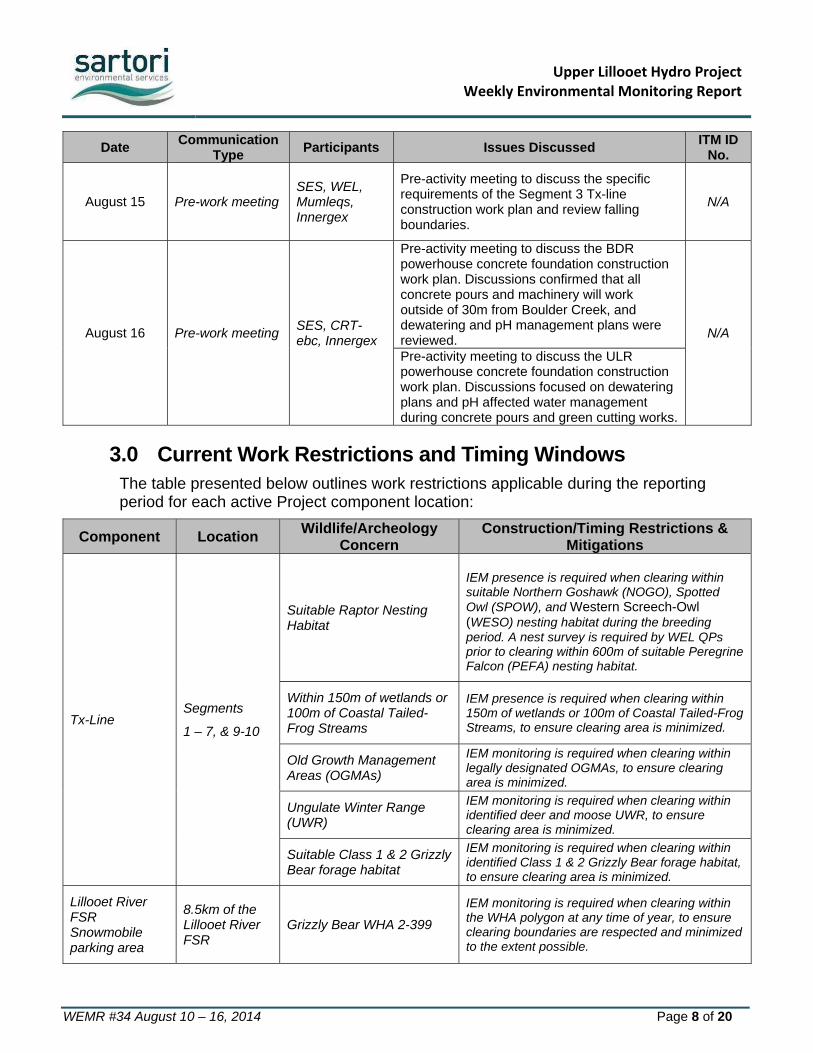
August 15 Pre-work meeting SES, WEL, Mumleqs, Innergex
Pre-activity meeting to discuss the specific requirements of the Segment 3 Tx-line construction work plan and review falling boundaries.
N/A
August 16 Pre-work meeting SES, CRT-ebc, Innergex
Pre-activity meeting to discuss the BDR powerhouse concrete foundation construction work plan. Discussions confirmed that all concrete pours and machinery will work outside of 30m from Boulder Creek, and dewatering and pH management plans were reviewed. N/A
Pre-activity meeting to discuss the ULR powerhouse concrete foundation construction work plan. Discussions focused on dewatering plans and pH affected water management during concrete pours and green cutting works.
3.0 Current Work Restrictions and Timing Windows The table presented below outlines work restrictions applicable during the reporting period for each active Project component location:
Component Location Wildlife/Archeology
Concern Construction/Timing Restrictions &
Mitigations
Tx-Line Segments
1 – 7, & 9-10
Suitable Raptor Nesting Habitat
IEM presence is required when clearing within suitable Northern Goshawk (NOGO), Spotted Owl (SPOW), and Western Screech-Owl (WESO) nesting habitat during the breeding period. A nest survey is required by WEL QPs prior to clearing within 600m of suitable Peregrine Falcon (PEFA) nesting habitat.
Within 150m of wetlands or 100m of Coastal Tailed-Frog Streams
IEM presence is required when clearing within 150m of wetlands or 100m of Coastal Tailed-Frog Streams, to ensure clearing area is minimized.
Old Growth Management Areas (OGMAs)
IEM monitoring is required when clearing within legally designated OGMAs, to ensure clearing area is minimized.
Ungulate Winter Range (UWR)
IEM monitoring is required when clearing within identified deer and moose UWR, to ensure clearing area is minimized.
Suitable Class 1 & 2 Grizzly Bear forage habitat
IEM monitoring is required when clearing within identified Class 1 & 2 Grizzly Bear forage habitat, to ensure clearing area is minimized.
Lillooet River FSR Snowmobile parking area
8.5km of the Lillooet River FSR
Grizzly Bear WHA 2-399
IEM monitoring is required when clearing within the WHA polygon at any time of year, to ensure clearing boundaries are respected and minimized to the extent possible.

Upper Lillooet Hydro ProjectWeekly Environmental Monitoring Report
WEMR #34 August 10 – 16, 2014 Page 9 of 20
Component Location Wildlife/Archeology
Concern Construction/Timing Restrictions &
Mitigations
ULRHEF powerhouse, and Intake diversion channel
Within 50m of identified archeologically significant area
Archaeologically significant site EdRu-3
The ASMP recommends that an archaeological technician from the Lil’wat Nation be present to monitor initial ground-disturbance activities within 50 m of the EdRu-3 site boundaries.
Within 30m of the Upper Lillooet River
Riparian area and fish bearing streams
IEM presence is required when working within 30m of the Upper Lillooet River. Instream acoustic pressure monitoring required when blasting within 30m of the Upper Lillooet River.
Lillooet River FSR; ULRHEF intake access; FSR realignment at Truckwash Creek
Access roads above the lower limit of the 200m buffer Truckwash Creek Migration Corridor to the ULRHEF intake; including FSR realignment at Truckwash Creek
Mountain Goat UWR
If a goat is observed within 500 m of construction operations, construction must cease for at least 48 hours. The IEM must record and submit all goat observations to FLNR within 48 hours.
4.0 Hydroelectric Facilities
4.1 Ancillary Components – Monitoring Results
38km Laydown
Material crushing and screening plant operation continued this week. A watering hose was used effectively for dust control at the screening plant. No environmental concerns were noted.
Lillooet River FSR (8.5 km) Snowmobile Parking Area
Clearing continued on August 10th, within the Grizzly Bear WHA 2-399 polygon. The IEM was present to ensure clearing boundaries were respected and verify that clearing was minimized to the extent possible. Stripping and grubbing, grading and capping were completed following clearing during this reporting period.
4.2 Boulder Creek Hydroelectric Facility – Monitoring Results
BDRHEF Downstream Portal and Powerhouse
Tunneling activities (including: drilling, blasting, excavation, rock bolts and shotcrete/mesh installation) continued.

Upper Lillooet Hydro ProjectWeekly Environmental Monitoring Report
WEMR #34 August 10 – 16, 2014 Page 10 of 20
The settling ponds were effectively used to manage water from seepages encountered during tunnelling activities and to manage excess process water this week. No discharge from the sediment ponds occurred this week; therefore, no WQ samples were collected.
The powerhouse excavation was completed and concrete form works began in preparation for the mud slab concrete pour, following a pre-activity meeting on August 16th. Seepage water from the excavation seepage is being directed to a central sump and pumped to the sediment ponds currently being used to manage seepage/process water from the tunneling operations (Photo 2).
BDRHEF Intake Access Road & Crane Pad
A Stop Work Order was issued by the Owner on July 25th, 2014 and by the IE (True North Energy), on July 26th for all activities at the Boulder Creek Intake New Access Road and Crane Pad (ULR#18). On August 10th the Owner and IE rescinded their respective Stop Work Orders as CRT-ebc was able to provide all information requested by the IE. On August 11th, a pre-activity meeting was held to review the repair and stabilization works to be executed as outlined in the revised work plan. Mobilization of equipment occurred following the pre-activity meeting and repair work resumed under IEM supervision for the remainder of the week. The IEM can confirm that all excavator operators performing the repair and stabilization works demonstrated due care when operating on and adjacent to steep slopes. To the extent possible operators prevented rocks and debris from rolling downhill during the repair works to prevent additional impacts to standing timber outside of the approved OLTC boundaries.
Environmental Summary:
Seepage flowing out of the tunnel continues to be collected at the portal tunnel entrance in a sump and this water is then pumped from the sump to the oil/water separator, pH adjustment holding tank, and settlement ponds for treatment. The pH was monitored daily by the contractor and a CO2 diffuser was used as necessary to ensure pH was within acceptable surface water quality guidelines (pH 6.5 – 9). No discharge from the treatment ponds occurred during this reporting period; therefore, the IEM did not collect WQ results.
Hydro-seeding of exposed slopes at the downstream tunnel portal face has not resulted in vegetation growth that will help to stabilize the slope. Additional hydro-seeding applications during appropriate weather conditions or other slope stabilization measures (e.g. poly sheeting, coco matting, etc.) may be required to ensure slopes are protected prior to fall rain events.
Water from the Boulder Creek water withdrawal site authorized in the Short Term Water Use Approval (No.A2006123) was used effectively for dust suppression above 37.5km of the Lillooet River FSR and on active construction site access roads.
The gravity fed water diversion system was used in tunneling and shotcrete process works in accordance with Short Term Water Use Approval (No.A2006123). No WQ or environmental concerns were noted.
Upper Lillooet Hydro ProjectWeekly Environmental Monitoring Report
WEMR #34 August 10 – 16, 2014 Page 11 of 20
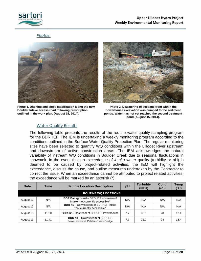
Photos:
Photo 1. Ditching and slope stabilization along the new Boulder Intake access road following prescription outlined in the work plan. (August 15, 2014).
Photo 2. Dewatering of seepage from within the powerhouse excavation was pumped to the sediment
ponds. Water has not yet reached the second treatment pond (August 15, 2014).
Water Quality Results
The following table presents the results of the routine water quality sampling program for the BDRHEF. The IEM is undertaking a weekly monitoring program according to the conditions outlined in the Surface Water Quality Protection Plan. The regular monitoring sites have been selected to quantify WQ conditions within the Lillooet River upstream and downstream of active construction areas. The IEM acknowledges the natural variability of instream WQ conditions in Boulder Creek due to seasonal fluctuations in snowmelt. In the event that an exceedance of in-situ water quality (turbidity or pH) is deemed to be caused by project-related activities, the IEM will highlight the exceedance, discuss the cause, and outline measures undertaken by the Contractor to correct the issue. When an exceedance cannot be attributed to project related activities, the exceedance will be marked by an asterisk (*).
Date Time Sample Location Description pH Turbidity
(NTU) Cond (uS)
Temp (°C)
ROUTINE WQ LOCATIONS
August 13 N/A BDR Background – BRDHEF upstream of
intake *not currently accessible* N/A N/A N/A N/A
August 13 N/A BDR #1 – Downstream of BDRHEF intake
*not currently accessible* N/A N/A N/A N/A
August 13 11:30 BDR #2 – Upstream of BDRHEF Powerhouse 7.7 30.1 28 12.1
August 13 11:41 BDR #3 – Downstream of BDRHEF Powerhouse at Pebble Creek Bridge
7.7 26.7 28 13.4

Upper Lillooet Hydro ProjectWeekly Environmental Monitoring Report
WEMR #34 August 10 – 16, 2014 Page 12 of 20
4.3 Upper Lillooet River Hydroelectric Facility – Monitoring Results
ULRHEF Powerhouse and Access Road
Excavation is complete and work is on hold pending the ULR powerhouse concrete LTC.
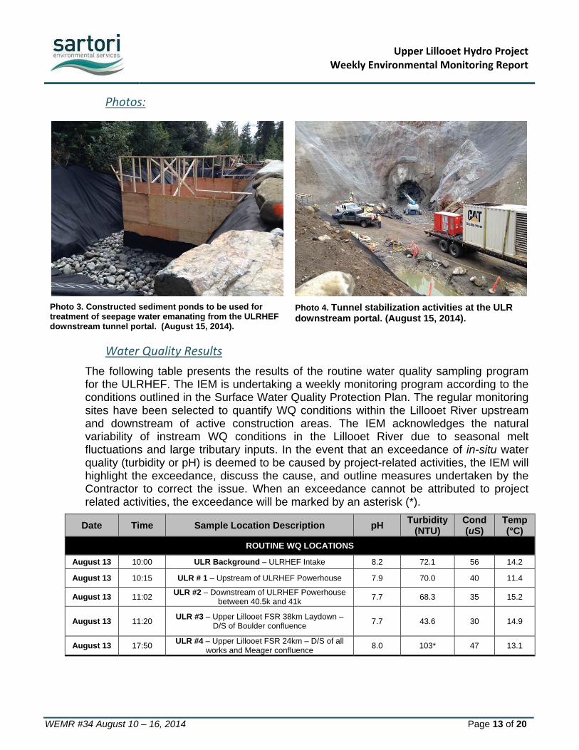
Sediment ponds were used to treat seepage water from within the powerhouse excavation (Photo 3). Water from the ponds discharged to vegetation prior to reaching the Lillooet River. Water quality was taken upstream and downstream of the discharge point (within the mixing zone) daily when water reached the Lillooet River. No WQ concerns were noted (see Results below)
ULRHEF Intake and Access Roads
Works associated with the intake diversion channel resumed on August 15th once the landslide risk fell to within acceptable limits. Works included mobilization, drilling, blasting, excavation, and slope stabilization.
ULRHEF Downstream Portal
Drilling & blasting of exposed bedrock surrounding the tunnel portal was completed and tunneling began following the pre-activity meeting on August 11th. Sediment ponds were installed adjacent to Truckwash Creek on August 11th and 12th as outlined on the work plan. The IEM was onsite to oversee the sediment pond construction. The pond outlet is directed to a vegetated area away from Truckwash creek. Blast rock was hauled to the lower spoil area and managed according to the ARD management plan. No environmental concerns were noted.
Environmental Summary:
On August 15th and 16th work resumed at the intake diversion channel. The IEM scheduled a monitor to be onsite full time for all blasts and excavation activities to document that all efforts to prevent rocks from entering the Lillooet River were made and to record approximate quantities in the event rocks do enter the River. The IEM recognizes that large rocks are not a deleterious substance and that rock entering the river at this location is unlikely to cause serious harm to fish given the marginal fish habitat present at this location due to the water velocity bed materials within the rock canyon.
A gravity feed water extraction system was used for drilling activities according to the conditions of the Short Term Water Use Approval (No.A2006123) (Photo 4).
Dewatering of the powerhouse excavation into the sediment ponds will be monitored daily and WQ will be recorded when discharge to vegetation reaches the Lillooet River.
Upper Lillooet Hydro ProjectWeekly Environmental Monitoring Report
WEMR #34 August 10 – 16, 2014 Page 13 of 20
Photos:
Photo 3. Constructed sediment ponds to be used for treatment of seepage water emanating from the ULRHEF downstream tunnel portal. (August 15, 2014).
Photo 4. Tunnel stabilization activities at the ULR downstream portal. (August 15, 2014).
Water Quality Results
The following table presents the results of the routine water quality sampling program for the ULRHEF. The IEM is undertaking a weekly monitoring program according to the conditions outlined in the Surface Water Quality Protection Plan. The regular monitoring sites have been selected to quantify WQ conditions within the Lillooet River upstream and downstream of active construction areas. The IEM acknowledges the natural variability of instream WQ conditions in the Lillooet River due to seasonal melt fluctuations and large tributary inputs. In the event that an exceedance of in-situ water quality (turbidity or pH) is deemed to be caused by project-related activities, the IEM will highlight the exceedance, discuss the cause, and outline measures undertaken by the Contractor to correct the issue. When an exceedance cannot be attributed to project related activities, the exceedance will be marked by an asterisk (*).
Date Time Sample Location Description pH Turbidity
(NTU) Cond (uS)
Temp (°C)
ROUTINE WQ LOCATIONS
August 13 10:00 ULR Background – ULRHEF Intake 8.2 72.1 56 14.2
August 13 10:15 ULR # 1 – Upstream of ULRHEF Powerhouse 7.9 70.0 40 11.4
August 13 11:02 ULR #2 – Downstream of ULRHEF Powerhouse
between 40.5k and 41k 7.7 68.3 35 15.2
August 13 11:20 ULR #3 – Upper Lillooet FSR 38km Laydown –
D/S of Boulder confluence 7.7 43.6 30 14.9
August 13 17:50 ULR #4 – Upper Lillooet FSR 24km – D/S of all
works and Meager confluence 8.0 103* 47 13.1

Upper Lillooet Hydro ProjectWeekly Environmental Monitoring Report
WEMR #34 August 10 – 16, 2014 Page 14 of 20
SITE-SPECIFIC WQ LOCATIONS
August 10 13:32 Lillooet River – Upstream of powerhouse
dewatering input 8.0 69 38 15.1
August 10 13:30 Lillooet River – Downstream of powerhouse
dewatering input 7.9 60.4 37 15.8
August 13 10:40 Lillooet River – Upstream of powerhouse
dewatering input 8.2 72.1 47 12.3
August 13 10:47 Lillooet River – Downstream of powerhouse
dewatering input 7.9 78.1 31 11.2
4.4 Hydroelectric Facilities – Recommendations
The installation of ESC measures (including hydro-seeding, protection with poly-sheeting) should be performed on all cut-slopes at risk of eroding during rain events. In particular, the steep cut slopes at the ULRHEF diversion channel, ULRHEF downstream tunnel portal, ULRHEF powerhouse, and BDRHEF tunnel portal, are all at risk of developing rills during heavy rain events. Where these cut slopes are permanent a permanent solution is recommended.
The IEM recommends that a shallow interception ditch or swale be installed at the top of the ULRHEF intake diversion channel cut-slope. This ditch/swale should be installed to direct the surface runoff towards the adjacent forested area for infiltration, and prevent it from flowing over the slope. The intent is to prevent further generation of rills that have already begun to develop.
4.5 Hydroelectric Facilities – Upcoming Works
CRT-ebc has confirmed that the failed crossing at 39.7km (ULR#8) will be repaired and/or replaced, and the failed culvert at 47km (ULR#4) will be remediated by removing debris from within the stream. This work will be completed during the 2014 instream work window following the preparation of a work plan and approval by MFLNRO.
Excavation of the intake diversion channel is scheduled to continue next week at the ULRHEF intake provided the landslide hazard rating is at suitable levels to permit works to continue. Tunneling at the BDRHEF and ULRHEF downstream tunnel portals will continue for the remainder of the season. Foundation preparations at the ULRHEF and BDRHEF powerhouses will continue for the next two weeks. Repair work and slope stabilization of the new sections of the BDRHEF intake access road will continue for the next 4-6 weeks.
5.0 Transmission Line
5.1 Monitoring Results
Segment 1‐7 & 9‐10
Pole installation and foundation works continued in Segment 1, 2, 4, & 5 this week.
Upper Lillooet Hydro ProjectWeekly Environmental Monitoring Report
WEMR #34 August 10 – 16, 2014 Page 15 of 20
Hand clearing occurred along an access trail in Segment 3. No further falling was completed on the TX-Line during this reporting period due primarily to fire hazard.
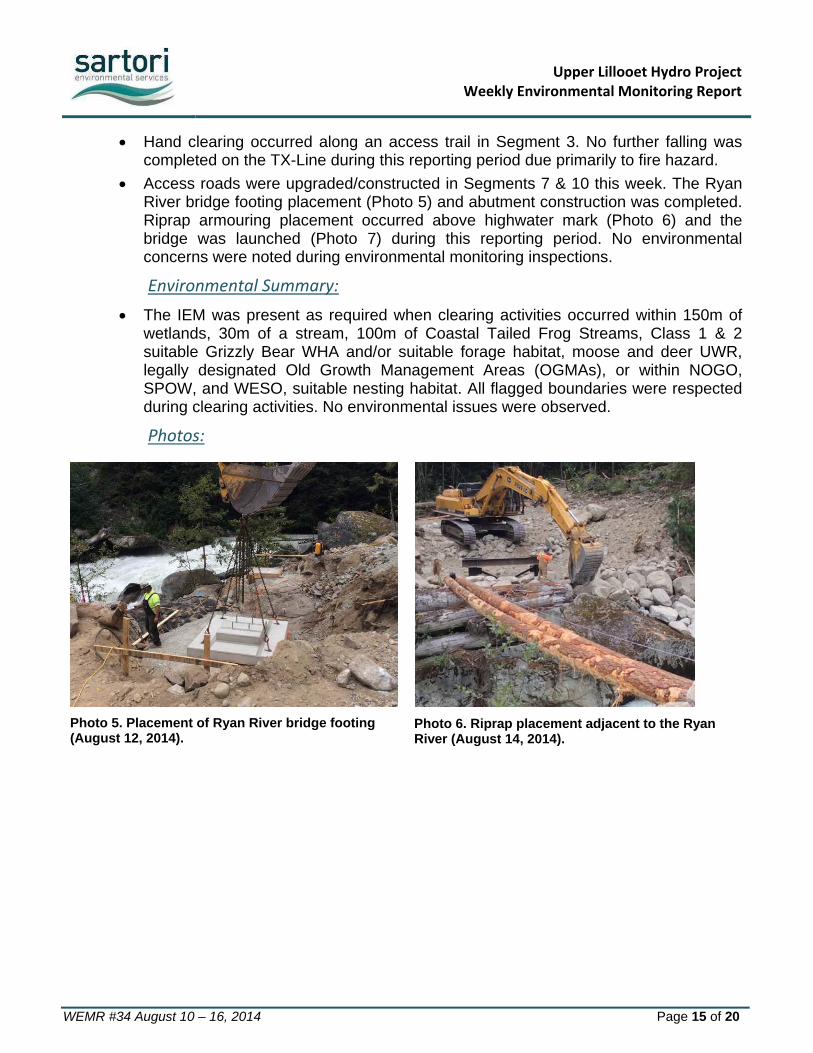
Access roads were upgraded/constructed in Segments 7 & 10 this week. The Ryan River bridge footing placement (Photo 5) and abutment construction was completed. Riprap armouring placement occurred above highwater mark (Photo 6) and the bridge was launched (Photo 7) during this reporting period. No environmental concerns were noted during environmental monitoring inspections.
Environmental Summary:
The IEM was present as required when clearing activities occurred within 150m of wetlands, 30m of a stream, 100m of Coastal Tailed Frog Streams, Class 1 & 2 suitable Grizzly Bear WHA and/or suitable forage habitat, moose and deer UWR, legally designated Old Growth Management Areas (OGMAs), or within NOGO, SPOW, and WESO, suitable nesting habitat. All flagged boundaries were respected during clearing activities. No environmental issues were observed.
Photos:
Photo 5. Placement of Ryan River bridge footing (August 12, 2014).
Photo 6. Riprap placement adjacent to the Ryan River (August 14, 2014).

Upper Lillooet Hydro ProjectWeekly Environmental Monitoring Report
WEMR #34 August 10 – 16, 2014 Page 16 of 20
Photo 8. Ryan River Bridge girders (August 16, 2014).
Water Quality Results
Date Time Sample Location Description pH Turbidity
(NTU) Temperature (°C)
No WQ measurements were recorded at active Tx-line work areas during this reporting period. Construction and clearing activities had no visual effect on WQ.
5.2 Transmission Line – Recommendations
No recommendations are provided for this reporting period.
5.3 Transmission Line – Upcoming Works
Pole installation and dressing is scheduled to continue in Segment 4 & 5 next week. Clearing is scheduled to continue in Segment 3, 4, 5 & 7 and in Segment 9 and 10. Upcoming transmission line works will be focused on road construction and the Ryan River Bridge deck installation and grouting, pole installation, and completing the clearing within the Segments 3-10.
6.0 Wildlife Sightings As per the CEMP, a wildlife sightings record has been implemented and will be updated regularly by Project Personnel. It is mandatory for all personnel to report wildlife sightings including, but not limited to bears, cougars, mountain goats and deer. Wildlife sighting will be reported and recorded by the contractor(s) and will submitted to the IEM on a weekly basis. Wildlife Observation forms will be summarized on a monthly basis and appended to the first WEMR of the following month. Observation or detection of the following species will trigger notification to identified parties according to the following table.

Upper Lillooet Hydro ProjectWeekly Environmental Monitoring Report
WEMR #34 August 10 – 16, 2014 Page 17 of 20
7.0 Mountain Goat Monitoring Program The critical early summer forage period for Mountain Goats has now ended; therefore Mountain Goat Monitoring has been temporarily suspended until the fall monitoring period as outlined in the Mountain Goat Management Plan.
No Mountain Goats were observed within 500m line of sight of construction activities during this reporting period; therefore no work stoppages were required.
Species Observed or Detected
Notification Period
Agencies to be Notified
Northern Rubber Boa Immediately IEM, Owner
Grizzly Bear 24hrs IEM, Safety Officer, Conservation
Officer, Owner Wolverine Den 24hrs IEM, MFLNRO, Owner Spotted Owls 24hrs IEM, MOE, Owner
Mountain Goats 48hrs IEM, MFLNRO, Owner
Upper Lillooet Hydro Project Weekly Environmental Monitoring Report
WEMR #34 August 10 – 16, 2014 Page 18 of 20
8.0 Environmental Issues Tracking Matrix (ITM)
8.1 Hydroelectric Facilities (ULRHEF & BDRHEF)
ITM Tracking Legend: Work Item Open
Work Item Complete
Issue Closed
Issue Tracking Environmental Issue Mitigation Measures
ID No. Status Location Issue Description Action Taken/Recommended Date of
Identification Targeted Date for Completion
Date Completed
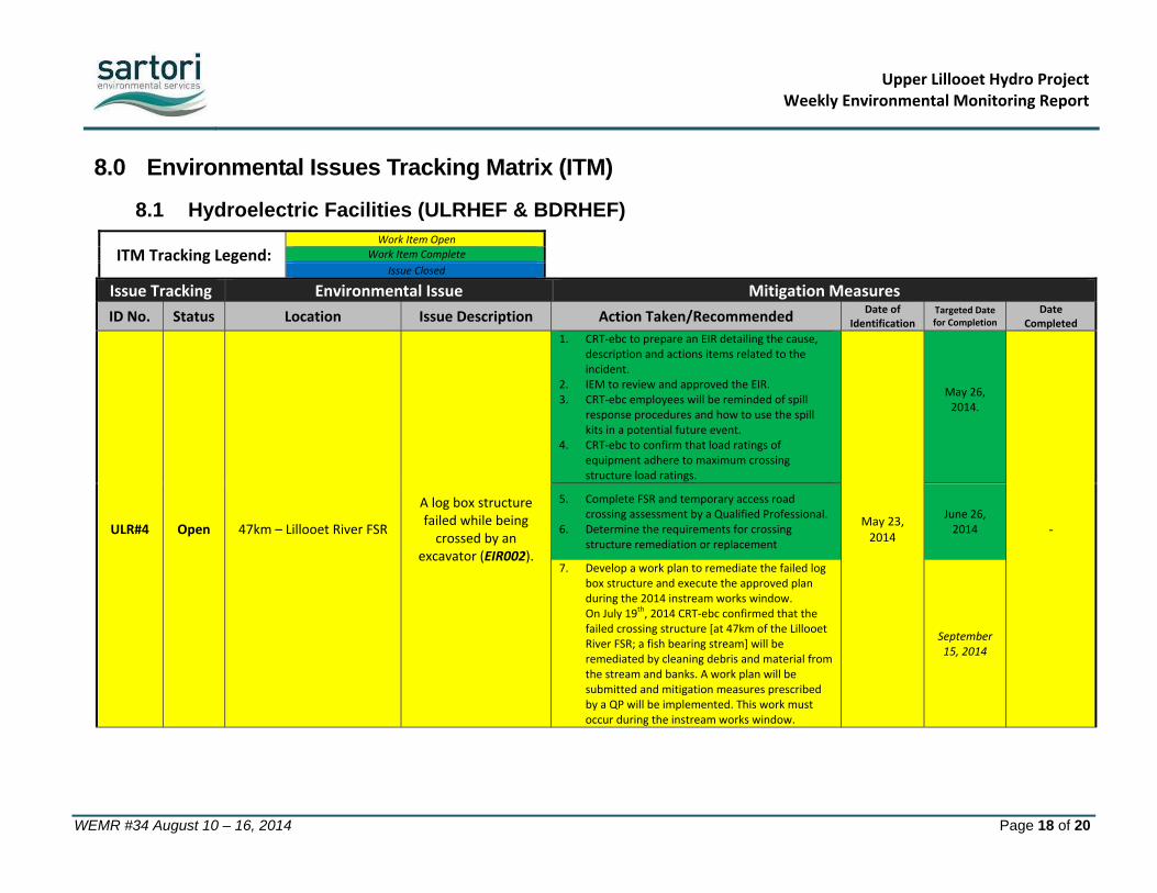
ULR#4 Open 47km – Lillooet River FSR
A log box structure failed while being crossed by an
excavator (EIR002).
1. CRT‐ebc to prepare an EIR detailing the cause, description and actions items related to the incident.
2. IEM to review and approved the EIR. 3. CRT‐ebc employees will be reminded of spill
response procedures and how to use the spill kits in a potential future event.
4. CRT‐ebc to confirm that load ratings of equipment adhere to maximum crossing structure load ratings.
May 23, 2014
May 26, 2014.
‐
5. Complete FSR and temporary access road crossing assessment by a Qualified Professional.
6. Determine the requirements for crossing structure remediation or replacement
June 26, 2014
7. Develop a work plan to remediate the failed log box structure and execute the approved plan during the 2014 instream works window. On July 19th, 2014 CRT‐ebc confirmed that the failed crossing structure [at 47km of the Lillooet River FSR; a fish bearing stream] will be remediated by cleaning debris and material from the stream and banks. A work plan will be submitted and mitigation measures prescribed by a QP will be implemented. This work must occur during the instream works window.
September 15, 2014

Upper Lillooet Hydro Project Weekly Environmental Monitoring Report
WEMR #34 August 10 – 16, 2014 Page 19 of 20
Issue Tracking Environmental Issue Mitigation Measures
ID No. Status Location Issue Description Action Taken/Recommended Date of
Identification
Targeted Date for
Completion
Date Issue Closed
ULR#8 Open 39.7km –
Lillooet River FSR
Stream 9 – log box structure failure (EIR004).
1. Develop a work plan to remediate the failed log box structure and execute during the 2014 instream works window. On July 19th, 2014 CRT‐ebc confirmed that this crossing structure will be repaired or replaced during the 2014 instream works window following MFLNRO approval.
May 28, 2014 September 15, 2014
ULR#10 Open Lillooet River
FSR
Innergex issued stop work order for heavy hauling on
Lillooet River FSR
Recommendations have been submitted to MFLNRO for review and approval. Work plan submission and repairs to be completed prior to September 15 for crossing structures at 39.7km and 47km of the Lillooet River FSR.
May 28, 2014 September 15, 2014
‐
ULR#17 Open BDR Intake Access Road
Damage to standing timber and impacts outside of
minimized clearing boundary & approved OLTC limit (both
within and adjacent to UWR)
1. Prepare and submit EIR#011 outlining the root cause of the incident and how it will be avoided in future.
July 25th, 2014
July 30, 2014
August 1, 2014
2. Assess damage to standing timber and impacts outside of the minimized clearing boundaries and approved OLTC (both within and adjacent to UWR). Preliminary information has been provided to satisfy the requirements of ULR#18, however detailed survey is necessary to confirm impacted areas and access is currently not available due to slope stability issues.
Confirmed in Hedberg report July 25th, 2014
Pending safe work access – mid‐
September, 2014
‐
ULR#18 Closed BDR Intake Access Road
STOP WORK ORDER for Boulder Creek Intake Access
Road and Crane Pad
Based on the recommendations by Hedberg Associates and the lack of following Work Plans the IE requests the following prior to re‐authorizing the commencement of work on the Boulder Creek intake access: 1. Complete an Environmental Incident Report (“EIR”) within
48 hours. The EIR should describe/quantify both the damage to standing merchantable and the impacts to the area outside the Occupant Licence to Cut (“OLTC”).
July 26, 2014 July 30, 2014
August 1, 2014
2. Submit to the IE a new/updated Work Plans prior to the IE removing the Stop Work Order and reissuing the Leave to Construct Authorization the following:
a. encompasses the repair/remediation of the works completed to date;
b. implements the recommendations by Hedberg Associates; and
c. includes methods to execute to ensure that the road construction meets the approved “Issued for Construction” design.
July 26, 2014
August 10,
2014
Stop Work Order
rescinded August 10,
2014
Upper Lillooet Hydro Project Weekly Environmental Monitoring Report
WEMR #34 August 10 – 16, 2014 Page 20 of 20
Issue Tracking Environmental Issue Mitigation Measures
ID No. Status Location Issue Description Action Taken/Recommended Date of
Identification
Targeted Date for
Completion
Date Issue Closed
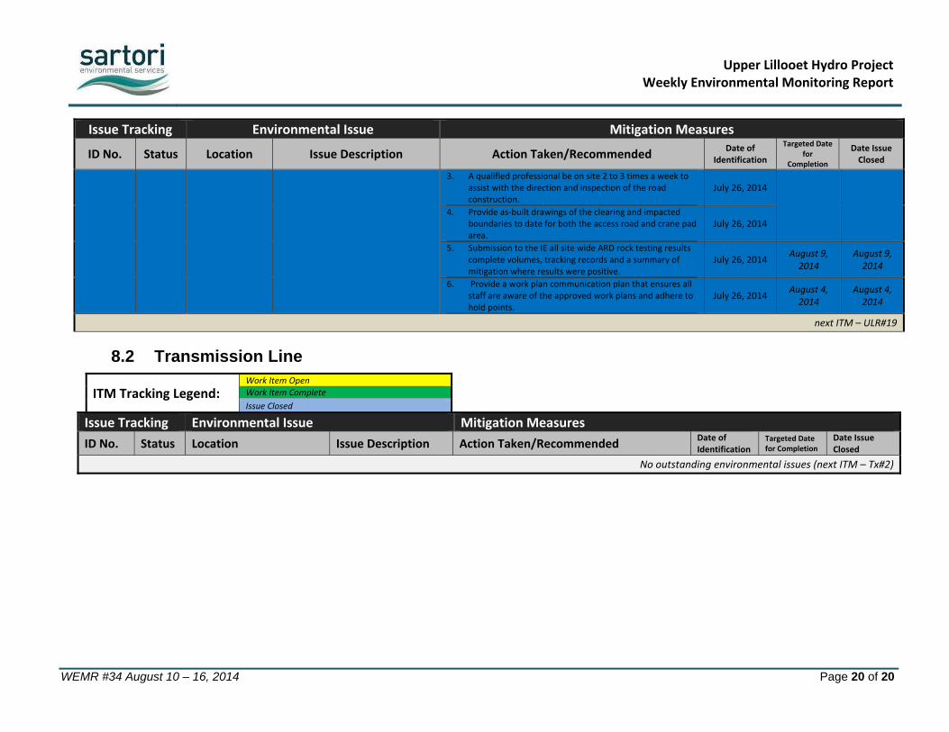
3. A qualified professional be on site 2 to 3 times a week to assist with the direction and inspection of the road construction.
July 26, 2014
4. Provide as‐built drawings of the clearing and impacted
boundaries to date for both the access road and crane pad area.
July 26, 2014
5. Submission to the IE all site wide ARD rock testing results complete volumes, tracking records and a summary of mitigation where results were positive.
July 26, 2014 August 9, 2014
August 9, 2014
6. Provide a work plan communication plan that ensures all staff are aware of the approved work plans and adhere to hold points.
July 26, 2014 August 4, 2014
August 4, 2014
next ITM – ULR#19
8.2 Transmission Line
ITM Tracking Legend: Work Item Open
Work Item Complete
Issue Closed
Issue Tracking Environmental Issue Mitigation Measures
ID No. Status Location Issue Description Action Taken/Recommended Date of Identification
Targeted Date for Completion
Date Issue Closed
No outstanding environmental issues (next ITM – Tx#2)


