Download - TOIRET - preterhuman.net

TOIRETAPPROVED FORRELEASEl DATE:15-Jul-2011
ECRET
PIC/JR-17/59
JULY 1959Declass Review by NIMA / DoD
COORDINATED, PUBLISHED, AND DIST-TiriO)U_IAJ.,,
CENTRAL INTELLIGENCE AGENCY HR70-14
PHOTOGRAPHIC INTELLIGENCE CENTER

CO2751374I
TOP SECRET DAUNT CHESS
PROBABLE TYURA TAM
MISSILE TEST RANGE FACILITY
NEAR TARTUGAY, USSR
PIC JR-17 59
JULY 1959
TOP SCRET DAUNT CHESS

X-13rn
cri
4
40
36
52 56 72 76.■
36
3232r.4
1 .41
BAku -
fa lS HA,
evidlit
Z
.....
Q4
•Z
8.ndar sh
Krasnovcvsk
.
.
I R
Shah rtid
ka Minsk
Kayl Orda •1-"."
E,..-
\ „,• P,,,,,t,"_,/ -
...._ .--- -- ^ . i■ ( .\•\
1 )
\ F,nze
AlMh'h16,ssyK.K.,s,
Bor,sovka
DzhambulRyb.ch.Y
0 p, ' )
• lasChimkent / „Nef,su o. xr,''',.
.. • . Harr^ .) il'''
Dzheatalf.Abad ... 2:.• a " '
L T:beHKEN_ N.TrnFan.ng• L... ..___, an .,..."
, 0---,•-_,,_ \,_,_. C '‘. j\
\
\KaSh8.' Ps
ARAL SEA
qt
/
Tashauz ,
1 '
I
Se.YY Zavoi"--
Chardzhou
i ....\" N.s-`\
\ Mary
\\
MESHED■-...)
VKA N . ,
.......-...*
R.
.144 laoo kowin. .32 .t
. SAMARKAND
Karshi
ef rn
AFGHANIS,'
Rad
)
I Novabao.
Stalinabad
./4^Kulyeh $ Khotan c.
oNizhn:/;*"--. ' : Khor g ./..--"S... ...,••••• .I I
'.) \I
./".......,-.---..";..., . `",—.......Pvandzi,
'- - /
N.1,,,,s,,,AIR .5\
A N . 1■AKIKO-3i •
.
. " " ".-1 - f)SR-INAGARKASH cs / +..
C ,.
N . • : • .13M010 INDIA
, not /wow
Su. G........(
52 56 60 64 68 72 76 80
€)
U.S.S.R.
CENTRAL ASIA
-.--.--.- Railroad (selected] 0 100 700 m.k.s Road (selected) ----,----- Canal (selected/NatIonal caPda l0 100 200 1017414140
Base 11971 4.52
NM • NM MN • • INN I= NM 111111 INN IIIIII MI MI MI NM =I IIIIII I= MEI =I

CO2751374I.
TOP"SECRET DAUNT CHESS
SC-03885/59
PROBABLE TYURA TAM MISSILE TEST RANGE FACILITY
NEAR TARTUGAY, USSR
I. INTRODUCTIONThis joint photographic intelligence report describes a probable Tyura
Tam M issue Test Range (TTMTR) facility appearing August 1957photography. It is located at 44°29'N/66°18'E, two nm north of Tartugayand 150 nm southeast of the Tyura Tam rangehead. This report also
5X1
includes an analysis of material believed to be associated withthis facility. Finally, through collation of the two sets of data, anattempt is made to analyze its activities and identify its function.
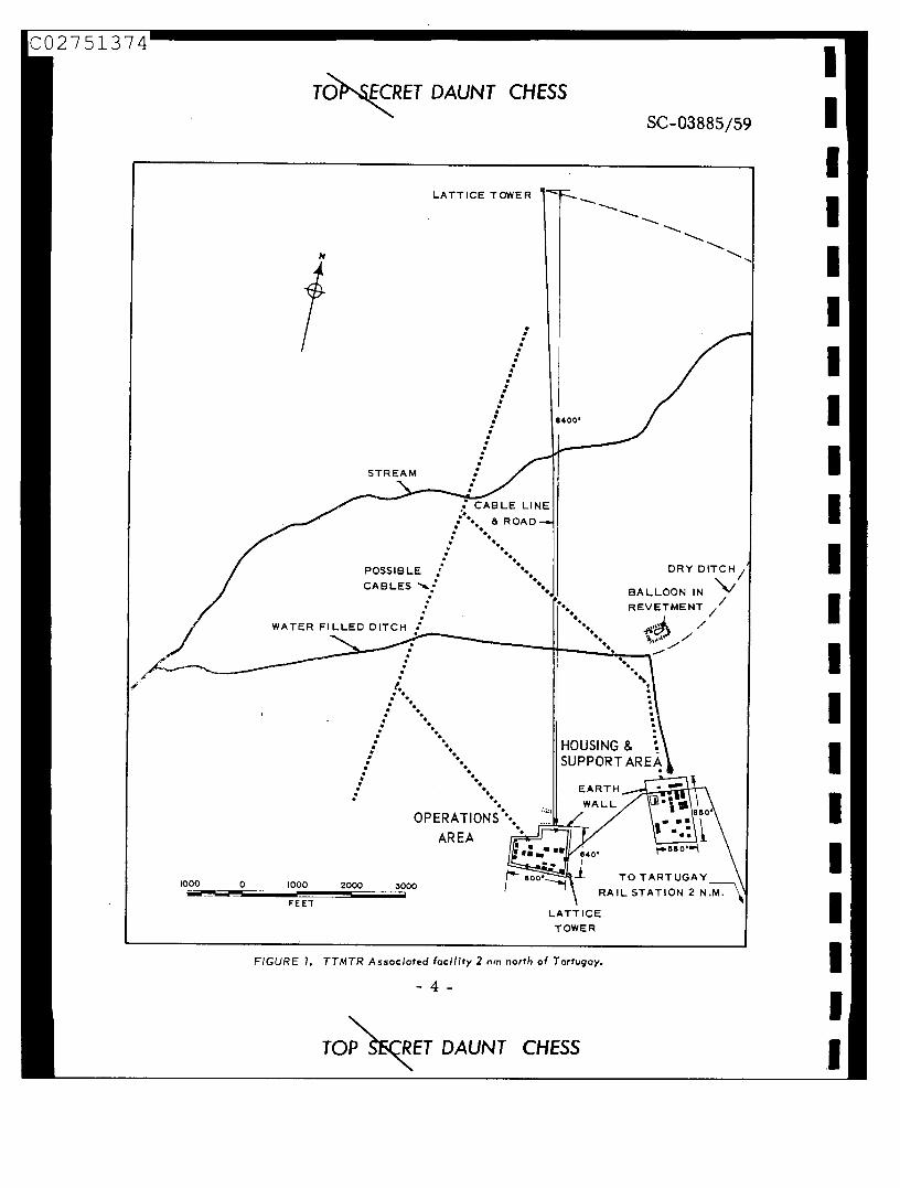
II. DESCRIPTION FROM PHOTOGRAPHYThe site (see Figure 1) consists of a self-supporting lattice tower,
two building areas, one of which may be for operations and the other for25X1 housing and support, and a tear-shaped balloon.
The self-supporting lattice tower (see Figure 2), 295 feet high, islocated 8,400 feet north of the building areas. A dome-shaped object,
in diameter, is situated on top of the tower. At the base of thetower and enclosed within the tower supports is a 10-foot-square building.A cable and an enclosed elevator lead from the top of the tower down theside to the base. The cable then leads 8,400 feet south to the possibleoperations area.
The possible operations area consists of 15 buildings enclosed by afence and an earthen wall 800 by 640 feet. Two guard towers are locatedbetween the fence and the wall at opposite corners of the area. An 80-foot-high self-supporting lattice tower is located outside and adjacent to the.southeast portion of the wall. A probable open storage area is located.adjacent to and outside of the northern portion of the wall.
The possible housing and support area is located 2,500 feet east of thepossible operations area. This area consists of 23 buildings surrounded
- 3 -
TO ECRET DAUNT CHESS
SC-03885/59
LATTICE TOWER
STREAM
: CABLE LINE& ROAD•• •
POSSIBLECABLES ',b.:.
•WATER FILLED DITCH :
••■••
DRY DITCH
BALLOON IN \*/REVETMENT
•
8400'
••
••
•
4. .: '..
.....
.
:.....
:
:.......
.•......
OP ERATION.S\
AREA
HOUSING &SUPPORT AREA
EARTHWALL
TO TARTUGAY800*--yiRAIL STATION 2 11.171:\•
LATT ICETOWER
• 0'
1000
0
1000
2000
3000/■1■111••
FEET
CO2751374
TO ECRET DAUNT CHESS
FIGURE 7. TTMTR Associated facility 2 nm north of Tortugay.
- 4 -
TOP CRET DAUNT CHESS

25X1
CO2751374
TON5ECRET DAUNT CHESSSC-03885/59
by an earthen wall 850 by 550 feet. Anall-weather road leads from thepossible operations area through thepossible housing and support areaand then south two miles to the railstation at Tartugay.
A 10-foot-wide ditch leads 2.75nm north and west from the possiblehousing and support area to a streamwhich drains into the Syr-DaryaRiver. It appears that water ispumped from the possible housingand support area into the ditch whichat the time of photography was filledwith water.
Possible cable scars lead northfrom both the possible operationsarea and the possible housing and
FIGURE 2. Self-supporting lattice tower associatedsupport area toward the 295-foot lat- with probable TTMTR facility near Tartugay.
tice tower. Due to the large amountof track activity throughout the vicinity it cannot be determined where thesepossible cable scars actually terminate.
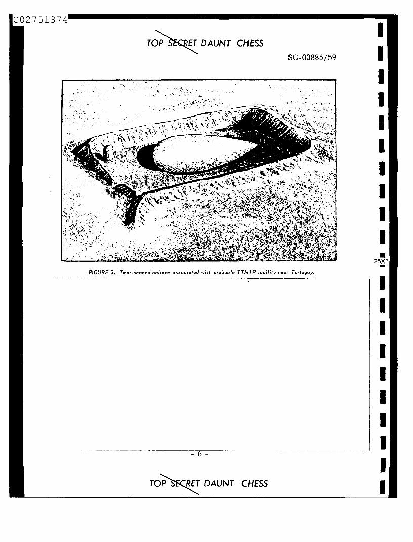
The tear-shaped balloon, 80 by 20 feet (see Figure 3), is located in anenclosed earthen revetment, 150 by 100 feet, 4,000 feet north of the possiblehousing and support area. Unidentified equipment is present within therevetment.
TOP SKRET DAUNT CHESS
CO2751374
TOP SECRET DAUNT CHESSSC-03885/59
FIGURE 3. Tear-shaped balloon associated with probable TTMTR facility near Tartugay.
TOP SECRET DAUNT CHESS

CO2751374111 25X1
TOP SECRET DAUNT CHESSSC-03885/59
2. Kapustin Yar M issue Test Range Communications - Evidence of aguided missile installation in the vicinity of Tartugay can be inferred frommessages passed over the Kapustin Yar Missile Test Range (KYMTR)communications links in July 1958 which revealed the transfer of equipmentof an unspecified type from a Kapustin Yar instrumentation site in the "F"(650 nm) impact area to the Tartugay railroad station.
3. Weather Analysis - Analysis of the surface weather reports passedby CO5B, an outstation of the local Tyura Tam communications complex,indicates that this station is located within 50 nautical miles of a point44°30'N/66°00'E, near Tartugay.
4. Frequency Allocation - A study of the transmission frequencyallocation pattern for all TTMTR outstations in the near range areaindicates that these frequencies are allocated on the basis of distance fromthe control station at Tyura Tam. On this basis outstation CO5B would belocated more than 60 nm but less than 260 nm from Tyura Tam. Tartugay islocated approximately 150 rim from the Tyura Tam rangehead.
5. Pre-Fire Reports - Certain pre-fire reports, designated by NSA.as "Bl, B2" reports (see 3/0/RUGM/R253-59), normally appear to be sentto the outstations in the near range area on the basis of their distance fromthe control station (i.e., the numerical values of the reports increase asthe stations receiving them are further and further from the rangehead)The "Bl, B2" numerical values sent to CO5B suggest that this outstation islocated further from the rangehead than the C07 group outstations (60 to65 miles ) but not as far as the C08 group outstations, which are believedto be located between 230 and 260 nm from Tyura Tam.
6. Balloon in the Tartugay Area - A message originated by Dzhusalyon 20 May 1958 and passed by Moscow/Vnukovo stated that something(possibly a captive balloon) would be raised to a height of 1,500 meters inthe region 126 degrees and 200 kilometers from Dzhusaly from 1700 hourson 20 May to 1700 hours on21M ay 1958. It further requested that all (air)crews be warned. The region described in terms of azimuth and rangemeasurements from Dzhusaly equates to the immediate Tartugay area.
- 7 -
TOP SECRET DAUNT CHESS

CO2751374
TOP ECRET DAUNT CHESSSC-03885/59
25X1
1
IV. ACTIVITIES OF THE CO5 GROUPThe CO5 group of the TTMTR was first identified in
25X1
consisted of a control station, COSA, located at Tyura Tam, and threeoutstations, CO5B, CO5C, and CO5D. Outstation CO5C was not heard after
5X1 1 Although in a new outstation (CO5E)became active, it is not believed to be the same station identified in 1957
5X1 as CO5C. In a new outstation, CO5F, was noted. It is possiblethat it represents the same station as CO5E.
Flight activity by range-associated aircraft, as of the fall of 1957,suggests an association of Tashauz (41 (51'N/59'56'E) with Tyura Tam at atime when CO5C was active. If a site at' Tashauz were part of the TTMTRinstrumentation, it would be compatible with a description of a guidanceprogram used on ICBM/space vehicles appearing in the Soviet magazineTekhnika Molodezhi, 12 December 1957.
On the basis of weather analysis, station CO5D is believed to be locatedin the Chelkar/Aralsk area within 50 nautical miles of 47'30'N/60'00'E.Flight activity also implies a TTMTR site in this same general area. COM'is tentatively located at or near Aralsk.
The CO5 group has been active operationally in some practices, and at5X1 least since in all valid countdowns for firings. It is
interesting to note, however, that only outstations CO5B (Tartugay) andCO5D (Chelkar/Aralsk area) receive countdown data. Outstation CO5E (un-located) does not. The communications behavior of this group differs fromthat of the other near range communications groups in several ways. TheCO5 outstations, for example, (1) do not normally send in the quick-look"acquisition-and-loss" time reports characteristic of outstations in theTyura Tam communications complex: (2) do not send the control station the
- 8 -
TOP S ET DAUNT CHESS
25X1
1

1
1
1
1
CO2751374
1 TOP 3ECRET DAUNT CHESS
SC-03885/59
single digit audibility reports; and (3) do not participate in the tracking of
space vehicles.
V. POSSIBLE FUNCTIONS OF OUTSTATION CO5BSeveral possibilities were considered in attempting to identify the
function of CO5B. The most probable were: (1) a tracking site (radaror optical); (2) a distance measuring equipment unit; or (3) a missileor space vehicle guidance installation. The preponderance of evidence,summarized below, tends to support the guidance station possibility.
The actual physical size of the layout exceeds that reasonably expectedfor a simple tracking facility, while distance from rangehead is greater thanexpected for an optical site. Moreover, if CO5B were performing some typeof tracking function it can be reasonably expected that the station wouldfurnish Tyura Tam with "acquisition-and-loss" time reports in the samemanner as do all other tracking stations on the range. The fact that CO5Bis not observed providing such information to Tyura Tam is of itself an in-dication that the station's role in range operations is different from that ofthe regular tracking units previously identified (the C07, C08, and C09group outstations). Additionally it appears that the rangetracking devices, in particular the telemetry antenna, are aimed. It seemsreasonable to assume that the equipment inside the dome-like object atopthe 295-foot tower was elevated to lessen the effects of ground return, afactor of little consequence if the device itself is a unidirectional collectiondevice which can be oriented toward a specific point or path in space.
The provision for sizable water run-off noted on photography is con-sidered significant in that it tends to suggest the use of water in quantitiesone might expect if sizable cooling facilities were located in the area. Inturn, a requirement for considerable cooling facilities is more indicativeOf the existence of additional electronic gear other than that possiblyhoused under the dome atop the large tower. If the station were performinga guidance function it would require some type of computer center tocorrelate the input from a detection and tracking device and provide
- 9 -
TOP S RET DAUNT CHESS
25X1

CO2751374
TOP SECRET DAUNT CHESS
SC-03885/59
appropriate command signals to direct a space vehicle. There would not
appear to be such a need for cooling facilities if the station were merely
operating a tracker of some type. Furthermore, as stated previously,
the fact that the station does not provide the control center at Tyura Tam
with a "quick-look" appreciation of its efforts following a launch tends to
negate a simple tracking function.
CO58 had ample opportunity to indicate an interest in detection and
tracking of vehicles launched from Tyura Tam. Other near range stations
were actively engaged in this type of program with respect to various
orbits of Sputniks I, II, Iii. However, CO5B was not so engaged, and did
not appear to be required to participate.
If CO5B were a distance measuring equipment unit, it seems reason-
able to assume that the station would indicate the results obtained to the
rangehead in its operational exchanges with the control station. It has not
been observed proving any identifiable information of the distance-
measuring type in the manner described.
VI. SUMMARYCO5B is located 150 nm south and east of the rangehead, and the angle
between the line of fire and a line between the rangehead and CO5B is
25X1 sSel From a purely technical point of view, it is
feasible for a station at this location to perform a guidance function, and
both COM1NT and photography suggest this as a possibility.25X1 Dcates CO5D in an area on the opposite side of the
rangehead where it could have the same spatial relationship to the range-
head and the line of fire as CO5B, it is possible that these two stations
represent a part of a long-base-line guidance/tracking system. However,
no signals have so far been received which would tend to confirm this
theory.
- 10 -
TOP CRET DAUNT CHESS

CO2751374
TOP - CR ET


