
1
The status and future plan of China’s FengYun Meteorological Satellite Programs
Jun YANG National Satellite Meteorological Center, China Meteorological Administration
18th International (A)TOVS Study Conferences Toulouse, France, 20 – 27 March 2012

2
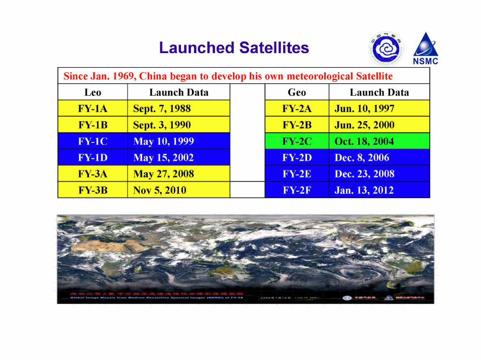
Chinese Meteorological Satellite: FengYun Series
Polar System Geostationary System
FY |
1A 1B 1C 1D
FY | 3A 3B 3C … 3F
FY
| 2A 2B 2C 2D 2E 2F
Second Generation
First Generation
Second Generation
First Generation
FY | 4A 4B 4C …


FengYun GEO. Satellites: FY-2
No. Pos. Status Launch FY-2A 105E Exp. (dead) Jun.10, 1997
FY-2B 105E Exp. (dead) Jun.20, 2000 FY-2C 105E Op. (spare) Oct.18, 2004
FY-2D 86.5E Op. (working) Dec.8, 2006
FY-2E 105E Op. (Working) Dec.23, 2008
FY-2F 112E Op. (Check-out)
Jan.13, 2012
FY-2D B: 86.5ºE
FY-2E A: 105ºE
Platform: Spin stabilization Payload: 5 chl. VISSR Full Disc: every 30 min. at most
FY-2E & FY-2D are working together to implement 15 min. interval obs.
FY-2E took over FY-2C in Dec. 2009!

ok
11 instruments onboard FY-3A, including: VIRR: Visible and Infra-Red Radiometer MERSI: Medium Resolution Spectral Imager IRAS: Infrared Atmospheric Sounder MWTS:MicroWave Temperature Sounder MWHS: MicroWave Humidity Sounder MWRI: MicroWave Radiation Imager SBUS: Solar Backscatter Ultraviolet Sounder TOU: Total Ozone mapping Unit SIM: Solar Irritation Monitor ERM: Earth Radiation Monitor SEM: Space Environment Monitor
No. Launch Orbit Status
FY-3A May 27,2008 M R&D
FY-3B Nov 05,2011 A R&D
FY-3C 2013 (plan) M Op.
FY-3D 2015 (plan) A Op.
FY-3E 2017 (plan) M Op.
FY-3F 2019 (plan) A Op.
Current 2nd Generation of LEO: FY-3A/B

Next update on 2nd generation FY-3 series


Next Generation of GEO satellite: FY-4
Prototype structure of FY-4A
Advanced Geo. Radiation Imager Geo. Interferometric Infrared Sounder Lightning Mapping Imager Space Environmental Package (not available on 1st satellite)
4 main instruments
No. Plan Launch Design Life Status FY-4A 2015 5 years R&D FY-4B 2017 7 years Op. FY-4C 2020 7 years Op.

FY-4A(R&D) FY-4B(Operational) Spectral
Parameters (cm-1)
Spectrum Range Resolution Channels LWIR: 700-1130 0.8 538 S/MIR:1650-2250 1.6 375
Spectrum Range Resolution Channels LWIR: 700-1130 0.625 688 S/MIR:1650-2250 1.2 500
Spatial Resolution At Nadir: 16Km IFOV: 448μrad At Nadir: 8Km IFOV: 224μrad
Operational Mode China area 5000 × 5000 Km2
Mesoscale area 1000 × 1000 Km2
China area 5000 × 5000 Km2
Mesoscale area 1000 × 1000 Km2
Temporal Resolution
China area 1 hr Mesoscale area ½ hr
China area about 1 hr Mesoscale area about ½ hr
Sensitivity (mW/m2sr cm-1)
LWIR: 0.5 S/MIR: 0.1 LWIR: 0.3 S/MIR: 0.06
Calibration accuracy of radiation
1.5k (3σ) 1.0k (3σ)
Calibration accuracy of spectrum
10 ppm (3σ) 5 ppm (3σ)
Quantization Bits 13 bits 13 bits
GIIRS: Specifications

11
2008FY-2E 2008FY-3A (R&D)
2012FY-2F
2010FY-3B (R&D)
2013FY-3C(Op)
2015FY-3D(Op)
2014FY-2G
2015FY-4A (R&D)
2017FY-3E(Op)
2016FY-RM(R&D)
2017FY-4B (Op)
2019FY-3F(Op)
2020FY-RM2 2020FY-4C(Op)
Road Map of FENGYUN Meteorological Satellites Development by Year 2020
2015FY-2H


