5The Changing Earth
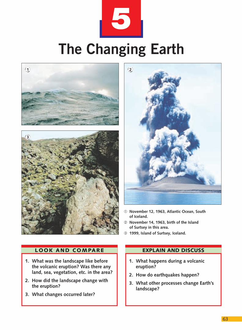
1. What was the landscape like beforethe volcanic eruption? Was there anyland, sea, vegetation, etc. in the area?
2. How did the landscape change withthe eruption?
3. What changes occurred later?
63
LOOK AND COMPARE
1. What happens during a volcaniceruption?
2. How do earthquakes happen?
3. What other processes change Earth’slandscape?
EXPLAIN AND DISCUSS
1 2
3
➀ November 12, 1963, Atlantic Ocean, Southof Iceland.
➁ November 14, 1963, birth of the Islandof Surtsey in this area.
➂ 1999, Island of Surtsey, Iceland.
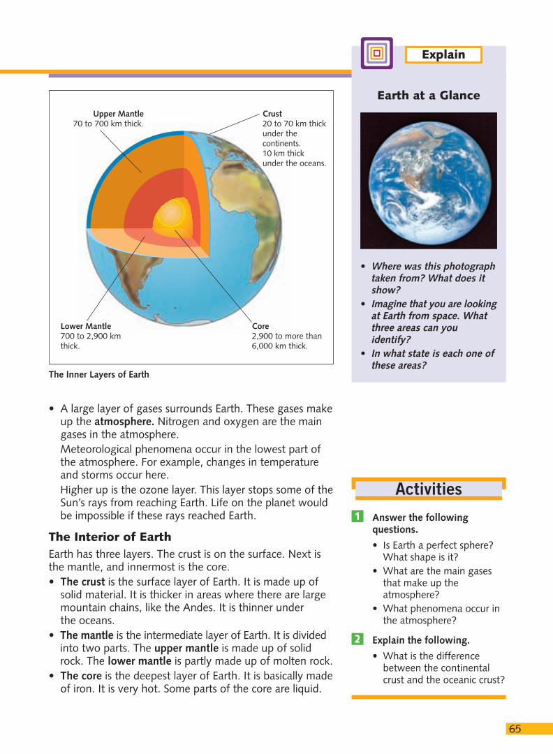
Shape and Size of EarthEarth is spherical. The other planets in the solar system are also spherical. But Earth is not a perfect sphere. It is flattened at the poles. We call this shape a geode.Earth is very small for a celestial body. For example, the Sun is more than a million times bigger than Earth.
The Surface of EarthWe can see different colors on the surface of Earth if welook at it from space. These colors correspond to threedifferent areas.• Some areas are solid land. These areas are called the
lithosphere. Part of the lithosphere is under the oceans.The other part is above the oceans and forms thecontinents and islands. There are seven continents: Asia, Europe, Africa, North America, South America,Australia/Oceania and the Antarctic. The continents and islands cover a quarter of Earth’s surface.
• Other areas are covered by water. This is called thehydrosphere. It includes oceans, seas, rivers, lakes andice. There are five oceans: the Pacific, Atlantic, Indian,Arctic and Antarctic. The hydrosphere covers threequarters of Earth’s surface.
64
1. Features of Earth
1. What is theatmosphere?
2. What do we call thesolid and the liquidareas of Earth?
3. What is the interior ofEarth like?
Questions
ARCTIC OCEAN
ANTARCTIC OCEAN
PACIFIC
OCEAN
ATLANTIC
OCEAN
E U R O P E
A F R I C A
INDIAN
OCEAN
A S I A
O C E A N I A
A N T A R C T I C
60°
40°
180°
20°
0°
20°
40°
60°
150°120°90°60°30°0°30°90° 60°120°150°180°150°60°
40°
20°
Tropic of Capricorn
Tropic of Cancer
20°
0° Equator
40°
60°180°
Artic Circle
N O R T HA M E R I C A
C E N T R A LA M E R I C A
S O U T HA M E R I C A
Gre
enw
ich
Mer
idia
n
Dateline
0 2.240
KilometresAntarctic Circle
Map of Earth’s Oceans and Continents
65
• A large layer of gases surrounds Earth. These gases makeup the atmosphere. Nitrogen and oxygen are the maingases in the atmosphere.Meteorological phenomena occur in the lowest part ofthe atmosphere. For example, changes in temperatureand storms occur here.Higher up is the ozone layer. This layer stops some of theSun’s rays from reaching Earth. Life on the planet wouldbe impossible if these rays reached Earth.
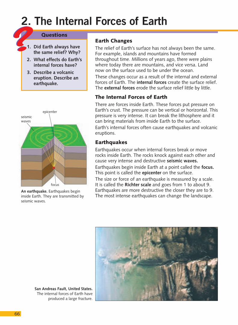
The Interior of EarthEarth has three layers. The crust is on the surface. Next isthe mantle, and innermost is the core.• The crust is the surface layer of Earth. It is made up of
solid material. It is thicker in areas where there are largemountain chains, like the Andes. It is thinner under the oceans.
• The mantle is the intermediate layer of Earth. It is dividedinto two parts. The upper mantle is made up of solidrock. The lower mantle is partly made up of molten rock.
• The core is the deepest layer of Earth. It is basically madeof iron. It is very hot. Some parts of the core are liquid.
Earth at a Glance
• Where was this photographtaken from? What does itshow?
• Imagine that you are lookingat Earth from space. Whatthree areas can youidentify?
• In what state is each one ofthese areas?
Explain
Answer the followingquestions.
• Is Earth a perfect sphere?What shape is it?
• What are the main gasesthat make up theatmosphere?
• What phenomena occur inthe atmosphere?
Explain the following.
• What is the differencebetween the continentalcrust and the oceanic crust?
2
1
Activities
The Inner Layers of Earth
Upper Mantle70 to 700 km thick.
Crust20 to 70 km thickunder thecontinents. 10 km thickunder the oceans.
Lower Mantle700 to 2,900 kmthick.
Core2,900 to more than6,000 km thick.
66
2. The Internal Forces of Earth
Earth ChangesThe relief of Earth’s surface has not always been the same.For example, islands and mountains have formedthroughout time. Millions of years ago, there were plainswhere today there are mountains, and vice versa. Landnow on the surface used to be under the ocean.These changes occur as a result of the internal and externalforces of Earth. The internal forces create the surface relief.The external forces erode the surface relief little by little.
The Internal Forces of EarthThere are forces inside Earth. These forces put pressure onEarth’s crust. The pressure can be vertical or horizontal. Thispressure is very intense. It can break the lithosphere and itcan bring materials from inside Earth to the surface.Earth’s internal forces often cause earthquakes and volcaniceruptions.
EarthquakesEarthquakes occur when internal forces break or moverocks inside Earth. The rocks knock against each other andcause very intense and destructive seismic waves.Earthquakes begin inside Earth at a point called the focus.This point is called the epicenter on the surface.The size or force of an earthquake is measured by a scale.It is called the Richter scale and goes from 1 to about 9.Earthquakes are more destructive the closer they are to 9.The most intense earthquakes can change the landscape.
1. Did Earth always havethe same relief? Why?
2. What effects do Earth’sinternal forces have?
3. Describe a volcaniceruption. Describe anearthquake.
Questions
San Andreas Fault, United States.The internal forces of Earth have
produced a large fracture.
An earthquake. Earthquakes begininside Earth. They are transmitted byseismic waves.
epicenter
focus
seismicwaves
67
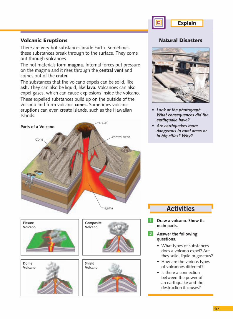
Volcanic EruptionsThere are very hot substances inside Earth. Sometimesthese substances break through to the surface. They comeout through volcanoes.The hot materials form magma. Internal forces put pressureon the magma and it rises through the central vent andcomes out of the crater.The substances that the volcano expels can be solid, likeash. They can also be liquid, like lava. Volcanoes can alsoexpel gases, which can cause explosions inside the volcano. These expelled substances build up on the outside of thevolcano and form volcanic cones. Sometimes volcaniceruptions can even create islands, such as the HawaiianIslands.
Draw a volcano. Show itsmain parts.
Answer the followingquestions.
• What types of substancesdoes a volcano expel? Arethey solid, liquid or gaseous?
• How are the various typesof volcanoes different?
• Is there a connectionbetween the power of an earthquake and thedestruction it causes?
2
1
Activities
Natural Disasters
• Look at the photograph.What consequences did theearthquake have?
• Are earthquakes moredangerous in rural areas orin big cities? Why?
Explain
Parts of a Volcano
Fissure Volcano
CompositeVolcano
DomeVolcano
ShieldVolcano
Cone
crater
central vent
magma
68
The External Forces of EarthWind, water and people erode the relief of Earth’s surface.These changes occur slowly, over millions of years.External changes happen in three phases: erosion of theground, transport of the eroded materials, and depositionof these materials in faraway places.
ErosionErosion is the constant wearing away of rocks and soil.Temperature, water, wind and people cause erosion.• Sharp changes in temperature break rocks into
fragments. This occurs in areas where there is a bigdifference between daytime and nighttime temperatures,such as mountains and deserts. Sometimes water thathas filtered through cracks in rocks freezes. This acts likea wedge and breaks the rocks.
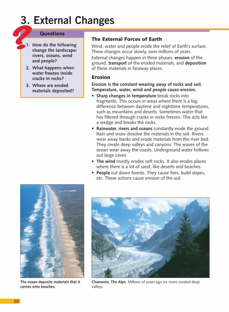
• Rainwater, rivers and oceans constantly erode the ground.Rain and snow dissolve the materials in the soil. Riverswear away banks and erode materials from the river bed.They create deep valleys and canyons. The waves of theocean wear away the coasts. Underground water hollowsout large caves.
• The wind mostly erodes soft rocks. It also erodes placeswhere there is a lot of sand, like deserts and beaches.
• People cut down forests. They cause fires, build slopes,etc. These actions cause erosion of the soil.
3. External Changes
1. How do the followingchange the landscape:rivers, oceans, windand people?
2. What happens whenwater freezes insidecracks in rocks?
3. Where are erodedmaterials deposited?
Questions
The ocean deposits materials that itcarries onto beaches.
Chamonix, The Alps. Millions of years ago ice rivers created deepvalleys.

Look at the diagram of thecourse of river
• Where do you think theerosive power of a river isgreatest, in the upper,middle or lower course?
• Where is sedimentationgreatest? Why?
6969
Transporting MaterialsEroded materials are transported from one place to another.The wind, river currents and ocean water transport thesematerials. Wind carries sand and small rocks. Rivers andoceans carry large amounts of dissolved materials. Theyalso carry larger materials floating on the surface.
SedimentationSedimentation occurs when the materials carried by water,ice or wind are deposited. The accumulation of thesematerials leads to changes in the landscape.• A river transports the materials. It deposits them on its
banks to create terraces. It deposits them at its mouth tocreate deltas.
• Ocean waves deposit materials on the low shores. Thedeposited materials create beaches.
• The wind transports large quantities of sand. This createsdunes in deserts and on the coast.
Explain erosion, transportand sedimentation in relationto the following:
a) a river. c) a desert.b) an ocean. d) a mountain.
Is erosion occurring on Earthnow? Why?
2
1
Activities
Compare
The Course of a River ➀ The river erodes materials in its upper course. ➁ Waterfallsform in mountainous or hilly areas. Waterfalls alsoerode materials. ➂ The river creates deep gorges.➃ The river deposits some materials in its middlecourse and creates meanders. ➄ The river depositsmaterials midstream and creates terraces.➅ The river deposits materials at its mouth. This creates a delta. ➆ The river can create natural bridges.
123
4
5
6
7
GENERAL CONCEPTS
Write the meaning of the following:
a) Earth’s crust. d) sedimentation.b) Earth’s core. e) volcano.c) erosion. f) earthquake.
Check your knowledge. Write the letter ofone of the above terms in the spaces.
Write an X in the correct columns.
BASIC CONTENT
Complete the concept map.4
3
2
1
70
Write the name of each layer.
Answer the following questions.
• Has Earth always looked the same?• What caused the changes?• Do internal or external forces form Earth’s
surface relief?• What kinds of forces change the relief
later, over time?
Label the parts of a volcano. Complete thesentences.
a) The materials that volcanoes expel can be, or.
b) The solid materials volcanoes expel are.
c) The materials in liquid form are called.
SYNTHESIZE
Put these sentences in order from 1 to 5.
The wind transports the eroded materials.The height of the mountain decreases.Internal forces create a mountain.The materials settle at the foot of themountain.Wind and rain erode the mountain.
Write an example for each case.9
8
7
6
5
Atmosphere
Hydrosphere
Lithosphere
Crust
Upper Mantle
Lower Mantle
Core
Gaseous Liquid Solid
Earth
has three outerparts
has three innerlayers
Earth's Layers
composed of
Activities
Earth is constantly moving. Theinternal movements (…) (…)sometimes cause great catastrophes.The surface layer of Earth (…) isconstantly being eroded. (…) Theeroded materials are transported anddeposited. They create beaches,terraces and deltas. (…) Theinnermost layer of Earth (…) has asolid and a liquid part.
Erosion
Transport
Sedimentation
Rivers Wind Ocean

MULTICULTURAL EDUCATION
7171
Formation of the Continents
Look at the maps and answer the questions.
• How many continents were present on Earth 500 million years ago? What was its name?• What changes happened 248 million years ago? And 65 million years ago?• When did Earth start to look like it does now?• How was Earth 65 million years ago different from Earth today?
Answer and explain the following.
• What causes Earth to change?• Do you think the continents are moving now? Why or why not?• Why does Africa’s outline fit into America’s outline?
2
1
INVESTIGATE
Outdated Devicesto Detect Earthquakes
People have always been concerned withearthquakes. A Chinese scientist invented the first device to detect earthquakes in thesecond century. It was a very big bronzedevice with a small pendulum inside. Thependulum shook when there was a tremor.There were dragons on the outside of thedevice. They dropped the heavy balls theyhad in their mouths into the mouths of thefrogs sitting around the device. People couldtell where the earthquake happeneddepending on where the balls fell.
• What do you think would happen if a tremor was very strong?
PANGAEA TethysSea
LAURASIA
GONDWANA
AMERICA
AFRICA
ANTARCTICA-AUSTRALIA
ASIAEUROPE
AFRICA
OCEANIA
AMERICA
ANTARCTIC
PALEOZOIC ERA570 to 248 million
years ago
MESOZOIC ERA248 to 65 million
years ago
CENOZOIC ERA65 million years ago
to present
PRESENT DAY
72
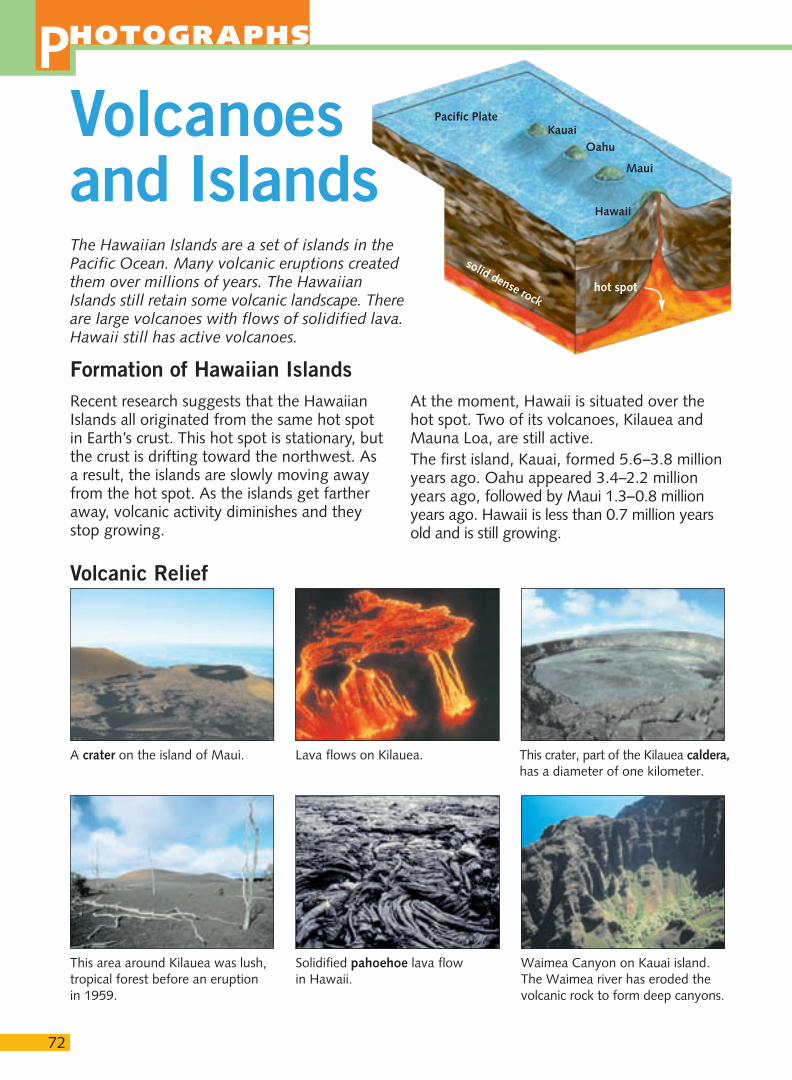
Volcanoes and IslandsThe Hawaiian Islands are a set of islands in thePacific Ocean. Many volcanic eruptions createdthem over millions of years. The HawaiianIslands still retain some volcanic landscape. Thereare large volcanoes with flows of solidified lava.Hawaii still has active volcanoes.
A crater on the island of Maui. This crater, part of the Kilauea caldera,has a diameter of one kilometer.
Lava flows on Kilauea.
This area around Kilauea was lush,tropical forest before an eruption in 1959.
Waimea Canyon on Kauai island.The Waimea river has eroded thevolcanic rock to form deep canyons.
Solidified pahoehoe lava flow in Hawaii.
Volcanic Relief
PHOTOGRAPHS
At the moment, Hawaii is situated over thehot spot. Two of its volcanoes, Kilauea andMauna Loa, are still active. The first island, Kauai, formed 5.6–3.8 millionyears ago. Oahu appeared 3.4–2.2 millionyears ago, followed by Maui 1.3–0.8 millionyears ago. Hawaii is less than 0.7 million yearsold and is still growing.
Formation of Hawaiian IslandsRecent research suggests that the HawaiianIslands all originated from the same hot spotin Earth’s crust. This hot spot is stationary, butthe crust is drifting toward the northwest. Asa result, the islands are slowly moving awayfrom the hot spot. As the islands get fartheraway, volcanic activity diminishes and theystop growing.
Pacific PlateKauai
Oahu
Maui
Hawaii
hot spot
solid dense rock
1. Find information about the Kilaueavolcano. Complete the fact file.
2. Choose an animal and a plant from theHawaiian Islands. Complete the diagram.
73
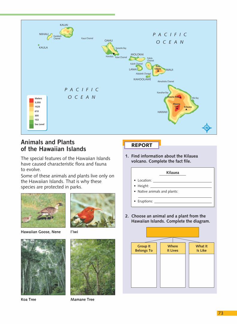
Mauna Kea
P A C I F I C
O C E A N
P A C I F I C
O C E A N
KAULA
NIIHAU
KAUAI
OAHU
MOLOKAI
LANAI MAUI
KAHOOLAWE
HAWAII
MaunaLoa Kilauea
Kawaihae Bay
Hilo Bay
Alenuihaha Channel
Alalakeiki Channel
PailoloChannel
Kalohi Channel
Kaiwi Channel
Kauai ChannelKaulakahiChannel
PuuUlaula
Kaneohe Bay
Honolulu
3,050
1525
610
305
153
Sea Level
Meters
REPORT
Kilauea
• Location:
• Height:
• Native animals and plants:
• Eruptions:
Animals and Plantsof the Hawaiian IslandsThe special features of the Hawaiian Islandshave caused characteristic flora and fauna to evolve.Some of these animals and plants live only onthe Hawaiian Islands. That is why thesespecies are protected in parks.
WhereIt Lives
Group ItBelongs To
What ItIs Like
Hawaiian Goose, Nene
Koa Tree Mamane Tree
I’iwi
PHOTOGRAPHS
74
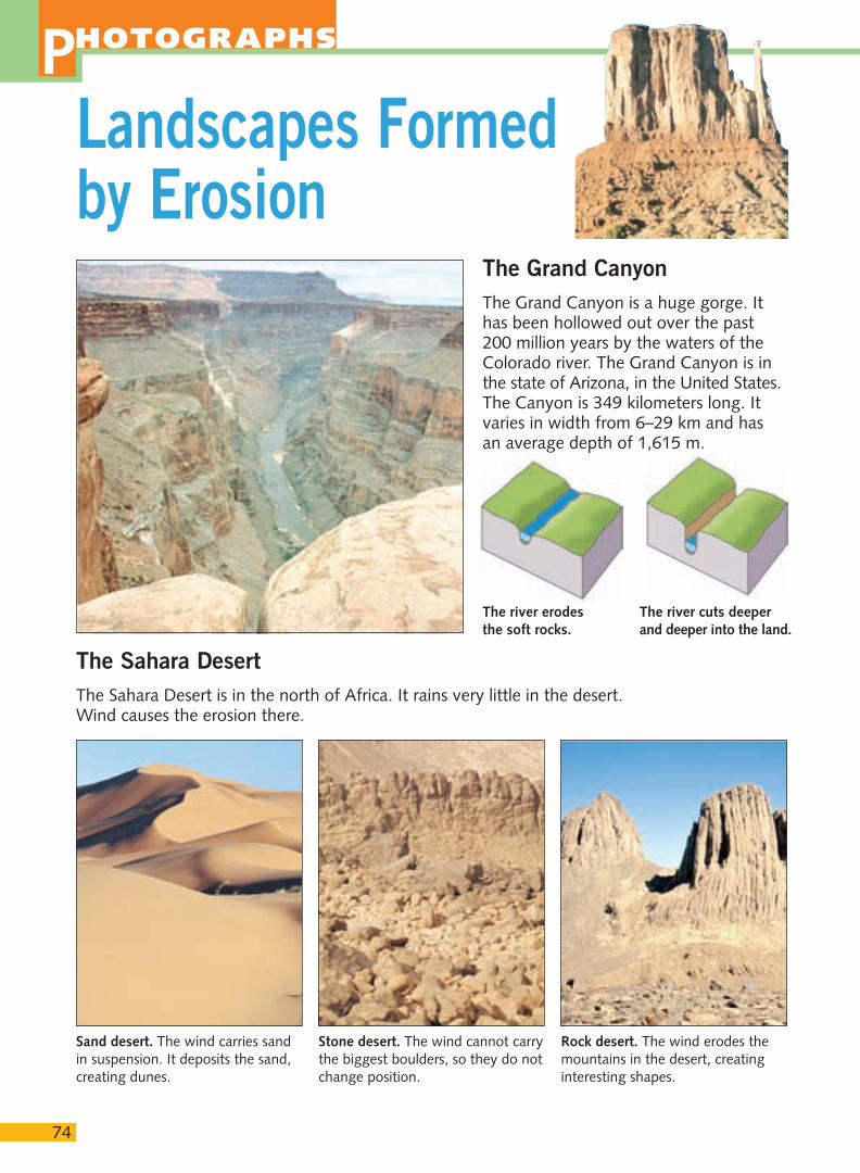
The Grand CanyonThe Grand Canyon is a huge gorge. Ithas been hollowed out over the past200 million years by the waters of theColorado river. The Grand Canyon is inthe state of Arizona, in the United States.The Canyon is 349 kilometers long. Itvaries in width from 6–29 km and has an average depth of 1,615 m.
Landscapes Formedby Erosion
The Sahara DesertThe Sahara Desert is in the north of Africa. It rains very little in the desert.Wind causes the erosion there.
Sand desert. The wind carries sandin suspension. It deposits the sand,creating dunes.
Rock desert. The wind erodes themountains in the desert, creatinginteresting shapes.
Stone desert. The wind cannot carrythe biggest boulders, so they do notchange position.
The river cuts deeperand deeper into the land.
The river erodesthe soft rocks.
75
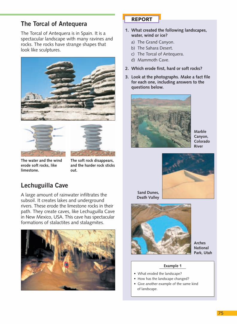
The Torcal of AntequeraThe Torcal of Antequera is in Spain. It is aspectacular landscape with many ravines androcks. The rocks have strange shapes thatlook like sculptures.
Lechuguilla CaveA large amount of rainwater infiltrates thesubsoil. It creates lakes and undergroundrivers. These erode the limestone rocks in theirpath. They create caves, like Lechuguilla Cavein New Mexico, USA. This cave has spectacularformations of stalactites and stalagmites.
1. What created the following landscapes,water, wind or ice?
a) The Grand Canyon.b) The Sahara Desert.c) The Torcal of Antequera.d) Mammoth Cave.
2. Which erode first, hard or soft rocks?
3. Look at the photographs. Make a fact filefor each one, including answers to thequestions below.
REPORT
The water and the winderode soft rocks, likelimestone.
The soft rock disappears,and the harder rock sticksout.
Example 1
• What eroded the landscape? • How has the landscape changed? • Give another example of the same kind
of landscape.
Sand Dunes,Death Valley
ArchesNationalPark, Utah
MarbleCanyon,ColoradoRiver
76
A FICTITIOUS CASE: DOCUMENTS FOR DEBATE
DEBATE
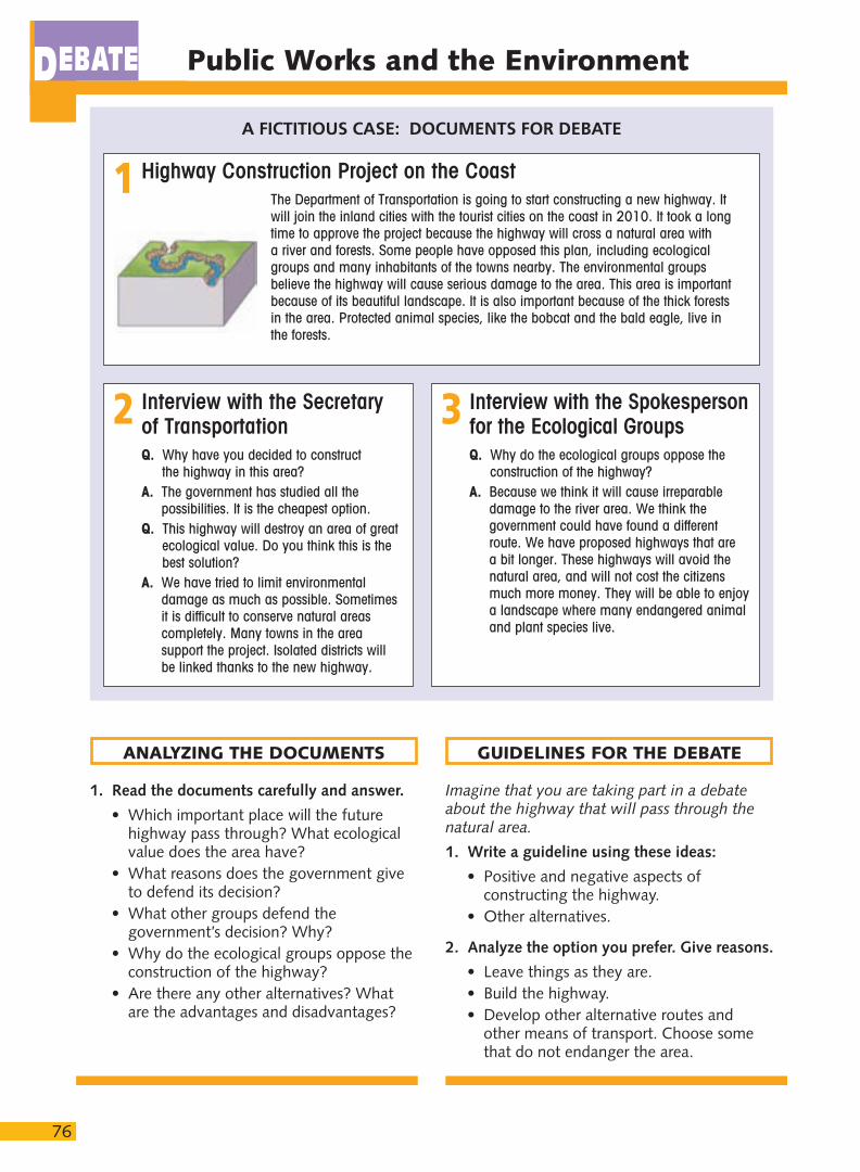
Highway Construction Project on the CoastThe Department of Transportation is going to start constructing a new highway. Itwill join the inland cities with the tourist cities on the coast in 2010. It took a longtime to approve the project because the highway will cross a natural area with a river and forests. Some people have opposed this plan, including ecologicalgroups and many inhabitants of the towns nearby. The environmental groupsbelieve the highway will cause serious damage to the area. This area is importantbecause of its beautiful landscape. It is also important because of the thick forestsin the area. Protected animal species, like the bobcat and the bald eagle, live inthe forests.
1
Interview with the Secretaryof TransportationQ. Why have you decided to construct
the highway in this area?A. The government has studied all the
possibilities. It is the cheapest option.Q. This highway will destroy an area of great
ecological value. Do you think this is thebest solution?
A. We have tried to limit environmentaldamage as much as possible. Sometimesit is difficult to conserve natural areascompletely. Many towns in the areasupport the project. Isolated districts willbe linked thanks to the new highway.
2 Interview with the Spokesperson for the Ecological GroupsQ. Why do the ecological groups oppose the
construction of the highway?A. Because we think it will cause irreparable
damage to the river area. We think thegovernment could have found a differentroute. We have proposed highways that are a bit longer. These highways will avoid thenatural area, and will not cost the citizensmuch more money. They will be able to enjoya landscape where many endangered animaland plant species live.
3
1. Read the documents carefully and answer.
• Which important place will the futurehighway pass through? What ecologicalvalue does the area have?
• What reasons does the government giveto defend its decision?
• What other groups defend thegovernment’s decision? Why?
• Why do the ecological groups oppose theconstruction of the highway?
• Are there any other alternatives? Whatare the advantages and disadvantages?
Imagine that you are taking part in a debateabout the highway that will pass through the natural area.
1. Write a guideline using these ideas:
• Positive and negative aspects ofconstructing the highway.
• Other alternatives.
2. Analyze the option you prefer. Give reasons.
• Leave things as they are.• Build the highway.• Develop other alternative routes and
other means of transport. Choose somethat do not endanger the area.
ANALYZING THE DOCUMENTS GUIDELINES FOR THE DEBATE
Public Works and the Environment


