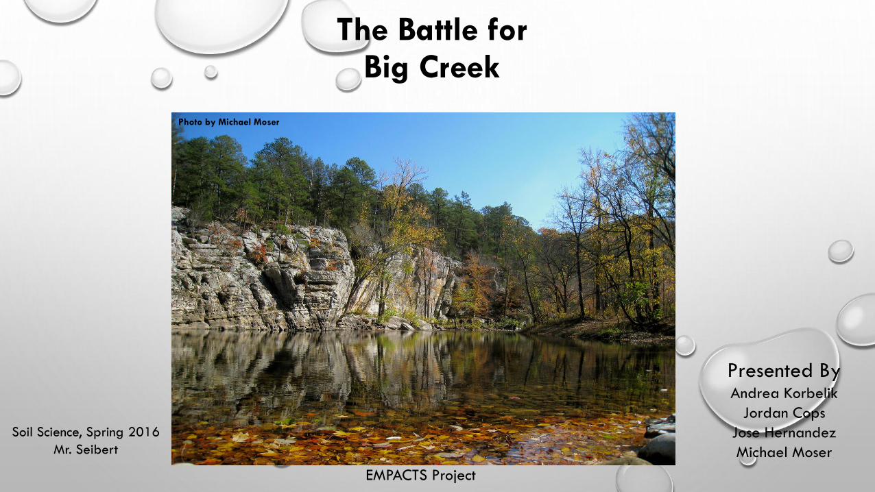
The Battle for Big Creek
Soil Science, Spring 2016
Mr. Seibert
Presented By Andrea Korbelik
Jordan Cops
Jose Hernandez
Michael Moser
EMPACTS Project
Photo by Michael Moser

Mission Statement
• With new technological advances and a
rapidly growing population, our natural
environments are at risk.
• With soil sampling and analysis along the
Big Creek Watershed, we hope to ensure
the preservation of our local ecosystem.
Photo by Michael Moser
Project Overview Methods and Technology
• On March 3rd, our group gathered soil samples and developed visual cues around the farm.
Samples were collected above the farm to create a control for our experiment. Four more samples
were collected downstream along the banks of Big Creek. The samples were collected in low lying
areas influenced by run-off.
• With assistance from the Benton County Extensions Service, we were able to process the samples
and investigate available nutrients within the soil. Our sample soil analysis was made available on
April 12th.
• Through research and communication with local organizations, we hope to see a relocation of the
C & H Swine Farm.
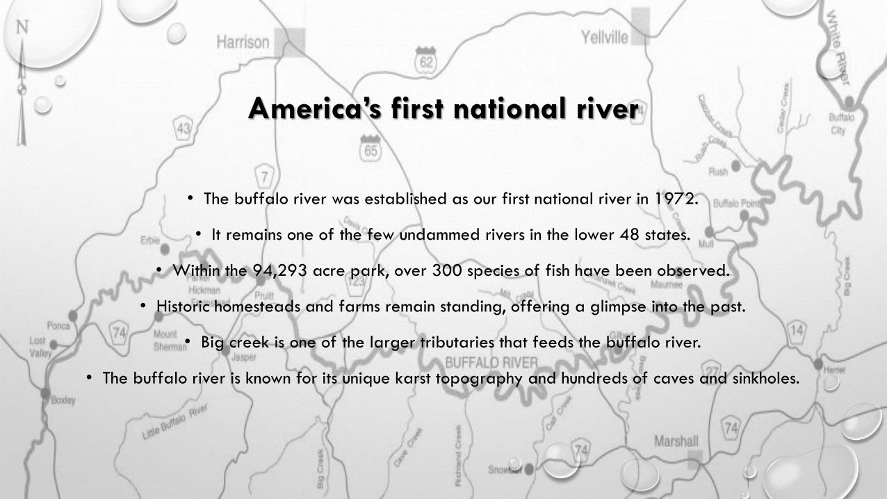
America’s first national river
• The buffalo river was established as our first national river in 1972.
• It remains one of the few undammed rivers in the lower 48 states.
• Within the 94,293 acre park, over 300 species of fish have been observed.
• Historic homesteads and farms remain standing, offering a glimpse into the past.
• Big creek is one of the larger tributaries that feeds the buffalo river.
• The buffalo river is known for its unique karst topography and hundreds of caves and sinkholes.

Karst topography
• Karstic features are created through the dissolution of soluble limestone. It is a dominate
characteristic found throughout the Ozark Mountains (47,000 sq. Miles).
• These features lead to the formation of caves, sinkholes and springs. This is due to the porosity of
the rock.
• The quick absorption rate allows toxic materials to infiltrate the water table and private wells
without the natural filtration process.
Photo by Michael Moser

• The swine farm rests on 630 acres within the Big Creek watershed, which finds its way into the
Buffalo River. The facility consists of 17 waste application fields and several holding ponds that
equate to a 1,904,730 gallon capacity.
• This concentrated animal feeding operation (CAFO) has over 6,000 pigs. The population creates 2
million pounds of sewage each year.
• Swine manure contains nitrogen, phosphorous, potassium, calcium, magnesium, sulfur, and many
metals. We expect to see an increase in the primary and secondary nutrients through soil testing.
• High amounts of air pollution and water pollution are synonymous with large operations. This
concerns the local population of Mt. Judea because the school is only 1/16th of a mile away.
The C & H Swine Farm
The C & H Swine Farm
• The holding ponds take advantage of naturally occurring bacteria to break town the waste. They are
lined with several inches of clay, leaving them exposed to the open atmosphere.
• Byproducts associated with swine farms are ammonia, methane, hydrogen sulfide, and antibiotic
resistant bacteria.
• The farm is designed to accommodate the effects of a 25 year rain event. Within the past 40 years,
Big Creek has seen one 50 year flood in 1982.
• Property values have decreased within a 3 mile radius.
• The Mt. Judea community was completely oblivious to the construction of the swine farm. Public
information regarding this CAFO was buried deep within the ADEQ online database. Unfortunately, an
environmental impact statement is not required in the state of Arkansas.
• In 2011, the EPA made alterations to regulations that created general restrictions and permits across
the state. This does not account for sensitive environments such as the karst landscape around the
Buffalo River.


Notice the location of the Farm and waste
application fields. Each field lies above a
tributary that makes its way into Big Creek
and eventually, the Buffalo River.
Mt. Judea School (k-12) is surrounded by
these waste application fields.
http://buffaloriveralliance.org/Resources/Documents/B
ig%20Creek%20Karst%20Facts.jpg

Sample 1: Big Creek (above pig farm)
Qat – Alluvium and terrace deposits.
Unconsolidated clay, silt, sand, and gravel
including deposits on one or more terrace levels.
Sample 2: Big Creek (below pig farm)
Qat
Sample 3: Left Fork of Big Creek
Qat
Sample 4: Big Creek (after Left Fork joins)
Qat
Sample 5: The Buffalo River (where Big Creek
rushes in)
Qty – Unconsolidated clay, silt, sand and
gravel along the Buffalo River. The tops of
terraces are generally tree-covered and
flat. Approximately 20-30 feet thick

Collecting samples above the C & H swine farm.
Left Fork of Big Creek
Photo by Michael Moser
Photo by Michael Moser
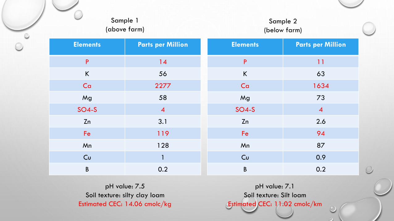
Elements Parts per Million
P 14
K 56
Ca 2277
Mg 58
SO4-S 4
Zn 3.1
Fe 119
Mn 128
Cu 1
B 0.2
Elements Parts per Million
P 11
K 63
Ca 1634
Mg 73
SO4-S 4
Zn 2.6
Fe 94
Mn 87
Cu 0.9
B 0.2
pH value: 7.5
Soil texture: silty clay loam
Estimated CEC: 14.06 cmolc/kg
pH value: 7.1
Soil texture: Silt loam
Estimated CEC: 11.02 cmolc/km
Sample 1
(above farm) Sample 2
(below farm)

Elements Parts per
Million
P 19
K 50
Ca 4076
Mg 73
SO4-S 14
Zn 5.4
Fe 242
Mn 103
Cu 1.6
B 0.8
Elements Parts per
Million
P 12
K 42
Ca 4359
Mg 34
SO4-S 11
Zn 3.7
Fe 186
Mn 129
Cu 2
B 0.5
pH value: 7.5
Soil texture: clay
Estimated CEC: 23.18 cmolc/kg
pH value: 7.6
Soil texture: clay
Estimated CEC: 24.26 cmolc/km
Sample 3
(Left Fork)
Sample 4
(after merging with
Left Fork)
Elements Parts per
Million
P 17
K 39
Ca 1862
Mg 61
SO4-S 7
Zn 5.4
Fe 197
Mn 117
Cu 1.2
B 0.6
pH value: 7.1
Soil texture: Silt loam
Estimated CEC: 11.96 cmolc/km
Sample 5
(Buffalo River)

Results
• Our findings indicate a presence of pollution entering the Big Creek Watershed. Yet, the increase
in nutrients are entering from the Left Fork of Big Creek.
• The results conclude that there are high levels of phosphorous, sulfates, and iron entering the creek;
components found in manure. Due to the fragile karst geology, it is difficult to trace the source of
pollution.
• After investigating topography maps of the Big Creek watershed, there are several other farms
that reside along the flood plains of the Left Fork of Big Creek. These other farms could be the
source of the increase of foreign substances.
• Further studies on the Left Fork and main prong of Big Creek are necessary to locate the source of
pollution.
Photo by Michael Moser

Left Fork of Big Creek
Big Creek
C & H Swine Farm

Possible sources of point pollution on the Left Fork of Big Creek
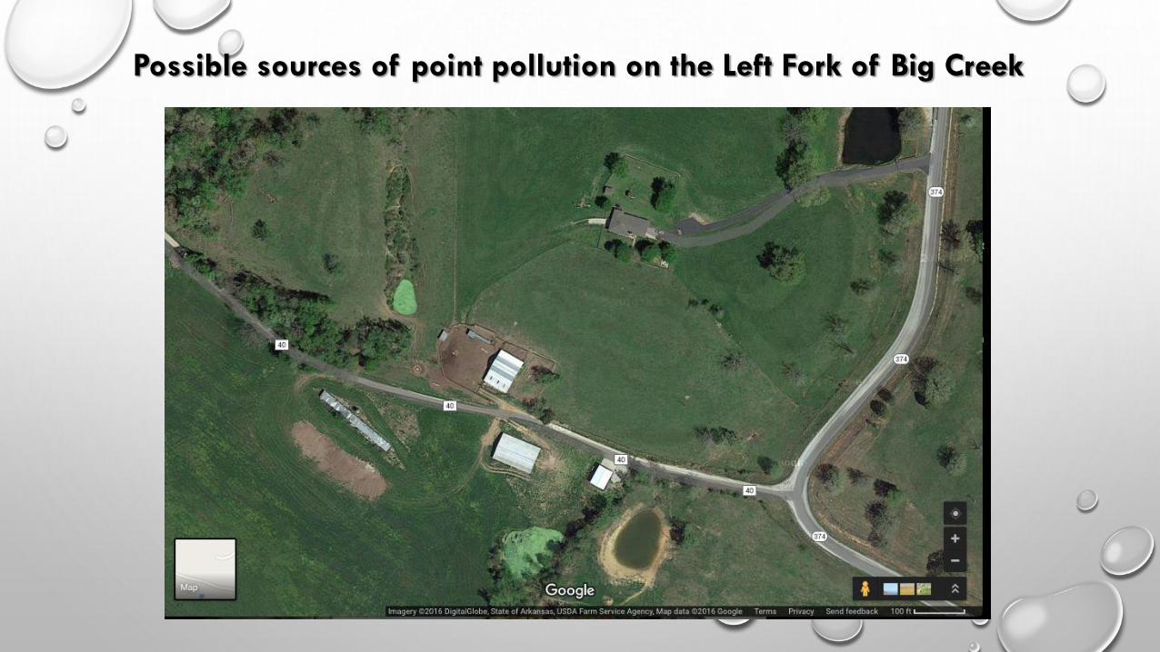
Possible sources of point pollution on the Left Fork of Big Creek

Soil Contamination
• Excess amounts of phosphorous and calcium can prevent plants from taking up other vital
nutrients. Acidic soils are usually associated with too much phosphorous or calcium.
• High amounts of iron can be toxic to plants, and prevent the absorption of other minerals.
The leaves of plants can brown when there is too much available iron within the soil.
• These excess metals can be harmful to microorganism within the soil, damaging their cellular
structures.

Ground Water Contamination
• Even though the C & H Swine Farm has taken extra
precautions to prevent the infiltration of sewage
into ground water, the karst landscape needs
special protection.
• With 6,000 swine and 17 waste application fields,
there will always be a chance of pollution.
• The porous rock found along the Buffalo River
watershed allows liquids to enter aquifers and
under ground caverns with very little filtration.
• Toxins that enter ground water systems can lead to
widespread devastation within thousands of square
miles.

Water Pollution
• Eutrophication is the accumulation of nutrients,
usually phosphates and nitrates, within a
body of water. This typically leads to an
algae bloom that can dominate the water’s
surface. Once the algae dies, the organic
matter accumulates and depletes the
dissolved oxygen levels.
• The processes of eutrophication can devastate
aquatic life, and impact the local food chain.
Fish, reptiles, birds, and even humans can be
affected from excessive amounts of nutrients
found within fresh water sources.
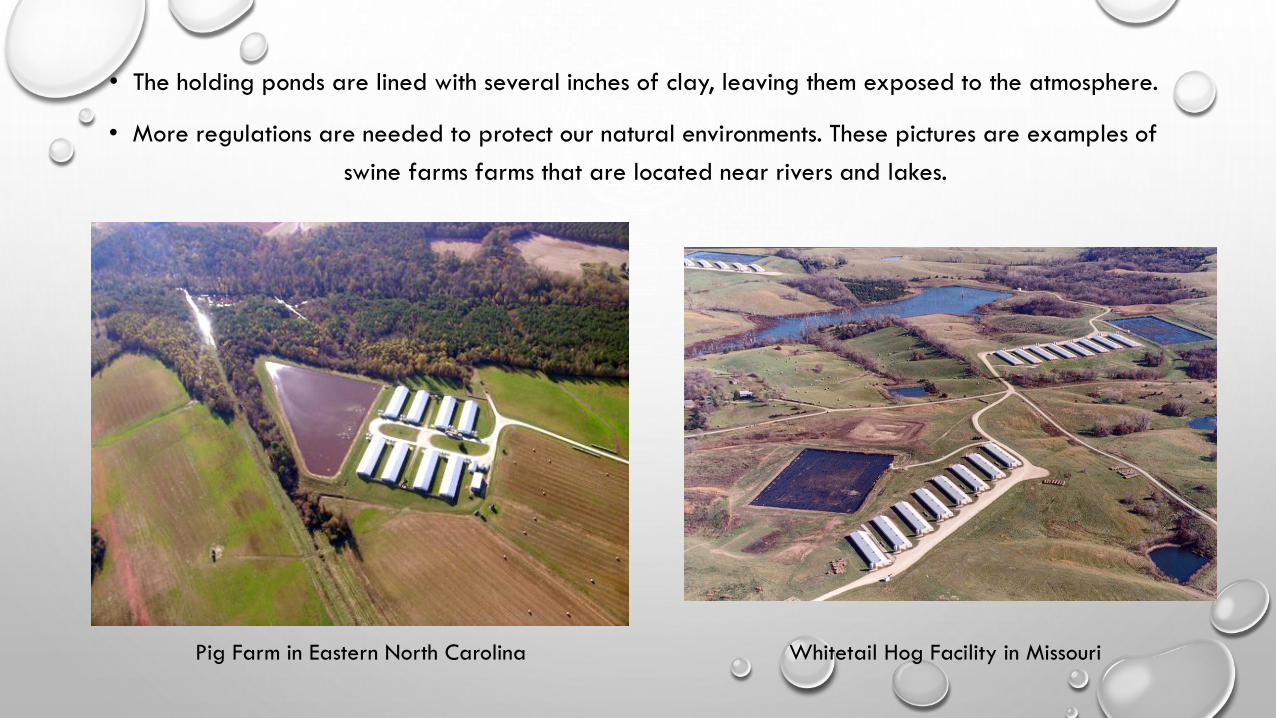
• The holding ponds are lined with several inches of clay, leaving them exposed to the atmosphere.
• More regulations are needed to protect our natural environments. These pictures are examples of
swine farms farms that are located near rivers and lakes.
Pig Farm in Eastern North Carolina Whitetail Hog Facility in Missouri
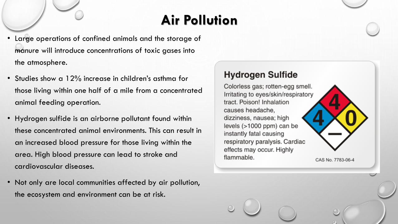
Air Pollution • Large operations of confined animals and the storage of
manure will introduce concentrations of toxic gases into
the atmosphere.
• Studies show a 12% increase in children’s asthma for
those living within one half of a mile from a concentrated
animal feeding operation.
• Hydrogen sulfide is an airborne pollutant found within
these concentrated animal environments. This can result in
an increased blood pressure for those living within the
area. High blood pressure can lead to stroke and
cardiovascular diseases.
• Not only are local communities affected by air pollution,
the ecosystem and environment can be at risk.

What can we do?
• The Buffalo River Watershed is a precious treasure that must be protected.
• There are many other ideal locations for these concentrated animal feeding operations such as the
C & H Swine Farm.
• More regulations are needed to protect the public, and ensure the health of our natural
environments.
• As populations continue to grow and arable land becomes less available, we will see a rapid
development of these large, concentrated operations. Location and regulations are going to play
a critical role in ensuring a healthy environment.
• We the people must speak up and take action before corporations take hold of our sacred lands
and rivers.

Phytoremediation
• By planting more trees, shrubs, and water
loving plants along the waterway, we can
reduce the amount of toxins that enter the
water. This method uses phytoremediation,
the natural accumulation of nutrients in
plants, to absorb excess nutrients.
• This has been used since the 14th century to
prevent eutrophication and absorb high
levels of metals.

Riparian buffer zones
• This satellite image of Big Creek shows very little vegetation along
the creek.
• A riparian zone is an area along a body of water that slows the
rate of infiltration. This method uses a variety of plants that uptake
these excessive nutrients as they grow and accumulate mass over the
years.

• Even though our findings are inconclusive of pollution leaving the C & H Swine Farm, we have
stumbled upon other non-point sources entering the Big Creek watershed.
• These soil samples were gathered at the beginning of March, early in the spring season. It could
be that the C & H operation had not applied any fertilizer yet this year. With 17 application
fields, there is a high possibility that runoff will enter the watershed.
• The C & H Swine Farm has seen much criticism over the years and is tied down to several
regulations. It is assuring that we do not see toxic levels of nutrients entering below the operation,
although, further testing on a routine schedule is needed.
Conclusion
Photo by Michael Moser

Acknowledgements
Soil Science & Management: sixth edition – Edward Plaster; Delmar
Neil Mays with the Benton County Extensions Services
Buffalo River Watershed Alliance
National Center for Biotechnology Information
USGS Arkansas Water Science Center
University of Arkansas
Clemons University
Dianne Phillips
Photo by Michael Moser


