FILENAME: H:\PROJFILE\10771 - MEDFORD TGM\MEMOS\MEMO3\TM3A_DRAFT_JA EDITS_V2.DOC
Technical Memorandum #3: Roadway Review
Date: July 20, 2012
To: Alex Georgevitch
City of Medford
From: Joe Bessman, Julia Kuhn, and Matt Kittelson
Project: TSP/UGB Amendment
Subject: Draft 2028 Roadway Needs Memorandum
This memorandum outlines our review of the City of Medford’s roadway functional
classification system, cross-section elements, and supporting standards and policies. This review
will help inform recommended policy modifications to support the updated year 2028 planning
horizon and better meet the City’s multi-modal, economic development, and mobility goals.
FUNCTIONAL CLASSIFICATION PURPOSE AND GOALS
The City’s functional classification system
provides an integrated, interconnected
transportation system that supports its land
use vision, economic development goals, and
provides mobility for all modes of travel for
people and goods. Meeting these objectives
requires appropriately located and sized
facilities for the types and amount of lands
served.
Roadways are typically classified as local
streets, collectors, arterials, and highways, with
various subsets of these general classes. Lower-
order streets, such as those found in residential
neighborhoods, provide high levels of
accessibility to the adjacent street. Throughput
on local streets is intended to be low as the
primary function is to connect users to their destinations. Alternatively, freeways provide strictly
controlled access with entering movements allowed only at merging and diverging movements
at interchanges. Limiting the speed differentials between through and turning movements on
freeways through access management allows high levels of throughput.
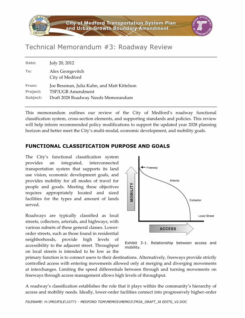
A roadway’s classification establishes the role that it plays within the community’s hierarchy of
access and mobility needs. Ideally, lower-order facilities connect into progressively higher-order
Exhibit 3-1. Relationship between access and mobility.

Technical Memorandum 3: Roadway Review July 20, 2012
City of Medford TSP/UGB Amendment Page 2
facilities, allowing a smooth transition between access and throughput while providing for safe
and efficient movement of people and goods. However, natural features, topographical
limitations, compatibility issues, and the built urban environment all provide constraints that
make this ideal system impractical. Planning for the needs of active transportation modes is
essential to providing a complete transportation system for a community. The Transportation
Planning Rule (OAR 660-12) requires that Collector and Arterial facilities include pedestrian and
bicycle facilities (typically bicycle lanes and sidewalks) to provide continuous facilities for
walking and cycling.
Functional classification systems set standards for how facilities should “look and feel” and
provide a basis for the public and policy-makers to understand, identify, and prioritize needed
improvements. Functional classification helps inform right-of-way needs and provides a vision
for appropriate street design and streetscape characteristics. Finally, functional classification
systems guide the City’s development of policies and performance standards needed to operate,
manage, maintain, and finance a transportation system that advances the City’s economic and
livability goals.
EXISTING STREET FUNCTIONAL CLASSIFICATION SYSTEM
The City of Medford uses the Street Functional Classification system to reserve future right-of-
way, determine a consistent street design that complements existing and planned land uses,
develop future street improvement projects, and maximize the effectiveness of transportation
investments. Service to commercial and industrial centers typically includes higher-order facility
classifications to promote mobility and recognize Medford’s role in the regional, state, and
interstate economy; in residential areas low-level classifications are used to support livability,
accessibility, and traffic calming. The existing Street Functional Classification system provides
flexibility to accommodate changing needs as the City develops; however, as Medford continues
to grow, it will occasionally review and assess the functional classification system to ensure that
designations meet the City’s needs.
The existing Street Functional Classification system, as described in the Medford Municipal
Code, contains twelve classifications. Table 1 shows the cross-section dimensions of each
functional classification. A detailed description of the design and operation of the primary
functional classes and standard cross-section graphics are provided below. Figure 1 shows the
existing functional classification of streets in the City of Medford.

BIDDLE RD
E MCANDREWS RD
TAB
LE R
OCK
RD
BARNETT RD
HILLCREST RD
LEA
R WY
W MAIN ST
CRA
TER
LAKE
AV
E VILAS RD
E MAIN ST
SPRING ST
SISKIYOU BL
N FO
OTHI
LL R
D
HAU
L RD
CHERRY LN
S COL
UMBU
S AV
E JACKSON ST
GARFIELD AV
S HOLLY ST N PH
OENI
X RD
N RO
SS LN
N CENTRAL AV
LOZ
IER
LN
SAGE RD
KIN
GS H
W
W 8TH ST
DELTA WATERS RD
W 10TH ST
OWEN DR
S OAK
DALE
AV
N RIVERSIDE AV
STEWART AV
S PEA
CH ST
W 4TH ST
LONE PINE RD
BLA
CK O
AK D
R
S RIVERSIDE AV
DIAMOND ST
BEALL LN
POP
LAR
DR
DAKOTA AV
JUANIPERO WY
CEDAR LINKS DR
N CO
LUMB
US AV
COU
RT S
T
COAL MINE RD
INDU
STRY
DR
W MCANDREWS RD
HIG
HLAN
D DR
MED
CO H
AUL R
D
STEVENS ST
SOUTH STAGE RD
COKER BUTTE RD
MUR
PHY R
D
MERRIMAN RD
BUL
LOCK
RD
N HOLLY ST
PIER
CE R
D ROY
AL AV
W JACKSON ST
ROSSANLEY DR
E 10TH ST
OREGON AV
ROBERTS RD
CENTER DR
SUNSET DR
E 8TH ST
BRO
OKDA
LE AV
CARDINAL AV
N OAKDALE AV
CUNNINGHAM AV
ELL
ENDA
LE D
R
INTE
RNAT
IONA
L WY
WILLOW WY
OAK
GRO
VE R
D
SPRINGBROOK RD
LAWNSDALE RD
S FRONT ST
ROSSANLEY DR
STEWART AV BARNETT RD
SUNR
ISE AV
EXCE
L DR
Bear Creek
CENTRAL OREGON AND PACIFIC RR
Existing Functional Classifications
H:\projfile
\10771 - M
edford TG
M\GIS\20
28 Tech M
emo 4\3-1
Existing F
unctional
Classifica
tion.mxd
Medford TSP Update and UGB Amendment July 2012
5
5
99
238
99
62
62
NFunctional Classifications
Major ArterialMinor ArterialMajor CollectorMinor CollectorCommercial StreetStandard ResidentialMinor ResidentialLocal StreetsUrban Growth Boundary
3-1Figure

Technical Memorandum 3: Roadway Review July 20, 2012
City of Medford TSP/UGB Amendment Page 4
Table 1 Medford Street Cross-Sections Dimensions1
Functional Classification
Features/Dimensions (Each Direction)
Left Turn Lane/
Median2
Total Paved Width
Total Right-of-Way Width
Travel Lane
Bike Lane
On-Street
Parking Sidewalk Planter Strip1
Major Arterial 11’ & 11’ 6’ None 5’ 10’ 14’ 70’ 100’
Minor Arterial 12’ 5’ None 5’ 10’ 14’ 48’ 78’
Major Collector 11’ 5’ None 5’ 10’ 12’ 44’ 74’
Alternative 11’ 5’ 7’ 5’ 10’ None 46’ 76’
Minor Collector 11’ 5’ 7’ 5’ 8’ None 46’ 72’
Commercial Street 11’ None 7’ 5’ 8’ None 36’ 63’
Industrial Street 12’ None 8’ 5’ 8’ 14’ 54’ 80’
Standard Residential
11’ None 7’ 5’ 8’ None 36’ 63’
Minor Residential (See 10.430(2) for design options.)
11’ None 7’ 5’ 8’ None 28’+3 55’
Residential Lane 17’ None 7’
One Side 5’
One Side None None 26’3 33’
Minimum Access Easement
18’ None None None None None 18’ 20’
Alley 18’ None None None None None 18’ 20
Notes: These street standards apply to new or reconstructed streets under the jurisdiction of and maintained by the City of Medford. Jackson County and ODOT have their own street design standards that are applicable to facilities under the jurisdiction of and maintained by those agencies
See the Central Business (C-B) District Overlay and adopted specific or Neighborhood Circulation Plans for exceptions to these standards.
1A pedestrian pad may be required in the right-of-way at bus stops to ensure ADA compliance. A pedestrian pad is at minimum a four-foot-wide area between the bus stop and curb where a bus ramp would be deployed. Planter strips may be eliminated in areas with greater pedestrian activity (such as Downtown or in transit-oriented districts) to provide up to fifteen (15) feet of walking area, including a "furniture zone" for utilities, benches, trees and other streetscape components.
2Raised medians shall be installed with turn bays as necessary. Traffic analysis shall be conducted to determine the need for turn bays and required vehicle storage length.
3Street width numbers are not additive. When vehicles are parked on both sides of the street, travel lane width is effectively reduced to accommodate only a single vehicle at any one time.
Major Arterials
This designation is primarily used for streets with high traffic volumes (greater than 15,000
Average Daily Trips, ADT) and inter-regional connections. Arterials are high-order facilities that
are generally intended to connect to several collector roadways or provide links to higher order
interstate or highway facilities. One-hundred feet of right-of-way is required for major arterials
to allow construction of a five-lane roadway section, bicycle lanes, and detached sidewalks with
1 Based on the City of Medford Land Development Code, Section 10.430(B).

Technical Memorandum 3: Roadway Review July 20, 2012
City of Medford TSP/UGB Amendment Page 5
a landscaped planter strip. Major arterials within the City of Medford are illustrated in Figure 1,
and include roadways such as McAndrews Road (west of Crater Lake Avenue), Riverside
Boulevard, and Biddle Road.
Standard cross-section elements for the major arterial designation are shown in Exhibit 3-2. As
discussed within the 2003 TSP, elements such as the landscape strips may be replaced with
pavers or other treatments within transit-oriented development areas or the downtown where
supporting pedestrian travel is a high priority. Adjustment of these standards can be provided
through an adopted plan or code standards to provide a “main street” atmosphere.
Exhibit 3-2. Major Arterial standard cross-section.
The City’s higher-order major arterial facilities are generally intended as high-mobility corridors
and freight routes, so design flexibility that would enable wider curbside travel lanes could
minimize truck encroachment into the bicycle lanes. The mix of trucks and bicycles is less
desirable because of safety concerns between these two road users. By providing more design
flexibility of major arterial facilities, particularly along freight routes, may help reduce conflicts
between cyclists and freight traffic, or simply improve separation along higher-speed facilities.
This could be accomplished by narrowing the planter width without increasing the right-of-way.
A slightly reduced landscape strip (e.g., 8 feet instead of 10 feet) can still provide for a
comfortable buffer between pedestrians and the street.
Minor Arterials
The Minor Arterial classification was amended into the City’s TSP as part of the 2003 update to
further distinguish between arterials with a five-lane cross-section and those with three. Minor
Arterials generally serve slightly lower traffic volumes than Major Arterials, ranging from
approximately 10,000 to 15,000 ADT.
The standard cross-section for the minor arterial classification is illustrated in Exhibit 3-3. As
shown, this classification includes 48 feet of paved width versus the 70 feet within the Major
Arterial designation. Within the 2003 TSP, the City acknowledges the design flexibility for minor
arterials to allow lower vehicular speeds, on-street parking, and variations in landscape strip and
sidewalk width to better reflect specific area needs. The additional design flexibility is provided

Technical Memorandum 3: Roadway Review July 20, 2012
City of Medford TSP/UGB Amendment Page 6
due to lower mobility goals for these facilities and the desire for minor arterials to serve transit-
oriented districts (TODs), adopted neighborhood plans, and pedestrian friendly, mixed-use
development areas.
Exhibit 3-3. Minor Arterial standard cross-section.
The City’s classified minor arterial roadways are generally limited to the west side of the I-5
corridor, as shown in Figure 3-1. These roadways vary in their context between downtown, one-
way roads with on-street parking demands (such as Main Street and 8th Street), to those that link
residential areas (such as Cunningham Avenue), or serve more of a regional function (such as
Table Rock Road south of Biddle).
The design flexibility provided within this classification allows minor arterials to adapt the
allocation of the right-of-way to the surrounding land use context. No changes to this
classification are recommended.
Major Collectors
The Major Collector designation is used for streets that link arterial and lower-order streets and
serve moderate traffic volumes (approximately 5,000 to 10,000 ADT). Collectors serve both
mobility and access functions with a three-lane roadway section, bicycle lanes, and detached
sidewalks with a landscaped planter strip. Within this classification on-street parking is
prohibited. Major Collectors within the City of Medford are illustrated in Figure 3-1, and include
roadways such as Lozier Lane, Hillcrest Road, Black Oak Drive, Sunrise Avenue, and
Springbrook Road. Exhibit 3-4 illustrates the standard Major Collector cross-section.
An alternative cross-section (Major Collector Alternative) is also available where included in an
adopted neighborhood plan, neighborhood circulation plan, or transit-oriented district. This
alternative allows the removal of the center turn lane to allow two 7-foot parking strips on both
sides of the roadway. This section requires two additional feet of right-of-way as the standard
center turn lane replaced by the on-street parking is 12 feet wide.

Technical Memorandum 3: Roadway Review July 20, 2012
City of Medford TSP/UGB Amendment Page 7
Exhibit 3-4. Existing Major Collector standard cross-section.
The City’s major collector section provides a narrower vehicular section than the City’s arterials
for reduced emphasis on throughput. With the narrowed 11-foot travel lanes standard, bicycle
lanes could be widened an additional foot to increase separation and comfort, with the width
taken from the planter strip. Given the location of major collectors near employment centers,
schools, and residential areas, increasing the sidewalk width to six feet would also improve
pedestrian comfort while walking abreast or passing. Retaining eight-foot planters to
accommodate the wider cyclist and pedestrian facilities would still provide adequate width for
landscape buffers, utilities, and transit stops.
Within the Alternative Collector standard it is recommended that the cross-section be modified
to reduce the planter by a foot, allowing an identical right-of-way width for either section.
Minor Collectors
The Minor Collector classification was amended into the City’s TSP as part of the 2003 update to
further distinguish between collectors with a three-lane cross-section and those with two. Minor
Collectors place a greater emphasis on access than throughput as compared to major collectors
and serve relatively low traffic volumes (2,500 to 5,000 ADT). Most Minor Collectors run through
neighborhoods and link residential streets to higher-order collectors and arterials.
The standard cross-section for the minor arterial classification is illustrated in Exhibit 3-5. As
shown, this classification includes the same 46 feet of paved width as a major collector but
includes on-street parking and no center turn lane. Similar to Major Collectors, the 2003 TSP
provides flexibility to provide 7-foot sidewalks without planter strips where right-of-way is
constrained.

Technical Memorandum 3: Roadway Review July 20, 2012
City of Medford TSP/UGB Amendment Page 8
Exhibit 3-5. Minor Collector standard cross-section.
Currently, the City’s minor collector network is only applied to a small number of streets. This
designation could be particularly useful in low-speed commercial environments, TOD areas, and
employment areas.
Industrial Street
The Industrial Street designation is used for lower-order streets within or abutting industrially
zoned lands. Industrial streets provide frontage and direct access to industrial uses and link
them to collectors and arterials to facilitate mobility for vehicles and goods. This designation
provides wider travel lanes and center turn lanes/medians to accommodate heavy trucks.
Industrial Streets also provide on-street parking, sidewalk, and planter strips on both sides of the
street. The standard cross-section for Industrial Streets is shown in Exhibit 3-6.
Exhibit 3-6. Industrial Street standard cross-section.
The City’s industrial street designation requires a wide right-of-way in an environment that is
intended to serve very low traffic volumes but a higher percentage of trucks. Given the low-
volume nature of industrial areas, unless warranted for specific uses or at intersections it is
recommended that the travel lanes be increased to 14 feet and the left-turn median be
eliminated. The 14-foot travel lane can serve as a shared bicycle/vehicular lane.

Technical Memorandum 3: Roadway Review July 20, 2012
City of Medford TSP/UGB Amendment Page 9
On-street parking areas in industrial systems often serve more of a loading function, and a note
designating the parking/loading function may be appropriate. Given the lower pedestrian use
along industrial areas and the conflicts with loading functions, slightly wider attached sidewalks
may be more functional on these facilities. On industrial roadways where on-street parking is not
needed it should be eliminated to avoid overly wide travel lanes.
Commercial Street
The Commercial Street designation is intended to provide frontage and direct access to land uses
within a commercially zoned district. Commercial streets link downtown and commercial
centers with other parts of the City and provide vehicular and pedestrian mobility and access by
providing one travel lane and on-street parking in each direction with a sidewalk and planter
strip on both sides. The Municipal Code allows for adjustments in sidewalk width and planter
strip use to create a “main street” atmosphere.
The standard cross-section for Commercial Streets, shown in Exhibit 3-7, is identical to that of the
Standard Residential designation, albeit with higher traffic volume. The narrow section is
expected to help enforce a lower speed along these facilities that enhances the pedestrian
environment. Within a lower speed environment bicyclists would be expected to share the road.
Exhibit 3-7. Commercial Street standard cross-section.
Given the increased pedestrian use in commercial areas and buffering provided by the on-street
parking, a 13-foot sidewalk is recommended in lieu of a planter strip and sidewalk. This enables
a minimum of 5 feet of clear space for pedestrians while still providing for transit stops and
street furniture (trash receptacles, benches, dining areas, planters, and street trees).
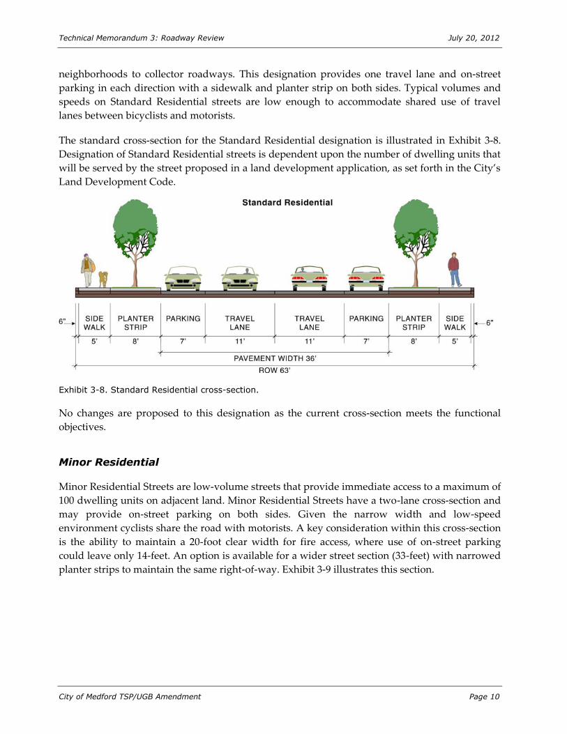
Standard Residential
Standard residential streets prioritize access over throughput and generally serve less than 2,500
ADT. Standard residential is the highest of the residential roadway classifications, connecting
Technical Memorandum 3: Roadway Review July 20, 2012
City of Medford TSP/UGB Amendment Page 10
neighborhoods to collector roadways. This designation provides one travel lane and on-street
parking in each direction with a sidewalk and planter strip on both sides. Typical volumes and
speeds on Standard Residential streets are low enough to accommodate shared use of travel
lanes between bicyclists and motorists.
The standard cross-section for the Standard Residential designation is illustrated in Exhibit 3-8.
Designation of Standard Residential streets is dependent upon the number of dwelling units that
will be served by the street proposed in a land development application, as set forth in the City’s
Land Development Code.
Exhibit 3-8. Standard Residential cross-section.
No changes are proposed to this designation as the current cross-section meets the functional
objectives.
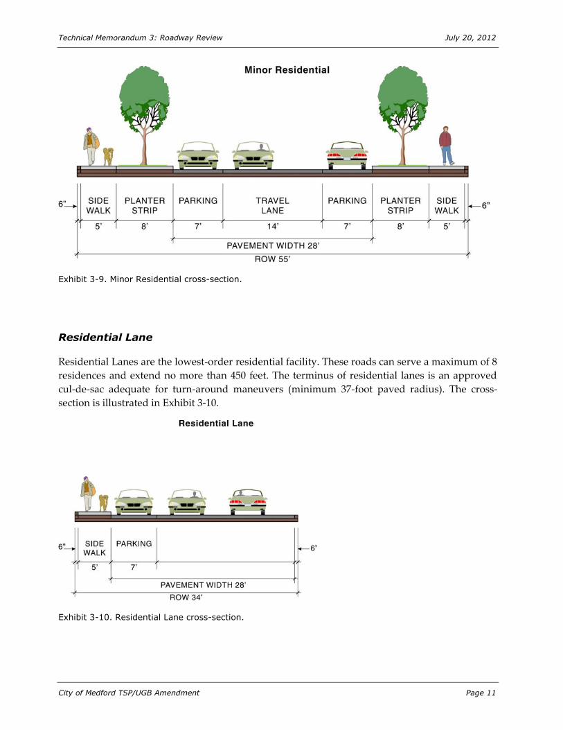
Minor Residential
Minor Residential Streets are low-volume streets that provide immediate access to a maximum of
100 dwelling units on adjacent land. Minor Residential Streets have a two-lane cross-section and
may provide on-street parking on both sides. Given the narrow width and low-speed
environment cyclists share the road with motorists. A key consideration within this cross-section
is the ability to maintain a 20-foot clear width for fire access, where use of on-street parking
could leave only 14-feet. An option is available for a wider street section (33-feet) with narrowed
planter strips to maintain the same right-of-way. Exhibit 3-9 illustrates this section.
Technical Memorandum 3: Roadway Review July 20, 2012
City of Medford TSP/UGB Amendment Page 11
Exhibit 3-9. Minor Residential cross-section.
Residential Lane
Residential Lanes are the lowest-order residential facility. These roads can serve a maximum of 8
residences and extend no more than 450 feet. The terminus of residential lanes is an approved
cul-de-sac adequate for turn-around maneuvers (minimum 37-foot paved radius). The cross-
section is illustrated in Exhibit 3-10.
Exhibit 3-10. Residential Lane cross-section.

Technical Memorandum 3: Roadway Review July 20, 2012
City of Medford TSP/UGB Amendment Page 12
Freight Routes
Freight routes are intended to direct through-freight movements to facilities where truck traffic
is most appropriate considering traffic volumes, street design, and surrounding land uses.
Freight Routes are not a specific classification within the City of Medford’s Street Functional
Classification System or within the Oregon Highway Plan (OHP), though these routes are
documented in the TSP and OHP and are used to inform roadway planning, design, and funding
decisions.
Most freight routes are major arterials or collectors where the demand for access and circulation
by large vehicles is expected to be highest. This includes major corridors that serve long distance
freight movements such as Interstate 5 and Highway 62; as well as streets that serve high
volumes of local and regional freight movements, such as Biddle Road, Table Rock Road, and
McAndrews Road. Freight route designations inform City investments and street design by
identifying areas where it is a priority to maintain high throughput levels, to design access to
accommodate large vehicle movements, and to maintain facilities to avoid temporary weight
restrictions and out-of-direction travel for trucks. Figure 3-2 identifies the existing classified
freight routes.
EFFECTIVENESS OF EXISTING SYSTEM
Policy Coordination
There are many roads located within the Medford UGB that are under the jurisdiction of Jackson
County and other roads that cross jurisdictional boundaries at the edge of the UGB (including
streets in the unincorporated area around the City and streets in the city of Central Point). As a
result, it is important that Medford’s Functional Classification System, the street classifications of
surrounding jurisdictions, and those established in the Rogue Valley Council of Governments’
Regional Transportation Plan (RTP) are coordinated. The revisions to Medford’s Functional
Classification System that were implemented as part of the TSP were based on a review of the
functional classification systems of surrounding jurisdictions and RVCOG. The existing Medford
Street Functional Classification system meets the requirements of the Transportation Planning
Rule and ODOT access management guidelines.

BIDDLE RD
E MCANDREWS RD
TAB
LE R
OCK
RD
BARNETT RD
HILLCREST RD
LEA
R WY
W MAIN ST
CRA
TER
LAKE
AV
E VILAS RD
E MAIN ST
SPRING ST
SISKIYOU BL
N FO
OTHI
LL R
D
HAU
L RD
CHERRY LN
S COL
UMBU
S AV
E JACKSON ST
GARFIELD AV
S HOLLY ST N PH
OENI
X RD
N RO
SS LN
N CENTRAL AV
LOZ
IER
LN
SAGE RD
KIN
GS H
W
W 8TH ST
DELTA WATERS RD
W 10TH ST
OWEN DR
S OAK
DALE
AV
N RIVERSIDE AV
STEWART AV
S PEA
CH ST
W 4TH ST
LONE PINE RD
BLA
CK O
AK D
R
S RIVERSIDE AV
DIAMOND ST
BEALL LN
POP
LAR
DR
DAKOTA AV
JUANIPERO WY
CEDAR LINKS DR
N CO
LUMB
US AV
COU
RT S
T
COAL MINE RD
INDU
STRY
DR
W MCANDREWS RD
HIG
HLAN
D DR
MED
CO H
AUL R
D
STEVENS ST
SOUTH STAGE RD
COKER BUTTE RD
MUR
PHY R
D
MERRIMAN RD
BUL
LOCK
RD
N HOLLY ST
PIER
CE R
D ROY
AL AV
W JACKSON ST
ROSSANLEY DR
E 10TH ST
OREGON AV
ROBERTS RD
CENTER DR
SUNSET DR
E 8TH ST
BRO
OKDA
LE AV
CARDINAL AV
N OAKDALE AV
CUNNINGHAM AV
ELL
ENDA
LE D
R
INTE
RNAT
IONA
L WY
WILLOW WY
OAK
GRO
VE R
D
SPRINGBROOK RD
LAWNSDALE RD
S FRONT ST
ROSSANLEY DR
STEWART AV BARNETT RD
SUNR
ISE AV
EXCE
L DR
Bear Creek
CENTRAL OREGON AND PACIFIC RR
Truck and Freight Routes
H:\projfile
\10771 - M
edford TG
M\GIS\20
28 Tech M
emo 4\3-6
Truck and
Freight R
outes.mxd
Medford TSP Update and UGB Amendment July 2012
5
5
99
238
99
62
62
NState Freight Highway andNational Highway System RoutesOther National HighwaySystem RoutesCity Truck Freight RoutesRailroadUrban Growth Boundary
3-2Figure
Technical Memorandum 3: Roadway Review July 20, 2012
City of Medford TSP/UGB Amendment Page 14
The existing Medford Street Functional Classification system also supports the City’s existing
Comprehensive Plan, which contains goals, policies and implementation strategies that address
street classification. Specifically, the Comprehensive Plan provides that “Streets shall be designated
as arterial streets, and officially identified as such in the Arterial Streets Plan. All other streets
shall function as collectors or residential streets” (Goal 2, Policy 1). The Comprehensive Plan
further establishes as policy the intent that “Streets shall be designated as arterial streets in
advance of actual function, thereby allowing for the application of the proper planning criteria
necessary to integrate the street function into the adjacent land use pattern with minimum
impact to neighborhood livability” (Goal 2, Policy 2). Other policies and implementation
strategies related to street classifications identify design criteria; a level of service standard;
provision of space for alternative transportation modes such as transit, bicycling and walking;
and minimization of adverse environmental impacts.
Current Functional Classification System
The recommended changes to the Street Functional Classification System within the 2003 TSP
have been successfully codified in Medford. The addition of major and minor arterial and
collector designations provide the City with the flexibility to adopt a five-, three-, or two-lane
design to accommodate local conditions and constraints in the built and natural environment
without having to diverge from adopted standards. This flexibility also helps the City to save
both time and money on street improvement projects. The current range of designations
provides a variety of design options to better fit the surrounding context and multimodal
environment.
Additional flexibility could also be provided within the TOD boundaries. While the current
provisions allow planter space to be used for hardscape treatments to provide wider sidewalks,
additional flexibility to alter the dimensions of the sidewalks, bicycle lanes, and planter strips, or
include on-street parking could be implemented.
Finally, implementation of a new facility designation has been discussed by the City for regional
roadways that interconnect to the surrounding cities and communities. The creation of an
Expressway classification could emphasize automobile and freight mobility, affording intercity
pedestrian and bicycle connectivity through a parallel multi-use pathway.
Evaluation of Functional Classification Designations
We reviewed the City’s functional classification system to address: 1) the connectivity and
continuity of the system; 2) the continuous length and density of the collector and arterial system
based on the surrounding zoning; and 3) review of the opportunities and constraints of the
current system based on the existing vehicular demands.

Technical Memorandum 3: Roadway Review July 20, 2012
City of Medford TSP/UGB Amendment Page 15
System Connectivity and Hierarchy
Connectivity of the arterial and collector street system was reviewed by identifying the extents
and layout of the City’s street system for the separate classifications and their sub-classifications
(major and minor). The intent of this review was to identify whether a continuous grid network
is in place throughout the City, how the facility classification changes or continues at the junction
of collector and arterial roadways, and to identify areas that are not able to follow a traditional
hierarchical access scheme. For additional clarity, Figure 3-3 illustrates the Arterial roadway
network, and Figure 3-4 illustrates the Collector classifications.
As shown in Figure 3-3, the arterial network exhibits the highest density along the City core and
surrounding the I-5 corridor. The network of arterials is poorly spaced east of Crater Lake
Avenue, with both limited east-west and north-south connections. While several roadways are
classified as minor arterials west of I-5, the transition in the east side of the City generally occurs
directly from Major Arterial to some form of Collector.
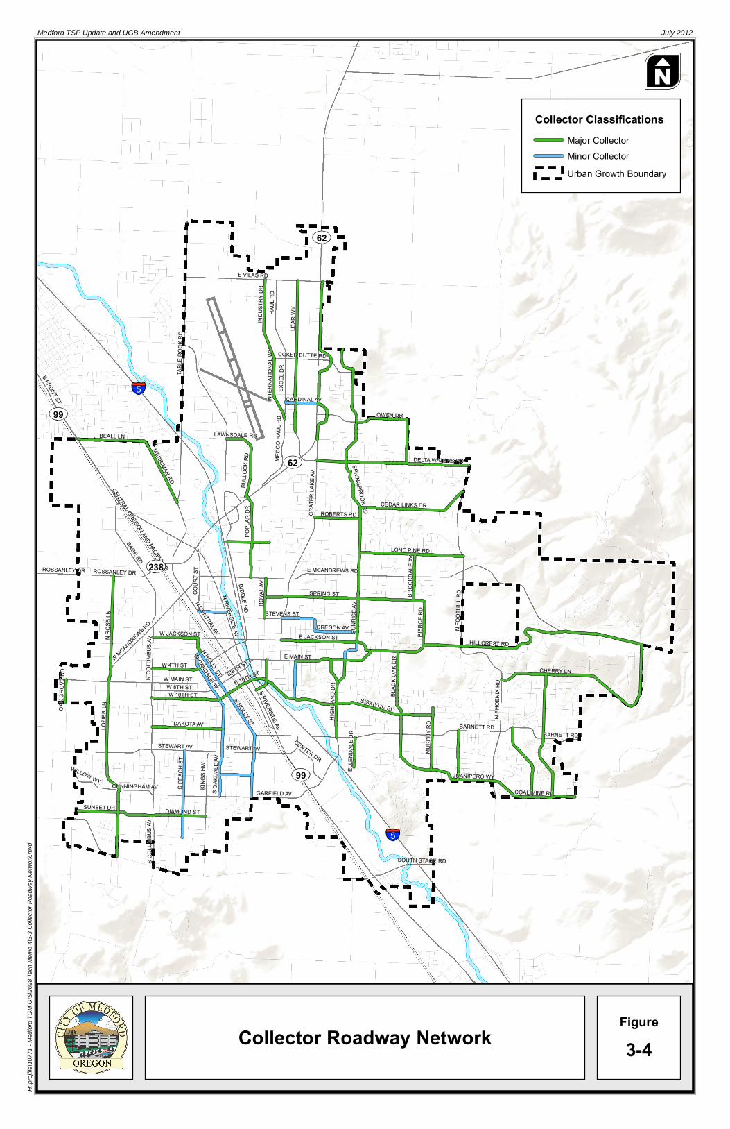
Figure 3-4 illustrates the Collector roadway network. This figure highlights the lack of minor
collector roadways throughout the City and shows the limited length and continuity of the
collector network. The integration and stepped access from minor collectors to major collectors is
generally not present in Medford, with the two collector classes generally operating
independently. While these lower-order facilities are intended to carry lower volumes and
shorter lengths, the result is an over-reliance on the City’s arterial network that also has the
burden of serving regional connectivity needs.
Review of the network and classification identified the following deficiencies:
Lack of arterial roadways in eastern Medford
Limited Minor Collector designations throughout Medford
Limited intra-city network and reliance on a limited number of corridors

S COL
UMBU
S AV
SOUTH STAGE RD
SUNSET DR
WILLOW WY CUNNINGHAM AV
DIAMOND ST
S PEA
CH ST
KIN
GS H
WS O
AKDA
LE AV
GARFIELD AV COAL MINE RD
CENTER DR
ELL
ENDA
LE D
R
MUR
PHY R
D
JUANIPERO WY
LOZ
IER
LN
DAKOTA AV
STEWART AV
S HOLLY ST
STEWART AV
S RIVERSIDE AV HIG
HLAN
D DR
BARNETT RD BARNETT RD
OAK
GRO
VE R
D
W 8TH STW 10TH ST
N OAKDALE AV
SISKIYOU BL
BLA
CK O
AK D
R
N PH
OENI
X RD
W MCANDREWS RDN
COLU
MBUS
AV
W MAIN ST
W 4TH ST
N HOLLY ST
E 10TH STE 8TH STE MAIN ST
CHERRY LN
N RO
SS LN
W JACKSON ST
N CENTRAL AVN RIVERSIDE AV E JACKSON ST
OREGON AV SUNR
ISE AV
PIER
CE R
D
N FO
OTHI
LL R
D
HILLCREST RD
COU
RT S
T
BIDDLE RD
STEVENS ST
ROY
AL AV
SPRING ST BRO
OKDA
LE AV
ROSSANLEY DR ROSSANLEY DR
SAGE RD
E MCANDREWS RD
POP
LAR
DR
LONE PINE RD
CRA
TER
LAKE
AV
ROBERTS RD
SPRINGBROOK RD CEDAR LINKS DR
MERRIMAN RD
BUL
LOCK
RD
MED
CO H
AUL R
D
DELTA WATERS RD
BEALL LN LAWNSDALE RD
S FRONT ST CARDINAL AV INTE
RNAT
IONA
L WY
OWEN DR
TAB
LE R
OCK
RD
EXCE
L DR
COKER BUTTE RD
INDU
STRY
DR
HAU
L RD
LEA
R WY
E VILAS RD
Bear Creek
CENTRAL OREGON AND PACIFIC RR
Arterial Roadway Network
H:\projfile
\10771 - M
edford TG
M\GIS\20
28 Tech M
emo 4\3-2
Arterial R
oadway N
etwork.mx
dMedford TSP Update and UGB Amendment July 2012
5
5
99
238
99
62
62
NArterial Classifications
Major ArterialMinor ArterialUrban Growth Boundary
3-3Figure
I-5 Interchange
I-5 Interchange
I-5 Interchange
I-5 Interchange
S COL
UMBU
S AV
SOUTH STAGE RD
DIAMOND ST SUNSET DR
WILLOW WY CUNNINGHAM AV S P
EACH
ST
KIN
GS H
WS O
AKDA
LE AV
GARFIELD AV COAL MINE RD
STEWART AV CENTER DR
ELL
ENDA
LE D
R
MUR
PHY R
D
JUANIPERO WY
LOZ
IER
LN
DAKOTA AV
STEWART AV
S HOLLY STS RIVERSIDE AV H
IGHL
AND
DR
BARNETT RD BARNETT RD
OAK
GRO
VE R
D
W 8TH STW 10TH ST
N OAKDALE AV
SISKIYOU BL
BLA
CK O
AK D
R
N PH
OENI
X RD
W MCANDREWS RDN
COLU
MBUS
AV
W MAIN ST
W 4TH ST
N HOLLY ST
E 10TH STE 8TH STE MAIN ST
CHERRY LN
N RO
SS LN
W JACKSON ST
N CENTRAL AVN RIVERSIDE AV E JACKSON ST
OREGON AV SUNR
ISE AV
PIER
CE R
D
N FO
OTHI
LL R
D
HILLCREST RD
COU
RT S
T
BIDDLE RD
STEVENS ST
ROY
AL AV
SPRING ST BRO
OKDA
LE AV
ROSSANLEY DR ROSSANLEY DR
SAGE RD
E MCANDREWS RD
POP
LAR
DR
LONE PINE RD
CRA
TER
LAKE
AV
ROBERTS RD
SPRINGBROOK RD CEDAR LINKS DR
MERRIMAN RD
BUL
LOCK
RD
MED
CO H
AUL R
D
DELTA WATERS RD
BEALL LN LAWNSDALE RD
S FRONT ST CARDINAL AV INTE
RNAT
IONA
L WY
OWEN DR
TAB
LE R
OCK
RD
EXCE
L DR
COKER BUTTE RD
INDU
STRY
DR
HAU
L RD
LEA
R WY
E VILAS RD
Bear Creek
CENTRAL OREGON AND PACIFIC RR
Collector Roadway Network
H:\projfile
\10771 - M
edford TG
M\GIS\20
28 Tech M
emo 4\3-3
Collector
Roadway
Network.m
xdMedford TSP Update and UGB Amendment July 2012
5
5
99
238
99
62
62
NCollector Classifications
Major CollectorMinor CollectorUrban Growth Boundary
3-4Figure
Technical Memorandum 3: Roadway Review July 20, 2012
City of Medford TSP/UGB Amendment Page 18
Length and Density of Classified Roadways
The roadway hierarchy was further reviewed to assess the length of classified roadways and the
surrounding densities that the roadways serve; the longer a facility and the higher the density
along that facility the higher the demands will be. The purpose of this review was to consider
whether the designation of parallel facilities would be appropriate, or if a change in classification
should be considered.
Review of the roadway system noted the following:
Springbrook Road –Sunrise Avenue serves as the only continuous north-south route
between Crater Lake Avenue and N Foothill Road along a relatively built-out area of
residential uses. This route is a key link in providing regional connections to I-5 and OR
62.
Near the airport, the close spacing between Industry Drive (International Way), Lear
Way, Excel Drive, and Highway 62 result in a very high density of higher-order roadway
facilities. The functions and reclassification of the supporting network surrounding the
planned bypass should be considered as part of the OR 62 bypass project.
Hillcrest Road–Jackson Street provides a continuous east-west connection across the City
changing functional classification between a collector and arterial roadway. The length of
this facility, land uses served, and changes in classification indicate the potential for a
higher order classification throughout its length.
Within the Arterial roadway system, notable gaps are present on the east side of the City
bounded by Crater Lake Avenue to the west, Owen Drive to the north, Foothill Road to the east,
and Barnett Road to the south. A robust network of Major Collectors is present within this area,
though continuous north-south and east-west travel opportunities are limited. High arterial
roadway density was noted in the area surrounding the South Medford Interchange and may be
in part a remnant of the previous interchange configuration that should be reassessed based on
the forecast needs.
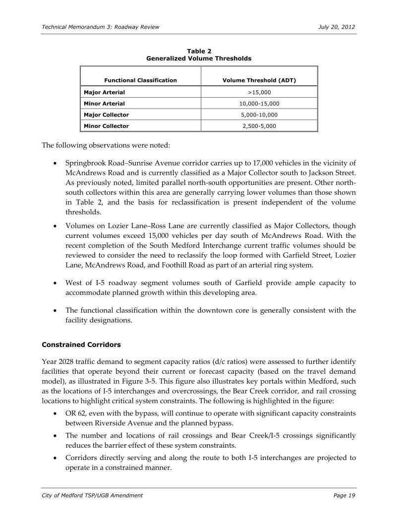
Collector and Arterial Opportunities and Constraints
The City’s 2008 roadway segment volumes were reviewed to assess where opportunities and
constraints exist within the current system. This assessment was intended to identify roadways
that carry higher or lower volumes than is typical for their classification. Table 2 presents the
general volume thresholds for the City’s higher-order facilities from the 2003 Transportation
System Plan. These thresholds are intended as a guideline only, and volumes alone are not
intended to form the basis of a roadways’ classification.
Technical Memorandum 3: Roadway Review July 20, 2012
City of Medford TSP/UGB Amendment Page 19
Table 2 Generalized Volume Thresholds
Functional Classification Volume Threshold (ADT)
Major Arterial >15,000
Minor Arterial 10,000-15,000
Major Collector 5,000-10,000
Minor Collector 2,500-5,000
The following observations were noted:
Springbrook Road–Sunrise Avenue corridor carries up to 17,000 vehicles in the vicinity of
McAndrews Road and is currently classified as a Major Collector south to Jackson Street.
As previously noted, limited parallel north-south opportunities are present. Other north-
south collectors within this area are generally carrying lower volumes than those shown
in Table 2, and the basis for reclassification is present independent of the volume
thresholds.
Volumes on Lozier Lane–Ross Lane are currently classified as Major Collectors, though
current volumes exceed 15,000 vehicles per day south of McAndrews Road. With the
recent completion of the South Medford Interchange current traffic volumes should be
reviewed to consider the need to reclassify the loop formed with Garfield Street, Lozier
Lane, McAndrews Road, and Foothill Road as part of an arterial ring system.
West of I-5 roadway segment volumes south of Garfield provide ample capacity to
accommodate planned growth within this developing area.
The functional classification within the downtown core is generally consistent with the
facility designations.
Constrained Corridors
Year 2028 traffic demand to segment capacity ratios (d/c ratios) were assessed to further identify
facilities that operate beyond their current or forecast capacity (based on the travel demand
model), as illustrated in Figure 3-5. This figure also illustrates key portals within Medford, such
as the locations of I-5 interchanges and overcrossings, the Bear Creek corridor, and rail crossing
locations to highlight critical system constraints. The following is highlighted in the figure:
OR 62, even with the bypass, will continue to operate with significant capacity constraints
between Riverside Avenue and the planned bypass.
The number and locations of rail crossings and Bear Creek/I-5 crossings significantly
reduces the barrier effect of these system constraints.
Corridors directly serving and along the route to both I-5 interchanges are projected to
operate in a constrained manner.
BIDDLE RD
E MCANDREWS RD
TAB
LE R
OCK
RD
BARNETT RD
HILLCREST RD
LEA
R WY
W MAIN ST
CRA
TER
LAKE
AV
E VILAS RD
E MAIN ST
SPRING ST
SISKIYOU BL
N FO
OTHI
LL R
D
HAU
L RD
CHERRY LN
S COL
UMBU
S AV
E JACKSON ST
GARFIELD AV
S HOLLY ST N PH
OENI
X RD
N RO
SS LN
N CENTRAL AV
LOZ
IER
LN
SAGE RD
KIN
GS H
W
W 8TH ST
DELTA WATERS RD
W 10TH ST
OWEN DR
S OAK
DALE
AV
N RIVERSIDE AV
STEWART AV
S PEA
CH ST
W 4TH ST
LONE PINE RD
BLA
CK O
AK D
R
S RIVERSIDE AV
DIAMOND ST
BEALL LN
POP
LAR
DR
DAKOTA AV
JUANIPERO WY
CEDAR LINKS DR
N CO
LUMB
US AV
COU
RT S
T
COAL MINE RD
INDU
STRY
DR
W MCANDREWS RD
HIG
HLAN
D DR
MED
CO H
AUL R
D
STEVENS ST
SOUTH STAGE RD
COKER BUTTE RD
MUR
PHY R
D
MERRIMAN RD
BUL
LOCK
RD
N HOLLY ST
PIER
CE R
D ROY
AL AV
W JACKSON ST
ROSSANLEY DR
E 10TH ST
OREGON AV
ROBERTS RD
CENTER DR
SUNSET DR
E 8TH ST
BRO
OKDA
LE AV
CARDINAL AV
N OAKDALE AV
CUNNINGHAM AV
ELL
ENDA
LE D
R
INTE
RNAT
IONA
L WY
WILLOW WY
OAK
GRO
VE R
D
SPRINGBROOK RD
LAWNSDALE RD
S FRONT ST
ROSSANLEY DR
STEWART AV BARNETT RD
SUNR
ISE AV
EXCE
L DR
Bear Creek
CENTRAL OREGON AND PACIFIC RR
System Constraints andConstrained Corridors
H:\projfile
\10771 - M
edford TG
M\GIS\20
28 Tech M
emo 4\3-4
System C
onstraints
and Cons
trained Co
rridors.mx
dMedford TSP Update and UGB Amendment July 2012
5
5
99
238
99
62
62
NI-5 Over- or UndercrossingAt-Grade Railroad CrossingI-5 CorridorGreater Than 75% DemandI-5 ViaductUrban Growth Boundary
3-5Figure
I-5 Interchange
I-5 Interchange
I-5 Interchange
I-5 Interchange
Technical Memorandum 3: Roadway Review July 20, 2012
City of Medford TSP/UGB Amendment Page 21
Recommended Functional Classification Changes
Based on the system needs, connectivity, forecast demands, and review of the existing functional
classification, the following changes are recommended to support the 2028 travel demand
forecasts:
Expand the City’s Standard Residential classification to relieve pressure on the Collector
and Arterial system while minimizing impacts to adjacent neighborhoods. This
classification should initially focus on the east side of Medford between Barnett Road and
Delta Waters Road. While lower-order facilities are generally not addressed within
citywide plans, the ability of the local roadway network to better serve its local function
and relieve higher-order facilities could provide significant system improvements.
Identify and improve an arterial system in coordination with Jackson County along
Lozier Lane, McAndrews, Foothill, and South Stage Road. Development of a continuous
route can help to relieve the intra-city function of the highway and interstate system.
Reclassify Hillcrest Road from the North Phoenix Road–Foothill Road intersection west
along Jackson Street to Crater Lake Avenue as a Minor Arterial. Providing this consistent
classification throughout this route better satisfies the roadway function. The route
through residential areas and the constrained right-of-way in built areas may require
deviations from a standard section.
Reclassify Springbrook Road–Sunrise Avenue between Delta Waters and Jackson Street
as a Minor Arterial. Similar to Hillcrest, the location of this roadway within built
residential areas with direct driveway access may limit development of a standard
section. However, removal of the on-street parking, relocation of utilities outside of the
sidewalk clear space, and other improvements can be made to allow this road to better
meet its intended function.
Delta Waters Road also is located within a built-out residential area, and its current cross-
section may not accommodate additional improvements. The current classification as a
Major Collector prioritizes the throughput function, so that direct access onto Delta
Waters from individual residences can be reduced over time as alternative options allow.
As the upgrade of Delta Waters to an ideal classification as a Minor Arterial may not be
feasible within the built environment, it is recommended that extension of the local
roadway system be applied within the surrounding neighborhoods. A hierarchical
residential classification system has been started within this area and should seek to
extend beyond the current system.
Downgrade the classification of Center Drive to a Major Collector. Despite the roadway’s
existing cross-section the function of the roadway is to link Stewart Avenue and Garfield
Avenue, as well as collect traffic from the adjacent retail uses. The downgraded
classification provides additional emphasis on serving this access role.

Technical Memorandum 3: Roadway Review July 20, 2012
City of Medford TSP/UGB Amendment Page 22
Coordination with Jackson County to extend South Stage Road east to connect to Phoenix
Road over the Interstate. South Stage is classified as a freight route, and the ability of this
regional roadway to connect to the east while remaining separate from facilities serving I-
5 will help preserve parallel routes.
Identification of a future extension of Murphy Road north to align with Pierce Road as a
Major Collector. This extension would occur only as part of future redevelopment of the
Rogue Valley Country Club, but would help to reduce the reliance on Phoenix Road,
allowing it to better serve its regional function.
Develop a regional expressway designation for roadways that provide intercity
connections. The focus of this designation should be on throughput as a means of
reducing highway reliance. The regional expressway designation should be coordinated
with Jackson County and other agencies for segments outside of the Medford UGB.
Candidate roadways include the following:
o North Phoenix Road–Foothill Road
o South Stage Road
o Vilas Road
o Table Rock Road
o Biddle Road
Expressway facilities should be designed to accommodate freight, with a classification as
City Truck Freight Route. All of the roads recommended for this classification already
contain this freight designation.
The items listed above are illustrated in Figure 3-6.

S COL
UMBU
S AV
SOUTH STAGE RD
SUNSET DR DIAMOND ST
S OAK
DALE
AV
GARFIELD AV COAL MINE RD
WILLOW WY CUNNINGHAM AV S P
EACH
ST
KIN
GS H
W
CENTER DR
ELL
ENDA
LE D
R
JUANIPERO WY
LOZ
IER
LN
STEWART AV
DAKOTA AV
S HOLLY ST
STEWART AV
S RIVERSIDE AV
MUR
PHY R
D BARNETT RD BARNETT RD
OAK
GRO
VE R
D
W 10TH ST
HIG
HLAN
D DR
SISKIYOU BL
BLA
CK O
AK D
R
N PH
OENI
X RD
W MCANDREWS RDN
COLU
MBUS
AV
W MAIN STW 8TH ST
W 4TH ST
N OAKDALE AVN HOLLY ST
E 10TH STE 8TH ST CHERRY LN
N RO
SS LN
W JACKSON ST
N CENTRAL AVN RIVERSIDE AV
E MAIN ST
E JACKSON ST OREGON AV SU
NRISE
AV
PIER
CE R
D
HILLCREST RD
N FO
OTHI
LL R
D COU
RT S
T
BIDDLE RD ROY
AL AV
STEVENS ST
SPRING ST BRO
OKDA
LE AV
ROSSANLEY DR ROSSANLEY DR
SAGE RD
E MCANDREWS RD
POP
LAR
DR
LONE PINE RD
CRA
TER
LAKE
AV
ROBERTS RD
SPRINGBROOK RD CEDAR LINKS DR
MERRIMAN RD
BUL
LOCK
RD
MED
CO H
AUL R
D
DELTA WATERS RD
BEALL LN LAWNSDALE RD
S FRONT ST CARDINAL AV INTE
RNAT
IONA
L WY
OWEN DR
TAB
LE R
OCK
RD
EXCE
L DR
COKER BUTTE RD
LEA
R WY
INDU
STRY
DR
HAU
L RD
E VILAS RD
Bear Creek
CENTRAL OREGON AND PACIFIC RR
Recommended FunctionalClassification Changes
H:\projfile
\10771 - M
edford TG
M\GIS\20
28 Tech M
emo 4\3-5
Recomm
ended Fu
nctional C
lassificati
on Chang
es.mxd
Medford TSP Update and UGB Amendment July 2012
5
5
99
238
99
62
62
NRegional ExpresswayUpgrade to Minor ArterialDowngrade to Major CollectorFuture ExtensionArterial RingUrban Growth Boundary
3-6Figure
Note: Facilities outside of the Medford UGB will require coordination and approval by Jackson County
Develop SupportingLocal Network


