
T H A M E S V A L L E Y
S E R V I C E S
ARCHAEOLOGICAL
The White House, St Mary’s College, Bitterne Park, Southampton, Hampshire
Building Recording
by Genni Elliott
Site Code: SOU1635
(SU 4445 1358)
The White House, St Mary’s College, Bitterne Park, Southampton, Hampshire
Building Recording
For Blaze Construction
by�Genni�Elliott�
Thames�Valley�Archaeological�Services�Ltd
Site Code SOU 1635
November 2013

iThames Valley Archaeological Services Ltd, 47–49 De Beauvoir Road, Reading RG1 5NR
Tel. (0118) 926 0552; Fax (0118) 926 0553; email [email protected]; website : www.tvas.co.uk
Summary
Site name: The White House, St Mary’s College, Bitterne Park, Southampton, Hampshire
Grid reference: SU 4445 1358
Site activity: Building Recording
Date and duration of project: 13th September 2013
Project manager: Steve Ford
Site code: SOU 1635
Summary of results: The White House or Bitterne Grove was built c. 1791 as a large, square building. Extensive additions were made prior to the tithe map of 1845. The height of the building was raised c. 1912 and re-roofed.
Location and reference of archive: The archive is presently held at Thames Valley Archaeological Services, Reading and will be deposited with Southampton Museum in due course.
This report may be copied for bona fide research or planning purposes without the explicit permission of the copyright holder. All TVAS unpublished fieldwork reports are available on our website: www.tvas.co.uk/reports/reports.asp.
Report edited/checked by: Steve Ford� 27.11.13
The White House, St Mary’s College, Bitterne Park, Southampton, Hampshire Building Recording
by Genni Elliott
Report 13/184
Introduction
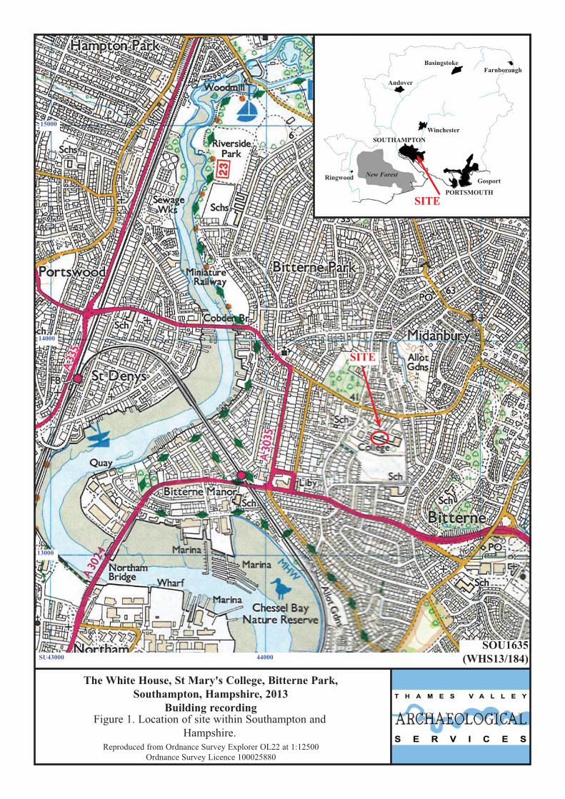
This report documents the results of building recording at The White House, St Mary’s College, Bitterne Park,
Southampton, Hampshire (SU 4445 1358) (Fig. 1). The work was commissioned by Eugene Broderick of Blaze
Construction, 93 Leigh Road, Eastleigh, Hampshire, SO50 9DQ. The White House is undergoing extensive
repair works which has entailed the removal of lime mortar and cement render to reveal detail of the underlying
structure. Monitoring of this work by the Southampton Historic Environment Team prompted the requirement of
a programme of building recording of the revealed structure. This report documents the results of the building
survey. This is in accordance with the Department for Communities and Local Government’s Planning Policy
Statement, National Planning Policy Framework (NPPF 2012), and the City’s policies on historic buildings. The
fieldwork was undertaken by Genni Elliott on 13th September 2013 and the site code is SOU 1635.
The archive is presently held at Thames Valley Archaeological Services, Reading and will be deposited
with Southampton Museum and a copy sent to the National Monuments Record in due course.
Location, topography and geology
The White House is located within the grounds of St Mary’s College, on the east side of Middanbury Lane, in
the area of Bitterne Park. This lies on the east side of the River Itchen, Southampton (SU 4445 1358) (Fig. 2).
The land slopes from north to south from approximately 38m above Ordnance Datum to 30m aOD with the
building situated on a terrace. The land slopes from the Wittering Formation above London Clay above
Portsmouth Sand (BGS 1987).
Historical Background
The White House, formerly known as Bitterne Grove, is grade II listed and described as:
'Early C19. Three storeys and modern attic. Stuccoed and hipped and mansarded slate roof. Wide bracketed eaves cornice. Six windows with glazing bars. The 4 central window bays project slightly. The main block is flanked by small one storey pavilions which project considerably. On the north or entrance front these are of painted brick, have one triple sash with elliptical arch modillion cornice and gable over and are linked to the main block by a curved wall. In the centre of this front is a semi-circular porch. On the
1

south or garden front the pavilions have curved fronts of 3 windows each. The main block has 3 round-headed windows on the ground floor with a Venetian window to the west of these and a doorway to the east with pilasters and a projecting cornice, over.'
Bitterne Grove was built about 1790 by Richard Leversuch and shortly afterwards purchased by James Dott, who
lived there from 1791 until his death in 1844. It changed hands a few more times, until it was purchased by the
French Catholics who used the house to train priests before opening it as a boarding school in 1922. During this
period a chapel, dormitory and new roof was added. During World War II the house was used by the Home
Guard (Vale, 1980, 1983). A picture taken prior to the roof being replaced shows the house to have half-sized
windows on the second floor and what is probably a hipped roof.
A range of Ordnance Survey and other historical maps of the area were consulted at the Hampshire Record
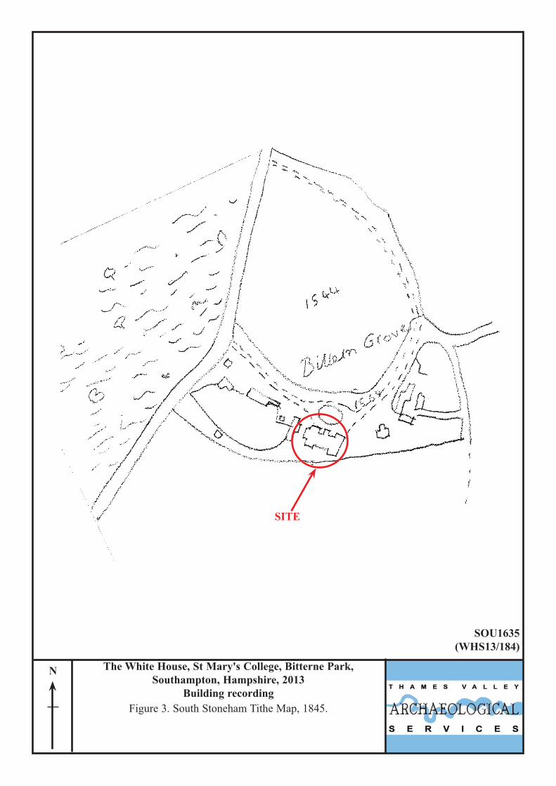
Office in order to show the development of the site. The earliest map to show the building is the South Stoneham
Tithe map of 1845 (Fig. 3). The scale of the map means the building can not be seen in great detail but it would
appear it consists of a central area with a wing at either end, a porch on the north side and an extension on the
west end.
The first edition Ordnance Survey map of 1885 (Fig. 4) shows a bit more detail. The shape of the wings at
either end of the house can be seen to be curved on the southern side of the building. The porch on the north side
of the building is also curved and there is a further small extension on the western side of the building. The only
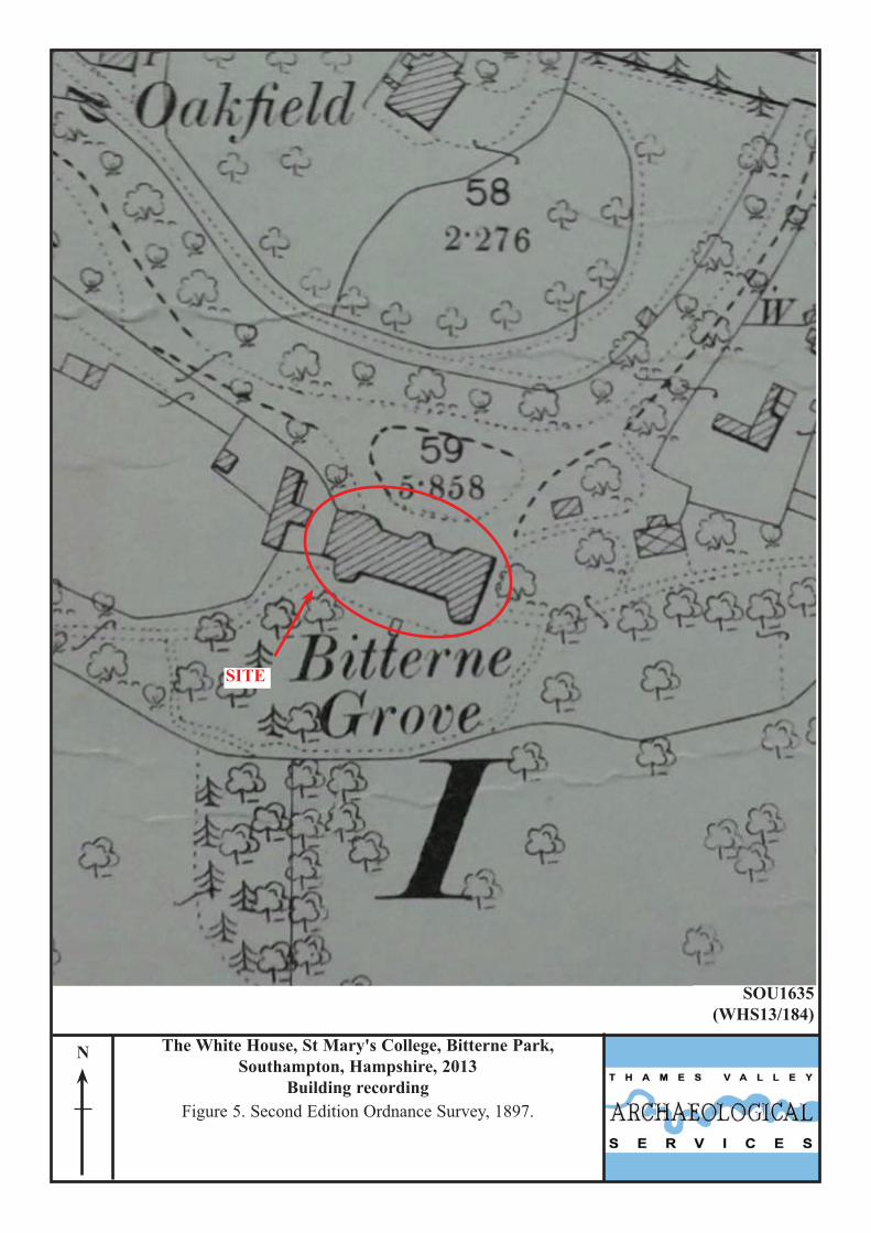
change by 1897 (Fig. 5) appears to be the demolition of the small extension on the western side of the building
that had appeared on the earlier 1885 map. No further changes have occurred by 1910 (Fig. 6). However by 1933
(Fig. 7) significant changes have taken place. A large, L-shaped extension has been added to the eastern end of
the building, though no changes have been made to existing building. It is at this point that the building becomes
known as St Mary’s Roman Catholic College, rather than Bitterne Grove. No further changes can be seen on the
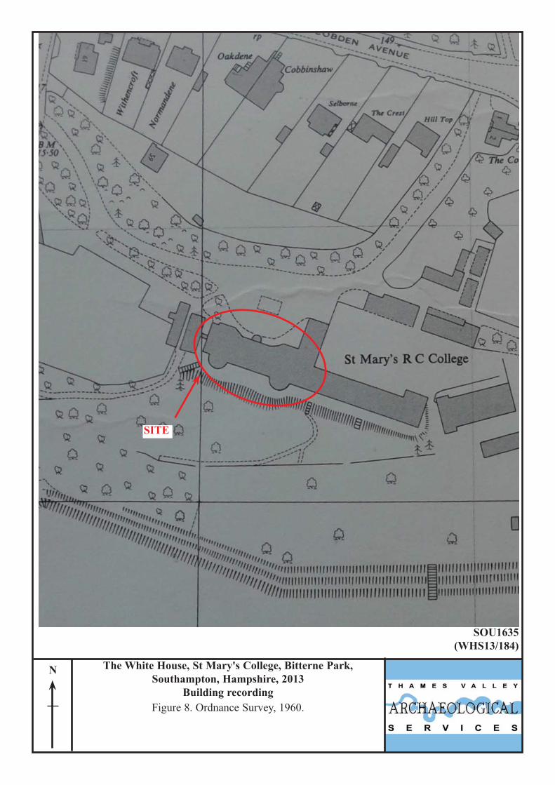
1941 and 1947 maps. By 1960 (Fig. 8) a building has been built to the east and connected to the existing building
via a corridor. On the 1973 map the building is at the junction of two map sheets and consequently the exact
nature of the extensions to the east are unclear, however a further extension has been added to the west.
Methodology
The building survey was carried out in accordance with guidelines set out by the Royal Commission on Historic
Monuments (RCHM 1996) and English Heritage (EH 2006). The survey comprised a photographic survey and
drawn record, paying attention to the methods of construction, chronological development and alterations, and
2
features of special interest and comprised only the external structure of the building. The building has been
recorded photographically both digitally and on 35mm format using colour print and black and white media
which are catalogued (Appendix 1).
Description (Fig. 9)
Bitterne Grove stands on a terrace of land with its main entrance on the northeast east side (Pl. 1) with a patio
area at the rear before the land slopes away to the south (Pl. 2). It is a three-storey building, six windows wide
with a slate mansard roof covering the main central area. The two wings either side have a pitched slate roof.
The building can be sub-divided into four distinct parts; the central area, the southeast wing, the northwest wing
and the lean-to extension.
The Central Area
The central area consists of the main three storey element of the building, covered by the mansard roof. Within
this part of the building more than one phase of construction can be observed.
Phase 1
The original building consisted of the four window wide very central part of the building which was originally
two and a half storey’s high. It was constructed of red bricks, 223mm x 103mm x 59mm (8 7/8” x 4 1/16” x 2
3/8”) laid in Flemish bond, bonded in lime mortar. The northeast elevation contained the large front door with
fan light enclosed by a classical style curved portico with flat roof. Earlier photographs show the statue on top of
this portico. Either side of the front door was a sash window of six panes above six panes. The first floor
consisted of a row of four sash windows; none of which had horns. Above each of the windows was a gauged
flat brick arch.
The rear, southwest elevation contained only three windows across its width on the first floor. These
were the same as the ones round the front. On the ground floor were three French windows with fan lights set
back in arches. Each had three steps up to it. Repair work has been carried out around all of the doors which may
suggest that the original may have been a different size or could have been windows (Pl. 3).
At either end of the house were two chimneys.
Phase 2 (Figs. 10 and 11)
To the northwest and southwest of the original building a one room, one window wide extension was added, set
slightly back. The front elevation consists of a curved, yellow brick wall on the ground floor, containing a sash
3
window and joining the original building with the two wings at either end. In the northwest wall it would appear
that there was once a doorway that has subsequently been blocked up beneath the window (Pl. 4).
Above this was a timber frame construction, containing a window at each storey. The timber frame
consisted of re-used oak timbers containing peg holes and mortices. The construction consisted of a timber joist
supporting two upright posts each side of the window, tied together with a brace (Pl. 5). Supported on this was a
second joist, window and timber frame. Smaller uprights were then added to hold laths for plaster. At the
northwest end it was possible to see chiselled carpenters marks on some of the timbers (Pl. 6). Part of the
southeast end had been rebuilt in brick, presumably when the roof was raised, c. 1912.
The rear elevation was entirely brick built with a window on both the first and second storeys. The
construction was of red brick with slightly blue headers measuring 212mm x 102mm x 60mm (8 3/8” x 4” x 2
3/8”) laid in English bond with lime mortar. On the ground floor the northwest end contained a Venetian style
window, similar in size to the French doors of the original building. The southeast end contained a door, set back
in an arched porch with a pilaster on either side (Pl. 7). Alcoves were present either side of the door.
Phase 3
The final phase of construction within the central area of the building was the raising of the building height and
the new roof. Plans deposited with Hampshire Record Office show that this was carried out around 1912. The
raising of the roof could be seen in the change of brickwork particularly at the southeast and northwest ends of
the building on the northeast elevation where a brick soldier course was laid with English bond above it, bonded
with cement mortar (Pl. 8). The English bond extended across the entire frontage and rear of the central area of
the building. Above the windows were concrete lintels, except in one instance where a gauged flat arch was
present. This is possibly indicative of later repair work, prior to the entire building being rendered. A scrap of
newspaper found beneath part of the render dated to 1952.
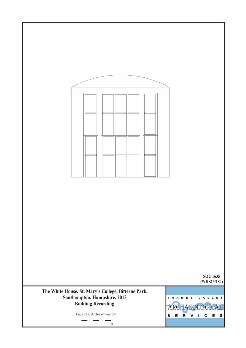
The Northwest Wing (Fig. 12)
The northwest wing consists of a single storey structure with a curved wall at the rear. The northeast face
consists of a facing of yellow bricks measuring 218mm x 103mm x 61mm (8 5/8” x 4 1/8” x 2 3/8”) laid in
Flemish bond with lime mortar. Behind this facing, the walls are of red brick laid in English bond. The roof is
pitched and covered in slates, hidden behind a parapet. A large sash window with side lights, of six over six
4
design, was located centrally within the frontage, recessed into an archway. The curve of the archway, above the
window, was bricked up and covered in laths to enable plastering (Pl. 9).
The southwest face was also constructed of yellow bricks laid as headers in lime mortar to construct a curve
which stood proud of the central area of the building. The bricks measured 114mm wide by 60mm thick (4 ½” x
2 3/8”). Within the curved wall were three tall sash windows of six over six panes. As on the northeast face, a
parapet concealed the roof.
Where visible, the northwest face was constructed of red bricks bonded in lime mortar, measuring 220mm
x 110mm x 62mm (7 7/8” x 4 3/8” x 2 7/16”). The lower part was obscured by a lean-to extension but the upper
part of the wall contained five half-sized sash windows of three over three panes. Originally two chimneys
would have been visible, but one had been removed (Pl. 10).
The Southeast Wing
The southeast wing is similar in construction to the northwest wing and consists of a single storey structure with
a curved wall at the rear. The northeast face consists of a facing of yellow bricks measuring 218mm x 103mm x
61mm (8 5/8” x 4 1/8” x 2 3/8”) laid in Flemish bond with lime mortar. Behind this facing, the walls are of red
brick laid in English bond (Pl. 11). The roof is pitched and covered in slates, hidden behind a parapet. A large
sash window with side lights, of six over six design, was located centrally within the frontage, recessed into an
archway. The curve of the archway, above the window, was bricked up. Two different types of brick can be seen
in this archway and probably represent repair work. Lath grooves in the uppermost brickwork suggest that it was
originally the same as the northwest wing (Pl. 12).
The southwest face was also constructed of yellow bricks laid as headers in lime mortar to construct a curve
which stood proud of the central area of the building. The bricks measured 114mm wide by 60mm thick (4 ½” x
2 3/8”). Within the curved wall were three tall sash windows of six over six panes. As on the northeast face, a
parapet concealed the roof.
The Lean-to Extension
The lean-to extension on the northwest side of the building shows evidence for much alteration with blocked
doors and windows, areas of rebuilding and an extension to the southwest. The bricks are primarily of red bricks
measuring 216mm x 110mm x 62mm (8 1/2” x 4 3/8” x 2 7/16”) bonded in lime mortar and laid three stretchers
to one header in Flemish garden wall bond. The roof was covered in felt (Pl. 10).
5

Conclusion
It is possible to see at least three and possibly four phases of construction at Bitterne Grove. The original
building consisted of the four window wide central area built in Flemish bond, two and a half storeys high. It is
unclear whether the additions to the northwest and southeast are of one or two phases. The ground floor plan
(Fig. 13) shows thicker walls in the northwest end of the building which would indicate two phases of
construction; the southeast is less clear. The timber framing is a light weight structure which removes the need
for structural walls on the ground floor where the curved wall is present. It is clear from the map evidence that
all this construction was carried out prior to the tithe map of 1845, and therefore must have been done in the
period of James Dot’s ownership. Plans dated to 1912 show the final phase of construction with the raising of the
building and the new roof.
References BGS, 1987, British Geological Survey, 1:50,000, Sheet 315, Solid and Drift Edition, Keyworth EH, 2006, Understanding Historic Buildings, English Heritage, London NPPF 2012, National Planning Policy Framework, Dept Communities and Local Govt, London RCHME, 1996, Recording Historic Buildings: a descriptive specification, 3rd edn, Roy Comm Hist Monuments
(England), London Vale, J, 1980, The Lost Houses of Southampton, Southampton Vale, J, 1983, ‘The Country Houses of Southampton, reprinted from Proceedings of the Hampshire Field Club
and Archaeological Society Vol. 39, Southampton
6
APPENDIX 1: Photographic Catalogue A . Digital
Cat. No Direction of view Scales Comment1 SW - Front General view (Pl. 1) 2 S - Front To chapel3 SE 2x1m Front Jointing S. wing to main building (Pl. 11)4 SW 2x1m Front N wing timbers S. top 5 SW - Front N wing timbers S. top 6 W 2x1m Front N wing timbers N. top 7 W - Front N wing timbers N. top 8 SW 2x1m Front N wing bottom (Pl. 5)9 SW - Front N wing bottom carpenters mark III (Pl. 6)10 S 1x1m Front S wing above window (Pl. 12)11 SE - Front General view showing laths 12 E - Rear General view (Pl. 2) 13 NE - Rear General view central area 14 NE - Side General view lean to (Pl. 10)15 NE 2x1m Rear Brickwork around door (Pl. 3)16 NE 2x1m Rear Brickwork around door 17 N 2x1m Rear Large rear door (Pl. 7)18 N - Rear Lack of jointing 19 NW - Rear Jointing20 N - Rear Roof over N wing 21 W - Front N wing above window (Pl. 9)22 W 2x1m Front Brickwork under window, N wing (Pl. 4)23 S 2x1m Front Laths top, S wing, S side (Pl. 8)24 SW 2x1m Front Laths top, S wing, N side 25 S 2x1m Front Laths bottom, S wing
B. Colour Prints
Cat. No Direction of view Scales Comment1 SW - Front General view2 S - Front To chapel3 SE 2x1m Front Jointing S. wing to main building 4 SW 2x1m Front N wing timbers S. top 5 SW - Front N wing timbers S. top 6 W 2x1m Front N wing timbers N. top 7 W - Front N wing timbers N. top 8 SW 2x1m Front N wing bottom 9 SW - Front N wing bottom carpenters mark III 10 S 1x1m Front S wing above window 11 SE - Front General view showing laths 12 E - Rear General view13 NE - Rear General view central area 14 NE - Side General view lean to 15 NE 2x1m Rear Brickwork around door 16 NE 2x1m Rear Brickwork around door 17 N 2x1m Rear Large rear door 18 N - Rear Lack of jointing 19 NW - Rear Jointing20 N - Rear Roof over N wing 21 W - Front N wing above window 22 W 2x1m Front Brickwork under window, N wing 23 S 2x1m Front Laths top, S wing, S side 24 SW 2x1m Front Laths top, S wing, N side 25 S 2x1m Front Laths bottom, S wing
7
8
C. Monochrome Images
Cat. No Direction of view Scales Comment1 SW - Front General view2 S - Front To chapel3 SE 2x1m Front Jointing S. wing to main building 4 SW 2x1m Front N wing timbers S. top 5 SW - Front N wing timbers S. top 6 W 2x1m Front N wing timbers N. top 7 W - Front N wing timbers N. top 8 SW 2x1m Front N wing bottom 9 SW - Front N wing bottom carpenters mark III 10 S 1x1m Front S wing above window 11 SE - Front General view showing laths 12 E - Rear General view13 NE - Rear General view central area 14 NE - Side General view lean to 15 NE 2x1m Rear Brickwork around door 16 NE 2x1m Rear Brickwork around door 17 N 2x1m Rear Large rear door 18 N - Rear Lack of jointing 19 NW - Rear Jointing20 N - Rear Roof over N wing 21 W - Front N wing above window 22 W 2x1m Front Brickwork under window, N wing 23 S 2x1m Front Laths top, S wing, S side 24 SW 2x1m Front Laths top, S wing, N side 25 S 2x1m Front Laths bottom, S wing
14000
SU43000 44000
SITE
The White House, St Mary's College, Bitterne Park, Southampton, Hampshire, 2013
Building recordingFigure 1. Location of site within Southampton and
Hampshire.
SOU1635(WHS13/184)
Reproduced from Ordnance Survey Explorer OL22 at 1:12500Ordnance Survey Licence 100025880
SITE
Basingstoke
Andover
SOUTHAMPTON
New Forest
PORTSMOUTH
Gosport
Farnborough
Ringwood
Winchester
13000
15000

SU44500 44600
13500
13600
SITE
N
SOU1635(WHS13/184)
Reproduced from Ordnance Survey Digital Mapping under licence.Crown copyright reserved. Scale 1:1250
The White House, St Mary's College, Bitterne Park, Southampton, Hampshire, 2013
Building recordingFigure 2. Detailed location of site.
SITE
N
SOU1635(WHS13/184)
The White House, St Mary's College, Bitterne Park, Southampton, Hampshire, 2013
Building recordingFigure 3. South Stoneham Tithe Map, 1845.

SITE
N
SOU1635(WHS13/184)
The White House, St Mary's College, Bitterne Park, Southampton, Hampshire, 2013
Building recordingFigure 4. First Edition Ordnance Survey, 1885.
SITE
N
SOU1635(WHS13/184)
The White House, St Mary's College, Bitterne Park, Southampton, Hampshire, 2013
Building recordingFigure 5. Second Edition Ordnance Survey, 1897.

SITE
N
SOU1635(WHS13/184)
The White House, St Mary's College, Bitterne Park, Southampton, Hampshire, 2013
Building recordingFigure 6. Third Edition Ordnance Survey, 1910.

SITE
N
SOU1635(WHS13/184)
The White House, St Mary's College, Bitterne Park, Southampton, Hampshire, 2013
Building recordingFigure 7. Ordnance Survey, 1933.
SITE
N
SOU1635(WHS13/184)
The White House, St Mary's College, Bitterne Park, Southampton, Hampshire, 2013
Building recordingFigure 8. Ordnance Survey, 1960.

SOU 1635(WHS13/184)
Figure 9. Elevations.
The White House, St. Mary's College, Bitterne Park, Southampton, Hampshire, 2013
Building Recording
0 10m
Front (north) elevation
East end
Rear (south) elevation
West end

SOU 1635(WHS13/184)
Figure 10. Timber framing (front north wing).
The White House, St. Mary's College, Bitterne Park, Southampton, Hampshire, 2013
Building Recording
0 1m
Brick Brick

SOU 1635(WHS13/184)
Figure 11. Timber framing (front south wing).
The White House, St. Mary's College, Bitterne Park, Southampton, Hampshire, 2013
Building Recording
0 1m
not visible
brickbrickbrick
rebuiltin brick
SOU 1635(WHS13/184)
Figure 12. Archway window.
The White House, St. Mary's College, Bitterne Park, Southampton, Hampshire, 2013
Building Recording
0 1m

SOU 1635(WHS13/184)
Figure 13. Ground floor.
The White House, St. Mary's College, Bitterne Park, Southampton, Hampshire, 2013
Building Recording
0 5m
N

Plate 1. Front of building, looking south west. Plate 2. Rear of building, looking east.
Plate 3. Brickwork around door, looking north east, Scales: 1m.
Plate 4. Brickwork under window, N wing, looking west, Scales: 1m.
SOU1635(WHS13/184)
The White House, St Mary's College, Bitterne Park, Southampton, Hampshire, 2013
Building recordingPlates 1 - 4.

Plate 5. North wing bottom, looking south west, Scales: 1m.
Plate 6. North wing bottom carpenters mark III, looking south west.
Plate 7. Large rear door, looking north, Scales: 1m.
Plate 8. Laths top, South wing, South side, looking south, Scales: 1m.
SOU1635(WHS13/184)
The White House, St Mary's College, Bitterne Park, Southampton, Hampshire, 2013
Building recordingPlates 5 - 8.

Plate 9. North wing above window, looking west. Plate 10. General view lean to, looking north east.
Plate 11. Jointing South wing to main building, looking south east, Scales: 1m.
Plate 12. South wing above window, looking south, Scale: 1m.
SOU1635(13-184)
The White House, St Mary's College, Bitterne Park, Southampton, Hampshire, 2013
Building recordingPlates 9 - 12.

TIME CHART
Calendar Years
Modern AD 1901
Victorian AD 1837
Post Medieval AD 1500
Medieval AD 1066
Saxon AD 410
Roman AD 43BC/AD
Iron Age 750 BC
Bronze Age: Late 1300 BC
Bronze Age: Middle 1700 BC
Bronze Age: Early 2100 BC
Neolithic: Late 3300 BC
Neolithic: Early 4300 BC
Mesolithic: Late 6000 BC
Mesolithic: Early 10000 BC
Palaeolithic: Upper 30000 BC
Palaeolithic: Middle 70000 BC
Palaeolithic: Lower 2,000,000 BC

Thames Valley Archaeological Services Ltd,47-49 De Beauvoir Road, Reading,
Berkshire, RG1 5NR
Tel: 0118 9260552Fax: 0118 9260553
Email: [email protected]: www.tvas.co.uk


