
1
Subsidence & Groundwater Withdrawal
Flooding due to Subsidence
2
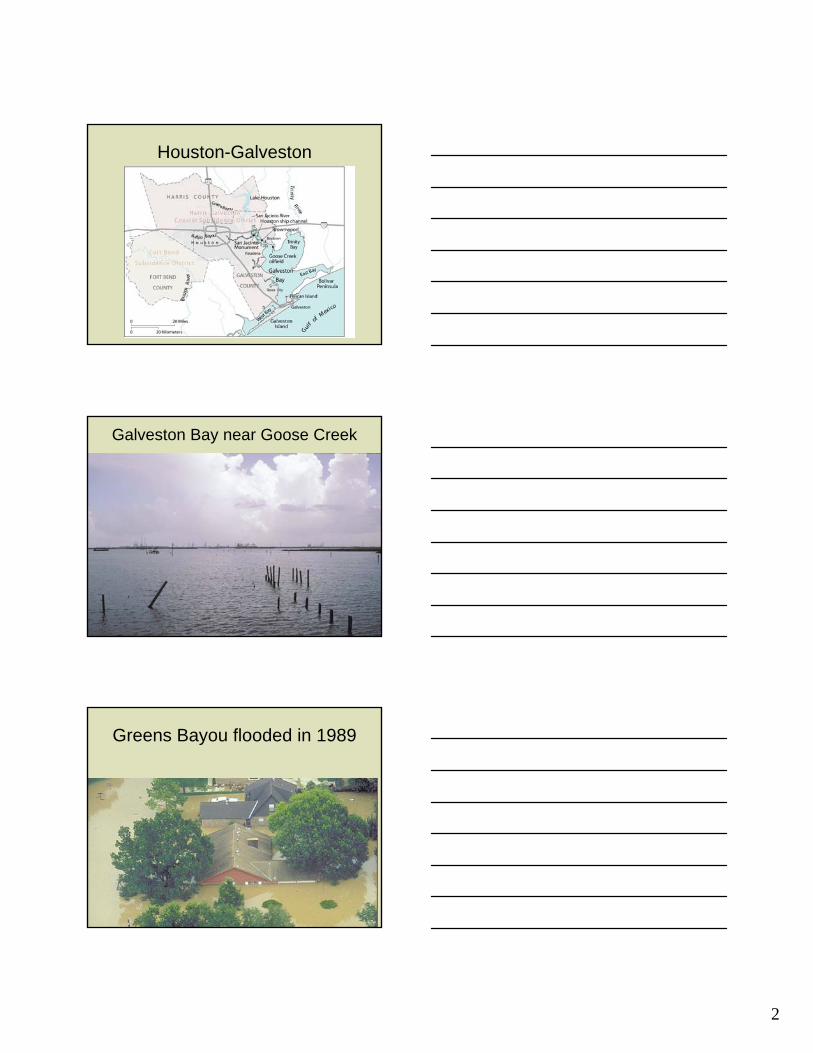
Houston-Galveston
Galveston Bay near Goose Creek
Greens Bayou flooded in 1989

3
Houston Ship Channel
This photograph takenabout 1926 shows a‘fault fissure’ in Pelley,one-half mile north ofthe oil fields. To theleft of the fault, theground had droppedabout 16 inches.

4
Baytown in 1960

5
Brownwood Subdivision
Wetlands Loss due to Subsidence
Drowned Coastal Woodlands

6
Subsidence activates faults

7
Impact of Subsidence
Structural Damage Observed at Former Woodlawn High School
Main Crack Main Crack
Secondary Crack Secondary Crack
Offset between sides of aperture is approximately ½ - 1 inch.

8
Laser Level Measurements Inside Western Band Room Wall
Surface extent of Louisiana’s aquifers and aquifer systems
GROUND-WATER WITHDRAWALS IN LOUISIANA, 1960-2000
15251438
1764
1341 1299
16341562
11731029
0
200
400
600
800
1000
1200
1400
1600
1800
2000
1960 1965 1970 1975 1980 1985 1990 1995 2000
WIT
HD
RA
WA
LS
, IN
MIL
LIO
N G
AL
LO
NS
PE
R D
AY

9
G R O UN D- WATER WITHDR AWALS , 2 0 0 0( 1, 6 0 0 MILL IO N G ALLO NS P ER D AY )
P u b lic S u p p ly2 2 %
In d u st r y17 %
P o w e r G e n e r a t io n2 %
R u r a l D o me st ic3 %
L ive st o c k0 %
Ir r ig a t io n4 8 %
A q u a c u l t u r e8 %
PUMPAGE BY MAJOR AQUIFER OR AQUIFER SYSTEM, 2000
354
8
798
291
22 423 7
6815 521
0
100
200
300
400
500
600
700
800
900
Red R
iver A
lluvia
l
Miss
issip
pi Rive
r Allu
vial
Upland
Ter
race
Chicot
South
ern H
ills
Evang
eline
Jasp
er
Cataho
ula
Cockfi
eld
Sparta
Carriz
o-W
ilcox
othe
r
WIT
HD
RA
WA
L R
AT
E,
IN M
ILL
ION
GA
LL
ON
S P
ER
DA
Y
1
1
AREAS WHERE WATERLEVELS IN ONE OR MOREAQUIFERS ARE DECLINING1 FOOT OR MORE PERYEAR BASED ON TRENDSOBSERVED AT DOTD/USGS NETWORK WELLS

10
0
0 KILOMETERS50
MILES50
Southern Hills aquifer system
BATON ROUGE FAULT ZONE(Approximate southern limit of aquifer system)

11
WITHDRAWALS FROM THE SOUTHERN HILLS AQUIFER SYSTEM, 2000(290 MILLION GALLONS PER DAY)
Public supply49%
Industry39%
Power generation5%
Rural domestic6%
All other uses1%
Artesian Well
Baton Rouge in 1943?
12
100
80
60
40
20
0
-20
Date
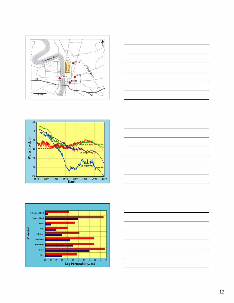
EB-168 (1500 ft)
EB-90 (2000 ft)
1940 1950 1960 1970 1980 1990 2000 2010
EB-128 (800 ft)
WBR-5 (1200 ft)
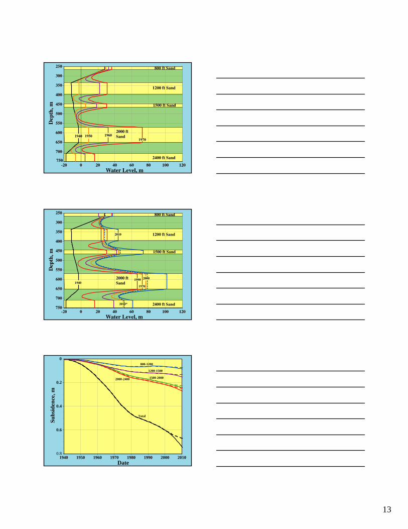
Clay
Sand
Limestone
Sandstone
Siltstone
Salt
Shale
Fractured Rock
Unfractured Rock
-21 -20 -19 -18 -17 -16 -15 -14 -13 -12 -11 -10
Log Permeability, m2
13
0.8
0.6
0.4
0.2
0
1940 1950 1960 1970 1980 1990 2000 2010Date
800-1200
1200-1500
1500-20002000-2400
Total

14
1900-1965 1935-1965 1964-1969 1964-1976 1975-1979 1981-1990 1991-2000 2001-20100
0.002
0.004
0.006
0.008
0.01
0.012
0.014
0.016
Time Interval
This Study
Releveling/Extensometers
WITHDRAWALS FROM THE CHICOT AQUIFER SYSTEM, 2000(800 MILLION GALLONS PER DAY)
Public supply11%
Industry9%
Power generation2%
Other uses2%
Irrigation68%
Aquaculture8%
15
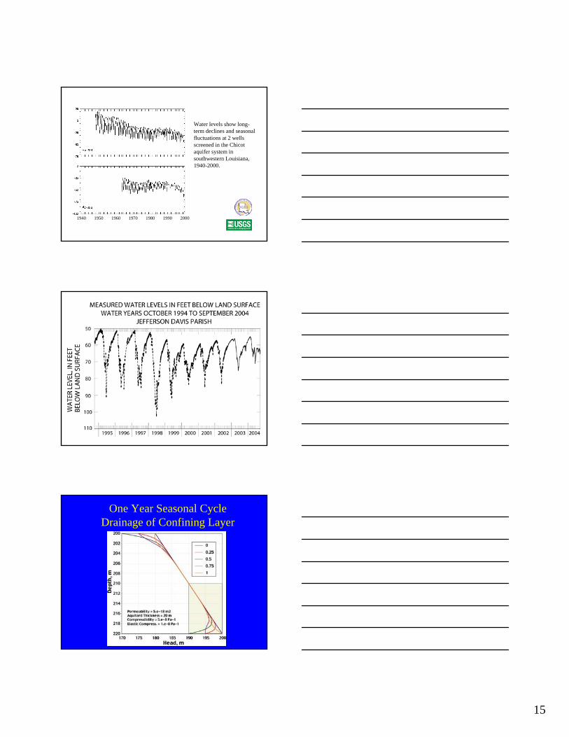
Water levels show long-term declines and seasonal fluctuations at 2 wells screened in the Chicot aquifer system in southwestern Louisiana, 1940-2000.
1940 1950 1960 1970 1980 1990 2000
One Year Seasonal CycleDrainage of Confining Layer

16
One Year Seasonal CycleBottom Half of Confining Layer
Second Seasonal Cycle Drainage of Confining Layer
Second Seasonal Cycle Bottom Half of Confining Layer

17
Fifth Seasonal Cycle Drainage of Confining Layer
Fifth Seasonal Cycle Bottom Half of Confining Layer
Five Seasonal CyclesDrainage at Low Water Level

18
Five Seasonal CyclesDrainage at Low Water Level
10
9
8
7
6
5
4
3
2
1
0
0 20 40 60 80 100
Maximum Decline in Water Level, meters
SJV
SCV
HGTEPALVNNOL
SG
BRL

19
CONCLUSIONS
• Declining water levels in the Chicot and Southern Hills Aquifers should drain intervening clay layers and produce significant compaction and land surface subsidence
• The amount and temporal distribution of subsidence will depend on the number and thickness of clay layers which varies both North to South and East to West

20
CONCLUSIONS
• Drainage and compaction of confining layers also can result from seasonal variations in water levels even if long term water levels do not change
• Land surface subsidence will continue in the region even if water levels remain constant.
• The potential for future land surface subsidence in the region is high.
Figure 13.13
Fissures and depressionsFissures and depressionscaused by caused by
ground subsidence ground subsidence due to due to overpumpingoverpumping
of groundwaterof groundwater

21
St. Mark’s Square, Venice
p. 254
p. 255


![RECENT ADVANCES IN THE MODELLING OF CRACK GROWTH … · fatigue crack growth during secondary plastic flow dc = [C1 (K- Kop)n + C2_iKPh(K -Kop) n'p]dK no growth the crack is opened;](https://cdn.vdocuments.us/doc/165x107/5e57a43a9270ef75843575ce/recent-advances-in-the-modelling-of-crack-growth-fatigue-crack-growth-during-secondary.jpg)


