STRATIGRAPHY AND DEPOSITIONAL ENVIRONMENTS OF THE LATE
CRETACEOUS (LATE TURONIAN) CODELL SANDSTONE AND JUANA LOPEZ
MEMBERS OF THE CARLILE SHALE, SOUTHEAST COLORADO
by
Russell K. Lewis
ii
A thesis submitted to the Faculty and the Board of Trustees of the Colorado
School of Mines in partial fulfillment of the requirements for the degree of Master of
Science (Geology).
Golden, Colorado
Date:____________________
Signed:____________________________
Russell K. Lewis
Signed:____________________________
Dr. Stephen A. Sonnenberg Thesis Advisor
Golden, Colorado
Date:____________________
Signed:_________________________
Dr. Paul Santi Professor and Department Head
Department of Geology and Geological Engineering
iii
ABSTRACT
Late Cretaceous formations in the Rocky Mountains are of significant importance
to petroleum exploration throughout the region. Recent exploration in the Codell
Sandstone Member of Carlile Shale, Smoky Hill and Fort Hays Limestone members of
the Niobrara and Greenhorn formations has rejuvenated interest in not only their
petroleum potential, but also stratigraphy, petrography, biostratigraphy, geochemistry
and other disciplines within the geosciences.
Throughout most of northern, central and southeastern Colorado and eastern
Kansas, the Codell Sandstone represents the final regressive deposit of the Greenhorn
cyclothem and the Fort Hays Limestone represents the basal sequence of the Niobrara
cyclothem. The intermediate, unconformity bound Juana Lopez Member of the Carlile
Shale has been interpreted as a palimpsest deposit, and generally disregarded as a
significant stratigraphic interval within the region.
Southeast Colorado contains some of the world's best outcrops of Late
Cretaceous strata and has been the focus of research for nearly a century. The purpose
of this research was to better understand the impact and regional extent of the late
Turonian unconformities on the Codell Sandstone and Juana Lopez members, and the
implications on previous interpretations of the depositional environments and Late
Cretaceous paleogeography.
Analysis of outcrop, core, subsurface well logs and support from hand-held X-ray
fluorescence geochemistry data indicates that significant faulting, topographic highs and
subaqueous erosion removed the Codell Sandstone differentially throughout the region,
creating a depositional remnant prior to and during deposition of the Juana Lopez and

iv
the basal Fort Hays Limestone. The Juana Lopez is a fossiliferous grainstone to
calcareous sandstone, deposited in a sediment starved, high-energy, current winnowed,
shallow marine shelf environment during the basal transgression of the Niobrara
cyclothem.

v
TABLE OF CONTENTS
ABSTRACT ..................................................................................................................... iii
LIST OF FIGURES ..........................................................................................................ix
LIST OF TABLES .......................................................................................................... xiv
ACKNOWLEDGEMENTS ..............................................................................................xv
CHAPTER 1 .................................................................................................................... 1
INTRODUCTION ............................................................................................................. 1
1.1 Study Objectives .................................................................................................... 1
1.2 Area of Investigation .............................................................................................. 1
1.3 Dataset and Procedures ........................................................................................ 2
1.4 Previous Research ................................................................................................. 5
CHAPTER 2 .................................................................................................................. 10
BACKGROUND GEOLOGY .......................................................................................... 10
2.1 Geologic Overview ............................................................................................... 10
2.2 Stratigraphy .......................................................................................................... 13
2.3 Structural Framework ........................................................................................... 20
2.4 Regional Stratigraphic Unconformities ................................................................. 23
CHAPTER 3 .................................................................................................................. 27
SEDIMENTOLOGY ....................................................................................................... 27
3.1 Blue Hill Shale Facies .......................................................................................... 27
3.1.1 Facies BHS-1 – Lower Blue Hill Shale ........................................................... 28
3.1.2 Facies BHS-2 – Lower Blue Hill Shale ........................................................... 28
3.1.3 Facies BHS-3 – Upper Blue Hill Shale ........................................................... 28
vi
3.2 Codell Sandstone Facies ..................................................................................... 29
3.2.1 Facies CDL-1 – Lower Codell Sandstone ...................................................... 30
3.2.2 Facies CDL-2 – Lower Codell Sandstone ...................................................... 30
3.2.3 Facies CDL-3 – Upper Codell Sandstone ...................................................... 31
3.2.4 Facies CDL-4 – Upper Codell Sandstone ...................................................... 32
3.3 Codell Sandstone Petrography ............................................................................ 34
3.4 Juana Lopez Facies ............................................................................................. 36
3.4.1 Facies JL-1 – Juana Lopez ............................................................................ 37
3.4.2 Facies JL-2 – Juana Lopez ............................................................................ 39
3.5 Juana Lopez Petrography .................................................................................... 40
3.6 Fort Hays Limestone Facies ................................................................................ 41
3.6.1 Facies FH-1 – Fort Hays Limestone .............................................................. 44
3.6.2 Facies FH-2 – Fort Hays Limestone .............................................................. 45
3.6.3 Facies FH-3 – Fort Hays Limestone .............................................................. 45
3.6.4 Facies FH-4 – Fort Hays Limestone .............................................................. 45
CHAPTER 4 .................................................................................................................. 49
CORE AND OUTCROP STRATIGRAPHY .................................................................... 49
4.1 Primary Outcrops and Core ................................................................................. 49
4.1.1 Portland 1 Core (PC) ..................................................................................... 49
4.1.2 Rebecca Bounds 1 Core (RBC) ..................................................................... 50
4.1.3 Deadman's Curve Outcrop (DCO) ................................................................. 50
4.1.4 Lake Pueblo State Park Outcrop (LPO) ......................................................... 52
4.1.5 Peck Creek Outcrop (PCO) ........................................................................... 53

vii
4.1.6 Pueblo Nature Center Outcrop (PNCO) ......................................................... 54
4.1.7 Verde Road Outcrop (VRO) ........................................................................... 55
4.1.8 Walsenburg Outcrop (WO) ............................................................................ 57
4.2. Secondary Outcrops ........................................................................................... 58
4.2.1 B.F. Rockafellow Ecology Park Outcrop (RFPO) ........................................... 58
4.2.2 Beaver Creek Anticline Outcrop (BCO) ......................................................... 59
4.2.3 Rock Hill North Outcrop (RHNO) ................................................................... 60
4.2.4 Sanders Arroyo (SAO) ................................................................................... 61
CHAPTER 5 .................................................................................................................. 63
SUBSURFACE STRATIGRAPHY ................................................................................. 63
5.1 Overview .............................................................................................................. 63
5.2 Blue Hill Shale Stratigraphic Distribution .............................................................. 63
5.3 Blue Hill Shale Regional Isopachs ....................................................................... 65
5.4 Codell Sandstone Stratigraphic Distribution ......................................................... 68
5.5 Codell Sandstone Regional Isopachs .................................................................. 71
5.6 Juana Lopez Stratigraphic Distribution ................................................................. 73
5.7 Fort Hays Limestone Stratigraphic Distribution .................................................... 75
CHAPTER 6 .................................................................................................................. 77
GEOCHEMISTRY ......................................................................................................... 77
6.1 X-ray Fluorescence Overview .............................................................................. 77
6.2 Provenance Analysis ............................................................................................ 78
6.3 X-ray Fluorescence Results ................................................................................. 80
6.4 Provenance Summary .......................................................................................... 85
viii
CHAPTER 7 .................................................................................................................. 87
DEPOSTIONAL ENVIRONMENTS AND PALEOGEOGRAPHY .................................. 87
7.1 Cretaceous Interior Seaway ................................................................................. 87
7.2 Blue Hill Shale ...................................................................................................... 87
7.3 Codell Sandstone ................................................................................................. 88
7.4 Juana Lopez ........................................................................................................ 91
7.5 Late Turonian Paleogeography ............................................................................ 92
CHAPTER 8 .................................................................................................................. 97
CONCLUSIONS ............................................................................................................ 97
FUTURE WORK............................................................................................................ 99
REFERENCES CITED ................................................................................................ 101
APPENDIX A: CORE AND OUTCROP INFORMATION ............................................. 115
APPENDIX B: WELL INFORMATION ......................................................................... 118
APPENDIX C: STRATIGRAPHIC PICKS .................................................................... 153
APPENDIX D: SUPPLEMENTAL FILES ..................................................................... 190
ix
LIST OF FIGURES
Figure 1.1: Area of Investigation (AOI) in southeast Colorado. ....................................... 2
Figure 2.1: Generalized facies distribution of Late Cretaceous strata in the WIC seaway (modified from Kauffman, 1977). ............................................................................ 11
Figure 2.2: WIC seaway marine cycles (partial) from the USGS Portland 1 core (modified from Kauffman 1977, Obradovich, 1993, Ogg et al. 2004, and Locklair 2008). ..................................................................................................................... 12
Figure 2.3: Evolution of stratigraphic nomenclature of the upper Carlile Shale (partial) and lower Niobrara formations in southeast Colorado. .......................................... 16
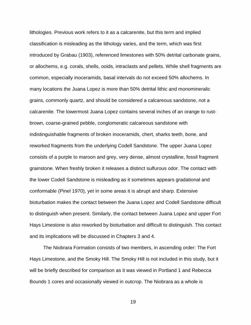
Figure 2.4: Regional structural features in southeast Colorado (modified from Pinel, 1977). ..................................................................................................................... 21
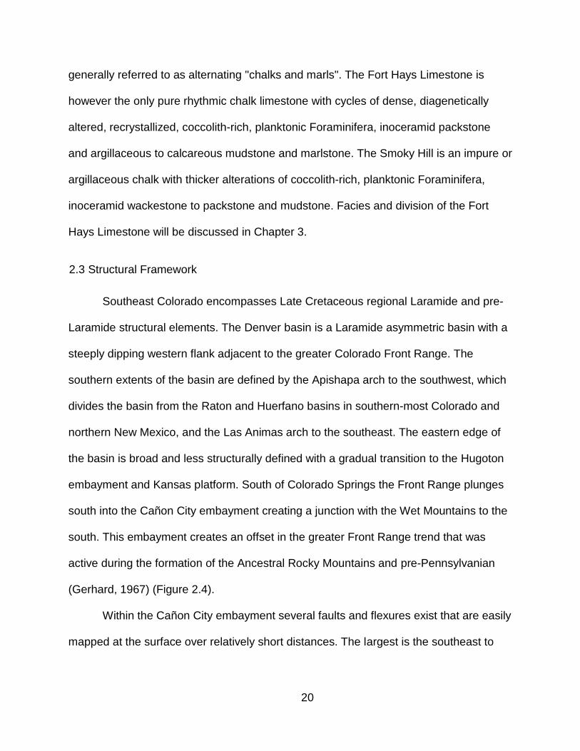
Figure 2.5: Structural features within the Cañon City embayment and western flank of the Denver basin (modified from Pinel, 1977). ....................................................... 22
Figure 2.6: Lithologies and lacunae in strate of Cenomanian, Turonian, and Coniancian (Late Cretaceous). Otero County, Colorado is the most applicable to this area of research (Merewether et al., 2007). ..................................................................... 225
Figure 2.7: Positive structural elements and pre-Niobrara erosion in southeast Colorado
(Laferriere and Hattin, 1989). ................................................................................. 26
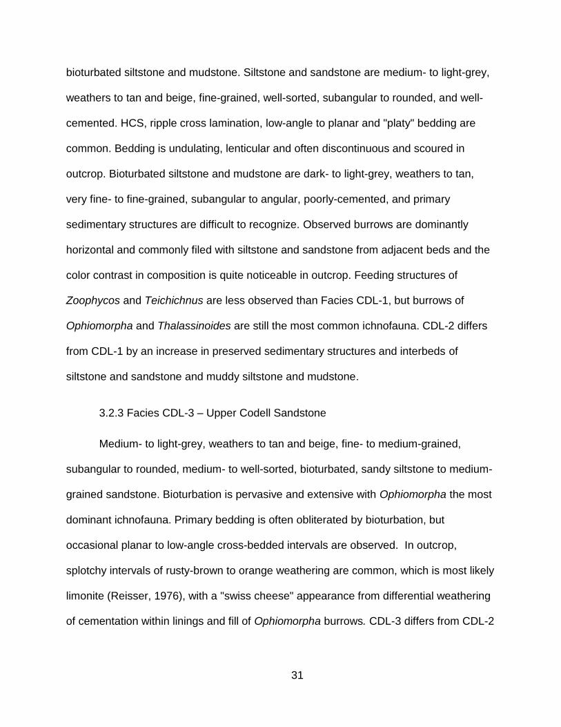
Figure 3.1: Repeating depositional sequences in the upper Codell Sandstone. Bedding is massive with upward gradation of planar to low-angle cross-bedding to increasingly more bioturbated near the top (location: PNCO). ............................... 33
Figure 3.2: 2D symmetrical to slightly asymmetrical wave ripples with evidence of crest plaining and interference. Paleocurrent direction is dominantly south to southeast (location: PNCO). ................................................................................................... 34

x
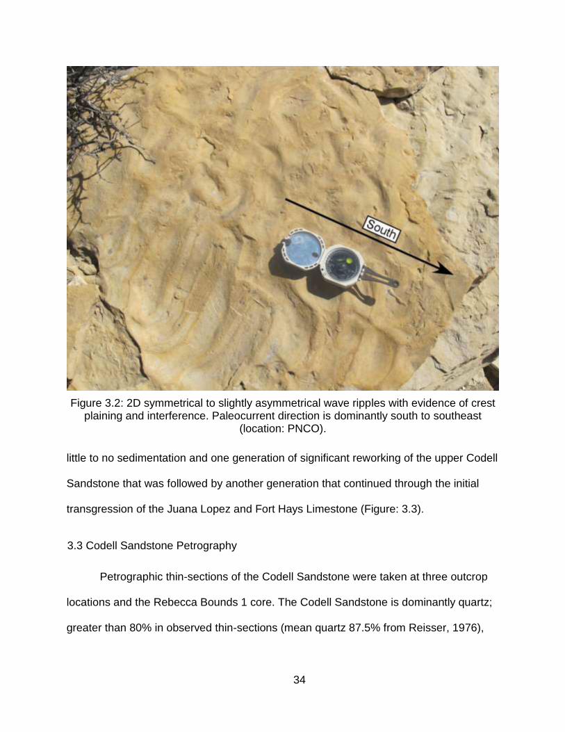
Figure 3.3: Significantly burrowed and vertically reworked surface atop the Codell Sandstone as a Glossifungites inchofauna. Lighter grey streaks are burrows lined with overlying Fort Hays Limestone mud (location: LPO). ...................................... 35
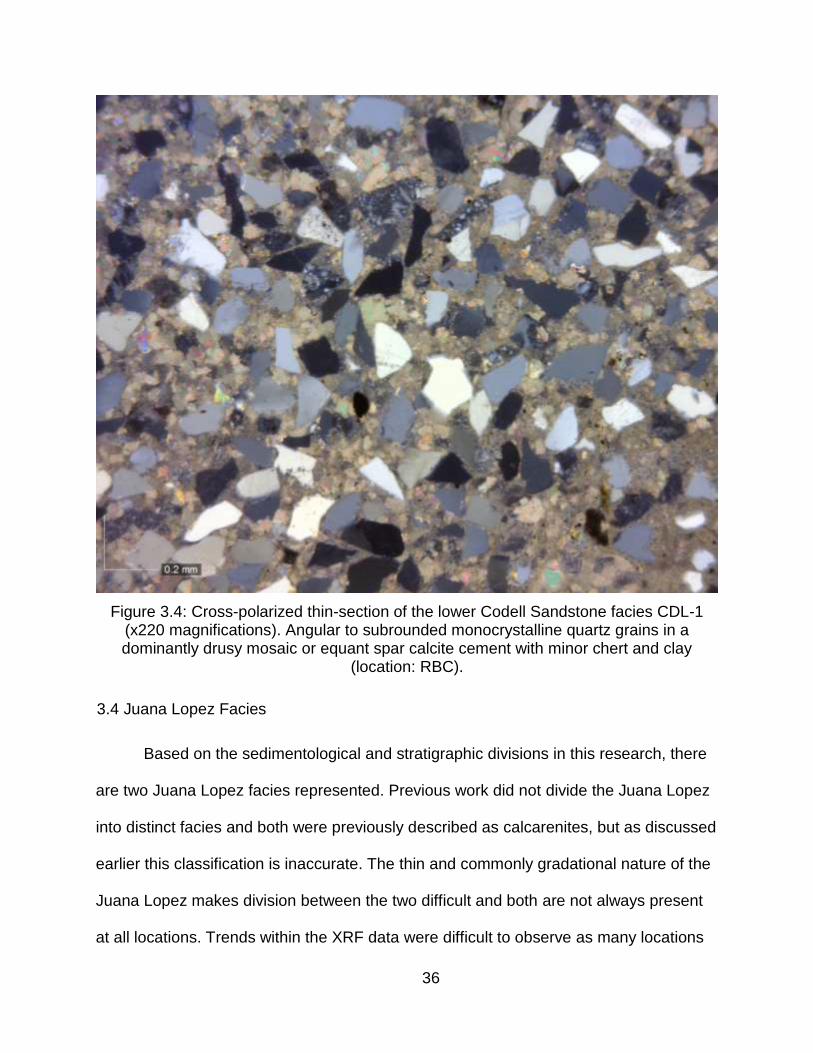
Figure 3.4: Cross-polarized thin-section of the lower Codell Sandstone facies CDL-1 (x220 magnifications). Angular to subrounded monocrystalline quartz grains in a dominantly drusy mosaic or equant spar calcite cement with minor chert and clay (location: RBC). ...................................................................................................... 36
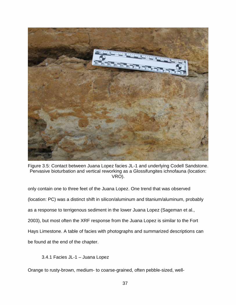
Figure 3.5: Contact between Juana Lopez facies JL-1 and underlying Codell Sandstone. Pervasive bioturbation and vertical reworking as a Glossifungites ichnofauna (location: VRO). ...................................................................................................... 37
Figure 3.6: Contact between Juana Lopez facies JL-2 and overlying Fort Hays Limestone (facies: FH-4). Pervasive bioturbation and vertical reworking of Fort Hays Limestone mud down into “clasts” of Juana Lopez (location: PCO). ............. 38
Figure 3.7: Thin-section of Juana Lopez facies JL-1 (x220 magnification). Mixed population of large quartz grains with smaller mixed quartz and broken inoceramid fragments in drusy mosaic of equant spar calcite and limonite-stained cement. Large fragment in the center is an unidentified vertebrae (location: PCO). ............ 41
Figure 3.8: Thin-section of Juana Lopez facies JL-2 (x220 magnification). Sample is almost entirely broken inoceramid fragments in poikilotopic and syntaxial calcite cement. Mauve to purple and turquoise stain might indicate the presence of ferroan calcite or ferroan dolomite. Note the faint but recognizable parallel-to-bedding grain alignment from compaction (location: PNCO). ....................................................... 42
Figure 3.9: Thin-section of the Juana Lopez facies JL-2 (x220 magnification). Sample is almost entirely broken inoceramid fragments with a trace of quarts grains and variable calcite cement. Note the very large quartz grain beneath the still intact inoceramid fragment. The third fragment is most likely a tooth fragment or bone. Mauve to purple and turquoise staining response may indicate ferroan calcite or ferroan dolomite (location: PNCO). ........................................................................ 43
Figure 3.10: Thin-section of the Juana Lopez facies JL-2 (x220 magnification). Sample is mostly broken inoceramid fragments, but there is a larger percentage of monocrystalline quartz grains (grey color). Note the abundant syntaxial overgrowths near the center of the sample (location: PCO). .................................. 44
xi
Figure 4.1: Deadman's Curve Outcrop (DCO)............................................................... 51
Figure 4.2: Lake Pueblo State Park Outcrop (LPO) ...................................................... 52
Figure 4.3: Peck Creek Outcrop (PCO) ......................................................................... 54
Figure 4.4: Pueblo Nature Center Outcrop (PNCO) ...................................................... 55
Figure 4.5: Verde Road Outcrop (VRO) ........................................................................ 56
Figure 4.6: Walsenburg Outcrop (WO) .......................................................................... 57
Figure 4.7: B.F. Rockafellow Park Outcrop (RFPO) ...................................................... 59
Figure 4.8: Beaver Creek anticline (Highway 50) Outcrop (BCO). ................................ 60
Figure 4.9: Rock Hill North Outcrop (RHNO). ................................................................ 61
Figure 4.10: Sanders Arroyo Outcrop (SAO). ................................................................ 62
Figure 5.1: Reference log illustrating subsurface units and stratigraphic tops used in this research and their typical log response. ................................................................. 64
Figure 5.2: North to southeast resorted stratigraphic section illustrating truncation of the Blue Hill Shale to the north (Weimer and Sonnenberg, 1983). ............................... 66
Figure 5.3: North to south cross-section from Colorado Springs to Pueblo illustrating the truncation of the upper Blue Hill Shale. Grey shading represents Blue Hill Shale "Carlile Shale" interval (datum=CDL_SS). ............................................................. 67
Figure 5.4: West to east cross-section from Pueblo to Rebecca Bounds 1 core in Kansas. Grey shading represents Blue Hill Shale "Carlile Shale" interval (datum = CDL_SS). ............................................................................................................... 68
xii
Figure 5.5: Regional isopach of the lower Blue Hill Shale (tops: FAIRPORT to LBHS). Contour interval equals 5 feet. ............................................................................... 69
Figure 5.6: Regional isopach of Carlile Shale excluding Fairport Chalk (tops: FAIRPORT to CDL_SS). Contour interval equals 10 feet. ........................................................ 70
Figure 5.7: North to south cross-section from Colorado Springs to Pueblo. Yellow shading represents upper Codell Sandstone (datum = FH_MRK_1). .................... 71
Figure 5.8: West to east cross-section from Pueblo to the Kansas state line. Yellow shading represents upper Codell Sandstone (datum=FH_MRK_1). ...................... 72
Figure 5.9: Regional isopach of the upper Codell Sandstone (tops: B_CDL_SS to CDL_SS). Contour interval equals 5 feet. .............................................................. 73
Figure 5.10: Stratigraphy in the northern Huerfano basin. Yellow represents upper Codell Sandstone, grey represents upper Codell siltstone, orange and brown represent Juana Lopez and blue represents Fort Hays Limestone. ....................... 74
Figure 5.11: West to east cross-section from Pueblo to the Kansas state line. Blue shading represents lower Fort Hays Limestone (datum = FH_MRK_1). ................ 76
Figure 6.1: Mafic to felsic ratio (MFR) versus Si/Al for the Taconic and Blountian foreland basins (Andersen, 1995). ......................................................................... 81
Figure 6.2: Mafic to felsic ratio (MFR) versus Si/Al for the Blue Hill Shale and lower Codell Sandstone. .................................................................................................. 82
Figure 6.3: Mafic to felsic ratios (MFR) versus depth ofr the Blue Hill Shale and lower Codell Sandstone. .................................................................................................. 83
Figure 6.4: Cr/Nb versus Ti/Nb for the Blue Hill Shale and lower Codell Sandstone. .... 84
Figure 6.5: Ni/Nb versus Ti/Nb for the Blue Hill Shale and lower Codell Sandstone. .... 84
xiii
Figure 7.1: Southeast Colorado paleocurrent data (Aulia, 1982). ................................. 94
Figure 7.2: Paleogeography of the late middle Turonian, zone Prionocyclus hyatti. (edited from Wallace, 1975; Lowman, 1977; Hook and Cobban, 1979; Aulia, 1982; Merewether, Molenaar and Cobban, 1983; Merewether and Cobban, 1986 and Laferriere and Hattin, 1989). .................................................................................. 96
xiv
LIST OF TABLES
Table 1.1: Core information. ............................................................................................ 4
Table 1.2: Primary and secondary outcrops information. ................................................ 4
Table 3.1: Carlile Shale facies summary. Order generally reflects increasing depositional energy. ............................................................................................... 46
Table 3.2: Carlile Shale facies summary. Order generally reflects increasing depositional energy. ............................................................................................... 47
Table 3.3: Fort Hays Limestone and lower Smokey Hill facies summary. Order generally reflects increasing depositional energy. ................................................................. 48
Table 6.1: Mafic to felsic (MFR) ratios for two core and three outcrop locations where XRF data was obtained. ......................................................................................... 80

xv
ACKNOWLEDGEMENTS
I would first like to thank my primary thesis advisor Dr. Stephen A. Sonnenberg
for the opportunity and assistance to complete this research. In addition, I must also
thank Dr. John D. Humphrey and Dr. Edmund R. Gustason "Gus" for their assistance in
rounding out my committee. Special thanks must be given to Gus for his countless
hours of field and core assistance and almost daily conversations and guidance.
Recognition must be given to all the companies that employed me full-time
during this long process and aided in funding, training, access to data, and software and
hardware. From 2002 through 2005, RockWare, Inc.; 2005 through 2011, El Paso
Corporation; 2011 through 2012, Whiting Petroleum Corporation; and finally since late
2012, Enerplus Resources USA.
Several additional people outside my Committee were instrumental in this
process and must be acknowledged for their assistance: David Wheeler, Paul Dellva,
Nathan Fisher and especially Kelly Bruchez for helping with my outcrop work.
Thanks to my family for all of their support and patience. Finally, my wife Emily
Tompkins. Words cannot express how fortunate I am to have you in my life and your
support and patience supersedes all those listed above. If not for you the completion of
this would never have been possible.
1
CHAPTER 1
INTRODUCTION
1.1 Study Objectives
The purpose of this research was threefold: (1) Examine the sedimentology,
stratigraphy and depositional environments of the Late Cretaceous Carlile Shale and
three of its four members; the Blue Hill Shale, the Codell Sandstone and the Juana
Lopez in southeast Colorado. Emphasis was placed on the interval between the Carlile
Shale and the basal Fort Hays Limestone. (2) Identify and interpret the causes and
controls on the present-day distribution of the Codell Sandstone and Juana Lopez
members and the impact of the late Turonian unconformities in southeast Colorado. (3)
Examine the potential for a connection between the Codell Sandstone in southeast
Colorado to an eastern shoreline in west-central Kansas and if any significant sediment
was contributed to the seaway from the central craton. Due to the nature of the
transition from the Juana Lopez to the Fort Hays Limestone, partial analysis of the basal
Fort Hays was needed for greater distinction between the units and stratigraphic
correlations.
1.2 Area of Investigation
The area of investigation (AOI) is the southern portion of the Denver Julesburg
(Denver) basin including the Cañon City Embayment, Rock Creek anticline, and the
northern flanks of the Las Animas and Apishapa arches (Figure 1.1). This AOI is ideal
because of its numerous, laterally extensive, well-exposed outcrop belts of the
Greenhorn through Niobrara formations, especially the Codell Sandstone through Fort
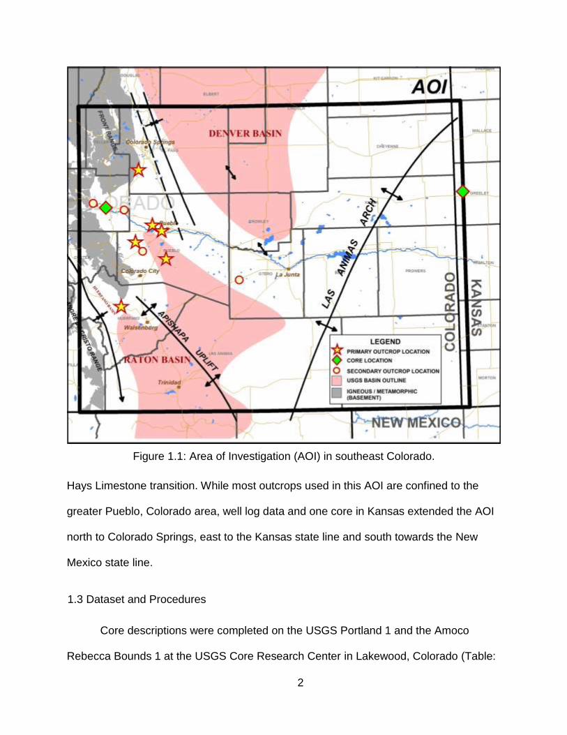
2
Figure 1.1: Area of Investigation (AOI) in southeast Colorado.
Hays Limestone transition. While most outcrops used in this AOI are confined to the
greater Pueblo, Colorado area, well log data and one core in Kansas extended the AOI
north to Colorado Springs, east to the Kansas state line and south towards the New
Mexico state line.
1.3 Dataset and Procedures
Core descriptions were completed on the USGS Portland 1 and the Amoco
Rebecca Bounds 1 at the USGS Core Research Center in Lakewood, Colorado (Table:
3
1.1). Both cores cover the complete study interval and are excellent data points. The
Portland 1 core is located in the center of the AOI and most proximal to outcrops; the
Rebecca Bounds 1 core is in western Kansas and is the easternmost data point used in
this research. All cores were measured at one foot to sub-one foot intervals and
described in detail based on grain size, rock texture, hand-sample mineralogy, fossil
assemblage, ichnofacies, and sedimentary structures. A complete list of and details
about the subsurface core locations can be found in Appendix A, and Table 1.1
summarizes names and locations referenced in Figure 1.1.
Six primary outcrops were described in detail within the AOI (Table: 1.2). In
addition to the six, four secondary outcrops were viewed and informally measured to
help in understanding facies changes and regional stratigraphic relationships. Fieldwork
was accomplished over two years and several trips to the area. All primary outcrops
were analyzed using the same procedures as core analysis. Outcrops also provided
limited paleocurrent data and information on stratigraphic architecture. A complete list of
and details about the outcrop locations can be found in Appendix A, and Table 1.2
summarizes names and locations referenced in Figure 1.1.
Samples for petrographic thin-section analysis were taken from the Codell
Sandstone and Juana Lopez at multiple locations. Samples were analyzed for
composition, optical mineralology, fabric, texture, cementation and all samples were
half-stained with alizarin red-s (ARS) and potassium ferricyanide (PF) for calcite, ferroan
calcite and ferroan dolomite identification. All thin-section images were analyzed using a
Dino-Lite AM413ZTAS digital microscope and light stage polarizing plate, and images
were captured using the DinoCapture 2.0 software at x220 magnification.

4
Table 1.1: Core information.
NBR CODE
OPERATOR WELL NAME
API NUMBER CRC LIBRARY
LOCATION COUNTY &
STATE
1 (PC)
USGS Portland 1
N/A E099
S20-T19S-R68W Fremont, CO
2 (RBC)
Amoco Rebecca Bounds 1
150712044600 E006
S17-T18S-R42W Greeley, KS
Table 1.2: Primary and secondary outcrop information.
NBR CODE
OUTCROP NAME LOCATION COUNTY &
STATE
3 (DCO)
Deadman's Curve S11-T16S-R67W El Paso, CO
4 (LPO)
Lake Pueblo State Park S26-T20S-R66W Pueblo, CO
5 (PCO)
Peck Creek S21-T21S-R67W Pueblo, CO
6 (PNCO)
Pueblo Nature Center S32-T20S-R65W Pueblo, CO
7 (VRO)
Verde Road S9-T23S-R65W Pueblo, CO
8 (WO)
Walsenburg S4-T27S-R68W Huerfano, CO
9 (RFPO)
B.F. Rockafellow Park S7-T19S-R70W Fremont, CO
10 (BCO)
Beaver Creek S7-T19S-R68W Fremont, CO
11 (RHNO)
Rock Hill North S18-T22S-R66W Pueblo, CO
12 (SAO)
Sanders Arroyo S26-T25S-R61W Pueblo, CO
X-Ray Fluorescence (XRF) elemental geochemistry was obtained using a
Thermo Scientific Niton hand-held analyzer on both cores and three primary outcrops.
Data were captured at one and two foot intervals, and sub-foot intervals on major
5
contacts or important changes in lithology and marker beds such as a volcanic ash
beds, and interbeds within the Fort Hays Limestone. Data were collected at 90 second
intervals with 30 second focus on the lighter elements.
Well log data is abundant throughout the Denver basin, especially in and around
Wattenberg, but penetrations of the Niobrara through Greenhorn decrease to the south
and east as the formations shallow and petroleum potential within these Late
Cretaceous formations decreases. Fortunately deeper exploration targets in the region
recorded the shallow Late Cretaceous intervals. Recent oil and gas drilling in the
southeast flank of the basin aided in access to newer well logs within the eastern region
of the AOI, but in general the available well log control in the southern Denver basin is
sporadic and of poor quality due to age. Within the AOI, raster logs were obtained and
manually depth calibrated from the Colorado Oil and Gas Conservation Commission
website (COGCC). Additional raster logs and digital LAS files were supplied by
Enerplus Resources (USA). In total, 141 wells with digital LAS files and 1,881 wells with
raster logs were used in this study. It must be stated that many did not cover the entire
study interval and were only used for partial correlations. A complete list of and details
about the subsurface well log locations and stratigraphic tops can be found in
Appendixes B and C respectively.
1.4 Previous Research
Southeast Colorado has been the focus of Cretaceous outcrop research for
several decades. E.G. Kauffman published and co-authored several works on
biostratigraphy, chronostratigraphy and cyclicity, depositional environments,
geochemistry and stratigraphy in the region, starting in the late 1960’s and continued

6
through the early 1990’s. During his tenure, several of his students published separate
works and continue today on Late Cretaceous research. Of most significance are:
Kauffman, 1969; 1977a; 1977b; 1985; Kauffman et al., 1977; 1985; 1987; 1993; Barlow
and Kauffman, 1985; Fisher et al., 1985; and Glenister and Kauffman, 1985. The
emphasis of these works was on the major marine cycles of sedimentation within both
the Greenhorn and Niobrara cycles from the Dakota up through the Smoky Hill Member
of the Niobrara Formation. While the Codell Sandstone and Juana Lopez were
recognized, limited information was presented regarding their deposition and distribution
throughout southeast Colorado.
The Carlile Shale is part of the unit originally defined as the Fort Benton Group
and later recognized as the upper unit of the Benton Shale or Benton Formation. The
earliest proposal to divide the Benton in Kansas and Colorado was made by Cragin
(1896). The Carlile Shale was named by Gilbert in 1986 from exposures in the Arkansas
River valley region of eastern Colorado. Haun (in Meek and Hayden, 1857) and Leconte
(1868) gave the first descriptions of the Carlile in Kansas. In 1872 a more detailed
description was published by Hayden, who worked along the Union Pacific Railroad in
western Kansas and eastern Colorado. The Carlile Shale was first divided into three
members (in ascending order): the Fairport Chalk, the Blue Hill Shale and the Codell
Sandstone by Bass in 1926 at its type locality in Ellis County, Kansas (NE of Section 3,
Township 11 South, Range 17 West). The Blue Hill shale was first named by Logan in
1897 as a grey to blue-grey, fossiliferous, clayey, non-calcareous shale.
T.W. Stanton (1893) first noted "a bed of rather coarse massive grey sandstone"
that is almost 15 feet thick at Carlile Springs and lay atop the Fort Benton shales. On
7
top of this sandstone he noted "1 to 2 feet of brown calcareous sandstone containing
Ostrea lugubris, impressions of Prionocyclus wyomingensis, and numerous sharks
teeth." He described a variety of fauna from these units in a section to the south in
Huerfano Park and referred to it as the "Pungellus sandstone" after a characteristic
gastropod, Pungellus fusiformis.
The name Juana Lopez was first applied by Rankin (1944) to the top ten feet of
“very calcareous sandstone” which occurs atop of the Carlile Shale on the Mesita Juana
Lopez Grant, six miles northwest of Cerrillos, Santa Fe County, New Mexico. Before
Rankin’s work, the distinctive nature and wide extent of the beds that he included in his
“Juana Lopez Sandstone Member” had been noted by other authors (Newberry, 1876;
Stanton, 1893). Rankin however, emphasized the lateral extent and continuity of the
member by identifying it in measured stratigraphic sections around the margins of the
San Juan basin.
After Rankin’s work, Pike (1947) described the member as the “late Carlile zone”
and noted its distinct fauna and lateral persistence in the northwestern part of the San
Juan basin. The name Juana Lopez was applied to the member in the type area by
Stearns (1953) and along the east side of the San Juan basin by Cobban and Reeside
(1952), and Young (1960). In 1965 the name Juana Lopez was officially accepted by
the USGS as a member of the Mancos Shale in the Ute Mountains area of southwest
Colorado (Ekren and Houser, 1965) and as a member of the Carlile Shale in the Pueblo
area of southeast Colorado (Scott, 1964). Kauffman applied the name widely in
southern Colorado and northern New Mexico (1965). Scott and Cobban (1964) first
applied the name Juana Lopez to the thin calcarenites in the Pueblo area. Dane et al.
8
(1966) and Hattin (1975) extended the usage of the name Juana Lopez Member of the
Carlile Shale throughout southern Colorado and western Kansas.
In his work on the Codell Sandstone Member of the Carlile Shale in southeast
Colorado, Krutak (1970), recognized and classified the uppermost Codell Sandstone as
a calcarenite or limy sandstone unit, pale yellowish-orange, which may be moderate
brown in phosphorite-rich zones. He termed this unit “facies 1” of the Codell Sandstone
and recognized that the thickness throughout the region varied, and in all sections it
marked the top of the unit. Krutak concluded that based on the “podded” morphology,
mineral composition, and sporadic occurrence that this facies represented localized
coquinoid thanatocoenosis of molluscan fragments entombed in intertidal flats which
were alternately exposed and inundated by tidal fluctuations during late Codell
Sandstone time.
Pinel (1977) measured outcrops in Pueblo and Fremont Counties concentrating
around the Brush Hollow and Beaver Creek anticlines, north of Highway 50, utilizing the
excellent local outcrop exposures of the Codell Sandstone and Juana Lopez. The entire
Fort Hays in this area is not always exposed and complete sections are difficult to find.
The extent of his investigation was relatively small, and while he was able to view
several outcrops, his work did not extend far enough to see the variability and
stratigraphic changes within the Codell Sandstone and Juana Lopez. He divided the
system (Blue Hill Shale through Fort Hays Limestone) into four depositional
environments: (I): foreshore or littoral, (II): shoreface, (III): sub-shoreface, and (IV):
deeper neritic (after Land, 1972). Most of the Codell Sandstone in this area was
classified as environments (II) and (III) with rare occurrences of environment (I) in only
9
two of his locations. The Juana Lopez was also classified as environment (II). Based on
the evidence of a weathered exposure and partial lithification of the upper Codell
Sandstone, Pinel alluded to the potential for periods of brief emergence and erosion of
the upper Codell Sandstone, but did not quantify the amount or extent of the possible
exposure and erosion.
Aulia (1982) examined 17 sections, measuring 12 in El Paso County, south and
southwest of Colorado Springs, concentrating on the eastern edge of Garden of the
Gods National Natural Landmark. His work was very local in extent, only covering a few
miles and only briefly referenced secondary locations to the south near Lake Pueblo
State Park and Highway 50 west of Pueblo. Aulia concluded that there was lack of
evidence for subaerial exposure, and that the unconformity between the Codell
Sandstone and Fort Hays was a minor submarine process, and the thinning of the
Codell Sandstone is considered to be the result of positive structural elements, or
erosion related to recurrent fault movement (after Weimer, 1984). In addition, based on
the areas of investigation he concluded that the Juana Lopez thins from the north to
south over the region.
10
CHAPTER 2
BACKGROUND GEOLOGY
2.1 Geologic Overview
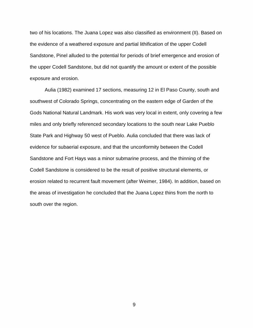
The Western Interior Cretaceous (WIC) basin consists of marine, marginal
marine, coastal plain and alluvial plain sedimentation during periods of maximum
flooding by epicontinental seas (Late Cenomanian-Early Turonian, and Coniacian-
Santonian) (Fig. 2.1). At its maximum development, the basin extended from Arctic
Canada to the Gulf of Mexico, a distance of more than 3,000 miles, in a general north-
south direction (Kauffman, 1977a). It extended from the Boreal sea in the north to the
Tethyian sea in the south. The seaway was bordered on the west by the rising
Cordilleran orogenic belt from which much clastic debris was shed; clastic influx was
minimal from the more stable platform to the east (Pollastro, 1992).
Cretaceous rocks and faunas of the WIC basin reflect two major cycles of marine
sedimentation, the Greenhorn cyclothem (Albian-Middle Turonian) and the Niobrara
cyclothem (Late Turonian-Maastrictian), (Kauffman, 1969) (Fig. 2.2). Each marine cycle
is generally marked by a basal transgressive and terminal regressive sandstone unit
reflecting complex near-strand environments, associated with variable marginal marine-
coastal plain deposits (e.g., Dakota Group, Codell Sandstone, Fox Hill-Laramie
sequence, Trinidad-Vermejo sequence). Maximum transgression is characterized by the
development of widespread fine-grained carbonates near the center of the depositional
basin (Bridge Creek and Fort Hays Limestones) (Kauffman, 1969).
11
Figure 2.1: Generalized facies distribution of Late Cretaceous strata in the WIC seaway (modified from Kauffman, 1977).

12
Figure 2.2: WIC seaway marine cycles (partial) from the USGS Portland 1 core (modified from Kauffman 1977, Obradovich, 1993, Ogg et al. 2004, and Locklair 2008).
13
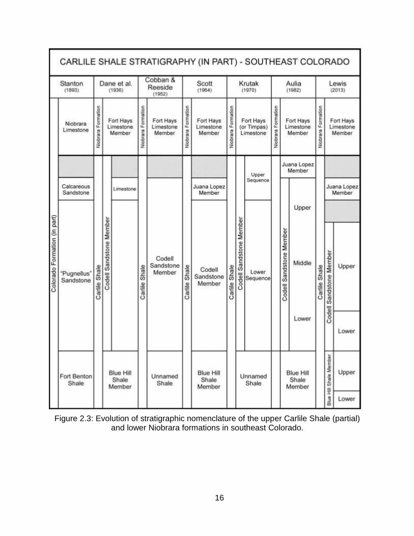
2.2 Stratigraphy
The Carlile Shale consists of four members, in ascending order: the Fairport
Chalk, the Blue Hill Shale, the Codell Sandstone, and the Juana Lopez. The Codell
Sandstone and Juana Lopez are overlain by the Fort Hays Limestone Member of the
Niobrara Formation (Fig 2.3).
The Fairport Chalk is not included in this study, but it will be briefly described for
comparison as it was used in subsurface correlations and viewed in the Portland 1 and
Rebecca Bounds 1 cores, but never viewed in outcrop. The Fairport Chalk consists of
approximately 80 feet of medium- to light-grey to beige and tan calcareous shale.
Numerous thin bentonite layers are present and easily identified throughout the unit.
The base of the unit is gradational with the lower Bridge Creek Member of the
Greenhorn Formation and is commonly designated above the last massive chalk of the
Bridge Creek Limestone. The contact between the Fairport Chalk and overlying Blue Hill
Shale is marked by a change in color from dark-grey to black predominantly laminated
shale and a marked absence of calcium carbonate content, except where concretions
within the lower Blue Hill Shale occur. The contact is rarely found in outcrop, but easy to
identify in core. Genetically the Fairport Chalk is more similar to the Bridge Creek
Limestone, as it represents the regressive hemicycle of the Greenhorn cycle and should
be included as the final member of the Greenhorn Formation instead of the basal
member of the Carlile Shale (Kauffman, 1977).
The Blue Hill Shale consists of dark- to medium-grey to olive shale, mudstone,
siltstone and silty sandstone. The unit coarsens upward from mudstone to siltstone and
fine-grained sandstone that become increasingly more bioturbated. The lower 20-25
14
feet consists of dark-grey to black often laminated shale and bioturbation is absent to
rare. Large Septarian limestone concretions are common, but most are concentrated in
the middle of the unit and can be as large at three feet in diameter. The unit is
commonly a slope former and therefore covered and concealed in outcrop, making
accurate and complete outcrop measurements difficult.
The Blue Hill Shale and its stratigraphic division and nomenclature have not been
equally applied by previous authors. Most designate the Blue Hill Shale as everything
above the Fairport Chalk up to the first significant sandstone of the Codell Sandstone.
This sequence encompasses several intertonguing and gradational lithologies that are
technically not shale. Pinel (1977) stated that there was up to 100 feet of Blue Hill Shale
in southeast Colorado and included everything above the Fairport Chalk to the first
significant sandstone beds of the Codell Sandstone as the Blue Hill Shale. This
transition, as it coarsens upward from shale and mudstone to siltstone, to silty
sandstone, all of which are heavily bioturbated, makes definitive division difficult. This
transition, as the Blue Hill Shale becomes coarser, siltier and more bioturbated is often
referred to as just "Carlile Shale". This usage is misleading as the name Carlile Shale is
outdated, and has what this author considers formation status within the Benton Group
once it was divided by Bass in 1926 (in Kansas Geological Bulletin 11) to contain three,
then later four, distinct, regionally mapable members, none of which were termed
"Carlile Shale". Furthermore, the USGS is inconsistent in their division and usage of the
terms Carlile Shale, Blue Hill Shale and Codell Sandstone. Their report on the Rebecca
Bounds 1 core in Greeley County, Kansas divides the Carlile Shale into three of its four
members (Juana Lopez is absent): Fairport Chalk (784-905 feet), Blue Hill Shale (755-
15
784 feet), Codell Sandstone (675-755 feet). Based on their division the Codell
Sandstone is 80 feet thick and the Blue Hill is 29 feet thick. The Portland 1 core in
Fremont County, Colorado contains similar stratigraphic intervals and facies and is
divided into four of the Carlile members: Fairport Chalk (376-456 feet), Blue Hill Shale
(273-376 feet), Codell Sandstone (260-273 feet) and Juana Lopez (257-260 feet).
Based on their division the Blue Hill Shale is 103 feet thick and the Codell Sandstone is
13 feet thick. As stated, these two cores contain similar stratigraphic intervals and
similar facies, yet based on the inconsistency of their naming one could infer significant
stratigraphic changes between the two locations that do not exist. While this may seem
conjectural when viewing the Carlile Shale as a stratigraphic package of intertonguing
and gradational marine facies, a detailed analysis cannot be done without an attempt at
greater stratigraphic clarification (Figure 2.3).
To avoid confusion, the name Carlile Shale should not be used to describe a
specific facies in the transition from the Blue Hill Shale to the Codell Sandstone, but
rather the interval as a whole. However, the name Blue Hill Shale for everything above
the Fairport Chalk and below the Codell Sandstone is equally misleading. Difficulty
arises when needing to describe and correlate this gradational transition from the true
black to dark-grey, fine-grained, laminated Blue Hill Shale to the upper very fine- to fine-
grained, bioturbated mudstone and siltstone that is more Codell Sandstone-like in
appearance. Furthermore, the vertical succession of facies is not always linear and
what is preserved in southeast Colorado does not always adhere to the classic upward-
swallowing shelf to shoreface facies models, which creates greater difficulty in vertical
stratigraphic division. For the purposes of this research, in core and in outcrop, the
16
Figure 2.3: Evolution of stratigraphic nomenclature of the upper Carlile Shale (partial) and lower Niobrara formations in southeast Colorado.

17
name “lower Blue Hill Shale” will used for the lower, dark-grey to black, very fine- to
fine-grained, laminated, often friable, sparsely bioturbated shale, where obvious silt
content is low. Everything above this interval, once the bioturbation and silt content
starts to increase, but below the first occurrence of significant siltstone in the lower
Codell Sandstone, will be referred to as the “upper Blue Hill Shale”, not the Carlile
Shale. This division of the lower Blue Hill Shale is regionally mapable in core and the
subsurface and therefore can be correlated. It is often marked by a color change from a
dark- to medium-grey, more resistant slope ledge, near a concretion zone containing
significant Septarian nodules that some authors recognized as a laterally continuous
regional marker bed of the Blue Hill Shale. It is also generally marked by a decrease in
gamma ray and an increase in resistivity and bulk density log responses. The upper
Blue Hill Shale is more difficult to distinguish in outcrop than in the subsurface on well
logs and in core. The term Carlile Shale will still be used throughout, but only as a
general grouping or in the subsurface where distinct facies division between the upper
Blue Shale and lower Codell Sandstone transition is not possible. An explanation of
these divisions will be addressed in Chapter 3.
The Codell Sandstone consists of 0-40 feet of very fine- to medium-grained, thin
to massive, bioturbated to planar and low-angle, cross-bedded siltstone and sandstone.
Krutak (1970) divided the Codell Sandstone into two informal divisions, a "lower", or
"basal", and an "upper" sequence. Aulia (1982) divided the Codell Sandstone into three
units. The lowermost unit was chosen below where previous work placed the contact to
accommodate log correlations and the occasional silty-sandstone bed that occurs in
outcrop; by doing this Aulia included what many authors consider to be the upper-most
18
Blue Hill Shale transition or what has been previously called "Carlile Shale", as basal
Codell Sandstone. For the purposes of this research, the terms “lower Codell
Sandstone” and “upper Codell Sandstone” will be used to represent the Codell
Sandstone (after Krutak, 1970 and Aulia, 1982). Further explanation of these divisions
will be addressed in Chapter 3. The base of the lower Codell Sandstone with the
underlying upper Blue Hill Shale is occasionally abrupt and can appear to be a scoured
surface, and flute or load casts are common at the base. This is not always present, but
previous authors interpreted this sharp surface as a regional disconformity (Krutak
1970, Reisser 1976, Pinel 1977, and McLane 1982). The lower Codell Sandstone
consists of thinly bedded, often lenticular fine-grained siltstone and sandstone with
interbedded very fine- to fine-grained siltstone and mudstone. The upper Codell
Sandstone consists of thick, pervasively bioturbated, sometimes thin to tabular, and
occasionally planar to low-angle cross-bedded, fine-grained siltstone and sandstone.
Bioturbation is common throughout the entire Codell Sandstone but it can also be
interbedded with stratified sandstone beds and in general it increases towards the top.
The uppermost several few feet of the Codell Sandstone is commonly intensely
bioturbated creating a Glossifungites ichnofacies. This assemblage and the resulting
surface and its implications will be discussed in Chapters 3 and 4.
The Juana Lopez Member is the most enigmatic unit within the Carlile Shale. For
years it was recognized as an uppermost facies of the Codell Sandstone; often
described as a dense, fetid limestone, or calcarenite within the Codell Sandstone. The
Juana Lopez varies in thickness from absent to several feet, never greater than six feet
and considering its relatively thin and elusive nature, it encompasses a wide variety of
19
lithologies. Previous work refers to it as a calcarenite, but this term and implied
classification is misleading as the lithology varies, and the term, which was first
introduced by Grabau (1903), referenced limestones with 50% detrital carbonate grains,
or allochems, e.g. corals, shells, ooids, intraclasts and pellets. While shell fragments are
common, especially inoceramids, basal intervals do not exceed 50% allochems. In
many locations the Juana Lopez is more than 50% detrital lithic and monomineralic
grains, commonly quartz, and should be considered a calcareous sandstone, not a
calcarenite. The lowermost Juana Lopez contains several inches of an orange to rust-
brown, coarse-grained pebble, conglomeratic calcareous sandstone with
indistinguishable fragments of broken inoceramids, chert, sharks teeth, bone, and
reworked fragments from the underlying Codell Sandstone. The upper Juana Lopez
consists of a purple to maroon and grey, very dense, almost crystalline, fossil fragment
grainstone. When freshly broken it releases a distinct sulfurous odor. The contact with
the lower Codell Sandstone is misleading as it sometimes appears gradational and
conformable (Pinel 1970), yet in some areas it is abrupt and sharp. Extensive
bioturbation makes the contact between the Juana Lopez and Codell Sandstone difficult
to distinguish when present. Similarly, the contact between Juana Lopez and upper Fort
Hays Limestone is also reworked by bioturbation and difficult to distinguish. This contact
and its implications will be discussed in Chapters 3 and 4.
The Niobrara Formation consists of two members, in ascending order: The Fort
Hays Limestone, and the Smoky Hill. The Smoky Hill is not included in this study, but it
will be briefly described for comparison as it was viewed in Portland 1 and Rebecca
Bounds 1 cores and occasionally viewed in outcrop. The Niobrara as a whole is
20
generally referred to as alternating "chalks and marls". The Fort Hays Limestone is
however the only pure rhythmic chalk limestone with cycles of dense, diagenetically
altered, recrystallized, coccolith-rich, planktonic Foraminifera, inoceramid packstone
and argillaceous to calcareous mudstone and marlstone. The Smoky Hill is an impure or
argillaceous chalk with thicker alterations of coccolith-rich, planktonic Foraminifera,
inoceramid wackestone to packstone and mudstone. Facies and division of the Fort
Hays Limestone will be discussed in Chapter 3.
2.3 Structural Framework
Southeast Colorado encompasses Late Cretaceous regional Laramide and pre-
Laramide structural elements. The Denver basin is a Laramide asymmetric basin with a
steeply dipping western flank adjacent to the greater Colorado Front Range. The
southern extents of the basin are defined by the Apishapa arch to the southwest, which
divides the basin from the Raton and Huerfano basins in southern-most Colorado and
northern New Mexico, and the Las Animas arch to the southeast. The eastern edge of
the basin is broad and less structurally defined with a gradual transition to the Hugoton
embayment and Kansas platform. South of Colorado Springs the Front Range plunges
south into the Cañon City embayment creating a junction with the Wet Mountains to the
south. This embayment creates an offset in the greater Front Range trend that was
active during the formation of the Ancestral Rocky Mountains and pre-Pennsylvanian
(Gerhard, 1967) (Figure 2.4).
Within the Cañon City embayment several faults and flexures exist that are easily
mapped at the surface over relatively short distances. The largest is the southeast to
21
Figure 2.4: Regional structural features in southeast Colorado (modified from Pinel, 1977).
northwest plunging Rock Canyon anticline. This structure is a transpressional feature,
related to the offset of the Rampart Range and Wet Mountains that warped Mesozoic
sediments over the plunging southern nose of the Front Range. It was breached during
the Quaternary and is actively being down-cut by the Arkansas River today.
Perpendicular to the Rock Canyon anticline are the Brush Hollow, Beaver Creek and
Turkey Creek anticlines, which were the areas of focus by Pinel (1977). The Cañon City
syncline is the westernmost structure before the Wet Mountain thrust and the Red
22
Figure 2.5: Structural features within the Cañon City embayment and western flank of the Denver basin (modified from Pinel, 1977).
Creek arch is the easternmost flexure before the Ute Pass fault which defines the
western edge of the Denver basin. Many of these structures show evidence of a pre-
Pennsylvanian formation with impacts on thickness variations within Upper Cretaceous
formations (Brown 1978) (Figure 2.5).
23
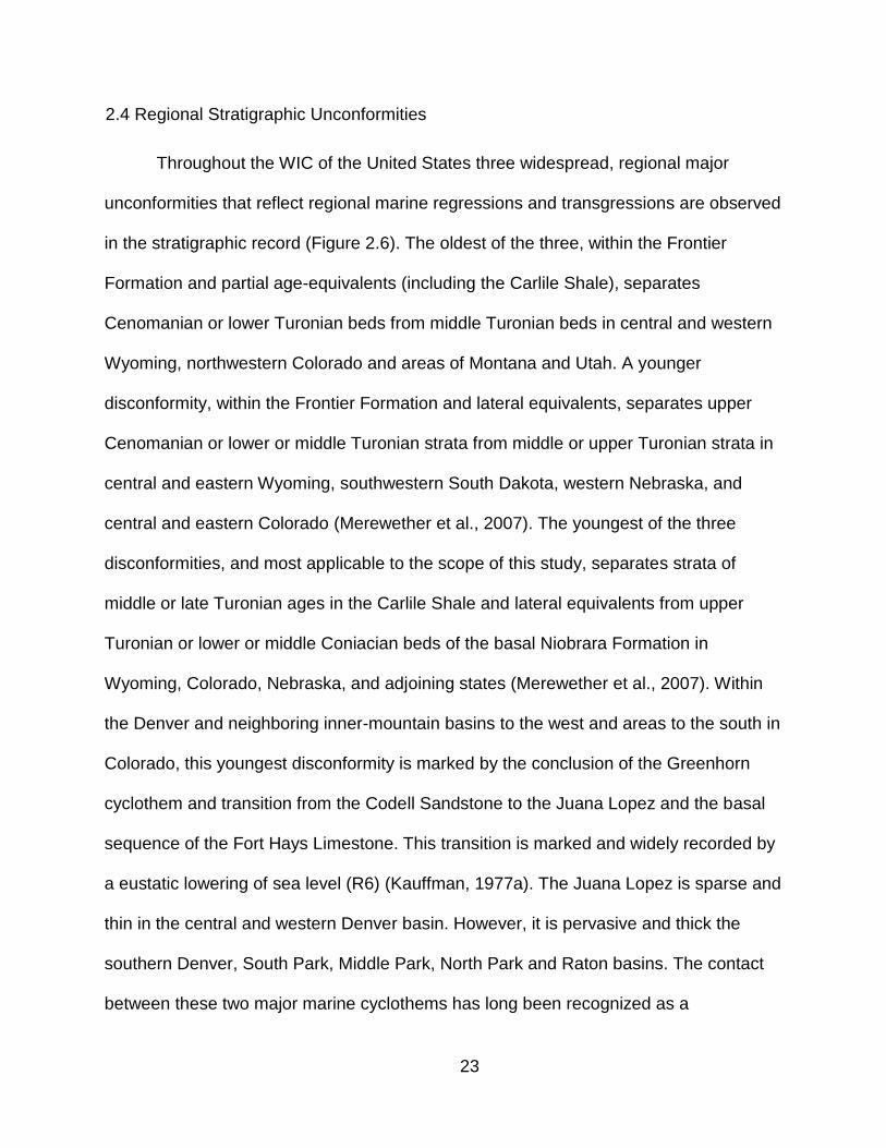
2.4 Regional Stratigraphic Unconformities
Throughout the WIC of the United States three widespread, regional major
unconformities that reflect regional marine regressions and transgressions are observed
in the stratigraphic record (Figure 2.6). The oldest of the three, within the Frontier
Formation and partial age-equivalents (including the Carlile Shale), separates
Cenomanian or lower Turonian beds from middle Turonian beds in central and western
Wyoming, northwestern Colorado and areas of Montana and Utah. A younger
disconformity, within the Frontier Formation and lateral equivalents, separates upper
Cenomanian or lower or middle Turonian strata from middle or upper Turonian strata in
central and eastern Wyoming, southwestern South Dakota, western Nebraska, and
central and eastern Colorado (Merewether et al., 2007). The youngest of the three
disconformities, and most applicable to the scope of this study, separates strata of
middle or late Turonian ages in the Carlile Shale and lateral equivalents from upper
Turonian or lower or middle Coniacian beds of the basal Niobrara Formation in
Wyoming, Colorado, Nebraska, and adjoining states (Merewether et al., 2007). Within
the Denver and neighboring inner-mountain basins to the west and areas to the south in
Colorado, this youngest disconformity is marked by the conclusion of the Greenhorn
cyclothem and transition from the Codell Sandstone to the Juana Lopez and the basal
sequence of the Fort Hays Limestone. This transition is marked and widely recorded by
a eustatic lowering of sea level (R6) (Kauffman, 1977a). The Juana Lopez is sparse and
thin in the central and western Denver basin. However, it is pervasive and thick the
southern Denver, South Park, Middle Park, North Park and Raton basins. The contact
between these two major marine cyclothems has long been recognized as a
24
disconformable or unconformable contact (McLane, 1982). While often referred to as
one major unconformity between the Codell Sandstone and the Fort Hays Limestone,
two unconformities exist in the transition, one beneath the Juana Lopez with the Codell
Sandstone and one above the Juana Lopez with the Fort Hays Limestone.
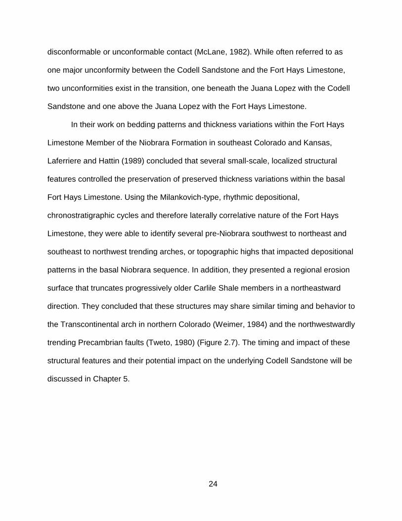
In their work on bedding patterns and thickness variations within the Fort Hays
Limestone Member of the Niobrara Formation in southeast Colorado and Kansas,
Laferriere and Hattin (1989) concluded that several small-scale, localized structural
features controlled the preservation of preserved thickness variations within the basal
Fort Hays Limestone. Using the Milankovich-type, rhythmic depositional,
chronostratigraphic cycles and therefore laterally correlative nature of the Fort Hays
Limestone, they were able to identify several pre-Niobrara southwest to northeast and
southeast to northwest trending arches, or topographic highs that impacted depositional
patterns in the basal Niobrara sequence. In addition, they presented a regional erosion
surface that truncates progressively older Carlile Shale members in a northeastward
direction. They concluded that these structures may share similar timing and behavior to
the Transcontinental arch in northern Colorado (Weimer, 1984) and the northwestwardly
trending Precambrian faults (Tweto, 1980) (Figure 2.7). The timing and impact of these
structural features and their potential impact on the underlying Codell Sandstone will be
discussed in Chapter 5.
25
Figure 2.6: Lithologies and lacunae in strata of Cenomanian, Turonian, and Coniacian (Late Cretaceous). Otero County, Colorado is the most applicable to this research (Merewether et al., 2007).
26
Figure 2.7: Positive structural elements and pre-Niobrara erosion in southeast Colorado (Laferriere and Hattin, 1989).
27
CHAPTER 3
SEDIMENTOLOGY
3.1 Blue Hill Shale Facies
The Blue Hill Shale is a dark- to medium-grey, fine-grained, well-sorted,
subangular to rounded, often laminated, non-calcareous, shale to mudstone. Thin, light-
grey streaks or blebs are common in the lower Blue Hill Shale and thin bentonite beds
are present but not always identifiable in outcrop. It is usually not seen in its entirely in
outcrop, but can be completely viewed in both the Portland 1 and Rebecca Bounds 1
cores. It contains little to no calcium carbonate and it does not react when tested with
hydrochloric acid (HCL), except for localized deposits of Septarian concretions and in
the upper intervals where calcite has cemented the fine-grained siltstone. The contact
with the Fairport Chalk is often difficult to distinguish visually, but very sharp when
tested with HCL. The upper Blue Hill Shale becomes increasingly silty, and bioturbation
gradually increases towards the top. The upper contact with the lower Codell Sandstone
is commonly gradational, yet sharp in some instances. XRF data within the Blue Hill
Shale displays a general vertical trend in decreasing aluminum and potassium, probably
associated with decreasing clay content, and occasional spikes in calcium within calcite
cement or Septarian concretions. The top of the Blue Hill Shale commonly has a shift in
in the titanium/aluminum ratio which most likely indicates an increase it terrigenous
sediment (Sageman, 2003) with the transition to the lower Codell Sandstone.
Based on the sedimentological and stratigraphic divisions in this research, there
are three Blue Hill Shale facies represented. One of these facies (BHS-1) and its
designation as Blue Hill Shale is supported by all previous work. The remaining two
28
facies (BHS-2 and BHS-3) are debatable, and depending on previous work have been
classified as Blue Hill Shale, Carlile Shale, or Codell Sandstone. Table 3.1 contains
photographs and summary descriptions of these facies and can be found at the end of
the chapter.
3.1.1 Facies BHS-1 – Lower Blue Hill Shale
Dark-grey to black, weathers to grey, very fine grained, subangular to rounded,
well-sorted, streaky to laminated, often friable, argillaceous shale. Bioturbation is absent
to rare. Fossils in both outcrop and core are rare, but specimens of Inoceramus cuvieri
and Inoceramus flaccidus have been found in the lower interval in western Kansas and
the Pueblo area (Hattin and Cobban, 1977). Both disseminated and nodular pyrite is
present but does not visually appear abundant in core and outcrop.
3.1.2 Facies BHS-2 – Lower Blue Hill Shale
Dark- to medium-grey, weathers to grey, very fine grained, subangular to
rounded, well- to medium-sorted, mudstone and siltstone. Bioturbation is present
throughout, but subtle and dominantly horizontal. Individual trace fossils and ichnofauna
are difficult to distinguish. BHS-2 differs from BHS-1 by an increase in silt and
bioturbation and a lack of bedding laminations.
3.1.3 Facies BHS-3 – Upper Blue Hill Shale
Medium- to light-grey, weathers to grey and beige, very fine grained, subangular
to rounded, poorly-sorted, bioturbated muddy siltstone. Bioturbation is common to
abundant and ichnofuana diversity is greater than BHS-2 with recognizable feeding
structures of Zoophycos and Teichichnus and burrows of Ophiomorpha and
29
Thalassinoides. Cementation, especially calcite, increases in some intervals. BHS-3
differs from BHS-2 by an increase in silt and bioturbation with an increase in
recognizable vertical burrowing and calcite cement.
3.2 Codell Sandstone Facies
Sandstone can be a misleading classification for the Codell Sandstone. A
majority of the lower unit is interbedded fine-grained mudstone to siltstone to sandstone
and the upper true sandstone facies are not present at all outcrop locations and in the
subsurface. The Codell Sandstone is a light- to medium-grey, weathers to tan, beige
and rusty-brown to orange, fine- to medium-grained, poor- to well-sorted, angular to
well-rounded siltstone to sandstone. Planar and low-angle cross-bedding and
hummocky cross-stratified (HCS) are common, especially in the upper Codell
Sandstone. Many facies within the Codell Sandstone are devoid of silt and mud while
some are interbedded with significant siltstone and mudstone. Bioturbation is present to
pervasive throughout most of the Codell Sandstone, but some intervals show little to no
bioturbation and well preserved sedimentary structures. Intervals of significant calcite
cement are common but their distribution within the upper Codell Sandstone is not as
uniform and predictable as the lower Codell Sandstone and intervals within the upper
Blue Hill Shale. Discrete facies classification in the Codell Sandstone, especially the
lower Codell Sandstone, can be difficult as bioturbation varies to such an extent that
facies changes are gradational. Preserved primary sedimentary structures, abrupt shifts
in silt and mud content and the pervasiveness and occurrence of bioturbation are often
the only distinguishing characteristic between facies. Based on the sedimentological
and stratigraphic divisions in this research, there are four facies of the Codell Sandstone
30
represented. Facies CDL-1 is the only facies that differs from previous work as most
authors place this facies in the upper Blue Hill Shale, as it sits stratigraphically below
the first massive mapable sandstone layer. Aulia (1982) however, also include this
facies as lower Codell Sandstone. XRF data within the Codell is relatively uniform,
owning to its sediment maturity. No distinct trends occur in aluminum, potassium
(assumed to be clay), or any other elements. Silicon is the dominant elemental
response from quartz. Table 3.1 contains photographs and summary descriptions of
these facies and can be found at the end of the chapter.
3.2.1 Facies CDL-1 – Lower Codell Sandstone
Medium- to light-grey, fine-grained, angular to subrounded, poorly-sorted, sandy
siltstone mixed with silty mudstone. Primary sedimentary structures are commonly
obliterated from bioturbation, but faint "ghost" beds of more cemented and therefore
more resistant siltstone is present in outcrop. Feeding structures of Zoophycos and
Teichichnus are common, but burrows of Ophiomorpha, Thalassinoides and
Palaeophycus are the most common ichnofauna. In general cementation is strong
throughout this facies, but certain intervals have a significant increase in calcite cement
that occurs within the upper portion of what appears to be minor upward-shallowing
sequences. This can be difficult to observe in outcrop, but easy to identify in the
Portland 1 core.
3.2.2 Facies CDL-2 – Lower Codell Sandstone
Interbedded planar and hummocky, lenticular siltstone and sandstone and
31
bioturbated siltstone and mudstone. Siltstone and sandstone are medium- to light-grey,
weathers to tan and beige, fine-grained, well-sorted, subangular to rounded, and well-
cemented. HCS, ripple cross lamination, low-angle to planar and "platy" bedding are
common. Bedding is undulating, lenticular and often discontinuous and scoured in
outcrop. Bioturbated siltstone and mudstone are dark- to light-grey, weathers to tan,
very fine- to fine-grained, subangular to angular, poorly-cemented, and primary
sedimentary structures are difficult to recognize. Observed burrows are dominantly
horizontal and commonly filed with siltstone and sandstone from adjacent beds and the
color contrast in composition is quite noticeable in outcrop. Feeding structures of
Zoophycos and Teichichnus are less observed than Facies CDL-1, but burrows of
Ophiomorpha and Thalassinoides are still the most common ichnofauna. CDL-2 differs
from CDL-1 by an increase in preserved sedimentary structures and interbeds of
siltstone and sandstone and muddy siltstone and mudstone.
3.2.3 Facies CDL-3 – Upper Codell Sandstone
Medium- to light-grey, weathers to tan and beige, fine- to medium-grained,
subangular to rounded, medium- to well-sorted, bioturbated, sandy siltstone to medium-
grained sandstone. Bioturbation is pervasive and extensive with Ophiomorpha the most
dominant ichnofauna. Primary bedding is often obliterated by bioturbation, but
occasional planar to low-angle cross-bedded intervals are observed. In outcrop,
splotchy intervals of rusty-brown to orange weathering are common, which is most likely
limonite (Reisser, 1976), with a "swiss cheese" appearance from differential weathering
of cementation within linings and fill of Ophiomorpha burrows. CDL-3 differs from CDL-2

32
by a decrease in mudstones and siltstones and a general lack of interbedded
lithologies, bioturbation is more homogenous and massive.
3.2.4 Facies CDL-4 – Upper Codell Sandstone
Medium- to light-grey, weathers to tan, beige and brown, subrounded to rounded,
well- to medium-sorted, fine-grained, planar to low-angle cross-bedded, silty sandstone
and fine- to medium-grained sandstone. Swaley cross-stratification (SCS) is rare but
present in some locations. Bioturbation is less obvious than facies CDL-3, and overall
the bioturbation gradually increases towards the top (similar to CDL-3) but is still
present throughout, especially in cycles that cap planar to low-angle cross-bedded
event sequence (Figure: 3.1). Ophiomorpha and Thalassinoides are the most common
observed ichnofauna. This facies has the only preserved occurrence (location: PNCO)
of wave rippled bedding surfaces near the very top of the Codell Sandstone, with
enough resolution to measure paleocurrent data. All data indicates a south to southeast
current direction at the time of deposition (Figure: 3.2). CDL-4 differs from CDL-3 by an
overall lack of homogenous bioturbation and an increase in recognizable massive
bedding and preserved sedimentary structures, grain-size and sand content. This facies
is commonly the uppermost and final facies succession within the Codell Sandstone. In
most locations the top of this facies and therefore the top of the Codell Sandstone
sequence contains a Glossifungites ichnofacies and surface that is extensively
bioturbated. In most occurrences the lining fill of the burrows contain vertically reworked
sediment from the overlying Juana Lopez or Fort Hays Limestone. In some instances
several generations of material has been burrowed down several feet below the contact.
33
Figure 3.1: Repeating depositional sequences in the upper Codell Sandstone. Bedding is massive with upward gradation of planar to low-angle cross-bedding to increasingly
more bioturbated near the top (location: PNCO).
This surface demonstrates discontinuity and a significant pause in sedimentation and
extensive erosion in a series of events, not just one surface, that are important in
understanding these units. Glossifungites assemblages are common in lowstand marine
surfaces of erosion and represent sharp breaks in the vertical stratigraphic record and
may signify fundamental changes in depositional environments and initiation of new
cycles of sedimentation (MacEachern, Raychaudhuri and Pemberton, 1992). They are
commonly thought to occur where lowstand conditions expose or exhume the substrate,
but no evidence is present or remains in the Codell Sandstone to support significant
exposure, especially subaerial. This surface therefore represents a long duration with
34
Figure 3.2: 2D symmetrical to slightly asymmetrical wave ripples with evidence of crest plaining and interference. Paleocurrent direction is dominantly south to southeast
(location: PNCO).
little to no sedimentation and one generation of significant reworking of the upper Codell
Sandstone that was followed by another generation that continued through the initial
transgression of the Juana Lopez and Fort Hays Limestone (Figure: 3.3).
3.3 Codell Sandstone Petrography
Petrographic thin-sections of the Codell Sandstone were taken at three outcrop
locations and the Rebecca Bounds 1 core. The Codell Sandstone is dominantly quartz;
greater than 80% in observed thin-sections (mean quartz 87.5% from Reisser, 1976),
35
Figure 3.3: Significantly burrowed and vertically reworked surface atop the Codell Sandstone as a Glossifungites inchofauna. Lighter grey streaks are burrows lined with
overlying Fort Hays Limestone mud (location: LPO).
and almost entirely monocrystalline with straight and undulose extinctions, with a small
fraction polycrystalline. Pore-filling cement is abundant, often comprising 25-30% of the
rock and is dominantly quartz, calcite and chert, with rare occurrences of hematite.
Compaction and its effects on grains increase vertically within the Codell Sandstone.
The lower Codell Sandstone is dominantly unaligned grains that are well-cemented with
occurrences of minor grain-to-grain deformation and some fracturing (Figure: 3.4). The
upper Codell Sandstone shows more evidence with greater grain-to-grain contact,
fracturing, suturing and dissolution seams.
36
Figure 3.4: Cross-polarized thin-section of the lower Codell Sandstone facies CDL-1 (x220 magnifications). Angular to subrounded monocrystalline quartz grains in a dominantly drusy mosaic or equant spar calcite cement with minor chert and clay
(location: RBC).
3.4 Juana Lopez Facies
Based on the sedimentological and stratigraphic divisions in this research, there
are two Juana Lopez facies represented. Previous work did not divide the Juana Lopez
into distinct facies and both were previously described as calcarenites, but as discussed
earlier this classification is inaccurate. The thin and commonly gradational nature of the
Juana Lopez makes division between the two difficult and both are not always present
at all locations. Trends within the XRF data were difficult to observe as many locations
37
Figure 3.5: Contact between Juana Lopez facies JL-1 and underlying Codell Sandstone. Pervasive bioturbation and vertical reworking as a Glossifungites ichnofauna (location:
VRO).
only contain one to three feet of the Juana Lopez. One trend that was observed
(location: PC) was a distinct shift in silicon/aluminum and titanium/aluminum, probably
as a response to terrigenous sediment in the lower Juana Lopez (Sageman et al.,
2003), but most often the XRF response from the Juana Lopez is similar to the Fort
Hays Limestone. A table of facies with photographs and summarized descriptions can
be found at the end of the chapter.
3.4.1 Facies JL-1 – Juana Lopez
Orange to rusty-brown, medium- to coarse-grained, often pebble-sized, well-

38
Figure 3.6: Contact between Juana Lopez facies JL-2 and overlying Fort Hays Limestone (facies: FH-4). Pervasive bioturbation and vertical reworking of Fort Hays
Limestone mud down into “clasts” of Juana Lopez (location: PCO).
rounded to angular, poorly-sorted, calcareous conglomerate to sandstone. Clasts
consist of broken shell fragments of unidentifiable inoceramids and oysters, including
Lopha lugubris, chert, phosphatic nodules, sharks teeth, quartz grains of reworked
Codell Sandstone, and other various allochems and detrital lithic and monomineralic
fragments are common. Bioturbation is absent to pervasive with multi-generational
mélanges of burrows containing sediment from the underlying Codell Sandstone and
overlying Fort Hays Limestone. Bedding and sedimentary structures are commonly
39
indistinguishable, with a few rare occurrences of low-angle to planar cross-bedding.
Clasts or fragments commonly show no orientation or imbrication.
3.4.2 Facies JL-2 – Juana Lopez
Dark-grey to maroon and brown, very dense, extremely well-cemented to almost
crystalline, often "fetid " in odor, fossiliferous grainstone. Clasts consist of broken shell
fragments of unidentifiable inoceramids and oysters of Lopha lugubris. Detrital
components are less than facies JL-1. Bedding can be tabular and massive to
undulating and wavy to lenticular, with distinct breaks between beds. Bioturbation is
absent to pervasive and in some locations so extensive that pieces or clasts are
"suspended" or "floating" in a bioturbated matrix from the overlying Fort Hays Limestone
and sand grains from the underlying Codell Sandstone. Angularity, continuity and
orientation of these "floating" clasts indicate that, in some areas, the Juana Lopez may
have been lithified antecedent to bioturbation, possibly representing a firmground.
This facies is common in the uppermost of the Juana Lopez below the Fort Hays
Limestone. Similar to the surface atop the underlying Codell Sandstone, extensive
reworking and bioturbation is common, interpreted as a Glossifungites ichnofacies
(Figure 3.5). This surface is slightly different from the Codell Sandstone surface as the
Juana Lopez is much coarser and was lithified pre-Fort Hays deposition. This surface
has more evidence of downward reworking of the overlying Fort Hays Limestone into
the burrows that not only penetrate the Juana Lopez but also the underlying Codell
Sandstone (Figure: 3.6).
40
3.5 Juana Lopez Petrography
Petrographic thin-sections of the Juana Lopez were taken from all of the six
primary outcrop locations. An attempt was made to obtain equal samples from both
facies. Facies JL-1 is the least common and is a well-cemented calcareous
conglomerate to sandstone with a variety of fragments. Monocrystalline quartz grains
are common and vary from fine- to coarse-grained and angular to rounded. Compaction
is minor with some occurrences of grain-to-grain contact. Calcite fragments from broken
inoceramids are common, but the largest population is quartz grains with fragments of
chert, bone, sharks teeth and other phosphatic grains (Figure: 3.7). Facies JL-2 (Figure:
3.8) consists of almost entirely broken inoceramid fragments with the occasional large,
well-preserved fragment and is extremely well-cemented with dominantly calcite
cement. Quartz grains and other fragments of bone, teeth and phosphatic grains are still
common (Figure: 3.9), but less than facies JL-1. Compaction is obvious throughout this
facies with grain deformation, fracturing and suturing common and alignment of grains
is very common. One sample in particular (Figure: 3.10) exhibits several generations of
syntaxial overgrowths of calcite cement encasing not only calcite grains but several
monocrystalline quartz grains. Although difficult to conclude with certainty, several
grains within this facies have a mauve to purple to even turquoise stain that may
indicate the presence of ferroan calcite or ferroan dolomite. Trace amounts of dolomite
have been observed in the Juana Lopez (Reisser, 1976) but no obvious dolomite grains
were observed in this research.
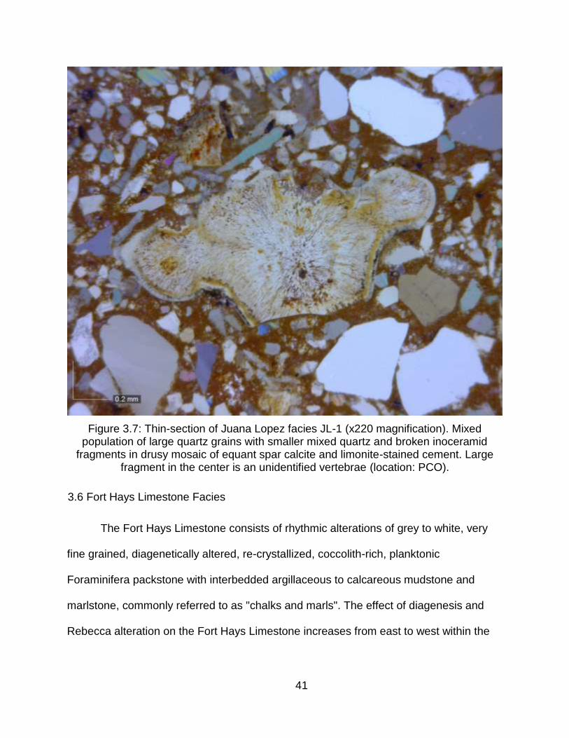
41
Figure 3.7: Thin-section of Juana Lopez facies JL-1 (x220 magnification). Mixed population of large quartz grains with smaller mixed quartz and broken inoceramid
fragments in drusy mosaic of equant spar calcite and limonite-stained cement. Large fragment in the center is an unidentified vertebrae (location: PCO).
3.6 Fort Hays Limestone Facies
The Fort Hays Limestone consists of rhythmic alterations of grey to white, very
fine grained, diagenetically altered, re-crystallized, coccolith-rich, planktonic
Foraminifera packstone with interbedded argillaceous to calcareous mudstone and
marlstone, commonly referred to as "chalks and marls". The effect of diagenesis and
Rebecca alteration on the Fort Hays Limestone increases from east to west within the

42
Figure 3.8: Thin-section of Juana Lopez facies JL-2 (x220 magnification). Sample is almost entirely broken inoceramid fragments in poikilotopic and syntaxial calcite
cement. Mauve to purple and turquoise stain might indicate the presence of ferroan calcite or ferroan dolomite. Note the faint but recognizable parallel-to-bedding grain
alignment from compaction (location: PNCO).
AOI. The Rebecca Bounds 1 core has been less buried than the Portland 1 core and
outcrops to the west and was therefore less compacted and cemented; in core it
appears whiter and less dense. Based on the sedimentological and stratigraphic
division in this research there are four facies within the Fort Hays Limestone and lower
interbedded limestone. Table 3.2 contains photographs and summary descriptions of
these facies and can be found at the end of the chapter.
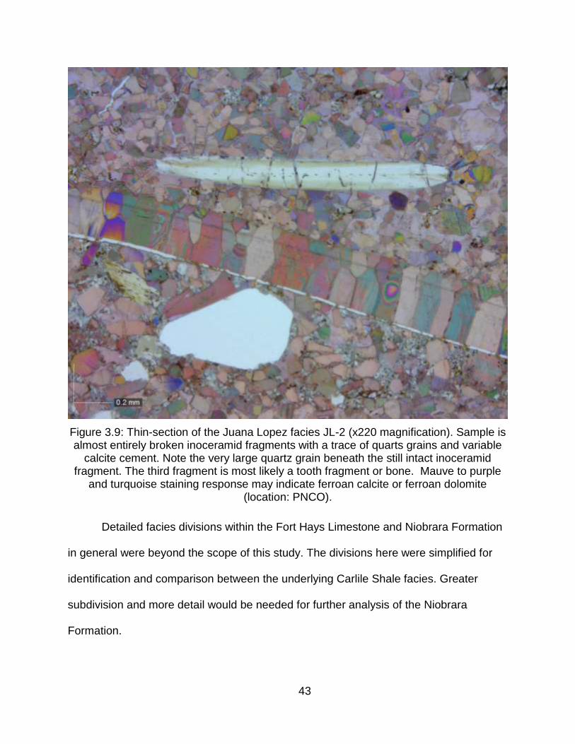
43
Figure 3.9: Thin-section of the Juana Lopez facies JL-2 (x220 magnification). Sample is almost entirely broken inoceramid fragments with a trace of quarts grains and variable
calcite cement. Note the very large quartz grain beneath the still intact inoceramid fragment. The third fragment is most likely a tooth fragment or bone. Mauve to purple
and turquoise staining response may indicate ferroan calcite or ferroan dolomite (location: PNCO).
Detailed facies divisions within the Fort Hays Limestone and Niobrara Formation
in general were beyond the scope of this study. The divisions here were simplified for
identification and comparison between the underlying Carlile Shale facies. Greater
subdivision and more detail would be needed for further analysis of the Niobrara
Formation.
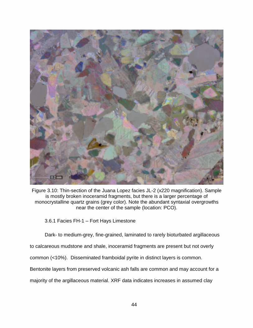
44
Figure 3.10: Thin-section of the Juana Lopez facies JL-2 (x220 magnification). Sample is mostly broken inoceramid fragments, but there is a larger percentage of
monocrystalline quartz grains (grey color). Note the abundant syntaxial overgrowths near the center of the sample (location: PCO).
3.6.1 Facies FH-1 – Fort Hays Limestone
Dark- to medium-grey, fine-grained, laminated to rarely bioturbated argillaceous
to calcareous mudstone and shale, inoceramid fragments are present but not overly
common (<10%). Disseminated framboidal pyrite in distinct layers is common.
Bentonite layers from preserved volcanic ash falls are common and may account for a
majority of the argillaceous material. XRF data indicates increases in assumed clay

45
elements of aluminum and magnesium, and iron from pyrite with an increase in silicon
and a strong decrease in calcium as compared to adjacent facies (commonly FH-4).
3.6.2 Facies FH-2 – Fort Hays Limestone
Medium- to dark-grey, fine-grained, wispy laminated to rarely and commonly
bioturbated, calcareous mudstone to inoceramid wackestone "Marl". Fossil fragments of
broken inoceramids are common and often imbricated parallel to bedding. FH-2 differs
from FH-1 by an increase in carbonate material, inoceramus fragments and a decrease
in XRF responses of aluminum, magnesium and silicon, with an increase in calcium.
3.6.3 Facies FH-3 – Fort Hays Limestone
Medium- to light-grey, fine-grained, bioturbated, coccolith-rich, planktonic
Foraminifera and inoceramid packstone to wackestone "Argillaceous Chalk".
Bioturbation is extensive with multi-generational burrows of Ophiomorpha,
Thalassinoides, Chondrities, Zoophycos and Teichichnus. Fragments of inoceramids
are abundant. FH-3 is similar to FH-4 with an increase in argillaceous material and
decrease in fine-grained carbonate material.
3.6.4 Facies FH-4 – Fort Hays Limestone
Light-grey to white, very fine grained, well-cemented, diagenetically altered,
crystalline, coocolith-rich, Foraminifera and inoceramid packstone, "Chalk". Bioturbation
is extensive and consists of multi-generational burrows of dominantly Ophiomorpha and
Thalassinoides with lesser amounts of Chondrities, Zoophycos and Teichichnus. XRF
data indicates higher amounts of calcium from calcium carbonate and decreases in clay

46
assigned elements of aluminum and magnesium, and iron from pyrite, with a decrease
in silicon as compared to adjacent facies (commonly FH-1).
Table 3.1: Carlile Shale facies summary. Order generally reflects increasing depositional energy.
CARLILE SHALE PHOTO DESCRIPTION MBR
Laminated to streaky shale
(BHS-1)
Dark-grey to streaky medium-grey, fine-grained, friable, argillaceous mudstone and shale. Bioturbation is cryptic to rare. Fossils
in core and outcrop are present but rare.
LOW
ER B
LUE
HILL SH
ALE
Bioturbated silty mudstone (BHS-2)
Dark- to medium-grey, fine-grained, angular to subrounded mudstone to wispy silty
mudstone. Bioturbation is common, but not intense of mostly indistinguishable, small
horizontal burrows.
UP
PER
BLU
E H
ILL SHA
LE
Bioturbated muddy siltstone (BHS-3)
Medium- to light-grey, fine-grained, subangular to subrounded, mixed muddy
siltstone. Bioturbation is intense with obvious vertical and horizontal burrows. Primary
sedimentary structures and bedding have been obliterated.
UP
PER
BLU
E H
ILL SHA
LE
Bioturbated muddy siltstone to fine-
grained sandstone (CDL-1)
Light- to medium-grey, fine-grained, subangular to subrounded, mixed siltstone with lesser amounts of fine-grained mud.
Bioturbation is pervasive with obvious vertical and horizontal burrows. Primary
sedimentary structures and bedding have been obliterated.
LOW
ER C
OD
ELL SA
ND
STON
E
Interbedded siltstone and
sandstone with bioturbated
siltstone and mudstone (CDL-2)
Interbedded planar and hummocky, fine-grained, well-sorted, subangular to subrounded, lenticular siltstone and
sandstone, and bioturbated siltstone and mudstone. Bioturbation in muddy intervals is
dominantly horizontal and common.
LOW
ER C
OD
ELL SA
ND
STON
E
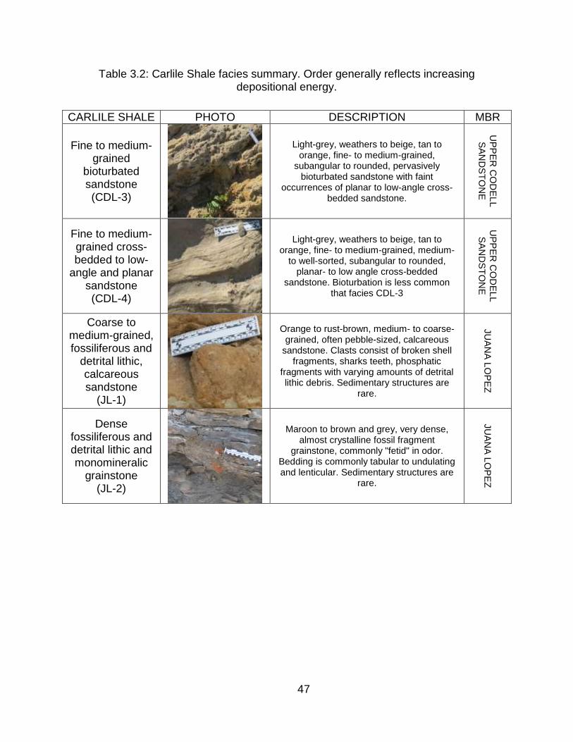
47
Table 3.2: Carlile Shale facies summary. Order generally reflects increasing depositional energy.
CARLILE SHALE PHOTO DESCRIPTION MBR
Fine to medium-grained
bioturbated sandstone (CDL-3)
Light-grey, weathers to beige, tan to orange, fine- to medium-grained,
subangular to rounded, pervasively bioturbated sandstone with faint
occurrences of planar to low-angle cross-bedded sandstone.
UP
PE
R C
OD
EL
L
SA
ND
ST
ON
E
Fine to medium-grained cross-bedded to low-
angle and planar sandstone (CDL-4)
Light-grey, weathers to beige, tan to orange, fine- to medium-grained, medium-
to well-sorted, subangular to rounded, planar- to low angle cross-bedded
sandstone. Bioturbation is less common that facies CDL-3
UP
PE
R C
OD
EL
L
SA
ND
ST
ON
E
Coarse to medium-grained, fossiliferous and
detrital lithic, calcareous sandstone
(JL-1)
Orange to rust-brown, medium- to coarse-grained, often pebble-sized, calcareous
sandstone. Clasts consist of broken shell fragments, sharks teeth, phosphatic
fragments with varying amounts of detrital lithic debris. Sedimentary structures are
rare.
JU
AN
A L
OP
EZ
Dense fossiliferous and detrital lithic and monomineralic
grainstone (JL-2)
Maroon to brown and grey, very dense, almost crystalline fossil fragment
grainstone, commonly "fetid" in odor. Bedding is commonly tabular to undulating and lenticular. Sedimentary structures are
rare.
JU
AN
A L
OP
EZ
48
Table 3.3: Fort Hays Limestone and lower Smokey Hill facies summary. Order generally reflects increasing depositional energy.
FORT HAYS PHOTO DESCRIPTION MBR
Laminated Calcareous Mudstone
(FH-1)
Dark- to medium-grey, fine-grained, laminated to faintly bioturbated “marly mudstone”. Fossil fragments of broken
inoceramids are common (but often less than 10%) and often imbricated parallel to
bedding. Bentonite ash beds and pyrite are common.
FO
RT
HA
YS
LIM
ES
TO
NE
Laminated to wavy
Wackstone (marl) (FH-2)
Medium- to dark-grey, fine-grained, laminated to faintly bioturbated coccolith-rich, planktonic, Foraminifera, inoceramid wackstone. Fragments of inoceramids are
often imbricated parallel to bedding.
FO
RT
HA
YS
LIM
ES
TO
NE
&
SM
OK
EY
HIL
L
Biotrubated Wackstone to
Packstone (dirty chalk) (FH-3)
Medium- to light-grey, fine-grained, bioturbated coccolith-rich, planktonic
Foraminifera, inoceramid wackestone to packstone “dirty chalk”. Bioturbation is
extensive with multi-generational burrows. Fragments of inoceramids are abundant.
FO
RT
HA
YS
LIM
ES
TO
NE
&
SM
OK
EY
HIL
L
Bioturbated Packstone
(chalk) (FH-4)
White to light-grey, pervasively bioturbated coccolith-rich, planktonic Foraminifera,
inoceramid, packstone “chalk”. Bioturbation is extensive, with multi-generational
burrows. Fragments of inoceramids are common.
FO
RT
HA
YS
LIM
ES
TO
NE

49
CHAPTER 4
CORE AND OUTCROP STRATIGRAPHY
4.1 Primary Outcrops and Core
Subsurface core retrieval is invaluable to geological analysis. While this particular
study relied heavily on the use of outcrop analysis and subsurface well log data, the two
core locations were important data points for creating the main facies classifications
used in this research.
There are numerous Late Cretaceous-aged outcrops in southeast Colorado, the
six chosen for this study were some of the most complete and varied enough to
illustrate the regional changes in facies, stratigraphy and depositional settings. Previous
work by Krutak (1970) incorporated several more (over 50) but access to these outcrops
has changed due to development in the area. Much like core, outcrops present an
excellent chance to view the sedimentology and stratigraphy of the formations, but
unlike cores, larger bedding architectures and localized changes can be observed.
Correlations between outcrop and core locations can be found in Plate 9.
4.1.1 Portland 1 Core (PC)
The Portland 1 (USGS Core Library E099) was drilled by the USGS in 1992. It is
located NW SE SE of Section 20, Township 19 South, Range 68 West, Fremont
County, Colorado. It was drilled to Cretaceous age sediments of the Dakota Formation
with a total depth of 700 feet. The core has been studied extensively and sampled by
the USGS and all reports and data are available on the USGS Core Research Center
website. The digital well log data used for this research was created by scanning and
digitizing the data in IHS Petra. The description of the Portland 1 core can be found in

50
Plate 1. The lower Blue Hill Shale (BHS-1) is 25 feet thick, the upper Blue Hill Shale
(BHS-2 and BHS-3) is 65 feet, the lower Codell Sandstone (CDL-1 and CDL-2) is 10
feet, the upper Codell Sandstone (CDL-3 and CDL-4) is 12-15 feet, and the Juana
Lopez (JL-2) is 2-3 feet.
4.1.2 Rebecca Bounds 1 Core (RBC)
The Rebecca Bounds 1 core (API: 15071204460000 / USGS Core Library E006)
was drilled by Amoco in 1988. It is located NE SE NE of Section 17, Township 18
South, Range 42 West, Greeley County, Kansas. It was drilled to Mississippian age
sediments with a total depth of 5,956 feet. The core has been studied extensively,
especially the Greenhorn Formation, and sampled by the USGS. All reports and data
are available on the USGS Core Research Center website. The digital well log data
used for this research was supplied by Enerplus Resources (USA) and licensed from
TGS-NOPEC Geophysical Company. The description of the Rebecca Bounds 1 core
can be found in Plate 2. The lower Blue Hill Shale (BHS-1) is 25 feet thick, the upper
Blue Hill Shale (BHS-2 and BHS-3) is 70 feet, the Codell Sandstone is very thin, only
about 10 feet, and the only facies present is CCL-2, no upper Codell Sandstone facies
are present. The Juana Lopez is absent.
4.1.3 Deadman's Curve Outcrop (DCO)
Deadman's Curve (Figure: 4.1) is located on Highway 115 roughly twelve miles
south of Colorado Springs in the NW of Section 11, Township 16 South, Range 67
West, El Paso County, Colorado. It is easily found and accessible on the west side of
the highway just as it curves to the west, south of Keeton Ranch Road. Parking is safest
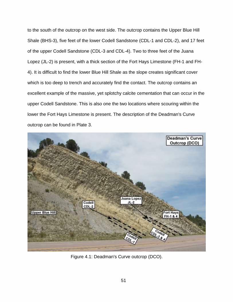
51
to the south of the outcrop on the west side. The outcrop contains the Upper Blue Hill
Shale (BHS-3), five feet of the lower Codell Sandstone (CDL-1 and CDL-2), and 17 feet
of the upper Codell Sandstone (CDL-3 and CDL-4). Two to three feet of the Juana
Lopez (JL-2) is present, with a thick section of the Fort Hays Limestone (FH-1 and FH-
4). It is difficult to find the lower Blue Hill Shale as the slope creates significant cover
which is too deep to trench and accurately find the contact. The outcrop contains an
excellent example of the massive, yet splotchy calcite cementation that can occur in the
upper Codell Sandstone. This is also one the two locations where scouring within the
lower the Fort Hays Limestone is present. The description of the Deadman's Curve
outcrop can be found in Plate 3.
Figure 4.1: Deadman's Curve outcrop (DCO).
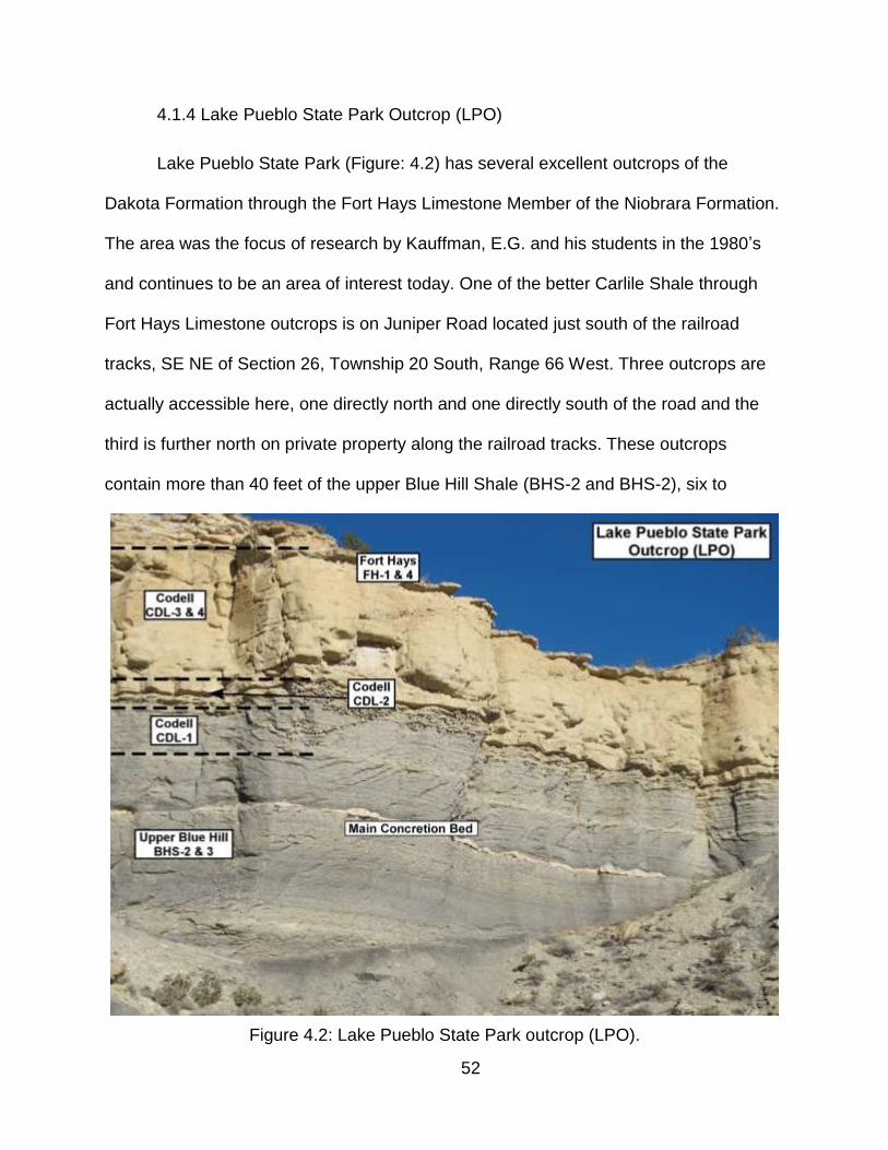
52
4.1.4 Lake Pueblo State Park Outcrop (LPO)
Lake Pueblo State Park (Figure: 4.2) has several excellent outcrops of the
Dakota Formation through the Fort Hays Limestone Member of the Niobrara Formation.
The area was the focus of research by Kauffman, E.G. and his students in the 1980’s
and continues to be an area of interest today. One of the better Carlile Shale through
Fort Hays Limestone outcrops is on Juniper Road located just south of the railroad
tracks, SE NE of Section 26, Township 20 South, Range 66 West. Three outcrops are
actually accessible here, one directly north and one directly south of the road and the
third is further north on private property along the railroad tracks. These outcrops
contain more than 40 feet of the upper Blue Hill Shale (BHS-2 and BHS-2), six to
Figure 4.2: Lake Pueblo State Park outcrop (LPO).
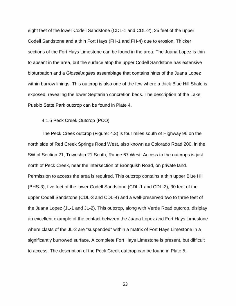
53
eight feet of the lower Codell Sandstone (CDL-1 and CDL-2), 25 feet of the upper
Codell Sandstone and a thin Fort Hays (FH-1 and FH-4) due to erosion. Thicker
sections of the Fort Hays Limestone can be found in the area. The Juana Lopez is thin
to absent in the area, but the surface atop the upper Codell Sandstone has extensive
bioturbation and a Glossifungites assemblage that contains hints of the Juana Lopez
within burrow linings. This outcrop is also one of the few where a thick Blue Hill Shale is
exposed, revealing the lower Septarian concretion beds. The description of the Lake
Pueblo State Park outcrop can be found in Plate 4.
4.1.5 Peck Creek Outcrop (PCO)
The Peck Creek outcrop (Figure: 4.3) is four miles south of Highway 96 on the
north side of Red Creek Springs Road West, also known as Colorado Road 200, in the
SW of Section 21, Township 21 South, Range 67 West. Access to the outcrops is just
north of Peck Creek, near the intersection of Bronquish Road, on private land.
Permission to access the area is required. This outcrop contains a thin upper Blue Hill
(BHS-3), five feet of the lower Codell Sandstone (CDL-1 and CDL-2), 30 feet of the
upper Codell Sandstone (CDL-3 and CDL-4) and a well-preserved two to three feet of
the Juana Lopez (JL-1 and JL-2). This outcrop, along with Verde Road outcrop, dislplay
an excellent example of the contact between the Juana Lopez and Fort Hays Limestone
where clasts of the JL-2 are "suspended" within a matrix of Fort Hays Limestone in a
significantly burrowed surface. A complete Fort Hays Limestone is present, but difficult
to access. The description of the Peck Creek outcrop can be found in Plate 5.
54
Figure 4.3: Peck Creek outcrop (PCO).
4.1.6 Pueblo Nature Center Outcrop (PNCO)
This outcrop locality (Figure: 4.4) consist of a series of bluffs and terraces along
the Arkansas River, just west of downtown Pueblo in the SW NW of Section 32,
Township 20 South, Range 65 West. Access is a mixed public and private road and
paved walking path that runs west from the Pueblo Nature Center along the river.
Several outcrops of the upper Blue Hill Shale through the lower Smoky Hill member of
the Niobrara Formation are easily accessible. The best Carlile Shale outcrops are a
large bluff, less than a mile west of the main parking lot. These outcrops contain a thin
section of upper of Blue Hill Shale (BHS-2 and BHS-3) ten feet of the lower Codell
55
Figure 4.4: Pueblo Nature Center outcrop (PNCO).
Sandstone (CDL-1 and CDL-2), and 15 feet of the upper Codell Sandstone. The Juana
Lopez is present (JL-2) but very thin (< two inches) and the Fort Hays Limestone (FH-1
and FH-4) is well preserved in the area at other outcrops. The description of the Pueblo
Nature Center outcrop can be found in Plate 6.
4.1.7 Verde Road Outcrop (VRO)
The Verde Road outcrop (Figure: 4.5) is located 15 miles south of Pueblo, east of
I-25 in the NW of Section 9, Township 23 South, Range 65 West. Exit I-25 onto
Colorado Road 337 (Verde Road) and continue east, the road will veer south as it
approaches Graneros Creek. As the road continues south a bluff of outcrops will
56
Figure 4.5: Verde Road outcrop (VRO).
appear to the west. The outcrop is on private land owned by the Reno Family and
permission to access the area is required. Verde Road is one of the best outcrops to
illustrate the intertonguing, non-vertical succession of facies within the upper Blue Hill
Shale and lower Codell Sandstone. Twenty feet of the upper Blue Hill Shale is present
(BHS-2 and BHS-3), less than five feet of the lower Codell Sandstone, and the upper
Codell Sandstone (CDL-3 or CDL-4) is absent. The Juana Lopez (JL-1 and JL-2) is
approximately two feet thick. The Fort Hays Limestone is thick, but difficult to measure
accurately. Of the six primary outcrops it is one of the best examples of the significant
erosion and removal of the Codell Sandstone in the area. The description of the Verde
Road outcrop can be found in Plate 7.

57
4.1.8 Walsenburg Outcrop (WO)
The Walsenburg outcrop (Figure: 4.6) is located on Highway 69 roughly fifteen
miles northwest of Walsenburg, just before Colorado Road 520 and 616 in the SE of
Section 4, Township 27 South, Range 68 West. It is the southernmost outcrop, located
on the south side of the highway, just before the exit for Colorado Road 520.
Technically it is in the northern Huerfano basin, but it provides an excellent southern
data point for the greater Cañon City area. The outcrop is very exposed and parking is
safest west of the outcrop near the intersection of Colorado Road 520 on the south side.
The outcrop contains ten feet of the upper Codell Sandstone (CDL-3 and CDL-4) and
four to five feet of bioturbated muddy siltstone which is similar to the lower Codell
Sandstone (CDL-1) at other locations, yet it sits above the usual upper Codell
Figure 4.6: Walsenburg outcrop (WO).
58
Sandstone facies (CDL-4) and below the Juana Lopez. The occurrence of this
additional unit illustrates the intertonguing relationship of the Codell Sandstone and Blue
Hill Shale and the decrease in erosion and removal of the upper Codell Sandstone
towards the west and south. The Juana Lopez is four feet thick and this particular
outcrop is one of the best for the Juana Lopez in the area. The Fort Hays Limestone is
thick and well exposed. The description of the Walsenburg outcrop can be found in
Plate 8.
4.2. Secondary Outcrops
The greater Cañon City and Pueblo areas have more outcrops of Late
Cretaceous strata than one could ever hope to see in a lifetime. While the six outcrops
previously described were the primary focus, four additional outcrops were viewed in
completing this research. These outcrops were used to help define facies and
stratigraphic relationships. None of the outcrops were formally measured and no
samples were taken for analysis.
4.2.1 B.F. Rockafellow Ecology Park Outcrop (RFPO)
B.F. Rockafellow Park (Figure: 4.7) is located just south of Cañon City on
Colorado Road 3 in the SW of Section 7, Township 19 South, Range 70 West. It is best
found by walking directly west of the parking area down into the drainage and then head
south following the creek. It contains excellent outcrops of the Dakota Group, Bridge
Creek Limestone Member of the Greenhorn and Fort Hays Limestone and Smoky Hill
members of the Niobrara. The Juana Lopez is very thick but, overall, not an ideal
location to measure. The upper Codell Sandstone appears to be absent with only a

59
Figure 4.7: B.F. Rockafellow Park outcrop (RFPO).
very thin lower Codell Sandstone present.
4.2.2 Beaver Creek Anticline Outcrop (BCO)
Beaver Creek anticline (Figure: 4.8) is a large road cut within Highway 50
seventeen miles east of Cañon City and twenty miles west of downtown Pueblo in the
S1/2 of Section 24, Township 19 South, Range 68 West. It is just west of the Old
Portland Road 120. Access is best from the west side of the outcrop off the east-bound
side of Highway 50. The outcrop is actively weathering and exposed to traffic and
caution should be taken while accessing. The upper Codell Sandstone is present (CDL-
3 and CDL4), so are the Juana Lopez (JL-2) and Fort Hays Limestone (FH-1 and FH-4).
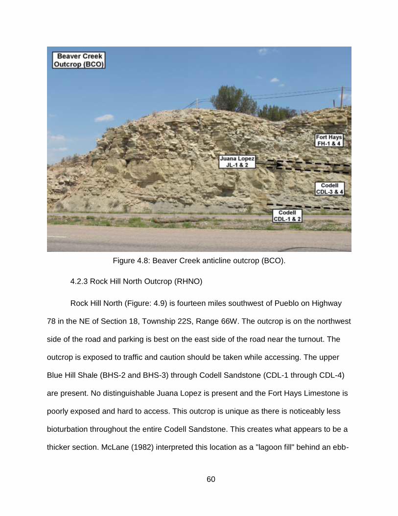
60
Figure 4.8: Beaver Creek anticline outcrop (BCO).
4.2.3 Rock Hill North Outcrop (RHNO)
Rock Hill North (Figure: 4.9) is fourteen miles southwest of Pueblo on Highway
78 in the NE of Section 18, Township 22S, Range 66W. The outcrop is on the northwest
side of the road and parking is best on the east side of the road near the turnout. The
outcrop is exposed to traffic and caution should be taken while accessing. The upper
Blue Hill Shale (BHS-2 and BHS-3) through Codell Sandstone (CDL-1 through CDL-4)
are present. No distinguishable Juana Lopez is present and the Fort Hays Limestone is
poorly exposed and hard to access. This outcrop is unique as there is noticeably less
bioturbation throughout the entire Codell Sandstone. This creates what appears to be a
thicker section. McLane (1982) interpreted this location as a "lagoon fill" behind an ebb-
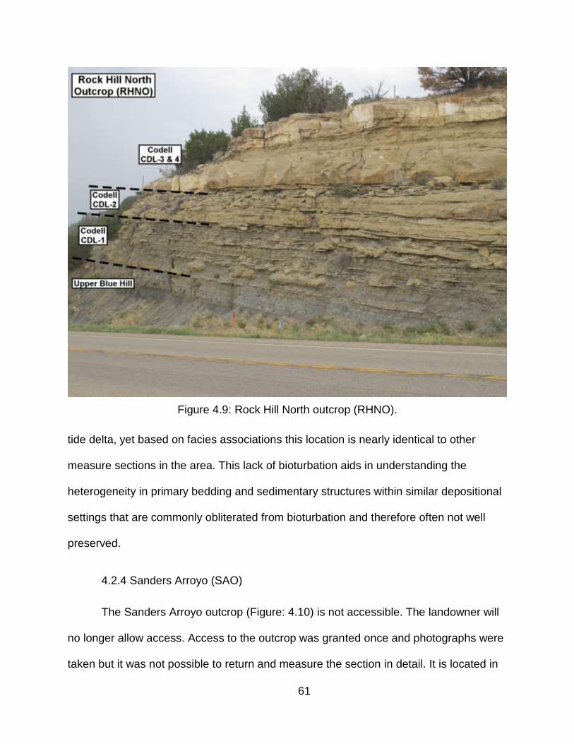
61
Figure 4.9: Rock Hill North outcrop (RHNO).
tide delta, yet based on facies associations this location is nearly identical to other
measure sections in the area. This lack of bioturbation aids in understanding the
heterogeneity in primary bedding and sedimentary structures within similar depositional
settings that are commonly obliterated from bioturbation and therefore often not well
preserved.
4.2.4 Sanders Arroyo (SAO)
The Sanders Arroyo outcrop (Figure: 4.10) is not accessible. The landowner will
no longer allow access. Access to the outcrop was granted once and photographs were
taken but it was not possible to return and measure the section in detail. It is located in
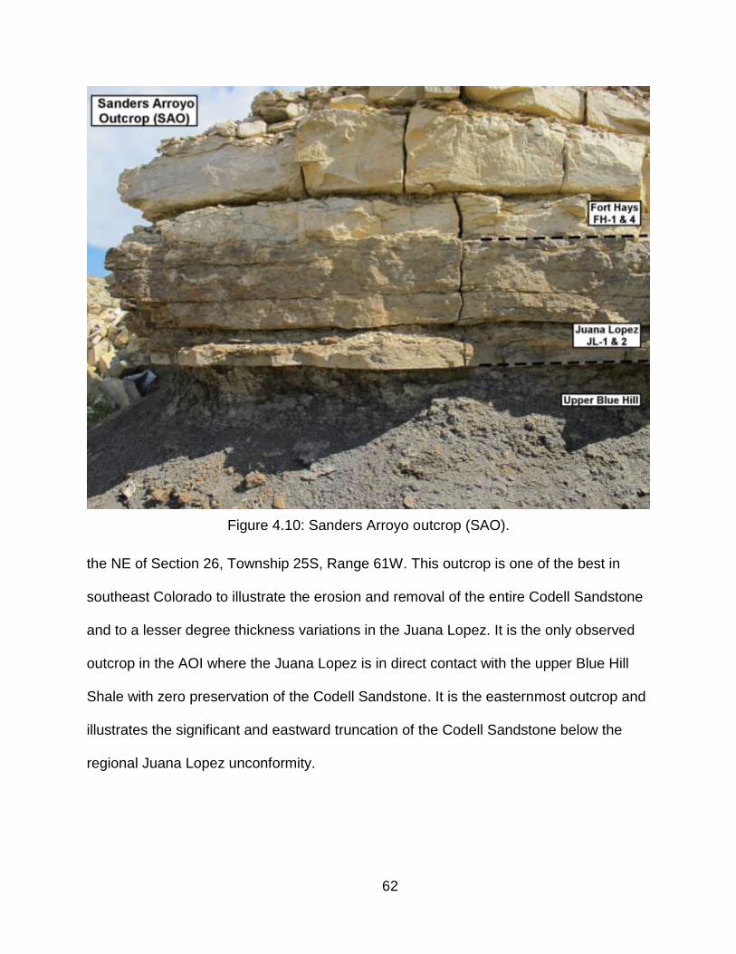
62
Figure 4.10: Sanders Arroyo outcrop (SAO).
the NE of Section 26, Township 25S, Range 61W. This outcrop is one of the best in
southeast Colorado to illustrate the erosion and removal of the entire Codell Sandstone
and to a lesser degree thickness variations in the Juana Lopez. It is the only observed
outcrop in the AOI where the Juana Lopez is in direct contact with the upper Blue Hill
Shale with zero preservation of the Codell Sandstone. It is the easternmost outcrop and
illustrates the significant and eastward truncation of the Codell Sandstone below the
regional Juana Lopez unconformity.
63
CHAPTER 5
SUBSURFACE STRATIGRAPHY
5.1 Overview
Inside the AOI there were 1818 well locations used for various levels of
correlations and isopach mapping. Digital LAS files were available for 141 wells and the
remaining contained raster logs alone or were combined with digital LAS. Some
locations were outside the AOI but were used to aid in stratigraphic mapping and are
included in the Appendixes. Many wells had incomplete coverage and while they were
suitable for picking certain stratigraphic tops, they were not complete enough for all
isopach maps. A complete list of the well locations used and the formation tops can be
found in Appendixes B and C respectively.
Well log resolution does not allow for the same level of detail as outcrop and
core in the subsurface. Correlations were done in detail where possible, but generally
treated as stratigraphic packages, especially the transition from the upper Blue Hill
Shale to lower Codell Sandstone. Throughout southeast Colorado the Codell
Sandstone, what is commonly facies CDL3 and CDL-4 of the upper Codell Sandstone,
is resolvable on log, but division between these two facies is not possible. Figure 5.1 is
a summary of the stratigraphic tops and packages that were used for correlations and
isopach mapping and their typical log responses in southeast Colorado.
5.2 Blue Hill Shale Stratigraphic Distribution
Stratigraphic variations within the Blue Hill Shale are difficult to measure between
outcrop locations as a complete Blue Hill Shale outcrop section was never viewed in its
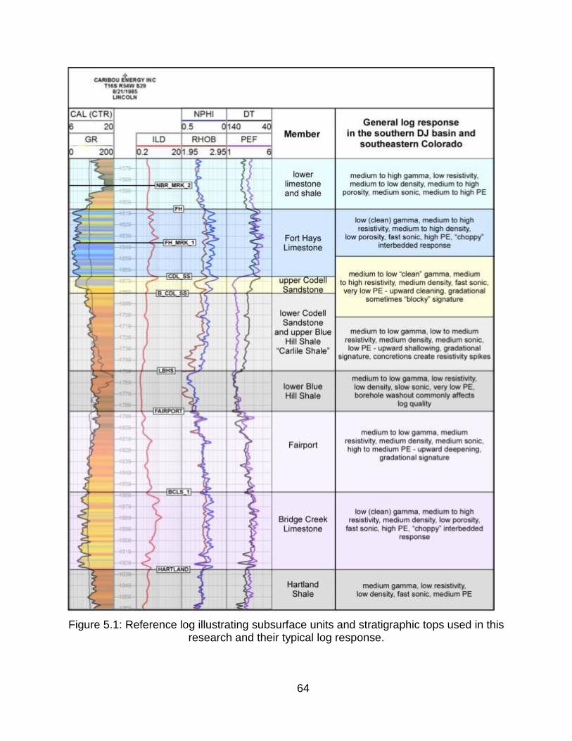
64
Figure 5.1: Reference log illustrating subsurface units and stratigraphic tops used in this research and their typical log response.

65
entirety by observing the contact with the Fairport Chalk. Both the Portland 1 and
Rebecca Bounds 1cores contain the complete section of the Blue Hill Shale and both
portray the typical log response and thickness. Regional stratigraphic analysis of the
Blue Hill Shale can better be accomplished with the use of subsurface data. For the
purpose of this research the mapping interval defined as Blue Hill Shale (Carlile Shale)
is from the top of the Fairport Chalk (top: FAIRPORT) to the base of the upper Codell
Sandstone (top: B_CDL_SS).
Weimer and Sonnenberg (1983) documented that the Blue Hill Shale becomes
progressively truncated to the north from the south and east approaching Wattenberg
field. They proposed that the Transcontinental arch and associated topographic highs
within the northern Denver basin were reactivated prior to the deposition of the Fort
Hays (Figure: 5.2). In and around Wattenberg field the Codell Sandstone is very thin
and rests directly on the Fairport Chalk. This thinning and gradual truncation of the Blue
Hill Shale by the Codell Sandstone is also apparent near the center of the basin from
Colorado Springs south to the Pueblo area (Figure: 5.3). No significant thickness
variation is observed however in the Blue Hill Shale from the Pueblo area east into
Kansas towards the Rebecca Bounds 1 core. Even though the Pueblo area and
immediately east is within the axis of the basin, no apparent thickness variations, or
erosion has affected the deposition or preservation of the Blue Hill Shale (Figure: 5.4).
5.3 Blue Hill Shale Regional Isopachs
Two regional isopach maps of the Blue Hill Shale were created: (1) lower Blue Hill
Shale (tops: FAIRPORT to LBHS) and (2) the entire Carlile interval (minus the Fairport),

66
Figure 5.2: North to southeast resorted stratigraphic section illustrating truncation of the Blue Hill Shale to the north (Weimer and Sonnenberg, 1983).
(tops: FAIRPORT to CDL_SS). The LBHS top, and therefore the lowermost isopach, is
not resolvable throughout the area. The LBJS top is easier to identify in the eastern
portion of the AOI and less resolvable to the west. This probably represents a lateral
facies change from BHS-1 to BHS-2, or lack of deposition of that specific facies. While
data points were sparse for this interval, the isopach does illustrate thinning towards the
northwest, especially in the west of the AOI near the basin axis. The eastern portion
creates an off-trend thick that may represent an isolated low or area of preservation of
facies BHS-1 (Figure: 5.5). A small southwest to northeast thick is also preserved
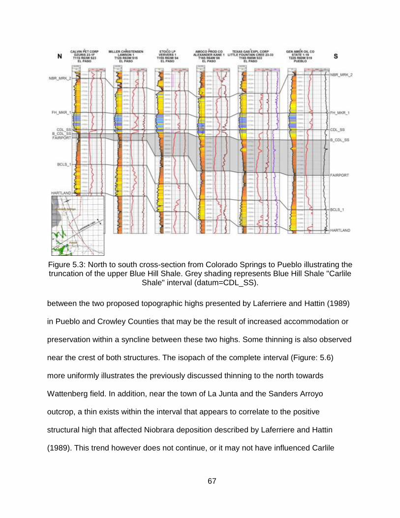
67
Figure 5.3: North to south cross-section from Colorado Springs to Pueblo illustrating the truncation of the upper Blue Hill Shale. Grey shading represents Blue Hill Shale "Carlile
Shale" interval (datum=CDL_SS).
between the two proposed topographic highs presented by Laferriere and Hattin (1989)
in Pueblo and Crowley Counties that may be the result of increased accommodation or
preservation within a syncline between these two highs. Some thinning is also observed
near the crest of both structures. The isopach of the complete interval (Figure: 5.6)
more uniformly illustrates the previously discussed thinning to the north towards
Wattenberg field. In addition, near the town of La Junta and the Sanders Arroyo
outcrop, a thin exists within the interval that appears to correlate to the positive
structural high that affected Niobrara deposition described by Laferriere and Hattin
(1989). This trend however does not continue, or it may not have influenced Carlile

68
Figure 5.4: West to east cross-section from Pueblo to Rebecca Bounds 1 core in Kansas. Grey shading represents Blue Hill Shale "Carlile Shale" interval (datum =
CDL_SS).
Shale deposition the same as the Fort Hays Limestone, as to the east their trend
correlates to a preserved thick. In general, from Pueblo to the Kansas state lines there
is a preserved west to east thick, but due to a lack of data in the south, as you approach
outcrops of both the Greenhorn and Niobrara cycles, it is not possible correlate and
confirm the extents of the trend to the south.
5.4 Codell Sandstone Stratigraphic Distribution
The preserved thickness and facies distributions of the Codell Sandstone may

69
Figure 5.5: Regional isopach of the lower Blue Hill Shale (tops: FAIRPORT to LBHS). Contour interval equals 5 feet.
seem consistent within localized areas but regionally it varies greatly between most
outcrops and in the subsurface. Subsurface correlations can be inaccurate as the
gradational transition between the upper Blue Hill Shale and lower Codell Sandstone
makes defining the base of the upper Codell Sandstone difficult on well logs. Much like
the underlying Blue Hill Shale and lower Codell Sandstone the upper Codell Sandstone
thins to the north from Pueblo to Colorado Springs (Figure: 5.7). The preservation of the
Codell Sandstone to the north truncates the underlying Blue Hill Shale. The underlying
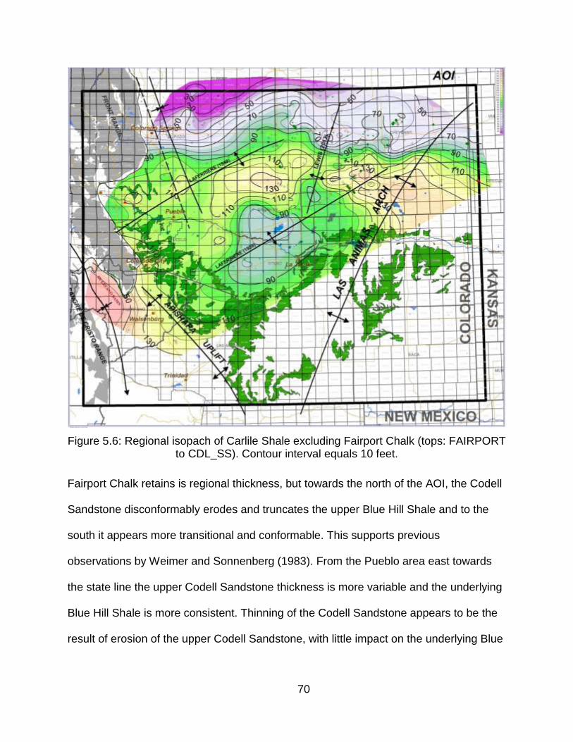
70
Figure 5.6: Regional isopach of Carlile Shale excluding Fairport Chalk (tops: FAIRPORT to CDL_SS). Contour interval equals 10 feet.
Fairport Chalk retains is regional thickness, but towards the north of the AOI, the Codell
Sandstone disconformably erodes and truncates the upper Blue Hill Shale and to the
south it appears more transitional and conformable. This supports previous
observations by Weimer and Sonnenberg (1983). From the Pueblo area east towards
the state line the upper Codell Sandstone thickness is more variable and the underlying
Blue Hill Shale is more consistent. Thinning of the Codell Sandstone appears to be the
result of erosion of the upper Codell Sandstone, with little impact on the underlying Blue
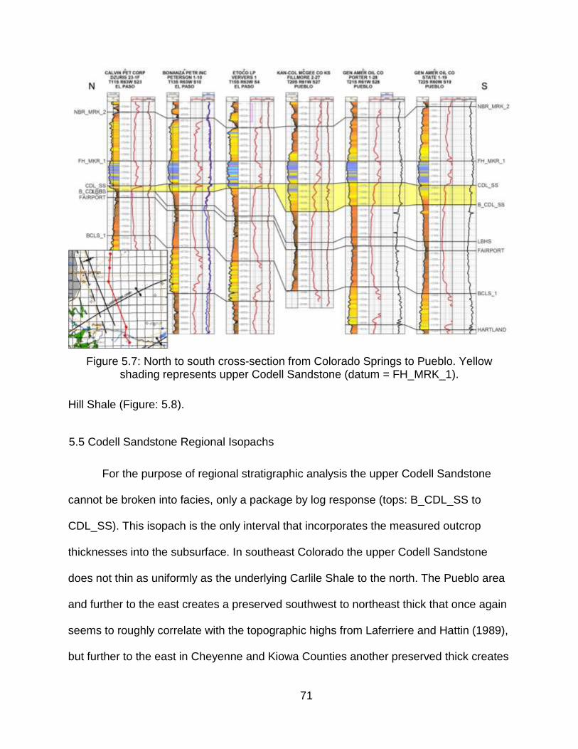
71
Figure 5.7: North to south cross-section from Colorado Springs to Pueblo. Yellow shading represents upper Codell Sandstone (datum = FH_MRK_1).
Hill Shale (Figure: 5.8).
5.5 Codell Sandstone Regional Isopachs
For the purpose of regional stratigraphic analysis the upper Codell Sandstone
cannot be broken into facies, only a package by log response (tops: B_CDL_SS to
CDL_SS). This isopach is the only interval that incorporates the measured outcrop
thicknesses into the subsurface. In southeast Colorado the upper Codell Sandstone
does not thin as uniformly as the underlying Carlile Shale to the north. The Pueblo area
and further to the east creates a preserved southwest to northeast thick that once again
seems to roughly correlate with the topographic highs from Laferriere and Hattin (1989),
but further to the east in Cheyenne and Kiowa Counties another preserved thick creates
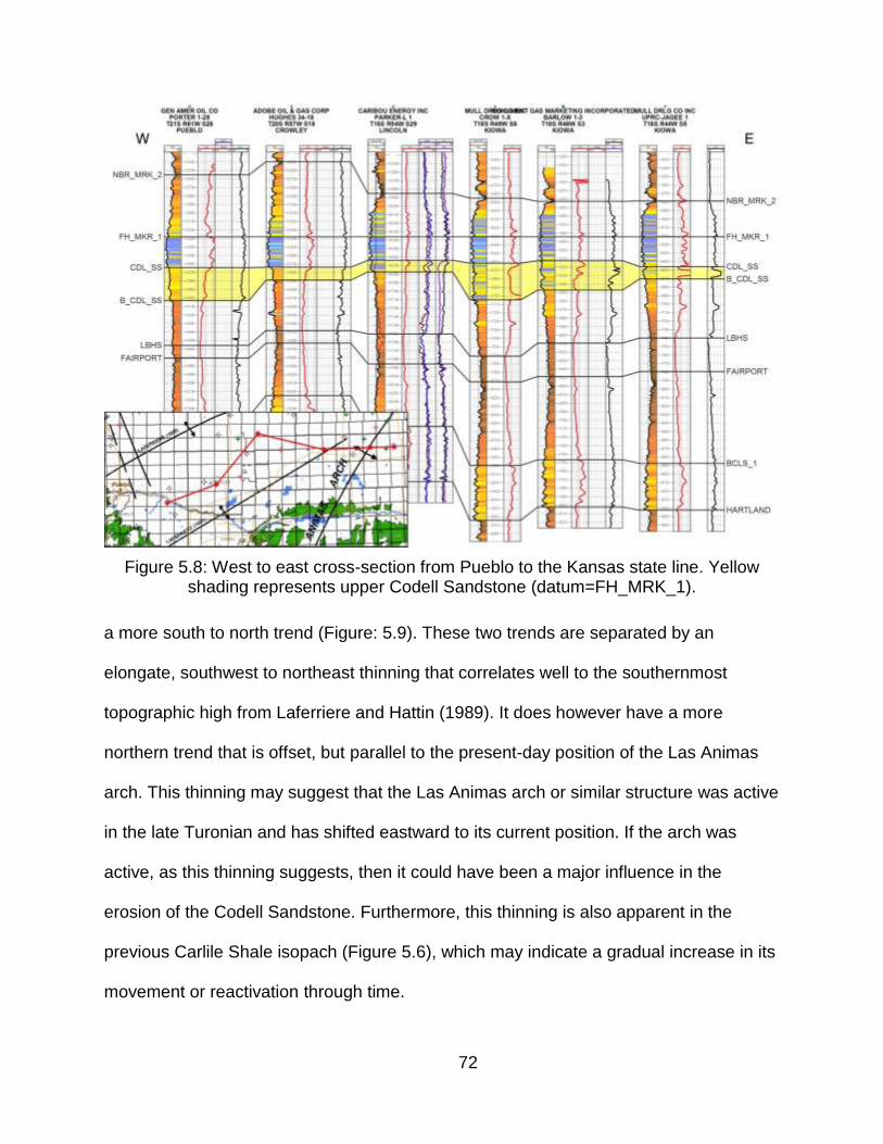
72
Figure 5.8: West to east cross-section from Pueblo to the Kansas state line. Yellow shading represents upper Codell Sandstone (datum=FH_MRK_1).
a more south to north trend (Figure: 5.9). These two trends are separated by an
elongate, southwest to northeast thinning that correlates well to the southernmost
topographic high from Laferriere and Hattin (1989). It does however have a more
northern trend that is offset, but parallel to the present-day position of the Las Animas
arch. This thinning may suggest that the Las Animas arch or similar structure was active
in the late Turonian and has shifted eastward to its current position. If the arch was
active, as this thinning suggests, then it could have been a major influence in the
erosion of the Codell Sandstone. Furthermore, this thinning is also apparent in the
previous Carlile Shale isopach (Figure 5.6), which may indicate a gradual increase in its
movement or reactivation through time.
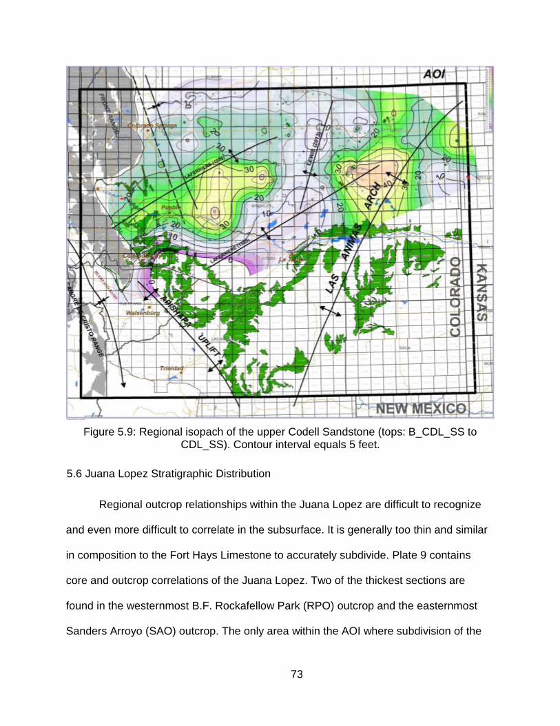
73
Figure 5.9: Regional isopach of the upper Codell Sandstone (tops: B_CDL_SS to CDL_SS). Contour interval equals 5 feet.
5.6 Juana Lopez Stratigraphic Distribution
Regional outcrop relationships within the Juana Lopez are difficult to recognize
and even more difficult to correlate in the subsurface. It is generally too thin and similar
in composition to the Fort Hays Limestone to accurately subdivide. Plate 9 contains
core and outcrop correlations of the Juana Lopez. Two of the thickest sections are
found in the westernmost B.F. Rockafellow Park (RPO) outcrop and the easternmost
Sanders Arroyo (SAO) outcrop. The only area within the AOI where subdivision of the
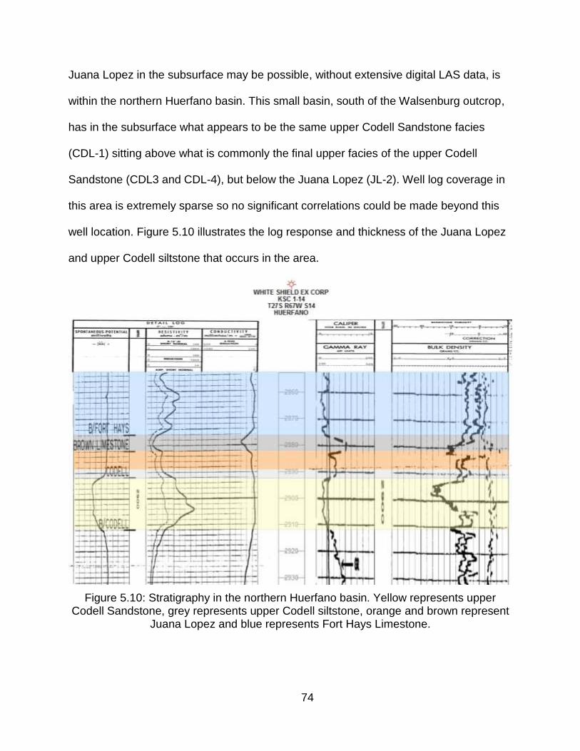
74
Juana Lopez in the subsurface may be possible, without extensive digital LAS data, is
within the northern Huerfano basin. This small basin, south of the Walsenburg outcrop,
has in the subsurface what appears to be the same upper Codell Sandstone facies
(CDL-1) sitting above what is commonly the final upper facies of the upper Codell
Sandstone (CDL3 and CDL-4), but below the Juana Lopez (JL-2). Well log coverage in
this area is extremely sparse so no significant correlations could be made beyond this
well location. Figure 5.10 illustrates the log response and thickness of the Juana Lopez
and upper Codell siltstone that occurs in the area.
Figure 5.10: Stratigraphy in the northern Huerfano basin. Yellow represents upper Codell Sandstone, grey represents upper Codell siltstone, orange and brown represent
Juana Lopez and blue represents Fort Hays Limestone.
75
5.7 Fort Hays Limestone Stratigraphic Distribution
The work done by Laferriere and Hattin (1989) illustrated that the cyclic
depositional patterns in the Fort Hays Limestone are laterally extensive and contain
several distinct correlative limestone beds and interbedded markers. Based on this,
southwest to northeast structural movement created topographic highs that affected the
preservation in the Fort Hays Limestone. Their marker number 6, which they describe
as a significant bentonite bed separating limestone beds of units 6 and 7 is the same as
top FH_MKR_1 used in this research. Laferriere and Hattin (1989) used this marker
number 6 as a regional datum and the top of the main regional lower Fort Hays
Limestone isopach. In southeast Colorado this interval ranges between 30 and 40 feet,
with some anomalous thin areas near Florence field and south near the Walsenburg
outcrop. Localized faulting is the most likely cause of this as regionally this interval in
the Fort Hays maintains a constant thickness. Figure 5.10 is a west to east cross-
section within the southern Denver basin that illustrates the relationship between the
Fort Hays and the variability of the underlying Carlile Shale. Based on the consistent
thickness of the Fort Hays Limestone and the variability within the Carlile Shale, the
same faulting that affected the Codell Sandstone may have influenced the Fort Hays
Limestone, but overall had little impact on thickness variations in the overlying
formations.
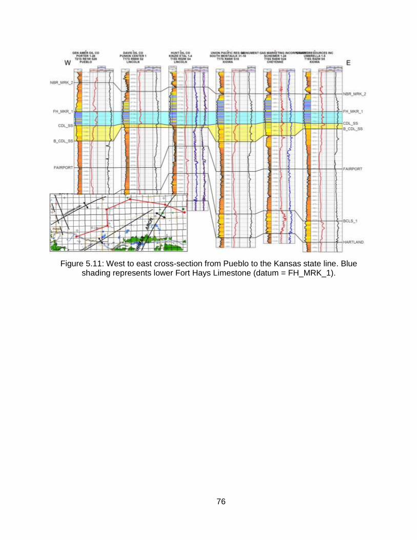
76
Figure 5.11: West to east cross-section from Pueblo to the Kansas state line. Blue shading represents lower Fort Hays Limestone (datum = FH_MRK_1).

77
CHAPTER 6
GEOCHEMISTRY
6.1 X-ray Fluorescence Overview
Energy Dispersive X-ray Fluorescence (XRF) devices have long been used by
the mineral and mining industries for elemental geochemical analysis. The handheld
devices are easy to use, portable and relatively inexpensive given the number of
samples that can be obtained over a short period of time. Compared to traditional X-ray
crystallography and X-ray diffraction (XRD), which require large and expensive
machines in a laboratory setting, XRF is ideal for core and outcrop analysis.
XRF has limitations as the devices (depending on manufacturer and model) are
restricted in their detectable range of elements. The lightest is usually magnesium (Mg,
element 12), the heaviest is uranium (U, element 92), and the sensitivity in the focus
beam of the detector can deliver poor results on uneven surfaces, which creates
variable error ranges dependent on each element. Regardless of these limitations, XRF
is an excellent tool for qualitative elemental analysis. While the potential usages of raw
elemental data are numerous, two main techniques were used for the purposes of this
research: (1) raw plots of elemental data to infer mineralogy, and therefore lithology to
correlation between locations, and (2) elemental ratios of transition metals to analyze
provenance.
Direct assignment or mapping of elementals to a specific chemical compound
can be used to interpret mineralogy and lithology. Example: calcium. While more than
one mineral exists in nature that contains calcium, the most likely in a mature
sedimentary environment is calcium carbonate as a constituent of limestone, dolomite,
78
or as a calcite cement. Again, this approach is qualitative and chances for error in
interpretation are high. Without the confirmation of mineralogy from XRD, and to lesser
accuracy petrographic thin-sections, assumptions of mineralogy and lithology from XRF
data alone could be inaccurate and misinterpreted. Plots of elements that were used to
infer mineralogy and lithology are incorporated within the descriptions for both core and
outcrop descriptions. This data can be found for each location in Plates 1-8.
Certain transition metals can be analyzed to interpret composition of sediment
source, or provenance. Ratios of these elements and cross-plots with other known
mafic and felsic indicators can be used to interpret the composition and sediment
maturity. Nickel, chromium and titanium are transition metals that commonly substitute
for iron and magnesium in mafic igneous rocks and are therefore suitable to represent
"mafic component" elements (Krauskopf, 1979). Although iron and magnesium are
potential choices to represent the "mafic component", magnesium is at the upper
elemental limit of the XRF device and was commonly below detectable amounts, and
when present, the values varied widely. In reducing and anoxic depositional
environments iron will commonly combine with sulfur to create pyrite. Concentrations of
pyrite can be localized in nodules and or diffused and disseminated throughout the
background; both occurrences can lead to variable readings and therefore inaccurate
iron measurements.
6.2 Provenance Analysis
Provenance studies of foreland basins have focused mainly on sandstones
(McBride, 1962; Rowley and Kidd 1981; Mack 1985), and recent work by Schwab
(1986, 1991) suggests that the framework grain composition of sandstones does not
79
constrain tectonic models very accurately. This may be due to diagenetic processes that
remove or alter framework grains (McBride, 1985, Grantham and Velbel, 1988; Miliken
and others, 1989; Johnson and Stallard, 1989, Girty 1991; Ramseyer and others, 1992).
Mudstones and siltstones potentially provide three advantages over sandstones for
provenance studies: (1) mudstones and other very fine- to fine-grained deposits are the
predominant rock type of foreland basin sedimentary sequences, as is the case with the
WIC of North America, and (2) mudstones are less subject to significant changes in bulk
composition during diagenesis (Shaw, 1956), and (3) mudstones better represent the
average composition of regional source areas (Heller and Front, 1988) (Andersen,
1995).
The Late Cretaceous Carlile Shale in southeast Colorado and western Kansas is
dominantly a fine-grained mudstone and siltstone, and is therefore potentially
appropriate for the application of provenance analysis presented by Andersen (1995).
While the lower Blue Hill Shale is truly the only significant fine-grained shale in the AOI,
the transition to the Codell Sandstone contains enough fine-grained mud and silt in its
composition to still be suitable for analysis. Based on the conclusions summarized by
Andersen (1995), elemental analysis in the carbonate-rich Fort Hays Limestone and
Juana Lopez should not be used in provenance analysis as diagenesis could have
altered the framework grain composition. In addition, differences in the depositional
environments and potentially provenance for the Fort Hays and Juana Lopez could
affect the results. XRF data collected from the Fort Hays Limestone Juana Lopez were
excluded completely from the following provenance analysis.
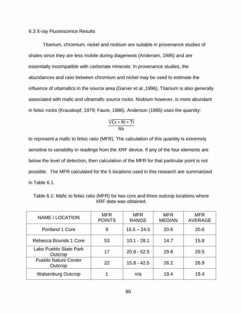
80
6.3 X-ray Fluorescence Results
Titanium, chromium, nickel and niobium are suitable in provenance studies of
shales since they are less mobile during diagenesis (Andersen, 1995) and are
essentially incompatible with carbonate minerals. In provenance studies, the
abundances and ratio between chromium and nickel may be used to estimate the
influence of ultamafics in the source area (Garver et al.,1996). Titanium is also generally
associated with mafic and ultramafic source rocks. Niobium however, is more abundant
in felsic rocks (Krauskopf, 1979; Faure, 1986). Anderson (1995) uses the quantity:
√
to represent a mafic to felsic ratio (MFR). The calculation of this quantity is extremely
sensitive to variability in readings from the XRF device. If any of the four elements are
below the level of detection, then calculation of the MFR for that particular point is not
possible. The MFR calculated for the 5 locations used in this research are summarized
in Table 6.1.
Table 6.1: Mafic to felsic ratio (MFR) for two core and three outcrop locations where XRF data was obtained.
NAME / LOCATION MFR
POINTS MFR
RANGE MFR
MEDIAN MFR
AVERAGE
Portland 1 Core 9 16.5 – 24.5 20.6 20.6
Rebecca Bounds 1 Core 53 10.1 - 28.1 14.7 15.8
Lake Pueblo State Park Outcrop
17 20.8 - 52.5 29.8 29.5
Pueblo Nature Center Outcrop
22 15.8 - 42.5 26.2 26.9
Walsenburg Outcrop 1 n/a 19.4 19.4
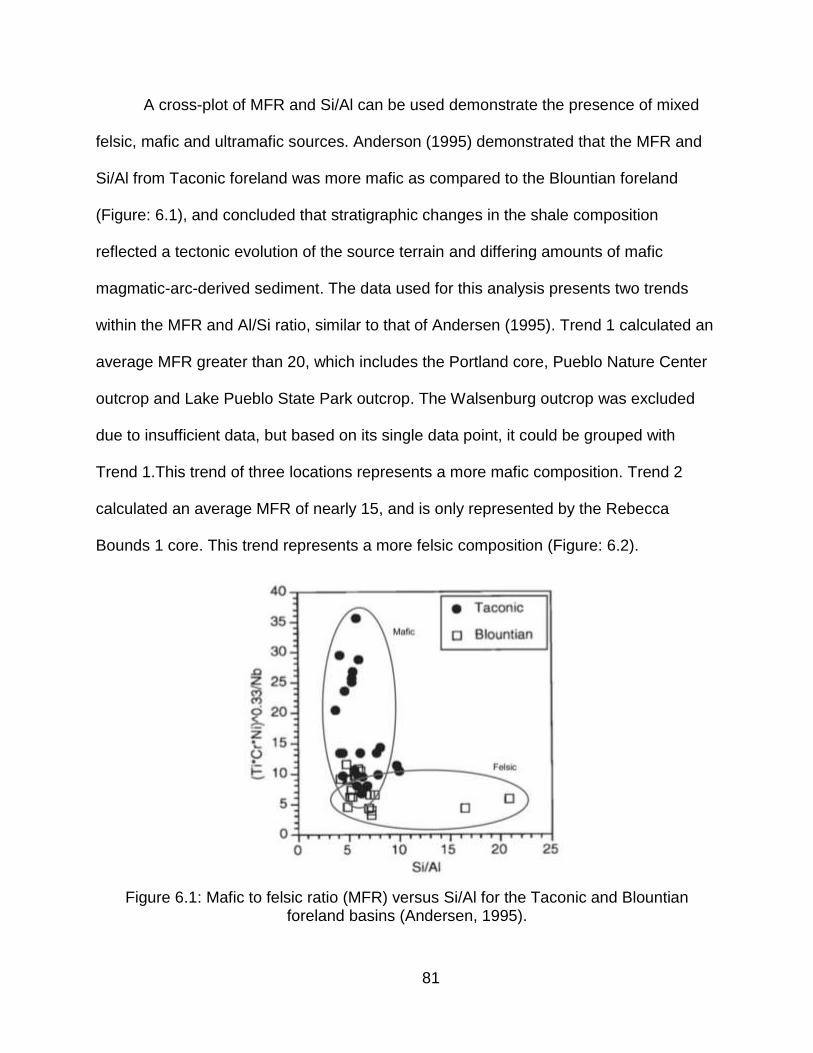
81
A cross-plot of MFR and Si/Al can be used demonstrate the presence of mixed
felsic, mafic and ultramafic sources. Anderson (1995) demonstrated that the MFR and
Si/Al from Taconic foreland was more mafic as compared to the Blountian foreland
(Figure: 6.1), and concluded that stratigraphic changes in the shale composition
reflected a tectonic evolution of the source terrain and differing amounts of mafic
magmatic-arc-derived sediment. The data used for this analysis presents two trends
within the MFR and Al/Si ratio, similar to that of Andersen (1995). Trend 1 calculated an
average MFR greater than 20, which includes the Portland core, Pueblo Nature Center
outcrop and Lake Pueblo State Park outcrop. The Walsenburg outcrop was excluded
due to insufficient data, but based on its single data point, it could be grouped with
Trend 1.This trend of three locations represents a more mafic composition. Trend 2
calculated an average MFR of nearly 15, and is only represented by the Rebecca
Bounds 1 core. This trend represents a more felsic composition (Figure: 6.2).
Figure 6.1: Mafic to felsic ratio (MFR) versus Si/Al for the Taconic and Blountian foreland basins (Andersen, 1995).
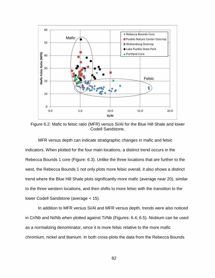
82
Figure 6.2: Mafic to felsic ratio (MFR) versus Si/Al for the Blue Hill Shale and lower Codell Sandstone.
MFR versus depth can indicate stratigraphic changes in mafic and felsic
indicators. When plotted for the four main locations, a distinct trend occurs in the
Rebecca Bounds 1 core (Figure: 6.3). Unlike the three locations that are further to the
west, the Rebecca Bounds 1 not only plots more felsic overall, it also shows a distinct
trend where the Blue Hill Shale plots significantly more mafic (average near 20), similar
to the three western locations, and then shifts to more felsic with the transition to the
lower Codell Sandstone (average < 15).
In addition to MFR versus Si/Al and MFR versus depth, trends were also noticed
in Cr/Nb and Ni/Nb when plotted against Ti/Nb (Figures: 6.4; 6.5). Niobium can be used
as a normalizing denominator, since it is more felsic relative to the more mafic
chromium, nickel and titanium. In both cross-plots the data from the Rebecca Bounds
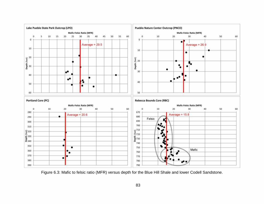
83
Figure 6.3: Mafic to felsic ratio (MFR) versus depth for the Blue Hill Shale and lower Codell Sandstone.
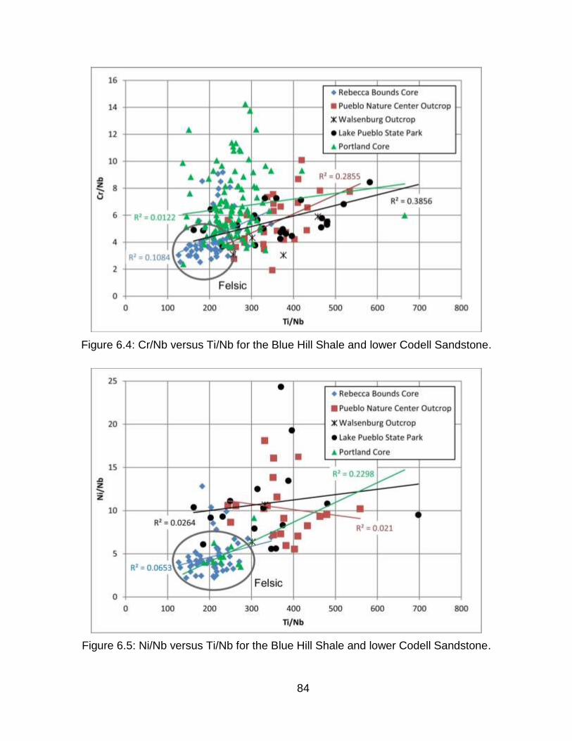
84
Figure 6.4: Cr/Nb versus Ti/Nb for the Blue Hill Shale and lower Codell Sandstone.
Figure 6.5: Ni/Nb versus Ti/Nb for the Blue Hill Shale and lower Codell Sandstone.
85
core plotted lower in the more mafic components and higher in the more felsic than the
other three western locations. While the highest correlation coefficient (R2) for all of
these trends was low, less than 0.38 for Cr/Nb versus Ti/Nb, and less than 0.22 for
Ni/Nb versus Ti/Nb, the data for each location did plot in suitable clusters, given the
variability of the XRF data. General trends indicate that the Rebecca Bounds 1 is more
felsic in overall composition.
6.4 Provenance Summary
The analysis performed by Andresen (1995) showed that within the Appalachian
Blountian and Taconic foreland basins changes occurred in the composition and
mixture of sediments being eroded from the outer-arc and magmatic-arc terrains of the
colliding arc system. Changes in composition do not always reflect changes over time
within the same sediment provenance from the same region or geologic terrain.
Changes can also be inferred to represent changes in sediment contribution from
different terrains. It is this concept that may support the application of this analysis to
the WIC seaway, even though the geologic ages and formation of the foreland basins
may not be analogous. Regardless of the geologic differences, the behavior of the
elements chromium, nickel and titanium can still be used to represent a more mafic
proxy, and are inferred to be a different, potentially more western sediment source.
Niobium can therefore be used as a proxy for a potentially more felsic source of eroded
Paleozoic sediments from the stable eastern craton. Kauffman (1977) and Kauffman
and Caldwell (1993) documented that the Cretaceous was a period of extensive
volcanism with intrusions and uplifts from the western Sevier Orogeny within the
Eastern Great basin. Ash beds are commonly preserved in marine facies and while their
86
use as chronostratigraphic markers is important, their existence and abundance,
particularly in the middle Albian through the Turonian are an indication that any western
derived sediment would comparatively be more mafic than any eastern sediment
derived from the Paleozoic craton.
Wallace (1975) completed an outcrop-based petrographic and depositional
environment analysis of the Codell Sandstone in central and western Kansas. Based on
the presence of angular quartz grains, chert grains and angular lithic clasts of limestone,
siltstone and shale, he concluded the Codell Sandstone in Kansas was deposited in a
near-shore marine environment that was sourced from the eastern eroded Paleozoic
craton of the central United States.
The Rebecca Bounds 1 core is the furthest east within the AOI and west of the
research conducted by Wallace (1975). Based on the felsic composition of the data, the
stable eastern craton on the eastern edge of the seaway may have supplied more
sediment to this location as compared to the three locations further to the west near
Pueblo. While one data point is rarely sufficient enough to represent a trend, it may
provide enough evidence to suggest that during the final stages of the late Turonian
regression (R6) (Kauffman 1977a) an eastern shoreline was proximal enough to the
Rebecca Bounds 1 core location to supply enough felsic sediment to affect the bulk
composition of the upper Blue Hill Shale and Codell Sandstone. The implications of this
data on the Late Turonian paleogeography will be discussed further in Chapter 7.
87
CHAPTER 7
DEPOSTIONAL ENVIRONMENTS AND PALEOGEOGRAPHY
7.1 Cretaceous Interior Seaway
The upper Cretaceous strata of the WIC have been recognized as a cyclic
sequence of intertonguing marine and non-marine facies, deposited in and marginal to a
Cretaceous seaway. According to Kauffman (1969), the Greenhorn Cycle initiated with
the transgressive deposits of the Dakota Group. Transgression continued and reached
its maximum extent during the Greenhorn Formation with the deposition of the Bridge
Creek Limestone. The final regression (R6) (Kauffman, 1977a) concluded with the
deposition of the Codell Sandstone.
7.2 Blue Hill Shale
The lower Blue Hill Shale (Facies BHS-1) consists of black to dark-grey, very fine
grained, well-laminated mudstone and shale with pyrite and an overall lack of
bioturbation. Combine this with no preserved sedimentary structures and deposition
was mostly likely within a reducing and restricted, offshore to outer shelf, marine
environment, well below both storm- and fair-weather wave base.
The upper Blue Hill Shale (Facies BHS-2 and BHS-3) is coarser with a larger
grain size and an increase in silt, with recognizable and vertically increasing
bioturbation. There are few preserved sedimentary structures, and no significant
evidence of periodic storm influence, which places these facies, and the Blue Hill Shale
in general, below storm- and fair-weather wave base. The upper Blue Hill, displays
shallowing upward cycles of facies BHS-2 to BHS-3 which are difficult to recognize, but
may correlate updip to a prograding Codell Sandstone shoreline. This is not conclusive

88
however as mapping of these smaller intervals was not done extensively and there was
not enough resolvable well data to correlate and support lateral continuity.
7.3 Codell Sandstone
In many ways the data compiled in this study is consistent with the previous work
of Weimer (1960), Kauffman (1969), Krutak (1970), Reisser (1976), Pinel (1977) Aulia
(1982), McLane (1983), and many others for the Codell Sandstone. The described
"sheet-like" distribution of the Codell Sandstone has been interpreted by many to
support a marine-shelf, or bar-shelf sand deposition set forth by Potter (1967). These
characteristics also include mineralogic maturity, good sorting and roundness, abundant
crossbedding, bioturbation and the presence of detrital carbonate skeletal debris and
Collophane (Reisser, 1976). McLane (1983) supported shallow, low-energy microtidal,
coastal marine environments with northeast-trending sand bodies and shorelines.
The characteristics of the Codell Sandstone may share similarities to Potter's
model and interpretation for the Campanian sandstones of the Pierre Shale, but this
does not mean that the presence of these characteristics is diagnostic to that
interpretation alone. Several depositional environments can contain many of the
characteristics described in the Codell Sandstone. This author questions the interpreted
“sheet-like” and “linear bar” form distribution of the Codell Sandstone in northeast-
trending shoreline sand bodies. Based on outcrop, core and especially subsurface
correlations presented in Chapter 5, the Codell Sandstone does not exhibit these trends
in distribution, or rather preservation, throughout southeast Colorado. The region does
contain areas of localized, somewhat equal thicknesses, but removal of the Codell
Sandstone has created a depositional remnant that is not linear or predictable in
89
preservation. In general the erosion and removal of the Codell Sandstone and down into
the Carlile Shale does increase to the east as presented by Laferriere and Hattin
(1989), but it is not regionally uniform. The oversight in recognition of the significant
erosion and removal of the Codell Sandstone, and therefore interpretations based on
present-day preserved sand-body thicknesses, may have led previous authors to
depositional interpretations that were not accurate for the Codell Sandstone. The
discontinuous nature of the remaining sand-bodies should not be interpreted as primary
trends representative of the environment at the time of deposition; rather as depositional
remnants.
The Lower Codell Sandstone (facies CDL-1 and CDL-2) consists of fine-grained,
heavily bioturbated to laminated siltstone and sandstone and interbedded mudstone,
with open marine ichnofacies, deposited at or below fair-weather wave base, yet still
shallow enough to be periodically exposed to and reworked by storm deposits and
storm-weather wave base. Most of the preserved sedimentary structures are HCS and
symmetrical ripples from oscillatory wave energy with little outcrop evidence of current
derived transport and deposition. Erosion and truncation of the lenticular beds is
common, and the laminated to often tabular and massive siltstone and sandstone was
deposited rapidly, as evident from the cycles of massive to planar bedded and
dominantly horizontal burrows that occur in the mudstone and siltstone, but not in the
more tabular sandstone. The upper Codell Sandstone (facies CDL-2 and CDL-3)
consists of fine- to medium-grained bioturbated massive and planar to low-angle
siltstone and sandstone, with open marine ichnofacies, that was deposited in cycles of
gradual to rapid deposition as evident from escape structures, planar to low angle

90
sedimentary structures and repeating truncated sequences of upward increasing
bioturbation. The only preserved paleocurrent data indicates a southern flow at the time
of preservation and these observations are supported by the previous data supplied by
Aulia (1984) and Pinel (1977). The upper Codell Sandstone was deposited in a lower
shoreface to possibly lowermost upper shoreface setting, low to mid-shelf, proximal to
storm deposits and was periodically affected by shelf or geostrophic currents from the
north.
There is no remaining evidence within the preserved Codell Sandstone in
southeast Colorado to support deposition in a "classic" prograding upper shoreface or
foreshore setting. Trough cross-bedding is absent to rare and when present it is very
thin. There is no evidence of seaward-inclined laminae, no associated fluvial, floodplain
or lagoonal facies and no foreshore or littoral environment as interpreted by Pinel (1977)
or McLane (1982). The lack of evidence for these environments does not however
conclusively support that they were not originally deposited as part of the original facies
succession within the upper Codell Sandstone. Erosion of the upper Codell Sandstone,
prior to and during deposition of the Juana Lopez and Fort Hays Limestone could have
removed these facies and all evidence of their depositional environments and shelf to
shoreline sequence. Furthermore, the base of the Codell Sandstone is sometimes a
sharp, or scoured surface with the underlying upper Blue Hill Shale, yet in some areas it
is gradational. In a low gradient shelf or ramp setting, lowstand shorelines will undergo
major seaward translation as a consequence of a drop in relative sea level. With an
ensuing transgression, these sharp-based shorelines would become encased in muds
deposited in a shelf or offshore environment, potentially several miles removed, and
91
isolated from preserved shorelines (Plint, 1988). If the coeval upper shoreface,
foreshore and associated alluvial plain deposits were thin as a consequence of
sediment bypass, low accommodation or ravinement then the subsequent transgression
could erode and remove any evidence of these shorelines and alluvial plain deposits.
7.4 Juana Lopez
The variable lithology, extensive bioturbation and sporadic preservation of the
Juana Lopez make depositional interpretations difficult. Krutak (1970), Pinel (1977) and
(Aulia 1982) and Reisser (1976) all support a high-energy, current swept shallow marine
to inter-tidal environments, similar to winnowed shelf carbonates and sand
environments present today. Most recognized the basal erosional surface and thin
natured limestones with abundant shell material and suggested that it be regarded as a
shallow marine palimpsest deposit. The lower calcareous conglomerate to sandstone
(JL-1) represents the basal transgressive lag of the Niobrara cycle and the upper
inoceramid grainstone (JL-2) a winnowed shallow marine setting with low-sedimentation
rates as an "omission surface".
The Juana Lopez contains little to no mud and a significant amount of coarse,
angular and disseminated shell fragments with lithic and monomineralic fragments from
the underlying Codell Sandstone. While this supports a shallow, high energy current
swept environment, it also supports a sediment starved system. The grainstones within
the Juana Lopez may reflect periods of significant shallow marine sediment winnowing
and washing in what would ultimately be deposited as a condensed section of nothing
more than broken inoceramids and other localized fragments - the only "sediment"
available at the time. To further complicate the issue, the Juana Lopez is unconformably
92
overlain by the Fort Hays Limestone, which many consider to be a deep water
limestone deposited in the transgressive to highstand systems tracts during the
seaward invasion of the Niobrara cyclothem, yet the only preserved evidence from the
initial transgression of the Niobrara sequence is within the Juana Lopez itself. In some
instances (locations: PCO and VRO) large clasts of the Juana Lopez appear to be
“floating” in a matrix of pervasively bioturbated Fort Hays Limestone mud. The casts all
appear to be in-situ as there is no evidence of any transport. The large, angular clasts
are broken in such a pattern to suggest desiccation from subaerial exposure, but there
is no conclusive evidence to support such exposure. For these clasts to form and retain
their angularity and present-day orientation, the Juana Lopez must have been partially
lithified prior to the deposition of the Fort Hays. This surface and the mélange of
lithologies as a Glossifungites assemblage suggest long periods of time with little to no
sedimentation.
7.5 Late Turonian Paleogeography
Existing work on the paleogeography and distribution of facies and depositional
settings within the WIC is plentiful, especially the middle to late Turonian: (Lowman,
1977; Cobban and Hook, 1979, Aulia, 1982; Merewether and Cobban, 1986; and
Laferriere and Hattin, 1989). Paleogeographic reconstructions of facies within the upper
Blue Hill Shale and Codell Sandstone based on Collignoniceras woolgari and
Prionocyclus hyatti from (Lowman 1977, Aulia, 1982 and Merewether and Cobban
1986) and data presented here can be found in Figure 7.2. This diagram illustrates the
remoteness of the shoreline in western Utah. The equivalent Ferron Formation is about
350 miles to the west and inferred to be surrounded by marine shale to the east.

93
However a lack of correlative units in central and western Colorado makes analysis
difficult. Equivalent units of the Frontier Formation in southwestern Wyoming share a
similar remoteness and lack of correlative units in northern and north-central Colorado.
While some of the previous work on the Codell Sandstones infers a direct western
source in southeast Colorado (Reisser, 1976, Pinel 1977, Aulia 1982, and Laferriere
and Hattin 1989), there is little evidence to support this connection and considering the
significant distance of correlative shorelines in Utah and the western position of the
basin foredeep, sediment transport from the west seems unlikely. In addition, there are
time equivalent offshore mudstones for 100-200 miles west of the AOI towards northern
New Mexico and eastern Utah.
A northern source from western and south-central Wyoming in the equivalent
Emigrant Gap Member of the Frontier formation delta system has potential merit given
the sparse, north to south, paleocurrent data and slightly closer proximity to southeast
Colorado. However, the position of the transcontinental arch and other northeast
trending topographic highs, in central and north-central Colorado may have obstructed
significant north to south distal delta sediment transport. Furthermore, the Codell
Sandstone is not an isolated current-derived shelf sand, it is a depositional remnant of a
shoreface deposit with no remaining shoreline connection that was only reworked by
and subjected to event deposition by geostrophic currents.
Evidence for a dominant sediment transport direction within the upper Codell
Sandstone is a mixture of cross-bedding and symmetrical and asymmetrical wave
ripples, during the final stages, approaching maximum regression and probably the
most shallow water depths (Pinel, 1977 and Aulia, 1982). All existing cross-bedded
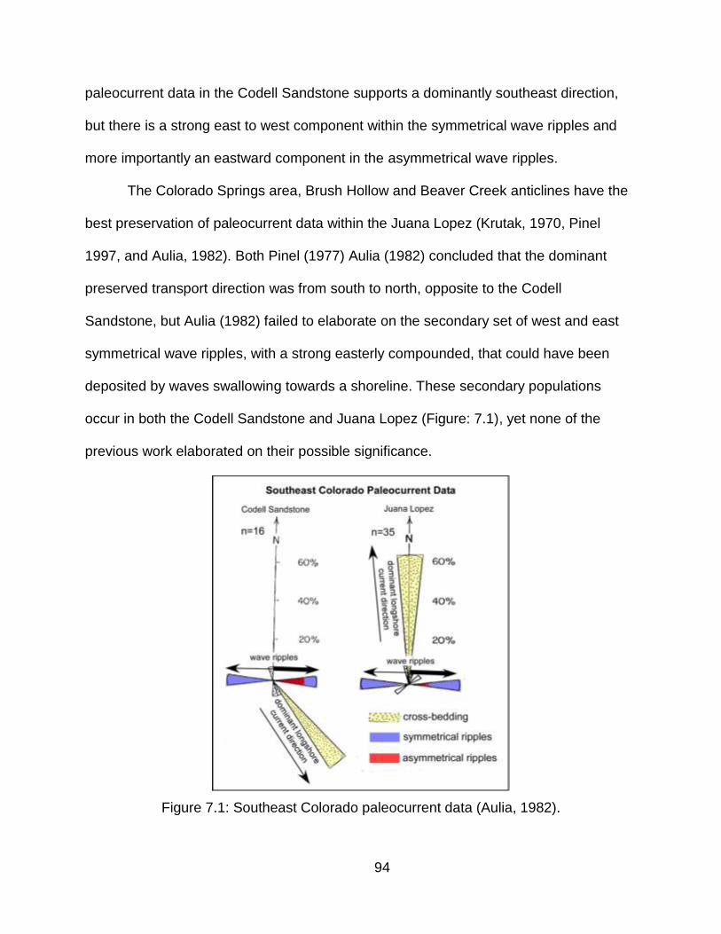
94
paleocurrent data in the Codell Sandstone supports a dominantly southeast direction,
but there is a strong east to west component within the symmetrical wave ripples and
more importantly an eastward component in the asymmetrical wave ripples.
The Colorado Springs area, Brush Hollow and Beaver Creek anticlines have the
best preservation of paleocurrent data within the Juana Lopez (Krutak, 1970, Pinel
1997, and Aulia, 1982). Both Pinel (1977) Aulia (1982) concluded that the dominant
preserved transport direction was from south to north, opposite to the Codell
Sandstone, but Aulia (1982) failed to elaborate on the secondary set of west and east
symmetrical wave ripples, with a strong easterly compounded, that could have been
deposited by waves swallowing towards a shoreline. These secondary populations
occur in both the Codell Sandstone and Juana Lopez (Figure: 7.1), yet none of the
previous work elaborated on their possible significance.
Figure 7.1: Southeast Colorado paleocurrent data (Aulia, 1982).

95
Another possible interpretation for a potential shoreline connection and additional
sediment source for the Codell Sandstone in southeast Colorado may exist in central
Kansas. Wallace (1975) depicted a vertical coarsening sequence of barrier-beach and
barrier-bar environments with the presence of tidal channels in central Kansas sourced
from the stable eastern craton that prograded to the west. He concluded from
petrographic samples that detrital chert and other lithic fragments all increased from the
southwest to the northeast towards their provenance.
The eastern platform of the WIC seaway has long been thought to be a broad
low angle, relatively stable and flat platform that supplied little sediment to the seaway
(Kauffman, 1969; Pollastro 1992). Given this low angle configuration, the eastern
platform would have had very low accommodation with relatively no space for significant
vertical sediment accumulation. Relatively minor decreases in sea level would have
created significant lateral westward migration and progradation of a very thin shoreline.
This configuration could also explain why there is no preserved upper shoreface,
foreshore and contributing alluvial sequence in southeast Colorado. Erosion and
removal of the evidence would have occurred in three stages. The first stage initiated
with the conclusion of the Codell Sandstone which resulted in a pause in sedimentation
and significant biological reworking and subaqueous removal along topographic
features. The second stage initiated with the high-energy Juana Lopez transgression
that further eroded and re-deposited sediment from the underlying Codell Sandstone.
As this shallow winnowing continued, all fine-grained sediment was eventually removed
from the system, and deposition of the grainstones commenced. The third and final
stage was the eventual deepening and deposition of the Fort Hays Limestone, which
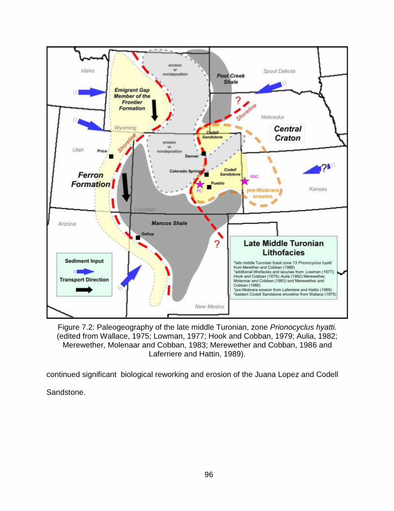
96
Figure 7.2: Paleogeography of the late middle Turonian, zone Prionocyclus hyatti. (edited from Wallace, 1975; Lowman, 1977; Hook and Cobban, 1979; Aulia, 1982;
Merewether, Molenaar and Cobban, 1983; Merewether and Cobban, 1986 and Laferriere and Hattin, 1989).
continued significant biological reworking and erosion of the Juana Lopez and Codell
Sandstone.
97
CHAPTER 8
CONCLUSIONS
1) The Codell Sandstone Member of the Carlile Shale is a fine- to medium-
grained, mineralogically mature, bioturbated to planar and cross-bedded siltstone and
sandstone that was deposited in a shoreface environment, under normal marine
conditions, during the final stages of the Greenhorn regression.
2) Evidence presented here supports a lowstand prograding shoreline sequence
with present-day preservation of the shelf to lower shoreface transition. Upper
shoreface, foreshore and alluvial deposits were eroded or top-truncated before and
during the Juana Lopez transgression.
3) Significant erosion and removal of the upper Codell Sandstone in the form of
several subaqueous unconformities created a depositional remnant with present-day
preservation that does not reflect primary distribution at the time of deposition. No
evidence exists, or remains, to support subaerial exposure.
4) Isopach mapping illustrates that Laramide and pre-Laramide structures and
topographic features were active and influential during and after deposition of the Codell
Sandstone and were one controlling factor in the erosion and removal of the upper
Codell Sandstone.
5) The Juana Lopez Member of the Carlile Shale in southeast Colorado is a
coarse-grained detrital and fossil fragment calcareous sandstone and inoceramid
grainstone that was deposited in a sediment-starved, high-energy, current swept,
winnowed, shallow marine environment that reflects the basal transgressive sequence
of the Niobrara cyclothem.
98
6) Transgression and the initiation of the Niobrara cyclothem and the deposition
of the basal Juana Lopez member created a transgressive surface of erosion that aided
in erosion and removal of the upper Codell Sandstone.
7) Outcrop and core analysis indicates a significant break in sedimentation in the
form of a Glossifungites assemblage at the conclusion of the Codell Sandstone and the
contact with the Juana Lopez that reflects a regional unconformity. A similar
assemblage and unconformity exists between the Juana Lopez and overlying Fort Hays
Limestone Member of the Niobrara formation.
8) Elemental geochemistry data and the use of mafic to felsic ratios (MRF)
suggests that the eastern portion of the AOI has a greater felsic composition and is
interpreted to reflect an eastern shoreline and provenance for Codell Sandstone
sediment, probably from eroded Paleozoic sediments of the central craton.
9) Paleogeographic reconstructions, combined with basin geometries,
interpretations of depositional settings and conclusions from elemental geochemistry
and the use of new and existing paleocurrent data suggest that that during the
deposition of the Codell Sandstone, significant longshore or geostrophic currents
carried sediment from the north to the south, parallel to an eastern shoreline in Kansas.
During deposition of the Juana Lopez member, transgression occurred from south to
north creating a south to north current transport that may have paralleled the pre-
existing eastern Codell Sandstone shoreline.
99
FUTURE WORK
1) Incorporate more outcrops within the AOI and the greater Rocky Mountain
region. While all of the outcrops that were originally analyzed by Krutak (1970), McLane
(1982), Reisser (1976), Pinel (1977), Aulia (1982), and others are no longer accessible.
Additional outcrops that are still accessible should be re-measured and re-correlated.
This does not only apply to southeast Colorado. Outcrops on the eastern flank of the
Raton basin in northern New Mexico, far eastern Colorado and western Kansas, and
outcrops further west in the South Park and North Park basins and north in southern
Wyoming should be incorporated. More outcrop-based evidence for a potential eastern
influence for the Codell Sandstone may exist in Kansas.
2) Detail well log and subsurface facies analysis. With proper funding and
support, mainly in the form of digital data, it may be possible to divide and regionally
correlate the Juana Lopez in the subsurface from southeast Colorado to the west.
Furthermore, greater subdivision within the lower and upper Codell Sandstone is
possible, but this can only be done with enough digital LAS data.
3) Additional XRF geochemistry data from more outcrop locations and especially
cores throughout the basin. The conclusions presented in this work on the potential
eastern shoreline and contribution from an eastern sediment source, based in part on
mafic to felsic ratios, needs support from other locations within the Denver basin.
Additional data may help in determining if the analysis itself, originally presented by
Anderson (1995), is truly applicable to the Cretaceous Interior Seaway.
4) Detailed regional petrographic and diagenesis analysis of the upper Codell
Sandstone and Juana Lopez member of the Carlile Shale. There are zones within the
100
upper Codell Sandstone where calcite cement varies greatly from absent to pervasive,
yet no trends seem apparent in vertical and lateral distribution. A better understanding
of the cause, timing and types of these cements is not only important for this region, but
other basins within the Rocky Mountains containing similar stratigraphic intervals,
especially for future oil and gas exploration. The work done by Reisser (1976) focused
on southeast Colorado and while the conclusions presented were in alignment with this
research, more analysis is needed to incorporate regional distribution.
5) Integration of seismic. In gathering information for this research, one seismic
line was discovered. The line is a concatenated of several smaller lines that begins
south of Canon City and runs east well into the Denver basin. A paper copy of the data
was observed and the data quality is excellent. It was previously analyzed by Brown
(1978) and while the emphasis was on pre-Pennsylvanian influences on the stratigraphy
of the Fountain Formation, the data does include and clearly resolves shallower
Cretaceous intervals, and should be studied in detail for timing and distribution of
regional faulting.
6) XRF data in the Fort Hays Limestone could be a very useful tool for detailed
chemostratigraphic analysis. While not conducted in this research, it may be possible to
analyze and therefore "type" based on XRF response, major fine-grained mudstone,
siltstone and bentonite beds within the Fort Hays and create regional correlations
between locations. Given the responses in data seen here, it may be possible to isolate
particular bentonite beds geochemically and distinguish them stratigraphically.
101
REFERENCES CITED
Aulia, K.R., 1982, Stratigraphy of the Codell sandstone and Juana Lopez members of
the Carlile Formation (Upper Cretaceous), El Paso and Fremont Counties,
Colorado: Unpublished M.Sc. Thesis, T-2589, Colorado School of Mines,
Golden, Colorado, 146 p.
Andersen, C.B., 1995, Provenance of mudstones from two Ordovician foreland basins
in the Appalachians: Provenance Studies in Foreland Basin, Part 2, SEPM -
Special Publication, p. 54-63.
Barlow, L.K., and Kauffman, E.G., 1985, Depositional cycles in the Niobrara Formation,
Colorado Front Range, in Pratt, L.M., et al., eds., Fine-Grained Deposits and
Biofacies of the Cretaceous Western Interior Seaway: Evidence of Cyclic
Sedimentary Processes, SEPM - Field Trip Guidebook No. 4, 1985 Midyear
Meeting, Golden, Colorado, p. 199-208.
Bass, N.W., 1926, Geologic investigations in western Kansas: Kansas Geological
Survey, Bulletin 11, p. 1-96.
Brown, D.W., 1978, A Reflection seismic study of the Cañon City-Pueblo area, Fremont
and Pueblo counties, Colorado, Unpublished M.Sc. Thesis, T-2109, Colorado
School of Mines, Golden, Colorado.
Cobban, W.A., and Hook, S.C., 1979, Collignoniceras woollgari woollgari (Mantell)
Ammonite Fauna from Upper Cretaceous of Western Interior, United States: New
Mexico Bureau of Mines and Mineral Resuources, Memoir 37, 51 p.
Cobban, W.A., and Reeside, J.B., 1952, Correlation of the Cretaceous formations of the
Western Interior of the United States: GSA Bulletin., v. 63, no. 10, p. 1011-1043.
102
Colorado Oil and Gas Conservation Commission (COGCC), <http://cogcc.state.co.us/>
Cragin, F.W., 1896, On the stratigraphy of the Platte series or Upper Cretaceous of the
Plains: Colorado Collection Studies, v. 6, p. 49-52.
Dane, C.H., Cobban, W.A., and Kauffman, E.G., 1966, Stratigraphy and regional
relationships of the reference section for the Juana Lopez Member, Mancos
Shale, in the San Juan basin, New Mexico, U.S. Geological Survey, Bulletin
1224-H.
Dean, W.E., and Arthur, M.A., 1998, Geochemical expression of cyclicity in Cretaceous
pelagic limestone sequences: Niobrara Formation, Western Interior Seaway in
Dean, W.E., and Arthur, M.A., eds., Stratigraphy and Paleoenvironments of the
Cretaceous Western Interior seaway, U.S.A.: SEPM - Concepts in
Sedimentology and Paleontology No. 6, p. 277-255.
Dickenson, W.R., 1976, Sedimentary basin developed during evolution of Mesozoic-
Cenozoic arc-trench systems in western North America: Canadian Journal of
Earth Sciences, v.13, p. 1268-1287.
Ekren, E.B., and Houser, F.N., 1965, Geology and petrology of the Ute Mountains area,
Colorado: U.S. Geological Survey, Professional Paper 481, 74 p.
Eicher, D.L., 1969, Paleobathymetry of Cretaceous Greenhorn sea in eastern Colorado:
AAPG Bulletin, v. 53, no. 5, p. 1075-1090.
Faure, G., 1986, Principle of Isotope Geology (2nd eds): New York, John Wiley and
Sons, 608 p.
Fisher et al., 1985, The Niobrara transgressive hemicyclothem in central and eastern
103
Colorado: The Anatomy of a multiple disconformity in L.M. Pratt, et al., eds.,
Fine-Grained Deposits and Biofacies of the Cretaceous Western Interior Seaway:
Evidence of Cyclic Sedimentary Processes, SEPM Field Trip Guidebook No. 4,
Midyear Meeting, Golden, Colorado, p. 184-198.
Gerhard, L.C., 1967, Paleozoic geologic development of Canon City embayment,
Colorado: AAPG Bulletin, v. 51, no. 11, p. 2260-2280.
Gilbert, G.K., 1896, The underground water of the Arkansas valley in eastern Colorado:
US Geological Survey, 17th Annual Report, pt. 2, p. 551-601
Girty, G.H., 1991, A note on the composition of plutoniclastic sand produced in different
climate belts: Journal of Sedimentary Petrology, v. 61, p. 428-433.
Glenister, L.M., and Kauffman, E.G., 1985, High resolution stratigraphy and depositional
history of the Greenhorn regressive hemicyclothem, Rock Canyon anticline,
Pueblo, Colorado, in L.M. Pratt, et al., eds., Fine-Grained Deposits and Biofacies
of the Cretaceous Western Interior Seaway: Evidence of Cyclic Sedimentary
Processes, SEPM - Field Trip Guidebook No. 4, Midyear Meeting, Golden,
Colorado, p. 172-183.
Grabau, A.W., 1903, Paleozoic coral reefs: GSA Bulletin, v. 14, p. 337-352.
Grantham, J.H., abd Velbel, M.A., 1988, The influence of climate and topography on
rock-fragment abundance in modern fluvial sands of the southern Blue Ridge
Mountains, North Carolina: Journal of Sedimentary Petrology, v. 58, p. 219-227.
Hattin, D.E., 1975, Stratigraphic study of the Carlile-Niobrara (Upper Cretaceous)
unconformity in Kansas and northeastern Nebraska, in W.G.E. Caldwell, eds.,
The Cretaceous System in the Western Interior of North America, Geological
Association of Canada Special Paper 13, p. 195-210.

104
Hattin, D.E., and Cobban, W.A., 1977, Fourth and fifth days: Upper Cretaceous
stratigraphy, paleontology and paleoecology of western Kansas: The Mountain
Geologist, v. 14, no.3-4, p. 175-217.
Hattin, D.E., 1981, Petrology of Smoky Hill Members, Niobrara Chalk (Upper
Cretaceous), in type area, western Kansas: AAPG Bulletin, v. 65, p. 831-849.
Hattin, D.E., 1982, Stratigraphy and depositional environments of Smoky Hill Chalk
Member, Niobrara chalk (Upper Cretaceous) of the type area, western Kansas:
Kansas State Geological Survey Bulletin, v. 225, 108 pp.
Hayden, F. V., 1872, Sketch of the geological formations along the route of the Union
Pacific Railway, Eastern Division, in Final report of the United States Geological
Survey of Nebraska and portions of adjacent territories: U.S. 42nd Congress, 1st
Session, House Document 19, p. 66-69.
Heller, P.L., and Frost, C.D., 1988, Isotopic provenance of clastic deposits: application
of geochemistry to sedimentary provenance studies, in Kleinspehn, K.L. and
Paola, C., eds., New Perspectives in Basin Analysis: New York, Springer-Verlag,
p. 27-42.
Johnson, M.J., and Stallard, R.F., 1989, Physiographic controls on the composition of
sediments derived from volcanic and sedimentary terrains on Barro Colorado
Island, Panama: Journal of Sedimentary Petrology, v. 59, p. 768-781.
Kauffman, E.G., 1965, Middle and late Turonian oysters of the Lopha lugubris group:
Smithsonian Misc. Collection, v. 148, no. 6, pub. 4602, 93 p.
Kauffman, E.G., 1969, Cretaceous marine cycles of the Western Interior: The Mountain
Geologist, v.6, p. 227-245.
105
Kauffman, E.G., 1975, Dispersal and biostratigraphic potential of Cretaceous benthic
bivalvia in the Western Interior, in Caldwell, W.G.E., eds., The Cretaceous
System in the Western Interior of North America: Geological Association of
Canada, Special Paper 13, p. 163-194.
Kauffman, E.G., 1977a, Geological and biological overview: Western Interior
Cretaceous Basin: The Mountain Geologist, v. 14, no. 3-4, p. 75-99.
Kauffman, E.G., 1977b, Illustrated guide to the biostratigraphically important Cretaceous
macrofossils, Western Interior Basin, U.S.A: The Mountain Geologist, v.14, no. 3-
4, p. 225-274.
Kauffman, E.G., et al., 1977, Second Day: Upper Cretaceous cyclothems, biotas, and
environments, Rock Canyon anticline, Pueblo, Colorado: The Mountain
Geologist, v.14, no. 3-4, p. 129-152.
Kauffman, E.G., 1985, Cretaceous evolution of the Western Interior Basin of the United
States in Pratt, L.M., et al., eds., Fine-Grained Deposits and Biofacies of the
Cretaceous Western Interior Seaway: Evidence of Cyclic Sedimentary
Processes, SEPM - Field Trip Guidebook No. 4, Midyear Meeting, Golden,
Colorado, p. IV-XIII.
Kauffman, E.G., 1985b, Depositional history of the Graneros shale (Cenomanian), Rock
Canyon anticline in Pratt, L.M., et al., eds., Fine-Grained Deposits and Biofacies
of the Cretaceous Western Interior Seaway: Evidence of Cyclic Sedimentary
Processes, SEPM - Field Trip Guidebook No. 4, Midyear Meeting, Golden,
Colorado, p. 90-99.
Kauffman, E.G., et al., 1987, A field trip guidebook: High-resolution event stratigraphy
Greenhorn cyclothem (Cretaceous: Cenomanian-Turonian), Western Interior
106
Basin of Colorado and Utah, GSA Rocky Mountain Section Regional Meeting,
Boulder, Colorado, p. 43-90.
Kauffman, E.G., and Caldwell, W.G.E., 1993, The Western Interior Basin in space and
time, in Caldwell, W.G.E. and Kauffman, E.G., eds., Evolution of the Western
Interior Basin, Geological Association of Canada, Special Paper 39, p. 1-30.
Kauffman, E.G., et al., 1993, Molluscan biostratigraphy of the Cretaceous Western
Interior Basin, North America in Caldwell, W.G.E. and Kauffman, E.G., eds.,
Evolution of the Western Interior Basin, Geological Association of Canada,
Special Paper 39, p. 1-30.
Krutak, P.R., 1970, Origin and depositional environments of the Codell Sandstone
Member of the Carlile Shale (Upper Cretaceous) Southeastern, Colorado: The
Mountain Geologist, v.7, no. 3, p. 185-204.
Krauskopf, K.B., 1979, Introduction to Geochemistry (2nd ed.): New York, McGraw-Hill,
617 p.
Laferriere, A.P. 1992, Regional isotopic variations in the Fort Hays Member of the
Niobrara Formation: United States Western Interior: Primary signals and
diagenetic overprinting in a Cretaceous pelagic rhythmite: GSA Bulletin, v. 104,
p. 980-992.
Laferriere, A.P., and Hattin, D.E., 1989, Use of rhythmic bedding patterns for locating
strucural features, Niobrara Formation, United States Western Interior: AAPG
Bulletin, v. 73., no. 5., p. 630-640.
Land, C.B., Jr., 1972, Stratigraphy of Fox Hills Sandstone and associated formations,
Rock Springs Uplift and Wamsutter arch area, Sweetwater County, Wyoming: A

107
shoreline-estuary sandstone model for the Late Cretaceous: Colorado School of
Mines Quarterly, v. 67, no. 2, 69 p.
Leconte, J. L., 1868, Notes on the geology of the survey for the extension of the Union
Pacific Railway, E. D., from the Smoky Hill River, Kansas, to the Rio Grande:
Philadelphia, Review Printing House, 76 p.
Locklair, R.E., 2007, Causes and consequences of marine carbon burial: Examples
from the Cretaceous Niobrara Formation and the Permian Brushy Canyon
Formation: Unpublished ph.D. Thesis, Northwestern University, Evanston,
Illinois, 515 p.
Locklair, R. E. and Sageman, B.B., 2008, Cyclostratigraphy of the Upper Cretaceous
Niobrara Formation, Western Interior, U.S.A.,: A Coniaician-Santonian orbital
timescale: Earth and Planetary Science Letters v. 269, p. 540-553.
Lockridge, J.P. and Scholle, P.A., 1978, Niobrara gas in eastern Colorado and
northwestern Kansas: Energy Resource of the Denver Basin: RMAG
Symposium, p. 35-49.
Logan, W. N., 1897, The Upper Cretaceous of Kansas: Kansas Geological Survey, v. 2,
p. 195-234.
Longman, M.W. ,et al., 1998, Nature and distribution of Niobrara lithologies in the
Cretaceous Western Interior seaway of the Rocky Mountain Region: The
Mountain Geologist, v. 35, no. 4, p. 137-170.
Lowman, B.M., 1977, Stratigraphy of the Upper Benton and lower Niobrara formations
(Upper Cretaceous) Boulder County, Colorado: Unpublished M.Sc. Thesis, T-
1926, Colorado School of Mines, Golden, Colorado, T-1926, 95 p.
108
MacEachern, J.A., Raychaudhuri, I., and Pemberton, G.S., 1992, Stratigraphic
applications of the Glossifungities Inchofacies: Delineating discontinuities in the
rock record, SEPM - Applications of Ichnoloy to Petroleum Exploration (CW170),
p 1-20.
Mack, G.H., 1985, Provenance of the Middle Ordovician Blount clastic wedge, Georgia
and Tennessee: Geology, v. 13, p. 299-302.
Maliva, R.G., and Dickson, D., 1992, Microfacies and diagenetic controls of porosity in
Cretaceous/Tertiary chalks, Eldfisk Field, Norwegian North Sea: AAPG Bulletin,
v.76, p. 1825-1838.
McBride, E.F., 1985, Flysch and associeted beds of the Martinsburg Formation
(Ordovician), central Appalachians: Journal of Sedimentary Petrology, v. 32, p.
48-91.
McLane, M., 1982, Upper Cretaceous deposits in south-central Colorado-Codell and
Juana Lopez Members of Carlile Shale: AAPG Bulletin, v. 66, no. 1, p. 71-90.
Meek, F. B., and Hayden, F. V., 1857, Descriptions of new species and genera of
fossils, collected by Dr. F. V. Hayden in Nebraska Territory, etc.: Philadelphia
Academic Natural Science Proceedings, v. 9, p. 117-148.
Merewether, E.A., Molenaar, C.M., and Cobban, W.A., 1983, Map and diagrams
showing lithofacies and stratigraphic nomenclature for formations of Turonian
and Coniacian age in the middle Rocky Mountains: Mid-Cretaceous Codell
Sandstone Member of the Carlile Shale Eastern Colorado, SEPM - Rocky
Mountain Section, Spring Fieldtrip Guidebook, p. 19-25.
Merewether, E.A., and Cobban, W.A., 1986, Biostratigraphic units and tectonism in the
mid-Cretaceous foreland of Wyoming, Colorado and adjoining areas in Peterson,
109
J.A., eds., Paleotectonics and Sedimentation in the Rocky Mountain region,
Unites States, part III, middle Rocky Mountains: AAPG Memoir 41, p. 433-468.
Merewether, E.A., et al., 2007, Regional disconformities in Turonian and Coniacian
(Upper Cretaceous) strata in Colorado, Wyoming, and adjoining states –
biochronological evidence: Rocky Mountain Geology, v. 42, no. 2, p. 95-112.
Milliken, K.L., McBride, E.F., and Land, L.S., 1989, Numerical assessment of dissolution
versus replacement in the subsurface destruction of detrital feldspars, Oligocene
Frio Formation, south Texas: Journal of Sedimentary Petrology, v. 59, p. 740-
757.
Molenaar, C.M., 1983, Major depositional cycles and regional correlations of Upper
Cretaceous rocks, southern Colorado Plateau and adjacent areas, in Reynolds,
M.W., and Dolly, E.D., eds., Mesozoic Paleogeography of the West-central
United States, SEPM - Rocky Mountain Section, p. 201-224.
Molenaar, C.M., and Cobban, W.A., 1991, Middle Cretaceous stratigraphy on the south
side of the Uinta Basin, northeastern Utah and northwestern Colorado: U.S.
Geological Survey Bulletin 1787-P, 34 p.
Newberry, J.S., 1876, Geological Report, in: Macomb, J.N., eds., Report of the
Exploring Expedition from Santa Fe, New Mexico: US Army Engineering
Department, p. 9-118.
Obradovich, J.D., and Cobban, W.A., 1975, A Time-scale for the Late Cretaceous of the
Western Interior of North America, in Caldwell, W.G.E., eds., The Cretaceous
System in the Western Interior of North America: Geological Association of
Canada, Special Paper 13, p. 163-194.
Obradovich, J., 1993. A Cretaceous time scale, in: Caldwell,W.G.E., Kauffman, E.G.,
eds., Evolution of the Western Interior Basin: Geologic Association of Canada,

110
Special Paper 39, p. 379–396.
Ogg, J.G., Agterberg, F.P., Gradstein, F.M., 2004. The Cretaceous Period in Gradstein,
F.M.,Ogg, J.G., Smith, A.G., eds., A Geologic Time Scale. Cambridge University
Press, New York, p. 344–383.
Pettijohn, F.J., Potter, P.E., and Siever, R., 1973, Sand and Sandstone: New York
Spinger-Verlag, 618 p.
Pike, W.S., Jr., 1947, Intertonguing marine and nonmarine Upper Cretaceous deposits
of New Mexico, Arizona and Southwestern Colorado: Journal of Geology, v. 51,
p. 56-62.
Pinel, M.J., 1977, Stratigraphy of the Upper Carlile and Lower Niobrara Formations
(Upper Cretaceous), Fremont and Pueblo Counties, Colorado: Unpublished
M.Sc. Thesis, T-1938, Colorado School of Mines, Golden, Colorado, 111 p.
Plint, A.G., 1988, Sharp-based shoreface sequences and "offshore bars" in the Cadium
Formation of Alberta: Their relationship to realtive changes in sea level, Sea-
Level Changes – An Intgrated Approach, SEPM - Special Publication 42, p.357-
370.
Pollastro, R.M., 1992, Natural fractures, compostion, cyclicity, and diagenesis of the
Upper Creataceous Niobrara Formation, Berthod Field, Colorado in J. W.
Schmoker, E.B. Coalson, and C.A. Brown, eds., Geological Studies Relevant to
Horizontal Drilling: Examples from Western North America, Rocky Mountain
Association of Geologist, p. 243-256.
Pollastro, R.M., and Martinez, C.J. 1985, Mineral, chemical and textural relationships in
rhythmic-bedded, hydrocarbon-productive chalk of the Niobrara Formation,
Denver Basin, Colorado: The Mountain Geologist, v. 22, p. 55-63.
111
Pollastro, R.M., and Scholle, P.A., 1986, Diagenetic relationships in a hydrocarbon
productive chalk, the Cretaceous Niobrara Formation, in F.A. Mumpton, eds.,
Studies in Diagenesis: U.S. Geological Survey, Bulletin 1578, p. 219-236.
Potter, P.E., 1967, Sand bodies and sedimentary environments: A review: AAPG
Bulletin, v. 51, no. 3, p.337-365.
Pratt, L.M., and Kauffman, E.G., 1985, A field guide to the stratigraphy, geochemistry,
and depositional environments of the Kiowa-Skull Creek, Greenhorn, and
Niobrara marine cycles in the Pueblo-Cañon City Area, Colorado, in Pratt, L.M.,
et al., eds., Fine-Grained Deposits and Biofacies of the Cretaceous Western
Interior Seaway: Evidence of Cyclic Sedimentary Processes, SEPM - Field Trip
Guidebook No. 4, Midyear Meeting, Golden, Colorado, p. 1-26.
Ramseyer, K., Boles, J.R., and Lichtner, P.C., 1992, Mechanism of plagioclase
albitization: Journal of Sedimentary Petrology, v. 62, p. 349-357.
Rankin, C.H., 1944, Stratigraphy of the Colorado Group, Upper Cretaceous, in Northern
New Mexico: New Mexico School of Mines Bulletin 20, 27 pp.
Reisser, K.D. 1976, Petrography, diagenesis, and depositional environments of the
Codell Sandstone and Juana Lopez members of the Carlile Shale (Upper
Cretaceous) south-central Colorado: Unpublished M.Sc., Univeristy of Nebraska,
Lincoln, Nebraska, 87 pp.
Rowley, D.B., and Kidd., W.S.F., 1981, Stratigraphic relationships and detrital
compostion of the medial Ordovician flysch of western New England: implications
for the tectonic evolution of the Taconic Orogeny: Journal of Geology, v.89, p.
199-218.
Sageman, B.B., et al., 2003, A tale of shales: the relative roles of production,
112
decompostion, and dilution in the accumulation of organic-rich strata, Middle-
Upper Devonian, Appalachian basin: Chemical Geology, v. 195, p. 229-273.
Savrda, C.E., 1998, Ichnocoenoses in the Niobrara Formation: Implications for benthic
oxygenation histories in W.E. Dean, and Arthur, M.A., eds., Stratigraphy and
Paleoenvironments of the Cretaceous Western Interior Seaway, U.S.A.: SEPM -
Concepts in Sedimentology and Paleontology No. 6, p. 137-151.
Savrda, C.E., and Bottjer, D.J., 1989, Trace fossil model for reconstructing oxygenation
histories of ancient marine bottom waters: Application to Upper Cretaceous
Niobrara Formation, Colorado: Palaeogeography, Palaeoclimatology, and
Palaeoecology, v. 74, p. 49-75.
Scholle, P.A., 1977, Chalk diagensis and its relation to petroleum exploration: Oil from
chalks, a modern miracle?: AAPG Bulletin, v. 61., no. 7., p. 982-1009.
Schwab, F.L., 1986, Sedimentary “signatures” of foreland basin assemblages: real or
counterfeit? in Allen, P.A., and Homewood, P., eds., Freland Basins: Oxford,
International Association of Sedimentologists Special Publication 8, p. 91-102.
Schwab, F.L. 1991, Detrital modes of late Precambrian—early Paleozoic sandstones
across Newfoundland: Do they contrain Appalachian tectonics models?:
Geological Socierty of America Bulletin, v. 103, p.1317-1323.
Scott, G.R., and Cobban, W.A., 1964, Stratigraphy of the Niobrara Formation at Pueblo,
Colorado: U.S. Geological Survey, Professional Paper 454-L, 27 p.
Shaw, D.M., 1956, Geochemistry of pelitic rocks. III. Major elements and general
geochemistry: Geological Society of America Bulletin, v. 67, p. 919-934.
Sonnenberg, S.A, and Weimer, R.J., 1981. Tectonics, sedimentation and petroleum

113
potential, northern Denver Basin, Colorado, Wyoming, and Nebraska: Colorado
School of Mines Quarterly, v. 76, no. 2, 44 p.
Stanton, T.W., 1893, The Colorado Formation and its invertebrate fauna: U.S.
Geological Survey, Bulletin 106, 288 pp.
Stearns, C.E., 1953, Upper Cretaceous rocks of Galisteo-Tonque area, North-Central
New Mexico: AAPG Bulletin, v. 37, no. 5, p. 961-974.
TGS-NOPEC Geophysical Company, <http://www.tgs.com/>
Tweto, O.,1979, Geologic map of Colorado: U.S. Geological Survey, scale 1:500,000.
Wallace, K.C., 1975, Depositonal history of the Codell Sandstone (Upper Cretaceous) in
Kansas: Unpublished M.Sc. Thesis, Fort Hays State College, Hays, Kansas, 32
p.
Weimer, R.J., 1960, Upper Cretaceous straigraphy, Rocky Mountain area: AAPG
Bulletin, v. 44, no. 1, p. 1-20.
Weimer, R.J., and Sonnenberg, S.A., 1983, Codell Sandstone, New exploration play,
Denver basin: Mid-Cretaceous Codell Sandstone Member of the Carlile Shale
Eastern Colorado, SEPM - Rocky Mountain Section, Spring Fieldtrip Guidebook
p. 26-48.
Weimer, R.J., 1984, Relation of Unconformities, Tectonics, and Sea level
Changes, Cretaceous of Western Interior, U.S.A: in M.W. Reynolds and E.D.
Dolly, eds., Mesozoic paleogeography of the west-central United States: SEPM -
Rocky Mountain Section, Rocky Mountain Paleogeography Symposium 2, p.
359-376.

114
Young, R.G., 1960, Dakota group of Colorado Plateau: AAPG Bulletin, V. 44, no. 2, p.
156-194
115
APPENDIX A: CORE AND OUTCROP INFORMATION
1 (PC) - USGS Portland 1
API: N/A, CRC Library Number: E006
Location: Latitude / Longitude: 38.3766 / -105.0216
Congressional: NW SE SE of S20, T19S, RT18S-R42W68W
Fremont County, Colorado
Comments: Contact the USGS Core Research Center to view
2 (RBC) - Amoco Rebecca Bounds 1
API: 15071204460000; CRC Library Number: E099
Location: Latitude / Longitude: 38.4895 / - 101.9742
Congressional: NE SE NE of S17, T18S, R42W
Greeley County, Kansas
Comments: Contact the USGS Core Research Center to view.
3 (DCO) - Deadman's Curve Outcrop
Location: Highway 115 roughly 12 miles south of Colorado Springs.
Latitude / Longitude: 38.6736 / -104.8520
Congressional: NW of S11-T16S-R67W
El Paso County, Colorado
Comments: Outcrop is on the west side of Highway 115, south of Colorado
Springs, access is from the south.
4 (LPO) - Lake Pueblo State Park Outcrop
Location: North end of the reservoir off Juniper Road.
Latitude / Longitude: 38.2802 / -104.7395
Congressional: SE NE of S26-T20S-R66W
Pueblo County, Colorado
Comments: Three outcrops are accessible near Juniper road and the Juniper
campgrounds on the north side of the lake.
116
5 (PCO) - Peck Creek Outcrop
Location: Highway 200 roughly 4 miles south of intersection with Highway 96.
Latitude / Longitude: 38.2031 / -104.8975
Congressional: SW of S21-T21S-67W
Pueblo County, Colorado
Comments: Private Property. Contact Gilmore Family to access outcrops.
6 (PNCO) - Pueblo Nature Center Outcrop
Location: Honor Farm Road roughly 3/4 of a mile east of main parking lot.
Latitude / Longitude: 38.2676 / -104.6951
Congressional: SW NW of S32-T20S-R65W
Pueblo County, Colorado
Comments: Follow walking path west from parking for one mile.
7 (VRO) - Verde Road Outcrop
Location: 10 miles south of Pueblo, exit road 337, follow south on to Verde Road.
Latitude / Longitude: 38.0734 / -104.6568
Congressional: NW of S9-T23S-R65W
Pueblo County, Colorado
Comments: Private Property. Contact Reno Family to access outcrops.
8 (WO) - Walsenburg Outcrop
Location: Highway 69 roughly 15 miles west of Walsenburg, near Bandito.
Latitude / Longitude: 37.7246 / -105.0126
Congressional: SE of S4-T27S-R68W
Huerfano County, CO
Comments: Outcrop is near intersection of Hwy 69 and Rd 520 on south side.
9 (RFPO) – B.F. Rockafellow Park Outcrop
Location: Temple Canyon Road (County Road 3), 2 miles south of Cañon City.
Latitude / Longitude: 38.4146 / -105.2685

117
Congressional: SW of S7-T19S-R70W
Fremont County, Colorado
Comments: Park in designated parking area and walk directly west down into
drainage, turn south and follow drainage past Bridge Creek Limestone outcrop.
10 (BCO) – Beaver Creek Outcrop
Location: Highway 50, 17 miles east of Cañon City and 20 miles west of Pueblo.
Latitude / Longitude: 38.3758 / -104.9472
Congressional: S1/2 of S24-T19S-R68W
Fremont County, Colorado
Comments: Highway road cut, east of Old Portland Road. Access from the west
of the outcrop on the east bound side of the highway.
11 (RHNO) – Rock Hill North Outcrop
Location: Highway 78 roughly 12 miles southwest of Pueblo.
Latitude / Longitude: 38.1394 / -104.8164
Congressional: NE of S18-T22S-R66W
Pueblo County, Colorado
Comments: Outcrop is on west side of the road, park on the east side.
12 (SAO) – Sanders Arroyo Outcrop
Location: Highway 10 roughly 35 miles northeast of Walsenburg.
Latitude / Longitude: 37.8521 / -104.1948
Congressional: NE of S26-T25S-R61W
Pueblo County, Colorado
Comments: Private Property. Contact owner to access outcrops (good luck).
118
APPENDIX B: WELL INFORMATION
UWI / API Operator Well Label T R S
PORTLAND 1 USGS PORTLAND 1 CORE 19S 68W 20
050010505000 ROUSE JACK MCVEY 1 3S 65W 17
050010509800 ROUSE JACK BOX-ELDER 2 3S 66W 1
050010542900 HUNT OIL CO KOCH 1 1S 68W 34
050010620200 GREAT WESTERN OIL & GAS HARTNAGLE 1 2S 64W 2
050010631100 ANSCHUTZ CORP STATE 93 1 3S 64W 16
050010631200 ANSCHUTZ CORP KING RANCH 1 3S 65W 21
050010637400 DIAMOND OPERATING STATE-P 3 1S 65W 36
050010638300 DIAMOND OPERATING STATE OF COLORADO-P 4 1S 65W 36
050010646200 MCCARTNEY ENGINEERING INC COLORADO A-B 2 2S 66W 16
050010646300 CITY AND COUNTY OF DENVER BOX ELDER A 1 2S 66W 12
050010647900 PAINE JOE JC & ASSOC BOX ELDER FARMS CO 1 3S 65W 6
050010648100 AMOCO PROD CO CHAMPLIN 125 AMOCOC 1 2S 66W 23
050010649400 RUTH ULA PEARL RUTH 3 3S 64W 21
050010650400 AMOCO PROD CO CHAMPLIN 117 AMOCOD 1 2S 66W 9
050010652700 NOBLE ENERGY INC CHAMPLIN-78-A 1 1S 65W 35
050010653100 AMOCO PROD CO EMMA E MCVAY 1 3S 65W 29
050010653600 AMOCO PROD CO FLADER INDUSTRIES-B 1 3S 65W 34
050010655000 AMOCO PROD CO CHAMPLIN 80 AMOCO-A 1 3S 66W 20
050010656900 CHANDLER & ASSOC INC GRIMM 16-25 3S 66W 25
050010659500 MARTY BROTHERS MARTY BROTHERS 1 2S 67W 21
050010662600 ENCANA OIL & GAS (USA) INC MARTIN 1 1S 65W 25
050010664700 BEAVER MESA EXPL WAGNER 14-12 1S 65W 12
050010665200 SOVEREIGN ENERGY LLC BOX ELDER /G/ 2 2S 65W 24
050010665500 RENEGADE OIL & GAS CHAMPLIN 75 AMOCO-C 1 2S 64W 19
050010668400 SOVEREIGN ENERGY LLC BOX ELDER-H 1 1S 65W 31
050010670500 BARRETT BILL CORP EDAN STATE 1 2S 65W 36
050010671100 BOBCAT OIL CO EVERINGIM 1 3S 64W 20
050010671700 BARRETT BILL CORP MORAN 1 2S 64W 30
050010673200 CITY AND COUNTY OF DENVER BOX ELDER-J 1 1S 65W 32
050010673500 BARRETT BILL CORP ROSENBROCK 1 1S 65W 30
050010674100 BOBCAT OIL CO DAVIDSON 1 3S 66W 14
050010674400 CITY AND COUNTY OF DENVER C E SMITH 1 2S 64W 18
050010677300 BARRETT BILL CORP CHAMPLIN-DANFORD 1 2S 64W 32
050010678200 CITY AND COUNTY OF DENVER BOX ELDER K 1 2S 65W 6
050010678500 RENEGADE OIL & GAS PUGH 20-7 2S 64W 20
050010688100 NOBLE ENERGY INC CHAMPLIN BOX ELDER 1 1S 65W 35
050010688400 TEXON OIL & GAS LLC BOX ELDER FARMS 2 2S 66W 1
050010689500 WEBB RESOURCES INC JEFF DROHAN 23-1 3S 65W 23
050010694700 KAISER-FRANCIS OIL MARTIN 11-25 1S 65W 25
050010694800 ENCANA OIL & GAS (USA) INC OHD 1 2S 66W 6
050010695600 OVERLAND RESOURCES LIM MUEGGE 6-1 3S 64W 6
050010695700 MGF OIL CORP MATHEWS 41-26 1S 65W 26
050010696900 WEBB RESOURCES INC JEFF DROHAN 14-1 3S 65W 14
050010699700 MGF OIL CORP E JOHNSON 31-28 2S 64W 28
050010701200 KERR-MCGEE OIL & GAS LP BOXELDER G 2 1S 65W 26
050010701300 WEBB RESOURCES INC FLADER 13-1 3S 65W 13
050010704700 WEBB INC DROHAN JEFF 2-C 3S 65W 2
050010709200 CUTLER BROTHERS FREEMAN 1-A 1S 66W 31
050010709800 SUMMIT OIL CO ETAL KUGEL A-1 2S 64W 12

119
UWI / API Operator Well Label T R S
050010712500 SOVEREIGN ENERGY LLC BOX ELDER M 1 1S 65W 34
050010717300 GRAYROCK CORP THE STEELE 1 3S 64W 17
050010719200 HILCORP ENERGY CHAMPLIN 75 AMOCO-G 1 2S 64W 29
050010719800 HILCORP ENERGY UPRR 23 PAN AM-H 1 2S 64W 17
050010722200 RENEGADE OIL & GAS CHMPLN 248 AMOCO-B 1 2S 64W 31
050010725100 O R M EXPLORATION CHAMPLIN 75 AMOCO-I 1 2S 64W 21
050010730000 KAUFFMAN K P INC UPRR 24 PAN AM-C 1 2S 64W 3
050010733200 HILCORP ENERGY CHAMPLIN 75 AMOCO-J 1 2S 65W 25
050010733400 AMOCO PROD CO BOX ELDER-H 1 1S 65W 27
050010734500 TRINITY ENERGY CORP BOX ELDER I 1 2S 66W 26
050010739600 FAHEY OIL & GAS BULLARD 2 2S 64W 24
050010740100 HILCORP ENERGY UPRR 24 PAN AM E 1 2S 64W 15
050010744400 PAPES OILFIELD SERVICE PILAND 1-12 3S 64W 12
050010746600 OVERLAND RESOURCES LIM FARM RANCH EXPL 1 2S 64W 34
050010747600 RME PETROLEUM MONAGHAN FARMS 1-A 3S 65W 5
050010751700 UNITED STATES EXPLORATION 80 TOWER INVESTMENT 1 2S 66W 27
050010760100 LIFESTYLE ENRGY CORP DANFORD-CHAMPLIN 2-24 3S 64W 24
050010764200 SOHIO PETROLEUM CO QUALLS 5-8 3S 64W 5
050010769900 MORGAN OIL CO INC LARSON OSCAR 1 3S 64W 9
050010774000 THREE FORKS RESOURCES LLC BULLARD 26-13 2S 64W 26
050010775900 SUNSET PRODUCING BULLARD 5 3S 64W 2
050010781600 PETROLUM CRP OF AMER BOX ELDER FARM 1-8 3S 65W 8
050010786700 NIGAS INC MCHUGH 2 2S 66W 28
050010787000 SCHNEIDER ENERGY SERVICES AMOCO-TUPPS 1-19 3S 64W 19
050010787600 OVERLAND RESOURCES LIM LISCO 14-32 3S 64W 14
050010793100 MORMAC OIL & GAS CO MUNDELL 43-14 2S 64W 14
050010794300 RME PETROLEUM ATWATER 1 3S 64W 1
050010803800 FARM RANCH EXPL CORP CARLSON 1 3S 64W 18
050010806800 CHAMPLIN PETRO CMPNY LOPEZ-CHRISMAN 1 3S 64W 11
050010807300 HOOKS BROS OIL CO MCCARTNEY 1 2S 66W 17
050010809700 RME PETROLEUM STATE 42-36 1 2S 64W 36
050010810400 UNITED STATES EXPLORATION TRUPP 32-35 2 2S 64W 35
050010823300 KAUFFMAN K P INC CHMPLN 117 AMOCO-I 2 2S 66W 21
050010823900 DIAMONDBACK OIL CORP LARSON 4-12 3S 64W 4
050010824900 RENEGADE OIL & GAS CHMPLN 248 AMOCO-C 8 2S 64W 33
050010830600 ROCKY MTN PRODUCTION WAGNER 22-13 1S 65W 13
050010834800 MCCARTNEY ENGINEERING INC CUSTY 3 2S 66W 15
050010835000 CHANDLER & ASSOC INC UPRR 15-7 3S 65W 7
050010835700 PILAND RESOURCES PILAND 15-3 3S 64W 15
050010837600 PIKE PETROLEUM CORP RADAR-UPRR 1 3S 64W 3
050010837900 ROCKY MTN PRODUCTION UPRR-WAGNER J 33-25 2S 64W 25
050010842000 BASS ENTRPRS PROD CO BASS LINNEBUR 12-31 3S 65W 12
050010842300 PIKE PETROLEUM CORP AKREP-UPRR 248-1 3S 65W 1
050010844900 KAUFFMAN K P INC RUEBEL ET AL 1-1 1S 65W 1
050010846000 SOHIO PETROLEUM CO SOHIO CHAMPLIN 7-1 3S 64W 7
050010849800 ROCKY MTN PRODUCTION UPRR STARK 13-23 2S 64W 23
050010851700 SOUTHWESTERN PROD CORP GOOSE 1 1S 65W 34
050010853800 BASS ENTRPRS PROD CO BASS BOX ELDER 10-24 3S 65W 10
050010854800 ROCK OIL CORP GREMLIN 2 2S 65W 2
050010855200 GRIFFIN OIL & GAS CO GOOSE-UPRR 12-35 1S 65W 35
050010872000 SOUTHWESTERN PROD CORP GOOSE 2 1S 65W 34
050010873200 KAUFFMAN K P INC RUEBEL ETAL 1-3 1S 65W 1
050010881800 CITY AND COUNTY OF DENVER LIBERTY 1 3S 65W 11
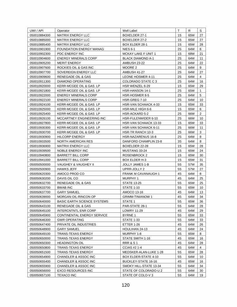
120
UWI / API Operator Well Label T R S
050010884300 MATRIX ENERGY LLC BOXELDER 27-1 1S 65W 27
050010885000 MATRIX ENERGY LLC BOXELDER 27-2 1S 65W 27
050010885400 MATRIX ENERGY LLC BOX ELDER 28-1 1S 65W 28
050010901900 FOUNDATION ENERGY MANAG NIES 6-1 2S 64W 6
050010902300 PDC ENERGY INC MCKAY LAKE F UNIT 1 1S 68W 21
050010904600 ENERGY MINERALS CORP BLACK DIAMOND A-1 2S 64W 11
050010905200 MERIT ENERGY AMBUSH 23-22 2S 64W 22
050010907600 ROCKIES OIL & GAS INC MOORE 2 2S 64W 9
050010907700 SOVEREIGN ENERGY LLC AMBUSH 41-27 2S 64W 27
050010909600 RENEGADE OIL & GAS LEONE HOSMER 4-11 2S 64W 4
050010911300 DIAMOND OPERATING COLORADO STATE C 3 2S 64W 16
050010920000 KERR-MCGEE OIL & GAS LP HSR WENZEL 6-29 1S 65W 29
050010921800 KERR-MCGEE OIL & GAS LP HSR-HANSON 14-1 2S 65W 1
050010922000 ENERGY MINERALS CORP HSR-HOSMER 8-5 2S 64W 5
050010922100 ENERGY MINERALS CORP HSR-GREG 7-10 2S 64W 10
050010924100 KERR-MCGEE OIL & GAS LP HSR-VAN SCHAACK 4-33 1S 65W 33
050010925000 KERR-MCGEE OIL & GAS LP HSR-MILE HIGH 6-6 1S 65W 6
050010925400 KERR-MCGEE OIL & GAS LP HSR-ACKARD 5-2 2S 66W 2
050010926100 MCCARTNEY ENGINEERING INC HSR-FULENWIDER 6-10 2S 66W 10
050010927800 KERR-MCGEE OIL & GAS LP HSR-VAN SCHAACK 13-33 1S 65W 33
050010930300 KERR-MCGEE OIL & GAS LP HSR-VAN SCHAACK 6-11 2S 66W 11
050010930700 KERR-MCGEE OIL & GAS LP HSR-TR RANCH 10-3 2S 66W 3
050010930900 HILCORP ENERGY HSR-NAZARENUS 16-8 2S 64W 8
050010933500 NORTH AMERICAN RES DANFORD CHAMPLIN 23-8 3S 64W 8
050010936900 MATRIX ENERGY LLC BOXELDER 22-28 1S 65W 28
050010939500 NOBLE ENERGY INC MUSTANG 33-24 1S 65W 24
050010940800 BARRETT BILL CORP ROSENBROCK 2 1S 65W 30
050010941000 BARRETT BILL CORP BOX ELDER H-3 1S 65W 31
050050500000 VAUGHEY & VAUGHEY II JOLLY JAMES 1-B 5S 57W 35
050050500900 HAWKS JEFF UPRR-JOLLY 2 5S 57W 27
050050620300 AMOCO PROD CO FRANK M CAVANAUGH 1 4S 64W 8
050050630200 DAVIS OIL CO MURPHY 1 4S 64W 25
050050632700 RENEGADE OIL & GAS STATE 13-25 5S 65W 25
050050633700 BWAB INC STATE 1-10 5S 65W 10
050050637700 GARY SAMUEL AMOCO 13-16 4S 64W 13
050050639000 MORGAN OIL-RINCON OP GRIMM-TINIANOW 1 4S 64W 34
050050640000 BASIC EARTH SCIENCE SYSTEMS STATE 1 5S 65W 36
050050643100 RENEGADE OIL & GAS PAR-STATE 28-1 5S 64W 28
050050645100 INTERCNTNTL ENR CORP LOWRY 11-29 4S 64W 29
050050645900 CONTINENTAL ENERGY SERVICE BYRNE 1 5S 65W 33
050050646300 GWR OPERATING STATE 1-33 5S 64W 33
050050647400 PRIVATE OIL INDUSTRIES ETTER 1-26 4S 64W 26
050050648900 GARY SAMUEL HOULIHAN 24-13 4S 64W 24
050050649100 TRANS-TEXAS ENERGY MURPHY 1-8 5S 65W 8
050050650000 TRANS-TEXAS ENERGY STATE SMITH 1-16 4S 65W 16
050050650300 HEADINGTON OIL RRR & S 1 4S 64W 28
050050650800 TRANS-TEXAS ENERGY CCIAS #2 1-4 4S 64W 4
050050651500 TRANS-TEXAS ENERGY MEDSKER-ALAN-LUKE 1-28 5S 65W 28
050050654900 CHANDLER & ASSOC INC BOX ELDER-STATE 4-10 5S 64W 10
050050655400 CHANDLER & ASSOC INC BUCKLEY-STATE 16-16 4S 65W 16
050050655900 CHANDLER & ASSOC INC SMOKY HILL-STATE 13-34 5S 64W 34
050050656000 EXCO RESOURCES INC STATE OF COLORADO-U 2 5S 64W 30
050050657100 TEXACO INC STATE OF COLO-V 3 5S 64W 19
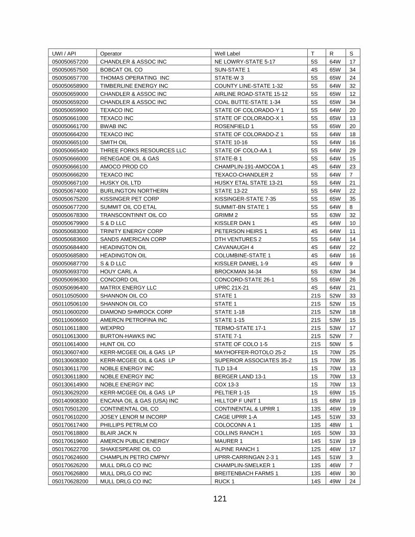
121
UWI / API Operator Well Label T R S
050050657200 CHANDLER & ASSOC INC NE LOWRY-STATE 5-17 5S 64W 17
050050657500 BOBCAT OIL CO SUN-STATE 1 4S 65W 34
050050657700 THOMAS OPERATING INC STATE-W 3 5S 65W 24
050050658900 TIMBERLINE ENERGY INC COUNTY LINE-STATE 1-32 5S 64W 32
050050659000 CHANDLER & ASSOC INC AIRLINE ROAD-STATE 15-12 5S 65W 12
050050659200 CHANDLER & ASSOC INC COAL BUTTE-STATE 1-34 5S 65W 34
050050659900 TEXACO INC STATE OF COLORADO-Y 1 5S 64W 20
050050661000 TEXACO INC STATE OF COLORADO-X 1 5S 65W 13
050050661700 BWAB INC ROSENFIELD 1 5S 65W 20
050050664200 TEXACO INC STATE OF COLORADO-Z 1 5S 64W 18
050050665100 SMITH OIL STATE 10-16 5S 64W 16
050050665400 THREE FORKS RESOURCES LLC STATE OF COLO-AA 1 5S 64W 29
050050666000 RENEGADE OIL & GAS STATE-B 1 5S 64W 15
050050666100 AMOCO PROD CO CHAMPLIN-191-AMOCOA 1 4S 64W 23
050050666200 TEXACO INC TEXACO-CHANDLER 2 5S 64W 7
050050667100 HUSKY OIL LTD HUSKY ETAL STATE 13-21 5S 64W 21
050050674000 BURLINGTON NORTHERN STATE 13-22 5S 64W 22
050050675200 KISSINGER PET CORP KISSINGER-STATE 7-35 5S 65W 35
050050677200 SUMMIT OIL CO ETAL SUMMIT-BN STATE 1 5S 64W 8
050050678300 TRANSCONTINNT OIL CO GRIMM 2 5S 63W 32
050050679900 S & D LLC KISSLER DAN 1 4S 64W 10
050050683000 TRINITY ENERGY CORP PETERSON HEIRS 1 4S 64W 11
050050683600 SANDS AMERICAN CORP DTH VENTURES 2 5S 64W 14
050050684400 HEADINGTON OIL CAVANAUGH 4 4S 64W 22
050050685800 HEADINGTON OIL COLUMBINE-STATE 1 4S 64W 16
050050687700 S & D LLC KISSLER DANIEL 1-9 4S 64W 9
050050693700 HOUY CARL A BROCKMAN 34-34 5S 63W 34
050050696300 CONCORD OIL CONCORD-STATE 26-1 5S 65W 26
050050696400 MATRIX ENERGY LLC UPRC 21X-21 4S 64W 21
050110505000 SHANNON OIL CO STATE 1 21S 52W 33
050110506100 SHANNON OIL CO STATE 1 21S 52W 15
050110600200 DIAMOND SHMROCK CORP STATE 1-18 21S 52W 18
050110606600 AMERCN PETROFINA INC STATE 1-15 21S 53W 15
050110611800 WEXPRO TERMO-STATE 17-1 21S 53W 17
050110613000 BURTON-HAWKS INC STATE 7-1 21S 52W 7
050110614000 HUNT OIL CO STATE OF COLO 1-5 21S 50W 5
050130607400 KERR-MCGEE OIL & GAS LP MAYHOFFER-ROTOLO 25-2 1S 70W 25
050130608300 KERR-MCGEE OIL & GAS LP SUPERIOR ASSOCIATES 35-2 1S 70W 35
050130611700 NOBLE ENERGY INC TLD 13-4 1S 70W 13
050130611800 NOBLE ENERGY INC BERGER LAND 13-1 1S 70W 13
050130614900 NOBLE ENERGY INC COX 13-3 1S 70W 13
050130629200 KERR-MCGEE OIL & GAS LP PELTIER 1-15 1S 69W 15
050140908300 ENCANA OIL & GAS (USA) INC HILLTOP F UNIT 1 1S 68W 19
050170501200 CONTINENTAL OIL CO CONTINENTAL & UPRR 1 13S 46W 19
050170610200 JOSEY LENOR M INCORP CAGE UPRR 1-A 14S 51W 33
050170617400 PHILLIPS PETRLM CO COLOCONN A 1 13S 48W 1
050170618800 BLAIR JACK N COLLINS RANCH 1 16S 50W 33
050170619600 AMERCN PUBLIC ENERGY MAURER 1 14S 51W 19
050170622700 SHAKESPEARE OIL CO ALPINE RANCH 1 12S 46W 17
050170624600 CHAMPLIN PETRO CMPNY UPRR-CARRINGAN 2-3 1 14S 51W 3
050170626200 MULL DRLG CO INC CHAMPLIN-SMELKER 1 13S 46W 7
050170626800 MULL DRLG CO INC BREITENBACH FARMS 1 13S 46W 30
050170628200 MULL DRLG CO INC RUCK 1 14S 49W 24

122
UWI / API Operator Well Label T R S
050170629100 MULL DRLG CO INC STATE-CULLEN 1-16 14S 48W 16
050170634700 MURFIN DRILLING S-S-M PELGER 1-12 13S 51W 12
050170635100 MURFIN DRLG CO S-S-M CONNELLEY 1-8 15S 50W 8
050170635400 MURFIN DRLG CO SSM-UP-KITCHELIN 1-5 12S 51W 5
050170637200 MURFIN DRLG CO S-S-M FICK 1-2 14S 47W 2
050170638000 MULL DRLG CO INC STEWART 1 14S 49W 22
050170638500 LEAR PET EXPL INC SCHAFER 18-13 13S 51W 18
050170638600 LEAR PET EXPL INC REED 20-11 14S 49W 20
050170640300 MICHIGAN OIL LAS ANIMAS MINERALS 1-10 13S 50W 10
050170640500 MULL DRLG CO INC HOCK 1 13S 50W 8
050170640800 MURFIN DRLG CO S-S-M KELLER 1-30 15S 49W 30
050170640900 HBB INC SAYLES 44-12 14S 50W 12
050170641100 HBB INC SIMMONS-STATE 16-7 13S 50W 16
050170641300 CHANDLER & ASSOC INC SANDERS 16-24 13S 51W 24
050170641900 SKYLINE OIL CO JELINEK 14-13 15S 48W 14
050170642800 TRICENTROL RES INC WILKERSON 22-8 14S 49W 8
050170643000 CHAMPLIN PETRO CMPNY PILGER-BERGE 11-7 1 13S 50W 7
050170643300 MURFIN DRLG CO S-S-M UPRR 1-5 15S 48W 5
050170643500 TXO PROD CORP SHADE 1 12S 50W 28
050170643700 MURFIN DRLG CO S-S-M BLEDSOE 1-20 12S 51W 20
050170643800 MARLIN OIL SANDERS 1 13S 50W 18
050170646300 HBB INC STATE 33-16 13S 50W 16
050170647300 MURFIN DRLG CO H & L ENTERPRISES 1-22 13S 51W 22
050170649000 WILLIFORD ENERGY CO RHOADES 2-6 14S 48W 6
050170650400 RME PETROLEUM MITCHEK 3 13S 48W 34
050170651200 MULL DRLG CO INC KERNS FARMS 1-30 13S 43W 30
050170652600 MURFIN DRLG CO CELSIUS-STATE 1-16 13S 44W 16
050170653000 GEAR PETRO CO INC MITCHEK 1-18 13S 47W 18
050170653900 RME PETROLEUM MOUSEL 2 13S 47W 30
050170654100 CHAMPLIN PETRO CMPNY MCCORMICK 24-25 1 13S 49W 25
050170654200 RME PETROLEUM SAYLES 13-29 1 13S 47W 29
050170654700 RME PETROLEUM SAYLES 24-29 5 13S 47W 29
050170655200 TOTAL PETROLEUM INC STATE 1-24 12S 50W 24
050170655800 RME PETROLEUM SAYLES 31-29 7 13S 47W 29
050170656200 RME PETROLEUM SAYLES 42-29 9 13S 47W 29
050170656300 MULL DRLG CO INC STATE DECHANT 1-36 13S 47W 36
050170656400 MULL DRLG CO INC RANDOLPH 1 14S 48W 12
050170656800 MULL DRLG CO INC STATE-HINES 1-16 13S 47W 16
050170657600 BURCH BOB SAYLES 1 14S 50W 13
050170658100 RME PETROLEUM ERVIN 31-33 3 13S 48W 33
050170658200 MULL DRLG CO INC BLODER 1 12S 48W 23
050170658500 BURCH BOB PELTON 1 12S 45W 27
050170658700 RME PETROLEUM WHITE 44-25 7 13S 48W 25
050170659100 BURCH BOB JELENIK 1 15S 48W 15
050170659200 MULL DRLG CO INC LAS ANIMAS MINERALS 1 13S 47W 28
050170659300 CHAMPLIN PETRO CMPNY KREGEL 44-32 1 12S 51W 32
050170659700 TOTAL PETROLEUM INC DAVID CURE 1-18 12S 49W 18
050170660300 MULL DRLG CO INC VON-A 1 13S 47W 20
050170660400 CHAMPLIN PETRO CMPNY EUREKA 1 42-21 13S 47W 21
050170660600 MULL DRLG CO INC LAS ANIMAS MINERALS 2 13S 47W 28
050170661100 MULL DRLG CO INC HITZING 1 13S 47W 24
050170661500 MEDALLION OIL CO L KUHN 1-10 14S 51W 10
050170661700 MULL DRLG CO INC ERVIN 1 13S 47W 14
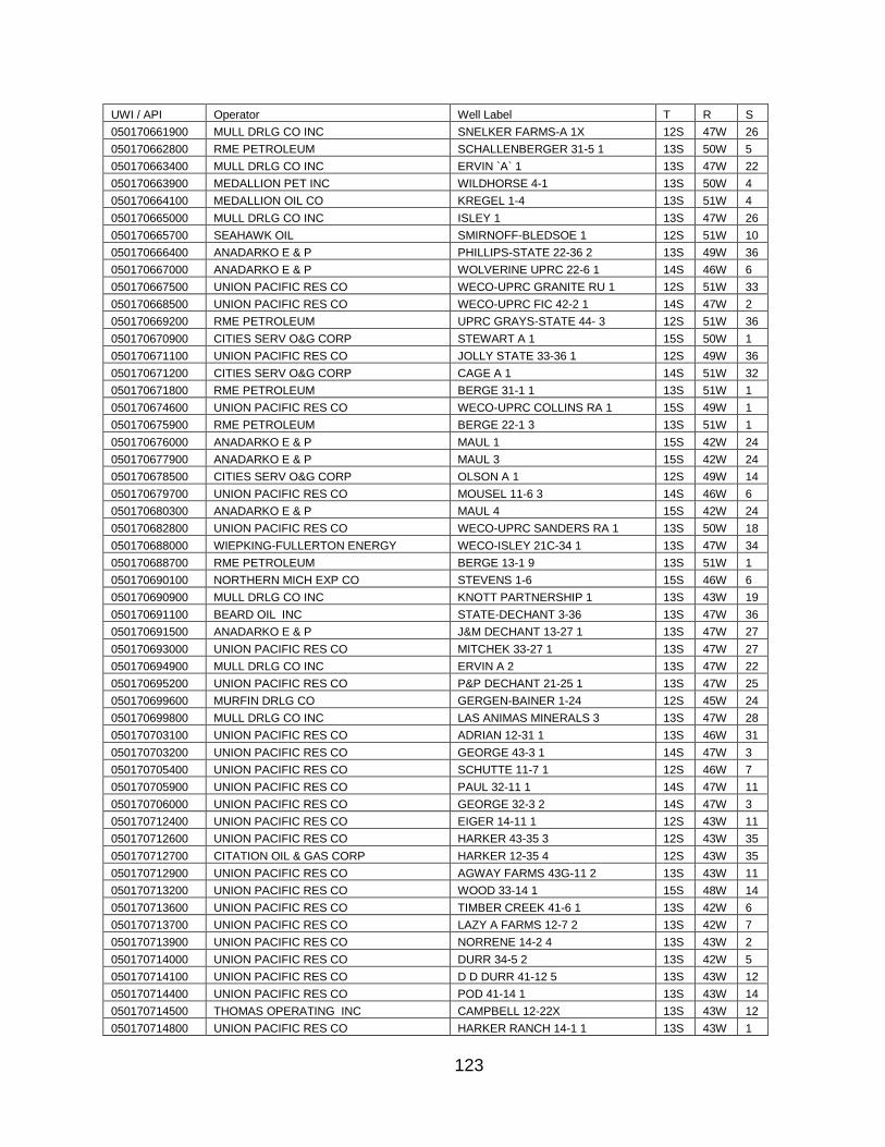
123
UWI / API Operator Well Label T R S
050170661900 MULL DRLG CO INC SNELKER FARMS-A 1X 12S 47W 26
050170662800 RME PETROLEUM SCHALLENBERGER 31-5 1 13S 50W 5
050170663400 MULL DRLG CO INC ERVIN `A` 1 13S 47W 22
050170663900 MEDALLION PET INC WILDHORSE 4-1 13S 50W 4
050170664100 MEDALLION OIL CO KREGEL 1-4 13S 51W 4
050170665000 MULL DRLG CO INC ISLEY 1 13S 47W 26
050170665700 SEAHAWK OIL SMIRNOFF-BLEDSOE 1 12S 51W 10
050170666400 ANADARKO E & P PHILLIPS-STATE 22-36 2 13S 49W 36
050170667000 ANADARKO E & P WOLVERINE UPRC 22-6 1 14S 46W 6
050170667500 UNION PACIFIC RES CO WECO-UPRC GRANITE RU 1 12S 51W 33
050170668500 UNION PACIFIC RES CO WECO-UPRC FIC 42-2 1 14S 47W 2
050170669200 RME PETROLEUM UPRC GRAYS-STATE 44- 3 12S 51W 36
050170670900 CITIES SERV O&G CORP STEWART A 1 15S 50W 1
050170671100 UNION PACIFIC RES CO JOLLY STATE 33-36 1 12S 49W 36
050170671200 CITIES SERV O&G CORP CAGE A 1 14S 51W 32
050170671800 RME PETROLEUM BERGE 31-1 1 13S 51W 1
050170674600 UNION PACIFIC RES CO WECO-UPRC COLLINS RA 1 15S 49W 1
050170675900 RME PETROLEUM BERGE 22-1 3 13S 51W 1
050170676000 ANADARKO E & P MAUL 1 15S 42W 24
050170677900 ANADARKO E & P MAUL 3 15S 42W 24
050170678500 CITIES SERV O&G CORP OLSON A 1 12S 49W 14
050170679700 UNION PACIFIC RES CO MOUSEL 11-6 3 14S 46W 6
050170680300 ANADARKO E & P MAUL 4 15S 42W 24
050170682800 UNION PACIFIC RES CO WECO-UPRC SANDERS RA 1 13S 50W 18
050170688000 WIEPKING-FULLERTON ENERGY WECO-ISLEY 21C-34 1 13S 47W 34
050170688700 RME PETROLEUM BERGE 13-1 9 13S 51W 1
050170690100 NORTHERN MICH EXP CO STEVENS 1-6 15S 46W 6
050170690900 MULL DRLG CO INC KNOTT PARTNERSHIP 1 13S 43W 19
050170691100 BEARD OIL INC STATE-DECHANT 3-36 13S 47W 36
050170691500 ANADARKO E & P J&M DECHANT 13-27 1 13S 47W 27
050170693000 UNION PACIFIC RES CO MITCHEK 33-27 1 13S 47W 27
050170694900 MULL DRLG CO INC ERVIN A 2 13S 47W 22
050170695200 UNION PACIFIC RES CO P&P DECHANT 21-25 1 13S 47W 25
050170699600 MURFIN DRLG CO GERGEN-BAINER 1-24 12S 45W 24
050170699800 MULL DRLG CO INC LAS ANIMAS MINERALS 3 13S 47W 28
050170703100 UNION PACIFIC RES CO ADRIAN 12-31 1 13S 46W 31
050170703200 UNION PACIFIC RES CO GEORGE 43-3 1 14S 47W 3
050170705400 UNION PACIFIC RES CO SCHUTTE 11-7 1 12S 46W 7
050170705900 UNION PACIFIC RES CO PAUL 32-11 1 14S 47W 11
050170706000 UNION PACIFIC RES CO GEORGE 32-3 2 14S 47W 3
050170712400 UNION PACIFIC RES CO EIGER 14-11 1 12S 43W 11
050170712600 UNION PACIFIC RES CO HARKER 43-35 3 12S 43W 35
050170712700 CITATION OIL & GAS CORP HARKER 12-35 4 12S 43W 35
050170712900 UNION PACIFIC RES CO AGWAY FARMS 43G-11 2 13S 43W 11
050170713200 UNION PACIFIC RES CO WOOD 33-14 1 15S 48W 14
050170713600 UNION PACIFIC RES CO TIMBER CREEK 41-6 1 13S 42W 6
050170713700 UNION PACIFIC RES CO LAZY A FARMS 12-7 2 13S 42W 7
050170713900 UNION PACIFIC RES CO NORRENE 14-2 4 13S 43W 2
050170714000 UNION PACIFIC RES CO DURR 34-5 2 13S 42W 5
050170714100 UNION PACIFIC RES CO D D DURR 41-12 5 13S 43W 12
050170714400 UNION PACIFIC RES CO POD 41-14 1 13S 43W 14
050170714500 THOMAS OPERATING INC CAMPBELL 12-22X 13S 43W 12
050170714800 UNION PACIFIC RES CO HARKER RANCH 14-1 1 13S 43W 1
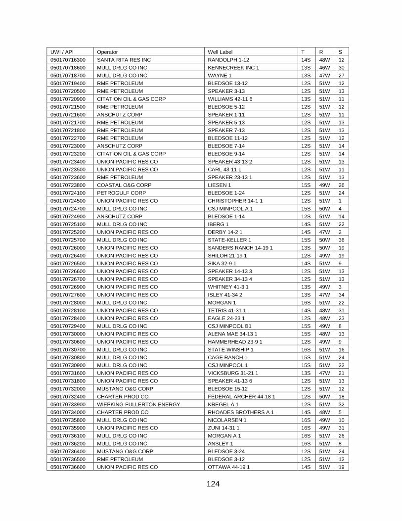
124
UWI / API Operator Well Label T R S
050170716300 SANTA RITA RES INC RANDOLPH 1-12 14S 48W 12
050170718600 MULL DRLG CO INC KENNECREEK INC 1 13S 46W 30
050170718700 MULL DRLG CO INC WAYNE 1 13S 47W 27
050170719400 RME PETROLEUM BLEDSOE 13-12 12S 51W 12
050170720500 RME PETROLEUM SPEAKER 3-13 12S 51W 13
050170720900 CITATION OIL & GAS CORP WILLIAMS 42-11 6 13S 51W 11
050170721500 RME PETROLEUM BLEDSOE 5-12 12S 51W 12
050170721600 ANSCHUTZ CORP SPEAKER 1-11 12S 51W 11
050170721700 RME PETROLEUM SPEAKER 5-13 12S 51W 13
050170721800 RME PETROLEUM SPEAKER 7-13 12S 51W 13
050170722700 RME PETROLEUM BLEDSOE 11-12 12S 51W 12
050170723000 ANSCHUTZ CORP BLEDSOE 7-14 12S 51W 14
050170723200 CITATION OIL & GAS CORP BLEDSOE 9-14 12S 51W 14
050170723400 UNION PACIFIC RES CO SPEAKER 43-13 2 12S 51W 13
050170723500 UNION PACIFIC RES CO CARL 43-11 1 12S 51W 11
050170723600 RME PETROLEUM SPEAKER 23-13 1 12S 51W 13
050170723800 COASTAL O&G CORP LIESEN 1 15S 49W 26
050170724100 PETROGULF CORP BLEDSOE 1-24 12S 51W 24
050170724500 UNION PACIFIC RES CO CHRISTOPHER 14-1 1 12S 51W 1
050170724700 MULL DRLG CO INC CSJ MINPOOL A 1 15S 50W 4
050170724900 ANSCHUTZ CORP BLEDSOE 1-14 12S 51W 14
050170725100 MULL DRLG CO INC IBERG 1 14S 51W 22
050170725200 UNION PACIFIC RES CO DERBY 14-2 1 14S 47W 2
050170725700 MULL DRLG CO INC STATE-KELLER 1 15S 50W 36
050170726000 UNION PACIFIC RES CO SANDERS RANCH 14-19 1 13S 50W 19
050170726400 UNION PACIFIC RES CO SHILOH 21-19 1 12S 49W 19
050170726500 UNION PACIFIC RES CO SIKA 32-9 1 14S 51W 9
050170726600 UNION PACIFIC RES CO SPEAKER 14-13 3 12S 51W 13
050170726700 UNION PACIFIC RES CO SPEAKER 34-13 4 12S 51W 13
050170726900 UNION PACIFIC RES CO WHITNEY 41-3 1 13S 49W 3
050170727600 UNION PACIFIC RES CO ISLEY 41-34 2 13S 47W 34
050170728000 MULL DRLG CO INC MORGAN 1 16S 51W 22
050170728100 UNION PACIFIC RES CO TETRIS 41-31 1 14S 48W 31
050170728400 UNION PACIFIC RES CO EAGLE 24-23 1 12S 48W 23
050170729400 MULL DRLG CO INC CSJ MINPOOL B1 15S 49W 8
050170730000 UNION PACIFIC RES CO ALENA MAE 34-13 1 15S 48W 13
050170730600 UNION PACIFIC RES CO HAMMERHEAD 23-9 1 12S 49W 9
050170730700 MULL DRLG CO INC STATE-WINSHIP 1 16S 51W 16
050170730800 MULL DRLG CO INC CAGE RANCH 1 15S 51W 24
050170730900 MULL DRLG CO INC CSJ MINPOOL 1 15S 51W 22
050170731600 UNION PACIFIC RES CO VICKSBURG 31-21 1 13S 47W 21
050170731800 UNION PACIFIC RES CO SPEAKER 41-13 6 12S 51W 13
050170732000 MUSTANG O&G CORP BLEDSOE 15-12 12S 51W 12
050170732400 CHARTER PROD CO FEDERAL ARCHER 44-18 1 12S 50W 18
050170733900 WIEPKING-FULLERTON ENERGY KREGEL A 1 12S 51W 32
050170734000 CHARTER PROD CO RHOADES BROTHERS A 1 14S 48W 5
050170735800 MULL DRLG CO INC NICOLARSEN 1 16S 49W 10
050170735900 UNION PACIFIC RES CO ZUNI 14-31 1 16S 49W 31
050170736100 MULL DRLG CO INC MORGAN A 1 16S 51W 26
050170736200 MULL DRLG CO INC ANSLEY 1 16S 51W 8
050170736400 MUSTANG O&G CORP BLEDSOE 3-24 12S 51W 24
050170736500 RME PETROLEUM BLEDSOE 3-12 12S 51W 12
050170736600 UNION PACIFIC RES CO OTTAWA 44-19 1 14S 51W 19
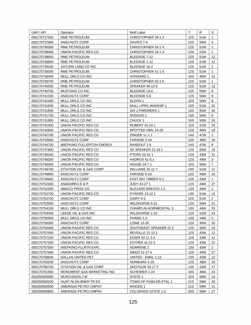
125
UWI / API Operator Well Label T R S
050170737500 RME PETROLEUM CHRISTOPHER 34-1 2 12S 51W 1
050170737900 ANSCHUTZ CORP DAVIES 7-4 12S 50W 4
050170738300 RME PETROLEUM CHRISTOPHER 43-1 4 12S 51W 1
050170738400 UNION PACIFIC RES CO CHRISTOPHER 23-1 3 12S 51W 1
050170738600 RME PETROLEUM BLEDSOE 7-12 12S 51W 12
050170738800 RME PETROLEUM BLEDSOE 1-12 12S 51W 12
050170739100 SATURN LAND CO INC BLEDSOE 16-2 12S 51W 2
050170739300 RME PETROLEUM CHRISTOPHER 41-1 5 12S 51W 1
050170739400 MULL DRLG CO INC GOSSARD 1 15S 46W 14
050170739700 RME PETROLEUM CHRISTOPHER 32-1 6 12S 51W 1
050170740500 RME PETROLEUM SPEAKER 44-13 8 12S 51W 13
050170740700 MUSTANG CO INC BLEDSOE 13-6 12S 50W 6
050170741200 ANSCHUTZ CORP BLEDSOE 5-6 12S 50W 6
050170741400 MULL DRLG CO INC ELDON 1 15S 50W 8
050170741500 MULL DRLG CO INC MULL UPRC-WINSHIP 1 15S 51W 31
050170741600 MULL DRLG CO INC SIX J PARDNERS 1 14S 50W 34
050170741700 MULL DRLG CO INC ROGERS 1 16S 50W 8
050170741800 MULL DRLG CO INC CHUCK 1 15S 50W 26
050170742400 UNION PACIFIC RES CO ROBERT 41-24 1 12S 51W 24
050170742600 UNION PACIFIC RES CO SPOTTED OWL 14-29 12S 46W 29
050170742700 UNION PACIFIC RES CO ZINGER 11-1 1 14S 47W 1
050170743500 ANSCHUTZ CORP FARSIDE 2-19 12S 48W 19
050170744700 WIEPKING-FULLERTON ENERGY RANDOLF 1-9 14S 47W 9
050170747800 UNION PACIFIC RES CO SE SPEAKER 21-19 1 12S 50W 19
050170748100 UNION PACIFIC RES CO PTERO 23-31 1 12S 43W 31
050170748200 UNION PACIFIC RES CO HADROS 41-3 1 12S 49W 3
050170748300 UNION PACIFIC RES CO HOUSE 24-7 1 12S 50W 7
050170748700 CITATION OIL & GAS CORP WILLIAMS 31-11 7 13S 51W 11
050170748800 ANSCHUTZ CORP FARSIDE 6-19 12S 48W 19
050170749600 ANSCHUTZ CORP EAST BIG TIMBER 6-1 12S 43W 1
050170752300 ANADARKO E & P JUDY 43-27 1 12S 43W 27
050170752500 AMOCO PROD CO BUZZARD BREATH 1-2 13S 46W 2
050170752700 UNION PACIFIC RES CO PYROPE 13-12 1 13S 51W 12
050170753700 ANSCHUTZ CORP DAIRY 9-2 12S 51W 2
050170753900 ANSCHUTZ CORP WILDHORSE 8-21 12S 50W 21
050170754100 MULL DRLG CO INC CHAMPLIN-HORNBOSTAL 3 13S 44W 33
050170754400 LEEDE OIL & GAS INC WILDHORSE 1-23 12S 51W 23
050170755500 MULL DRLG CO INC PHARO 1-2 13S 44W 2
050170756300 ANSCHUTZ CORP LOWE 13-20 12S 45W 20
050170756400 UNION PACIFIC RES CO SOUTHEAST SPEAKER 22 2 12S 50W 19
050170757000 UNION PACIFIC RES CO REVEILLE 21-12 1 12S 43W 12
050170757100 UNION PACIFIC RES CO EIGER 43-11 3-X 12S 43W 11
050170757200 UNION PACIFIC RES CO ESTHER 41-22 3 12S 43W 22
050170757500 WIEPKING-FLLRTN EXPL NORRENE 2 13S 43W 2
050170757600 UNION PACIFIC RES CO WEED 21-27 4 12S 43W 27
050170758600 DALLAS UNITED PET UNITED - EMAL 1-12 13S 42W 12
050170760200 ANSCHUTZ CORP NORBURG 4-20 12S 48W 20
050170760700 CITATION OIL & GAS CORP SHOTGUN 33-17 2 13S 43W 17
050170761800 MONUMENT GAS MARKETING INC SCHEIMER 1-24 16S 46W 24
050250500000 MURCHISON J W STATE 1 22S 56W 14
050250500200 HUNT NLSN BNKR TR ES TOWN OF FOWLER-ETAL 1 21S 59W 33
050250500500 AMERADA PETRO CMPNY WOODS 1 21S 59W 11
050250500800 AMERADA PETRO CMPNY COLORADO STATE 1-C 20S 56W 17
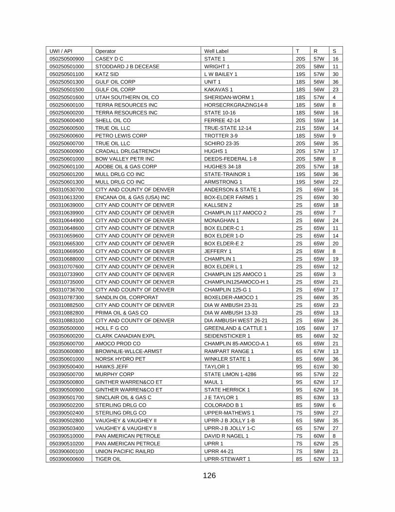
126
UWI / API Operator Well Label T R S
050250500900 CASEY D C STATE 1 20S 57W 16
050250501000 STODDARD J B DECEASE WRIGHT 1 20S 58W 11
050250501100 KATZ SID L W BAILEY 1 19S 57W 30
050250501300 GULF OIL CORP UNIT 1 18S 56W 36
050250501500 GULF OIL CORP KAKAVAS 1 18S 56W 23
050250501600 UTAH SOUTHERN OIL CO SHERIDAN-WORM 1 18S 57W 4
050250600100 TERRA RESOURCES INC HORSECRKGRAZING14-8 18S 56W 8
050250600200 TERRA RESOURCES INC STATE 10-16 18S 56W 16
050250600400 SHELL OIL CO FERREE 42-14 20S 55W 14
050250600500 TRUE OIL LLC TRUE-STATE 12-14 21S 55W 14
050250600600 PETRO LEWIS CORP TROTTER 3-9 18S 55W 9
050250600700 TRUE OIL LLC SCHIRO 23-35 20S 56W 35
050250600900 CRADALL DRLG&TRENCH HUGHS 1 20S 57W 17
050250601000 BOW VALLEY PETR INC DEEDS-FEDERAL 1-8 20S 58W 8
050250601100 ADOBE OIL & GAS CORP HUGHES 34-18 20S 57W 18
050250601200 MULL DRLG CO INC STATE-TRAINOR 1 19S 56W 36
050250601300 MULL DRLG CO INC ARMSTRONG 1 19S 56W 22
050310530700 CITY AND COUNTY OF DENVER ANDERSON & STATE 1 2S 65W 16
050310613200 ENCANA OIL & GAS (USA) INC BOX-ELDER FARMS 1 2S 65W 30
050310639000 CITY AND COUNTY OF DENVER KALLSEN 2 2S 65W 18
050310639900 CITY AND COUNTY OF DENVER CHAMPLIN 117 AMOCO 2 2S 65W 7
050310644900 CITY AND COUNTY OF DENVER MONAGHAN 1 2S 66W 24
050310648600 CITY AND COUNTY OF DENVER BOX ELDER-C 1 2S 65W 11
050310659600 CITY AND COUNTY OF DENVER BOX ELDER 1-D 2S 65W 14
050310665300 CITY AND COUNTY OF DENVER BOX ELDER-E 2 2S 65W 20
050310669500 CITY AND COUNTY OF DENVER JEFFERY 1 2S 65W 8
050310688000 CITY AND COUNTY OF DENVER CHAMPLIN 1 2S 65W 19
050310707600 CITY AND COUNTY OF DENVER BOX ELDER L 1 2S 65W 12
050310733900 CITY AND COUNTY OF DENVER CHAMPLIN 125 AMOCO 1 2S 65W 3
050310735000 CITY AND COUNTY OF DENVER CHAMPLIN125AMOCO-H 1 2S 65W 21
050310736700 CITY AND COUNTY OF DENVER CHAMPLIN 125-G 1 2S 65W 17
050310787300 SANDLIN OIL CORPORAT BOXELDER-AMOCO 1 2S 66W 35
050310882500 CITY AND COUNTY OF DENVER DIA W AMBUSH 23-31 2S 65W 23
050310882800 PRIMA OIL & GAS CO DIA W AMBUSH 13-33 2S 65W 13
050310883100 CITY AND COUNTY OF DENVER DIA AMBUSH WEST 26-21 2S 65W 26
050350500000 HOLL F G CO GREENLAND & CATTLE 1 10S 66W 17
050350600200 CLARK CANADIAN EXPL SEIDENSTICKER 1 8S 66W 32
050350600700 AMOCO PROD CO CHAMPLIN 85-AMOCO-A 1 6S 65W 21
050350600800 BROWNLIE-WLLCE-ARMST RAMPART RANGE 1 6S 67W 13
050350601000 NORSK HYDRO PET WINKLER STATE 1 8S 66W 36
050390500400 HAWKS JEFF TAYLOR 1 9S 61W 30
050390500700 MURPHY CORP STATE LIMON 1-4286 9S 57W 22
050390500800 GINTHER WARREN&CO ET MAUL 1 9S 62W 17
050390500900 GINTHER WARREN&CO ET STATE HERRICK 1 9S 62W 16
050390501700 SINCLAIR OIL & GAS C J E TAYLOR 1 8S 63W 13
050390502200 STERLING DRLG CO COLORADO B 1 8S 59W 6
050390502400 STERLING DRLG CO UPPER-MATHEWS 1 7S 59W 27
050390502800 VAUGHEY & VAUGHEY II UPRR-J B JOLLY 1-B 6S 58W 35
050390503400 VAUGHEY & VAUGHEY II UPRR-J B JOLLY 1-C 6S 57W 27
050390510000 PAN AMERICAN PETROLE DAVID R NAGEL 1 7S 60W 8
050390510200 PAN AMERICAN PETROLE UPRR 1 7S 62W 25
050390600100 UNION PACIFIC RAILRD UPRR 44-21 7S 58W 21
050390600600 TIGER OIL UPRR-STEWART 1 8S 62W 13
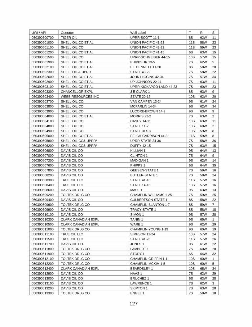
127
UWI / API Operator Well Label T R S
050390600700 TIGER OIL UPRR-SCOTT 11-1 8S 62W 11
050390601000 SHELL OIL CO ET AL UNION PACIFIC 41-23 11S 58W 23
050390601100 SHELL OIL CO UNION PACIFIC 42-23 11S 59W 23
050390601200 SHELL OIL CO ET AL UNION PACIFIC 41-15 6S 63W 15
050390601500 SHELL OIL CO UPRR-SCHMEISER 44-15 10S 57W 15
050390601900 SHELL OIL CO ET AL PHIPPS JR 13-5 7S 62W 5
050390602100 SHELL OIL CO ET AL E L BENNETT 11-20 8S 58W 20
050390602300 SHELL OIL & UPRR STATE 43-22 7S 58W 22
050390602600 SHELL OIL CO ET AL JOHN HIGGINS 42-34 7S 57W 34
050390602900 SHELL OIL CO ET AL UP-JOHNSON 22-11 7S 63W 11
050390603100 SHELL OIL CO ET AL UPRR-KICKAPOO LAND 44-23 7S 60W 23
050390603300 CHANCELLOR EXPL J E CLARK 1 8S 63W 9
050390603400 WEBB RESOURCES INC STATE 20-12 10S 62W 20
050390603700 SHELL OIL CO VAN CAMPEN 13-24 9S 61W 24
050390603800 SHELL OIL CO MCFARLIN 14-34 9S 62W 34
050390603900 SHELL OIL CO LUCORE-BROWN 14-9 9S 63W 9
050390604000 SHELL OIL CO ET AL MORRIS 22-2 7S 63W 2
050390604100 SHELL OIL CO CASEY 14-11 10S 63W 11
050390604800 SHELL OIL CO STATE 11-2 10S 60W 2
050390604900 SHELL OIL CO STATE 31X-8 10S 59W 8
050390605000 SHELL OIL CO ET AL FELCH-GARRISON 44-8 11S 59W 8
050390605800 SHELL OIL CO& UPRR* UPRR-STATE 24-36 7S 58W 36
050390606200 SHELL OIL CO& UPRR* DUFFY 12-15 7S 63W 15
050390606800 DAVIS OIL CO KILLIAN 1 9S 64W 13
050390607000 DAVIS OIL CO CLINTON 1 7S 64W 9
050390607200 DAVIS OIL CO MADIGAN 1 9S 62W 14
050390607600 DAVIS OIL CO PHIPPS 1 6S 64W 35
050390607800 DAVIS OIL CO GEESEN-STATE 1 7S 59W 16
050390608200 DAVIS OIL CO BUTLER-STATE 1 7S 58W 24
050390608300 TRUE OIL LLC STATE 41-16 11S 57W 16
050390608400 TRUE OIL LLC STATE 14-16 10S 57W 16
050390608600 DAVIS OIL CO MAUL 1 9S 63W 13
050390609200 TOLTEK DRLG CO CHAMPLIN-WILLIAMS 1-25 7S 59W 25
050390609400 DAVIS OIL CO CULBERTSON-STATE 1 8S 58W 22
050390609600 TOLTEK DRLG CO CHAMPLIN-BLANTON 1-7 8S 59W 7
050390609900 DAVIS OIL CO TRACY-STATE 1 8S 58W 18
050390610100 DAVIS OIL CO SIMON 1 9S 57W 28
050390610300 CLARK CANADIAN EXPL TANIN 1 9S 65W 1
050390610500 CLARK CANADIAN EXPL WARE 1 9S 62W 29
050390611000 TOLTEK DRLG CO CHAMPLIN-YOUNG 1-19 9S 60W 19
050390611100 TRUE OIL LLC SIMPSON 11-24 10S 57W 24
050390611500 TRUE OIL LLC STATE 41-26 11S 57W 26
050390611700 DAVIS OIL CO JONES 1 9S 61W 22
050390611800 TOLTEK DRLG CO LAMBERT 1 7S 60W 28
050390611900 TOLTEK DRLG CO STORY 1 6S 64W 32
050390612100 TOLTEK DRLG CO CHAMPLIN-GRIFFIN 1-1 10S 60W 1
050390612200 TOLTEK DRLG CO CHAMPLIN-MCKIM 1-5 10S 60W 5
050390612400 CLARK CANADIAN EXPL BEARDSLEY 1 10S 65W 34
050390612900 DAVIS OIL CO HAAS 1 7S 62W 29
050390613000 DAVIS OIL CO BRUCHEZ 1 6S 63W 28
050390613100 DAVIS OIL CO LAWRENCE 1 7S 62W 3
050390613200 DAVIS OIL CO SKIPTON 1 7S 63W 28
050390613300 TOLTEK DRLG CO ENGEL 1 7S 58W 18
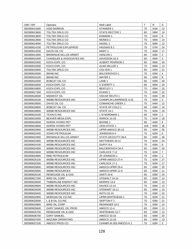
128
UWI / API Operator Well Label T R S
050390613400 KIDD BARRON STANDER 1 7S 61W 12
050390613600 TOLTEK DRLG CO STATE-RECTOR 1 8S 59W 14
050390613800 TOLTEK DRLG CO EHMANN 1 7S 61W 8
050390613900 TOLTEK DRLG CO MONKS 1 7S 59W 14
050390614000 TOLTEK DRLG CO NAGEL 1 7S 60W 12
050390614100 PETROLEUM EXPL&PROD HIGGINS B 1 7S 57W 24
050390614200 DAVIS OIL CO MARY 1 7S 64W 17
050390614300 BROWNLIE-WLLCE-ARMST HANLON 1 6S 63W 2
050390615300 CHANDLER & ASSOCIATES INC DAVIDSON 16-3 6S 65W 3
050390615400 KOCH EXPL CO ALBERT PEARSON 1 6S 65W 34
050390615500 KOCH EXPL CO ALMA MILLER 1 7S 65W 14
050390615600 TOLTEK DRLG CO COLYER 1 9S 64W 21
050390616000 BWAB INC BALCEROVICH 1 7S 63W 4
050390616100 BWAB INC MAYER 1 6S 63W 8
050390616300 BOBCAT OIL CO LANE 1 6S 63W 30
050390616500 KOCH EXPL CO C EVERITT 1 6S 65W 24
050390616800 KOCH EXPL CO BENTLEY 1 7S 65W 15
050390617300 KOCH EXPL CO EVANS 1 7S 64W 32
050390618000 MIDWEST OIL OSCAR REUTH 1 7S 63W 28
050390618100 WEBB RESOURCES INC CHAMPLIN-LAWRENCE 3-16 7S 62W 3
050390618500 DAVIS OIL CO COMANCHE CREEK 1 7S 64W 12
050390618600 BOBCAT OIL CO STATE OF COLO 1 6S 63W 16
050390618800 WEBB RESOURCES INC STATE 16-1 7S 62W 16
050390619100 TEXACO INC L M NORDMAN 1 6S 64W 2
050390619400 BEAVER MESA EXPL RARICK 14-18 7S 61W 18
050390619500 NORSK HYDRO PET BOONE 1 9S 64W 8
050390619600 NORSK HYDRO PET ZION STATE 1 10S 65W 36
050390620900 WEBB RESOURCES INC UPRR-AMOCO 35-13 6S 63W 35
050390622400 SOHIO PETROLEUM JOHNSON 6-4 7S 62W 6
050390622800 BROWNLIE-WLLCE-ARMST STATE-DEZZUTTI 36-6 6S 63W 36
050390622900 WEBB RESOURCES INC MATTHEWS 20-11 7S 62W 20
050390624100 WEBB RESOURCES INC DUFFY 8-4 7S 63W 8
050390624300 WEBB RESOURCES INC BALCEROVICH 34-3 6S 63W 34
050390624600 WEBB RESOURCES INC CARLOCK 7-12 7S 62W 7
050390624800 RME PETROLEUM JR JOHNSON 1 7S 63W 1
050390625100 WEBB RESOURCES INC UPRR-AMOCO 27-4 7S 62W 27
050390625300 WEBB RESOURCES INC CARLOCK 17-1 7S 62W 17
050390625800 WEBB RESOURCES INC AMOCO-UPRR 25-4 6S 63W 25
050390625900 WEBB RESOURCES AMOCO-UPRR 11-9 6S 63W 11
050390626100 RENEGADE OIL & GAS SARTI 24-6 6S 63W 24
050390627200 BIRD OIL CORP STEWALT 14-14 6S 63W 14
050390628000 TIMBERLINE ENERGY INC MORRIS 13-6 6S 63W 13
050390628900 WEBB RESOURCES INC DAVIES 12-13 7S 63W 12
050390629200 WEBB RESOURCES INC STEWART 10-11 6S 63W 10
050390629400 WEBB RESOURCES INC ROTH 22-10 7S 63W 22
050390632900 MORGAN OIL CO INC UPRR-WHITEHEAD 1 7S 62W 21
050390633000 L & B OIL CO INC SKIPTON F 1 7S 63W 21
050390634800 BIRD OIL CORP REININGER 10-2 7S 63W 10
050390635600 GARY SAMUEL OIL PROD AMOCO 11-4 6S 65W 11
050390635700 RENEGADE OIL & GAS WHITEHEAD 12-7 6S 63W 12
050390636700 GARY SAMUEL AMOCO 33-16 6S 64W 33
050390637000 MAZUMA OPERATING AMOCO 13-16 6S 64W 13
050390637100 AMOCO PROD CO CHAMPLIN 303 AMOCO-A 1 7S 63W 3
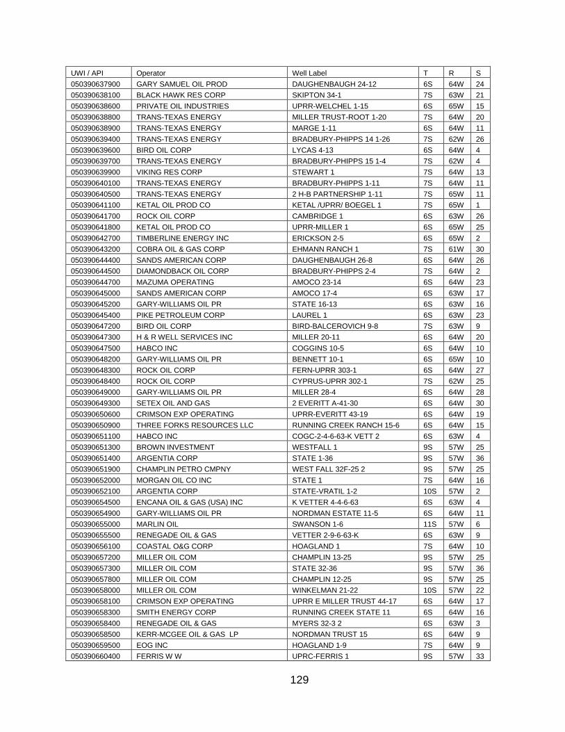
129
UWI / API Operator Well Label T R S
050390637900 GARY SAMUEL OIL PROD DAUGHENBAUGH 24-12 6S 64W 24
050390638100 BLACK HAWK RES CORP SKIPTON 34-1 7S 63W 21
050390638600 PRIVATE OIL INDUSTRIES UPRR-WELCHEL 1-15 6S 65W 15
050390638800 TRANS-TEXAS ENERGY MILLER TRUST-ROOT 1-20 7S 64W 20
050390638900 TRANS-TEXAS ENERGY MARGE 1-11 6S 64W 11
050390639400 TRANS-TEXAS ENERGY BRADBURY-PHIPPS 14 1-26 7S 62W 26
050390639600 BIRD OIL CORP LYCAS 4-13 6S 64W 4
050390639700 TRANS-TEXAS ENERGY BRADBURY-PHIPPS 15 1-4 7S 62W 4
050390639900 VIKING RES CORP STEWART 1 7S 64W 13
050390640100 TRANS-TEXAS ENERGY BRADBURY-PHIPPS 1-11 7S 64W 11
050390640500 TRANS-TEXAS ENERGY 2 H-B PARTNERSHIP 1-11 7S 65W 11
050390641100 KETAL OIL PROD CO KETAL /UPRR/ BOEGEL 1 7S 65W 1
050390641700 ROCK OIL CORP CAMBRIDGE 1 6S 63W 26
050390641800 KETAL OIL PROD CO UPRR-MILLER 1 6S 65W 25
050390642700 TIMBERLINE ENERGY INC ERICKSON 2-5 6S 65W 2
050390643200 COBRA OIL & GAS CORP EHMANN RANCH 1 7S 61W 30
050390644400 SANDS AMERICAN CORP DAUGHENBAUGH 26-8 6S 64W 26
050390644500 DIAMONDBACK OIL CORP BRADBURY-PHIPPS 2-4 7S 64W 2
050390644700 MAZUMA OPERATING AMOCO 23-14 6S 64W 23
050390645000 SANDS AMERICAN CORP AMOCO 17-4 6S 63W 17
050390645200 GARY-WILLIAMS OIL PR STATE 16-13 6S 63W 16
050390645400 PIKE PETROLEUM CORP LAUREL 1 6S 63W 23
050390647200 BIRD OIL CORP BIRD-BALCEROVICH 9-8 7S 63W 9
050390647300 H & R WELL SERVICES INC MILLER 20-11 6S 64W 20
050390647500 HABCO INC COGGINS 10-5 6S 64W 10
050390648200 GARY-WILLIAMS OIL PR BENNETT 10-1 6S 65W 10
050390648300 ROCK OIL CORP FERN-UPRR 303-1 6S 64W 27
050390648400 ROCK OIL CORP CYPRUS-UPRR 302-1 7S 62W 25
050390649000 GARY-WILLIAMS OIL PR MILLER 28-4 6S 64W 28
050390649300 SETEX OIL AND GAS 2 EVERITT A-41-30 6S 64W 30
050390650600 CRIMSON EXP OPERATING UPRR-EVERITT 43-19 6S 64W 19
050390650900 THREE FORKS RESOURCES LLC RUNNING CREEK RANCH 15-6 6S 64W 15
050390651100 HABCO INC COGC-2-4-6-63-K VETT 2 6S 63W 4
050390651300 BROWN INVESTMENT WESTFALL 1 9S 57W 25
050390651400 ARGENTIA CORP STATE 1-36 9S 57W 36
050390651900 CHAMPLIN PETRO CMPNY WEST FALL 32F-25 2 9S 57W 25
050390652000 MORGAN OIL CO INC STATE 1 7S 64W 16
050390652100 ARGENTIA CORP STATE-VRATIL 1-2 10S 57W 2
050390654500 ENCANA OIL & GAS (USA) INC K VETTER 4-4-6-63 6S 63W 4
050390654900 GARY-WILLIAMS OIL PR NORDMAN ESTATE 11-5 6S 64W 11
050390655000 MARLIN OIL SWANSON 1-6 11S 57W 6
050390655500 RENEGADE OIL & GAS VETTER 2-9-6-63-K 6S 63W 9
050390656100 COASTAL O&G CORP HOAGLAND 1 7S 64W 10
050390657200 MILLER OIL COM CHAMPLIN 13-25 9S 57W 25
050390657300 MILLER OIL COM STATE 32-36 9S 57W 36
050390657800 MILLER OIL COM CHAMPLIN 12-25 9S 57W 25
050390658000 MILLER OIL COM WINKELMAN 21-22 10S 57W 22
050390658100 CRIMSON EXP OPERATING UPRR E MILLER TRUST 44-17 6S 64W 17
050390658300 SMITH ENERGY CORP RUNNING CREEK STATE 11 6S 64W 16
050390658400 RENEGADE OIL & GAS MYERS 32-3 2 6S 63W 3
050390658500 KERR-MCGEE OIL & GAS LP NORDMAN TRUST 15 6S 64W 9
050390659500 EOG INC HOAGLAND 1-9 7S 64W 9
050390660400 FERRIS W W UPRC-FERRIS 1 9S 57W 33
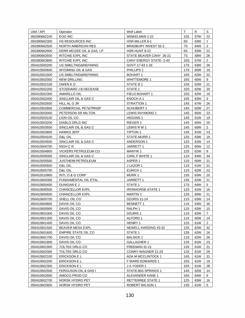
130
UWI / API Operator Well Label T R S
050390662100 EOG INC WINKELMAN 1-22 10S 57W 22
050390662300 HS RESOURCES INC HSR-MILLER 6-1 6S 63W 1
050390662500 NORTH AMERICAN RES BRADBURY INVEST 32-2 7S 64W 2
050390662900 KERR-MCGEE OIL & GAS LP HSR-HUNT 8-22 6S 63W 22
050390663500 RITCHIE EXPL INC STATE BEAVER CANY 26-21 7S 58W 26
050390663800 RITCHIE EXPL INC CANY ENERGY STATE- 2-43 10S 57W 2
050410500200 US SMELTING&REFINING GOVT-17-63 1-26 17S 63W 26
050410500600 WYOMING OIL & GAS PHILLIPS 1 17S 60W 19
050410501500 US SMELTING&REFINING BOHART 1 16S 62W 22
050410502000 NEW DRILLING WHITTEMORE 1 16S 60W 9
050410502100 OWEN K D STATE B 1 15S 62W 21
050410502200 STODDARD J B DECEASE STATE 1 15S 62W 20
050410502300 AMARILLO OIL FIELD BOHART 1 15S 62W 19
050410502400 SINCLAIR OIL & GAS C ENOCH A 1 15S 63W 3
050410502600 HILL AL G JR STRATTON 1 14S 67W 26
050410502800 COMMERCIAL PET&TRNSP SCHUBERT 1 14S 62W 27
050410503000 PETERSON SR MILTON LEWIS RAYMOND 1 14S 65W 23
050410503100 LION OIL CO HIGGINS 1 14S 61W 19
050410503200 DIABLO DRLG INC RIEGER 1 14S 60W 20
050410503500 SINCLAIR OIL & GAS C LEWIS R W 1 14S 65W 2
050410503800 HAWKS JEFF TIPTON 1 13S 61W 23
050410504100 D&L OIL STATE-MURR 1 13S 63W 16
050410504500 SINCLAIR OIL & GAS C ANDERSON 1 12S 62W 14
050410504700 NIGH C R JARRETT 1 12S 60W 12
050410504900 VICKERS PETROLEUM CO MANYIK 1 12S 62W 8
050410505000 SINCLAIR OIL & GAS C CARL F WHITE 1 11S 64W 34
050410505500 JUSTHEIM PETROLEUM ASPER 1 11S 60W 21
050410505600 D&L OIL J LAZOR 1 11S 61W 21
050410505700 D&L OIL EURICH 1 11S 62W 22
050410510900 INTL O & G CORP MURR 1 13S 63W 20
050410600300 FUNDAMENTAL OIL ETAL JARRETT 1 13S 62W 21
050410600400 DUNIGAN E J STATE 1 17S 64W 5
050410600500 CHANCELLOR EXPL IRONHORSE-STATE 1 12S 61W 16
050410600600 CHANCELLOR EXPL MARTIN 1 12S 60W 21
050410600700 SHELL OIL CO DZURIS 11-14 11S 63W 14
050410600800 DAVIS OIL CO BENNETT 1 11S 63W 30
050410600900 DAVIS OIL CO RALPH 1 11S 63W 15
050410601000 DAVIS OIL CO DZURIS 1 11S 62W 7
050410601300 DAVIS OIL CO ALFORD 1 11S 60W 14
050410601400 DAVIS OIL CO HENRY 1 12S 61W 2
050410601500 BEAVER MESA EXPL NEWELL-HARDING 43-32 12S 62W 32
050410601600 EMPIRE STATE OIL CO STATE 1 13S 62W 16
050410601700 DAVIS OIL CO BALSICK 1 11S 62W 26
050410601800 DAVIS OIL CO GALLAGHER 1 12S 61W 23
050410601900 TOLTEK DRLG CO FREEMAN 31-21 13S 61W 21
050410602000 TOLTEK DRLG CO CONRY-WAGNER 21-29 12S 61W 29
050410602100 ERICKSON E L ADA M MCCLINTOCK 1 14S 61W 31
050410602200 ERICKSON E L F WARD EDWARDS 1 15S 61W 18
050410602300 ERICKSON E L J A YODER 1 15S 61W 28
050410602500 FERGUSON OIL & GAS I STATE-BIG SPRINGS 1 14S 62W 14
050410602600 AMOCO PROD CO ALEXANDER KANE 1 16S 64W 6
050410602700 NORSK HYDRO PET RETTERREE STATE 1 12S 63W 16
050410602800 NORSK HYDRO PET ROBERT WILSON 1 13S 61W 5
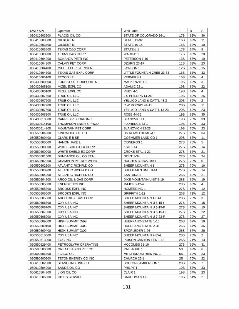
131
UWI / API Operator Well Label T R S
050410603200 PLACID OIL CO STATE OF COLORADO 36-1 17S 65W 36
050410603300 GILBERT M STATE 11-32 16S 63W 11
050410603400 GILBERT M STATE 10-14 15S 62W 10
050410603500 TEXAS O&G CORP STATE-L 1 17S 64W 8
050410603900 TEXAS O&G CORP WARD-B 1 17S 65W 20
050410604200 BONANZA PETR INC PETERSON 1-10 13S 63W 10
050410604300 CALVIN PET CORP DZURIS 23-1F 11S 63W 23
050410604400 MILLER CHRISTENSEN LAWSON 1 12S 63W 15
050410604600 TEXAS GAS EXPL CORP LITTLE FOUNTAIN CREE 23-33 16S 65W 33
050410605100 ETOCO LP VERVERS 1 15S 63W 4
050430600800 FOREST OIL CORPORATN MACKENZIE 1-3 19S 69W 3
050430605100 MIZEL EXPL CO ADAMIC 22-1 19S 69W 22
050430606100 MIZEL EXPL CO RUBY 4-1 19S 69W 4
050430607500 TRUE OIL LLC J S PHILLIPS 14-26 19S 69W 26
050430607600 TRUE OIL LLC YELLICO LAND & CATTL 43-2 20S 69W 2
050430607700 TRUE OIL LLC R W MORRIS 44-11 20S 69W 11
050430607800 TRUE OIL LLC YELLICO LAND & CATTL 13-23 20S 69W 23
050430608300 TRUE OIL LLC ROBB 44-35 19S 69W 35
050430613800 CARR EXPL CORP INC SLANOVICH 1 19S 70W 33
050430614100 THOMPSON ENGR & PROD FLORENCE 33-1 19S 69W 33
050430614800 MOUNTAIN PET CORP SLANOVICH 32-23 19S 70W 23
050550504900 KINGWOOD OIL CO US ALAMO DOME-A 1 27S 68W 34
050550600400 CLARK E B SR GOEMMER LAND CO 1 29S 67W 11
050550600500 HAMON JAKE L CISNEROS 1 27S 70W 5
050550600800 WHITE SHIELD EX CORP KSC 1-14 27S 67W 14
050550600900 WHITE SHIELD EX CORP CROKE ETAL 1-21 27S 66W 21
050550601500 SUNDANCE OIL CO ETAL GOVT 1-34 27S 66W 34
050550602200 CHAMPLIN PETRO CMPNY HUGHES 32-5/27-70/ 1 27S 70W 5
050550602600 ATLANTIC RICHFLD CO SHEEP MOUNTAIN 1 27S 70W 16
050550603200 ATLANTIC RICHFLD CO SHEEP MTN UNIT 8-14 27S 70W 14
050550604200 ATLANTIC RICHFLD CO SANTANA 1 25S 69W 21
050550604500 ARCO OIL & GAS CORP DIKE MOUNTAIN UNIT 5-19 28S 69W 19
050550605000 ENERGETICS INC MAJORS 42-4 28S 68W 4
050550605300 BROOKS EXPL INC HOMERDING 1 27S 68W 12
050550605600 BROOKS EXPL INC GRIFFITH 1-12 26S 71W 12
050550605800 ARCO OIL & GAS CORP SHEEP MOUNTAIN 1-3-M 28S 70W 3
050550606600 OXY USA INC SHEEP MOUNTAIN U 6-15-I 27S 70W 15
050550606700 OXY USA INC SHEEP MOUNTAIN U 5-15-F 27S 70W 15
050550607000 OXY USA INC SHEEP MOUNTAIN U 5-15-O 27S 70W 22
050550608000 OXY USA INC SHEEP MOUNTAIN U 7-22-P 27S 70W 27
050550609000 HIGH SUMMIT O&G HUERFANO-STATE 1-16 26S 67W 16
050550609100 HIGH SUMMIT O&G HUERFANO-STATE 2-36 26S 67W 36
050550609400 HIGH SUMMIT O&G SPORLEDER 1-26 26S 67W 26
050550610600 OXY USA INC SHEEP MOUNTAIN 7-35-L 28S 70W 2
050550613900 EOG INC POISON CANYON FED 1-13 26S 71W 13
050550629400 PETROGLYPH OPERATING MCCOMBS 31-10 27S 66W 31
050590500600 GREAT BASINS PET CO PALLAORE 1 5S 69W 6
050590506300 FLAGG OIL METZ INDUSTRIES INC 1 5S 69W 23
050590600900 TETON ENERGY CO INC CHURCH 22-1 2S 70W 22
050610502800 STANOLIND O&G CO BOLTON-LAMBERSON 1 20S 52W 7
050610504000 SANDS OIL CO PHILPY 1 19S 53W 33
050610504800 LION OIL CO CLAIR 1 19S 54W 23
050610506000 CITIES SERVICE BAUGHMAN 1-B 19S 51W 2
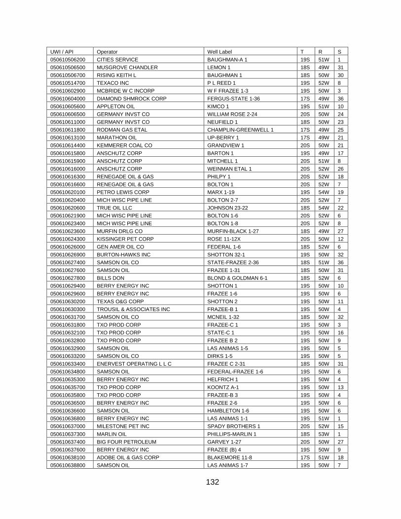
132
UWI / API Operator Well Label T R S
050610506200 CITIES SERVICE BAUGHMAN-A 1 19S 51W 1
050610506500 MUSGROVE CHANDLER LEMON 1 18S 49W 31
050610506700 RISING KEITH L BAUGHMAN 1 18S 50W 30
050610514700 TEXACO INC P L REED 1 19S 52W 8
050610602900 MCBRIDE W C INCORP W F FRAZEE 1-3 19S 50W 3
050610604000 DIAMOND SHMROCK CORP FERGUS-STATE 1-36 17S 49W 36
050610605600 APPLETON OIL KIMCO 1 19S 51W 10
050610606500 GERMANY INVST CO WILLIAM ROSE 2-24 20S 50W 24
050610611000 GERMANY INVST CO NEUFIELD 1 18S 50W 23
050610611800 RODMAN GAS ETAL CHAMPLIN-GREENWELL 1 17S 49W 25
050610613100 MARATHON OIL UP-BERRY 1 17S 49W 21
050610614400 KEMMERER COAL CO GRANDVIEW 1 20S 50W 21
050610615800 ANSCHUTZ CORP BARTON 1 19S 49W 17
050610615900 ANSCHUTZ CORP MITCHELL 1 20S 51W 8
050610616000 ANSCHUTZ CORP WEINMAN ETAL 1 20S 52W 26
050610616300 RENEGADE OIL & GAS PHILPY 1 20S 52W 18
050610616600 RENEGADE OIL & GAS BOLTON 1 20S 52W 7
050610620100 PETRO LEWIS CORP MARX 1-19 19S 54W 19
050610620400 MICH WISC PIPE LINE BOLTON 2-7 20S 52W 7
050610620600 TRUE OIL LLC JOHNSON 23-22 18S 54W 22
050610621900 MICH WISC PIPE LINE BOLTON 1-6 20S 52W 6
050610623400 MICH WISC PIPE LINE BOLTON 1-8 20S 52W 8
050610623600 MURFIN DRLG CO MURFIN-BLACK 1-27 18S 49W 27
050610624300 KISSINGER PET CORP ROSE 11-12X 20S 50W 12
050610626000 GEN AMER OIL CO FEDERAL 1-6 18S 52W 6
050610626900 BURTON-HAWKS INC SHOTTON 32-1 19S 50W 32
050610627400 SAMSON OIL CO STATE-FRAZEE 2-36 18S 51W 36
050610627600 SAMSON OIL FRAZEE 1-31 18S 50W 31
050610627800 BILLS DON BLOND & GOLDMAN 6-1 18S 52W 6
050610629400 BERRY ENERGY INC SHOTTON 1 19S 50W 10
050610629600 BERRY ENERGY INC FRAZEE 1-6 19S 50W 6
050610630200 TEXAS O&G CORP SHOTTON 2 19S 50W 11
050610630300 TROUSIL & ASSOCIATES INC FRAZEE-B 1 19S 50W 4
050610631700 SAMSON OIL CO MCNEIL 1-32 18S 50W 32
050610631800 TXO PROD CORP FRAZEE-C 1 19S 50W 3
050610632100 TXO PROD CORP STATE-C 1 19S 50W 16
050610632800 TXO PROD CORP FRAZEE B 2 19S 50W 9
050610632900 SAMSON OIL LAS ANIMAS 1-5 19S 50W 5
050610633200 SAMSON OIL CO DIRKS 1-5 19S 50W 5
050610633400 ENERVEST OPERATING L L C FRAZEE C 2-31 18S 50W 31
050610634800 SAMSON OIL FEDERAL-FRAZEE 1-6 19S 50W 6
050610635300 BERRY ENERGY INC HELFRICH 1 19S 50W 4
050610635700 TXO PROD CORP KOONTZ A-1 19S 50W 13
050610635800 TXO PROD CORP FRAZEE-B 3 19S 50W 4
050610636500 BERRY ENERGY INC FRAZEE 2-6 19S 50W 6
050610636600 SAMSON OIL HAMBLETON 1-6 19S 50W 6
050610636800 BERRY ENERGY INC LAS ANIMAS 1-1 19S 51W 1
050610637000 MILESTONE PET INC SPADY BROTHERS 1 20S 52W 15
050610637300 MARLIN OIL PHILLIPS-MARLIN 1 18S 53W 1
050610637400 BIG FOUR PETROLEUM GARVEY 1-27 20S 50W 27
050610637600 BERRY ENERGY INC FRAZEE (B) 4 19S 50W 9
050610638100 ADOBE OIL & GAS CORP BLAKEMORE 11-8 17S 51W 18
050610638800 SAMSON OIL LAS ANIMAS 1-7 19S 50W 7
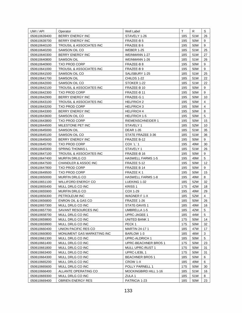
133
UWI / API Operator Well Label T R S
050610639400 BERRY ENERGY INC STAVELY 1-26 18S 51W 26
050610639700 BERRY ENERGY INC FRAZEE-B 5 19S 50W 9
050610640100 TROUSIL & ASSOCIATES INC FRAZEE B 6 19S 50W 9
050610640200 SAMSON OIL CO WEBER 1-25 18S 51W 25
050610640300 BERRY ENERGY INC WEINMANN 1-27 18S 51W 27
050610640800 SAMSON OIL WEINMANN 1-26 18S 51W 26
050610640900 TXO PROD CORP FRAZEE-B 8 19S 50W 9
050610641000 TROUSIL & ASSOCIATES INC FRAZEE-B 9 19S 50W 9
050610641500 SAMSON OIL CO SALISBURY 1-25 18S 51W 25
050610641700 SAMSON OIL CHILDS 1-22 18S 51W 22
050610642000 SAMSON OIL CO STOKER 1-22 18S 51W 22
050610642100 TROUSIL & ASSOCIATES INC FRAZEE-B 10 19S 50W 9
050610642300 TXO PROD CORP FRAZEE-B 11 19S 50W 9
050610642900 BERRY ENERGY INC FRAZEE-G 1 19S 50W 10
050610643100 TROUSIL & ASSOCIATES INC HELFRICH 2 19S 50W 4
050610643200 TXO PROD CORP HELFRICH 3 19S 50W 4
050610643300 BERRY ENERGY INC HELFRICH 4 19S 50W 8
050610643600 SAMSON OIL CO HELFRICH 1-5 19S 50W 5
050610643800 TXO PROD CORP RIEMENSCHNEIDER 1 19S 50W 15
050610644500 MILESTONE PET INC STAVELY 1 18S 52W 10
050610645000 SAMSON OIL DEAR 1-35 18S 51W 35
050610645100 SAMSON OIL CO STATE FRAZEE 3-36 18S 51W 36
050610645600 BERRY ENERGY INC FRAZEE B-12 19S 50W 9
050610645700 TXO PROD CORP COX `L` 1 19S 49W 30
050610645900 SPRING THOMAS L STAVELY 1 18S 51W 26
050610647100 TROUSIL & ASSOCIATES INC FRAZEE-B 16 19S 50W 9
050610647400 MURFIN DRLG CO HASWELL FARMS 1-5 19S 49W 5
050610647500 CHANDLER & ASSOC INC FRAZEE 5-12 19S 50W 12
050610647800 TXO PROD CORP FRAZEE B 14 19S 50W 9
050610649500 TXO PROD CORP FRAZEE K 1 19S 50W 15
050610650000 MURFIN DRLG CO HASWELL FARMS 1-8 19S 49W 8
050610651100 WILLIFORD ENERGY CO LUEKING 1-32 18S 52W 32
050610655400 MULL DRLG CO INC KRISS 1 17S 42W 18
050610655900 MURFIN DRLG CO COX 1-29 19S 49W 29
050610656300 PETROLEUM INC WAGNER F 1-X 18S 52W 4
050610656800 ENRON OIL & GAS CO FRAZEE 1-26 18S 50W 26
050610657300 MULL DRLG CO INC STATE-DAVIS 1 18S 49W 16
050610657700 SAVANT RESOURCES INC UMBRELLA 1-5 18S 42W 5
050610658700 MULL DRLG CO INC UPRC-JAGEE 1 18S 44W 5
050610659800 MULL DRLG CO INC UNITED BANK 1 17S 50W 14
050610659900 MULL DRLG CO INC PECK 1 17S 50W 32
050610660400 UNION PACIFIC RES CO MARTIN 24-17 1 18S 47W 17
050610660800 MONUMENT GAS MARKETING INC BARLOW 1-3 18S 46W 3
050610661300 MULL DRLG CO INC UPRC-ALDRICH 1 18S 50W 5
050610661400 MULL DRLG CO INC UPRC-BEACHNER BROS 1 17S 50W 23
050610661800 MULL DRLG CO INC MULL UPRC-RUST 1 17S 50W 31
050610663400 MULL DRLG CO INC UPRC-LIEBL 1 17S 50W 31
050610664300 MULL DRLG CO INC BEACHNER BROS 1 18S 50W 6
050610665200 MULL DRLG CO INC CROW 1-X 18S 49W 6
050610665600 MULL DRLG CO INC POLLY PARNELL 1 17S 50W 30
050610666400 ALLANTE OPERATING CO MOCKINGBIRD HILL 1-16 18S 51W 16
050610669300 MULL DRLG CO INC ZULA 1 18S 51W 8
050610669400 OBRIEN ENERGY RES PATRICIA 1-23 18S 50W 23
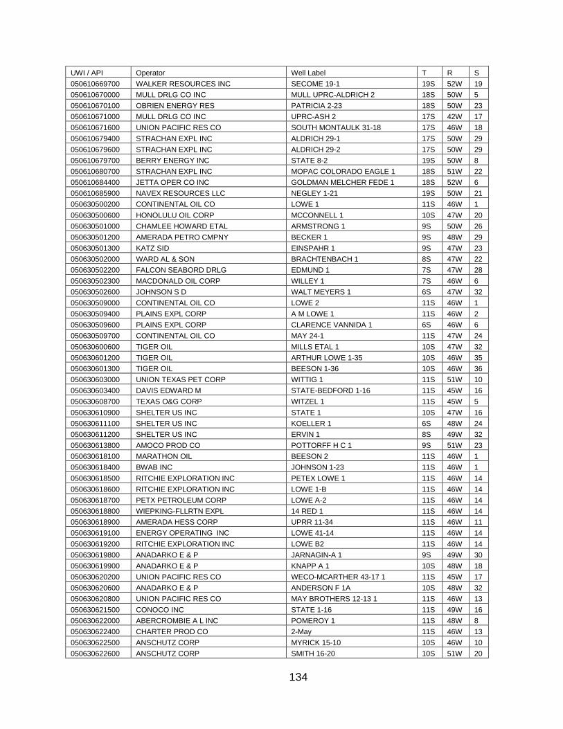
134
UWI / API Operator Well Label T R S
050610669700 WALKER RESOURCES INC SECOME 19-1 19S 52W 19
050610670000 MULL DRLG CO INC MULL UPRC-ALDRICH 2 18S 50W 5
050610670100 OBRIEN ENERGY RES PATRICIA 2-23 18S 50W 23
050610671000 MULL DRLG CO INC UPRC-ASH 2 17S 42W 17
050610671600 UNION PACIFIC RES CO SOUTH MONTAULK 31-18 17S 46W 18
050610679400 STRACHAN EXPL INC ALDRICH 29-1 17S 50W 29
050610679600 STRACHAN EXPL INC ALDRICH 29-2 17S 50W 29
050610679700 BERRY ENERGY INC STATE 8-2 19S 50W 8
050610680700 STRACHAN EXPL INC MOPAC COLORADO EAGLE 1 18S 51W 22
050610684400 JETTA OPER CO INC GOLDMAN MELCHER FEDE 1 18S 52W 6
050610685900 NAVEX RESOURCES LLC NEGLEY 1-21 19S 50W 21
050630500200 CONTINENTAL OIL CO LOWE 1 11S 46W 1
050630500600 HONOLULU OIL CORP MCCONNELL 1 10S 47W 20
050630501000 CHAMLEE HOWARD ETAL ARMSTRONG 1 9S 50W 26
050630501200 AMERADA PETRO CMPNY BECKER 1 9S 48W 29
050630501300 KATZ SID EINSPAHR 1 9S 47W 23
050630502000 WARD AL & SON BRACHTENBACH 1 8S 47W 22
050630502200 FALCON SEABORD DRLG EDMUND 1 7S 47W 28
050630502300 MACDONALD OIL CORP WILLEY 1 7S 46W 6
050630502600 JOHNSON S D WALT MEYERS 1 6S 47W 32
050630509000 CONTINENTAL OIL CO LOWE 2 11S 46W 1
050630509400 PLAINS EXPL CORP A M LOWE 1 11S 46W 2
050630509600 PLAINS EXPL CORP CLARENCE VANNIDA 1 6S 46W 6
050630509700 CONTINENTAL OIL CO MAY 24-1 11S 47W 24
050630600600 TIGER OIL MILLS ETAL 1 10S 47W 32
050630601200 TIGER OIL ARTHUR LOWE 1-35 10S 46W 35
050630601300 TIGER OIL BEESON 1-36 10S 46W 36
050630603000 UNION TEXAS PET CORP WITTIG 1 11S 51W 10
050630603400 DAVIS EDWARD M STATE-BEDFORD 1-16 11S 45W 16
050630608700 TEXAS O&G CORP WITZEL 1 11S 45W 5
050630610900 SHELTER US INC STATE 1 10S 47W 16
050630611100 SHELTER US INC KOELLER 1 6S 48W 24
050630611200 SHELTER US INC ERVIN 1 8S 49W 32
050630613800 AMOCO PROD CO POTTORFF H C 1 9S 51W 23
050630618100 MARATHON OIL BEESON 2 11S 46W 1
050630618400 BWAB INC JOHNSON 1-23 11S 46W 1
050630618500 RITCHIE EXPLORATION INC PETEX LOWE 1 11S 46W 14
050630618600 RITCHIE EXPLORATION INC LOWE 1-B 11S 46W 14
050630618700 PETX PETROLEUM CORP LOWE A-2 11S 46W 14
050630618800 WIEPKING-FLLRTN EXPL 14 RED 1 11S 46W 14
050630618900 AMERADA HESS CORP UPRR 11-34 11S 46W 11
050630619100 ENERGY OPERATING INC LOWE 41-14 11S 46W 14
050630619200 RITCHIE EXPLORATION INC LOWE B2 11S 46W 14
050630619800 ANADARKO E & P JARNAGIN-A 1 9S 49W 30
050630619900 ANADARKO E & P KNAPP A 1 10S 48W 18
050630620200 UNION PACIFIC RES CO WECO-MCARTHER 43-17 1 11S 45W 17
050630620600 ANADARKO E & P ANDERSON F 1A 10S 48W 32
050630620800 UNION PACIFIC RES CO MAY BROTHERS 12-13 1 11S 46W 13
050630621500 CONOCO INC STATE 1-16 11S 49W 16
050630622000 ABERCROMBIE A L INC POMEROY 1 11S 48W 8
050630622400 CHARTER PROD CO 2-May 11S 46W 13
050630622500 ANSCHUTZ CORP MYRICK 15-10 10S 46W 10
050630622600 ANSCHUTZ CORP SMITH 16-20 10S 51W 20

135
UWI / API Operator Well Label T R S
050630623000 ANSCHUTZ CORP BLEDSOE 5-35 11S 51W 35
050630623100 DRW OPERATING CO POPEYE 1 11S 46W 12
050630623300 WIEPKING-FULLERTON WIMPY 1 11S 46W 13
050630623700 UNION PACIFIC RES CO FLATHEAD 14-31 1 11S 50W 31
050630623800 RME PETROLEUM SPEAKER-STATE 43-36 1 11S 51W 36
050630623900 CHARTER PROD CO GREENWOOD TRUST 1 11S 47W 1
050630624000 UNION PACIFIC RES CO FLATHEAD 12-31 2 11S 50W 31
050630624100 ANADARKO E & P PATRICIA 43-25 1 11S 51W 25
050630624200 RME PETROLEUM FLATHEAD 14-31 3 11S 50W 31
050630624300 CHARTER PROD CO FIRST NATIONAL 1 10S 45W 34
050630624500 UNION PACIFIC RES CO COLMENO 21-30 2 11S 50W 30
050630624600 ANADARKO E & P COLMENO 12-30 1 11S 50W 30
050630624700 UNION PACIFIC RES CO PATRICIA 32-25 2 11S 51W 25
050630624800 UNION PACIFIC RES CO PATRICIA 41-25 3 11S 51W 25
050630624900 UNION PACIFIC RES CO PATRICIA 23-25 4 11S 51W 25
050630625200 UNION PACIFIC RES CO SPEAKER STATE 34-36 2 11S 51W 36
050630625400 ANADARKO E & P COLMENO 14-19 1 11S 50W 19
050630625600 UNION PACIFIC RES CO PATRICIA 42-25 5 11S 51W 25
050630625900 ANSCHUTZ CORP LAZY RIVER 12-29 11S 48W 29
050630627000 ANADARKO E & P COLMENO 11-30 3 11S 50W 30
050630627200 UNION PACIFIC RES CO HIGHPOINT STATE 21-3 1 11S 51W 36
050630627800 UNION PACIFIC RES CO HIGHPOINT 23-19 1 11S 50W 19
050630627900 UNION PACIFIC RES CO PATRICIA 34-25 6 11S 51W 25
050630628500 ANSCHUTZ CORP WEST BIG TIMBER 8-11 11S 44W 11
050630628600 UNION PACIFIC RES CO HIGHPOINT 34-19 3 11S 50W 19
050630629100 UNION PACIFIC RES CO RETRIEVER 43-19 1 11S 44W 19
050630629200 CITATION OIL & GAS CORP KIRCHOFFNER 21-35 2 11S 45W 35
050630629400 UNION PACIFIC RES CO HOVAWART 24-1 1 11S 46W 1
050690508800 FRNT RNGE O&URNUM CO DEAN 1 7N 69W 4
050690607300 UNIOIL CORP RODENBERGER 1 7N 68W 12
050690612100 ENSERCH EXPL INC MOODY-WARREN 1-12 7N 68W 12
050690612700 AMOCO PROD CO THAYER KENNETH 1 7N 68W 27
050690615200 TOLTEK DRLG CO DEINES 1 6N 69W 14
050690617400 UNIOIL CORP TIMNATH 1 7N 68W 34
050710616800 GERRITY CO INC THE COPPA 20-6 30S 64W 20
050710751500 PIONEER NATURAL RESOURCES JOLLY 12-17 30S 64W 17
050710770500 EVERGREEN OPERG CORP DUPONT LAKE 43-18 30S 64W 18
050730500100 UTAH SOUTHERN OIL CO TUDOR 1 17S 57W 26
050730500400 MCLAUGHLN C T ANDERSON 1 16S 59W 30
050730500500 MCLAUGHLN C T HODGSON 1 16S 56W 3
050730500600 MCLAUGHLN C T MILLER 1 16S 58W 5
050730501000 HUNT H L NEWELL 1-A 15S 57W 8
050730501600 ROOD C M WHITE 1 13S 56W 19
050730501700 HOOTS H W WHITE CARL 2 13S 56W 19
050730501900 KINGWOOD OIL CO TAYLOR 1 10S 53W 26
050730502100 MURPHY CORP BENNETT 1-6 10S 55W 6
050730502300 MURPHY OIL STATE & LIMON 1-4244 9S 56W 36
050730502600 MURPHY CORP STATE LIMON 1-4242 9S 56W 23
050730502700 KINGWOOD OIL CO UPRR-GOODMAN-GRN&SD 1 9S 52W 5
050730502800 LOHMANN-JOHNSON DRLG BAUGHMAN FARM 1 8S 53W 14
050730502900 LOHMANN-JOHNSON DRLG G ONEILL 1 8S 56W 15
050730503000 LOHMANN-JOHNSON DRLG E EWING ETAL 1 8S 54W 15
050730503100 LOHMANN-JOHNSON DRLG CHUBBUCK 1 8S 52W 15
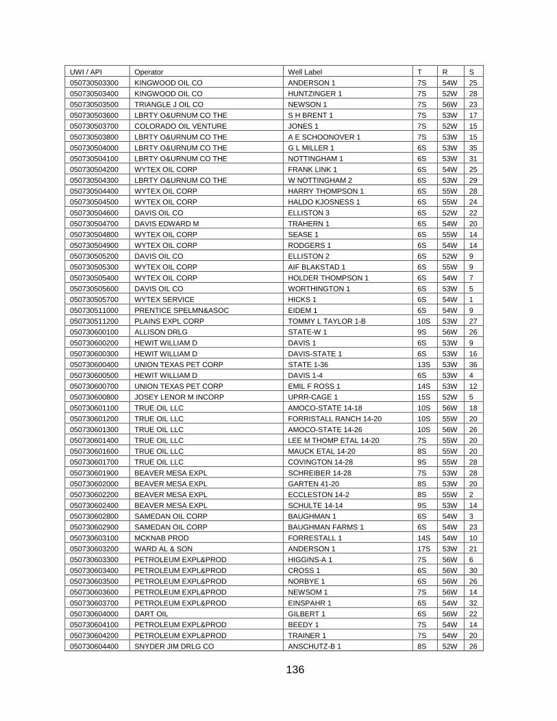
136
UWI / API Operator Well Label T R S
050730503300 KINGWOOD OIL CO ANDERSON 1 7S 54W 25
050730503400 KINGWOOD OIL CO HUNTZINGER 1 7S 52W 28
050730503500 TRIANGLE J OIL CO NEWSON 1 7S 56W 23
050730503600 LBRTY O&URNUM CO THE S H BRENT 1 7S 53W 17
050730503700 COLORADO OIL VENTURE JONES 1 7S 52W 15
050730503800 LBRTY O&URNUM CO THE A E SCHOONOVER 1 7S 53W 15
050730504000 LBRTY O&URNUM CO THE G L MILLER 1 6S 53W 35
050730504100 LBRTY O&URNUM CO THE NOTTINGHAM 1 6S 53W 31
050730504200 WYTEX OIL CORP FRANK LINK 1 6S 54W 25
050730504300 LBRTY O&URNUM CO THE W NOTTINGHAM 2 6S 53W 29
050730504400 WYTEX OIL CORP HARRY THOMPSON 1 6S 55W 28
050730504500 WYTEX OIL CORP HALDO KJOSNESS 1 6S 55W 24
050730504600 DAVIS OIL CO ELLISTON 3 6S 52W 22
050730504700 DAVIS EDWARD M TRAHERN 1 6S 54W 20
050730504800 WYTEX OIL CORP SEASE 1 6S 55W 14
050730504900 WYTEX OIL CORP RODGERS 1 6S 54W 14
050730505200 DAVIS OIL CO ELLISTON 2 6S 52W 9
050730505300 WYTEX OIL CORP AIF BLAKSTAD 1 6S 55W 9
050730505400 WYTEX OIL CORP HOLDER THOMPSON 1 6S 54W 7
050730505600 DAVIS OIL CO WORTHINGTON 1 6S 53W 5
050730505700 WYTEX SERVICE HICKS 1 6S 54W 1
050730511000 PRENTICE SPELMN&ASOC EIDEM 1 6S 54W 9
050730511200 PLAINS EXPL CORP TOMMY L TAYLOR 1-B 10S 53W 27
050730600100 ALLISON DRLG STATE-W 1 9S 56W 26
050730600200 HEWIT WILLIAM D DAVIS 1 6S 53W 9
050730600300 HEWIT WILLIAM D DAVIS-STATE 1 6S 53W 16
050730600400 UNION TEXAS PET CORP STATE 1-36 13S 53W 36
050730600500 HEWIT WILLIAM D DAVIS 1-4 6S 53W 4
050730600700 UNION TEXAS PET CORP EMIL F ROSS 1 14S 53W 12
050730600800 JOSEY LENOR M INCORP UPRR-CAGE 1 15S 52W 5
050730601100 TRUE OIL LLC AMOCO-STATE 14-18 10S 56W 18
050730601200 TRUE OIL LLC FORRISTALL RANCH 14-20 10S 55W 20
050730601300 TRUE OIL LLC AMOCO-STATE 14-26 10S 56W 26
050730601400 TRUE OIL LLC LEE M THOMP ETAL 14-20 7S 55W 20
050730601600 TRUE OIL LLC MAUCK ETAL 14-20 8S 55W 20
050730601700 TRUE OIL LLC COVINGTON 14-28 9S 55W 28
050730601900 BEAVER MESA EXPL SCHREIBER 14-28 7S 53W 28
050730602000 BEAVER MESA EXPL GARTEN 41-20 8S 53W 20
050730602200 BEAVER MESA EXPL ECCLESTON 14-2 8S 55W 2
050730602400 BEAVER MESA EXPL SCHULTE 14-14 9S 53W 14
050730602800 SAMEDAN OIL CORP BAUGHMAN 1 6S 54W 3
050730602900 SAMEDAN OIL CORP BAUGHMAN FARMS 1 6S 54W 23
050730603100 MCKNAB PROD FORRESTALL 1 14S 54W 10
050730603200 WARD AL & SON ANDERSON 1 17S 53W 21
050730603300 PETROLEUM EXPL&PROD HIGGINS-A 1 7S 56W 6
050730603400 PETROLEUM EXPL&PROD CROSS 1 6S 56W 30
050730603500 PETROLEUM EXPL&PROD NORBYE 1 6S 56W 26
050730603600 PETROLEUM EXPL&PROD NEWSOM 1 7S 56W 14
050730603700 PETROLEUM EXPL&PROD EINSPAHR 1 6S 54W 32
050730604000 DART OIL GILBERT 1 6S 56W 22
050730604100 PETROLEUM EXPL&PROD BEEDY 1 7S 54W 14
050730604200 PETROLEUM EXPL&PROD TRAINER 1 7S 54W 20
050730604400 SNYDER JIM DRLG CO ANSCHUTZ-B 1 8S 52W 26
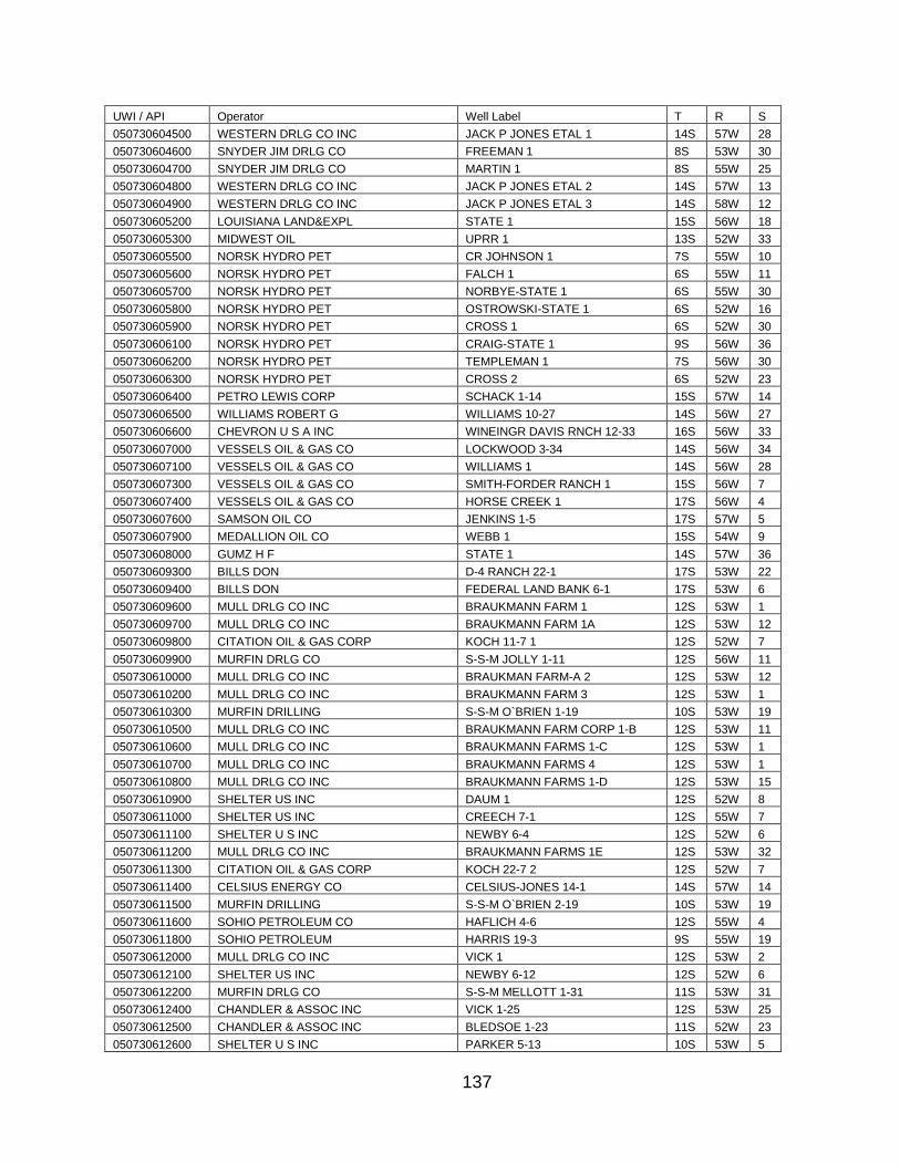
137
UWI / API Operator Well Label T R S
050730604500 WESTERN DRLG CO INC JACK P JONES ETAL 1 14S 57W 28
050730604600 SNYDER JIM DRLG CO FREEMAN 1 8S 53W 30
050730604700 SNYDER JIM DRLG CO MARTIN 1 8S 55W 25
050730604800 WESTERN DRLG CO INC JACK P JONES ETAL 2 14S 57W 13
050730604900 WESTERN DRLG CO INC JACK P JONES ETAL 3 14S 58W 12
050730605200 LOUISIANA LAND&EXPL STATE 1 15S 56W 18
050730605300 MIDWEST OIL UPRR 1 13S 52W 33
050730605500 NORSK HYDRO PET CR JOHNSON 1 7S 55W 10
050730605600 NORSK HYDRO PET FALCH 1 6S 55W 11
050730605700 NORSK HYDRO PET NORBYE-STATE 1 6S 55W 30
050730605800 NORSK HYDRO PET OSTROWSKI-STATE 1 6S 52W 16
050730605900 NORSK HYDRO PET CROSS 1 6S 52W 30
050730606100 NORSK HYDRO PET CRAIG-STATE 1 9S 56W 36
050730606200 NORSK HYDRO PET TEMPLEMAN 1 7S 56W 30
050730606300 NORSK HYDRO PET CROSS 2 6S 52W 23
050730606400 PETRO LEWIS CORP SCHACK 1-14 15S 57W 14
050730606500 WILLIAMS ROBERT G WILLIAMS 10-27 14S 56W 27
050730606600 CHEVRON U S A INC WINEINGR DAVIS RNCH 12-33 16S 56W 33
050730607000 VESSELS OIL & GAS CO LOCKWOOD 3-34 14S 56W 34
050730607100 VESSELS OIL & GAS CO WILLIAMS 1 14S 56W 28
050730607300 VESSELS OIL & GAS CO SMITH-FORDER RANCH 1 15S 56W 7
050730607400 VESSELS OIL & GAS CO HORSE CREEK 1 17S 56W 4
050730607600 SAMSON OIL CO JENKINS 1-5 17S 57W 5
050730607900 MEDALLION OIL CO WEBB 1 15S 54W 9
050730608000 GUMZ H F STATE 1 14S 57W 36
050730609300 BILLS DON D-4 RANCH 22-1 17S 53W 22
050730609400 BILLS DON FEDERAL LAND BANK 6-1 17S 53W 6
050730609600 MULL DRLG CO INC BRAUKMANN FARM 1 12S 53W 1
050730609700 MULL DRLG CO INC BRAUKMANN FARM 1A 12S 53W 12
050730609800 CITATION OIL & GAS CORP KOCH 11-7 1 12S 52W 7
050730609900 MURFIN DRLG CO S-S-M JOLLY 1-11 12S 56W 11
050730610000 MULL DRLG CO INC BRAUKMAN FARM-A 2 12S 53W 12
050730610200 MULL DRLG CO INC BRAUKMANN FARM 3 12S 53W 1
050730610300 MURFIN DRILLING S-S-M O`BRIEN 1-19 10S 53W 19
050730610500 MULL DRLG CO INC BRAUKMANN FARM CORP 1-B 12S 53W 11
050730610600 MULL DRLG CO INC BRAUKMANN FARMS 1-C 12S 53W 1
050730610700 MULL DRLG CO INC BRAUKMANN FARMS 4 12S 53W 1
050730610800 MULL DRLG CO INC BRAUKMANN FARMS 1-D 12S 53W 15
050730610900 SHELTER US INC DAUM 1 12S 52W 8
050730611000 SHELTER US INC CREECH 7-1 12S 55W 7
050730611100 SHELTER U S INC NEWBY 6-4 12S 52W 6
050730611200 MULL DRLG CO INC BRAUKMANN FARMS 1E 12S 53W 32
050730611300 CITATION OIL & GAS CORP KOCH 22-7 2 12S 52W 7
050730611400 CELSIUS ENERGY CO CELSIUS-JONES 14-1 14S 57W 14
050730611500 MURFIN DRILLING S-S-M O`BRIEN 2-19 10S 53W 19
050730611600 SOHIO PETROLEUM CO HAFLICH 4-6 12S 55W 4
050730611800 SOHIO PETROLEUM HARRIS 19-3 9S 55W 19
050730612000 MULL DRLG CO INC VICK 1 12S 53W 2
050730612100 SHELTER US INC NEWBY 6-12 12S 52W 6
050730612200 MURFIN DRLG CO S-S-M MELLOTT 1-31 11S 53W 31
050730612400 CHANDLER & ASSOC INC VICK 1-25 12S 53W 25
050730612500 CHANDLER & ASSOC INC BLEDSOE 1-23 11S 52W 23
050730612600 SHELTER U S INC PARKER 5-13 10S 53W 5
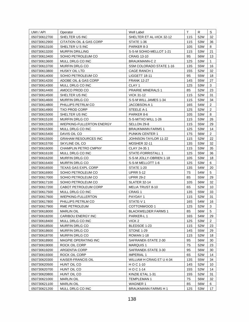
138
UWI / API Operator Well Label T R S
050730612700 SHELTER US INC SHELTER ET AL-VICK 32-12 11S 52W 32
050730612900 CITATION OIL & GAS CORP STATE 1-36 11S 53W 36
050730613100 SHELTER U S INC PARKER 8-3 10S 53W 8
050730613200 MURFIN DRILLING S-S-M SOHIO-MELLOT 1-21 11S 53W 21
050730613400 SOHIO PETROLEUM CO CRAIG 13-10 9S 56W 13
050730613600 MULL DRLG CO INC BRAUKMANN-C 2 12S 53W 1
050730613700 MURFIN DRLG CO SSM COLORADO STATE 1-16 13S 55W 16
050730613800 HUSKY OIL LTD CAGE RANCH 1 15S 52W 32
050730614000 SOHIO PETROLEUM CO LIGGETT 18-11 9S 55W 18
050730614200 ADOBE OIL & GAS CORP FRANK 12-27 14S 55W 27
050730614300 MULL DRLG CO INC CLAY 1 12S 53W 3
050730614400 AMOCO PROD CO PRAIRIE MINERALS 1 8S 52W 23
050730614500 SHELTER US INC VICK 31-12 11S 52W 31
050730614600 MURFIN DRLG CO S-S-M WILL JAMES 1-34 11S 53W 34
050730614800 PHILLIPS PETRLM CO JACOBSON-A 1 16S 54W 2
050730614900 TXO PROD CORP STEELE A-1 12S 52W 2
050730615000 SHELTER US INC PARKER 8-6 10S 53W 8
050730615100 MURFIN DRLG CO S-S-M/TXO WILL 1-26 11S 53W 26
050730615200 WIEPKING-FULLERTON ENERGY SELLON 29-8 11S 55W 29
050730615300 MULL DRLG CO INC BRAUKMANN FARMS 1 12S 53W 14
050730615400 DAVIS OIL CO PUNKIN CENTER 1 17S 56W 2
050730615500 GRAHAM RESOURCES INC JOHNSON-TAYLOR 11-22 11S 52W 22
050730615700 SKYLINE OIL CO MOSHER 32-11 13S 53W 32
050730616000 CHAMPLIN PETRO CMPNY CLAY 24-35 1 11S 53W 35
050730616100 MULL DRLG CO INC STATE-FORRISTALL 1 12S 55W 36
050730616200 MURFIN DRLG CO S-S-M JOLLY-OBRIEN 1-18 10S 53W 18
050730616400 MURFIN DRLG CO S-S-M MELLOTT 1-6 12S 53W 6
050730616500 TEXAS GAS EXPL CORP STATE 1-20 13S 54W 20
050730616900 SOHIO PETROLEUM CO UPRR 5-12 7S 54W 5
050730617000 SOHIO PETROLEUM CO UPRR 29-2 8S 55W 29
050730617100 SOHIO PETROLEUM CO SLATER 32-14 10S 56W 32
050730617200 CABOT PETROLEUM CORP MELIA TRUST 8-10 6S 52W 10
050730617500 MULL DRLG CO INC CRAIG 1 13S 55W 33
050730617600 WIEPKING-FULLERTON PAYDAY 1 11S 52W 31
050730617800 PHILLIPS PETRLM CO STATE-V 1 16S 54W 16
050730617900 RME PETROLEUM COTTONWOOD 1 12S 52W 3
050730618000 MARLIN OIL BLACKWELDER FARMS 1 8S 56W 5
050730618200 CARIBOU ENERGY INC PARKER-L 1 16S 54W 29
050730618400 MULL DRLG CO INC VICK 2 12S 53W 2
050730618500 MURFIN DRLG CO BLEDSOE 1-23 11S 52W 23
050730618600 MURFIN DRLG CO STONE 1-29 14S 55W 29
050730618700 MURFIN DRLG CO ROWAN 1-18 11S 52W 18
050730618900 MAGPIE OPERATING INC SAFRANEK-STATE 2-30 9S 56W 30
050730619000 ROCK OIL CORP MARQUIS 1 7S 52W 23
050730619200 ARGENTIA CORP SAFRANEK-STATE 3-30 9S 56W 30
050730619300 ROCK OIL CORP IMPERIAL 1 6S 52W 14
050730620300 KAISER-FRANCIS OIL WILLIAM H CRAIG ET U 4-34 13S 55W 34
050730620500 HUNT OIL CO H O C 1-10 14S 52W 10
050730620700 HUNT OIL CO H O C 1-14 15S 52W 14
050730620800 HUNT OIL CO KINZIE ETAL 1-31 15S 52W 31
050730621000 MARLIN OIL TEMPLEMAN 1 7S 56W 32
050730621100 MARLIN OIL WAGNER 1 8S 56W 6
050730621200 MULL DRLG CO INC BRAUKMANN FARMS H 1 12S 53W 17
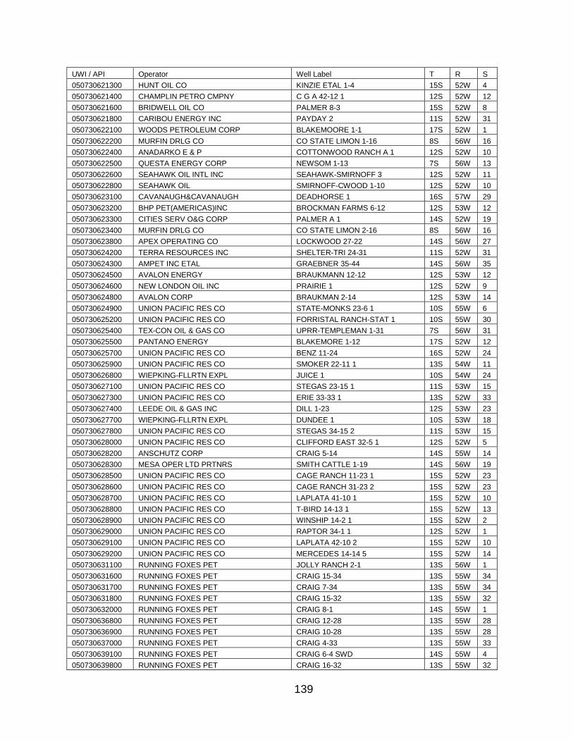
139
UWI / API Operator Well Label T R S
050730621300 HUNT OIL CO KINZIE ETAL 1-4 15S 52W 4
050730621400 CHAMPLIN PETRO CMPNY C G A 42-12 1 12S 52W 12
050730621600 BRIDWELL OIL CO PALMER 8-3 15S 52W 8
050730621800 CARIBOU ENERGY INC PAYDAY 2 11S 52W 31
050730622100 WOODS PETROLEUM CORP BLAKEMOORE 1-1 17S 52W 1
050730622200 MURFIN DRLG CO CO STATE LIMON 1-16 8S 56W 16
050730622400 ANADARKO E & P COTTONWOOD RANCH A 1 12S 52W 10
050730622500 QUESTA ENERGY CORP NEWSOM 1-13 7S 56W 13
050730622600 SEAHAWK OIL INTL INC SEAHAWK-SMIRNOFF 3 12S 52W 11
050730622800 SEAHAWK OIL SMIRNOFF-CWOOD 1-10 12S 52W 10
050730623100 CAVANAUGH&CAVANAUGH DEADHORSE 1 16S 57W 29
050730623200 BHP PET(AMERICAS)INC BROCKMAN FARMS 6-12 12S 53W 12
050730623300 CITIES SERV O&G CORP PALMER A 1 14S 52W 19
050730623400 MURFIN DRLG CO CO STATE LIMON 2-16 8S 56W 16
050730623800 APEX OPERATING CO LOCKWOOD 27-22 14S 56W 27
050730624200 TERRA RESOURCES INC SHELTER-TRI 24-31 11S 52W 31
050730624300 AMPET INC ETAL GRAEBNER 35-44 14S 56W 35
050730624500 AVALON ENERGY BRAUKMANN 12-12 12S 53W 12
050730624600 NEW LONDON OIL INC PRAIRIE 1 12S 52W 9
050730624800 AVALON CORP BRAUKMAN 2-14 12S 53W 14
050730624900 UNION PACIFIC RES CO STATE-MONKS 23-6 1 10S 55W 6
050730625200 UNION PACIFIC RES CO FORRISTAL RANCH-STAT 1 10S 55W 30
050730625400 TEX-CON OIL & GAS CO UPRR-TEMPLEMAN 1-31 7S 56W 31
050730625500 PANTANO ENERGY BLAKEMORE 1-12 17S 52W 12
050730625700 UNION PACIFIC RES CO BENZ 11-24 16S 52W 24
050730625900 UNION PACIFIC RES CO SMOKER 22-11 1 13S 54W 11
050730626800 WIEPKING-FLLRTN EXPL JUICE 1 10S 54W 24
050730627100 UNION PACIFIC RES CO STEGAS 23-15 1 11S 53W 15
050730627300 UNION PACIFIC RES CO ERIE 33-33 1 13S 52W 33
050730627400 LEEDE OIL & GAS INC DILL 1-23 12S 53W 23
050730627700 WIEPKING-FLLRTN EXPL DUNDEE 1 10S 53W 18
050730627800 UNION PACIFIC RES CO STEGAS 34-15 2 11S 53W 15
050730628000 UNION PACIFIC RES CO CLIFFORD EAST 32-5 1 12S 52W 5
050730628200 ANSCHUTZ CORP CRAIG 5-14 14S 55W 14
050730628300 MESA OPER LTD PRTNRS SMITH CATTLE 1-19 14S 56W 19
050730628500 UNION PACIFIC RES CO CAGE RANCH 11-23 1 15S 52W 23
050730628600 UNION PACIFIC RES CO CAGE RANCH 31-23 2 15S 52W 23
050730628700 UNION PACIFIC RES CO LAPLATA 41-10 1 15S 52W 10
050730628800 UNION PACIFIC RES CO T-BIRD 14-13 1 15S 52W 13
050730628900 UNION PACIFIC RES CO WINSHIP 14-2 1 15S 52W 2
050730629000 UNION PACIFIC RES CO RAPTOR 34-1 1 12S 52W 1
050730629100 UNION PACIFIC RES CO LAPLATA 42-10 2 15S 52W 10
050730629200 UNION PACIFIC RES CO MERCEDES 14-14 5 15S 52W 14
050730631100 RUNNING FOXES PET JOLLY RANCH 2-1 13S 56W 1
050730631600 RUNNING FOXES PET CRAIG 15-34 13S 55W 34
050730631700 RUNNING FOXES PET CRAIG 7-34 13S 55W 34
050730631800 RUNNING FOXES PET CRAIG 15-32 13S 55W 32
050730632000 RUNNING FOXES PET CRAIG 8-1 14S 55W 1
050730636800 RUNNING FOXES PET CRAIG 12-28 13S 55W 28
050730636900 RUNNING FOXES PET CRAIG 10-28 13S 55W 28
050730637000 RUNNING FOXES PET CRAIG 4-33 13S 55W 33
050730639100 RUNNING FOXES PET CRAIG 6-4 SWD 14S 55W 4
050730639800 RUNNING FOXES PET CRAIG 16-32 13S 55W 32
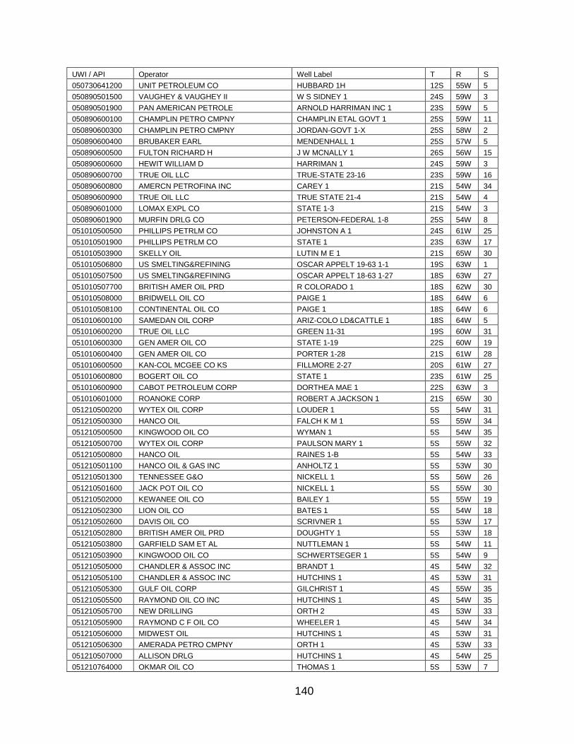
140
UWI / API Operator Well Label T R S
050730641200 UNIT PETROLEUM CO HUBBARD 1H 12S 55W 5
050890501500 VAUGHEY & VAUGHEY II W S SIDNEY 1 24S 59W 3
050890501900 PAN AMERICAN PETROLE ARNOLD HARRIMAN INC 1 23S 59W 5
050890600100 CHAMPLIN PETRO CMPNY CHAMPLIN ETAL GOVT 1 25S 59W 11
050890600300 CHAMPLIN PETRO CMPNY JORDAN-GOVT 1-X 25S 58W 2
050890600400 BRUBAKER EARL MENDENHALL 1 25S 57W 5
050890600500 FULTON RICHARD H J W MCNALLY 1 26S 56W 15
050890600600 HEWIT WILLIAM D HARRIMAN 1 24S 59W 3
050890600700 TRUE OIL LLC TRUE-STATE 23-16 23S 59W 16
050890600800 AMERCN PETROFINA INC CAREY 1 21S 54W 34
050890600900 TRUE OIL LLC TRUE STATE 21-4 21S 54W 4
050890601000 LOMAX EXPL CO STATE 1-3 21S 54W 3
050890601900 MURFIN DRLG CO PETERSON-FEDERAL 1-8 25S 54W 8
051010500500 PHILLIPS PETRLM CO JOHNSTON A 1 24S 61W 25
051010501900 PHILLIPS PETRLM CO STATE 1 23S 63W 17
051010503900 SKELLY OIL LUTIN M E 1 21S 65W 30
051010506800 US SMELTING&REFINING OSCAR APPELT 19-63 1-1 19S 63W 1
051010507500 US SMELTING&REFINING OSCAR APPELT 18-63 1-27 18S 63W 27
051010507700 BRITISH AMER OIL PRD R COLORADO 1 18S 62W 30
051010508000 BRIDWELL OIL CO PAIGE 1 18S 64W 6
051010508100 CONTINENTAL OIL CO PAIGE 1 18S 64W 6
051010600100 SAMEDAN OIL CORP ARIZ-COLO LD&CATTLE 1 18S 64W 5
051010600200 TRUE OIL LLC GREEN 11-31 19S 60W 31
051010600300 GEN AMER OIL CO STATE 1-19 22S 60W 19
051010600400 GEN AMER OIL CO PORTER 1-28 21S 61W 28
051010600500 KAN-COL MCGEE CO KS FILLMORE 2-27 20S 61W 27
051010600800 BOGERT OIL CO STATE 1 23S 61W 25
051010600900 CABOT PETROLEUM CORP DORTHEA MAE 1 22S 63W 3
051010601000 ROANOKE CORP ROBERT A JACKSON 1 21S 65W 30
051210500200 WYTEX OIL CORP LOUDER 1 5S 54W 31
051210500300 HANCO OIL FALCH K M 1 5S 55W 34
051210500500 KINGWOOD OIL CO WYMAN 1 5S 54W 35
051210500700 WYTEX OIL CORP PAULSON MARY 1 5S 55W 32
051210500800 HANCO OIL RAINES 1-B 5S 54W 33
051210501100 HANCO OIL & GAS INC ANHOLTZ 1 5S 53W 30
051210501300 TENNESSEE G&O NICKELL 1 5S 56W 26
051210501600 JACK POT OIL CO NICKELL 1 5S 55W 30
051210502000 KEWANEE OIL CO BAILEY 1 5S 55W 19
051210502300 LION OIL CO BATES 1 5S 54W 18
051210502600 DAVIS OIL CO SCRIVNER 1 5S 53W 17
051210502800 BRITISH AMER OIL PRD DOUGHTY 1 5S 53W 18
051210503800 GARFIELD SAM ET AL NUTTLEMAN 1 5S 54W 11
051210503900 KINGWOOD OIL CO SCHWERTSEGER 1 5S 54W 9
051210505000 CHANDLER & ASSOC INC BRANDT 1 4S 54W 32
051210505100 CHANDLER & ASSOC INC HUTCHINS 1 4S 53W 31
051210505300 GULF OIL CORP GILCHRIST 1 4S 55W 35
051210505500 RAYMOND OIL CO INC HUTCHINS 1 4S 54W 35
051210505700 NEW DRILLING ORTH 2 4S 53W 33
051210505900 RAYMOND C F OIL CO WHEELER 1 4S 54W 34
051210506000 MIDWEST OIL HUTCHINS 1 4S 53W 31
051210506300 AMERADA PETRO CMPNY ORTH 1 4S 53W 33
051210507000 ALLISON DRLG HUTCHINS 1 4S 54W 25
051210764000 OKMAR OIL CO THOMAS 1 5S 53W 7
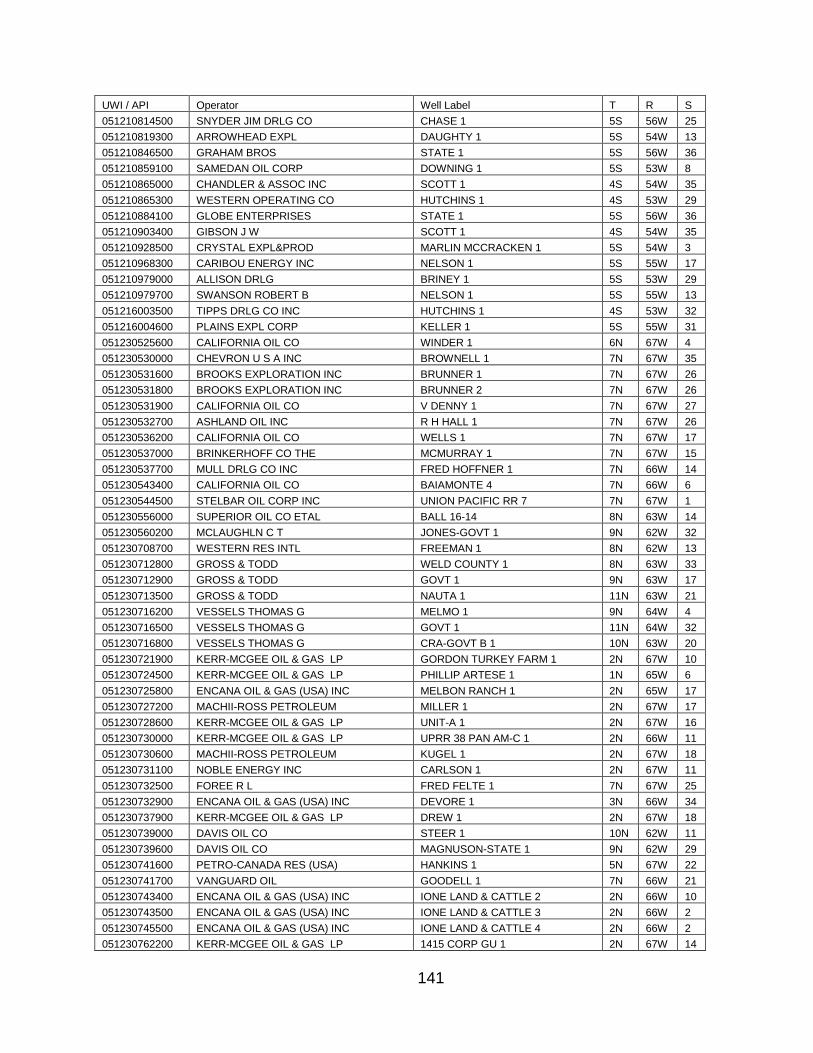
141
UWI / API Operator Well Label T R S
051210814500 SNYDER JIM DRLG CO CHASE 1 5S 56W 25
051210819300 ARROWHEAD EXPL DAUGHTY 1 5S 54W 13
051210846500 GRAHAM BROS STATE 1 5S 56W 36
051210859100 SAMEDAN OIL CORP DOWNING 1 5S 53W 8
051210865000 CHANDLER & ASSOC INC SCOTT 1 4S 54W 35
051210865300 WESTERN OPERATING CO HUTCHINS 1 4S 53W 29
051210884100 GLOBE ENTERPRISES STATE 1 5S 56W 36
051210903400 GIBSON J W SCOTT 1 4S 54W 35
051210928500 CRYSTAL EXPL&PROD MARLIN MCCRACKEN 1 5S 54W 3
051210968300 CARIBOU ENERGY INC NELSON 1 5S 55W 17
051210979000 ALLISON DRLG BRINEY 1 5S 53W 29
051210979700 SWANSON ROBERT B NELSON 1 5S 55W 13
051216003500 TIPPS DRLG CO INC HUTCHINS 1 4S 53W 32
051216004600 PLAINS EXPL CORP KELLER 1 5S 55W 31
051230525600 CALIFORNIA OIL CO WINDER 1 6N 67W 4
051230530000 CHEVRON U S A INC BROWNELL 1 7N 67W 35
051230531600 BROOKS EXPLORATION INC BRUNNER 1 7N 67W 26
051230531800 BROOKS EXPLORATION INC BRUNNER 2 7N 67W 26
051230531900 CALIFORNIA OIL CO V DENNY 1 7N 67W 27
051230532700 ASHLAND OIL INC R H HALL 1 7N 67W 26
051230536200 CALIFORNIA OIL CO WELLS 1 7N 67W 17
051230537000 BRINKERHOFF CO THE MCMURRAY 1 7N 67W 15
051230537700 MULL DRLG CO INC FRED HOFFNER 1 7N 66W 14
051230543400 CALIFORNIA OIL CO BAIAMONTE 4 7N 66W 6
051230544500 STELBAR OIL CORP INC UNION PACIFIC RR 7 7N 67W 1
051230556000 SUPERIOR OIL CO ETAL BALL 16-14 8N 63W 14
051230560200 MCLAUGHLN C T JONES-GOVT 1 9N 62W 32
051230708700 WESTERN RES INTL FREEMAN 1 8N 62W 13
051230712800 GROSS & TODD WELD COUNTY 1 8N 63W 33
051230712900 GROSS & TODD GOVT 1 9N 63W 17
051230713500 GROSS & TODD NAUTA 1 11N 63W 21
051230716200 VESSELS THOMAS G MELMO 1 9N 64W 4
051230716500 VESSELS THOMAS G GOVT 1 11N 64W 32
051230716800 VESSELS THOMAS G CRA-GOVT B 1 10N 63W 20
051230721900 KERR-MCGEE OIL & GAS LP GORDON TURKEY FARM 1 2N 67W 10
051230724500 KERR-MCGEE OIL & GAS LP PHILLIP ARTESE 1 1N 65W 6
051230725800 ENCANA OIL & GAS (USA) INC MELBON RANCH 1 2N 65W 17
051230727200 MACHII-ROSS PETROLEUM MILLER 1 2N 67W 17
051230728600 KERR-MCGEE OIL & GAS LP UNIT-A 1 2N 67W 16
051230730000 KERR-MCGEE OIL & GAS LP UPRR 38 PAN AM-C 1 2N 66W 11
051230730600 MACHII-ROSS PETROLEUM KUGEL 1 2N 67W 18
051230731100 NOBLE ENERGY INC CARLSON 1 2N 67W 11
051230732500 FOREE R L FRED FELTE 1 7N 67W 25
051230732900 ENCANA OIL & GAS (USA) INC DEVORE 1 3N 66W 34
051230737900 KERR-MCGEE OIL & GAS LP DREW 1 2N 67W 18
051230739000 DAVIS OIL CO STEER 1 10N 62W 11
051230739600 DAVIS OIL CO MAGNUSON-STATE 1 9N 62W 29
051230741600 PETRO-CANADA RES (USA) HANKINS 1 5N 67W 22
051230741700 VANGUARD OIL GOODELL 1 7N 66W 21
051230743400 ENCANA OIL & GAS (USA) INC IONE LAND & CATTLE 2 2N 66W 10
051230743500 ENCANA OIL & GAS (USA) INC IONE LAND & CATTLE 3 2N 66W 2
051230745500 ENCANA OIL & GAS (USA) INC IONE LAND & CATTLE 4 2N 66W 2
051230762200 KERR-MCGEE OIL & GAS LP 1415 CORP GU 1 2N 67W 14

142
UWI / API Operator Well Label T R S
051230772100 CHANDLER & ASSOC INC WELD COUNTY 13-23 8N 63W 23
051230772300 CHANDLER & ASSOC INC PETERS 16-34 12N 63W 34
051230773800 KERR-MCGEE OIL & GAS LP SARCHET B UNIT 1 2N 67W 11
051230775300 KERR-MCGEE OIL & GAS LP JOHN KUNZMAN C UNIT 1 2N 66W 5
051230776400 KERR-MCGEE OIL & GAS LP VINCENT RALPH UNIT 1 2N 67W 2
051230777700 NOBLE ENERGY INC STEINWALD 37 1N 65W 14
051230780100 KERR-MCGEE OIL & GAS LP GORDON TURKEY FARMS 1 2N 67W 10
051230788200 KERR-MCGEE OIL & GAS LP PHILLIP MCCOY UNIT B 1 2N 67W 14
051230791200 KERR-MCGEE OIL & GAS LP EARL BROTEMARKLE 1 3N 66W 24
051230791300 KERR-MCGEE OIL & GAS LP UPRR-22 PAN AM-F 1 3N 66W 25
051230798200 NOBLE ENERGY INC NICHOLS 41-16 2N 65W 16
051230806000 KERR-MCGEE OIL & GAS LP FRANK DAMIANA 1 1N 66W 19
051230808000 KERR-MCGEE OIL & GAS LP DONALD M VYNCHIER 1 2N 66W 31
051230810400 KERR-MCGEE OIL & GAS LP HELMER GETZ 1 1N 66W 18
051230816700 HUSKY OIL LTD WEST-SAND CREEK 8-24 8N 62W 24
051230826900 KERR-MCGEE OIL & GAS LP T P HOLTON GAS UNIT 1 1N 66W 6
051230829600 AMOCO PROD CO DONALD COOK GAS UN 1 2N 66W 12
051230834600 KERR-MCGEE OIL & GAS LP SHAKLEE GAS UNIT 1 2N 65W 26
051230836300 KERR-MCGEE OIL & GAS LP KELLY GAS UNIT 1 2N 66W 18
051230838500 NOBLE ENERGY INC GREELEY NATIONAL 1 2N 66W 31
051230840000 ENCANA OIL & GAS (USA) INC EWING 1 2N 66W 30
051230842100 KERR-MCGEE OIL & GAS LP LELA S THOMASON GAS 1 1N 65W 6
051230842600 KERR-MCGEE OIL & GAS LP SAM FUNAKOSHI GAS 1 2N 67W 36
051230864300 KERR-MCGEE OIL & GAS LP MUSE 1 2N 65W 18
051230869000 KERR-MCGEE OIL & GAS LP RITCHEY 1 1N 65W 5
051230870600 AMOCO PROD CO CHAMPLIN 311-A 1 7N 65W 5
051230875800 AMOCO PROD CO CHAMPLIN291 AMOCO-A 1 10N 65W 15
051230878600 KERR-MCGEE OIL & GAS LP WILLIAM DEASON GAS 1 1N 66W 6
051230889000 AMOCO PROD CO CHAMPLIN 344AMOCO-A 1 10N 64W 25
051230896500 AMOCO PROD CO CHAMPLIN307AMOCO-A 1 7N 64W 9
051230915900 KERR-MCGEE OIL & GAS LP UPRR 38 PAN AM-F 1 2N 66W 11
051230933600 ENCANA OIL & GAS (USA) INC ARISTOCRAT ANGUS 41-8 3N 65W 8
051230934900 APACHE CORP HASBROUCK 1 7N 66W 22
051230938100 APACHE CORP BLACK WILLOW 1 7N 67W 8
051230947500 KERR-MCGEE OIL & GAS LP MCCOY PHILLIP S GU ` 1 2N 67W 14
051230957800 NOBLE ENERGY INC CHAMPLIN 366 AMOCO 1 3N 63W 19
051230958600 KERR-MCGEE OIL & GAS LP GORDON TURKEY FARMS 1 2N 67W 15
051230977800 KERR-MCGEE OIL & GAS LP M EICHTHALER-B 2 2N 65W 35
051230984200 NOBLE ENERGY INC DECHANT-STATE 9 2N 67W 16
051230986500 KERR-MCGEE OIL & GAS LP WEICHEL-B 2 2N 65W 14
051230994500 NOBLE ENERGY INC NICHOLS 34-16 2N 65W 16
051230996000 KERR-MCGEE OIL & GAS LP UPRR 62 PAN AM-I 2 2N 65W 23
051230996200 KERR-MCGEE OIL & GAS LP UPRR 38 PAM AM-G 2 2N 66W 3
051230996300 KERR-MCGEE OIL & GAS LP UPRR 38 PAN AM-E 2 2N 66W 3
051231005600 ENCANA OIL & GAS (USA) INC IONE 13 2N 66W 2
051231005700 ENCANA OIL & GAS (USA) INC IONE 12 2N 66W 2
051231007000 ENCANA OIL & GAS (USA) INC IONE 11 2N 66W 10
051231007500 KERR-MCGEE OIL & GAS LP CLC GAS UNIT 2 2N 66W 18
051231007600 ENCANA OIL & GAS (USA) INC MASON 3 2N 66W 8
051231010900 ENCANA OIL & GAS (USA) INC IONE 10 2N 66W 4
051231011700 ENCANA OIL & GAS (USA) INC DAVIS GAS UNIT 2 2N 66W 9
051231013600 ST MICHAEL EXPL GRACE-MARATHON 3-1 8N 62W 3
051231017600 PANCANADIAN PET CO WELLS-CALVE 12-22 1 7N 65W 22
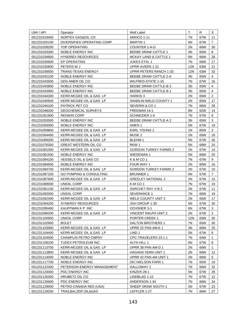
143
UWI / API Operator Well Label T R S
051231019400 NORTEX GAS&OIL CO AMOCO 1-11 7N 67W 11
051231025100 DIVERSIFIED OPERATING CORP MARTIN 1 6N 67W 7
051231028200 TOP OPERATING COUNTER 1-A-D 2N 66W 30
051231033300 NOBLE ENERGY INC BEEBE DRAW CATTLE 1 3N 65W 8
051231034800 HYNDREX RESOURCES MCKAY LAND & CATTLE 1 6N 66W 28
051231035600 EP OPERATING JUKES ETAL 1 7N 66W 17
051231035800 PETERS W J UPRR-AVERS 1-21 12N 63W 21
051231039500 TRANS-TEXAS ENERGY UPRR-PETERS RANCH 1-33 12N 63W 33
051231042100 NOBLE ENERGY INC BEEBE DRAW CATTLE 2-A 3N 65W 4
051231043500 GEN AMER OIL CO WILFRED-STATE 1-16 7N 67W 16
051231043800 NOBLE ENERGY INC BEEBE DRAW CATTLE-B 2 3N 65W 4
051231043900 NOBLE ENERGY INC BEEBE DRAW CATTLE-B 1 3N 65W 4
051231044300 KERR-MCGEE OIL & GAS LP HARKIS 3 2N 65W 2
051231045500 KERR-MCGEE OIL & GAS LP SANDLIN-WELD COUNTY 1 2N 65W 17
051231046100 PATRICK PET CO SEVERIN & CO 1 7N 66W 28
051231048200 GEOCHEMICAL SURVEYS FREEMAN 14-1 8N 62W 14
051231051900 REDWIN CORP SCHNEIDER 1-6 7N 67W 6
051231053500 NOBLE ENERGY INC BEEBE DRAW CATTLE-A 2 3N 65W 3
051231059300 NOBLE ENERGY INC AMEN 1 5N 67W 19
051231059800 KERR-MCGEE OIL & GAS LP EARL YOUNG 1 1N 65W 3
051231064400 KERR-MCGEE OIL & GAS LP MUSE 2 2N 65W 18
051231069200 KERR-MCGEE OIL & GAS LP BLEHM 1 5N 67W 26
051231076300 GREAT WESTERN OIL CO RKW 1 5N 66W 24
051231081000 KERR-MCGEE OIL & GAS LP GORDON TURKEY FARMS 2 2N 67W 10
051231081500 NOBLE ENERGY INC WIEDEMAN 1 5N 66W 20
051231084100 VESSELS OIL & GAS CO K & M CO 1 7N 67W 9
051231084500 NOBLE ENERGY INC FOUR WAY 1 2N 65W 16
051231084700 KERR-MCGEE OIL & GAS LP GORDON TURKEY FARMS 2 2N 67W 10
051231087100 GO PUMPING & CONSULTING BRUNNER 1 6N 67W 7
051231087600 KERR-MCGEE OIL & GAS LP GREELEY NATIONAL 2 2N 67W 15
051231089000 UNIOIL CORP K-M CO 1 7N 67W 19
051231091100 KERR-MCGEE OIL & GAS LP SARCHET RAY V-B 2 2N 67W 11
051231092000 UNIOIL CORP SEVERANCE 1 7N 66W 19
051231092400 KERR-MCGEE OIL & GAS LP WELD COUNTY UNIT 2 2N 65W 17
051231094200 SYNERGY RESOURCES JGH GROUP 1-30 5N 67W 30
051231095400 KAUFFMAN K P INC OCHSNER 3-1 6N 67W 3
051231096200 KERR-MCGEE OIL & GAS LP VINCENT RALPH UNIT 2 2N 67W 2
051231100500 UNIOIL CORP PORTER CREEK 1 12N 63W 35
051231102900 BOLET DALTON BROTHERS 1 7N 65W 30
051231103900 KERR-MCGEE OIL & GAS LP UPRR 22 PAN AM-K 1 3N 66W 25
051231104400 KERR-MCGEE OIL & GAS LP LIND 1 5N 67W 6
051231104500 CHAMPLIN PETRO CMPNY CPC-TRAVELERS 23-1 1 7N 64W 1
051231108100 TUDEX PETROLEUM INC ALFA-HILL 1 6N 67W 6
051231113700 KERR-MCGEE OIL & GAS LP UPRR 38 PAN AM-D 1 2N 66W 1
051231113800 KERR-MCGEE OIL & GAS LP HAGANS VERN UNIT 1 2N 66W 12
051231114000 NOBLE ENERGY INC UPRR 42 PAN AM UNIT 1 2N 66W 5
051231117700 NOBLE ENERGY INC DIC-NIELSON FARR 1 7N 65W 19
051231122300 PETERSON ENERGY MANAGEMENT GALLOWAY 1 7N 66W 32
051231123000 PDC ENERGY INC KINZER 28-1 5N 67W 28
051231126300 HRUBETZ OIL CO LINDBLAD 1-12 7N 67W 12
051231126600 PDC ENERGY INC ANDERSON 1-34 7N 66W 34
051231129000 PETRO-CANADA RES (USA) SHEEP DRAW SOUTH 1 5N 67W 23
051231129200 TRAILBALZER OIL&GAS LEFFLER 1-27 7N 66W 27
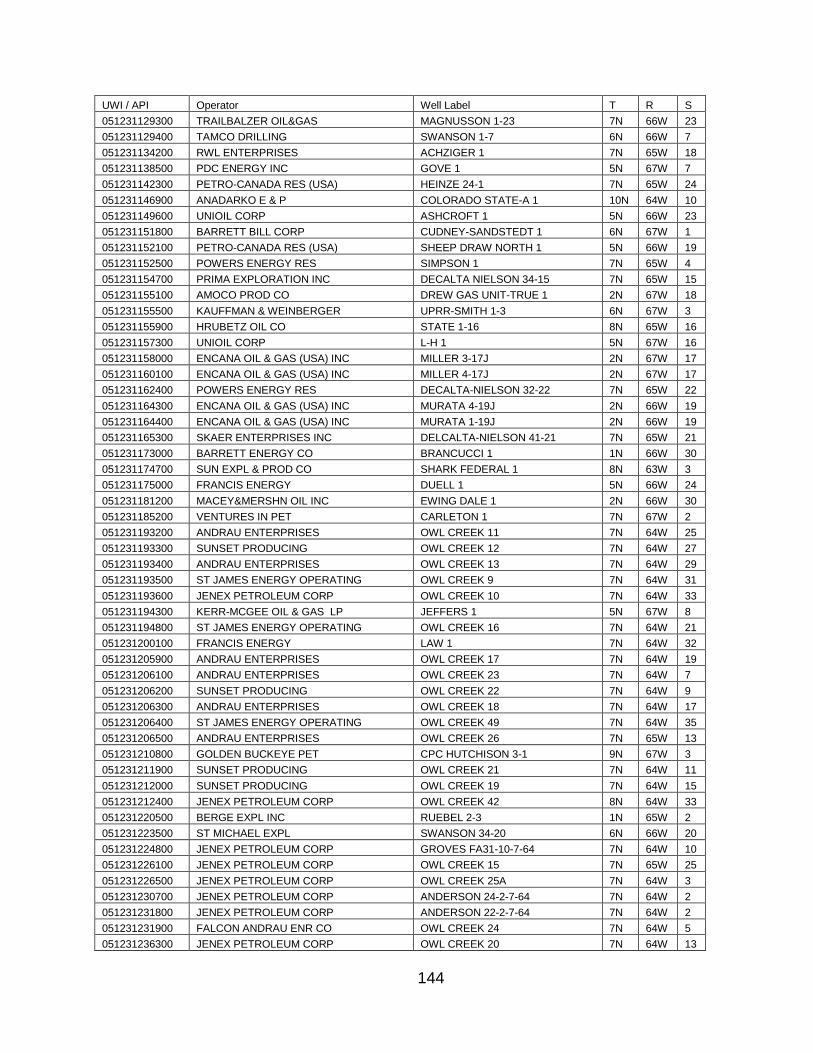
144
UWI / API Operator Well Label T R S
051231129300 TRAILBALZER OIL&GAS MAGNUSSON 1-23 7N 66W 23
051231129400 TAMCO DRILLING SWANSON 1-7 6N 66W 7
051231134200 RWL ENTERPRISES ACHZIGER 1 7N 65W 18
051231138500 PDC ENERGY INC GOVE 1 5N 67W 7
051231142300 PETRO-CANADA RES (USA) HEINZE 24-1 7N 65W 24
051231146900 ANADARKO E & P COLORADO STATE-A 1 10N 64W 10
051231149600 UNIOIL CORP ASHCROFT 1 5N 66W 23
051231151800 BARRETT BILL CORP CUDNEY-SANDSTEDT 1 6N 67W 1
051231152100 PETRO-CANADA RES (USA) SHEEP DRAW NORTH 1 5N 66W 19
051231152500 POWERS ENERGY RES SIMPSON 1 7N 65W 4
051231154700 PRIMA EXPLORATION INC DECALTA NIELSON 34-15 7N 65W 15
051231155100 AMOCO PROD CO DREW GAS UNIT-TRUE 1 2N 67W 18
051231155500 KAUFFMAN & WEINBERGER UPRR-SMITH 1-3 6N 67W 3
051231155900 HRUBETZ OIL CO STATE 1-16 8N 65W 16
051231157300 UNIOIL CORP L-H 1 5N 67W 16
051231158000 ENCANA OIL & GAS (USA) INC MILLER 3-17J 2N 67W 17
051231160100 ENCANA OIL & GAS (USA) INC MILLER 4-17J 2N 67W 17
051231162400 POWERS ENERGY RES DECALTA-NIELSON 32-22 7N 65W 22
051231164300 ENCANA OIL & GAS (USA) INC MURATA 4-19J 2N 66W 19
051231164400 ENCANA OIL & GAS (USA) INC MURATA 1-19J 2N 66W 19
051231165300 SKAER ENTERPRISES INC DELCALTA-NIELSON 41-21 7N 65W 21
051231173000 BARRETT ENERGY CO BRANCUCCI 1 1N 66W 30
051231174700 SUN EXPL & PROD CO SHARK FEDERAL 1 8N 63W 3
051231175000 FRANCIS ENERGY DUELL 1 5N 66W 24
051231181200 MACEY&MERSHN OIL INC EWING DALE 1 2N 66W 30
051231185200 VENTURES IN PET CARLETON 1 7N 67W 2
051231193200 ANDRAU ENTERPRISES OWL CREEK 11 7N 64W 25
051231193300 SUNSET PRODUCING OWL CREEK 12 7N 64W 27
051231193400 ANDRAU ENTERPRISES OWL CREEK 13 7N 64W 29
051231193500 ST JAMES ENERGY OPERATING OWL CREEK 9 7N 64W 31
051231193600 JENEX PETROLEUM CORP OWL CREEK 10 7N 64W 33
051231194300 KERR-MCGEE OIL & GAS LP JEFFERS 1 5N 67W 8
051231194800 ST JAMES ENERGY OPERATING OWL CREEK 16 7N 64W 21
051231200100 FRANCIS ENERGY LAW 1 7N 64W 32
051231205900 ANDRAU ENTERPRISES OWL CREEK 17 7N 64W 19
051231206100 ANDRAU ENTERPRISES OWL CREEK 23 7N 64W 7
051231206200 SUNSET PRODUCING OWL CREEK 22 7N 64W 9
051231206300 ANDRAU ENTERPRISES OWL CREEK 18 7N 64W 17
051231206400 ST JAMES ENERGY OPERATING OWL CREEK 49 7N 64W 35
051231206500 ANDRAU ENTERPRISES OWL CREEK 26 7N 65W 13
051231210800 GOLDEN BUCKEYE PET CPC HUTCHISON 3-1 9N 67W 3
051231211900 SUNSET PRODUCING OWL CREEK 21 7N 64W 11
051231212000 SUNSET PRODUCING OWL CREEK 19 7N 64W 15
051231212400 JENEX PETROLEUM CORP OWL CREEK 42 8N 64W 33
051231220500 BERGE EXPL INC RUEBEL 2-3 1N 65W 2
051231223500 ST MICHAEL EXPL SWANSON 34-20 6N 66W 20
051231224800 JENEX PETROLEUM CORP GROVES FA31-10-7-64 7N 64W 10
051231226100 JENEX PETROLEUM CORP OWL CREEK 15 7N 65W 25
051231226500 JENEX PETROLEUM CORP OWL CREEK 25A 7N 64W 3
051231230700 JENEX PETROLEUM CORP ANDERSON 24-2-7-64 7N 64W 2
051231231800 JENEX PETROLEUM CORP ANDERSON 22-2-7-64 7N 64W 2
051231231900 FALCON ANDRAU ENR CO OWL CREEK 24 7N 64W 5
051231236300 JENEX PETROLEUM CORP OWL CREEK 20 7N 64W 13

145
UWI / API Operator Well Label T R S
051231237500 FALCON ANDRAU ENR CO OWL CREEK 14-A 7N 64W 23
051231243500 JENEX OPERATING CO OWL CREEK 27 7N 65W 1
051231247800 FALCON ANDRAU ENR CO WELD COUNTY FA43-10-7-64 7N 64W 10
051231248600 JENEX PETROLEUM CORP WELD COUNTY 11-12-7-64 7N 64W 12
051231255500 KAUFFMAN K P INC ROLLIE J VINCENT 1 2N 67W 2
051231262200 BRANDLY OILMAN CONS ANDERSON 10-3 6N 66W 10
051231266400 NOBLE ENERGY INC STATE BOOTH 36-2 7N 65W 36
051231270200 ST JAMES ENERGY OPERATING MOODY 1-30 7N 64W 30
051231271800 MACHII-ROSS PETROLEUM MILLER 31-17C 2N 67W 17
051231272000 ENCANA OIL & GAS (USA) INC ARISTOCRAT 42-4C 3N 65W 4
051231307300 KAUFFMAN K P INC STATE 36-2 1N 65W 36
051231307600 TRUE OIL LLC AYARS 13-14 11N 63W 14
051231308800 TRUE OIL LLC WGB FEDERAL 14-26 10N 63W 26
051231309100 TRUE OIL LLC PETERSON FEDERAL 41-22 9N 63W 22
051231365900 ENCANA OIL & GAS (USA) INC ARISTOCRAT ANGUS 22-4 3N 65W 4
051231366100 ENCANA OIL & GAS (USA) INC ARISTOCRAT ANGUS 31-4 3N 65W 4
051231366200 ENCANA OIL & GAS (USA) INC ARISTOCRAT 33-4 3N 65W 4
051231366300 BASIC EARTH SCIENCE SYSTEMS ANTENNA-FEDERAL 22-36 3N 66W 36
051231371600 NOBLE ENERGY INC DANIEL 1 2N 67W 11
051231374900 SANDLIN OIL CORPORAT UPRR RICKETSON 1 1N 65W 1
051231410200 BASIN ENERGY CORPOR DOLPH UPPR 42-1 2N 66W 1
051231424700 NOBLE ENERGY INC DECHANT GU 2-16 2N 67W 16
051231443700 BASIC EARTH SCIENCE SYSTEMS ANTENNA FEDERAL 13-36 3N 66W 36
051231444100 UNITED STATES EXPLORATION HUDSON 1-11 1 1N 65W 11
051231445300 UNION PACIFIC RES CO LUDWIG 1-5 1 3N 65W 5
051231447400 BOSWELL ENERGY CORP K & M 1-10 7N 67W 10
051231447500 UNION PACIFIC RES CO CHINOOK FEDERAL 22-8 1 10N 63W 8
051231454700 UNITED STATES EXPLORATION UPRR 38 PAN AM UT/S 2 2N 65W 7
051231454900 KERR-MCGEE OIL & GAS LP UPRR 38 PAN AM UT/V 2 2N 66W 1
051231461100 TOWER ENERGY CORP KUGEL 1-18 2N 67W 18
051231461900 NORTH AMERICAN RES BANGERT 3-19 2N 66W 19
051231463400 NORTH AMERICAN RES BANGERT 2-19 2N 66W 19
051231464000 TOWER ENERGY CORP DIER 4-8 2N 67W 8
051231464400 BOSWELL ENERGY CORP JONES 1-32 8N 63W 32
051231472400 BOSWELL ENERGY CORP WINDSOR 1-24 7N 67W 24
051231497000 MARTIN EXPLOR MGMT C KNAUB 1-6 3N 65W 6
051231497700 NOBLE ENERGY INC STATE 36-6F 4N 66W 36
051231499800 KERR-MCGEE OIL & GAS LP HSR-J T 10-6 3N 65W 6
051231510400 NOBLE ENERGY INC POTTS X 18-15 2N 65W 18
051231528200 NORTH AMERICAN KUGEL 2-18 2N 67W 18
051231531500 KERR-MCGEE OIL & GAS LP ALFRED D SATER UNIT 2 2N 67W 8
051231531600 KERR-MCGEE OIL & GAS LP UNIT A GAS UNIT 2 2N 67W 16
051231533100 NOBLE ENERGY INC KUGEL K4-6 2N 66W 4
051231537300 NOBLE ENERGY INC KUGEL L4-4 2N 66W 4
051231547400 ENCANA OIL & GAS (USA) INC ECHEVERRIA 1-2 2N 67W 2
051231550700 KERR-MCGEE OIL & GAS LP HSR-AUSTIN 16-26 4N 66W 26
051231562100 KERR-MCGEE OIL & GAS LP WATTENBERG SWD 1 2N 66W 19
051231563700 NOBLE ENERGY INC UPRC 9-4J 3N 65W 9
051231563900 NOBLE ENERGY INC UPRC 9-6J 3N 65W 9
051231564000 NOBLE ENERGY INC UPRC 9-11J 3N 65W 9
051231575700 NOBLE ENERGY INC REHDER X6-3D 2N 65W 6
051231576900 NOBLE ENERGY INC OPATRIL 12-15L 3N 67W 12
051231582100 KERR-MCGEE OIL & GAS LP LINCOLN 3 2N 67W 18

146
UWI / API Operator Well Label T R S
051231593700 NOBLE ENERGY INC UPRC 9-6J-2 3N 65W 9
051231594700 KERR-MCGEE OIL & GAS LP BARCLAY 44-14 2N 67W 14
051231609400 BASIN OPERATING CO BEEBE DRAW 41-5 3N 65W 5
051231612300 KERR-MCGEE OIL & GAS LP BEEBE DRAW 41-9 3N 65W 9
051231623500 KERR-MCGEE OIL & GAS LP GORDON RED V10-4D 2N 67W 10
051231626300 KERR-MCGEE OIL & GAS LP HSR-MONTALI 14-33 4N 65W 33
051231638000 NOBLE ENERGY INC MARSHALL 32-14G 4N 65W 32
051231638800 GERRITY O&G CORP HARRIS RED X19-2J 2N 65W 19
051231639200 NOBLE ENERGY INC RANDLE RED XX3-2D 1N 65W 3
051231640900 ENCANA OIL & GAS (USA) INC ARISTOCRAT ANGUS 11-3 3N 65W 3
051231644900 ENCANA OIL & GAS (USA) INC ARISTOCRAT ANGUS 13-4 3N 65W 4
051231645000 ENCANA OIL & GAS (USA) INC ARISTOCRAT ANGUS 31-8 3N 65W 8
051231650300 UNION PACIFIC RES CO BROZOVICH 3-4 1 1N 68W 4
051231650500 NOBLE ENERGY INC MAGNESS RED W6-2D 2N 66W 6
051231657200 ENCANA OIL & GAS (USA) INC ARISTOCRAT ANGUS 23-4 3N 65W 4
051231657400 ENCANA OIL & GAS (USA) INC ARISTOCRAT ANGUS 21-4 3N 65W 4
051231657500 ENCANA OIL & GAS (USA) INC ARISTOCRAT ANGUS 12-3 3N 65W 3
051231658200 ENCANA OIL & GAS (USA) INC ARISTOCRAT ANGUS 22-8 3N 65W 8
051231658300 ENCANA OIL & GAS (USA) INC ARISTOCRAT ANGUS 21-8 3N 65W 8
051231662000 KERR-MCGEE OIL & GAS LP GORDON FARMS 21-15 2N 67W 15
051231664300 GERRITY O&G CORP WATADA RED WW19-4D 1N 66W 19
051231664500 NORTH AMERICAN RES BARCLAY-CHRISMAN 4-20 3N 66W 20
051231664700 NORTH AMERICAN RES MILLER 2-17 2N 67W 17
051231667500 KERR-MCGEE OIL & GAS LP HSR-KOCH 16-32 4N 65W 32
051231676900 ELK EXPL INC HSR MARLEY 15-33 4N 65W 33
051231679800 KERR-MCGEE OIL & GAS LP HSR-ROGERS 3-5 3N 65W 5
051231682800 NOBLE ENERGY INC DANIEL V11-9 2N 67W 11
051231690400 NOBLE ENERGY INC HEIN W19-5 2N 66W 19
051231690700 NOBLE ENERGY INC HEIN W19-12 2N 66W 19
051231691300 ENCANA OIL & GAS (USA) INC FEDERAL 11-10 3N 65W 10
051231691700 KERR-MCGEE OIL & GAS LP HSR-SAMUELSEN 3-24 3N 66W 24
051231703900 NOBLE ENERGY INC BB DRAW H8-9 3N 65W 8
051231707000 ENCANA OIL & GAS (USA) INC ARISTOCRAT ANGUS 42-8 3N 65W 8
051231713600 ENCANA OIL & GAS (USA) INC FEDERAL 12-10 3N 65W 10
051231719800 KERR-MCGEE OIL & GAS LP HSR-PAGE 10-5 3N 65W 5
051231730400 KERR-MCGEE OIL & GAS LP HSR-OBORNE 9-5 3N 65W 5
051231730600 KERR-MCGEE OIL & GAS LP HSR-RAFALOVICH 14-5 3N 65W 5
051231730800 KERR-MCGEE OIL & GAS LP HSR-GOODNOW 16-5 3N 65W 5
051231733000 KERR-MCGEE OIL & GAS LP HSR-NILAND 6-5 3N 65W 5
051231735000 ELK EXPL INC HSR-MORTON 9-9 3N 65W 9
051231760600 KERR-MCGEE OIL & GAS LP HSR-HOUSTON 13-34 4N 65W 34
051231765400 NOBLE ENERGY INC CANNON RED W3-12 2N 66W 3
051231767400 PRIMA OIL & GAS CO WARDLAW 35-23 6N 64W 35
051231795400 ENCANA OIL & GAS (USA) INC MELBON RANCH E UNIT 1 2N 65W 17
051231817700 KERR-MCGEE OIL & GAS LP BOYD 43-5 1N 65W 5
051231913100 KERR-MCGEE OIL & GAS LP SAM FUNAKOSHI GAS UN 2 2N 67W 36
051231917500 KERR-MCGEE OIL & GAS LP DONALD VYNCKIER GAS 2 2N 66W 31
051231934800 BONANZA CRK OPER FEURSTEIN 44-29 6N 66W 29
051231954200 NORTH AMERICAN RES IONE 23-2 2N 66W 2
051231954300 NORTH AMERICAN RES IONE 13-4 2N 66W 4
051231954400 NORTH AMERICAN RES BARCLAY CRISMAN 24-20 3N 66W 20
051231955600 HS RESOURCES INC HSR-WATADA 11-18A 1N 66W 18
051231955700 HS RESOURCES INC HSR-BALDWIN 5-11A 2N 65W 11
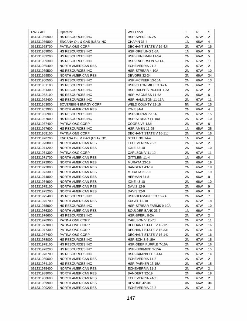
147
UWI / API Operator Well Label T R S
051231955900 HS RESOURCES INC HSR-SPERL 16-2A 2N 67W 2
051231956800 ENCANA OIL & GAS (USA) INC CHAPIN 33-4 1N 65W 4
051231958700 PATINA O&G CORP DECHANT STATE V 16-4JI 2N 67W 16
051231959000 HS RESOURCES INC HSR-DREILING 1-5A 1N 65W 5
051231959200 HS RESOURCES INC HSR-KUNZMAN 11-5A 2N 66W 5
051231959300 HS RESOURCES INC HSR-ENDERSON 5-11A 2N 67W 11
051231959400 NORTH AMERICAN RES ECHEVERRIA 21-2 2N 67W 2
051231959500 HS RESOURCES INC HSR-STREAR 4-10A 2N 67W 10
051231959800 NORTH AMERICAN RES DEVORE 32-34 3N 66W 34
051231960500 HS RESOURCES INC HSR-MCPEEK 13-10A 2N 66W 10
051231961100 HS RESOURCES INC HSR-ELTON MILLER 3-7A 2N 66W 7
051231961300 HS RESOURCES INC HSR-RALPH VINCENT 1-2A 2N 67W 2
051231962100 HS RESOURCES INC HSR-MAGNESS 11-6A 2N 66W 6
051231962400 HS RESOURCES INC HSR-HAMILTON 11-11A 2N 67W 11
051231963000 SOVEREIGN ENRGY CORP WELD COUNTY 22-15 5N 61W 15
051231963900 NORTH AMERICAN RES IONE 34-4 2N 66W 4
051231966900 HS RESOURCES INC HSR-DURAN 7-15A 2N 67W 15
051231967000 HS RESOURCES INC HSR-STREAR 11-10A 2N 67W 10
051231967400 PATINA O&G CORP COORS V6-13JI 2N 67W 6
051231967600 HS RESOURCES INC HSR-AMEN 11-25 1N 65W 25
051231968100 PATINA O&G CORP DECHANT STATE V 16-11JI 2N 67W 16
051231970700 ENCANA OIL & GAS (USA) INC STELLING 14-4 1N 65W 4
051231970800 NORTH AMERICAN RES ECHEVERRIA 23-2 2N 67W 2
051231971200 NORTH AMERICAN RES IONE 32-10 2N 66W 10
051231971300 PATINA O&G CORP CARLSON V 11-1JI 2N 67W 11
051231971700 NORTH AMERICAN RES GITTLEIN 11-4 1N 65W 4
051231972900 NORTH AMERICAN RES MURATA 23-19 2N 66W 19
051231973000 NORTH AMERICAN RES BANGERT 43-19 2N 66W 19
051231973300 NORTH AMERICAN RES MURATA 21-19 2N 66W 19
051231974800 NORTH AMERICAN RES HERMAN 34-8 2N 66W 8
051231974900 NORTH AMERICAN RES IONE 43-10 2N 66W 10
051231975100 NORTH AMERICAN RES DAVIS 12-9 2N 66W 9
051231975200 NORTH AMERICAN RES DAVIS 32-9 2N 66W 9
051231975400 HS RESOURCES INC HSR-HERMAN FED 15-7A 2N 66W 7
051231975700 NORTH AMERICAN RES KUGEL 12-18 2N 67W 18
051231975900 HS RESOURCES INC HSR-STREAR FARMS 9-10A 2N 67W 10
051231976300 NORTH AMERICAN RES BOULDER BANK 23-7 1N 66W 7
051231976600 HS RESOURCES INC HSR-SPERL 9-2A 2N 67W 2
051231976900 PATINA O&G CORP CARLSON V 11-7JI 2N 67W 11
051231977000 PATINA O&G CORP DECHANT STATE V 16-12JI 2N 67W 16
051231977300 PATINA O&G CORP DECHANT STATE V 16-3JI 2N 67W 16
051231977400 PATINA O&G CORP DECHANT STATE V 16-14JI 2N 67W 16
051231978000 HS RESOURCES INC HSR-SCHIS 5-15A 2N 67W 15
051231978100 HS RESOURCES INC HSR-DEEP PURPLE 7-16A 2N 67W 16
051231978200 HS RESOURCES INC HSR-KIRKMIDD 9-15A 2N 67W 15
051231978700 HS RESOURCES INC HSR-CAMPBELL 1-14A 2N 67W 14
051231980000 NORTH AMERICAN RES ECHEVERRIA 14-2 2N 67W 2
051231984100 HS RESOURCES INC HSR-PARKER 13-15A 2N 67W 15
051231985400 NORTH AMERICAN RES ECHEVERRIA 11-2 2N 67W 2
051231988000 NORTH AMERICAN RES BANGERT 32-19 2N 66W 19
051231988600 NORTH AMERICAN RES ECHEVERRIA 24-2 2N 67W 2
051231989900 NORTH AMERICAN RES DEVORE 42-34 3N 66W 34
051231990200 NORTH AMERICAN RES ECHEVERRIA 22-2 2N 67W 2

148
UWI / API Operator Well Label T R S
051231991900 NORTH AMERICAN RES DIER 44-8 2N 67W 8
051231993000 NORTH AMERICAN RES EWING 33-30 2N 66W 30
051231993600 NORTH AMERICAN RES DEVORE 31-34 3N 66W 34
051231994300 NORTH AMERICAN RES ECHEVERRIA 13-2 2N 67W 2
051231995700 NORTH AMERICAN RES IONE 44-10 2N 66W 10
051231996000 HS RESOURCES INC HSR-STREAR 14-10A 2N 67W 10
051231997000 NORTH AMERICAN RES IONE 32-2 2N 66W 2
051231997600 HS RESOURCES INC HSR-STREAR 7-10A 2N 67W 10
051231998600 NORTH AMERICAN RES IONE 43-4 2N 66W 4
051232000300 PATINA O&G CORP DECHANT STATE V 16-5JI 2N 67W 16
051232001300 PANCAN ENERG RES INC FOUR WAY 12-16 2N 65W 16
051232002600 HS RESOURCES INC HSR-PARKER 1-16A 2N 67W 16
051232004800 NORTH AMERICAN RES IONE 22-2 2N 66W 2
051232005000 NORTH AMERICAN RES IONE 14-4 2N 66W 4
051232005200 NORTH AMERICAN RES IONE 33-2 2N 66W 2
051232007900 PATINA O&G CORP CARLSON V 11-8JI 2N 67W 11
051232010100 HS RESOURCES INC HSR-SATER 1-8A 2N 67W 8
051232015100 NORTH AMERICAN RES IONE 44-4 2N 66W 4
051232015200 NORTH AMERICAN RES BANGERT 44-19 2N 66W 19
051232018800 NORTH AMERICAN RES LUHMAN 44-4 2N 67W 4
051232018900 NORTH AMERICAN RES IONE 24-4 2N 66W 4
051232021100 NORTH AMERICAN RES ECHEVERRIA 12-2 2N 67W 2
051232030700 NORTH AMERICAN RES KUGEL 42-18 2N 67W 18
051232031000 HS RESOURCES INC HSR-ENDERSON 4-11A 2N 67W 11
051232031400 KERR-MCGEE OIL & GAS LP HSR- WITTEMEYER 2-2 2N 67W 2
051232033600 HS RESOURCES INC HSR-PARKER 15-16A 2N 67W 16
051232034900 HS RESOURCES INC HSR-STREAR 12-10A 2N 67W 10
051232045400 KERR-MCGEE OIL & GAS LP HSR-FRENCH 2-6 2N 67W 6
051232049800 NORTH AMERICAN RES DAVIS 31-9 2N 66W 9
051232050700 HS RESOURCES INC HSR-WITTEMEYER 8-2A 2N 67W 2
051232050900 NORTH AMERICAN RES KUGEL 11-18 2N 67W 18
051232051000 KERR-MCGEE OIL & GAS LP HSR-PARKER 16-15A 2N 67W 15
051232052600 NORTH AMERICAN RES KUGEL 22-18 2N 67W 18
051232052700 NORTH AMERICAN RES KUGEL 21-18 2N 67W 18
051232052800 NORTH AMERICAN RES KUGEL 41-18 2N 67W 18
051232053400 KERR-MCGEE OIL & GAS LP HSR-STREAR 2-15 2N 67W 15
051232055700 HS RESOURCES INC HSR-GARDNER 13-11 2N 67W 11
051232056000 STHWSTRN PROD CORP KINZER 28-2 5N 67W 28
051232057000 KERR-MCGEE OIL & GAS LP HSR-BARCLAY 10-14A 2N 67W 14
051232057100 RED WILLOW PROD LLC PARK 43-4 4N 63W 4
051232059100 PANCAN ENERG RES INC STELLING 23-4 1N 65W 4
051232060000 NORTH AMERICAN RES BARNES 34-4 2N 67W 4
051232060100 PANCAN ENERG RES INC MURATA 24-19 2N 66W 19
051232061500 ENCANA OIL & GAS (USA) INC IONE 23-4 2N 66W 4
051232062300 PANCAN ENERG RES INC DAVIS 41-9 2N 66W 10
051232062600 KERR-MCGEE OIL & GAS LP HOOD 2-14 2N 67W 14
051232063700 PANCAN ENERG RES INC DIER J 1-A 2N 67W 8
051232065200 PANCAN ENERG RES INC DIER 13-8 2N 67W 8
051232072500 PANCAN ENERG RES INC MILLER 24-17J 2N 67W 17
051232074700 PANCAN ENERG RES INC MILLER 21-17 2N 67W 17
051232077000 PANCAN ENERG RES INC MILLER 11-17 2N 67W 17
051232077500 ENCANA OIL & GAS (USA) INC MILLER 22-17 2N 67W 17
051232082100 BONANZA CRK OPER 70 RANCH 21-3 4N 63W 3
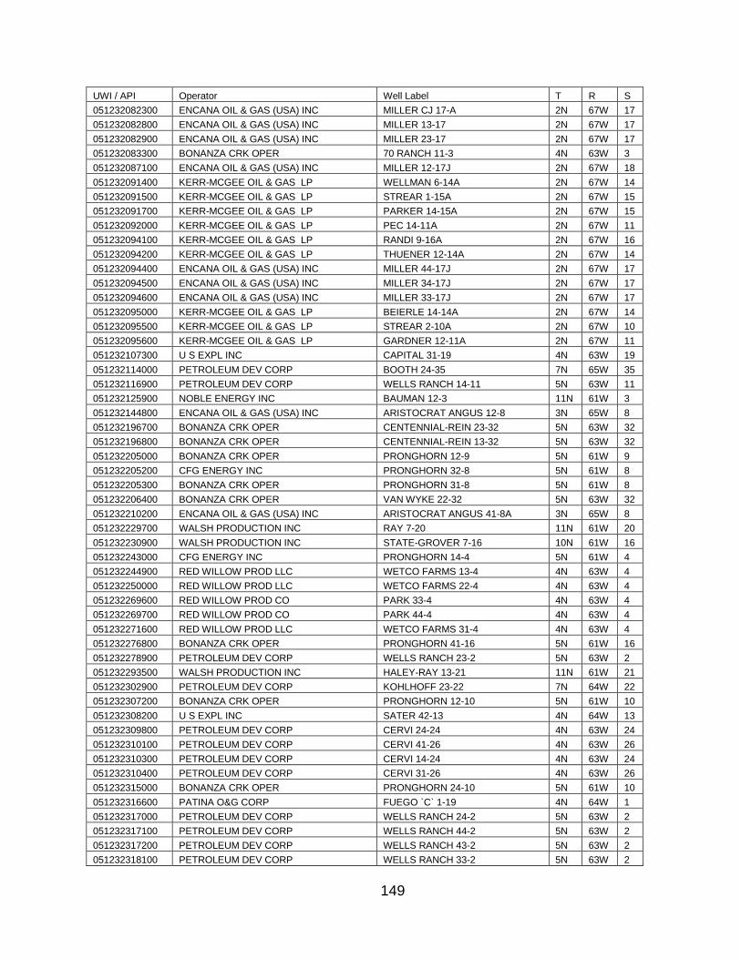
149
UWI / API Operator Well Label T R S
051232082300 ENCANA OIL & GAS (USA) INC MILLER CJ 17-A 2N 67W 17
051232082800 ENCANA OIL & GAS (USA) INC MILLER 13-17 2N 67W 17
051232082900 ENCANA OIL & GAS (USA) INC MILLER 23-17 2N 67W 17
051232083300 BONANZA CRK OPER 70 RANCH 11-3 4N 63W 3
051232087100 ENCANA OIL & GAS (USA) INC MILLER 12-17J 2N 67W 18
051232091400 KERR-MCGEE OIL & GAS LP WELLMAN 6-14A 2N 67W 14
051232091500 KERR-MCGEE OIL & GAS LP STREAR 1-15A 2N 67W 15
051232091700 KERR-MCGEE OIL & GAS LP PARKER 14-15A 2N 67W 15
051232092000 KERR-MCGEE OIL & GAS LP PEC 14-11A 2N 67W 11
051232094100 KERR-MCGEE OIL & GAS LP RANDI 9-16A 2N 67W 16
051232094200 KERR-MCGEE OIL & GAS LP THUENER 12-14A 2N 67W 14
051232094400 ENCANA OIL & GAS (USA) INC MILLER 44-17J 2N 67W 17
051232094500 ENCANA OIL & GAS (USA) INC MILLER 34-17J 2N 67W 17
051232094600 ENCANA OIL & GAS (USA) INC MILLER 33-17J 2N 67W 17
051232095000 KERR-MCGEE OIL & GAS LP BEIERLE 14-14A 2N 67W 14
051232095500 KERR-MCGEE OIL & GAS LP STREAR 2-10A 2N 67W 10
051232095600 KERR-MCGEE OIL & GAS LP GARDNER 12-11A 2N 67W 11
051232107300 U S EXPL INC CAPITAL 31-19 4N 63W 19
051232114000 PETROLEUM DEV CORP BOOTH 24-35 7N 65W 35
051232116900 PETROLEUM DEV CORP WELLS RANCH 14-11 5N 63W 11
051232125900 NOBLE ENERGY INC BAUMAN 12-3 11N 61W 3
051232144800 ENCANA OIL & GAS (USA) INC ARISTOCRAT ANGUS 12-8 3N 65W 8
051232196700 BONANZA CRK OPER CENTENNIAL-REIN 23-32 5N 63W 32
051232196800 BONANZA CRK OPER CENTENNIAL-REIN 13-32 5N 63W 32
051232205000 BONANZA CRK OPER PRONGHORN 12-9 5N 61W 9
051232205200 CFG ENERGY INC PRONGHORN 32-8 5N 61W 8
051232205300 BONANZA CRK OPER PRONGHORN 31-8 5N 61W 8
051232206400 BONANZA CRK OPER VAN WYKE 22-32 5N 63W 32
051232210200 ENCANA OIL & GAS (USA) INC ARISTOCRAT ANGUS 41-8A 3N 65W 8
051232229700 WALSH PRODUCTION INC RAY 7-20 11N 61W 20
051232230900 WALSH PRODUCTION INC STATE-GROVER 7-16 10N 61W 16
051232243000 CFG ENERGY INC PRONGHORN 14-4 5N 61W 4
051232244900 RED WILLOW PROD LLC WETCO FARMS 13-4 4N 63W 4
051232250000 RED WILLOW PROD LLC WETCO FARMS 22-4 4N 63W 4
051232269600 RED WILLOW PROD CO PARK 33-4 4N 63W 4
051232269700 RED WILLOW PROD CO PARK 44-4 4N 63W 4
051232271600 RED WILLOW PROD LLC WETCO FARMS 31-4 4N 63W 4
051232276800 BONANZA CRK OPER PRONGHORN 41-16 5N 61W 16
051232278900 PETROLEUM DEV CORP WELLS RANCH 23-2 5N 63W 2
051232293500 WALSH PRODUCTION INC HALEY-RAY 13-21 11N 61W 21
051232302900 PETROLEUM DEV CORP KOHLHOFF 23-22 7N 64W 22
051232307200 BONANZA CRK OPER PRONGHORN 12-10 5N 61W 10
051232308200 U S EXPL INC SATER 42-13 4N 64W 13
051232309800 PETROLEUM DEV CORP CERVI 24-24 4N 63W 24
051232310100 PETROLEUM DEV CORP CERVI 41-26 4N 63W 26
051232310300 PETROLEUM DEV CORP CERVI 14-24 4N 63W 24
051232310400 PETROLEUM DEV CORP CERVI 31-26 4N 63W 26
051232315000 BONANZA CRK OPER PRONGHORN 24-10 5N 61W 10
051232316600 PATINA O&G CORP FUEGO `C` 1-19 4N 64W 1
051232317000 PETROLEUM DEV CORP WELLS RANCH 24-2 5N 63W 2
051232317100 PETROLEUM DEV CORP WELLS RANCH 44-2 5N 63W 2
051232317200 PETROLEUM DEV CORP WELLS RANCH 43-2 5N 63W 2
051232318100 PETROLEUM DEV CORP WELLS RANCH 33-2 5N 63W 2
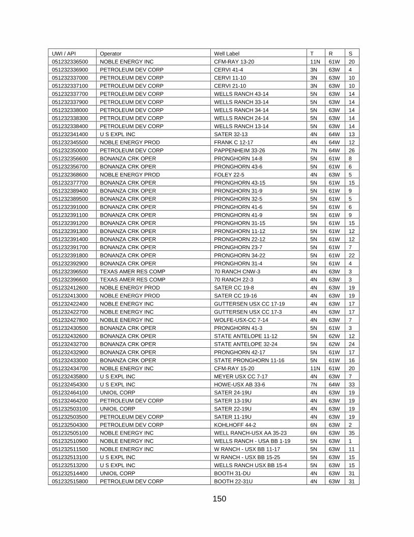
150
UWI / API Operator Well Label T R S
051232336500 NOBLE ENERGY INC CFM-RAY 13-20 11N 61W 20
051232336900 PETROLEUM DEV CORP CERVI 41-4 3N 63W 4
051232337000 PETROLEUM DEV CORP CERVI 11-10 3N 63W 10
051232337100 PETROLEUM DEV CORP CERVI 21-10 3N 63W 10
051232337700 PETROLEUM DEV CORP WELLS RANCH 43-14 5N 63W 14
051232337900 PETROLEUM DEV CORP WELLS RANCH 33-14 5N 63W 14
051232338000 PETROLEUM DEV CORP WELLS RANCH 34-14 5N 63W 14
051232338300 PETROLEUM DEV CORP WELLS RANCH 24-14 5N 63W 14
051232338400 PETROLEUM DEV CORP WELLS RANCH 13-14 5N 63W 14
051232341400 U S EXPL INC SATER 32-13 4N 64W 13
051232345500 NOBLE ENERGY PROD FRANK C 12-17 4N 64W 12
051232350000 PETROLEUM DEV CORP PAPPENHEIM 33-26 7N 64W 26
051232356600 BONANZA CRK OPER PRONGHORN 14-8 5N 61W 8
051232356700 BONANZA CRK OPER PRONGHORN 43-6 5N 61W 6
051232368600 NOBLE ENERGY PROD FOLEY 22-5 4N 63W 5
051232377700 BONANZA CRK OPER PRONGHORN 43-15 5N 61W 15
051232389400 BONANZA CRK OPER PRONGHORN 31-9 5N 61W 9
051232389500 BONANZA CRK OPER PRONGHORN 32-5 5N 61W 5
051232391000 BONANZA CRK OPER PRONGHORN 41-6 5N 61W 6
051232391100 BONANZA CRK OPER PRONGHORN 41-9 5N 61W 9
051232391200 BONANZA CRK OPER PRONGHORN 31-15 5N 61W 15
051232391300 BONANZA CRK OPER PRONGHORN 11-12 5N 61W 12
051232391400 BONANZA CRK OPER PRONGHORN 22-12 5N 61W 12
051232391700 BONANZA CRK OPER PRONGHORN 23-7 5N 61W 7
051232391800 BONANZA CRK OPER PRONGHORN 34-22 5N 61W 22
051232392900 BONANZA CRK OPER PRONGHORN 31-4 5N 61W 4
051232396500 TEXAS AMER RES COMP 70 RANCH CNW-3 4N 63W 3
051232396600 TEXAS AMER RES COMP 70 RANCH 22-3 4N 63W 3
051232412600 NOBLE ENERGY PROD SATER CC 19-8 4N 63W 19
051232413000 NOBLE ENERGY PROD SATER CC 19-16 4N 63W 19
051232422400 NOBLE ENERGY INC GUTTERSEN USX CC 17-19 4N 63W 17
051232422700 NOBLE ENERGY INC GUTTERSEN USX CC 17-3 4N 63W 17
051232427800 NOBLE ENERGY INC WOLFE-USX-CC 7-14 4N 63W 7
051232430500 BONANZA CRK OPER PRONGHORN 41-3 5N 61W 3
051232432600 BONANZA CRK OPER STATE ANTELOPE 11-12 5N 62W 12
051232432700 BONANZA CRK OPER STATE ANTELOPE 32-24 5N 62W 24
051232432900 BONANZA CRK OPER PRONGHORN 42-17 5N 61W 17
051232433000 BONANZA CRK OPER STATE PRONGHORN 11-16 5N 61W 16
051232434700 NOBLE ENERGY INC CFM-RAY 15-20 11N 61W 20
051232435800 U S EXPL INC MEYER USX CC 7-17 4N 63W 7
051232454300 U S EXPL INC HOWE-USX AB 33-6 7N 64W 33
051232464100 UNIOIL CORP SATER 24-19U 4N 63W 19
051232464200 PETROLEUM DEV CORP SATER 13-19U 4N 63W 19
051232503100 UNIOIL CORP SATER 22-19U 4N 63W 19
051232503500 PETROLEUM DEV CORP SATER 11-19U 4N 63W 19
051232504300 PETROLEUM DEV CORP KOHLHOFF 44-2 6N 63W 2
051232505100 NOBLE ENERGY INC WELL RANCH-USX AA 35-23 6N 63W 35
051232510900 NOBLE ENERGY INC WELLS RANCH - USA BB 1-19 5N 63W 1
051232511500 NOBLE ENERGY INC W RANCH - USX BB 11-17 5N 63W 11
051232513100 U S EXPL INC W RANCH - USX BB 15-25 5N 63W 15
051232513200 U S EXPL INC WELLS RANCH USX BB 15-4 5N 63W 15
051232514400 UNIOIL CORP BOOTH 31-DU 4N 63W 31
051232515800 PETROLEUM DEV CORP BOOTH 22-31U 4N 63W 31
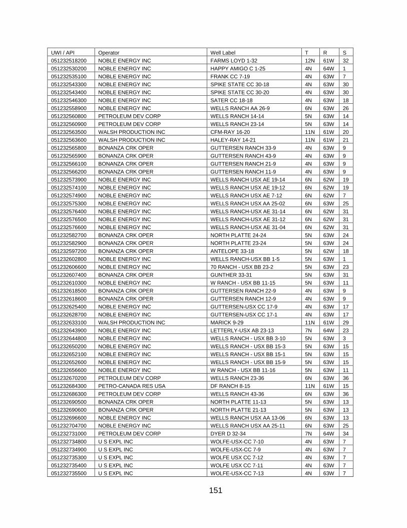
151
UWI / API Operator Well Label T R S
051232518200 NOBLE ENERGY INC FARMS LOYD 1-32 12N 61W 32
051232530200 NOBLE ENERGY INC HAPPY AMIGO C 1-25 4N 64W 1
051232535100 NOBLE ENERGY INC FRANK CC 7-19 4N 63W 7
051232543300 NOBLE ENERGY INC SPIKE STATE CC 30-18 4N 63W 30
051232543400 NOBLE ENERGY INC SPIKE STATE CC 30-20 4N 63W 30
051232546300 NOBLE ENERGY INC SATER CC 18-18 4N 63W 18
051232558900 NOBLE ENERGY INC WELLS RANCH AA 26-9 6N 63W 26
051232560800 PETROLEUM DEV CORP WELLS RANCH 14-14 5N 63W 14
051232560900 PETROLEUM DEV CORP WELLS RANCH 23-14 5N 63W 14
051232563500 WALSH PRODUCTION INC CFM-RAY 16-20 11N 61W 20
051232563600 WALSH PRODUCTION INC HALEY-RAY 14-21 11N 61W 21
051232565800 BONANZA CRK OPER GUTTERSEN RANCH 33-9 4N 63W 9
051232565900 BONANZA CRK OPER GUTTERSEN RANCH 43-9 4N 63W 9
051232566100 BONANZA CRK OPER GUTTERSEN RANCH 21-9 4N 63W 9
051232566200 BONANZA CRK OPER GUTTERSEN RANCH 11-9 4N 63W 9
051232573900 NOBLE ENERGY INC WELLS RANCH USX AE 19-14 6N 62W 19
051232574100 NOBLE ENERGY INC WELLS RANCH USX AE 19-12 6N 62W 19
051232574900 NOBLE ENERGY INC WELLS RANCH USX AE 7-12 6N 62W 7
051232575300 NOBLE ENERGY INC WELLS RANCH USX AA 25-02 6N 63W 25
051232576400 NOBLE ENERGY INC WELLS RANCH-USX AE 31-14 6N 62W 31
051232576500 NOBLE ENERGY INC WELLS RANCH-USX AE 31-12 6N 62W 31
051232576600 NOBLE ENERGY INC WELLS RANCH-USX AE 31-04 6N 62W 31
051232582700 BONANZA CRK OPER NORTH PLATTE 24-24 5N 63W 24
051232582900 BONANZA CRK OPER NORTH PLATTE 23-24 5N 63W 24
051232597200 BONANZA CRK OPER ANTELOPE 33-18 5N 62W 18
051232602800 NOBLE ENERGY INC WELLS RANCH-USX BB 1-5 5N 63W 1
051232606600 NOBLE ENERGY INC 70 RANCH - USX BB 23-2 5N 63W 23
051232607400 BONANZA CRK OPER GUNTHER 33-31 5N 63W 31
051232610300 NOBLE ENERGY INC W RANCH - USX BB 11-15 5N 63W 11
051232618500 BONANZA CRK OPER GUTTERSEN RANCH 22-9 4N 63W 9
051232618600 BONANZA CRK OPER GUTTERSEN RANCH 12-9 4N 63W 9
051232625400 NOBLE ENERGY INC GUTTERSEN-USX CC 17-9 4N 63W 17
051232628700 NOBLE ENERGY INC GUTTERSEN-USX CC 17-1 4N 63W 17
051232633100 WALSH PRODUCTION INC MARICK 9-29 11N 61W 29
051232643900 NOBLE ENERGY INC LETTERLY-USX AB 23-13 7N 64W 23
051232644800 NOBLE ENERGY INC WELLS RANCH - USX BB 3-10 5N 63W 3
051232650200 NOBLE ENERGY INC WELLS RANCH - USX BB 15-3 5N 63W 15
051232652100 NOBLE ENERGY INC WELLS RANCH - USX BB 15-1 5N 63W 15
051232652600 NOBLE ENERGY INC WELLS RANCH - USX BB 15-9 5N 63W 15
051232656600 NOBLE ENERGY INC W RANCH - USX BB 11-16 5N 63W 11
051232670200 PETROLEUM DEV CORP WELLS RANCH 23-36 6N 63W 36
051232684300 PETRO-CANADA RES USA DF RANCH 8-15 11N 61W 15
051232686300 PETROLEUM DEV CORP WELLS RANCH 43-36 6N 63W 36
051232690500 BONANZA CRK OPER NORTH PLATTE 11-13 5N 63W 13
051232690600 BONANZA CRK OPER NORTH PLATTE 21-13 5N 63W 13
051232696600 NOBLE ENERGY INC WELLS RANCH USX AA 13-06 6N 63W 13
051232704700 NOBLE ENERGY INC WELLS RANCH USX AA 25-11 6N 63W 25
051232731000 PETROLEUM DEV CORP DYER D 32-34 7N 64W 34
051232734800 U S EXPL INC WOLFE-USX-CC 7-10 4N 63W 7
051232734900 U S EXPL INC WOLFE-USX-CC 7-9 4N 63W 7
051232735300 U S EXPL INC WOLFE USX CC 7-12 4N 63W 7
051232735400 U S EXPL INC WOLFE USX CC 7-11 4N 63W 7
051232735500 U S EXPL INC WOLFE-USX-CC 7-13 4N 63W 7
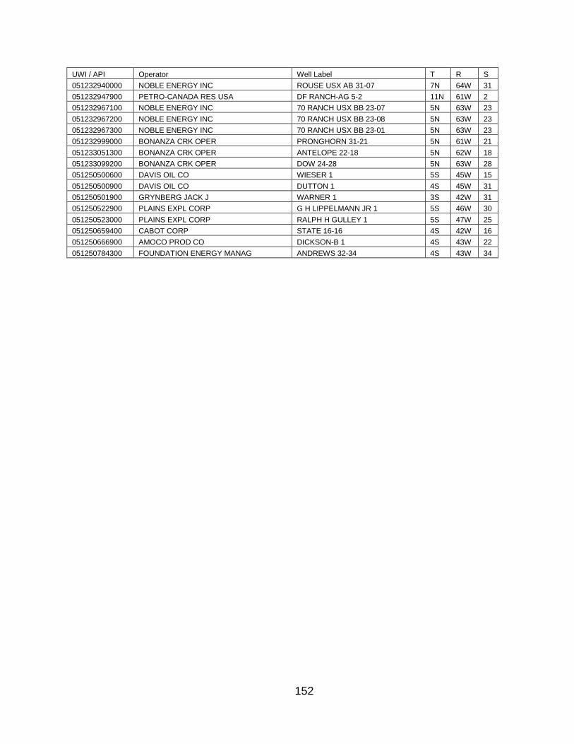
152
UWI / API Operator Well Label T R S
051232940000 NOBLE ENERGY INC ROUSE USX AB 31-07 7N 64W 31
051232947900 PETRO-CANADA RES USA DF RANCH-AG 5-2 11N 61W 2
051232967100 NOBLE ENERGY INC 70 RANCH USX BB 23-07 5N 63W 23
051232967200 NOBLE ENERGY INC 70 RANCH USX BB 23-08 5N 63W 23
051232967300 NOBLE ENERGY INC 70 RANCH USX BB 23-01 5N 63W 23
051232999000 BONANZA CRK OPER PRONGHORN 31-21 5N 61W 21
051233051300 BONANZA CRK OPER ANTELOPE 22-18 5N 62W 18
051233099200 BONANZA CRK OPER DOW 24-28 5N 63W 28
051250500600 DAVIS OIL CO WIESER 1 5S 45W 15
051250500900 DAVIS OIL CO DUTTON 1 4S 45W 31
051250501900 GRYNBERG JACK J WARNER 1 3S 42W 31
051250522900 PLAINS EXPL CORP G H LIPPELMANN JR 1 5S 46W 30
051250523000 PLAINS EXPL CORP RALPH H GULLEY 1 5S 47W 25
051250659400 CABOT CORP STATE 16-16 4S 42W 16
051250666900 AMOCO PROD CO DICKSON-B 1 4S 43W 22
051250784300 FOUNDATION ENERGY MANAG ANDREWS 32-34 4S 43W 34

153
APPENDIX C: STRATIGRAPHIC PICKS
UWI / API HARTLAND BCLS_1 FAIRPORT LBHS B_CDL_SS CDL_SS FH_MKR_1 NBR_MRK_2
PORTLAND 1 486 430 369 337 276 259 207 178
050010505000 8113
050010509800 8140
050010542900 8429
050010620200 7526
050010631100 7782
050010631200 8135
050010637400 7634
050010638300 7691
050010646200 8063
050010646300 8006
050010647900 8040
050010648100 8095
050010649400 7814
050010650400 8084
050010652700 7701
050010653100 8223
050010653600 8125
050010655000 8253
050010656900 8200
050010659500 8166
050010662600 7681
050010664700 7534
050010665200 7550
050010665500 7697
050010668400 7884
050010670500 7794
050010671100 7826
050010671700 7683
050010673200 7939
050010673500 7779
050010674100 8182
050010674400 7726
050010677300 7775
050010678200 7931
050010678500 7746
050010688100 7659
050010688400 7922
050010689500 7932
050010694700 7614
050010694800 7995
050010695600 7761
050010695700 7659
050010696900 7870
050010699700 7717
050010701200 7691
050010701300 7891
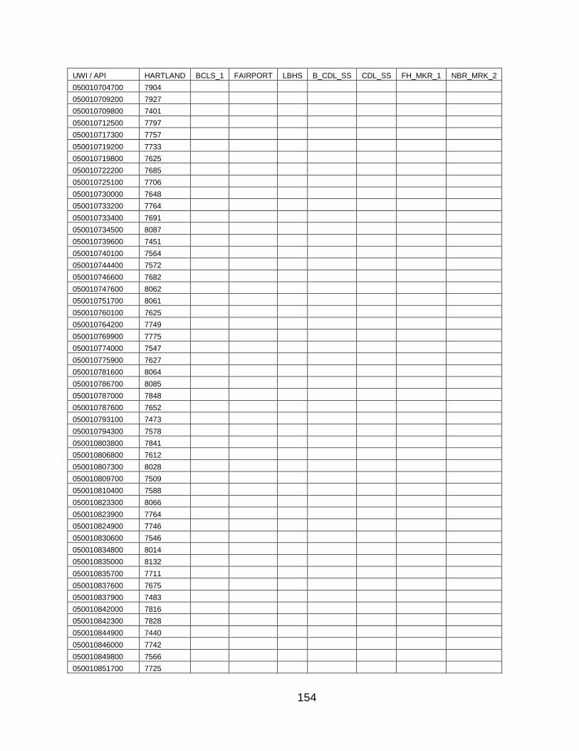
154
UWI / API HARTLAND BCLS_1 FAIRPORT LBHS B_CDL_SS CDL_SS FH_MKR_1 NBR_MRK_2
050010704700 7904
050010709200 7927
050010709800 7401
050010712500 7797
050010717300 7757
050010719200 7733
050010719800 7625
050010722200 7685
050010725100 7706
050010730000 7648
050010733200 7764
050010733400 7691
050010734500 8087
050010739600 7451
050010740100 7564
050010744400 7572
050010746600 7682
050010747600 8062
050010751700 8061
050010760100 7625
050010764200 7749
050010769900 7775
050010774000 7547
050010775900 7627
050010781600 8064
050010786700 8085
050010787000 7848
050010787600 7652
050010793100 7473
050010794300 7578
050010803800 7841
050010806800 7612
050010807300 8028
050010809700 7509
050010810400 7588
050010823300 8066
050010823900 7764
050010824900 7746
050010830600 7546
050010834800 8014
050010835000 8132
050010835700 7711
050010837600 7675
050010837900 7483
050010842000 7816
050010842300 7828
050010844900 7440
050010846000 7742
050010849800 7566
050010851700 7725
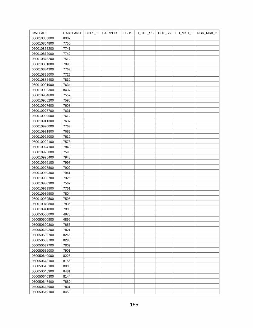
155
UWI / API HARTLAND BCLS_1 FAIRPORT LBHS B_CDL_SS CDL_SS FH_MKR_1 NBR_MRK_2
050010853800 8007
050010854800 7750
050010855200 7741
050010872000 7742
050010873200 7512
050010881800 7895
050010884300 7769
050010885000 7726
050010885400 7832
050010901900 7634
050010902300 8437
050010904600 7552
050010905200 7596
050010907600 7608
050010907700 7631
050010909600 7612
050010911300 7637
050010920000 7769
050010921800 7683
050010922000 7612
050010922100 7573
050010924100 7849
050010925000 7598
050010925400 7948
050010926100 7997
050010927800 7902
050010930300 7941
050010930700 7926
050010930900 7567
050010933500 7751
050010936900 7804
050010939500 7598
050010940800 7835
050010941000 7888
050050500000 4873
050050500900 4896
050050620300 7858
050050630200 7821
050050632700 8266
050050633700 8293
050050637700 7802
050050639000 7901
050050640000 8228
050050643100 8156
050050645100 8088
050050645900 8481
050050646300 8144
050050647400 7880
050050648900 7831
050050649100 8450
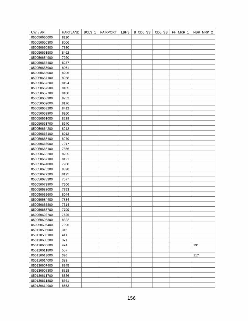
156
UWI / API HARTLAND BCLS_1 FAIRPORT LBHS B_CDL_SS CDL_SS FH_MKR_1 NBR_MRK_2
050050650000 8220
050050650300 8006
050050650800 7880
050050651500 8462
050050654900 7920
050050655400 8237
050050655900 8061
050050656000 8206
050050657100 8258
050050657200 8194
050050657500 8185
050050657700 8180
050050658900 8252
050050659000 8176
050050659200 8412
050050659900 8260
050050661000 8238
050050661700 8640
050050664200 8212
050050665100 8012
050050665400 8279
050050666000 7917
050050666100 7856
050050666200 8255
050050667100 8121
050050674000 7980
050050675200 8398
050050677200 8125
050050678300 7677
050050679900 7806
050050683000 7793
050050683600 8044
050050684400 7834
050050685800 7814
050050687700 7799
050050693700 7625
050050696300 8322
050050696400 7996
050110505000 315
050110506100 411
050110600200 371
050110606600 474 191
050110611800 507
050110613000 396 117
050110614000 339
050130607400 8845
050130608300 8818
050130611700 8536
050130611800 8661
050130614900 8653

157
UWI / API HARTLAND BCLS_1 FAIRPORT LBHS B_CDL_SS CDL_SS FH_MKR_1 NBR_MRK_2
050130629200 8397
050140908300 8485
050170501200 1550
050170610200 1715 1648 1567 1529 1496 1468 1413
050170617400 1894 1582
050170618800 1230 1165 1083 1040 971 940 899
050170619600 1900 1827 1760 1716 1715 1695 1662 1603
050170622700 1777
050170624600 1613
050170626200 1856 1814 1696 1657 1657 1625 1597 1548
050170626800 1612 1450 1448 1422 1391 1334
050170628200 1442 1381 1301 1249 1233 1198 1140
050170629100 1416 1115
050170634700 2184 1872
050170635100 1520 1451 1374 1304 1270 1216
050170635400 2794 2642 2594 2486
050170637200 1323 1299 1269 1219
050170638000 1469 1402 1327 1273 1262 1230 1170
050170638500 2044 1977 1932 1909 1879 1819
050170638600 1528 1456 1385 1336 1325 1292 1236
050170640300 2052 1744
050170640500 2160 1849
050170640800 1336 1273 1194 1149 1095 1065 1013
050170640900 1551 1472 1427 1405 1373 1317
050170641100 2075 1766
050170641300 2104 1803
050170641900 954 897
050170642800 1561 1485 1437 1417 1384 1326
050170643000 2161 1849
050170643300 1335 1029
050170643500 2298 1992
050170643700 2520 2450 2414 2390 2353 2290
050170643800 2100 1795
050170646300 2044 1738
050170647300 1830
050170649000 1649 1339
050170650400 1546 1397 1373 1345 1290
050170651200 1654 1344
050170652600 1770 1454
050170653000 1750 1441
050170653900 1551 1393 1367 1337 1283
050170654100 1719 1413
050170654200 1565 1455 1418 1417 1390 1358 1307
050170654700 1537 1426 1389 1389 1364 1331 1279
050170655200 2284 1983
050170655800 1588 1476 1437 1438 1408 1377 1326
050170656200 1411 1379 1349 1297
050170656300 1394 1368 1338 1288
050170656400 1479 1171
050170656800 1680 1561 1522 1522 1493 1462 1413
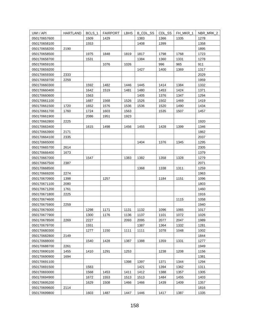
158
UWI / API HARTLAND BCLS_1 FAIRPORT LBHS B_CDL_SS CDL_SS FH_MKR_1 NBR_MRK_2
050170657600 1509 1429 1383 1366 1335 1278
050170658100 1553 1408 1399 1358
050170658200 2190 1895
050170658500 1975 1848 1819 1817 1798 1768 1723
050170658700 1531 1384 1360 1331 1278
050170659100 1076 1026 996 965 911
050170659200 1427 1400 1369 1317
050170659300 2333 2029
050170659700 2259 1959
050170660300 1592 1482 1446 1445 1414 1384 1332
050170660400 1642 1519 1481 1480 1453 1424 1371
050170660600 1563 1405 1376 1347 1294
050170661100 1687 1568 1526 1526 1502 1469 1419
050170661500 1720 1652 1576 1536 1536 1520 1490 1434
050170661700 1760 1724 1603 1563 1535 1507 1457
050170661900 2086 1951 1923
050170662800 2225 1920
050170663400 1615 1498 1456 1455 1428 1399 1346
050170663900 2171 1862
050170664100 2335 2037
050170665000 1404 1376 1345 1295
050170665700 2614 2305
050170666400 1673 1379
050170667000 1547 1383 1382 1358 1328 1279
050170667500 2387 2071
050170668500 1368 1338 1311 1259
050170669200 2274 1963
050170670900 1398 1257 1184 1151 1096
050170671100 2080 1803
050170671200 1761 1460
050170671800 2225 1916
050170674600 1115 1058
050170675900 2259 1940
050170676000 1298 1171 1131 1132 1096 1065 1017
050170677900 1300 1176 1136 1137 1101 1072 1026
050170678500 2269 2227 2093 2095 2077 2047 1989
050170679700 1551 1387 1364 1332 1281
050170680300 1277 1150 1111 1111 1078 1048 1002
050170682800 2149 1844
050170688000 1540 1428 1387 1388 1359 1331 1277
050170688700 2261 1949
050170690100 1455 1410 1291 1253 1238 1208 1156
050170690900 1694 1381
050170691100 1398 1397 1371 1344 1294
050170691500 1583 1421 1394 1362 1311
050170693000 1568 1453 1411 1412 1388 1357 1305
050170694900 1672 1553 1513 1513 1484 1455 1403
050170695200 1629 1508 1466 1466 1439 1409 1357
050170699600 2114 1816
050170699800 1603 1487 1447 1446 1417 1387 1335

159
UWI / API HARTLAND BCLS_1 FAIRPORT LBHS B_CDL_SS CDL_SS FH_MKR_1 NBR_MRK_2
050170703100 1607 1296
050170703200 1315 1288 1260 1208
050170705400 2125 1816
050170705900 1298 1271 1241 1187
050170706000 1519 1319 1293 1263 1212
050170712400 2009 1713
050170712600 1792 1491
050170712700 1803 1502
050170712900 1688 1402
050170713200 1084 992 953 906
050170713600 1769 1471
050170713700 1666 1365
050170713900 1934 1630
050170714000 1739 1447
050170714100 1683 1383
050170714400 1705 1407
050170714500 1702 1415
050170714800 1777 1474
050170716300 1440 1123
050170718600 1695 1390
050170718700 1452 1398 1349
050170719400 2562 2259
050170720500 2514 2209
050170720900 2213 1899
050170721500 2616 2343
050170721600 2633 2332
050170721700 2524 2221
050170721800 2494 2186
050170722700 2599 2296
050170723000 2509 2209
050170723200 2483 2174
050170723400 2470 2165
050170723500 2609 2301
050170723600 2449 2147
050170723800 1159 1062 1034 976 941 891
050170724100 2411 2099
050170724500 2665 2357
050170724700 1563 1498 1418 1348 1311 1255
050170724900 2528 2224
050170725100 1654 1584 1509 1464 1465 1449 1421 1365
050170725200 1322 1299 1265 1230
050170725700 1273 1208 1133 1086 1033 999 951
050170726000 2105 1808
050170726400 2237 1947
050170726500 1773 1703 1627 1590 1589 1575 1547 1484
050170726600 2485 2185
050170726700 2412 2108
050170726900 2072 1798
050170727600 1534 1422 1382 1383 1355 1327 1273
050170728000 1329 1264 1184 1147 1080 1050 1002
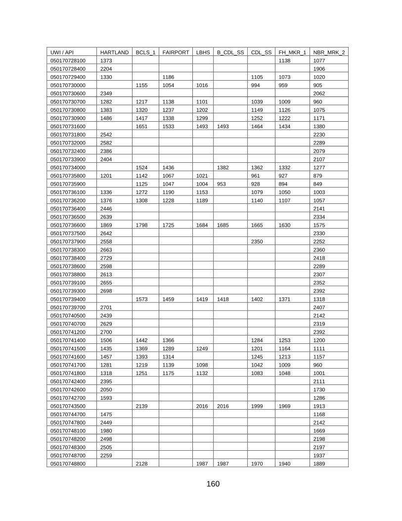
160
UWI / API HARTLAND BCLS_1 FAIRPORT LBHS B_CDL_SS CDL_SS FH_MKR_1 NBR_MRK_2
050170728100 1373 1138 1077
050170728400 2204 1906
050170729400 1330 1186 1105 1073 1020
050170730000 1155 1054 1016 994 959 905
050170730600 2349 2062
050170730700 1282 1217 1138 1101 1039 1009 960
050170730800 1383 1320 1237 1202 1149 1126 1075
050170730900 1486 1417 1338 1299 1252 1222 1171
050170731600 1651 1533 1493 1493 1464 1434 1380
050170731800 2542 2230
050170732000 2582 2289
050170732400 2386 2079
050170733900 2404 2107
050170734000 1524 1436 1382 1362 1332 1277
050170735800 1201 1142 1067 1021 961 927 879
050170735900 1125 1047 1004 953 928 894 849
050170736100 1336 1272 1190 1153 1079 1050 1003
050170736200 1376 1308 1228 1189 1140 1107 1057
050170736400 2446 2141
050170736500 2639 2334
050170736600 1869 1798 1725 1684 1685 1665 1630 1575
050170737500 2642 2330
050170737900 2558 2350 2252
050170738300 2663 2360
050170738400 2729 2418
050170738600 2598 2289
050170738800 2613 2307
050170739100 2655 2352
050170739300 2698 2392
050170739400 1573 1459 1419 1418 1402 1371 1318
050170739700 2701 2407
050170740500 2439 2142
050170740700 2629 2319
050170741200 2700 2392
050170741400 1506 1442 1366 1284 1253 1200
050170741500 1435 1369 1289 1249 1201 1164 1111
050170741600 1457 1393 1314 1245 1213 1157
050170741700 1281 1219 1139 1098 1042 1009 960
050170741800 1318 1251 1175 1132 1083 1048 1001
050170742400 2395 2111
050170742600 2050 1730
050170742700 1593 1286
050170743500 2139 2016 2016 1999 1969 1913
050170744700 1475 1168
050170747800 2449 2142
050170748100 1980 1669
050170748200 2498 2198
050170748300 2505 2197
050170748700 2259 1937
050170748800 2128 1987 1987 1970 1940 1889
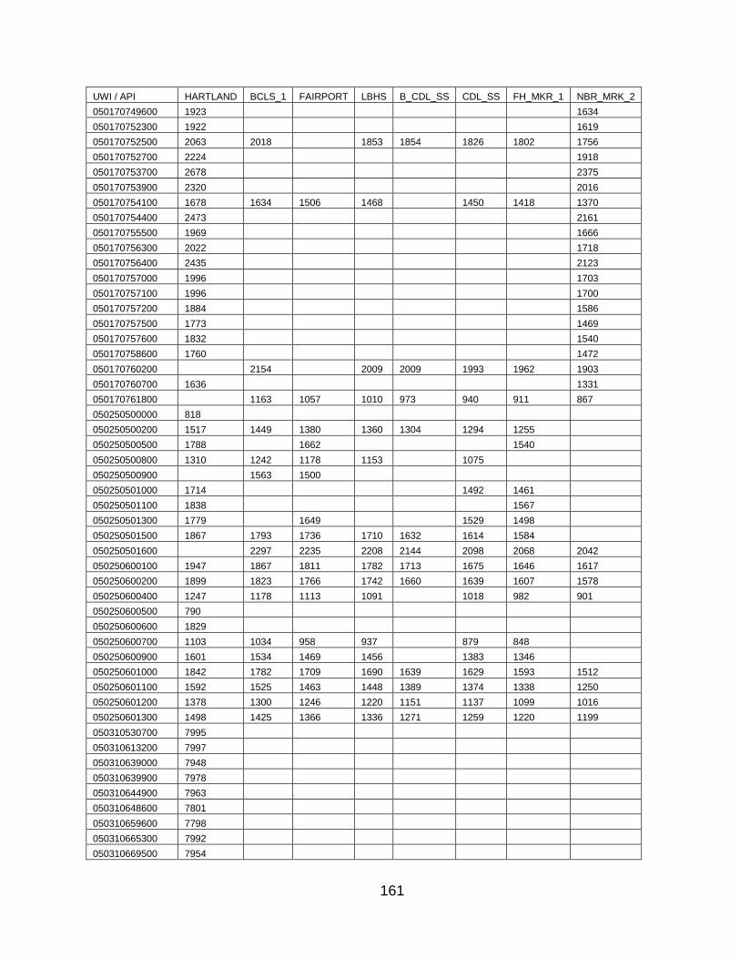
161
UWI / API HARTLAND BCLS_1 FAIRPORT LBHS B_CDL_SS CDL_SS FH_MKR_1 NBR_MRK_2
050170749600 1923 1634
050170752300 1922 1619
050170752500 2063 2018 1853 1854 1826 1802 1756
050170752700 2224 1918
050170753700 2678 2375
050170753900 2320 2016
050170754100 1678 1634 1506 1468 1450 1418 1370
050170754400 2473 2161
050170755500 1969 1666
050170756300 2022 1718
050170756400 2435 2123
050170757000 1996 1703
050170757100 1996 1700
050170757200 1884 1586
050170757500 1773 1469
050170757600 1832 1540
050170758600 1760 1472
050170760200 2154 2009 2009 1993 1962 1903
050170760700 1636 1331
050170761800 1163 1057 1010 973 940 911 867
050250500000 818
050250500200 1517 1449 1380 1360 1304 1294 1255
050250500500 1788 1662 1540
050250500800 1310 1242 1178 1153 1075
050250500900 1563 1500
050250501000 1714 1492 1461
050250501100 1838 1567
050250501300 1779 1649 1529 1498
050250501500 1867 1793 1736 1710 1632 1614 1584
050250501600 2297 2235 2208 2144 2098 2068 2042
050250600100 1947 1867 1811 1782 1713 1675 1646 1617
050250600200 1899 1823 1766 1742 1660 1639 1607 1578
050250600400 1247 1178 1113 1091 1018 982 901
050250600500 790
050250600600 1829
050250600700 1103 1034 958 937 879 848
050250600900 1601 1534 1469 1456 1383 1346
050250601000 1842 1782 1709 1690 1639 1629 1593 1512
050250601100 1592 1525 1463 1448 1389 1374 1338 1250
050250601200 1378 1300 1246 1220 1151 1137 1099 1016
050250601300 1498 1425 1366 1336 1271 1259 1220 1199
050310530700 7995
050310613200 7997
050310639000 7948
050310639900 7978
050310644900 7963
050310648600 7801
050310659600 7798
050310665300 7992
050310669500 7954
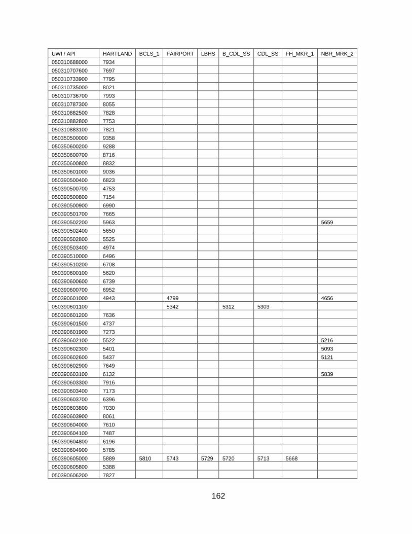
162
UWI / API HARTLAND BCLS_1 FAIRPORT LBHS B_CDL_SS CDL_SS FH_MKR_1 NBR_MRK_2
050310688000 7934
050310707600 7697
050310733900 7795
050310735000 8021
050310736700 7993
050310787300 8055
050310882500 7828
050310882800 7753
050310883100 7821
050350500000 9358
050350600200 9288
050350600700 8716
050350600800 8832
050350601000 9036
050390500400 6823
050390500700 4753
050390500800 7154
050390500900 6990
050390501700 7665
050390502200 5963 5659
050390502400 5650
050390502800 5525
050390503400 4974
050390510000 6496
050390510200 6708
050390600100 5620
050390600600 6739
050390600700 6952
050390601000 4943 4799 4656
050390601100 5342 5312 5303
050390601200 7636
050390601500 4737
050390601900 7273
050390602100 5522 5216
050390602300 5401 5093
050390602600 5437 5121
050390602900 7649
050390603100 6132 5839
050390603300 7916
050390603400 7173
050390603700 6396
050390603800 7030
050390603900 8061
050390604000 7610
050390604100 7487
050390604800 6196
050390604900 5785
050390605000 5889 5810 5743 5729 5720 5713 5668
050390605800 5388
050390606200 7827

163
UWI / API HARTLAND BCLS_1 FAIRPORT LBHS B_CDL_SS CDL_SS FH_MKR_1 NBR_MRK_2
050390606800 8174
050390607000 8395
050390607200 6821
050390607600 8202
050390607800 5946 5645
050390608200 5250 4940
050390608300 4621 4482
050390608400 4917 4622
050390608600 7766
050390609200 5571 5259
050390609400 5442 5123
050390609600 5917 5623
050390609900 5590
050390610100 4922
050390610300 8635
050390610500 7045
050390611000 6300
050390611100 4628
050390611500 4378 4242
050390611700 6491
050390611800 6215
050390611900 8415
050390612100 6095
050390612200 6263
050390612400 8894
050390612900 7349
050390613000 7741
050390613100 6970
050390613200 7792
050390613300 5592
050390613400 6553
050390613600 5729 5438
050390613800 6855
050390613900 5641 5344
050390614000 6110 5816
050390614100 5018 4707
050390614200 8412
050390614300 7590
050390615300 8498
050390615400 8661
050390615500 8634
050390615600 8418
050390616000 7718
050390616100 7748
050390616300 7896
050390616500 8411
050390616800 8940
050390617300 8532
050390618000 7855
050390618100 7013

164
UWI / API HARTLAND BCLS_1 FAIRPORT LBHS B_CDL_SS CDL_SS FH_MKR_1 NBR_MRK_2
050390618500 8166
050390618600 7590
050390618800 7268
050390619100 7950
050390619400 6792
050390619500 8318
050390619600 8681
050390620900 7635
050390622400 7516
050390622800 7496
050390622900 7345
050390624100 7980
050390624300 7732
050390624600 7591
050390624800 7509
050390625100 7061
050390625300 7344
050390625800 7409
050390625900 7513
050390626100 7422
050390627200 7545
050390628000 7393
050390628900 7563
050390629200 7564
050390629400 7798
050390632900 7366
050390633000 7789
050390634800 7735
050390635600 8417
050390635700 7366
050390636700 8231
050390637000 7957
050390637100 7734
050390637900 8076
050390638100 7797
050390638600 8571
050390638800 8451
050390638900 8047
050390639400 6868
050390639600 8307
050390639700 7227
050390639900 8181
050390640100 8251
050390640500 8669
050390641100 8543
050390641700 7503
050390641800 8510
050390642700 8423
050390643200 6824
050390644400 8131
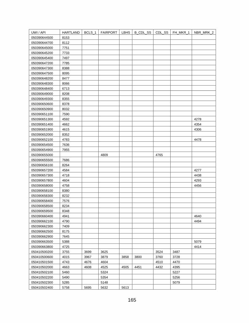
165
UWI / API HARTLAND BCLS_1 FAIRPORT LBHS B_CDL_SS CDL_SS FH_MKR_1 NBR_MRK_2
050390644500 8153
050390644700 8112
050390645000 7751
050390645200 7733
050390645400 7497
050390647200 7785
050390647300 8388
050390647500 8095
050390648200 8477
050390648300 8066
050390648400 6713
050390649000 8208
050390649300 8355
050390650600 8378
050390650900 8032
050390651100 7590
050390651300 4592 4278
050390651400 4662 4354
050390651900 4615 4306
050390652000 8352
050390652100 4783 4478
050390654500 7636
050390654900 7955
050390655000 4809 4765
050390655500 7686
050390656100 8264
050390657200 4584 4277
050390657300 4718 4438
050390657800 4604 4293
050390658000 4758 4456
050390658100 8380
050390658300 8232
050390658400 7576
050390658500 8234
050390659500 8348
050390660400 4941 4640
050390662100 4790 4494
050390662300 7409
050390662500 8175
050390662900 7645
050390663500 5388 5079
050390663800 4725 4414
050410500200 3755 3699 3625 3524 3487
050410500600 4015 3967 3879 3858 3800 3760 3728
050410501500 4743 4676 4604 4510 4470
050410502000 4663 4608 4525 4505 4451 4432 4395
050410502100 5460 5324 5227
050410502200 5490 5354 5256
050410502300 5285 5148 5079
050410502400 5758 5695 5632 5613
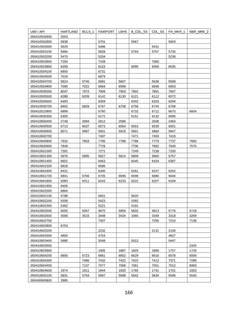
166
UWI / API HARTLAND BCLS_1 FAIRPORT LBHS B_CDL_SS CDL_SS FH_MKR_1 NBR_MRK_2
050410502600 2553
050410502800 5838 5701 5667 5603
050410503000 5629 5486 5431
050410503100 5960 5828 5793 5767 5735
050410503200 5470 5334 5238
050410503500 7254 7109 7060
050410503800 6259 6123 6090 6069 6035
050410504100 6850 6731
050410504500 7016 6879
050410504700 5824 5746 5681 5667 5638 5599
050410504900 7095 7022 6964 6958 6948 6903
050410505000 8047 7972 7909 7903 7902 7891 7847
050410505500 6288 6209 6142 6130 6121 6112 6072
050410505600 6493 6359 6342 6333 6294
050410505700 6902 6829 6767 6758 6758 6744 6708
050410510900 6899 6760 6732 6712 6670 6604
050410600300 6305 6172 6151 6132 6095
050410600400 2748 2684 2612 2586 2508 2464
050410600500 6713 6637 6573 6564 6553 6539 6501
050410600600 6071 5997 5931 5919 5901 5884 5847
050410600700 7497 7471 7459 7419
050410600800 7932 7853 7796 7788 7786 7779 7737 7660
050410600900 7849 7729 7706 7692 7649 7570
050410601000 7391 7271 7249 7238 7200
050410601300 5976 5895 5827 5814 5809 5800 5757
050410601400 6601 6463 6445 6434 6397
050410601500 6818 6686
050410601600 6421 6280 6261 6237 6202
050410601700 6841 6766 6705 6696 6698 6686 6646
050410601800 6383 6311 6243 6233 6222 6207 6169
050410601900 6406
050410602000 6864
050410602100 5788 5651 5620
050410602200 5558 5423 5392
050410602300 5362 5221 5191
050410602500 6000 5947 5870 5859 5832 5813 5776 5718
050410602600 3566 3516 3448 3434 3365 3349 3318 3269
050410602700 7307 7255 7210 7138
050410602800 6753
050410603200 2232 2131 2100
050410603300 4892 4753 4627
050410603400 5680 5548 5512 5447
050410603500 2320
050410603900 1905 1887 1825 1806 1757 1720
050410604200 6800 6723 6661 6652 6629 6616 6578 6506
050410604300 7496 7432 7422 7422 7412 7371 7289
050410604400 7137 7077 7068 7061 7051 7012 6950
050410604600 1974 1911 1844 1820 1765 1741 1701 1653
050410605100 5831 5764 5697 5688 5642 5634 5596 5540
050430600800 2885

167
UWI / API HARTLAND BCLS_1 FAIRPORT LBHS B_CDL_SS CDL_SS FH_MKR_1 NBR_MRK_2
050430605100 3482 3430 3386
050430606100 3610 3558 3505
050430607500 2922 2881
050430607600 2616 2601 2523 2508 2469
050430607700 2426 2381 2349
050430607800 2353 2309 2272
050430608300 2617 2572 2534
050430613800 1072 880 807
050430614100 3912 3866
050430614800 5776 5620 5572
050550504900 1810
050550600400 5287 5157
050550600500 3268
050550600800
050550600900 2088 1978 1854
050550601500 2217 2113 1990
050550602200 3239 3063
050550602600 5059 4874
050550603200 7024
050550604200 1650
050550604500 5222 5172 5153
050550605000 3278 3124
050550605300 1756
050550605600 3216
050550605800 5282 5230 5199
050550606600 3980
050550606700 2550
050550607000 3800
050550608000 5066
050550609000 2029 2009 1972
050550609100 2115 2093 2070
050550609400 1924 1805
050550610600 4422
050550613900 3083 3046 3009
050550629400 2926 2888 2868
050590500600 9009
050590506300 8912
050590600900 9219
050610502800 630
050610504000 746 684 606 586 520 515 475
050610504800 961 898 823 797 740 733 694
050610506000 864 802 723 610 578
050610506200 865 798 717 595 563
050610506500 781 718 622
050610506700 876 814 732 584
050610514700 894 832 754 724 661 628 564
050610602900 771
050610604000 1076 1012 929 794 766
050610605600 858 795 715 578
050610606500 511 391

168
UWI / API HARTLAND BCLS_1 FAIRPORT LBHS B_CDL_SS CDL_SS FH_MKR_1 NBR_MRK_2
050610611000 798 728 474
050610611800 1149 1092 1002 973 885 853
050610613100 989 926 847 807 710 684 637
050610614400 651 431 397
050610615800 734 672 584 548
050610615900 590 444 415
050610616000 525 441
050610616300 607
050610616600 642
050610620100 1209 1150 1057 944
050610620400 668
050610620600 1218 1159 1083 1054 993 954 884
050610621900 704
050610623400 599
050610623600 756
050610624300 563 481 447 372 346
050610626000 1341 1001
050610626900 616 581
050610627400 870 807 727 575
050610627600 876 814 733 577
050610627800 1336 1273 1196 1054 994
050610629400 745
050610629600 840
050610630200 837 480
050610630300 794
050610631700 900
050610631800 719
050610632100 732 589
050610632800 736
050610632900 800 652
050610633200 797
050610633400 883
050610634800 798 731 654 534 501 453
050610635300 802
050610635700 778 428
050610635800 752
050610636500 839
050610636600 804
050610636800 848 782 707 578 548 497
050610637000 499
050610637300 933
050610637400 513 430
050610637600 807
050610638100 1323 1259 1179 1140 1064 1029 981
050610638800 788 722 637 511 474 422
050610639400 875
050610639700 755
050610640100 782
050610640200 865 803 719 599 565 514
050610640300 938 876 795 675 639 591
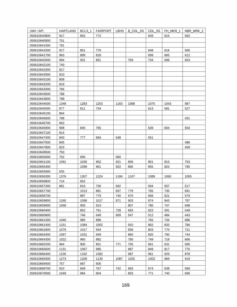
169
UWI / API HARTLAND BCLS_1 FAIRPORT LBHS B_CDL_SS CDL_SS FH_MKR_1 NBR_MRK_2
050610640800 917 852 772 649 615 562
050610640900 751
050610641000 791
050610641500 917 851 770 648 616 565
050610641700 963 899 818 699 665 612
050610642000 994 931 851 759 734 699 653
050610642100 740
050610642300 817
050610642900 810
050610643100 808
050610643200 819
050610643300 784
050610643600 788
050610643800 798
050610644500 1348 1283 1203 1163 1088 1075 1043 987
050610645000 877 811 734 613 581 527
050610645100 864
050610645600 798 431
050610645700 663
050610645900 908 845 765 639 604 554
050610647100 814
050610647400 840 777 684 648 551
050610647500 845 486
050610647800 823 459
050610649500 753
050610650000 752 690 560
050610651100 1091 1030 952 921 859 851 815 753
050610655400 1099 961 922 865 855 823 780
050610655900 635
050610656300 1376 1307 1224 1184 1107 1089 1060 1005
050610656800 714 652
050610657300 881 816 730 692 594 557 517
050610657700 1013 881 837 779 765 735 691
050610658700 887 779 740 670 656 621 579
050610659800 1160 1096 1017 971 903 874 843 797
050610659900 1058 993 913 807 780 747 698
050610660400 852 761 728 663 622 591 549
050610660800 746 649 609 547 512 484 443
050610661300 1040 980 896 765 734 686
050610661400 1151 1084 1002 910 862 833 786
050610661800 1079 1017 934 839 803 770 721
050610663400 1097 1031 949 860 820 790 744
050610664300 1022 960 882 785 749 718 666
050610665200 964 900 801 771 705 661 631 585
050610665600 1131 1067 985 887 849 817 770
050610666400 1226 1162 1082 987 961 929 878
050610669300 1273 1209 1130 1087 1025 1002 969 919
050610669400 757 687 600
050610669700 910 848 767 742 683 674 638 569
050610670000 1049 984 904 803 771 740 690
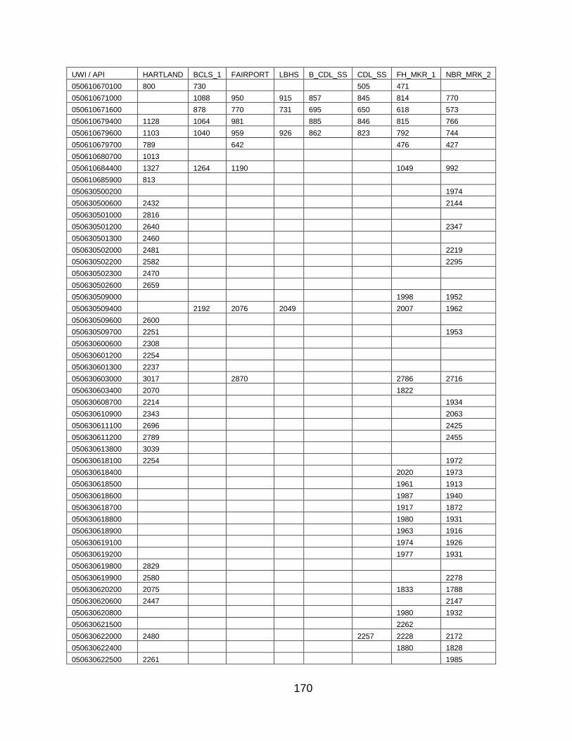
170
UWI / API HARTLAND BCLS_1 FAIRPORT LBHS B_CDL_SS CDL_SS FH_MKR_1 NBR_MRK_2
050610670100 800 730 505 471
050610671000 1088 950 915 857 845 814 770
050610671600 878 770 731 695 650 618 573
050610679400 1128 1064 981 885 846 815 766
050610679600 1103 1040 959 926 862 823 792 744
050610679700 789 642 476 427
050610680700 1013
050610684400 1327 1264 1190 1049 992
050610685900 813
050630500200 1974
050630500600 2432 2144
050630501000 2816
050630501200 2640 2347
050630501300 2460
050630502000 2481 2219
050630502200 2582 2295
050630502300 2470
050630502600 2659
050630509000 1998 1952
050630509400 2192 2076 2049 2007 1962
050630509600 2600
050630509700 2251 1953
050630600600 2308
050630601200 2254
050630601300 2237
050630603000 3017 2870 2786 2716
050630603400 2070 1822
050630608700 2214 1934
050630610900 2343 2063
050630611100 2696 2425
050630611200 2789 2455
050630613800 3039
050630618100 2254 1972
050630618400 2020 1973
050630618500 1961 1913
050630618600 1987 1940
050630618700 1917 1872
050630618800 1980 1931
050630618900 1963 1916
050630619100 1974 1926
050630619200 1977 1931
050630619800 2829
050630619900 2580 2278
050630620200 2075 1833 1788
050630620600 2447 2147
050630620800 1980 1932
050630621500 2262
050630622000 2480 2257 2228 2172
050630622400 1880 1828
050630622500 2261 1985

171
UWI / API HARTLAND BCLS_1 FAIRPORT LBHS B_CDL_SS CDL_SS FH_MKR_1 NBR_MRK_2
050630622600 3040 2742
050630623000 2813 2512
050630623100 1955 1908
050630623300 1972
050630623700 2716 2411
050630623800 2720 2411
050630623900 2314 2028
050630624000 2742 2437
050630624100 2769 2463
050630624200 2708 2405
050630624300 2135 1861
050630624500 2742 2452
050630624600 2759 2455
050630624700 2815 2503
050630624800 2793 2486
050630624900 2811 2501
050630625200 2709 2400
050630625400 2774 2485
050630625600 2782 2470
050630625900 2476 2170
050630627000 2776 2479
050630627200 2793 2484
050630627800 2760 2456
050630627900 2794 2480
050630628500 1982 1773 1742 1702
050630628600 2730 2442
050630629100 1967 1683
050630629200 2030 1813 1783 1737
050630629400 2005 1959
050690508800 1942
050690607300 6804
050690612100 6809
050690612700 6343
050690615200 4414
050690617400 6298
050710616800 1081 959
050710751500 943 821
050710770500 969 847
050730500100 2550 2474 2410 2379 2317 2279 2248
050730500400 3972 3838 3799
050730500500 2875 2809 2730 2637 2619 2590
050730500600 3709 3577 3557 3484 3473 3435
050730501000 3626 3485 3356
050730501600 3429
050730501700 3428 3345
050730501900 3349
050730502100 4002
050730502300 4072
050730502600 4350
050730502700 3613

172
UWI / API HARTLAND BCLS_1 FAIRPORT LBHS B_CDL_SS CDL_SS FH_MKR_1 NBR_MRK_2
050730502800 3812
050730502900 4778
050730503000 4119 3820
050730503100 3531
050730503300 4065 3765
050730503400 3724
050730503500 4967 4667
050730503600 3970 3677
050730503700 3638
050730503800 3920 3609
050730504000 3930 3628
050730504100 4211 3907
050730504200 4276 3979
050730504300 4141 3846
050730504400 4791 4505
050730504500 4537 4248
050730504600 3760
050730504700 4469
050730504800 4702 4415
050730504900 4293 4006
050730505200 3787
050730505300 4795
050730505400 4588 4302
050730505600 4211
050730505700 4286
050730511000 4470
050730511200 3364 3064
050730600100 4158
050730600200 4086
050730600300 4130
050730600400 2245
050730600500 4168 3874
050730600700 2287 2221 2150 2107 2106 2090 2066 2004
050730600800 1932 1642
050730601100 4560
050730601200
050730601300 4212 3897
050730601400 4727 4434
050730601600 4660 4343
050730601700 4046
050730601900 3952
050730602000 3901 3603
050730602200 4502 4220
050730602400 3642
050730602800 4436
050730602900 4325 4038
050730603100 2501 2430 2358 2315 2287 2272 2248
050730603200 1373 1309 1236 1200 1133 1101 1047
050730603300 4930
050730603400 4900 4610
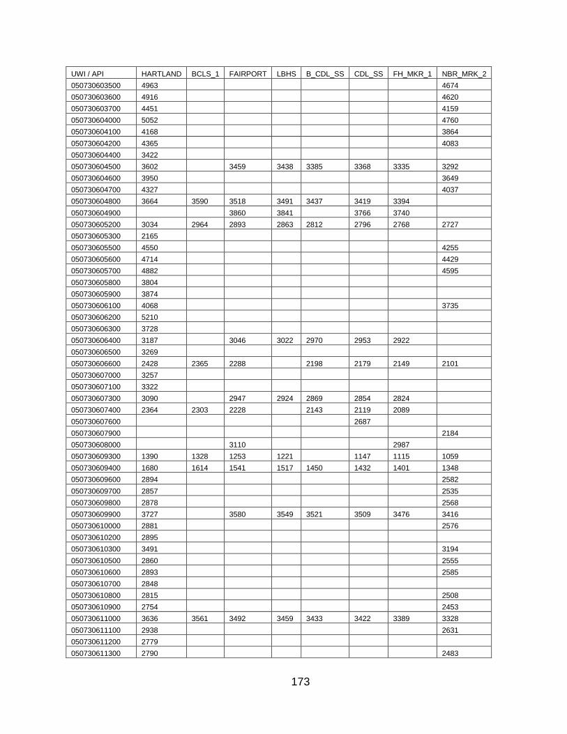
173
UWI / API HARTLAND BCLS_1 FAIRPORT LBHS B_CDL_SS CDL_SS FH_MKR_1 NBR_MRK_2
050730603500 4963 4674
050730603600 4916 4620
050730603700 4451 4159
050730604000 5052 4760
050730604100 4168 3864
050730604200 4365 4083
050730604400 3422
050730604500 3602 3459 3438 3385 3368 3335 3292
050730604600 3950 3649
050730604700 4327 4037
050730604800 3664 3590 3518 3491 3437 3419 3394
050730604900 3860 3841 3766 3740
050730605200 3034 2964 2893 2863 2812 2796 2768 2727
050730605300 2165
050730605500 4550 4255
050730605600 4714 4429
050730605700 4882 4595
050730605800 3804
050730605900 3874
050730606100 4068 3735
050730606200 5210
050730606300 3728
050730606400 3187 3046 3022 2970 2953 2922
050730606500 3269
050730606600 2428 2365 2288 2198 2179 2149 2101
050730607000 3257
050730607100 3322
050730607300 3090 2947 2924 2869 2854 2824
050730607400 2364 2303 2228 2143 2119 2089
050730607600 2687
050730607900 2184
050730608000 3110 2987
050730609300 1390 1328 1253 1221 1147 1115 1059
050730609400 1680 1614 1541 1517 1450 1432 1401 1348
050730609600 2894 2582
050730609700 2857 2535
050730609800 2878 2568
050730609900 3727 3580 3549 3521 3509 3476 3416
050730610000 2881 2576
050730610200 2895
050730610300 3491 3194
050730610500 2860 2555
050730610600 2893 2585
050730610700 2848
050730610800 2815 2508
050730610900 2754 2453
050730611000 3636 3561 3492 3459 3433 3422 3389 3328
050730611100 2938 2631
050730611200 2779
050730611300 2790 2483

174
UWI / API HARTLAND BCLS_1 FAIRPORT LBHS B_CDL_SS CDL_SS FH_MKR_1 NBR_MRK_2
050730611400 3638 3564 3495 3469 3418 3397 3370 3326
050730611500 3455 3153
050730611600 3641 3562 3486 3456 3426 3410 3380 3318
050730611800 4275 3939
050730612000 2852 2541
050730612100 2904 2608
050730612200 2928 2632
050730612400 2640 2340
050730612500 3128 2835
050730612600 3718 3432
050730612700 2911 2603
050730612900 2944 2651
050730613100 3650 3348
050730613200 2981 2686
050730613400 4357 4069
050730613600 2919 2599
050730613700 2926 2879 2859 2828 2776
050730613800 1629 1562 1489 1446 1396 1365 1318
050730614000 4334 4011
050730614200 2921 2848 2773 2739 2700 2678 2650 2607
050730614300 2856 2549
050730614400 3485 3170
050730614500 2979 2670
050730614600 2903 2594
050730614800 2231 2167 2094 2057 1997 1987 1960 1916
050730614900 2863 2554
050730615000 3619
050730615100 2948 2687
050730615200 3451 3408
050730615300 2696
050730615400 2405 2331 2275 2249 2174 2165 2133 2083
050730615500 3266 3120 3074 3036 2963
050730615700 2415 2346 2276 2235 2221 2212 2178 2126
050730616000 2868 2562
050730616100 3167 3000 2936
050730616200 3473 3170
050730616400 3991 3688
050730616500 2832
050730616900 4410 4120
050730617000 4606 4294
050730617100 4338 4030
050730617200 3730
050730617500 3044 2786
050730617600 3019 2712
050730617800 2052 1984 1911 1873 1804 1792 1763 1717
050730617900 2790 2552 2481
050730618000 5105 4788
050730618200 1924 1859 1785 1750 1677 1664 1636 1585
050730618400 2877 2568
050730618500 3199 2919
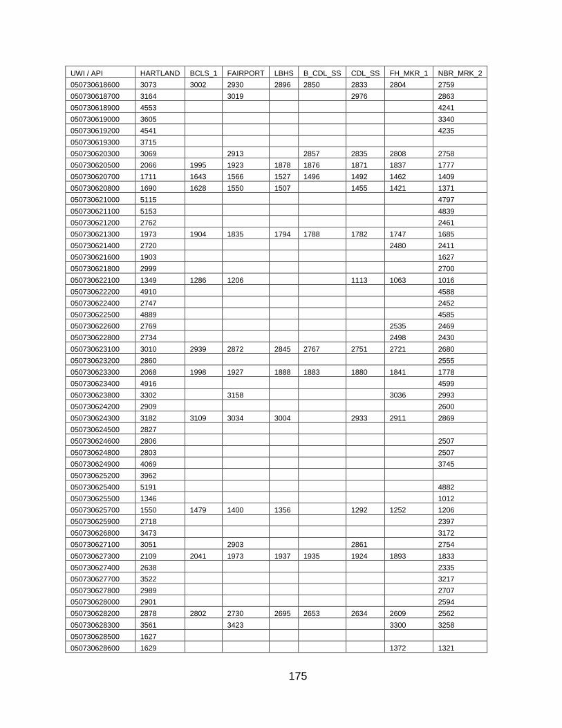
175
UWI / API HARTLAND BCLS_1 FAIRPORT LBHS B_CDL_SS CDL_SS FH_MKR_1 NBR_MRK_2
050730618600 3073 3002 2930 2896 2850 2833 2804 2759
050730618700 3164 3019 2976 2863
050730618900 4553 4241
050730619000 3605 3340
050730619200 4541 4235
050730619300 3715
050730620300 3069 2913 2857 2835 2808 2758
050730620500 2066 1995 1923 1878 1876 1871 1837 1777
050730620700 1711 1643 1566 1527 1496 1492 1462 1409
050730620800 1690 1628 1550 1507 1455 1421 1371
050730621000 5115 4797
050730621100 5153 4839
050730621200 2762 2461
050730621300 1973 1904 1835 1794 1788 1782 1747 1685
050730621400 2720 2480 2411
050730621600 1903 1627
050730621800 2999 2700
050730622100 1349 1286 1206 1113 1063 1016
050730622200 4910 4588
050730622400 2747 2452
050730622500 4889 4585
050730622600 2769 2535 2469
050730622800 2734 2498 2430
050730623100 3010 2939 2872 2845 2767 2751 2721 2680
050730623200 2860 2555
050730623300 2068 1998 1927 1888 1883 1880 1841 1778
050730623400 4916 4599
050730623800 3302 3158 3036 2993
050730624200 2909 2600
050730624300 3182 3109 3034 3004 2933 2911 2869
050730624500 2827
050730624600 2806 2507
050730624800 2803 2507
050730624900 4069 3745
050730625200 3962
050730625400 5191 4882
050730625500 1346 1012
050730625700 1550 1479 1400 1356 1292 1252 1206
050730625900 2718 2397
050730626800 3473 3172
050730627100 3051 2903 2861 2754
050730627300 2109 2041 1973 1937 1935 1924 1893 1833
050730627400 2638 2335
050730627700 3522 3217
050730627800 2989 2707
050730628000 2901 2594
050730628200 2878 2802 2730 2695 2653 2634 2609 2562
050730628300 3561 3423 3300 3258
050730628500 1627
050730628600 1629 1372 1321

176
UWI / API HARTLAND BCLS_1 FAIRPORT LBHS B_CDL_SS CDL_SS FH_MKR_1 NBR_MRK_2
050730628700 1544
050730628800 1628
050730628900 1843 1552
050730629000 2912 2599
050730629100 1536
050730629200 1662
050730631100 3470 3395 3325 3294 3263 3244 3214 3159
050730631600 3004 2849 2789 2772 2740
050730631700 3021 2863 2806 2788 2756 2707
050730631800 3086 3000 2869 2858 2819 2772
050730632000 2790 2720 2579 2568 2533 2484
050730636800 3033
050730636900 3108 2947 2895 2876 2845 2795
050730637000 2999 2741 2692
050730639100 3035 2771
050730639800 3075
050730641200 3635 3490 3455 3433 3424 3391 3333
050890501500 835 750 697 619 613 571
050890501900 973 908 838 762 753 712
050890600100 753 612 489
050890600300 532
050890600400 409 154
050890600500 178
050890600600 807 726 669 591 589 544
050890600700 818 734 680 603 595 554
050890600800 442
050890600900 833 763 694 670 597 560
050890601000 622
050890601900 269
051010500500 397
051010501900 269
051010503900 211
051010506800 3006 2953 2881 2781 2736
051010507500 3148 3097 3019 3000 2936 2914 2865
051010507700 3267 3210 3137 3119 3063 3036 2998
051010508000
051010508100 1818
051010600100 2090 1971 1934
051010600200 2679 2619 2542 2510 2461 2425 2390
051010600300 1318 1257 1185 1170 1108 1075 1035 943
051010600400 1603 1539 1471 1456 1403 1364 1328 1255
051010600500 1977 1908 1896 1844 1797 1760 1701
051010600800 867 729 633 591
051010600900 905 777 676 638
051010601000 280 152
051210500200 4555
051210500300 4716
051210500500 4377
051210500700 4855 4559
051210500800 4476
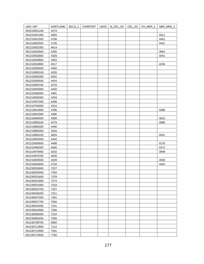
177
UWI / API HARTLAND BCLS_1 FAIRPORT LBHS B_CDL_SS CDL_SS FH_MKR_1 NBR_MRK_2
051210501100 4273
051210501300 4804 4511
051210501600 4758 4461
051210502000 4735 4441
051210502300 4614
051210502600 4250 3964
051210502800 4329 4041
051210503800 4454
051210503900 4517 4236
051210505000 4456
051210505100 4326
051210505300 4542
051210505500 4444
051210505700 4278
051210505900 4420
051210506000 4381
051210506300 4253
051210507000 4408
051210764000 4314
051210814500 4786 4489
051210819300 4380
051210846500 4908 4615
051210859100 4279 3988
051210865000 4446
051210865300 4316
051210884100 4829 4541
051210903400 4442
051210928500 4468 4178
051210968300 4666 4372
051210979000 4242 3948
051210979700 4620
051216003500 4329 4036
051216004600 4734 4442
051230525600 7227
051230530000 7294
051230531600 7278
051230531800 7274
051230531900 7318
051230532700 7327
051230536200 7211
051230537000 7261
051230537700 7562
051230543400 7241
051230544500 7266
051230556000 7154
051230560200 7050
051230708700 6982
051230712800 7112
051230712900 7591
051230713500 7760
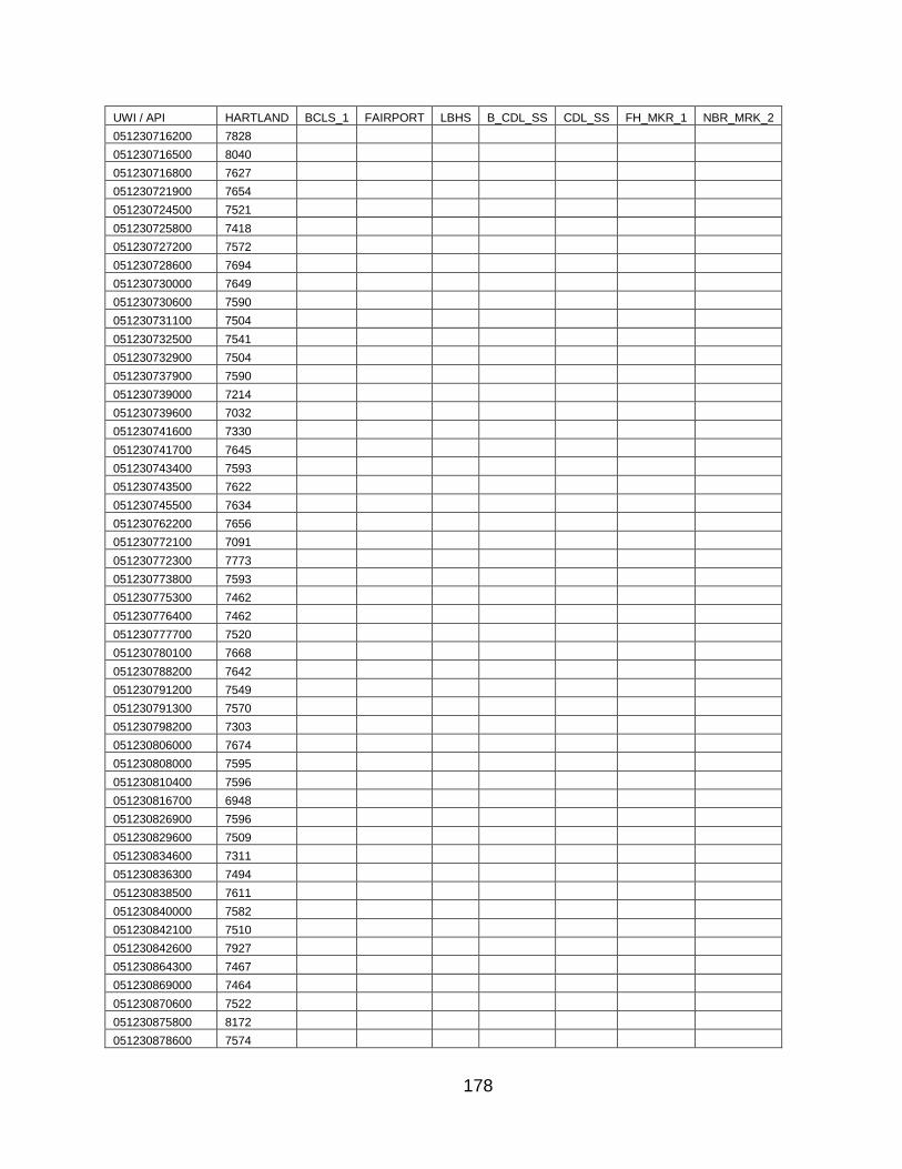
178
UWI / API HARTLAND BCLS_1 FAIRPORT LBHS B_CDL_SS CDL_SS FH_MKR_1 NBR_MRK_2
051230716200 7828
051230716500 8040
051230716800 7627
051230721900 7654
051230724500 7521
051230725800 7418
051230727200 7572
051230728600 7694
051230730000 7649
051230730600 7590
051230731100 7504
051230732500 7541
051230732900 7504
051230737900 7590
051230739000 7214
051230739600 7032
051230741600 7330
051230741700 7645
051230743400 7593
051230743500 7622
051230745500 7634
051230762200 7656
051230772100 7091
051230772300 7773
051230773800 7593
051230775300 7462
051230776400 7462
051230777700 7520
051230780100 7668
051230788200 7642
051230791200 7549
051230791300 7570
051230798200 7303
051230806000 7674
051230808000 7595
051230810400 7596
051230816700 6948
051230826900 7596
051230829600 7509
051230834600 7311
051230836300 7494
051230838500 7611
051230840000 7582
051230842100 7510
051230842600 7927
051230864300 7467
051230869000 7464
051230870600 7522
051230875800 8172
051230878600 7574

179
UWI / API HARTLAND BCLS_1 FAIRPORT LBHS B_CDL_SS CDL_SS FH_MKR_1 NBR_MRK_2
051230889000 7669
051230896500 7228
051230915900 7611
051230933600 7349
051230934900 7553
051230938100 7263
051230947500 7565
051230957800 6961
051230958600 7666
051230977800 7337
051230984200 7654
051230986500 7260
051230994500 7325
051230996000 7336
051230996200 7576
051230996300 7542
051231005600 7613
051231005700 7601
051231007000 7605
051231007500 7511
051231007600 7499
051231010900 7524
051231011700 7501
051231013600 7036
051231017600 7357
051231019400 7244
051231025100 7160
051231028200 7568
051231033300 7375
051231034800 7199
051231035600 7638
051231035800 7944
051231039500 7942
051231042100 7313
051231043500 7272
051231043800 7289
051231043900 7277
051231044300 7265
051231045500 7383
051231046100 7490
051231048200 7072
051231051900 7121
051231053500 7267
051231059300 7140
051231059800 7391
051231064400 7492
051231069200 7396
051231076300 7348
051231081000 7590
051231081500 7512

180
UWI / API HARTLAND BCLS_1 FAIRPORT LBHS B_CDL_SS CDL_SS FH_MKR_1 NBR_MRK_2
051231084100 7299
051231084500 7333
051231084700 7610
051231087100 7183
051231087600 7695
051231089000 7005
051231091100 7507
051231092000 7520
051231092400 7431
051231094200 7147
051231095400 7491
051231096200 7491
051231100500 7672
051231102900 7432
051231103900 7607
051231104400 7340
051231104500 7141
051231108100 7195
051231113700 7539
051231113800 7531
051231114000 7535
051231117700 7449
051231122300 7476
051231123000 7166
051231126300 7252
051231126600 7521
051231129000 7637
051231129200 7557
051231129300 7531
051231129400 7436
051231134200 7504
051231138500 7343
051231142300 7311
051231146900 7846
051231149600 7362
051231151800 7432
051231152100 7605
051231152500 7484
051231154700 7342
051231155100 7640
051231155500 7344
051231155900 7608
051231157300 7389
051231158000 7603
051231160100 7614
051231162400 7320
051231164300 7532
051231164400 7507
051231165300 7344
051231173000 7688
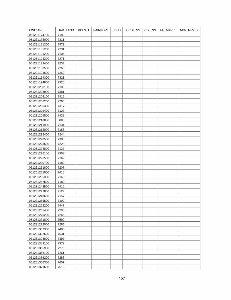
181
UWI / API HARTLAND BCLS_1 FAIRPORT LBHS B_CDL_SS CDL_SS FH_MKR_1 NBR_MRK_2
051231174700 7183
051231175000 7311
051231181200 7579
051231185200 7231
051231193200 7104
051231193300 7271
051231193400 7233
051231193500 7266
051231193600 7250
051231194300 7321
051231194800 7320
051231200100 7180
051231205900 7381
051231206100 7412
051231206200 7265
051231206300 7317
051231206400 7123
051231206500 7432
051231210800 8090
051231211900 7134
051231212000 7188
051231212400 7244
051231220500 7386
051231223500 7226
051231224800 7126
051231226100 7303
051231226500 7162
051231230700 7189
051231231800 7207
051231231900 7416
051231236300 7163
051231237500 7180
051231243500 7419
051231247800 7129
051231248600 7157
051231255500 7492
051231262200 7447
051231266400 7203
051231270200 7266
051231271800 7592
051231272000 7265
051231307300 7485
051231307600 7631
051231308800 7395
051231309100 7379
051231365900 7276
051231366100 7261
051231366200 7288
051231366300 7607
051231371600 7518
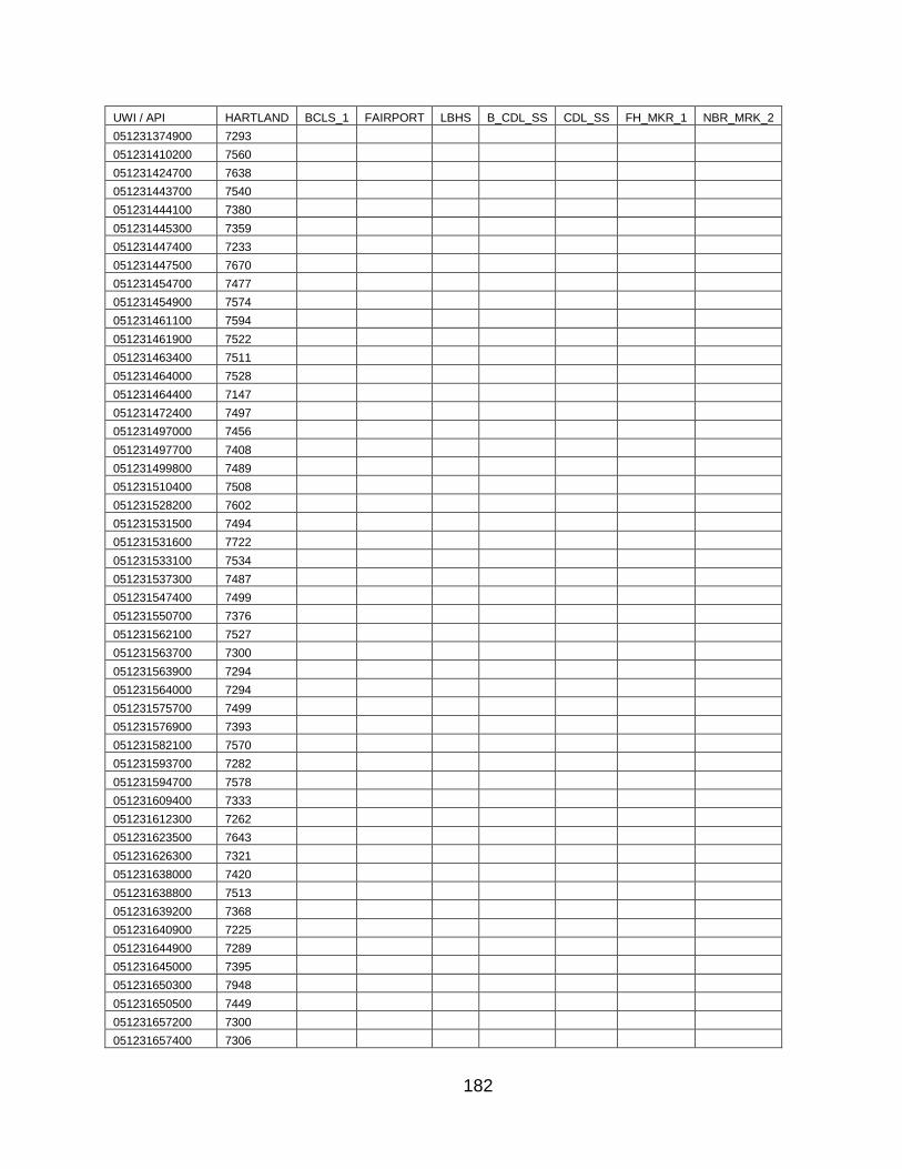
182
UWI / API HARTLAND BCLS_1 FAIRPORT LBHS B_CDL_SS CDL_SS FH_MKR_1 NBR_MRK_2
051231374900 7293
051231410200 7560
051231424700 7638
051231443700 7540
051231444100 7380
051231445300 7359
051231447400 7233
051231447500 7670
051231454700 7477
051231454900 7574
051231461100 7594
051231461900 7522
051231463400 7511
051231464000 7528
051231464400 7147
051231472400 7497
051231497000 7456
051231497700 7408
051231499800 7489
051231510400 7508
051231528200 7602
051231531500 7494
051231531600 7722
051231533100 7534
051231537300 7487
051231547400 7499
051231550700 7376
051231562100 7527
051231563700 7300
051231563900 7294
051231564000 7294
051231575700 7499
051231576900 7393
051231582100 7570
051231593700 7282
051231594700 7578
051231609400 7333
051231612300 7262
051231623500 7643
051231626300 7321
051231638000 7420
051231638800 7513
051231639200 7368
051231640900 7225
051231644900 7289
051231645000 7395
051231650300 7948
051231650500 7449
051231657200 7300
051231657400 7306
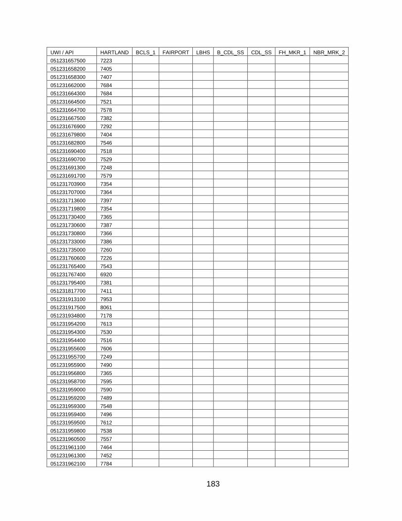
183
UWI / API HARTLAND BCLS_1 FAIRPORT LBHS B_CDL_SS CDL_SS FH_MKR_1 NBR_MRK_2
051231657500 7223
051231658200 7405
051231658300 7407
051231662000 7684
051231664300 7684
051231664500 7521
051231664700 7578
051231667500 7382
051231676900 7292
051231679800 7404
051231682800 7546
051231690400 7518
051231690700 7529
051231691300 7248
051231691700 7579
051231703900 7354
051231707000 7364
051231713600 7397
051231719800 7354
051231730400 7365
051231730600 7387
051231730800 7366
051231733000 7386
051231735000 7260
051231760600 7226
051231765400 7543
051231767400 6920
051231795400 7381
051231817700 7411
051231913100 7953
051231917500 8061
051231934800 7178
051231954200 7613
051231954300 7530
051231954400 7516
051231955600 7606
051231955700 7249
051231955900 7490
051231956800 7365
051231958700 7595
051231959000 7590
051231959200 7489
051231959300 7548
051231959400 7496
051231959500 7612
051231959800 7538
051231960500 7557
051231961100 7464
051231961300 7452
051231962100 7784
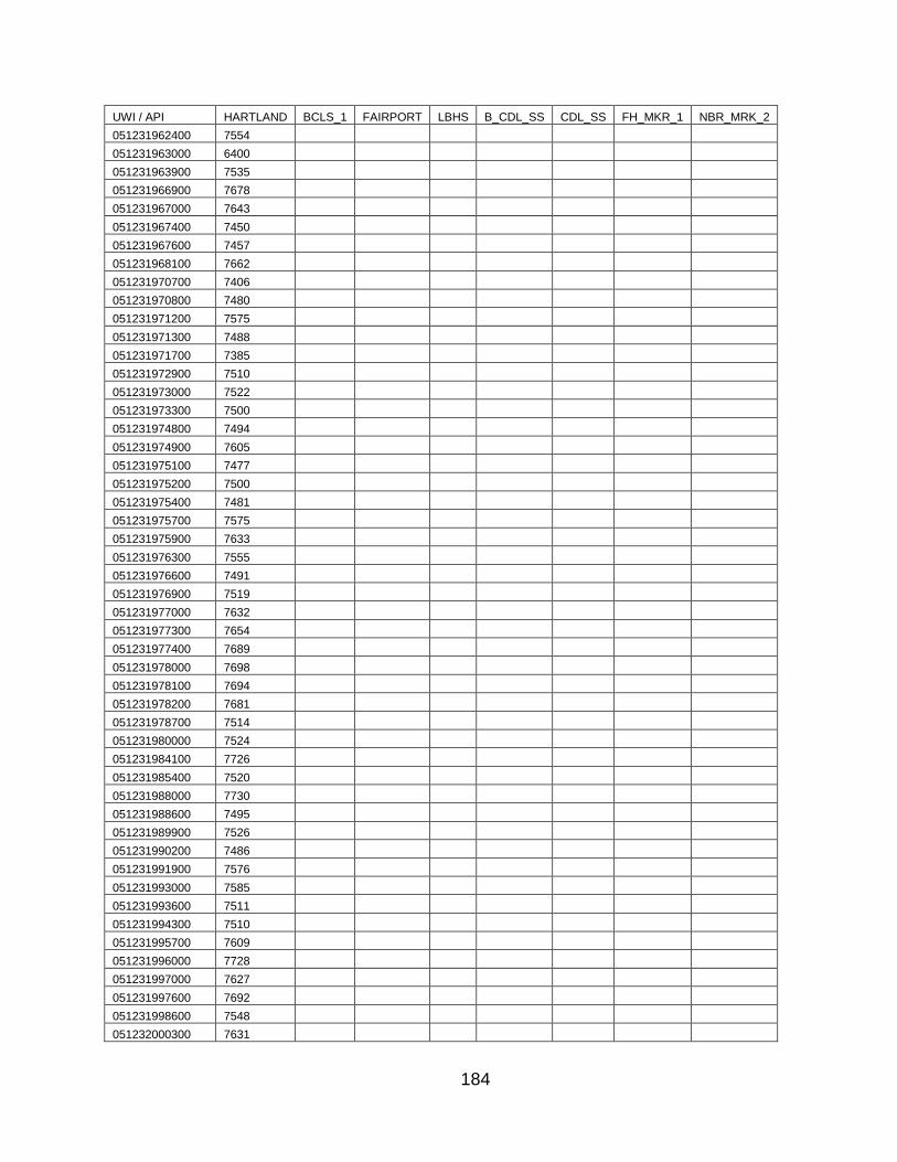
184
UWI / API HARTLAND BCLS_1 FAIRPORT LBHS B_CDL_SS CDL_SS FH_MKR_1 NBR_MRK_2
051231962400 7554
051231963000 6400
051231963900 7535
051231966900 7678
051231967000 7643
051231967400 7450
051231967600 7457
051231968100 7662
051231970700 7406
051231970800 7480
051231971200 7575
051231971300 7488
051231971700 7385
051231972900 7510
051231973000 7522
051231973300 7500
051231974800 7494
051231974900 7605
051231975100 7477
051231975200 7500
051231975400 7481
051231975700 7575
051231975900 7633
051231976300 7555
051231976600 7491
051231976900 7519
051231977000 7632
051231977300 7654
051231977400 7689
051231978000 7698
051231978100 7694
051231978200 7681
051231978700 7514
051231980000 7524
051231984100 7726
051231985400 7520
051231988000 7730
051231988600 7495
051231989900 7526
051231990200 7486
051231991900 7576
051231993000 7585
051231993600 7511
051231994300 7510
051231995700 7609
051231996000 7728
051231997000 7627
051231997600 7692
051231998600 7548
051232000300 7631

185
UWI / API HARTLAND BCLS_1 FAIRPORT LBHS B_CDL_SS CDL_SS FH_MKR_1 NBR_MRK_2
051232001300 7388
051232002600 7690
051232004800 7624
051232005000 7519
051232005200 7628
051232007900 7492
051232010100 7550
051232015100 7521
051232015200 7537
051232018800 7617
051232018900 7532
051232021100 7516
051232030700 7584
051232031000 7536
051232031400 7488
051232033600 7711
051232034900 7638
051232045400 7400
051232049800 7523
051232050700 7475
051232050900 7552
051232051000 7707
051232052600 7611
051232052700 7585
051232052800 7552
051232053400 7871
051232055700 7656
051232056000 7530
051232057000 7587
051232057100 6629
051232059100 7365
051232060000 7595
051232060100 7531
051232061500 7712
051232062300 7676
051232062600 7541
051232063700 7590
051232065200 7606
051232072500 7613
051232074700 7564
051232077000 7831
051232077500 7978
051232082100 6825
051232082300 7650
051232082800 7786
051232082900 7926
051232083300 6613
051232087100 7763
051232091400 7618
051232091500 7667

186
UWI / API HARTLAND BCLS_1 FAIRPORT LBHS B_CDL_SS CDL_SS FH_MKR_1 NBR_MRK_2
051232091700 7730
051232092000 7551
051232094100 7711
051232094200 7659
051232094400 7817
051232094500 7695
051232094600 7896
051232095000 7657
051232095500 7635
051232095600 7592
051232107300 6846
051232114000 7251
051232116900 6726
051232125900 7277
051232144800 7478
051232196700 6843
051232196800 6697
051232205000 6419
051232205200 6397
051232205300 6407
051232206400 6670
051232210200 7354
051232229700 7223
051232230900 7026
051232243000 6408
051232244900 6673
051232250000 6625
051232269600 6644
051232269700 6646
051232271600 6613
051232276800 6375
051232278900 6751
051232293500 7193
051232302900 7257
051232307200 6433
051232308200 6846
051232309800 6669
051232310100 6734
051232310300 6689
051232310400 6747
051232315000 6404
051232316600 6803
051232317000 6747
051232317100 6746
051232317200 6746
051232318100 6753
051232336500 7203
051232336900 6874
051232337000 6880
051232337100 6863
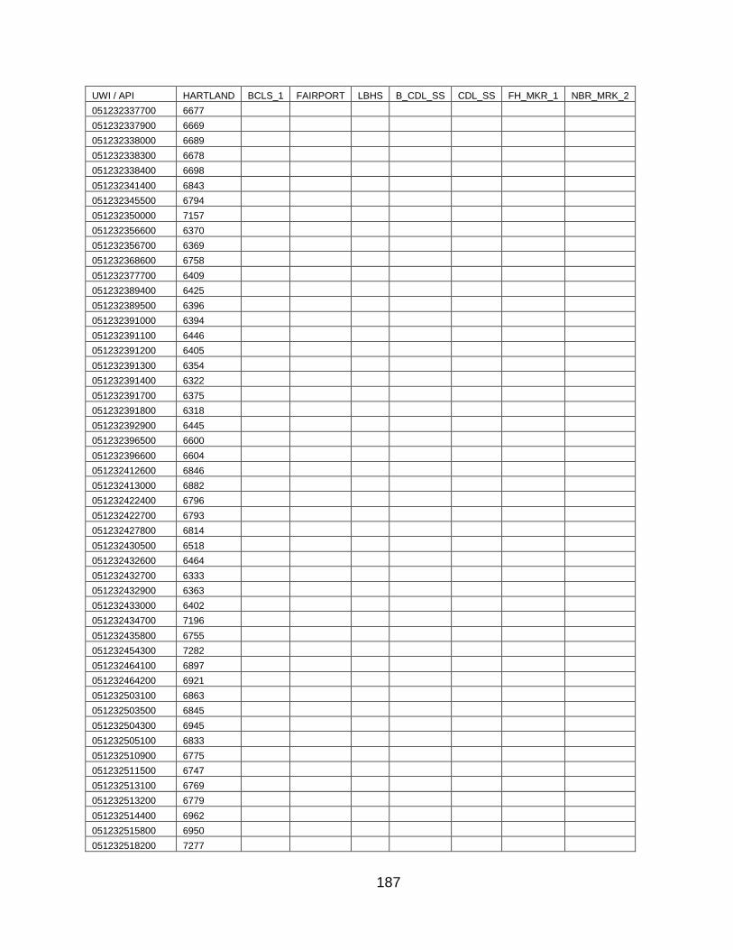
187
UWI / API HARTLAND BCLS_1 FAIRPORT LBHS B_CDL_SS CDL_SS FH_MKR_1 NBR_MRK_2
051232337700 6677
051232337900 6669
051232338000 6689
051232338300 6678
051232338400 6698
051232341400 6843
051232345500 6794
051232350000 7157
051232356600 6370
051232356700 6369
051232368600 6758
051232377700 6409
051232389400 6425
051232389500 6396
051232391000 6394
051232391100 6446
051232391200 6405
051232391300 6354
051232391400 6322
051232391700 6375
051232391800 6318
051232392900 6445
051232396500 6600
051232396600 6604
051232412600 6846
051232413000 6882
051232422400 6796
051232422700 6793
051232427800 6814
051232430500 6518
051232432600 6464
051232432700 6333
051232432900 6363
051232433000 6402
051232434700 7196
051232435800 6755
051232454300 7282
051232464100 6897
051232464200 6921
051232503100 6863
051232503500 6845
051232504300 6945
051232505100 6833
051232510900 6775
051232511500 6747
051232513100 6769
051232513200 6779
051232514400 6962
051232515800 6950
051232518200 7277
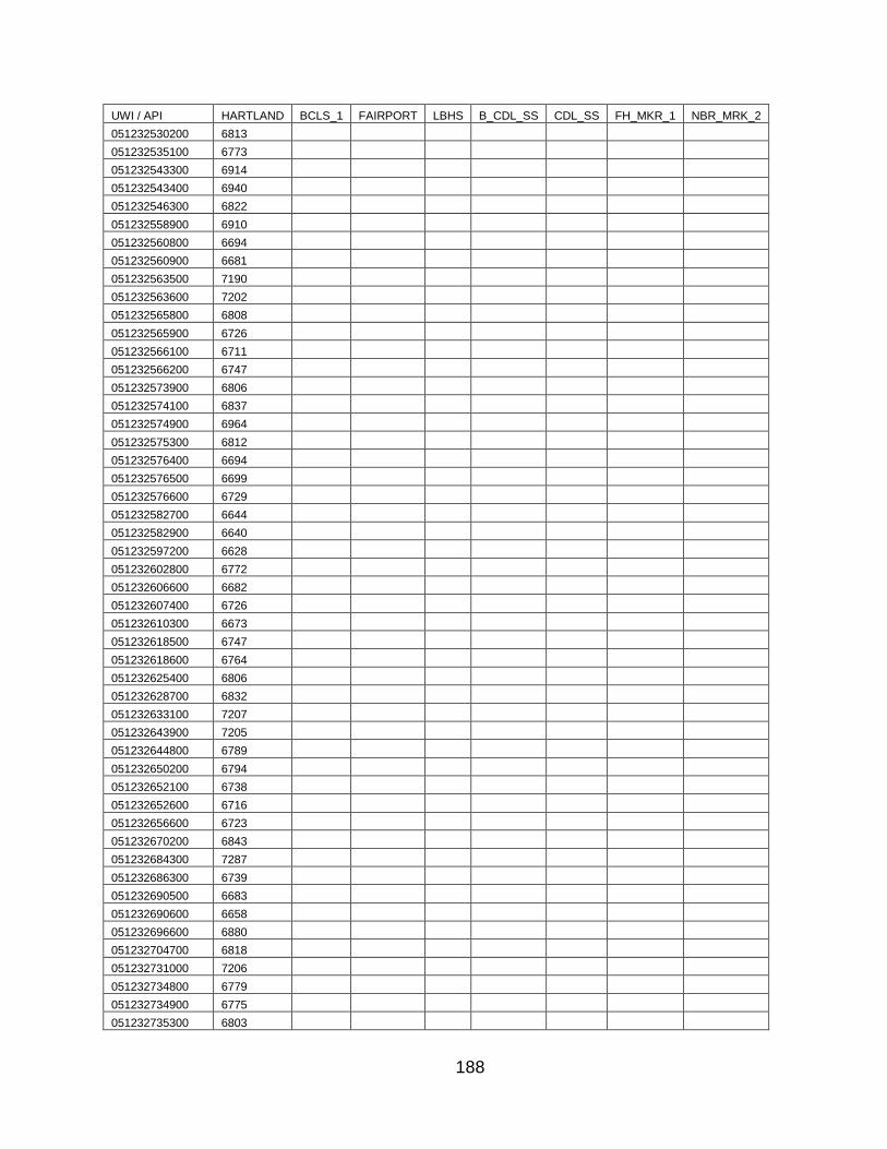
188
UWI / API HARTLAND BCLS_1 FAIRPORT LBHS B_CDL_SS CDL_SS FH_MKR_1 NBR_MRK_2
051232530200 6813
051232535100 6773
051232543300 6914
051232543400 6940
051232546300 6822
051232558900 6910
051232560800 6694
051232560900 6681
051232563500 7190
051232563600 7202
051232565800 6808
051232565900 6726
051232566100 6711
051232566200 6747
051232573900 6806
051232574100 6837
051232574900 6964
051232575300 6812
051232576400 6694
051232576500 6699
051232576600 6729
051232582700 6644
051232582900 6640
051232597200 6628
051232602800 6772
051232606600 6682
051232607400 6726
051232610300 6673
051232618500 6747
051232618600 6764
051232625400 6806
051232628700 6832
051232633100 7207
051232643900 7205
051232644800 6789
051232650200 6794
051232652100 6738
051232652600 6716
051232656600 6723
051232670200 6843
051232684300 7287
051232686300 6739
051232690500 6683
051232690600 6658
051232696600 6880
051232704700 6818
051232731000 7206
051232734800 6779
051232734900 6775
051232735300 6803
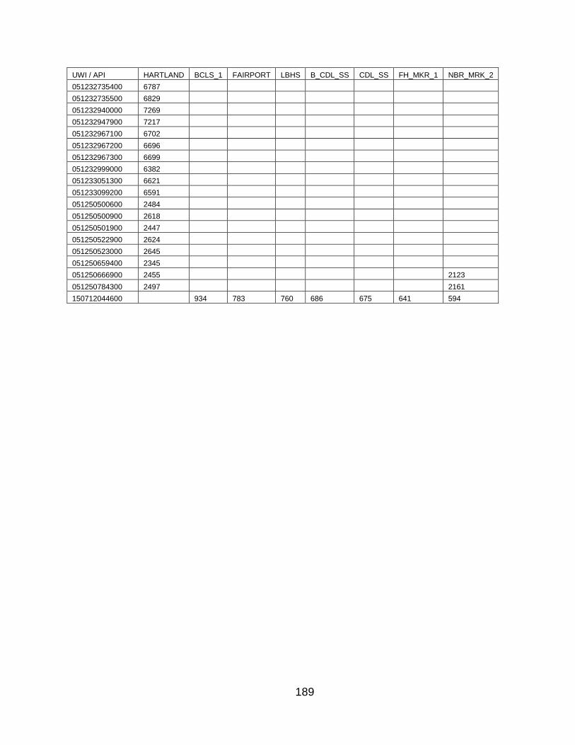
189
UWI / API HARTLAND BCLS_1 FAIRPORT LBHS B_CDL_SS CDL_SS FH_MKR_1 NBR_MRK_2
051232735400 6787
051232735500 6829
051232940000 7269
051232947900 7217
051232967100 6702
051232967200 6696
051232967300 6699
051232999000 6382
051233051300 6621
051233099200 6591
051250500600 2484
051250500900 2618
051250501900 2447
051250522900 2624
051250523000 2645
051250659400 2345
051250666900 2455 2123
051250784300 2497 2161
150712044600 934 783 760 686 675 641 594
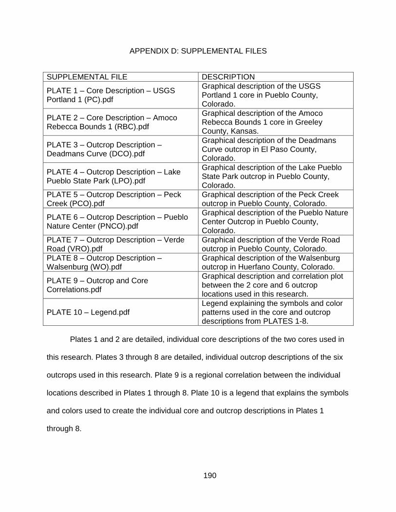
190
APPENDIX D: SUPPLEMENTAL FILES
SUPPLEMENTAL FILE DESCRIPTION
PLATE 1 – Core Description – USGS Portland 1 (PC).pdf
Graphical description of the USGS Portland 1 core in Pueblo County, Colorado.
PLATE 2 – Core Description – Amoco Rebecca Bounds 1 (RBC).pdf
Graphical description of the Amoco Rebecca Bounds 1 core in Greeley County, Kansas.
PLATE 3 – Outcrop Description – Deadmans Curve (DCO).pdf
Graphical description of the Deadmans Curve outcrop in El Paso County, Colorado.
PLATE 4 – Outcrop Description – Lake Pueblo State Park (LPO).pdf
Graphical description of the Lake Pueblo State Park outcrop in Pueblo County, Colorado.
PLATE 5 – Outcrop Description – Peck Creek (PCO).pdf
Graphical description of the Peck Creek outcrop in Pueblo County, Colorado.
PLATE 6 – Outcrop Description – Pueblo Nature Center (PNCO).pdf
Graphical description of the Pueblo Nature Center Outcrop in Pueblo County, Colorado.
PLATE 7 – Outcrop Description – Verde Road (VRO).pdf
Graphical description of the Verde Road outcrop in Pueblo County, Colorado.
PLATE 8 – Outcrop Description – Walsenburg (WO).pdf
Graphical description of the Walsenburg outcrop in Huerfano County, Colorado.
PLATE 9 – Outcrop and Core Correlations.pdf
Graphical description and correlation plot between the 2 core and 6 outcrop locations used in this research.
PLATE 10 – Legend.pdf Legend explaining the symbols and color patterns used in the core and outcrop descriptions from PLATES 1-8.
Plates 1 and 2 are detailed, individual core descriptions of the two cores used in
this research. Plates 3 through 8 are detailed, individual outcrop descriptions of the six
outcrops used in this research. Plate 9 is a regional correlation between the individual
locations described in Plates 1 through 8. Plate 10 is a legend that explains the symbols
and colors used to create the individual core and outcrop descriptions in Plates 1
through 8.


