
Gates Pass 62 (100k) START/FINISH: Oro Valley Aquatic Center (23 W Calle Concordia, Oro Valley, AZ 85704) MapMyRide Link: https://www.mapmyride.com/routes/view/2380725655 -West on W Calle Concordia -Right on to N La Canada -Left on N La Canada Dr to the CDO (Canada del Oro) Trail -Left on Santa Cruz River Trail to W Speedway Blvd -Right on W Speedway Blvd (W Speedway Blvd turns into W Gates Pass Rd) -Continue west on W Gates Pass Rd to McCain Loop Rd -Left on McCain Loop Rd to N Kinney Rd -Left on N Kinney R to N Sandario Rd -Right on N Sandario Rd to W Twin Peaks Rd -Right on Twin Peaks Dr to W Tangerine Rd -Right turn on W Tangerine Rd to N La Canada -Right turn on N La Canada to W Calle Concordia -Left turn on W Calle Concordia back to the Oro Valley Aquatic Center
W Tangerine Rd
N La Canada
W Twin Peaks Dr
Santa Cruz River Trail
McCain Loop Rd
W Calle Concordia
W Speedway Blvd
W Gates Pass Rd
N Kinney Rd
N Sandario Rd
W Twin Peaks Rd
CDO Trail
Gilbert Ray Campground (Great place to stop for
restroom and water)
FAST downhill – Be cautious or you’ll miss the turn to stay on
Twin Peaks Dr
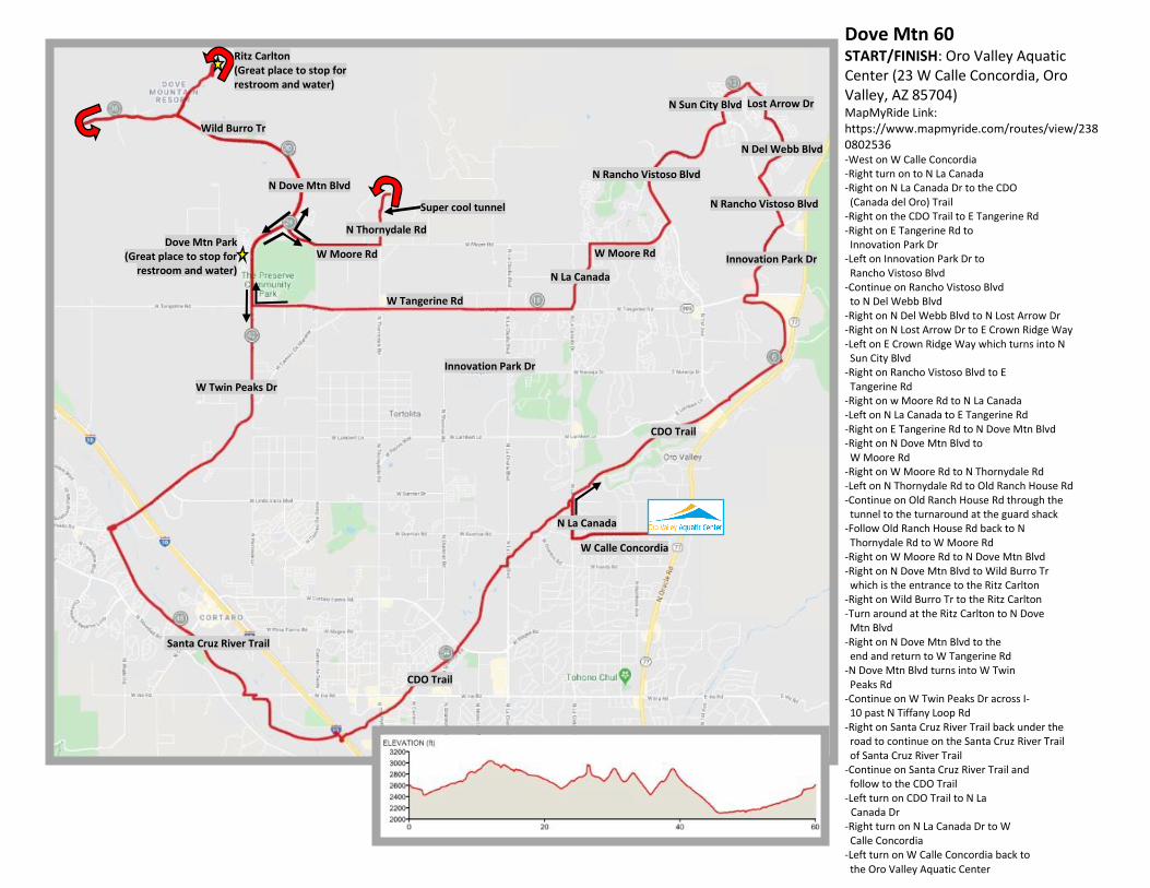
Dove Mtn 60 START/FINISH: Oro Valley Aquatic Center (23 W Calle Concordia, Oro Valley, AZ 85704) MapMyRide Link: https://www.mapmyride.com/routes/view/2380802536 -West on W Calle Concordia -Right turn on to N La Canada -Right on N La Canada Dr to the CDO (Canada del Oro) Trail -Right on the CDO Trail to E Tangerine Rd -Right on E Tangerine Rd to Innovation Park Dr -Left on Innovation Park Dr to Rancho Vistoso Blvd -Continue on Rancho Vistoso Blvd to N Del Webb Blvd -Right on N Del Webb Blvd to N Lost Arrow Dr -Right on N Lost Arrow Dr to E Crown Ridge Way -Left on E Crown Ridge Way which turns into N Sun City Blvd -Right on Rancho Vistoso Blvd to E Tangerine Rd -Right on w Moore Rd to N La Canada -Left on N La Canada to E Tangerine Rd -Right on E Tangerine Rd to N Dove Mtn Blvd -Right on N Dove Mtn Blvd to W Moore Rd -Right on W Moore Rd to N Thornydale Rd -Left on N Thornydale Rd to Old Ranch House Rd -Continue on Old Ranch House Rd through the tunnel to the turnaround at the guard shack -Follow Old Ranch House Rd back to N Thornydale Rd to W Moore Rd -Right on W Moore Rd to N Dove Mtn Blvd -Right on N Dove Mtn Blvd to Wild Burro Tr which is the entrance to the Ritz Carlton -Right on Wild Burro Tr to the Ritz Carlton -Turn around at the Ritz Carlton to N Dove Mtn Blvd -Right on N Dove Mtn Blvd to the end and return to W Tangerine Rd -N Dove Mtn Blvd turns into W Twin Peaks Rd -Continue on W Twin Peaks Dr across I- 10 past N Tiffany Loop Rd -Right on Santa Cruz River Trail back under the road to continue on the Santa Cruz River Trail of Santa Cruz River Trail -Continue on Santa Cruz River Trail and follow to the CDO Trail -Left turn on CDO Trail to N La Canada Dr -Right turn on N La Canada Dr to W Calle Concordia -Left turn on W Calle Concordia back to the Oro Valley Aquatic Center
N Rancho Vistoso Blvd
Innovation Park Dr
W Tangerine Rd
N La Canada
N Dove Mtn Blvd
W Twin Peaks Dr
Santa Cruz River Trail
CDO Trail
W Calle Concordia
Wild Burro Tr
CDO Trail
Ritz Carlton (Great place to stop for restroom and water)
N Thornydale Rd
W Moore Rd
N Del Webb Blvd
N Sun City Blvd
Super cool tunnel
Dove Mtn Park (Great place to stop for
restroom and water)
Innovation Park Dr
N La Canada
N Rancho Vistoso Blvd
Lost Arrow Dr
W Moore Rd
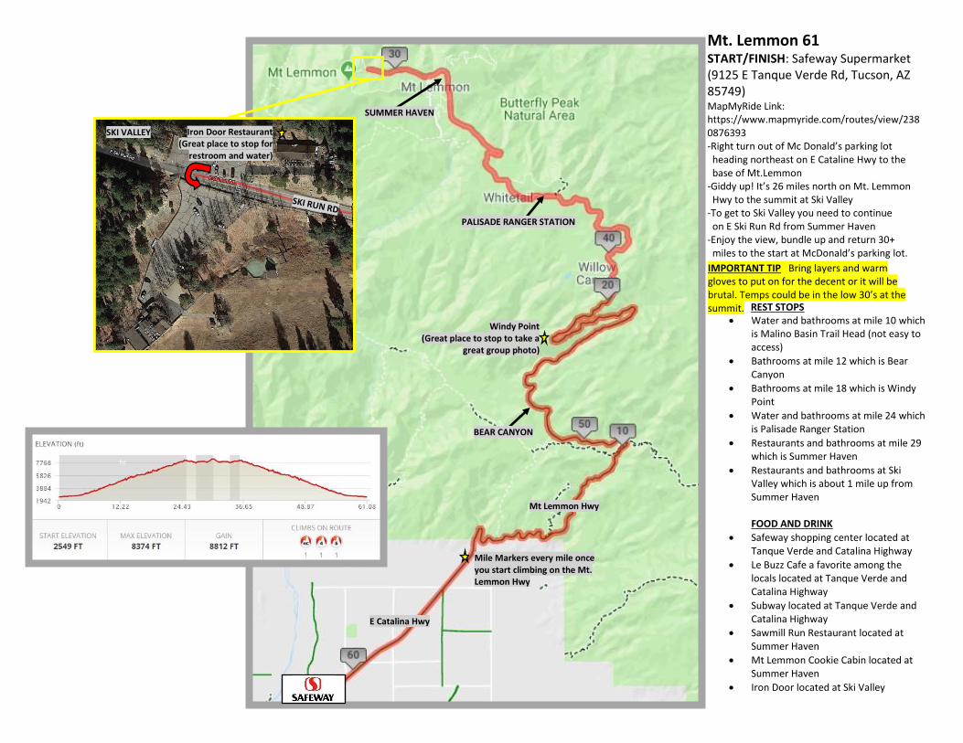
Mt. Lemmon 61 START/FINISH: Safeway Supermarket (9125 E Tanque Verde Rd, Tucson, AZ 85749) MapMyRide Link: https://www.mapmyride.com/routes/view/2380876393 -Right turn out of Mc Donald’s parking lot heading northeast on E Cataline Hwy to the base of Mt.Lemmon -Giddy up! It’s 26 miles north on Mt. Lemmon Hwy to the summit at Ski Valley -To get to Ski Valley you need to continue on E Ski Run Rd from Summer Haven -Enjoy the view, bundle up and return 30+ miles to the start at McDonald’s parking lot.
• Water and bathrooms at mile 10 which is Malino Basin Trail Head (not easy to access)
• Bathrooms at mile 12 which is Bear Canyon
• Bathrooms at mile 18 which is Windy Point
• Water and bathrooms at mile 24 which is Palisade Ranger Station
• Restaurants and bathrooms at mile 29 which is Summer Haven
• Restaurants and bathrooms at Ski Valley which is about 1 mile up from Summer Haven FOOD AND DRINK
• Safeway shopping center located at Tanque Verde and Catalina Highway
• Le Buzz Cafe a favorite among the locals located at Tanque Verde and Catalina Highway
• Subway located at Tanque Verde and Catalina Highway
• Sawmill Run Restaurant located at Summer Haven
• Mt Lemmon Cookie Cabin located at Summer Haven
• Iron Door located at Ski Valley
E Catalina Hwy
Mt Lemmon Hwy
SUMMER HAVEN
REST STOPS
IMPORTANT TIP Bring layers and warm gloves to put on for the decent or it will be brutal. Temps could be in the low 30’s at the summit.
PALISADE RANGER STATION
BEAR CANYON
Iron Door Restaurant (Great place to stop for
restroom and water)
SKI VALLEY
Windy Point (Great place to stop to take a
great group photo)
Mile Markers every mile once you start climbing on the Mt. Lemmon Hwy

Sabino Canyon Loop 10 START/FINISH: Sabino Canyon Recreation Area (5700 N Sabino Canyon Rd, Tucson, AZ 85750) MapMyRide Link: https://www.mapmyride.com/routes/view/2382091144 -Head northeast on N Upper Canyon Rd to the second intersection (Overlook Picnic Area) -Right turn at this intersection to the Crossing Zero intersection -Go right at Crossing Zero to the Phone Line Trail Head (it’s left turn, then a quick right turn) -Right turn on the Phone Line Trail to the Sabino Canyon Trail Phone Line Trail turns into Sabino Canyon Trail) -Continue on Sabino Canyon Trail until it ends at the Sabino Canyon Trail #23 trail head -Continue south on the N Upper Canyon Rd back to the parking lot TRAIL ETIQUETTE -Hikers traveling uphill have the right-of-way -Move to the side to allow hikers to pass -Leave No Trace
Romero Canyon Trail
N Upper Canyon Rd
Phoneline Trail
Sutherland Trail
N Upper Canyon Rd
Crossing Zero
Sabino Canyon Trail
Phoneline Trail
PAVEMENT BEGINS
IMPORTANT Remember to order your weekly pass
Overlook Picnic Area

Kitt Peak Observatory 58 START/FINISH: Three Points Veterans Memorial Park (10211 S Sasabe Hwy, Tuscon,, AZ 85736) MapMyRide Link:
https://www.mapmyride.com/routes/view/2419791157 -Right turn out of the park to Sasabe Hwy -Right on Sasabe Hwy to Tucson-Ajo Highway -Left on Tucson-Ajo Highway to the entrance to the Kitt Peak Observatory (Route 386) -Left at the entrance of the Kitt Peak Observatory and this road dead ends into the Kitt Peak Observatory -Reverse route and return to Three Points Veterans Memorial Park
Three Points Veterans Park
W Tucson-Ajo Hwy
Santa Cruz Trail
S Sasabe Rd
Parking for 34 mile option
*Make sure drivers license is with you for
this ride. There is a border patrol
checkpoint on the Hwy
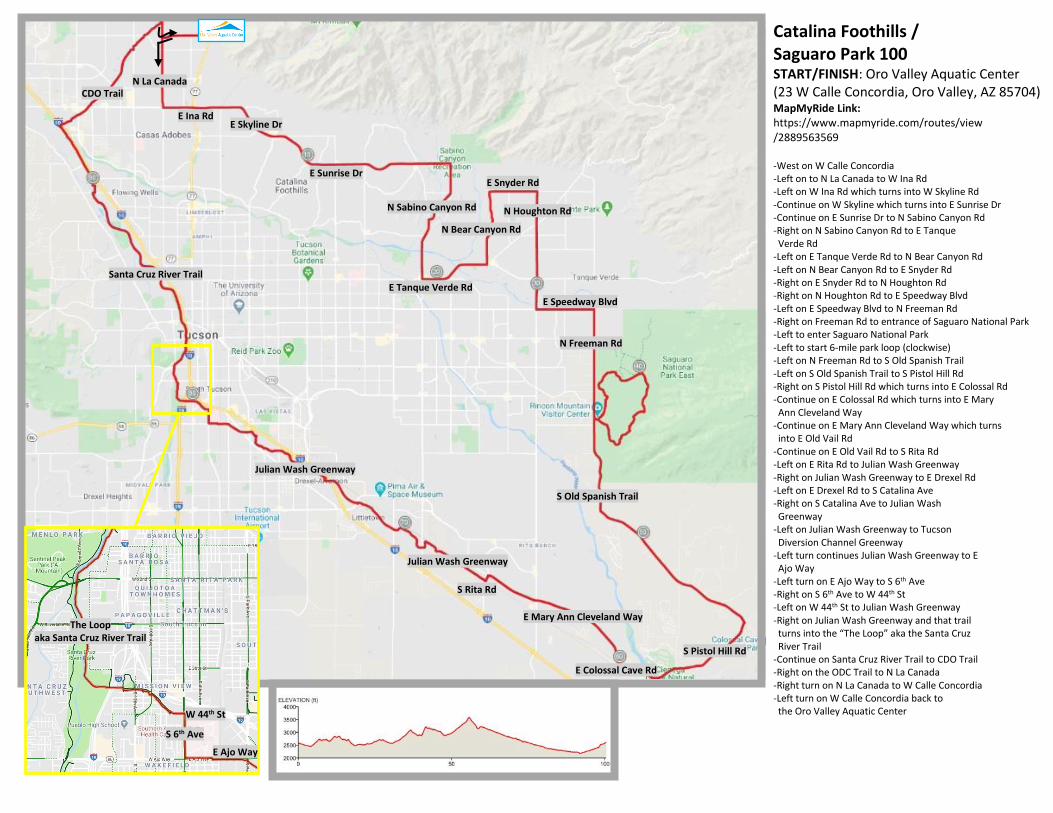
E Skyline Dr
CDO Trail
Santa Cruz River Trail
S Old Spanish Trail
E Colossal Cave Rd
S Pistol Hill Rd
Julian Wash Greenway
Julian Wash Greenway
E Ina Rd
E Sunrise Dr
N Sabino Canyon Rd
N La Canada
E Tanque Verde Rd
N Bear Canyon Rd
E Snyder Rd
N Houghton Rd
E Speedway Blvd
N Freeman Rd
E Mary Ann Cleveland Way
S Rita Rd
W 44th St
S 6th Ave
E Ajo Way
The Loop aka Santa Cruz River Trail
Catalina Foothills / Saguaro Park 100 START/FINISH: Oro Valley Aquatic Center (23 W Calle Concordia, Oro Valley, AZ 85704) MapMyRide Link: https://www.mapmyride.com/routes/view /2889563569 -West on W Calle Concordia -Left on to N La Canada to W Ina Rd -Left on W Ina Rd which turns into W Skyline Rd -Continue on W Skyline which turns into E Sunrise Dr -Continue on E Sunrise Dr to N Sabino Canyon Rd -Right on N Sabino Canyon Rd to E Tanque Verde Rd -Left on E Tanque Verde Rd to N Bear Canyon Rd -Left on N Bear Canyon Rd to E Snyder Rd -Right on E Snyder Rd to N Houghton Rd -Right on N Houghton Rd to E Speedway Blvd -Left on E Speedway Blvd to N Freeman Rd -Right on Freeman Rd to entrance of Saguaro National Park -Left to enter Saguaro National Park -Left to start 6-mile park loop (clockwise) -Left on N Freeman Rd to S Old Spanish Trail -Left on S Old Spanish Trail to S Pistol Hill Rd -Right on S Pistol Hill Rd which turns into E Colossal Rd -Continue on E Colossal Rd which turns into E Mary Ann Cleveland Way -Continue on E Mary Ann Cleveland Way which turns into E Old Vail Rd -Continue on E Old Vail Rd to S Rita Rd -Left on E Rita Rd to Julian Wash Greenway -Right on Julian Wash Greenway to E Drexel Rd -Left on E Drexel Rd to S Catalina Ave -Right on S Catalina Ave to Julian Wash Greenway -Left on Julian Wash Greenway to Tucson Diversion Channel Greenway -Left turn continues Julian Wash Greenway to E Ajo Way -Left turn on E Ajo Way to S 6th Ave -Right on S 6th Ave to W 44th St -Left on W 44th St to Julian Wash Greenway -Right on Julian Wash Greenway and that trail turns into the “The Loop” aka the Santa Cruz River Trail -Continue on Santa Cruz River Trail to CDO Trail -Right on the ODC Trail to N La Canada -Right turn on N La Canada to W Calle Concordia -Left turn on W Calle Concordia back to the Oro Valley Aquatic Center
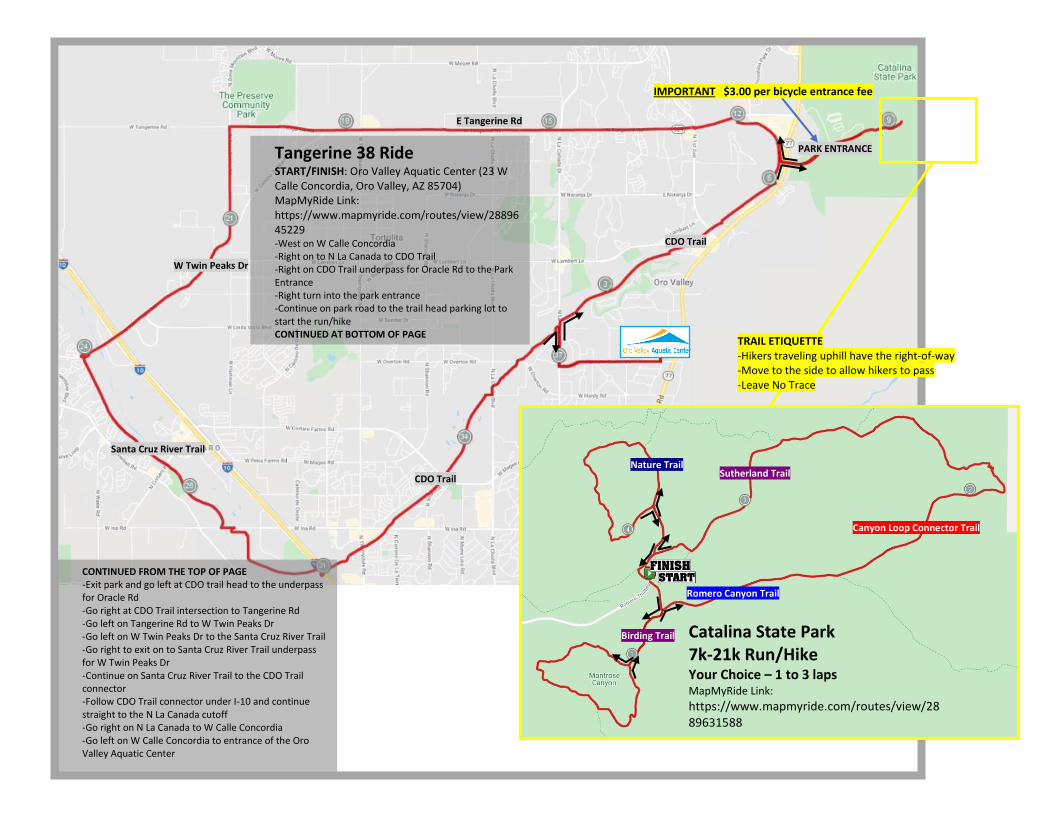
PARK ENTRANCE
CDO Trail
CDO Trail
E Tangerine Rd
W Twin Peaks Dr
Santa Cruz River Trail
IMPORTANT $3.00 per bicycle entrance fee
Birding Trail
Romero Canyon Trail
Canyon Loop Connector Trail
Sutherland Trail Nature Trail
Tangerine 38 Ride START/FINISH: Oro Valley Aquatic Center (23 W Calle Concordia, Oro Valley, AZ 85704) MapMyRide Link: https://www.mapmyride.com/routes/view/2889645229 -West on W Calle Concordia -Right on to N La Canada to CDO Trail -Right on CDO Trail underpass for Oracle Rd to the Park Entrance -Right turn into the park entrance -Continue on park road to the trail head parking lot to start the run/hike CONTINUED AT BOTTOM OF PAGE
CONTINUED FROM THE TOP OF PAGE -Exit park and go left at CDO trail head to the underpass for Oracle Rd -Go right at CDO Trail intersection to Tangerine Rd -Go left on Tangerine Rd to W Twin Peaks Dr -Go left on W Twin Peaks Dr to the Santa Cruz River Trail -Go right to exit on to Santa Cruz River Trail underpass for W Twin Peaks Dr -Continue on Santa Cruz River Trail to the CDO Trail connector -Follow CDO Trail connector under I-10 and continue straight to the N La Canada cutoff -Go right on N La Canada to W Calle Concordia -Go left on W Calle Concordia to entrance of the Oro Valley Aquatic Center
Catalina State Park 7k-21k Run/Hike Your Choice – 1 to 3 laps MapMyRide Link:
https://www.mapmyride.com/routes/view/2889631588
TRAIL ETIQUETTE -Hikers traveling uphill have the right-of-way -Move to the side to allow hikers to pass -Leave No Trace


