Download - Satellites, GPS & atomic clock - ELTE
Satellites, GPS & atomic clock
2016. május 4.
Rozgonyi Kristóf
Phisical foundations of IT tools,
2016.05.04

Brief historical introduction
• The Space Race began on August 2, 1955,when the Soviet Union responded to theUS announcement four days earlier ofintent to launch artificial satellites.
• The first artificial satellite was Sputnik 1,launched by the Soviet Union on October4, 1957.
• Explorer 1 was the United States’ firstartificial satellite, launched on January 31,1958.
1 / 24

Brief historical introduction
• William Guier and George Weiffenbach decided tomonitor Sputnik’s radio transmissions.
• Because of the Doppler effect, they could pinpointwhere the satellite was along its orbit.
• A year later they investigated the inverse problem –pinpointing the user’s location, given that of thesatellite.
• The first satellite navigation system, TRANSIT,used by the United States Navy, was firstsuccessfully tested in 1960. (It used a constellationof five satellites.)
2 / 24

The early concept of GPS
• The TRANSIT system was too slow for the Air Force operation, thusthe research continued with the Timation (Time Navigation) satellites.
• The first launched in 1967, and with the third one in 1974 carrying thefirst atomic clock into orbit.
• In 1973, a meeting at the Pentagon discussed the creation of aDefense Navigation Satellite System (DNSS).
• Later the DNSS program was named Navstar, or Navigation SystemUsing Timing and Ranging.
3 / 24

The construction of GPS
• In the early stage Navstar used already orbitingsatellites.
• Eleven "Block I" prototype satellites werelaunched between 1978 and 1985.
• The "Block II" satellites were the first fullscale operational GPS satellites, was firstlaunched in 1989.
• By December 1993, GPS achieved initialoperational capability, indicating a fullconstellation of 24 satellites.
4 / 24

The construction of GPS
• Full Operational Capability was declared by AirForce Space Command in April 1995.
• In 2004, Qualcomm announced successful testsof assisted GPS for mobile phones.
• The latest upgrade of the system was "BlockIIF" with twelve satellites, launched between2010 and 2016.
• The next generation "Block III" satellites areproject to launch in 2017.
5 / 24

Politics and GPS
• In the early stage the system was only available forthe US military.
• After a Korean aircraft was accidentally shot downin 1983, Ronald Reagan issued a directive makingGPS freely available for civilian use.
• Although the signal was publicly available, it wasintentionally degraded, because the highest qualitysignal was reserved for military use.
• The US government decrypt the signal at 2000 toprovide the same precision to civilians that wasafforded to the military.
6 / 24

Main satellite orbits
• Yet 72 GPS navigation satellites have been launched, 31 are operational(at full constellation 24 satellite are in operation)
• Three main types ofEarth-close satellite orbits:
• Low Earth Orbit (LEO):100-1500 km
• Middle Earth Orbit(MEO): 5000-10000 km
• Geo-Synchro-Orbit (GSO):36000 km
7 / 24
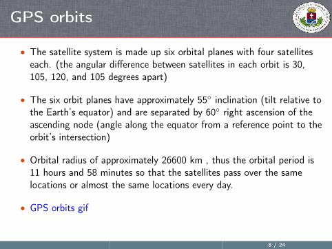
GPS orbits
• The satellite system is made up six orbital planes with four satelliteseach. (the angular difference between satellites in each orbit is 30,105, 120, and 105 degrees apart)
• The six orbit planes have approximately 55◦ inclination (tilt relative tothe Earth’s equator) and are separated by 60◦ right ascension of theascending node (angle along the equator from a reference point to theorbit’s intersection)
• Orbital radius of approximately 26600 km , thus the orbital period is11 hours and 58 minutes so that the satellites pass over the samelocations or almost the same locations every day.
• GPS orbits gif
8 / 24

Operation Control Segment
• The Operation Control Segment (OCS) serves as the control segmentof record. It provides the operational capability and keeps the GPSsystem operational and performing within specification.
• OCS contains eleventracking and monitoringstations all over the globe.
• Contains a control stationand ground antennas inorder to communicate withthe satellites regularly.
9 / 24

GPS satellite frequencies
Band Frequency Description
L1 1575.42 MHz C/A and P(Y) codes.
L2 1227.60 MHz P(Y) code.
L3 1381.05 MHz Used for nuclear detonation(NUDET) detection.
L4 1379.913 MHz Being studied for additionalionospheric correction.
L5 1176.45 MHz Civilian safety-of-life(SoL) signal.
10 / 24
GPS signal encryption
• The relevant bands are L1 & L2, where the low-bitrate message datais encoded with a high-rate pseudo-random (PRN) sequence that isdifferent for each satellite.
• Coarse Acquisition code (C/A): for civilian use, transmits data at 1.023million chips per second.
• Precision code (P(Y)): or U.S. military use, transmits at 10.23 millionchips per second.
• A chip is a pulse of a pseudo random code, thus the signal will be themultiplication of the cip and the bit.
• To decrypt the signal you need to know the pseudo random code (theGold code) of the satellite.
11 / 24

GPS signal decryption
• Because all of the satellite signals are modulated onto the same carrierfrequency, the signals must be separated after demodulation.
12 / 24

GPS message
• Each GPS satellite continuously broadcasts a navigation message at arate of 50 bits per second.
• Each message takes 750 seconds to complete, and contain twenty-fiveframe, each contain five subframe:
Subframe Description
1 Satellite clock, GPS time relationship.
2-3 Ephemeris (precise satellite orbit).
4-5 Almanac component(satellite network synopsis, error correction).
13 / 24

Coordinate system
• The International Celestial Reference Frame (ICRF) is a quasi-inertialframe of reference centered at the barycenter of the Solar System,defined by the measured positions of 212 extragalactic sources.
• ICRF is now the standardreference frame used todefine the positions of theplanets (including theEarth)
• ICRF is the realization ofInternational CelestialReference System (ICRS).
14 / 24

Universal Time
• Coordinated Universal Time (UTC), is the primary time standard bywhich the world regulates clocks and time.
• UTC is defined by various synchronized atomic clocks and at irregularintervals to compensate for the slowing of Earth’s rotation.
• GPS use the Universal Time (UT), that is not corrected to match therotation of the Earth, thus the UT does not contain leap seconds.
• The GPS navigation message includes the difference between GPStime and UTC.
15 / 24

GPS reciver position
• To calculate the receiver’sposition three conditionsmust be satisfied:
• Clocks need to besynchronized
• Reciver have to know thesatellites positions
• Reciver have to connect atleast to four satellites
16 / 24

GPS problems
• The main problem is timekeeping:
• We need to measure time very precisely.
• We have to use atomic clocks.
• We have to make corrections for relativistic effects.
• For measure position very precisely, other ground stations andavailable satellites required.
• The system is sensitive to solar flares.
• Owned and run by the US army.
17 / 24

The history of the atomic clock
• Lord Kelvin suggested to use atomic transitions tomeasure time in 1879.
• The first atomic clock, based on the transition ofthe cesium-133 atom, was built by Louis Essen in1995.
• This led to the internationally agreed definition ofthe latest SI second being based on atomic time.
• In 2004, NIST scientists demonstrated a chip-scaleatomic clock.
18 / 24

Physical background
• The definition makes the cesium oscillator the primary standard fortime and frequency measurements, called the cesium standard.
• Cesium is an ideal material for atomic clocks, thus it is solid at roomtemperature and have only one electron on its valence shell.
• The actual time-reference of an atomic clock based on the hyperfinetransition of the cesium.
19 / 24

Physical background
• The core of the atomic clock is a tunable microwave cavity containinggas.
• We measure the photons (or the lack of photons) from the inducedemissions (induced absorption).
• With the help of thedetector’s feedback signalwe can keep the microwavecavity at resonancefrequency.
20 / 24

Modern atomic clocks
• Modern clocks try to correct the unwantedside-effects, and uses advanced techniques.
• The modern standards use laser cooling,magneto-optical traps and precision laserspectroscopy.
• Furthermore the modern clocks use othermaterials to increase the accuracy.
• Current accuracy: 1.5× 10⁻¹⁶ s
21 / 24

GPS time synchronization
• Every satellite has at least two onboard cesium atomic clocks.
• At each control stations there is also an atomic clock.
• The clock not synchronized to each otherbut the UT "absolute" time.
• We have to make the relativisticcorrections for the satellite’s clocks:
• Special relativistic correction, for thespeed of the satellite.
• General relativistic correction, for theEarth mass.
22 / 24
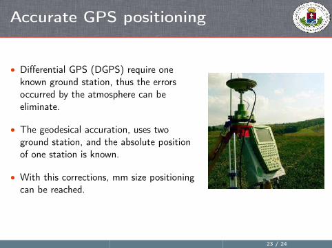
Accurate GPS positioning
• Differential GPS (DGPS) require oneknown ground station, thus the errorsoccurred by the atmosphere can beeliminate.
• The geodesical accuration, uses twoground station, and the absolute positionof one station is known.
• With this corrections, mm size positioningcan be reached.
23 / 24

Future of the GPS, alternatives
• 32 more satellites are planned with NASA’s new atomic clock: DeepSpace Atomic Clock (2016).
• Alternative systems: GLONASS (Russian), Galileo (Europa), Beidou-2(China).
24 / 24


