Download - RUSI SA April 2007
GEOGRAPHIC INTELLIGENCE: KNOW YOUR WORLD THROUGH STORY-TELLING
Presentation to Royal United Services Institute of South Australia Inc
on Monday 2nd April 2007
By
Dr R.J.Williams
C3I Division Defence Science and Technology Organisation
Edinburgh, South Australia
NOTE: Views and opinions expressed in this presentation are those of the author and not necessarily those of his organisation nor the Department of Defence.
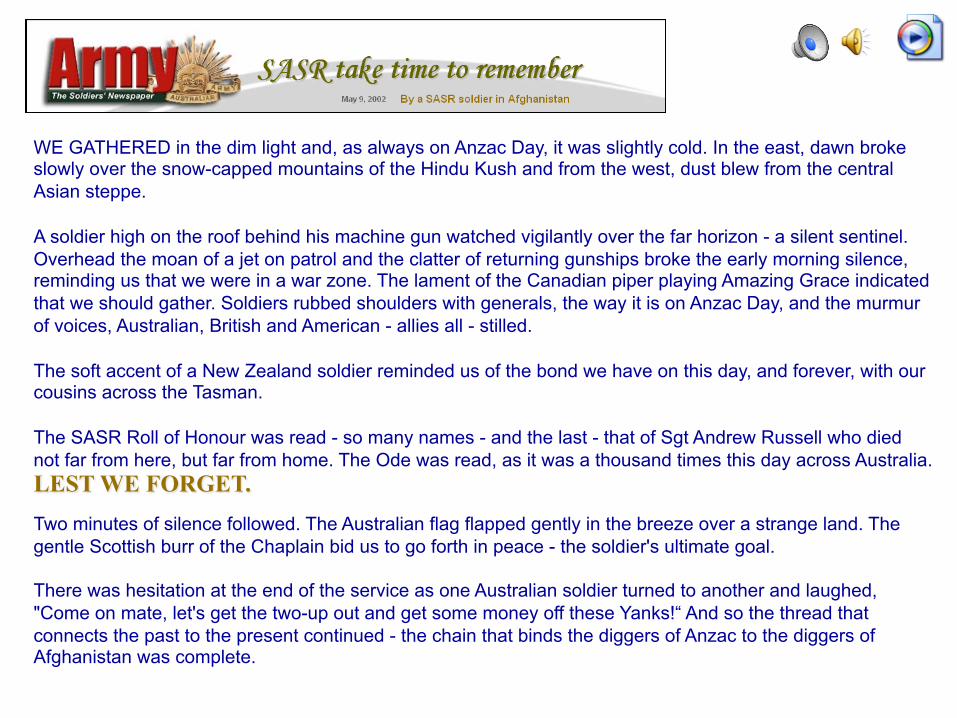
WE GATHERED in the dim light and, as always on Anzac Day, it was slightly cold. In the east, dawn broke slowly over the snow-capped mountains of the Hindu Kush and from the west, dust blew from the central Asian steppe. A soldier high on the roof behind his machine gun watched vigilantly over the far horizon - a silent sentinel. Overhead the moan of a jet on patrol and the clatter of returning gunships broke the early morning silence, reminding us that we were in a war zone. The lament of the Canadian piper playing Amazing Grace indicated that we should gather. Soldiers rubbed shoulders with generals, the way it is on Anzac Day, and the murmur of voices, Australian, British and American - allies all - stilled. The soft accent of a New Zealand soldier reminded us of the bond we have on this day, and forever, with our cousins across the Tasman. The SASR Roll of Honour was read - so many names - and the last - that of Sgt Andrew Russell who died not far from here, but far from home. The Ode was read, as it was a thousand times this day across Australia. LEST WE FORGET.
Two minutes of silence followed. The Australian flag flapped gently in the breeze over a strange land. The gentle Scottish burr of the Chaplain bid us to go forth in peace - the soldier's ultimate goal. There was hesitation at the end of the service as one Australian soldier turned to another and laughed, "Come on mate, let's get the two-up out and get some money off these Yanks!“ And so the thread that connects the past to the present continued - the chain that binds the diggers of Anzac to the diggers of Afghanistan was complete.
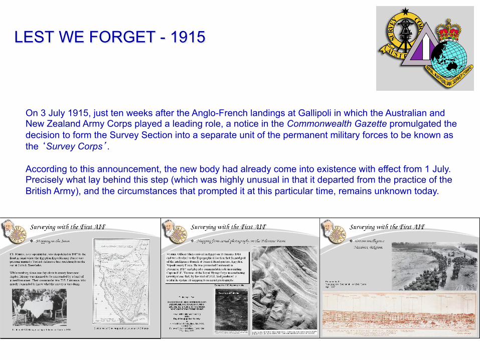
On 3 July 1915, just ten weeks after the Anglo-French landings at Gallipoli in which the Australian and New Zealand Army Corps played a leading role, a notice in the Commonwealth Gazette promulgated the decision to form the Survey Section into a separate unit of the permanent military forces to be known as the ‘Survey Corps’. According to this announcement, the new body had already come into existence with effect from 1 July. Precisely what lay behind this step (which was highly unusual in that it departed from the practice of the British Army), and the circumstances that prompted it at this particular time, remains unknown today.
LEST WE FORGET - 1915
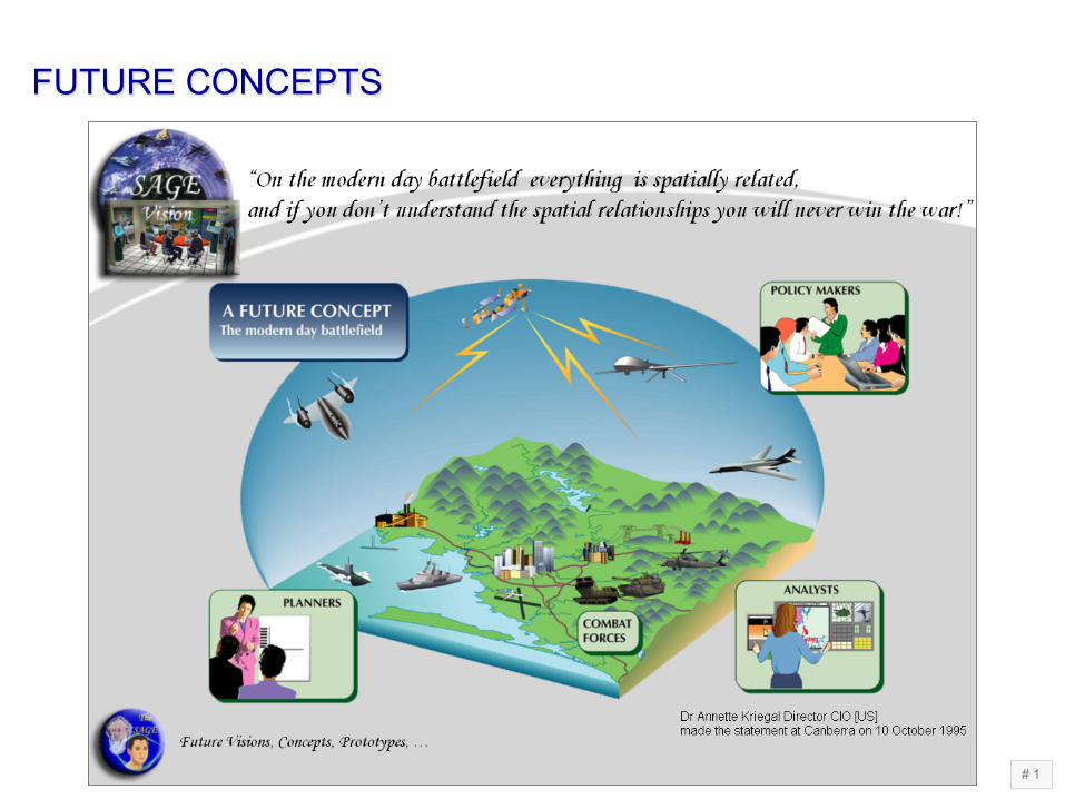
FUTURE CONCEPTS
# 1

FUTURE CONCEPTS
# 1

STRATEGIC GUIDANCE
BUILDING ON OUR PAST - What do we need to carry forward to 2020?
UNDERSTANDING OUR PRESENT TO SECURE OUR FUTURE - What do we need to do now?
OUR FUTURE - What do we want to be like? FROM VISION TO REALITY
FORCE 2020
THE AUSTRALIAN APPROACH TO WARFARE
STRATEGIC GEOGRAPHY Geographic environment, Border issues, Industries and infrastructure, Sea approaches, Logistic support, Transport, Climatic conditions
ECONOMIC GEOGRAPHY Sea lines of communication, Scientific and technical base
POLITICAL GEOGRAPHY THREATS TO SECURITY
Weapons of mass destruction, terrorism, attacks on information systems Natural disasters, pandemic diseases, environmental degradation Illegal immigration, people smuggling, illegal fishing Narcotics, trans-national crime
George Coates and Dora Meeson General William Bridges and his staff watching the manoeuvres of the 1st Australian Division in the desert in Egypt, March 1915 1922-26. Oil on canvas. Australian War Memorial
June 2002
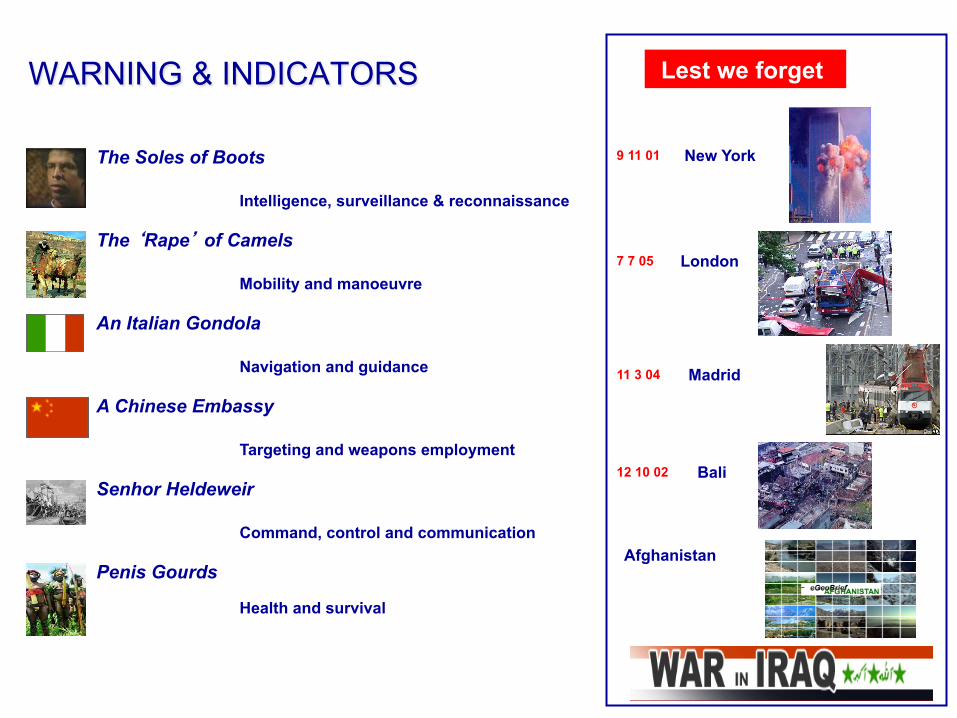
WARNING & INDICATORS
A Chinese Embassy
Lest we forget
Afghanistan
New York 9 11 01
London 7 7 05
Madrid 11 3 04
Bali 12 10 02
Intelligence, surveillance & reconnaissance
Targeting and weapons employment
Command, control and communication
Navigation and guidance
Health and survival
Mobility and manoeuvre
The ‘Rape’ of Camels
The Soles of Boots
An Italian Gondola
Senhor Heldeweir
Penis Gourds
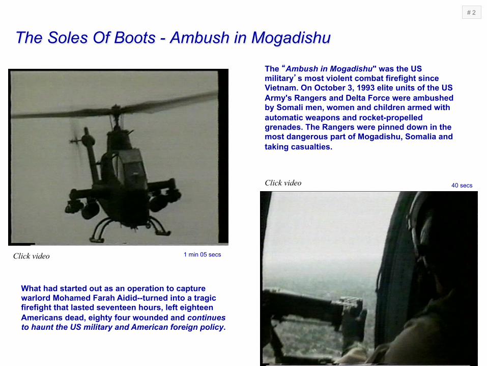
The Soles Of Boots - Ambush in Mogadishu
The “Ambush in Mogadishu" was the US military’s most violent combat firefight since Vietnam. On October 3, 1993 elite units of the US Army's Rangers and Delta Force were ambushed by Somali men, women and children armed with automatic weapons and rocket-propelled grenades. The Rangers were pinned down in the most dangerous part of Mogadishu, Somalia and taking casualties.
What had started out as an operation to capture warlord Mohamed Farah Aidid--turned into a tragic firefight that lasted seventeen hours, left eighteen Americans dead, eighty four wounded and continues to haunt the US military and American foreign policy.
40 secs
1 min 05 secs
# 2
Click video
Click video

An Italian Gondola & A Chinese Embassy
Click video
A Chinese Embassy - Bombing of the Chinese Embassy in Belgrade, Yugoslavia

‘Senhor João Luis Jacques António Henrique Heldeweir’

Penis Gourds
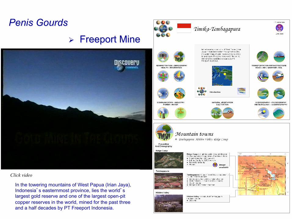
In the towering mountains of West Papua (Irian Jaya), Indonesia’s easternmost province, lies the world’s largest gold reserve and one of the largest open-pit copper reserves in the world, mined for the past three and a half decades by PT Freeport Indonesia.
Penis Gourds
Ø Freeport Mine
Click video

The ‘Rape’ Of Camels
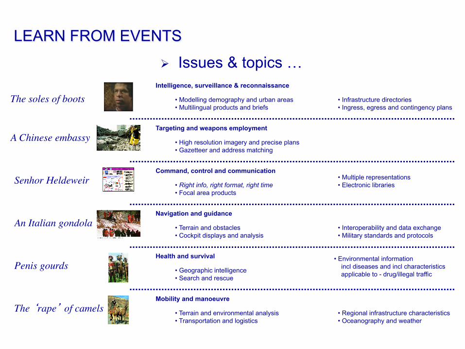
LEARN FROM EVENTS
The ‘rape’ of camels
A Chinese embassy
Senhor Heldeweir
An Italian gondola
Penis gourds
The soles of bootsIntelligence, surveillance & reconnaissance
Targeting and weapons employment
Command, control and communication
Navigation and guidance
Health and survival
Mobility and manoeuvre
• Modelling demography and urban areas • Multilingual products and briefs
• Infrastructure directories • Ingress, egress and contingency plans
• High resolution imagery and precise plans • Gazetteer and address matching
• Right info, right format, right time • Focal area products
• Multiple representations • Electronic libraries
• Terrain and obstacles • Cockpit displays and analysis
• Interoperability and data exchange • Military standards and protocols
• Geographic intelligence • Search and rescue
• Environmental information incl diseases and incl characteristics applicable to - drug/illegal traffic
• Terrain and environmental analysis • Transportation and logistics
• Regional infrastructure characteristics • Oceanography and weather
Ø Issues & topics …
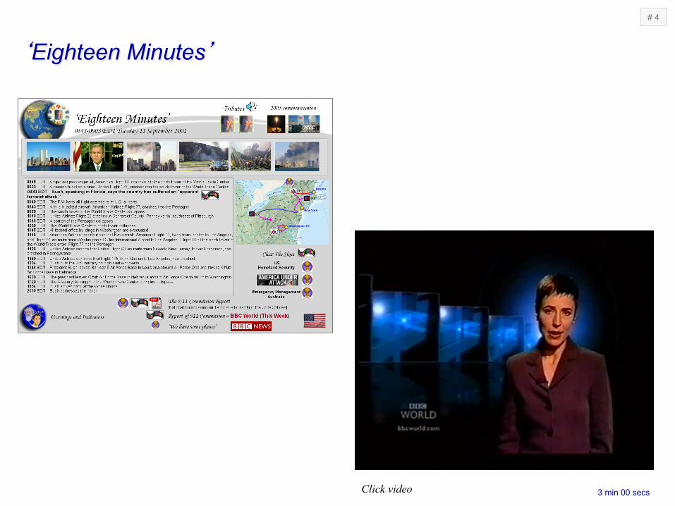
‘Eighteen Minutes’
3 min 00 secs
# 4
Click video

Current aeronautical information is published as charts and supplements in PDF [Adobe]
The future will require new concepts and models for ‘deep structure’ representing complex relationships
The future will require visualization for ‘situation awareness’ in time and space
Ø Capability development; initiatives …
Current air traffic management display
# 4
# 1
# 5
‘Eighteen Minutes’ Aero Intell 2001

At 0720 hours on the 23rd March 2003, the US Army’s 507th Maintenance Company of 33 soldiers in 18 vehicles mistakenly entered an Nasiriyah, Iraq
11 soldiers were killed - 9 soldiers were wounded – 7 soldiers were captured10 vehicles were destroyed or captured
‘Jessica Lynch …’

‘Jessica Lynch …’
4 min 40 sec
$2 Million Cash Prize Awarded to Stanford’s “Stanley” as Five Autonomous Ground Vehicles Complete DARPA Grand Challenge Course [October 8, 2005]
Command (Decision) Support Systemse.g. vehicle monitoring & tracking
Transportation & Logistics Systemse.g. autonomous vehicles
# 6
# 7
Ø Capability development; initiatives …
Slide
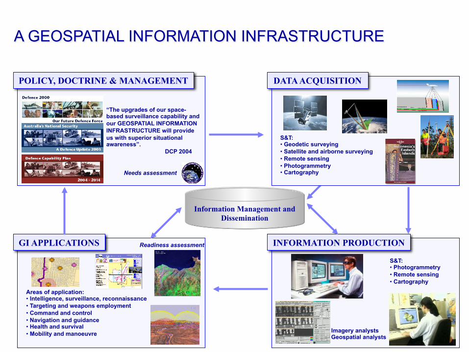
S&T: • Photogrammetry • Remote sensing • Cartography
INFORMATION PRODUCTION
Imagery analysts Geospatial analysts
GI APPLICATIONS
Areas of application: • Intelligence, surveillance, reconnaissance • Targeting and weapons employment • Command and control • Navigation and guidance • Health and survival • Mobility and manoeuvre
POLICY, DOCTRINE & MANAGEMENT DATA ACQUISITION
Information Management and Dissemination
S&T: • Geodetic surveying • Satellite and airborne surveying • Remote sensing • Photogrammetry • Cartography Needs assessment
Readiness assessment
“The upgrades of our space-based surveillance capability and our GEOSPATIAL INFORMATION INFRASTRUCTURE will provide us with superior situational awareness”. DCP 2004
A GEOSPATIAL INFORMATION INFRASTRUCTURE

DEPARTURE Let us complete our odyssey by re-asserting the point that we need to know our history before we can forecast our future. So in the next 5 minutes let us review the development of military mapmaking in Australia over the past century!
5 mins

Video extracts from WGBH FRONTLINE #1704 Air date: September 28, 1998 “Ambush in Mogadishu” Written, Produced and Directed By William Cran http://www.pbs.org/wgbh/pages/frontline/shows/ambush/
# 2
# 6
# 7
# 4
# 5
# 1
NATIONAL GEOSPATIAL INTELLIGENCE AGENY (NGA), 2006. “NGA – Products and Services – Aeronautical” https://164.214.2.62/products/usfif/terminals/enroutelist.cfm?charttype=enroutechartscur&country=Pacific_Australasia_Antarctica
A TOUR of AIXM Concepts, Presented at ESRI Users Conference, 2004 by Brett Brunk (US FAA) and Eddy Porosnicu (EUROCONTROL)
“Our educational mission allows for the exploitation of our programming in not for profit markets with an educational purpose”. WGBH Wed 21/09/2005 12:51 AM
DSTO Geospatial Presentation (Military Logistics), Produced for DSTO via a contract by ESRI Australia Pty Ltd, 2006
DARPA Grand Challenge 2005, Video download from DARPA (Defense Advanced Research Projects Agency), 2005
Illustrations, Produced for DSTO via a contract by BISI Pty Ltd, 2003-2006
http://www.darpa.mil/grandchallenge/gcvideos.asp Videos provided courtesy of CarTV.com are used with permission
# 3 Video extract from BBC WORLD, “This Week”, Thursday 17 June 2004
Questions


