
Retaruke River / Manganui o te Ao River Whio Security Site
Operational Plan June 2009-2014

Retaruke River / Manganui o te Ao River Whio Security Site
Operational Plan June 2009-2014
Prepared by: Jim Campbell
For: Nic Peet, Area Manager, Whanganui Area Office
Damien Coutts, Conservator, Whanganui Conservancy
Whio Recovery Group
Published by
Department of Conservation
Whanganui Conservancy
Private Bag 3016
Whanganui
New Zealand

© Copyright 2010, New Zealand Department of Conservation
ISBN 978-0-478-14780-3
ISSN 1179-1659 - Te Tai Hauauru Whanganui Conservancy Fauna Series 2010/2
Cover photo: Department of Conservation ranger Rufus Bristol recording whio data. Photo: Jim Campbell

CONTeNT
1 Introduction 5
1.1 Background 5
1.2 Operational Area 5
1.3 Other Benefit Species/ecosystems 7
1.4 existing Management (prior to 2009) 7
1080 operations 7
Predator trapping 8
Whio operation nest egg (WHIONe) 9
2 Goals / Objectives of the Plan 9
2.1 Goal for Security Sites 9
2.2 Objective for Security Sites (5 year) 9
3 Predator Control 11
3.1 Strategy 11
3.2 Methods 11
Stoat control 11
Other- dogs, cats & ferrets 11
1080 operations 13
4 Monitoring 13
4.1 environmental Monitoring 13
Habitat sampling 13
Didymo 13
4.2 Outcome Monitoring 15
Length of monitored section 15
Methodology 15
5 Other Whio Management 16
6 Waitotara / Omaru Catchments 16
7 Administration 17
7.1 Proposed establishment timing 17
7.2 Staff and Roles 17
7.3 Information management and Reporting 17
7.4 Infrastructure 18
7.5 Community Relations and Advocacy 18
7.6 Health and Safety 19
7.7 Consents 19
8 Budgets 19
9 Acknowledgements 20
10 References 21


5Retaruke River / Manganui o te Ao River Whio Security Site - Operational Plan June 2009 - 2014
1 Introduction
1 . 1 B A C k G R O u N D
The catchments of the Retaruke and Manganui o te Ao Rivers combine to
form one of four North Island security sites designated under the national
Whio Recovery Plan 2007 - 2017 as a priority for whio management.
These catchments and associated side streams support a large population
of whio Hymenolaimus malacorhynchos (blue duck).
The Manganui o te Ao River has had a history of scientific studies dating
back to Ogle’s surveys for the Wildlife Service in 1980 and followed
by a series of papers by a variety of scientists including Williams and
Veltman in the 1980 - 90’s. Ongoing surveys by the Lands and Survey
Department then the Department of Conservation (DoC) were carried out
by Pipiriki based Whanganui Area Office (WAO) staff
In 2003 intensive population monitoring began on a 10 km section of the
Manganui o te Ao River as part of a five year study funded by the Central
North Island Blue Duck Conservation Charitable Trust (CNIBDCCT) looking
at the impacts of predator control on the whio population (Conservation
Strategy for the blue duck (whio) in the central North Island 2004 -
2009). Blue duck productivity and survival was intensively monitored
using banded birds. Predator control was started using three parallel trap
lines with the centre line running along the river banks, the other lines
running roughly parallel and approximately one kilometre apart.
In 2006, eight Security Sites were formed around the country as priority
protection areas for whio. The target was set at 50 km of protected
waterway maintaining 50 pairs of whio. Manganui o te Ao and the
Retaruke River catchments fulfilled the criteria and were accepted.
In 2008, the largest joint Regional Council/DoC biodiversity project ‘kia
Wharite”, covering some 90,000 ha of private land and 90,000 ha of
public land, was formed. The whio protection project dovetails into this
greater biodiversity programme.
1 . 2 O P e R A T I O N A L A R e A
The security site covers two catchments, whose headwaters are separated
by less than one kilometre. Both flow into the Whanganui River though
the individual confluences are approximately forty kilometres apart. Both
rivers have extremely clean water especially in the headwaters, high
quality benthic communities (see references – Bio-surveys) and broken
water habitat that seem ideal for whio.
Initially, the main protection study site was a 10 km section of the
Manganui o te Ao River (see Securing blue duck in the Central North
Island, Technical Report No.1 - 2004-2005 for detailed information on
the study area). Once the trapping (2004 - 2008 trap diagnosis report

6 Retaruke River / Manganui o te Ao River Whio Security Site - Operational Plan June 2009 - 2014
FIGuRe 1: THe MONITOReD SeCTIONS OF THe MANGANuI O Te AO AND THe ReTARuke
RIVeRS WITH ASSOCIATeD WHIO RIVeRS THAT BeNeFIT FROM THe GReATeR WAO PeST
CONTROL PROGRAMMe.

7Retaruke River / Manganui o te Ao River Whio Security Site - Operational Plan June 2009 - 2014
pending) regime was verified, 15 km of trap line extensions north and
south of existing trap lines were planned and are being deployed as
funding allows.
The Retaruke catchment flows north-west then west of the Manganui o
te Ao River. In the both catchments there small parcels of public land,
some land under covenant and some private reserve. The majority of
the whio security area is held in private ownership. When all trap lines
are completed around 35 km of the Retaruke and more than 25 km of
the Manganui o te Ao Rivers will be trapped and monitored.
As well as the blue duck security site protection, pest control is
undertaken on adjacent private land and 60,000 ha of Whanganui National
Park (WNP). The combination of all three provides substantial area of
protected rivers for juvenile.
1 . 3 O T H e R B e N e F I T S P e C I e S / e C O S y S T e M S
The trap lines run through a large variety of habitats from pure farm
grassland to unlogged podocarp forest with a large variety of land tenure
from private single owners, multiple iwi owners, collective organisations,
companies, private reserves to public managed lands.
Land owners, tangata whenua and Regional Councils often have a holistic
view of the ecosystem. The benefits to game bird (pheasants, ducks, quail
etc) populations are considered just as important as native avian forest
species. Also important is the improving water quality done through
advocacy in riparian protection also associated with the project
While our trap lines are targeted at protecting whio the removal of
mustelids, hedgehogs, rats and cats have a positive effect on other flora
and fauna species. Whanganui National Park, other adjacent reserves
and private bush blocks hold the largest North Island Brown kiwi
population in New Zealand, estimated between 6000 - 9000 kiwi. The
whio protection trap-lines border the National Park in the Lower Retaruke
and large reserves in the upper Retaruke. The Manganui o te Ao River
also has significant areas of bush. All these areas hold kiwi populations
or are potential habitats. Other species that directly receive benefit from
trapping include all the common forest birds, e.g. tui, bellbird, kereru
whitehead etc as well as bush falcon, North Island wren, fernbird, robin,
bittern, and grey duck. under current management other species such
as long and short-tail bats, insects and lizards should all show population
benefits.
1 . 4 e x I S T I N G M A N A G e M e N T ( P R I O R T O 2 0 0 9 )
1080 operations
Although the WNP is not part of the Security Site it is adjacent to the
Security Site and is important for dispersal and population expansion.

8 Retaruke River / Manganui o te Ao River Whio Security Site - Operational Plan June 2009 - 2014
The WNP was part of a seven year rotational cycle of 1080. In 1995 -
1996, 2002 and 2007 the kia Wharite area of the WNP received aerial
drops. Subsequent drops will have a different strategy applied as our
knowledge of the pest and bait improves. This year’s drop is pre-fed,
covers 31 690 ha at 2 kg per hectare and will be dropped to coincide
with the breeding season.
In last 10 - 15 years private land within the security site has had regular
possum control mainly for TB. Carried out by the Animal Health Board
(AHB) and Horizons Regional Council it has kept the possum numbers
very low over the two catchments.
Individual land owners have undertaken various pest control operations
on their own land. From minor cat control to extensive predator control
programmes over whole farms e.g. Tony Punch Safari Park and Steele
Farms.
The Manganui o te Ao / Retaruke River Security Site is within the Animal
Health Board (AHB) schedule for possum control as part of bovine
tuberculosis vector control. Typically 1080 operations occur every five
years, dependent on how quickly possums return to critical numbers
Predator trapping
Most of our whio Security Site is on private land with some small isolated
sections of public reserve.
Possum numbers have been low in the last five years in both valleys, but
recent accounts suggest an increasing population in some areas.
In 2004 after considerable discussion with local landowners, it was agreed
that 10 km of predator trapping would begin along the Manganui o te Ao
River’s main stem for whio protection. By 2006, two 10 km outside lines
were added. In the 2008/09 season discussions began with landowners to
extend upstream and downstream to make a total of up to 35 km of river
main stem protected. Trap deployment for the main stem was completed
in May 2009 and the outside line deployment has been approved by the
landowners and now is being put in place.
In 2005 a Retaruke landowner Dan Steele, whose kaiwhakauka Valley
farm is surrounded by National Park, received a Biodiversity Fund grant.
Part of that grant initiated predator trapping on the lower Retaruke for
whio and kiwi protection. With assistance from Whanganui Area Office
(WAO) these lines have been slowly extended.
The joint Horizons / DoC kai Wharite project has consolidated that effort
and extended the operation into the upper Retaruke. In September 2008,
negotiations with the group of landowners and tangata whenua began.
Most landowners and have agreed to allow a local contractor to deploy
and service traps on their land.
each protected river section has three lines (the tramline approach)
- one line following the river, and one line either side of the river
approximately one kilometre back from the river. DOC 200 double sets
are used, 100 metres apart, checked fortnightly September- February and
9Retaruke River / Manganui o te Ao River Whio Security Site - Operational Plan June 2009 - 2014
monthly outside this period. Traps are set inside a standard wooden
trap box as detailed on http://www.predatortraps.com. Traps boxes are
baited either with hen’s eggs or rabbit meat bait. The current predator
trapping regime (Figure: 2) protects about 50 - 60 pairs.
Whio operation nest egg (WHIONE)
This is not an existing management approach for these sites. However, in
the 2008/09 season, an attempt was made using a dog to locate nests in
the lower Retaruke. This was unsuccessful and another attempt may be
made from the Manganui o te Ao River if the conditions are favourable.
These lifts are from one nest and are removed to provide stock for the
captive breeding programme. Further whio genetic work should allow
stock from other sites to be used in the captive breeding programme in
the near future.
2 Goals / Objectives of the Plan
2 . 1 G O A L F O R S e C u R I T y S I T e S
The following has been established as the goal for all Whio Security
Sites:
50 pairs secured within a predator controlled area within 10 years (by
2017).
2 . 2 O B J e C T I V e F O R S e C u R I T y S I T e S ( 5 y e A R )
The following has been established as the objective for the Retaruke/
Manganui o te Ao Security Site:
50 pairs secured within a predator controlled area within five years (by
2012).

10 Retaruke River / Manganui o te Ao River Whio Security Site - Operational Plan June 2009 - 2014
FIGuRe 2: MAP OF CuRReNT AND PROPOSeD TRAPLINeS ON MANGANuI O Te AO RIVeR AND
ReTARuke RIVeR, AS AT JuNe 2009.

11Retaruke River / Manganui o te Ao River Whio Security Site - Operational Plan June 2009 - 2014
3 Predator Control
3 . 1 S T R A T e G y
The management approach chosen for the Retaruke / Manganui o te Ao
River security site for the next five years is to conduct predator trapping
over three specific sites within the two catchments; Manganui o te Ao
River, upper Retaruke and Lower Retaruke with the total length of river
being over 50 km, capable of supporting the 50 whio pairs.
3 . 2 M e T H O D S
Stoat control
We aim to continue to maintain and expand the current number of traps.
The current schedule of trap checks described above will be maintained
where land owners agree, this equates to 18 trap checks a year. Stoat
control will continue to follow best practice as specified in the Stoats-
kill Trapping Best Practice.
On the Manganui o te Ao River, the main stem trap lines are complete.
The outside “tram- lines” will be extended with the aim of having the
extensions completed in the 2009/2010 financial year, (Figure: 2).
On the upper Retaruke, the terrain and landowner requirements have
led to a revised “tramline pattern”. The total number of traps will be
roughly the same and coverage area is equivalent to the tramline pattern.
Again, by end the 2009/2010 financial year it is thought all traps could
be in place on the Lower Retaruke and final lines in place in 2010/11
season for the upper Retaruke.
On the lower Retaruke, all traps have been in place for two years, but
some refinement could be undertaken allowing a redistribution of some
traps so covering a greater area.
Other- dogs, cats & ferrets
Appropriate control measures for other potential predators will be
implemented as necessary.
The Ruatiti Domain, a favourite camping and fishing site on the
Manganui o te Ao River attracts a lot of predators including dogs and
cats intentionally or unintentionally released by their owners. There
has been one confirmed dog predation of adult whio in the study area,
although dogs are banned from the camping ground. Whanganui Area
Office staff have recently completed training and are now qualified to
run kiwi and whio aversion for dogs. Courses will now be offered to
hunters and farmers in the surrounding districts. Cat traps are regularly
set in known hotspots on the Manganui o te Ao and cat traps have been
distributed to land owners on the Retaruke.

12 Retaruke River / Manganui o te Ao River Whio Security Site - Operational Plan June 2009 - 2014
FIGuRe 3: kIA WHARITe PROJeCT AReA

13Retaruke River / Manganui o te Ao River Whio Security Site - Operational Plan June 2009 - 2014
1080 operations
The 1080 pest control operations in the Whanganui National Park have
been modified to run on a 3 year cycle and pre-feed to align with the
kia Wharite project. The 2009 drop is centred on the Mangapurua /
kaiwhakauka Valleys (30,000hecs) which have resident whio populations.
These valley systems are adjacent to the Manganui o te Ao and Retaruke
catchments. It is expected this 1080 regime will not only benefit the
resident pairs in the WNP but also the juveniles as they disperse into
predator free habitats.
4 Monitoring
4 . 1 e N V I R O N M e N T A L M O N I T O R I N G
Habitat sampling
The two whio study area rivers, Manganui o te Ao and Retaruke, underwent
a periphyton and macroin vertebrate bioassessment in April 2008. The
aim was to obtain a snapshot of the communities along three sampling
points in each of the rivers. These surveys have given a baseline or
indication of the former community if didymo (didymosphenia geminata)
should become introduced. In addition, the sampling gave an indication
of water quality changes along the length of the river systems.
Didymo
Central North Island Rivers have been classified by Biosecurity New
Zealand as a high risk for didymo incursion in the North Island. Routine
monthly didymo surveys (using DNA sampling) are undertaken by DOC
staff from Pipiriki. All samples are taken and analysed using best practice
methodologies. The sampling regime may improve the likelihood of early
detection of didymo.
The impacts of didymo for whio have not been studied with any scientific
rigour. Didymo sampling will continue on a monthly basis for 2009/10.
This will be reviewed annually.
A small modelling exercise was done looking at areas of likely didymo
habitat overlaid with known whio feeding patterns. The outcome for
whio from this excersise was bleak and predicted a significant negative
impact (see internal paper by J. Campbell).
14 Retaruke River / Manganui o te Ao River Whio Security Site - Operational Plan June 2009 - 2014
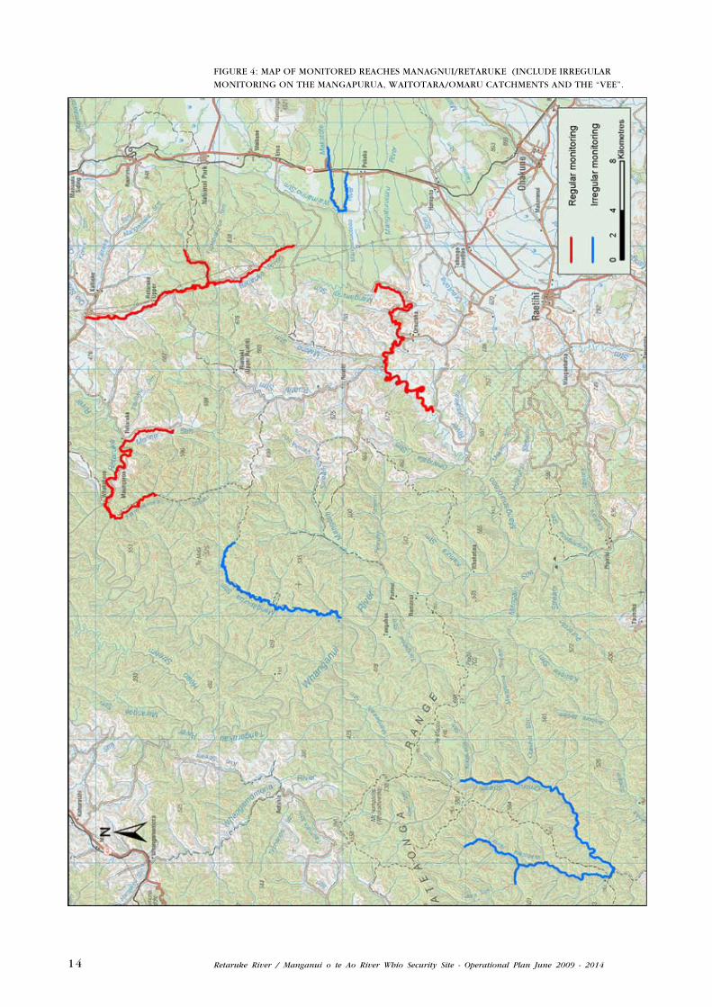
FIGuRe 4: MAP OF MONITOReD ReACHeS MANAGNuI/ReTARuke (INCLuDe IRReGuLAR
MONITORING ON THe MANGAPuRuA, WAITOTARA/OMARu CATCHMeNTS AND THe “Vee”.

15Retaruke River / Manganui o te Ao River Whio Security Site - Operational Plan June 2009 - 2014
4 . 2 O u T C O M e M O N I T O R I N G
Length of monitored section
Approximately 35 km of the Manganui o te Ao River is monitored and
is broken into three sections; Garety’s to Hoihenga Bridge, Hoihenga
Bridge to Ruatiti Domain, and the Ruatiti Domain to Thompsons Bridge
(6.9 km on the Whakapapa, 6.6 km on the Mangatepopo and 14 km on
the Whanganui)
Methodology
The whio population was initially banded with metal bands and individual
colour combinations for the study to determine the success of the
“tramline” pattern. This five year study is now completed and the report
is pending. Birds in the Manganui o te Ao River have shown no ill
effects from wearing bands.
Bands will be left on individuals to wear off naturally and the birds
monitored. Bands will be removed if any sign of distress is shown.
For nest location purposes a sample of females had radio transmitters
fitted for a short period one season but due to the high failure rate of the
equipments they were removed. The skill level of the team was sufficient
to locate nests without imposing on the birds to carry transmitters.
The following factors have led to a change in monitoring intensity;
combining of the Manganui o te Ao and Retaruke Rivers into a single
Security Site, the completion of the verification study and the extensions
to monitored river sections.
From September to February, monthly monitoring surveys will collect
sufficient data to report on pair density, adult survival, territory lengths,
chicks to the river, and chick survival to fledging. This data will be
bolstered by incidental sightings when trap lines are being serviced.
Rivers are monitored irregularly from March - August in conjunction with
trap-checks.
Outside of the core security site, monitoring is also carried out in
the Makatoke / Manganui o te Ao “Vee” in the form of two or three
surveys around November / December / January to collect a snapshot of
breeding and adults numbers. Opportunistic surveys also happen in the
Mangapurua and kaiwhakauka Streams as time allows.
16 Retaruke River / Manganui o te Ao River Whio Security Site - Operational Plan June 2009 - 2014
5 Other Whio Management
The Tongariro/Taupo Conservancy trialled the translocation of eggs with
some success. Although not an existing management approach for any
sites in the Whanganui Area, the emergency translocation of eggs at
immediate risk would remain an option. No WHIONe is planned for
these rivers while predator trapping remains a viable option for in-situ
management.
The Whanganui Area will also continue to monitor human recreation
impacts on rivers in the area, through advocacy with recreational river
users. Landowners also assist in whio advocacy work.
6 Waitotara / Omaru Catchments
These catchments are located in the rugged and isolated Waitotara forests
and part of the WNP. unlogged forests completely cover the whole length
of the Omaru Stream and 99% of the upper Waitotara River headwaters.
It is a difficult four day survey in the best of conditions and due to the
expense and rugged country it is only undertaken annually.
Three surveys have taken place in these catchments to determine any
population trends and attempt to understand any breeding success.
The importance of the Waitotara/Omaru area nationally relates to its
inaccessibility. If didymo establishes in the North Island the core Central
North Island rivers are highly susceptible. These would include the
Tongariro/Taupo river complex and the Manganui o te Ao River and
Retaruke Rivers, all highly regarded and often visited by fishermen and
tourists. It is presumed the Waitotara/Omaru, with its distinct lack of
visitors may become the only didymo free system in the central North
Island.
Several ideas are being proposed to increase whio protection to sustain
a viable population. Surveys will provide a small amount of data and
confirm numbers.

17Retaruke River / Manganui o te Ao River Whio Security Site - Operational Plan June 2009 - 2014
7 Administration
7 . 1 P R O P O S e D e S T A B L I S H M e N T T I M I N G
In 2009/10 season, the aim is to complete trap line extensions in the
Manganui o te Ao Valley by April 2010. Delays in trap deployment are
expected due to weather and lambing. There are a little over 300 traps
to bed in, label and gps on predetermined landowner approved routes.
These extensions complete the “tram line” series for the Manganui o te
Ao catchment.
The Retaruke has landowner approval for all but one section of the
valley. Most trap line routes have had a preliminary survey and trap
deployment has begun but will also be determined by weather, lambing
and landowner preferences.
The same timeframe applies, April 2011 is a goal to complete all
trap deployment. All central river trap lines are in place in both
catchments.
7 . 2 S T A F F A N D R O L e S
The success of this programme requires the commitment of competent
and skilled operators whose efforts are coordinated in a cohesive way.
These operators require a good knowledge of whio behaviour, the
habitat and the overall plan/strategy to contribute effectively to it. The
Whanganui Area Office whio team are:
TABLe 1: WHANGANuI AReA WHIO TeAM STAFF AND ROLeS.
STAFF ROLe LOCATION
Jim Campbell Programme manager- Biodiversity Assets Whanganui Area Office, (WAO) Wanganui
Rufus Bristol Whio Team Leader Pipiriki Field Centre, (WAO) Pipiriki
kane Low Whio contractor Pipiriki Field Centre, (WAO) Pipiriki
Tai edmonds Biodiversity ranger Pipiriki Field Centre, (WAO) Pipiriki
Richard Taiaroa Ranger Taumarunui Field Centre, (WAO) Taumarunui
Leon Stratford Contract trapper Retaruke
Daniel Hurley Bio Ranger – data/field support Whanganui Area Office
7 . 3 I N F O R M A T I O N M A N A G e M e N T A N D R e P O R T I N G
Operating updates are produced for the Central North Island Blue Duck
Conservation Charitable Trust (CNIBDCCT) in October, November, January
and February, as well as an annual Technical Report in August.

18 Retaruke River / Manganui o te Ao River Whio Security Site - Operational Plan June 2009 - 2014
The following are relevant documents pertaining to the Whanganui Whio
Programme:
TABLe 2: key DOCuMeNTS IN THe MANGANuI O Te AO /ReTARuke WHIO PROGRAMMe.
RePORT DOCDM LINk
Whio Recovery Plan 2007-2017 dme://docdm-281492/
Conservation Strategy for the blue duck (whio) in the central North Island 2004-2009 dme://olddm-257939/
Securing blue duck in the Central North Island, Technical Report No. 1: 2004-2005 dme://olddm-654426/
Securing blue duck in the Central North Island, Technical Report No. 2: 2005-2006 dme://docdm-50105/
Securing blue duck in the Central North Island, Technical Report No. 3: 2006-2007 dme://docdm-157048/
Securing blue duck in the Central North Island, Technical Report No. 4: 2007-2008 dme://docdm-321605/
Stoat- kill Trapping Best Practice dme://docdm-29448/
Blue Duck Best Practice Manual dme://olddm-770375/
7 . 4 I N F R A S T R u C T u R e
Access to the rivers and trap lines is often not far from the road but
often requires crossing through private land. Access through private
land is obtained and agreed upon with individual owners and managers.
Consideration for lambing and other farm practices have to be taken into
account. This may mean that access is not available at certain times
of the year. Staff are in regular contact with owners and managers
throughout the year. The Department tries to use as few different staff
as possible, this allows for a more trusting relationship.
7 . 5 C O M M u N I T y R e L A T I O N S A N D A D V O C A C y
There are a wide variety of stakeholders with different interests in whio
conservation in the central North Island. These include hapu whose
rohe encompass important whio rivers and / or regard whio as taonga,
local communities and landowners living close to blue duck rivers,
organisations involved in blue duck management and monitoring such
as DoC, enviro Research, the Central North Island Blue Duck Charitable
Trust, river-users such as Genesis Power Ltd, kayakers, anglers and rafters,
and local schools.
See the Conservation Strategy for blue duck in the central North Island
2004-2009, which outlines aims and actions that will be initiated in order
to engage these key stakeholders.

19Retaruke River / Manganui o te Ao River Whio Security Site - Operational Plan June 2009 - 2014
7 . 6 H e A L T H A N D S A F e T y
Health and safety is of the highest priority and DOC will ensure that
Health and Safety Plans are in place and that staff and volunteers are
competent. Any incidents or near-misses will be reported (https://www.
riskmanager.co.nz/)
and corrective measures put in place to prevent recurrences. All staff
and contractors will hold current first aid certificates.
When carrying out whio field work all staff and contractors use a radio
call in and call out method and a have Hazard Plan.
Relevant SOPs and safety guidelines that will be followed include:
• On road and 4x4 driving competencies
• River rescue and crossings training undertaken
• Basic Field skills
7 . 7 C O N S e N T S
All banding operations are covered by permits authorised under the
Wildlife Regulations 1955. All staff working with whio are listed on
the national Whio Training Registrar.
8 Budgets
The Manganui o te Ao / Retaruke Whio Programme is managed by
Whanganui Area Office but has three different funding streams. The
Manganui o te Ao River is partially funded by the Central North Island
Blue Duck Charitable Trust, with the remainder being funded by the
Department. The Retaruke site has funding from DoC and Horizons’
Regional Council as part of the kia Wharite project and input in kind
from local landowners. Steele Farms also run a volunteer scheme to
assist with trapping and monitoring whio on the lower Retaruke.

20 Retaruke River / Manganui o te Ao River Whio Security Site - Operational Plan June 2009 - 2014
9 Acknowledgements
The work detailed in this report would not have been possible without
the generous support of the Central North Island Blue Duck Charitable
Trust.
DOC Whanganui gratefully acknowledges the support and cooperation
from Landowners and managers for access along the Manganui o te Ao
River including the following families; Fahey, Merson, McNee, Volkerling,
Deadman, Oliver, Graeme,
The Department of Conservation is grateful for the assistance, advice and
blessing from iwi for the work on the Rivers.
Invaluable assistance, reminders, copy and advice from the indefatigable
Alison Beath, and the support from the Blue Duck recovery group leader
Andy Glaser.
Thanks for the ongoing interest from the teachers, helpers and students
at Orautoha and kaitieke Schools.
Thanks to Connie Norgate for the public relations work and the assistance
with the newsletters and other support.
Land owners and farmers from the Retaruke catchment including all
farmers of the upper Retaruke namely; Ross Green, Tim Graeme, Clarke
Taylor, Dean Wilson, Trevor Couper, Baldy Haitana and other tangata
whenua land owners, Dean Collins, Tony Punch, Greg Shaw, Bryan
Macannelly, Jason Smalley, Dr keith Buswell, and the Forest Heritage
Restoration Trust.
A special mention for the efforts put in by the family members and
employees of Steele Farms and their volunteers with their biodiversity
protection initiatives.
Also thanks to those who have assisted the project but have been
inadvertently missed of the list.
Whanganui Area Office would like to acknowledge the advice and support
from Sue Jones who produced the maps and Peter Lock for photo and
document formatting and printing.

21Retaruke River / Manganui o te Ao River Whio Security Site - Operational Plan June 2009 - 2014
10 References
etheridge, N & Peet N.B. 2004. Conservation strategy for the blue duck (whio) Hymenolaimus
malacorhynchos in the central North Island 2004-2009. Department of Conservation,
Tongariro / Taupo and Wanganui Conservancies.
James, Dr Alex. December 2008 DoC A Biosurvey of the benthic macro invertebrates and algae
of the Manganui o te Ao River. Whanganui Coservancy Fauna Series 2008/4
James, Dr Alex. December 2008 DoC A Biosurvey of the benthic macro invertebrates and
algae of the Retaruke River. Whanganui Coservancy Fauna Series 2008/5
Ogle, C.C. 1980. Wildlife of the Mangatiti-Mangapurua district, upper Wanganui River. Wildlife-a
review 11:58-61.
Technical Report No.1 2004-2005. Securing blue duck in the Central North Island. Department
of Conservation, Wanganui & Tongariro/Taupo Conservancies.
Technical Report No.2 2005-2006. Securing blue duck in the Central North Island. Department
of Conservation, Wanganui & Tongariro/Taupo Conservancies.
Technical Report No.3 2006-2007. Securing blue duck in the Central North Island. Department
of Conservation, Wanganui & Tongariro/Taupo Conservancies.
Technical Report No.4 2007-2008. Securing blue duck in the Central North Island. Department
of Conservation, Wanganui & Tongariro/Taupo Conservancies.
Van klink, P. 2007. Whio / blue duck (Hymenolaimus malacorhynchos) recovery plan 2007-2017.
Threatened species recovery plan no. 60. Department of Conservation, Wellington.
George, Robert A. An Annotated Bibliography of 19th and 20th Century Literature on Blue Duck.
Submitted to the School of Information Management,Victoria university of Wellington, in
partial fulfilment of the requirements for the degree of Master of Library and Information
Studies, 2004

22 Retaruke River / Manganui o te Ao River Whio Security Site - Operational Plan June 2009 - 2014


