Download - Rapid Ride Corridor Planning
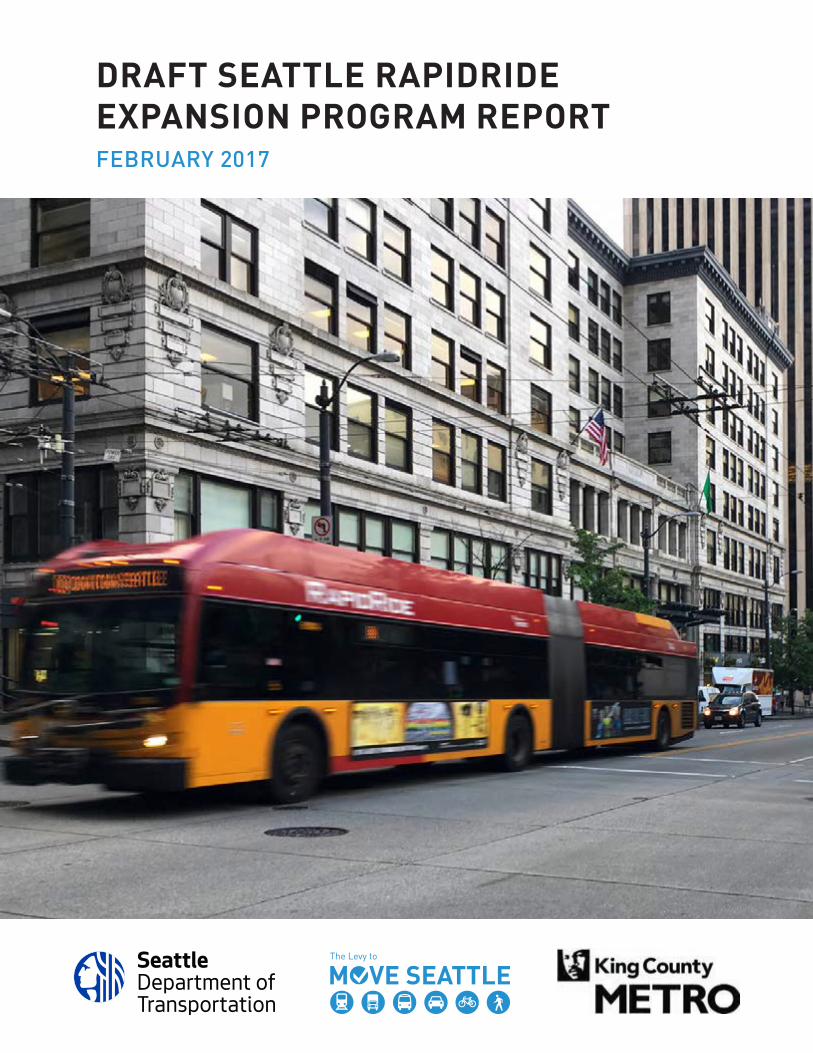
DRAFT SEATTLE RAPIDRIDE EXPANSION PROGRAM REPORTFEBRUARY 2017

Table of ContentsPROGRAM INTRODUCTION . . . . . . . . . . . . . . . . . . . . . . . . . . . . . . . . . . . . . 1
RapidRide Network . . . . . . . . . . . . . . . . . . . . . . . . . . . . . . . . . . . . . . . . . . . 3What is RapidRide in Seattle? . . . . . . . . . . . . . . . . . . . . . . . . . . . . . . . . . . 4Why RapidRide? . . . . . . . . . . . . . . . . . . . . . . . . . . . . . . . . . . . . . . . . . . . . . 5Transit Service and Performance Objectives . . . . . . . . . . . . . . . . . . . . . . 6Seattle’s RapidRide System Today . . . . . . . . . . . . . . . . . . . . . . . . . . . . . . . 7
BACKGROUND . . . . . . . . . . . . . . . . . . . . . . . . . . . . . . . . . . . . . . . . . . . . . . . . 9Planning History . . . . . . . . . . . . . . . . . . . . . . . . . . . . . . . . . . . . . . . . . . . . 10
NETWORK DEVELOPMENT . . . . . . . . . . . . . . . . . . . . . . . . . . . . . . . . . . . . 13Corridor Development Process . . . . . . . . . . . . . . . . . . . . . . . . . . . . . . . . 14Draft Program Timeline . . . . . . . . . . . . . . . . . . . . . . . . . . . . . . . . . . . . . . 16Corridor Overview Sheets . . . . . . . . . . . . . . . . . . . . . . . . . . . . . . . . . . . . 18
PROGRAM FUNDING AND COSTS . . . . . . . . . . . . . . . . . . . . . . . . . . . . . . . 33Potential Funding Sources . . . . . . . . . . . . . . . . . . . . . . . . . . . . . . . . . . . . 34Program Investments . . . . . . . . . . . . . . . . . . . . . . . . . . . . . . . . . . . . . . . . 35
NEXT STEPS . . . . . . . . . . . . . . . . . . . . . . . . . . . . . . . . . . . . . . . . . . . . . . . . 37

Draft Seattle RapidRide Expansion Program Report | February 2017
PROGRAM INTRODUCTIONThe RapidRide Expansion Program is a partnership between the City of Seattle and King County Metro to deliver reliable, convenient, high-quality transit options to Seattle’s growing population through the implementation of seven new RapidRide corridors.
Through a combination of transit service improvements, capital investment, and design treatments, these corridors will build on the success of existing RapidRide service and help meet local and regional transportation goals. RapidRide corridor design considers the unique needs and context of each location. In addition to the transportation plans that inform it, corridor development is shaped by transit performance data, agency partnerships, and public input.
1
GreenLake
Lake Washington
Elliot Bay
LakeUnion
Magnolia
Queen Anne
CapitolHill
MadisonValley
Madrona
Wallingford
Fremont
GreenLake University
District
PhinneyRidge
Ballard
North Beach Greenwood
Northgate
Maple Leaf
Wedgwood
CentralDistrict
Beacon Hill
MountBaker
ColumbiaCity
Georgetown
HarborIsland
WestSeattle
Fauntleroy
Delridge
White Center
RainierValley
RainierBeach
MercerIsland
Universityof Washington
Roosevelt
Link
Link
East Link
To Burien
D
E
C
E
C
5
5
5
5
9090
G
H
H
RR MARKETRR FREMONT
RR ROOSEVELT
RR 23RDRR RAINIER
Existing RapidRide
Link Light Rail
2024 RapidRide Network*
Other Transit
Madison - G Line
Delridge - H Line
Rainier
Roosevelt
Market
Fremont
23rd
Seattle Streetcar
Major Transfer Hub
2024 SEATTLE RAPIDRIDE NETWORK
*To be refined during corridor development
Delivery approach subject to further analysis
DRAFT - FEBRUARY 2017
RapidRide Extension
Data Sources: City of Seattle, King CountyNot to Scale
Draft Seattle RapidRide Expansion Program Report | February 2017
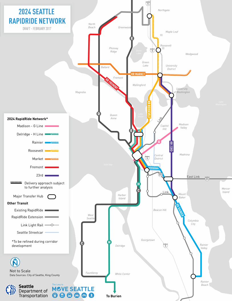
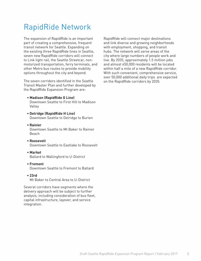
RapidRide NetworkThe expansion of RapidRide is an important part of creating a comprehensive, frequent transit network for Seattle. Expanding on the existing three RapidRide lines in Seattle, seven new RapidRide corridors will connect to Link light rail, the Seattle Streetcar, non-motorized transportation, ferry terminals, and other Metro bus routes to provide mobility options throughout the city and beyond.
The seven corridors identified in the Seattle Transit Master Plan and further developed by the RapidRide Expansion Program are:
• Madison (RapidRide G Line) Downtown Seattle to First Hill to Madison Valley
• Delridge (RapidRide H Line) Downtown Seattle to Delridge to Burien
• Rainier Downtown Seattle to Mt Baker to Rainier Beach
• Roosevelt Downtown Seattle to Eastlake to Roosevelt
• Market Ballard to Wallingford to U-District
• Fremont Downtown Seattle to Fremont to Ballard
• 23rd Mt Baker to Central Area to U-District
Several corridors have segments where the delivery approach will be subject to further analysis, including consideration of bus fleet, capital infrastructure, layover, and service integration.
RapidRide will connect major destinations and link diverse and growing neighborhoods with employment, shopping, and transit hubs. The network will serve areas of the city where large numbers of people work and live. By 2035, approximately 1.5 million jobs and almost 650,000 residents will be located within half a mile of a new RapidRide corridor. With such convenient, comprehensive service, over 50,000 additional daily trips are expected on the RapidRide corridors by 2035.
3
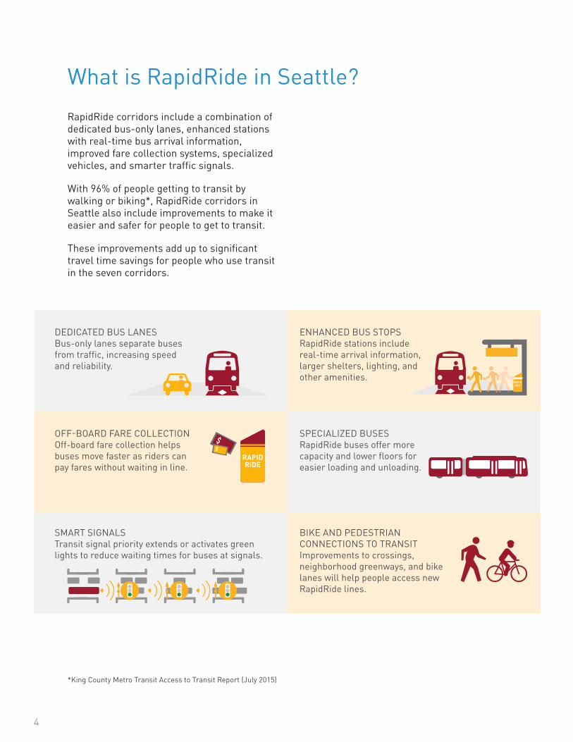
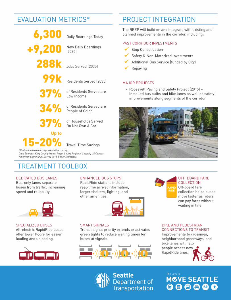
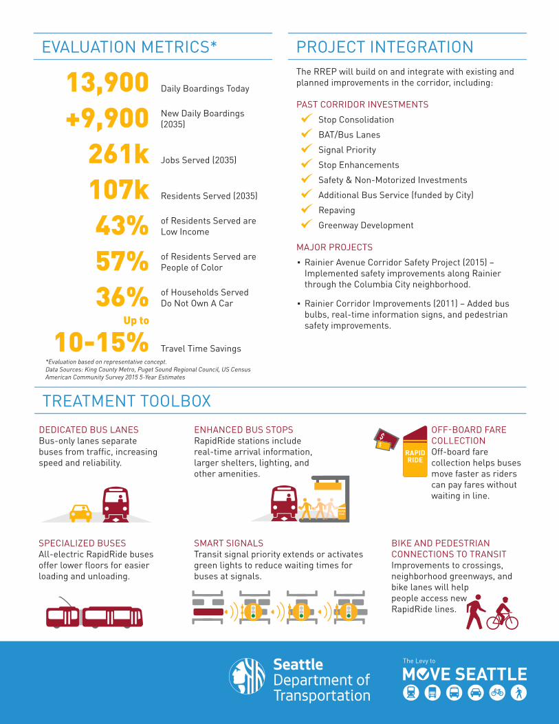
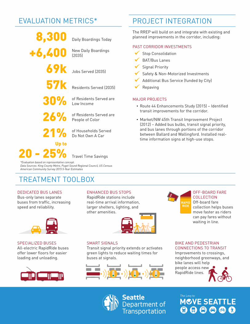
RapidRide corridors include a combination of dedicated bus-only lanes, enhanced stations with real-time bus arrival information, improved fare collection systems, specialized vehicles, and smarter traffic signals.
With 96% of people getting to transit by walking or biking*, RapidRide corridors in Seattle also include improvements to make it easier and safer for people to get to transit.
These improvements add up to significant travel time savings for people who use transit in the seven corridors.
What is RapidRide in Seattle?
ENHANCED BUS STOPS RapidRide stations include real-time arrival information, larger shelters, lighting, and other amenities.
OFF-BOARD FARE COLLECTION Off-board fare collection helps buses move faster as riders can pay fares without waiting in line.
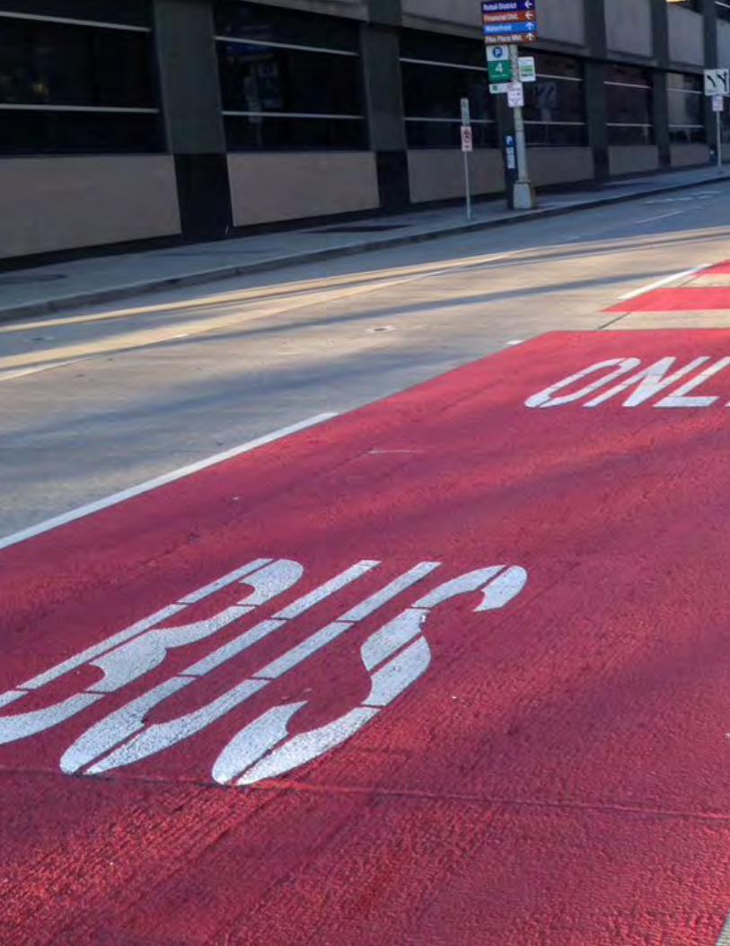
DEDICATED BUS LANES Bus-only lanes separate buses from traffic, increasing speed and reliability.
SMART SIGNALS
Transit signal priority extends or activates green lights to reduce waiting times for buses at signals.
SPECIALIZED BUSES RapidRide buses offer more capacity and lower floors for easier loading and unloading.
BIKE AND PEDESTRIAN CONNECTIONS TO TRANSIT Improvements to crossings, neighborhood greenways, and bike lanes will help people access new RapidRide lines.
*King County Metro Transit Access to Transit Report (July 2015)
4
Draft Seattle RapidRide Expansion Program Report | February 2017
Why RapidRide?Seattle is creating a safe, interconnected, vibrant, affordable, and innovative city for all.
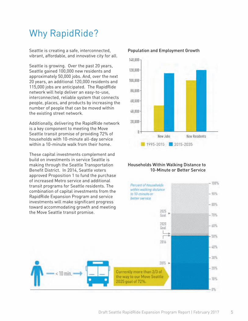
Seattle is growing. Over the past 20 years, Seattle gained 100,000 new residents and approximately 50,000 jobs. And, over the next 20 years, an additional 120,000 residents and 115,000 jobs are anticipated. The RapidRide network will help deliver an easy-to-use, interconnected, reliable system that connects people, places, and products by increasing the number of people that can be moved within the existing street network.
Additionally, delivering the RapidRide network is a key component to meeting the Move Seattle transit promise of providing 72% of households with 10-minute all-day service within a 10-minute walk from their home.
These capital investments complement and build on investments in service Seattle is making through the Seattle Transportation Benefit District. In 2014, Seattle voters approved Proposition 1 to fund the purchase of increased Metro service and additional transit programs for Seattle residents. The combination of capital investments from the RapidRide Expansion Program and service investments will make significant progress toward accommodating growth and meeting the Move Seattle transit promise.
Population and Employment Growth
Households Within Walking Distance to 10-Minute or Better Service
5
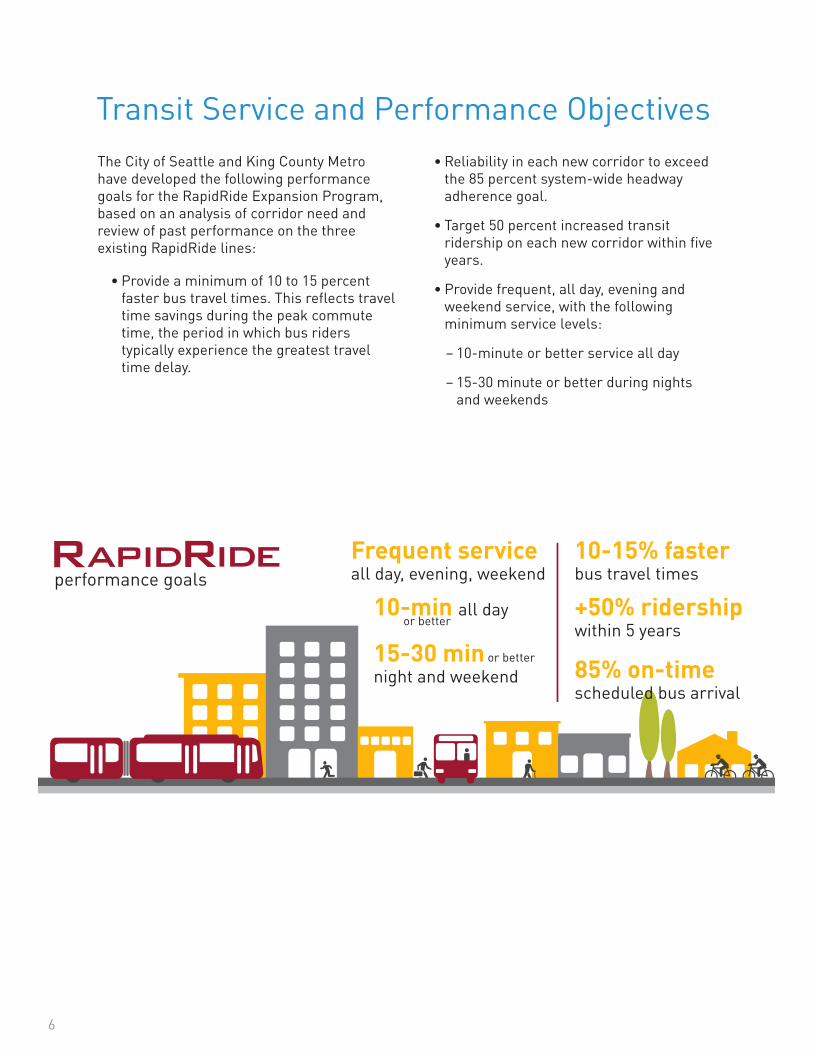
Transit Service and Performance ObjectivesThe City of Seattle and King County Metro have developed the following performance goals for the RapidRide Expansion Program, based on an analysis of corridor need and review of past performance on the three existing RapidRide lines:
• Provide a minimum of 10 to 15 percent faster bus travel times. This reflects travel time savings during the peak commute time, the period in which bus riders typically experience the greatest travel time delay.
• Reliability in each new corridor to exceed the 85 percent system-wide headway adherence goal.
• Target 50 percent increased transit ridership on each new corridor within five years.
• Provide frequent, all day, evening and weekend service, with the following minimum service levels:
– 10-minute or better service all day
– 15-30 minute or better during nights and weekends
PROGRAM INFORMATION & CONTACTDawn Schellenberg, [email protected] or (206) 684-5189
PROGRAM INFORMATION & CONTACTDawn Schellenberg, [email protected] or (206) 684-5189
SEATTLE RAPIDRIDE EXPANSION PROGRAM
FACT SHEET February 2017
Seattle is one of the nation’s fastest-growing cities with ever-increasing demands on our transportation system. SDOT is working with King Country Metro to improve the RapidRide transit network throughout our city, planning seven new lines to help better connect people, places, and products.
EXPANDING RAPIDRIDE WILL IMPROVE TRANSIT CONNECTIONS• Advances our transit promise from the Levy to
Move Seattle to provide 72% of Seattle residents with transit service that runs every 10 minutes or better all-day within a 10-minute walk from their home
• Incorporates the best of King County Metro’s service, with simple, frequent service in the latest Metro vehicles
• Goes beyond transit to better connect people walking and people riding bikes to the transit network by improving sidewalks, paths, and neighborhood greenways
• Links diverse neighborhoods to downtown, transit hubs, employment opportunities, and shopping districts
10-min all dayor better
15-30 min night and weekend
Frequent serviceall day, evening, weekend
10-15% fasterbus travel times
85% on-timescheduled bus arrival
+50% ridershipwithin 5 years
performance goals
or better
COSTS AND FUNDINGThe nine-year, $930 million Levy to Move Seattle provides partial funding for the RapidRide Expansion Program, along with funds for other projects to improve safety for all travelers, maintain streets and bridges, and invest in reliable, affordable travel options for a growing city.
SDOT will work with King County Metro to pursue grant funding programs and other partnership opportunities to stretch taxpayer dollars to cover the full cost of the program.
• Brings SDOT and King County Metro together to address bus speed and service reliability, so we can better ensure fast and on-time buses
GET INVOLVEDWe’ll be working with communities during the planning, design, and construction phases of each new RapidRide line. For each new line, we’ll share data, ask for your feedback, and show how community input has been incorporated into the design.
To learn more about the RapidRide Expansion Program and how you can get involved, please visit www.Seattle.gov/Transportation/RapidRideExpansion.htm.
6

Draft Seattle RapidRide Expansion Program Report | February 2017
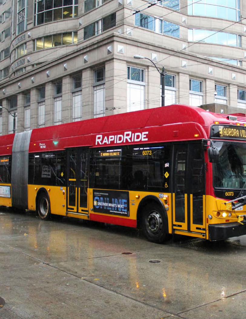
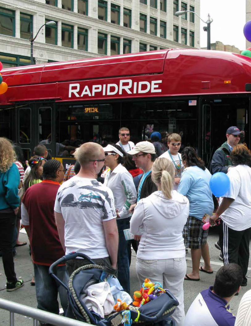
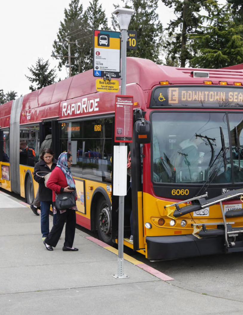
Seattle’s RapidRide System TodayRapidRide was launched by King County Metro in 2010 as their premier transit service, complete with more trips, enhanced stations, unique branding and other improvements to speed up bus service. It was partially funded by the Transit Now initiative, a sales tax increase approved by King County voters in 2006, and with federal funding in partnership with the Federal Transit Administration.
Three of the six existing RapidRide corridors serve the City of Seattle and were implemented by King County Metro working closely with the City:
• RapidRide C Line – Connecting West Seattle to Downtown Seattle (launched in 2012) and extended to South Lake Union in 2016
• RapidRide D Line – Connecting Ballard to Uptown and Downtown Seattle (Launched in 2012)
• RapidRide E Line – Connecting Downtown Seattle and Shoreline (Launched in 2014)
More than 275,000 annual service hours were provided to the system by the three lines. On average, they have seen an 87 percent ridership increase since launching and carry more than 43,000 riders per weekday. Each line has sped up travel time during the busiest commute hours by an average of 11%. The number of trips coming on time has improved to 84% from 76%.
The Seattle Transportation Benefit District, approved by voters in 2014, has invested in the three Seattle RapidRide lines. These investments help to reduce overcrowding, improve reliability, and provide more service at night on weekends.
“There has been an average 87 percent ridership increase since launching RapidRide; carrying more than 43,000 riders per weekday.”
7
Source: Oran Viryincy
Draft Seattle RapidRide Expansion Program Report | February 2017
BACKGROUNDSeattle’s strong economy, vibrant culture, and attractive location have made it one of the fastest growing cities in the nation. Transit ridership is at an all-time high with over 45% of commuters accessing downtown via transit. With the voter approval of the Levy to Move Seattle, the City of Seattle has committed to building a high-quality transportation system that connects people, places and products, and meets tomorrow’s transportation needs.
There are many efforts underway to improve mobility in the city and the region, such as Link Light Rail expansion, the Center City Connector Streetcar, downtown bus service restructuring and improvements to pedestrian and bicycle connections. The RapidRide network is an essential piece of an integrated transit network.
The RapidRide Expansion Program is built on a foundation of extensive planning done by the City through the approval of the Levy to Move Seattle, the 2016 Transit Master Plan update, and continued partnership with King County Metro as reflected in their recently developed METRO CONNECTS Long Range Vision.
9
Planning History
The Seattle Pedestrian Master Plan and the Seattle Bicycle Master Plan were adopted in 2014. Connecting to transit is a key part of the mission statement of both plans. Recommended bike and pedestrian projects overlap all seven RapidRide corridors. Improvements to sidewalks, pedestrian crossings, ADA accessibility, greenways, and bike lanes are all examples of what might be integrated into the planning process to create safer and easier access to frequent transit service, effectively leverage funding, and help create a complete multimodal network for Seattle.
The Levy to Move Seattle, which passed in 2015, expands the transportation system over the next nine years to meet tomorrow’s needs. Projects in the Levy to Move Seattle were prioritized by integrating the four Seattle modal plans (freight, bicycle, pedestrian, and transit) into a cohesive, near-term strategy. By integrating with modal plans, the City can define neighborhood transportation projects that address several needs. The Levy expanded the transit vision in the Transit Master Plan by emphasizing multimodal improvements for each corridor. A desired outcome of the RapidRide Expansion Program is to further the vision of the Levy to build a system that provides not only great transit service but optimizes the movement of people and goods.
SEATTLE PEDESTRIAN AND BICYCLE MASTER PLANS (2014)
LEVY TO MOVE SEATTLE (2015)
20152014
10
Draft Seattle RapidRide Expansion Program Report | February 2017
Originally adopted in 2012, the Seattle Transit Master Plan set forth a comprehensive 20-year look-ahead for the type of transit system required to meet the City’s needs. Through extensive public and agency involvement, the plan identifies the City’s most important transit corridors that improve mobility throughout the city. The Seattle City Council subsequently approved an update to the Transit Master Plan in 2016, providing a framework for the RapidRide Expansion Program.
King County Metro recently developed their long range vision, METRO CONNECTS. This plan identifies a 70% increase in transit service by 2040, with a vision for service that comes more often, is faster and more reliable, and that is easier to use for customers. Integration with other transportation service providers and partnerships with King County cities are key to achieving the METRO CONNECTS vision.
In addition to expanded frequent, local, and express service, the plan envisions thirteen new RapidRide corridors throughout the King County service area by 2025, including the seven Seattle corridors, and 20 new lines total by 2040. King County will continue to operate and maintain RapidRide service, while partnerships and coordinated planning can contribute to making sure each corridor reaches the targeted level of service and service quality.
The partnership between the City of Seattle and King County Metro is critical and is underscored by a common goal to expand and improve the Seattle transit system, improving performance levels on each corridor. Together, the City of Seattle and King County Metro’s work will translate into faster buses, better reliability, capacity to meet growing ridership demand and more frequent night and weekend service.
THE CITY OF SEATTLE TRANSIT MASTER PLAN UPDATE (2016)
KING COUNTY METRO CONNECTS LONG RANGE VISION (2017)
20172016
11
Draft Seattle RapidRide Expansion Program Report | February 2017
NETWORK DEVELOPMENTThe framework for designing, funding, and building the seven RapidRide Expansion Program corridors is outlined in the following pages.
The corridors are developed as a network to provide an integrated transit system that functions seamlessly with other transportation elements as well as regional transit projects such as Sound Transit’s light rail expansion. This integrated approach ensures the network will best serve the citizens of the City, while optimizing corridor project delivery and funding opportunities.
As this network is further developed, conceptual corridor planning and design will draw on the City’s Transit, Pedestrian, Bicycle and Freight Master Plans and the Vision Zero Initiative to guide safety and multimodal improvements to provide better access for people and goods.
13
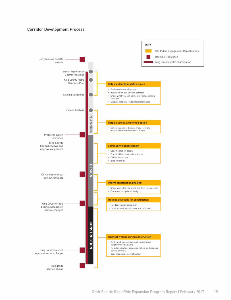
Corridor Development ProcessThe framework for designing, funding, and delivering RapidRide Expansion Program corridors in Seattle will use the following process, which aligns with the approach used to develop projects in the Levy to Move Seattle.
Community participation throughout the process is critical to meet the vision of an integrated and enhanced transit corridor project. Detailed development of the corridors, including corridor-specific timelines, designs and environmental review, will start when the individual corridors are advanced. The City is currently working on the Madison, Roosevelt, and Delridge corridor projects.
The Seattle City Council will receive regular briefings on the RapidRide Expansion Program over the course of program delivery. For corridors seeking a Federal Transit Administration Small Starts grant, Council will be asked to adopt a “Locally Preferred Alterative” that supports the corridor delivery strategy outlined in this document.
Each new RapidRide line is expected to require two actions by the King County Council—one to adopt the corridor alignment and another to replace or change underlying transit service along the corridor. The exact timeline for King County Council review will be based on the RapidRide corridor phasing and complexity of the projects.
14
Draft Seattle RapidRide Expansion Program Report | February 2017
Corridor Development Process
Existing Conditions
King County Metro Connects Plan
Options Analysis
Transit Master Plan Recommendations
RapidRide service begins
Levy to Move Seattle passes
Preferred option identified
King County Council reviews and approves alignment
City environmental review complete
King County Metro begins outreach on
service changes
King County Council approves service change
CON
STRU
CTION
DESIG
NP
LAN
NIN
G
• Preferred route alignment• Input on how you use the corridor• Share what you see as mobility issues along
corridor• Discuss mobility tradeoffs/preferences
Help us identify mobility issues
• Develop options, discuss trade-offs and prioritize multimodal investments
Help us select a preferred option
• Specific station details• Transit riders access to stations• Deliveries access• Bike amenities
Community shapes design
• Share your ideas on when and how work occurs• Comment on updated design
Inform construction phasing
• Feedback on phasing plan• Input on best ways to keep you informed
Help us get ready for construction
• Dedicated, responsive, and coordinated neighborhood liaisons
• Regular updates, advanced notice, and signage during detours
• Your thoughts on construction
Connect with us during construction
Decision Milestones
City Public Engagement Opportunities
KEY
King County Metro coordination
15
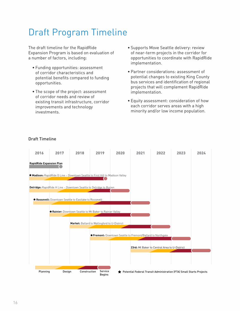
Draft Program TimelineThe draft timeline for the RapidRide Expansion Program is based on evaluation of a number of factors, including:
• Funding opportunities: assessment of corridor characteristics and potential benefits compared to funding opportunities.
• The scope of the project: assessment of corridor needs and review of existing transit infrastructure, corridor improvements and technology investments.
• Supports Move Seattle delivery: review of near-term projects in the corridor for opportunities to coordinate with RapidRide implementation.
• Partner considerations: assessment of potential changes to existing King County bus services and identification of regional projects that will complement RapidRide implementation.
• Equity assessment: consideration of how each corridor serves areas with a high minority and/or low income population.
Madison: RapidRide G Line – Downtown Seattle to First Hill to Madison Valley
RapidRide Expansion Plan
Delridge: RapidRide H Line – Downtown Seattle to Delridge to Burien
Rainier: Downtown Seattle to Mt Baker to Rainier Valley
Market: Ballard to Wallingford to U-District
Fremont: Downtown Seattle to Fremont/Ballard to Northgate
Roosevelt: Downtown Seattle to Eastlake to Roosevelt
23rd: Mt Baker to Central Area to U-District
ConstructionPlanning ServiceBegins
Potential Federal Transit Administration (FTA) Small Starts ProjectsDesign
RAPIDRIDE EXPANSION PROGRAMCorridor Implementation Schedule
2016 2017 2018 2019 2020 2021 2022 2023 2024
Draft Timeline
16

[this page intentionally blank]
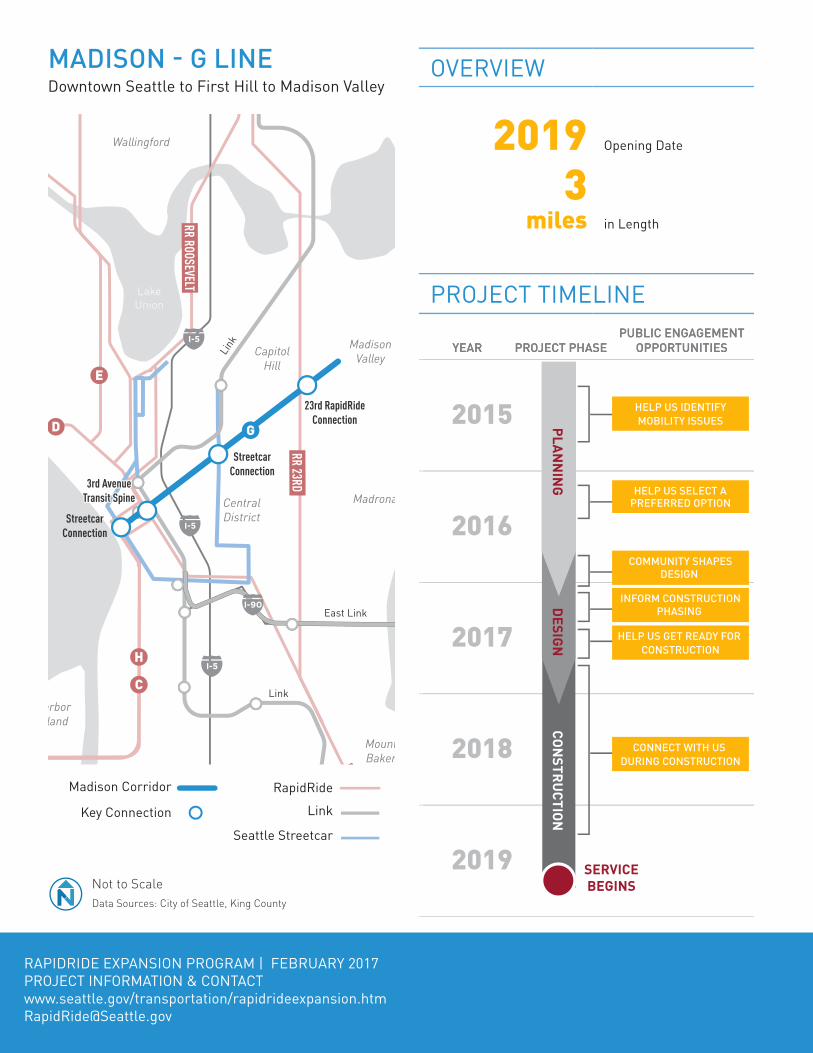
OVERVIEW
2019 Opening Date
3 miles in Length
PROJECT TIMELINE
GreenLake
Elliott Bay
LakeUnion
Queen Anne
CapitolHill
MadisonValley
Madrona
Wallingford
Fremont
GreenLake University
District
PhinneyRidge
Wedgwood
CentralDistrict
Beacon Hill
MountBaker
ColumbiaCity
Georgetown
HarborIsland
23rd RapidRide Connection
Streetcar Connection
3rd Avenue Transit Spine
Streetcar Connection
I-5
I-5
I-5
I-90
Link
Link
East Link
D
E
C
G
H
RR MARKET
RR ROOSEVELT
RR 23RD
RR RAINIER
2016
2017
2018
2019
2020
2015
2016
2017
2018
2019
2024
PROJECT PHASEPROJECT PHASEYEARYEARPUBLIC ENGAGEMENT
OPPORTUNITIESPUBLIC ENGAGEMENT
OPPORTUNITIES
CONSTRUCTIONPLANNING
SERVICEBEGINS
DESIGN
CONNECT WITH US DURING CONSTRUCTION
HELP US GET READY FOR CONSTRUCTION
INFORM CONSTRUCTIONPHASING
COMMUNITY SHAPESDESIGN
H
HELP US SELECT A PREFERRED OPTION
HELP US IDENTIFY MOBILITY ISSUES
RAPIDRIDE EXPANSION PROGRAM | FEBRUARY 2017PROJECT INFORMATION & CONTACTwww.seattle.gov/transportation/rapidrideexpansion.htm [email protected]
MADISON - G LINEDowntown Seattle to First Hill to Madison Valley
Link
Madison Corridor RapidRide
Seattle Streetcar
Key Connection
Not to ScaleData Sources: City of Seattle, King County

TREATMENT TOOLBOXENHANCED BUS STOPS RapidRide stations include raised platforms, real-time arrival information, larger shelters, lighting, and other amenities.
OFF-BOARD FARE COLLECTION Off-board fare collection helps buses move faster as riders can pay fares without waiting in line.
DEDICATED BUS LANESBus-only lanes separate buses from traffic, increasing speed and reliability.
SMART SIGNALSTransit signal priority extends or activates green lights to reduce waiting times for buses at signals.
SPECIALIZED BUSES All-electric RapidRide buses offer more doors and lower floors for easier loading and unloading.
BIKE AND PEDESTRIAN CONNECTIONSImprovements to crossings, neighborhood greenways, and bike lanes will help people get to new RapidRide lines.
PROJECT INTEGRATIONThe RREP will build on and integrate with existing and planned improvements in the corridor, including:
PAST CORRIDOR INVESTMENTS i Additional Bus Service (funded by City)
flickr user SounderBruce, https://creativecommons.org/licenses/by-sa/2.0/legalcode
EVALUATION METRICS*
10,000 Consolidated Corridor Boardings
+7,000 New Daily Boardings (2035)
190k Jobs Served (2035)
56k Residents Served (2035)
36% of Residents Served are Low Income
35% of Residents served are People of Color
38% of Households Served Do Not Own a Car
Up to
25% Travel Time Savings*Data Sources: Consolidated corridor boardings per FTA documentation, King County Metro, Puget Sound Regional Council, US Census American Community Survey 2015 5-Year Estimates

OVERVIEW
2020 Opening Date
14miles in Length
PROJECT TIMELINEElliott Bay
Queen Anne
CapitolHill
CentralDistrict
Beacon Hill
Georgetown
WestSeattle
Fauntleroy
Delridge
White Center
Link
Link
To Burien
3rd Avenue Transit Spine
C Line Connection
Streetcar and RapidRide
Connections
C Line Connection
DE
C
C
G
H
HRR ROOSEVELT
RR 23RD
RR RAINIERI-5
I-5
RapidRide
Link Light Rail
Seattle Streetcar
High-CapacityTransit Connection
Delridge Corridor
Data Sources: City of Seattle, King CountyNot to Scale
Not to ScaleData Sources: City of Seattle, King County
YEAR
2020
2021
2022
2023
2024
2016
2017
2018
2019
2020
2021
2022
2023
2024
PROJECT PHASEPROJECT PHASEYEARYEARPUBLIC ENGAGEMENT
OPPORTUNITIESPUBLIC ENGAGEMENT
OPPORTUNITIES
CONNECT WITH US DURING CONSTRUCTION
HELP US GET READY FOR CONSTRUCTION
INFORM CONSTRUCTIONPHASING
COMMUNITY SHAPESDESIGN
DESIGN
HELP US SELECT A PREFERRED OPTION
HELP US IDENTIFY MOBILITY ISSUES2016
2017
2018
2019
CONSTRUCTIONPLANNING
SERVICEBEGINS
DESIGN
RAPIDRIDE EXPANSION PROGRAM | FEBRUARY 2017PROJECT INFORMATION & CONTACTwww.seattle.gov/transportation/rapidrideexpansion.htm [email protected]
DELRIDGE - H LINEDowntown Seattle to Delridge to Burien
Delridge Corridor
Subject to Further Analysis
LinkRapidRide
Seattle StreetcarKey Connection

BIKE AND PEDESTRIAN CONNECTIONS TO TRANSITImprovements to crossings, neighborhood greenways, and bike lanes will help people access new RapidRide lines.
TREATMENT TOOLBOXENHANCED BUS STOPS RapidRide stations include real-time arrival information, larger shelters, lighting, and other amenities.
OFF-BOARD FARE COLLECTION Off-board fare collection helps buses move faster as riders can pay fares without waiting in line.
DEDICATED BUS LANESBus-only lanes separate buses from traffic, increasing speed and reliability.
SPECIALIZED BUSES RapidRide buses offer lower floors for easier loading and unloading.
SMART SIGNALSTransit signal priority extends or activates green lights to reduce waiting times for buses at signals.
PROJECT INTEGRATIONThe RREP will build on and integrate with existing and planned improvements in the corridor, including:
PAST CORRIDOR INVESTMENTSi Stop Consolidationi BAT/Bus Lanesi Signal Priorityi Safety & Non-Motorized Investmentsi Additional Bus Service (funded by City)i Repavingi Greenway Development
MAJOR PROJECTS ▪ Delridge-Highland Park Greenway (2016) – Constructed a neighborhood greenway along 17th and 21st Ave SW between the West Seattle Bridge Trail and White Center.
▪ Route 120 Speed and Reliability Improvements (2013) – Consolidated bus stops, installed transit signal priority and a bus lane between SW Andover St and SW Oregon St.
▪ Delridge Way SW Safety and Paving Improvement Projects (2013) - Narrowed travel lanes, installed pedestrian safety improvements, installed bike lanes and repaved roadway.
EVALUATION METRICS*
5,200 Daily Boardings Today
+7,100 New Daily Boardings (2035)
187k Jobs Served (2035)
49k Residents Served (2035)
39% of Residents Served are Low Income
48% of Residents Served are People of Color
34% of Households Served Do Not Own A Car
Up to
10-15% Travel Time Savings*Evaluation based on representative concept, does not include the segment from Seattle City limits to Burien. Data Sources: King County Metro, Puget Sound Regional Council, US Census Ameri-can Community Survey 2015 5-Year Estimates
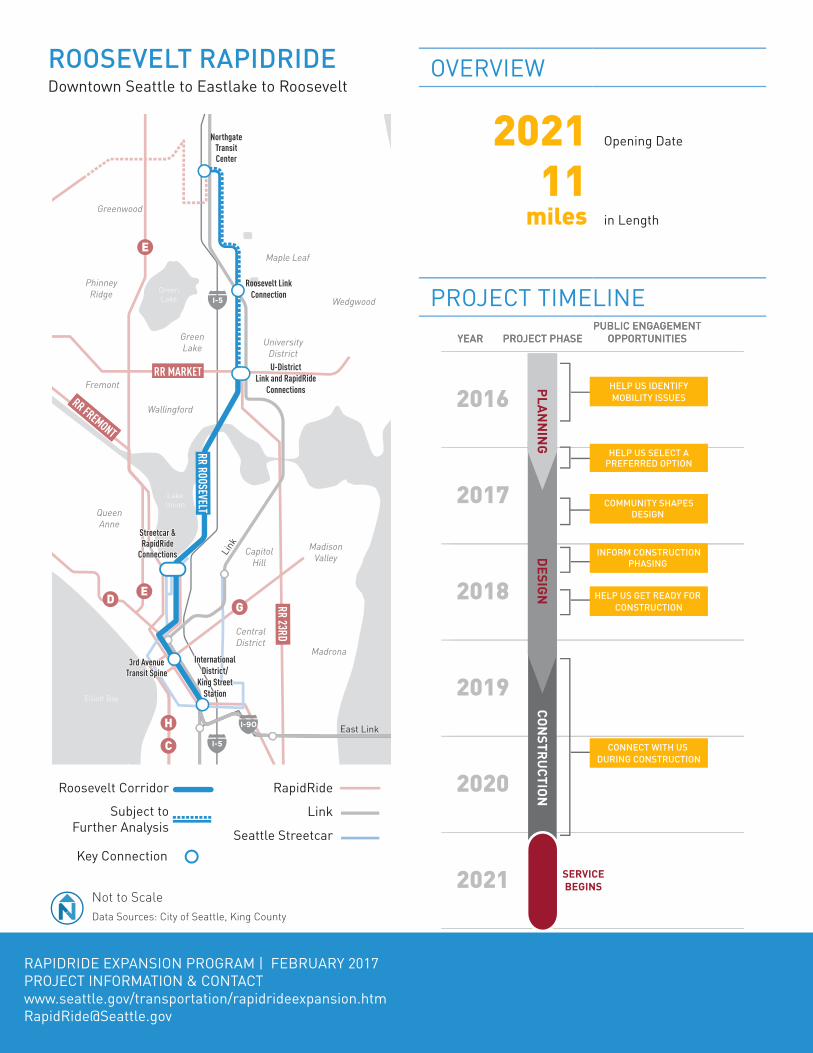
OVERVIEW
2021 Opening Date
11 miles in Length
PROJECT TIMELINEGreenLake
Elliott Bay
LakeUnion
Queen Anne
CapitolHill
MadisonValley
Madrona
Wallingford
Fremont
GreenLake University
District
PhinneyRidge
Greenwood
Maple Leaf
Wedgwood
CentralDistrict
Beacon Hill
MountBaker
ColumbiaCity
HarborIsland
I-5
I-5
I-90
Link
Link
East Link
D E
E
C
G
H
RR MARKET
RR FREMONT
RR FREMONT
RR ROOSEVELT
RR 23RD
RR RAINIER
U-DistrictLink and RapidRide
Connections
Northgate Transit Center
3rd Avenue Transit Spine
International District/
King Street Station
Roosevelt Link Connection
Streetcar & RapidRide
Connections
YEAR
2016
2017
2018
2019
2020
2021
2022
2023
2024
2016
2017
2018
2019
2020
2021
2022
2023
2024
PROJECT PHASEPROJECT PHASEYEARYEARPUBLIC ENGAGEMENT
OPPORTUNITIESPUBLIC ENGAGEMENT
OPPORTUNITIES
CONSTRUCTIONPLANNING
SERVICEBEGINS
DESIGN
CONNECT WITH US DURING CONSTRUCTION
HELP US GET READY FOR CONSTRUCTION
INFORM CONSTRUCTIONPHASING
COMMUNITY SHAPESDESIGN
DESIGN
HELP US SELECT A PREFERRED OPTION
HELP US IDENTIFY MOBILITY ISSUES
RAPIDRIDE EXPANSION PROGRAM | FEBRUARY 2017PROJECT INFORMATION & CONTACTwww.seattle.gov/transportation/rapidrideexpansion.htm [email protected]
ROOSEVELT RAPIDRIDEDowntown Seattle to Eastlake to Roosevelt
Roosevelt Corridor RapidRide
Link
Seattle StreetcarKey Connection
Not to ScaleData Sources: City of Seattle, King County
Subject to Further Analysis
BIKE AND PEDESTRIAN CONNECTIONS TO TRANSITImprovements to crossings, neighborhood greenways, and bike lanes will help people access new RapidRide lines.
TREATMENT TOOLBOXENHANCED BUS STOPS RapidRide stations include real-time arrival information, larger shelters, lighting, and other amenities.
OFF-BOARD FARE COLLECTION Off-board fare collection helps buses move faster as riders can pay fares without waiting in line.
DEDICATED BUS LANESBus-only lanes separate buses from traffic, increasing speed and reliability.
SMART SIGNALSTransit signal priority extends or activates green lights to reduce waiting times for buses at signals.
SPECIALIZED BUSES All-electric RapidRide buses offer lower floors for easier loading and unloading.
EVALUATION METRICS*
6,300 Daily Boardings Today
+9,200 New Daily Boardings (2035)
288k Jobs Served (2035)
99k Residents Served (2035)
37% of Residents Served are Low Income
34% of Residents Served are People of Color
37% of Households Served Do Not Own A Car
Up to
15-20% Travel Time Savings*Evaluation based on representative concept. Data Sources: King County Metro, Puget Sound Regional Council, US Census American Community Survey 2015 5-Year Estimates
PROJECT INTEGRATIONThe RREP will build on and integrate with existing and planned improvements in the corridor, including:
PAST CORRIDOR INVESTMENTSi Stop Consolidationi Safety & Non-Motorized Investmentsi Additional Bus Service (funded by City)i Repaving
MAJOR PROJECTS ▪ Roosevelt Paving and Safety Project (2015) – Installed bus bulbs and bike lanes as well as safety improvements along segments of the corridor.
OVERVIEW
2020 Opening Date
8 miles in Length
PROJECT TIMELINE
Lake Washington
Elliott Bay
LakeUnion
Queen Anne
CapitolHill
MadisonValley
Madrona
CentralDistrict
Beacon Hill
MountBaker
ColumbiaCity
Georgetown
White Center
RainierValley
RainierBeach
Link
Link
23rd
East Link
To Burien
Link
To Burien
3rd Avenue Transit Spine
Mt. Baker Transit Center
Rainier Beach Station
Streetcar and RapidRide
Connections
C Line Connection
E
C
Streetcar Connection
Rainier Station
3rd Avenue Transit Spine
International District/
King Street Station
5
I-5
I-5
I-90
RapidRide
Link Light Rail
Seattle Streetcar
High-CapacityTransit Connection
Rainier Corridor
Data Sources: City of Seattle, King CountyNot to Scale
G
H
RR ROOSEVELT
RR 23RD
RR RAINIER
YEAR
2017
2018
2019
2020
2021
2022
2023
2024
2025
2017
2018
2019
2020
2021
2022
2023
2024
2025
PROJECT PHASEPROJECT PHASEYEARYEARPUBLIC ENGAGEMENT
OPPORTUNITIESPUBLIC ENGAGEMENT
OPPORTUNITIES
CONSTRUCTIONPLANNING
SERVICEBEGINS
DESIGN
CONNECT WITH US DURING CONSTRUCTION
HELP US GET READY FOR CONSTRUCTION
INFORM CONSTRUCTIONPHASING
COMMUNITY SHAPESDESIGN
DESIGN
HELP US SELECT A PREFERRED OPTION
HELP US IDENTIFY MOBILITY ISSUES
Not to ScaleData Sources: City of Seattle, King County
RAPIDRIDE EXPANSION PROGRAM | FEBRUARY 2017PROJECT INFORMATION & CONTACTwww.seattle.gov/transportation/rapidrideexpansion.htm [email protected]
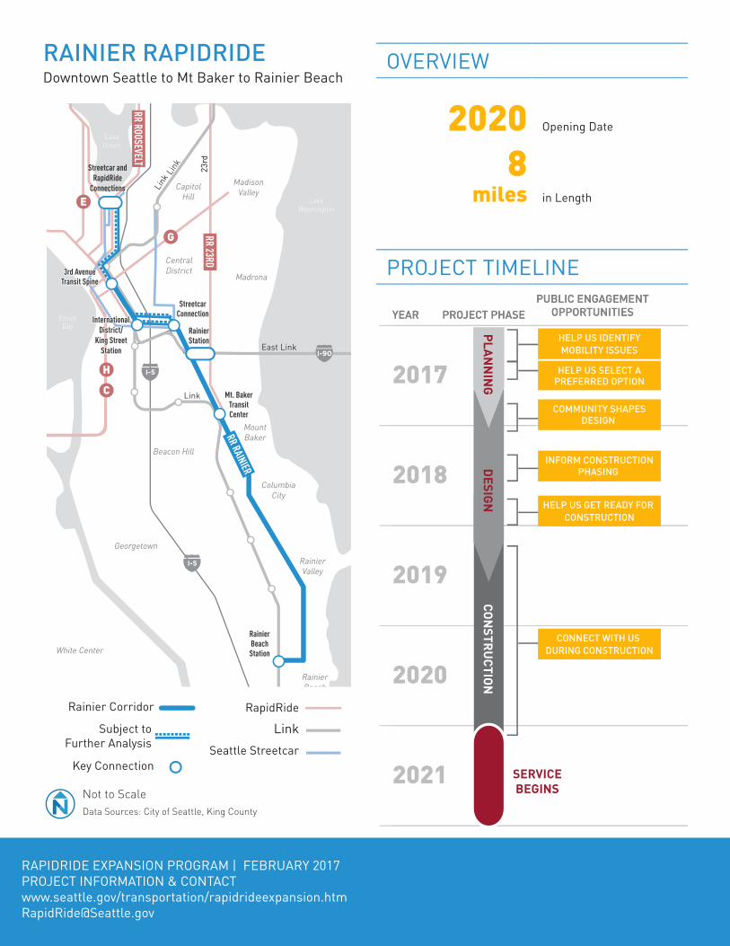
RAINIER RAPIDRIDE Downtown Seattle to Mt Baker to Rainier Beach
LinkRainier Corridor RapidRide
Seattle StreetcarKey Connection
Subject to Further Analysis
BIKE AND PEDESTRIAN CONNECTIONS TO TRANSITImprovements to crossings, neighborhood greenways, and bike lanes will help people access new RapidRide lines.
TREATMENT TOOLBOXENHANCED BUS STOPS RapidRide stations include real-time arrival information, larger shelters, lighting, and other amenities.
OFF-BOARD FARE COLLECTION Off-board fare collection helps buses move faster as riders can pay fares without waiting in line.
DEDICATED BUS LANESBus-only lanes separate buses from traffic, increasing speed and reliability.
SMART SIGNALSTransit signal priority extends or activates green lights to reduce waiting times for buses at signals.
SPECIALIZED BUSES All-electric RapidRide buses offer lower floors for easier loading and unloading.
EVALUATION METRICS*
13,900 Daily Boardings Today
+9,900 New Daily Boardings (2035)
261k Jobs Served (2035)
107k Residents Served (2035)
43% of Residents Served are Low Income
57% of Residents Served are People of Color
36% of Households Served Do Not Own A Car
Up to
10-15% Travel Time Savings*Evaluation based on representative concept. Data Sources: King County Metro, Puget Sound Regional Council, US Census American Community Survey 2015 5-Year Estimates
PROJECT INTEGRATIONThe RREP will build on and integrate with existing and planned improvements in the corridor, including:
PAST CORRIDOR INVESTMENTSi Stop Consolidationi BAT/Bus Lanesi Signal Priorityi Stop Enhancementsi Safety & Non-Motorized Investmentsi Additional Bus Service (funded by City)i Repavingi Greenway Development
MAJOR PROJECTS ▪ Rainier Avenue Corridor Safety Project (2015) – Implemented safety improvements along Rainier through the Columbia City neighborhood.
▪ Rainier Corridor Improvements (2011) – Added bus bulbs, real-time information signs, and pedestrian safety improvements.
OVERVIEW
2022 Opening Date
6 miles in Length
GreenLake
Lake Washington
LakeUnion
PugetSound
Magnolia
Queen Anne
Wallingford
Fremont
GreenLake
UniversityDistrict
PhinneyRidge
Ballard
Maple Leaf
Wedgwood
I-5
D
E
UW/Husky StadiumLink and RapidRide
Connections
RR MARKETRR FREMONT
RR ROOSEVELT
U-DistrictLink and RapidRide
Connections
RapidRide E Line
Connection
Fremont RapidRide
Connection
YEAR
2018
2019
2020
2021
2022
2023
2024
2025
2026
2018
2019
2020
2021
2022
2023
2024
2025
2026
PROJECT PHASEPROJECT PHASEYEARYEARPUBLIC ENGAGEMENT
OPPORTUNITIESPUBLIC ENGAGEMENT
OPPORTUNITIES
CONSTRUCTIONPLANNING
SERVICEBEGINS
DESIGN
CONNECT WITH US DURING CONSTRUCTION
HELP US GET READY FOR CONSTRUCTION
INFORM CONSTRUCTIONPHASING
COMMUNITY SHAPESDESIGN
DESIGN
HELP US SELECT A PREFERRED OPTION
HELP US IDENTIFY MOBILITY ISSUES
PROJECT TIMELINE
RAPIDRIDE EXPANSION PROGRAM | FEBRUARY 2017PROJECT INFORMATION & CONTACTwww.seattle.gov/transportation/rapidrideexpansion.htm [email protected]
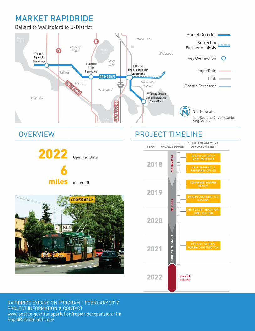
MARKET RAPIDRIDEBallard to Wallingford to U-District
Market Corridor
RapidRide
Link
Seattle Streetcar
Key Connection
Not to ScaleData Sources: City of Seattle, King County
Subject to Further Analysis
BIKE AND PEDESTRIAN CONNECTIONS TO TRANSITImprovements to crossings, neighborhood greenways, and bike lanes will help people access new RapidRide lines.
TREATMENT TOOLBOXENHANCED BUS STOPS RapidRide stations include real-time arrival information, larger shelters, lighting, and other amenities.
OFF-BOARD FARE COLLECTION Off-board fare collection helps buses move faster as riders can pay fares without waiting in line.
DEDICATED BUS LANESBus-only lanes separate buses from traffic, increasing speed and reliability.
SMART SIGNALSTransit signal priority extends or activates green lights to reduce waiting times for buses at signals.
SPECIALIZED BUSES All-electric RapidRide buses offer lower floors for easier loading and unloading.
EVALUATION METRICS*
8,300 Daily Boardings Today
+6,400 New Daily Boardings (2035)
69k Jobs Served (2035)
57k Residents Served (2035)
30% of Residents Served are Low Income
26% of Residents Served are People of Color
21% of Households Served Do Not Own A Car
Up to
20 - 25% Travel Time Savings*Evaluation based on representative concept. Data Sources: King County Metro, Puget Sound Regional Council, US Census American Community Survey 2015 5-Year Estimates
PROJECT INTEGRATIONThe RREP will build on and integrate with existing and planned improvements in the corridor, including:
PAST CORRIDOR INVESTMENTSi Stop Consolidationi BAT/Bus Lanesi Signal Priorityi Safety & Non-Motorized Investmentsi Additional Bus Service (funded by City)i Repaving
MAJOR PROJECTS ▪ Route 44 Enhancements Study (2015) – Identified transit improvements for the corridor.
▪ Market/NW 45th Transit Improvement Project (2012) – Added bus bulbs, transit signal priority, and bus lanes through portions of the corridor between Ballard and Wallingford. Installed real-time information signs at high-use stops.

OVERVIEW
2023 Opening Date
13miles in Length
PROJECT TIMELINEGreenLake
Elliott Bay
LakeUnion
Magnolia
Queen Anne
CapitolHill
Wallingford
Fremont
GreenLake University
District
PhinneyRidge
Ballard
North Beach Greenwood
Maple Leaf
Northgate
CentralDistrict
Beacon Hill
HarborIsland
WestSeattle
I-5
I-5
I-5
I-90
Link
Link
D
E
E
C
G
H
RR MARKETRR FREMONT
RR ROOSEVELT
RR 23RD
RapidRide D Line Connection
Market RapidRide
Connection
Streetcar & RapidRide
Connections
3rd Avenue Transit Spine
International District/
King Street Station
RapidRide D Line Connection
YEAR
2019
2020
2021
2022
2023
2024
2025
2026
2027
2019
2020
2021
2022
2023
2024
2025
2026
2027
PROJECT PHASEPROJECT PHASEYEARYEARPUBLIC ENGAGEMENT
OPPORTUNITIESPUBLIC ENGAGEMENT
OPPORTUNITIES
CONSTRUCTIONPLANNING
SERVICEBEGINS
DESIGN
DESIGN
CONNECT WITH US DURING CONSTRUCTION
HELP US GET READY FOR CONSTRUCTION
INFORM CONSTRUCTIONPHASING
COMMUNITY SHAPESDESIGN
DESIGN
HELP US SELECT A PREFERRED OPTION
HELP US IDENTIFY MOBILITY ISSUES
Not to ScaleData Sources: City of Seattle, King County
RAPIDRIDE EXPANSION PROGRAM | FEBRUARY 2017PROJECT INFORMATION & CONTACTwww.seattle.gov/transportation/rapidrideexpansion.htm [email protected]
FREMONT RAPIDRIDEDowntown Seattle to Fremont/Ballard to Northgate
Fremont Corridor RapidRide
Link
Seattle Streetcar
Key Connection
RapidRide Extension
BIKE AND PEDESTRIAN CONNECTIONS TO TRANSITImprovements to crossings, neighborhood greenways, and bike lanes will help people access new RapidRide lines.
TREATMENT TOOLBOXENHANCED BUS STOPS RapidRide stations include real-time arrival information, larger shelters, lighting, and other amenities.
OFF-BOARD FARE COLLECTION Off-board fare collection helps buses move faster as riders can pay fares without waiting in line.
DEDICATED BUS LANESBus-only lanes separate buses from traffic, increasing speed and reliability.
SPECIALIZED BUSES RapidRide buses offer lower floors for easier loading and unloading.
SMART SIGNALSTransit signal priority extends or activates green lights to reduce waiting times for buses at signals.
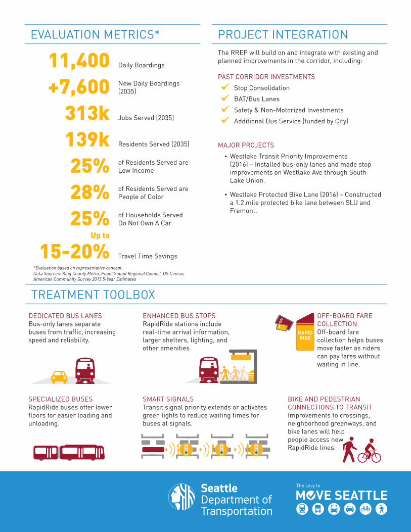
EVALUATION METRICS*
11,400 Daily Boardings
+7,600 New Daily Boardings (2035)
313k Jobs Served (2035)
139k Residents Served (2035)
25% of Residents Served are Low Income
28% of Residents Served are People of Color
25% of Households Served Do Not Own A Car
Up to
15-20% Travel Time Savings*Evaluation based on representative concept. Data Sources: King County Metro, Puget Sound Regional Council, US Census American Community Survey 2015 5-Year Estimates
PROJECT INTEGRATIONThe RREP will build on and integrate with existing and planned improvements in the corridor, including:
PAST CORRIDOR INVESTMENTSi Stop Consolidationi BAT/Bus Lanesi Safety & Non-Motorized Investmentsi Additional Bus Service (funded by City)
MAJOR PROJECTS ▪ Westlake Transit Priority Improvements (2016) – Installed bus-only lanes and made stop improvements on Westlake Ave through South Lake Union.
▪ Westlake Protected Bike Lane (2016) – Constructed a 1.2 mile protected bike lane between SLU and Fremont.

OVERVIEW
2024 Opening Date
7 miles in Length
PROJECT TIMELINE
Lake Washington
LakeUnion
CapitolHill
MadisonValley
Madrona
Wallingford
GreenLake University
District
CentralDistrict
Beacon Hill
MountBaker
ColumbiaCity
Georgetown
RainierValley
5
I-5
I-5
I-5
I-90
Link
Link
East Link
C
U-DistrictLink and RapidRide
Connections
Madison RapidRide G Line Connection
Rainier Station
Mt. Baker Transit Center
UW/Husky StadiumLink and RapidRide
Connections
G
H
RR MARKET
RR ROOSEVELT
RR 23RD
RR RAINIER
YEAR
2021
2022
2023
2024
2025
2026
2027
2028
2024
2021
2022
2023
2024
2025
2026
2027
2028
2024
PROJECT PHASEPROJECT PHASEYEARYEARPUBLIC ENGAGEMENT
OPPORTUNITIESPUBLIC ENGAGEMENT
OPPORTUNITIES
CONSTRUCTIONPLANNING
SERVICEBEGINS
DESIGN
CONNECT WITH US DURING CONSTRUCTION
HELP US GET READY FOR CONSTRUCTION
INFORM CONSTRUCTIONPHASING
COMMUNITY SHAPESDESIGN
DESIGN
HELP US SELECT A PREFERRED OPTION
HELP US IDENTIFY MOBILITY ISSUES
Not to ScaleData Sources: City of Seattle, King County
RAPIDRIDE EXPANSION PROGRAM | FEBRUARY 2017PROJECT INFORMATION & CONTACTwww.seattle.gov/transportation/rapidrideexpansion.htm [email protected]
23RD RAPIDRIDE Mt Baker to Central Area to U-District
23rd Corridor RapidRide
Link
Seattle Streetcar
Key Connection

BIKE AND PEDESTRIAN CONNECTIONS TO TRANSITImprovements to crossings, neighborhood greenways, and bike lanes will help people access new RapidRide lines.
TREATMENT TOOLBOXENHANCED BUS STOPS RapidRide stations include real-time arrival information, larger shelters, lighting, and other amenities.
OFF-BOARD FARE COLLECTION Off-board fare collection helps buses move faster as riders can pay fares without waiting in line.
DEDICATED BUS LANESBus-only lanes separate buses from traffic, increasing speed and reliability.
SMART SIGNALSTransit signal priority extends or activates green lights to reduce waiting times for buses at signals.
SPECIALIZED BUSES All-electric RapidRide buses offer lower floors for easier loading and unloading.
EVALUATION METRICS*
5,900 Daily Boardings Today
+4,500 New Daily Boardings (2035)
65k Jobs Served (2035)
64k Residents Served (2035)
37% of Residents Served are Low Income
42% of Residents Served are People of Color
25% of Households Served Do Not Own A Car
Up to
10-15% Travel Time Savings*Evaluation based on representative concept. Data Sources: King County Metro, Puget Sound Regional Council, US Census American Community Survey 2015 5-Year Estimates
PROJECT INTEGRATIONThe RREP will build on and integrate with existing and planned improvements in the corridor, including:
PAST CORRIDOR INVESTMENTSi Stop Consolidationi BAT/Bus Lanesi Signal Priorityi Stop Enhancementsi Safety & Non-Motorized Investmentsi Additional Bus Service (funded by City)i Repaving
MAJOR PROJECTS ▪ 23rd Ave Corridor Improvements Project – Reconfigured and reconstruct roadway to a three-lane street, implemented pedestrian safety improvements, consolidated and improved bus stops, and installed transit signal priority.
Draft Seattle RapidRide Expansion Program Report | February 2017
PROGRAM FUNDING AND COSTSAchieving the full RapidRide Expansion Program as set forth in the Levy to Move Seattle will involve strategic leveraging of project funds, partnerships, and pursuing competitive grant opportunities.
The RapidRide Expansion Program will be competitive for available grant funding programs and will leverage Levy to Move Seattle funds as far as possible by:
• Considering a range of competitive regional and federal grant sources.
• Considering how agency and private partners can uniquely support the program.
• Identifying complementary projects that enhance grant competitiveness. These projects may be fully or partially funded and can be delivered with the RapidRide corridor projects to increase efficiency and advance overall Move Seattle goals.
33
Potential Funding SourcesLevy to Move Seattle
Approved by voters in 2015, the nine-year, $930 million Levy to Move Seattle provides funding to improve safety for all travelers, maintain streets and bridges, and invest in reliable, affordable travel options for a growing city. The seven RapidRide Expansion Program corridors are identified and partially funded by the Levy.
The Levy to Move Seattle also provides a foundational project prioritization and funding framework. It includes opportunities for enhanced modal integration through coordination with other Move Seattle projects. Funded or partially funded projects that are planned for RapidRide corridors can be strategically coordinated to secure additional funding, and make project delivery more efficient and cost effective.
Local Partnerships
King County Metro and the City of Seattle have a history of successful partnership, which has included joint project funding, delivery, and ongoing investments to improve transit operations in the City. This partnership was key to the success of the RapidRide C, D and E lines in Seattle and will be critical to the success of the RapidRide Expansion Program. Existing transit service in the seven new RapidRide corridors is also supported through a King County Metro and City funding agreement.
In addition to the partnerships with King County Metro, the recent Sound Transit 3 package includes funding for the Madison corridor, as well as potential transit investments that are along or intersect with the RapidRide Expansion Program corridors. The City of Seattle will continue to partner with Sound Transit to explore funding opportunities and ensure integration with the regional transit network.
The State of Washington is another funding partner for the program, with investments planned in the Madison, Delridge and Market corridors.
Competitive Grant Sources
Competitive grant programs at both the federal and local level provide opportunities for funding transportation projects. The Federal Transit Administration (FTA) was a funding partner in existing RapidRide lines. The FTA Small Starts program is ideal for some of the RapidRide Expansion Program corridors. The City has applied for Small Starts funds for the Madison (RapidRide G) Line and applications will be submitted for other corridors as appropriate. Other potential federal funding and financing sources include the Transportation Investment Generating Economic Recovery (TIGER) and Transportation Infrastructure Finance and Innovation Act (TIFIA) programs through the United States Department of Transportation.
Local grant sources have historically included grants administered by the Puget Sound Regional Council. The City will examine other local grant funding opportunities and develop alternative funding plans as needed, depending on the future availability of federal funds.
Other Funding Sources
Depending on the success of funding obtained through competitive sources, additional local and private funding opportunities may be considered, such as the creation of new revenue streams, and the development of public-private partnerships.
34

Draft Seattle RapidRide Expansion Program Report | February 2017
Program InvestmentsThe preliminary suite of program investments was developed based on the planning level corridor concepts developed as part of the Transit Master Plan and Levy to Move Seattle. The following is a summary of the type of program investments anticipated for the network:
• Service enhancements needed to meet RapidRide service levels.
• Roadway improvements include transit supportive elements such as dedicated transit lanes.
• Signal upgrades include Transit Signal Priority (TSP) and Intelligent Transportation Systems (ITS), as described in the Treatment Toolbox (p. 4)
• Upgraded station facilities include new RapidRide shelters, real time information signs, off board fare collection and enhanced passenger facilities.
• Pedestrian and bicycle facilities to improve access to transit, includeing improved sidewalks, passenger waiting areas, and curb ramps at intersections, as well as neighborhood greenways and bike lanes.
• Trolley infrastructure improvements such as trolley wire and overhead catenary poles are needed to operate RapidRide buses on four of the seven corridors.
• Bus fleet needs have not yet been determined for most of the RapidRide corridors. New buses are needed for the Madison (RapidRide G) Line, and a small percentage of the program costs go towards that purchase. New bus needs for the other corridors will be evaluated based on the program implementation schedule and Metro’s available fleet.
35

Sour
ce: F
lickr
, Or
an V
iriyi
ncy
Draft Seattle RapidRide Expansion Program Report | February 2017
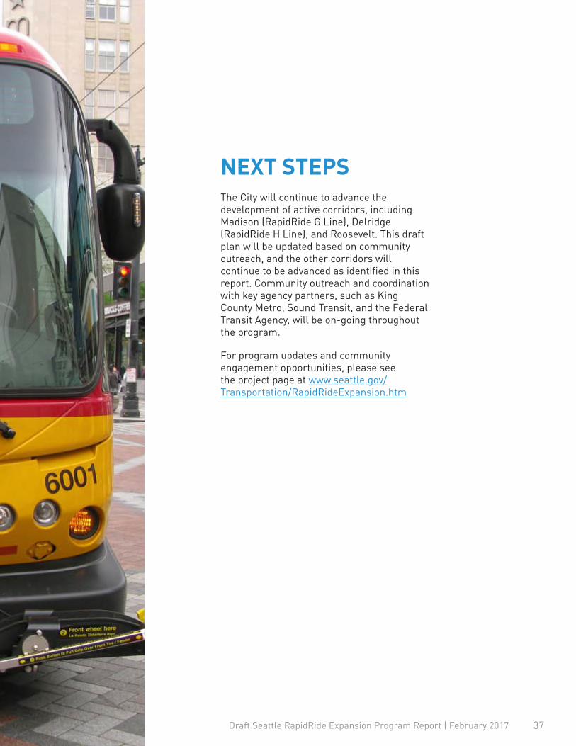
The City will continue to advance the development of active corridors, including Madison (RapidRide G Line), Delridge (RapidRide H Line), and Roosevelt. This draft plan will be updated based on community outreach, and the other corridors will continue to be advanced as identified in this report. Community outreach and coordination with key agency partners, such as King County Metro, Sound Transit, and the Federal Transit Agency, will be on-going throughout the program.
For program updates and community engagement opportunities, please see the project page at www.seattle.gov/Transportation/RapidRideExpansion.htm
NEXT STEPS
37


