
RIDGEFIELD
PIONEER & 45TH SUB-AREA PLAN
E. D. Hovee & Company, LLC BergerABAM
Stakeholder Meeting #1
June 1, 2015
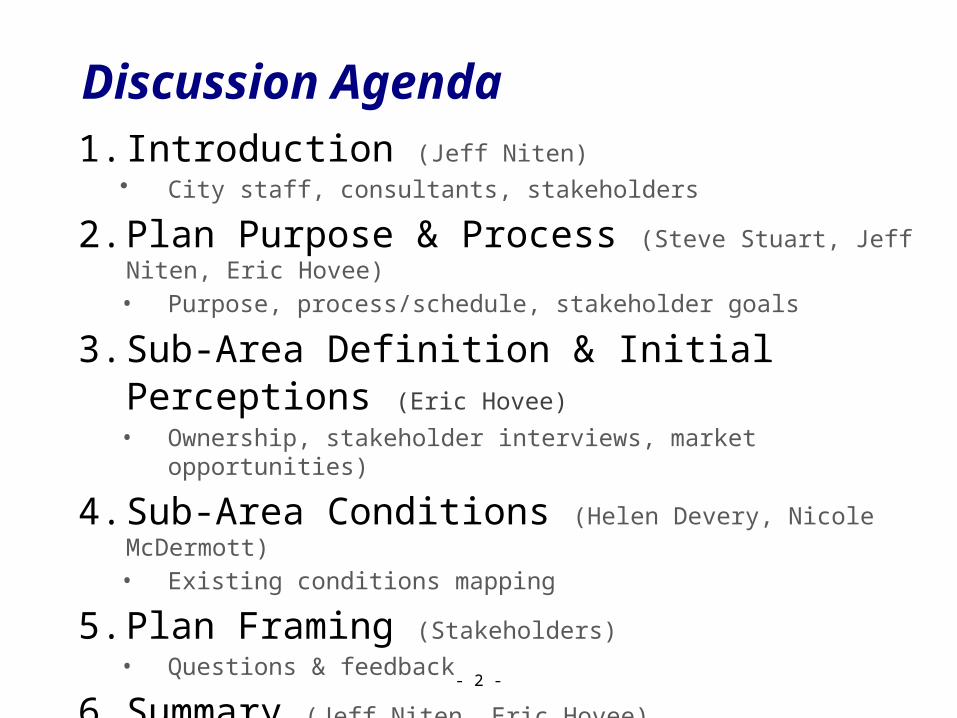
Discussion Agenda1. Introduction (Jeff Niten)
• City staff, consultants, stakeholders
2. Plan Purpose & Process (Steve Stuart, Jeff Niten, Eric Hovee)• Purpose, process/schedule, stakeholder goals
3. Sub-Area Definition & Initial Perceptions (Eric Hovee)• Ownership, stakeholder interviews, market opportunities)
4. Sub-Area Conditions (Helen Devery, Nicole McDermott) • Existing conditions mapping
5. Plan Framing (Stakeholders) • Questions & feedback
6. Summary (Jeff Niten, Eric Hovee) • Wrap up, next steps, meeting schedule
- 2 -
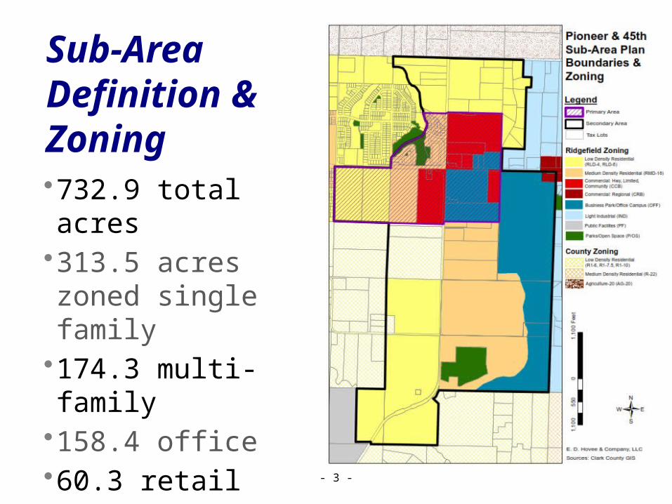
Sub-Area Definition & Zoning•732.9 total acres•313.5 acres zoned single family
•174.3 multi-family•158.4 office•60.3 retail•26.3 parks/open space
- 3 -

Sub-Area Ownerships•99 tax parcels•10 owners of 20+ acres represent 80% of land area
•Major holdings south of Pioneer
•Current assessed value of $30 million(70% land/30% improvements)
- 4 -

Sub-Area Planning Linkages•All plans coordinated via Comp Plan update•Ready by year-end for 2016 adoption
- 5 -

Stakeholder Interviews
Key Observations:•Bullish but cautious•Transport/utilities north of Pioneer, need work south
•Flexible zoning & mixed use interest
•Time for a fresh vision•Cooperative approach plus realistic expectations
- 6 -
Purposes:• Owner interests
& opportunities• Representing
majority of land area (all 4 quadrants)
• Multi-topic focus(future development, site attributes, infrastructure, land use, environmental, linkage opportunities)
Market Opportunities
- 7 -
Use Features Questions
Single Family Residential
Entry-level to trade-up
• Diversity?• Common amenity?
Multi-Family Residential
Apartments, townhomes
• Market depth?• Timing?
Campus Office
Reinforce Junction, long-lead option
• Kruse Way vision?• Catalyst anchors?
Community Retail
Grocery anchored, full service
• Rooftops?• DT complement?
Horizontal Mixed Use
Integrate live, work, environment
• Zoning flex?• Incentives?

Existing Conditions:•Land Use and Zoning•Parks, Trails, and Open Spaces
•Critical Areas•Utility Infrastructure and Capacity
•Transportation Network and Capacity
Sub-Area Plan
- 8 -
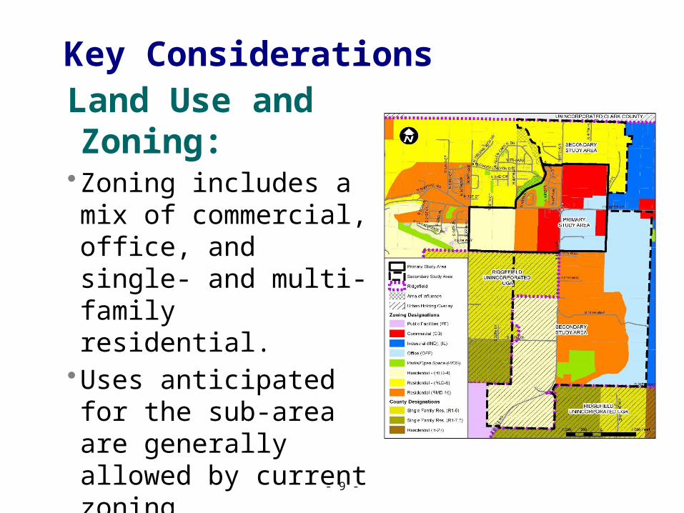
Land Use and Zoning:•Zoning includes a mix of
commercial, office, and single- and multi-family residential.
•Uses anticipated for the sub-area are generally allowed by current zoning.
•No provision in CCB or OFF zone for horizontal mixed-use with residential.
Key Considerations
- 9 -

Parks, Trails, and Open Spaces:
•Further identification of proposed park and trail facilities is needed.
•Develop a useable open space network to support quality of life.
•Consider relocation of CP-5 and trail connections.
Key Considerations
- 10 -
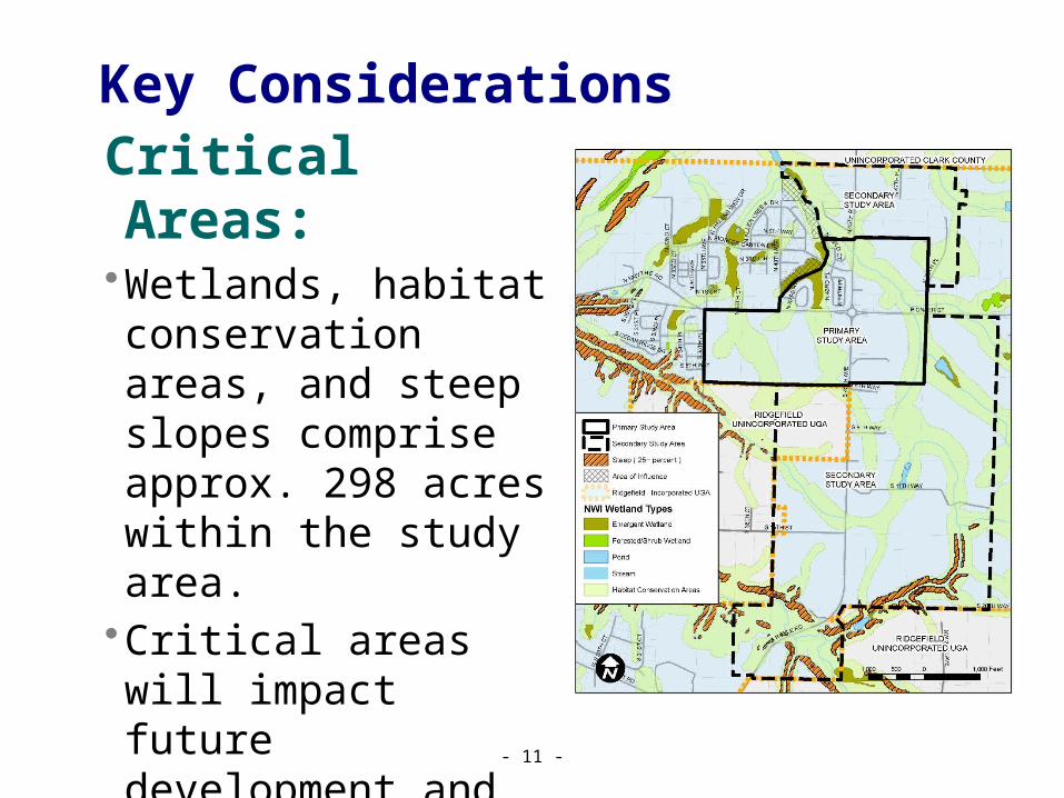
Critical Areas:•Wetlands, habitat
conservation areas, and steep slopes comprise approx. 298 acres within the study area.
•Critical areas will impact future development and must be considered in the development of sub-area plan concept plans.
Key Considerations
- 11 -
Key Considerations
- 12 -Water
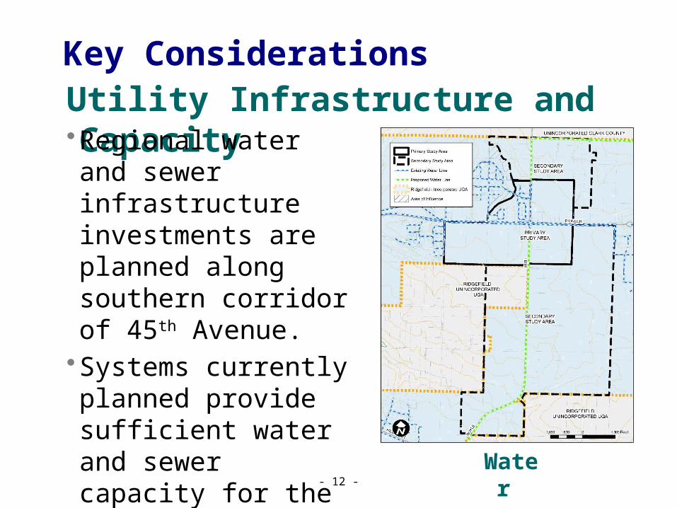
Utility Infrastructure and Capacity •Regional water and sewer
infrastructure investments are planned along southern corridor of 45th Avenue.
•Systems currently planned provide sufficient water and sewer capacity for the majority of the sub-area.
Utility Infrastructure and Capacity Key Considerations
- 13 -Sewer
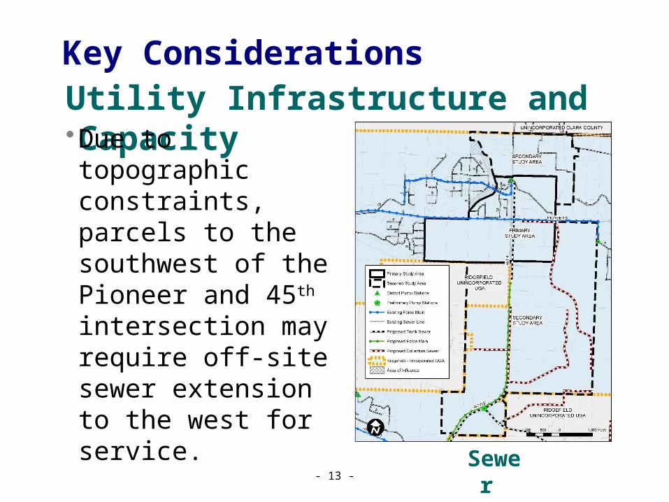
•Due to topographic constraints, parcels to the southwest of the Pioneer and 45th intersection may require off-site sewer extension to the west for service.
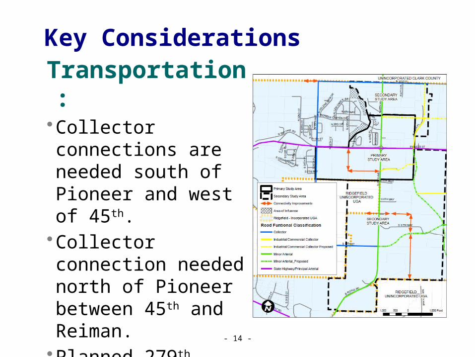
Transportation:•Collector connections are
needed south of Pioneer and west of 45th.
•Collector connection needed north of Pioneer between 45th and Reiman.
•Planned 279th collector should extend west of 35th Place to keep local trips off of Pioneer.
Key Considerations
- 14 -

Sub-Area Build-Out Capacity
- 15 -
Per County VBLM(adjusted)
•733 acres total •< 40 developed•298 critical lands•112 infrastructure•~310 net buildable1,700 housing units + 2,500 jobs @ build-out

Sub-Area Plan Framing
- 16 -
Questions for Discussion:1. Vision for the sub-area (short / long term)?2. Questions for Comp Plan update to address?3. Priorities for critical lands & infrastructure?4. Development concepts to be explored?5. Roles for stakeholder, city & other partners?
Question #1:
- 17 -
What is your vision for the sub-area (over the next 5 years and to build-out)?

Question #2:
- 18 -
What are the key questions that Comp Plan and zoning updates should address?
Question #3:
- 19 -
What are the priorities for critical lands & transportation/utility/parks infrastructure?
Question #4:
- 20 -
What development concepts should be explored (as with flexible zoning and horizontal mixed use)?

Question #5:
- 21 -
What roles should stakeholders, the City and other partners play in plan review and implementation?

Summary•Wrap-up
(Stakeholder questions & comments)
•Next Steps (Meeting #2 – Concepts & action plan brainstorming)(Meeting #3 – Feasibility, preferred concept, policy)
•Meeting schedule
- 22 -


