
Ice_Sheets-CCI:Essential Climate Variables for the
Greenland Ice Sheet
R Forsberg, L Sørensen, J Levinsen, R Meister, J Dall, A Kusk (DTU-Space. Denmark), C Ås, D Evansberget (S&T, Norway), R Mottram (DMI, Denmark), S Andersen, M Langer (GEUS), C Hvidberg (NBI, Denmark), K Khvorostovsky (NERSC, Norway), T Nagler, K Scharrer (ENVEO, Austria), A Shepard, F Ticconi (U Leeds, UK)

Products overview
The CCI_ice_sheet project will provide selected, consistent, easy-to-use selected ECV’s for Greenland, based mainly on ESA EO data (radar altimetry and SAR)
Coverage of ECVs, based on user requirements
ECV Product Spatial resolution
Temporal resolution
Period Spatial and temporal coverage, first 3-yr phase
Surface Elevation Change (SEC)
5 km grid 4 per year 1991- present
All ice sheet, 1991-20125-year running means
Ice Velocity(IV) 500 m grid 1 per year*
1991- present
Coastal margin (winter 1995/96 and summer 2008)Timeseries on Jakobshavn and Upernavik isbræ; North Greenland interior drainage basin (winter 1991/92)
Calving Front Location (CFL)
250 m shapefile 4 per year
1991- present
19 named major glaciers(some glaciers sampled yearly, depending on data availability)
Grounding Line Location (GLL)
250 m shapefile
1 per year 1991- present
Petermann, Hagen and 79- Fjord Glaciers
* After CCI phase 1

Examples: IV and CFL
<=Example of IV forKangerlussuaq Glacier,East GreenlandNov 2009-Jan 2010 (Merryman, DTU-Space)
=>Example of CFL
1999-2010 forsouthern glaciers,
East Greenland (Nagler, ENVEO)
• Ice velocity and grounding lines determined by SAR feature tracking and interferometry• CFL and GLL from optical and SAR imagery

Examples: SEC
The ECV products will build on ERS/Envisat/Sentinel-3 .. with auxillary use of IceSatFinal algorithm selection awaits Round-Robin exersise results ..
SEC from IceSat data 2003-9 (Sørensen et al, DTU-Space)
Total mass loss ~230 GT/yr, similar to GRACE resultsSEC from ERS and Envisat 1992-2008 (Khvorostovsky, NERSC)

Products – areas and data
Example of first phase ECV data coverage:Ice Velocity from SAR interferometry:Coastal regions, northern basin, and timeSeries on Jakobshavn and Upernavik Glaciers
Key regions for ECV validation from independentsatellite, airborne and surface data (background image: Ice velocities from SAR, from I. Joughin)

Status: Algorithms and errors
Example: Ice Velocity
• Ice velocity and grounding lines determined by SAR feature tracking and interferometry – local + ESA GPOD
• Three methods - complementary error characteristics:- Speckle tracking- D-InSAR- MAI (multi-aperture interferometry)
Area Accu- racy Sensors Method
Ice sheet interior
<10 m/y
ERS SAR
Calibration with balance velocitiesD-InSAR and MAI techniques
Ice sheet margin
10 to 30
m/yr
ERS SAR, ASAR, PALSAR
Calibration with stationary control points on bedrock.Speckle-tracking (highest accuracy) and feature- tracking (lowest accuracy)
79-fjord IV from speckle tracking (GEUS/DTU)
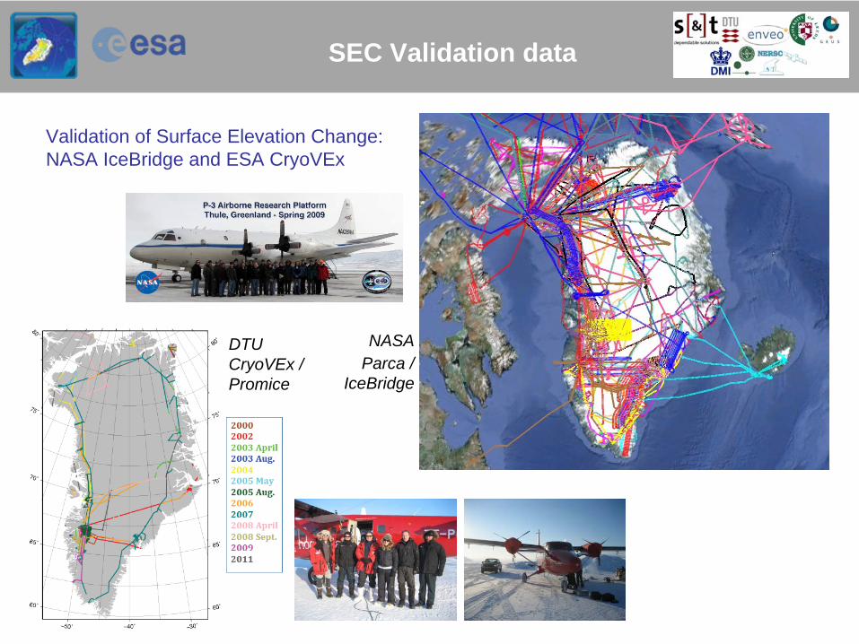
SEC Validation data
Validation of Surface Elevation Change:NASA IceBridge and ESA CryoVEx
DTU CryoVEx /Promice
NASAParca /
IceBridge

Validation data …. GPS velocity (IV) and Landsat (CFL)
IV and CFL validation data
Envisat ASAR summer 2008(ECV production data)
Landsat data coverage for Calving Front validation
In-situ GPS data from PROMICEand various outlet glacier projects

Auxillary data
Improved DEM of Greenland from digital mapping, ASTER, ERS/ICESat and (soon) CryoSat• Reference for SEC and IV .. resolution 200 m-1 km, polar stereographic or UTM• Land/ice masks … including outlying glaciers and ice caps

Status: Round-Robin excersize
Round-Robin: External tests for best methods .. Common areas, time span, dataParticipants: SEC: 10 researchers; IV: 11; CFL: 4; GLL: 0 (!)
Example: Surface Elevation Change – ICESat and EnviSat / x-over and repeat-track methods
Envisat SEC (T Flament)
IceSat(several)
Area:Jakobshavn Isbrædrainage basin
x-overvs
repeat- track (IceSat)

Status: Round-Robin - IV
Round Robin Dataset
Goal: derive slant-range velocity map using DEME (two-pass) or DD (four-pass)
Input:• Level 0 (RAW) data• Precise state vectors (Delft)• 90 m DEM
Coherence

Status: Round-Robin - IV
Slant-range Velocities Storstrømmen Glacier
LoS= GPS
Group 2Group 1 Group 3a
Group 3b Group 3c Group 3d
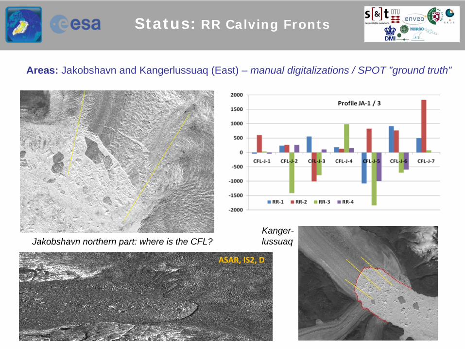
Status: RR Calving Fronts
Areas: Jakobshavn and Kangerlussuaq (East) – manual digitalizations / SPOT ”ground truth”
Jakobshavn northern part: where is the CFL?Kanger-lussuaq
ASAR, IS2, D

Status: RR grounding lines
Grounding
zone
Master: 28/02/1992Slave: 02/03/1992Bperp
: 1 m+ 3 more
scenes
distributed
No external
participants.. but
nearly
same
data
usedby
Rignot
(1996)
GPS ground truth anyone?Internal experimental validation: TanDEM-X repeat (ENVEO)
Antarctica experiment upcoming(Fimbul Ice Shelf, DML)

• PVASR, IODD+DPM• System documents (SRD, SSD) in prep
Living Planet release of first prototype ECVs
Antarctica preparatory project (1 yr) – PI U Leeds - Sentinel-1 preparation for IV (1.5 yr) – PI Enveo- CryoSat-2 for bridging SEC Envisat gap – PI DTU
GRACEmass loss2003-12(DTU-Space)

![ESA [ECV] CCI Newsletter - Met Officeensembles-eu.metoffice.com/cmug/06_CMUG_web.pdf · 2016-01-26 · CMUG CCI Newsletter | Issue n. 6 | Jan 2016 The next cmug@metoffice.gov.uk Met](https://cdn.vdocuments.us/doc/165x107/5f3e774154e648248c07c6ad/esa-ecv-cci-newsletter-met-officeensembles-eu-2016-01-26-cmug-cci-newsletter.jpg)


